Embed Size (px)
Citation preview

The Potential Use Of Open Source GI Software in Education
Presented by Elisabeth Dresen, FIT 2006
Research Semester - Project
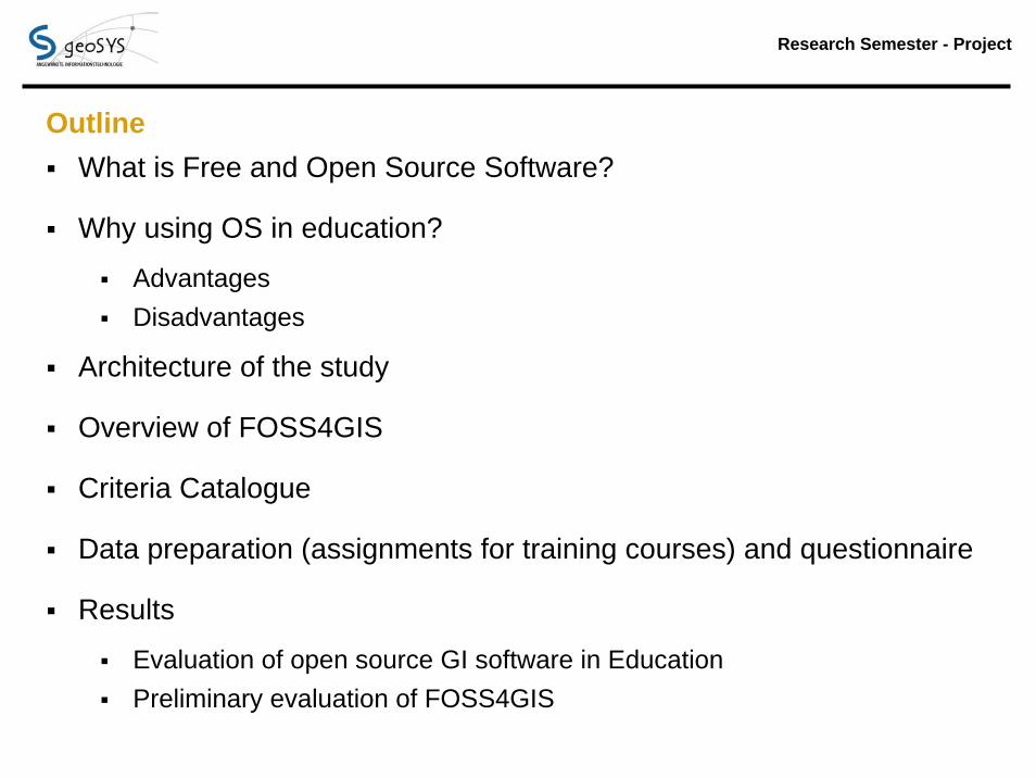
OutlineWhat is Free and Open Source Software?
Why using OS in education?
AdvantagesDisadvantages
Architecture of the study
Overview of FOSS4GIS
Criteria Catalogue
Data preparation (assignments for training courses) and questionnaire
Results
Evaluation of open source GI software in EducationPreliminary evaluation of FOSS4GIS

‚Open Source‘ Concept
‚Free Software‘ is a matter of liberty, not price!

Research Semester - Project Why using OS GI Software in education?
PROS:
- Costs of Software = 0 €
- Application of different GI Software -> diversified experience, flexibility, focus on methods
- Source Code is ‚open‘->new possibilities for teaching
- transparency
- Distribution of software possible
- High Quality, scientific (adaptation of knowledge very fast)
- Fast development cycle
- Direct communication between user and developer
CONS:
- Finally Costs not = 0 €
- Mostly stepwise installation
- Needs of labor market
- Very quick development cycle
- Documentation lags behind
- GUI not always intuitive
- Regular update of material
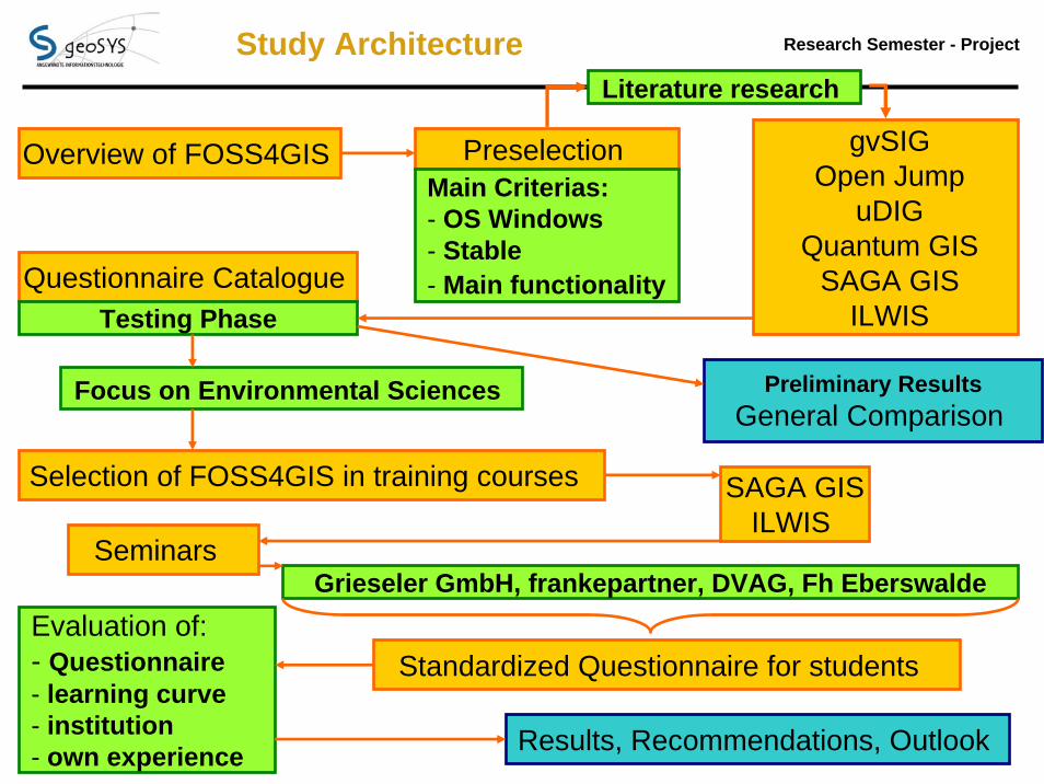
Research Semester - Project Study Architecture
Overview of FOSS4GIS
Questionnaire Catalogue
Preselection
Selection of FOSS4GIS in training courses
Standardized Questionnaire for students
gvSIGOpen Jump
uDIGQuantum GIS
SAGA GISILWIS
Literature research
Focus on Environmental Sciences Preliminary ResultsGeneral Comparison
Seminars
SAGA GISILWIS
Evaluation of: - Questionnaire - learning curve - institution- own experience Results, Recommendations, Outlook
Grieseler GmbH, frankepartner, DVAG, Fh Eberswalde
Main Criterias:- OS Windows- Stable- Main functionality
Testing Phase
Research Semester - Project
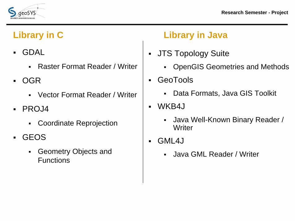
Library in C Library in Java
GDAL
Raster Format Reader / Writer
OGR
Vector Format Reader / Writer
PROJ4
Coordinate Reprojection
GEOS
Geometry Objects and Functions
JTS Topology SuiteOpenGIS Geometries and Methods
GeoToolsData Formats, Java GIS Toolkit
WKB4JJava Well-Known Binary Reader / Writer
GML4JJava GML Reader / Writer

Research Semester - Project
Development(General) statistical computing environment:
http://www.r-project.org/
Rgeo: spatial data analysis in R, unified classes and interfaces (e.g, RGRASS)http://r-spatial.sourceforge.net/
Spatially-enabled Internet applications http://mapserver.gis.umn.edu/
GDAL - Geospatial Data Abstraction Library http://www.gdal.org
PostGIS: support forgeographic objects to thePostgreSQL object-relationaldatabasehttp://postgis.refractions.net
PostgreSQLMost advanced open sourcerelational databasehttp://www.postgresql.org/
GRASS GISSpatial Computing http://grass.itc.it
QGIS: user friendly Open Source GIS http://www.qgis.org
(Mitasova 2006)
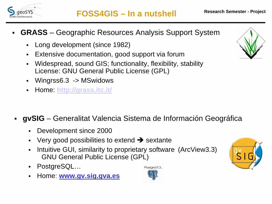
Research Semester - Project FOSS4GIS – In a nutshell
GRASS – Geographic Resources Analysis Support SystemLong development (since 1982)Extensive documentation, good support via forumWidespread, sound GIS; functionality, flexibility, stability License: GNU General Public License (GPL)Wingrss6.3 -> MSwidowsHome: http://grass.itc.it/
gvSIG – Generalitat Valencia Sistema de Información GeográficaDevelopment since 2000Very good possibilities to extend sextanteIntuitive GUI, similarity to proprietary software (ArcView3.3)
GNU General Public License (GPL)PostgreSQL…Home: www.gv.sig.gva.es

Research Semester - Project
SAGA GIS – System for Automated Geoscientific Analysis
Pros and ConsDevelopment since 2001, Open Source since 2004Scientific SoftwareVery good raster processing Good GPS – ImportLow resource requirement no extraordinary hardware requirements StabileGood support Forum No installation Data history Inconvenient data visualization GUI/documentation/forum EnglishDocumentation extendible; no helpPoor print layouthome: http://www.saga-gis.uni-goettingen.de/html/
FOSS4GIS – In a nutshell

Research Semester - Project
ILWIS – Integrated Land and Water Information System
Pros and Cons
Development since 1985, since 2007 Open SourceVery good remote sensing applicationUser friendly -> Very good tutorial; very extensive help systemStatistics, CalculationsGood format support (import/export)Good layout optionsFull functionality via command line Good Scripting Data management based on Domains Uncomfortable GPS – ImportOwn formats (vector, raster)So far, low forum activity home: http://www.itc.nl/ilwis/
FOSS4GIS – In a nutshell

Research Semester - Project
SAGA GIS – System for Automated Geoscientific Analysis
Data VisualizationWorking Environment Objekt PropertiesScreenshot from SAGA GIS
Research Semester - Project
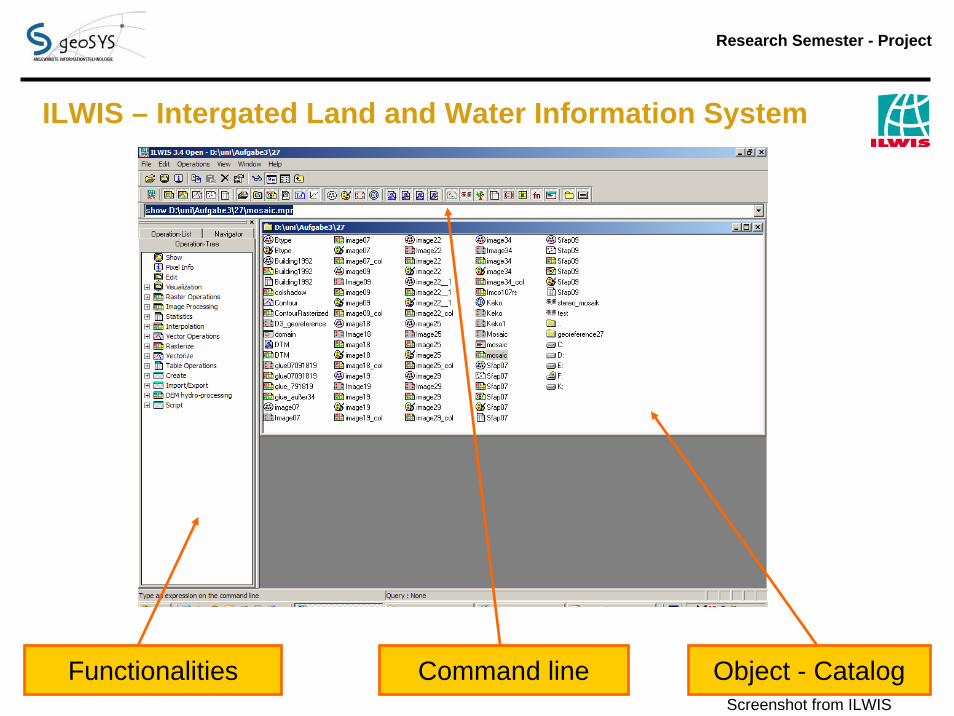
ILWIS – Intergated Land and Water Information System
Functionalities Command line Object - CatalogScreenshot from ILWIS

Research Semester - Project
Criteria Catalogue (Extract) Collection of c.a. 160 criteria were tested Standard setting (ESRI)Provided geodata sets were evaluated
Main topics to be covered:Documentation / User CommunityDevelopment CycleHandlingData – FormatsGeneral ToolsGeoreferencing / Coordinates SystemsDigitizing / EditingGeoprocessingThematic View / Layout OptionsRaster functionalitiesRemote sensing abilities3D View / Animations
Research Semester - Project
Data preparation (training courses) and questionnaire
Provided Datasets of software
Evaluation of available tutorials
General emphasis on raster functionalities
Verification / Comparison with ArcGIS
Evaluation Sheet for students

Research Semester - Project
Questionnaire – some results
In total: 33 Evaluation
Do you think that now or in future OS GIS will substitute proprietary software?
Frage 6
76%
21%
3%
Ja
Nein
Weiß nicht
Research Semester - Project
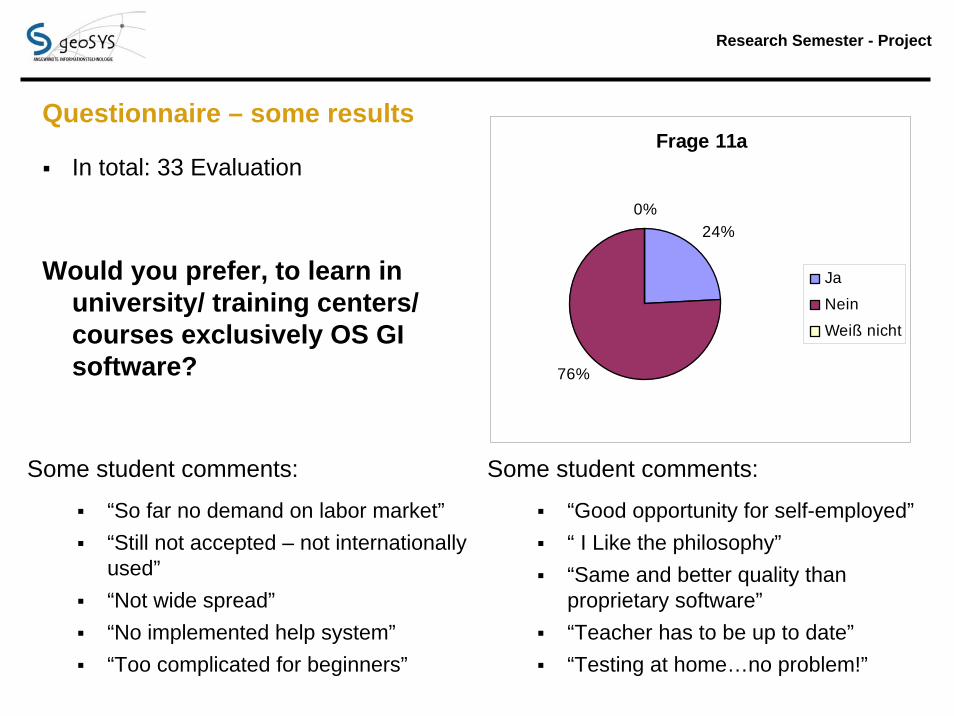
Questionnaire – some results
In total: 33 Evaluation
Would you prefer, to learn in university/ training centers/ courses exclusively OS GI software?
Frage 11a
24%
76%
0%
Ja
Nein
Weiß nicht
Some student comments:
“So far no demand on labor market”“Still not accepted – not internationally used”“Not wide spread”“No implemented help system”“Too complicated for beginners”
Some student comments:
“Good opportunity for self-employed”“ I Like the philosophy”“Same and better quality than proprietary software”“Teacher has to be up to date”“Testing at home…no problem!”
Research Semester - Project
Results, Recommendations, Outlook
Very positive feedbacks! Student’ s side
Surprisingly broad functionality Software's side
Easier to adopt for students with no experience in GIS (ongoing research?) my (subjective) side (as teacher)
Substitution not all at once, but step by step (Extensions) Greater user community in education field (exchange of assignments, ideas, experience…)
Pace of change
System administration -> security
Not “THE one GI software” but taking the best parts of everything
Research Semester - Project
References & Acknowledgement
Mitasova H. (2006) Open Source GIS: A GRASS GIS Approach. 3rd edition. The Kluwer international series in Engineering and Computer Science (SECS): Volume 773. Kluwer Academic Publishers, Boston, Dordrecht, London. ISBN: 1-4020-8064-6. 424 pages
Thank a lot for all work, done by programmers and all other involved people for the great OS software!!!
Special thanks go to the company geoSYS for every support to realize the study!
Thanks to the Fh-Eberswalde, to be able to realize such a project in the frame of the study!
Furthermore I have to express my gratitude to all students who participated in the study! use it or loose it;-)
Research Semester - Project
Questions? -- Thank you for your attention! --


![[FOSS4G Seoul 2015] New Geoprocessing Toolbox in uDig Desktop GIS](https://img.pdfslide.us/doc/110x75/587d50891a28abee158b47a3/foss4g-seoul-2015-new-geoprocessing-toolbox-in-udig-desktop-gis.jpg)
