Embed Size (px)
Citation preview

This article was downloaded by: [University of Southern Queensland]On: 04 October 2014, At: 10:01Publisher: Taylor & FrancisInforma Ltd Registered in England and Wales Registered Number:1072954 Registered office: Mortimer House, 37-41 Mortimer Street,London W1T 3JH, UK
International Journal ofGeographical InformationSciencePublication details, including instructions forauthors and subscription information:http://www.tandfonline.com/loi/tgis20
On the accuracy of TIGER-type geocoded address datain relation to cadastral andcensus areal unitsJerry H. RatcliffePublished online: 06 Aug 2010.
To cite this article: Jerry H. Ratcliffe (2001) On the accuracy of TIGER-type geocoded address data in relation to cadastral and census areal units,International Journal of Geographical Information Science, 15:5, 473-485
To link to this article: http://dx.doi.org/10.1080/13658810110047221
PLEASE SCROLL DOWN FOR ARTICLE
Taylor & Francis makes every effort to ensure the accuracy of allthe information (the “Content”) contained in the publications on ourplatform. However, Taylor & Francis, our agents, and our licensorsmake no representations or warranties whatsoever as to the accuracy,completeness, or suitability for any purpose of the Content. Any opinionsand views expressed in this publication are the opinions and views ofthe authors, and are not the views of or endorsed by Taylor & Francis.The accuracy of the Content should not be relied upon and should beindependently verified with primary sources of information. Taylor andFrancis shall not be liable for any losses, actions, claims, proceedings,demands, costs, expenses, damages, and other liabilities whatsoeveror howsoever caused arising directly or indirectly in connection with, inrelation to or arising out of the use of the Content.

This article may be used for research, teaching, and private studypurposes. Any substantial or systematic reproduction, redistribution,reselling, loan, sub-licensing, systematic supply, or distribution in anyform to anyone is expressly forbidden. Terms & Conditions of accessand use can be found at http://www.tandfonline.com/page/terms-and-conditions
Dow
nloa
ded
by [
Uni
vers
ity o
f So
uthe
rn Q
ueen
slan
d] a
t 10:
01 0
4 O
ctob
er 2
014
int. j. geographical information science, 2001, vol. 15, no. 5, 473± 485
Research Article
On the accuracy of TIGER-type geocoded address data in relation tocadastral and census areal units
JERRY H. RATCLIFFE
School of Policing Studies, Charles Sturt University, NSW Police College,McDermott Drive, Goulburn NSW 2580, Australia; e-mail:jerry.ratcliŒ[email protected]
(Received 20 January 2000; accepted 16 January 2001 )
Abstract. In many applications of Geographical Information Systems (GIS) acommon task is the conversion of addresses into grid coordinates. In manycountries this is usually accomplished using address range TIGER-type � les inconjunction with geocoding packages within a GIS. Improvements in GIS func-tionality and the storage capacity of large databases mean that the spatial investi-gation of data at the individual address level is now commonly performed. Thisprocess relies on the accuracy of the geocoding mechanism and this paper exam-ines this accuracy in relation to cadastral records and census tracts. Results froma study of over 20 000 addresses in Sydney, Australia, using a TIGER-typegeocoding process suggest that 5–7.5% (depending on geocoding method) ofaddresses may be misallocated to census tracts, and more than 50% may be givencoordinates within the land parcel of a diŒerent property.
1. IntroductionThere are now a large number of socio-economic applications that require a
researcher to manipulate address-based data in a Geographical Information System(GIS). As the capabilities of databases and GIS improve, a greater level of resolutionis possible and the individual address is becoming a standard level for spatialinvestigation. Such address-based data may refer to a wide range of records such asinsurance policy holders, medical records or vehicle ownership, and application areasinclude market research, the provision of public utilities and the work of the emer-gency services. To utilise fully the spatial nature of an address it is usually necessaryto create a point associated with the address record. Most GIS have the capabilityto geocode - the process of associating an address record with a point on a map—and to perform spatial queries on the result. Such spatial queries may only requirethe original point data and a number of spatial investigative algorithms have beendesigned for point pattern analysis (Bailey and Gatrell 1995), though other techniquesmay require a point-in-polygon operation to compare the number of point recordswith attribute data associated with an areal unit.
Early work by Gatrell and colleagues (Gatrell 1989, Gatrell et al. 1991) examinedthe relationship between points attributed to UK postcodes at a 100 m resolution,
Internationa l Journal of Geographica l Information ScienceISSN 1365-8816 print/ISSN 1362-3087 online © 2001 Taylor & Francis Ltd
http://www.tandf.co.uk/journalsDOI: 10.1080/13658810110047221
Dow
nloa
ded
by [
Uni
vers
ity o
f So
uthe
rn Q
ueen
slan
d] a
t 10:
01 0
4 O
ctob
er 2
014
J. H. RatcliVe474
with enumeration districts, the smallest UK census tract. Martin and Higgs (1997)reviewed a number of spatial data sets in the UK, comparing council tax registerswith individually geocoded locations, and variations in the number of properties inan enumeration district by various means. These studies concentrated on the extrac-tion of maximum accuracy from postcode information (variously the zip code orpostal code depending on country), used regularly in the UK as a means to protectthe con� dentiality of individuals in a study. Much of the research was conducted ata time when automated individual address mapping was in its infancy, expensiveand generally beyond the scope of many researchers unable to access more descriptiveaddress records. Recent advances in the last decade have raised expectations inlocation referencing, and reduced costs to the level that the centreline data necessaryfor geocoding a city such as Canberra, Australia (population 330 000) costs less thanUS$500. Once access to con� dential address-based data has been negotiated (oftenthe hardest part of the process) it is now possible to use as a matter of routine theindividual property as the unit of spatial investigation. Within the speci� c � eld oflaw enforcement, the imperfections in the geocoding of address data for policingpurposes have been recognised (Harries 1999, PFCML 2000), though not articulatedor quanti� ed clearly. The level of imprecision in geocoding is important to lawenforcement so that a better understanding of the limitations of the data can beappreciated prior to further spatial analysis, analysis that might be spurious giventhe spatial limitations of the geocoded data.
This study aims to build on the previous work in the area, by concerning itselfwith the accuracy of individual address locations in the form of high resolutiongeocoded point data, by comparison with both cadastral records that delineate theindividual target properties, and areal units from the Australian national census. Westart with an outline of the geocoding process before examining the study area inSydney, Australia, in §3 and §4.
2. Geocoding address recordsPoint-in-polygon operations require both points and polygons. Point data for
urban locations are commonly created from geocoded address records. Currentgeocoding tools in the USA and Australia are derived from US TIGER � les, collec-tions of street line segments that hold street names, and the range of house numberson each side of the street as attribute data. The TIGER composition was developedfrom the DIME structure used originally to map US census data and provides aUS-wide address matching standard (Cooke 1998).
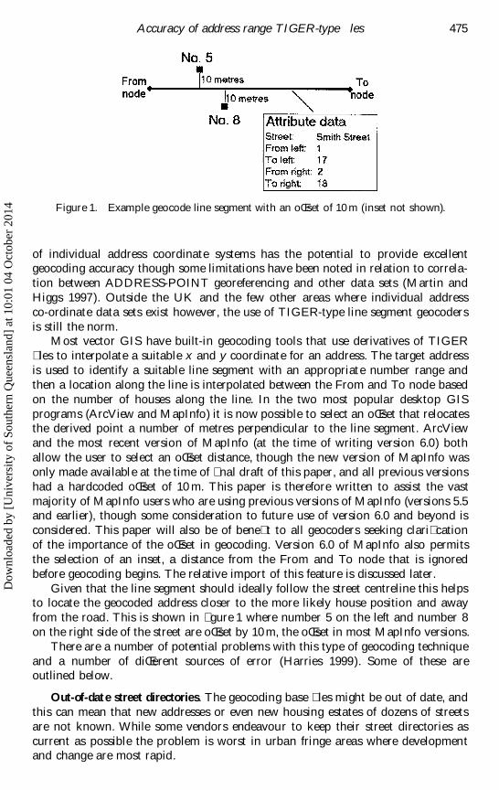
An example is shown in � gure 1 where a polyline for Smith Street has a Fromnode, To node and attribute data. The attribute data for the line indicates that odd
house numbers are on the left side of the street and range from 1 to 17, and theeven numbers found on the right side of the street range from 2 to 18. This is notthe only method of geocoding addresses and some commercial organisations havecreated address registers that contain individual coordinates for every house andaddress. One of the most widely used in the UK is the ADDRESS-POINT data setthat contains x and y coordinates for millions of British addresses. Derived fromOrdnance Survey mapping (www.ordsvy.gov.uk1 ) with a resolution of 0.1 m the use
1 Information relating speci� cally to ADDRESS-POINT is available atwww.ordsvy.gov.uk/productpages/addresspoint/index.htm (accessed January 2001).
Dow
nloa
ded
by [
Uni
vers
ity o
f So
uthe
rn Q
ueen
slan
d] a
t 10:
01 0
4 O
ctob
er 2
014
Accuracy of address range T IGER-type � les 475
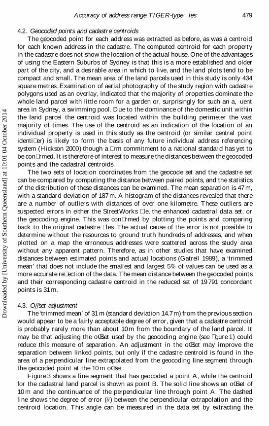
Figure 1. Example geocode line segment with an oŒset of 10 m (inset not shown).
of individual address coordinate systems has the potential to provide excellentgeocoding accuracy though some limitations have been noted in relation to correla-tion between ADDRESS-POINT georeferencing and other data sets (Martin andHiggs 1997). Outside the UK and the few other areas where individual addressco-ordinate data sets exist however, the use of TIGER-type line segment geocodersis still the norm.
Most vector GIS have built-in geocoding tools that use derivatives of TIGER� les to interpolate a suitable x and y coordinate for an address. The target addressis used to identify a suitable line segment with an appropriate number range andthen a location along the line is interpolated between the From and To node basedon the number of houses along the line. In the two most popular desktop GISprograms (ArcView and MapInfo) it is now possible to select an oŒset that relocatesthe derived point a number of metres perpendicular to the line segment. ArcViewand the most recent version of MapInfo (at the time of writing version 6.0) bothallow the user to select an oŒset distance, though the new version of MapInfo wasonly made available at the time of � nal draft of this paper, and all previous versionshad a hardcoded oŒset of 10 m. This paper is therefore written to assist the vastmajority of MapInfo users who are using previous versions of MapInfo (versions 5.5and earlier), though some consideration to future use of version 6.0 and beyond isconsidered. This paper will also be of bene� t to all geocoders seeking clari� cationof the importance of the oŒset in geocoding. Version 6.0 of MapInfo also permitsthe selection of an inset, a distance from the From and To node that is ignoredbefore geocoding begins. The relative import of this feature is discussed later.
Given that the line segment should ideally follow the street centreline this helpsto locate the geocoded address closer to the more likely house position and awayfrom the road. This is shown in � gure 1 where number 5 on the left and number 8on the right side of the street are oŒset by 10 m, the oŒset in most MapInfo versions.
There are a number of potential problems with this type of geocoding techniqueand a number of diŒerent sources of error (Harries 1999). Some of these areoutlined below.
Out-of-date street directories. The geocoding base � les might be out of date, andthis can mean that new addresses or even new housing estates of dozens of streetsare not known. While some vendors endeavour to keep their street directories ascurrent as possible the problem is worst in urban fringe areas where developmentand change are most rapid.
Dow
nloa
ded
by [
Uni
vers
ity o
f So
uthe
rn Q
ueen
slan
d] a
t 10:
01 0
4 O
ctob
er 2
014
J. H. RatcliVe476
Abbreviations or misspelling. Street names can be misspelled or abbreviated. Forexample Smith Street can also be shown as Smith St., Smythe Street, or SmitheStreet. Many geocoding engines may only be able to recognise some of the variations.Often an alias type of table to replace misspellings and abbreviations must bemanually created. Rigid database entry tied to street naming standards can limit theimpact of this type of error. The Australian standard (www.auslig.gov.au) has beenin use for about 5 years and has been developed to establish a consistent set of rulesfor street naming, while similar standards exist in other countries.
Local name variations. In some areas the street directory name of a road maynot re� ect the local name of the road and this can mean that the target addresscannot be matched to the geocode address � le.
Address duplication. In many cities roads are named after historical � gures orplaces and can be duplicated in nearby suburbs. For example, 40 occurrences ofSmith Street can be found in the Sydney street directory. Without the geocodingprocess specifying a suburb or a limiting boundary polygon it is possible for ageocoding engine to � nd multiple matches of common addresses.
Non-existent addresses. Simple typographical errors can easily turn 30 SmithStreet into 300 Smith Street, an address that may not exist.
Line simpli� cation. The sections of line segment may not re� ect accurately thegeography of the road or housing layout. This will reduce the geocoding accuracyand can aŒect streets in hilly areas that can be more winding or new streets inresidential areas that are built on sweeping bends.
Noise in the address � le. Unnecessary additional data can complicate an address� eld. Some householders may choose to give their house a name or a target address� eld may start with a company name and this can be di� cult for a geocoding engineto interpret accurately. For example some geocoders would struggle with:‘Dunroamin, 24 Smith Street’. Similarly a business address can often start with acompany name.
Geocoding non-address locations. A number of organisations such as the emer-gency services might want to record the location of incidents that do not occur inbuildings. Some geocoding engines can use special characters to recognise intersec-tions but, for example, an ambulance supervisor might want to record a road tra� caccident that happened ‘50 metres West of the junction with Brown Street’ or ‘outsidenumber 12 Smith Street’. These locations would be rejected by most geocoders, orthey would geocode to the exact intersection or house.
Geocoding imprecision. The geocoded point might be some distance from theactual address, and it is the extent of this particular problem that the next sectionswill examine.
Ambiguous or vague addresses. Ambiguity of addresses in the target � le (such assimply ‘Smith Street’) can make geocoding impossible. Some geocoders can becon� gured to geocode ambiguous addresses to either the nearest existing address orto the centroid of the line segment. Neither is an ideal solution as a number of vagueaddresses can create a cluster of points at an arbitrary location.
Dow
nloa
ded
by [
Uni
vers
ity o
f So
uthe
rn Q
ueen
slan
d] a
t 10:
01 0
4 O
ctob
er 2
014
Accuracy of address range T IGER-type � les 477
3. Source dataThis study uses three sources of data. The geocoded points have been determined
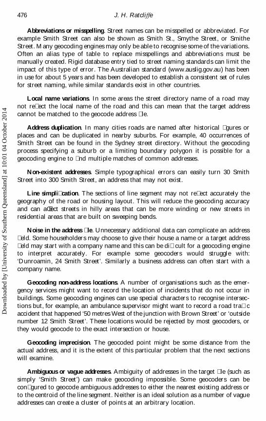
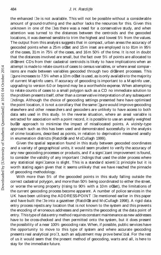
from centreline data for Sydney in StreetWorks version 5.0, available from MapInfoAustralia. This was used in conjunction with the standard geocoding engine foundin MapInfo version 5.5—the most current version at time of analysis. The geocodedlocations have been compared to the cadastral base for the study area. Cadastrerecords are a catalogue of interests in land parcels. Usually these are now retainedas digital maps that contain descriptions of land parcels as well as unique identi� ersthat can be used to identify who has ownership rights to the land as well as otherlegal interests. An enhanced digital cadastral � le has been made available for thisstudy by the Land Information Centre, Bathurst, NSW, Australia. The LandInformation Centre (LIC) is the government mapping organisation for the state ofNew South Wales. Individual polygons in the cadastre are identi� ed by a uniqueLot/Deposited Plan (Lot/DP) number. There is no indication from this uniqueidenti� er as to the conventional address of the property or even the name of thestreet. During 2000 the LIC have been attempting to correlate disparate data sourcesfrom a number of government bodies to try and identify a street number and roadname for each land parcel in the cadastre. Road names exist as an integral part ofthe Digital Cadastre Database (DCDB) for New South Wales and are encoded intothe road polygons but due to technical constraints the names are not included inthe other parcel tags. This is still under development and the choice of study areawas dictated by the availability of data from a semi-completed area. The EasternSuburbs of Sydney, New South Wales, Australia has attracted interest from a numberof organisations since this area was the victim of a severe hail storm in 1998 thatcaused a considerable amount of property damage. Figure 2 shows this region.
The cadastre for this area has had house numbers attached to polygons by theLIC, where these can be determined, though no street names. Where a house numberwas available the complete street name was attached manually by the author. This
Figure 2. The study area in the Eastern suburbs of Sydney.
Dow
nloa
ded
by [
Uni
vers
ity o
f So
uthe
rn Q
ueen
slan
d] a
t 10:
01 0
4 O
ctob
er 2
014
J. H. RatcliVe478
involved identifying the nearest street for the property and con� rming that the houserange for the street matched the house number, and that they were on the correctside of the street, running in the correct direction (see � gure 1). Where any ambiguityexisted the property was not included in the � nal study set. The majority of ambigu-ous locations were on street corners where a house number could have been in eitherstreet. These accounted for less than 2% of the original data set, resulting in over20 000 addresses included in the following analysis.
The third source of data was the polygon boundaries of the census collectiondistricts for the study area. Collection districts (CD) are the smallest geographicalarea de� ned in the Australian Standard Geographical Classi� cation (ASGC). Inurban areas, such as the Eastern Suburbs of Sydney, there is an average of 225dwellings in each of these census tracts. The boundary � les were obtained fromCData96, a production of the Australian Bureau of Statistics that includes censusdata along with boundary � les in MapInfo format.
4. AnalysisA list of 21 890 addresses was obtained by cross-comparison of the StreetWorks
� le and the cadastral data set. This ensured that both � les knew an address. Thepurpose of the study was not to correct every error in each data set, but to extractenough addresses common to both � les that a meaningful analysis could be com-pleted. There are over 21 890 addresses in the study area shown in � gure 2, thougha small proportion did not have house numbers shown in the cadastre � le, or theirhouse number could have referred to more than one street at an intersection. Thislack of completeness in the data set is understandable given that this addressenhanced cadastral data set is still under development. Version 5.5 of MapInfo wasused for the following analysis (this version has a hardcoded oŒset of 10 m).
4.1. Geocoded points and cadastre polygonsThe � rst part of the study performed a standard point-in-polygon operation to
examine the match between geocoded points and their corresponding cadastralpolygons. Of the 21 980 addresses 7774 (35%) geocoded points were located withina polygon from the cadastral set. Unfortunately the majority of these were locatedin the wrong polygon. Only 2165 (10% of the 21 980) were correctly located in theconcordant cadastral polygon, while 5609 (26%) were located in the polygon foranother address. If we consider these as a proportion of only those points that werelocated within a polygon, then this equates to an error level of 72%. This � gure doesnot include those geocoded points that were referenced within another cadastralproperty polygon that was not part of the 21 980 study set.
These � gures would seem to raise cause for concern for researchers and mappersinterested in micro-level mapping applications of address related records. The TIGERsystem was not designed originally along a cadastral basis but was created to providea relatively accurate large scale mapping capability. It is therefore understandablethat to some degree it does not hold up to a micro-level examination. The lownumber of records that were located correctly (10%) did however suggest that furtherwork was necessary to better understand the extent of the geocoding error. Visualinspection of a number of misplaced points showed that a high number were nearthe correct polygon, often located in a neighbouring land parcel, though this wasnot always the case. The next part of the study endeavoured to get a more empiricalmeasure of the error level.
Dow
nloa
ded
by [
Uni
vers
ity o
f So
uthe
rn Q
ueen
slan
d] a
t 10:
01 0
4 O
ctob
er 2
014
Accuracy of address range T IGER-type � les 479
4.2. Geocoded points and cadastre centroidsThe geocoded point for each address was extracted as before, as was a centroid
for each known address in the cadastre. The computed centroid for each propertyin the cadastre does not show the location of the actual house. One of the advantagesof using the Eastern Suburbs of Sydney is that this is a more established and olderpart of the city, and a desirable area in which to live, and the land plots tend to becompact and small. The mean area of the land parcels used in this study is only 434square metres. Examination of aerial photography of the study region with cadastrepolygons used as an overlay, indicated that the majority of properties dominate thewhole land parcel with little room for a garden or, surprisingly for such an a‚ uentarea in Sydney, a swimming pool. Due to the dominance of the domestic unit withinthe land parcel the centroid was located within the building perimeter the vastmajority of times. The use of the centroid as an indication of the location of anindividual property is used in this study as the centroid (or similar central pointidenti� er) is likely to form the basis of any future individual address referencingsystem (Hickson 2000) though a � rm commitment to a national standard has yet tobe con� rmed. It is therefore of interest to measure the distances between the geocodedpoints and the cadastral centroids.
The two sets of location coordinates from the geocode set and the cadastre setcan be compared by computing the distance between paired points, and the statisticsof the distribution of these distances can be examined. The mean separation is 47 m,with a standard deviation of 187 m. A histogram of the distances revealed that thereare a number of outliers with distances of over one kilometre. These outliers aresuspected errors in either the StreetWorks � le, the enhanced cadastral data set, orthe geocoding engine. This was con� rmed by plotting the points and comparingback to the original cadastre � les. The actual cause of the error is not possible todetermine without the resources to ground truth hundreds of addresses, and whenplotted on a map the erroneous addresses were scattered across the study areawithout any apparent pattern. Therefore, as in other studies that have examineddistances between estimated points and actual locations (Gatrell 1989), a ‘trimmedmean’ that does not include the smallest and largest 5% of values can be used as amore accurate re� ection of the data. The mean distance between the geocoded pointsand their corresponding cadastre centroid in the reduced set of 19 791 concordantpoints is 31 m.
4.3. OVset adjustmentThe ‘trimmed mean’ of 31 m (standard deviation 14.7 m) from the previous section
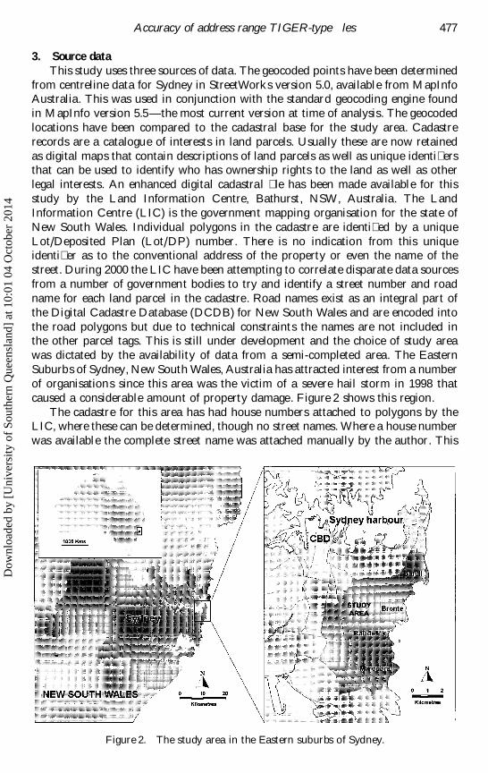
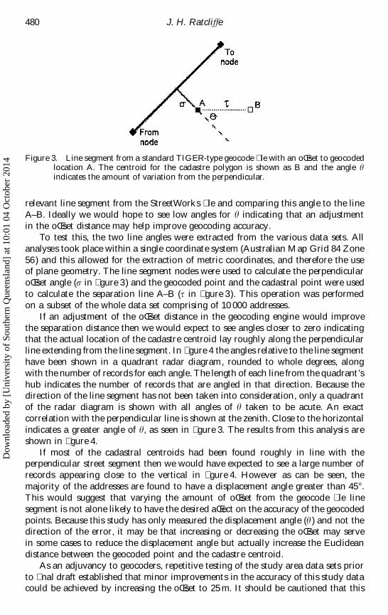
would appear to be a fairly acceptable degree of error, given that a cadastre centroidis probably rarely more than about 10 m from the boundary of the land parcel. Itmay be that adjusting the oŒset used by the geocoding engine (see � gure 1) couldreduce this measure of separation. An adjustment in the oŒset may improve theseparation between linked points, but only if the cadastre centroid is found in thearea of a perpendicular line extrapolated from the geocoding line segment throughthe geocoded point at the 10 m oŒset.
Figure 3 shows a line segment that has geocoded a point A, while the centroidfor the cadastral land parcel is shown as point B. The solid line shows an oŒset of10 m and the continuance of the perpendicular line through point A. The dashedline shows the degree of error (h ) between the perpendicular extrapolation and thecentroid location. This angle can be measured in the data set by extracting the
Dow
nloa
ded
by [
Uni
vers
ity o
f So
uthe
rn Q
ueen
slan
d] a
t 10:
01 0
4 O
ctob
er 2
014
J. H. RatcliVe480
Figure 3. Line segment from a standard TIGER-type geocode � le with an oŒset to geocodedlocation A. The centroid for the cadastre polygon is shown as B and the angle hindicates the amount of variation from the perpendicular.
relevant line segment from the StreetWorks � le and comparing this angle to the lineA–B. Ideally we would hope to see low angles for h indicating that an adjustmentin the oŒset distance may help improve geocoding accuracy.
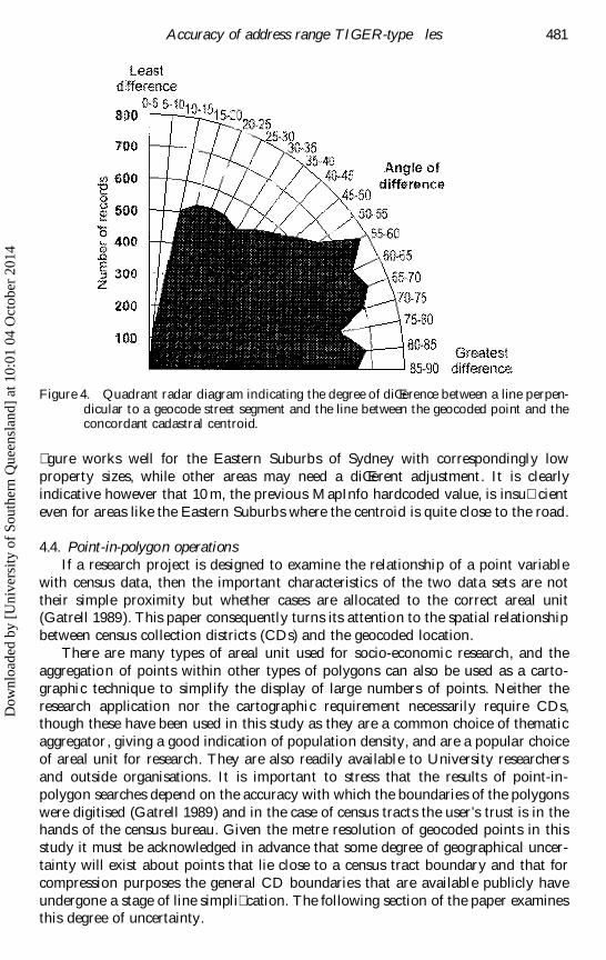
To test this, the two line angles were extracted from the various data sets. Allanalyses took place within a single coordinate system (Australian Map Grid 84 Zone56) and this allowed for the extraction of metric coordinates, and therefore the useof plane geometry. The line segment nodes were used to calculate the perpendicularoŒset angle (s in � gure 3) and the geocoded point and the cadastral point were usedto calculate the separation line A–B (t in � gure 3). This operation was performedon a subset of the whole data set comprising of 10 000 addresses.
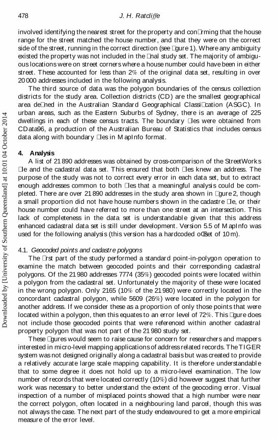
If an adjustment of the oŒset distance in the geocoding engine would improvethe separation distance then we would expect to see angles closer to zero indicatingthat the actual location of the cadastre centroid lay roughly along the perpendicularline extending from the line segment. In � gure 4 the angles relative to the line segmenthave been shown in a quadrant radar diagram, rounded to whole degrees, alongwith the number of records for each angle. The length of each line from the quadrant’shub indicates the number of records that are angled in that direction. Because thedirection of the line segment has not been taken into consideration, only a quadrantof the radar diagram is shown with all angles of h taken to be acute. An exactcorrelation with the perpendicular line is shown at the zenith. Close to the horizontalindicates a greater angle of h, as seen in � gure 3. The results from this analysis areshown in � gure 4.
If most of the cadastral centroids had been found roughly in line with theperpendicular street segment then we would have expected to see a large number ofrecords appearing close to the vertical in � gure 4. However as can be seen, themajority of the addresses are found to have a displacement angle greater than 45 ß .This would suggest that varying the amount of oŒset from the geocode � le linesegment is not alone likely to have the desired aŒect on the accuracy of the geocodedpoints. Because this study has only measured the displacement angle (h ) and not thedirection of the error, it may be that increasing or decreasing the oŒset may servein some cases to reduce the displacement angle but actually increase the Euclideandistance between the geocoded point and the cadastre centroid.
As an adjuvancy to geocoders, repetitive testing of the study area data sets priorto � nal draft established that minor improvements in the accuracy of this study datacould be achieved by increasing the oŒset to 25 m. It should be cautioned that this
Dow
nloa
ded
by [
Uni
vers
ity o
f So
uthe
rn Q
ueen
slan
d] a
t 10:
01 0
4 O
ctob
er 2
014
Accuracy of address range T IGER-type � les 481
Figure 4. Quadrant radar diagram indicating the degree of diŒerence between a line perpen-dicular to a geocode street segment and the line between the geocoded point and theconcordant cadastral centroid.
� gure works well for the Eastern Suburbs of Sydney with correspondingly lowproperty sizes, while other areas may need a diŒerent adjustment. It is clearlyindicative however that 10 m, the previous MapInfo hardcoded value, is insu� cienteven for areas like the Eastern Suburbs where the centroid is quite close to the road.
4.4. Point-in-polygon operationsIf a research project is designed to examine the relationship of a point variable
with census data, then the important characteristics of the two data sets are nottheir simple proximity but whether cases are allocated to the correct areal unit(Gatrell 1989). This paper consequently turns its attention to the spatial relationshipbetween census collection districts (CDs) and the geocoded location.
There are many types of areal unit used for socio-economic research, and theaggregation of points within other types of polygons can also be used as a carto-graphic technique to simplify the display of large numbers of points. Neither theresearch application nor the cartographic requirement necessarily require CDs,though these have been used in this study as they are a common choice of thematicaggregator, giving a good indication of population density, and are a popular choiceof areal unit for research. They are also readily available to University researchersand outside organisations. It is important to stress that the results of point-in-polygon searches depend on the accuracy with which the boundaries of the polygonswere digitised (Gatrell 1989) and in the case of census tracts the user’s trust is in thehands of the census bureau. Given the metre resolution of geocoded points in thisstudy it must be acknowledged in advance that some degree of geographical uncer-tainty will exist about points that lie close to a census tract boundary and that forcompression purposes the general CD boundaries that are available publicly haveundergone a stage of line simpli� cation. The following section of the paper examinesthis degree of uncertainty.
Dow
nloa
ded
by [
Uni
vers
ity o
f So
uthe
rn Q
ueen
slan
d] a
t 10:
01 0
4 O
ctob
er 2
014
J. H. RatcliVe482
Using the CD � le available from the Australian Census Bureau, a point-in-polygon operation was performed on both the geocoded points and the cadastre
centroids for all 21 890 points in the study area. Comparison of the unique identi� ers
for each concordant pair show that 1634 (7.5%) geocoded points fell into diŒerentCDs than their corresponding cadastral centroid. The use of every address in the
study was felt reasonable even though it was known from the earlier analysis that
there were outliers that indicated errors in the geocoding process. This is becausemost GIS users will not have the bene� t of both data sets (given that the cadastre
set used in this study is more or less unique) and in the absence of any indication
to the contrary will take the geocoded location as ‘truth’. Most users of geocodingtools, such as police analysts wanting to map crime occurrence for example, will
neither have the time nor the skills to question and analyse the distribution of 20 000
geocoded locations, and will proceed with their analysis using the points geocodedautomatically by their GIS.
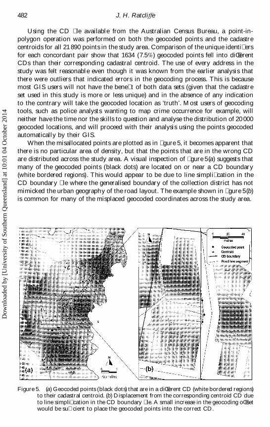
When the misallocated points are plotted as in � gure 5, it becomes apparent that
there is no particular area of density, but that the points that are in the wrong CDare distributed across the study area. A visual inspection of � gure 5(a) suggests that
many of the geocoded points (black dots) are located on or near a CD boundary(white bordered regions). This would appear to be due to line simpli� cation in the
CD boundary � le where the generalised boundary of the collection district has not
mimicked the urban geography of the road layout. The example shown in � gure 5(b)is common for many of the misplaced geocoded coordinates across the study area.
Figure 5. (a) Geocoded points (black dots) that are in a diŒerent CD (white bordered regions)to their cadastral centroid. (b) Displacement from the corresponding centroid CD dueto line simpli� cation in the CD boundary � le. A small increase in the geocoding oŒsetwould be su� cient to place the geocoded points into the correct CD.
Dow
nloa
ded
by [
Uni
vers
ity o
f So
uthe
rn Q
ueen
slan
d] a
t 10:
01 0
4 O
ctob
er 2
014
Accuracy of address range T IGER-type � les 483
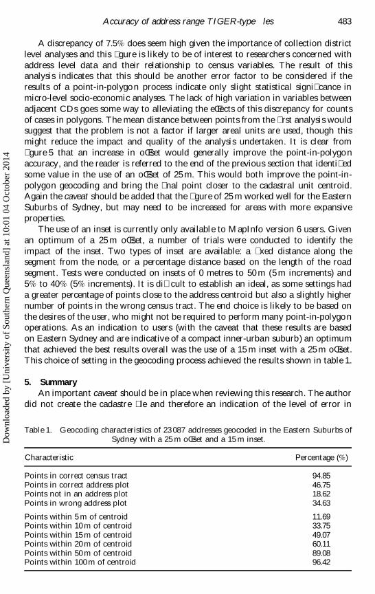
A discrepancy of 7.5% does seem high given the importance of collection districtlevel analyses and this � gure is likely to be of interest to researchers concerned withaddress level data and their relationship to census variables. The result of thisanalysis indicates that this should be another error factor to be considered if theresults of a point-in-polygon process indicate only slight statistical signi� cance inmicro-level socio-economic analyses. The lack of high variation in variables betweenadjacent CDs goes some way to alleviating the eŒects of this discrepancy for countsof cases in polygons. The mean distance between points from the � rst analysis wouldsuggest that the problem is not a factor if larger areal units are used, though thismight reduce the impact and quality of the analysis undertaken. It is clear from� gure 5 that an increase in oŒset would generally improve the point-in-polygonaccuracy, and the reader is referred to the end of the previous section that identi� edsome value in the use of an oŒset of 25 m. This would both improve the point-in-polygon geocoding and bring the � nal point closer to the cadastral unit centroid.Again the caveat should be added that the � gure of 25 m worked well for the EasternSuburbs of Sydney, but may need to be increased for areas with more expansiveproperties.
The use of an inset is currently only available to MapInfo version 6 users. Givenan optimum of a 25 m oŒset, a number of trials were conducted to identify theimpact of the inset. Two types of inset are available: a � xed distance along thesegment from the node, or a percentage distance based on the length of the roadsegment. Tests were conducted on insets of 0 metres to 50 m (5 m increments) and5% to 40% (5% increments). It is di� cult to establish an ideal, as some settings hada greater percentage of points close to the address centroid but also a slightly highernumber of points in the wrong census tract. The end choice is likely to be based onthe desires of the user, who might not be required to perform many point-in-polygonoperations. As an indication to users (with the caveat that these results are basedon Eastern Sydney and are indicative of a compact inner-urban suburb) an optimumthat achieved the best results overall was the use of a 15 m inset with a 25 m oŒset.This choice of setting in the geocoding process achieved the results shown in table 1.
5. SummaryAn important caveat should be in place when reviewing this research. The author
did not create the cadastre � le and therefore an indication of the level of error in
Table 1. Geocoding characteristics of 23 087 addresses geocoded in the Eastern Suburbs ofSydney with a 25 m oŒset and a 15 m inset.
Characteristic Percentage (%)
Points in correct census tract 94.85Points in correct address plot 46.75Points not in an address plot 18.62Points in wrong address plot 34.63
Points within 5 m of centroid 11.69Points within 10 m of centroid 33.75Points within 15 m of centroid 49.07Points within 20 m of centroid 60.11Points within 50 m of centroid 89.08Points within 100 m of centroid 96.42
Dow
nloa
ded
by [
Uni
vers
ity o
f So
uthe
rn Q
ueen
slan
d] a
t 10:
01 0
4 O
ctob
er 2
014
J. H. RatcliVe484
the enhanced � le is not available. This will not be possible without a considerable
amount of ground-truthing and the author lacks the resources for this. Given this
unknown in one of the � les there was a need for a conservative study, and whenattention was turned to the distances between the centroids and the geocoded
locations, it was deemed sensible to trim the highest and lowest 5% from the values.
The output from this analysis suggests that in compact, urban areas the accuracy of
geocoded points when a 25 m oŒset and 15 m inset are employed is to 81m in 95%of the cases, 31 m in 75% of the cases, and 16 m 50% of the time. It is not in doubt
that the distances involved are small, but the fact over 5% of points are allocated to
diŒerent CDs from their cadastral centroids is likely to have implications when an
attempt is made to relate counts of cases to census variables, or where areal compar-isons are made between variables geocoded through two diŒerent processes. This
� gure increases to 7.5% when a 10 m oŒset is used, as is only available to the majority
of current MapInfo users. If accuracy of geocoding is important to a MapInfo user,
upgrading to version 6.0 or beyond may be a worthwhile expense. When attempting
to relate counts of cases to a small polygon such as a CD no immediate solution to
the problem presents itself, other than a conservative interpretation of any subsequent
� ndings. Although the choice of geocoding settings presented here have optimisedthe point location, it is not a corollary that the same � gure would improve geocoding
elsewhere and other researchers and geocoders are unlikely to have access to both
data sets used in this study. In the reverse situation, where an areal variable is
extracted for association with a point record, it is possible to use an areally weighted
buŒer approach to minimise the impact of misallocated points. A vicinity-type
approach such as this has been used and demonstrated successfully in the analysis
of crime locations, described as points, in relation to deprivation measured areallyin enumeration districts (RatcliŒe and McCullagh 1999).
Given the spatial separation found in this study between geocoded coordinates
and a variety of geographical units, it would seem prudent to verify the accuracy of
any new geocoding processes or products, and if a signi� cant improvement is found,
to consider the validity of any important � ndings that used the older process where
any statistical signi� cance is slight. This is a standard scienti� c principle but it is
worth stating again given that it seems unlikely that we have reached the pinnacle
of geocoding methodology.With more than 5% of the geocoded points in this study falling outside the
correct cadastral polygon, and more than 50% being coordinated to either the street,
or worse the wrong property (rising to 90% with a 10 m oŒset), the limitations of
the current geocoding process become apparent. A number of police services in the
UK have been utilising the ADDRESS-POINT � le mentioned earlier in this paper
and have built the � le into a gazetteer (RatcliŒe and McCullagh 1998). A rigid data
entry process rejects any location that is not known to the system and this preventsthe encoding of erroneous addresses and permits the geocoding at the data point of
entry. This type of data entry method requires constant maintenance as new addresses
have to be cross-checked and then permitted onto the system, but it does present
the possibility of a near 100% geocoding rate. When, if possible, public services have
the opportunity to move to this type of system and where accurate geocoding
presents real analytical pro� t, such an adjustment may prove bene� cial. For the rest
of us it would seem that the present method of geocoding, warts and all, is here to
stay for the immediate future.
Dow
nloa
ded
by [
Uni
vers
ity o
f So
uthe
rn Q
ueen
slan
d] a
t 10:
01 0
4 O
ctob
er 2
014
Accuracy of address range T IGER-type � les 485
References
Bailey, T. C., and Gatrell, A. C., 1995, Interactive Spatial Data Analysis (London: Longman).Cooke, D. F., 1998, Topology and TIGER: The Census Bureau’s contribution. In T he History
of Geographical Information Systems: Perspectives from the Pioneers, edited by T. W.Foresman ( Upper Saddle River, NJ: Prentice Hall), pp. 47–57.
Gatrell, A. C., 1989, On the spatial representation and accuracy of address-based data inthe UK. International Journal of Geographical Information Systems, 3, 335–348.
Gatrell, A. C., Dunn, C. E., and Boyle, P. J., 1991, The relative utility of the CentralPostcode Directory and Pinpoint Address Code in applications of geographicalinformation systems. Environment and Planning A, 23, 1447–1458.
Harries, K., 1999, Mapping Crime: Principles and Practice (Washington: US Departmentof Justice).
Hickson, J., 2000, L and Information Centre (Bathurst, NSW, Australia), personalcommunication.
Martin, D., and Higgs, G., 1997, Population georeferencing in England and Wales: basicunits reconsidered. Environment and Planning A, 29, 333–347.
PFCML, 2000, Police Federation Crime Mapping L aboratory, Geocoding in law enforcement:Final report. (Washington DC, US Department of Justice: O� ce of CommunityOrientated Policing Services): 17.
Ratcliffe, J. H., and McCullagh, M. J., 1998, Identifying repeat victimisation with GIS.British Journal of Criminology, 38, 651–662.
Ratcliffe, J. H., and McCullagh, M. J., 1999, Burglary, victimisation and social deprivation.Crime Prevention and Community Safety, 1, 37–46.
Dow
nloa
ded
by [
Uni
vers
ity o
f So
uthe
rn Q
ueen
slan
d] a
t 10:
01 0
4 O
ctob
er 2
014