Embed Size (px)
Citation preview

Olsen, P. E., Schlische, R. W., and Gore, P. J. W. (and others), 1989, Field Guide to the Tectonics, stratigraphy, sedimentology, and paleontology of the Newark Supergroup, eastern North America. International Geological Congress, Guidebooks for Field Trips T351, p. 47-57

3. RICHMOND BASIN, VIRGINIA
GEOLOGY OF THE RICHMOND BASIN (by P.J. W. Gore and P.E. Olsen)
The Riclunond basin is located in east-central Virginia, approximately 19 km west of Riclunond, near the eastern edge of the Piedmont (Figures I.I, 3.1). The basin is surrounded by igneous and metamorphic rocks of the Piedmont Province and bounded on the west by a nonnal fault believed to be a reactivated portion of the Hylas zone (Goodwin et al., 1985), a Paleozoic thrust fault (faylor and Ressetar, 1985) or Alleghenian strike-slip fault {Manspeizer and Gates, 1988). The basin is approximately 53 km long and 15 km wide at its widest point (Goodwin et al., 1985). The dated sedimentary rocks in the basin range from early to middle Carnian (early Late Triassic) (fraverse, 1987; Comet, in press), and a few Jurassic diabase dikes intrude both the rocks in the basin and the surrounding Piedmont (Goodwin et al., 1986). The thickness of the sedimentary fill in the Riclunond basin has been detennined by drilling in several locations. Depth to basement reaches 2177 min the south central part of the basin (Goodwin et al., 1986). Five small outlier basins are present near the northeastern edge of the Riclunond basin and were probably once continuous with the main basin, but were later isolated from it by erosion (Goodwin et al., 1985). Based on trends of maturation and porosity, Comet and Ziegler (1985) stated that more than 2100 m of sediment have been eroded from the Riclunond and Taylorsville basins. If so, the total thickness of sedimentary basin fill in the Riclunond basin may have been as much as 4300 m.
The similarity of the fossil assemblages and facies patterns (Olsen et al., 1982) and the proximity of the two basins suggest that the Richmond basin was once continuous with the Taylorsville basin, which lies just 11 km to the north. The Taylorsville basin extends in the subsurface to the northeast and according to Hansen (1988) is continuous with the recently discovered Queen Anne basin of the Delmarva Peninsula, and possibly its equivalents in southern New Jersey (Sheridan et al., 1988, pers. comm., 1988). Far from being small isolated remnants, the Richmond-Taylorsville-Queen Anne sub-basins constitute one of the largest divisions of the Newark SuJ>t:rgroup, one with a very distinctive stratigraphic and sedimentologic pattern.
Shaler and Woodworth (1899) established the first formal stratigraphic classification of the Riclunond basin (fable 3.1). Recent exploratory drilling and field work by a number of workers have shown the need for revision of their system, including the need for several new unit names. Herein, the revised nomenclature of Ediger et al. (in prep.) is used (Table 3.1 ).
RICHMOND BASIN LITHOSTRA TIGRAPHY AND PALEOENVIRONMENTS (by B. Cornet)
The small size of the Riclunond basin relative to other basins of the Newark Supergroup is deceiving, because the basin occupies the southwestern side of an elongated rift valley area and the distribution of its sedimentary facies suggest that this basin may preserve only a part of the original rift valley fill south of the Taylorsville-Queen Anne basins. Based on the literature (e.g., Taylor, 1835; Clifford, 1887; Shaler and Woodworth, 1899; Goodwin and Farrell, 1979), the basin was thought to contain no more than 1067
m of basin-restricted fluvial, lacustrine, and coal swamp strata. Well and seismic data acquired since 1980 have greatly expanded our knowledge of the stratigraphy and structure of the basin. To date at least 17 shallow wells (under 1000 m) and 3 deep wells have been drilled for oil
STOP 3.1
Skm
\
Figure 3.1: Geologic map or the Richmond basin and its outlier or subsidiary basins (D, Deep Run basin; F, Flat Branch basin), Virginia. Thin, double lines represent dikes; black represents coal measures and interbedded strata. Abbreviations are: Tp, Productive Coal Measures Member and underlying Lower Barren Beds Member or the Tuckahoe Formation; Tv, Vinita Beds Member or the Tuckahoe Formation; Tb, Turkey Branch Formation; 0, Otterdale Formation; and B, Boscabel Formation. Wells are indicated by open circles: a, Horner; b, Hicks; c, Chesapeake; d, Bailey and Turner; e, Hudgins; r, Adamson; and g, Chalkey. B-B' represents transect or seismic renection profile on which cross-section in Figure 3.2 is based. Cross-section A-A' shown in Figure 3.7. Based on Cornet (1977a) and Ediger (1986).
T351: 47

and gas within the basin, with three of them reaching preTriassic basement at 363 m (Chalkey No. l ), 1369 m (J.R. Hicks No. 1), and 2177 m (Bailey No. 1). The Adamson No. 1 was thought to have reached basement at 844 m, but recent seismic interpretation and analysis of bottom hole samples (metasedimentary) suggest that the well terminated at the top of a probable diabase sill in the upper Productive Coal Measures. These wells have all yielded oil and gas shows. One well (Chesapeak No. 1) pumped oil at 5 bbls. (110 bbls water) per day, but commercial production has yet to be established. A major conclusion from data of two of the deep test wells (Homer No. l and Bailey No. 1) is that the basin is more than twice as deep as previously thought.
Three major revisions in our knowledge of the stratigraphy and structure of the basin have occurred since exploration for hydrocarbons in the basin began in 1980 (Figures 3.2 and 3.3): 1) the basin contains an additional sequence of strata (Turkey Branch Formation), which has limited surface exposure and was misidentified as Vinita Beds (q. v. the Turkey Branch section) by Shaler and Woodworth (1899); 2) the Otterdale Formation unconfonnably overlies and hides much of the older Triassic sequence and is a separate geologic unit depositionally unrelated to older facies or sequences; and 3) the basin deepens rapidly south and southwest of Midlothian, Virginia, with the oldest strata cropping out mostly in the northern part of the basin rather than just along the eastern side as in a typical half-graben model (cf. Venkatakrishnan and Lutz, 1988). . Our new understanding of the structure and stratigraphy of the basin is based on the study of seismic, gravity, aeromagnetic, well, and outcrop data (Comet and Ziegler, 1985). Early Camian strata lie unconformably upon metamorphic and igneous basement (lower unconformity, Figure 3.3). A syndepositional unconformity (middle unconformity, Figure 3.3) separates an underlying sequence (Tuckahoe Formation) consisting of about 975 meters of folded, faulted, and rotated deltaic-lacustrine strata (i.e., Vinita Beds Member, Productive Coal Measures Member, and Lower Barren Beds Member) from an overlying sequence (Turkey Branch Formation) consisting of as much as 1128 meters of deltaic-lacustrine and fluvio-deltaic strata. The middle unconformity is best developed in up-dip areas of rotated fault blocks, where it is angular, but may disappear in synclines where deposition was probably
continuous (Figure 3.2). Vinita Beds eroded from the tops of anticlines and steeply-dipping fault blocks were redeposited in synclinal and fault-controlled lows as the Hidden Member, so named because it has no known surface exposure.
Seismic, well, and outcrop data indicate the presence of an erosional unconformity between the Otterdale Formation and the underlying Triassic (upper unconformity, Figures 3.2 and 3.3). This unconformity can be traced due to the incision of deep canyons separated by buttes and plateaus. The Hicks and Turner wells, for example, penetrated a 344-415 m deep canyon system with 26-36 m of talus at its base. Palynomorphs present in shale clasts of this talus indicate a source from the canyon walls. The erosional contact between the Otterdale and the upper Turkey Branch formations can be seen along Old Hundred Road at Stop 3.2 (Figure 3.1 ). Black shale clasts from just above the unconformity contain a palynoflora that correlates with lithologic zone C3 (Figure 3.3).
The Horner and Bailey Wells
During the Summer of 1981 the Homer and Bailey wells (Figures 3.3, 3.4) were drilled about 9.7 km apart (Figure 3.1) and tested the stratigraphic sections in the central and southern thirds of the basin. Since they were drilled in the deeper parts of separate fault blocks, they contain the most complete stratigraphic sequences yet recognized in the basin. The SEPCO J.R. Hicks No. l, for example, which was drilled on the up-dip edge of a rotated fault block, contains a condensed lower section with all of the Lower Barren Beds and most of the Productive Coal Measures members missing (non-deposition), as well as the uppermost part of Vinita Beds Member, which was apparently eroded. A condensed Turkey Branch Formation unconformably overlies the Vinita Beds (seismic interpretation), since most of the Hidden Member is not present (cf. Figure 3.2).
Environmental interpretation using only well cuttings and electric logs leaves considerable latitude for differences of opinion because these data lack valuable depositional features visible in outcrop, such as cross bed types, trace fossils, and mud cracks, which enable geologists to interpret environments of deposition without the aid of paleontology. The study of palynofloral and kerogen facies for the Homer
Table 3.1: Stratigraphy of the Richmond basin, Virginia.
Units Thick-Shaler and Ediger et al. ness (m) Age Description
Woodworth (1899) (in prep.)
OUerdale Otterdale Fm. 415 m fL-.Trias.- Mostly coarse, buff and red fluvial elastics
Sandstone Fm EJw'l
\ e TORWwk 950m M. Gray to black, fine to medium lacustrine, deltaic, and
~~ CreekMbr Camian brown to red fluvial elastics
~ ~ Hidden Mbr 244 m ? E.-M. Gray to black, fine to medium lacustrine elastics and turbiditic
Vinita Beds Fm l:Q Cam.ian sandstones; (subsurface unit)
c: tf Vinita Beds Mbr 640m Early Gray to black, fine to medium deep-water lacustrine elastics
0 -.::i Camian at base, passing upward into deltaic elastics
J 8 Productive Coal ~
Productive Coal 180m Early Coal measures interbedded with gray to black, fine to medium
Measures Fm 0
Measures Mbr Camian fluvio-lacustrine elastics Lower Barren ~ ~ Lower Barren 185 m Early Brown to black, fine to very coarse fluvial elastics Beds Formation Beds Member Camian
Boscabel Boulder ~ ? ? Very coarse, angular fault talus slope breccias Beds Formation al
T35 1: 48

and Bailey wells made it possible to recognire depositional facies and interpret at least the general type of environment .. Certainly the addition and correlation of outcrop data and observations will help refine the interpretations given below.
Palynofloral and kerogen composition of the shales and siltstones reflect the cyclic waxing and waning of a large fresh-water and possibly alkaline lake and the progradation of large deltaic complexes during three different periods of basin history (Figure 3.3; Comet and Olsen, 1985). A graph of the relative percentage of amorphous kerogen (mostly algal debris) in the Homer samples records major lacustrine cycles as zones of high amorphous kerogen content (Figure 3.3, column seven). A second graph (Figure 3.3, column eight) shows the relative abundance of palynomorphs in the palynological preparations (i.e., number of palynomorphs per traverse of a slide). That graph tends to track the curve for amorphous kerogen; the correlation between the curves reflects the finer grain size of the sediments yielding the higher concentrations of kerogen and palynomorphs. Higher than normal percentages of palynomorphs occur in prodeltaic facies underlying prograding deltaic complexes and in swamp facies that lie on top of deltas. A third graph (Figure 3.3, column nine) tracks the relative percentage of pollen versus spores in the Homer No. 1. Intervals dominated by spores are interpreted to reflect either swampy or lacustrine facies, whereas intervals dominated by pollen are believed to reflect either prodeltaic or fluviodeltaic facies. Swampy conditions correlate with the presence of coals, whereas strictly fluvial conditions
correlate with very low palynomorph abundances, a strong dominance by pollen, and an abundance of sandstone.
A fourth graph (Figure 3.3, column 10) gives a summary of lacustrine transgressions and regressions in proximity to the Homer No. 1 well, based on the data in Figure 3.3. Deltas prograding in one part of the basin may be replaced by lacustrine or prodeltaic facies in another part; the deltaic complex present in the Homer No. 1 near the top of the Vinita Beds Member, for example, is represented by shallow lacustrine and delta-margin deposits with high palynomorph abundance in the Bailey No. 1 well. The fourth graph portrays the major trends in lake history for the center of the basin and does not reflect short-duration fluctuations in water depth (i.e., precession cycles) that may have occurred from orbital forcing of the climate. Shortduration depositional cycles are apparent in the Homer and Bailey wells, but water depth apparently did not fall to the extent that it did in the Newark basin, where the lake actually dried up about every 21,000 years (Olsen, 1986). The lacustrine history as presented in Figure 3.3 reflects both long term climatic cycles on the order of 1.6 million years (see below; Comet, in press) and local tectonic subsidence mediated by structural deformation.
Two types of depositional cycles are recognizable in the Richmond basin wells: 1) very thick, generally coarseningupward cycles of approximately 838 m in thickness, consisting of swamp and shallow lacustrine deposits dominated by cryptogam spores in the lowest part, mostly lacustrine facies in the middle, and fluvial-deltaic facies dominated by pollen in the upper part of the cycle, and 2)
AGE LITHOSTRATIGRAPHIC UNITS
JURASSIC?
L A T E
T R I A s s I c
M I D DC L A E R
TO N I
E A A N R L y
M ? "R LAtt?
T u R K E y F eM R A N c H
BASEMENT COMPLEX
POORLY-SORTED ARKOSIC D ORGANIC-POOR COARSER SANDSTONES AND CONGLOMERATES LACUSTRINE FACIES
rr:11 WELL-SORTED SANDSTONES DOMINANT I I ORGANIC-RICH FINER [ifil IN FLUVIAL-DELTAIC FACIES LACUSTRINE FACIES
Figure 3.2: Idealized cross section or the Richmond basin along seismic line B-B' (Figure 3.1). The similarity in general l.ithostratigraphy between the Tuckahoe and Turkey Branch formations is a renection or long-term climatic cycles, whereas the up-dip truncation of the Tuckahoe Formation and the wedge shape or the Hidden Member are the direct results or tectonism. Formation names and ages are from Ediger et al. (in prep.). PCM Mbr. = Productive Coal Measures Member; LBB Mbr. =Lower Barrtn Beds Member.
T351: 49
smaller-scale coarsening-upward cycles averaging 28 m in thickness (Comet. in press). The smaller cycles range from 15-45 m in thickness, with organic carbon-rich shale intervals usually separated by more than 9 m and typically by at least 18 m of sandstone and siltstone.
The smaller cycles are believed to be double cycles (i.e., two cycles of 21 ,000 yr., or 42,000 yr.), because they frequently have a shalier or siltier bed near their middle and sometimes are divisible into two coarsening-upward cycles of similar thickness (cf Ediger, 1986). Palynofloral change
through these double cycles sometimes shows a high fem spore count near the center, suggesting that the most obvious cycles are not the smallest ones (i.e., equivalent to the 21,000 year precession cycles; Olsen, 1986). Every other cycle in the Homer and Bailey wells may have been masked to a greater or lesser extent by the movement of coarse sediment into the deeper parts of the basin (via gravity slides and turbidites?) when lake level was high.
Two complete large-scale cycles (i.e., 838 m) and the top and bottom portions of two others are preserved. The two
BAILEY No.1 HORNER No.1 HORNER DATA _!,ti.!!:!,_ ~ AMORPHOUS RELATIVE POLLEN/ LACUST;RINE
COMPOS1n FOIWATION s1 LT STONE SANOSTONE s1 LTSTONE SANDSTONE KEAOOEN PALYNOMOA. SPORE TAANSGA£SS/ BAILEY No. 1 HORNER No. 1 OEPTH • MIEMeER 1.0 A~~;o o,:,.u:~NT 01.0 R~510 010:R:NT 0 PER;o~"~,;,eu~~·".,;10 AA~~o i.o REGRESS datum
' M OTTERDALE ' 1 FORMATION
1.000
500 T u R K
2,000 E y
B R A N c H
F 3,000 0
R M
1, A T I
0 N
4,000
1,SOO 5,000 T
2,
7,000
u c K A H 0 E
TOMAHAWK
CREEK
MEllllHll
MElllllER
LOWER BARREN
llEOS MEMBER
BASEMENT
0 i--1---~-- 0
500 500
1,000 - 1,000
E3
1,500 1,500
03
2,000 TRANS
2,000 --
J 3 ";?- <t 6,000
6,500
8 2 D 6,000 - CJ A2 T.0.6328
7,000 7140 ----- · BASEMENT
Figure 3.3: Properties, interpretations, and lithozone correlation of the sections in the Horner No. 1 and Bailey No. 1 wells, Richmond Basin.
T351: 50

>.,)
w
\J
1
\J1
%
c:
PO
INT
BA
R 1
2
~
PO
INT
BA
R 1
1 C
RE
VA
SS
E S
PL
AY
S
C
....----....
C)
PO
INT
BA
R 1
4 I I
I,. /
8 I I I I I I I I I I I I I I I I I I I
,, i I I I I I I I I I I I I I I I I
PO
I N
T B
AR
13
/
A
'-
I I I I
I I I
I I I I I
I I I I I I I I
I I
I I
I/ ,, I I
I I I I I I I I I I I I I I I I
I I I I I I I I I I I I I
----
:~ !
I
Is I
I I
I
I I
I
/ I
I I I
I I
: I
I I
I I/
I
I I
I I
I I
I ,'
I
I I I
~ I
I 11
I
I It
I I
I I
A
I I ••
I I I I I I I I I I I I I I J.1i
.. "'
1• I
8 I I I I I I
, , I
I '
I I
: I
I I
I I
I ' 0
I I
I <n
::a
0 /
_j_
__
J ~ ~ u
; I
_,, .
.. ..
--I
>>
-4
I ,'
(\
I <
<n
>
I _
/'_
,._
/\.
! ~
r-,-
.-..
I - I~
0 (l)
::a
..,,,,
r-<
,.
>
<<
n
I <n
g:
I ,..,,.,,------~~
I/'
: -
N
1! •
I.
Fig
ure
3.4:
Cor
rela
tion
of
gam
ma
and
indu
ctio
n lo
gs a
nd f
acie
s in
terp
reta
tion
fo
r lit
holo
gic
zone
DJ
in t
he H
udgi
ns N
o. 1
, C
hesa
peak
e N
o. 1
, and
Tu
rner
No.
4 w
ells
. T
he c
lose
spa
cing
or t
hese
thr
ee w
ells
(Fig
ure
3.1)
and
the
sud
den
tran
siti
on t
o ov
erba
nk f
acie
s in
all
thre
e w
ells
at t
he to
p o
r the
cha
nnel
fill
sequ
ence
mad
e it
pos
sibl
e to
reco
gn
iu th
ese
chan
nel f
orm
s as
di
ffer
ent p
arts
of
a ve
.ry la
rge
mea
nder
set.
See
Cos
sey
and
Fra
nk (1
983)
for
ele
ctri
c lo
g re
spon
ses
in a
n E
ocen
e de
ltai
c po
int
bar.
(')
%
m
(/l >
"'O
m
>
;lo: m
z ~

_fOmplete cycles are depicted by lithologic zones A2 to D2 and A3 to D3, respectively, in Figure 3.3. Portions of the two additional (incomplete) cycles are depicted by lithologic zones DI (only penetrated by the Bailey No. 1 well) and E3 to F3 (present in both the Homer No. 1 and Bailey No. 1 wells). The youngest cycle (E3-F3) shows no return to basin-wide lacustrine conditions and lithologically appears to be a continuation of the preceding cycle (cycle 3), but palynoflorules from that part of the section show a distinct return to wet climatic conditions with the dominance of the local flora by hydrophytic cryptogamous plants (Figure 3.3, swampy in column 6) and the formation of local coal beds (Figures 3.3). The fact that the lake did not return in the upper Tomahawk Creek Member is consistent with models of rift basin filling, where the deepest lakes and most organic carbon-rich shales occur early in basin history, and fluvial environments with common red beds dominate the stratigraphy late in basin history (Lambiase and Rodgers, 1988; Schlische and Olsen, in review; this volume).
The eastern and northeastern parts of the basin experienced significant uplift and erosion during the deposition of the Hidden Member, which reaches 244 m in the Homer and Bailey wells. Evidence for such erosion comes from the sandstones in this member, which are better sorted and more porous than older and immediately younger sandstones of the basin. These sandstones are probably the result of recycling of eroded Triassic sands and are organized into about 30 well-sorted sandstone beds, interpreted as turbidites, and two thick poorly-sorted slumps (e.g., core #1, Homer well), separated by discrete shale beds. The turbidites become thinner and finer towards the south, become more closely spaced upwards in the Hidden Member as the rate of sedimentation decreased, and are capped by a thick shale unit. The restricted development of strata younger than the Vinita Beds Member in the northern part of the basin may be due to syndepositional erosion and non-deposition following deformation.
River Size and Form
The fluvial environments established during lithologic zone 03 can be identified and mapped, because many of the wells drilled in the basin (Figure 3.1) penetrated this sequence. The Homer No. 1 and Gordon No. 1 show mainly overbank and crevasse splay deposits, whereas the three Turner wells, the Chesapeake No. 1, the Hudgins No. 1, and the Bailey No. 1 show mainly point bar and channel deposits (cf. Figure 3. l ). The point bars can be identified on electric logs as fining-upward sequences of sandstone and siltstone and are very thick for a basin as small as the Richmond, ranging from 26 m to over 46 m in thickness. These point bars are stacked as a sequence of upper point bar sandstones in the Hudgins No. 1, whereas the sequence is mainly middle point bar sandstones containing clay drapes in the Chesapeake No. l, and conglomeratic lower point bar sandstones in the Turner No. 4 (Figure 3.4) and in the Hicks No. 1, located at the up-dip edge of a rotated fault block. The similarity of the dominantly shale channel-fill sequences to the correlative overbank sequence in the Homer No. 1 is noteworthy.
The repetition of similar sedimentary structures in each well suggests a strong degree of structural control for the path of the river. It would appear that a large river traversed the basin from southwest to east toward the end of Triassic deposition, probaby continuing into the Taylorsville part of the rift valley. Because of the narrow width of the meander belt and the large size of the river, the channel form was
repeated in successive sequences, resulting in the stacking of similar facies to form repetitious sequences in the closely-spaced wells (Figure 3.4). By contrast, the west central part of the basin received mainly overbank deposits during this time.
Lake Duration
The Richmond-Taylorsville basins represent the oldest rift valley deposits currently recognized south of Nova Scotia and developed at a time when the North American plate was near the paleo-equator (Comet and Olsen, 1985; Comet, in press). A humid tropical climate and the presence of large rivers that emptied into the rift valley created lakes that frequently filled and interconnected the basins, and existed for long periods of time, much like lakes Tanganyika and Malawi of East Africa. The dominance of lacustrine environments despite climatic fluctuations is a pattern very different from that of the Newark, Gettysburg, and Culpeper basins, where lakes dried up periodically, and lake margin facies were reworked into the basin. Depositional topography is therefore much more likely to be preserved in the Richmond-Taylorsville rift, as deltaic sands became encapsulated by lacustrine shales.
mileage 0 Leave previous night's stop, turning left onto VA 15
South. 0.2 Tum onto US 460 east (toward Richmond). 1.6 Cross Briery Creek downstream of the Briery Creek
basin. 7.0 Turn left onto VA 309 East toward US 360 (about 9
miles). 16.l Tum left on US 360 toward Richmond and Amelia. 41.9 Clover Hill. A major coal mine once existed near here in
the Richmond basin. 46.8 Powhite Parkway overpass. Follow US 360 east. 48.7 Intersection of US 360 and VA 604. 49 .8 Tum left onto Courthouse Road (VA 653) heading north. 54.4 Intersection with US 60, begin North VA 147. Continue
straight on VA 147 for 0.3 mi. 54.7 Tum left on Old Buckingham Road (VA 677). 55.4 Tum right onto Old Blackheath Road (Road 1482). 55.9 Tum right onto Deerhurst Drive (Road 1232) in a
housing subdivision. 56.l Follow to cul-de-sac and park.
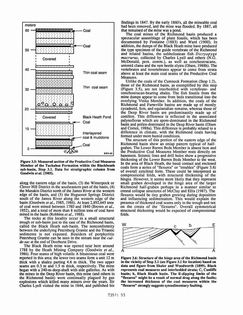
STOP 3.1: BLACKHEATH MINE (by P.J.W. Gore and P.E. Olsen) Highlights: Productive Coal Measures; structure at the updip edge of the Richmond basin.
Follow path to railroad tracks on the left (northwest) side of Deerhurst Drive. Walk along railroad tracks approximately 145-150 paces to the left (southwest), and follow a path into the woods on the right (northwest) to a stream. [The path can also be reached by walking straight back behind the house at 11808 Deerhurst Drive]. Tuckahoe Group coals and associated sedimentary rocks are exposed in the banks of the stream (Figure 3.5).
Coal was mined in the Richmond basin from the early 1700's until the 1930's (Goodwin et al., 1985, 1986). Five major mining centers were present in the basin: (1) the Midlothian District south of the James River along the eastern edge of the basin, part of which we will see here, (2) the Gayton or Carbon Hill District north of the James River
T351: 52
meters
60 --t=====~p--Coal .......... . . . . . . . . . . . . . . . . . . . . . . . . . . . . . . ...... ... . . . . . . . . . . . . . ........... .. . . . . . . . . . . . . .
,,..__Coal 50 __, ·: ·: ·: ·: ·: ·: ·: ·: ·: ·: ·: ·: ·: .............
Covered
••• j
Thin coal seam
30
-·-. -. -· -. -·-· -·-. -. -·-. -·-·-. -. -·-·-·-·-. -· -·-·-. -. -. -·-. -·-·-· -·-·-·-·-. -·-·-. -· ... ·-·-·-.... . -·-·-· ... . -......... -. -·-·-·-·-· -. -·-·. -. -. -·-· -·-·-. -·-. -·-·-. ·-·-. -·-· -·-. -·-. -·-·-. -. ... . -. -. -. -·- ·-. -. -............ -. -. -. -·-·-·-·-. -·-·-·-· -· ......... .... ........... . . . . . . . . . . . . . . . . . . . . . . . . . . . . ... ..........
Thin coal seam
: Covered 1
Black Heath Pond
~ : : : : : : : : : : : .\ .____ Coal
10 ................ : ........ I ·: ·: ·: -: ·: ·: -: ·: ·: ·: ·: ·: ·: lnterlayered
1. · · · · · · · · · · ·'........-coal & mudstone
0 >"":;:;:;:;:;:;:;:::3~6:-Coal
RWS-89
Figure 3.5: Measured section of the Productive Coal Measures Member of the Tuckahoe Formation within the Blackheath sub-basin, Stop 3.1. Data for stratigraphic column from Goodwin et aL (1985).
alogg the eastern edge of the basin, (3) the Winterpock or Clover Hill District in the southeastern part of the basin, (4) the Manakin District north of the James River at the western edge of the basin, and (5) the Huguenot Springs District south of the James River along the western edge of the basin (Goodwin et al., 1985, 1986). At least 2,892,645 tons of coal were mined between 1780 and 1840 (Brown et al., 1952), and a total of more than 8 million tons of coal have mined in the basin (Robbins et al., 1988).
The rocks at this locality occur in a small structural trough or sub-basin just to the east of the Richmond basin, called the Black Heath sub-basin. The nonconfonnity between the underlying Petersburg Granite and the Triassic sediments is not exposed. Boulders of porphyritic Petersburg Granite can be seen in the stream near the cu/de-sac at the end of Deerhurst Drive.
The Black Heath mine was opened near here around 1788 by the Heath Mining Company (Goodwin et al., 1986). Four seams of high volatile A bituminous coal were reported in this area; the lower two seams fonn a unit 12 m thick with a shaley parting 4.6 m thick. The two upper seams are 0.3 m and 1.5 m thick, respectively. The mine began with a 240-m-deep-shaft with side galleries. As with the mines in the Deep River basin, this mine.(and others in the Richmond basin) were continually plagued by gas explosions which killed many miners over the years. Sir Charles Lyell visited the mine in 1844, and published his
findings in 1847. By the early 1860's, all the mineable coal had been removed, and the mine was flooded. By 1887, all that remained of the mine was a pond.
The coal mines of the Richmond basin produced a spectacular assemblage of plant fossils, which has been documented by Fontaine (1883) and Ward (1900). In addition, the dumps of the Black Heath mine have produced the type specimen of the guide vertebrate of the Richmond and related basins, the subholostean fish Dictyopyge macrurus, collected by Charles Lyell and others (N.G. McDonald, pers. comm.), as well as conchostracans, unionid clams and the rare beetle elytra (Olsen, 1988b). The vertebrates and invertebrates appear to come from strata above at least the main coal seams of the Productive Coal Measures.
Unlike the coals of the Cumnock Fonnation (Stop 1.2), those of the Richmond basin, as exemplified by this stop (Figure 3.5), are not interbedded with vertebrate- and conchostracan-bearing shales. The fish fossils from the mine dumps appear to come from beds transitional into the overlying Vinita Member. In addition, the coals of the Richmond and Fannville basins are made up of mostly cycadeoid, fem, and equisetalian remains, whereas those of the Deep River basin are predominantly made up of conifers. This difference is reflected in the associated palynofloras which are spore-dominated in the Richmond basin and pollen-dominated in the Deep River basin (Olsen and Comet, 1988a). This difference is probably related to a difference in climate, with the Richmond coals having fonned under more humid conditions.
The structure of this portion of the eastern edge of the Richmond basin show an onlap pattern typical of halfgraben. The Lower Barren Beds Member is absent here and the Productive Coal Measures Member rests directly on basement. Seismic lines and drill holes show a progressive thickening of the Lower Barren Beds Member to the west. In the area of Black Heath, the basal contact and enclosed coals fonn a series of "flexures" or "troubles" (Figure 3.6) of overall synclinal fonn. These could be interpreted as compressional folds, with structural thickening of the hinges. However, it seems more likely that they represent small graben developed in the hinge area of the larger Richmond half-graben perhaps in a manner similar to crestal collapse structures of McClay and Ellis (1987). The flexures would be tiny graben growing during deposition and influencing sedimentation. This would explain the presence of thickened coal seams only in the trough and not on the crests of the "flexures". Overall symmetrical structural thickening would be expected of compressional folds.
W c b E
~] A A Figure 3.6: Structure or the hinge area of the Richmond basin in the vicinity of Stop 3.1 (see Figure 3.1 ror location) based on data and figure from Shaler and Woodworth (1899). Black represents coal measures and interbedded strata; C, Cunliffe basin; b, Black Heath basin. The E-dipping limbs or the "flexures" might be a result of normal drag along the faults; the increased thickness or the coal measures within the "flexures" strongly suggests synsedimentary faulting.
T351 : 53

56.1 56.4 56.5 57.0 58.0
58.5
62.0
62.5 63.2
Leave cul-de-sac. Pass Blackheath Road. Tum left onto Olde Coalmine Road (Road 1265). Tum right onto VA 677 (Buckingham Road). Turn right onto US 60 (Midlothian Turnpike) at shopping center. Turn left on Coalfield Road (VA 754), just past the high school. Tum right (west) at T-junction. Turn right (nonhwest) onto VA 652, Old Hundred Road. Road will tum to left and become a din road. OulCrop of Vinita (?) Beds. Stop and park.
STOP 3.2: TOMAHAWK TETRAPOD QUARRY (by P.E. Olsen) Highlights: One of the richest vertebrate localities in Triassic rocks in North America.
Because of a lack of exposures, the vertebrate paleontology of the early Camian portion of the Newark Supergroup has been very poorly known, but recently joint teams from Columbia University (Olsen), the Smithsonian Institution (Hans-Dieter Sues), Rutgers University (ShayMaria Silvestri) and the Virginia Museum of Science (Noel Boaz) have excavated a spectacularly rich reptile assemblage in the Turkey Branch Formation which should shed considerable light on this time period. Unlike all other North American Triassic age assemblages, this one is dominated by mammal-like reptiles and is closely comparable to those known for many years from southern Africa, Brazil, and Argentina. Most common is an advanced traversodont mammal-like reptile almost identical to Massetognathus (Figure 3.7 A), otherwise known only from
B
Figure 3.7: Vertebrates from the Tomahawk tetrapod quarry, Turkey Branch Formation, Stop 3.2: A) Massetognathus (redrawn from Jenkins, 1970); B) speculative reconstruction of d. Microconodon (adapted from Romer and Lewis, 1973); C) Doswellia kallenbachia (adapted from Weems, 1980). Scale is2cm.
Argentina. Most of the other reptiles present were previously unknown from North America but resemble southern hemisphere forms, whereas others appear to be completely new. A faunal list as of February 1989 is given in Table 3.2. A major discovery is excellent jaw and skull material of what appears to be a form similar to Microconodon (from the Cumnock Formation of the Sanford sub-basin) and one of the closest reptilian forms to mammals (Figure 3.7 B). For the first time it is clear that the differences between the Camian assemblages of Laurasia and Gondwanaland were due to differences in age rather than geographic isolation.
Table 3.2: Vertebrates and invertebrates from the Richmond basin. Lithologic units: CM) productive coal measures or Tuckahoe Formation; V) Vinta beds of Tuckahoe Formation; T) Turkey Branch Formation; 0) Otterdale Formation. Field stop occurences: b) Boscabel Quarry (3.4); t) Tomahawk Quarry (Stop 3.2); bh) Blackheath (Stop 3.1).
Mollusks Pelecypoda
Unionidae undetermined clams [Y,bh]
Arthropods Crustacea
Diplostraca (clam shrimp and water fleas) Cyzicus sp. [Y, bh; T, t] ?Paleolimnadia sp. [Y, bh; ?Y, b]
Ostracoda Darwinula spp. [Y, bh; T,t]
?Decapoda tScoyenia [?PM, bh; T; OJ
Insecta Coleoptera (beetles)
undetermined fragments [Y, bh] Pisces (fish)
Actinopterygii (bony fishes) Palaeonisciformes
Tannaocrossus sp. [VJ Dictopyge macrusus [Y, bh, b; T, t] Cwnichlhys meekeri [Y, b]
Amphibia ?Urodela?
undientifiedjaws and vertebrae [T, t] Reptilia
Procolophonia Procolophonidae
unidentified form [T, t] Synapsida ·
Traversodontidae aff. Massetognathus [T, t]
?Chiniquodontidae new genus near Microconodon [T,
incertae sedis 2 new taxa near Tricuspes [T, t]
Lepidosauromorpha Sphenodonta
unidentified form [T, t] ?Lacertilia
unidentified form [T, t] Archosauria
?Proterochamsidae Doswellia kaltenbachia [T, t]
Phytosauridae (crocodile like archosaurs) ?? teeth [T, t]
Archosauria incertae sedis bilaterally compressed teeth [T, t] small recurved conical teeth [Y, b, bh; T, t]
T351: 54

The outcrops occur along the northeast bank of Old Hundred Road, just east of the east branch of Tomahawk Creek, on what was the Tomahawk Plantation. The section consists of a poorly-exposed sequence of laminated conchostracan-bearing claystone grading up into massive mudstone and nodular limestone with root structures, in which the tetrapod bones are found. The bones occur as disarticulated but partially associated skulls and skeletons, as well as small isolated bone fragments. Unlike virtually all of the other Newark bone localities, the bone is hard, almost uncrushed, and separated easily from the rock. Microvertebrates are recovered by bulk processing in kerosene and hot water and sieving. Microvertebrate remains found so far include more mammal-like reptile teeth, and bones and jaws of lizard-like and salamander-like forms.
63.2 Continue northwest on Old Hundred Road. 64.6 Tum left on Ouerdale Road (VA 667). 66.2 Cross Swift Creek. 66.6 Weathered exposure of Vinita Beds in road cut on left
side of the road, according to Goodwin et al. (1985). 66.8 Cross VA 604 (Genito Road). Continue south on VA
667. 67.2 Cross Ouerdale Branch. Conglomerate is exposed in the
creek bed on the right Continue to a T junction 2 miles after crossing creek.
68.2 Near here, three wells were drilled by Merrill Natural Resources and Shore Petroleum betweenl980 and 1985.
69.2 Tum left at T junction (staying on Otterdale Road). 71.0 Tum right (west) onto US 360 (Hull Street Road). 72.3 Tum left onto VA 730, Baldwin Creek Road. 73.6 Stop sign at Beach Road (VA 665). Park.
STOP 3.3: OTTERDALE FORMATION NEAR WINTERPOCK, VA (by P.J.W. Gore) Highlights: Sandstone with petrified wood in saprolite and liesegang banding.
The Otterdale Formation is the uppermost unit in the Richmond basin. This outcrop is a conglomeratic, coarsegrained, arkosic sandstone with associated siltstone altered to saprolite, but the overall geometry, sedimentary structures and textures of the Otterdale Formation are well exposed.
Four lithologies are present in this exposure: (1) poorlysorted, matrix-supported, pebbly conglomerate in lenticular beds 30-60 cm thick with poorly defined planar bedding; (2) poorly-sorted, sandy to clayey siltstone in beds 60-180 cm thick, which vary in thickness laterally; (3) cross-bedded, pebbly, coarse arkosic sandstone in beds 30-150 cm thick; and (4) cross-bedded, planar-bedded, or graded, coarse arkosic sandstone in beds 30-60 cm thick (Roberts, 1986). The sandstone consists of quartz, highly-weathered feldspar (now clay), and muscovite (Roberts, 1986). Channel forms and dune-scale trough cross-beds are visible in the sides of the pit (Goodwin et al., 1986). Boulders and cobbles overlie distinct erosional surface-truncated cross-bedded sandstone. Most clasts are subrounded to subangular, but a few are angular and some are rounded (Roberts, 1986). There is a varied suite of clast lithologies in the Otterdale, including muscovite schist, granite gneiss, quartzite, vein quartz, cataclastic rock, and granite (which is the most common), derived from nearby Piedmont rocks, but many of the clasts are highly weathered and difficult to identify (Roberts, 1986). Weathering has produced liesegang banding in the
sandstone, which locally obscures primary sedimentary structures.
On the basis of lithologies and sedimentary structures, the Otterdale could be interpreted as a braided stream (Goodwin et al., 1985) or alluvial fan deposit (Roberts, 1986). Smoot (pers. comm.) argues that the dominance of dune-scale cross bedding points more towards a large-scale braided river. The scale of the system is clearly larger than most fluvial systems in the Newark Supergroup, and because the Otterdale appears to blanket much of the Richmond basin, the rivers were probably through-flowing and the basin hydrologically open. Smoot (1985) argues that either the Otterdale represents a through-going drainage system in a small basin or that the Richmond basin is an erosional remnant of what was a much larger basin. Interpreted in terms of the basin filling model outlined in the Overview, the fluvial Otterdale would be a consequence of slowing basin subsidence so that the depositional surface reached the hydrologic outlet (Schlische and Olsen, in review). This is not incompatible with the Richmond basin having been part of a larger basin system.
Fossils are not common in the Otterdale, but petrified wood (Araucarioxylon) has been found at this locality. Without other fossils (primarily pollen and spores), it is difficult to date the Otterdale. It has been assumed that the Otterdale Formation overlies the Vinita Beds (Shaler and Woodworth, 1899), but if the Otterdale interfingers with the Vinita Beds (cf. Roberts, 1986) it is Camian in age (cf. Goodwin et al., 1986). However, if an unconformity separates the Otterdale from the Vinita Beds, as Comet and Ziegler (1985) suggested (see Figure 3.2), the Otterdale may be younger. The Otterdale is cut by diabase dikes, suggesting that it can be no younger than earliest Jurassic.
It is difficult to distinguish between weathered early Mesozoic conglomerates and Tertiary or Quaternary upland gravels, which are also highly weathered in this area (Goodwin et al., 1986). The main distinction between the two is geomorphic. The lower contact of the Cenozoic gravels is an eastward-dipping surface, which in this area should be at an elevation of 100-106 m (Goodwin et al., 1986). The elevation of this exposure is 81 m, which is much lower than the predicted elevation of the younger upland gravels (Goodwin et al., 1986). Clast composition may also be useful in distinguishing between the two conglomerates. The Cenozoic conglomerates appear to have a greater abundance of quartz, sandstone, and quartzite clasts, some of which contain Skolithus (vertical burrows), derived from Cambrian rocks in the Blue Ridge Province (Goodwin et al., 1986). These clasts are only known to be present in Miocene and younger conglomerates (Goodwin et al., 1986). In contrast, most of the clasts in the Triassic conglomerates are locally derived igneous and metamorphic lithologies.
Tum around and return to intersection with US 360. 74.8 Turn right on US 360 toward Richmond. (We will be
staying on US 360 for about 15 miles). 88.1 Exit onto VA 150, Chippingham Parkway (to 1-95). 89.9 Pass over Midlothian Turnpike. 91.4 Veer right toward 1-64 and 1-95 onto Powhite Parkway
(VA 76). (This is a toll road). 93.5 Cross the James River. 93.8 Road forks. Go left toward Charlottesville and
Washington, D.C. (I-195North,to1-64and1-95 North.) 94.5 Exit onto VA 147, Cary Street/Floyd Avenue. Go west
(left) onto VA 147 at end of ramp. (Alternate Route - take the next exit, Patterson Avenue, VA 6 west; stay on VA 6 to Manakin, VA and quarry.)
T351: 55
95.l Go right onto Cary Street at T junction (YA 147 west). 97.2 Veer right onto Three Chopt Road. 97. 7 Note sign to University of Richmond. 98.8 Tum left onto Patterson Avenue, YA 6. (10 miles to
Manakin). 108.5 Tum left into Luck Stone Quarry.
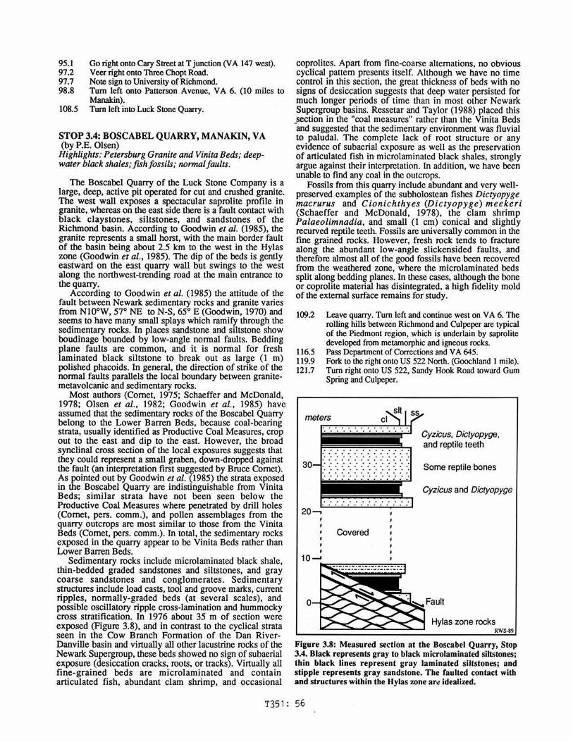
STOP 3.4: BOSCABEL QUARRY, MANAKIN, VA (by P.E. Olsen)
Highlights: Petersburg Granite and Vinita Beds; deepwater black shales; fish fossils; normal f au/ts.
The Boscabel Quarry of the Luck Stone Company is a large, deep, active pit operated for cut and crushed granite. The west wall exposes a spectacular saprolite profile in granite, whereas on the east side there is a fault contact with black claystones, siltstones, and sandstones of the Riclunond basin. According to Goodwin et al. (1985), the granite represents a small horst, with the main border fault of the basin being about 2.5 km to the west in the Hylas zone (Goodwin et al., 1985). The dip of the beds is gently eastward on the east quarry wall but swings to the west along the northwest-trending road at the main entrance to the quarry.
According to Goodwin et al. (1985) the attitude of the fault between Newark sedimentary rocks and granite varies from NI0°W, 57° NE to N-S, 65° E (Goodwin, 1970) and seems to have many small splays which ramify through the sedimentary rocks. In places sandstone and siltstone show boudinage bounded by low-angle normal faults. Bedding plane faults are common, and it is normal for fresh laminated black siltstone to break out as large (1 m) polished phacoids. In general, the direction of strike of the normal faults parallels the local boundary between granitemetavolcanic and sedimentary rocks.
Most authors (Comet, 1975; Schaeffer and McDonald, 1978; Olsen et al., 1982; Goodwin et al., 1985) have assumed that the sedimentary rocks of the Boscabel Quarry belong to the Lower Barren Beds, because coal-bearing strata, usually identified as Productive Coal Measures, crop out to the east and dip to the east. However, the broad synclinal cross section of the local exposures suggests that they could represent a small graben, down-dropped against the fault (an interpretation first suggested by Bruce Comet). As pointed out by Goodwin et al. (1985) the strata exposed in the Boscabel Quarry are indistinguishable from Vinita Beds; similar strata have not been seen below the Productive Coal Measures where penetrated by drill holes (Comet, pers. comm.), and pollen assemblages from the quarry outcrops are most similar to those from the Vinita Beds (Comet, pers. comm.). In total, the sedimentary rocks exposed in the quarry appear to be Vinita Beds rather than Lower Barren Beds.
Sedimentary rocks include microlaminated black shale, thin-bedded graded sandstones and siltstones, and gray coarse sandstones and conglomerates. Sedimentary structures include load casts, tool and groove marks, current ripples, normally-graded beds (at several scales), and possible oscillatory ripple cross-lamination and hummocky cross stratification. In 1976 about 35 m of section were exposed (Figure 3.8), and in contrast to the cyclical strata seen in the Cow Branch Formation of the Dan RiverDanville basin and virtually all other lacustrine rocks of the Newark Supergroup, these beds showed no sign of subaerial exposure (desiccation cracks, roots, or tracks). Virtually all fine-grained beds are microlaminated and contain articulated fish, abundant clam shrimp, and occasional
coprolites. Apart from fine-coarse alternations, no obvious cyclical pattern presents itself. Although we have no time control in this section, the great thickness of beds with no signs of desiccation suggests that deep water persisted for much longer periods of time than in most other Newark Supergroup basins. Ressetar and Taylor (1988) placed this section in the "coal measures" rather than the Vinita Beds -and suggested that the sedimentary environment was fluvial to paludal. The complete lack of root structure or any evidence of subaerial exposure as well as the preservation of articulated fish in microlaminated black shales, strongly argue against their interpretation. In addition, we have been unable to find any coal in the outcrops.
Fossils from this quarry include abundant and very wellpreserved examples of the subholostean fishes Dictyopyge macrurus and Cionichthyes (Dictyopyge) meekeri (Schaeffer and McDonald, 1978), the clam shrimp Palaeolimnadia, and small (I cm) conical and slightly recurved reptile teeth. Fossils are universally common in the fine grained rocks. However, fresh rock tends to fracture along the abundant low-angle slickensided faults, and therefore almost all of the good fossils have been recovered from the weathered zone, where the microlaminated beds split along bedding planes. In these cases, although the bone or coprolite material has disintegrated, a high fidelity mold of the external surface remains for study.
109.2 Leave quarry. Tum left and continue west on YA 6. The rolling hills between Richmond and Culpeper are typical of the Piedmont region, which is underlain by saprolite developed from metamorphic and igneous rocks.
116.5 Pass Department of Corrections and YA 645. 119.9 Fork to the right onto US 522 North. (Goochland 1 mile). 121.7 Tum right onto US 522, Sandy Hook Road toward Gum
Spring and Culpeper.
30
20--.
Covered
' 10-' --~--------.......... ----,,..,.,,.,.,,....
0
Cyzicus, Dictyopyge, and reptile teeth
Some reptile bones
Cyzicus and Dictyopyge
Hylas zone rocks RWS-89
Figure 3.8: Measured section at the Boscabel Quarry, Stop 3.4. Black represents gray to black microlaminated siltstones; thin black lines represent gray laminated siltstones; and stipple represents gray sandstone. The faulted contact with and structures within the Hylas zone ar~ idealized.
T351: 56

126.3 128.1
128.8 150.6
161.0 161.5
Sandy Hook. Pass intersecLion with US 250. Go straight on US 522 Nonh to I-64. Turn onto 1-64 WesL Exit onLo US 15 (Exit 27) toward Gordonsville and Orange. Pass intersection with US 33. Gordonsville, VA.
About 8 km to the west is Barboursville, Virginia, located in the small, elliptical Barboursville basin. The basin is located about 2.5 km southwest of the southern end of the Culpeper basin, of which it is probably an erosional outlier. IL is about 16 km long and 4 km wide, with a normal border fau!L on the western flank and strata dipping moderately to the west (Lee, 1980), beginning at the Rapidan River and extending to the southwest. The sediments consist primarily of red terrigenous elastics 330-576 m thick (Lee and Froelich, in press), and are probably entirely Late Triassic in age. The rocks belong to the lower part of the Culpeper Group (nomenclature
162.5 170.8 174.2
178.8 188.0 188.9
T351: 57
extended from Culpeper basin), and consist of three formations (from the bottom up): Manassas Sandstone with basal greenstone conglomerate (Rapidan Member), Balls Bluff Siltstone, and Tibbstown Formation with conglomerate member (Haudrickes Mountain Member) (Lee and Froelich, in press). Unlike the Culpeper basin, there are no known igneous rocks in the Barboursville basin (Lee and Froelich, in press). Turn right. staying on US 15. Turn right. staying on US 15 Nonh in Orange, VA. Rapidan River. Madison Mills. Entering the southern tip of the Culpeper basin. Note the rich, dark red color of the soil. This is typical of the southern Culpeper basin, especially where basal greenstone conglomerate underlies the margin, but is not common in most of the southern basins. Robinson River (Jackson's Crossing). Turn south onto US 29. Tum right into parking lot for overnight stop, Culpeper, VA.