Embed Size (px)
Citation preview
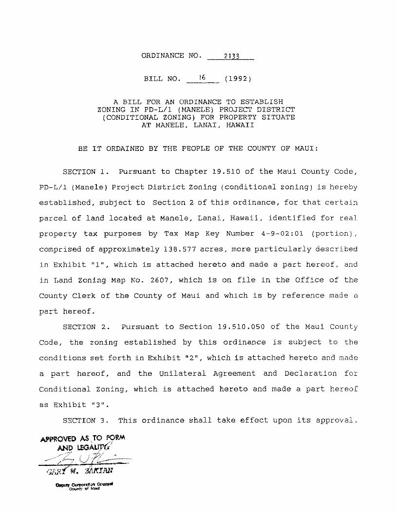
ORDINANCE NO. 2133
BILL NO. 16 (1992)
A BILL FOR AN ORDINANCE TO ESTABLISHZONING IN PD-L/1 (MANELE) PROJECT DISTRICT(CONDITIONAL ZONING) FOR PROPERTY SITUATE
AT MANELE, LANAI, HAWAII
BE IT ORDAINED BY THE PEOPLE OF THE COUNTY OF MAUI:
SECTION 1. Pursuant to Chapter 19.510 of the Maui County Code,
PD-L/1 (Manele) Project District Zoning (conditional zoning) is hereby
established, subject to Section 2 of this ordinance, for that certain
parcel of land located at Manele, Lanai, Hawaii, identified for real
property tax purposes by Tax Map Key Number 4-9-02:01 (portion),
comprised of approximately 138.577 acres, more particularly described
in Exhibit "1", which is attached hereto and made a part hereof, and
in Land Zoning Map No. 2607, which is on file in the Office of the
County Clerk of the County of Maui and which is by reference made a
part hereof.
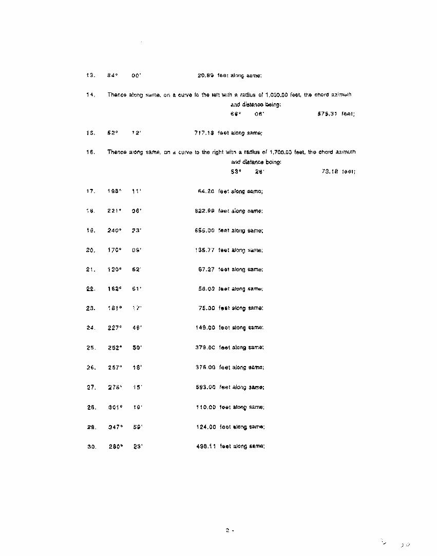
SECTION 2. Pursuant to Section 19.510.050 of the Maui County
Code, the zoning established by this ordinance is subject to the
conditions set forth in Exhibit "2", which is attached hereto and made
a part hereof, and the Unilateral Agreement and Declaration for
Conditional Zoning, which is attached hereto and made a part hereof
as Exhibit "3".
SECTION 3. This ordinance shall take effect upon its approval.
APPROVED AS.,TO FORMAND LmAinple;.
Ar. itiCTAN
Deputy Oorporat! ODursoddcounty or mut

BULB= "1"
All of those certain parcels of land being portionsof Lot 10 (map pending) of Land Court Consolidation 170,situate at Nanele, Island of Lanai, State of Hawaii, describedas follows:
FIRST: Parcel "A", more particularly described inExhibit A attached hereto and by reference made a part hereof.
SECOND: Parcel "8", more particularly described inExhibit 13 attached hereto and by reference made a part hereof.
THTRD: Parcel "C", more particularly described inExhibit C attached hereto and by reference made a part hereof.
=IMO Parcel "D", more particularly described inExhibit D attached hereto and by reference made a part hereof.
036

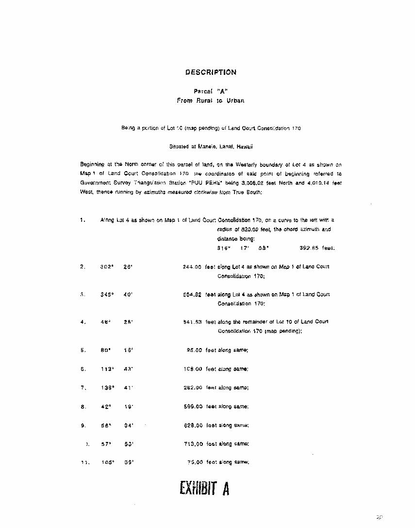
DESCRIPTION
Parcel "A"
From Rural to Urban
Baru, a pc:t,crl o' "..3t '3 yrisc pending) ul Land Gov't Consoi 1 3t.en
aituated at Partelc Lanai, Kawait
Beginning t 1ta North i•ttrnar• this oarost of isro, Cl !re Westerly boundary at Lot 4 as showr
map t of Lard Consoltoation 170. :ria coordinator of saw poirt of LAKinring rolarreo to
Guoonment Survoy Triangt., atirn ,Station *PUU PEnrs' bating 3.308.02 lest Norm aro 4.010.1.4 'set
'Now, :ram* running by azimults measured clerlfArsar from True Soutrt:
t , A ring Lot 4 as showi on Mao 1 of Ind Court COnsalkiation 170. on a cure 10 the !eh will' a
radiksA of 820.00 feet, The CMOKII alirruEn
Cliatance boing:
318 1 Ir 08" 301.65 !imi„
2. 3C2' 2e . 244 30 feat CON; Lot 4 as snow or. Mao i of LAM CoLn
COnsotida4on 170;
345 1 40' :34.32 'eat atorig ',_01 4 as shown z41 Mag, t $7.'r L ang Court
Cartioidslon 170.
A. Alt' 2R' 541.53 'eel along the refraxioar ot Lc/ 10 of Lam Court
Cansstlestior. 170 (map Plbed"gy,
S. 851 15' 05.00 feet alchg Barra;
113 4:I' 108 00 tbs ., lions 441har
3a• 4 • 2B2,00 'se., 41ong ear110;
4 2 • ty S80.03 last AiCrg UM*.
4 34' 423.00 foal aortg tarty:
57" 53— '13.00 boat aiorg gam*:
3S' -5 00 1 007 a ono sa"ro.
11IIRIT

12 56° 3a. .C17,:Q last licri came;
11. 323' ld` 32;.:• :0 'set a.ortg car•tc•,
3.1.....;^ CO feet Corg tams
15 :0' 12' 41 0c 'eat along :same;
6, 51' OS' ti co 1Ettr along same:
s1crtg .atorcEns tot tre nor. five t5)
co.trtoe, the 01ract Avmu":Ai acid siatartcs
borvmen Poulta on sad smorekele
17, 04° 4E1' 20° 1,252,56 'est;
18, 1005 44' 05' 057 33 foot;
tit '04' S' 23 . 1. 42.34 feel;
20. SS• 41' SI' "t89. 35 feet;
2' 92* 51' 07' 4C 53 feet;
22. 1q6° ce• 157 0f) fast a:one; tto 'ernatruzer t C of ',-and Court
Zansc:friatfcri '70 Psodirgi
23 2391 04 48.00 'est alcmg came;
2.: 142• 25'
26S 03 feet alaMg came:
25 till° 47'
270.00 teat along ammo;
114' 10' C0 taiat ,tiorg some
2? 214°
66.30 'sot avvg sen4.
25 25,4• 40 321.00 !sat along &Arne.
29 232c 60'
85.00 feet con tar's,
30 227• 54'
7 4 20 * lett *erg same:
31. Theca ton gam., 3n a :3 Ula 4it wilt! a radius If 1,730.:,c
and distatute EIrç
e crQtc azirrit,th
239* 34' 19• 1,7 caot.
02. 25° 46' 29.98 few a.orlej
33 70° 30' 4 16.70 feet along same;
34 3$,,V 733$ !eat &cog same:
236" 26' 19.04 last 3ictrg stew
32?" 26' 59,10 fett avari came;
27. 23 24' 74.00 feet alorst tame;
38. 43• IV few! a;ong soma;
33 23° 47' 00 lest along sarne;
40. 33C' 31' 43.00 test 'AN earl*.
273° 30' C4.00 tettoiaif samu,
42 243° 47' 548.00 fact: along same'
43. 2/0- 04' a 7.00 foot itioni sure;
44. ra7• 43' la 00 NE aiomi
45 t 2* 13' 79.00 'oat A419 wrilk;
46. 154* 43' 103 fo444 thong 'atria:
ISO' 33' B3,00 *eat 2Inng yam.;
45 221• 57' 378.00 foot wets lamp,
4Q 251° 104 a' 00 fest: iang tsfro.
S. 271• 2! a' 1.00 set aisms istra;

S' 209• 33' 7' 00 ',alit ftiorg .:11171.f,
52 353' 14' :15..SC 'edit Wong ZOFIEL.
2; 2' '18 00 failt along same
54. 213° C2' 8ti.3C `•i! 414:1g wrte:
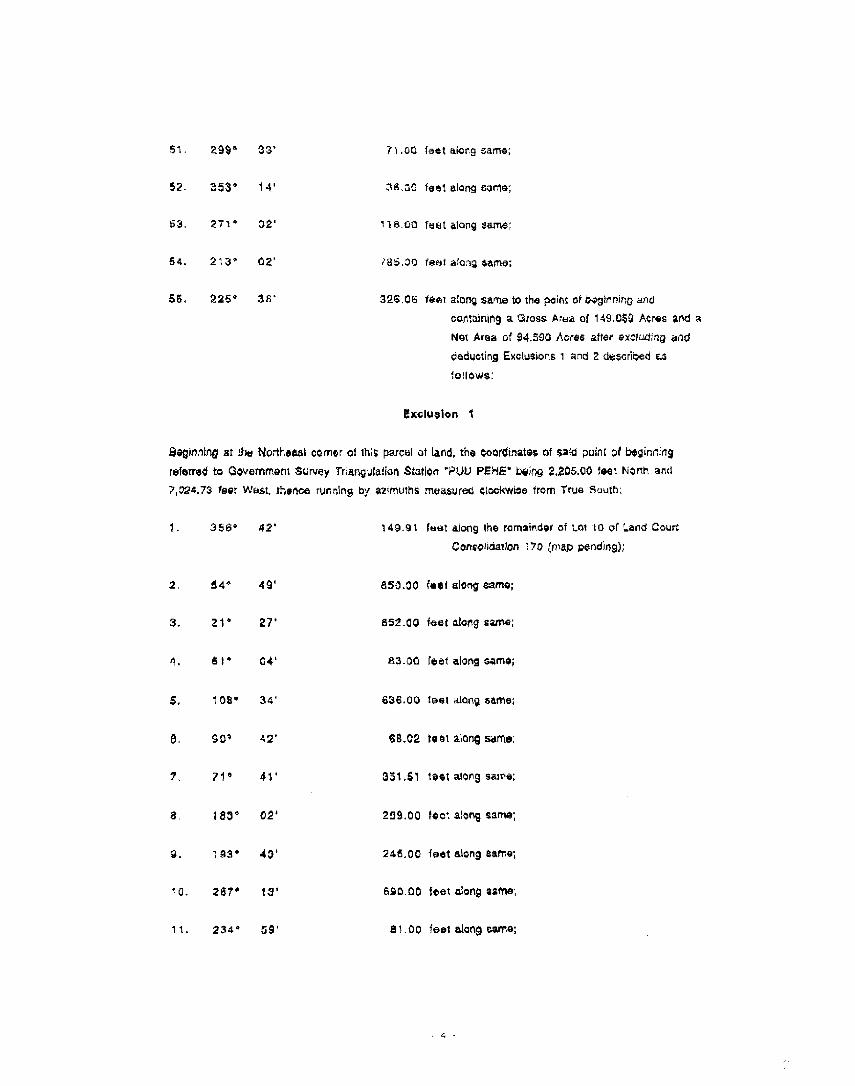
$8. 225• 3A' 326 ca fent along same to :no polit of 04.91emmg And
=mauling a Gross A:kitt of '49.053 Acres and a
Nat Area of 94.590 Acres alter exettzi;-,; and
oecluarAEXCII..itmOrt 1 and 2 dtocf.oeitt
! tciu3Ion
iegirlfrtgai :1* No -testi:4 terror at th.# parcel of tart the coordinates of 32;4 Mirlt ct becirr
referred 14 Government SLNey Tr arc.laticn Station `PUU FtEME' Wing 2,205.00 toot Norm arid
7 : 724,73 feat w61.$1. rherve a2rmuttIS frohoweIG C;OCkWtO41 'torn True SUUth -,
1 386' 42' 140 of firot along the remainder of ant to of ;..and ;,curt
ConsOfirlaildrt ' 7 0 ',,rrap p•3r42410.);
2 14* 49' 850,30 feet Long same;
3. 21 • 27' 352 00 fest along
6 I• C4' A3.00 !let alOrig Sarno;
S. ' 38• 34' 636.00 feet 41409 same;
5 30• 42' 69,02 rest a,ordg sorts.
71 • 41' 361.6! .541 along saint),
1$3' 02' 259.03 fee' a.onig same:
03".. 43' 246.00 'sot eteng (*MC
'0 267' t 3' 690 00 feet along Call•
1 234•8 1 00 'set along t..erre:
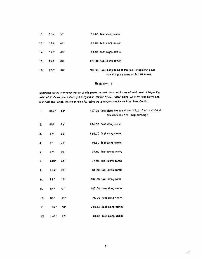
12 200• 57' 81. ..',Q `Gal air..}(4 setre:
f : 1 6• 02' 12' 3O foe: a or; sane,
14 ' i1, 8° al ' .','4.00 fist aoer4 sarrw,
15. 240' C6' 473.03 few earn same:
I a 203° Oa' 729.94 feat Long same te tt' punt of irpirso-lictg stole
CCM:ening an Area of 21.146 Acres.
fixolusion 2
Beginning at the rionneest corner cf :his parcel of lend, me Goordinaleti Of said Boom of begtromitio
referred to Gaverernent Survey rfoargboviero Stat:be 1 0 1..OU PENE° being 2,011 qa feat Ncrth and
5.017,51 i*Ctt Watt, teenee ro..nnoro by azirmtris moloWs4 VookAld's* fruffl True $0 1.`117
350* 43' 417.00 feet elorg eN4s reconnect of Lc: 13 of Larva Courtcor.olooatiort 170 (map peediroa).
2. 51° 62'
47° 32'
4 3• 2Y
57" 28'
6 143• 41'
7. 1•3• 25'
8. 15° 15'
1. 54° 471—
59" 01'
tt 1C4' 53 1
12 .47• .5 .
264 00 fest ong 'erne,
588.0G 'eel an same;
71 CO feet z.:loog
97 OC feet akos :errs;
71 00 feet 910,11 Sarre;
31.00 1 1114t *Jung same:
567 C3 feet along same.
407.00 'eat along same:
7e co .det awe; earns.
140 30 feet along IMMO:
ca L10 feet along 3110140i

RELT =U.N.:,8 ASSOC RTES
Rooters() Professional SurveyCerunosto Ni., rricor 4'88
to. 104° 52'
4 2290 47'
15 24E10= 5$'
25$" • S .
17. 21 S • 25'
71' 25'
10. In', 44'
20, 181° 43*
21. 254° 27'
22 2216 46'
23. 242•
24 25C• 52'
680 Aid 1440an& Blvda ide 200rlorto , t,r)u, marre31 96873
..zry 9 . 1991
41 00 foot a,orlg sa^no
206.00 foot ztorg .arse:
553.00 feet f...'!orts samse
7`1S.CO feet Cart2 sure;
63 oo ric LOrtg4141V-%1:
74 CO Idot &Jots 3sMS;
96.30 'sat mccv *arra;
31.72 lett worig *erre,.
11).00 foot rorig saris:
4 16.00 feet aior6 earl*:
$3.00 fest along seas;
508_00 feet &erg 4.2.1* to me pc:pm C•girriirt; arci
temtakr . ig al Ares of 20.323 Acrea.

DESCRIPTION
Parcel
From Rural to Urban
3o•ng a portior C 1'44: ic.endir;) of Latxt Cog,/ r'..:rsonla,tfor, 170
S)t.,atiao at tvt.artoia, Lanai, }lowc,
9atfprtAtttitat !me cocror parch at lane, ctl Worer4 oawrivary a as avow, on
Mao 1 of Lard Court Conzolication 170, ma coordirates 1t $lAci p&r: of L444,rinimg rbiorrbol 'o
Covornrront Survoy iriar.fiuiation Stator 7 P7.11.1 0.0 iHE" nottn 3.054,93 tee Norm and 4 X35 Cti feet
Woc , thainCe rvArlfro4 OY azi:11Jtes maaS:irad doc.X*34, from No So:arr.
72• OS' 447 01 foot arOng tie remould's( of 'Lot '0 of Lane Court
an 170 (trap pontilt10),
2. 92• 28' ti2.96 foot Along oarmat
3, I 1 39' 5418.00 toot atorg wife.
4.
3.
741'
112*
Jo'
39'
26.00 root Vol; cam*,
74.03 loot along Lame.
4. 140• 29' 720.00 'eat atom; tama;
9S" SO' 54 CO toot atorg •orto:
a. 63• 10' btil )0 'Wit alo -Ig some:
3. 100* 39' 99 CO foot aturm;
1C, 1 46 • 1 3' 88.30 'Oat Al•CIN sir's,
1,1 1 - 111` 02.00 toot atom sasrta,
2 ZCO' 58' 40,20 toot aioNg Sarni!'
1 ' 34' 42' 249 54 l•at oJorg
, 3 •
14. 51. 21'
333 feat a.zets tom)!
•,•:.). 76° 14'
55,00 ',set aicmg same;
.8 112" Z3`
60.0 teal a.oric *am*,
17 S6* 48'
49 fAat akg SI nine,
16. Trlanna along same, on a cl..•!ra !,a ma !oft OM A tar.lius at .700-3C foot. tn• cord avrr.,,th
and diatarlea o•
233• 26' 73 FMW L
19. 232* '2 / • 7.19 '04t mans same;
20. Mena.: along sane, or A t rve !a the ,A■ th a tadit.1$ Of ',030,00 feet, the chard
arc t.,,stance1Oetirsv
249" 36' 575.31 'OJT;
21. 254' CC'
22. 59' 28'
23. S7' 14'
24 5I' 22'
25. 314° 42
29 230' 59
27 2.57. 41'
4g 275• 43'
239° 59*
2 3_ 110'
243' 40'
32 285' 31'
20 39 for acing carnal;
306,23 febt alcrg same;
221.00 feel kt..wv um*:
380.21 fait aioro Iamb,
221.71 fast Mary same;
311,51 !sat aiorg
7 1,7.20 test Zong gar*:
85 00 loot al4rej ear';
40 '..11.) !G• alt;o1V Sirmi;
531.00 loot alero same.
138 00 feet aang same:
459.21 feat along tuns:

.580 Ads. Mama ghid„ SWIG 211C11,-+ or &wail 95812
r.A0fi*Cd4A6LANO
luPyrros
Jan4ary 9, 1901
32. 339- 5!' 105.*7 'mat a!ortg Lot 4 4.ss)-.7.4rt an Moo 1 of Lanes C34r1
Consokation 170 to the and
:rtrairtir,1 an iltriaa .)1 15.0.13 Acros.
ii-EL,1" Cc-xi .N3 & ASZOCIA7ES
AsillSteroo PPoNips3 ortaiCartific&te Nwnoer 4183

Moans B Su la 200 •hit3C1, . rots 46613 (3
QC
Je.-1,4a.y g, 1 .11 Regiate•ed Pf0fOSSier&I 5I1.1111 hluint.Of crae
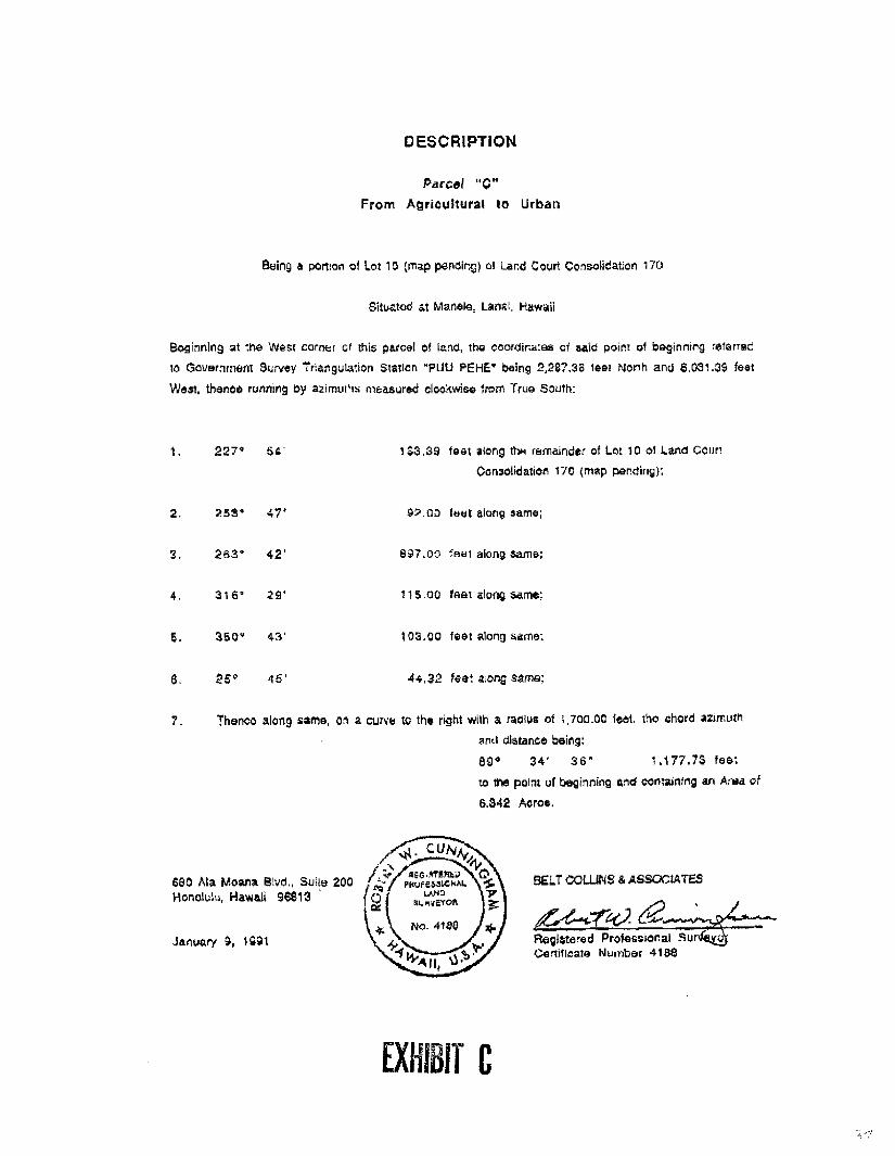
DESCRIPTION
Parcel "C"From Agricultural to Urban
Beir.j 3 porton of Lot 10 ;rr•ap panning) of and COLirt CO -.r.olleatxr 177.)
Sitwatoo it manaie, Lanai, i !swell
Soc,ining at :M41 west ccrtier Gr this otucei of :!-10 000rotr.k:kis et &Aso Dort .0/ bagirirt$r9 ri•arrec
to Government St:Nov Siiticrl *PIM toEHE` being 2,2E'.38 feet morn arcs 6.031.39 feet
west, iheirco ruroirg oy azrnurls rreasured c4c•Kons• from Tr ca 53utT1'.
227• 64
2. 2534 47'
3, 2&3• 42'
4 314 • 24'
S. 350'• 4.1
25°
132,39 teat aiong rerfaunclw at Lot 10 of Land
Cortaotioalton 170 tits° rear.cupg),
tout along serne;
147.30 `Noit along 3afrilr,
115 CO ?eat along 34:"ne:
103.00 feet aloni lame;
44.32 filot aoric saliva;
7 7haric0 31ang sun*, ci a cum, tc Ins pot with & ractt.te of t 700.00 `Sot ;-io cr:cre M
and distance beirg:
BP 34' 36' 1.177,73 las:
to no pc-It uf'Doginning a,a ton:almng an Alm
6.342 ACTG.
9E47 COL JNS £ ASSOCIATES
EXHIE1

DESCRIPTION
Parcel '0 -
;forte Agrituitural tc Urban
134.inq a boriOrl of LOC 10 (.7".4p tzendingl of sand Court (,:anavnaftcn
Stuatee. at Manilla. 7,.aral,
Befinfrl at fna East Corner Of 111!: parcel of land , or: in* Northwesterly boundary .of t or 4 se *norm on
"v1..Lio 1 of Land Court Contoidatiorl 170, coorc,nates of Sale! point of t: eo?nring reterrec
3overnment Survey TI•ancalat.on StaflOt1 "Pt,11.3 PE1-1!" oulny 3,700.34 loot Nona arc 1,104 04 feat
. nenz.• runmi cy 12Frrutne rn4asured ;.;10ckwiae fron't True Scutt:
52' 301 44 foist Lon,9 L,c* 4 AS snare or. Moot Of Lam Coup
CorsU#iCa ion '70:
2. 08 425.68 'eat alcru3L t 4 as shown on Map of LArtol C.414.01
Canroolidation
3. i 1 A• 54;4 85 !isiot along the nornitinder or Lot 13 of Land Court
CceccIldavon tTtS (mac) Dorwrs.9:,,
4 145" 3G` 80.00 foot along carne•
5 97* 2S' 209.77 fast altng lama;
78' 24' 714S 80 fey tang erne:
350* OS' ' 79 33 'erg AJCrIg latTO:
a 2403 23' 110 41 root a,cr
9. 230' 57' 121,30 iser azio errs:
328' 32' 10* 00 fest eons ivre -
•cr• 14' /241 'oat Meng gams;
• 2. tin' 2C" 780 83 'ea; ai4ni
Dtithib UI

3, 84° 00' 23.8il few ainns sails
4 T•ilarO• alGriu on a Crvilit to t , a kir!! 41i.ti a radlLa of 'OHM tree trsord
and 34tersao oethg:
et • col' 575.31 faRt•
15. 52° 2' ?I 's aierl tarr4:
1 8. Thoice aeons same on a Ci.live to the Ight a radius tlf L700,00 feet, the trtoro
400 d'sta.nce boirs
53° 26' 73.19 tilb41;
17 9 B" 11' F14 20 'lief along Ursa;
' 8 221' 35' &22.48 !net aloorg saute;
10. 240' 23' 555,3u feet aitatv to.kine;
20. 17C° (..16' '35 7/ !cwt. War01.410e.
21. 124° 52 67.27 `41411 atm, rare;
22. 162' 51' 58. 03 reef aiorg
23. '81° 75.30 'eat awn terra:
2l1 227, 46' 14'3.03 {ow atang Sarre.
25 252" 50' 379 00 'eat akvIg Carr*:
21:1. 257° 15' 3715 00 fest .1'c:tog etne,
27. 275- S. 53.r4C aboog
28. 301$ IQ . t 0 co feet alarl cam*.
29 347*. 56' 124.00 'cot aleN cam*:
33 aeo• 23 490 It fait Wort sal%

6.3Q A a Voara 1:11./.5 Surfs) 200
No. 405January 3. loai
31 Z70* 53' 2 9 2 57 foet aforg cams to tno port of 0egirnrng and
an Arita of 31.%;2 Acres.
V.L.T CCLL1NS 4 ASSC+C■AliS
Rautstrerocl Prolesstona1 $L/..d
CerOfiaats .Nurroar

EXHIBIT "2" (NANELE)
Conditions
Pursuant to Section 19.510.050 of the Maui County Code,the zoning established for the parcels of land shall be subjectto the following conditions:
*1. The Declarant will establish a loan fund of$1,000,000.00 to be administered and managed by the Bank ofHawaii, in consultation with Lanai Resort Partners for thepurpose of assisting current Lanai City merchants withimprovements of their commercial facilities. Loans will bemade available to the merchants from the date of the UnilateralAgreement and for a minimum of 10 years thereafter, at anannual rate of 2% per annum below the Bank of Hawaii'sprevailing commercial loan rate for similar type loans. Also,the loan qualifications and pay back methods shall not exceedthose required by the Bank of Hawaii for their commercialloans. Written notice that the loan fund of $1,000,000.00 isavailable for disbursement to qualified Lanai. City merchantsshall be given by Bank of Hawaii to said merchants, the Mayorof the County of Maui and the Chairperson of the County Counciland the Chairperson of the Planning and Economic DevelopmentCommittee. Written notice of the expiration of the loan fundshall be given to the above-named persons one (1) year prior tosuch expiration.
*2. The Declarant shall on a fee simple basis, donate atno cost and free and clear of all mortgage and lienencumbrances, 115 acres of land adjacent to the Lower WaialuaSingle Family site to the County as shown in Exhibit "A"(shaded area) attached hereto and by reference made a parthereof, for an affordable housing project. The project shallbe similar in design quality and density to the recentaffordable housing developments on Lanai.
*3. The Declarant shall on a fee simple basis, donate atno cost and free and clear of all mortgage and lienencumbrances, a minimum of one acre of land on Lanai to theCounty for use as a veteran's cemetery.
*4. The Declarant shall consummate a land exchange withthe County for a new police station upon terms and conditionsacceptable to Declarant and the County.
5. The Declarant will use only non-potable water, asdefined in Ordinance No. 2066 enacted by the County onDecember 17, 1991, for the irrigation of the Golf Course inthe Manele Project District.

6. The Declarant shall make the Manele golf courseavailable for play to Lanai residents at a kamaaina rate of50% of the standard rate, and for Hawaii residents at 60% ofthe standard rate.
7. The Declarant shall take appropriate preventivemeasures so that its development, construction, operation, andmaintenance activities in the Manele Project District do notcause any deterioration in the Class AA water quality standardscurrently in existence at Hulopoe Bay and the coastal watersadjacent to the Manele Bay Hotel and the Manele golf course asdetermined by present studies, or any comparable standards asthey may be established by law in the future, taking intoaccount temporary perturbations from natural occurrences.Quarterly monitoring of Hulopoe Bay and aforesaid coastalwaters shall be conducted by Declarant, with copies of thereport being sent to the County Council and the Department ofHealth for review. The monitoring of Hulopoe Bay shall beginupon approval of the zoning of the golf course area within theManele Project District, and shall continue for at least 2years after completion of the construction of the Manele golfcourse, with the monitoring to be done semi-annually during thefinal year of monitoring. Declarant shall provide notice toall persons receiving the reports of the termination of themonitoring of Hulopoe Bay when it submits the first report ofthe final year of monitoring. If the report indicates that theconditions of Hulopoe Bay exceeds the standards of the Class AAwater and Declarant's activities are the cause of suchconditions, then the Declarant shall be responsible for allcosts to mitigate the source of deterioration and make its bestefforts to restore the conditions to the standards of Class AAwaters within one year of the date of the report.
8. The Declarant shall provide such additional non-potable sources of water as may be needed for Manele golfcourse irrigation after consultation with the State Commissionon Water Resource Management and Department of Health.
9. The Declarant shall comply with the environmentalhealth concerns addressed in Exhibit "B" attached hereto andincorporated herein by reference, entitled "Twelve (12)Conditions Applicable to All New Golf Course Development,"dated January 1992, issued by the State Department of Health.Copies of all reports that are sent to the Department of Healthby Declarant shall also be sent to the Chairperson of thePlanning, Economic and Development Committee of the County
-2-
Council, the directors of the Department of Planning and theDepartment of Public Works.
*Asterisked conditions are contained in the UnilateralAgreement for the Koele rezoning application as well.Fulfillment of these conditions shall satisfy the requirementsin both the Koele rezoning application and this Manele rezoningapplication.
4388/2M

EXHIBIT "A"

STATE OF HAWAIIDEPARTMENT OF HEALTH
January, 1992 (Version 4)
TWEE.VE (12) CONDMONS APPLICABLE TO ALL 'SEW GOLF COURSE DEVELcpmE4 -7
The following conditions are recommended for all new golf muse development in Hawa,,1assure that environmental quality is preserved and enhanced as it relates to human health andthe protection of sensitive ecosystems. Additional conditions may be imposed based on site-specific oonuderations.
1. Baseline groundwaterivadose zone andior, if appropriate, coastal water quality shallbe established. Once the sampling plan has been determined and approved by theState Department of Health, the owner/developer shall establish the baselinegroundwaterivadose zone water quality, and, if appropriate, nearshore water tualiry,and report the findings to the State Department of Health. Analyses shall be cone bya )aboratory approved by the Department of Health.
2. The ovdnerideveloper and all subsequent owners shall establish a groundwatermonitoring plan and system which shall be presented to the State DC;1/4111mer.c ofHealth for its approval. The groundwater monitoring plan and system shall nunimai)describe the following componenu:
a. A monitoring system tailored to. fit site conditions and circumstances. Thesystem shall include, and not be limited to, the use of monitoring wells,lysmeters, and vadpse zone monitoring technologies. If monitoring wells areused, the monitoring wells shall generally extend 10 to 15 feet below the watertable,
b. A routine groundwater monitoring schedule of at least once every su (6)moths, or more frequently, if tequired by the State Department of Health LZ1
the event that the monitoring data indicates a need for more frequentexialoring.
c. A fist of eomixiunds which shall be tested for as agreed to by the StateDepartment of Health. This list shall include, but not be Unwed to thefollowing: total dissolved solids; chlorides; PH; nitrogen'. phosphorus: andother compounds associated with fertilizers, biocides, or effluent irrigation,
VitaterT .5"

- 2-
3. If the data from the monitoring system indicate increased levels of a contaminate thatposes, or may pose, a threat to public health and the environment, the StateDeportment of Health shall require the owner to tale Immediate action to stop thesource of contamination. Subsequently, the owner shall mitigate any adverse effectscaused by the contamination.
4. Owner/developer shall provide sewage disposal for the clubhouse and other facilitiesby connecting to the public sewer system or by means of a treatment individualwastewater system approved by the Department of Health in conformance withAdministrative Rules, Title 11, Chapter 62, Wastewater Treatment Systems. The useof wastewater for irrigation will be generally encouraged, with appropriate eantn-.11s(see Condition 5).
5. If a wastewater treatment works with effluent reuse becomes the choice of wastewaterdisposal, then the owneridevelotxr, and all subsequent owners, shall develop andadhere to a Wastewater Reuse Plan which shall incorporate the provisions of theDepartment of Health'sfaisiellats_fgLIL.Lise_ofleclaiingl jatict which includes:
a. Art Irrigation Plan encompassing buffer distances, pipe and appurtenanceplacement, and labeling.
b. An Engineering Report encompassing treatment options and treatment levels.
c. Hydro-geologic and hydrologic surveys to determine application rates, sizingand storage needs.
d. A monitoring plan.
e. A management plan.
f. Public and employee education plans.
6. Underground storage tanks ‘USTs) used to store petroleum products for fueling golfcarts, maintenance vehicles, and emergency power generators that pose potential riskto groundwater shall be discouraged. Use of electric golf cans and abovelroundstorage tanks for emergency power generators shall be encouraged.
Should the eviller/developer/operator plan to install USTs that contain or otherregulated substances, the owner/developer/operator must comply with the federal USTtechnical and financial responsibility requirements setfonh in Title 40 of the Code ofFederal Regulations Pan 280. These federal rules require, among other things,owners and operators of USTs to meet specific requirements in release detection andresponse, and subsequent corrective action. Also, the ownerideveloperioixrator mustcomply with all State UST rules and regulations pursuant to the Hawaii RevisedStatutes, Chaplet 342-1., Underground Static Tom.

-3-
7, Buildings designed to house the fertilizer and biocides be berried to a heightsutelcisat cont tiljt;rophjc ;mic of all fluid conmin as. it is alsoto einrecoarneenied that the floor of this room be made waterproof so that all leaks can becontained within the sri-UCCUr6 Cot Cleanup.
S. A golf course mainzenance plan and program A,11 be established used on 'BestManagement Practices (BM2)* in regards to utilization of fertilizers and biocides aswell as the irrigation schedule. BMP's will be reviewed by the State Department ofHealth prior to implementation.
9. Every effort shall be made to minimize the amount of noise from golf coursernaillteiarICe acavide3. E4Untial maintenance activities (e.g., mowing of greens andfairways) shall be conducted at times that do not disturb nearby residents.
10. Solid waste shall be managed in a mariner that does not create a nuisance. wheneverpossible, oorrqxisting of green wastes for subsequent use as a soli conditioner ormulching material is encouraged. The composting and reuse should be confined tothe golf course property to eliminate the necessity for offstie transport of tahie :zvi orprocessed material.In addition, during construction, the developer should utilize locally-producedcompost and soil amendments whenever Mailable.
11. Fugitive dust shall be controlled during construction in accordance with HawaiiAdministrative Rules, Tide 11, Chapter 60, kr Pollution Control. Pesticides andother agricultural chemicals should be applied in a manner that 'precludes the °flutedrift of spray material. The State Department of Agriculture should be consulted Inthis regard.
12. To avoid soil runoff during construction, the developer should consult with the 1J S.Department of Agriculture, Soil Conservation Service to assure that best managementpractices are utilized. If the total project area is five (5) AM,* or more and thedevelopment activities include daring, gilding, and excavation, a National PollutantDischarge Elimination System (NPDES) stormwater permit application shall besubmitted to the Depart:neat of Health in accordance with the Federal Clean WaterAct requirements.
if then are any gee dart regarding the twelve (12) conditions mentioned here, please contactthe Environmental Planning °Moe at 586.4337. We appreciate your cooperation in;reserving and wowing environmental quality in Hawaii,

THE ORIGINAL 05 WERECORD:1) ,r 11'0!:: 1.71 1 ..!&.:
SIAlE Q t.:AWAY,
BUREAU OF CC' ;
DATE ... . TimE_ ...........DOCUMENT NO..1'::-2
REGULAR SYSTEMLAND COURT SYSTEM
Return by Mail ( X ) PickupOffice of the County ClerkCounty of Maui200 South High StreetWailuku, Hawaii 96793
TO :
UNILATERAL AGREEMENT AND DECLARATIOO 'OR CONDITIONAL ZONTNG
THIS INDENTURE, made this /341t, day of
4/144AGUit_ , 19 gt)-, by LANAI RESORT PARTNERS, a
California general partnership, whose business and mailing
address is 650 Iwilei Street, Honolulu, Hawaii 96803,
hereinafter referred to as "Declarant", and who is the
developer of that certain parcel located at Manele, Lanai,
Hawaii, comprised of approximately 138.577 acres, and
identified for real property tax purposes by Tax Map Key No.
4-9-02:01 (portion), hereinafter referred to as the "Parcel".
WITNESS.E1 11:
WHEREAS, the Council of the County of Maui, State of
Hawaii, hereinafter referred to as "Council", is considering
EXHIBIT

the establishment of PD-L/1 (Manele) Project District zoning
for the Parcel, comprised of approximately 138.577 acres and
which is more particularly described in Exhibit "1", which is
attached hereto and made a part hereof, and which is more
particularly identified in Land Zoning Map No. 2607, which is
on file in the Office of the County Clerk of the County of
Maui; and
WHEREAS, the Council recommends through its Planning
and Economic Development Committee, Committee Report No.
92-38 , that said establishment of zoning be approved
for passage on first reading subject to certain conditions
pursuant to Section 19.510.050, Maui County Code; and
WHEREAS, Declarant has agreed to execute this
instrument pursuant to the conditional zoning provisions of
Section 19.510.050, Maui County Code.
NOW, THEREFORE, the Declarant hereby makes the
following Declaration:
1. That this Declaration is made pursuant to the
provisions of Section 19.510.050, Maui County Code, relating to
conditional zoning.
2. That the Parcel, and all parts thereof, is and
shall be held subject to the covenants, conditions and
restrictions contained herein and that all of such covenants,
conditions and restrictions shall be effective as to and shall
run with the land as to the Parcel from and after the
-2-
recording of this Declaration with the Bureau of Conveyances or
the Land Court of the State of Hawaii, as the case may be,
without the execution, delivery or recordation of any further
deed, instrument, document, agreement, declaration, covenant
or the like with respect thereto by the Declarant, the County
of Maui, or any heir, devisee, executor, administrator,
personal representative, successor, and assign, as the case may
be, of any of them, that the acquisition of any right, title or
interest in or with respect to the Parcel by any person or
persons, entity or entities, whomsoever, shall be deemed to
constitute the acceptance of all of the covenants, conditions
and restrictions of this Declaration by such person or persons,
entity or entities, and that upon any transfer of any right,
title or interest in or with respect to the Parcel the same
shall be subject to, and the transferee shall assume and be
bound and obligated to observe and perform, all of the
covenants, conditions and restrictions of this Declaration;
3. This Declaration and all of the covenants,
conditions and restrictions contained herein shall continue to
be effective as to and run with the land in perpetuity, or
until the same is released as to the Parcel or any part thereof
by the County;
4. The term "Declarant" and any pronoun in
reference thereto, wherever used herein, shall be construed to
mean the singular or the plural, the masculine or the feminine
-3-
or the neuter, and vice versa, and shall include any
corporation, and shall be held to mean and include the
"Declarant", Declarant's heirs, devisees, executors,
administrators, personal representatives, successors, and
assigns;
5. That the Declaration shall become fully
effective on the effective date of the zoning ordinance
approving the establishment of PD-L/1 (Manele) Project District
Zoning and this Declaration shall be recorded in the Bureau of
Conveyances or Land Court of the State of Hawaii, as the case
may be;
6. That the Declarant agrees to develop said Parcel
in conformance with the conditions set forth in Exhibit "2",
which is attached hereto and made a part hereof and which shall
be made a part of the zoning ordinance;
7. That the conditions imposed are reasonable and
rationally relate to the objective of preserving the public
health, safety and general welfare and such conditions fulfill
the need for the public service demands created by the proposed
use;
AND IT IS EXPRESSLY UNDERSTOOD AND AGREED that the
conditions imposed in this Declaration shall run with the land
identified hereinabove and shall bind and constitute notice to
all subsequent lessees, grantees, assignees, mortgagees,
lienors and any other persons who claim an interest in said
-4-

land, and the County of Maui shall have the right to enforce
this Declaration by appropriate action at law or suit in equity
against all such persons, provided that the Declarant or its
successors and assigns may at any time file a petition for the
removal of the conditions and terminate this Unilateral
Agreement, such petition to be processed in the same manner as
petitions for change in zoning.
IN WITNESS WHEREOF, the undersigned has executed this
Declaration the day and year first above written.
DECLARANT:
ORT PARTNERS
THOMAS C.•ERTIts Senior Vice President
APPROVED AS TO FORM:
B. MARTIN LUNAAttorney for Declarant
APPROVED AS TO FORMAND LEGALITY:
I i\-
GARY W. ZAKIADeputy Corporation CounselCounty of Maui
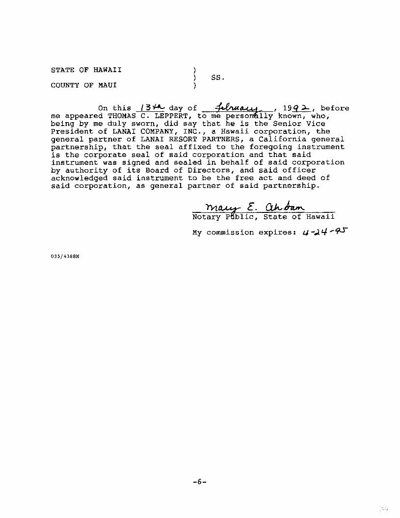
STATE OF HAWAII) SS.
COUNTY OF MAUI
)
On this /3i4116- day of -1a4/40.4.44 , 19q.)-, beforeme appeared THOMAS C. LEPPERT, to me persontaly known, who,being by me duly sworn, did say that he is the Senior VicePresident of LANAI COMPANY, INC., a Hawaii corporation, thegeneral partner of LANAI RESORT PARTNERS, a California generalpartnership, that the seal affixed to the foregoing instrumentis the corporate seal of said corporation and that saidinstrument was signed and sealed in behalf of said corporationby authority of its Board of Directors, and said officeracknowledged said instrument to be the free act and deed ofsaid corporation, as general partner of said partnership.
)1/.04-441,- E. ah... Atm.
Notary Ptblic, State of Hawaii
My commission expires: 44;211V-10-
035/4388M

EXHIBIT "1"
All of those certain parcels of land being portionsof Lot 10 (map pending) of Land Court Consolidation 170,situate at Manele, Island of Lanai, State of Hawaii, describedas follows:
FIRST: Parcel "A", more particularly described inExhibit A attached hereto and by reference made a part hereof.
EELOND: Parcel "8", more particularly described inExhibit B attached hereto and by reference made a part hereof.
THIRD: Parcel "C", more particularly described inExhibit C attached hereto and by reference made a part hereof.
FOURTH: Parcel "0", more particularly described inExhibit O attached hereto and by reference made a part hereof.
036
DESCRIPTION
Parcel "A"From Rural to Urban
18Cng a portion of Lot (map pending) of Land Court Consolidation 170
Situated at Man.le,. Lanai, Hawaii
Beginning at the North corner of this oaroel of land, on the Westerly boundary of Lot 4 as shown onMap I of Land Court Consolloaton 170. Th6 coordinates of gale point of beginning roferred to
Government Survey Triangulation Station "PUU being 3.006.02 feet North and 4 ,OT 0.14 feetWest, thence running by azimuths measured cicriomise from Ttue Bout:
1. kong Lot 4 as shown on Map 1 of Land Coe, Consolidation 170, an a curve to the left with a
radius of 820.00 feet, the chord azimuth and
Oistanoe being:
316' 17' 08" 392.ES feet:
2. 302° 26' 244.00 feel along Lot 4 as shown on Map I of Land CoLnConsolidation 1701
A 345° 40' 584.82 feel along Lot 4 as shown on Map 1 of Land court
Consadation 170:
4. 41:1' 28' 541 . S3 feel along the remainder of Lac 10 of Land Court
Consolidation 170 (MAO Pending):
5. 80° 18' a5.00 feat along game;
O. 113° 43' 108 00 feet along same;
7. 13S° 41' 282.00 feet along sem;
8. 42° 19' 599.00 feat along Same,
9, 584 34' 828.00 fool along same.,
1. 57" 50' 713,00 foot along same:
11. 105° 39' 75.00 foot along game;
EXHIBIT A

12, 554 38' 107.00 feet along same;
13. 323° 10' 360,00 feet aiong saris;
14, 345° 47' 66,00 feet along same,
15. 10" 121 S 1 , 00 feet along same;
16. 51" OS' 96.00 feel along same;
Thence along shoreline for to ner. (..5)co.troes, the direct azirnuThe and distancesbouvean points on seed aharetiala being!
17. 04° 41' 20" 1,252.55 teat;
18, 100 44' 05" 657,33 foot;
19. 104° 15' 23" 1, 42.38 feet;
20. 994 41' 51" 384.50 feet;
99 4 51' 07" 60.53 feet
22. 195° 08 . 157.00 feet along the remainder of tat ;0 of Lard Court
Consolidation 170 (map pending);
23. 239° 04' 98.00 feet along came;
24. 182° 23' 265.00 feet along cant
25. 193' 47' 270.00 feat along sumo;
26. 164° 10' 86.00 feet along same;
27. 218° 18' 66.00 toot along same:
28, 254° 40' 321.00 toot along same;
29. 2334 BO' 85.00 feet tang same:
30. 227° 54 1 742.61 sect along same;

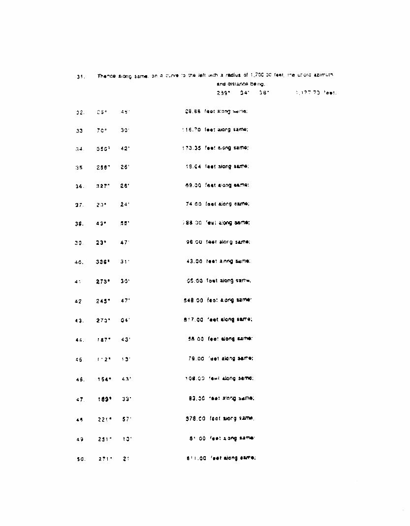
31, The
32. 26°
33, 70°
34. 350°
35. 286"
36. 321°
37. 20°
38. 43°
10. 23°
40. 336°
41. 273°
42. 245°
43. 210°
44. 1E7°
46. 112*
46, 154°
47. 189°
48 221°
44. 251°
50. 271°
atonq 5arrta, on a curve zo tho left with a radius DI 1,700.0c loco, Ina of-,corcl azimuth
and atstasIce being:
254° 34' 36' 1,177.'73 feat;
45'
28.54 tool along s:ip-r5;
30'
116.70 feet along same;
42'
173.35 feet Wong same;
26'
1.9.04 feet along same;
26'
69,00 feet along game;
24'
74.00 feet along carat);
55'
788.00 feat along Game;
47'
86.00 fact al0n9 5=6:
31'
43,00 teat mang same:
30'
65.00 toot along same;
47'
B49.00 feat air► Same:
04'
417.00 feet Wang earro;
43'
Sa.00 teat along same;
13'
79.00 reel along Same;
43'
108.00 loot along eema;
32*
83.00 Teat along same;
S7'
578.00 fact Ware tame;
13'
81.00 feet v.!onia same:
21'
8 t t .00 feet along Sara;
293 5 33' 71.30 feet along earns;
52. 353° 14' 36.30 feet along come;
53. 271° 32' 118.00 feet along UMW
54. 213° 02' 785,3) feet aktag same;
55. 225° 3C1' 326,06 fear along same to the paint of begIrnino and
containing a 3ross Area of 149.0s9 Acres and a
Net Area of 94.590 Acres after excluding and
deducting Exclusions 1 and 2 descriOed
f011CNt:
E xc lusion
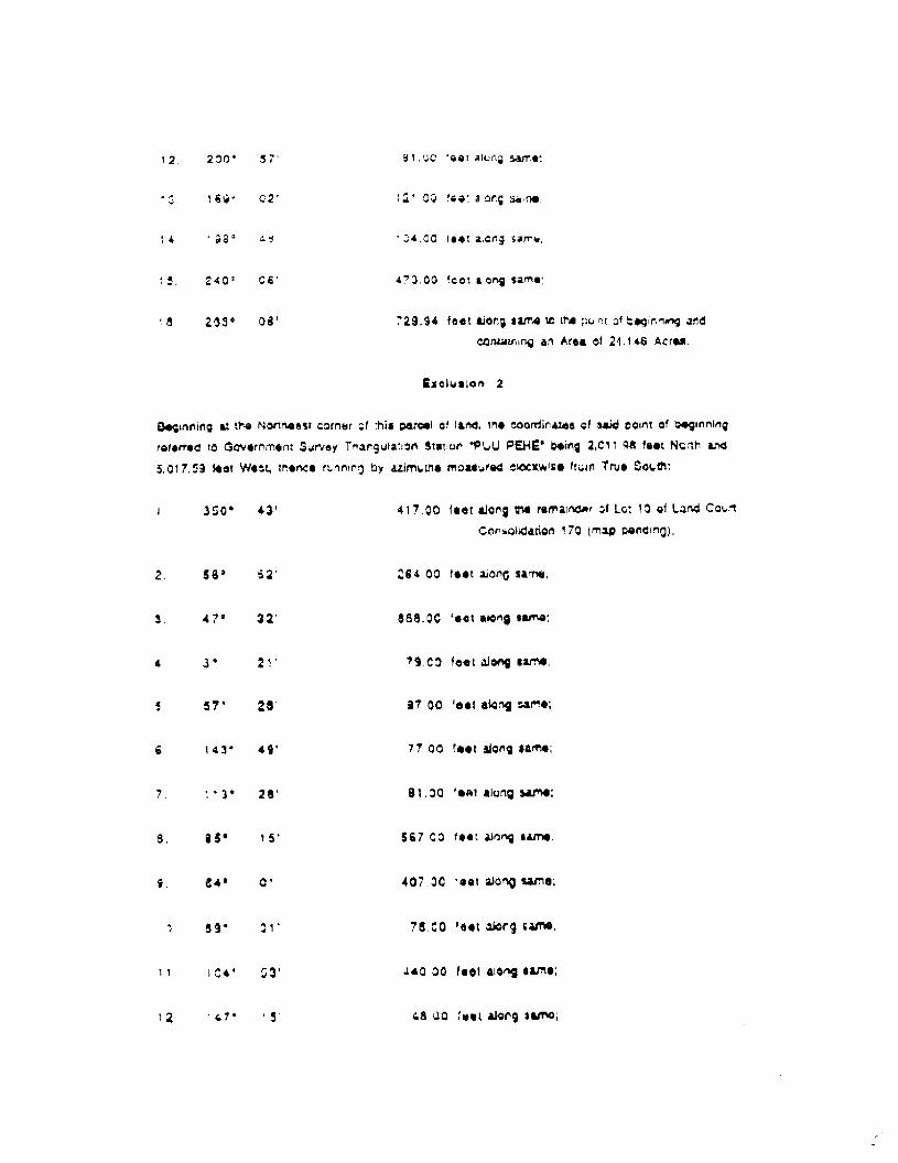
aninning at the Wortheilet corner of MS parcel of land, the coordinates of said 'point of beginn:ng
referred to eovernmern Survey Tranvia:4o Station "PLR) PEHE" being 2.205.00 feet North and
7,024.73 leer Wast, thence running by azimuths measured Clockwise from True South:
1. 366. 42* 149.91 feet along the remainder of Lot ID or Land Court
Consolidation 17D (map pending);
2. 54° 40' 850.00 feet along same;
3. 21° 27' 85200 feet along same;
6I* 04' 83-00 feet along same;
5. 10$° 34' 636.00 lest along same:
8. SO4 42* 68.02 teat axing same;
7, 711 41' 351.51 test alerg seine;
8. 183° 02' 259.00 feot along sam;
S. 193° 40' 248.00 feet along same;
10. 267° 13' 5;0.00 feet along raise;
1 I . 234° 59' 81.00 feet along same;
12. 200' 57' e1.00 feel along same:
13. 169" 02' 121.03 teat gong eau*:
14, 1 09° 48T 104.00 teat atone same;
15. 240° C6' 473,00 foot along same:
18 233° 08' 729.94 feet along same to the point of beginning and
containing an Area of 24.146 Acres.
Exclusion 2
Beginning at the Northeast corner of this parcel of land, The coordinates of acid point of beginning
referred to Government Survey Triangulation Station "PUU PEHE" being 2,011.99 feet North and
5.017.59 feet Wear, thence ruining by azimuths mossured clockwise 'ruin True Ooutht
I. 550' 43' 417.00 feet along the rerhainc1Rr of Lot 10 of Land Court
CON twliciatiort 170 (map pending);
2, 58° 52' 284,00 feet afong same;
S. 47° 22' 858.00 feet along $3.M1r,
4. 3' 21' 79.00 feet along same;
5. 57* 28' 37.00 feet along =MO;
6, 143' 49' 77.00 feet along same;
7. 113* 28' B1.00 teat along came;
B. 9S° 15' 597,00 feet along same:
9. 846 01' 407,00 beet along same;
10, 139" 01' 76.00 feet along same;
11. 104* 53' 4 40-00 feet along same;
12. ',47* 15' 48.00 feet along aamo;
-5-

680 Ale MoanaBlvd„ Suite 200Honolulu, Ft2Wall g6813
January 9, 1991
PELT GOWNS' 8 ASSOCIATES
‘.)
Registered Professional SurveyCertificate Number 4'.88
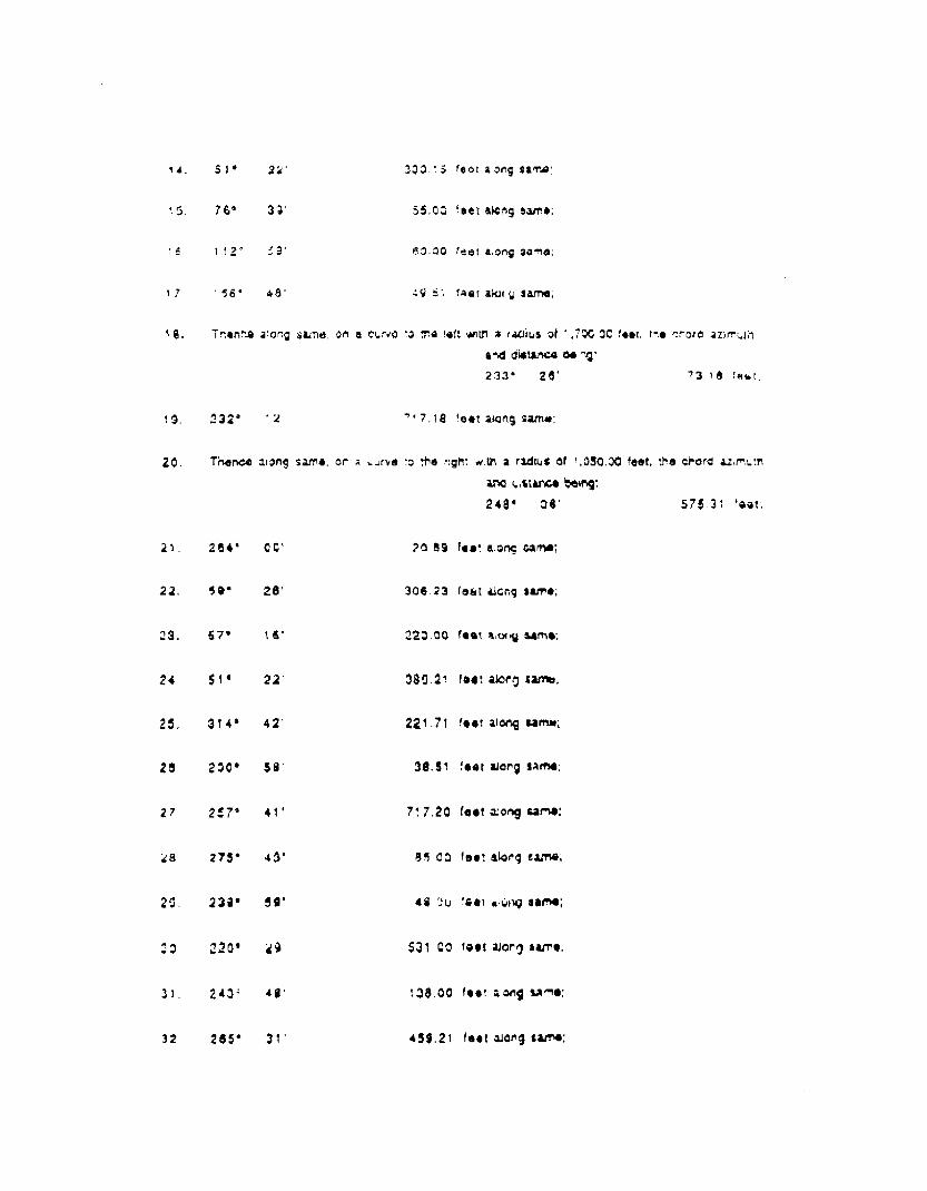
13. 104° 52' 41.00 foot along same,
14. 224° 47' 206.00 feet along same;
15, 246* 58' 535.00 feet along same;
16. 259° 18' 768.00 feet along same;
17. 213° 26' 83_00 feet song saran;
18. 171° 25' 74.00 feet along samo;
10. 111° 44' 66.00 feel along $4me;
20. 181° 43' 51.72 feet along same;
21. 254° 27' 110.00 feet Wong same;
22. 221A 40' 416,00 feet along same;
23. 24V SO' 83.30 feat along rams;
24, 280° 52' 508.00 teat along same to the poInt of beginning and
containlrig art Area of 30.323 Acres.
6 •

DESCRIPTION
Parcel "8"From Rural to Urban
Being a portion cf Lot is (rukp psi-ding) of Land Court r..-,onsoliriation 170
Situated at Manele, Lanai, Hawaii
Saginnfrts at the East Comer of this parcel of iand, on the Westerly boundary 01 Lot 4 as shown on
Map 1 of Land Court COnsotidatIon 170, tne coordinates of said poirt of beg;nnimg rotor/194i to
Govornment Survey Triangulation Station °PLR' HEHE° rising 3,054.93 feet North and 4.035.00 islet
Wes;, itrence running by azimuths meaSured clockwise from Two south:
72° 05' 447.01 feet along the remainder of Lot 10 of Land Court
Consolidation 170 (nap pending),
2, 52' 28' 82.98 feel along sautes
3. ti 1° 30' 646,00 feet along same:
4, 74° 30' 06.00 feel along same:
112 ° 38' 74.00 teat along same:
140° 28' 120.00 feat along same;
95° 501 54.00 feet along same;
53 ° 10' 651 .04 feet along same;
0, 1004 39' 99.00 feet alarm aarnic
10. 146'0 1.3: 88.00 teal along same;
1, 171° 08' 32.00 feet along same;
12 - 200° 50 1 40,00 foot along same:
13. 134° 42' 249.53 foot along lama;
EXHIBIT B

14. 51° 22' 330.15 foot along same;
15. 78° 39' 55.00 feet along same;
16. 112° 59' 60.00 feet along Same;
17, f 58* 48' 49.61 that along same:
18. Tnence along Same. on a v.:No to the loft with a radius of 1.700.00 feet, lie or'oro azimuth
and distance toe n!
233 28' 78.16 feet,
15. 232° 12' 717.18 feet along same;
20. Thew] aiOng same, on a curve to the right with a radius of 1,060.00 feet, the chord azimuth
and (Atom) being:248° 06` 575.31 foal;
21. 264* 00'
22. 69° 28'
23. 57° 16*
24, 51* 22'
25, 014° 42'
28, 200° 58'
27. 257° 41'
2S. 275° 45'
25. 239° 59'
30, 220 °29'
31. 243' 48'
32 285° 31'
20.89 fee along oaroc
306,23 feet along same;
220.00 feet along same;
389,21 foot akin0 same;
221.71 feet along same;
38,51 feet along same:
717,20 feet along same;
85.00 feet along same;
48.00 teat along 55trie;
531.00 leer along same;
138.00 feat a.ong same;
459.21 feet along same;
2.

990 Ale. Monalvd., Stole 2001-ionctulu, 1-iawai 28313
ociatararta&,Til0FEEEIONAt.
LANDSURVEYOR
January 9. 1991 PtegiSterecl Professcmal $1.1 ovaCertificate Nuricer 4128
23, 3:3a- 51. 105.17 feet along Lot 4 as shown on Map of Land CourtConsokation 170 to the point c/ binning andcontaining an Artki a 15.053 Acme.
BELT COLT :NS& ASUOCIATES
630 Ala Moana Blvd., Suite 200 —Honolulu, Hawaii 98813
January 0, 1001 Registered Professional SurCenitioate Number 418e
DESCRIPTION
Parcel "0"From Agricultural to Urban
Being a portion of Lot 10 (map pendinc.,) of Lard Court Consolidation 170
Situated at Manele, Lanai, Hawaii
Boginning at :he West corner of this parcel of land, the coordinates of said point of beginning referred
to Government Survey Triangulation Station "PLIU PERE° being 2,287.36 feel North and 8031.39 feet
West, thenoo running by azimuths measured clockwise from True South:
1. 227° 64' 133,39 feet along tai remainder of Lot 10 of Land Court
Consolidation 170 (map pending);
2. 253° 47' A%.n0 feet along same;
3. 263* 42' e97.00 feet along same;
4, 316' 29' 115.00 feet along same;
5. 3504 43' 105.00 feet along same;
6. 25° 45' 44,32 feet tong same;
7. Thane along same, On a curve to the right with a ractut of 1,700.00 feat, the chord azimuth
anti distance being:
89 4 34' 36' 1,177.73 feat
to the point of beginning and containing an Area of
6.342 Acme.
Bar coLutts & ASSOCIATES
EXHIBIT C

DESCRIPTION
Parcel "D"From Aar 'cultural to Urban
Deing a borion of Lot to (map pending) of Land Court Consolirtation 17C
Situated at Manete, Lanai, Hawaii
Reg.nning at the East corner of this, parcel of land, on the Northwesterly boundary of oat 4 as shown onMap 1 of Land Court Consolidation 170, the doord;nate; of sate point of beginning referred t3
Government Survey Triangulafon Station i'uU PEHE" being 3.700,94 foot North and 3,109.04 feet
West, thence running by azimuths maasured clockwise from True South:
1, 01° 62' 301.19 foot along Ltr.4 as snown on Mao 1 of Land Court
C,onsrAidadon 170;
2. G9' OEV 426.00 feet along Lot 4 as shown on Map 1 of Land Cowl
Consolidation 170;
3. 115* 30' 564.65 lest along the romainclor of Lot 13 of Land Court
Consolidation 170 (map bowing);
4. 145" 30' 80.00 feet along same:
5. 91' 25' 209.77 feet along same;
9 70' 24' 199.130 feet along tame;
7, 350' 09' 119.33 feet along Same;
0. 240° 23' 119.41 IGGI alorbz same;
9. 290° 67' 121.00 feet alono same;
10. 328' 32' 101.00 feet along same;
11. 10" 34' 124.00 feet along same;
12. 60' 20t 280.83 feet along same;
12. 84° 00' 2(0.99 feet along same;
14. Ther.ce along Herne, on a cure to the lett w.th a radius of 1.050.00 feet, the chord az1rrugh
and distenoo going:68* Os' 575.31 fiaAt;
15. 52° 7 2' 717.19 feet along same;
16. Thence along same, on a curve to the right with a radius of 1,700.00 feet, the chord azimuth
and distance boing:
SS° 26' 73.19 feet.;
17. 19v
18, 2214 08'
19. 240* 23'
20, 170° 09'
21. 120° 62'
22. 162° St'
23. 191° lir
24. 227° 46'
25. 252* SO'
26. 257* 18'
27. 276° 15'
28. 501° IQ'
29. 347* 50'
30. 280 6 23'
64.20 feet along sem;
822.99 It along same;
655.00 feet along same;
196.77 teat along same;
67.27 1eot along same;
58.00 feet aiong same;
75.00 feel along same;
149.00 feot along t afttc
379.00 feet along same;
376.00 fees along tarrel;
593.00 feet along same;
110.00 loin along same;
124.00 fool along same;
498.11 feet along same;
2 •

660 At Mcana Suite 20DHonolulu, Hawaii 90013
Jartuttey a, 101
BELT COLLINI6 5 ASSOCiAlRi01911,14.PROFggSlck,%.1
LANUCdtv4-YOR
Registered Profeseic=Zy rCertificate Number 4188
31- 270' SO' 299_57 feet along same to the point of beginning and
containing an Area of 21.992 Acres.
EXHIBIT "2" (MANELE)
Conditions
Pursuant to Section 19.510.050 of the Maui County Code,the zoning established for the parcels of land shall be subjectto the following conditions:
*1. The Declarant will establish a loan fund of$1,000,000.00 to be administered and managed by the Bank ofHawaii, in consultation with Lanai Resort Partners for thepurpose of assisting current Lanai City merchants withimprovements of their commercial facilities. Loans will bemade available to the merchants from the date of the UnilateralAgreement and for a minimum of 10 years thereafter, at anannual rate of 2% per annum below the Bank of Hawaii'sprevailing commercial loan rate for similar type loans. Also,the loan qualifications and pay back methods shall not exceedthose required by the Bank of Hawaii for their commercialloans. Written notice that the loan fund of $1,000,000.00 isavailable for disbursement to qualified Lanai City merchantsshall be given by Bank of Hawaii to said merchants, the Mayorof the County of Maui and the Chairperson of the County Counciland the Chairperson of the Planning and Economic DevelopmentCommittee. Written notice of the expiration of the loan fundshall be given to the above-named persons one (1) year prior tosuch expiration.
*2. The Declarant shall on a fee simple basis, donate atno cost and free and clear of all mortgage and lienencumbrances, 115 acres of land adjacent to the Lower WaialuaSingle Family site to the County as shown in Exhibit "A"(shaded area) attached hereto and by reference made a parthereof, for an affordable housing project. The project shallbe similar in design quality and density to the recentaffordable housing developments on Lanai.
*3. The Declarant shall on a fee simple basis, donate atno cost and free and clear of all mortgage and lienencumbrances, a minimum of one acre of land on Lanai to theCounty for use as a veteran's cemetery.
*4. The Declarant shall consummate a land exchange withthe County for a new police station upon terms and conditionsacceptable to Declarant and the County.
5. The Declarant will use only non-potable water, asdefined in Ordinance No. 2066 enacted by the County onDecember 17, 1991, for the irrigation of the Golf Course inthe Manele Project District.

6. The Declarant shall make the Manele golf courseavailable for play to Lanai residents at a kamaaina rate of50% of the standard rate, and for Hawaii residents at 60% ofthe standard rate.
7. The Declarant shall take appropriate preventivemeasures so that its development, construction, operation, andmaintenance activities in the Manele Project District do notcause any deterioration in the Class AA water quality standardscurrently in existence at Hulopoe Bay and the coastal watersadjacent to the Manele Bay Hotel and the Manele golf course asdetermined by present studies, or any comparable standards asthey may be established by law in the future, taking intoaccount temporary perturbations from natural occurrences.Quarterly monitoring of Hulopoe Bay and aforesaid coastalwaters shall be conducted by Declarant, with copies of thereport being sent to the County Council and the Department ofHealth for review. The monitoring of Hulopoe Bay shall beginupon approval of the zoning of the golf course area within theManele Project District, and shall continue for at least 2years after completion of the construction of the Manele golfcourse, with the monitoring to be done semi-annually during thefinal year of monitoring. Declarant shall provide notice toall persons receiving the reports of the termination of themonitoring of Hulopoe Bay when it submits the first report ofthe final year of monitoring. If the report indicates that theconditions of Hulopoe Bay exceeds the standards of the Class AAwater and Declarant's activities are the cause of suchconditions, then the Declarant shall be responsible for allcosts to mitigate the source of deterioration and make its bestefforts to restore the conditions to the standards of Class AAwaters within one year of the date of the report.
8. The Declarant shall provide such additional non-potable sources of water as may be needed for Manele golfcourse irrigation after consultation with the State Commissionon Water Resource Management and Department of Health.
9. The Declarant shall comply with the environmentalhealth concerns addressed in Exhibit "B" attached hereto andincorporated herein by reference, entitled "Twelve (12)Conditions Applicable to All New Golf Course Development,"dated January 1992, issued by the State Department of Health.Copies of all reports that are sent to the Department of Healthby Declarant shall also be sent to the Chairperson of thePlanning, Economic and Development Committee of the County
-2-

Council, the directors of the Department of Planning and theDepartment of Public Works.
*Asterisked conditions are contained in the UnilateralAgreement for the Koele rezoning application as well.Fulfillment of these conditions shall satisfy the requirementsin both the Koele rezoning application and this Manele rezoningapplication.
4388/2M

ow
zG5

STATE OF HAWAIIDEPARTMENT OF HEALTH
January, 1992 (Version 4)
'TWELVE (12) CONDITIONS APPLICABLE TO ALL NEW GOLF COURSE DEVELOPMENT
The following conditions are recommended for all new golf course development in Hawaii toassure that environmental quality is preserved and enhanced as it relates to human health andthe protection of sensitive ecosystems, Additional conditions may be imposed based on site-Med& considerations.
Baseline groundwater/vadose zone anclior, if appropriate, coastal water quality shallbe established. Once the sampling plan has been determined and approved by theState Department of Health, the owner/developer shall establish the baselinegroundwater/vadose zone water quality, and, if appropriate, nearshore water quality,and report the findings to the State Department of Health. Analyses shall be done bya laboratory approved by the Department of Health.
The owner/developer and all subsequent owners shall establish a groundwatermonitoring plan and system which shall be presented to the State Department ofHealth for its approval. The groundwater monitoring plan and system shall minimallydescribe the following components:
a. A monitoring system tailored to fit site conditions and circumstances. Thesystem shall include, and not be limited to, the use of monitoring wells,lysimeters, and vadose zone monitoring technologies. If monitoring wells areused, the monitoring wells shall generally extend 10 to 15 feet below the watertable.
b. A routine groundwater monitoring schedule of at least once every six (6)months, or more frequently, if required by the State Department of Health inthe event that the monitoring data indicates a need for more frequentmonitoring.
c. A list of compounds which shall be tested for as agreed to by the StateDepartment of Health. This list shall include, but not be limited to thefollowing: total dissolved solids; chlorides; PH; nitrogen; phosphorus; andother compounds associated with fertilizers, biocides, or effluent irrigation.
EXHIBIT B

3. If the data from the monitoring system indicate increased levels of a contaminate thatposes, or may pose, a threat to public health and the environment, the StateDepartment of Health shall require the owner to take immediate action to stop thesource of contamination. Subsequently, the owner shall mitigate any adverse effectscaused by the contamination.
4. Owner/developer shall provide sewage disposal for the clubhouse and other facilitiesby connecting to the public sewer system or by means of a treatment individualwastewater system approved by the Department of Health in conformance withAdministrative Rules, Title 11, Chapter 62, Wastewater Treatment Systems. The useof wastewater for irrigation will be generally encouraged, with appropriate controls(see Condition 5).
5. If a wastewater treatment works with effluent reuse becomes the choice of wastewaterdisposal, then the owner/developer, and all subsequent owners, shall develop andadhere to a Wastewater Reuse Plan which shall incorporate the provisions of theDepartment of Health's fanigkainesjoreafleelainziff= which includes:
a. An Irrigation Plan encompassing buffer distances, pipe and appurtenanceplacement, and labeling.
b. An Engineering Report encompassing treatment options and treatment levels.
c. Hydro-geologic and hydrologic surveys to determine application rates, sizingand storage needs.
d. A monitoring plan.
e. A management plan.
1. Public and employee education plans.
6. Underground storage tanks LUSTS) used to store petroleum products for fueling golfcarts, maintenance vehicles, and emergency power generators that pose potential riskto groundwater shall be discouraged. Use of electric golf carts and above-groundstorage tanks for emergency power generators shall be encouraged.
Should the owner/developer/operator plan to install USTs that contain or otherregulated substances, the owner/developer/operator must comply with the federal USTtechnical and financial responsibility requirements setforth in Title 40 of the Code ofFederal Regulations Part 280. These federal rules require, among other things,owners and operators of USTI to meet specific requirements in release detection andresponse, and subsequent corrective action. Also, the owner/developer/operator mustcomply with all State UST rules and regulations pursuant to the Hawaii RevisedStatutes, Chapter 342-L, ttriderground Storage Tang.

-3-
7. Buildings designed to house the fertilizer and biocides shall be berthed to a heightsufficient to contain a catastrophic leak of all fluid containers. It is alsorecommended that the floor of this room be made waterproof so that all leaks can becontained within the structure for cleanup.
A golf course maintenance plan and program will be established based on "BestManagement Practices (BMF)" in regards to utilization of fertilizers and biocides aswell as the irrigation schedule. BMP's will be reviewed by the State Department ofHealth prior to implementation.
9. Every effort shall be made to minimize the amount of noise from golf coursemaintenance activities. Essential maintenance activities (e.g., mowing of greens andfairways) shall be conducted at times that do not disturb nearby residents.
10. Solid waste shall be managed in a manner that does not create a nuisance. Wheneverpossible, composting of green wastes for subsequent use as a soil conditioner ormulching material is encouraged. The composting and reuse should be confined tothe golf course property to eliminate the necessity for offsite transport of the raw orprocessed material.In addition, during construction, the developer should utilize locally -producedcompost and soil amendments whenever available.
11. Fugitive dust shall be controlled during construction in accordance with HawaiiAdministrative Rules, Title 11, Chapter 60, Air Pollution Control. Pesticides andother agricultural chemicals should be applied in a manner that precludes the offsitedrift of spray material. The State Department of Agriculture should be consulted inthis regard.
12. To avoid soil runoff during construction, the developer should consult with the U.S.Department of Agriculture, Soil Conservation Service to assure that best managementpractices are utilized. If the total project area is five (5) acres or more and thedevelopment activities include clearing, grading, and excavation, a National PollutantDischarge Elimination System (NPDES) stormwater permit application shall besubmitted to the Department of Health in accordance with the Federal Clean WaterAct requirements.
If there are any questions regarding the twelve (12) conditions mentioned here, please contactthe Environmental Planning Office at 586-4337. We appreciate your cooperation inpreserving and protecting environmental quality in Hawaii.
WE HEREBY CERTIFY that the foregoing BILL NO. 16 (1992 )
1. Passed FINAL READING at the meeting of the Council of the County of Maui, State ofHawaii, held on the 17th day of July , 19 92 , by the following votes:
I Howard S.KIHUNE
Chair
Patrick S.KAWANOVice-Chair
Vince G.BAGGY°, Jr.
GoroHOKAMA
Alice L.LEE
RicardoMEDINA
Wayne K.NISHIKI
Joe S.TANAKA
LeinaalaTERUYA
DRUMMOND
Aye Aye Aye Excused Aye Aye Aye Aye Excused
2. Was transmitted to the Mayor of the County of Maui, State of Hawaii, on the 1 7 t h dayof July , 19 92 ,
DATED AT WAILUKU, MAUI, HAWAII, this 17t h day of July , 1992 .
HOWARD S. KIHUNE, CHAIRCouncil of the County of Maui
DARYL T. A AMOTO, COUNTY CLERKCounty of Maui
THE FOREGOING BILL IS HEREBY APPROVED THIS 27 DAY OF Nik/X , 19 92.
LINDA CROCKETT LINGLE, MA ORCounty of Maui
I HEREBY CERTIFY that upon approval of the foregoing BILL by the Mayor of the County ofMaui, the said BILL was designated as ORDINANCE NO. 2133 of the County of Maui, Stateof Hawaii.
DARYL T. YAMA TO, COUNTY CLERKCounty of Maui
Passed First Reading on February 21, 1992.Effective date of Ordinance July 27, 1992.
I HEREBY CERTIFY that the foregoing is a true and correct copyof Ordinance No. 21 33 the original of which is on file inthe Office of the County Clerk. County of Maui, State of Hawaii_
Dated at Wailuku, Hawaii, on
County Clerk, County of Maui