Embed Size (px)
Citation preview
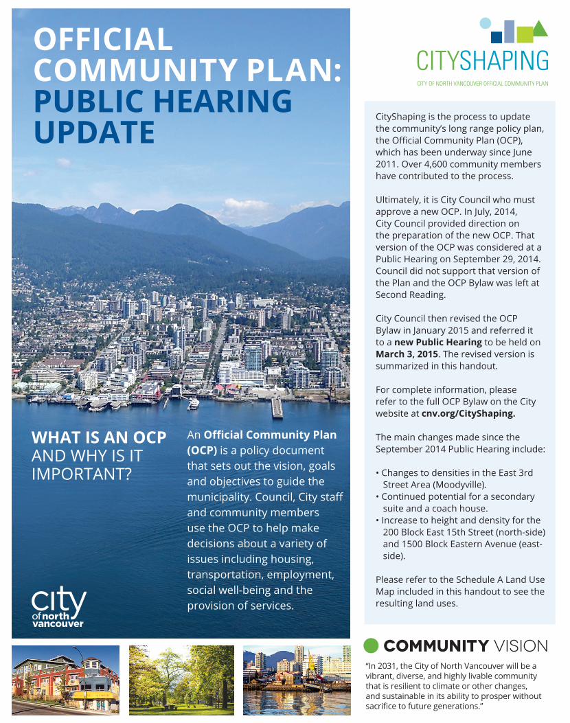
An Official Community Plan (OCP) is a policy document that sets out the vision, goals and objectives to guide the municipality. Council, City staff and community members use the OCP to help make decisions about a variety of issues including housing, transportation, employment, social well-being and the provision of services.
WHAT IS AN OCP AND Why is it imPOrtANt?
OFFICIAL COMMUNITY PLAN: PUBLIC HEARING UPDATE
“in 2031, the City of North Vancouver will be a vibrant, diverse, and highly livable community that is resilient to climate or other changes, and sustainable in its ability to prosper without sacrifice to future generations.”
community vision
Cityshaping is the process to update the community’s long range policy plan, the Official Community Plan (OCP), which has been underway since June 2011. Over 4,600 community members have contributed to the process.
Ultimately, it is City Council who must approve a new OCP. in July, 2014, City Council provided direction on the preparation of the new OCP. that version of the OCP was considered at a Public hearing on september 29, 2014. Council did not support that version of the Plan and the OCP Bylaw was left at second reading.
City Council then revised the OCP Bylaw in January 2015 and referred it to a new Public Hearing to be held on March 3, 2015. the revised version is summarized in this handout.
For complete information, please refer to the full OCP Bylaw on the City website at cnv.org/CityShaping.
the main changes made since the september 2014 Public hearing include:
• Changes to densities in the East 3rd Street Area (Moodyville).
• Continued potential for a secondary suite and a coach house.
• Increase to height and density for the 200 Block East 15th Street (north-side) and 1500 Block Eastern Avenue (east-side).
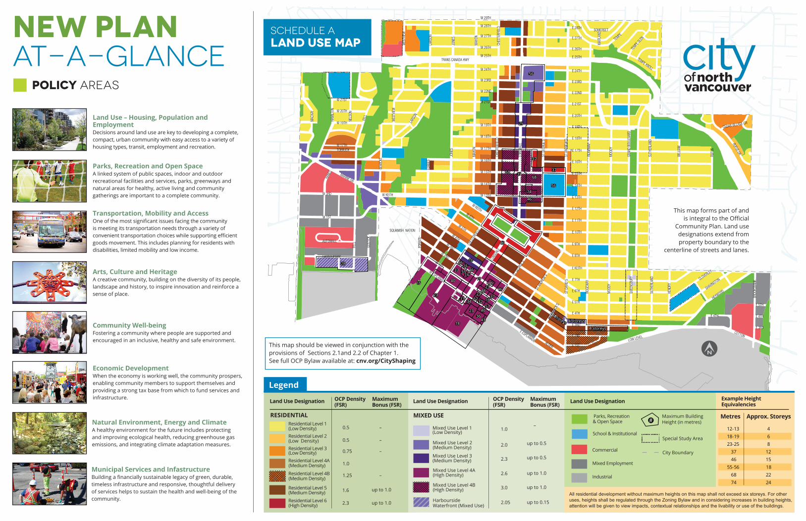
Please refer to the schedule A Land Use map included in this handout to see the resulting land uses.
NEW PLANAT-A-GLANCE
Land Use – Housing, Population and EmploymentDecisions around land use are key to developing a complete, compact, urban community with easy access to a variety of housing types, transit, employment and recreation.
Parks, Recreation and Open SpaceA linked system of public spaces, indoor and outdoor recreational facilities and services, parks, greenways and natural areas for healthy, active living and community gatherings are important to a complete community.
Transportation, Mobility and AccessOne of the most significant issues facing the community is meeting its transportation needs through a variety of convenient transportation choices while supporting efficient goods movement. this includes planning for residents with disabilities, limited mobility and low income.
Arts, Culture and HeritageA creative community, building on the diversity of its people, landscape and history, to inspire innovation and reinforce a sense of place.
Community Well-beingFostering a community where people are supported and encouraged in an inclusive, healthy and safe environment.
Economic DevelopmentWhen the economy is working well, the community prospers, enabling community members to support themselves and providing a strong tax base from which to fund services and infrastructure.
Natural Environment, Energy and ClimateA healthy environment for the future includes protecting and improving ecological health, reducing greenhouse gas emissions, and integrating climate adaptation measures.
Municipal Services and InfastructureBuilding a financially sustainable legacy of green, durable, timeless infrastructure and responsive, thoughtful delivery of services helps to sustain the health and well-being of the community.
POLICY AREAS
• •• •
• • •• • •
• • •• • •
• • •• • •
•••• ••••••••••••••••••••••••••
••••••
• • • • • • • • • • • • • • •••••••••••••••••••••••••••••••••••••••
•••••••••••••••••••••••
••••••••••••••••••••••••••••••••• • • • • • • • • • • • • • • • • • ••
•••••••••••••••••
••••••••••••••••••••••••••••••••••••••••••
••••••••••••••••••••••••••••••••• • • • • • • •
•••••••••••••••••
• • • • • • • • • • • • • •••••••••••••••••••••••••••••••••••••••••••
•••••••••••••••
• • • • •••••
•••••
••••
68
46
19
48
166232
57
46
46
5537
23
40
34
3643
23
18
46
3768
74
3723
16
1616
56
56
25
28
16
13
40
23 4646
37
37
4 storeys
4 storeys
4 storeys
TOBRUCKW 17TH
W 19TH
W 20TH
W 21ST
E 4TH
E 3RD
E 4TH
E 5TH
E 25TH
E 7TH
ST A
NDRE
W'S
ST G
EORG
E'S
CHES
TERF
IELD
LONS
DALE
FORB
ESLA
RSON
HANE
S
W 1ST
W 2ND
W 3RD
W 4TH
W 5TH
W 6TH
W KEITH
W ESPLANADE
W 13TH
W 25TH
W 29TH
W 26TH
W 27TH
W 28TH
W 21ST
W 19TH
W 18TH
W 17TH
HEND
RY
LOW LEVEL
E 1ST
E 3RD
E 28TH
E 22ND
E 23RD
E 24TH
E 21ST
E 26TH
E 27TH
E 20TH
E 19TH
E 14TH
E 15TH
E 16TH
E 17TH
E 18TH
E 8TH
E 9TH
E 10TH
E 11TH
E 12TH
E 13TH
E KEITH
SOMERSET
TEMPE
MAI
TLAN
D
RIDG
EWAY
MOO
DY
GRAN
D BO
ULEV
ARD
SUTH
ERLA
ND
WILL
IAM
RUFU
S
ST D
AVID
'S
RIDG
EWAY
MOO
DY
QUEE
NSBU
RY
SUTH
ERLA
ND CLOVERLEY
SHAVINGTON
E 6TH
E 5TH
E 4TH
E 2NDE ESPLANADE
ST PA
TRICK
'S
ST AN
DREW
'S
JONE
S
MAH
ON
CHES
TERF
IELD
ST G
EORG
E'S
LONS
DALE
TRANS CANADA HWY
SQUAMISH NATION
GOST
ICK
FELL
AUTOMALL
HARBOURSIDE
W 3RD
W 1ST
MARINE DR
HAM
ILTON
NELS
ON
FELL
W 24TH
W 23RD
W 22ND
WES
TVIE
W
W 16TH
W 15TH
W 14TH
LARS
ON
W KEITH
BEW
ICKE
JONE
S
MAH
ON
CHES
TERF
IELD
MAC
KAY
WES
TVIE
W
TEMPE
GLEN
TEMPE KNOLLRUFUS DR
CEDAR VILLAGE CR
ALDER
HEYWOOD
BROO
KSBA
NK
COTTON
FORB
ESResidential Level 1(Low Density) 0.5
0.5Residential Level 2(Low Density)Residential Level 3(Low Density) 0.75
Residential Level 4B (Medium Density)
Residential Level 4A (Medium Density)
1.25
1.0
–
–
–
–
Residential Level 5 (Medium Density) 1.6 up to 1.0
Residential Level 6 (High Density) 2.3 up to 1.0
Mixed Use Level 1(Low Density)
1.0–
Mixed Use Level 2(Medium Density) 2.0 up to 0.5
Mixed Use Level 3(Medium Density) 2.3 up to 0.5
Mixed Use Level 4A(High Density)
Mixed Use Level 4B(High Density)
2.6
3.0
up to 1.0
Legend
Land Use Designation Land Use Designation
HarboursideWaterfront (Mixed Use)
2.05 up to 0.15
up to 1.0
OCP Density(FSR)
MaximumBonus (FSR)
OCP Density(FSR)
MaximumBonus (FSR)
RESIDENTIAL
Land Use Designation
MIXED USE& Open SpaceParks, Recreation
School & Institutional
Commercial
Mixed Employment
Industrial
Maximum Building Height (in metres)
Special Study Area
City Boundary
#
All residential development without maximum heights on this map shall not exceed six storeys. For otheruses, heights shall be regulated through the Zoning Bylaw and in considering increases in building heights,attention will be given to view impacts, contextual relationships and the livability or use of the buildings.
Example HeightEquivalencies
Metres Approx. Storeys
12-13 4 18-19 6 23-25 8 37 12 46 15 55-56 18 68 22 74 24
• • • • • • • • • •
• • • • • • • • • •• •
• •
• •
• •
• •
• •
schedule ALand Use Map
this map should be viewed in conjunction with the provisions of sections 2.1and 2.2 of Chapter 1.see full OCP Bylaw available at: cnv.org/CityShaping
this map forms part of andis integral to the Official
Community Plan. Land use designations extend from property boundary to the
centerline of streets and lanes.
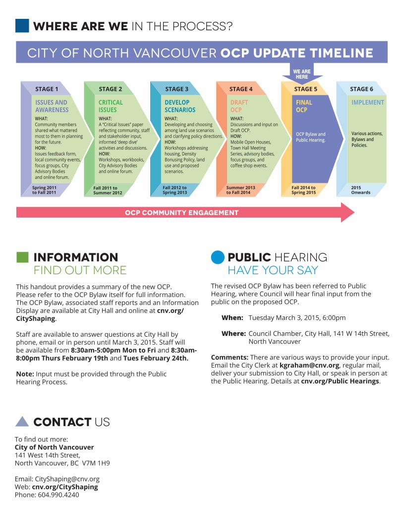
STAGE 6
Various actions,Bylaws andPolicies.
STAGE 5
Summer 2013to Fall 2014
Fall 2014 toSpring 2015
2015Onwards
STAGE 4
DRAFT OCP
FINAL OCP
IMPLEMENT
Fall 2012 toSpring 2013
STAGE 3
DEVELOPSCENARIOSWHAT:Developing and choosingamong land use scenariosand clarifying policy directions.HOW:Workshops addressinghousing, DensityBonusing Policy, landuse and proposedscenarios.
Fall 2011 toSummer 2012
STAGE 2
CRITICALISSUESWHAT:A “Critical Issues” paperreflecting community, staffand stakeholder input,informed ‘deep dive’activities and discussions.HOW:Workshops, workbooks,City Advisory Bodiesand online forum.
Spring 2011to Fall 2011
STAGE 1
ISSUES ANDAWARENESSWHAT:Community membersshared what matteredmost to them in planningfor the future.HOW:Issues feedback form,local community events,focus groups, CityAdvisory Bodiesand online forum.
City of North Vancouver OCP UPDATE Timeline
WHAT:Discussions and input on Draft OCP. HOW:Mobile Open Houses,Town Hall MeetingSeries, advisory bodies,focus groups, andcoffee shop events.
OCP COMMUNITY ENGAGEMENT
where are we in the process?
public hearing
the revised OCP Bylaw has been referred to Public Hearing, where Council will hear final input from the public on the proposed OCP.
When: tuesday march 3, 2015, 6:00pm Where: Council Chamber, City hall, 141 W 14th street, North Vancouver
Comments: there are various ways to provide your input.Email the City Clerk at [email protected], regular mail, deliver your submission to City hall, or speak in person at the Public hearing. Details at cnv.org/Public Hearings.
this handout provides a summary of the new OCP. Please refer to the OCP Bylaw itself for full information. The OCP Bylaw, associated staff reports and an Information Display are available at City hall and online at cnv.org/CityShaping. Staff are available to answer questions at City Hall by phone, email or in person until March 3, 2015. Staff will be available from 8:30am-5:00pm Mon to Fri and 8:30am-8:00pm Thurs February 19th and Tues February 24th. Note: input must be provided through the Public hearing Process.
informationfind out more HAVE YOUR SAY
To find out more:City of North Vancouver141 West 14th street,North Vancouver, BC V7m 1h9
Email: [email protected]: cnv.org/CityShapingPhone: 604.990.4240
contact Us