Embed Size (px)
Citation preview
September 2002
#200 – 286 St. Paul Street Kamloops, BC V2C 6G4 Phone: (250) 374-8311 Fax: (250) 374-5334
VILLAGE OF CHASE
OFFICIAL COMMUNITY PLAN
Bylaw Number 635, 2002
Official Community Plan
Bylaw Number 635, 2002
September 2002
Village of Chase
VILLAGE OF CHASE
OFFICIAL COMMUNITY PLAN BYLAW NUMBER 635, 2002
A bylaw to adopt the Village of Chase Official Community Plan Bylaw Number 635, 2002. WHEREAS Council wishes to repeal Bylaw Number 372 cited as “Village of Chase Amended Official Community Plan Bylaw No. 372, 1989” and all amendments thereto and wishes to adopt a new Official Community Plan pursuant to Part 26 of the Local Government Act, R.S.B.C. 1996, c. 323 as enacted by the Local Government Statutes Amendment Act, 2000. AND WHEREAS Council has examined the plan in conjunction with its most recent capital expenditure program under the Local Government Act and any waste management plan or economic strategy plan that is applicable to the Municipality to ensure consistency between them. AND WHEREAS Council has referred the plan to the Land Reserve Commission for comment. AND WHEREAS Council has referred the plan to the Board of the Thompson-Nicola Regional District and Columbia Shuswap Regional District for comment. AND WHEREAS Council has provided opportunity for consultation with persons, organizations and authorities it considers will be affected pursuant to Section 879 of the Local Government Act. AND WHEREAS Council has held a Public Hearing pursuant to the Local Government Act. NOW THEREFORE Council of the Village of Chase, in open meeting assembled, hereby enacts as follows; 1. This Bylaw shall be cited as the “Village of Chase Official Community Plan Bylaw Number
635, 2002”.
2. The following schedules attached hereto are hereby made part of this Bylaw and adopted as the Official Community Plan for the Village of Chase:
• Schedule A (Official Community Plan Text) except the following sections which are
provided for information and convenience only:
- Introduction [(Section 1) except Regional Context Statement (Section 1.6.2)] - Preambles (Sections 2 through 13) - Existing Conditions Discussions (Sections 2 through 10)
• Schedule B (Land Use Map)
• Schedule C (Development Permit Area Map)
• Schedule D (Boundary Expansion Areas)
3. If any section, subsection, sentence, clause, or phrase of this Bylaw is for any reason held to be invalid by the decision of any court of competent jurisdiction, the invalid portion shall be severed and the decision that it is invalid shall not affect the validity of the remainder.
Official Community Plan
Bylaw Number 635, 2002
September 2002
Village of Chase
Official Community Plan
Bylaw Number 635, 2002
Page (i) September, 2002
Village of Chase
TABLE OF CONTENTS
SCHEDULE A - OFFICIAL COMMUNITY PLAN TEXT
1.0 INTRODUCTION .............................................................................................................. 1 1.1 THE OFFICIAL COMMUNITY PLAN ........................................................................................... 1 1.2 STRUCTURE OF THE OFFICIAL COMMUNITY PLAN........................................................................ 2 1.3 FORCE AND EFFECT ............................................................................................................ 2 1.4 LAND USE MAP DESIGNATIONS.............................................................................................. 3 1.5 GUIDING PRINCIPLES .......................................................................................................... 3 1.6 REGIONAL CONTEXT ........................................................................................................... 5 1.7 DEMOGRAPHICS, LABOUR FORCE INFORMATION AND HOUSING PROJECTIONS .................................... 8
2.0 RESIDENTIAL ................................................................................................................ 10 2.1 PREAMBLE...................................................................................................................... 10 2.2 EXISTING CONDITIONS...................................................................................................... 10 2.3 OBJECTIVES.................................................................................................................... 12 2.4 LAND USE MAP DESIGNATIONS............................................................................................ 13 2.5 POLICIES ....................................................................................................................... 13
3.0 COMMERCIAL ................................................................................................................ 15 3.1 PREAMBLE...................................................................................................................... 15 3.2 EXISTING CONDITIONS...................................................................................................... 15 3.3 OBJECTIVES.................................................................................................................... 15 3.4 LAND USE MAP DESIGNATION ............................................................................................. 16 3.5 POLICIES ....................................................................................................................... 16
4.0 INDUSTRIAL .................................................................................................................. 18 4.1 PREAMBLE...................................................................................................................... 18 4.2 EXISTING CONDITIONS...................................................................................................... 18 4.3 OBJECTIVES.................................................................................................................... 18 4.4 LAND USE MAP DESIGNATIONS............................................................................................ 18 4.5 POLICIES ....................................................................................................................... 18 4.6 SAND AND GRAVEL DEPOSITS.............................................................................................. 19
Official Community Plan
Bylaw Number 635, 2002
Page (ii) September, 2002
Village of Chase
5.0 CIVIC AND INSTITUTIONAL.......................................................................................... 20 5.1 PREAMBLE...................................................................................................................... 20 5.2 EXISTING CONDITIONS...................................................................................................... 20 5.3 OBJECTIVES.................................................................................................................... 20 5.4 LAND USE MAP DESIGNATION ............................................................................................. 20 5.5 POLICIES ....................................................................................................................... 20
6.0 PARKS AND OPEN SPACE .............................................................................................. 22 6.1 PREAMBLE...................................................................................................................... 22 6.2 EXISTING CONDITIONS...................................................................................................... 22 6.3 OBJECTIVES.................................................................................................................... 22 6.4 LAND USE MAP DESIGNATIONS............................................................................................ 22 6.5 POLICIES ....................................................................................................................... 22
7.0 AGRICULTURAL LANDS ................................................................................................. 24 7.1 PREAMBLE...................................................................................................................... 24 7.2 EXISTING CONDITIONS...................................................................................................... 24 7.3 OBJECTIVES.................................................................................................................... 24 7.4 LAND USE MAP DESIGNATIONS............................................................................................ 24 7.5 POLICIES ....................................................................................................................... 24
8.0 SPECIAL DEVELOPMENT AREA ...................................................................................... 25 8.1 PREAMBLE...................................................................................................................... 25 8.2 EXISTING CONDITIONS...................................................................................................... 25 8.3 OBJECTIVES.................................................................................................................... 25 8.4 LAND USE MAP DESIGNATIONS............................................................................................ 25 8.5 POLICIES ....................................................................................................................... 25
9.0 INFRASTRUCTURE......................................................................................................... 26 9.1 PREAMBLE...................................................................................................................... 26 9.2 OBJECTIVES.................................................................................................................... 28 9.3 POLICIES ....................................................................................................................... 29 9.4 FINANCING OF INFRASTRUCTURE.......................................................................................... 30
10.0 ENVIRONMENTALLY SENSITIVE AND HAZARDOUS AREAS .......................................... 32 10.1 PREAMBLE..................................................................................................................... 32 10.2 EXISTING CONDITIONS..................................................................................................... 32
Official Community Plan
Bylaw Number 635, 2002
Page (iii) September, 2002
Village of Chase
10.3 OBJECTIVES................................................................................................................... 32 10.4 POLICIES ...................................................................................................................... 32
11.0 DEVELOPMENT PERMIT AREAS ..................................................................................... 34 11.1 PREAMBLE..................................................................................................................... 34 11.2 DESIGNATED DEVELOPMENT PERMIT AREAS........................................................................... 34
12.0 TEMPORARY COMMERCIAL AND INDUSTRIAL USE PERMITS ...................................... 47 12.1 POLICIES ...................................................................................................................... 47
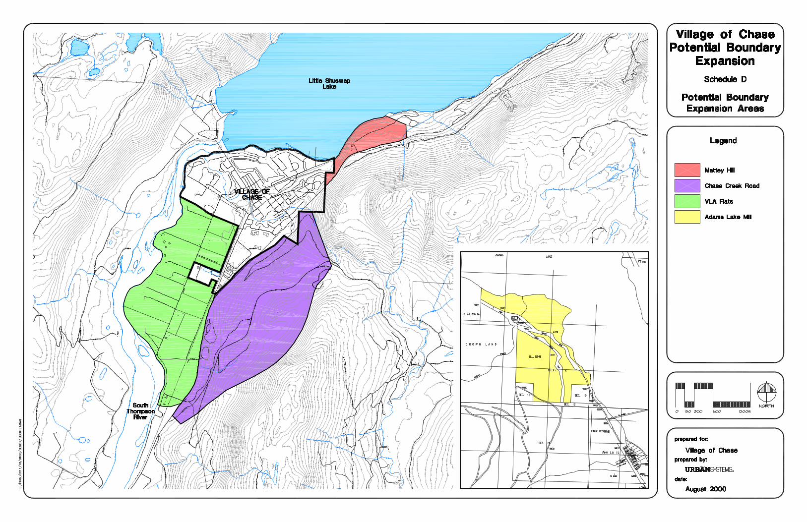
13.0 BOUNDARY EXPANSION AREAS .................................................................................... 48 13.1 PREAMBLE..................................................................................................................... 48 13.2 OBJECTIVES................................................................................................................... 51
14.0 IMPLEMENTATION ........................................................................................................ 54 14.1 INTRODUCTION .............................................................................................................. 54 14.2 ZONING BYLAW .............................................................................................................. 54 14.3 REZONING CRITERIA........................................................................................................ 54 14.4 SUBDIVISION SERVICING................................................................................................... 54 14.5 REDESIGNATION CRITERIA ................................................................................................ 54 14.6 ECONOMIC DEVELOPMENT STRATEGIES................................................................................. 55
SCHEDULE B - LAND USE MAP SCHEDULE C - DEVELOPMENT PERMIT AREA MAP SCHEDULE D - BOUNDARY EXPANSION AREAS

Official Community Plan
Bylaw Number 635, 2002
September, 2002
Village of Chase
Schedule A
OFFICIAL COMMUNITY PLAN TEXT
Official Community Plan
Bylaw Number 635, 2002
Page 1 September, 2002
Village of Chase
1.0 INTRODUCTION 1.1 The Official Community Plan
The Village of Chase Official Community Plan is intended to establish the policy framework within which planning decisions are made by Council.
In accordance with the Local Government Act an Official Community Plan statement of objectives and policies to guide decisions on planning and land use management, within the area covered by the plan, respecting the purposes of local government.
According to the Local Government Act, the plan should address:
• the approximate location, amount, type and density of residential development required to meet anticipated housing needs over a period of at least 5 years;
• the approximate location, amount and type of present and proposed commercial, industrial, institutional, agricultural, recreational and public utility land uses;
• the approximate location and area of sand and gravel deposits that are suitable for future sand and gravel extraction;
• restrictions on the use of land that is subject to hazardous conditions or that is environmentally sensitive to development;
• the approximate location and phasing of any major road, sewer and water systems;
• the approximate location and type of present and proposed public facilities, including schools, parks and waste treatment and disposal sites;
• other matters that may, in respect of any plan, be required or authorized by the minister;
• An official community plan must include housing policies of the Village of Chase respecting affordable housing, rental housing and special needs housing.
Once implemented, the Official Community Plan will serve to allow Council to achieve identified
community goals and objectives.
The Local Government Act sets out the criteria and mandatory considerations on which the Official Community Plan is based. The process followed in the preparation and adoption of the Plan has also been consistent with provisions of the Local Government Act.
The Official Community Plan (OCP) is based on the resources and capabilities of the Village of Chase. The OCP aims to meet the requirements, needs and aspirations of Chase's residents for the foreseeable future. The Plan should be updated periodically to ensure that the document continues to reflect the long-range planning objectives of the community.
Official Community Plan
Bylaw Number 635, 2002
Page 2 September, 2002
Village of Chase
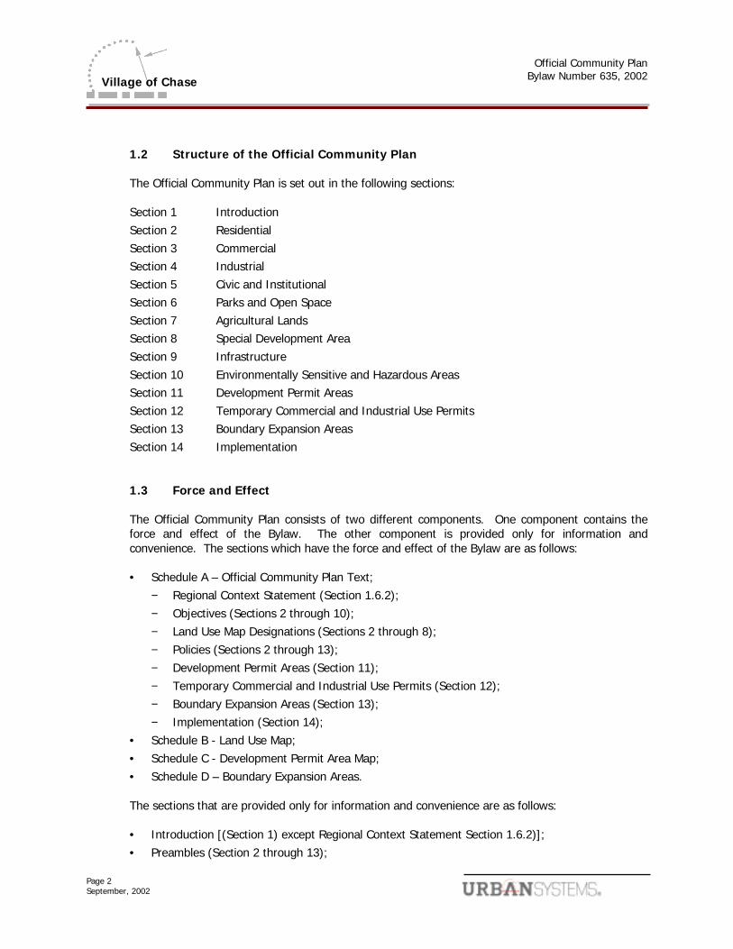
1.2 Structure of the Official Community Plan
The Official Community Plan is set out in the following sections: Section 1 Introduction Section 2 Residential Section 3 Commercial Section 4 Industrial Section 5 Civic and Institutional Section 6 Parks and Open Space Section 7 Agricultural Lands Section 8 Special Development Area Section 9 Infrastructure Section 10 Environmentally Sensitive and Hazardous Areas Section 11 Development Permit Areas Section 12 Temporary Commercial and Industrial Use Permits Section 13 Boundary Expansion Areas Section 14 Implementation 1.3 Force and Effect
The Official Community Plan consists of two different components. One component contains the force and effect of the Bylaw. The other component is provided only for information and convenience. The sections which have the force and effect of the Bylaw are as follows: • Schedule A – Official Community Plan Text;
− Regional Context Statement (Section 1.6.2); − Objectives (Sections 2 through 10); − Land Use Map Designations (Sections 2 through 8); − Policies (Sections 2 through 13); − Development Permit Areas (Section 11); − Temporary Commercial and Industrial Use Permits (Section 12); − Boundary Expansion Areas (Section 13); − Implementation (Section 14);
• Schedule B - Land Use Map; • Schedule C - Development Permit Area Map; • Schedule D – Boundary Expansion Areas.
The sections that are provided only for information and convenience are as follows:
• Introduction [(Section 1) except Regional Context Statement Section 1.6.2)]; • Preambles (Section 2 through 13);
Official Community Plan
Bylaw Number 635, 2002
Page 3 September, 2002
Village of Chase
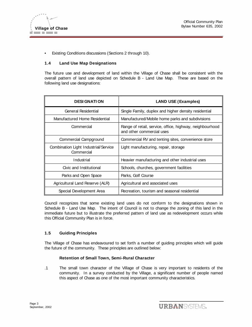
• Existing Conditions discussions (Sections 2 through 10). 1.4 Land Use Map Designations
The future use and development of land within the Village of Chase shall be consistent with the overall pattern of land use depicted on Schedule B - Land Use Map. These are based on the following land use designations:
DESIGNATION LAND USE (Examples)
General Residential Single Family, duplex and higher density residential
Manufactured Home Residential Manufactured/Mobile home parks and subdivisions
Commercial Range of retail, service, office, highway, neighbourhood and other commercial uses
Commercial Campground Commercial RV and tenting sites, convenience store
Combination Light Industrial/Service Commercial
Light manufacturing, repair, storage
Industrial Heavier manufacturing and other industrial uses
Civic and Institutional Schools, churches, government facilities
Parks and Open Space Parks, Golf Course
Agricultural Land Reserve (ALR) Agricultural and associated uses
Special Development Area Recreation, tourism and seasonal residential
Council recognizes that some existing land uses do not conform to the designations shown in
Schedule B - Land Use Map. The intent of Council is not to change the zoning of this land in the immediate future but to illustrate the preferred pattern of land use as redevelopment occurs while this Official Community Plan is in force.
1.5 Guiding Principles
The Village of Chase has endeavoured to set forth a number of guiding principles which will guide the future of the community. These principles are outlined below:
Retention of Small Town, Semi-Rural Character
.1 The small town character of the Village of Chase is very important to residents of the community. In a survey conducted by the Village, a significant number of people named this aspect of Chase as one of the most important community characteristics.
Official Community Plan
Bylaw Number 635, 2002
Page 4 September, 2002
Village of Chase
Linear Downtown
.2 The downtown area of the Village of Chase is currently concentrated along Shuswap Avenue between Chase Creek and MacPherson Street. While there are some commercial activities located on the streets directly parallel to Shuswap Avenue in the same area, the shopping mall on Brooke Street is some distance away. It is the intention of the Village of Chase to focus further commercial development on Shuswap Avenue, moving linearly towards the mall.
Economic Diversification
.3 Retail is the largest single sector employer of people in Chase. Growth in other sectors of
the economy would strengthen the local economy, provide an improved property tax base and better the employment outlook. It is the intention of the Village of Chase to facilitate the establishment of light industry. Service and tourist commercial businesses will also be encouraged in Chase. Increasing employment opportunities within the local area will be promoted so that the Village of Chase continues to be a family- oriented community, as well as a suitable place for retirement.
Intensification of Land Use
.4 Land use intensification will be encouraged where appropriate in the Village of Chase. In
particular, in areas suitable for residential use, low-rise multi-family housing will be given full consideration. In addition, full utilization of areas zoned for commercial and industrial use will be promoted. This infilling will be promoted in order to make optimal use of existing infrastructure and to minimize the necessity for expanding services to peripheral areas.
Emphasize Waterfront Aspects of Community
.5 Survey results indicated that living in a waterfront community was one of the most valued
qualities of life in the Village of Chase. Every effort will be made to improve linear park space for walking and biking along the creek, river and lake. Use of the waterfront parks and facilities will be encouraged. The waterfront will be featured in tourism promotion.
Development Permit Areas
.6 The objective of Development Permit Areas is to allow Council control over certain types of
development. Development Permit Areas will be used to promote design integrity and to ensure the compatibility of new development with surrounding neighbourhoods in the Village of Chase. In addition, Development Permit Areas will be established so that development in those areas most visible to the community and to tourists will be held to strict guidelines and close scrutiny will be given to plans.
Maintain Mix of Housing Types
.7 It is the intention of the Village of Chase to encourage a mix of housing types and tenures.
Rental housing, in particular, is in short supply; rental projects will be encouraged, as well affordable and special needs housing. It is the intention of the Village of Chase to encourage the use of secondary suites as rental accommodation in accordance with
Official Community Plan
Bylaw Number 635, 2002
Page 5 September, 2002
Village of Chase
Provincial legislation in this regard. Moves to promote a mix of residential and commercial uses will also be encouraged where appropriate. Mobile and manufactured housing, as well as some of the older homes, provide a good base of affordable housing. The Village of Chase will continue to facilitate the development of a variety of housing forms in an effort to maintain the desirable mix already in evidence. There is a special awareness of differing needs for both family housing and housing oriented for seniors. The Village intends to continue to accommodate a housing base for both groups.
Tourism
.8 Tourism is seen as an important avenue to economic prosperity. Tourism will be
encouraged through support for local events and through overall community enhancement and promotion. Development of potential tourist attractions will be given special consideration.
Traffic
.9 The impact of continued development in the Village of Chase is of concern with regard to
traffic flows. Developers of large areas may be asked to provide traffic impact studies prior to approval of the project. The Village of Chase will consider carrying out an overall traffic study in an effort to prevent major problems from occurring. The Ministry of Transportation may be asked to assist with such a study.
Health and Safety
.10 Health and safety are of primary concern to the Village of Chase. In the broad context,
health and safety relate to a healthy environment, adequate play space, sufficient street lighting and crime prevention. The Village of Chase will continue to try and maintain a safe community.
1.6 Regional Context
Background
.1 In 1995 the Thompson Nicola Regional District (TNRD) and its member municipalities undertook a Regional Growth Strategy as outlined in the Local Government Act. A series of background reports were completed, and the TNRD adopted the Regional Growth Strategy in the spring of 2000.
The Regional Growth Strategy is not a land use plan, but rather a cooperative strategy for achieving a sustainable future for the region. The Village of Chase worked in partnership with the TNRD to develop this document. Some critical issues that face the central sub region of the TNRD, of which Chase is a part, include population growth pressure facing the South Thompson Valley, protection of resource lands, parks and recreation areas, protection of community watersheds and the enhancement of visual corridors and amenity areas.
Official Community Plan
Bylaw Number 635, 2002
Page 6 September, 2002
Village of Chase
Given these challenges a Vision Statement focused on a sustainable future was created. The Regional Vision for the TNRD is as follows:
“The TNRD is a unique region of diversity and contrast characterized by numerous distinct and special places. Building on this diverse mix of urban and rural resource and wilderness settings shall be the dominant guiding principle as new development is encouraged. Urban places will grow while retaining their existing scope and character; rural places will remain rural while accepting appropriate new development; and settlement in resource areas will be limited and carefully managed.” 1
In 2001, the TNRD, in conjunction with the Village of Chase, the City of Kamloops and an Intergovernmental Advisory Committee representing key agencies began the process of establishing the South Thompson Settlement Strategy which will guide growth and future settlement within the region for the next 20 years. Along with the policies of the Regional Growth Strategy, the Village of Chase Official Community Plan (OCP) will embody the principles and policies that form the substance of the South Thompson Settlement Strategy.
Regional Context Statement .2 As outlined in the Local Government Act, Official Community Plans must include a
regional context statement. The purpose of a regional context statement is to outline the principles of regional growth management strategies as they apply to the municipality and to identify the OCP policies that support those principles.
The Village of Chase is a primary urban centre in the South Thompson Valley outside of the City of Kamloops, so this community plays a significant role within the Valley and the TNRD. The Village of Chase Official Community Plan was developed in accordance with the TNRD’s Regional Growth Strategy and the South Thompson Settlement Strategy. The following describes how the Village of Chase OCP relates to these two growth management strategies.
Human Settlement
Future residential development will occur in a compact, cost effective and sustainable manner. The Village will encourage a range of housing types and promote mixed use development where possible. Infill on existing vacant parcels within the Village will be directed to those areas with existing community services. Development to higher density residential uses will be encouraged on selected vacant sites, as well as within potential redevelopment areas. A range of commercial, industrial and public activities will be encouraged to continue to develop within the Village.
Fringe development will be discouraged and the expansion of the Village boundaries required to accommodate growth will come in consultation with the TNRD Fringe Areas Policy Paper, stakeholders, and landowners to reflect the growth management principles contained in the Regional Growth Strategy and the South Thompson Settlement Strategy.
1 TNRD Regional Growth Strategy, TNRD, p.5
Official Community Plan
Bylaw Number 635, 2002
Page 7 September, 2002
Village of Chase
In compliance with the South Thompson Settlement Strategy, the development and expansion of the Village onto those lands within the Agricultural Land Reserve (ALR) will not be endorsed by the Village and the preservation of environmental features such as watercourses, riparian areas and wildlife habitats will be encouraged. Urban-density residential development along with associated public and neighbourhood commercial uses will be encouraged in the Chase Creek Road area.
Where new development occurs, applications for OCP amendments, rezoning and development permits will be addressed ensuring that they act to support the principles of the Regional Growth Strategy and the South Thompson Settlement Strategy.
Transportation and Energy
The Village of Chase recognizes the importance of an efficient transportation system, and will continue to work the Ministry of Transportation and the TNRD in relation to major transportation corridors.
Economic Development
Strengthening the local economy through economic diversification and increasing employment opportunities are fundamental principles within the OCP. Facilitating and retaining the establishment of new light industry, service and tourist commercial businesses will help the Village to meet these policies.
Environmental Protection
The Village of Chase recognizes the value of preserving and enhancing the natural environment. The Village will safeguard natural features as well as take steps to minimize risks associated with hazardous conditions such as flooding and construction on steep slopes.
Open Space and Cultural Heritage
Residents value the rural character and cultural heritage within the Valley. Preserving these values by acknowledging the importance of the Agricultural Land Reserve, and significant cultural and heritage sites within and around the Village are outlined within the OCP.
Implementation
The Village of Chase is committed to being an active participant in the South Thompson Settlement Strategy and will work to support the TNRD’s Intergovernmental Advisory Committee and Interagency Agreements on an on-going basis by consulting on regional settlement planning policies and projects.
As an adjunct to the OCP, the Village is researching boundary expansion issues and will develop land use planning policies for the areas most appropriate for expansion. This process will identify land uses, density, and infrastructure criteria to guide development
Official Community Plan
Bylaw Number 635, 2002
Page 8 September, 2002
Village of Chase
that corresponds with and reinforces the policies of the Regional Growth Strategy and the South Thompson Settlement Strategy.
1.7 Demographics, Labour Force Information and Housing Projections
Existing Population
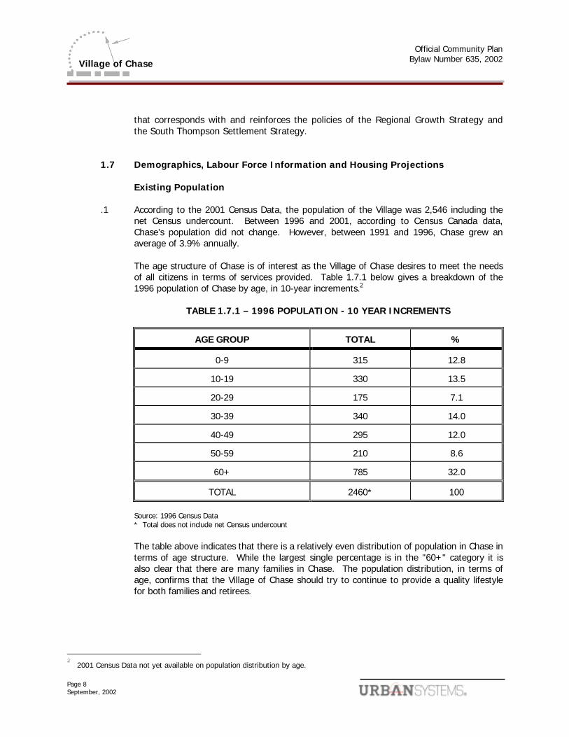
.1 According to the 2001 Census Data, the population of the Village was 2,546 including the net Census undercount. Between 1996 and 2001, according to Census Canada data, Chase’s population did not change. However, between 1991 and 1996, Chase grew an average of 3.9% annually.
The age structure of Chase is of interest as the Village of Chase desires to meet the needs
of all citizens in terms of services provided. Table 1.7.1 below gives a breakdown of the 1996 population of Chase by age, in 10-year increments.2
TABLE 1.7.1 – 1996 POPULATION - 10 YEAR INCREMENTS
AGE GROUP TOTAL %
0-9 315 12.8
10-19 330 13.5
20-29 175 7.1
30-39 340 14.0
40-49 295 12.0
50-59 210 8.6
60+ 785 32.0
TOTAL 2460* 100 Source: 1996 Census Data * Total does not include net Census undercount
The table above indicates that there is a relatively even distribution of population in Chase in terms of age structure. While the largest single percentage is in the "60+" category it is also clear that there are many families in Chase. The population distribution, in terms of age, confirms that the Village of Chase should try to continue to provide a quality lifestyle for both families and retirees.
2
2001 Census Data not yet available on population distribution by age.
Official Community Plan
Bylaw Number 635, 2002
Page 9 September, 2002
Village of Chase
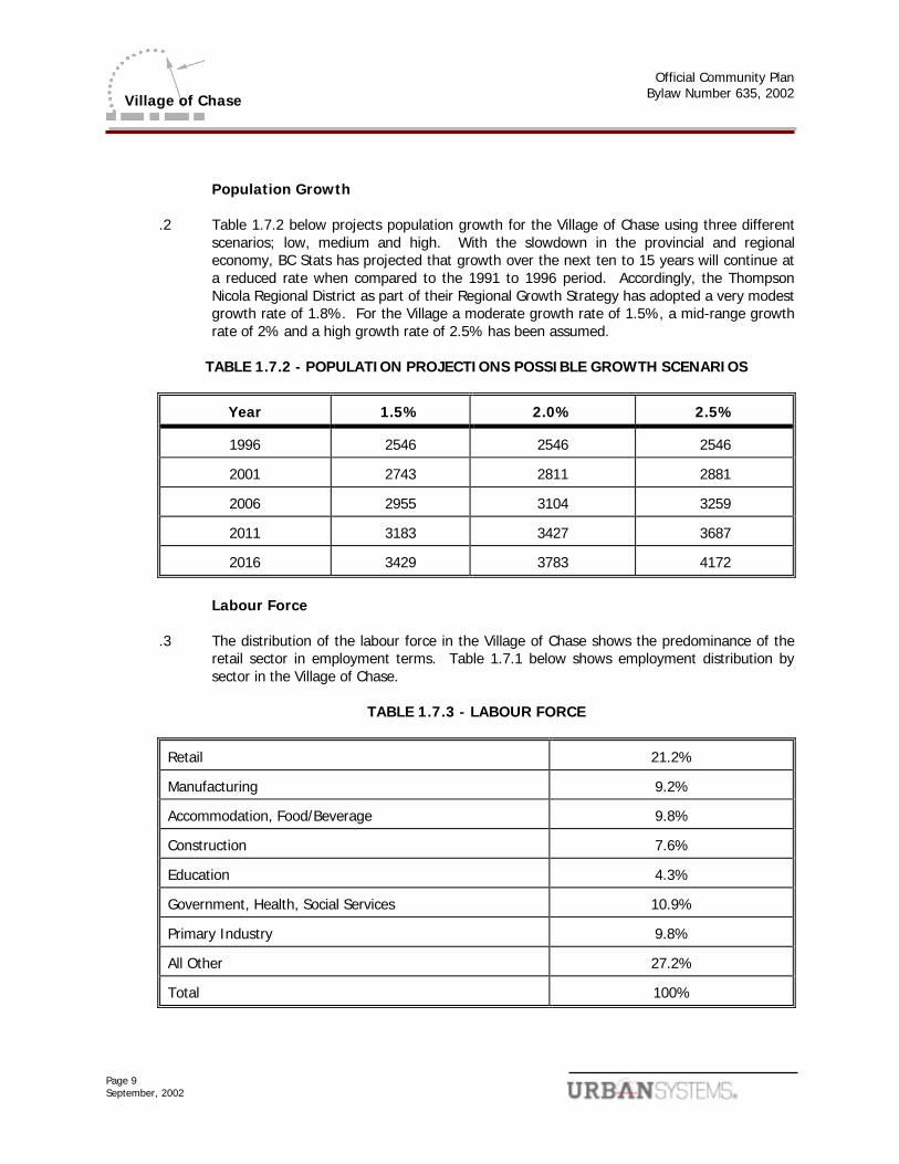
Population Growth
.2 Table 1.7.2 below projects population growth for the Village of Chase using three different scenarios; low, medium and high. With the slowdown in the provincial and regional economy, BC Stats has projected that growth over the next ten to 15 years will continue at a reduced rate when compared to the 1991 to 1996 period. Accordingly, the Thompson Nicola Regional District as part of their Regional Growth Strategy has adopted a very modest growth rate of 1.8%. For the Village a moderate growth rate of 1.5%, a mid-range growth rate of 2% and a high growth rate of 2.5% has been assumed.
TABLE 1.7.2 - POPULATION PROJECTIONS POSSIBLE GROWTH SCENARIOS
Year 1.5% 2.0% 2.5%
1996 2546 2546 2546
2001 2743 2811 2881
2006 2955 3104 3259
2011 3183 3427 3687
2016 3429 3783 4172
Labour Force
.3 The distribution of the labour force in the Village of Chase shows the predominance of the
retail sector in employment terms. Table 1.7.1 below shows employment distribution by sector in the Village of Chase.
TABLE 1.7.3 - LABOUR FORCE
Retail 21.2%
Manufacturing 9.2%
Accommodation, Food/Beverage 9.8%
Construction 7.6%
Education 4.3%
Government, Health, Social Services 10.9%
Primary Industry 9.8%
All Other 27.2%
Total 100%
Official Community Plan
Bylaw Number 635, 2002
Page 10 September, 2002
Village of Chase
2.0 RESIDENTIAL 2.1 Preamble
Chase is a picturesque town nestled between steep slopes and the Trans Canada Highway on the south, Little Shuswap Lake and the South Thompson River on the east and north, and agricultural land on the west. Located within reasonable commuting distance of both Kamloops and Salmon Arm, Chase had very significant growth, with an average annual growth rate of 3.9% between 1991 and 1996. Since then growth has decreased considerably and it is estimated that the Village will experience growth in the area of 1.5-2%. As a result of these factors, the amount of land available to accommodate growth is limited by the same topographic features that make the Village so attractive. This means that larger vacant land parcels need to be carefully utilized. The Local Government Act requires that this Plan identify the location, type and density of sufficient residential land to accommodate anticipated housing demands over a period of at least 5 years.
The Village of Chase is concerned to ensure that housing is available to a wide range of socio-economic groups. Mobile and manufactured home parks provide a source of affordable, medium density housing. In addition, some older housing stock provides housing to people of modest means.
Residents of Chase are of mixed ages, and at varying points in the family life cycle. Therefore a variety of housing types is required. Almost one-third of the residents are over the age of 60 and some of these people will most likely require changing accommodation over time (i.e. from large single family homes to townhouses or apartments). This, in turn, will help free up some single family homes for younger and growing families.
2.2 Existing Conditions
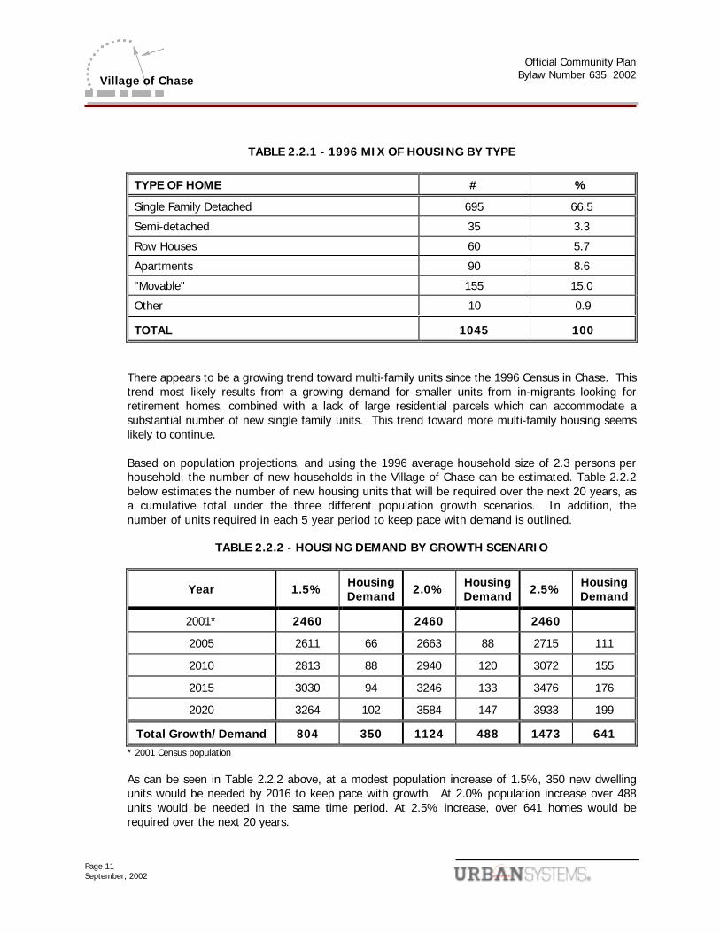
Chase currently has a well balanced mix of housing types. A number of neighbourhoods have several different types of housing contained within one area. Older areas are predominantly single family residential with the exception of a few of the mobile home parks and some duplexes. At least one older area has good redevelopment potential to higher density use. Townhomes and cluster housing are becoming more common in new developments. The 1996 mix of housing is shown in Table 2.2.1.
Official Community Plan
Bylaw Number 635, 2002
Page 11 September, 2002
Village of Chase
TABLE 2.2.1 - 1996 MIX OF HOUSING BY TYPE
TYPE OF HOME # %
Single Family Detached 695 66.5
Semi-detached 35 3.3
Row Houses 60 5.7
Apartments 90 8.6
"Movable" 155 15.0
Other 10 0.9
TOTAL 1045 100
There appears to be a growing trend toward multi-family units since the 1996 Census in Chase. This
trend most likely results from a growing demand for smaller units from in-migrants looking for retirement homes, combined with a lack of large residential parcels which can accommodate a substantial number of new single family units. This trend toward more multi-family housing seems likely to continue. Based on population projections, and using the 1996 average household size of 2.3 persons per household, the number of new households in the Village of Chase can be estimated. Table 2.2.2 below estimates the number of new housing units that will be required over the next 20 years, as a cumulative total under the three different population growth scenarios. In addition, the number of units required in each 5 year period to keep pace with demand is outlined.
TABLE 2.2.2 - HOUSING DEMAND BY GROWTH SCENARIO
Year 1.5% Housing Demand 2.0% Housing
Demand 2.5% Housing Demand
2001* 2460 2460 2460
2005 2611 66 2663 88 2715 111
2010 2813 88 2940 120 3072 155
2015 3030 94 3246 133 3476 176
2020 3264 102 3584 147 3933 199
Total Growth/Demand 804 350 1124 488 1473 641 * 2001 Census population
As can be seen in Table 2.2.2 above, at a modest population increase of 1.5%, 350 new dwelling units would be needed by 2016 to keep pace with growth. At 2.0% population increase over 488 units would be needed in the same time period. At 2.5% increase, over 641 homes would be required over the next 20 years.
Official Community Plan
Bylaw Number 635, 2002
Page 12 September, 2002
Village of Chase
Given the number of existing vacant and subdivided lots, the low and mid range projections for housing demand over the next 10 years, growth has the potential to exhaust all of the existing residential land available. In order to address the projected growth past the 10-year time frame, the increase in demand for housing can only be met by a combination of infill and redevelopment of existing parcels, encouraging higher density housing and the possibility of boundary expansion. 2.3 Objectives
Encourage Mixed Housing, Tenure, Form and Density
.1 It is an objective of Council to ensure that an adequate supply of land is designated for a range of housing tenures, forms and densities. This objective is meant to secure housing that will accommodate differing socio-economic groups, age groups, and various lifestyles over at least the next 5 years.
Rental Accommodation
.2 It is an objective of Council to promote the provision of more rental housing. Secondary
suites will be encouraged. It should be noted that this policy is in keeping with forthcoming provincial legislation.
New Development Compatibility
.3 It is Council's objective to make sure that new residential developments are generally compatible, in terms of built form, with the surrounding areas.
Infilling
.4 It is an objective of Council to direct as much future residential growth as possible to existing serviced areas in order to reduce future servicing costs. In particular, infilling will be encouraged.
Redevelopment of Older Areas
.5 It is Council's objective to carefully review all redevelopment proposals to ensure that an adequate amount of affordable housing is sustained. Higher density use of underutilized areas will be promoted, as long as an adequate mix of market and affordable housing is maintained within the area to be redeveloped.
Affordable and Special Needs Housing
.6 It is Council's objective to ensure an adequate supply of affordable housing. Mobile homes and older homes, in particular, are recognized as forms of affordable housing. Council will also encourage the provision of units to support special needs housing.
Official Community Plan
Bylaw Number 635, 2002
Page 13 September, 2002
Village of Chase
Strata Conversions
.7 It is an objective of Council to limit strata conversions of existing rental units to prevent the depletion of affordable rental housing units.
2.4 Land Use Map Designations Two types of residential use are designated on Schedule B - Land Use Map:
1) General Residential; and 2) Manufactured Home Residential. 2.5 Policies .1 It is the policy of Council to consider a range of residential types and densities in the areas
designated General Residential on Schedule B - Land Use Map. Single family residences, with the exception of single wide mobile homes less than 6 m in width, are allowed in any areas designated General Residential. New duplexes or multiple family residential developments comprising three or more units will be considered by Council on a case-by-case basis. Council will use the following factors when considering proposed developments:
• location on the periphery of a predominantly low density residential area, rather than in
the midst of such an area
• location on street with higher traffic capacity or on a street that is designed to accommodate higher traffic levels
• availability of community water and sanitary sewer
• proximity to parks, schools and other community service and amenities
Rezoning will be required to advance any new duplex or multiple family residential
development. This will require holding a Public Hearing. Furthermore, any new multiple family residential development comprising three or more dwelling units will be designated as a Development Permit Area in accordance with Section 11 of this Bylaw. This will require an amendment to this Official Community Plan.
.2 It is the policy of Council that the density of residential development on any specific parcel
be governed by applicable zoning. In any case, the maximum density shall not be inconsistent with the Zoning Bylaw.
.3 It is the policy of Council to allow only single wide mobile and other forms of manufactured
housing in areas designated Manufactured Home Residential on Schedule B - Land Use Map. .4 It is the policy of Council to consider secondary suites in areas designated General
Residential on Schedule B - Land Use Map.
Official Community Plan
Bylaw Number 635, 2002
Page 14 September, 2002
Village of Chase
.5 It is the policy of Council to ensure that residences on land designated ALR on Schedule B -
Land Use Map conform to the regulations of the Agricultural Land Commission. .6 It is the policy of Council to encourage the development of affordable, rental and special
needs housing in the Village.
Official Community Plan
Bylaw Number 635, 2002
Page 15 September, 2002
Village of Chase
3.0 COMMERCIAL 3.1 Preamble
The Village Core contains the greatest concentration of commercial activity. According to 1996 Census Canada data, the retail sector is the largest single sector employer in the Village of Chase, employing about 21% of the labour force. Recognizing the opportunity that the motoring public has to support and expand retail services and the economic development implications that tourism has on the Village, Council in cooperation with the Chamber of Commerce and service clubs is exploring options to revitalize the downtown core of Chase and the other commercial areas.
3.2 Existing Conditions
There are three principal commercial areas - the Downtown, the Highway access and the Shopping Mall.
The greatest concentration of existing commercial activity is within the downtown area, primarily along Shuswap Avenue. Retail activities dominate with some service commercial and tourist commercial mixed in. Commercial land use also exists in a 1 block area both east and west of Shuswap Avenue between Sicamous and First Avenues and Haldane and Coburn Streets. There is also a medical clinic located across from the Diagnostic and Treatment Centre. Recently, community groups and the local Chamber of Commerce have approached the Village regarding revitalizing the commercial core of Chase. The Village is exploring opportunities to form partnerships to move this initiative forward.
The Shopping Mall is located to the south-west of the downtown core on Brooke Street. Along Shuswap Avenue, between the mall and the downtown the land use is mixed. Residential, civic and institutional and various types of commercial uses are located in this area.
3.3 Objectives
.1 It is an objective of Council to direct retail, service sector and related uses into the downtown commercial core in order to maintain a strong commercial focus in the downtown area.
.2 It is an objective of Council to provide for a wide range of commercial uses within the
Village by designating land for various forms of commercial use in order to meet the needs of the local residents and the travelling public.
.3 It is Council's objective to promote expansion of the commercial area along Shuswap
Avenue, secondary to the Downtown Core, toward Brooke Street. .4 It is an objective of Council to cooperate with the Chamber of Commerce, service clubs, land
owners and the public to promote the revitalization and beautification of the downtown and the other commercial areas. Council will consider developing a Community Enhancement
Official Community Plan
Bylaw Number 635, 2002
Page 16 September, 2002
Village of Chase
Plan for the Village incorporating relevant information from the Downtown Revitalization Plan done in the early 1980’s.
.5 It is an objective of Council to encourage mixed commercial and residential use of buildings
in areas designated for commercial use.
3.4 Land Use Map Designation
Land intended for commercial use carry three designations for commercial on Schedule B - Land Use Map. The designations are as follows:
1) Commercial
2) Campground Commercial
3) Combination Light Industrial/Service Commercial 3.5 Policies
.1 It is a policy of Council to provide for the continued development of the Village Core area to ensure it remains the focal point of the community. Future retail, office, institutional, cultural and related commercial facilities shall be encouraged to locate in the downtown core area and along Shuswap Avenue south from the downtown towards the Shopping Mall area. Appropriate commercial activity in this area would include, but is not necessarily limited to restaurants, hotels, financial institutions, office buildings, retail outlets and personal services. This area will be referred to herein as the Village Core Expansion Area.
The Village Core is outlined on Schedule B - Land Use Map. The Village Core is generally
bounded by the CPR mainline, Sicamous Avenue, Coburn Street and Chase Creek as it passes through the Village Core.
.2 It is a policy of Council to permit residential uses where they currently exist. Residential use
will also be permitted in combination with a commercial use in a designated commercial area. Existing residential land could be considered for rezoning to commercial use.
.3 It is the policy of Council to provide for the ongoing revitalization and beautification of the
downtown core and the other commercial areas in accordance with the Downtown Revitalization Plan.
.4 It is a policy of Council to encourage enlargement of the Village Core to the Village Core
Expansion Area. The expansion area is shown as the "Village Core Expansion Area" on Schedule B - Land Use Map.
.5 It is a policy of Council to require new developments and major renovations to existing
buildings to conform to the Development Permit Area guidelines for commercial areas and for the Village Core where applicable.
Official Community Plan
Bylaw Number 635, 2002
Page 17 September, 2002
Village of Chase
.6 It is Council policy to recognize that service commercial and light industrial uses in Chase are closely related. Service commercial uses are permitted in all areas designated Combination Light Industrial/Service Commercial on Schedule B - Land Use Map.
.7 It is Council policy to allow neighbourhood commercial use where it already exists. New
neighbourhood commercial use in evolving neighbourhoods will be considered on a case by case basis. All neighbourhood commercial use must be integrated into its surroundings. Neighbourhood commercial use will be small in scale.
.8 It is Council policy to recognize the appropriate use of the area designated Commercial on
Schedule B - Land Use Map at the corner of Coburn Street and the Trans Canada Highway for highway/tourist commercial use.
.9 It is Council policy to recognize the importance of the Shopping Mall on Brooke Street for a
variety of retail and personal service uses. The Village Core Expansion Area is specifically intended to recognize the important links between the shopping mall commercial and the Village Core commercial areas.
.10 It is Council policy to identify areas suitable for Commercial Campground development and
to create regulations for this type of commercial use. It is Council policy to permit this type of use in conjunction with applicable municipal, provincial and federal legislation and land development guidelines. Where Commercial Campground areas abut existing or proposed residential areas, landscaping or screening vegetation will be provided to buffer the adjacent residential uses. It is Council policy to direct this type of use to areas designated “Campground Commercial” on Schedule B – Land Use Map.
Official Community Plan
Bylaw Number 635, 2002
Page 18 September, 2002
Village of Chase
4.0 INDUSTRIAL 4.1 Preamble
Council's objective of diversifying the economy of Chase is given a high priority. Council intends to encourage new industries to locate in Chase and resident industry to expand.
4.2 Existing Conditions
Currently, most industrially zoned lands are located along Aylmer Road with the exception of the Trans-Canada industrial area. One large parcel is currently occupied by forestry industries. One large parcel is used as a park and the rest is mixed light industry. Both of the large parcels are located on the north side of Aylmer. At the south west corner of Aylmer Road and Veteran Road there is one light industry and three single family dwellings. In addition, light industries and service commercial are also located along Shuswap Avenue, near the southern entrance to Chase off the Trans Canada Highway.
4.3 Objectives
.1 It is an objective of Council to minimize conflict between industrial and other land uses within the Village.
.2 It is Council's objective to attract new industries to Chase by ensuring that there is adequate
land available for various types of industrial developments.
4.4 Land Use Map Designations
.1 Schedule B - Land Use Map designates two Industrial land use classifications:
1) Combination Light Industrial/Service Commercial; and 2) Industrial.
4.5 Policies
.1 It is Council policy to encourage a range of light industrial and service commercial uses in areas designated Combination Light Industrial/Service Commercial on Schedule B - Land Use Map.
.2 It is Council policy to encourage heavier industrial uses to locate in areas designated
Industrial on Schedule B - Land Use Map. .3 It is Council policy to designate all Combination Light Industrial/Service Commercial and
Industrial areas as Development Permit Areas in accordance with the justification and
Official Community Plan
Bylaw Number 635, 2002
Page 19 September, 2002
Village of Chase
guidelines set out in Section 11 of this Plan. This is intended to ensure compatibility with, and minimize impacts on, adjacent lands.
.4 It is Council policy to encourage any industrial activity to comply with all senior government
environmental standards. .5 It is Council policy to discourage light industrial/service commercial operations with
recognizable negative external impacts such as noise and dust from locating in the area designated Combination Light Industrial/Service Commercial on Schedule B - Land Use Map and located on Shuswap Avenue. Such uses are preferred in the area designated Industrial on Schedule B.
.6 It is Council's policy to retain existing industry on the designated parcel west of Veteran
Road on the north side of Aylmer Road and to encourage more intensified use of this area.
.7 It is Council's policy to retain and intensify industrial use on the parcel on the south side of Aylmer Road east of Veteran Road and west of the railroad tracks.
.8 It is Council's policy to encourage the continued utilization of the lands located north of
Aylmer Road and south of Chase Creek as community park land. Should the owner of this parcel decide to use the land for other purposes, Council will look at options including parkland dedication at the time of subdivision to retain some public use.
.9 It is Council policy to retain the south-west corner of Veteran and Aylmer Roads as industrial
but to allow the homeowners south along Veteran Road to apply for re-zoning to single-family residential land use.
4.6 Sand and Gravel Deposits
There are no known sand and gravel deposits in the Village of Chase.
Official Community Plan
Bylaw Number 635, 2002
Page 20 September, 2002
Village of Chase
5.0 CIVIC AND INSTITUTIONAL 5.1 Preamble
Various public and quasi-public land uses are located in Chase including, but not limited to, schools, religious institutions, government offices and the diagnostic and treatment centre.
5.2 Existing Conditions
Major existing public and institutional uses in the Village include: • schools and churches located generally south and east of Shuswap Avenue;
• Village and other government offices located both in the Village core area and south along
Shuswap Avenue;
• cemetery and highways maintenance yard located southeast of the Trans-Canada Highway;
• clinic (diagnostic and treatment centre) located at the corner of Thompson Avenue and Coburn Street.
5.3 Objectives
.1 It is Council's objective to ensure that Civic and Institutional uses are located where they will best serve the needs of residents and visitors.
.2 It is Council’s objective to support the expansion of health care facilities in the Village
boundaries.
5.4 Land Use Map Designation
Civic and institutional uses are designated Civic and Institutional on Schedule B - Land Use Map.
5.5 Policies
.1 It is Council policy to encourage new government offices to locate in the Village Core.
.2 It is Council policy to work with the School District to ensure adequate lands are designated for future school requirements.
.3 It is Council policy to support the expansion of existing and construction of new health care
facilities to provide care for area residents and enhance employment opportunities in the Village.
Official Community Plan
Bylaw Number 635, 2002
Page 21 September, 2002
Village of Chase
.4 It is Council policy to consider smaller churches and other religious and spiritual institutions, along with related facilities, to locate in all areas of Chase. These will require site-specific rezonings. Larger churches and similar religious and spiritual facilities should locate in Commercial areas.
.5 It is Council's policy to allow small community care facilities as defined in the Community
Care Facility Act to locate throughout Chase, except in industrial areas.
.6 It is Council's policy to consider rezonings for larger community care facilities as defined in the Community Care Facility Act subject to the following criteria:
• suitability of site for intended use;
• compatibility of intended use with adjacent land uses and form and character of neighbourhood;
• adequacy of water supply and sewage disposal system;
• accessibility to Village road system;
• capability of site to accommodate on-site parking;
• accessibility to amenities required by patrons (parks, clinics, shopping and similar amenities).
.7 It is Council's policy to study the possibility of relocating the Public Works yard to either the
Industrial area on Aylmer Road or to the sewage lagoons on Shuswap Avenue should a more appropriate use for the present land become apparent. As the sewage lagoon site is within the ALR, use of the site for the Public Works yard would require approval of the Land Reserve Commission, an issue which the Commission has yet to consider.
.8 It is Council’s policy to strongly support the establishment of a multi-level care facility in the
community.
Official Community Plan
Bylaw Number 635, 2002
Page 22 September, 2002
Village of Chase
6.0 PARKS AND OPEN SPACE 6.1 Preamble
The Village is fortunate to have a number of parks and other open space and recreation areas within its boundaries.
6.2 Existing Conditions
Nine parks exist in Chase. They are designated Parks and Open Space in Schedule B - Land Use Map. The park on the north side of Aylmer Road west of CPR mainline is privately owned and currently zoned Light Industrial. There are walking paths along much of Chase Creek though some cross over private property. Finally, the Sun Shore Golf Course provides a large open space and recreation amenity within the Village.
6.3 Objectives .1 It is an objective of Council to ensure that adequate parks and open spaces are available to
residents and visitors, particularly on waterfront property. .2 It is an objective of Council to link parks and the Village Core by encouraging the
development of linear walking and bicycling paths, particularly along public waterfronts. .3 It is an objective of Council to preserve and expand recreation areas and areas valued for
aesthetic reasons in order to make the Village increasingly attractive to residents and visitors.
6.4 Land Use Map Designations
Parks and open space uses are designated “Parks and Open Space” on Schedule B - Land Use Map.
6.5 Policies
.1 It is a policy of Council that it may require parkland dedication at the time of subdivision in all areas along Chase Creek or other waterfronts. Parkland will also be required at the time of subdivision for the parcel designated Combination Light Industrial/Service Commercial on Schedule B - Land Use Map between Veteran Road and the railroad tracks on the north side of Aylmer Road. Council will also require parkland for a linear walkway on Hillside Avenue. In all other cases, Council may require payment in lieu of parkland dedication at the time of subdivision.
.2 It is a policy of Council to encourage a safe use of community parks by promoting
appropriate measures to prevent vandalism and by encouraging residents to take an active role in the protection and development of these parks.
Official Community Plan
Bylaw Number 635, 2002
Page 23 September, 2002
Village of Chase
.3 It is a policy of Council to continue to recognize the importance of the Sun Shore Golf
Course in providing a valued recreation and open space amenity in the community.
Official Community Plan
Bylaw Number 635, 2002
Page 24 September, 2002
Village of Chase
7.0 AGRICULTURAL LANDS 7.1 Preamble
The areas designated as ALR on Schedule B - Land Use Map lie within the Agricultural Land Reserve (ALR). The intent of the Land Reserve Commission is to protect the agricultural value and rural nature of these areas. Included within the ALR are lands utilized by the Village for the sewage treatment and soil composting facility.
Notwithstanding any other provisions of this Plan, all lands within the ALR except those exempted in the Agricultural Land Reserve Act or general Orders of the Commission, are subject to the provision of the Agricultural Land Reserve Act, regulations pertaining thereto, and Orders of the Commission (thereby not permitting the subdivision of land or the development of new non-farm uses unless approved by the Land Reserve Commission).
7.2 Existing Conditions
Much of the land between the South Thompson River, south of Aylmer Road, north of the Village boundary and east of the CPR mainline lies within the ALR. In addition, there are also lands within the ALR between Veteran Road and the railroad tracks where the Village sewage treatment and disposal facilities are located.
7.3 Objectives
It is an objective of Council to preserve lands suited to agriculture.
7.4 Land Use Map Designations All land currently in the ALR is designated ALR on Schedule B - Land Use Map. 7.5 Policies
.1 It is Council's policy to restrict parcel size in accordance with Land Reserve Commission regulations.
.2 It is Council's policy to support the ALR within the Village boundaries as a means to preserve
both farmland and the semi-rural character of the Village of Chase. .3 It is Council’s policy to require buffering where new non-farm development adjoins lands
within the ALR. Buffering standards will be developed in conjunction with the Land Reserve Commission, will be implemented through enactment of a development permit area at the time of the proposed development, and will be a condition of subdivision approval.
Official Community Plan
Bylaw Number 635, 2002
Page 25 September, 2002
Village of Chase
8.0 SPECIAL DEVELOPMENT AREA 8.1 Preamble
The area to the west of Cummings Avenue, north of the CPR mainline, south of the Little Shuswap Lake and east of the Lakeshore Drive residential area offers unique development opportunities.
8.2 Existing Conditions
The area is currently a mix of seasonal recreation vehicle sites and lots for mobile homes. It has excellent lakeshore frontage and abuts a waterfront park on the east.
8.3 Objectives
.1 It is an objective of Council to consider a variety of recreation and tourism related activities on this site.
.2 It is an objective of Council to retain an emphasis on seasonal residential use.
8.4 Land Use Map Designations
This site is designated Special Development Area on Schedule B - Land Use Map.
8.5 Policies
.1 It is a policy of Council to discourage the development of this site for year-round residential use.
.2 It is a policy of Council to encourage recreation and tourism related uses in the Special
Development Area.
.3 It is a policy of Council to recognize the importance of this site for future tourism promotion and development in Chase.
.4 It is a policy of Council to require the designation of a unique and tailor-made Development
Permit Area within this Special Development Area at the time of rezoning. The specific nature of this Development Permit Area and its guidelines will reflect the type and scope of the proposed development. In general terms, justification for this designation is to ensure that any future redevelopment will be of high quality and will fit with the form and function of the existing neighbourhood and waterfront area.
Official Community Plan
Bylaw Number 635, 2002
Page 26 September, 2002
Village of Chase
9.0 INFRASTRUCTURE 9.1 Preamble
Water
.1 The Village draws its water supply from the South Thompson River. One central intake facility/high lift pump station is located at the point where Little Shuswap Lake feeds into the South Thompson River, just upstream of the confluence of Chase Creek. Two interconnected water storage reservoirs which supply the Village during periods of peak demand are located on the steep hillside east of the Village core area. The pump station feeds the distribution system and fills the water storage reservoirs but there is not a dedicated water main to fill the water reservoirs. The distribution works served by this intake/storage system provide potable and fire flow water throughout the Village. The primary limitation to the system is the capacity of the storage reservoirs to serve future growth. A comprehensive examination of the system is underway. In the mid 1990’s, the Village instituted a water restriction program to conserve water.
The quality of the Village's water is generally good. Treatment works comprise the addition
of chlorine. Turbidity of the water supply has been noted as a periodic concern. Steps have been taken to reduce this problem at the intake. Recently, the Village flows have topped 1 million gallons per day which exceeds the existing chlorination system’s capacity. The chlorination system is at its limit for present peak demand and the chlorine contact system requires upgrading. It is expected that filtration of potable water for the Village will be required in the future.
Sanitary Sewer
.2 There are two approaches to the treatment of sanitary sewage effluent in the Village. The
predominant approach is through the use of a community collection system and treatment facility. The collection system serves most of the area between the CPR mainline and the Trans Canada Highway, as well as lands north of Chase Creek on the west side of the CPR mainline corridor. The sewage treatment facility is located near the southern entrance to the Village. It comprises two aeration lagoons, a storage basin, four rapid infiltration basins and associated works.
Currently system limitations include the rate at which the rapid infiltration basins are able to dispose of effluent and the reliability of the lift stations which currently serve the system. A significant issue regarding the capacity of the treatment system is related to the level of input. The Adam’s Lake Indian Band currently discharge into the Village system and development levels on Band lands have a direct impact on inputs and capacity of the system. Upgrading of this system is ongoing and the Village has completed a Liquid Waste Management Plan (LWMP) to address sewage disposal issues.
Official Community Plan
Bylaw Number 635, 2002
Page 27 September, 2002
Village of Chase
The second approach to treatment of sanitary sewage effluent comprises on-site disposal through septic systems. The main areas served by septic systems include:
• Paquette Road area east of the Village Core
• lands lying east of the Trans-Canada Highway
• area south of Aylmer Road (except newly-developed subdivision)
No problems have been reported with the functioning of these on-site systems.
Storm Drainage
.3 There are two primary storm sewers within the Village. The first, which services much of the Village core area, is located on Shuswap Avenue and discharges into Chase Creek. The second is located in the east portion of the Village on Pine Street and discharges into the South Thompson River. The remainder of the Village is served by small area-specific systems which discharge collected water to the ground, open ditch/culvert arrangements and individual on-site disposal systems. Due to the unfeasibility of connecting to community systems, soil conditions and factors such as evolving senior government regulations, the disposal of stormwater in some parts of the Village has proven problematic and will require continued inter-agency co-operation and study. The Village is currently preparing a master drainage plan.
Transportation
.4 The existing roadway system in the Village of Chase comprises the following main elements,
which are shown as major streets on Schedule B - Land Use Plan.
• Trans-Canada Hwy. - this significant component of the national highway bisects the Village, and presently serves a limited role in moving traffic within the Village.
• Shuswap Avenue - this designated secondary highway provides two major access points to the Trans-Canada Highway and also serves as the Village's major commercial street.
• Pine Street - this designated secondary highway provides access across the CPR mainline tracks and extends from there to areas outside the Village on the west side of the South Thompson River.
• 3rd Avenue/ Veteran Road - this route was extended to connect across Chase
Creek and presently serves the residential area north of the Creek and the mixed industrial/residential /agricultural area to the south.
Official Community Plan
Bylaw Number 635, 2002
Page 28 September, 2002
Village of Chase
• Coburn Street - this street provides an additional access point
to the Trans-Canada Highway from the Village core area.
• Second Avenue - this avenue serves much of the northeast part of the Village. • Aylmer Road - this road serves the southwest part of the
Village and connects it to the Village core area. Generally speaking, the Village is well-served by this existing system of major roadways and
the lesser components which stem from it. The Village has adopted a 5-year Pavement Management Program to guide pavement improvements and identify priority maintenance areas. In addition, there are 6 bridges, 4 vehicular and 2 pedestrian, that provide service throughout the Village. Ongoing maintenance to these structures is required and the Village is assessing their current status in order to develop a maintenance plan.
One area of potential concern, however, is traffic congestion in the Village core area. This
may become particularly pronounced as additional development takes place in and around the core area. Non-automobile modes of transportation appear to be reasonably popular in the Village. This includes both cycling and walking, which people enjoy for both recreation purposes and to commute to/from work. No public transit system exists in the Village and is unlikely to develop in the foreseeable future given the size of the community.
Parking is another transportation issue which has generated considerable discussion in the
Village for some time. Specifically, on-street parking in the Village core area is perceived by many residents to be in short supply. An analysis done in the summer of 1994 showed 72 on-street parking spaces on Shuswap Avenue between Chase Creek and Coburn Street and an additional 200 spaces on adjacent commercial streets (these spaces are composed of both existing and potential parking spaces) including the 40 spaces at the curling rink. Observations showed that even when on-street parking spaces were heavily utilized, many vacant spaces were present in off-street spaces. In addition, there are other undeveloped areas close to the downtown core that could be developed for parking.
9.2 Objectives
.1 It is Council's objective to provide water, sanitary sewer and storm drainage systems that will ensure good health and comply with recognized need, servicing standards, environmental standards and the ability of residents to pay for services.
.2 It is Council's objective to establish and maintain a road network that will guide
development and provide for safe and efficient traffic circulation.
.3 It is Council’s objective to link development approvals, OCP amendments, rezoning and subdivision applications to potable water and wastewater treatment capacity.
Official Community Plan
Bylaw Number 635, 2002
Page 29 September, 2002
Village of Chase
9.3 Policies
Water .1 Council's policies are to:
• require that all residential, commercial, industrial and civic/institutional developments are provided with a safe and healthy supply of water;
• consider requiring water meters for future development;
• consider development applications relative to water system capacity and approve only
those developments that will provide and pay for any system upgrades required to accommodate that development;
• aggressively pursue a water conservation program aimed at managing demand for
water rather than increasing supply. When an increase in system capacity becomes unavoidable, the Village will focus its efforts on enhancing storage capacity.
Sanitary Sewer .2 Council's policies are to:
• require that all residential, commercial, industrial and civic/institutional developments are served by either a community sanitary sewer system or a properly functioning on-site sewerage disposal system approved by the Interior Health Authority;
• work toward providing community sanitary sewer services to all urban residential areas.
Advancements of this initiative will be dependant upon health and environmental reasons and financial viability;
• consider development applications relative to the sewer system capacity and approve
only those developments that will provide and pay for any system upgrades required to accommodate that development;
• aggressively pursue a wastewater reduction program in concert with the water
conservation program. The intent of this program is to stabilize or reduce flows to the treatment facility thus deferring the need for upgrading. When upgrading becomes necessary, the Village will concentrate upon improvements to the rapid infiltration system.
Storm Drainage .3 Council's policies are to:
• require that all residential, commercial industrial and civic/institutional developments manage storm drainage in a manner which does not impact upon adjacent private or public property, lakes, river or creek;
Official Community Plan
Bylaw Number 635, 2002
Page 30 September, 2002
Village of Chase
• require that natural drainage patterns are retained through the use of overland flow, open channels, existing natural drainage courses and swale routing where possible.
Transportation .4 Council's policies are to:
• utilize the major streets in the community for through traffic and minimize the amount of such traffic utilizing local roads in residential neighbourhoods;
• carefully consider the impacts of any new development in the Village core area on traffic
movement and congestion. Council may require a developer to furnish, at the developer's expense, a report outlining anticipated traffic impacts and relevant mitigative measures when significant developments are contemplated in this area;
• work with the Ministry of Transportation in evolving the Village's major street network to
respond to changing circumstances, and in undertaking capital and maintenance works in a cost-shared basis. The Village road network is shown on Schedule B - Land Use Map;
• encourage the use of non-automobile modes of transportation including cycling and
walking. With respect to pedestrian use, Council will reconsider the requirements of the Subdivision Servicing Bylaw with respect to sidewalks in order to ensure that they are required in appropriate locations to facilitate easy pedestrian movement;
• encourage the business community to direct employees to park in off-street parking lots
and leave on-street spaces available to short-term users; • encourage better signage and utilization of off-street parking spaces throughout the
Village core area; • encourage development of parking lots on select vacant lots and unused street areas.
This could include the purchase of land for community parking facilities; • work on an advanced street plan for all land south and east of the railroad tracks.
9.4 Financing of Infrastructure
Council's policy is to utilize a variety of tools to finance required infrastructure projects. These tools include:
• Village General Revenue Fund
• Village Sewer and Water Utility Funds
• Development Cost Charges
• Specified Area Taxation
Official Community Plan
Bylaw Number 635, 2002
Page 31 September, 2002
Village of Chase
• Special Agreements, such as that currently in place with the Adams Lake Indian Band regarding sanitary sewer services.
In addition, the Village will aggressively pursue funding from senior governments for projects which
offer public benefits.
Official Community Plan
Bylaw Number 635, 2002
Page 32 September, 2002
Village of Chase
10.0 ENVIRONMENTALLY SENSITIVE AND HAZARDOUS AREAS 10.1 Preamble
Protecting the environment is of great importance to the Village of Chase. The quality of life is enhanced through preserving the natural environment for recreation, agriculture and tourism. In addition, it is necessary to identify those lands subject to hazard to protect the population and prohibit future development.
10.2 Existing Conditions Little Shuswap Lake, the South Thompson River and Chase Creek are prominent environmental features in Chase. In some areas hazardous conditions exist due to flood potential. Unstable soils are another hazard concern. 10.3 Objectives
.1 It is an objective of Council to preserve and enhance environmentally sensitive lands within the Village of Chase.
.2 It is an objective of Council to try to protect both people and property from identifiable
natural hazards in Chase.
.3 It is Council's objective to protect the water quality in the Shuswap Lake and South Thompson River with consideration for recreational, fisheries and downstream uses.
10.4 Policies
.1 It is Council's policy to work with the Department of Fisheries and Oceans to achieve a balance between enhancing fisheries habitat and maintaining the appeal and usability of waterfront areas in the Village. This includes the Memorial, Mill, Centennial and Willson Park waterfront areas. Council will consider the Department’s Stream Stewardship Guidelines in these deliberations.
.2 It is Council's policy to designate the following as hazardous floodplain areas:
.1 the area within the 200 year floodplain of Little Shuswap Lake, the South Thompson
River and Chase Creek;
.2 the area within the floodplain of other streams. .3 It is Council's policy to protect against the loss of life and to minimize property damage
associated with flooding events by encouraging parks and trails, agricultural and other non-developed uses on the floodplain. Where floodable lands are designated for other land uses, the construction and siting of buildings and mobile homes to be used for habitation,
Official Community Plan
Bylaw Number 635, 2002
Page 33 September, 2002
Village of Chase
business or the storage of goods that could be damaged by floodwaters shall be flood proofed to those standards and elevations specified by the Ministry of Water, Land and Air Protection.
.4 It is Council's policy to designate steep slopes with grades in excess of 30% and areas
subject to soil subsidence, land slip, rock fall, hazard and erosion as hazardous areas.
.5 It is Council's policy to prevent development in areas having steep slopes (greater than 30%) and areas where soil subsidence, land slip, rock fall or erosion hazards are known or suspected. Council will, however, consider permitting development on steep slopes or areas subject to soil subsidence (settling), land slips, rock fall or erosion hazards if the developer provides a report from an engineer experienced and qualified in geotechnical engineering setting out how the area can be safely developed.
.6 It is Council's policy to recognize that hazardous areas may assist in providing and linking
important natural habitats in the community.
Official Community Plan
Bylaw Number 635, 2002
Page 34 September, 2002
Village of Chase
11.0 DEVELOPMENT PERMIT AREAS 11.1 Preamble As outlined in the Local Government Act, Development Permit Areas may be designated for:
• Protection of the natural environment, its ecosystems and biological diversity; • Protection of development from hazardous conditions; • Protection of farming; • Revitalization of an area in which a commercial use is permitted; • Establishment of objectives for the form and character of intensive residential
development; • Establishment of objectives for the form and character of commercial, industrial or
multi-family residential development.
Where Development Permit Areas are designated, the special conditions that justify the designation must be described and guidelines respecting the manner by which the special conditions or objectives will be addressed must be specified.
11.2 Designated Development Permit Areas
Council has designated ten Development Permit Areas, as shown on Schedule C - Development Permit Area Map.
Category Area A - Village Core Revitalization Area .2.1 The Village Core Revitalization Development Permit Area is designated under the Local
Government Act that refers to the revitalization of an area in which a commercial use is permitted.
Area .2.2 Development Permit Area A – Village Core Revitalization Area on the Development Permit
Area Map.
Justification
.2.3 Council wants to ensure that redevelopment in the downtown area be undertaken in a manner that enhances the visual quality and function of the downtown business and commercial core. Council intends to retain a mix of old and new buildings in the area, while recognizing that some buildings may be subject to redevelopment and/or renovation.
Official Community Plan
Bylaw Number 635, 2002
Page 35 September, 2002
Village of Chase
Guidelines
.2.4 .a Historically significant sites are encouraged to be preserved and where practical and within economic reason, these sites should be rehabilitated.
.b The form and character of streetscape improvements and facade improvements
should be complementary to the evolving vision of the Village Core streetscape.
.c The development of new buildings and renovations to existing buildings should be sympathetic to the scale, mass, materials and colours found in heritage and commercial buildings, without being exact replicas. Wherever possible, local materials and building styles should be encouraged.
.d A buffer of landscaping with trees and planting should separate commercial or
institutional uses from adjacent residential areas.
.e Commercial and institutional buildings should be set back from adjacent properties designated for residential use.
.f Large buildings should be designed to minimize domination of the streetscape and
should be articulated by offsetting and planting to give the appearance of smaller blocks.
.g Adjacent properties should be encouraged to provide shared parking with one
entrance and one exit point. Large parking areas, or parking areas that abut one another should be segmented by trees or plantings for visual breaks.
.h Exterior lighting of buildings or in parking lots should not shine on adjacent
properties but should provide adequate lighting for safety purposes.
.i Exterior signs should either be incorporated into the design of the building or relate to the character of the site and the streetscape.
.j Outdoor storage areas should be screened with planting, fencing or screening
structure.
Official Community Plan
Bylaw Number 635, 2002
Page 36 September, 2002
Village of Chase
Category Area B - Highway Entry Corridor
.2.5 The Highway Entry Corridor Development Permit Area is designated under the Local
Government Act in regards to the establishment of objectives and the provisions of guidelines for the form and character of commercial, industrial or multi-family residential development.
Area
.2.6 Development Permit Area B – Highway Entry Corridor as shown on Schedule C -
Development Permit Area Map.
Justification
.2.7 A portion of the highway entry corridor is visible to a high volume of traffic on the Trans-Canada Highway with the entire corridor providing the first impression of Chase for motorists entering from the southwest along Shuswap Avenue.
Guidelines
.2.8 .a A landscaped and planted strip should be provided along Shuswap Avenue and the
Trans-Canada Highway.
.b Large buildings should be articulated by offsetting and planting to give the appearance of smaller blocks.
.c Access should be from Shuswap Avenue whenever possible.
.d Parking areas should be in smaller groups with visual breaks and landscaping.
.e Free standing signs should be enhanced by landscaping or planting at the base.
.f Signs should be carefully integrated into the landscape to form an integral part of
the building. They should relate to the structure by means of colour, material or graphic association.
.g Outdoor storage should be screened by planting, fencing or a screening structure to
ensure that the storage is not visible from Shuswap Avenue or the Trans-Canada Highway.
.h Building and site lighting should be designed to satisfy normal safety or security
standards, not for advertising purposes.
.i The use of fencing along roads or property lines should be discouraged unless there is an absolute requirement for security, screening or delineation of the property, or where the decorative aspect contributes to the specific design solution.
Official Community Plan
Bylaw Number 635, 2002
Page 37 September, 2002
Village of Chase
Category
Area C - Brooke Street Commercial
.2.9 The Brook Street Commercial Development Permit Area is designated under the Local
Government Act - establishment of objectives and the provisions of guidelines for the form and character of commercial, industrial or multi-family residential development.
Area
.2.10 Development Permit Area C – Brooke Street Commercial, as shown on Schedule C -
Development Permit Area Map. Justification
.2.11 Area C is surrounded on three sides by park and residential land. The objective is to reduce
potential conflicts with adjacent uses.
Guidelines
.2.12 .a Landscaping, planting or fencing should be provided on the north and west sides of the property and along Brooke Street in order to act as a buffer and reduce any potential conflicts with adjacent public and residential uses.
.b Large buildings should be articulated by offsetting and planting to give the
appearance of smaller blocks.
.c Consideration should be given to shared parking. Large parking areas, or parking areas that abut one another should be segmented by trees or plantings for visual breaks.
.d Outdoor storage areas should be screened with planting, fencing or a screening
structure to ensure the storage is not visible from surrounding residential, public and commercial areas.
.e Signs should be either incorporated in the design of the building or relate to the
buildings and structures on the site.
.f The general character and design of the building should be compatible with the small town nature of Chase and should not have a negative impact on surrounding parcels.
Official Community Plan
Bylaw Number 635, 2002
Page 38 September, 2002
Village of Chase
Category
Area D - Trans-Canada Industrial Area
.2.13 The Trans-Canada Highway Industrial Development Permit Area is designated under the Local Government Act regarding the establishment of objectives and the provisions of guidelines for the form and character of commercial, industrial or multi-family residential development.
Area
.2.14 Development Permit Area D - Trans-Canada Highway Industrial, as shown on Schedule C -
Development Permit Area Map.
Justification
.2.15 Area D is highly visible from the Trans-Canada Highway. The area is also adjacent to the Village's cemetery and receives its access through the cemetery via Foothill Road. The objective is to ensure that industrial development is adequately screened from the highway and to minimize any negative impact of development on the cemetery.
Guidelines
.2.16 .a A screening buffer planted with trees, shrubs and other native plants should be provided along the Trans-Canada Highway and along the edge of the property adjacent to the cemetery.
.b Access must not be directly from the Trans-Canada Highway. Access will be
provided by Foothills Road and should be designed not to have a negative impact on the adjacent cemetery.
.c Signs should be carefully integrated into the landscape or form an integral part of
the building. They should relate to the structure by means of colour, material or graphic association.
.d Outdoor storage should be screened from the Trans-Canada Highway and adjacent
cemetery by fencing, planting or a screening structure as described in guideline .a above.
.e The general character of the exterior design and finish should allow the building to
be well integrated with the surrounding landscaping and trees and should complement the lakeshore setting of the Village.
.f Lighting should be designed so as not to shine on adjacent parcels while still
providing adequate lighting for safety and security purposes.
Official Community Plan
Bylaw Number 635, 2002
Page 39 September, 2002
Village of Chase
Category
Area E - Aylmer Road Industrial Area
.2.17 The Aylmer Road General Industrial Development Permit Area is designated under the Local Government Act regarding the establishment of objectives and the provisions of guidelines for the form and character of commercial, industrial or multi-family residential development.
Area
.2.18 Development Permit Area E - Aylmer Road General Industrial is shown on Schedule C -
Development Permit Area Map.
Justification
.2.19 The land designated as industrial along Aylmer Road is currently utilized for industrial use. The area may experience some redevelopment for a different future industrial use. Concern exists over redevelopment because the area is surrounded by agricultural and future residential use and it is bordered by Chase Creek and park areas. The objective is to encourage any redevelopment to be compatible with its surroundings.
Guidelines
.2.20 .a Screening in the form of fencing, landscaping, planting, trees, natural vegetation or
a combination of these should be provided along Aylmer Road, Chase Creek and along areas abutting adjacent properties.
.b Buildings should be set back far enough from the outer boundary of the planning
area to avoid negative impacts on neighbouring uses.
.c Outdoor storage should be screened on all sides with fencing, planting or a screening structure, or be located so as not to be visible from outside the development permit areas.
.d Lighting should be designed not shine on parcels adjacent to the development
permit area or across Chase Creek.
Official Community Plan
Bylaw Number 635, 2002
Page 40 September, 2002
Village of Chase
Category Area F.1 - Residential Development Permit Area 1 .2.21 This Development Permit Area is designated in the Local Government Act regarding the
establishment of objectives and the provision of guidelines for the form and character of commercial, industrial of multi-family residential developments. Multi-family developments will be permitted in all residentially designated areas of Chase, provided that the appropriate zoning is obtained. Developments consisting of two units or less will not require Development Permits, in accordance with the Local Government Act.
Area .2.22 The Residential Development Permit Area 1 applies to all multi-family residential
developments in excess of 2 units. For the purposes of this Official Community Plan, ‘Residential Development Permit Areas’ shall mean those areas of the Village of Chase now zoned, or hereafter zoned for multi family use of 3 units or more. Current areas with relevant zoning and the attendant Development Permit Area designation at the time of adoption of this bylaw are shown as Development Permit Area F1 – Residential 1 on Schedule C - Development Permit Area Map.
Justification .2.23 To ensure that existing neighbourhood character is not compromised. Most residential
areas in Chase already contain a variety of housing types and tenure which should be encouraged as a positive aspect of Chase.
Guidelines .2.24 .a The development of new buildings should be sympathetic to the scale, mass,
materials and colours found in the existing neighbourhood. .b Parking areas and service areas should be screened and landscaped. .c Landscaping should be compatible with materials currently in place to reinforce
continuity of character and to soften the visual effect of the streetscape. Land clearing and alteration should be minimized.
.d Planting, trees, decorative fencing, a landscaped berm or other suitable buffer
should be provided adjacent to single family residential properties. .e Lighting should be designed to maximize safety for pedestrians and parking areas
and designed not to shine on adjacent residential properties. .f The quality of the development should be high enough so that the value of nearby
and adjacent properties are either maintained or enhanced. .g Transportation impacts of multi-family developments on the adjacent
neighbourhoods must be addressed in development proposals.
Official Community Plan
Bylaw Number 635, 2002
Page 41 September, 2002
Village of Chase
.h Other aspects of development such as access routes and pedestrian pathways which are relevant to individual development proposals must be addressed.
Official Community Plan
Bylaw Number 635, 2002
Page 42 September, 2002
Village of Chase
Category Area F.2 - Residential Development Permit Area 2 .2.25 This Development Permit Area is designated under the Local Government Act regarding the
protection of development from hazardous conditions; and establishment of objectives and the provision of guidelines for the form and character of commercial, industrial or multi-family residential development.
Area .2.26 Development Permit Area F.2 – Residential 2 as shown on Schedule C - Development Permit
Area Map. Justification .2.27 Area F.2 is a prime location to establish a Mobile Home Park. The objective is to encourage
a quality Mobile Home Park that is compatible with the surrounding uses. In addition, the development must be safeguarded from steep slopes.
Guidelines .2.28 .a A geotechnical report on the steep slope must be provided. Should development
proceed it must be supervised by a professional Engineer to ensure compliance with the recommendations of the report.
.b Pedestrian Routes: A pathway along Bay Drive and then a utility easement from
Okanagan Avenue to the Hillside Avenue pathway are required. .c Access: Improvements to Bay Drive or alternate access to ensure safety and the
ability of Bay Drive or alternate access to carry additional traffic flow from the development are required. Access to be provided must be satisfactory for emergency vehicle use (e.g. Fire, Ambulance, Police).
.d The general character and design of the Mobile Homes and accessory buildings
must be well integrated with the surrounding natural landscape and should complement the setting. The existing landscape is to be preserved and disturbance to be minimal.
.e The Development must conform to Mobile Home Park Bylaw No. 162.
Official Community Plan
Bylaw Number 635, 2002
Page 43 September, 2002
Village of Chase
Category Area F.3 - Residential Development Permit Area 3 .2.29 This Development Permit Area is designated under the Local Government Act regarding the
protection of development from hazardous conditions; and establishment of objectives and the provision of guidelines for the form and character of commercial, industrial or multi-family residential development.
Area .2.30 Development Permit Area F.3 – Residential 3 as shown on Schedule C - Development Permit
Area Map. Justification .2.31 There are two principal justifications for designating Area F.3 as a Development Permit Area.
First, the site is subject to hazardous conditions including slope stability. Second, the site has potential for residential development at densities which are higher than those characteristic of surrounding residential uses.
Guidelines .2.32 .a Completion of a geotechnical report prepared by a professional engineer describing
the slope and soil conditions of the site as they relate to slope stability, and conditions under which development may proceed. Should development proceed, it must be supervised by a professional engineer to ensure compliance with stated conditions.
.b Registration of identified soil conditions or constraints in the form of a restrictive
covenant against each legal parcel may be required by the Village as a means to protect the Village from liability in case of property damage due to slope failure, and to ensure property owners are aware of the slope stability requirements.
.c Buildings should be designed and sited to minimize the effect on adjacent
residential uses through forming the appearance of individual residential units or clusters of units.
.d Off-street parking should be broken into small groups with visual breaks in
landscaping and may be located within the unstable soil setback area. .e Plantings, trees, berms and other landscape features should be utilized to integrate
the development with the natural setting and surrounding land uses.
Official Community Plan
Bylaw Number 635, 2002
Page 44 September, 2002
Village of Chase
Category Area F.4 - Residential Development Permit Area 4 .2.33 This Development Permit Area is designated under the Local Government Act regarding the
protection of the natural environment its ecosystems and biological diversity; protection of development from hazardous conditions; and establishment of objectives and the provision of guidelines for the form and character of commercial, industrial or multi-family residential development.
Area .2.34 Development Permit Area F.4 – Residential 4 as shown on Schedule C - Development Permit
Area Map. Justification .2.35 There are three principal justifications for designating Area F.4 as a Development Permit
Area. Firstly, the site is subject to hazardous conditions including slope stability and location substantially within the Chase Creek floodplain. Secondly, Chase Creek itself is a significant natural feature within the Village and, as such, warrants protection. Thirdly, the site has potential for residential development at densities which are higher than those characteristic of surrounding residential uses.
Guidelines .2.36 .a Completion of a geotechnical report prepared by a professional engineer describing
the slope and soil conditions of the site as they relate to slope stability, and conditions under which development may proceed. Should development proceed, it must be supervised by a professional engineer to ensure compliance with stated conditions.
.b Registration of identified soil conditions or constraints in the form of a restrictive
covenant against each legal parcel may be required by the Village as a means to protect the Village from liability in case of property damage due to slope failure, or to ensure property owners are aware of the slope stability requirements.
.c In accordance with the advice of Ministry of Water, Land and Air Protection the
following requirements be established as guidelines: the minimum distance between the natural boundary of Chase Creek and any residential development on the flood plain shall be 30 metres. In addition, any landfill or structural support required to elevate a floor system or pad shall be above the flood level.
.d The bank protection of Chase Creek will have to be assessed and designed by a
professional engineer to meet Ministry of Water, Land and Air Protection standards to a minimum of the 200-year flood level. The construction of bank protection works must be supervised by a professional engineer to ensure compliance with design requirements.
Official Community Plan
Bylaw Number 635, 2002
Page 45 September, 2002
Village of Chase
.e Registration of a “save harmless” restrictive covenant against each legal parcel may be required by the Ministry of Water, Land and Air Protection as a means to protect the province and the Village of Chase from liability in case of property damage due to flooding, or to ensure property owners are aware of flood protection requirements.
.f In accordance with Ministry of Water, Land and Air Protection recommendations, a
10 metre wide right-of-way following the natural boundary of Chase Creek shall be provided with no buildings being built thereon. This right-of-way will ensure protection of Chase Creek’s banks and natural features, allow access for maintenance activities and allow development of the Chase Creek Trail system for the enjoyment of Village residents and visitors.
.g The general character of any development should allow buildings to be well
integrated with the surrounding natural landscape and should complement the setting beside Chase Creek.
.h Buildings should be designed and sited to minimize the effect on adjacent
residential uses through forming the appearance of individual residential units or clusters of units.
.i Off-street parking should be broken into small groups with visual breaks and
landscaping and may be located within the floodplain setback area. .j Plantings, trees, berms and other landscape features should be utilized to integrate
the development with the natural setting and surrounding land uses.
Official Community Plan
Bylaw Number 635, 2002
Page 46 September, 2002
Village of Chase
Category Area F.5 - Residential Development Permit Area 5 .2.37 This Development Permit Area is designated under the Local Government Act regarding the
establishment of objectives and the provision of guidelines for the form and character of commercial, industrial or multi-family residential development.
Area .2.38 Area Development Area F.5 – Residential 5 as shown on Schedule C - Development Permit
Area Map. Justification .2.39 Area F.5 has a prime location of large lots which will be fronting on Shepherd Road
Extension between Brooke Street and Cottonwood Street. The potential exists for re-development of the large lots to Multi-Family Residential Development. The objective is to encourage quality Multi-Family Residential Development that enhances the area and maximizes the re-development of land, meeting local social and housing needs without access onto Shuswap Avenue.
Guidelines .2.40 .a The development of new buildings should be sympathetic to the scale, mass,
materials and colours found in the existing neighbourhood. .b Parking areas and service areas should be screened and landscaped. .c Landscaping should be compatible with materials currently in place to reinforce
continuity of character and to soften the visual effect of the streetscape. Land clearing and alteration should be minimized.
.d Planting, trees, decorative fencing, a landscaped berm or other suitable buffer
should be provided adjacent to neighbouring commercial uses and the Shepherd Road extension.
.e Lighting should be designed to maximize safety for pedestrians and parking areas
and designed not to shine on adjacent residential properties. .f The quality of the development should be high enough so that the value of nearby
and adjacent properties are either maintained or enhanced. .g Access must be provided from the Shepherd Road extension. .h Other aspects of development such as access routes and pedestrian pathways
which are relevant to individual development proposals must be addressed.
Official Community Plan
Bylaw Number 635, 2002
Page 47 September, 2002
Village of Chase
12.0 TEMPORARY COMMERCIAL AND INDUSTRIAL USE PERMITS
12.1 Policies
Council may issue Temporary Commercial and Industrial Permits in all areas within the Village of Chase, except the area bounded by Little Shuswap Lake, the Canadian Pacific Railway and Chase Creek. These Permits are valid for a maximum of two years and may be renewed only once. The Permit may be issued only under the following conditions: • does not have a negative impact on lands in the vicinity; • does not create a significant increase in the level of demand for services; • does not permanently alter the site upon which it is located; and • complies with all the conditions specified by Council in the Temporary Commercial and Industrial
Permit.
• if within the ALR, complies with the conditions of any approval by the Provincial Land Reserve Commission.
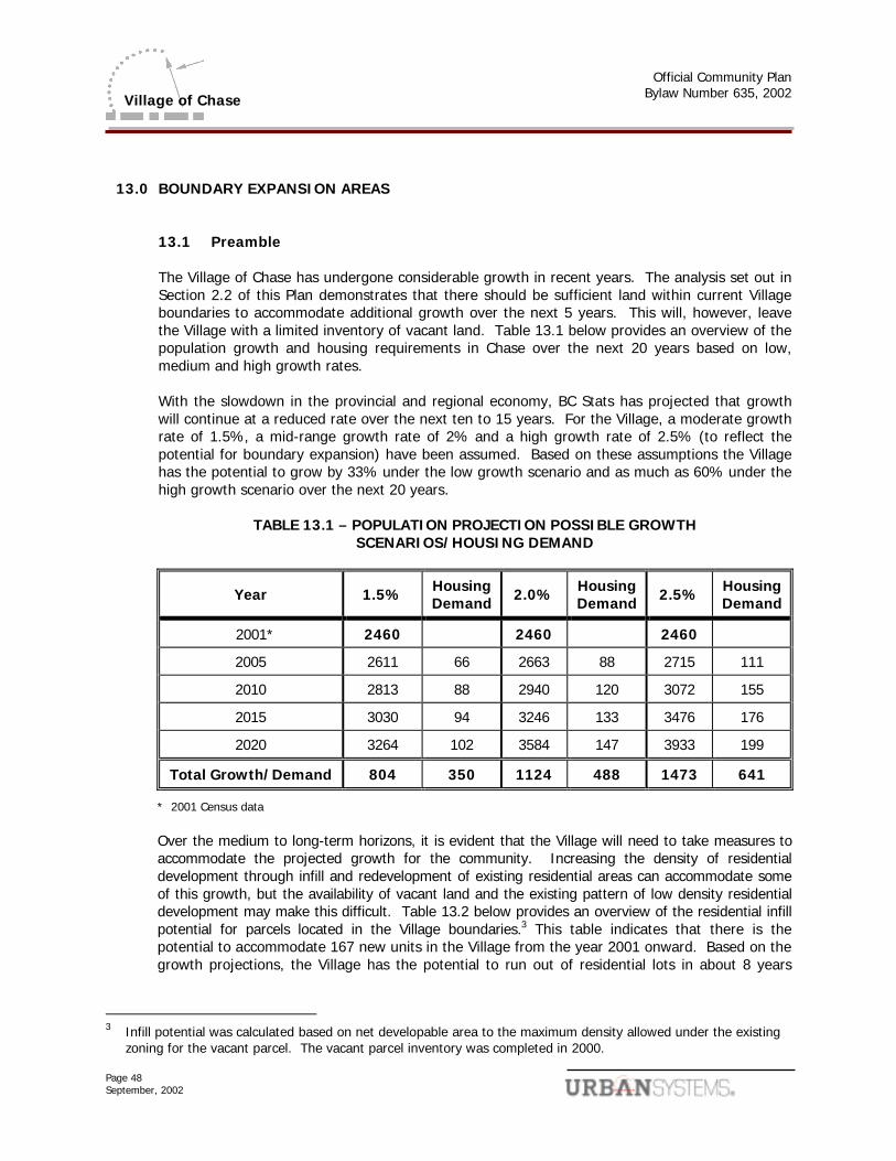
Official Community Plan
Bylaw Number 635, 2002
Page 48 September, 2002
Village of Chase
13.0 BOUNDARY EXPANSION AREAS 13.1 Preamble The Village of Chase has undergone considerable growth in recent years. The analysis set out in Section 2.2 of this Plan demonstrates that there should be sufficient land within current Village boundaries to accommodate additional growth over the next 5 years. This will, however, leave the Village with a limited inventory of vacant land. Table 13.1 below provides an overview of the population growth and housing requirements in Chase over the next 20 years based on low, medium and high growth rates. With the slowdown in the provincial and regional economy, BC Stats has projected that growth will continue at a reduced rate over the next ten to 15 years. For the Village, a moderate growth rate of 1.5%, a mid-range growth rate of 2% and a high growth rate of 2.5% (to reflect the potential for boundary expansion) have been assumed. Based on these assumptions the Village has the potential to grow by 33% under the low growth scenario and as much as 60% under the high growth scenario over the next 20 years.
TABLE 13.1 – POPULATION PROJECTION POSSIBLE GROWTH SCENARIOS/HOUSING DEMAND
Year 1.5% Housing Demand 2.0% Housing
Demand 2.5% Housing Demand
2001* 2460 2460 2460
2005 2611 66 2663 88 2715 111
2010 2813 88 2940 120 3072 155
2015 3030 94 3246 133 3476 176
2020 3264 102 3584 147 3933 199
Total Growth/Demand 804 350 1124 488 1473 641
* 2001 Census data
Over the medium to long-term horizons, it is evident that the Village will need to take measures to accommodate the projected growth for the community. Increasing the density of residential development through infill and redevelopment of existing residential areas can accommodate some of this growth, but the availability of vacant land and the existing pattern of low density residential development may make this difficult. Table 13.2 below provides an overview of the residential infill potential for parcels located in the Village boundaries.3 This table indicates that there is the potential to accommodate 167 new units in the Village from the year 2001 onward. Based on the growth projections, the Village has the potential to run out of residential lots in about 8 years
3 Infill potential was calculated based on net developable area to the maximum density allowed under the existing
zoning for the vacant parcel. The vacant parcel inventory was completed in 2000.
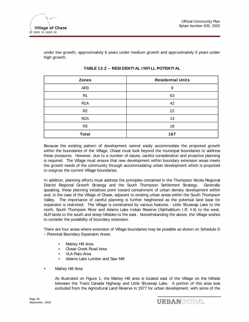
Official Community Plan
Bylaw Number 635, 2002
Page 49 September, 2002
Village of Chase
under low growth, approximately 6 years under medium growth and approximately 5 years under high growth.
TABLE 13.2 – RESIDENTIAL INFILL POTENTIAL
Zones Residential Units
AR3 8
R1 63
R1A 42
R2 22
R2A 14
R3 18
Total 167
Because the existing pattern of development cannot easily accommodate the projected growth within the boundaries of the Village, Chase must look beyond the municipal boundaries to address these pressures. However, due to a number of issues, careful consideration and proactive planning is required. The Village must ensure that new development within boundary extension areas meets the growth needs of the community through accommodating urban development which is projected to outgrow the current Village boundaries. In addition, planning efforts must address the principles contained in the Thompson Nicola Regional District Regional Growth Strategy and the South Thompson Settlement Strategy. Generally speaking, these planning initiatives point toward containment of urban density development within and, in the case of the Village of Chase, adjacent to existing urban areas within the South Thompson Valley. The importance of careful planning is further heightened as the potential land base for expansion is restricted. The Village is constrained by various features - Little Shuswap Lake to the north, South Thompson River and Adams Lake Indian Reserve (Sahhaltkum I.R. #4) to the west, ALR lands to the south and steep hillsides to the east. Notwithstanding the above, the Village wishes to consider the possibility of boundary extension. There are four areas where extension of Village boundaries may be possible as shown on Schedule D – Potential Boundary Expansion Areas:
• Mattey Hill Area • Chase Creek Road Area • VLA Flats Area • Adams Lake Lumber and Saw Mill
• Mattey Hill Area As illustrated on Figure 1, the Mattey Hill area is located east of the Village on the hillside
between the Trans Canada Highway and Little Shuswap Lake. A portion of this area was excluded from the Agricultural Land Reserve in 1977 for urban development, with some of the
Official Community Plan
Bylaw Number 635, 2002
Page 50 September, 2002
Village of Chase
area continuing to remain in the ALR and therefore necessitating further consideration of exclusion from the ALR. The development area has been zoned for residential use and includes approximately 24.5 ha which has the potential to accommodate approximately 120 units. However, there are a number of challenges associated with development in this area as an extension of the Village of Chase.
� the only means of access linking the two areas is the Trans Canada Highway.
� all servicing systems (e.g., water, sanitary sewer) would be separate from existing systems.
� discontinuous development results in an enclave that is separate from the rest of Village services and community facilities.
• Chase Creek Road Area
The Chase Creek Road area (see Schedule D) is located southeast of Chase at an elevation
ranging from 600 to 800 feet above the existing community. Due to steep slopes and undulating terrain, there are only a few sites which are well-suited to development. The first is located at the junction of Chase Creek Road and the Trans Canada Highway and includes approximately 12 ha. The second area straddles Chase Creek Road and includes approximately 62 ha. The third area is located north east of Chase Creek Road and includes approximately 39 ha of land. If urban residential density standards are applied to this area there is the potential to accommodate in the range of 850 - 1300 units of housing.3
A narrow strip of ALR land exists along the southeast side of the Trans Canada Highway within this area. Council will therefore work with the ALR as this area is examined for possible boundary expansion. Similar to the Mattey Hill area, there are also a number of deficiencies associated with development in this area:
� access would be via a circuitous route and would also necessitate use of the Trans
Canada Highway.
� extension of Village servicing systems would be costly.
� discontinuous development results in an enclave that is separate from the rest of Village services and community facilities.
� preservation of viewscape. The Village places considerable value on the vistas from the valley bottom. In recognition of this, the Village has purchased land along the hillside rising toward Chase Creek Road to ensure its preservation in a natural state. In addition, the Village is also working with a development interest to secure a key view corridor as parkland dedication.
• VLA Flats Area
The potential exists for the Village to extend its boundaries into the VLA Flats area as there
are no physical or jurisdictional boundaries which would preclude such an expansion. The entire area is, however, within the Agricultural Land Reserve and possesses very high
3 Range of potential housing units calculated by taking 75% of total land area (to account for roads, slopes, etc.) and applying
overall average density of 10 - 15 units per hectare.
Official Community Plan
Bylaw Number 635, 2002
Page 51 September, 2002
Village of Chase
capability for agriculture. In the past the Land Reserve Commission has indicated that it is strongly opposed to conversion of agricultural land in this area for other purposes, including urban residential development.
The financial impacts of boundary extensions on the Village must be carefully weighed.
Embracing additional lands within Village boundaries brings additional costs to the Village for services such as road maintenance. These costs may be offset by revenues derived from property taxation and other sources. The balance of these costs and benefits must be considered, as well as the timing of on-set.
• Adams Lake Lumber and Saw Mill
The Adams Lake Lumber and Saw Mill, owned by International Forest Products Ltd. (Interfor), was built in 1942 and is located at the south end of Adams Lake. The Mill is approximately 25 kilometres (15 miles) from the Village of Chase, and it currently employs approximately 200 people. Although the location of Adams Lake Lumber and Saw Mill is physically separate from the Village, extending municipal boundaries to include the Mill as a satellite area of the Village would directly contribute significant tax benefits to the community in which many Mill employees live.
13.2 Objectives
.1 It is Council's objective to ensure that there is adequate residential land, located within the municipal boundaries, to meet the future needs of the community.
.2 It is Council’s objective to promote boundary expansion in a timely, orderly, cost effective
and efficient manner. .3 It is Council policy to support in principle the extension of the Village of Chase’s municipal
boundaries to include land for urban residential development in the Mattey Hill and Chase Creek Road areas.
.4 It is Council policy to explore the possibility of including the Mattey Hill, Chase Creek Road
and Adams Lake Lumber and Saw Mill as satellite areas of the municipality which fall within Village boundaries but are physically and legally discontinuous from existing Village boundaries.
.5 It is Council policy to encourage urban density residential land use as the primary land use
within boundary extension areas in the Chase Creek Road area and Mattey Hill. The overall density of urban density residential land use in these areas should be in the range of 10 - 15 units per hectare.
.6 It is Council policy to consider public (school, community centre) and limited neighbourhood
commercial uses within the Chase Creek Road boundary extension area.
Official Community Plan
Bylaw Number 635, 2002
Page 52 September, 2002
Village of Chase
.7 It is Council policy to require full urban infrastructure services (water, sanitary sewer, roads, drainage) within the boundary extension areas. These services must be consistent with the standards set out in the Village of Chase's Subdivision Control.
.8 It is Council policy to require that all infrastructure services required to serve urban
development within the boundary extension areas be financed by the development applicant. This includes both services within the development sites as well as any required off-site services.
.9 It is Council policy to require the development applicant to prepare and submit a
comprehensive development plan prior to the initiation of any boundary expansion efforts. The comprehensive development plan will address the following issues as minimum requirements:
• land use pattern, designations and densities
• infrastructure requirements (on-site and off-site)
• phasing of development
• tenure of development (i.e., fee simple, strata title, other)
• cost recovery plan for infrastructure
• environmental considerations (particularly wildlife habitat)
• protection of development from hazardous conditions
• protection of viewscapes from the South Thompson Valley bottom
• buffering of development from agricultural lands (including ALR)
• other issues the Village may deem relevant
.10 It is Council policy to undertake a financial analysis of the benefits and costs to the Village of Chase of the development proposals set out in comprehensive development plans required under Policy 13.2.9. The Village will seek funding partners to contribute toward these financial analyses.
.11 It is Council policy to not proceed with extensions to Village boundaries until comprehensive
development plans as outlined above in Policy 13.2.9 have been developed and approved by the Village, and subdivision applications consistent with these comprehensive development plans have been approved by the applicable subdivision approval authority. If subdivision approval is envisioned to take place on a phased basis, the Village may proceed with boundary extension on a phased basis as well.
.12 It is Council policy to recognize that the Ministry of Transportation is currently the
subdivision approval authority for the Mattey Hill and Chase Creek Road areas. Council also recognizes that the Thompson Nicola Regional District has considerable interest in this area, and may at some point assume subdivision approval authority for lands within its jurisdiction. In recognition of these factors, the Village wishes to develop a Memorandum of Understanding with the Ministry of Transportation and the Thompson Nicola Regional
Official Community Plan
Bylaw Number 635, 2002
Page 53 September, 2002
Village of Chase
District to clearly articulate how the three agencies will work together in advancing land use management and boundary extension initiatives.
Official Community Plan
Bylaw Number 635, 2002
Page 54 September, 2002
Village of Chase
14.0 IMPLEMENTATION 14.1 Introduction
The Official Community Plan sets out statements of broad objectives, policies and directions for Chase. The various tools for the implementation plan are not generally provided for in this document. Therefore, the purpose of this Section is to outline steps which the Village of Chase can take to implement this Plan.
14.2 Zoning Bylaw
The Official Community Plan sets out statements of broad objectives, policies and directions for Chase. The various tools for the implementation plan are not generally provided for in this document. Therefore, the purpose of this Section is to outline steps which the Village of Chase can take to implement this Plan.
14.3 Rezoning Criteria
When reviewing the rezoning applications, Council may consider the following criteria where relevant. Council may also consider factors beyond these criteria:
.1 the permitted range of uses in the proposed zone should be compatible with the permitted range of uses on adjacent roads and properties;
.2 the parcel should be large enough to accommodate the intended use and associated uses
such as parking and on-site sewage disposal where necessary;
.3 specific measures should be set out by land owners to address any hazardous or environmentally sensitive conditions, ensuring that land can be used safely for the intended use;
.4 the proposed zone should be consistent with the objectives and policies of this Plan.
14.4 Subdivision Servicing
The Village's Subdivision Control Bylaw provides minimum standards for roads, water and sewer systems, storm drainage and other infrastructure and services. Approval of subdivision applications must be contingent on these standards being met. The Subdivision Control Bylaw will need to be reviewed to ensure consistency with this Official Community Plan.
14.5 Redesignation Criteria
When reviewing applications for land use redesignation in this Plan, Council may consider any or all of the criteria set forth below including, but not necessarily limited to:
Official Community Plan
Bylaw Number 635, 2002
Page 55 September, 2002
Village of Chase
.1 the proposed designation should be compatible with surrounding land uses;
.2 the proposed designation should be compatible with possible future land uses as indicated
on the Land Use Map;
.3 the proposed use should not have a negative environmental impact;
.4 the land owner should identify and address any potentially hazardous conditions, such as flood hazards or unstable soils;
.5 the owner should demonstrate that the site will have access to adjacent roadways and will
be provided with adequate water and sewer services;
.6 the owner should demonstrate that the traffic impact on the Village of Chase is minimal or can be mitigated;
.7 the proposed designation should be consistent with the objectives and policies of the Official
Community Plan.
14.6 Economic Development Strategies Economic development strategies may be considered to determine ways to stimulate investment within the community. Economic development efforts will prepare realistic and workable strategies to provide effective planning tools for initiatives that may include: community enhancement, promotion of tourism, marketing or other priorities identified by the community.
Official Community Plan
Bylaw Number 635, 2002
September, 2002
Village of Chase
Schedule B
Land Use Map
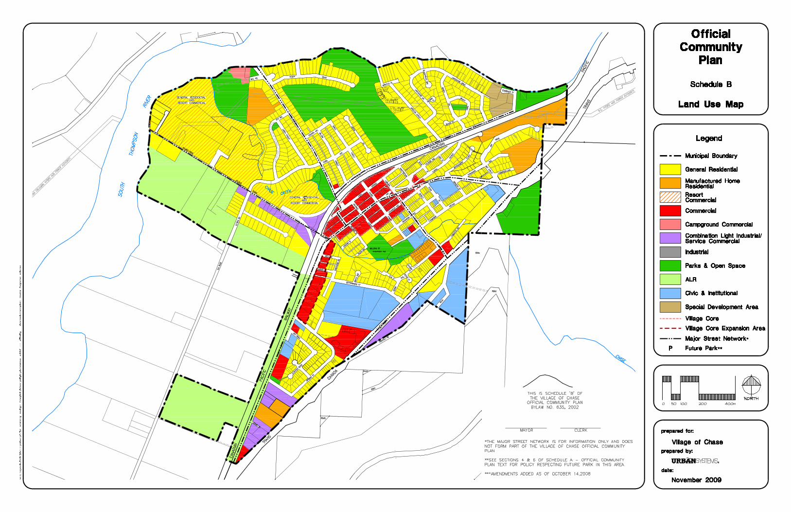

Official Community Plan
Bylaw Number 635, 2002
September, 2002
Village of Chase
Schedule C
Development Permit Area Map
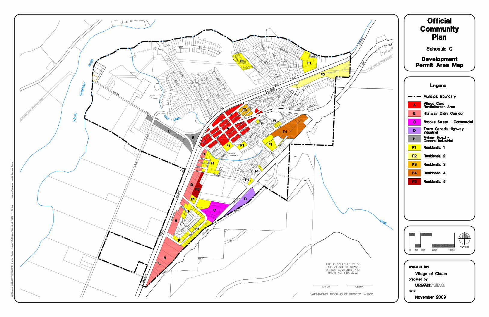
Official Community Plan
Bylaw Number 635, 2002
September, 2002
Village of Chase
Schedule D
Potential Boundary Expansion Areas