Embed Size (px)
Citation preview

COUR INTERNATIONALE DE JUSTICE
RECUEIL DES ARRE|TS,AVIS CONSULTATIFS ET ORDONNANCES
DEuLIMITATION MARITIMEEN MER NOIRE
(ROUMANIE c. UKRAINE)
ARRE|T DU 3 FEuVRIER 2009
2009
INTERNATIONAL COURT OF JUSTICE
REPORTS OF JUDGMENTS,ADVISORY OPINIONS AND ORDERS
MARITIME DELIMITATIONIN THE BLACK SEA
(ROMANIA v. UKRAINE)
JUDGMENT OF 3 FEBRUARY 2009
Mode officiel de citation:Délimitation maritime en mer Noire (Roumanie c. Ukraine),
arrêt, C.I.J. Recueil 2009, p. 61
Official citation:Maritime Delimitation in the Black Sea (Romania v. Ukraine),
Judgment, I.C.J. Reports 2009, p. 61
ISSN 0074-4441ISBN 978-92-1-071059-6
Sales numberNo de vente : 950

DEuLIMITATION MARITIMEEN MER NOIRE
(ROUMANIE c. UKRAINE)
MARITIME DELIMITATIONIN THE BLACK SEA
(ROMANIA v. UKRAINE)
3 FEuVRIER 2009
ARRE|T
3 FEBRUARY 2009
JUDGMENT

TABLE OF CONTENTS
Paragraphs
1. CHRONOLOGY OF THE PROCEDURE 1-13
2. GENERAL GEOGRAPHY 14-16
3. PRELIMINARY LEGAL ISSUES 17-42
3.1. Subject-matter of the dispute 17-193.2. Jurisdiction of the Court and its scope 20-303.3. Applicable law 31-42
4. EXISTING MARITIME DELIMITATION BETWEEN THE PARTIES (EFFECT OF
THE PROCÈS-VERBAUX OF 1949, 1963 AND 1974, AS WELL AS THE 1949AND 1961 TREATIES BETWEEN ROMANIA AND THE USSR AND THE
2003 TREATY BETWEEN ROMANIA AND UKRAINE) 43-76
5. RELEVANT COASTS 77-105
5.1. The Romanian relevant coast 80-885.2. The Ukrainian relevant coast 89-105
6. RELEVANT MARITIME AREA 106-114
7. DELIMITATION METHODOLOGY 115-122
8. ESTABLISHMENT OF THE PROVISIONAL EQUIDISTANCE LINE 123-154
8.1. Selection of base points 123-1498.2. Construction of the provisional equidistance line 150-154
9. RELEVANT CIRCUMSTANCES 155-204
9.1. Disproportion between lengths of coasts 158-1689.2. The enclosed nature of the Black Sea and the delimitations
already effected in the region 169-1789.3. The presence of Serpents’ Island in the area of delimitation 179-1889.4. The conduct of the Parties (oil and gas concessions, fishing
activities and naval patrols) 189-1989.5. Any cutting off effect 199-2019.6. The security considerations of the Parties 202-204
10. THE LINE OF DELIMITATION 205-209
11. THE DISPROPORTIONALITY TEST 210-216
12. THE MARITIME BOUNDARY DELIMITING THE CONTINENTAL SHELF AND
EXCLUSIVE ECONOMIC ZONES 217-218
13. OPERATIVE CLAUSE 219
61
4
INTERNATIONAL COURT OF JUSTICE
YEAR 2009
3 February 2009
MARITIME DELIMITATIONIN THE BLACK SEA
(ROMANIA v. UKRAINE)
JUDGMENT
Present : President HIGGINS ; Vice-President AL-KHASAWNEH ; Judges RANJEVA,SHI, KOROMA, BUERGENTHAL, OWADA, TOMKA, ABRAHAM, KEITH,SEPÚLVEDA-AMOR, BENNOUNA, SKOTNIKOV ; Judges ad hoc COT,OXMAN ; Registrar COUVREUR.
In the case concerning maritime delimitation in the Black Sea,
between
Romania,represented by
H.E. Mr. Bogdan Aurescu, Director General, Ministry of Foreign Affairs ofRomania, Lecturer, Faculty of Law, University of Bucharest, President ofthe Romanian Branch of the International Law Association, memberof the Permanent Court of Arbitration,
as Agent, Counsel and Advocate ;Mr. Cosmin Dinescu, Director General for Legal Affairs, Ministry of For-
eign Affairs of Romania,as Co-Agent, Counsel and Advocate ;H.E. Mr. Calin Fabian, Ambassador of Romania to the Kingdom of the
Netherlands,as Co-Agent ;Mr. James Crawford, S.C., F.B.A., Whewell Professor of International Law,
62
20093 February
General ListNo. 132
5
University of Cambridge, member of the Institut de droit international,Barrister,
Mr. Vaughan Lowe, Q.C., Chichele Professor of International Law, Univer-sity of Oxford, member of the English Bar, associate member of the Insti-tut de droit international,
Mr. Alain Pellet, Professor at the University of Paris Ouest, Nanterre-La Défense, member and former Chairman of the International Law Com-mission, associate member of the Institut de droit international,
as Senior Counsel and Advocates ;Mr. Daniel Müller, Researcher at the Centre de droit international de Nan-
terre (CEDIN), University of Paris Ouest, Nanterre-La Défense,Mr. Simon Olleson, member of the English Bar,as Counsel and Advocates ;Mr. Gicu Borosi, Director General, National Agency for Mineral Resources,
Mr. Mihai German, Deputy Director General, National Agency for MineralResources, member of the United Nations Commission on the Limits ofthe Continental Shelf,
Mr. Eugen Laurian, Counter-Admiral (retired),Mr. Octavian Buzatu, Lieutenant Commander (retired),Mr. Ovidiu Neghiu, Captain, Ministry of Defence of Romania,as Technical and Cartographic Experts ;Mr. Liviu Dumitru, Head of the Borders and Maritime Delimitation Unit,
Ministry of Foreign Affairs of Romania,Ms Irina Nit(a, Second Secretary, Legal Adviser, Embassy of Romania in the
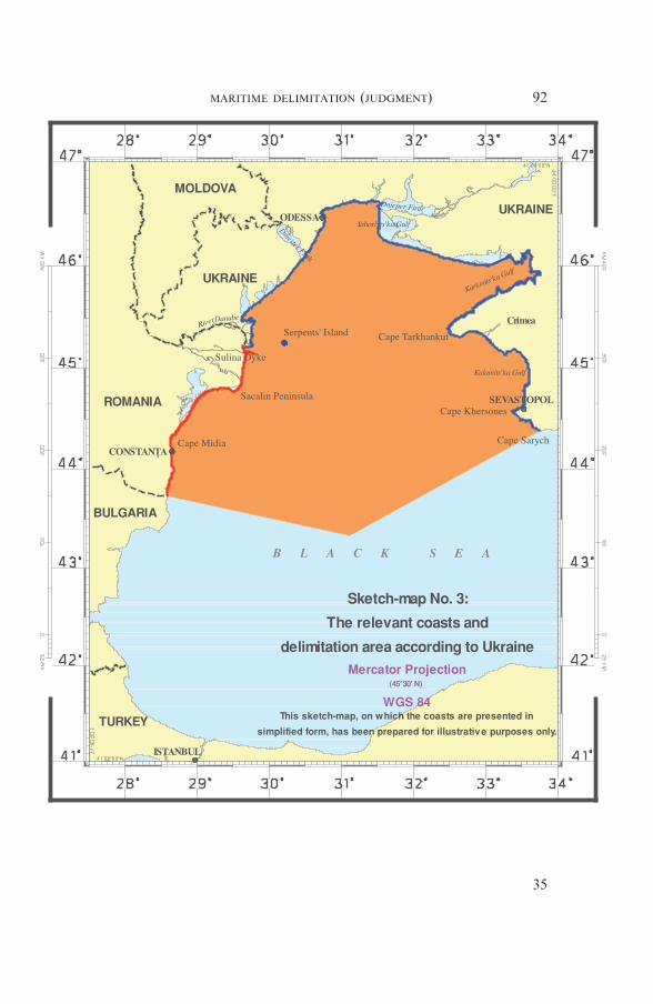
Kingdom of the Netherlands,Ms Catrinel Brumar, Third Secretary, Borders and Maritime Delimitation
Unit, Ministry of Foreign Affairs of Romania,Ms Mirela Pascaru, Third Secretary, Borders and Maritime Delimitation
Unit, Ministry of Foreign Affairs of Romania,Ms Ioana Preda, Third Secretary, Borders and Maritime Delimitation Unit,
Ministry of Foreign Affairs of Romania,Ms Olivia Horvath, Desk Officer, Public Diplomacy Department, Ministry
of Foreign Affairs of Romania,as Advisers,
and
Ukraine,represented by
H.E. Mr. Volodymyr A. Vassylenko, Adviser to the Minister for ForeignAffairs of Ukraine, Ambassador Extraordinary and Plenipotentiary ofUkraine, Professor of International Law, National University of KyivMohyla Academy,
as Agent ;H.E. Mr. Oleksandr M. Kupchyshyn, Ambassador Extraordinary and Pleni-
potentiary of Ukraine, Deputy Foreign Minister of Ukraine,Mr. Volodymyr G. Krokhmal, Director of the Legal and Treaty Department
of the Ministry of Foreign Affairs of Ukraine,as Co-Agents ;
63MARITIME DELIMITATION (JUDGMENT)
6
Mr. Rodman R. Bundy, avocat à la Cour d’appel de Paris, member of theNew York Bar, Eversheds LLP, Paris,
Mr. Jean-Pierre Quéneudec, Professor Emeritus of International Law, theUniversity of Paris I (Panthéon-Sorbonne),
Sir Michael Wood, K.C.M.G., member of the English Bar, member of theInternational Law Commission,
Ms Loretta Malintoppi, avocat à la Cour d’appel de Paris, member of theRome Bar, Eversheds LLP, Paris,
as Counsel and Advocates ;H.E. Mr. Vasyl G. Korzachenko, Ambassador Extraordinary and Pleni-
potentiary of Ukraine to the Kingdom of the Netherlands,Mr. Nick Minogue, Solicitor of the Supreme Court of England and Wales,
Mr. Oleksii V. Ivaschenko, Acting Head of International Law Division,Legal and Treaty Department of the Ministry of Foreign Affairs ofUkraine,
Mr. Maxime O. Kononenko, First Secretary of the Embassy of Ukraine inthe French Republic,
Ms Mariana O. Betsa, Second Secretary of the Embassy of Ukraine in theKingdom of the Netherlands,
as Legal Advisers ;Mr. Robin Cleverly, M.A., D. Phil, C. Geol., F.G.S., Law of the Sea Con-
sultant, Admiralty Consultancy Services,Major General Borys D. Tregubov, Assistant to the Head of the State Bor-
der Protection Service of Ukraine,as Technical Advisers,
THE COURT,
composed as above,after deliberation,
delivers the following Judgment :
1. On 16 September 2004 Romania filed in the Registry of the Court anApplication dated 13 September 2004, instituting proceedings against Ukraineconcerning the delimitation of the continental shelf and the exclusive economiczones of Romania and Ukraine in the Black Sea.
In its Application, Romania seeks to found the jurisdiction of the Court onthe provisions of paragraph 4 (h) of the Additional Agreement constituted byan exchange of letters of 2 June 1997 between the Ministers for Foreign Affairsof Romania and Ukraine. The Additional Agreement was concluded with ref-erence to Article 2 of the Treaty on the Relations of Good Neighbourliness andCo-operation between Romania and Ukraine, signed on 2 June 1997 (herein-after the “Treaty on Good Neighbourliness and Co-operation”). Both instru-ments entered into force on 22 October 1997.
2. Pursuant to Article 40, paragraph 2, of the Statute, the Registrar imme-diately communicated a certified copy of the Application to the Government ofUkraine ; and, in accordance with paragraph 3 of that Article, all States entitledto appear before the Court were notified of the Application.
3. Pursuant to the instructions of the Court under Article 43 of the Rules ofCourt, the Registrar addressed to States parties to the United Nations Conven-
64MARITIME DELIMITATION (JUDGMENT)
7
tion on the Law of the Sea of 10 December 1982 the notifications provided forin Article 63, paragraph 1, of the Statute of the Court. In addition, the Regis-trar addressed to the European Community, which is also party to that Con-vention, the notification provided for in Article 43, paragraph 2, of the Rules ofCourt, as adopted on 29 September 2005, and asked that organization whetheror not it intended to furnish observations under that provision. In response, theRegistrar was informed that the European Community did not intend to sub-mit observations in the case.
4. Since the Court included upon the Bench no judge of the nationality ofeither of the Parties, each Party proceeded to exercise its right conferred byArticle 31, paragraph 3, of the Statute to choose a judge ad hoc to sit in thecase. Romania chose Mr. Jean-Pierre Cot and Ukraine Mr. Bernard H. Oxman.
5. By an Order dated 19 November 2004, the Court fixed 19 August 2005and 19 May 2006, respectively, as the time-limits for the filing of the Memorialof Romania and the Counter-Memorial of Ukraine ; those pleadings were dulyfiled within the time-limits so prescribed.
6. By an Order of 30 June 2006, the Court authorized the submission of aReply by Romania and a Rejoinder by Ukraine, and fixed 22 December 2006and 15 June 2007 as the respective time-limits for the filing of those pleadings.The Reply of Romania was filed within the time-limits thus fixed. By an Orderof 8 June 2007 the Court, at the request of Ukraine, extended to 6 July 2007 thetime-limit for the filing of the Rejoinder. Ukraine duly filed its Rejoinder withinthe time-limit as thus extended.
7. By letter dated 23 August 2007 and received in the Registry on 30 August2007, the Agent of Romania informed the Court that his Government wishedto produce a new document in accordance with Article 56 of the Rules of Courtand provided certain explanations in justification of its request, namely that thedocument was necessary “in order to make as complete a disclosure as possible,both to the Ukrainian Party and to the Court, of material evidence” and thatthe “lateness of disclosure” was due to the fact that the document had not been“filed together with the main archival sources relevant to this matter”. Inresponse, the Agent of Ukraine informed the Court that his Government didnot consent to the production of the new document, on the grounds thatRomania had not “acted in compliance with Practice Direction IX, since it didnot indicate why it considered it necessary to file this new document now, nordid it provide an explanation why it did not produce this map at an earlierstage in these proceedings”. In view of the absence of consent of Ukraine, on10 December 2007, the Registrar, on the instructions of the Court, requestedthat the Government of Romania provide further explanations as to why thenew document should be regarded as necessary. Such additional explanationswere duly submitted by the Government of Romania on 18 December 2007. On23 January 2008, the Parties were informed that the Court, after consideringthe views of the Parties, had decided, pursuant to Article 56, paragraph 2, ofthe Rules of Court, to authorize the production by the Government of Roma-nia of the new document in question.
8. In accordance with Article 53, paragraph 2, of the Rules of Court, theCourt decided, after ascertaining the views of the Parties, that copies of thepleadings and documents annexed would be made available to the public asfrom the opening of the oral proceedings.
65MARITIME DELIMITATION (JUDGMENT)
8
9. Public hearings were held between 2 and 19 September 2008, at which theCourt heard the oral arguments and replies of :
For Romania : H.E. Mr. Bogdan Aurescu,Mr. Alain Pellet,Mr. Cosmin Dinescu,Mr. James Crawford,Mr. Vaughan Lowe,Mr. Daniel Müller,Mr. Simon Olleson.
For Ukraine : H.E. Mr. Volodymyr A. Vassylenko,Mr. Rodman R. Bundy,Sir Michael Wood,Mr. Jean-Pierre Quéneudec,Ms Loretta Malintoppi.
10. At the hearings, a judge put questions to the Parties, to which replieswere given orally in accordance with Article 61, paragraph 4, of the Rules ofCourt.
*
11. In its Application, the following claims were made by Romania :
“Reserving the right to complement, amend or modify the presentrequest in the course of the proceedings, Romania requests the Court todraw in accordance with the international law, and specifically the criterialaid down in Article 4 of the Additional Agreement, a single maritimeboundary between the continental shelf and the exclusive economic zonesof the two States in the Black Sea.”
12. In the written proceedings, the following submissions were presented bythe Parties :
On behalf of the Government of Romania,in the Memorial :
“For the reasons set out above, the Government of Romania respect-fully requests the Court to draw a single maritime boundary dividing thecontinental shelf and the exclusive economic zones of Romania andUkraine in the Black Sea, having the following description :— from Point F, at 45° 05′ 21″ N, 30° 02′ 27″ E, on the 12 nm arc sur-
rounding Serpents’ Island, to Point X, at 45° 14′ 20″ N, 30° 29′ 12″ E,
— from Point X in a straight segment to Point Y, at 45° 11′ 59″ N,30° 49′ 16″ E,
— then on the line equidistant between the Romanian and Ukrainianadjacent coasts, from Point Y to Point T, at 45° 09′ 45″ N, 31° 08′ 40″ E,
— and then on the line median between the Romanian and Ukrainianopposite coasts, from Point T to Point Z, at 43° 26′ 50″ N,31° 20′ 10″ E.”
66MARITIME DELIMITATION (JUDGMENT)
9
in the Reply :
“For the reasons set out in the Memorial, as well as in this Reply,Romania respectfully requests the Court to draw a single maritime bound-ary dividing the maritime areas of Romania and Ukraine in the Black Sea,having the following description :(a) from Point F, at 45° 05′ 21″ N, 30° 02′ 27″ E, on the 12 nm arc sur-
rounding Serpents’ Island, to Point X, at 45° 14′ 20″ N, 30° 29′ 12″ E,
(b) from Point X in a straight segment to Point Y, at 45° 11′ 59″ N,30° 49′ 16″ E,
(c) then on the line equidistant between the Romanian and Ukrainianadjacent coasts, from Point Y to Point T, at 45° 09′ 45″ N,31° 08′ 40″ E,
(d) and then on the line median between the Romanian and Ukrainianopposite coasts, from Point T to Point Z, at 43° 26′ 50″ N,31° 20′ 10″ E.”
On behalf of the Government of Ukraine,in the Counter-Memorial and Rejoinder :
“In the light of the facts and legal principles set out in [Ukraine’s Counter-Memorial and Rejoinder], and rejecting Romania’s claims to the con-trary, Ukraine respectfully submits that the Court adjudge and declarethat the delimitation of the continental shelf and exclusive economic zonesbetween the Parties is a delimitation line the course of which, employingthe Pulkovo datum (i.e., using the Krasovsky ellipsoid), is as follows :
From the point identified in Article 1 of the 2003 Treaty having the co-ordinates of 45° 05′ 21″ N; 30° 02′ 27″ E, the delimitation line extends in asouth-easterly direction to Point 2, having the coordinates of 44° 54′ 00″ N;30° 06′ 00″ E, and thence to Point 3, having the co-ordinates of 43° 20′ 37″ N;31° 05′ 39″ E, and then continues along the same azimuth, until the bound-ary reaches a point where the interests of third States potentially come intoplay.”
13. At the oral proceedings, the following submissions were presented by theParties :
On behalf of the Government of Romania,at the hearing of 16 September 2008 :
“Romania respectfully requests the Court to draw a single maritimeboundary dividing the maritime areas of Romania and Ukraine in theBlack Sea, having the following description :(a) from Point F, at 45° 05′ 21″ N, 30° 02′ 27″ E, on the 12 nm arc sur-
rounding Serpents’ Island, to Point X, at 45° 14′ 20″ N, 30° 29′ 12″ E;
(b) from Point X in a straight segment to Point Y, at 45° 11′ 59″ N,30° 49′ 16″ E;
(c) then on the line equidistant between the relevant Romanian and
67MARITIME DELIMITATION (JUDGMENT)
10
Ukrainian adjacent coasts, from Point Y, passing through Point D, at45° 12′ 10″ N, 30° 59′ 46″ E, to Point T, at 45° 09′ 45″ N, 31° 08′ 40″ E;
(d) and then on the line median between the relevant Romanian andUkrainian opposite coasts, from Point T − passing through thepoints of 44° 35′ 00″ N, 31° 13′ 43″ E and of 44° 04′ 05″ N,31° 24′ 40″ E, to Point Z, at 43° 26′ 50″ N, 31° 20′ 10″ E.” 1
On behalf of the Government of Ukraine,at the hearing of 19 September 2008 :
“For the reasons given in Ukraine’s written and oral pleadings, Ukrainerequests the Court to adjudge and declare that the line delimiting the con-tinental shelf and exclusive economic zones between Ukraine and Roma-nia is as follows :(a) from the point (Point 1) identified in Article 1 of the 2003 Treaty
between Ukraine and Romania on the Regime of the Ukrainian-Romanian State Border, having the co-ordinates of 45° 05′ 21″ N;30° 02′ 27″ E, the line runs along a straight line to Point 2, having theco-ordinates of 44° 54′ 00″ N; 30° 06′ 00″ E; then
(b) from Point 2, the line runs along an azimuth of 156° to Point 3,having the co-ordinates of 43° 20′ 37″ N; 31° 05′ 39″ E; and then con-tinues along the same azimuth until it reaches a point where the inter-ests of third States potentially come into play.
The co-ordinates are referenced to the Pulkovo datum (i.e., using theKrasovsky ellipsoid), and all lines are loxodromes.”1
* * *
2. GENERAL GEOGRAPHY
14. The maritime area within which the delimitation in the presentcase is to be carried out is located in the north-western part of the BlackSea.
15. The Black Sea is an enclosed sea connected with the Mediterra-nean Sea by the Straits of the Dardanelles, the Sea of Marmara and theBosphorus. The Black Sea is situated between 40° 56′ and 46° 33′ N andbetween 27° 27′ and 41° 42′ E. The Crimean Peninsula extends southwardfrom Ukraine’s mainland into the Black Sea. The Black Sea has a surfacearea of some 432,000 sq km and consists of the territorial seas and exclu-sive economic zones of the coastal States which border it.
16. In the north-western part of the Black Sea, approximately 20 nau-
1 See sketch-map No. 1, p. 69, prepared for illustrative purposes only.
68MARITIME DELIMITATION (JUDGMENT)
11

69MARITIME DELIMITATION (JUDGMENT)
12
tical miles to the east of the Danube delta, is situated a natural featurecalled Serpents’ Island. Serpents’ Island is above water at high tide, has asurface area of approximately 0.17 sq km and a circumference of approxi-mately 2,000 m.
3. PRELIMINARY LEGAL ISSUES
3.1. Subject-matter of the Dispute
17. The dispute between Romania and Ukraine concerns the establish-ment of a single maritime boundary delimiting the continental shelf andexclusive economic zones between the two States in the Black Sea.
18. The two States, when they concluded on 2 June 1997 the Treaty onGood Neighbourliness and Co-operation, agreed also through the Addi-tional Agreement (see paragraph 1 above), that they “shall negotiate anAgreement on the delimitation of the continental shelf and the exclusiveeconomic zones in the Black Sea” (Additional Agreement, para. 4).Negotiations for the conclusion of such Agreement were to start “as soonas possible, during a period of three months from the date of the enteringinto force of the Treaty on Good Neighbourliness and Co-operation”(ibid., para. 4 (g)). The Treaty entered into force on 22 October 1997, thenegotiations on the delimitation of the continental shelf and exclusiveeconomic zones opened in January 1998, but despite their 24 rounds, thelast being held in September 2004, as well as ten rounds at an expert level,no delimitation agreement was reached.
19. Under these circumstances, Romania seised the Court on 16 Sep-tember 2004 by filing, in the Registry of the Court, its Application insti-tuting proceedings in the present case.
3.2. Jurisdiction of the Court and its Scope
20. Romania invokes as a basis for the Court’s jurisdiction Article 36,paragraph 1, of the Statute of the Court and paragraph 4 (h) of theAdditional Agreement, the latter of which provides :
“If these negotiations shall not determine the conclusion of theabove-mentioned agreement in a reasonable period of time, but notlater than 2 years since their initiation, the Government of Romaniaand the Government of Ukraine have agreed that the problem ofdelimitation of the continental shelf and the exclusive economiczones shall be solved by the UN International Court of Justice, atthe request of any of the parties, provided that the Treaty on theregime of the State border between Romania and Ukraine hasentered into force. However, should the International Court of Jus-tice consider that the delay of the entering into force of the Treatyon the regime of the State border is the result of the other Party’s
70MARITIME DELIMITATION (JUDGMENT)
13
fault, it may examine the request concerning the delimitation of thecontinental shelf and the exclusive economic zones before the entryinto force of this Treaty.”
21. It follows from the text of the compromissory clause that two con-ditions have to be met before either of the Parties is entitled to submit thecase to the Court. The first condition is that no delimitation agreementshould have been concluded “in a reasonable period of time, but not laterthan 2 years” since the start of negotiations. No agreement was reachedbetween the Parties in the six years during which the negotiations wereheld (see paragraph 18 above). The second condition, namely that theTreaty on the Régime of the State Border should have entered into force,has also been fulfilled. On 17 June 2003, the Treaty between Romaniaand Ukraine on the Romanian-Ukrainian State Border Régime, Collabo-ration and Mutual Assistance on Border Matters (hereinafter the “2003State Border Régime Treaty”) was signed, and it entered into force on27 May 2004.
22. The Parties are in agreement that all the conditions for the Court’sjurisdiction were satisfied at the time of the filing of the Application andthat the Court accordingly has jurisdiction to decide the case. However,they differ as to the exact scope of the jurisdiction conferred upon theCourt.
*
23. The issue of the scope of the Court’s jurisdiction was raised byUkraine in the course of the written proceedings in response to Roma-nia’s contention that “the initial segment of the boundary separating theRomanian exclusive economic zone and continental shelf from theUkrainian territorial waters around Serpents’ Island” between “Point F”(Romania’s way of referring to the point of intersection of the territorialseas of Romania and Ukraine established by the 2003 State BorderRégime Treaty) and “Point X” (the endpoint, according to Romania, ofthe agreed boundary on the 12-mile arc around Serpents’ Island) wasestablished by bilateral agreements. In the view of Romania, “the properway for the Court to conduct the delimitation” is to confirm the bound-ary between these two points and then to proceed to the determination ofthe delimitation line in the other segments where the line has not yet beenestablished by the two States.
24. Ukraine argues that the jurisdiction of the Court is “restricted tothe delimitation of the areas of continental shelf and the exclusive eco-nomic zones of the Parties”. In its view, the Court has no jurisdiction todelimit other maritime zones pertaining to either of the Parties and inparticular their respective territorial seas. Ukraine contends that the“delimitation has to begin at the outer limit of the territorial waters of thetwo States” and the line to be drawn by the Court “shall be a line div-iding exclusively areas of continental shelf and EEZ”. It claims that theCourt is excluded from drawing a line dividing the territorial sea of one
71MARITIME DELIMITATION (JUDGMENT)
14

State from the continental shelf and exclusive economic zone of the otherState. For this reason, Ukraine contends, the Court has no jurisdiction
“for the drawing of a delimitation line as claimed by Romaniabetween the so-called points F and X along a 12-nautical mile seg-ment of arc around Serpent’ Island, since that portion of [the] linewould delimit Ukraine’s territorial sea and Romania’s alleged areasof continental shelf and EEZ”.
Ukraine adds that the Parties’ agreement to confer jurisdiction on theCourt has
“the consequence that the boundaries to be delimited by the Courtmust be such that, starting from the agreed terminal point of theirterritorial sea boundary, each Party has some zones of continentalshelf and EEZ immediately to the east and south of that agreed ter-minal point”.
Ukraine notes however that in its view “this jurisdictional questiondoes not need to be decided because, from Point F, the line proceeds in asouth-easterly direction as a line delimiting areas of continental shelf andthe EEZs appertaining to each of the Parties”.
*
25. Romania argues in response that international courts
“do not consider themselves inhibited from establishing maritimeboundaries separating, on the one hand, the continental shelf (or theexclusive economic zone) of one party and, on the other hand, othermaritime areas (including the territorial sea) of the other party”.
In any event, in its view, no practical consequences flow from the Parties’divergent approaches to the Court’s jurisdiction. As there is already amaritime boundary running along the 12-nautical mile line around Ser-pents’ Island up to Point X established by bilateral agreements, even ifthe Court had no jurisdiction to delimit the continental shelf and exclu-sive economic zone of one Party from the territorial sea of the other, itwould still have to take into account the agreements in force betweenRomania and Ukraine and the resulting maritime boundary. Thus, Roma-nia concludes that, whether the Court has jurisdiction to perform thedelimitation between Points F and X or not, this will have no influenceon the drawing of a new delimitation line, which in any event will beginfrom Point X.
* *
72MARITIME DELIMITATION (JUDGMENT)
15

26. The Court observes that Ukraine is not contending that underinternational law, as a matter of principle, there cannot be a delimitationline separating the territorial sea of one State from the exclusive eco-nomic zone and the continental shelf of another State. In fact, such a linewas determined by the Court in its latest Judgment on maritime delimita-tion (see Territorial and Maritime Dispute between Nicaragua and Hon-duras in the Caribbean Sea (Nicaragua v. Honduras), I.C.J. Reports2007 (II), p. 659. Ukraine rather relies on the terms of paragraph 4 (h)of the Additional Agreement, which in its view, “suggest[s] that theParties did not anticipate that the Court would be called upon to delimitan all-purpose maritime boundary along the outer limit of Ukraine’s ter-ritorial sea” around Serpents’ Island.
27. The wording of paragraph 4 (h) of the Additional Agreement that“the problem of delimitation of the continental shelf and the exclusiveeconomic zones shall be solved by the . . . International Court of Justice”,is neutral as to whether these zones must be found on both sides of thedelimitation line throughout its length. The Court is of the view that ithas to interpret the provision of paragraph 4 (h) of the AdditionalAgreement conferring jurisdiction on the Court in the light of the objectand purpose of that Agreement and its context.
That Agreement was concluded on the same day as the Treaty onGood Neighbourliness and Co-operation between Romania and Ukraine,which in Article 2, paragraph 2, provides :
“The Contracting Parties shall conclude a separate Treaty on theregime of the border between the two states and shall settle the prob-lem of the delimitation of their continental shelf and of economicexclusive zones in the Black Sea on the basis of the principles andprocedures agreed upon by an exchange of letters between the min-isters of foreign affairs, which shall take place simultaneously withthe signature of the Treaty. The understandings included in thisexchange of letters shall enter into force simultaneously with theentry into force of this Treaty.”
28. The Additional Agreement specifies the manner in which effect isto be given to the commitment of both Parties stated in Article 2, para-graph 2, of the Treaty on Good Neighbourliness and Co-operationquoted above. The Parties specified, in particular, in paragraph 1 of theAdditional Agreement that a Treaty on the régime of the border betweenthe two States should be concluded “not later than 2 years from the dateof the entering into force of the Treaty on Good Neighbourliness andCo-operation”, which took place on 22 October 1997. In paragraph 4 ofthe same Agreement, the Parties specified that an Agreement on thedelimitation of the continental shelf and the exclusive economic zones inthe Black Sea should be negotiated by the Parties. The Court considersthat the Parties intended that all boundary issues between them, whetheron land or at sea, be resolved in a comprehensive way. Under the narrow
73MARITIME DELIMITATION (JUDGMENT)
16
interpretation of Ukraine, the Court would not “settle the problem of thedelimitation” between the two States were it not to find substantively forUkraine.
The Court notes that the State Border Régime Treaty was concludedon 17 June 2003, i.e., within six years from the entry into force of theTreaty on Good Neighbourliness and Co-operation, not two as originallycontemplated. The 2003 State Border Régime Treaty, in its Article 1,describes the boundary line between the two Parties not only on land butalso the line separating their territorial seas, “up to the point of45° 05′ 21″ north latitude and 30° 02′ 27″ east longitude, which is themeeting point [of Ukraine’s territorial sea around Serpents’ Island] withthe Romanian State border passing on the outer limit of its territorialsea”.
29. No agreement on the delimitation of the continental shelf andexclusive economic zones in the Black Sea was reached. The Parties con-templated in paragraph 4 (h) of the Additional Agreement that, in suchcircumstances, either of them could request this Court to decide the issueof the delimitation. The Court’s judgment will thus substitute for thenon-existent agreement between the Parties on the delimitation of thecontinental shelf and the exclusive economic zones and shall resolve allsuch matters which have not been settled by the Parties.
30. In discharging its task, the Court will duly take into account theagreements in force between the Parties relating to the delimitation oftheir respective territorial seas. The Court has no jurisdiction to delimitthe territorial seas of the Parties. Its jurisdiction covers the delimitationof their continental shelf and the exclusive economic zones. However,contrary to what has been suggested by Ukraine, nothing hinders thatjurisdiction from being exercised so that a segment of the line may resultin a delimitation between, on the one hand, the exclusive economic zoneand the continental shelf of one State, and, on the other hand, the terri-torial sea of the other State at its seaward limit.
3.3. Applicable law
31. Both Romania and Ukraine are parties to the 1982 United NationsConvention on the Law of the Sea (UNCLOS). Romania deposited itsinstrument of ratification on 17 December 1996 and Ukraine on 26 July1999.
Articles 74 and 83 of UNCLOS are relevant for the delimitation of theexclusive economic zone and the continental shelf, respectively. Theirtexts are identical, the only difference being that Article 74 refers to theexclusive economic zone and Article 83 to the continental shelf. TheseArticles provide as follows:
“1. The delimitation of the exclusive economic zone [the conti-nental shelf] between States with opposite or adjacent coasts shall beeffected by agreement on the basis of international law, as referred
74MARITIME DELIMITATION (JUDGMENT)
17

to in Article 38 of the Statute of the International Court of Justice,in order to achieve an equitable solution.
2. If no agreement can be reached within a reasonable period oftime, the States concerned shall resort to the procedures providedfor in Part XV.
3. Pending agreement as provided for in paragraph 1, the Statesconcerned, in a spirit of understanding and co-operation, shall makeevery effort to enter into provisional arrangements of a practicalnature and, during this transitional period, not to jeopardize orhamper the reaching of the final agreement. Such arrangements shallbe without prejudice to the final delimitation.
4. Where there is an agreement in force between the States con-cerned, questions relating to the delimitation of the exclusive eco-nomic zone [the continental shelf] shall be determined in accordancewith the provisions of the agreement.”
32. Romania states that the Parties concur in the view that the Procès-Verbaux concluded between Romania and the USSR in 1949, 1963 and1974 are agreements which are legally binding on the Parties. Romaniacontends that these agreements, which establish the initial segment of themaritime boundary, should be taken into account as agreements relatingto the delimitation within the meaning of Articles 74, paragraph 4, and83, paragraph 4, of UNCLOS. Another such agreement is the 2003 StateBorder Régime Treaty which delimited the maritime boundary up to theouter limit of the territorial sea at the point of intersection of Romania’sterritorial sea with the 12-nautical mile arc drawn around Serpents’Island. According to Romania, in any event, the question as to whetheror not the agreements fall within the above-mentioned category is of noconsequence: they are binding on the Parties, and it is for the Court toensure their application.
33. Romania argues that the principles recognized by the Parties in the1997 Additional Agreement are applicable both to the diplomaticnegotiations between the two States and for the purposes of any eventualsettlement of the dispute by the Court. These principles are listed inparagraph 4 of the 1997 Additional Agreement as follows:
“(a) the principle stated in article 121 of the United Nations Con-vention on the Law of the Sea of December 10, 1982, asapplied in the practice of states and in international case juris-prudence;
(b) the principle of the equidistance line in areas submitted todelimitation where the coasts are adjacent and the principle ofthe median line in areas where the coasts are opposite ;
(c) the principle of equity and the method of proportionality, asthey are applied in the practice of states and in the decisions ofinternational courts regarding the delimitation of continentalshelf and exclusive economic zones ;
75MARITIME DELIMITATION (JUDGMENT)
18

(d) the principle according to which neither of the ContractingParties shall contest the sovereignty of the other ContractingParty over any part of its territory adjacent to the zone sub-mitted to delimitation;
(e) the principle of taking into consideration the special circum-stances of the zone submitted to delimitation”.
Romania also affirms that the delimitation should be carried out inaccordance with the provisions of UNCLOS.
34. Romania asserts, with regard to the Additional Agreement, that ifthe Parties had intended to impose limits on the relevance of the “prin-ciples and procedures” set out in paragraph 4 therein, that would havebeen made clear in the Agreement. Romania contends that its position issupported by the terms of Article 2, paragraph 2, of the Treaty on GoodNeighbourliness and Co-operation, according to which the Parties “shallsettle the problem of the delimitation of their continental shelf and ofeconomic exclusive zones in the Black Sea on the basis of the principlesand procedures agreed upon by [the 1997] exchange of letters . . .”.Romania asserts with reference to this provision that no distinction ismade between, on the one hand, the negotiations and, on the other hand,the other procedures to which the Parties might have recourse to solvethe problem of delimitation.
35. Romania submits that the Treaty on Good Neighbourliness andCo-operation and the Additional Agreement enshrine a legal commit-ment reached between Romania and Ukraine, according to which, inexchange for the fact that Romania formally confirmed that Serpents’Island belonged to Ukraine, Ukraine accepted the delimitation principleslaid down by the Additional Agreement for reaching an equitable solu-tion to the delimitation. In particular, according to Romania, Ukraineaccepted the applicability of Article 121, paragraph 3, of UNCLOS in thedelimitation of the continental shelf and exclusive economic zones, asinterpreted by Romania when signing and ratifying it. The relevant partof its declaration reads as follows:
“3. Romania states that according to the requirements of equity —as it results from Articles 74 and 83 of the Convention on the Law ofthe Sea — the uninhabited islands without economic life can in noway affect the delimitation of the maritime spaces belonging to themainland coasts of the coastal States.”
Romania contends that, under these circumstances, Ukraine’s accept-ance of the reference to Article 121 as one of the principles to be appliedin delimitation clearly indicates that the two States agreed in 1997 thatSerpents’ Island could receive no other effect in addition to those effectsalready produced by it on the delimitation of the territorial seas of thetwo Parties.
*
76MARITIME DELIMITATION (JUDGMENT)
19
36. Ukraine contends that the Court is obliged to decide disputes inaccordance with international law, as laid down in Article 38, para-graph 1, of the Statute. In relation to maritime delimitation and asbetween the Parties to the present case, “that applicable body of rules ofinternational law comprises principally the provisions of UNCLOS andcertain specific rules which have become well established in the jurispru-dence of the Court”.
37. According to Ukraine, the 1997 Additional Agreement is an inter-national treaty binding upon the Parties, however, “its provisions do notembody an agreement which relates to the present proceedings”. Theprinciples enunciated therein were to form the basis on which the Partieswere to negotiate a delimitation agreement, but they were not agreed bythe Parties as applying to the subsequent judicial proceedings. At thesame time Ukraine acknowledges that some of these principles may berelevant as part of the established rules of international law which theCourt will apply but not as part of any bilateral agreement.
38. Ukraine further argues that the 1949, 1963 and 1974 Procès-Verbaux and the 1997 Additional Agreement do not constitute agreementsmentioned in Articles 74, paragraph 4, and 83, paragraph 4, of UNCLOSbecause they were not agreements delimiting the continental shelf andexclusive economic zones.
39. With regard to the declaration made by Romania with respect toArticle 121 upon the signature and ratification of UNCLOS, Ukrainepoints out the difference between a declaration and a reservation, andstates that a declaration “does not modify the legal effect of the treaty inquestion” and does not call for any response from the other ContractingParties. Thus, according to Ukraine, the Court does not have to take intoconsideration Romania’s declaration. As Ukraine further notes, Roma-nia claims that the reference to Article 121 of UNCLOS in the AdditionalAgreement of 1997, considered to be one of the principles applicable tothe delimitation, demonstrates that Ukraine has thus “accepted the appli-cability of the third paragraph of Article 121, as interpreted by theRomanian declaration, to the present situation”; for Ukraine, this asser-tion is groundless.
* *
40. In deciding what will be a single maritime delimitation line, theCourt will duly take into account the agreements in force between theParties. Whether the Procès-Verbaux concluded between Romania andthe USSR in 1949, 1963 and 1974 constitute agreements relating to thedelimitation within the meaning of Articles 74, paragraph 4, and 83, para-graph 4, of UNCLOS, depends on the conclusion the Court will reach onRomania’s contention that they establish the initial segment of the mari-time boundary which the Court has to determine. The Court considersthe issue in Section 4 of this Judgment.
77MARITIME DELIMITATION (JUDGMENT)
20
41. With respect to the principles listed in subparagraphs 4 (a) to (e)of the Additional Agreement, the Court is of the view that the chapeau ofthat paragraph providing that
“[t]he Government of Ukraine and the Government of Romaniashall negotiate an Agreement on the delimitation of the continentalshelf and the exclusive economic zones in the Black Sea, on the basisof the following principles and procedures” (emphasis added),
suggests that these principles were intended by the Parties to be takeninto account in their negotiations on the maritime delimitation, but donot constitute the law to be applied by the Court. This does not neces-sarily mean that these principles would per se be of no applicability in thepresent case ; they may apply to the extent that they are part of the rele-vant rules of international law. The Court further notes that the princi-ples listed in the Additional Agreement were drawn up by the Parties in1997. The entry into force of UNCLOS as between the Parties in 1999means that the principles of maritime delimitation to be applied by theCourt in this case are determined by paragraph 1 of Articles 74 and 83thereof.
42. Finally, regarding Romania’s declaration, quoted in paragraph 35above, the Court observes that under Article 310 of UNCLOS, a State isnot precluded from making declarations and statements when signing,ratifying or acceding to the Convention, provided these do not purport toexclude or modify the legal effect of the provisions of UNCLOS in theirapplication to the State which has made a declaration or statement. TheCourt will therefore apply the relevant provisions of UNCLOS as inter-preted in its jurisprudence, in accordance with Article 31 of the ViennaConvention on the Law of Treaties of 23 May 1969. Romania’s declara-tion as such has no bearing on the Court’s interpretation.
4. EXISTING MARITIME DELIMITATION BETWEEN THE PARTIES
(EFFECT OF THE PROCÈS-VERBAUX OF 1949, 1963 AND 1974,AS WELL AS THE 1949 AND 1961 TREATIES BETWEEN ROMANIA AND
THE USSR AND THE 2003 TREATY BETWEEN ROMANIA AND UKRAINE)
43. The Court notes that the Parties disagree as to whether therealready exists an agreed maritime boundary around Serpents’ Island forall purposes. They therefore disagree also on the starting-point of thedelimitation to be effected by the Court. To clarify the issues under dis-cussion, the Court must distinguish between these two different matters :firstly, the determination of the starting-point of the delimitation as afunction of the land boundary and territorial sea boundary as alreadydetermined by the Parties ; and secondly, whether there exists an agreedmaritime boundary around Serpents’ Island and what is the nature of
78MARITIME DELIMITATION (JUDGMENT)
21

such a boundary, in particular whether it separates the territorial sea ofUkraine from the continental shelf and the exclusive economic zone ofRomania, as claimed by the latter and denied by the former.
*
44. Romania explains that a number of agreements were entered intobetween Romania and the Soviet Union in relation to their boundary.The most important is the General Procès-Verbal of 27 September 1949(hereinafter “the 1949 General Procès-Verbal”), which embodies thework of the Joint Soviet-Romanian Commission for Delimitation of theState Border. Romania states the boundary fixed in 1949 was confirmedin further Soviet-Romanian Procès-Verbaux in 1963 and 1974 and in the1949 and 1961 Border Treaties between Romania and the USSR. Accord-ing to Romania, these agreements, “which are binding on Ukraine byway of succession”, established the first part of the maritime boundaryalong the 12-nautical-mile arc around Serpents’ Island. Romania pointsout that in the 1997 Additional Agreement and the 2003 State BorderRégime Treaty, Ukraine expressly affirmed the binding character of theborder as agreed in the 1961 Border Régime Treaty between Romaniaand the USSR which itself affirmed the applicability of the 1949Procès-Verbaux.
45. According to Romania, it is clear from the language of the1949 General Procès-Verbal that the Parties agreed that the boundarywould follow the exterior margin of the 12-mile marine boundary zone“surrounding” Serpents’ Island. Moreover, Romania continues, theAgreement effected an “all-purpose delimitation” which was not limitedto an initial short sector in the west.
46. Romania points out that on the sketch-map included in the indi-vidual 1949 Procès-Verbal relating to border sign 1439, as well as onmap 134 attached to the 1949 General Procès-Verbal, the boundary isclearly drawn along the 12-nautical-mile arc around Serpents’ Islanduntil the edge of the said maps. It asserts that the sketch-maps form anintegral part of the Procès-Verbaux and have to be given a correspondingweight. In its view, regardless of whether they are to scale or are geo-graphically accurate, the sketch-maps confirm the meaning of the text ofthe Procès-Verbaux, namely that the State boundary line extends beyondborder sign 1439 along the 12-mile arc around Serpents’ Island, and thatit has the same character along its entire length.
47. Romania adds that, although the final point of the maritimeboundary between Romania and the USSR was not identified by specificgeographical co-ordinates, the extent of the agreed boundary is fixed bythe language of the 1949 General Procès-Verbal itself. The existence and
79MARITIME DELIMITATION (JUDGMENT)
22

acceptance of the maritime boundary around Serpents’ Island followingthe 12-nautical-mile arc until a point situated due east of the island is alsoconfirmed by various navigation charts issued after 1949 by the USSRand later Ukraine, as well as by Romania, Bulgaria, France and Ger-many. These charts, Romania maintains, consistently show the boundaryas extending beyond the last point depicted on map 134, and as havingthe same character along its entire length up to a point due east of Ser-pents’ Island. Romania claims that the position of this point, which itrefers to as “Point X”, coincides on all of these charts : it is located atapproximately 45° 14′ 20″ N and 30° 29′ 12″ E.
48. The last point of the boundary depicted on map 134 cannot beconsidered, in Romania’s view, the final point of the boundary becausethe short segment of the boundary from border sign 1439 up to the pointwhere the drawing terminates does not constitute a boundary “surround-ing” Serpents’ Island as envisaged in the text of the individual 1949 Procès-Verbal relating to border sign 1439. Romania further argues that theblank space between the endpoint of the line depicted on map 134 andthe edge of the map is of no relevance and cannot serve as an argumentthat this point is the final point of the boundary. Map 134 was intendedto depict the boundary between Points 1438 and 1439, and “the bound-ary sectors situated both before and beyond point 1438 and 1439 are onlypartially depicted”.
49. According to Romania, the fact that there happens to be a closecoincidence between the endpoint of the boundary on map 134 and thepoint of intersection of 12-nautical-mile territorial seas of Romania andUkraine, identified in the 2003 State Border Régime Treaty, does notprove that the endpoint of the boundary on map 134 was a final point ofthe maritime boundary agreed in 1949. While the endpoint of the bound-ary on map 134 is at approximately 12 nautical miles from the Sulinadyke as it exists presently, in 1949 (when the dyke was shorter) this pointwas at about 13.4 nautical miles from the Romanian coast. No conclu-sion as to what was agreed in 1949 is to be drawn from coincidencesresulting from the changing coastal situation.
*
50. Ukraine disagrees that a maritime boundary along the 12-nautical-mile arc around Serpents’ Island up to Point X was established by theagreements between Romania and the USSR starting from 1949. Itfurther argues that both Parties acknowledge that the final point of theState border was established by the 2003 State Border Régime Treaty,which means that maritime spaces beyond this point had not previouslybeen delimited.
80MARITIME DELIMITATION (JUDGMENT)
23
51. In particular, Ukraine asserts that the text of the 1949 Procès-Verbaux did not provide for an all-purpose maritime boundary, and neitherdid map 134. It notes that in accordance with the settlement recorded inthe 1949 Procès-Verbaux the boundary line between Points 1437 and1438 “is a true State boundary between the territorial sea and/or internalwaters of Romania and the Soviet Union”. The boundary line runningout to sea from Point 1438 in the direction of Point 1439 was “a trueState boundary between the territorial seas of Romania and the SovietUnion only as far out as a point 6 nautical miles from the baseline fromwhich Romania’s territorial sea is measured”. The boundary runningfurther out to sea beyond the 6-nautical-mile point to Point 1439 andthereafter following the 12-nautical-mile arc around Serpents’ Island wasthe boundary between the Soviet Union’s sovereign territorial sea and theadjacent high seas. Waters beyond the territorial sea limits were highseas, which in 1949 meant for Romania the waters beyond 6 nauticalmiles (since 1951, when Romania extended the breadth of its territorialsea, beyond 12 nautical miles), and for the Soviet Union watersbeyond 12 nautical miles.
52. Ukraine argues that neither the 1949 Procès-Verbaux nor anyother agreed text identifies the status of the waters to the south of theshort length of agreed line along the 12-nautical-mile arc around Ser-pents’ Island. The line agreed in 1949 could not have been intended bythe Parties as a line separating sea areas subject to distinctive régimeswhich at that time simply did not exist, i.e., the continental shelf andexclusive economic zone. Thus, Ukraine asserts that, while the 1949 aswell as the 1963 and 1974 Procès-Verbaux are binding internationalagreements, they “are not continental shelf or EEZ delimitation agree-ments”. It emphasizes that no relevant text provides for the agreedboundary line to be an “all-purpose” maritime boundary restrictingUkraine’s (and previously the Soviet Union’s) rights “to any and all cat-egories of maritime claims beyond that line”.
53. Ukraine contends that “[n]one of the relevant Procès-Verbaux norany other agreements say that the agreed boundary extends as far asRomania’s alleged Point X”, nor give any co-ordinates for such a point.This conclusion is evident from a reading of their texts.
Ukraine states that map 134 annexed to the 1949 General Procès-Verbal shows that the relevant part of the 12-mile arc around Serpents’Island extends on the arc beyond Point 1439 but without however reach-ing the edge of the map (there is a blank space). Ukraine maintains thatnothing in the text “suggests that the relevant part of the 12-nautical-milearc around Serpents’ Island extended to the south-east or east aroundSerpents’ Island”, as contended by Romania. According to Ukraine,
81MARITIME DELIMITATION (JUDGMENT)
24
map 134 was intended specifically to show the boundary which had beenagreed in the Procès-Verbal to which it was attached, including the end-point of the boundary. The final point depicted on map 134 is “within avery few metres” of the point agreed in the 2003 State Border RégimeTreaty as the point of intersection of the outer limits of Ukraine’s andRomania’s territorial seas (a difference of 93 m (north) and 219 m (east)).
54. As to the cartographic evidence produced by Romania, Ukrainereplies that none of the maps or sketch-maps contemporaneous with the1949 Procès-Verbaux show that the agreed boundary extends as far asRomania’s alleged Point X. Non-contemporaneous maps “are of little orno evidentiary value as to what was agreed in 1949”. In particular, itnotes that the maps referred to by Romania are unreliable, cannot serveas a confirmation that there exists an agreed boundary terminating at apoint due east of Serpents’ Island (Point X) and that none of them “hasany substantial legal value”.
* *
55. The Court first notes that the Procès-Verbaux of 1949 resultedfrom the work of the Joint Soviet-Romanian Border Commission imple-menting the Protocol to Specify the Line of the State Boundary betweenthe People’s Republic of Romania and the Union of Soviet SocialistRepublics, signed in Moscow on 4 February 1948 (hereinafter “the1948 Protocol”). It emerged from these negotiations that this Protocolwas primarily aimed at the modification of what had been agreed uponby the 1947 Paris Peace Treaty between the Allied and Associated Powersand Romania, which confirmed that the Soviet-Romanian border wasfixed “in accordance with the Soviet-Romanian Agreement of June 28,1940, and the Soviet-Czechoslovak Agreement of June 29, 1945”.
56. The text of the Peace Treaty has no express provision relating toSerpents’ Island. However, the 1948 Protocol stipulated where thenational borders between the States should lie as follows:
“1. The State border between Romania and the [USSR], indicatedon the maps annexed to the present Protocol/Annex I and II/, passesas follows:
(a) in accordance with Annex I :[the description of the land boundary between Romania andthe USSR];
(b) in accordance with Annex II :along the River Danube, from Pardina to the Black Sea, leav-ing the islands of Tataru Mic, Daleru Mic and Mare, Maican
82MARITIME DELIMITATION (JUDGMENT)
25
and Limba on the side of the [USSR], and the islandsTataru Mare, Cernovca and Babina — on the Romanian side ;Serpents’ Island, situated in the Black Sea, eastwards from theDanube mouth, is incorporated into the [USSR].”
57. The Procès-Verbal of the Description of the State Boundary dated27 September 1949, contains a complete description of the demarcationthus effected in the form of the traversal of the State boundary line fromboundary mark No. 1052 to boundary mark No. 1439, covering both theland territory in the national border area and the maritime territory up toPoint 1439. It is the description of the border included in this Procès-Verbal, carried forward into later agreements, that is of importance forpresent purposes.
58. According to the General Procès-Verbal describing the whole Stateborder line, the boundary continues from a defined point near the end ofthe river boundary between the two States (Point 1437) for a short dis-tance along the middle of the channel of the river and then roughly southsouth-easterly in a straight line to a buoy anchored in water (Point 1438),at which point the direction of the boundary line in the Black Seachanges and continues roughly easterly in a straight line for about12 miles to a beacon (Point 1439), the final point defined with co-ordinates stated by the Commission. It is at the point at which the straightline from Point 1438 intersects with “the exterior margin of the Sovietmaritime boundary line, of 12 miles, surrounding Serpents’ Island”. Thedocument continues with this sentence : “The State boundary line, fromborder sign No. 1439 (beacon), goes on the exterior margin of the marineboundary zone of 12 miles, leaving Serpents’ Island on the side of theUSSR.”
59. The border lines in the sketch-map included in the individualProcès-Verbal of border Point 1439 (which includes almost the sameexpression as that just quoted) uses the same symbols from the rivermouth (Point 1437) along the line through the coastal waters to Point 1438and on to Point 1439 and then beyond on the arc around Serpents’Island, shown for about 5 miles, to the point where the arc ends, at themargin of the sketch-map included in that Procès-Verbal. The expres-sions “CCCP” and “URSS” are used on the Soviet side and “PHP” and“RPR” on the Romanian side, including the short section of the arc.
60. Wording almost identical to that in the 1949 Procès-Verbaux rel-ating to the line beyond Point 1439, set out at the end of paragraph 58above, was included in a 1954 Act, signed by authorized officers of thetwo countries, relating to the boundary mark No. 1439.
61. In November 1949 and February 1961, Romania and the USSRconcluded treaties on the régime of their border, the latter treaty replac-
83MARITIME DELIMITATION (JUDGMENT)
26
ing the former. Both defined the State border between them by referenceto the earlier agreements including the demarcation documents of Sep-tember 1949. In terms of the 1961 Treaty, a further demarcation processwas carried out in 1963. While that process involved no modification ofthe border sign No. 1439 nor any sketch-map of it, the general descrip-tion of the border includes a passage similar to that in the earlier docu-ments with the change that “Soviet marine boundary zone” is replaced bythe “territorial sea of the USSR”: “From the border sign No. 1439 (bea-con), the State boundary passes on the exterior margin of the 12-mileterritorial sea of the USSR, leaving Serpents’ Island on the USSR side.”
62. Demarcation negotiations were conducted during the 1970s : in the1974 general Procès-Verbal, the wording from the general 1963 Procès-Verbal was reprised, while in the 1974 individual Procès-Verbal, thewording reverted to that of the 1949 general Procès-Verbal. The 1974 indi-vidual Procès-Verbal included a sketch-map with the same features interms of the marking of the various sections of the border and the use ofthe terms “CCCP/URSS” and “PHP/RPR” as were used in the sketch-maps attached to the individual 1949 Procès-Verbal and the individual1963 Procès-Verbal.
63. The final treaty in the series is the 2003 State Border RégimeTreaty. In the preamble, the Contracting Parties state their desire todevelop relations of collaboration on the basis of the principles and pro-visions in their Treaty on Good Neighbourliness and Co-operation andin the Additional Agreement providing principles and processes for delim-iting the continental shelf and exclusive economic zone. The 2003 Treatyin Article 1 describes the State border by reference to the 1961 Romania-USSR Treaty
“as well as . . . all the corresponding demarcation documents, themaps of the State border . . . the protocols of the border signs withtheir draft sketches . . . as well as the documents of verifications ofthe State border line . . . in force on 16 July, 1990”,
the date of the adoption of the Declaration on the State Sovereignty ofUkraine. The final part of the description says that the boundary
“continues, from the border sign 1439 (buoy) on the outer limit ofUkraine’s territorial waters around the Serpents’ Island, up to thepoint of 45° 05′ 21″ north latitude and 30° 02′ 27″ east latitude, whichis the meeting point with the Romanian State border passing on theouter limit of its territorial sea. The territorial seas of the Contract-ing Parties measured from the baselines shall permanently have, atthe meeting point of their outer limits, the width of 12 maritimemiles.”
84MARITIME DELIMITATION (JUDGMENT)
27
The Article concludes with these three sentences :
“If objective modifications due to natural phenomena which arenot related to human activities and that make it necessary for theseco-ordinates to be changed are noticed, the Joint Commission shallconclude new protocols.
The State border line, on its whole length, shall remain un-changed, unless the Contracting Parties agree otherwise.
The elaboration of the new documents on the State border doesnot represent a revision of the existent border between Romania andUkraine.”
The definition of the boundary no longer includes the passage about theboundary “passing” or “going on” the exterior margin of the maritimezone “from” Point 1439. Rather the boundary continues from that point“up to” the defined point.
64. In the view of the Court, the argument raised by Romania andbased by it on the words “from” and “goes on the exterior margin of themarine boundary zone” cannot support Point X as the endpoint of theagreed boundary (see paragraph 47 above). First, none of the contempo-raneous maps and sketch-maps arrive anywhere near Point X. Second,the agreements are about “State borders”, an expression which does noteasily apply to areas beyond territory, including territorial seas. Third,while, as Ukraine accepts, the 1949 and later agreements do not specifythe endpoint and Point 1439 is not the endpoint, the sketch-map which ispart of the Procès-Verbal for Point 1439 does indicate where that end-point might be; a clearer and more authoritative indication of that pointappears, if at a slightly different location, in map 134 which is to scale,unlike the sketch-maps; the map is part of the General Procès-Verbal of1949 and shows border signs 1438 and 1439 and only a short sector of thearc beyond the latter. Finally, while other features on map 134 go all theway to the margin of the map, the point at which the arc ends is short ofthe margin of it (it is very close to the point where Romania’s prospective12-mile territorial sea would intersect with the 12-mile arc around theisland). The gap between the end of the arc on that map and the 2003 co-ordinates is about 250 m.
65. A major problem with the Romanian thesis is the lack of any sup-port in the 1948-1949 processes and the resulting agreement for a point tothe east of Serpents’ Island. Apart from the argument based on the wordsthemselves, the only support for a point to the east of the island to bediscerned in the contemporary (1949) documentation is provided by thetwo sketch-maps and map 134. However, they fall a long way short ofRomania’s Point X; further, they produce very different results fromeach other, from the sketch-map in the Procès-Verbal for Point 1439 and,
85MARITIME DELIMITATION (JUDGMENT)
28
most importantly, from the end of the arc which appears in the only rele-vant map in the 1949 Agreement — map 134.
66. The Court concludes that in 1949 it was agreed that from the pointrepresented by border sign 1439 the boundary between Romania and theUSSR would follow the 12-mile arc around Serpents’ Island, without anyendpoint being specified. Under Article 1 of the 2003 State BorderRégime Treaty the endpoint of the State border between the Parties wasfixed at the point of intersection where the territorial sea boundary ofRomania meets that of Ukraine. The Court will hereinafter refer to thispoint as “Point 1”.
*
67. The Court now turns to the question as to whether there exists anagreed line which divides the territorial sea of Ukraine and the continen-tal shelf and the exclusive economic zone of Romania, as contended bythe latter.
68. A preliminary issue concerns the burden of proof. As the Courthas said on a number of occasions, the party asserting a fact as a basis ofits claim must establish it (Sovereignty over Pedra Branca/Pulau BatuPuteh, Middle Rocks and South Ledge (Malaysia/Singapore), Judgment,I.C.J. Reports 2008, p. 31, para. 45; Application of the Convention on thePrevention and Punishment of the Crime of Genocide (Bosnia and Herze-govina v. Serbia and Montenegro), Judgment, I.C.J. Reports 2007 (I),p. 128, para. 204, citing Military and Paramilitary Activities in and againstNicaragua (Nicaragua v. United States of America), Jurisdiction andAdmissibility, Judgment, I.C.J. Reports 1984, p. 437, para. 101). Ukraineplaced particular emphasis on the Court’s dictum in the case concerningTerritorial and Maritime Dispute between Nicaragua and Honduras inthe Caribbean Sea (Nicaragua v. Honduras) that “[t]he establishment ofa permanent maritime boundary is a matter of grave importance andagreement is not easily to be presumed” (Judgment, I.C.J. Reports 2007 (II),p. 735, para. 253). That dictum, however, is not directly relevant since inthat case no written agreement existed and therefore any implicit agree-ment had to be established as a matter of fact, with the burden of prooflying with the State claiming such an agreement to exist. In the presentcase, by contrast, the Court has before it the 1949 Agreement and thesubsequent agreements. Rather than having to make findings of fact,with one or other Party bearing the burden of proof as regards claimedfacts, the Court’s task is to interpret those agreements. In carrying outthat task, the Court must first focus its attention on the terms of thosedocuments including the associated sketch-maps.
69. The Court notes that Articles 74, paragraph 4, and 83, para-graph 4, of UNCLOS are relevant to Romania’s contention that aboundary delimiting the exclusive economic zones and continental shelf
86MARITIME DELIMITATION (JUDGMENT)
29
beyond Point 1, and extending around Serpents’ Island, was establishedby the 1949 instruments.
Paragraph 4 of Articles 74 and 83 provides that where there is anagreement in force between the States concerned, questions relating tothe delimitation of the exclusive economic zone and the continental shelf“shall be determined in accordance with the provisions of that agree-ment”.
The word “agreement” in paragraph 4 (as elsewhere in the Article)refers to an agreement delimiting the exclusive economic zone (Article 74)or the continental shelf (Article 83) referred to in paragraph 1. State prac-tice indicates that the use of a boundary agreed for the delimitation ofone maritime zone to delimit another zone is effected by a new agree-ment. This typically occurs when States agree to apply their continentalshelf boundary to the exclusive economic zone. The agreement betweenTurkey and the USSR applying the continental shelf boundary to theexclusive economic zone is one such example. By the same token, if Statesintend that their territorial sea boundary limit agreed earlier should laterserve also as the delimitation of the continental shelf and/or the exclusiveeconomic zones, they would be expected to conclude a new agreement forthis purpose.
70. The 1949 instruments make no reference to the exclusive economiczone or the continental shelf. Although in 1949 the Truman Proclama-tion and the claims that it had begun to stimulate were widely known,neither Party claimed a continental shelf in 1949 nor is there any indica-tion in the case file that either was preparing to do so. The InternationalLaw Commission (ILC) had yet to begin its work on the law of the seawhich ultimately led to the 1958 Convention on the Continental Shelfand widespread acceptance of that concept. The concept of an exclusiveeconomic zone in international law was still some long years away.
The only agreement between the Parties expressly dealing with delimi-tation of the exclusive economic zone and the continental shelf is the1997 Additional Agreement. It does not establish a boundary but rathera process for arriving at one, which is reaching its culmination in theseproceedings. The detailed provisions regarding factors to be taken intoaccount during the negotiations make no reference to an existing agree-ment. There was no agreement in 1949 delimiting the exclusive economiczone or the continental shelf within the meaning of Articles 74 and 83 ofUNCLOS.
71. A further issue that may arise under international law and Arti-cle 311, paragraph 2, of UNCLOS is whether the USSR could haverenounced in 1949 any rights which it might then or later have had over
87MARITIME DELIMITATION (JUDGMENT)
30

waters beyond the territorial sea. There is no express language of renun-ciation in the 1949 Treaty on the part of the USSR apart from its agree-ment to a State frontier with Romania. The express mention of a Statefrontier alludes to sovereignty which includes the territorial sea. Thequestion is whether there is an implied prospective renunciation by theUSSR, in a geographical sense with respect to the area beyond 12 miles,and in a legal sense with respect to zones not of sovereignty but of func-tional competence beyond the territorial sea.
72. Romania proffers a variety of maps by Soviet, Ukrainian andother sources, mostly prepared long after the conclusion of the 1949instruments. They show hooks or loops around Serpents’ Island withvarying lengths and markings, all extending beyond the point where the12-mile territorial seas of the Parties meet. Since in the circumstancesthere is no question of these maps themselves evidencing a new agree-ment or an estoppel, the issue is whether any of them evince a correctunderstanding of the meaning of the 1949 Treaty.
73. The USSR acquired Serpents’ Island in the context of the overallterritorial settlement that emerged following the Second World War. Aprimary USSR objective was to consolidate and stabilize the territorialsettlement by treaty with Romania, including the USSR’s acquisition ofSerpents’ Island.
74. So far as the territorial sea is concerned, the Court notes that a12-mile zone around Serpents’ Island would have been consistent withthe 12-mile zone that the USSR was claiming generally for its territorialsea.
75. This understanding of the effect of the textual references to the arcin the 1949 instruments is set forth in Article 1 of the 2003 State BorderRégime Treaty. That Treaty expressly contemplates the possibility offuture agreed modifications of the co-ordinates of the territorial seaboundary due to natural phenomena which are not related to humanactivities, and provides that “[t]he territorial seas of the ContractingParties measured from the baselines shall permanently have, at the meet-ing point of their outer limits, the width of 12 maritime miles”. Thus, the12-mile arc around Serpents’ Island will never be penetrated by Roma-nia’s territorial sea, no matter what changes occur in its coastline orbaselines.
The Court observes further that the 12-mile arc around Serpents’Island is shown on a map dealing with the State border ; this suggests thatthat arc represents simply the seaward limit of the territorial sea. Recog-nition by the USSR in the 1949 instruments that its State border followed
88MARITIME DELIMITATION (JUDGMENT)
31
the outer limit of its territorial sea around Serpents’ Island does not sig-nify that it thereby gave up any entitlements to maritime areas beyondthat zone.
76. The Court concludes that the 1949 instruments related only to thedemarcation of the State border between Romania and the USSR, whicharound Serpents’ Island followed the 12-mile limit of the territorial sea.The USSR did not forfeit its entitlement beyond the 12-mile limit of itsterritorial sea with respect to any other maritime zones. Consequently,there is no agreement in force between Romania and Ukraine delimitingbetween them the exclusive economic zone and the continental shelf.
5. RELEVANT COASTS
77. The title of a State to the continental shelf and to the exclusive eco-nomic zone is based on the principle that the land dominates the seathrough the projection of the coasts or the coastal fronts. As the Courtstated in the North Sea Continental Shelf (Federal Republic of Germany/Denmark; Federal Republic of Germany/Netherlands) cases, “the land isthe legal source of the power which a State may exercise over territorialextensions to seaward” (Judgment, I.C.J. Reports 1969, p. 51, para. 96).In the Continental Shelf (Tunisia/Libyan Arab Jamahiriya) case, theCourt observed that “the coast of the territory of the State is the decisivefactor for title to submarine areas adjacent to it” (Judgment, I.C.J.Reports 1982, p. 61, para. 73). It is therefore important to determine thecoasts of Romania and of Ukraine which generate the rights of thesecountries to the continental shelf and the exclusive economic zone,namely, those coasts the projections of which overlap, because the task ofdelimitation consists in resolving the overlapping claims by drawing aline of separation of the maritime areas concerned.
78. The role of relevant coasts can have two different though closelyrelated legal aspects in relation to the delimitation of the continental shelfand the exclusive economic zone. First, it is necessary to identify the rele-vant coasts in order to determine what constitutes in the specific contextof a case the overlapping claims to these zones. Second, the relevantcoasts need to be ascertained in order to check, in the third and finalstage of the delimitation process, whether any disproportionality exists inthe ratios of the coastal length of each State and the maritime areas fall-ing either side of the delimitation line.
79. The Court will begin by briefly setting out the Parties’ positions asto their respective relevant coasts (see sketch-maps Nos. 2 and 3, pp. 91-92).
89MARITIME DELIMITATION (JUDGMENT)
32
5.1. The Romanian Relevant Coast
80. Romania invokes the principle that the relevant coast is the coastthat generates the entitlement to maritime zones : that is, the coast whoseprojection extends over the area in question, which is the area of overlapbetween the zones generated by the coasts of the two States, so as to givethe coastal State the basis for its claim to the area in question. It explainsthat
“the criterion for determining the relevance of any given coast is theactual relation of adjacency or oppositeness between the coasts ofthe parties, as well as the ability of those coasts to generate overlap-ping entitlements”.
81. Romania contends that its coast is composed of two distinct seg-ments : a short and more or less straight coast from the last point of theriver border with Ukraine to the southern extremity of the Sacalin Penin-sula, and a longer slightly concave coast from the extremity of the SacalinPeninsula to the border with Bulgaria. Romania states that the onlymajor features in this stretch of coast are the Sulina dyke and the mouthof the St. George arm of the Danube, located slightly to the north of theSacalin Peninsula. The Sacalin Peninsula, which forms a narrow prom-ontory, is the southern limit of this section. From that peninsula, “thecoast proceeds in a westerly direction until it reaches the Razim Lake, abrackish Romanian lake separated from the sea by a narrow strip ofland”. The coast then gradually curves to the south, and proceeds in abroadly southerly direction until it reaches the land border with Bulgaria,south of Vama Veche.
82. In Romania’s view, the whole Romanian coast is relevant. In par-ticular, the coastal segment situated between the last point of the land/river border between Romania and Ukraine and the outer extremity ofthe Sacalin Peninsula is relevant for both sectors of the delimitation areacharacterized respectively by situations of coastal adjacency and coastaloppositeness. The segment situated south of the Sacalin Peninsula to thelast point of the Romanian/Bulgarian land border is relevant only for thesector of the delimitation area characterized by a coastal situation ofoppositeness.
83. The total length of its relevant coast, according to Romania, is269.67 km (baselines 204.90 km).
*
84. Ukraine notes that Romania divides its coast into two segments :first of all, from the land boundary with Ukraine down to the SacalinPeninsula, and secondly, from that peninsula southwards to the bound-ary with Bulgaria.
85. Ukraine further contends that “in constructing its claim line,Romania has double counted a significant part of its coast represented bythe northern sector of that coast”. According to Ukraine, Romania treats
90MARITIME DELIMITATION (JUDGMENT)
33

91MARITIME DELIMITATION (JUDGMENT)
34
92MARITIME DELIMITATION (JUDGMENT)
35
the northern sector of its coast as the relevant “adjacent coast” and thenuses its entire coast (i.e., including the northern sector) as the relevantcoast for the purposes of delimitation between the “opposite coasts” —“in other words, it double counts the 70 km-long stretch of its northerncoast” as relevant for both the “adjacent” maritime boundary and the“opposite” boundary.
In response, Romania explains that, while its coast has a role to playboth in relation to adjacent coasts and to opposite coasts, in the calcula-tion of the total length of its relevant coast, each of the segments of itscoast is counted only once.
86. While Ukraine expresses the view that “significant portions ofRomania’s coast actually face south or south-east”, it states that it isnonetheless prepared to treat all of Romania’s coast as a “relevant coast”for purposes of the present delimitation because the “projections fromeach Party’s coast generate overlapping maritime entitlements and EEZentitlements in this part of the Black Sea”.
87. The total length of Romania’s coast, according to Ukraine, isapproximately 258 km taking into account the sinuosities along thatcoast. If the coast is measured more generally according to its coastalfront, then the length is 185 km. If Romania’s coast is measured by ref-erence to Romania’s system of straight baselines, its length would beapproximately 204 km.
* *
88. The Court notes that the Parties are in agreement that the wholeRomanian coast constitutes the relevant coast for the purposes of delimi-tation. The first segment of the Romanian coast, from the last point ofthe river boundary with Ukraine to the Sacalin Peninsula, has a dualcharacteristic in relation to Ukraine’s coast ; it is an adjacent coast withregard to the Ukrainian coast lying to the north, and it is an oppositecoast to the coast of the Crimean Peninsula. The whole coast of Romaniaabuts the area to be delimited. Taking the general direction of its coastthe length of the relevant coast of Romania is approximately 248 km (seesketch-map No. 4, p. 94).
5.2. The Ukrainian Relevant Coast
89. The Court now turns to the issue of the Ukrainian relevant coastfor the purpose of this delimitation. The Parties take different views on it.
90. Romania asserts that the Ukrainian coast is characterized by anumber of deep indentations and reverses its course sharply severaltimes, with segments facing one another. From the land/river border withRomania, the Ukrainian coast proceeds broadly northwards for a short
93MARITIME DELIMITATION (JUDGMENT)
36
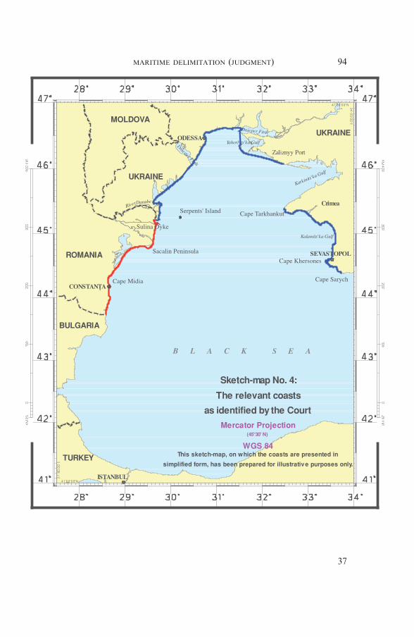
94MARITIME DELIMITATION (JUDGMENT)
37
distance and then in a north-easterly direction until the Nistru/DniesterFirth. The point where its southern bank meets the coast (referred to byRomania as “Point S”), according to Romania, marks the end of thatpart of Ukraine’s coast which has a relation of adjacency with the Roma-nian coast. From this point, the Ukrainian coast changes direction pro-ceeding in a north-north-easterly direction until it reaches Odessa. AtOdessa it initially goes north and then turns eastwards until the coastreaches the Dnieper Firth. From here the general direction of the coast isfirst a southerly one, and then, from the bottom of the Yahorlyts’kaGulf, the direction is an easterly one, until it comes to the bottom of theKarkinits’ka Gulf. The coast then turns back on itself sharply, extendingsouth-westwards along the southern coast of the Karkinits’ka Gulf, untilit reaches Cape Tarkhankut. The last sector comprises the coast of Cri-mea between Cape Tarkhankut and Cape Sarych, which is concave, itsgeneral direction being interrupted by a significant protrusion, the western-most point of which is Cape Khersones. According to Romania, theUkrainian coast is composed of eight distinct segments, determined bymarked changes in the direction of the coast.
91. Romania argues that the segments of the Ukrainian coast situatedto the north of the line running from Point S to Cape Tarkhankut do notproject on the area of delimitation or “have a relationship of either adja-cency or oppositeness with the Romanian coast” and therefore are irrele-vant for the delimitation. In particular Romania maintains that thecoastline of the Karkinits’ka Gulf, immediately north of the CrimeanPeninsula, should not be counted as a relevant coast, nor “can a closingline drawn across or anywhere within the Karkinits’ka Gulf be treated asa surrogate for its irrelevant coast”. Romania adds that such projectionsas are made by this northern coast are in fact overtaken by the westwardprojections of the Ukrainian coast from Cape Tarkhankut to CapeSarych.
92. Romania states that “Serpents’ Island does not form part of thecoastal configuration of the Parties ; it constitutes merely a small mari-time feature situated at a considerable distance out to sea from the coastsof the Parties”.
93. Thus, in Romania’s view, the relevant Ukrainian coast runsbetween the last point of the land/river border between Romania andUkraine and Point S, and on the western-facing coast of the CrimeanPeninsula, runs between Cape Tarkhankut and Cape Sarych.
The total length of the relevant Ukrainian coast, as perceived byRomania, is 388.14 km (baselines 292.63 km).
*
94. Ukraine contends that its own relevant coast is comprised of threedistinct sectors each of which generates an entitlement to a continental
95MARITIME DELIMITATION (JUDGMENT)
38
shelf and an exclusive economic zone in the area subject to delimitation.The first sector extends from the border with Romania until a pointlocated just north of Odessa. In the second sector, north of Odessa, theUkrainian coast turns to the east and comprises the south-facing littoralalong the north-western part of the Black Sea. The coast then extendsinto the Karkinits’ka Gulf. The third sector comprises the western coastof the Crimean Peninsula from the easternmost point of the Karkinits’kaGulf to Cape Sarych. (Both Parties agree that Ukraine’s coast east ofCape Sarych is not relevant to the present dispute.) This portion ofUkraine’s coast is characterized by the indentation created by theKarkinits’ka Gulf and by the less pronounced Gulf of Kalamits’ka. Allthree sectors of Ukraine’s coast generate 200-nautical-mile entitlementswhich extend over the entire area to be delimited with Romania.
95. Ukraine disagrees that the part of its coast from Point S to CapeTarkhankut (630 km long) should be excluded from the relevant coast ofUkraine, as claimed by Romania. It affirms that the seaward extensionsof the Ukrainian coastal fronts, including the part of Ukraine’s coastbetween Point S and Cape Tarkhankut, “converge in a southerly direc-tion”. Ukraine points out that its south-facing coast, which Romaniaseeks to suppress, “generates a 200-nautical-mile entitlement throughoutthe area of concern in this case”. Ukraine adds that its entire south-facingcoast generates “a 200 nautical mile continental shelf/EEZ entitlementthat extends well south of the parallel of latitude of the Romanian/Bulgarian border”, i.e., projecting into the area subject to delimitation withRomania. Thus Ukraine contends that its coast from Point S to CapeTarkhankut is relevant for the purposes of the delimitation between theParties.
96. Ukraine claims that Serpents’ Island “forms part of the geographi-cal context and its coast constitutes part of Ukraine’s relevant coasts”.
97. Ukraine concludes that the total length of its relevant coast is1,058 km (coastal façade 684 km; baselines 664 km).
* *
98. The Court notes that both Parties consider the coast of the CrimeanPeninsula between Cape Tarkhankut and Cape Sarych, as well as theUkrainian coast from their common territorial boundary running for ashort distance in a north and subsequently in a north-easterly directionuntil the Nistru/Dniester Firth (Romania designates this point as Point S)as the relevant Ukrainian coast. Their disagreement concerns the coastextending from this point until Cape Tarkhankut.
99. The Court, in considering the issue in dispute, would recall twoprinciples underpinning its jurisprudence on this issue : first, that the“land dominates the sea” in such a way that coastal projections in the
96MARITIME DELIMITATION (JUDGMENT)
39
seaward direction generate maritime claims (North Sea Continental Shelf(Federal Republic of Germany/Denmark; Federal Republic of Germany/Netherlands), Judgment, I.C.J. Reports 1969, p. 51, para. 96) ; second,that the coast, in order to be considered as relevant for the purpose of thedelimitation, must generate projections which overlap with projectionsfrom the coast of the other Party. Consequently “the submarine exten-sion of any part of the coast of one Party which, because of its geo-graphic situation, cannot overlap with the extension of the coast of theother, is to be excluded from further consideration by the Court” (Con-tinental Shelf (Tunisia/Libyan Arab Jamahiriya), Judgment, I.C.J.Reports 1982, p. 61, para. 75).
100. The Court therefore cannot accept Ukraine’s contention that thecoasts of Karkinits’ka Gulf form part of the relevant coast. The coasts ofthis gulf face each other and their submarine extension cannot overlapwith the extensions of Romania’s coast. The coasts of Karkinits’ka Gulfdo not project in the area to be delimited. Therefore, these coasts areexcluded from further consideration by the Court. The coastline ofYahorlyts’ka Gulf and Dnieper Firth is to be excluded for the same rea-son.
It is to be noted that the Court has drawn a line at the entrance ofKarkinits’ka Gulf from Cape Priboiny (which is the north-western tip ofTarkhankuts’ky Peninsula, slightly north of Cape Tarkhankut) to thepoint that marks the eastern end of the portion of the Ukrainiannorthern coast that faces the area to be delimited. This point (whoseco-ordinates are approximately 46° 04′ 38″ N and 32° 28′ 48″ E) lies atthe intersection of the meridian passing through Cape Priboiny with thenorthern coast of Karkinits’ka Gulf, east of Zaliznyy Port. The Courthas found it useful to do so with respect to such a significant featureas Karkinits’ka Gulf, in order to make clear both what coasts will notbe under consideration and what waters will not be regarded as fallingwithin the relevant area. However, the Court does not include this linein the calculation of the total length of the Ukrainian relevant coasts,as the line “replaces” the coasts of Karkinits’ka Gulf which, again, donot themselves project on the area to be delimited and thus do not gen-erate any entitlement to the continental shelf and the exclusive economiczone in that area. Consequently, the line does not generate any entitle-ment.
101. As for the remaining sectors of the Ukrainian coast betweenPoint S and Cape Tarkhankut, the Court observes that the north-westernpart of the Black Sea (where the delimitation is to be carried out) in itswidest part measures slightly more than 200 nautical miles and its extentfrom north to south does not exceed 200 nautical miles. As a result of thisgeographical configuration, Ukraine’s south-facing coast generates pro-jections which overlap with the maritime projections of the Romaniancoast. Therefore, the Court considers these sectors of Ukraine’s coast asrelevant coasts (see sketch-map No. 4, p. 94).
102. The coast of Serpents’ Island is so short that it makes no real dif-
97MARITIME DELIMITATION (JUDGMENT)
40
ference to the overall length of the relevant coasts of the Parties. TheCourt will later examine whether Serpents’ Island is of relevance for thechoice of base points (see paragraph 149 below).
103. The length of the relevant coast of Ukraine is approximately705 km.
* *
104. The Court notes that on the basis of its determination of whatconstitutes the relevant coasts, the ratio for the coastal lengths betweenRomania and Ukraine is approximately 1:2.8.
105. The second aspect mentioned by the Court in terms of the role ofrelevant coasts in the context of the third stage of the delimitation proc-ess (see paragraph 78 above) will be dealt with below in Section 11.
6. RELEVANT MARITIME AREA
106. Romania maintains that the relevant area in the north is bor-dered by the line running from Point S to Cape Tarkhankut. In thesouth, the area is bordered by the line equidistant between the adjacentRomanian and Bulgarian coasts, the median line between the oppositeRomanian and Turkish coasts and the delimitation line agreed upon bythe USSR and Turkey, to which agreement Ukraine has succeeded. Inthe south-east the area is bordered by the meridian uniting Cape Sarychwith the delimitation boundary between Ukraine and Turkey. In the westand in the east the limits of the area are formed by the Romanian andUkrainian relevant coasts.
107. According to Romania, the relevant area means all of the watersgenerated by projections from the relevant coasts, whether or not claimedby the other State. Romania states that there are three points of disagree-ment between the Parties as to the relevant area. First, Romania assertsthat the coasts looking on to the area north of the line between Point Sand Cape Tarkhankut are all Ukrainian, and that none of them are rele-vant to the delimitation. Second, it states that the south-western limit isrepresented by the equidistance line between the adjacent Romanian andBulgarian coasts and that to move the line south of this equidistance linecould prejudge potential interests of Bulgaria in this maritime area.Third, Romania claims that the south-eastern triangle lying betweenUkraine and Turkey also forms part of the relevant area because it iswithin a 200-mile projection from the Romanian coasts (see sketch-mapNo. 2, p. 91).
*
98MARITIME DELIMITATION (JUDGMENT)
41
108. Ukraine contends that the western limit of the relevant area cor-responds to the Romanian coastline between the land boundaries withBulgaria and Ukraine and the stretch of the Ukrainian coast extendingfrom the border with Romania until a point located just north of Odessa.In the north, the relevant area is bordered by the south-facing Ukrainiancoast. In the east, the relevant area is bordered by the west-facing coastof the Crimean Peninsula terminating at Cape Sarych. The southern limitof the relevant area is a line drawn perpendicular from the mainlandcoast from the point where the Bulgarian/Romanian land border reachesthe Black Sea until a point between the Romanian and Ukrainian coastswhere the interests of third States potentially come into play. This pointis then connected to Cape Sarych by a straight line which represents thesouth-eastern limit of the relevant area.
109. Ukraine contends, as to the three points of disagreement, that allof its south-facing coast between Point S and Cape Tarkhankut generatesmaritime entitlements to a distance of 200 nautical miles and that thismaritime area, accordingly, forms part of the relevant area. Ukrainefurther argues that the relevant area should include a sliver of maritimearea situated between the hypothetical equidistance line between Roma-nia and Bulgaria and a straight line connecting the endpoint of theRomanian/Bulgarian land boundary and a potential tripoint with Bul-garia and/or Turkey. Finally, according to Ukraine, a large triangle lyingbetween Ukraine and Turkey has already been subject to a prior delimi-tation between the former Soviet Union and Turkey to which Ukrainehas succeeded and therefore does not form part of the relevant area (seesketch-map No. 3, p. 92).
* *
110. The Court observes that the legal concept of the “relevant area”has to be taken into account as part of the methodology of maritimedelimitation.
In the first place, depending on the configuration of the relevant coastsin the general geographical context and the methods for the constructionof their seaward projections, the relevant area may include certain mari-time spaces and exclude others which are not germane to the case inhand.
Secondly, the relevant area is pertinent to checking disproportionality.This will be done as the final phase of the methodology. The purposeof delimitation is not to apportion equal shares of the area, nor indeedproportional shares. The test of disproportionality is not in itself amethod of delimitation. It is rather a means of checking whether thedelimitation line arrived at by other means needs adjustment because ofa significant disproportionality in the ratios between the maritime areaswhich would fall to one party or other by virtue of the delimitation line
99MARITIME DELIMITATION (JUDGMENT)
42

arrived at by other means, and the lengths of their respective coasts.111. The Court further observes that for the purposes of this final
exercise in the delimitation process the calculation of the relevant areadoes not purport to be precise and is approximate. The object ofdelimitation is to achieve a delimitation that is equitable, not an equalapportionment of maritime areas (North Sea Continental Shelf (FederalRepublic of Germany/Denmark; Federal Republic of Germany/Netherlands),Judgment, I.C.J. Reports 1969, p. 22, para. 18; Maritime Delimitation inthe Area between Greenland and Jan Mayen (Denmark v. Norway),Judgment, I.C.J. Reports 1993, p. 67, para. 64).
112. The Court notes that the delimitation will occur within theenclosed Black Sea, with Romania being both adjacent to, and oppositeUkraine, and with Bulgaria and Turkey lying to the south. It will staynorth of any area where third party interests could become involved.
113. As for the area in the north disputed by the Parties as a relevantarea, as explained above (see paragraph 101) the Court has taken theview that the section of the Ukrainian coast situated to the north of theline running from Point S to Cape Tarkhankut is a relevant coast for thepurpose of the delimitation exercise. Accordingly, the area lying immedi-ately south of this coast, but excluding Karkinits’ka Gulf at the mouth ofwhich the Court has drawn a line (see paragraph 100 above), falls withinthe delimitation area.
114. The Court turns now to the southern limit of the relevant area.The Parties hold different views as to whether the south-western andsouth-eastern “triangles” should be included in the relevant area (seeparagraphs 107 and 109 above and sketch-map Nos. 2 and 3, pp. 91-92).The Court notes that in both these triangles the maritime entitlements ofRomania and Ukraine overlap. The Court is also aware that in thesouth-western triangle, as well as in the small area in the western cornerof the south-eastern triangle, entitlements of third parties may come intoplay. However where areas are included solely for the purpose of approxi-mate identification of overlapping entitlements of the Parties to the case,which may be deemed to constitute the relevant area (and which in duecourse will play a part in the final stage testing for disproportionality),third party entitlements cannot be affected. Third party entitlementswould only be relevant if the delimitation between Romania and Ukrainewere to affect them.
In light of these considerations, and without prejudice to the positionof any third State regarding its entitlements in this area, the Court findsit appropriate in the circumstances of this case to include both the south-western and the south-eastern triangles in its calculation of the relevantarea (see sketch-map No. 5, p. 102).
100MARITIME DELIMITATION (JUDGMENT)
43

7. DELIMITATION METHODOLOGY
115. When called upon to delimit the continental shelf or exclusiveeconomic zones, or to draw a single delimitation line, the Court proceedsin defined stages.
116. These separate stages, broadly explained in the case concerningContinental Shelf (Libyan Arab Jamahiriya/Malta) (Judgment, I.C.J.Reports 1985, p. 46, para. 60), have in recent decades been specified withprecision. First, the Court will establish a provisional delimitation line,using methods that are geometrically objective and also appropriate forthe geography of the area in which the delimitation is to take place. Sofar as delimitation between adjacent coasts is concerned, an equidistanceline will be drawn unless there are compelling reasons that make this un-feasible in the particular case (see Territorial and Maritime Disputebetween Nicaragua and Honduras in the Caribbean Sea (Nicaragua v.Honduras), Judgment, I.C.J. Reports 2007 (II), p. 745, para. 281). Sofar as opposite coasts are concerned, the provisional delimitation line willconsist of a median line between the two coasts. No legal consequencesflow from the use of the terms “median line” and “equidistance line”since the method of delimitation is the same for both.
117. Equidistance and median lines are to be constructed from themost appropriate points on the coasts of the two States concerned, withparticular attention being paid to those protuberant coastal points situ-ated nearest to the area to the delimited. The Court considers elsewhere(see paragraphs 135-137 below) the extent to which the Court may, whenconstructing a single-purpose delimitation line, deviate from the basepoints selected by the Parties for their territorial seas. When constructionof a provisional equidistance line between adjacent States is called for,the Court will have in mind considerations relating to both Parties’ coast-lines when choosing its own base points for this purpose. The line thusadopted is heavily dependent on the physical geography and the mostseaward points of the two coasts.
118. In keeping with its settled jurisprudence on maritime delimita-tion, the first stage of the Court’s approach is to establish the provisionalequidistance line. At this initial stage of the construction of the provi-sional equidistance line the Court is not yet concerned with any relevantcircumstances that may obtain and the line is plotted on strictly geometri-cal criteria on the basis of objective data.
119. In the present case the Court will thus begin by drawing a provi-sional equidistance line between the adjacent coasts of Romania andUkraine, which will then continue as a median line between their oppo-site coasts.
120. The course of the final line should result in an equitable solution(Articles 74 and 83 of UNCLOS). Therefore, the Court will at the next,second stage consider whether there are factors calling for the adjustmentor shifting of the provisional equidistance line in order to achieve anequitable result (Land and Maritime Boundary between Cameroon and
101MARITIME DELIMITATION (JUDGMENT)
44
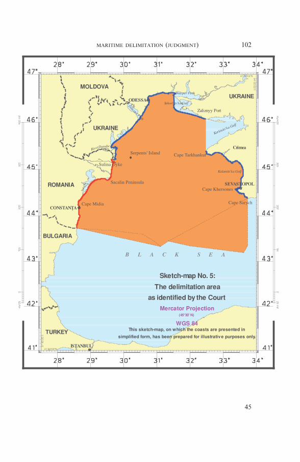
102MARITIME DELIMITATION (JUDGMENT)
45
Nigeria (Cameroon v. Nigeria : Equatorial Guinea intervening), Judg-ment, I.C.J. Reports 2002, p. 441, para. 288). The Court has also madeclear that when the line to be drawn covers several zones of coincidentjurisdictions, “the so-called equitable principles/relevant circumstancesmethod may usefully be applied, as in these maritime zones this methodis also suited to achieving an equitable result” (Territorial and MaritimeDispute between Nicaragua and Honduras in the Caribbean Sea (Nica-ragua v. Honduras), Judgment, I.C.J. Reports 2007 (II), p. 741,para. 271).
121. This is the second part of the delimitation exercise to which theCourt will turn, having first established the provisional equidistance line.
122. Finally, and at a third stage, the Court will verify that the line (aprovisional equidistance line which may or may not have been adjustedby taking into account the relevant circumstances) does not, as it stands,lead to an inequitable result by reason of any marked disproportionbetween the ratio of the respective coastal lengths and the ratio betweenthe relevant maritime area of each State by reference to the delimitationline (see paragraphs 214-215). A final check for an equitable outcomeentails a confirmation that no great disproportionality of maritime areasis evident by comparison to the ratio of coastal lengths.
This is not to suggest that these respective areas should be proportion-ate to coastal lengths — as the Court has said “the sharing out of thearea is therefore the consequence of the delimitation, not vice versa”(Maritime Delimitation in the Area between Greenland and Jan Mayen(Denmark v. Norway), Judgment, I.C.J. Reports 1993, p. 67, para. 64).
8. ESTABLISHMENT OF THE PROVISIONAL EQUIDISTANCE LINE
8.1. Selection of Base Points
123. Romania contends that the base points to take into accountin constructing the provisional equidistance line between the adjacentcoasts of Romania and Ukraine are, on the Romanian coast, the seawardend of the Sulina dyke, and on the Ukrainian coast, a point on theisland of Kubansky and Cape Burnas. In addition, in Romania’s view,the base points on the opposite coasts of Romania and Ukraineare, on the Romanian coast, the seaward end of the Sulina dyke andthe outer end of the Sacalin Peninsula, and on the Ukrainian coast,Capes Tarkhankut and Khersones. Romania points out that the Sac-alin Peninsula and the most seaward point of the Sulina dyke areamong the relevant points notified by Romania to the United Nationsunder Article 16 of UNCLOS for measuring the breadth of the ter-ritorial sea.
124. Romania argues that no account should be taken of Serpents’
103MARITIME DELIMITATION (JUDGMENT)
46
Island as a base point for the purposes of constructing the provisionalequidistance line. It claims that Serpents’ Island is a rock incapable ofsustaining human habitation or economic life of its own, “thereforehaving no exclusive economic zone or continental shelf, as provided forin Article 121 (3) of the 1982 UNCLOS”. Romania further points outthat when Ukraine notified the United Nations of the co-ordinates of itsbaselines used for measuring the breadth of its territorial sea, it made noreference at all to Serpents’ Island. In addition, it considers that usingthis island as a base point would result in an inordinate distortion of thecoastline.
*
125. Ukraine contends for its part that the relevant base points for theconstruction of the provisional equidistance line are situated on the base-lines of each of the Parties from which the breadth of their territorial seais measured. Thus, on the Romanian coast, Ukraine has used the basepoints situated on the Sulina dyke and the Sacalin Peninsula. On its owncoasts, it has taken as a reference “the base points situated on Serpents’Island” and the tip of Cape Khersones. Ukraine indicates, however, thatRomania’s use of a point situated at the seaward tip of the Sulina dykehas a huge effect on Romania’s provisional equidistance line. It also con-siders that
“[t]he notion that a protruding, man-made structure can be given afull effect for purposes of plotting the provisional equidistance line,while a natural feature — an island [Serpents’ Island] — can simplybe ignored does not comport with a proper application of the law orwith equitable principles”.
126. Ukraine maintains that because Serpents’ Island has a coast, itfollows that it has a baseline. As a result, it states that there are basepoints on that baseline that can be used for plotting the provisional equi-distance line. It points out that, contrary to what Romania claims, “nor-mal” baselines, defined as the low-water mark around the coast, do nothave to be notified to the United Nations, as straight baselines have tobe. Ukraine therefore contends that given its proximity to the Ukrainianmainland, Serpents’ Island should clearly be taken into account as one ofthe relevant base points for the construction of the provisional equidis-tance line. It notes that the belt of territorial sea which surrounds Ser-pents’ Island partly overlaps with the area of territorial sea bordering theUkrainian mainland. Consequently, “[t]his island therefore representswhat is commonly termed a coastal island”.
* *
104MARITIME DELIMITATION (JUDGMENT)
47
127. In this stage of the delimitation exercise, the Court will identifythe appropriate points on the Parties’ relevant coast or coasts whichmark a significant change in the direction of the coast, in such a way thatthe geometrical figure formed by the line connecting all these pointsreflects the general direction of the coastlines. The points thus selected oneach coast will have an effect on the provisional equidistance line thattakes due account of the geography.
128. The Court observes that in this instance, the geography showsthat the capacity of the coasts to generate overlapping titles indicates theexistence of two areas : in one case, the coasts are adjacent ; in the other,they are opposite. In practice, the first conclusion which the Court drawsfrom this is that, on the Romanian coast, the significant base points fromwhich the equidistance line and the median line must be established arethe same, since this coast is both adjacent and opposite to the Ukrainiancoast. The second conclusion is that, as the Ukrainian coast consists oftwo portions — one adjacent to the Romanian coast, the other oppositeto it — the base points to take into account must be defined separately,according to whether the adjacent or opposite portion is concerned. Thethird conclusion is the identification of a turning-point on the equidis-tance line where the effects of adjacency give way to those of the coastson the opposite side, resulting in a change in the direction of the line.Lastly, the Court will need to consider the relevance or otherwise of Ser-pents’ Island in terms of the choice of base points.
129. On the Romanian coast from the border with Bulgaria, the Courtwill first consider the Sacalin Peninsula. This is the point at which thedirection followed by the Romanian coast from the border betweenRomania and Bulgaria turns almost perpendicularly towards the north.At this place, the coasts of Romania and Ukraine are opposite oneanother. The significance of the Sacalin Peninsula in terms of the choiceof base points is questioned by Ukraine, which describes it as a spit ofsand. However, the Court observes that the peninsula belongs to thelandmass and forms part of the Romanian mainland: its permanentuncovering at high tide is not contested. The geomorphological featuresof the peninsula and its possibly sandy nature have no bearing on theelements of its physical geography which are relevant for maritime delimi-tation. For these reasons, the Court considers it appropriate, for the pur-pose of establishing the provisional equidistance line, to use a base pointon the Sacalin Peninsula (44° 50′ 28″ N and 29° 36′ 52″ E), which happensto correspond to the point notified by Romania to the United Nations asa base point pursuant to Article 16 of UNCLOS.
130. The Court will next consider whether any point on the Romaniancoast of the Musura Bay may serve as a base point. The southern head-land of this bay is the most prominent point of the Romanian coast in the
105MARITIME DELIMITATION (JUDGMENT)
48

direction of the Crimea and is also situated in the area where the coastsof the two States are adjacent. These two characteristics prompt its selec-tion for the purpose of establishing the provisional equidistance line.However, because of the construction on that southern headland of a7.5 km-long dyke out to sea, which accordingly extends this feature, it isnecessary to choose either the seaward end of the dyke or the end whereit adjoins the mainland.
131. In this respect, the Court observes that the geometrical nature ofthe first stage of the delimitation exercise leads it to use as base pointsthose which the geography of the coast identifies as a physical reality atthe time of the delimitation. That geographical reality covers not only thephysical elements produced by geodynamics and the movements of thesea, but also any other material factors that are present.
132. In light of the fact that the breadth of the exclusive economiczone and the continental shelf is measured from the baselines from whichthe territorial sea is measured (UNCLOS, Arts. 57 and 76), the Courtfirst has to consider whether the Sulina dyke could be regarded as “per-manent harbour works which form an integral part of the harbour sys-tem”, within the meaning of Article 11 of UNCLOS, which Article theCourt recalls concerns the delimitation of the territorial sea. It reads asfollows:
“For the purpose of delimiting the territorial sea, the outermostpermanent harbour works which form an integral part of the har-bour system are regarded as forming part of the coast. Off-shoreinstallations and artificial islands shall not be considered as perma-nent harbour works.”
133. The permanent nature of the Sulina dyke not having been ques-tioned, the Court will have to consider whether this structure can bedescribed as “harbour works” which form “an integral part of the har-bour system”. The term “works” denotes a combination of apparatus,structures and facilities installed for a specific purpose. The expression“harbour works” “which form an integral part of the harbour system” isnot defined in the Geneva Convention on the Territorial Sea and Con-tiguous Zone or in UNCLOS; these are generally installations whichallow ships to be harboured, maintained or repaired and which permit orfacilitate the embarkation and disembarkation of passengers and theloading or unloading of goods.
134. The Court notes, however, that the functions of a dyke are dif-ferent from those of a port : in this case, the Sulina dyke may be of use inprotecting shipping destined for the mouth of the Danube and for theports situated there. The difference between a port and a dyke extendingseawards has previously been discussed in the travaux préparatoires ofArticle 8 of the Geneva Convention on the Territorial Sea and Contigu-ous Zone. In 1954, the Special Rapporteur of the ILC observed that
106MARITIME DELIMITATION (JUDGMENT)
49
“dykes used for the protection of the coast constituted a separate prob-lem and did not come under either Article 9 (ports) or Article 10 (road-steads)”. Subsequently, the concept of a “dyke” was no longer used, andreference was made to “jetties” serving to protect coasts from the sea.The first sentence of Article 11 of UNCLOS corresponds, apart from oneminor change in the wording, to that of Article 8 of the Convention onthe Territorial Sea and Contiguous Zone. The second sentence, providingthat “permanent harbour works” shall not include “off-shore installa-tions and artificial islands”, is new. The expert at the 1958 Conferencestated that “harbour works such as jetties [are regarded] as part of . . .land territory”. It should be noted, however, that the ILC included thefollowing comment in its report to the General Assembly:
“(3) Where such structures are of excessive length (for instance, ajetty extending several kilometres into the sea), it may be askedwhether this article [Art. 8] could still be applied . . . As such casesare very rare, the Commission, while wishing to draw attention tothe matter, did not deem it necessary to state an opinion.” (ILCYearbook, 1956, Vol. II, p. 270.)
In the light of the above, the ILC did not, at the time, intend to defineprecisely the limit beyond which a dyke, jetty or works would no longerform “an integral part of the harbour system”. The Court concludes fromthis that there are grounds for proceeding on a case-by-case basis, andthat the text of Article 11 of UNCLOS and the travaux préparatoires donot preclude the possibility of interpreting restrictively the concept ofharbour works so as to avoid or mitigate the problem of excessive lengthidentified by the ILC. This may be particularly true where, as here, thequestion is one of delimitation of areas seaward of the territorial sea.
135. With regard to the use of the Sulina dyke as a base point for thepresent delimitation, the Court must consider the relevance of Romania’snotification to the United Nations under Article 16 of UNCLOS, inwhich Romania used the seaward end of the Sulina dyke as a base pointfor drawing the baseline for its territorial sea. This choice of base pointswas not contested by Ukraine.
136. Article 16 provides that “the base lines for measuring the breadthof the territorial sea . . . and the lines of delimitation [of the territorialsea] shall be shown on charts” (paragraph 1) and that “the coastal Stateshall deposit a copy of each such chart or list with the Secretary-Generalof the United Nations”. Since Article 57 (regarding the breadth of theexclusive economic zone) and Article 76, paragraph 1, (regarding thedefinition of the continental shelf) of UNCLOS stipulate that these mari-time zones can extend to a distance of 200 nautical miles “from the base-
107MARITIME DELIMITATION (JUDGMENT)
50
lines from which the breadth of the territorial sea is measured”, the ques-tion arises as to whether the same seaward end of the Sulina dyke has tobe retained for the purpose of the present delimitation.
137. The Court observes that the issue of determining the baseline forthe purpose of measuring the breadth of the continental shelf and theexclusive economic zone and the issue of identifying base points fordrawing an equidistance/median line for the purpose of delimiting thecontinental shelf and the exclusive economic zone between adjacent/opposite States are two different issues.
In the first case, the coastal State, in conformity with the provisions ofUNCLOS (Articles 7, 9, 10, 12 and 15), may determine the relevant basepoints. It is nevertheless an exercise which has always an internationalaspect (see Fisheries (United Kingdom v. Norway), Judgment, I.C.J.Reports 1951, p. 132). In the second case, the delimitation of the mari-time areas involving two or more States, the Court should not base itselfsolely on the choice of base points made by one of those Parties. TheCourt must, when delimiting the continental shelf and exclusive eco-nomic zones, select base points by reference to the physical geography ofthe relevant coasts.
138. As for the specific characteristics of the seaward end of the Sulinadyke as a relevant base point for constructing the provisional equidis-tance line, the Court points out that, irrespective of its length, noconvincing evidence has been presented that this dyke serves any directpurpose in port activities. For these reasons, the Court is not satisfied thatthe seaward end of the Sulina dyke is a proper base point for the pur-poses of the construction of a provisional equidistance line delimiting thecontinental shelf and the exclusive economic zones.
139. On the other hand, while the landward end of the dyke may notbe an integral part of the Romanian mainland, it is a fixed point on it.The land at this point is protected from shifts in the coastline due tomarine processes. As a relevant base point for the purposes of the firststage of delimitation, it has the advantage, unlike the seaward end of thedyke, of not giving greater importance to an installation than to thephysical geography of the landmass.
140. For these reasons, the Court is of the opinion that the landwardend of the Sulina dyke where it joins the Romanian mainland should beused as a base point for the establishment of the provisional equidistanceline.
141. The Court therefore concludes that it will use the Sacalin Penin-sula (44° 50′ 28″ N and 29° 36′ 52″ E) and the landward end of the Sulinadyke (45° 09′ 51.9″ N and 29° 43′ 14.5″ E) 2 as base points on the Roma-nian coast.
*
2 Co-ordinates provided by the Parties in Pulkovo datum.
108MARITIME DELIMITATION (JUDGMENT)
51
142. The Court will now turn to identifying the relevant base points onUkraine’s coast, starting with the sector of adjacent coasts.
143. The Court deems it appropriate in this first sector to use thesouth-eastern tip of Tsyganka Island on the Ukrainian side, which is thecounterpart of the landward end of the Sulina dyke on the Romanianside. Its location is significant, because in this area of adjacency it is themost prominent point on the Ukrainian coast.
144. In this sector of adjacent coasts, the Court needs also to considerthe relevance of the Ukrainian base point situated on the island of Kuban-sky as a base point for use in constructing the provisional equidistanceline. The Court notes that this base point does not produce any effect onthe equidistance line plotted by reference to the base point on TsygankaIsland on the Ukrainian coast and the base point on the landward end ofthe Sulina dyke on the Romanian coast. This base point is therefore to beregarded as irrelevant for the purposes of the present delimitation.
145. The Court will now consider the base points on the section ofUkraine’s coast opposite Romania’s coast.
146. It will start with Cape Tarkhankut, the most seaward point facingRomania’s coast on the Crimean coast. The Crimean coastline juts outsignificantly here, and its configuration makes this cape an appropriatechoice as a relevant base point.
147. Cape Khersones, another point on the Crimean coast where theland protrudes into the sea, also juts out markedly, though less so thanCape Tarkhankut. This configuration is sufficient to justify choosingCape Khersones as a relevant base point.
148. The Court therefore concludes that it will use Tsyganka Island(45° 13′ 23.1″ N and 29° 45′ 33.1″ E), Cape Tarkhankut (45° 20′ 50″ N and32° 29′ 43″ E) and Cape Khersones (44° 35′ 04″ N and 33° 22′ 48″ E) 3 asbase points on the Ukrainian coast.
149. Serpents’ Island calls for specific attention in the determination ofthe provisional equidistance line. In connection with the selection of basepoints, the Court observes that there have been instances when coastalislands have been considered part of a State’s coast, in particular when acoast is made up of a cluster of fringe islands. Thus in one maritimedelimitation arbitration, an international tribunal placed base pointslying on the low water line of certain fringe islands considered to consti-tute part of the very coastline of one of the Parties (Award of the ArbitralTribunal in the Second Stage of the Proceedings between Eritrea andYemen (Maritime Delimitation), 17 December 1999, RIAA, Vol. XXII,pp. 367-368, paras. 139-146). However, Serpents’ Island, lying alone and
3 Co-ordinates provided by the Parties in Pulkovo datum.
109MARITIME DELIMITATION (JUDGMENT)
52
some 20 nautical miles away from the mainland, is not one of a cluster offringe islands constituting “the coast” of Ukraine.
To count Serpents’ Island as a relevant part of the coast would amountto grafting an extraneous element onto Ukraine’s coastline ; the conse-quence would be a judicial refashioning of geography, which neither thelaw nor practice of maritime delimitation authorizes. The Court is thus ofthe view that Serpents’ Island cannot be taken to form part of Ukraine’scoastal configuration (cf. the islet of Filfla in the case concerning Conti-nental Shelf (Libyan Arab Jamahiriya/Malta), Judgment, I.C.J. Reports1985, p. 13).
For this reason, the Court considers it inappropriate to select any basepoints on Serpents’ Island for the construction of a provisional equidis-tance line between the coasts of Romania and Ukraine. Further aspectsrelevant to Serpents’ Island are dealt with at paragraphs 179 to 188below.
8.2. Construction of the Provisional Equidistance Line
150. Romania argues that the first segment of the maritime boundarydelimiting the maritime areas of the two States situated beyond their ter-ritorial seas was established by successive agreements between Romaniaand the Soviet Union: from the final point of the boundary separatingthe territorial seas of the two States at 45° 05′ 21″ N and 30° 02′ 27″ E, themaritime boundary passes along the 12-nautical-mile arc of the circlearound Serpents’ Island until it reaches a point situated on that arc at45° 14′ 20″ N and 30° 29′ 12″ E (see Section 4). Romania contends that themaritime boundary beyond that point was never delimited between Roma-nia and the USSR or Ukraine. Romania draws a provisional equidis-tance line from the final point of the land/river boundary between the twoStates taking into account the salient base points of the adjacent Roma-nian and Ukrainian coasts. These are : on the Romanian coast, the sea-ward end of the Sulina dyke; and on the Ukrainian coast, the island ofKubansky and Cape Burnas. As the point lying on the arc around Ser-pents’ Island at 45° 14′ 20″ N and 30° 29′ 12″ E, is not situated on theequidistance line, but about 2.5 nautical miles to the north, the delimita-tion of the maritime boundary beyond this point must, in Romania’sview, start by joining it to the provisional equidistance line. The line thusdrawn passes through the point at 45° 11′ 59″ N and 30° 49′ 16″ E, situ-ated practically midway between the 12-nautical-mile arc around Ser-pents’ Island and the tripoint as between the Romanian and Ukrainianadjacent coasts and the opposite Crimean coast, situated at 45° 09′ 45″ Nand 31° 08′ 40″ E. Romania contends that, from this point southwards,the delimitation is governed by the opposite Romanian and Ukrainiancoasts.
110MARITIME DELIMITATION (JUDGMENT)
53
151. Romania calculates the median line taking into account the sali-ent base points on the relevant opposite coasts of the two States (the sea-ward end of the Sulina dyke and the outer end of the Sacalin Peninsulaon the Romanian coast, and Capes Tarkhankut and Khersones on theUkrainian coast). Romania’s equidistance line in the sector of oppositecoasts thus coincides with the segment of the median line running from,in the north, the tripoint as between the Romanian and Ukrainian adja-cent coasts and the opposite Crimean coast to, in the south, the pointbeyond which the interests of third States may be affected, which Roma-nia situates at 43° 26′ 50″ N and 31° 20′ 10″ E.
*
152. Ukraine maintains that the provisional equidistance line must beconstructed by reference to the base points on each Party’s baselines fromwhich the breadth of its territorial sea is measured. Thus, on the Roma-nian side, Ukraine uses the base points at the seaward end of the Sulinadyke and on the Sacalin Peninsula. On its own side, it uses the basepoints on Serpents’ Island and at the tip of Cape Khersones. The provi-sional equidistance line advocated by Ukraine starts at the point of inter-section of the territorial seas of the Parties identified in Article 1 of the2003 State Border Régime Treaty (45° 05′ 21″ N and 30° 02′ 27″ E). Theline then runs in a southerly direction until the point at 44° 48′ 24″ N and30° 10′ 56″ E, after which it turns to run in a south-easterly direction untilthe point at 43° 55′ 33″ N and 31° 23′ 26″ E and thereafter continues duesouth.
* *
153. The Court recalls that the base points which must be used in con-structing the provisional equidistance line are those situated on the Saca-lin Peninsula and the landward end of the Sulina dyke on the Romaniancoast, and Tsyganka Island, Cape Tarkhankut and Cape Khersones onthe Ukrainian coast.
154. In its initial segment the provisional equidistance line between theRomanian and Ukrainian adjacent coasts is controlled by base pointslocated on the landward end of the Sulina dyke on the Romanian coastand south-eastern tip of Tsyganka Island on the Ukrainian coast. It runsin a south-easterly direction, from a point lying midway between thesetwo base points, until Point A (with co-ordinates 44° 46′ 38.7″ N and30° 58′ 37.3″ E) where it becomes affected by a base point located on theSacalin Peninsula on the Romanian coast. At Point A the equidistanceline slightly changes direction and continues to Point B (with co-ordinates 44° 44′ 13.4″ N and 31° 10′ 27.7″ E) where it becomes affected bythe base point located on Cape Tarkhankut on Ukraine’s opposite coasts.
111MARITIME DELIMITATION (JUDGMENT)
54
At Point B the equidistance line turns south-south-east and continues toPoint C (with co-ordinates 44° 02′ 53.0″ N and 31° 24′ 35.0″ E), calculatedwith reference to base points on the Sacalin Peninsula on the Romaniancoast and Capes Tarkhankut and Khersones on the Ukrainian coast.From Point C the equidistance line, starting at an azimuth of 185° 23′ 54.5″ 4,runs in a southerly direction. This line remains governed by the basepoints on the Sacalin Peninsula on the Romanian coast and Cape Kher-sones on the Ukrainian coast.
(For the construction of the equidistance line see sketch-maps Nos. 6and 7, pp. 114-115.)
9. RELEVANT CIRCUMSTANCES
155. As the Court indicated above (paragraphs 120-121), once the pro-visional equidistance line has been drawn, it shall “then [consider] whetherthere are factors calling for the adjustment or shifting of that line in orderto achieve an ‘equitable result’” (Land and Maritime Boundary betweenCameroon and Nigeria (Cameroon v. Nigeria : Equatorial Guinea inter-vening), Judgment, I.C.J. Reports 2002, p. 441, para. 288). Such factorshave usually been referred to in the jurisprudence of the Court, since theNorth Sea Continental Shelf (Federal Republic of Germany/Denmark;Federal Republic of Germany/Netherlands) cases, as the relevant circum-stances (Judgment, I.C.J. Reports 1969, p. 53, para. 53). Their function isto verify that the provisional equidistance line, drawn by the geometricalmethod from the determined base points on the coasts of the Parties isnot, in light of the particular circumstances of the case, perceived as in-equitable. If such would be the case, the Court should adjust the line inorder to achieve the “equitable solution” as required by Articles 74, para-graph 1, and 83, paragraph 1, of UNCLOS.
156. The Parties suggested and discussed several factors which theyconsider as the possible relevant circumstances of the case. They arrive atdifferent conclusions. Romania argues that its provisional equidistanceline achieves the equitable result and thus does not require any adjust-ment. Ukraine, on the other hand, submits that there are relevant circum-stances which call for the adjustment of its provisional equidistance line“by moving the provisional line closer to the Romanian coast”.
4 The geographical co-ordinates used by the Parties for the drawing of the equidistancelines proposed by them are given by reference to Pulkovo datum. The Court, for its part,has chosen to use WGS 84 datum. The positions of Points A, B and C are given by ref-erence to that geodetic datum. The equidistance line described in this paragraph is a geo-detic line and the azimuth given is a geodetic azimuth based on WGS 84 datum.
112MARITIME DELIMITATION (JUDGMENT)
55

157. Before addressing the relevant circumstances referred to by theParties, the Court wishes to recall that the provisional equidistance line ithas drawn in Section 8 above does not coincide with the provisional linesdrawn either by Ukraine or Romania. Therefore, it is this line, drawn bythe Court, and not by Romania or Ukraine, which will be in the focus ofthe Court’s attention when analysing what the Parties consider to be therelevant circumstances of the case.
9.1. Disproportion between Lengths of Coasts
158. The circumstance which Ukraine invokes in order to justify itsclaim that the provisional equidistance line should be adjusted by movingthe delimitation line closer to Romania’s coast is the disparity betweenthe length of the Parties’ coasts abutting on the delimitation area.
*
159. Romania acknowledges that the general configuration of thecoasts may constitute, given the particular geographical context, a rele-vant circumstance that can be taken into consideration with a view toadjusting the equidistance line. However, with regard specifically to anydisproportion between the lengths of the Parties’ coasts, Romania notesthat in a maritime delimitation it is rare for the disparities between theParties’ coasts to feature as a relevant circumstance. Moreover, in thepresent case, there is no manifest disparity in the respective coastallengths of Romania and Ukraine.
160. Romania adds that in any event proportionality should be dealtwith “only after having identified the line resulting from the applicationof the equitable principles/special circumstances approach”.
161. In conclusion Romania is of the view that the alleged “geographi-cal predominance of Ukraine in the area” and “the disparity betweencoastal lengths” of the Parties should not be considered relevant circum-stances in the case.
*
162. With regard to the role which may be played by the coastal con-figuration, Ukraine states that there is a broad margin of appreciation asto its scope as a relevant circumstance. In the circumstances of the cur-rent case, Ukraine argues that the coastal configuration clearly shows thegeographical predominance of Ukraine in the relevant area which alsofinds an expression in terms of coastal length: the Ukrainian relevantcoast is more than four times longer than the coast of Romania. Ukrainenotes that in almost all maritime delimitation cases dealt with by inter-national tribunals, “comparison of the lengths of the relevant coasts hasoccupied a quite significant place and even played a decisive role in anumber of the decisions taken”. Thus, according to Ukraine, the marked
113MARITIME DELIMITATION (JUDGMENT)
56
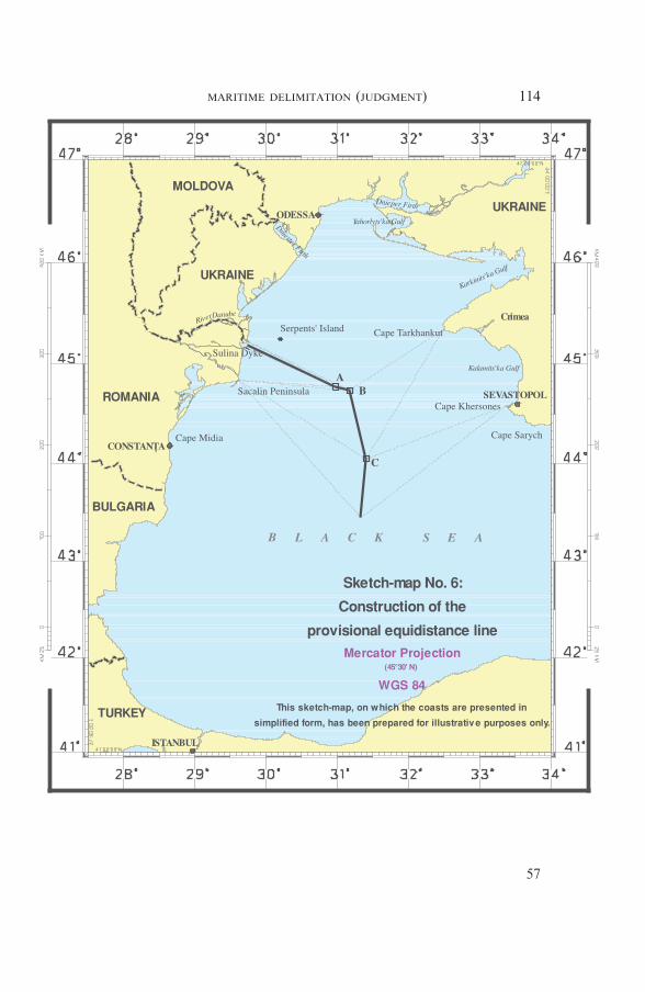
114MARITIME DELIMITATION (JUDGMENT)
57
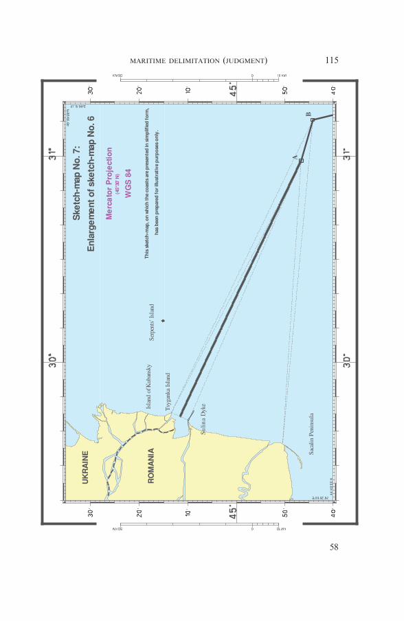
115MARITIME DELIMITATION (JUDGMENT)
58
disproportion between lengths of the Parties’ coasts is a relevant circum-stance to be taken into account in the construction of a delimitation lineand should result in a shifting of the provisional equidistance line inorder to produce an equitable result.
* *
163. The Court observes that the respective length of coasts can playno role in identifying the equidistance line which has been provisionallyestablished. Delimitation is a function which is different from the appor-tionment of resources or areas (see North Sea Continental Shelf (FederalRepublic of Germany/Denmark; Federal Republic of Germany/Nether-lands), Judgment, I.C.J. Reports 1969, p. 22, para. 18). There is no prin-ciple of proportionality as such which bears on the initial establishmentof the provisional equidistance line.
164. Where disparities in the lengths of coasts are particularly marked,the Court may choose to treat that fact of geography as a relevant cir-cumstance that would require some adjustments to the provisional equi-distance line to be made.
165. In the case concerning Land and Maritime Boundary betweenCameroon and Nigeria (Cameroon v. Nigeria ; Equatorial Guinea inter-vening), the Court acknowledged “that a substantial difference in thelengths of the parties’ respective coastlines may be a factor to be takeninto consideration in order to adjust or shift the provisional delimitationline” (Judgment, I.C.J. Report 2002, p. 446, para. 301; emphasis added),although it found that in the circumstances there was no reason to shiftthe equidistance line.
166. In the case concerning Maritime Delimitation in the Area betweenGreenland and Jan Mayen (Denmark v. Norway), the Court found thatthe disparity between the lengths of the coasts of Jan Mayen and Green-land (approximately 1:9) constituted a “special circumstance” requiringmodification of the provisional median line, by moving it closer to thecoast of Jan Mayen, to avoid inequitable results for both the continentalshelf and the fisheries zone. The Court stated that :
“It should, however, be made clear that taking account of the dis-parity of coastal lengths does not mean a direct and mathematicalapplication of the relationship between the length of the coastalfront of eastern Greenland and that of Jan Mayen.” (Judgment,I.C.J. Reports 1993, p. 69, para. 69.)
Then it recalled its observation from the Continental Shelf (Libyan ArabJamahiriya/Malta) case :
“If such a use of proportionality were right, it is difficult indeed tosee what room would be left for any other consideration; for itwould be at once the principle of entitlement to continental shelf
116MARITIME DELIMITATION (JUDGMENT)
59

rights and also the method of putting that principle into operation.Its weakness as a basis of argument, however, is that the use of pro-portionality as a method in its own right is wanting of support in thepractice of States, in the public expression of their views at (in par-ticular) the Third United Nations Conference on the Law of the Sea,or in the jurisprudence.” Judgment, I.C.J. Reports 1985, p. 45,para. 58.)
In the latter case, the Court was of the view that the difference in thelengths of the relevant coasts of Malta and Libya (being in ratio 1:8) “isso great as to justify the adjustment of the median line” (ibid., p. 50,para. 68; emphasis added). The Court added that “the degree of suchadjustment does not depend upon a mathematical operation and remainsto be examined” (ibid.).
167. The Court further notes that in the Delimitation of the MaritimeBoundary in the Gulf of Maine Area (Canada/United States of America)case, the Chamber considered that “in certain circumstances, the appro-priate consequences may be drawn from any inequalities in the extent ofthe coasts of two States into the same area of delimitation” (Judgment,I.C.J. Reports 1984, p. 313, para. 157; emphasis added). However, itmust be kept in mind that the Chamber did so in the context of discuss-ing what could be “the equitable criteria that may be taken into consid-eration for an international maritime delimitation” (ibid., p. 312,para. 157; emphasis added). It then further elaborated on this point bystating
“[...] that to take into account the extent of the respective coasts of theParties concerned does not in itself constitute either a criterion serv-ing as a direct basis for a delimitation, or a method that can be usedto implement such delimitation. The Chamber recognizes that thisconcept is put forward mainly as a means of checking whether aprovisional delimitation established initially on the basis of othercriteria, and by the use of a method which has nothing to do withthat concept, can or cannot be considered satisfactory in relation tocertain geographical features of the specific case, and whether it isreasonable or otherwise to correct it accordingly. The Chamber’s viewson this subject may be summed up by observing that a maritimedelimitation can certainly not be established by a direct division ofthe area in dispute proportional to the respective lengths of thecoasts belonging to the parties in the relevant area, but it is equallycertain that a substantial disproportion to the lengths of those coaststhat resulted from a delimitation effected on a different basis wouldconstitute a circumstance calling for an appropriate correction.”(Ibid., p. 323, para. 185; emphasis added.)
168. In the present case, however the Court sees no such particularlymarked disparities between the relevant coasts of Ukraine and Romania
117MARITIME DELIMITATION (JUDGMENT)
60
that would require it to adjust the provisional equidistance line at thisjuncture. Although there is doubtless a difference in the length of the rel-evant coasts of the Parties, the Court recalls that it previously (see para-graph 100 above) excluded the coast of Karkinits’ka Gulf (measuringsome 278 km) from further consideration. The Court further notes that itcannot disregard the fact that a good portion of the Ukrainian coastwhich it considers as relevant projects into the same area as other seg-ments of the Ukrainian coast, thus strengthening but not spatially expand-ing the Ukrainian entitlement.
9.2. The Enclosed Nature of the Black Sea and the DelimitationsAlready Effected in the Region
169. Romania notes that the enclosed nature of the Black Sea is also arelevant circumstance as part of the wider requirement to take account ofthe geographical context of the area to be delimited. According toRomania, in considering the equitable nature of an equidistance line, the“general maritime geography” of the Black Sea must be assessed. InRomania’s view, this geographical factor is to be considered togetherwith any pre-existing delimitation agreements so that any new delimita-tion should not dramatically depart from the method previously used inthe same sea between other riparian States in order not to produce aninequitable result.
170. Romania contends that all the delimitation agreements concludedin the Black Sea used equidistance as the method for the delimitation ofthe continental shelf and the exclusive economic zones. Romania addsthat the lines of delimitation established by two of these agreements endwith provisionally defined segments, the definitive course of which is todepend on subsequent discussions, and that the reason for this was thatthe Parties wished to avoid prejudicing the interests of third parties andthat they had Romania in mind.
171. Romania concludes that the Black Sea’s nature as an enclosed seaand its rather small size, together with the agreed solutions established inthe delimitation agreements in force, constitute a relevant circumstancewhich must be taken into account in the delimitation process for Roma-nia’s and Ukraine’s maritime areas.
*
172. In Ukraine’s view, there is “no support in law or in the factualcontext” for Romania’s arguments regarding the characterization of theBlack Sea as an enclosed sea and the importance of maritime delimitationagreements previously concluded between certain States bordering theBlack Sea. According to Ukraine, there is no special régime governingdelimitations taking place in an enclosed sea simply because of this
118MARITIME DELIMITATION (JUDGMENT)
61

nature. Ukraine therefore considers that the enclosed character of theBlack Sea “is not by itself a circumstance which ought to be regarded asrelevant for delimitation purposes” and has no bearing on the method ofdelimitation to be applied in the present proceedings.
173. Ukraine further notes that in general terms, bilateral agreementscannot affect the rights of third parties and, as such, the existing mari-time delimitation agreements in the Black Sea cannot influence the presentdispute.
Ukraine states that only in a limited sense can the presence of thirdStates in the vicinity of the area to be delimited be considered a relevantcircumstance. However, this has nothing to do with the choice of theactual method of delimitation or the character of a sea (whether or not itis enclosed). According to Ukraine, the presence of third States may berelevant only to the extent that the Court may have to take precautions inidentifying a precise endpoint of the delimitation line so as to avoidpotential prejudice to States situated on the periphery of the delimitationarea.
* *
174. The Court recalls that it has intimated earlier, when it brieflydescribed the delimitation methodology, that it would establish a provi-sional equidistance line (see paragraph 116 above). This choice was notdictated by the fact that in all the delimitation agreements concerning theBlack Sea this method was used.
175. Two delimitation agreements concerning the Black Sea werebrought to the attention of the Court. The first agreement, the Agree-ment concerning the Delimitation of the Continental Shelf in the BlackSea, was concluded between Turkey and the USSR on 23 June 1978.Some eight years later, they agreed, through an Exchange of Notes dated23 December 1986 and 6 February 1987, that the continental shelfboundary agreed in their 1978 Agreement would also constitute theboundary between their exclusive economic zones. The westernmost seg-ment of the line, between two points with co-ordinates 43° 20′ 43″ N and32° 00′ 00″ E and co-ordinates 43° 26′ 59″ N and 31° 20′ 48″ E, respec-tively, remained undefined and to be settled subsequently at a convenienttime. After the dissolution of the USSR at the end of 1991, the 1978 Agree-ment and the Agreement reached through the Exchange of Notesremained in force not only for the Russian Federation, as the State con-tinuing the international legal personality of the former USSR, but alsothe successor States of the USSR bordering the Black Sea, Ukraine beingone of them.
176. The second agreement is the Agreement between Turkey and Bul-garia on the determination of the boundary in the mouth area of theRezovska/Mutludere River and delimitation of the maritime areasbetween the two States in the Black Sea, signed on 4 December 1997. The
119MARITIME DELIMITATION (JUDGMENT)
62

drawing of the delimitation line of the continental shelf and the exclusiveeconomic zone further to the north-east direction, between geographicalpoint 43° 19′ 54″ N and 31° 06′ 33″ E and geographical point 43° 26′ 49″ Nand 31° 20′ 43″ E, was left open for subsequent negotiations at a suitabletime.
177. The Court will bear in mind the agreed maritime delimitationsbetween Turkey and Bulgaria, as well as between Turkey and Ukraine,when considering the endpoint of the single maritime boundary it isasked to draw in the present case (see Section 10 below).
178. The Court nevertheless considers that, in the light of the above-mentioned delimitation agreements and the enclosed nature of the BlackSea, no adjustment to the equidistance line as provisionally drawn iscalled for.
9.3. The Presence of Serpents’ Island in the Area of Delimitation
179. The Parties disagree as to the proper characterization of Serpents’Island and the role this maritime feature should play in the delimitationof the continental shelf and the Parties’ exclusive economic zones in theBlack Sea.
180. Romania maintains that Serpents’ Island is entitled to no morethan a 12-nautical-mile territorial sea, and that it cannot be used as abase point in drawing a delimitation line beyond the 12-mile limit. Roma-nia claims that Serpents’ Island is a rock incapable of sustaining humanhabitation or economic life of its own, and therefore has no exclusiveeconomic zone or continental shelf, as provided for in Article 121, para-graph 3, of the 1982 UNCLOS. According to Romania, Serpents’ Islandqualifies as a “rock” because : it is a rocky formation in the geomorpho-logic sense ; it is devoid of natural water sources and virtually devoid ofsoil, vegetation and fauna. Romania claims that human survival on theisland is dependent on supplies, especially of water, from elsewhere andthat the natural conditions there do not support the development of eco-nomic activities. It adds that “[t]he presence of some individuals, . . .because they have to perform an official duty such as maintaining a light-house, does not amount to sustained ‘human habitation’”.
181. Romania further argues that Serpents’ Island does not form partof the coastal configuration of the Parties and that its coast cannot there-fore be included among Ukraine’s relevant coasts for purposes of thedelimitation.
182. Romania nevertheless admits that in the present case the presenceof Serpents’ Island “with its already agreed belt of 12-nautical-mileterritorial sea” might be a relevant circumstance. It asserts that underinternational jurisprudence and State practice, small islands, irrespective oftheir legal characterization, have frequently been given very reduced or
120MARITIME DELIMITATION (JUDGMENT)
63
no effect in the delimitation of the continental shelf, exclusive economiczone or other maritime zones due to the inequitable effect they wouldproduce. Thus, contends Romania, in the present case the provisionalequidistance line should be drawn between the relevant mainland coastsof the Parties, with minor maritime formations only being considered ata later stage as possible relevant circumstances. Romania states that Ser-pents’ Island, given its location, could be considered as a relevant circum-stance only in the sector of the delimitation area where the coasts areadjacent (in other words, the provisional equidistance line would have tobe shifted so as to take into consideration the maritime boundary alongthe 12-nautical-mile arc around Serpents’ Island, which “cannot generatemaritime zones beyond 12 nautical miles”). Owing to its remoteness fromthe Ukrainian coast of Crimea, Serpents’ Island cannot, according toRomania, play any role in the delimitation in the area where the coastsare opposite. In short, Romania considers that, although Serpents’ Islandmay qualify as a “special circumstance”, it should not be given any effectbeyond 12 nautical miles.
*
183. Ukraine argues that Serpents’ Island has a baseline which gener-ates base points for the construction of the provisional equidistance line.Thus, in Ukraine’s view, the coast of the island constitutes part ofUkraine’s relevant coasts for purposes of the delimitation and cannot bereduced to just a relevant circumstance to be considered only at the sec-ond stage of the delimitation process after the provisional equidistanceline has been established.
184. According to Ukraine, Serpents’ Island is indisputably an “island”under Article 121, paragraph 2, of UNCLOS, rather than a “rock”.Ukraine contends that the evidence shows that Serpents’ Island can read-ily sustain human habitation and that it is well established that it can sus-tain an economic life of its own. In particular, the island has vegetationand a sufficient supply of fresh water. Ukraine further asserts that Ser-pents’ Island “is an island with appropriate buildings and accommoda-tion for an active population”. Ukraine also argues that paragraph 3 ofArticle 121 is not relevant to this delimitation because that paragraph isnot concerned with questions of delimitation but is, rather, an entitle-ment provision that has no practical application with respect to a mari-time area that is, in any event, within the 200-mile limit of the exclusiveeconomic zone and continental shelf of a mainland coast.
* *
121MARITIME DELIMITATION (JUDGMENT)
64

185. In determining the maritime boundary line, in default of anydelimitation agreement within the meaning of UNCLOS Articles 74 and83, the Court may, should relevant circumstances so suggest, adjust theprovisional equidistance line to ensure an equitable result. In this phase,the Court may be called upon to decide whether this line should beadjusted because of the presence of small islands in its vicinity. As thejurisprudence has indicated, the Court may on occasion decide not totake account of very small islands or decide not to give them their fullpotential entitlement to maritime zones, should such an approach have adisproportionate effect on the delimitation line under consideration (seeContinental Shelf (Libyan Arab Jamahiriya/Malta), Judgment, I.C.J.Reports 1985, p. 48, para. 64; Maritime Delimitation and TerritorialQuestions between Qatar and Bahrain (Qatar v. Bahrain), Merits, Judg-ment, I.C.J. Reports 2001, p. 104, para. 219; Territorial and MaritimeDispute between Nicaragua and Honduras in the Caribbean Sea (Nica-ragua v. Honduras), Judgment, I.C.J. Reports 2007 (II), pp. 751 et seq.,paras. 302 et seq.).
186. The Court recalls that it has already determined that Serpents’Island cannot serve as a base point for the construction of the provisionalequidistance line between the coasts of the Parties, that it has drawn inthe first stage of this delimitation process, since it does not form part ofthe general configuration of the coast (see paragraph 149 above). TheCourt must now, at the second stage of the delimitation, ascertain whetherthe presence of Serpents’ Island in the maritime delimitation area consti-tutes a relevant circumstance calling for an adjustment of the provisionalequidistance line.
187. With respect to the geography of the north-western part of theBlack Sea, the Court has taken due regard of the fact that Ukraine’scoast lies on the west, north and east of this area. The Court notes thatall of the areas subject to delimitation in this case are located in theexclusive economic zone and the continental shelf generated by themainland coasts of the Parties and are moreover within 200 nauticalmiles of Ukraine’s mainland coast. The Court observes that Serpents’Island is situated approximately 20 nautical miles to the east of Ukraine’smainland coast in the area of the Danube delta (see paragraph 16above). Given this geographical configuration and in the context of thedelimitation with Romania, any continental shelf and exclusive eco-nomic zone entitlements possibly generated by Serpents’ Island couldnot project further than the entitlements generated by Ukraine’s main-land coast because of the southern limit of the delimitation area asidentified by the Court (see paragraph 114 and sketch-map No. 5, p. 102).Further, any possible entitlements generated by Serpents’ Island in an east-ward direction are fully subsumed by the entitlements generated by thewestern and eastern mainland coasts of Ukraine itself. The Court alsonotes that Ukraine itself, even though it considered Serpents’ Island tofall under Article 121, paragraph 2, of UNCLOS, did not extend the rele-vant area beyond the limit generated by its mainland coast, as a conse-
122MARITIME DELIMITATION (JUDGMENT)
65

quence of the presence of Serpents’ Island in the area of delimitation (seesketch-map No. 3, p. 92).
In the light of these factors, the Court concludes that the presence ofSerpents’ Island does not call for an adjustment of the provisional equi-distance line.
In view of the above, the Court does not need to consider whether Ser-pents’ Island falls under paragraphs 2 or 3 of Article 121 of UNCLOSnor their relevance to this case.
188. The Court further recalls that a 12-nautical-mile territorial seawas attributed to Serpents’ Island pursuant to agreements between theParties. It concludes that, in the context of the present case, Serpents’Island should have no effect on the delimitation in this case, other thanthat stemming from the role of the 12-nautical-mile arc of its territorialsea.
9.4. The Conduct of the Parties (Oil and Gas Concessions,Fishing Activities and Naval Patrols)
189. Ukraine suggests that State activities in the relevant area “consti-tute a relevant circumstance which operates in favour of the continentalshelf/EEZ claim line proposed by Ukraine”. Ukraine explains that it doesnot point to this conduct of the Parties in order to show the existence ofa line arising from a tacit agreement or a modus vivendi. Instead, Ukraineseeks to assess the claims of the Parties in relation to their actual conduct.According to Ukraine, it is significant that Romania’s activities, or lackof them, are “fundamentally inconsistent” with Romania’s argument thatthere was a pre-existing maritime delimitation in the disputed area extend-ing out to “Point X”. Furthermore, Ukraine contends that the lack ofany comparable operations by Romania in the disputed area is incom-patible with the position taken by Romania in the proceedings before theCourt.
190. Ukraine argues that in 1993, 2001 and 2003 it licensed activitiesrelating to the exploration of oil and gas deposits within the continentalshelf/exclusive economic zone area claimed by Ukraine in the currentcase. It asserts that the existence of these licences demonstrates thatUkraine, both before and after the 1997 Additional Agreement, author-ized activities relating to the exploration of oil and gas deposits in areasof the continental shelf to which Romania lays claim in these proceed-ings. It adds that prior to 2001, Romania never protested Ukraine’s oiland gas activities in areas now claimed by Romania.
Ukraine concludes on this point that its oil-related activities are con-sistent with its delimitation line and should be taken into account togetherwith the other relevant circumstances, in particular the physical geo-graphy, in order to achieve an equitable solution.
123MARITIME DELIMITATION (JUDGMENT)
66
191. Ukraine further argues that the exclusive economic zone and con-tinental shelf boundary it claims furthermore corresponds generally tothe limit of the Parties exclusive fishing zones “as respected by bothRomania and Ukraine in their administration of fishing in the north-westpart of the Black Sea”. Ukraine emphasizes that it was Ukraine and notRomania that has been active in policing that part of the area. Ukrainecontends that Romania has neither demonstrated any interest in patrol-ling the area nor has it objected to the fact that the Ukrainian coastguardassumed the sole responsibility of intercepting illegal fishing vessels and,when possible, escorting them out of Ukraine’s exclusive economic zoneand taking any other appropriate measures.
192. With regard to the notion of a critical date introduced by Roma-nia, Ukraine states that “even assuming that there was a critical date atall, and that the critical date would have a role to play in maritimedelimitation, it is the date of Romania’s Application: 16 September2004”.
*
193. Romania does not consider that State activities in the relevantarea, namely licences for the exploration and exploitation of oil and gasand fishing practices, constitute relevant circumstances. As a matter oflegal principle, effectivités or “State activities” cannot constitute an ele-ment to be taken into account for the purposes of maritime delimitation.Romania notes that maritime effectivités can only be taken into accountif they “reflect a tacit agreement” which might constitute a relevant cir-cumstance for delimitation. In order to come within this “exception” tothe general rule, it notes that only State activities prior to the critical datemay be relevant and that they must be sufficient to prove that “a tacitagreement or modus vivendi exists”. According to Romania, the effectiv-ités presented by Ukraine do not reveal the existence of a “de facto line”or of a “pattern of conduct” proving one way or another an agreementbetween the Parties, or acquiescence by Romania relating in any way tomaritime delimitation. These activities cannot therefore constitute an ele-ment “undermining Romania’s argument regarding the 1949 Procès-Verbaux”.Romaniaconcludes that it is evident fromall theelements regard-ing the “State activities” in the disputed area that Ukraine has “failed todemonstrate that these State activities comply, in fact or in law, with thenecessary criteria that might transform them into a relevant circumstanceable to have an impact on [the] delimitation”.
194. Romania further recalls that under the 1997 Additional Agree-ment the two Parties clearly recognized in writing the existence of a dis-pute regarding the maritime delimitation, and set the framework forfuture negotiations to conclude a delimitation agreement. Romania adds
124MARITIME DELIMITATION (JUDGMENT)
67
that the Agreement’s provisions regarding the existence of the disputewere a mere confirmation of a factual situation that had already existedfor a long time. Thus any oil-related practice occurring after the conclu-sion of the 1997 Additional Agreement is, in its view, irrelevant in thepresent proceedings as the dispute had already crystallized by that date.
195. Romania concludes that Ukraine’s oil concessions practice offersno support to the latter’s claimed delimitation for the following reasons.First, the area covered by the Ukrainian concessions “does not evenroughly correspond to its claim in the present proceedings”. Second, twoof the three licences were issued in 2001 and 2003, i.e., after the criticaldate of 1997. Moreover, Romania consistently objected to Ukrainianhydrocarbon activity.
196. With regard to fishing activities, Romania contests that the prac-tice of the Parties has any bearing on the maritime delimitation in thepresent case since neither Party economically depends on fisheries activi-ties in an area in which pelagic fish stocks are limited; the practiceinvoked by Ukraine is recent and only covers a small part of the area indispute ; and it has always been challenged by Romania and has neverbeen recognized by third States. With regard to the naval patrols, Roma-nia submits, even if they could be considered a relevant circumstance,quod non, all the naval incidents reported by Ukraine are subsequent tothe critical date and as such are in any event irrelevant.
* *
197. The Court recalls that it had earlier concluded that there is noagreement in force between the Parties delimiting the continental shelfand the exclusive economic zones of the Parties (see paragraph 76 above).
It further notes that Ukraine is not relying on State activities in orderto prove a tacit agreement or modus vivendi between the Parties on theline which would separate their respective exclusive economic zones andcontinental shelves. It rather refers to State activities in order to under-mine the line claimed by Romania.
198. The Court does not see, in the circumstances of the present case,any particular role for the State activities invoked above in this maritimedelimitation. As the Arbitral Tribunal in the case between Barbados andTrinidad and Tobago observed,
“[r]esource-related criteria have been treated more cautiously by thedecisions of international courts and tribunals, which have not gen-erally applied this factor as a relevant circumstance” (Award of11 April 2006, RIAA, Vol. XXVII, p. 214, para. 241).
125MARITIME DELIMITATION (JUDGMENT)
68
With respect to fisheries, the Court adds that no evidence has been sub-mitted to it by Ukraine that any delimitation line other than that claimedby it would be “likely to entail catastrophic repercussions for the liveli-hood and economic well-being of the population” (Delimitation of theMaritime Boundary in the Gulf of Maine Area (Canada/United States ofAmerica), Judgment, I.C.J. Reports 1984, p. 342, para. 237).
Since the Court does not consider that the above-mentioned Stateactivities constitute a relevant circumstance in the present case, the issueof critical date discussed by the Parties does not require a response fromthe Court.
9.5. Any Cutting Off Effect
199. Romania contends that its proposed maritime boundary doesnot cut off the entitlements to the continental shelf and to the exclu-sive economic zone of either Romania or Ukraine. The area attributedto each Party does not encroach on the natural prolongation of theother.
Romania argues that Ukraine’s delimitation line leads to a cut-off ofRomania’s maritime entitlements, in particular in the northern sector ofits coast between the Sulina dyke and the Sacalin Peninsula. Romaniastates that the delimitation line advocated by Ukraine would make itextremely difficult for Romania to gain access to the port of Sulina andthe maritime branch of the Danube, which is an important route for thetransit of merchandise. In short, according to Romania, Ukraine’sclaimed line results in a dramatic curtailment of the maritime areas offthe Romanian coast, “as if the projection of every stretch of Ukraine’scoast run unobstructed in every direction while there is no opposing oradjacent Romanian territory”.
*
200. According to Ukraine, Romania’s line results in a two-fold cut-off of Ukraine’s maritime entitlements. First, the maritime entitlementsof Serpents’ Island are dramatically truncated by allocating no continen-tal shelf and no exclusive economic zone to it. Second, Ukraine’ssouth-facing mainland coast is deprived of the area to which it is legallyentitled: “[T]he end result is clearly inequitable and represents a funda-mental encroachment on continental shelf and exclusive economic areasthat should appertain to Ukraine . . ..” Thus, Ukraine argues that“Romania’s versions of equidistance produces a marked cut-off effect ofthe projection of Ukraine’s coastal front north of the land boundary”.Moreover Ukraine asserts that
“not only does Romania’s line encroach upon the extension orprojection of Ukraine’s south-east-facing coast — the coast just
126MARITIME DELIMITATION (JUDGMENT)
69
above the land boundary — it also produces a cut-off effect onthe projection of Ukraine’s south-facing coast lying beyondOdessa”.
Ukraine argues that its line fully respects the principle of non-encroachment. It reflects the geographical fact that “Ukraine’s coastfronting the area to be delimited projects in essentially three directionswhile Romania’s coast projects basically in a single direction — south-eastwards”.
* *
201. The Court observes that the delimitation lines proposed by theParties, in particular their first segments, each significantly curtail theentitlement of the other Party to the continental shelf and the exclusiveeconomic zone. The Romanian line obstructs the entitlement of Ukrainegenerated by its coast adjacent to that of Romania, the entitlementfurther strengthened by the northern coast of Ukraine. At the same time,the Ukrainian line restricts the entitlement of Romania generated by itscoast, in particular its first sector between the Sulina dyke and the SacalinPeninsula.
By contrast, the provisional equidistance line drawn by the Courtavoids such a drawback as it allows the adjacent coasts of the Parties toproduce their effects, in terms of maritime entitlements, in a reasonableand mutually balanced way. That being so, the Court sees no reason toadjust the provisional equidistance line on this ground.
9.6. The Security Considerations of the Parties
202. Romania asserts that there is no evidence to suggest that thedelimitation advanced by it would adversely affect Ukraine’s securityinterests, including Serpents’ Island, which has a belt of maritime spaceof 12 nautical miles.
In Romania’s view, Ukraine’s delimitation line runs unreasonablyclose to the Romanian coast and thus encroaches on the security interestsof Romania.
*
203. Ukraine claims that its line in no way compromises any Roma-nian security interests because Ukraine’s delimitation line accords toRomania areas of continental shelf and exclusive economic zone off itscoastline. In this regard Ukraine refers to “the predominant interestUkraine has for security and other matters as a function of its geographi-cal position along this part of the Black Sea on three sides of the coast”and maintains that Ukraine has been the only Party to police the areaand to prevent illegal fishing and other activities in that area. According
127MARITIME DELIMITATION (JUDGMENT)
70

to Ukraine, its claim is consistent with this aspect of the conduct of theParties, whereas Romania’s claim is not.
* *
204. The Court confines itself to two observations. First, the legitimatesecurity considerations of the Parties may play a role in determining thefinal delimitation line (see Continental Shelf (Libyan Arab Jamahiriya/Malta), Judgment, I.C.J. Reports 1985, p. 42, para. 51). Second, in thepresent case however, the provisional equidistance line it has drawn sub-stantially differs from the lines drawn either by Romania or Ukraine. Theprovisional equidistance line determined by the Court fully respects thelegitimate security interests of either Party. Therefore, there is no need toadjust the line on the basis of this consideration.
10. THE LINE OF DELIMITATION
205. The Court takes note of the fact that Article 1 of the 2003 StateBorder Régime Treaty situates the meeting point of the territorial seas ofthe Parties at 45° 05′ 21″ N and 30° 02′ 27″ E. This suffices for the fixingof the starting-point.
Romania and Ukraine have both indicated, in considerable detail, thecourse that their respective delimitation lines would then follow beyondthe point fixed by Article 1 of the 2003 State Border Régime Treaty (seeparagraph 13 above and sketch-map No. 1, p. 69). The Court notes thatthe Parties’ positions differ in this regard.
206. The delimitation line decided by the Court, for which neither theseaward end of the Sulina dyke nor Serpents’ Island is taken as a basepoint, begins at Point 1 and follows the 12-nautical-mile arc around Ser-pents’ Island until it intersects with the line equidistant from Romania’sand Ukraine’s adjacent coasts, as defined above; from there, it followsthat line until it becomes affected by base points on the opposite coasts ofRomania and Ukraine. From this turning point the delimitation line runsalong the line equidistant from Romania’s and Ukraine’s opposite coasts(for the course of the equidistance line see paragraph 154 above).
207. Romania maintains that the endpoint of the delimitation line issituated at co-ordinates 43° 26′ 50″ N and 31° 20′ 10″ E (Point Z). Itasserts that drawing the delimitation line up to Point Z does not affectany possible entitlements of third countries to maritime areas, as Point Zis “practically the point equidistant to the Romanian, Ukrainian andTurkish coasts, and is farther to the Bulgarian coast”.
208. Ukraine argues that no endpoint of the delimitation should be
128MARITIME DELIMITATION (JUDGMENT)
71
specified, so as to avoid any encroachment on possible entitlements ofthird States ; the line would therefore end in an arrow. The line advocatedby Ukraine continues from the point identified by it as Point 3 along theazimuth 156 until it reaches the point where the interests of third Statespotentially come into play.
209. The Court considers that the delimitation line follows the equi-distance line in a southerly direction until the point beyond which theinterests of third States may be affected.
11. THE DISPROPORTIONALITY TEST
210. The Court now turns to check that the result thus far arrived at,so far as the envisaged delimitation line is concerned, does not lead toany significant disproportionality by reference to the respective coastallengths and the apportionment of areas that ensue. This Court agreeswith the observation that
“it is disproportion rather than any general principle of proportion-ality which is the relevant criterion or factor . . . there can neverbe a question of completely refashioning nature . . . it is rather aquestion of remedying the disproportionality and inequitable effectsproduced by particular geographical configurations or features”(Anglo-French Continental Shelf Case, RIAA, Vol. XVIII, p. 58,para. 101).
211. The continental shelf and exclusive economic zone allocations arenot to be assigned in proportion to length of respective coastlines. Rather,the Court will check, ex post facto, on the equitableness of the delimita-tion line it has constructed (Delimitation of the maritime boundarybetween Guinea and Guinea-Bissau, RIAA, Vol. XIX, pp. 183-184,paras. 94-95).
212. This checking can only be approximate. Diverse techniques havein the past been used for assessing coastal lengths, with no clear require-ments of international law having been shown as to whether the realcoastline should be followed, or baselines used, or whether or not coastsrelating to internal waters should be excluded.
213. The Court cannot but observe that various tribunals, and theCourt itself, have drawn different conclusions over the years as to whatdisparity in coastal lengths would constitute a significant disproportion-ality which suggested the delimitation line was inequitable and stillrequired adjustment. This remains in each case a matter for the Court’sappreciation, which it will exercise by reference to the overall geographyof the area.
214. In the present case the Court has measured the coasts accordingto their general direction. It has not used baselines suggested by theParties for this measurement. Coastlines alongside waters lying behind
129MARITIME DELIMITATION (JUDGMENT)
72

gulfs or deep inlets have not been included for this purpose. These meas-urements are necessarily approximate given that the purpose of this finalstage is to make sure there is no significant disproportionality.
215. It suffices for this third stage for the Court to note that the ratioof the respective coastal lengths for Romania and Ukraine, measured asdescribed above, is approximately 1:2.8 and the ratio of the relevant areabetween Romania and Ukraine is approximately 1:2.1.
216. The Court is not of the view that this suggests that the line asconstructed, and checked carefully for any relevant circumstances thatmight have warranted adjustment, requires any alteration.
12. THE MARITIME BOUNDARY DELIMITING THE CONTINENTAL SHELF
AND EXCLUSIVE ECONOMIC ZONES
217. The Court observes that a maritime boundary delimiting the con-tinental shelf and exclusive economic zones is not to be assimilated to aState boundary separating territories of States. The former defines thelimits of maritime zones where under international law coastal Stateshave certain sovereign rights for defined purposes. The latter defines theterritorial limits of State sovereignty. Consequently, the Court considersthat no confusion as to the nature of the maritime boundary delimitingthe exclusive economic zone and the continental shelf arises and will thusemploy this term.
218. The line of the maritime boundary established by the Courtbegins at Point 1, the point of intersection of the outer limit of the terri-torial sea of Romania with the territorial sea of Ukraine around Ser-pents’ Island as stipulated in Article 1 of the 2003 State Border RégimeTreaty (see paragraph 28 above). From Point 1 it follows the arc of the12-nautical-mile territorial sea of Serpents’ Island until the arc intersectsat Point 2, with co-ordinates 45° 03′ 18.5″ N and 30° 09′ 24.6″ E, with aline equidistant from the adjacent coasts of Romania and Ukraine, plot-ted by reference to base points located on the landward end of the Sulinadyke and the south-eastern tip of Tsyganka Island. The maritime bound-ary from Point 2 continues along the equidistance line 5 in a south-easterly direction until Point 3, with co-ordinates 44° 46′ 38.7″ N and30° 58′ 37.3″ E (Point A of the provisional equidistance line), where theequidistance line becomes affected by a base point located on the SacalinPeninsula.
5 For the description of the entire course of the equidistance line, see paragraph 154above.
130MARITIME DELIMITATION (JUDGMENT)
73
From Point 3 the maritime boundary follows the equidistance line in asouth-easterly direction to Point 4, with co-ordinates 44° 44′ 13.4″ N and31° 10′ 27.7″ E (Point B of the provisional equidistance line), where theequidistance line becomes affected by the base point located on CapeTarkhankut on Ukraine’s opposite coast and turns south-south-east.From Point 4 the boundary traces the line equidistant from the oppositecoasts of Romania and Ukraine until Point 5, with co-ordinates44° 02′ 53.0″ N and 31° 24′ 35.0″ E) (Point C of the provisional equidis-tance line), which is controlled by base points on the Sacalin Peninsulaon the Romanian coast and Capes Tarkhankut and Khersones on theUkrainian coast, from where it continues along the equidistance line in asoutherly direction starting at a geodetic azimuth of 185° 23′ 54.5″ untilthe maritime boundary reaches the area where the rights of third Statesmay be affected (see sketch-maps Nos. 8 and 9, pp. 132-133).
The geographical co-ordinates for Points 2, 3, 4 and 5 of the singlemaritime boundary set out in this paragraph and in the operative clause(see paragraph 219) are given by reference to WGS 84 datum.
* * *
13. OPERATIVE CLAUSE
219. For these reasons,
THE COURT,
Unanimously,
Decides that starting from Point 1, as agreed by the Parties in Article 1of the 2003 State Border Régime Treaty, the line of the single maritimeboundary delimiting the continental shelf and the exclusive economiczones of Romania and Ukraine in the Black Sea shall follow the 12-nautical-mile arc of the territorial sea of Ukraine around Serpents’ Islanduntil Point 2 (with co-ordinates 45° 03′ 18.5″ N and 30° 09′ 24.6″ E) wherethe arc intersects with the line equidistant from Romania’s and Ukraine’sadjacent coasts. From Point 2 the boundary line shall follow the equidis-tance line through Points 3 (with co-ordinates 44° 46′ 38.7″ N and30° 58′ 37.3″ E) and 4 (with co-ordinates 44° 44′ 13.4″ N and31° 10′ 27.7″ E) until it reaches Point 5 (with co-ordinates 44° 02′ 53.0″ Nand 31° 24′ 35.0″ E). From Point 5 the maritime boundary line shall con-tinue along the line equidistant from the opposite coasts of Romania andUkraine in a southerly direction starting at a geodetic azimuth of185° 23′ 54.5″ until it reaches the area where the rights of third States maybe affected.
131MARITIME DELIMITATION (JUDGMENT)
74
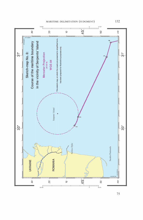
132MARITIME DELIMITATION (JUDGMENT)
75
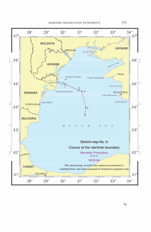
133MARITIME DELIMITATION (JUDGMENT)
76

Done in French and in English, the French text being authoritative, atthe Peace Palace, The Hague, this third day of February, two thousandand nine, in three copies, one of which will be placed in the archives ofthe Court and the others transmitted to the Government of Romania andthe Government of Ukraine, respectively.
(Signed) Rosalyn HIGGINS,President.
(Signed) Philippe COUVREUR,Registrar.
134MARITIME DELIMITATION (JUDGMENT)
77