Embed Size (px)
Citation preview
Not on file.
(972) 573-1630
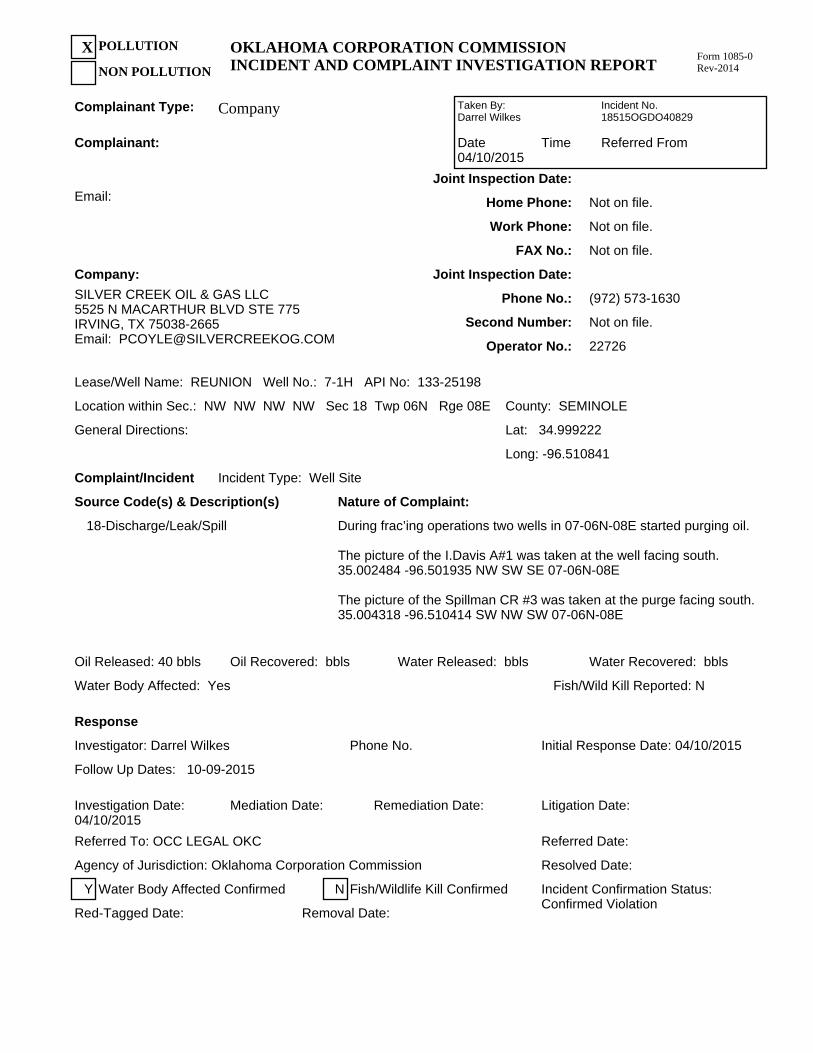
Company:
SILVER CREEK OIL & GAS LLC5525 N MACARTHUR BLVD STE 775IRVING, TX 75038-2665Email: [email protected]
Joint Inspection Date:
Phone No.:
Second Number:
Operator No.: 22726
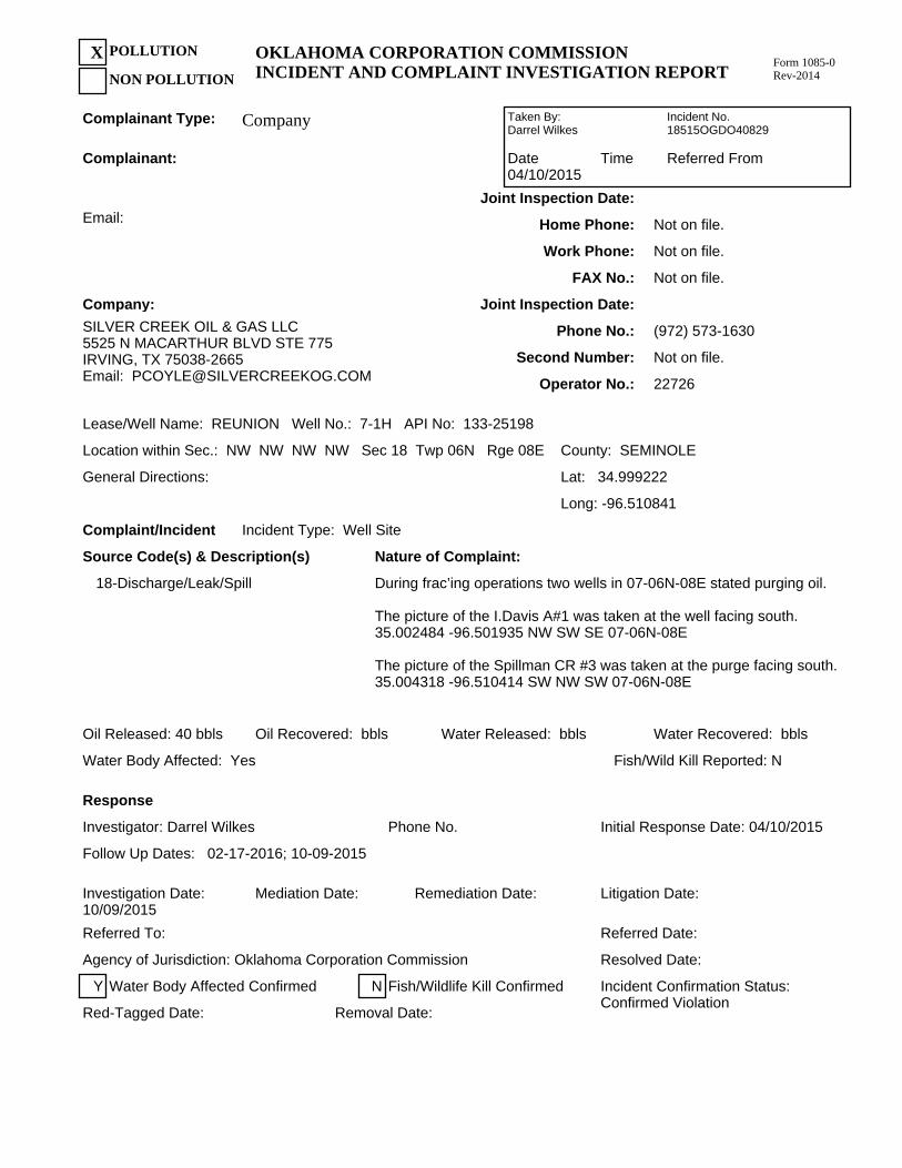
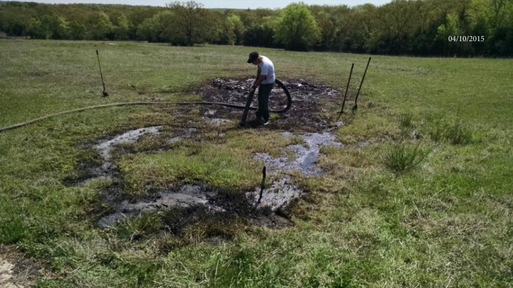
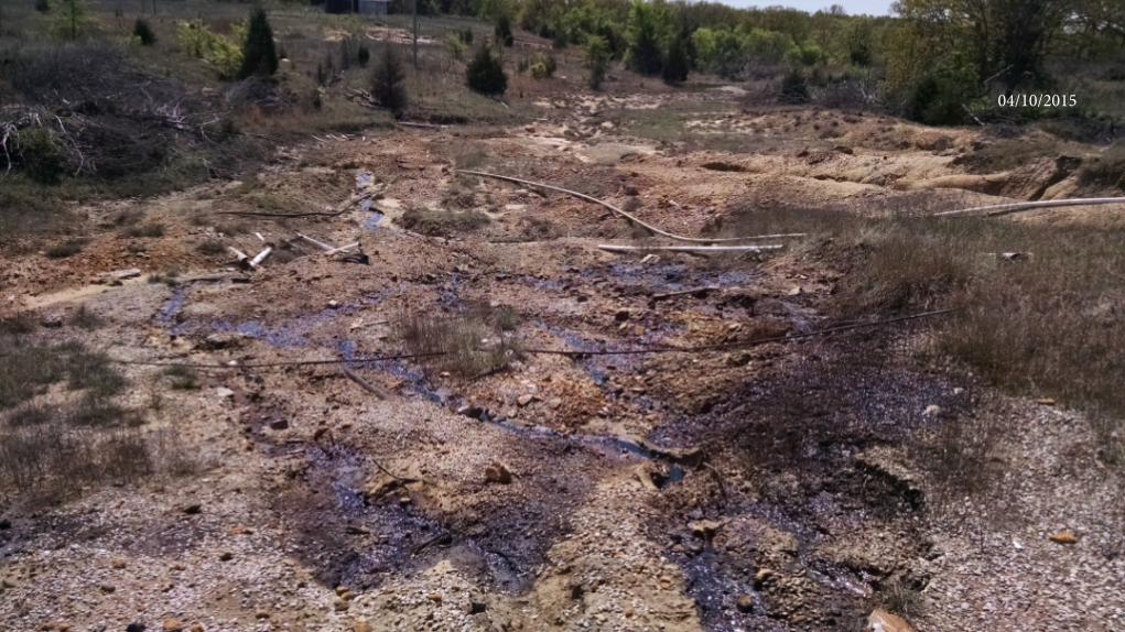
18-Discharge/Leak/Spill During frac’ing operations two wells in 07-06N-08E stated purging oil.
The picture of the I.Davis A#1 was taken at the well facing south. 35.002484 -96.501935 NW SW SE 07-06N-08E
The picture of the Spillman CR #3 was taken at the purge facing south. 35.004318 -96.510414 SW NW SW 07-06N-08E
Incident No. 18515OGDO40829
Referred FromTimeDate04/10/2015
Taken By: Darrel Wilkes
Water Body Affected: Yes Fish/Wild Kill Reported: N
Water Recovered: bblsWater Released: bblsOil Recovered: bblsOil Released: 40 bbls
Not on file.
Not on file.
Not on file.
FAX No.:
Work Phone:
Home Phone:
Joint Inspection Date:Email:
Complainant:
Response
Company
POLLUTION
NON POLLUTION
XForm 1085-0 Rev-2014
OKLAHOMA CORPORATION COMMISSIONINCIDENT AND COMPLAINT INVESTIGATION REPORT
Complaint/Incident
Lease/Well Name: REUNION Well No.: 7-1H API No: 133-25198
General Directions:
Location within Sec.: NW NW NW NW Sec 18 Twp 06N Rge 08E County: SEMINOLE
Lat: 34.999222
Long: -96.510841
Y
Removal Date: Red-Tagged Date:
Incident Confirmation Status:Confirmed Violation
Resolved Date: Agency of Jurisdiction: Oklahoma Corporation Commission
Referred Date: Referred To:
Litigation Date: Remediation Date: Mediation Date: Investigation Date: 10/09/2015
Initial Response Date: 04/10/2015Phone No. Investigator: Darrel Wilkes
N
Complainant Type:
Incident Type: Well Site
Source Code(s) & Description(s)
Fish/Wildlife Kill ConfirmedWater Body Affected Confirmed
Nature of Complaint:
Follow Up Dates: 02-17-2016; 10-09-2015
Recommendations: Re-plug the Spillman CR #3, and plug or repair the casing on the I.Davis A#1 to prevent the purging, before frac. operations can recommence. Determine weather or not the ground water has been contaminated, and remediate all contaminated soil. Give the operator until 5-8-15 to conduct the clean up. If you have any questions or concerns call Darrel Wilkes at (580)320-7973.
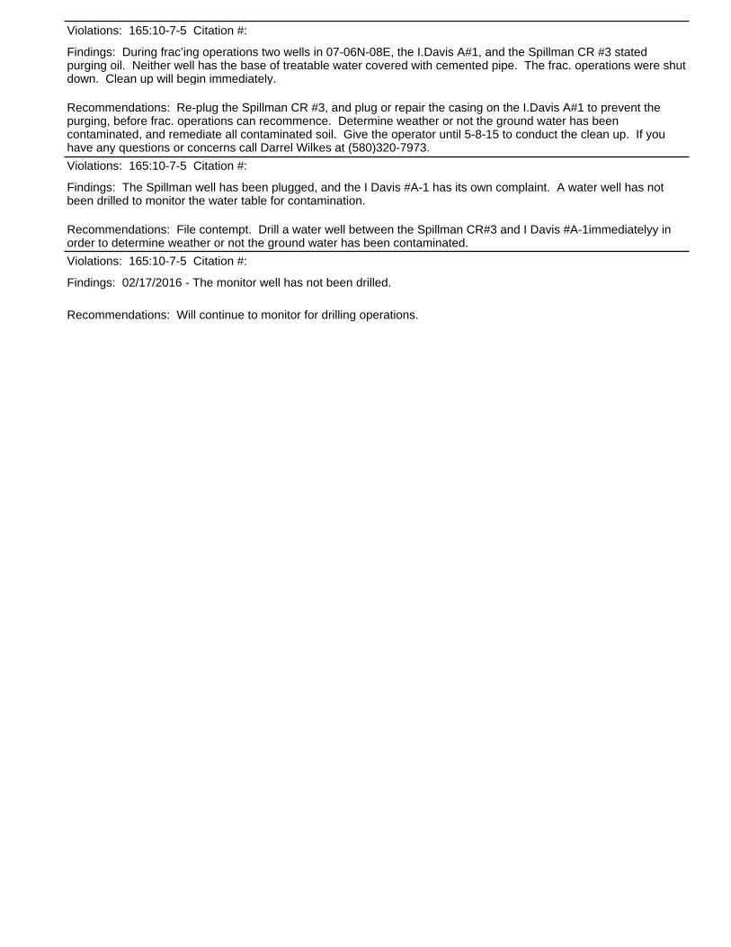
Findings: During frac’ing operations two wells in 07-06N-08E, the I.Davis A#1, and the Spillman CR #3 stated purging oil. Neither well has the base of treatable water covered with cemented pipe. The frac. operations were shut down. Clean up will begin immediately.
Violations: 165:10-7-5 Citation #:
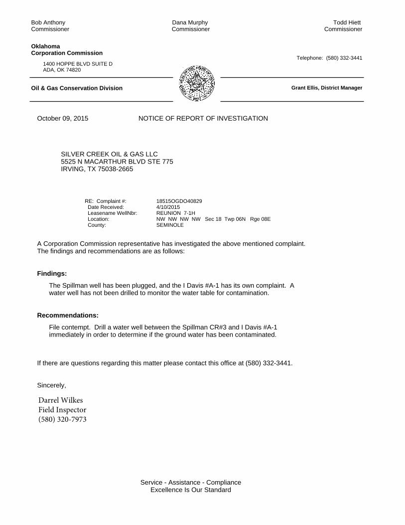
Recommendations: File contempt. Drill a water well between the Spillman CR#3 and I Davis #A-1immediatelyy in order to determine weather or not the ground water has been contaminated.
Findings: The Spillman well has been plugged, and the I Davis #A-1 has its own complaint. A water well has not been drilled to monitor the water table for contamination.
Violations: 165:10-7-5 Citation #:
Recommendations: Will continue to monitor for drilling operations.
Findings: 02/17/2016 - The monitor well has not been drilled.
Violations: 165:10-7-5 Citation #:
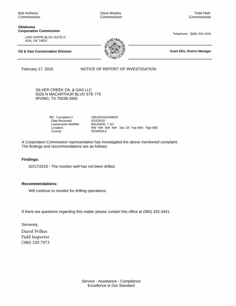
02/17/2016 - The monitor well has not been drilled.
Will continue to monitor for drilling operations.
If there are questions regarding this matter please contact this office at (580) 332-3441.
Sincerely,
A Corporation Commission representative has investigated the above mentioned complaint.The findings and recommendations are as follows:
RE: Complaint #: Date Received: Leasename WellNbr: Location: County:
February 17, 2016
SILVER CREEK OIL & GAS LLC5525 N MACARTHUR BLVD STE 775IRVING, TX 75038-2665
18515OGDO408294/10/2015REUNION 7-1HNW NW NW NW Sec 18 Twp 06N Rge 08E SEMINOLE
NOTICE OF REPORT OF INVESTIGATION
1400 HOPPE BLVD SUITE DADA, OK 74820
Telephone: (580) 332-3441
OklahomaCorporation Commission
Oil & Gas Conservation Division Grant Ellis, District Manager
Todd Hiett Commissioner
Dana Murphy Commissioner
Bob Anthony Commissioner
Findings:
Recommendations:
Service - Assistance - ComplianceExcellence Is Our Standard
Darrel WilkesField Inspector(580) 320-7973
Corporation Commission1400 Hoppe Blvd; Ste D Telephone: (580)332-3441Ada, OK 74820 FAX: (580)332-8434
OIL & GAS CONSERVATION DIVISION, DISTRICT IV GRANT ELLIS, DISTRICT MANAGER
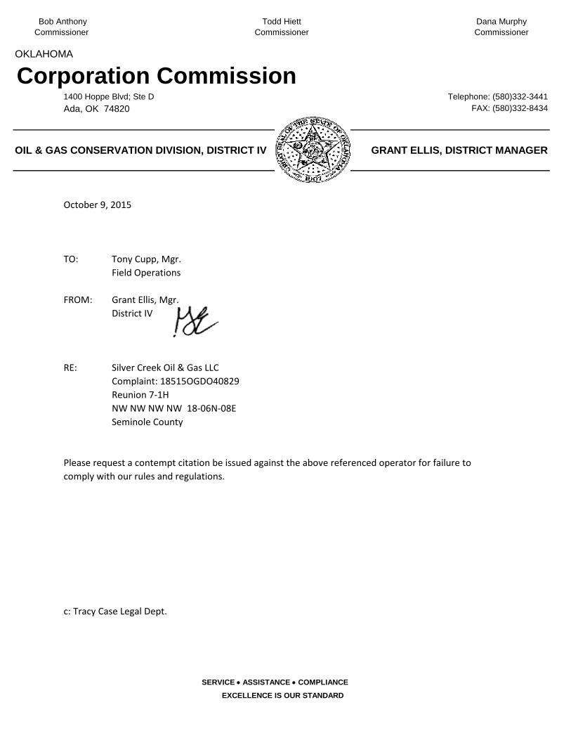
TO: Tony Cupp, Mgr. Field Operations
FROM: Grant Ellis, Mgr. District IV
RE: Silver Creek Oil & Gas LLCComplaint: 18515OGDO40829Reunion 7-1HNW NW NW NW 18-06N-08ESeminole County
c: Tracy Case Legal Dept.
SERVICE • ASSISTANCE • COMPLIANCE
EXCELLENCE IS OUR STANDARD
October 9, 2015
Please request a contempt citation be issued against the above referenced operator for failure to comply with our rules and regulations.
OKLAHOMA
Bob Anthony Todd Hiett Dana MurphyCommissionerCommissionerCommissioner
DISTRICT FIELD INSPECTOR
INTERNAL TRACKING NUMBER
DATE OF COMPLAINT FILED
OPERATOR OPERATOR #
WELL NAME API
LEGAL SEC 18 TN 06N RNG 08ENW 1/4 NW 1/4 NW 1/4 NW 1/4
COUNTY
ENFORCEMENT X DISMISSAL REQUEST
DISTRICT ONE JIM HAMILTON
DISTRICT TWO SUSAN CONRAD
DISTRICT THREE CONNIE MOORE
DISTRICT FOUR X TRACY CASE
4
22726
INTERNAL TRACKING LOG FOR REV2009
THE OFFICE OF GENERAL COUNSEL
Darrel Wilkes
18515OGDO40829
APPROVED BY:
4/10/2015
REVIEWED BY:
STATE FUND
Reunion 7-1H 133-25198
10/9/2015
Silver Creek Oil & Gas LLC
Seminole - 133
Not on file.
(972) 573-1630
Company:
SILVER CREEK OIL & GAS LLC5525 N MACARTHUR BLVD STE 775IRVING, TX 75038-2665Email: [email protected]
Joint Inspection Date:
Phone No.:
Second Number:
Operator No.: 22726
18-Discharge/Leak/Spill During frac’ing operations two wells in 07-06N-08E started purging oil.
The picture of the I.Davis A#1 was taken at the well facing south. 35.002484 -96.501935 NW SW SE 07-06N-08E
The picture of the Spillman CR #3 was taken at the purge facing south. 35.004318 -96.510414 SW NW SW 07-06N-08E
Incident No. 18515OGDO40829
Referred FromTimeDate04/10/2015
Taken By: Darrel Wilkes
Water Body Affected: Yes Fish/Wild Kill Reported: N
Water Recovered: bblsWater Released: bblsOil Recovered: bblsOil Released: 40 bbls
Not on file.
Not on file.
Not on file.
FAX No.:
Work Phone:
Home Phone:
Joint Inspection Date:Email:
Complainant:
Response
Company
POLLUTION
NON POLLUTION
XForm 1085-0 Rev-2014
OKLAHOMA CORPORATION COMMISSIONINCIDENT AND COMPLAINT INVESTIGATION REPORT
Complaint/Incident
Lease/Well Name: REUNION Well No.: 7-1H API No: 133-25198
General Directions:
Location within Sec.: NW NW NW NW Sec 18 Twp 06N Rge 08E County: SEMINOLE
Lat: 34.999222
Long: -96.510841
Y
Removal Date: Red-Tagged Date:
Incident Confirmation Status:Confirmed Violation
Resolved Date: Agency of Jurisdiction: Oklahoma Corporation Commission
Referred Date: Referred To: OCC LEGAL OKC
Litigation Date: Remediation Date: Mediation Date: Investigation Date: 04/10/2015
Initial Response Date: 04/10/2015Phone No. Investigator: Darrel Wilkes
N
Complainant Type:
Incident Type: Well Site
Source Code(s) & Description(s)
Fish/Wildlife Kill ConfirmedWater Body Affected Confirmed
Nature of Complaint:
Follow Up Dates: 10-09-2015
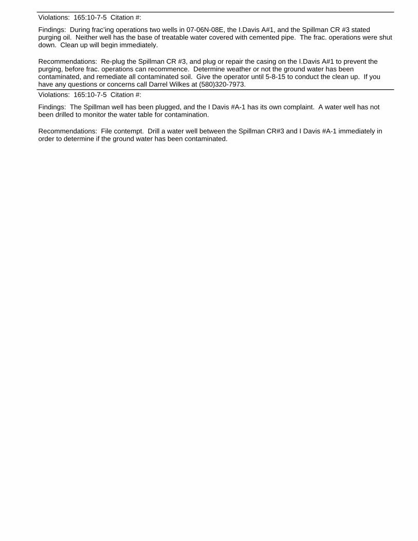
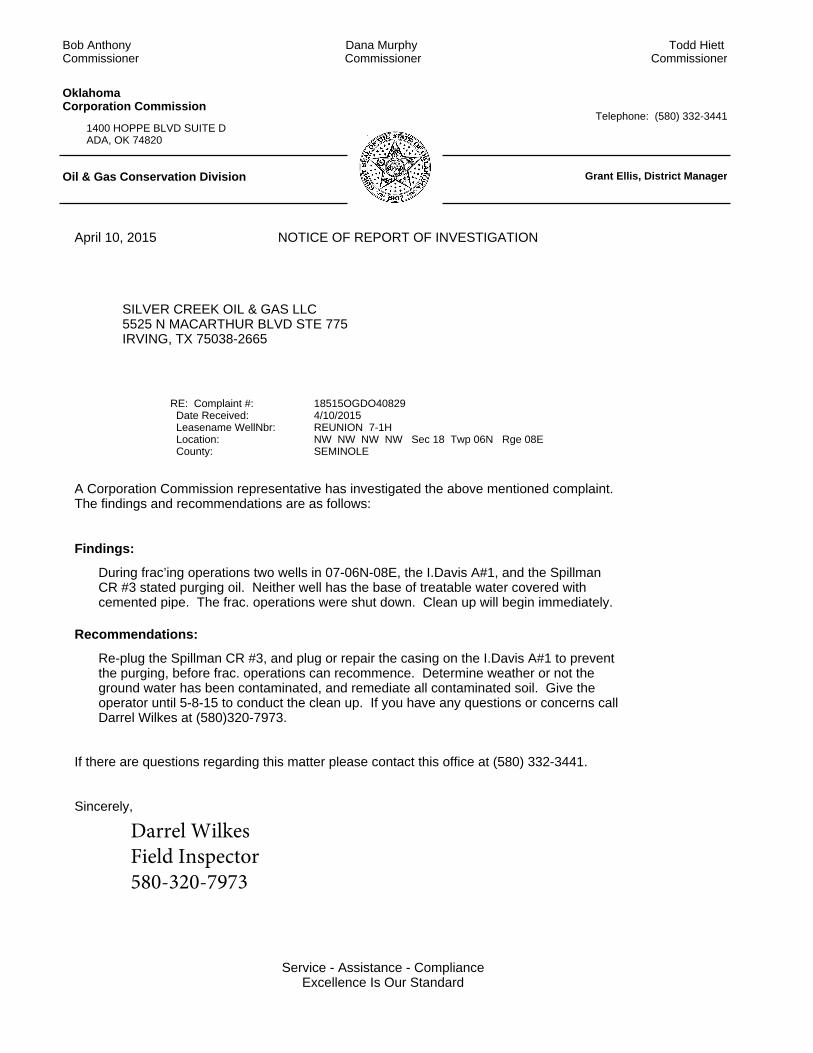
Recommendations: Re-plug the Spillman CR #3, and plug or repair the casing on the I.Davis A#1 to prevent the purging, before frac. operations can recommence. Determine weather or not the ground water has been contaminated, and remediate all contaminated soil. Give the operator until 5-8-15 to conduct the clean up. If you have any questions or concerns call Darrel Wilkes at (580)320-7973.
Findings: During frac’ing operations two wells in 07-06N-08E, the I.Davis A#1, and the Spillman CR #3 stated purging oil. Neither well has the base of treatable water covered with cemented pipe. The frac. operations were shut down. Clean up will begin immediately.
Violations: 165:10-7-5 Citation #:
Recommendations: File contempt. Drill a water well between the Spillman CR#3 and I Davis #A-1 immediately in order to determine if the ground water has been contaminated.
Findings: The Spillman well has been plugged, and the I Davis #A-1 has its own complaint. A water well has not been drilled to monitor the water table for contamination.
Violations: 165:10-7-5 Citation #:
The Spillman well has been plugged, and the I Davis #A-1 has its own complaint. A water well has not been drilled to monitor the water table for contamination.
File contempt. Drill a water well between the Spillman CR#3 and I Davis #A-1 immediately in order to determine if the ground water has been contaminated.
If there are questions regarding this matter please contact this office at (580) 332-3441.
Sincerely,
A Corporation Commission representative has investigated the above mentioned complaint.The findings and recommendations are as follows:
RE: Complaint #: Date Received: Leasename WellNbr: Location: County:
October 09, 2015
SILVER CREEK OIL & GAS LLC5525 N MACARTHUR BLVD STE 775IRVING, TX 75038-2665
18515OGDO408294/10/2015REUNION 7-1HNW NW NW NW Sec 18 Twp 06N Rge 08E SEMINOLE
NOTICE OF REPORT OF INVESTIGATION
1400 HOPPE BLVD SUITE DADA, OK 74820
Telephone: (580) 332-3441
OklahomaCorporation Commission
Oil & Gas Conservation Division Grant Ellis, District Manager
Todd Hiett Commissioner
Dana Murphy Commissioner
Bob Anthony Commissioner
Findings:
Recommendations:
Service - Assistance - ComplianceExcellence Is Our Standard
Darrel WilkesField Inspector(580) 320-7973
During frac’ing operations two wells in 07-06N-08E, the I.Davis A#1, and the Spillman CR #3 stated purging oil. Neither well has the base of treatable water covered with cemented pipe. The frac. operations were shut down. Clean up will begin immediately.
Re-plug the Spillman CR #3, and plug or repair the casing on the I.Davis A#1 to prevent the purging, before frac. operations can recommence. Determine weather or not the ground water has been contaminated, and remediate all contaminated soil. Give the operator until 5-8-15 to conduct the clean up. If you have any questions or concerns call Darrel Wilkes at (580)320-7973.
If there are questions regarding this matter please contact this office at (580) 332-3441.
Sincerely,
A Corporation Commission representative has investigated the above mentioned complaint.The findings and recommendations are as follows:
RE: Complaint #: Date Received: Leasename WellNbr: Location: County:
April 10, 2015
SILVER CREEK OIL & GAS LLC5525 N MACARTHUR BLVD STE 775IRVING, TX 75038-2665
18515OGDO408294/10/2015REUNION 7-1HNW NW NW NW Sec 18 Twp 06N Rge 08E SEMINOLE
NOTICE OF REPORT OF INVESTIGATION
1400 HOPPE BLVD SUITE DADA, OK 74820
Telephone: (580) 332-3441
OklahomaCorporation Commission
Oil & Gas Conservation Division Grant Ellis, District Manager
Todd Hiett Commissioner
Dana Murphy Commissioner
Bob Anthony Commissioner
Findings:
Recommendations:
Service - Assistance - ComplianceExcellence Is Our Standard
Darrel WilkesField Inspector580-320-7973
REV2009
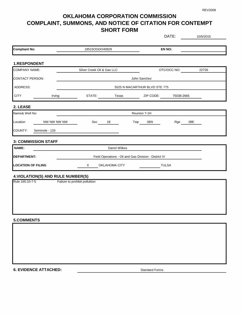
DATE:
Compliant No: EN NO:
1.RESPONDENTCOMPANY NAME: OTC/OCC NO:
CONTACT PERSON:
ADDRESS:
CITY STATE: ZIP CODE:
2. LEASEName& Well No:
Location Sec 18 Twp 06N Rge 08E
COUNTY:
3: COMMISSION STAFF NAME:
DEPARTMENT:
LOCATION OF FILING X OKLAHOMA CITY TULSA
4.VIOLATION(S) AND RULE NUMBER(S)
5.COMMENTS
6. EVIDENCE ATTACHED:
OKLAHOMA CORPORATION COMMISSIONCOMPLAINT, SUMMONS, AND NOTICE OF CITATION FOR CONTEMPT
SHORT FORM
John Sanchez
5525 N MACARTHUR BLVD STE 775
Reunion 7-1H
Darrel Wilkes
Field Operations - Oil and Gas Division - District IV
10/5/2015
18515OGDO40829
Silver Creek Oil & Gas LLC 22726
Standard Forms
Seminole - 133
Irving Texas 75038-2665
Rule 165:10-7-5
NW NW NW NW
Failure to prohibit polluttion
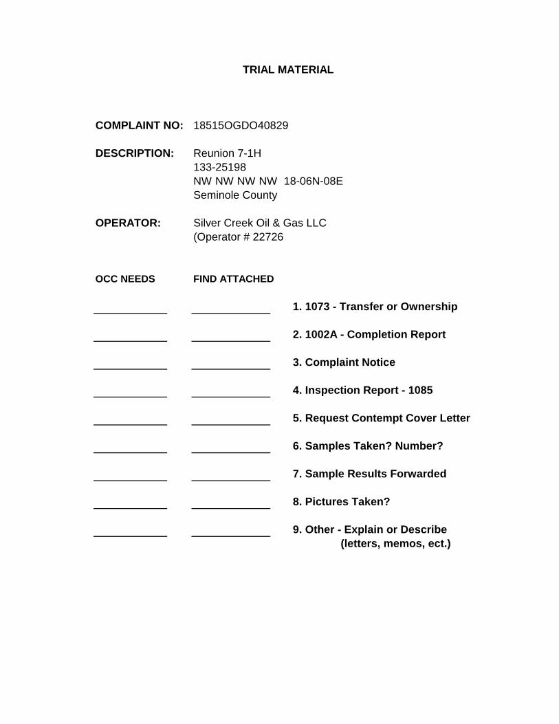
COMPLAINT NO: 18515OGDO40829
DESCRIPTION: Reunion 7-1H133-25198NW NW NW NW 18-06N-08ESeminole County
OPERATOR: Silver Creek Oil & Gas LLC(Operator # 22726
OCC NEEDS FIND ATTACHED
1. 1073 - Transfer or Ownership
2. 1002A - Completion Report
3. Complaint Notice
4. Inspection Report - 1085
5. Request Contempt Cover Letter
6. Samples Taken? Number?
7. Sample Results Forwarded
8. Pictures Taken?
9. Other - Explain or Describe(letters, memos, ect.)
TRIAL MATERIAL
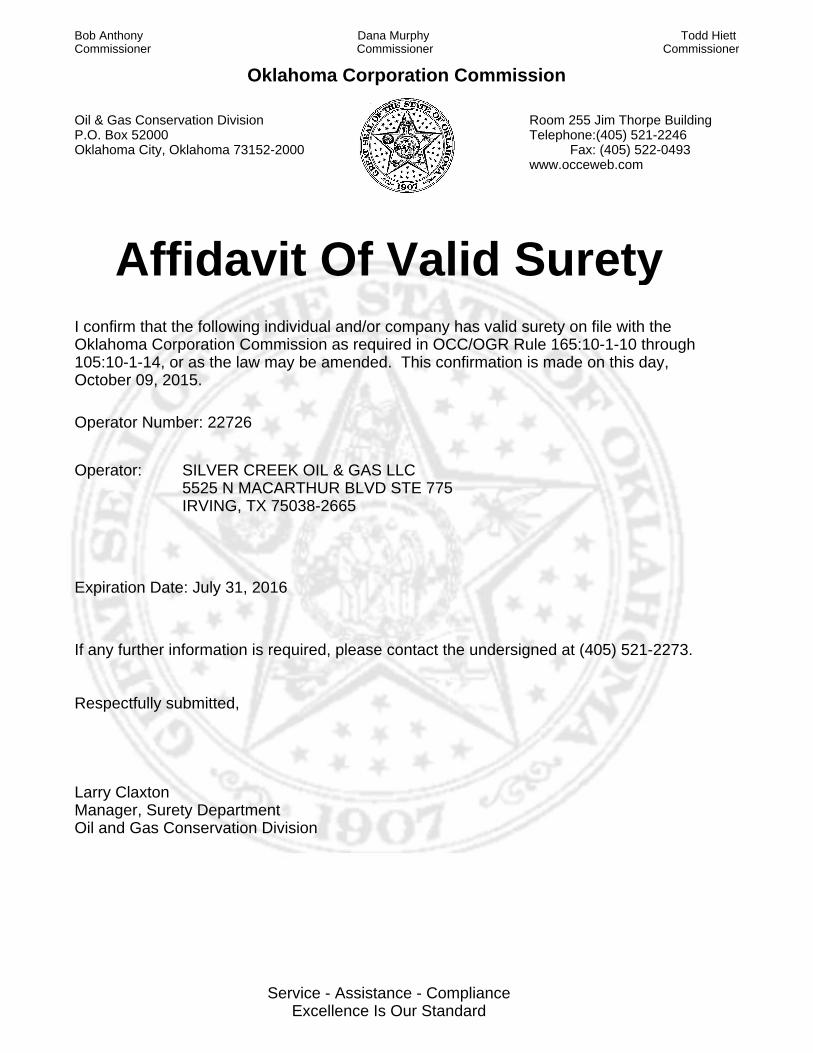
Affidavit Of Valid SuretyI confirm that the following individual and/or company has valid surety on file with the Oklahoma Corporation Commission as required in OCC/OGR Rule 165:10-1-10 through 105:10-1-14, or as the law may be amended. This confirmation is made on this day, October 09, 2015.
Operator Number: 22726
Operator: SILVER CREEK OIL & GAS LLC5525 N MACARTHUR BLVD STE 775IRVING, TX 75038-2665
Expiration Date: July 31, 2016
If any further information is required, please contact the undersigned at (405) 521-2273.
Respectfully submitted,
Larry ClaxtonManager, Surety DepartmentOil and Gas Conservation Division
Oklahoma Corporation Commission
Oil & Gas Conservation Division P.O. Box 52000 Oklahoma City, Oklahoma 73152-2000
Room 255 Jim Thorpe Building Telephone:(405) 521-2246 Fax: (405) 522-0493 www.occeweb.com
Todd Hiett Commissioner
Dana Murphy Commissioner
Bob Anthony Commissioner
Service - Assistance - ComplianceExcellence Is Our Standard
- ,. _. _ .
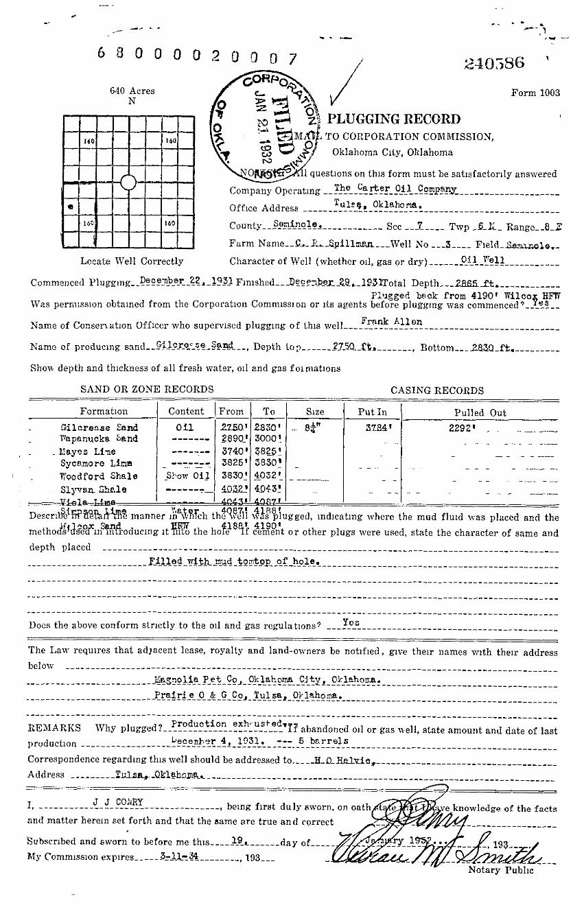
6 8 0 0 0 U 2 0 0 0 d
C_
. _ . .~_~_ . . _ .. ,.., ..__
240,i86
PLUGGING RECOR DTO CORPORATION COMMISSION,
Oklahoma City, Oklahoma
Form 1003
questions on this form must be sati sfac tor i ly answered
Company 0pe:atmg __Tho Carter Uil Compsny_ . .. .. .. .. .. .. . . . .. ..
Office Address ------ Tu l----e-g-, --
Oklah o-- --- -- -
ria- -----------------------------
160 Sec _-2---- Twp - 5- 1_ - Rang e__8 _ E
Farm Name__9~_F__ _Splll~r.n___We 11 No ___ 3 ---- Field_Se,~z~o1e~ _
Locate We ll Correctly Charac ter of W ell (whether oil, O il ~ga s or dry) ------- -- -- -"-e
-l l------- - ----
Commenced Pluggmg_ December 22a _ 1431Fmished__ DecP7be; _Zg,_ 1q3 lTot al Depth __ _2HfifiSt_ _ _ ___ ___ __ _ _plugge d beck from 4190 1 Wilco§ HFPt
Was permission obtained from the Corporation Commission or its agents before plugging was commenced?__ es__
Name of C onserN ation Off icer who su ervised lu Frank f~llenP P ~'gmg of this we ll------------------------------------------
Namc of produc ing sand__ Gilcre_se_Saad __~ Depth Lop-------29 5Q _f t , ____ _ __ , gottom__ _283Q _ft,_ __ ____ __
Shovc dep th and thickness of a ll fresh water, o i l and gas f oi mations
SAND OR ZONE RECORD S
Formation
Gilcrease SandWapanucka band
Liayes Lime
Sycnmoro Li rrn
Pi`oodPord Shal e
_ $15van Shale
Content I From To S ize
Oil 2250 1 2$30' $~-n------- 2$90_t 3000 2 -
------- 3740' Z825 !- 3825' 38 30 i
-Sh ow 011 3830' 4032 '
- - - - - --------------- 40-32! 4_043'
CASING RECORDS
Put In Pull ed Out
~Zfl4~ 2292' - - - -- -----
DescrilSSiRNPaAM manner in8v?ifch theZtiQell ~v1splugged , ind ic ating wh ere th e mud flu id was placed and the
me th od~sj~sE°dzin~t~oducing it xi~to the hole 8~f celmet or other plugs were used , state the character of same and
depth p l aced ---- - --- ------- ---- --------------------- - - - ---- -- -- -- -- - - - ---- - - --- -- -- - - --- -- -- -- -- --______________________ _ _- Ulled _with_ mad to ~ntop of hole .
- - -- - -- -- - - - --- - - - --- - - - - - -- --- - - - -- - -- --- ---- -
- - --------------------- --- --- - -------- ---- - -- - --------------------- - ---- --- - --------- -- --- ----- -------
-------- --------------------------- ---- -- ---- ----- --- ------ -- - ---- --- -------- ------ ------ -- ---- -
---- - ---- ---- ------ ------ ----- - ---- ------------------------ - ------- - --------- --- - -- -- -- -- ----- -- ---Does the above conform strictl y to the o i l and gas regulations9 __ _Yes __ _ __ _ ___ _
The Law requ ires that ad jacent lease, royalty and land-owners be notif ied, give their names with thei r address
below ------- - ----- ----------- -- ---- ----------- -- -- - ------- - - ----- - ----- ------- -- ------- ---- ------------- - - ------- ---- --iFagnolia Pet _Co,_O1: laF. oma Cityl 0klahoma . ------ -
------ ------- - - ---------- -- -_ _ ___________ __ ____ ______ Pruiri e 0& G _Co . _ Tulsai_Ok lahoma .____
- - --- ---- -- -- -- -- - ---- -- ---
---- -- ---- - ------ ---- -- --- ------------ - --- - ----- ---- ------ - -- ----- ------ -- -- ---- -- -- ---- - ------ -- -- ---PEMAi.KS Why plugged?__P
roduction exh_usted
'if abandoned oil or gas i~ell, s tate amount and d ate of last
produc tion ------------------ Lecenl- 3r 4,_1 931 . --- 5 barrel s------------ - -- --- ----- -- --- - ---- - - ---- ---- -- -- - -- -- ---
Correspond ence regarding this we ll should b e addressed __ __ _ __ ___ ____ ___ ______________ _ __ __
Address --------Tul sai _Qk1eh9m
.a - -----------------------------------------------------------------
I - ---------- J -J- CO1vRY _, being first duly sworn, on
and matter herein set forth and that the same are true and correct
Subscribed and swo rn to before me 19~ ______day of_____
My Commission espi res------ rda-w34 ________ 193___ _
knowledge of the facts
- lT v
9~ _Notary Public
640 AcresN
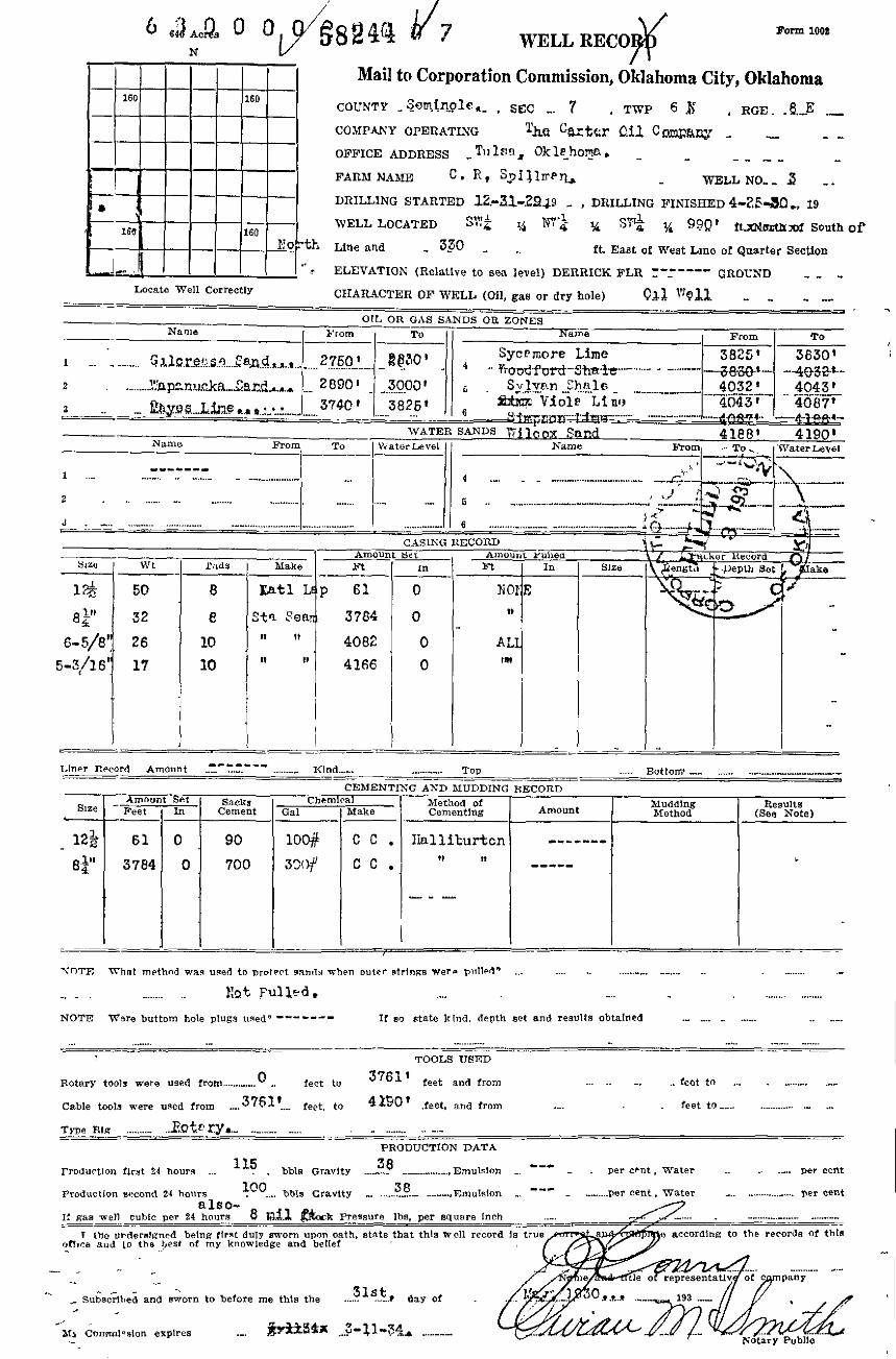
WLLL RECO so.~ iooa7 #
Mail to Corporation Commission, Oklahoma City, Oklahoma
COUNTY _56Ir 17I QZf A_ , $EC TWP 6 RGE . &.E
COMPANY OPERATING 1hC O 9..•.xCI' 011 C DI7a,^ EtA'f
OFFICE ADDRESS _T>>lsn, Oklehoma ,
FARM NAME C . R, SPi ;IRP7j, _ WELL NO__ s
DRILLING STARTED I2 -31-2849 DRILLING FINISHED 4 +Z: 30 ., 19
WELL L OC ATED ilZ 1/ AJT q 34 St"tq 3/ J~Qt f t,7QipythMl South of160 16 0
L r, 04
Line and 330 it East of West L ine of Quarter Section
ELEVATION (Relative to sea level) DERRICK FLR "_ '--^ GROUND
Locate Well Correctly CFIAFL4CTER OF WELL (Oil, gas or dry hole) Q~1 "J@1
1 OIL ORG A S SANDS OR ZONE SNam e I From I To I I
~ .. - .... . . .. .., . ._~ ?.760 1- . .... . ._.
2 ',".,nP:Lnxicka....~~rd... ... 2E190 1
Name
1 .. . .
2
J .
tl]ZB WC f n
lr 50 8
811' 32 8
E -5/8' 26 10
5-3/16' 17 10
}
To
Syce mpre Lime- -~ • ~ - Yroodford-Si is.ie.. ._. . . . .- -
3000 1 ~ . S~lvnn °h~le _ ... . ... . . .
3825 t ~' Viole L{ne. 6
wnxE I snxns Wilcox Sand
W' ateri.evel II Name
81ake Ft
Tatl L p 61
St : ea. 3784
4082
4166
4 ... .___
. . ....._ ..... . .... .
5 .. _ . .. . . ...__.. . ...._ ..____ ..__
. . . .... . ...._ 6 .. . . . . ... . _ ... _ ..'" ' . . . .. . . . .... . . .. .. . _.... .
CASING RECORD
iet NnounL Yullea
in n In Size
0 PiOpF.
0 to
0 ALo IN
•-4032 .i ._~ 4043 1. . . .
4043f 4087'
41881 4190 'From - To .,_ WaterI.e v e l
n7
.~_ ` ...
~ ..... . ..~.4'. ...~ . ~. _ . .~~~
"
_.~
.
" . . . _ .~ . . ..._ ._. .Jl "' ' . . ~~
~~ker lteuordla~
~iengt ~ }~eD th B e t ~ ake
i. lner Rec ord Amount ------ Kind .... . . . ..._ .... ToP ... . . Bottom _ ... .. . . . . ... . . ..... . ._..... . .... .....
CEMENTING AND MUDDING RECORD
Amount et i c .. . a ,. Cnem r-ra1--I n,_. . ._ . _. . . __. . . __ ..
g1Z e Feet In
122 61 0
84' 3784 0
90 100jk I C C . JInl l iturtcn
700 3~c3f C C ,it it
VOTF R'hn t m e t hnd wxs u sed to protect sands when outer ntrlntos were pulled' . . .
Not Ful],ed
Am oun t
NO TE Were buttom hole plugs used " ----°- If so state k ind, depth set a nd r e sults o btained . . .... . . . .....
"'.. . . ..... . . . . . . . . ... ..
TOOLS USE D
Rotary toola we re used from.. . . ..... . ...0 feet to 37611feet and from --. _ feet to ...
Cable tool s a•ere used from ... . 3 7f' 10. . .. [eet, to 4 Y5O I feet, and from . . . . feet to ...
. Type Rig. . . .-- .P.o kL ry.._ .. ._ . . . . ... . ..PRODUCTION DAT A
Pro d u r tl on first 24 hours ., . 115bbla Gravity 3 8.... . .._ _ ..
---Emul s ion _ ~ - - per cent , Water ... per c ent
. .. . . . . ..... . . ._ ' '.. .."" ... . . . .. . ...P2oduc Uon second 24 hours 1C O.. . . bbls Gravity 38 .-- ..... .,F,mulaton - . . ._ . . . .pet cent, Water per cent
0.150-
It gas w e ll cuAlc per 24 hours ~ Ai1.1 ~~py
w :k Pre ssure lbe, per equ a re Inch . .._ ~- .
I the un derefRned being first dul y aworn upon oath, state ihat th~s well record 1s trueeer[~ according to the records of thisoR ic e and to the p e sr of my knowledg e and belie
f ~.' Subecrlli¢d and sworn to before me this the31 S
tF day o f
Its C o n nnl selan expires .... . .... . . ...
. . ._.. 193
of
FOILHATION RECORD
Give detailed descri p tion and thfcknese of all formations drilled through a nd contents of sands w hethe r dry, water, otl o r gas
SurfaceShale & Shells
Sa ndy Shale
Shale & Shells
Hard Sandy Lime
Shale & Shells
Sa nd v Lime
Shale& Lime
S andy Lime
Shale & Lime
Hand Sand & Shale
Shale & Shells
Sand
Sand & ShaleSlateSand & S hale
S andy Lime
Sand & Shale
Lime & Shale
Hard Sand & Lis.a
ShAle & Sand
Shale & Shells
Shale & Hard Sand
Shale
Hard Sandy Lime
Lim.a
Sand Gilcroase
Lime r7spanucke
Sand Crorsroll
Lime Mayes
Lime I.'aye s
Lime
Lime
Shale
°hale
Shale
Lime
Lime
Lime (Sandy )
Lime "Lime "
Sand
Sand
I .eye s
Sycamo re
ddoodford
L7oodford
Sylvan
Viola
V io 1a
S imps on
Simg son
Simpson
Wilcox
'rilcox
SET 6" LIMIT PLUG 4126 -231
407 1-40641 - 6" LIL!IT PLUG
PLUG 4048- 45 ' - OPEN HOLE
PULLED ALL 6- 5/81 and 5- 3/
8 , 000 , 000 CU ,
70
1140
1226
1300
1310
1621
1 644
2038
2050
2 282
2299
2768
2784
2356
2917
2963
3042
3067
3075
3123
3288
3664
3674
3733
3742
7 0 ri0 t
114 01226
1300
1310
1621
1644
2038
205
0 228
2 2299
276
8 2784
2^5G
291
7 2y63
3042
3067
3075
3123
328
8 3664
3674
3733
374 2
2750-2830 1Show Oil
890-3000
3761 Cem. B4" Csg . 700 S . Cem,
3000 To p Crortrvell
3000 3740 Top Mayes
3740 3761 Stdz ,
3761 Std z,
3761 3825 Top Sycamore
3825 3830 , Top 1'oodford
3830 3980 3 boilers oil per hour
3980 403 2 Top Sylvan
4032 4043 top Viola
4043 4045 Set 6 5-8" Casing
4045 4087 Top Simpson
4087 i 4118 3000 1 'rNater
4118 4126 ~Set 5 3-16" Csg .
4126 ! 4188 Top tlilcox
4188 4189 B . F . V .
4189 4190 Total Lepth .
C E,dE 2dT D BA CK TO 123-4073 1 - POCR 4073-71 1
64- 6 1' LEAD W00L 4051-60' - CE }:,ti.]NT 4060-48 1
5-2900' - FO CK 29 0-28b5 , 2 8 6 5 1 T .D .
C A S7N (~ - RLPF 'ED ~11 CASING 2750-62 1 ESTIIJ!A'.
GAS 759-62'
C . C .
- LEAD- 6" L
a. .. ~. . ., ~ . ., .> ~a a ~ .. . ,. o.u
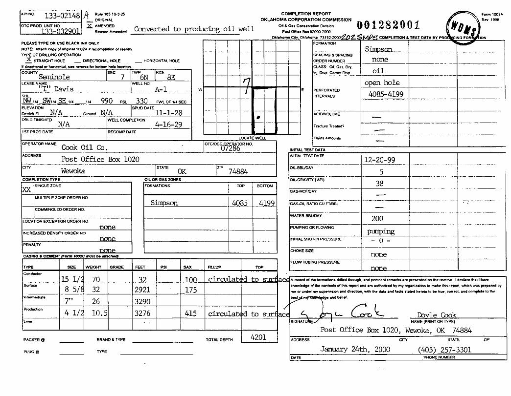
AM NO. Rule tES10J8 COMP LE T ION R EPO RT133-02148ORIGINAL OKLAHOMA CORP ORATIO N COMM ISSIO N
OTC PR OD . U
133-03290 1N R NO .
~ R~wr~i mmEW Converted to producing oil well O1PwG'OIlce Bm SZi]W 2000 ^001 2 8 2 0 0 1
Ok1aMm~ C . Okianoma ]1152.2000 2 COMVLETION t TESTP LEASE TYPE OH USE BLAC N INK ON LY FOR MATION
NOTE: AhacA co,, of on9in N 1002 A il racwnp Np on w reuMhy SjW$pnTYPE OF DRILLIN G OPER ATqN SPACI NG & SPACING
X STRAIGHT HOLE _ DIRECTIONAL HOLE _ HORIZONTAL HOLE ORDER NUMBER nORe
It dve clion .l orM n imlal, aea ra.arse M po!!om hole Imndion. ---~ - ~_- CLASS Oil. Gas . Ory.CWNIV
SSEC TWP
6NRGE
3EInj,Usp .Commpisp oil
~-uiole 7 __lE A SEN ~ME T., WELLNO e open hole
w E PERFOR ATED4085-419 9SHL INTFRV A I C
9G7 ia SFTw SE w va 990 Fsti 3LEVATION SPU
anckFl N/A crWne N/ARLGFINISHED
N/AWE
LLC~PLED
ST PROD DATE RECOMP DATE
,PERATORNAME ~. Oil Co .Cook.ini
oones5Post Office Box 1020
I ry Wewoka
❑ PLE ZONE ORDER NO.
IMINGLEO ORDER NO
EXCEPTION ORDER N O.
D DENSITY ORDER N O
8 5/ 32
7" 26
4 1/ 10
P ACKER Q BR AND 6 TVPE
PtUG 0 TYPE
FVJL OF 1 14 SEC
I
OK 74884OIL OR GAS ZONE S
FORMATIONS TOP BOTTOM
Sjqpscm 40 805 4199
2921
3290
3276 415 circulat d to s
TOTALDEVTH 4201
Fadem Tr eateEl
Fluids Amwn is
. TEST DATI.
TEST OATE
UDA Y
Mm 1 Wa
p CFIDAY --~--
Il RATI O W F TIBB L
SH U fAN PRESSURE
5
38
200
RIlipl21
- O ~
none
Fam 1002 A~ R N 199fi
DdINO FOR IOM
Kora o1 Me lamations arJIM Mroupn . and peronent remab are weei ntM on me ~e.eru I a«bre that I have
•IaEqe of IM wMSnb of this " pwf and am auMwiiatl by my m0ani + alkeri to make this f epat , wlikh was ppa md by
ot unAer my supemfion and dl reciion, with the data and lacls stalcd Aerein I. be hue , couM, and compkle 1o me
1 d9e and belid
• L- Ib le CookNATV N A ME (PRINT OR TYPE )
Post Office Box 1020, Wewoka, OK 74884JRESS CITY STATE ZI P
January 24th, 2000 (405) 257-3301
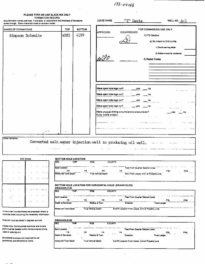
/33 -ozii~t8
LE A S ENAME "I" Davis WE L LNO . A- 1
FOR COMM ISSION USE ONLYDISAPPROVED
t) ITO Section
1"6~1 a)No Inte nt to Drill on file
1) Sw W Wrri rq Ntla
2) Riminm wd form qrnq
2 ) Reject Codea
Were open MWe logs n+n7 _ yes no
Were op e n hole logs mn9 ye s no
Were op e n hol e logs run? _ yes no
Were o pen hol e logs fun7 yes no
We re unusu a l dnlling circumstances encountered? _ ye s noIf yes . Dne fty explain .
Converted . salt-c,rater_ ~~ ,~ecr_i_c r , well - to producing oil well . -- - -
640 Acre s
if m ore (Mn n.o eou4wN , an pop osW. a tlW i ase ca r au snoq nEio onp the rou sta7 info^^ n wn.
OvKUan must W su 1W in degrees az imum.
PMw rqb . t M M ruonbl Cni NroN srb n, andpont must W IOqIW whh n Ib OounOa net f W i M
l sse Or swc :r q un .t
Oirectien al surv ey s are required for al lar, innoh. and ab.etien.i w .Ift .
BOTTOM HOLE
F aat From Qu a nitr Section Lin e ,1 N td t u 1/4 FSL FYJL_" .. ."_-'_ ..bl DepN True Veniul Depth BHL From Lease . Unn, or PropeM Lin
c BOTTOM H O LE L O CATION FOR HOR I ZONTAL HOLE : (DRA I N HOL E S )
_ ..__"_'_'___-'_-__" . . _. ._ ._. __Loralan Fae~ From Qusnx Ssnbn Lw~
1 14 1/4 114 1 11 FSL FV+IiWDe v'utbn--- , RWbs dTUm '---'---- 'Dinpb n
vaa Total De pin True Vertical Depth End M Lonl ion From Lus e, Una Or PropMy Linr
D RA I N HO LE 02
ocalpn Fe H From Oua n N Section LNss -'-'
114 1N 114 114 FSL FWldO rv u t qn RWVSd TUm - . ." Drep ion T oial Length . . . . .
vaC Tata l Depth True Vrtt iul Pa pth End PI lou ti on From Le u *. UnM1 or P ropatY linr.
PLEASE TYP E O R US E B L AC K I NK ONLYFO RMATIO N RECO R D
Gm lormawn n a mes and i opa . A aw iia oh . or tlnaiqiand and Nid u wu d lamwbrr
onIIW INW011 Slqy nl itr. valt CIXW IX d illsltim I ai 1W.
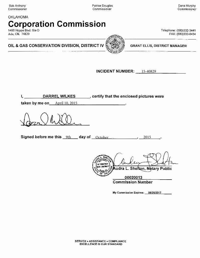
Bob Anthony Commissioner
OKLAHOMA
Patrice Douglas Commissioner
Corporation Commission
Dana Murphy Commissioner
Telephone: (580)332-3441 FAX: (580)332-8434
GRANT ELLIS, DISTRICT MANAGER
INCIDENT NUMBER: ~-----------
I, ___ ____;D~A;...;;.;;..;R~R=E=L;;...W.;;...;;...;;..IL=K;..;;..=E...;;;;;S ___ , certify that the enclosed pictures were
taken by me on ________________ _
Signed before me this ___ day of ______________ _
My Commission Expires: 08/26/2017
SERVICE• ASSISTANCE• COMPLIANCE EXCELLENCE IS OUR STANDARD
15-40829
April 10, 2015
9th October 2015
04/10/2015
04/10/2015


![7973 Index (265-270) [personalpages.manchester.ac.uk]€¦ · Massively Multiplayer Online Roleplaying Game (MMORPG), 214, 220. The Matrix, 234, 236–7 Matrix.Net, 26–7, 67 Matsumoto,](https://img.pdfslide.us/doc/110x75/5f9ac951266d2b714521af91/7973-index-265-270-massively-multiplayer-online-roleplaying-game-mmorpg.jpg)
![KMBT C364e-20151110122453...Java -16 ISBN[ 978-4-7973-7476-6 ] 6945 504A— • 2,600B+ä ISBN[ 978-4-7973-7477-3 ] 6946] 2,800B+ä Javan 978-4-7973-6855-0] 6422] Java • 2,800B+ä](https://img.pdfslide.us/doc/110x75/5fb228aae4b24778b549996d/kmbt-c364e-20151110122453-java-16-isbn-978-4-7973-7476-6-6945-504aa-a.jpg)