Embed Size (px)
DESCRIPTION
Objective method to determine the Typhoon intensity using IR1 images. 20/03/2007 NESDIS Japan Meteorological Agency Koji Kato. IR1. 20.5 [N] 135.0[E]. Today’s Topic. Preliminary objective approach to determine the typhoon intensity. - PowerPoint PPT Presentation
Citation preview
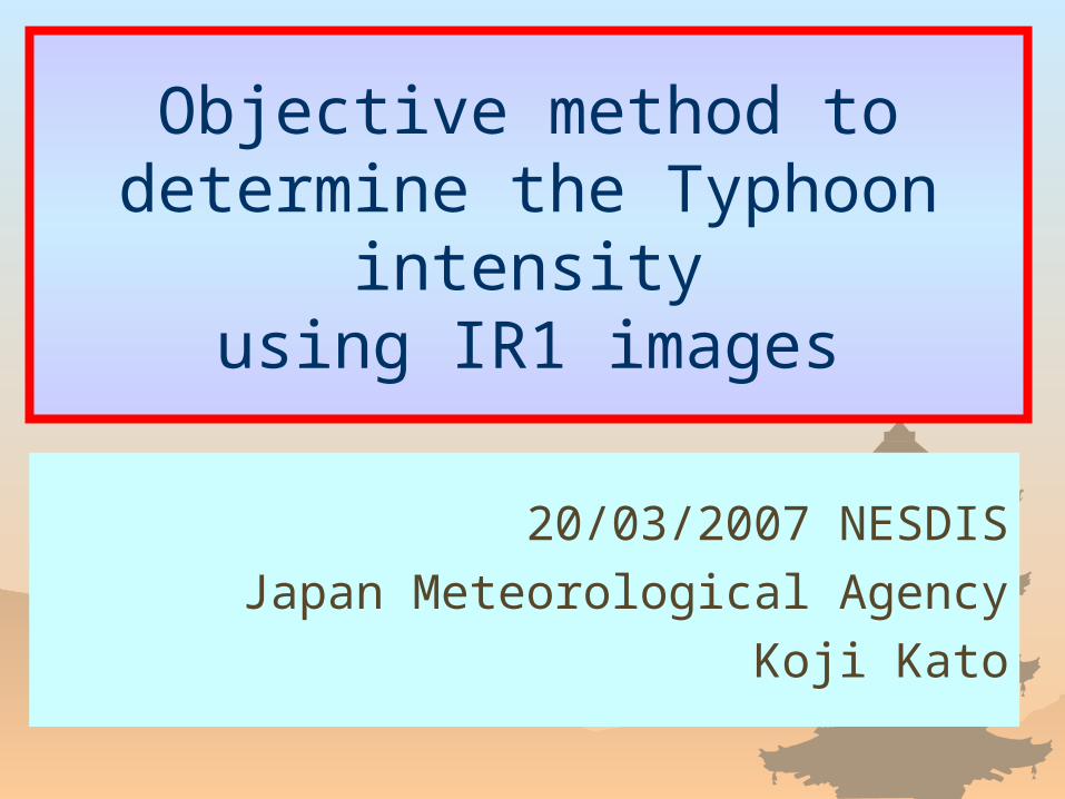
Objective method to determine the Typhoon intensity
using IR1 images
20/03/2007 NESDIS
Japan Meteorological Agency
Koji Kato
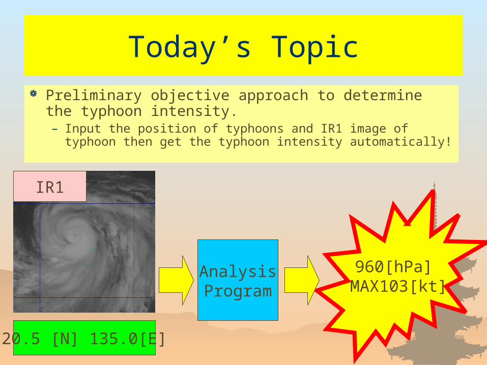
Today’s Topic Preliminary objective approach to determine the typhoon
intensity.– Input the position of typhoons and IR1 image of typhoon then
get the typhoon intensity automatically!
AnalysisProgram
960[hPa] MAX103[kt]
20.5 [N] 135.0[E]
IR1
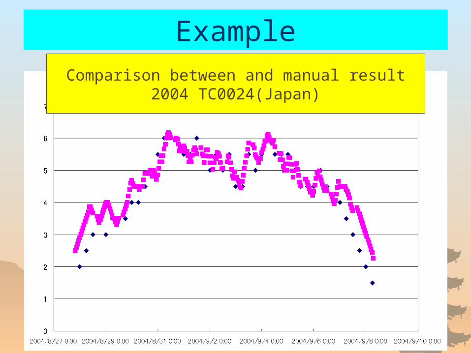
ExampleComparison between and manual result
2004 TC0024(Japan)
Procedure
Brief introduction of conventional method
Introduction of objective hurricane analysis method.
What is Dvorak Technique?
Tropical storm analysis method using IR (11μm) image of meteorological satellites.
(*Especially minimum pressure and maximum wind velocity)
At the JMA, we have no operational objective method for Typhoon analysis.
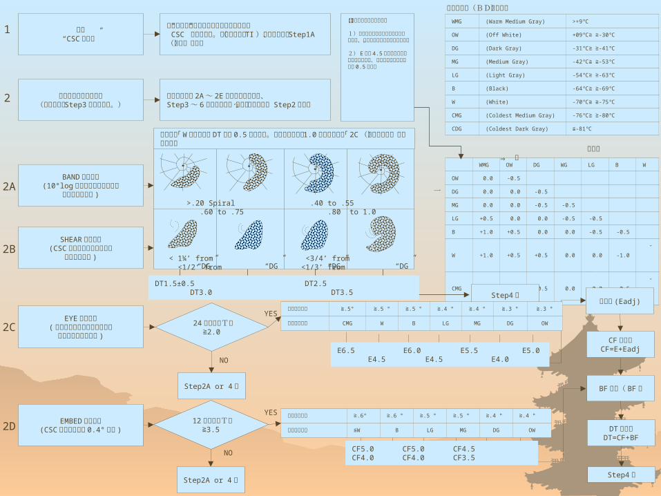
開始“CSC の決定”
雲パターンによる解析(不可能なら Step3 も考慮す
る。)
BAND パターン(10°log スパイラルを適合して
弧の長さを測定 )
SHEAR パターン(CSC 位置と濃密な雲域まで
の距離を測定 )
EYE パターン( バンド状眼パターンのときは
平均バンド幅を測定 )
EMBED パターン(CSC の埋没距離が 0.4° 以上 )
全ての湾曲した雲列または雲バンドにより”CSC” を決定する。初期の発達( TI )に対しては、 Step1A (本文)を参照
雲パターンが 2A ~ 2E に適合しない場合、Step3 ~ 6 を先に実施し、指示」された場合Step2 に戻る
【眼の明瞭さによる調整】
1)大きな眼あるいは細長い眼に対しては、対角線の右側の値のみを使う。
2) E 数が 4.5 以上である細長い眼に対しては、他に惹かれていなければ 0.5 を引く
WMG (Warm Medium Gray) >+9℃
OW (Off White) +09℃≧ ≧-30℃
DG (Dark Gray) -31℃≧ ≧-41℃
MG (Medium Gray) -42℃≧ ≧-53℃
LG (Light Gray) -54℃≧ ≧-63℃
B (Black) -64℃≧ ≧-69℃
W (White) -70℃≧ ≧-75℃
CMG (Coldest Medium Gray) -76℃≧ ≧-80℃
CDG (Coldest Dark Gray) ≦-81℃
WMGOW DG WG LG B W
OW 0.0 -0.5
DG 0.0 0.0 -0.5
MG 0.0 0.0 -0.5 -0.5
LG +0.5 0.0 0.0 -0.5 -0.5
B +1.0 +0.5 0.0 0.0 -0.5 -0.5
W +1.0 +0.5 +0.5 0.0 0.0 -1.0
-1.0
CMG +1.0 +0.5 +0.5 0.0 0.0 -0.5
-1.0
測定階調「 W 」のときは DT 数に 0.5 を加える。スパイラル長が 1.0 以上のときは「 2C (バンド状眼)」で解析する
24 時間前のT数≧2.0
12 時間前のT数≧3.5
Step2A or 4 へ
眼調整 (Eadj)
CF 数決定CF=E+Eadj
BF 調整( BF )
DT 数決定DT=CF+BF
1
DT1.5±0.5 DT2.5 DT3.0 DT3.5
Step4 へ
Step4 へ
最狭バンド幅 ≧.5° ≧.5 ° ≧.5 ° ≧.4 ° ≧.4 ° ≧.3 ° ≧.3 °
バンドの階調 CMG W B LG MG DG OW
E6.5 E6.0 E5.5 E5.0 E4.5 E4.5 E4.0
>.20 Spiral .40 to .55 .60 to .75 .80 to 1.0
< 1¼’ from <3/4’ from <1/2’ from <1/3’ from“DG” “DG” “DG” “DG”
Step2A or 4 へ
最狭バンド幅 ≧.6° ≧.6 ° ≧.5 ° ≧.5 ° ≧.4 ° ≧.4 °
バンドの階調 ≦W B LG MG DG OW
CF5.0 CF5.0 CF4.5 CF4.0 CF4.0 CF3.5
階調コード(BDコード)
眼階調 ⇒ 冷
眼を一周する最も冷たいリングの階調
YES
YES
NO
NO
2
2A
2B
2C
2D
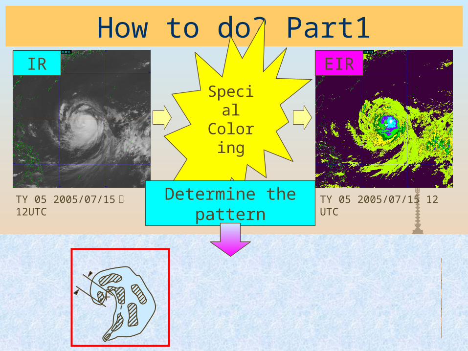
How to do? Part1
TY 05 2005/07/15 日 12UTC TY 05 2005/07/15 12 UTC
Special
Coloring
IR EIR
Determine the pattern
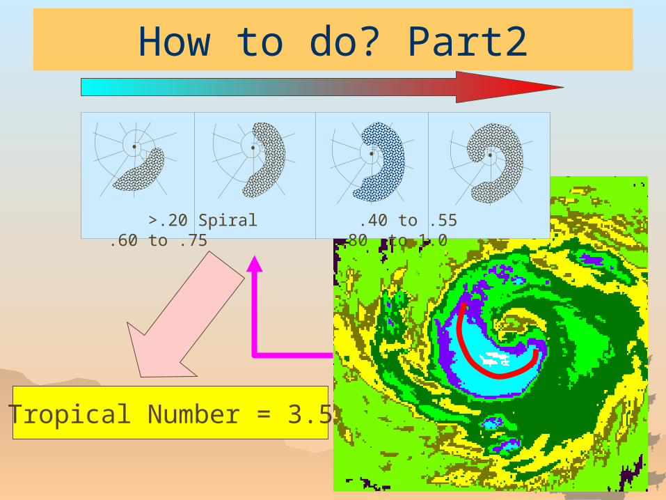
How to do? Part2
>.20 Spiral .40 to .55 .60 to .75 .80 to 1.0
Tropical Number = 3.5
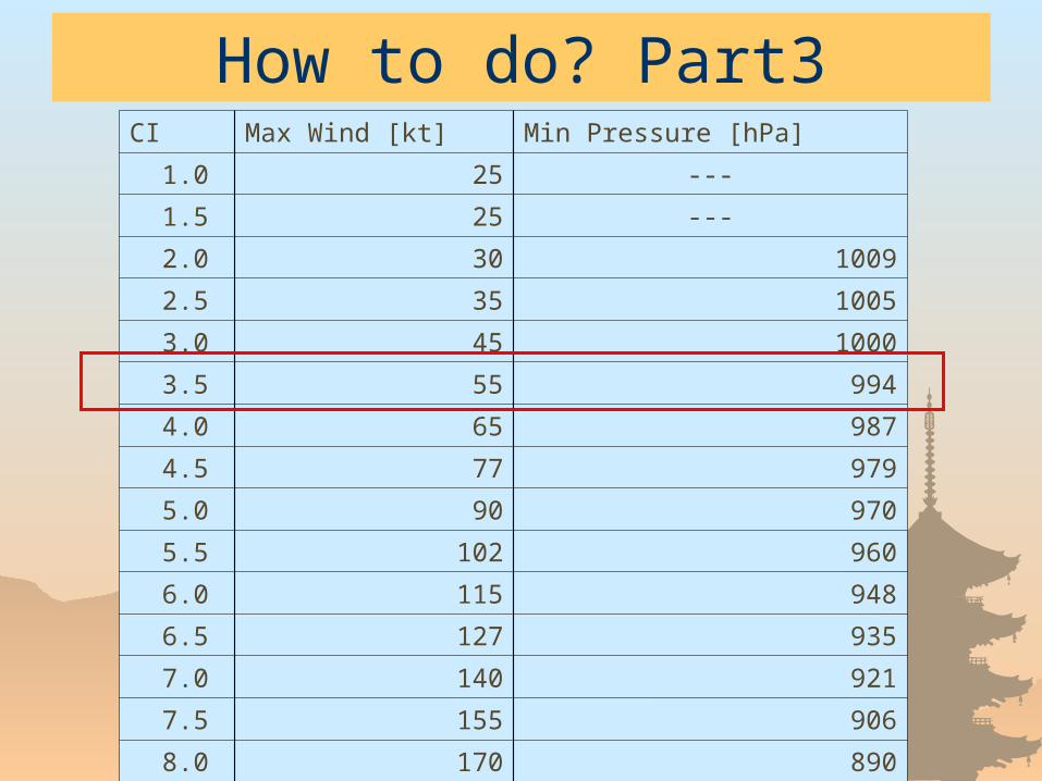
How to do? Part3CI Max Wind [kt] Min Pressure [hPa]
1.0 25 ---
1.5 25 ---
2.0 30 1009
2.5 35 1005
3.0 45 1000
3.5 55 994
4.0 65 987
4.5 77 979
5.0 90 970
5.5 102 960
6.0 115 948
6.5 127 935
7.0 140 921
7.5 155 906
8.0 170 890
Weak point of Dvorak Technique
1. Depend on forecaster’s skill.
2. Improvement of satellite sensor doesn’t
contribute the accuracy.
3. Get intensities in 6 hours interval.
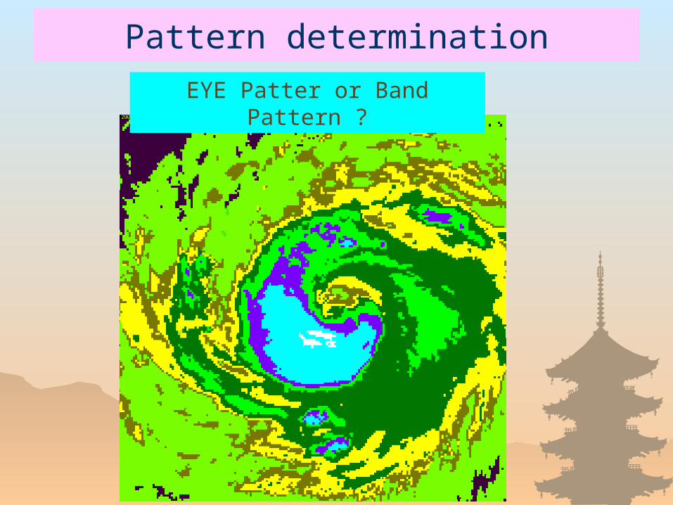
Pattern determination
EYE Patter or Band Pattern ?
Weak point of Dvorak Technique
1. Depend on forecaster’s skill.
2. Improvement of satellite sensor doesn’t
contribute the accuracy.
3. Get intensities in 6 hours interval. Why?
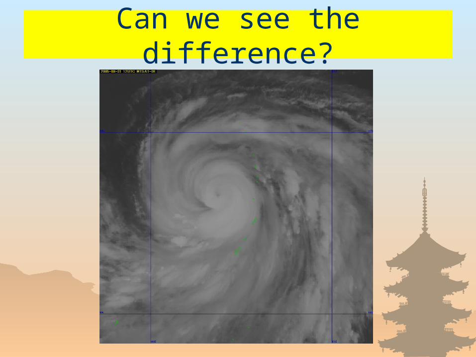
Can we see the difference?

How to overcome the problems?
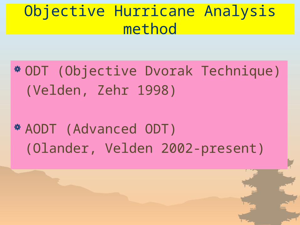
Objective Hurricane Analysis method
ODT (Objective Dvorak Technique)
(Velden, Zehr 1998)
AODT (Advanced ODT)
(Olander, Velden 2002-present)

What is AODT?
National Hurricane Center and Wisconsin university group developed AODT. Only one objective method to determine the hurricane intensities.
– Input the center position of the hurricane and the IR(10 μm) image, then output the hurricane intensity.
– Algorithm is not open!– Output the intensity every hour!
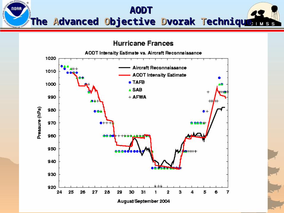
AODTAODTThe The AAdvanced dvanced OObjective bjective DDvorak vorak TTechniqueechnique

I want an objective method!I am envious of them.
But I can’t get the AODT……..
….!!
Make by myself!
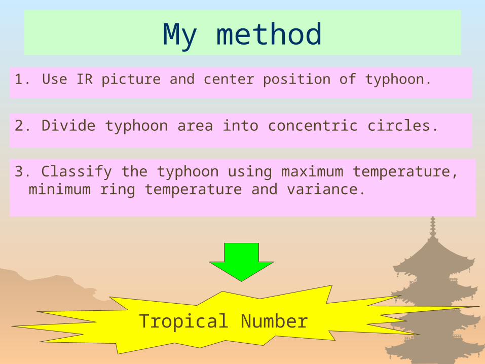
My method
1 . Use IR picture and center position of typhoon.
2. Divide typhoon area into concentric circles.
3. Classify the typhoon using maximum temperature, minimum ring temperature and variance.
Tropical Number
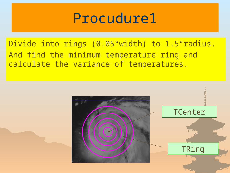
Procudure1
TCenter
TRing
Divide into rings (0.05°width) to 1.5°radius.
And find the minimum temperature ring and calculate the variance of temperatures.
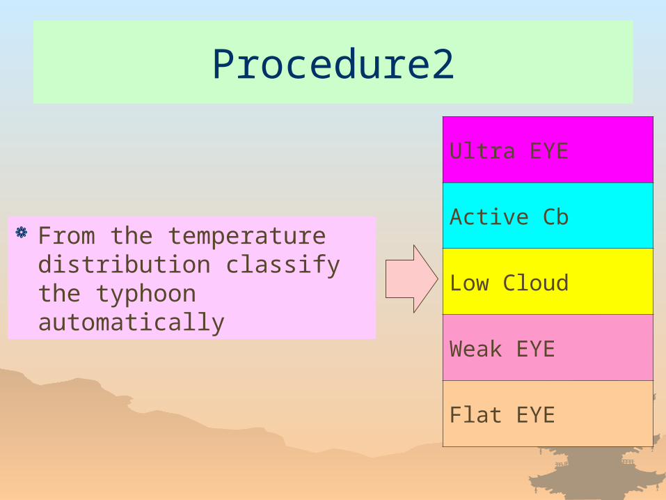
Procedure2
From the temperature distribution classify the typhoon automatically
Ultra EYE
Active Cb
Low Cloud
Weak EYE
Flat EYE
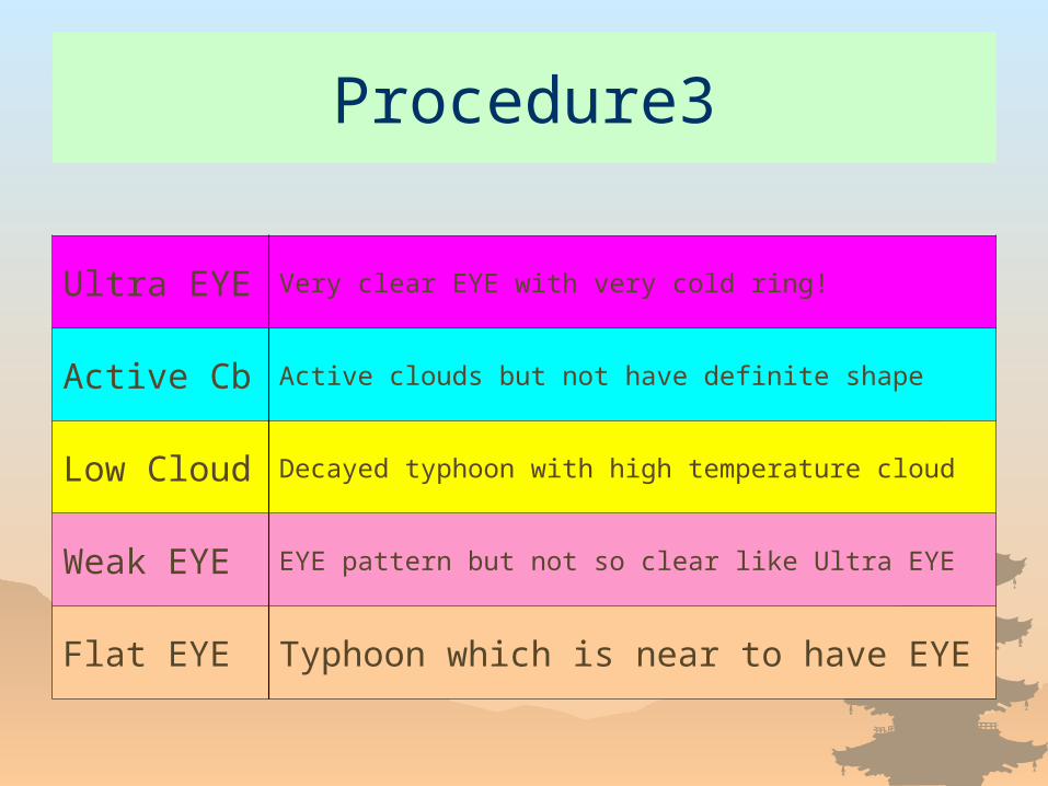
Procedure3
Ultra EYE Very clear EYE with very cold ring!
Active Cb Active clouds but not have definite shape
Low Cloud Decayed typhoon with high temperature cloud
Weak EYE EYE pattern but not so clear like Ultra EYE
Flat EYE Typhoon which is near to have EYE
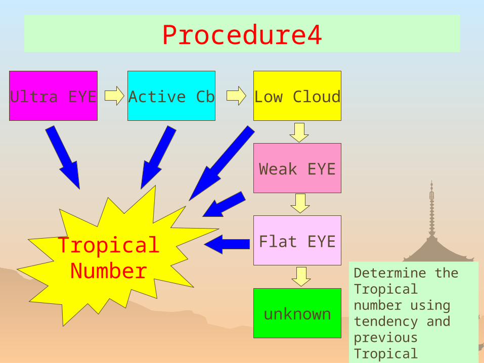
Procedure4
Ultra EYE Active Cb Low Cloud
Weak EYE
Flat EYE
unknown
TropicalNumber Determine the
Tropical number using tendency and previous Tropical number.

Example
Ultra EYE
Active Cb
Low Cloud
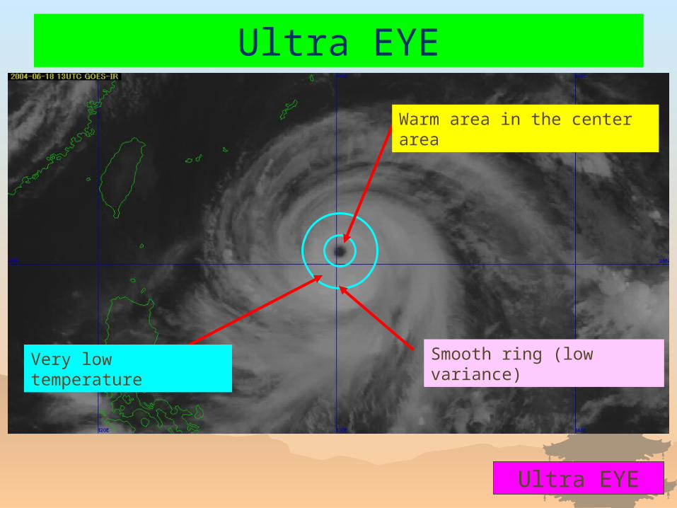
Ultra EYE
Ultra EYE
Very low temperature
Warm area in the center area
Smooth ring (low variance)
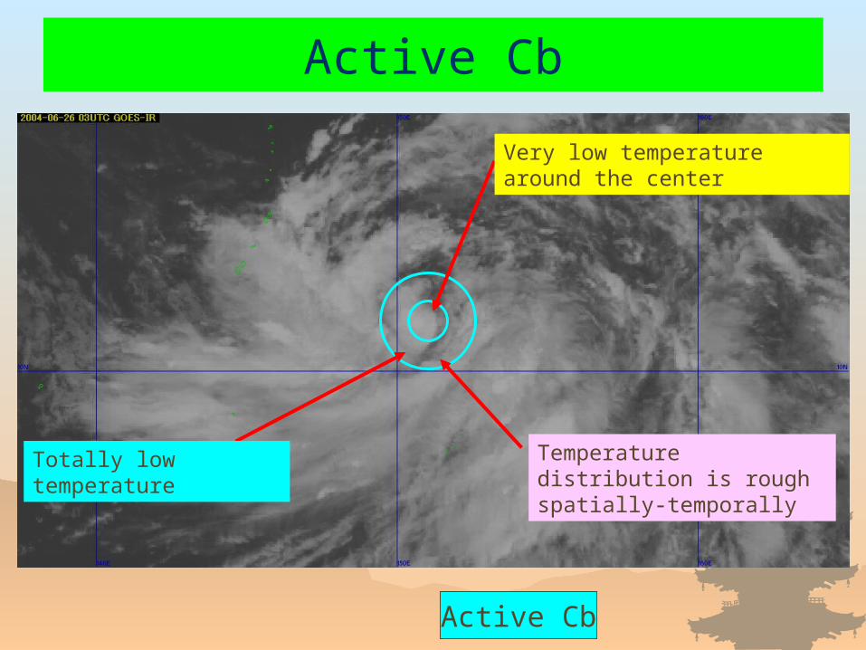
Active Cb
Active Cb
Totally low temperature
Very low temperature around the center
Temperature distribution is rough spatially-temporally
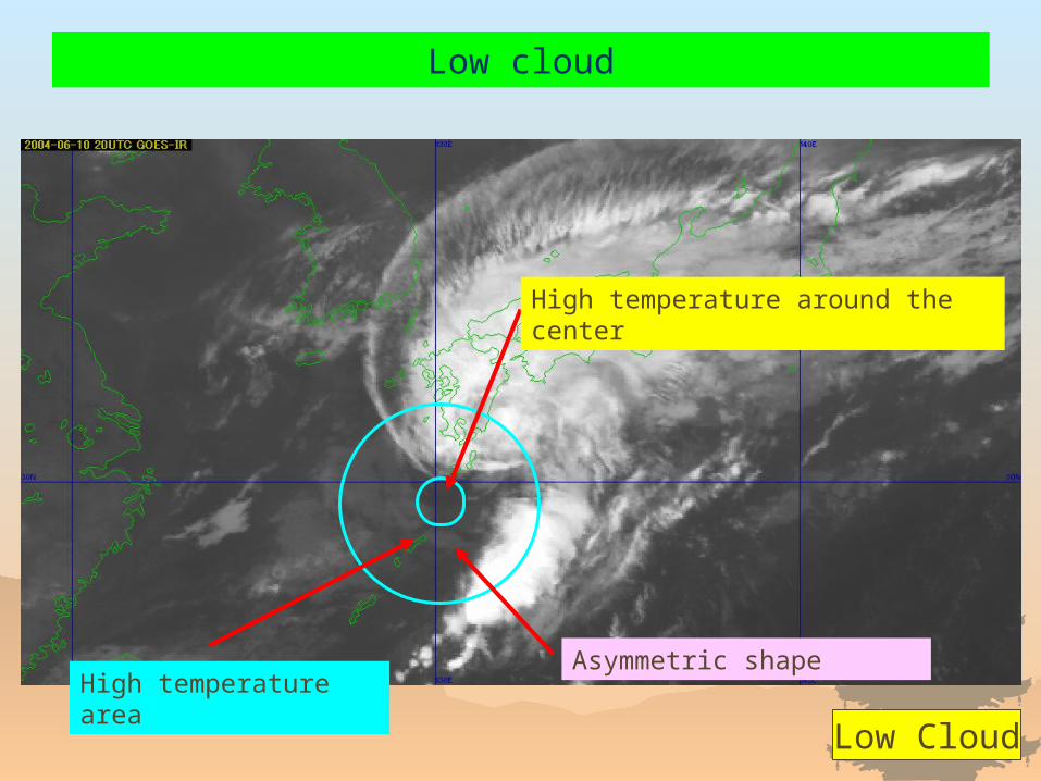
Low cloud
Low Cloud
High temperature area
High temperature around the center
Asymmetric shape
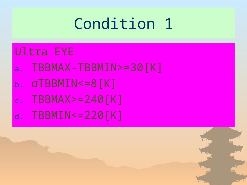
Condition 1
Ultra EYE
a. TBBMAX-TBBMIN>=30[K]
b. σTBBMIN<=8[K]
c. TBBMAX>=240[K]
d. TBBMIN<=220[K]
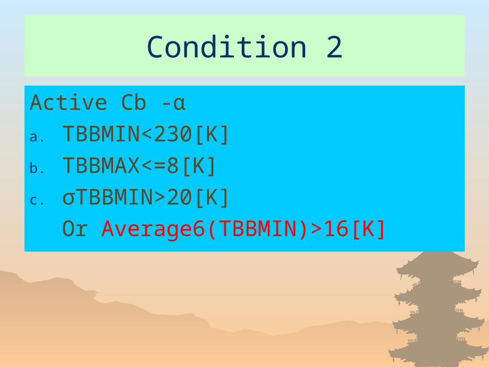
Condition 2
Active Cb -α
a. TBBMIN<230[K]
b. TBBMAX<=8[K]
c. σTBBMIN>20[K]
Or Average6(TBBMIN)>16[K]
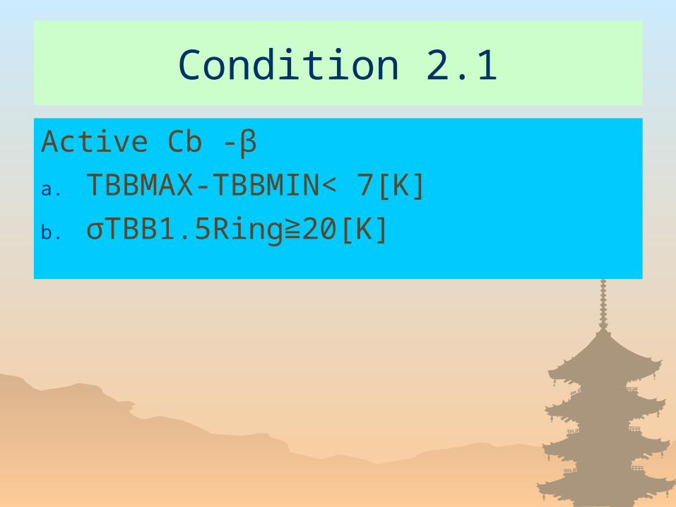
Condition 2.1
Active Cb -β
a. TBBMAX-TBBMIN< 7[K]
b. σTBB1.5Ring 20[K]≧
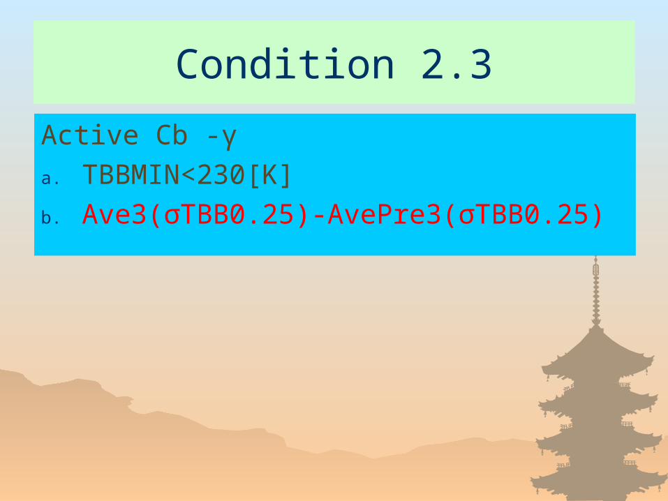
Condition 2.3
Active Cb -γ
a. TBBMIN<230[K]
b. Ave3(σTBB0.25)-AvePre3(σTBB0.25)
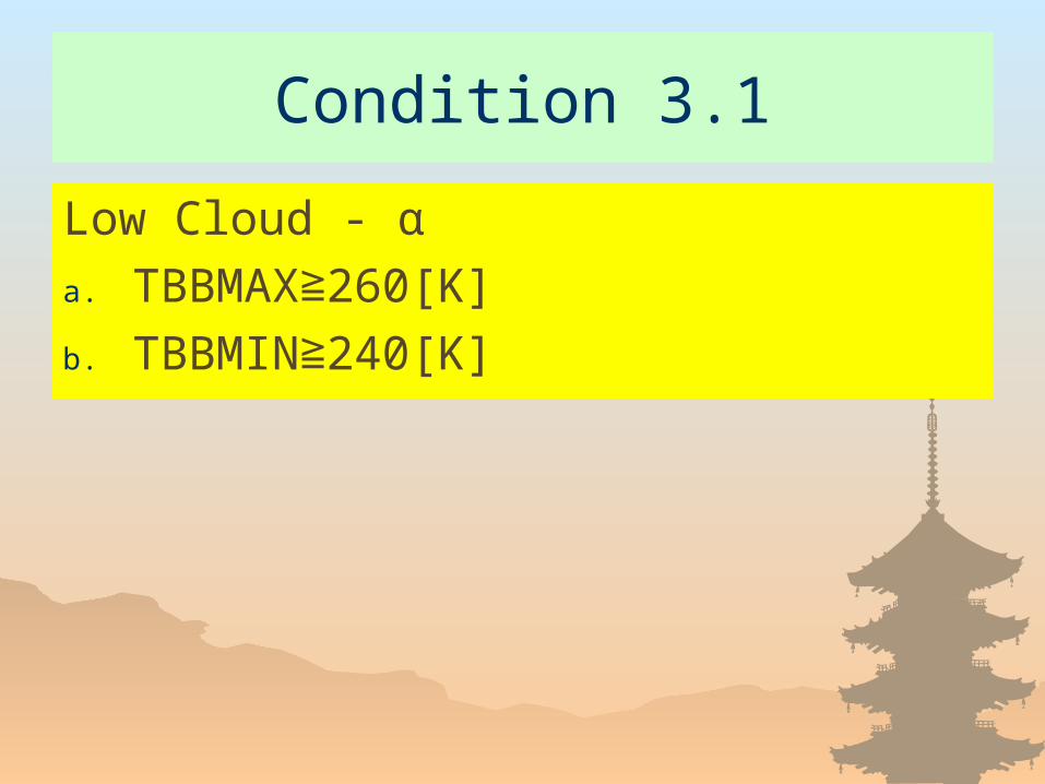
Condition 3.1
Low Cloud - α
a. TBBMAX 260[K]≧b. TBBMIN 240[K]≧

Condition 3.2
Low Cloud – β
a. TBB0.25 230[K]≧b. TBBMAX 260[K]≧c. σTBB0.25 15[K]≧
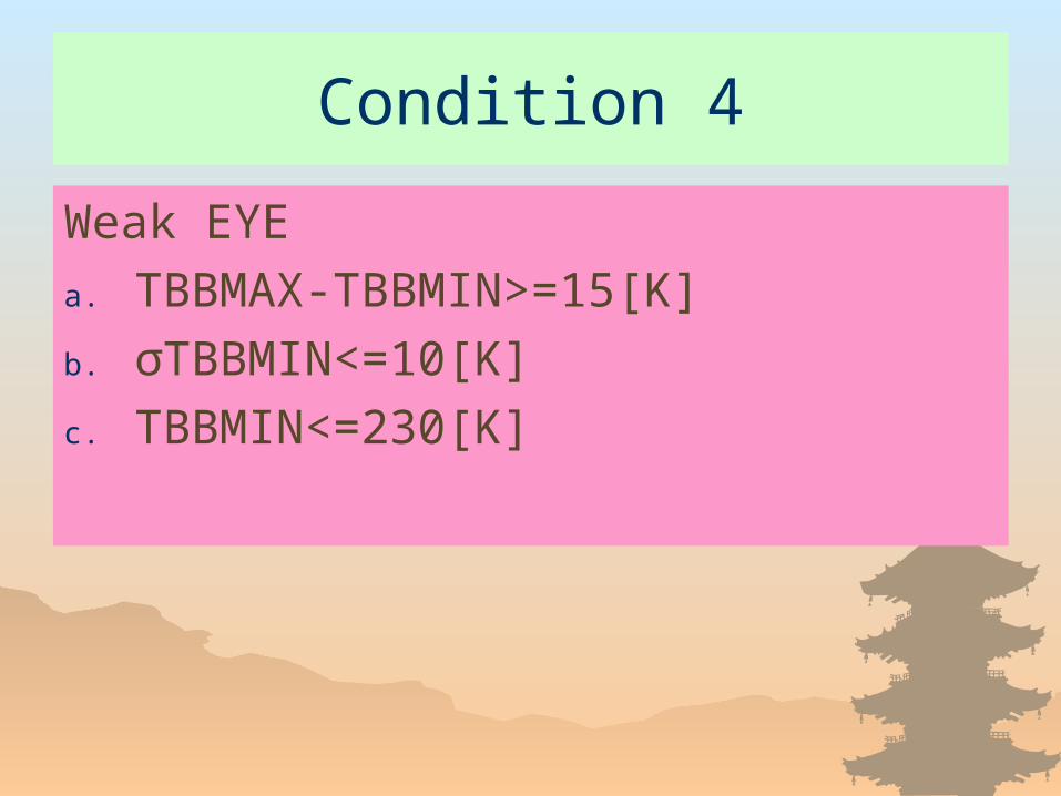
Condition 4
Weak EYE
a. TBBMAX-TBBMIN>=15[K]
b. σTBBMIN<=10[K]
c. TBBMIN<=230[K]
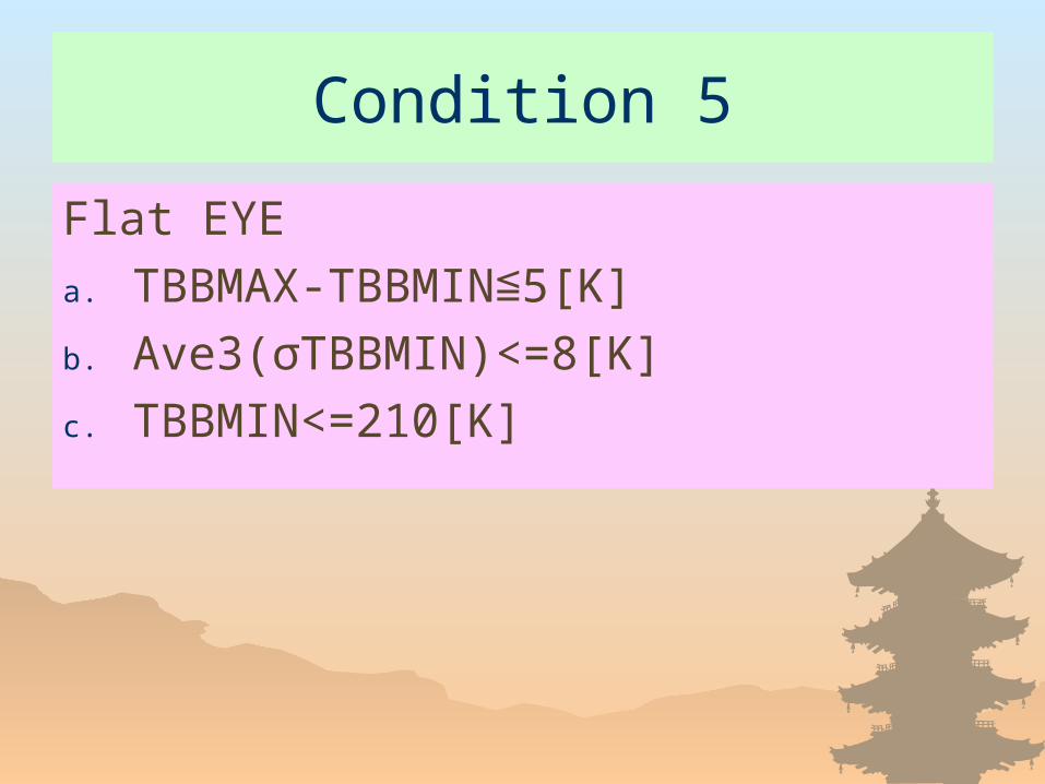
Condition 5
Flat EYE
a. TBBMAX-TBBMIN 5[K]≦b. Ave3(σTBBMIN)<=8[K]
c. TBBMIN<=210[K]
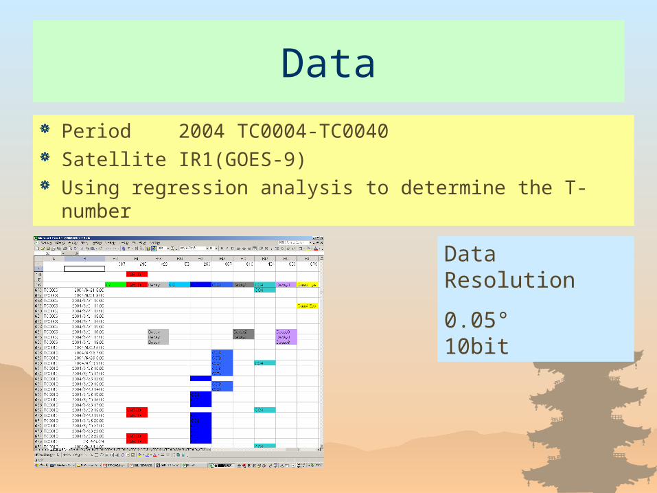
Data
Period2004 TC0004-TC0040 Satellite IR1(GOES-9) Using regression analysis to determine the T-number
Data Resolution
0.05° 10bit

Is this method is valid?
Introduce 5 examples.
TC0007 TC0009 TC0013 TC0021 TC0024
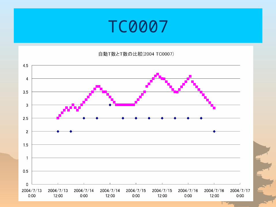
TC0007
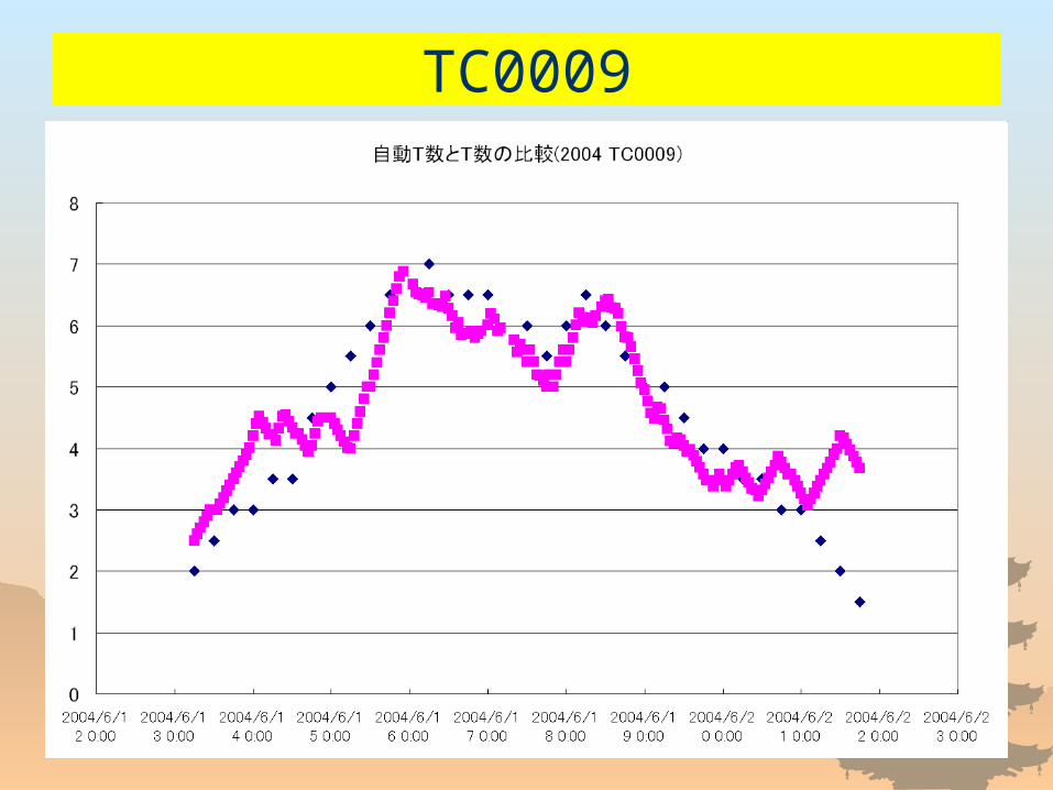
TC0009
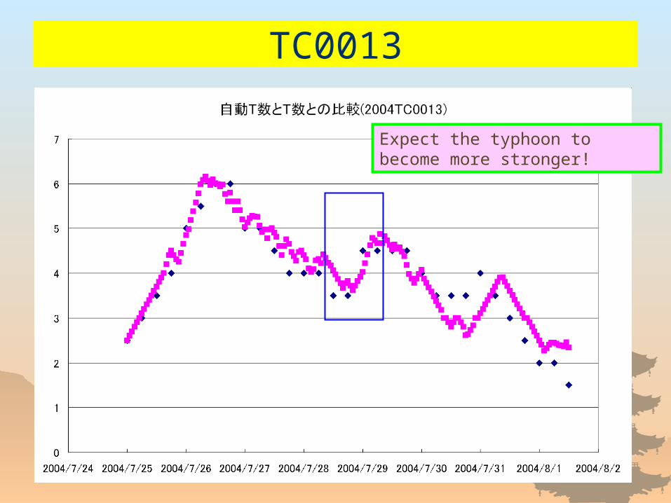
TC0013
Expect the typhoon to become more stronger!
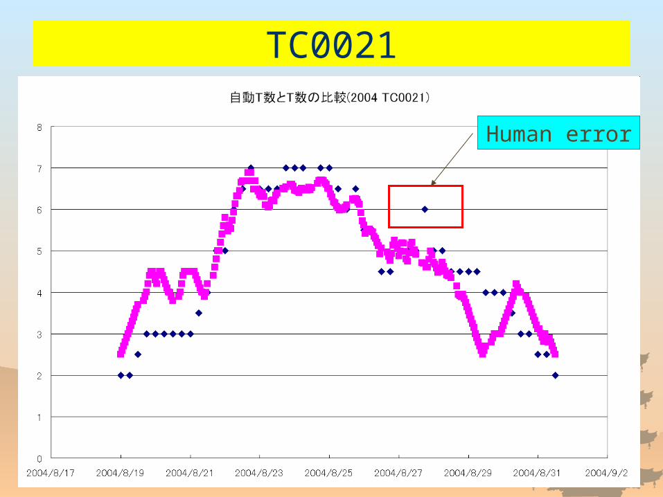
TC0021
Human error
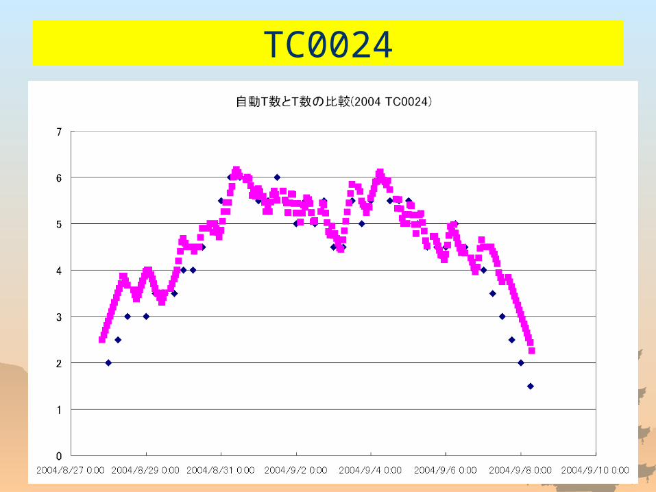
TC0024
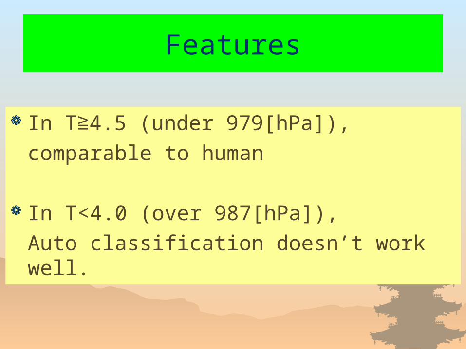
Features
In T 4.5 (under 979[hPa]),≧comparable to human
In T<4.0 (over 987[hPa]),
Auto classification doesn’t work well.
Further Study
Improve the recognition ability especially in the developing and decaying stage
Reduce biases between satellites
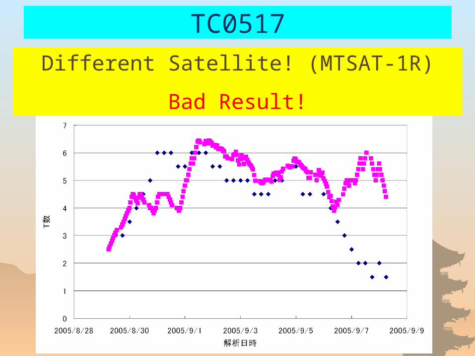
TC0517
Different Satellite! (MTSAT-1R)
Bad Result!

Thank you for your attention!
Sorry, I stopped developing these tools.
But I’d like to try again someday!
Thank you foryour attention!

Fin