Embed Size (px)
Citation preview
NWS WSR-88D Radar Fundamentals
Meteorology 432 Instrumentation and Measurements
Kevin Skow National Weather Service, Des Moines, IA
Topic List
• History of Radar
• Radar Basics
• NWS Radar Products
• Signatures on Radar
• Sources for Radar Data
• New and Future Radar Upgrades
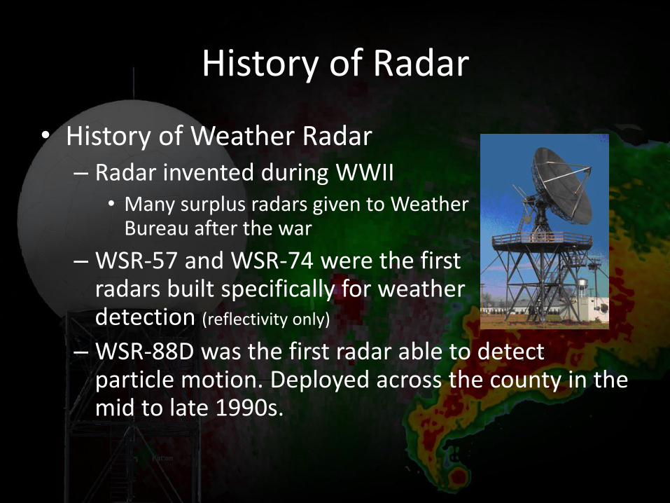
History of Radar
• History of Weather Radar – Radar invented during WWII
• Many surplus radars given to Weather Bureau after the war
– WSR-57 and WSR-74 were the first radars built specifically for weather detection (reflectivity only)
– WSR-88D was the first radar able to detect particle motion. Deployed across the county in the mid to late 1990s.
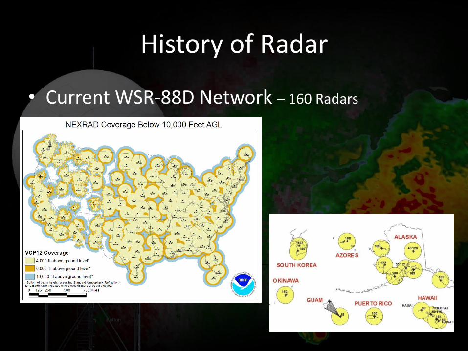
History of Radar
• Current WSR-88D Network – 160 Radars
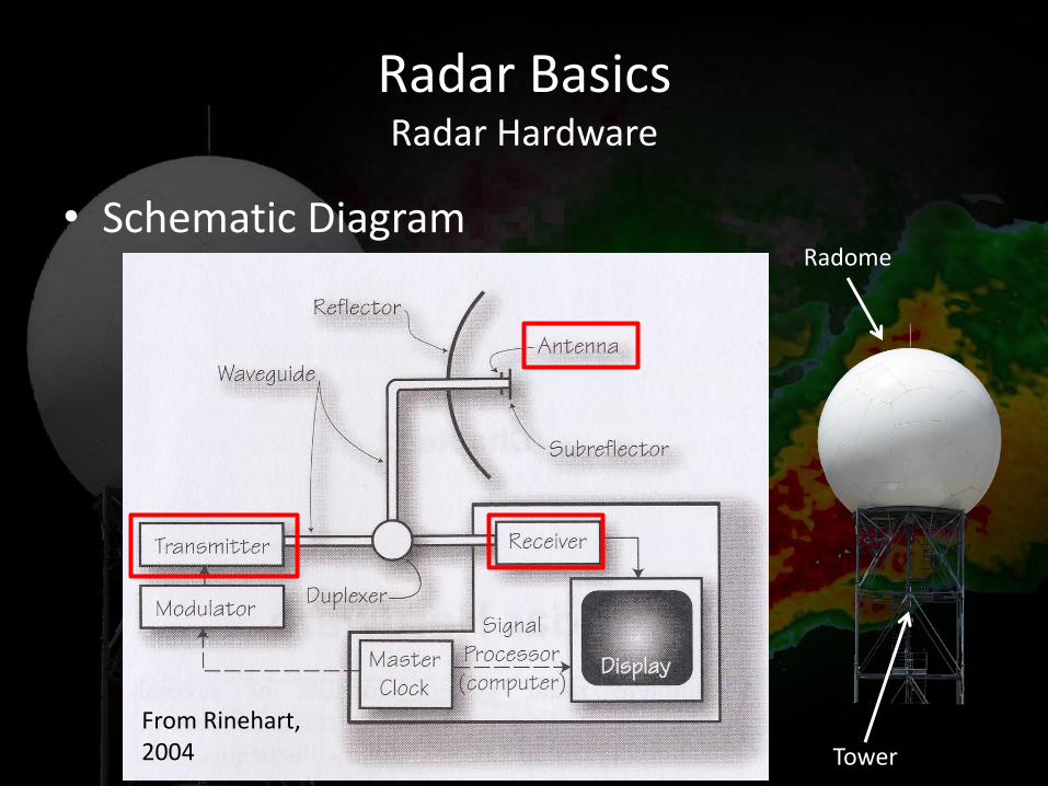
Radar Basics Radar Hardware
• Schematic Diagram
From Rinehart, 2004
Radome
Tower
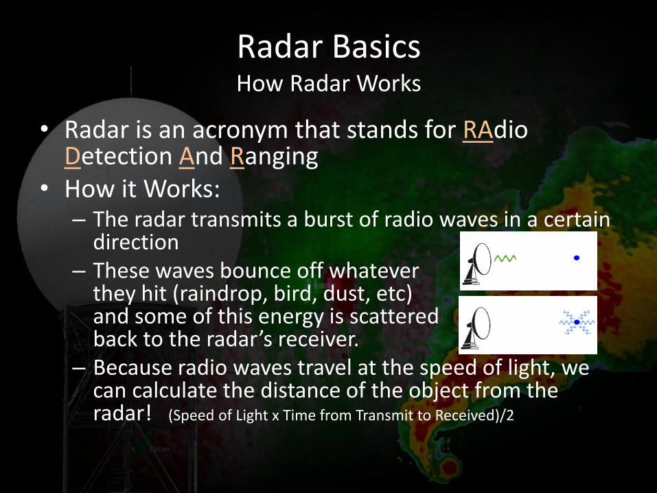
Radar Basics How Radar Works
• Radar is an acronym that stands for RAdio Detection And Ranging
• How it Works: – The radar transmits a burst of radio waves in a certain
direction – These waves bounce off whatever
they hit (raindrop, bird, dust, etc) and some of this energy is scattered back to the radar’s receiver.
– Because radio waves travel at the speed of light, we can calculate the distance of the object from the radar! (Speed of Light x Time from Transmit to Received)/2
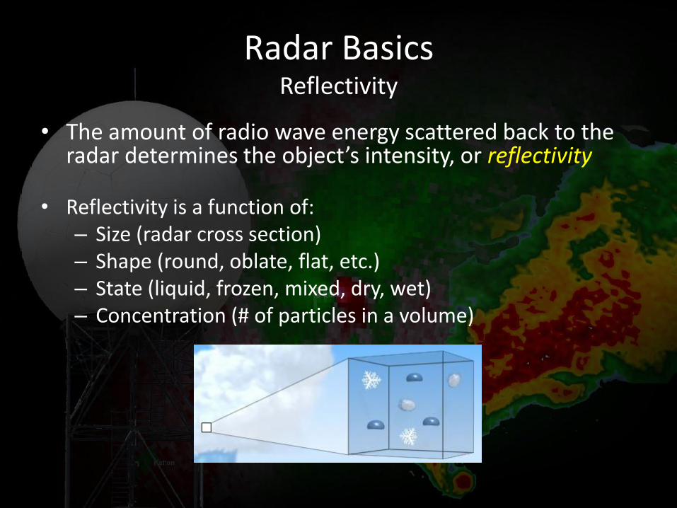
Radar Basics Reflectivity
• The amount of radio wave energy scattered back to the radar determines the object’s intensity, or reflectivity
• Reflectivity is a function of: – Size (radar cross section) – Shape (round, oblate, flat, etc.) – State (liquid, frozen, mixed, dry, wet) – Concentration (# of particles in a volume)
Radar Basics Reflectivity
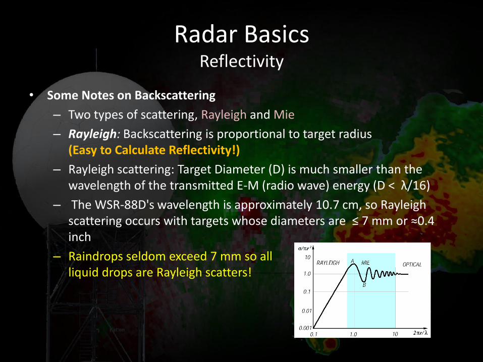
• Some Notes on Backscattering
– Two types of scattering, Rayleigh and Mie
– Rayleigh: Backscattering is proportional to target radius (Easy to Calculate Reflectivity!)
– Rayleigh scattering: Target Diameter (D) is much smaller than the wavelength of the transmitted E-M (radio wave) energy (D < λ/16)
– The WSR-88D's wavelength is approximately 10.7 cm, so Rayleigh scattering occurs with targets whose diameters are ≤ 7 mm or ≈0.4 inch
– Raindrops seldom exceed 7 mm so all liquid drops are Rayleigh scatters!
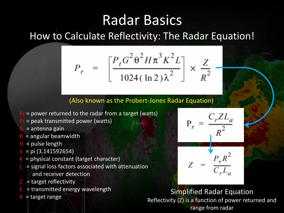
Radar Basics How to Calculate Reflectivity: The Radar Equation!
(Also known as the Probert-Jones Radar Equation)
Simplified Radar Equation Reflectivity (Z) is a function of power returned and
range from radar
Pr = power returned to the radar from a target (watts) Pt = peak transmitted power (watts) G = antenna gain θ = angular beamwidth H = pulse length π = pi (3.141592654) K = physical constant (target character) L = signal loss factors associated with attenuation and receiver detection Z = target reflectivity λ = transmitted energy wavelength R = target range
Radar Basics Reflectivity Units
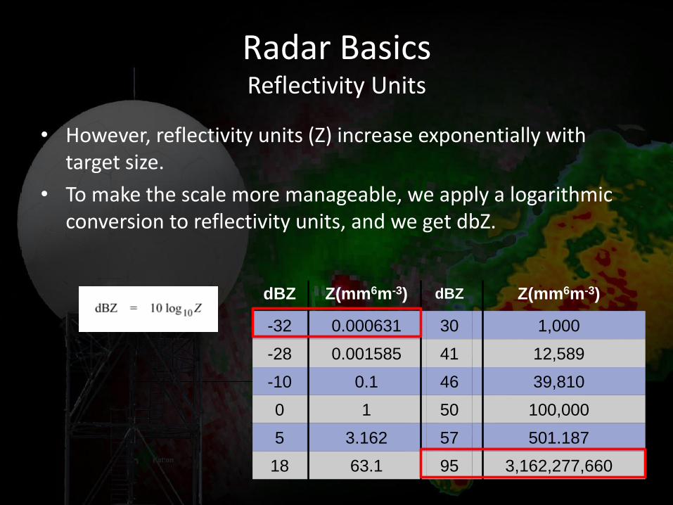
• However, reflectivity units (Z) increase exponentially with target size.
• To make the scale more manageable, we apply a logarithmic conversion to reflectivity units, and we get dbZ.
dBZ Z(mm6m-3) dBZ Z(mm6m-3)
-32 0.000631 30 1,000
-28 0.001585 41 12,589
-10 0.1 46 39,810
0 1 50 100,000
5 3.162 57 501.187
18 63.1 95 3,162,277,660
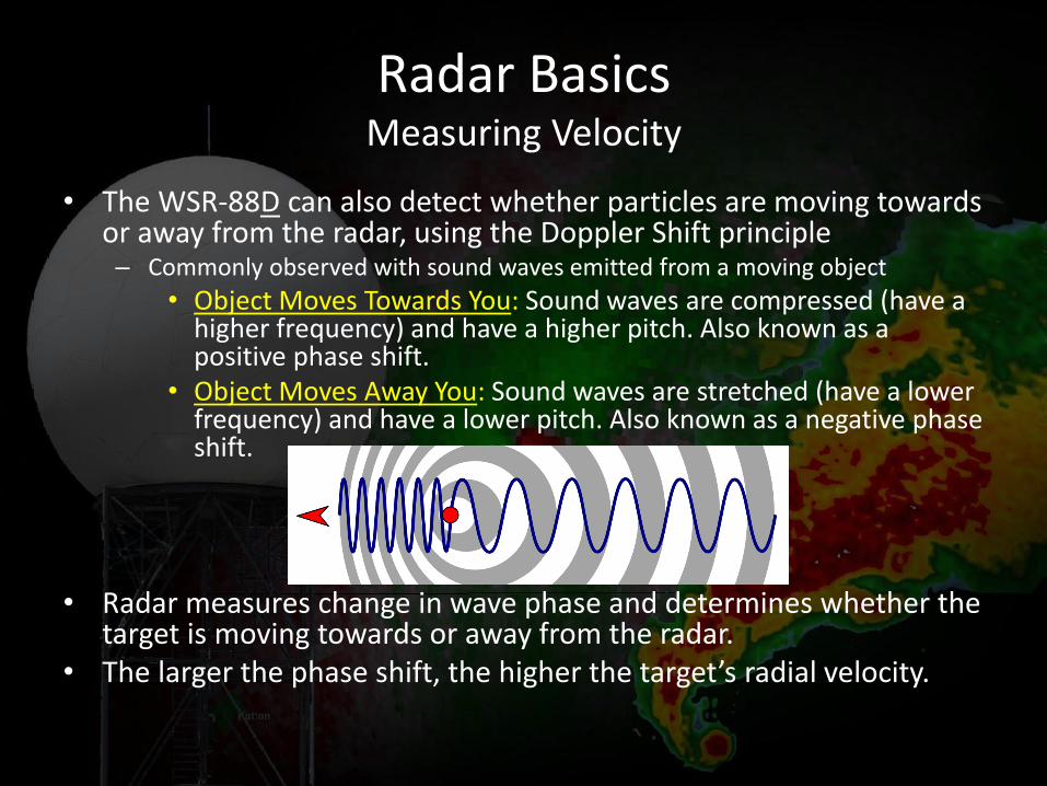
• The WSR-88D can also detect whether particles are moving towards or away from the radar, using the Doppler Shift principle – Commonly observed with sound waves emitted from a moving object
• Object Moves Towards You: Sound waves are compressed (have a higher frequency) and have a higher pitch. Also known as a positive phase shift.
• Object Moves Away You: Sound waves are stretched (have a lower frequency) and have a lower pitch. Also known as a negative phase shift.
• Radar measures change in wave phase and determines whether the target is moving towards or away from the radar.
• The larger the phase shift, the higher the target’s radial velocity.
Radar Basics Measuring Velocity
Radar Basics Dual Polarization
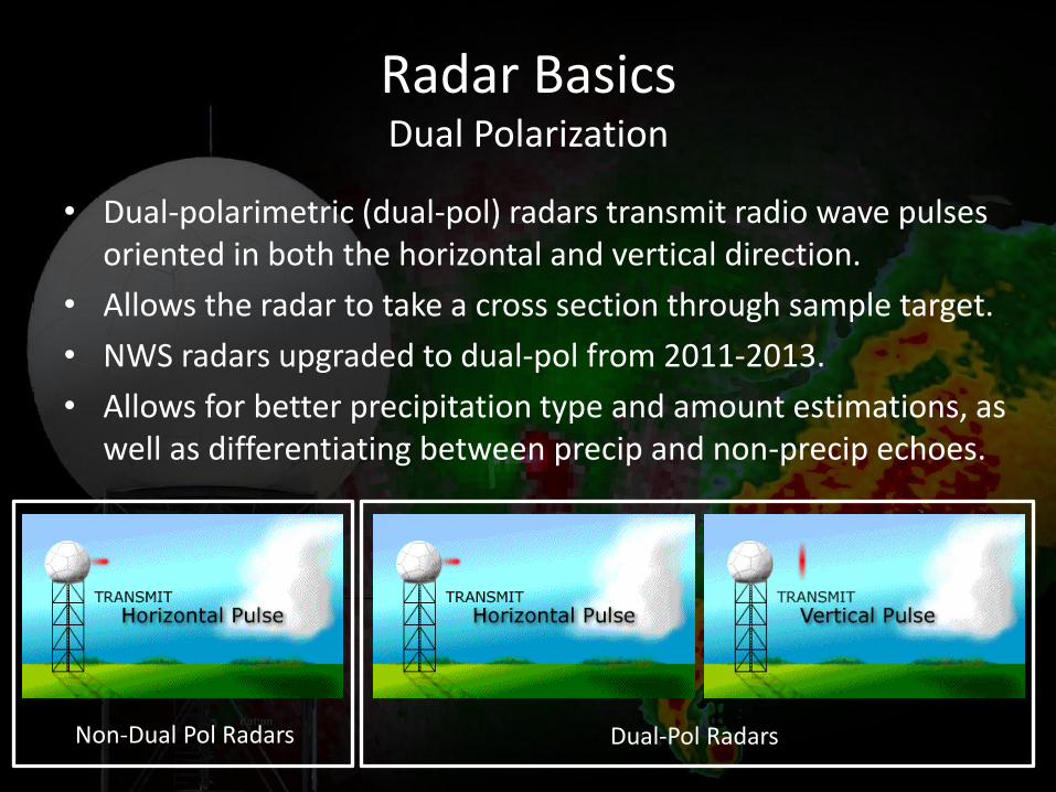
• Dual-polarimetric (dual-pol) radars transmit radio wave pulses oriented in both the horizontal and vertical direction.
• Allows the radar to take a cross section through sample target.
• NWS radars upgraded to dual-pol from 2011-2013.
• Allows for better precipitation type and amount estimations, as well as differentiating between precip and non-precip echoes.
Non-Dual Pol Radars Dual-Pol Radars
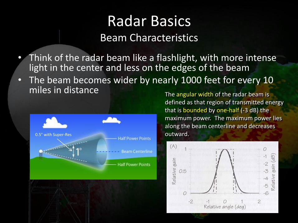
Radar Basics Beam Characteristics
• Think of the radar beam like a flashlight, with more intense light in the center and less on the edges of the beam
• The beam becomes wider by nearly 1000 feet for every 10 miles in distance
The angular width of the radar beam is defined as that region of transmitted energy that is bounded by one-half (-3 dB) the maximum power. The maximum power lies along the beam centerline and decreases outward. 0.5° with Super-Res
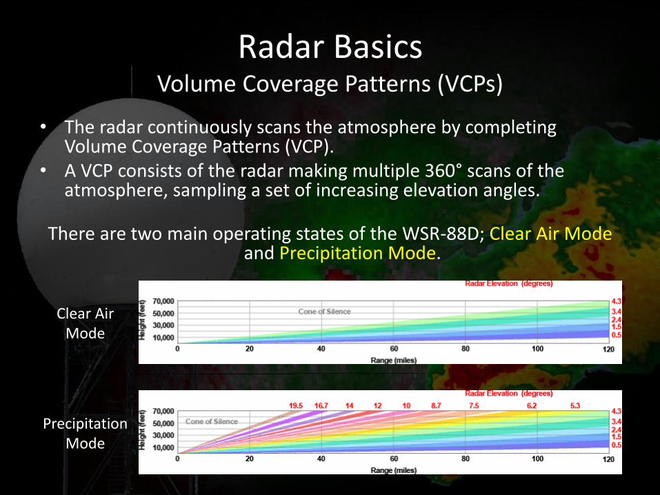
• The radar continuously scans the atmosphere by completing Volume Coverage Patterns (VCP).
• A VCP consists of the radar making multiple 360° scans of the atmosphere, sampling a set of increasing elevation angles.
There are two main operating states of the WSR-88D; Clear Air Mode and Precipitation Mode.
Radar Basics Volume Coverage Patterns (VCPs)
Clear Air Mode
Precipitation Mode
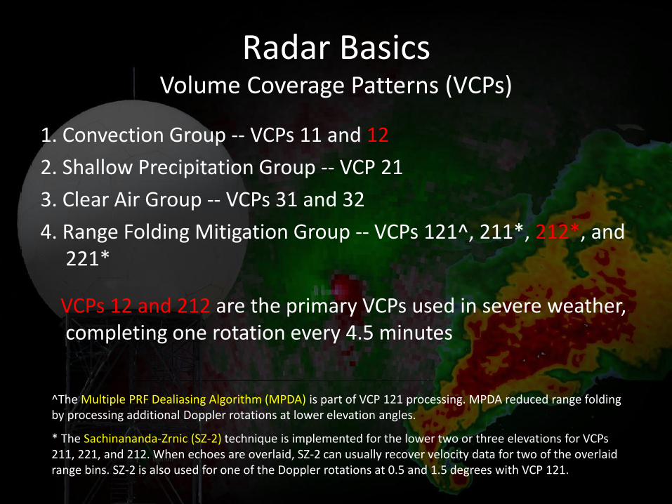
1. Convection Group -- VCPs 11 and 12
2. Shallow Precipitation Group -- VCP 21
3. Clear Air Group -- VCPs 31 and 32
4. Range Folding Mitigation Group -- VCPs 121^, 211*, 212*, and 221*
VCPs 12 and 212 are the primary VCPs used in severe weather, completing one rotation every 4.5 minutes
Radar Basics Volume Coverage Patterns (VCPs)
^The Multiple PRF Dealiasing Algorithm (MPDA) is part of VCP 121 processing. MPDA reduced range folding by processing additional Doppler rotations at lower elevation angles.
* The Sachinananda-Zrnic (SZ-2) technique is implemented for the lower two or three elevations for VCPs 211, 221, and 212. When echoes are overlaid, SZ-2 can usually recover velocity data for two of the overlaid range bins. SZ-2 is also used for one of the Doppler rotations at 0.5 and 1.5 degrees with VCP 121.
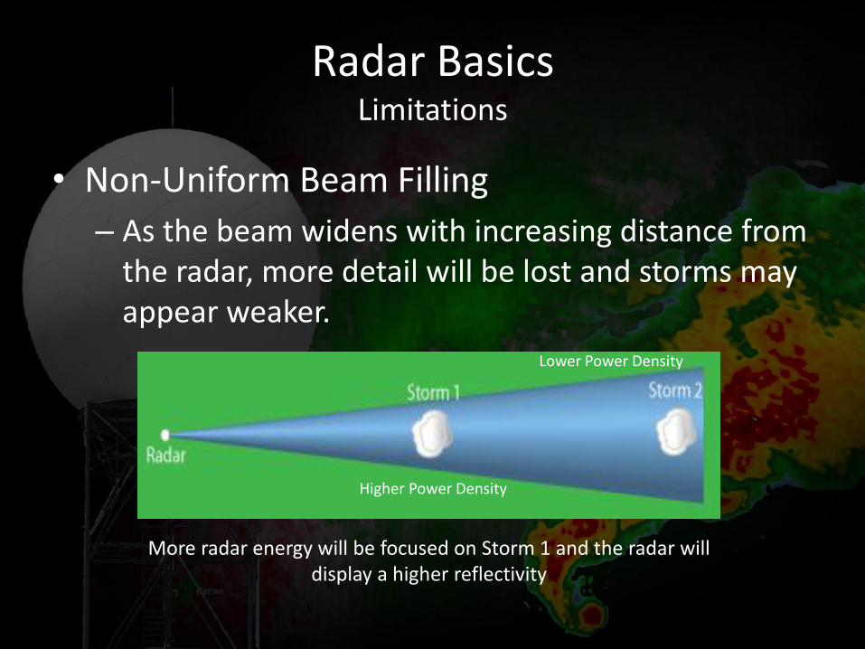
• Non-Uniform Beam Filling
– As the beam widens with increasing distance from the radar, more detail will be lost and storms may appear weaker.
Radar Basics Limitations
Higher Power Density
Lower Power Density
More radar energy will be focused on Storm 1 and the radar will display a higher reflectivity
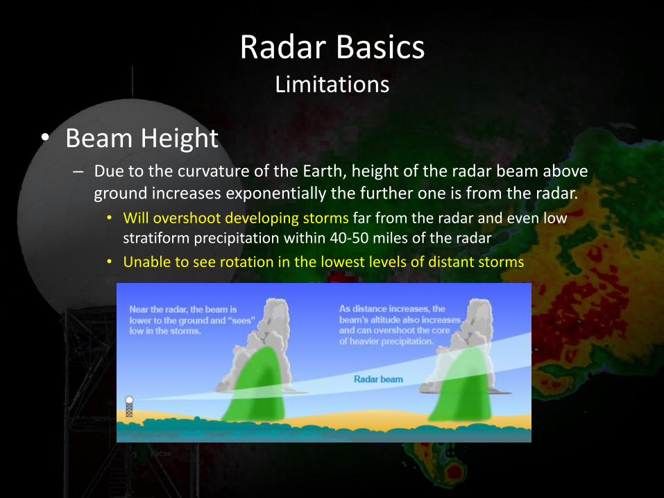
• Beam Height – Due to the curvature of the Earth, height of the radar beam above
ground increases exponentially the further one is from the radar.
• Will overshoot developing storms far from the radar and even low stratiform precipitation within 40-50 miles of the radar
• Unable to see rotation in the lowest levels of distant storms
Radar Basics Limitations
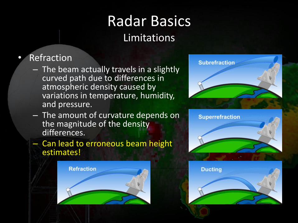
• Refraction – The beam actually travels in a slightly
curved path due to differences in atmospheric density caused by variations in temperature, humidity, and pressure.
– The amount of curvature depends on the magnitude of the density differences.
– Can lead to erroneous beam height estimates!
Radar Basics Limitations
• Attenuation
– Occurs when large objects scatter most of the radio energy back to the radar, leaving little to travel downradial to distant storms.
– Makes downradial storms appear weaker.
– Attenuation is fairly minimal with the WSR-88D, but can happen under circumstances
• Large Hail Cores
• Long line of storms oriented along the beam path
Radar Basics Limitations
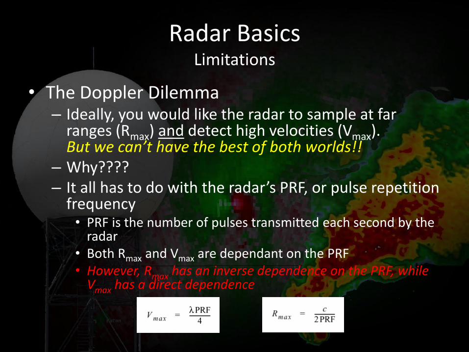
• The Doppler Dilemma – Ideally, you would like the radar to sample at far
ranges (Rmax) and detect high velocities (Vmax). But we can’t have the best of both worlds!!
– Why???? – It all has to do with the radar’s PRF, or pulse repetition
frequency • PRF is the number of pulses transmitted each second by the
radar • Both Rmax and Vmax are dependant on the PRF • However, Rmax has an inverse dependence on the PRF, while
Vmax has a direct dependence
Radar Basics Limitations
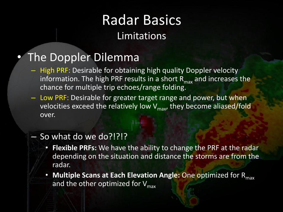
• The Doppler Dilemma – High PRF: Desirable for obtaining high quality Doppler velocity
information. The high PRF results in a short Rmax and increases the chance for multiple trip echoes/range folding.
– Low PRF: Desirable for greater target range and power, but when velocities exceed the relatively low Vmax, they become aliased/fold over.
– So what do we do?!?!? • Flexible PRFs: We have the ability to change the PRF at the radar
depending on the situation and distance the storms are from the radar.
• Multiple Scans at Each Elevation Angle: One optimized for Rmax and the other optimized for Vmax
Radar Basics Limitations
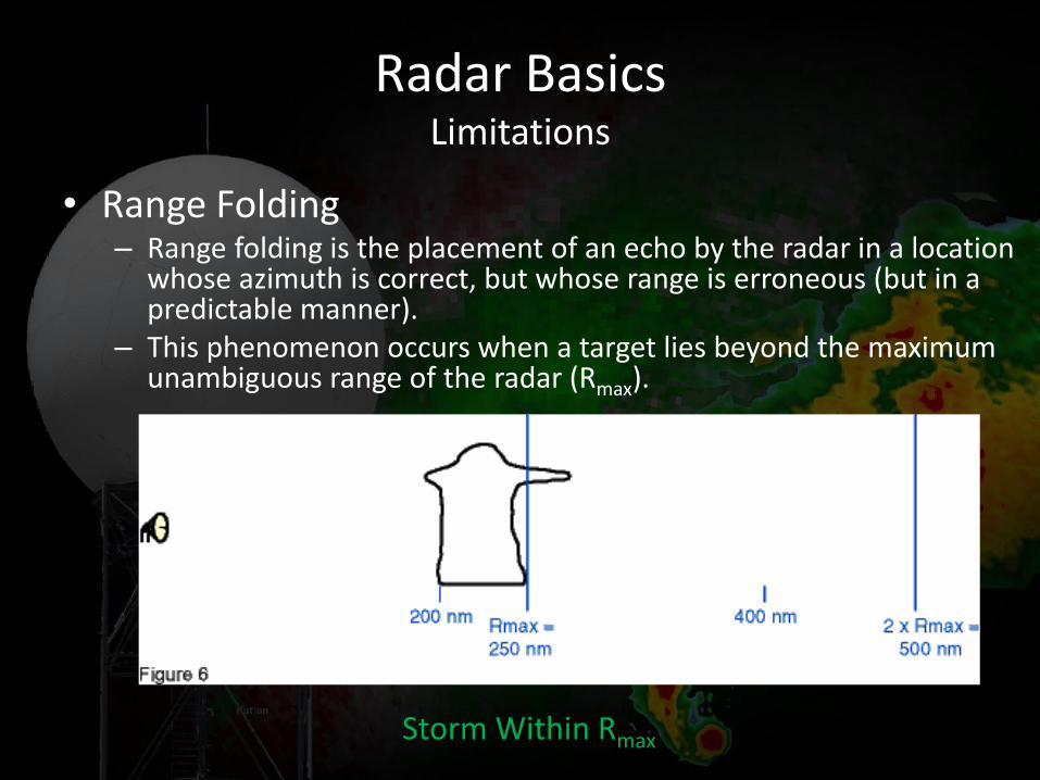
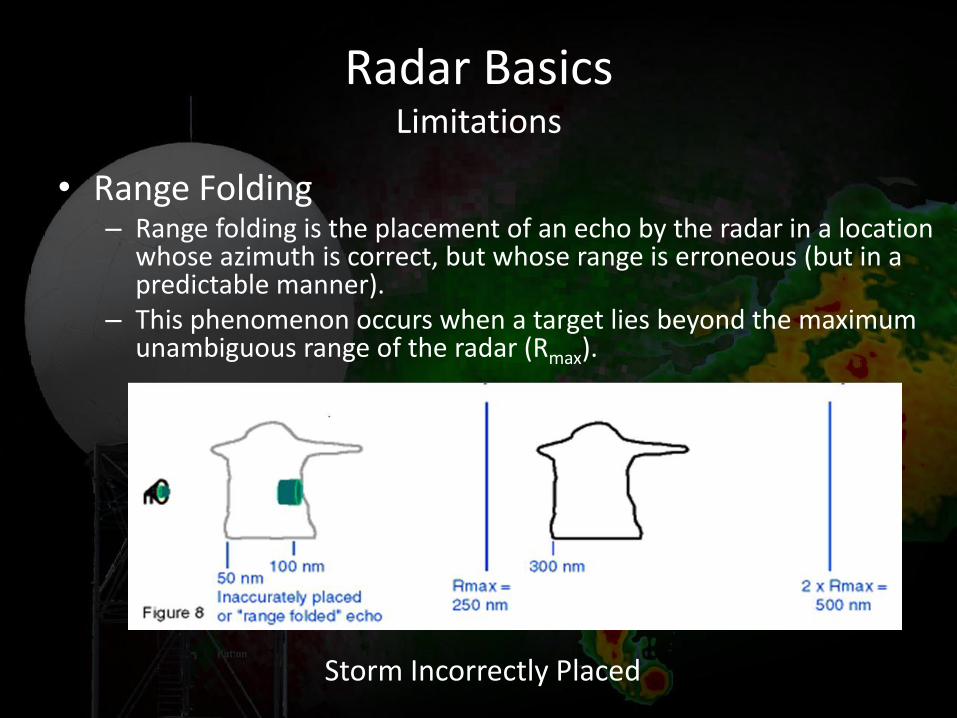
• Range Folding – Range folding is the placement of an echo by the radar in a location
whose azimuth is correct, but whose range is erroneous (but in a predictable manner).
– This phenomenon occurs when a target lies beyond the maximum unambiguous range of the radar (Rmax).
Radar Basics Limitations
Storm Within Rmax
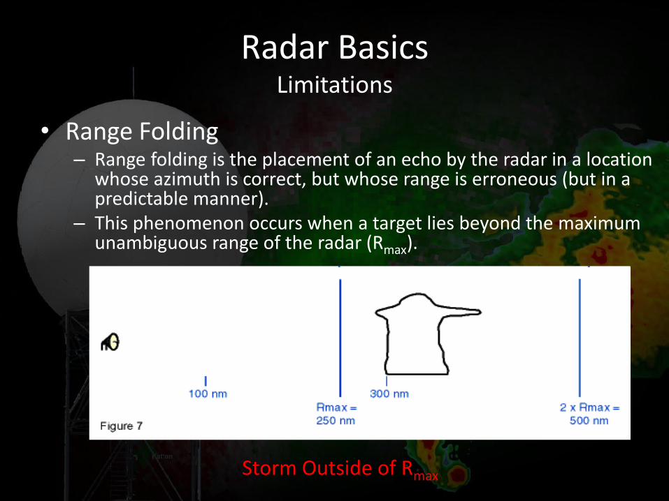
• Range Folding – Range folding is the placement of an echo by the radar in a location
whose azimuth is correct, but whose range is erroneous (but in a predictable manner).
– This phenomenon occurs when a target lies beyond the maximum unambiguous range of the radar (Rmax).
Radar Basics Limitations
Storm Outside of Rmax
• Range Folding – Range folding is the placement of an echo by the radar in a location
whose azimuth is correct, but whose range is erroneous (but in a predictable manner).
– This phenomenon occurs when a target lies beyond the maximum unambiguous range of the radar (Rmax).
Radar Basics Limitations
Storm Incorrectly Placed

• Velocity Aliasing/Folding – Occurs when the radio wave has been shifted so far
from its original position that the radar cannot tell if it is inbound or outbound.
– Can be corrected/mitigated with software (called dealiasing)
Radar Basics Limitations
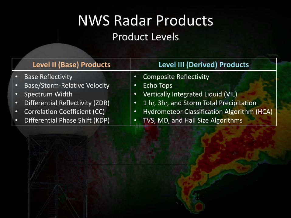
NWS Radar Products Product Levels
Level II (Base) Products Level III (Derived) Products
• Base Reflectivity • Base/Storm-Relative Velocity • Spectrum Width • Differential Reflectivity (ZDR) • Correlation Coefficient (CC) • Differential Phase Shift (KDP)
• Composite Reflectivity • Echo Tops • Vertically Integrated Liquid (VIL) • 1 hr, 3hr, and Storm Total Precipitation • Hydrometeor Classification Algorithm (HCA) • TVS, MD, and Hail Size Algorithms
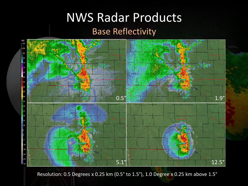
NWS Radar Products Base Reflectivity
0.5° 1.9°
5.1° 12.5°
Resolution: 0.5 Degrees x 0.25 km (0.5° to 1.5°), 1.0 Degree x 0.25 km above 1.5°
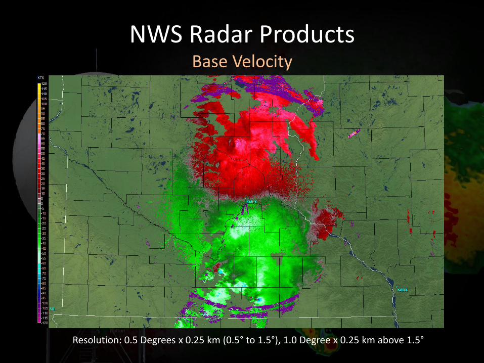
NWS Radar Products Base Velocity
Resolution: 0.5 Degrees x 0.25 km (0.5° to 1.5°), 1.0 Degree x 0.25 km above 1.5°
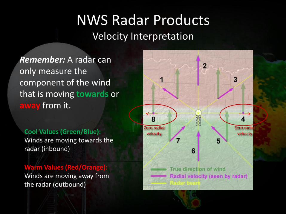
NWS Radar Products Velocity Interpretation
Zero radial velocity
Zero radial velocity
Remember: A radar can only measure the component of the wind that is moving towards or away from it.
Cool Values (Green/Blue): Winds are moving towards the radar (inbound)
Warm Values (Red/Orange): Winds are moving away from the radar (outbound)
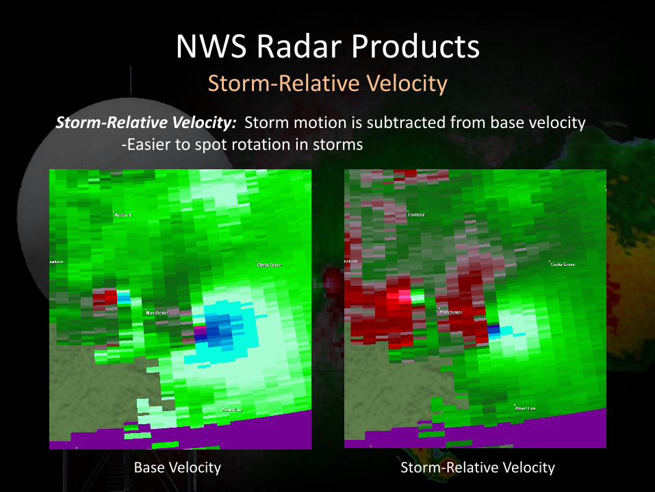
NWS Radar Products Storm-Relative Velocity
Storm-Relative Velocity: Storm motion is subtracted from base velocity -Easier to spot rotation in storms
Base Velocity Storm-Relative Velocity
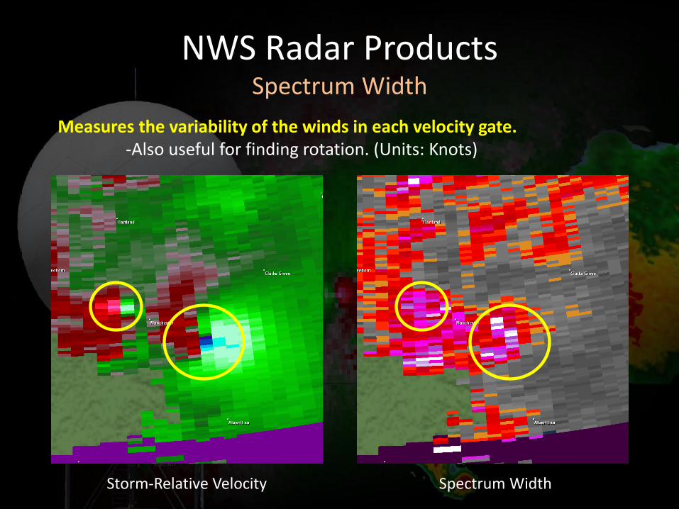
NWS Radar Products Spectrum Width
Measures the variability of the winds in each velocity gate. -Also useful for finding rotation. (Units: Knots)
Storm-Relative Velocity Spectrum Width
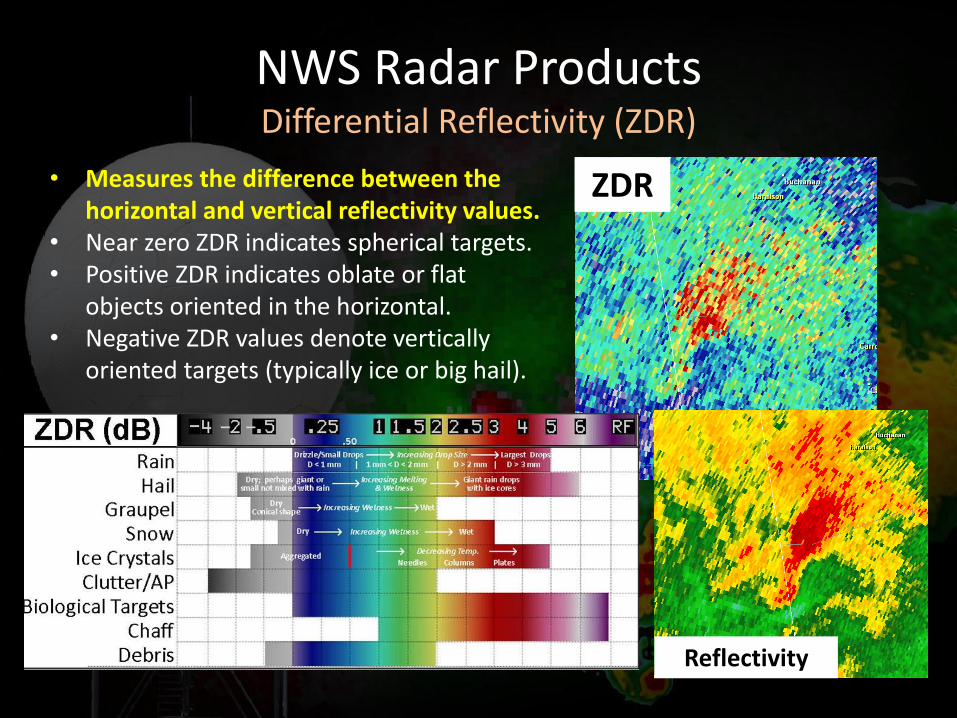
NWS Radar Products Differential Reflectivity (ZDR)
• Measures the difference between the horizontal and vertical reflectivity values.
• Near zero ZDR indicates spherical targets. • Positive ZDR indicates oblate or flat
objects oriented in the horizontal. • Negative ZDR values denote vertically
oriented targets (typically ice or big hail).
ZDR
Reflectivity
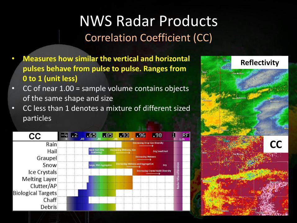
NWS Radar Products Correlation Coefficient (CC)
• Measures how similar the vertical and horizontal pulses behave from pulse to pulse. Ranges from 0 to 1 (unit less)
• CC of near 1.00 = sample volume contains objects of the same shape and size
• CC less than 1 denotes a mixture of different sized particles
CC
Reflectivity
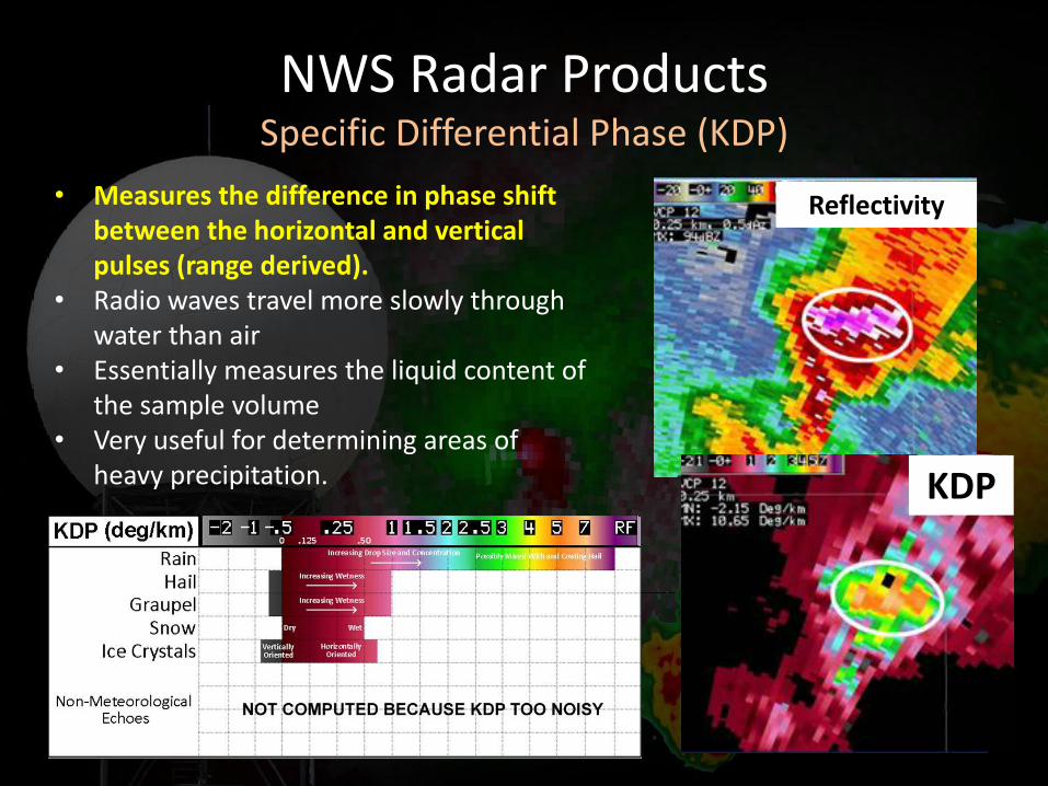
NWS Radar Products Specific Differential Phase (KDP)
• Measures the difference in phase shift between the horizontal and vertical pulses (range derived).
• Radio waves travel more slowly through water than air
• Essentially measures the liquid content of the sample volume
• Very useful for determining areas of heavy precipitation.
KDP
Reflectivity
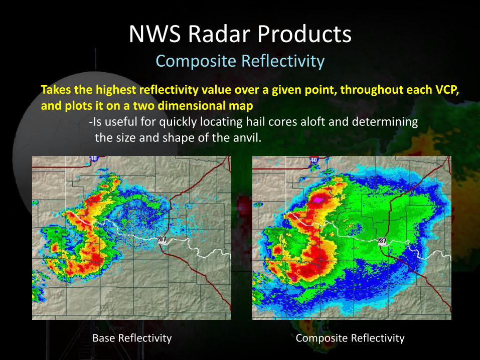
NWS Radar Products Composite Reflectivity
Takes the highest reflectivity value over a given point, throughout each VCP, and plots it on a two dimensional map -Is useful for quickly locating hail cores aloft and determining the size and shape of the anvil.
Base Reflectivity Composite Reflectivity
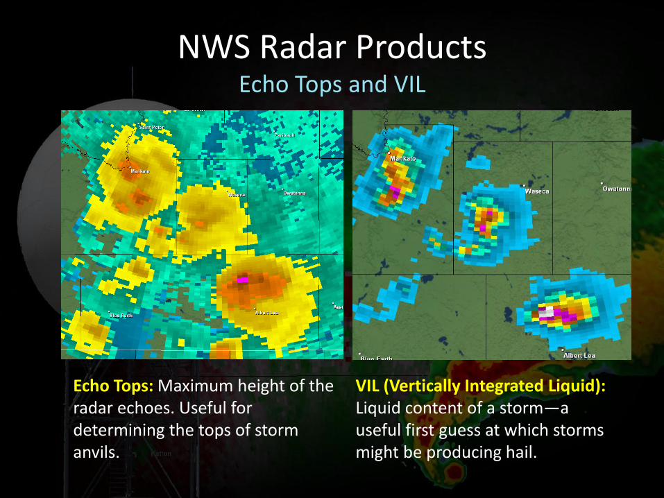
NWS Radar Products Echo Tops and VIL
Echo Tops: Maximum height of the radar echoes. Useful for determining the tops of storm anvils.
VIL (Vertically Integrated Liquid): Liquid content of a storm—a useful first guess at which storms might be producing hail.
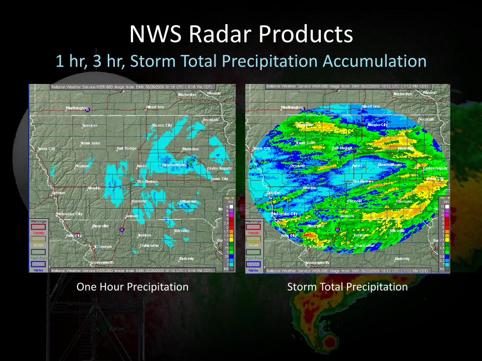
NWS Radar Products 1 hr, 3 hr, Storm Total Precipitation Accumulation
One Hour Precipitation Storm Total Precipitation
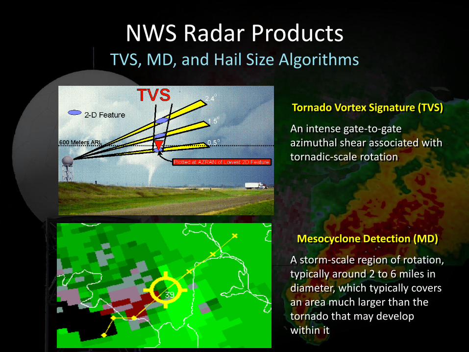
NWS Radar Products TVS, MD, and Hail Size Algorithms
Tornado Vortex Signature (TVS)
An intense gate-to-gate azimuthal shear associated with tornadic-scale rotation
Mesocyclone Detection (MD)
A storm-scale region of rotation, typically around 2 to 6 miles in diameter, which typically covers an area much larger than the tornado that may develop within it
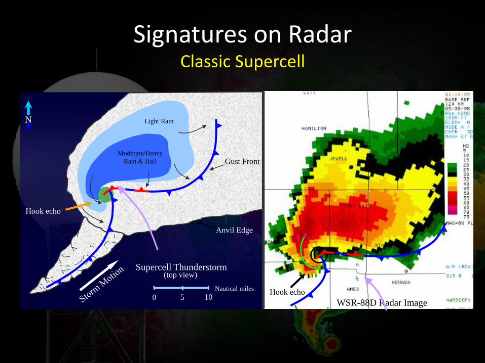
Signatures on Radar Classic Supercell
0 5 10 Nautical miles
Light Rain
Moderate/Heavy
Rain & Hail
Supercell Thunderstorm (top view)
Anvil Edge
Gust Front
WSR-88D Radar Image
N
Hook echo
Hook echo
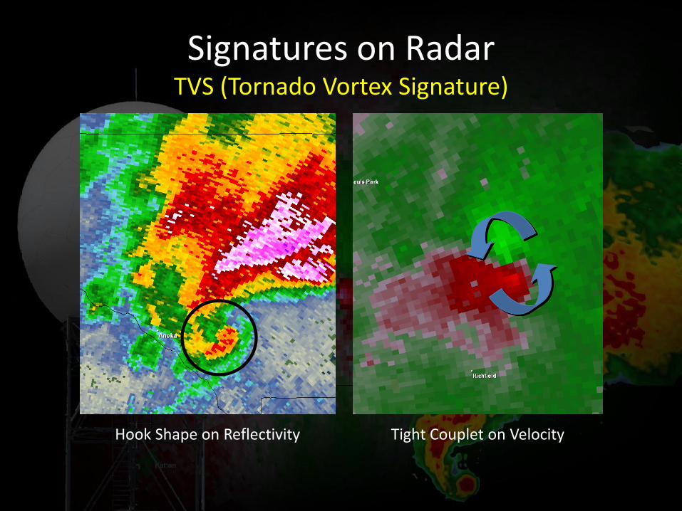
Signatures on Radar TVS (Tornado Vortex Signature)
Hook Shape on Reflectivity Tight Couplet on Velocity
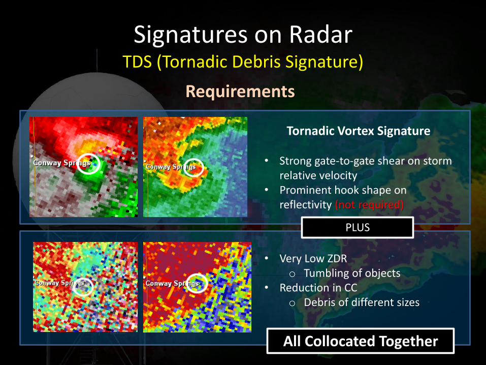
Signatures on Radar TDS (Tornadic Debris Signature)
Tornadic Vortex Signature
• Strong gate-to-gate shear on storm relative velocity
• Prominent hook shape on reflectivity (not required)
PLUS
Requirements
• Very Low ZDR o Tumbling of objects
• Reduction in CC o Debris of different sizes
All Collocated Together
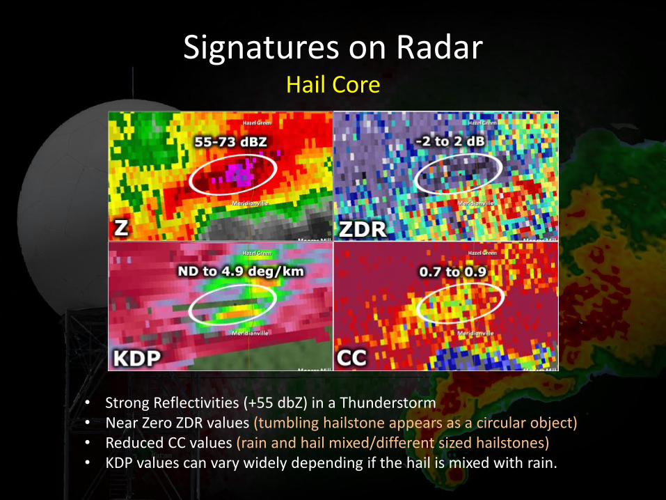
Signatures on Radar Hail Core
• Strong Reflectivities (+55 dbZ) in a Thunderstorm • Near Zero ZDR values (tumbling hailstone appears as a circular object) • Reduced CC values (rain and hail mixed/different sized hailstones) • KDP values can vary widely depending if the hail is mixed with rain.
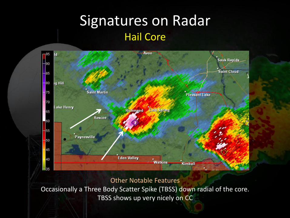
Signatures on Radar Hail Core
Other Notable Features Occasionally a Three Body Scatter Spike (TBSS) down radial of the core.
TBSS shows up very nicely on CC
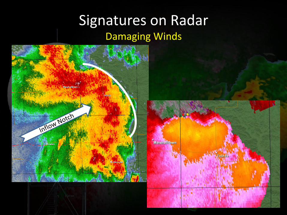
Signatures on Radar Damaging Winds
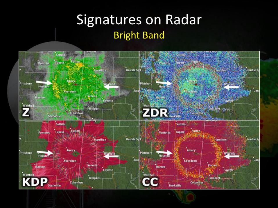
Signatures on Radar Bright Band
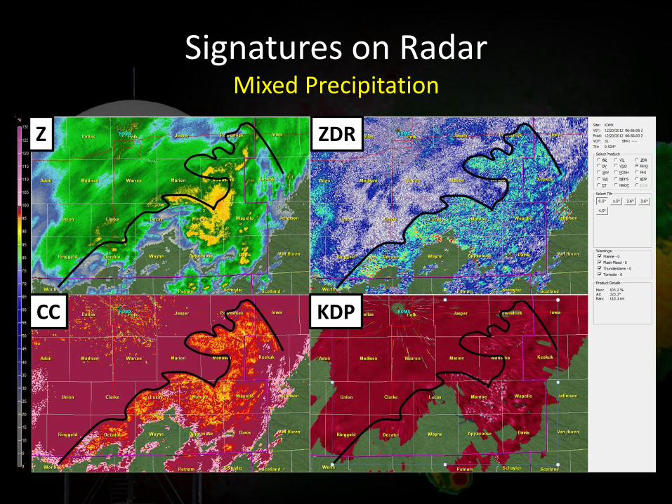
Signatures on Radar Mixed Precipitation
Z ZDR
KDP CC
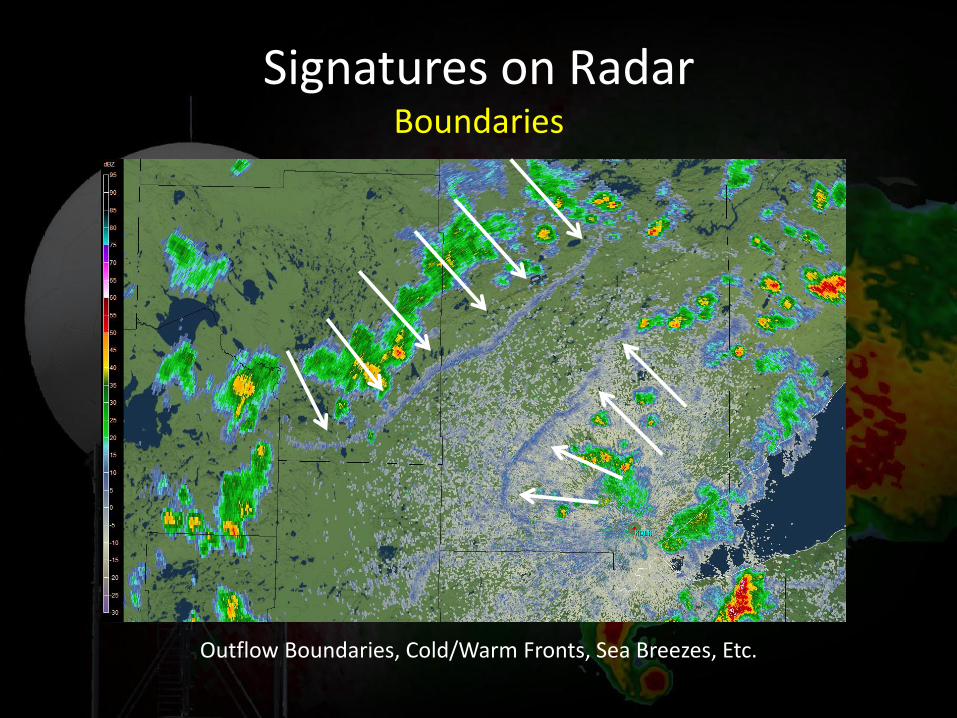
Signatures on Radar Boundaries
Outflow Boundaries, Cold/Warm Fronts, Sea Breezes, Etc.
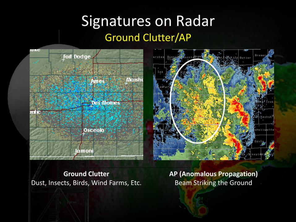
Signatures on Radar Ground Clutter/AP
Ground Clutter Dust, Insects, Birds, Wind Farms, Etc.
AP (Anomalous Propagation) Beam Striking the Ground
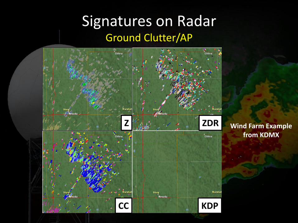
Signatures on Radar Ground Clutter/AP
Wind Farm Example from KDMX
CC
Z ZDR
KDP
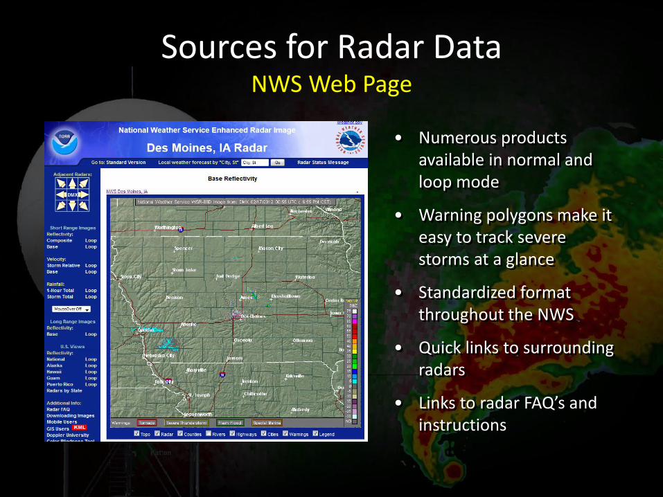
Sources for Radar Data NWS Web Page
• Numerous products available in normal and loop mode
• Warning polygons make it easy to track severe storms at a glance
• Standardized format throughout the NWS
• Quick links to surrounding radars
• Links to radar FAQ’s and instructions
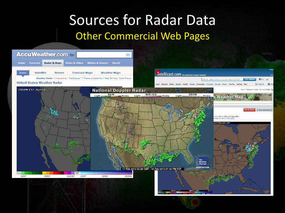
Sources for Radar Data Other Commercial Web Pages
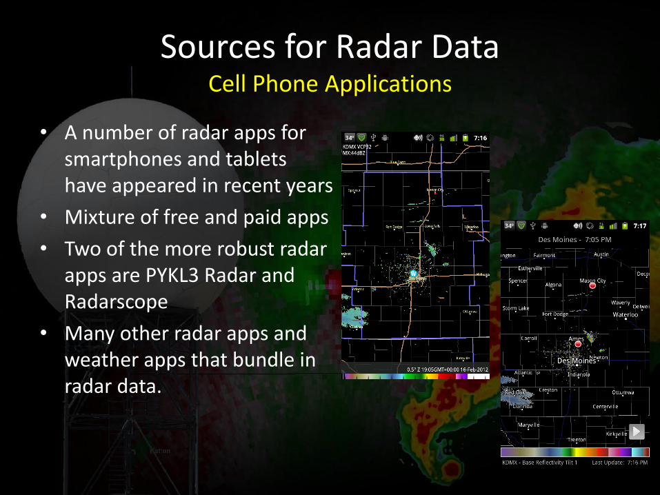
• A number of radar apps for smartphones and tablets have appeared in recent years
• Mixture of free and paid apps
• Two of the more robust radar apps are PYKL3 Radar and Radarscope
• Many other radar apps and weather apps that bundle in radar data.
Sources for Radar Data Cell Phone Applications
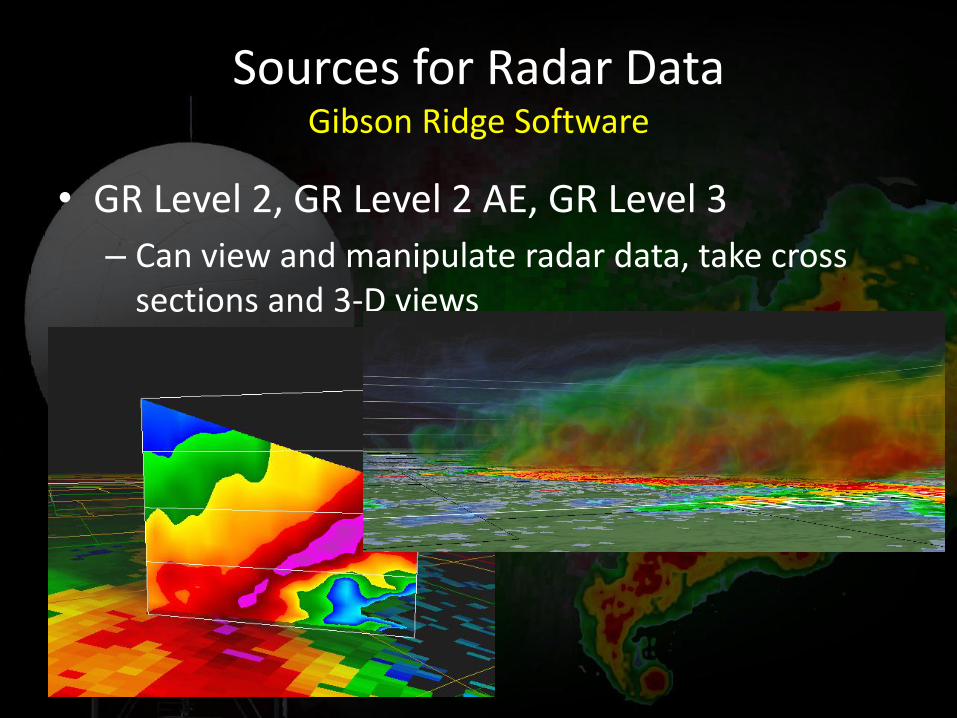
• GR Level 2, GR Level 2 AE, GR Level 3
– Can view and manipulate radar data, take cross sections and 3-D views
Sources for Radar Data Gibson Ridge Software
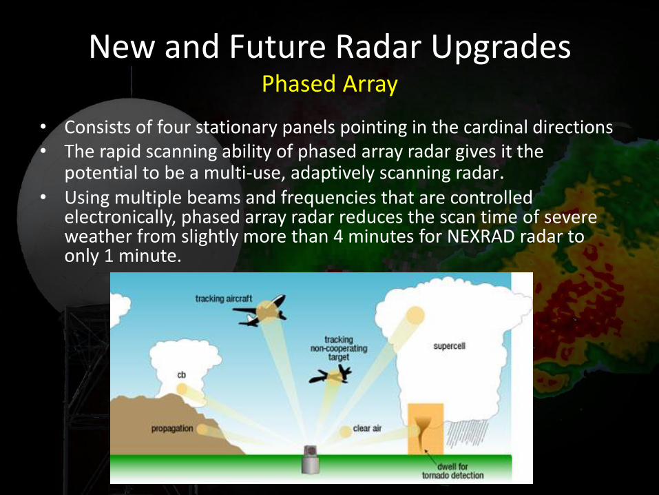
• Consists of four stationary panels pointing in the cardinal directions • The rapid scanning ability of phased array radar gives it the
potential to be a multi-use, adaptively scanning radar. • Using multiple beams and frequencies that are controlled
electronically, phased array radar reduces the scan time of severe weather from slightly more than 4 minutes for NEXRAD radar to only 1 minute.
New and Future Radar Upgrades Phased Array
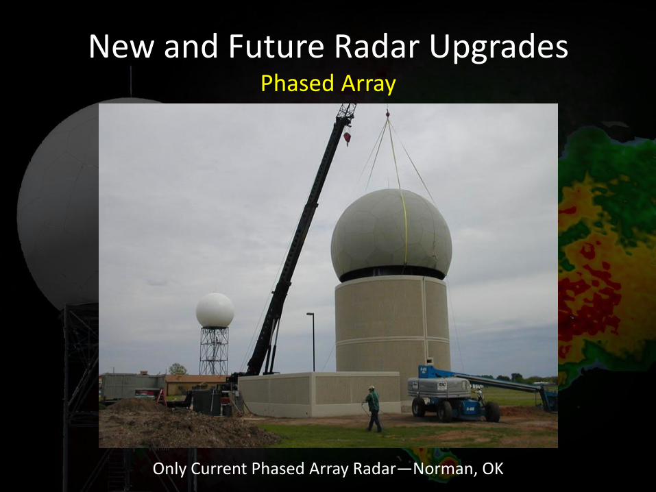
Only Current Phased Array Radar—Norman, OK
New and Future Radar Upgrades Phased Array
Questions?
Other Helpful Radar Web Pages http://www.srh.noaa.gov/jetstream/doppler/doppler_intro.htm
http://www.wdtb.noaa.gov/courses/dloc/topic3/lesson1/index.html
http://www.weather.gov/DesMoines [email protected]