Embed Size (px)
Citation preview
U.S. DEPARTMENT OF COMMERCE/ National Oceanic and Atmospheric Administration
OFFICE OF THE FEDERAL COORDINATOR FOR METEOROLOGICAL SERVICES AND SUPPORTING RESEARCH
FEDERAL METEOROLOGICAL HANDBOOK NO. 11
WSR-88D METEOROLOGICAL OBSERVATIONS
PART A SYSTEM CONCEPTS, RESPONSIBILITIES, AND PROCEDURES
FCM-H11A-2016
Washington, DC January 2016
THE INTERDEPARTMENTAL COMMITTEE FOR METEOROLOGICAL SERVICES AND SUPPORTING RESEARCH (ICMSSR)
DR. WILLIAM SCHULZ, CO-CHAIR Federal Coordinator DR. LOUIS UCCELLINI National Weather Service, Department of Commerce DR. STEPHEN VOLZ National Environmental Satellite, Data, and Information Service, Department of Commerce DR. SCOTT LIVEZEY United States Navy, Department of Defense MR. RALPH STOFFLER United States Air Force, Department of Defense MR. JOEL WALL Science and Technology Directorate, Department of Homeland Security MR. ROY WRIGHT Federal Emergency Management Agency, Department of Homeland Security DR. JONATHAN M. BERKSON United States Coast Guard, Department of Homeland Security MR. PAUL FONTAINE Federal Aviation Administration, Department of Transportation MR. MARK KEHRLI Federal Highway Administration, Department of Transportation
MR. JOHN VIMONT Department of the Interior MR. MARK BRUSBERG Department of Agriculture MR. RICKEY PETTY Department of Energy DR. DAVID REIDMILLER Department of State DR. ROHIT MATHUR Environmental Protection Agency MR. STEVEN CLARKE National Aeronautics and Space Administration DR. PAUL SHEPSON National Science Foundation MR. DONALD EICK National Transportation Safety Board MR. SCOTT FLANDERS U.S. Nuclear Regulatory Commission MR. MICHAEL CLARK Office of Management and Budget MR. MICHAEL BONADONNA Office of the Federal Coordinator for Meteorology, Secretariat
FEDERAL COORDINATOR FOR METEOROLOGICAL SERVICES AND SUPPORTING RESEARCH
WSR-88D METEOROLOGICAL OBSERVATIONS
FEDERAL METEOROLOGICAL HANDBOOK NO. 11
JANUARY 2016
PART A: SYSTEM CONCEPTS, RESPONSIBILITIES, AND PROCEDURES
FCM-H11A-2016 Washington, DC

FMH-11-PART A
PREFACE The Federal Coordinator for Meteorological Services and Supporting Research has the responsibility to maintain and publish Federal Meteorological Handbooks. This series of documents provides standards and procedures to facilitate the efficient collection, sharing, and use of meteorological information by agencies of the federal government and private industry.
The original Federal Meteorological Handbook, Number 11 (FMH-11), WSR-88D METEOROLOGICAL OBSERVATIONS, was prepared and published under the auspices of the Office of the Federal Coordinator for Meteorological Services and Supporting Research (OFCM) at the request of the Next Generation Weather Radar (NEXRAD) Program Council and in coordination with the federal agencies that are represented on the Interdepartmental Committee for Meteorological Services and Supporting Research (ICMSSR). The purpose of FMH-11 is to standardize, insofar as practical, the operation of the Weather Surveillance Radar-1988, Doppler (WSR-88D) systems and the procedures used by personnel of the Departments of Commerce, Defense, and Transportation. By approving publication of this handbook, those agencies have agreed to operate their WSR-88D systems accordingly. Some flexibility under certain meteorological, siting, or mission circumstances is permitted to enhance the quality and utility of some WSR-88D products.
All revisions are coordinated among the NEXRAD triagencies (Department of Commerce (DOC), Department of Defense (DoD), and Department of Transportation (DOT)) and approved by ICMSSR; thus, they possess the same authority as the initial edition of FMH-11. The revision process is dependent upon the evolution of WSR-88D subsystems hardware, software, and products, as well as resources to make the updates.
The agencies should review the documents annually. The goal is to review and update the handbooks (as necessary) as part of every major WSR-88D software build release. As required, the handbooks will be updated and published in electronic format, and made available on the OFCM home page at http://www.ofcm.gov/homepage/text/pubs.htm. Readers can make copies of the handbooks without a request for approval from the OFCM. A summary of changes made during updates will be in the preface of each part.
In all, FMH-11 has four parts:
Part A - System Concepts, Responsibilities, and Procedures
Part B - Doppler Radar Theory and Meteorology
Part C - WSR-88D Products and Algorithms
Part D - WSR-88D Systems Description and Operational Applications
Part A provides an introduction for the entire handbook including the restatement of some policy, definitions of terms, and agencies' functions and responsibilities under the WSR-88D System Concept. It provides references for the location of systems and WSR-88D products. Familiarity with Part A should aid the user of other parts of FMH-11 and provide a better understanding of the overall WSR-88D system and operations.
1
FMH-11-PART A
Summary of Major Changes:
This issue of FMH-11 Part A replaces the February 2013 version. The document has been updated to streamline information by removing obsolete details and providing links to additional information.
William Schulz, PhD
Federal Coordinator for Meteorological Services and Supporting Research
2
FMH-11-PART A
Table of Contents PREFACE ........................................................................................................................................... 1 TABLE OF CONTENTS ................................................................................................................... 3 LIST OF TABLES .............................................................................................................................. 5 DEFINITION OF TERMS ................................................................................................................. 6 LIST OF RESOURCES ...................................................................................................................... 7 CHAPTER 1: BACKGROUND ......................................................................................................... 9
1.1 Introduction. ............................................................................................ 9
1.2 Purpose and Scope. ................................................................................. 9
1.3 Policy. ..................................................................................................... 9
1.4 Changes ................................................................................................... 9 CHAPTER 2: WSR-88D SYSTEM CONCEPT .............................................................................. 11
2.1 Overview of Agency Functions. ........................................................... 11
2.1.1 Department of Commerce. ............................................................ 11
2.1.2 Department of Defense .................................................................. 11
2.1.3 Department of Transportation. ...................................................... 11
2.2 System Support Management. .............................................................. 11
2.3 Memorandum of Agreement for the Interagency Operation of the WSR-88D. ................................................................................................. 11
2.4 External User Access to WSR-88D Products and Level II Data. ......... 12
2.4.1 Products. ........................................................................................ 12
2.4.2 Level II Data. ................................................................................. 12
2.4.3 Retention by the National Centers for Environmental Information (NCEI). ....................................................................................... 12
CHAPTER 3: SITE RESPONSIBILITIES ...................................................................................... 13
3.1 Introduction. .......................................................................................... 13
3.2 Network Site Responsibilities. .............................................................. 13 CHAPTER 4: DATA TYPES, RESOLUTION, OPERATIONAL MODES, VOLUME COVERAGE PATTERNS, AND PRODUCTS ............................................................................... 15
4.1 Introduction. .......................................................................................... 15
4.2 WSR-88D Data Types. ......................................................................... 15
4.2.1 Base Data Moments. ...................................................................... 15
3
FMH-11-PART A
4.2.2 Dual Polarization Variables. .......................................................... 15
4.3 Data Resolution. .................................................................................... 15
4.3.1 Super Resolution............................................................................ 15
4.3.2 Standard Resolution. ...................................................................... 15
4.4 Operational Modes. ............................................................................... 16
4.4.1 Mode A – Precipitation Mode (VCPs 11, 12, 21, 121, 211, 212, and 221). ............................................................................................ 16
4.4.2 Mode B – Clear Air Mode (VCPs 31 and 32). .............................. 16
4.5 Volume Coverage Patterns. .................................................................. 16
4.5.1 Dynamic Scanning Techniques. .................................................... 16
4.6 WSR-88D Product Suite. ...................................................................... 16 APPENDIX A: ACRONYMS AND ABBREVIATIONS ............................................................... 19 APPENDIX B: GLOSSARY............................................................................................................ 21
4
FMH-11-PART A
LIST OF TABLES 4-1. Volume Coverage Pattern Descriptions……………………………………………………18
5
FMH-11-PART A
DEFINITION OF TERMS WSR-88D System. A WSR-88D system is composed of a Weather Surveillance Radar - 1988, Doppler and communications links to distribute products to various agency display systems. The functional designations are Radar Data Acquisition (RDA), Radar Product Generator (RPG), and agency user display systems.
External User. An external user is anyone other than a Principal User who uses WSR-88D data and products (e.g., information service companies, broadcast meteorologists, aviation interests, marine interests, industrial meteorologists, other government agencies, and universities).
National Weather Radar Network. The national weather radar network consists of WSR-88D sites dispersed throughout the United States and its territories.
Network Site. A network site is a DOC, DoD, or DOT WSR-88D site that continuously collects, collates, and makes available radar data and products in support of the national weather radar network. The data from these sites are also centrally collected and archived in real time.
NEXRAD Program Council (NPC). Body that provided overall policy, management guidance, and resource commitments for the NEXRAD Program until it was retired in 1997. The NPC could be reassembled under extenuating circumstance, but presently all NPC responsibilities have been delegated to the NEXRAD Program Management Committee.
NEXRAD Program Management Committee (NPMC). Tri-agency committee that makes decisions regarding changes, modifications, and new work that require authority to expend significant resources.
Principal User. Principal users are the NWS, Air Force, and FAA.
Level II Data. Digital radial base data (Reflectivity, Mean Radial Velocity, and Spectrum Width) and Dual Polarization variables (Differential Reflectivity, Correlation Coefficient, and Differential Phase) output from the signal processor in the RDA. The output also includes status information required to properly interpret the data (e.g., information on synchronization, calibration, date, time, antenna position, Nyquist velocity, and operational mode).
Level III Data. Output product data of the RPG that are used for weather analysis, forecasts, warnings, and weather tracking. The pre-defined products are provided in near real-time to the NWS Radar Product Central Collection Dissemination Service (RPCCDS) and archived by the National Centers for Environmental Information (NCEI).
6
FMH-11-PART A
LIST OF RESOURCES WSR-88D Radar Operations Center (ROC) web page: http://www.roc.noaa.gov/WSR88D/
WSR-88D Interface Control Documents for product information: http://www.roc.noaa.gov/WSR88D/BuildInfo/Files.aspx
Dual polarization training: training for meteorologists and non-meteorologists is available at the National Weather Service (NWS) Warning Decision Training Branch (WDTB) web site: http://www.wdtb.noaa.gov/courses/dualpol/Outreach/index.html
Software build-specific training materials: http://www.wdtb.noaa.gov/buildTraining/RPG-RDA.html
NWS real-time Level II data monitoring: http://weather.noaa.gov/monitor/radar2/
NWS real-time Level III products status: http://weather.noaa.gov/monitor/radar/
NWS RPCCDS information for product users: http://www.nws.noaa.gov/tg/rpccds.php
NCEI radar resources: order archived Level II and Level III data via ftp, use NCEI Java Viewer to view the data, etc.: https://www.ncdc.noaa.gov/oa/radar/radardata.html
Obtain RPG source code and executables for a LINUX Platform using the Common Operations and Development Environment (CODE): http://www.nws.noaa.gov/code88d/index.html
7

FMH-11-PART A
8
FMH-11-PART A
CHAPTER 1 BACKGROUND
1.1 Introduction. The impetus for originally preparing this handbook was the development, acquisition, and deployment of the Weather Surveillance Radar - 1988, Doppler (WSR-88D). The motivation for this update is to reflect the changing operation of the WSR-88D system as it evolves to meet new operational requirements.
Federal Meteorological Handbook, Number 11 (FMH-11) replaced Federal Meteorological Handbook, Number 7 (FMH-7), Weather Radar Observations when the WSR-88D was deployed. The original FMH-11 was developed by an OFCM working group comprising personnel from the National Weather Service (NWS) within the Department of Commerce (DOC), the Air Force within the Department of Defense (DoD), and the Federal Aviation Administration (FAA) within the Department of Transportation (DOT). Subsequent updates have been written by the tri-agency WSR-88D Radar Operations Center (ROC) with editorial support from OFCM for coordination and approval by the Interdepartmental Committee for Meteorological Services and Supporting Research.
1.2 Purpose and Scope. This handbook provides information, guidance, and instruction regarding the tri-agency management and operation of the WSR-88D systems. The following definitions apply throughout this handbook:
Shall: means that a procedure or practice is mandatory.
Should: means that a procedure or practice is recommended.
May: means that a procedure or practice is optional.
Will: means futurity, not a requirement to be applied to a procedure or practice.
1.3 Policy. The WSR-88D systems shall be operated to satisfy the integrated set of federal requirements that emanated primarily from the public charters of the departments represented in the Next Generation Weather Radar (NEXRAD) Program Council (NPC) and the NEXRAD Program Management Committee (NPMC). This handbook has been developed to establish standards for the tri-agency operation of the WSR-88D systems and the collection, processing, and dissemination of information to meet those requirements. As a federal system, it shall be operated to meet as many requirements as possible. However, this handbook guides operations to fulfill first those fundamental requirements of the agencies that founded the program.
1.4 Changes. Suggestions for modifications and additions should be sent to the WSR-88D Radar Operations Center webmaster at http://www.roc.noaa.gov/WSR88D/Comments.aspx for consideration for inclusion in a future update. No modification shall be adopted that impacts fulfillment of the integrated requirements that drove the development of the program without the consent of the NPMC. Additionally, this handbook will be reviewed and modified if the Memorandum of Agreement for the Interagency Operation of the WSR-88D is modified, expires or is terminated.
9

FMH-11-PART A
10
FMH-11-PART A
CHAPTER 2 WSR-88D SYSTEM CONCEPT
2.1 Overview of Agency Functions. The following sections provide discussions of each principal user agency's functions with regard to WSR-88D system operations.
2.1.1 Department of Commerce. Within the DOC, the National Oceanic and Atmospheric Administration’s (NOAA) NWS is the civilian weather agency of the Federal Government. As such, it must fill a broad spectrum of climatological, meteorological and hydrological requirements in its efforts to protect life and property and support the economy of the United States. Specifically, the NWS is responsible for the detection and public warning of hazardous weather such as tornadoes, severe thunderstorms, hurricanes, floods, flash floods, winter storms, damaging tides, and any other meteorological or hydrological event with possible harmful effects. The NWS provides weather information for marine operations covering offshore, coastal, Great Lakes, and river and harbor areas. The NWS also routinely provides forecasts for civilian aviation, reservoir regulation, and wild land firefighting agencies. To assist in fulfilling these responsibilities, the NWS operates the national weather radar network and uses information from DoD and DOT WSR-88D systems.
2.1.2 Department of Defense. Within the DoD, the U.S. Air Force operates WSR-88D systems in the continental United States (CONUS), Guam, Japan, Korea, and Portugal. The Air Force uses information from the DOC and DOT WSR-88D systems in support of meteorological and aerospace environmental services to the Air Force, Army, and other DoD elements. The Air Force is responsible for providing and relaying severe weather warnings for the protection of DoD resources and personnel, managing flood control reservoirs (U.S. Army Corps of Engineers), and providing environmental information to aid the military decision-making process.
2.1.3 Department of Transportation. The DOT, through the FAA, is responsible for the safe and efficient utilization of the National Airspace System. In meeting this responsibility, DOT disseminates information on the location and intensity of potentially hazardous weather conditions to pilots, air traffic controllers, air traffic flow management, and others concerned with aviation. The DOT obtains and processes data from DOC, DoD, and DOT WSR-88D systems for use by DOT personnel and DOC personnel located in DOT facilities.
2.2 System Support Management. Operational support for all deployed WSR-88D units is the responsibility of the tri-agency ROC located in Norman, Oklahoma. The ROC provides centralized radar operations support, field assistance, software maintenance, engineering support, and depot-level support (e.g., bull gear replacement, certain Dual Polarization repairs) for the WSR-88D units deployed by the three Principal Users. In addition, the ROC provides tri-agency support for analyzing the potential impacts of wind turbines, communications towers, and other obstacles and potential sources of interference.
2.3 Memorandum of Agreement for the Interagency Operation of the WSR-88D. Policies, procedures, and operational concepts, as defined in this handbook, have been agreed to by each principal user agency. Each agency shall endeavor to support, to the highest degree possible and in accordance with the terms of the Memorandum of Agreement (MOA) for Interagency Operation of the WSR-88D, the data, product, and operational requirements of the other agencies. This supportive service shall be consistent with the capabilities and mission priorities of the agency that has received the request for support. The MOA also forms the basis for the membership,
11
FMH-11-PART A
leadership, and activities of the Unit Radar Committee (URC) that shall be at each WSR-88D site. The current MOA is available at: http://www.roc.noaa.gov/WSR88D/PublicDocs/MOA.pdf
2.4 External User Access to WSR-88D Products and Level II Data. Real-time access to products and Level II data can be achieved through two networks the NWS manages: (1) Products can be obtained through the NWS’ Radar Product Central Collection Dissemination Service (RPCCDS); and (2) Level II data can be obtained through the NWS’ Level II Data Collection and Distribution Network.
2.4.1 Products. The RPCCDS makes a predefined subset of all WSR-88D products available to external users, in near real time, from every WSR-88D except four remote OCONUS locations (Lajes Air Base (AB), Kadena AB, USAG Camp Humphreys, and Kunsan AB). Users can obtain products from the RPCCDS via a dedicated connection (Family of Services) or file transfer protocol. Additional RPCCDS information is available at: http://www.nws.noaa.gov/tg/rpccds.php. There is a small predefined subset of products provided to SBN/NOAAPORT users and a few products from each WSR-88D available at: http://radar.weather.gov. Non-NEXRAD agency connections to individual radar sites for products are not permitted.
2.4.2 Level II Data. The principal user agencies offer direct access to Level II data from operational sites on a limited basis to support government operations. Only certified systems will be permitted to connect to radars and only with advance tri-agency approval. For other users, the NWS operates a WSR-88D Level II Data Collection and Distribution Network. This network includes all 122 NWS radars, 22 DoD radars, and 12 OCONUS FAA radars. These data are available in near real time from many sources and can be used or redistributed without any restriction. Information on the network is available at http://www.roc.noaa.gov/WSR88D/Level_II/Level2Info.aspx.
2.4.3 Retention by the National Centers for Environmental Information (NCEI). Archive Level II and Archive Level III data are electronically sent to the NCDC in real time for permanent retention. The NCEI receives, archives, and makes these products and data available upon request. Information on the WSR-88D data in the NCEI archives can be found at http://www.ncdc.noaa.gov/oa/radar/radarresources.html.
12
FMH-11-PART A
CHAPTER 3 SITE RESPONSIBILITIES
3.1 Introduction. The WSR-88D system is vital to supporting the operational mission of each principal user agency. Therefore, WSR-88D systems shall be operated to satisfy the integrated needs of all three agencies. The units shall be operated in accordance with the procedures described in this handbook and as agreed to by the URC within the terms of the MOA for the Interagency Operation of the WSR-88D. The weather forecast office (WFO), weather flight or operational weather squadron that is the manager of the Master System Control Function (MSCF) chairs the URC.
A list of WSR-88D sites can be found at: http://www.roc.noaa.gov/WSR88D/Program/NetworkSites.aspx
Additional site-specific information can be found in the Site ID Database: http://www.roc.noaa.gov/WSR88D/Program/SiteID.aspx
3.2 Network Site Responsibilities. WSR-88D Network Sites shall:
• Operate continuously, 24 hours per day • Collect, collate, and disseminate high quality radar data and products in support of the national
weather radar network, the FAA’s enroute weather radar coverage, and DoD operations. • Use one of the operational modes and volume coverage patterns (VCPs) agreed to by the URC. • Set the default precipitation VCP as agreed to by the URC. • Set the Mode Selection Function to switch the RPG Operational Mode to Clear Air (i.e., to a
Clear Air VCP) and to switch the mode from Clear Air to Precipitation as agreed to by the URC.
• Apply appropriate clutter filtering (e.g. Clutter Mitigation Decision Algorithm (CMD)) to reduce ground clutter and anomalous propagation (AP) for the WSR-88D systems the WFOs control, including DoD and DOT systems, via the MSCF.
In addition to the above responsibilities, DoD WSR-88D Network Sites shall:
• Maintain an Implementing Agreement (IA) with the NWS WFO controlling the MSCF (where applicable) regarding the WSR-88D maintenance. The DoD maintenance organization will initiate and maintain the IA. The IA template can be obtained from the DoD WSR-88D focal point listed in Appendix B of the MOA for Interagency Operation of the WSR-88D.
13

FMH-11-PART A
14
FMH-11-PART A
15
CHAPTER 4 DATA TYPES, RESOLUTION, OPERATIONAL MODES, VOLUME COVERAGE
PATTERNS, AND PRODUCTS 4.1 Introduction. This chapter outlines the WSR-88D data types, data resolution, data processing modes, operational modes, volume coverage patterns, and the full suite of products that may be generated.
4.2 WSR-88D Data Types. The WSR-88D RDA produces three Base Data Moments (Reflectivity, Mean Radial Velocity and Spectrum Width) and three Dual Polarization Variables (Differential Reflectivity, Correlation Coefficient and Differential Phase) for every scanned elevation angle. These data types are described in more detail in Chapter 2 of FMH-11 Part C.
4.2.1 Base Data Moments.
Reflectivity – The measure of the efficiency of a target in intercepting and returning radio energy. With hydrometeors, it is a function of the drop size distribution, number of particles per unit volume, physical state (ice or water), shape, and aspect.
Mean Doppler Velocity – Reflectivity-weighted average motion of targets toward or away from the radar within a given volume sample.
Spectrum Width – A measure of dispersion of velocities within the radar sample volume.
Standard deviation of the mean radial velocity spectrum.
4.2.2 Dual Polarization Variables.
Differential Reflectivity – The ratio of the reflected horizontal and vertical power returns. It indicates drop shape, which provides an estimate of average drop size and precipitation type (e.g. hail or rain). In addition, differential reflectivity can be used to identify some non-meteorological targets.
Correlation Coefficient – A correlation between the reflected horizontal and vertical power returns. It indicates regions where there is a mixture of precipitation types, such as rain and snow or rain and hail, as well as non-meteorological targets.
Differential Phase – A comparison of the returned phase difference between the horizontal and vertical pulses. This phase difference is caused by the difference in the number of wave cycles (or wavelengths) along the propagation path for horizontal and vertically polarized waves. It indicates precipitation type and intensity.
4.3 Data Resolution. Based on meteorological conditions and local operating policy, these data may be collected in Super Resolution or Standard Resolution.
4.3.1 Super Resolution. Super Resolution data is collected in the lowest 2 or 3 scans, depending on the VCP. During super resolution scans the RDA processes data (Base Moments and Dual Polarization Variables) with 0.5° azimuthal by 0.25 km (0.13 nm) range resolution. The reflectivity data are processed to a range of 460 km (248 nm) while the Doppler data and Dual Polarization Variables are processed to 300 km (161 nm). Standard resolution data is collected on higher scans and may be collected on all scans at the discretion of the user.
4.3.2 Standard Resolution. Standard resolution data produces Base Moments and Dual
FMH-11-PART A
Polarization Variables with 1° azimuthal by 0.25 km (0.13 nm) range resolution. Reflectivity data are provided to a range of 460 km (248 nm) while the Doppler data and Dual Polarization Variables are provided to 300 km (161 nm).
4.4 Operational Modes. Two operational modes have been implemented: Clear Air and Precipitation. Each mode has one product generation list and at least two VCPs. Selection of the operational mode is closely related to the detected coverage of precipitation. The Mode Selection Function (MSF) is designed to automatically determine if precipitation is occurring within 230 km (124 nm) of the radar. The MSF examines the area of reflectivity returns at a specified intensity and compares it to the predefined threshold determined by the URC.
Automatic mode switching from Clear Air to Precipitation and from Precipitation to Clear Air is operator-specified based on URC agreement. Precipitation accumulation estimates are made in all operational modes.
4.4.1 Mode A – Precipitation Mode (VCPs 11, 12, 21, 121, 211, 212, and 221). This mode should be used when significant weather echoes are present or severe weather is occurring or is anticipated. Usually, this mode will have been selected automatically due to the detection of reflectivity exceeding the predefined threshold. At times, however, such as during the early, mid-level formation of convective echoes, the RPG MSCF operator may choose to enter the Precipitation Mode manually.
4.4.2 Mode B – Clear Air Mode (VCPs 31 and 32). This mode may be used when there is no detectable precipitation or when precipitation intensity is light and/or areal extent is small, such as light stratiform precipitation or snow. The RPG software will not allow a change to Clear Air Mode until precipitation exceeding the predefined thresholds has not been detected for the period specified in the Clear Air Mode Selection Time.
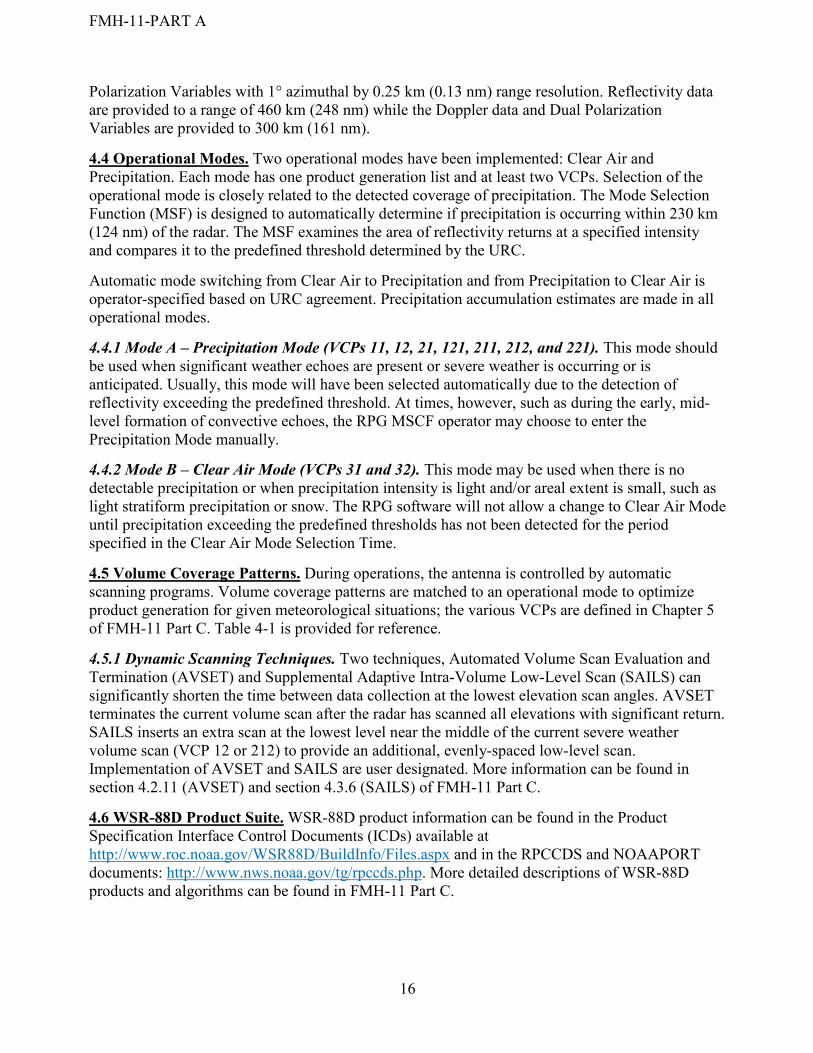
4.5 Volume Coverage Patterns. During operations, the antenna is controlled by automatic scanning programs. Volume coverage patterns are matched to an operational mode to optimize product generation for given meteorological situations; the various VCPs are defined in Chapter 5 of FMH-11 Part C. Table 4-1 is provided for reference.
4.5.1 Dynamic Scanning Techniques. Two techniques, Automated Volume Scan Evaluation and Termination (AVSET) and Supplemental Adaptive Intra-Volume Low-Level Scan (SAILS) can significantly shorten the time between data collection at the lowest elevation scan angles. AVSET terminates the current volume scan after the radar has scanned all elevations with significant return. SAILS inserts an extra scan at the lowest level near the middle of the current severe weather volume scan (VCP 12 or 212) to provide an additional, evenly-spaced low-level scan. Implementation of AVSET and SAILS are user designated. More information can be found in section 4.2.11 (AVSET) and section 4.3.6 (SAILS) of FMH-11 Part C.
4.6 WSR-88D Product Suite. WSR-88D product information can be found in the Product Specification Interface Control Documents (ICDs) available at http://www.roc.noaa.gov/WSR88D/BuildInfo/Files.aspx and in the RPCCDS and NOAAPORT documents: http://www.nws.noaa.gov/tg/rpccds.php. More detailed descriptions of WSR-88D products and algorithms can be found in FMH-11 Part C.
16
FMH-11-PART A
17
TABLE 4-1 VOLUME COVERAGE PATTERN DESCRIPTIONS
Quick Reference VCP Comparison Table for RPG Operators, July 2012 Slices Tilts VCP Time* Usage Limitations
14
11 5 mins
Severe and non-severe convective events. Local 11 has Rmax=80nm. Remote 11 has Rmax=94nm.
Fewer low elevation angles make this VCP less effective for long-range detection of storm features when compared to VCPs 12 and 212.
211 5 mins
Widespread precipitation events with embedded, severe convective activity (e.g. MCS, hurricane). Significantly reduces range-obscured V/SW data when compared to VCP 11.
All Bins clutter suppression is NOT recommended. PRFs are not editable for SZ-2 (Split Cut) tilts.
14
12 4 mins
Severe convective events. Extra low elevation angles increase low-level vertical resolution when compared to VCP 11.
High antenna rotation rates slightly decrease accuracy of the base data estimates.
212 4½ mins
Rapidly evolving, widespread severe convective events (e.g. squall line, MCS). Increased low-level vertical resolution compared to VCP 11. Significantly reduces range-obscured V/SW data when compared to VCP 12.
All Bins clutter suppression is NOT recommended. PRFs are not editable for SZ-2 (Split Cut) tilts. High antenna rotation rates slightly decrease accuracy of the base data estimates.
9
21 6 mins
Non-severe convective precipitation events. Local 21 has Rmax=80nm. Remote 21 has Rmax=94nm.
Gaps in coverage above 5°.
121 6 mins
VCP of choice for hurricanes. Widespread stratiform precipitation events. Significantly reduces range- obscured V/SW data within 300 km when compared to other VCPs.
All Bins clutter suppression is NOT recommended. High antenna rotation rates slightly decrease accuracy of the base data estimates.PRFs are not editable. Gaps in coverage above 5°.
221 6 mins
Widespread precipitation events with embedded, possibly severe convective activity (e.g. MCS, hurricane). Reduces range-obscured V/SW data out to 300 km when compared to other VCPs
All Bins clutter suppression is NOT recommended. PRFs are not editable for SZ-2 (Split Cut) tilts. Gaps in coverage above 5°.
5 31 10
mins
Clear-air, snow, and light stratiform precipitation. Best sensitivity. Detailed boundary layer structure often evident.
Susceptible to velocity dealiasing failures. No coverage above 5°. Rapidly developing convective echoes aloft might be missed.
32 10 mins
Clear-air, snow, and light stratiform precipitation.
No coverage above 5°. Rapidly developing convective echoes aloft might be missed.
* VCP update times are approximate.

FMH-11-PART A
18
FMH-11-PART A
APPENDIX A ACRONYMS AND ABBREVIATIONS
AGL Above Ground Level
AVSET Automated Volume Scan Evaluation and Termination
CMD Clutter Mitigation Decision Algorithm
CONUS Continental United States
DOC Department of Commerce
DoD Department of Defense
DOT Department of Transportation
FAA Federal Aviation Administration
FMH Federal Meteorological Handbook
IA Implementing Agreement
ICMSSR Interdepartmental Committee for Meteorological Services and Supporting Research
MOA Memorandum of Agreement
MSCF Master System Control Function
MSL Mean Sea Level
NCEI National Centers for Environmental Information
NEXRAD Next Generation Weather Radar
NOAA National Oceanic and Atmospheric Administration
NPC NEXRAD Program Council
NPMC NEXRAD Program Management Committee
NWS National Weather Service
OCONUS Outside the Continental United States
OFCM Office of the Federal Coordinator for Meteorological Services and Supporting Research
PRF Pulse Repetition Frequency
RDA Radar Data Acquisition
ROC WSR-88D Radar Operations Center
RPCCDS Radar Product Central Collection Dissemination Service
RPG Radar Product Generator
19
FMH-11-PART A
SAILS Supplemental Adaptive Intra-Volume Low-Level Scan
SZ-2 Sachidananda – Zrnic Algorithm
URC Unit Radar Committee
VCP Volume Coverage Pattern
WFO Weather Forecast Office
WG/DRMO Working Group for Doppler Radar Meteorological Observations
WSR-88D Weather Surveillance Radar - 1988, Doppler
20
FMH-11-PART A
21
APPENDIX B GLOSSARY
Adaptable Parameter: Generally, data related to a specific WSR-88D system. These data may consist of meteorological or hydrological parameters, or of geographic boundaries, political boundaries, system configuration, telephone numbers, or similar data. Such data may be generated at either a centralized location or locally.
Automated Volume Scan Evaluation and Termination: An algorithm that meets WSR-88D agency requirements for faster VCP updates, especially in severe weather situations. The algorithm terminates a volume scan after the WSR-88D has scanned all of the elevations with significant returns.
Clutter Mitigation Decision Algorithm: An advanced science algorithm that identifies clutter on a scan-by-scan basis and automatically builds a Bypass Map each volume scan.
Mode Selection Function: This function enables automatic switching between Precipitation Mode and Clear Air Mode as well as performing the mode switch manually.
NEXRAD Program Council: A NEXRAD Program tri-agency organization composed of senior representatives from DOC, DoD, and DOT, and the Federal Coordinator for Meteorological Services and Supporting Research. The NPC formally retired on November 17, 1997, after granting the PMC overall authority for the NEXRAD program.
NEXRAD Program Management Committee: A NEXRAD Program tri-agency organization comprised of representatives of DOC (NWS), DoD (Air Force Life Cycle Management Center), and DOT (FAA). The PMC provides oversight of the NEXRAD program budget, policy, resource commitment, and management guidance throughout the life cycle of the WSR-88D program to ensure that both common and unique agency requirements are addressed and resolved. The PMC also serves as a higher level Configuration Control Board for proposed major product improvement changes that affect the WSR-88D system configurations operationally deployed within the three agencies.
Supplemental Adaptive Intra-Volume Low-Level Scan: A dynamic scanning technique that inserts a new low-level split cut scan into severe weather VCPs 12 and 212. The effect of this scanning technique is to decrease the time interval between lowest angle split cut scans by half.
SZ-2 (Sachidananda–Zrnic Algorithm): Provides a range unfolding technique to alleviate the effects of the fundamental range-velocity ambiguity that exists with Doppler weather radars.
Unit Radar Committee: A coordinating committee, established by the MOA for Interagency Operation of the WSR-88D, composed of representatives of each principal user agency associated with a particular WSR-88D system.