Embed Size (px)
Citation preview
1
Summary Report of Planning and Management of
PT Globalindo Agung Lestari,
Kapuas and South Barito Regency and Central Kalimantan Province,
Indonesia
1. Executive Summary
PT. Globalindo Agung Lestari is a company operating palm oil plantation in the area of Central
Kalimantan Province. In operating oil palm plantations, the company is committed to adhering
to all applicable government policies, including in the areas of production, environment and
social economy. Further, the company is committed to maintain harmonious relationship with
the local communities and contribute to the economic livelihood of the local communities
through the development of plasma schemes, among other initiatives.
The concession area is situated in 15 villages in Mentangai and Kapuas Murung District, Kapuas
Regency and Dusun Hilir District, South Barito Regency, Central Kalimantan Province, and can
be reached from the capital of Kapuas Regency through land transportation and river for over a
distance of 40 km. As part of sustainable palm oil management, PT. GAL seeks to comply with
RSPO’s New Planting Procedures which was enforced on 1st January 2010.
The location permit (Izin Lokasi) for PT. Globalindo Agung Lestari was approved by Regent of
Kapuas, No. 444 year 2009 dated 15th
October 2009 and Regent of South Barito, No. 187/2012
dated 21st
May 2012. The Plantation Permit (Izin Usaha Perkebunan/IUP) was approved by
Regent of Kapuas No. 291/Disbunhut/2012 and Regent South Barito No. 44/Disbunhut/2007.
PT. GAL commissioned the preparation of AMDAL in 2010 and received government approval
on 5th
November 2010 No.188.44/340/2010. The AMDAL was prepared by an accredited
AMDAL consultant and included consideration of both negative as well as positive social and
environmental impacts. The scope of the AMDAL included assessment of impacts associated
with land development, infrastructure, road access, mill operations and transportation. The
AMDAL included assessment of the suitability of soils, topography and drainage and analysis of
the land cover vegetation. The AMDAL assessed the impacts on natural ecosystems and water
resources.
As HCVs were not covered by the AMDAL assessment, PT. GAL proceeded to have a separate
HCV assessment study carried out in 2013 by an appropriately qualified, experienced and RSPO
approved assessor team comprising an Ecologist and a Social Scientist from PT Sonokeling
Akreditas Nusantara. The HCV assessment collected additional information from local
communities on environmental and social aspects related to their use of resources from the
area.
The AMDAL preparation process involved a social survey at the communities likely to be directly
affected by the project. The survey involved the interview of local people to collect information
on the background of the respondent and also to seek the respondents’ views on the project as
2
well as suggestions. The AMDAL included assessment of current land resources use, land
ownership and user rights and potential social impacts.
PT. GAL has commenced a program to socialize information to the local communities on the
project and to receive feedback. This started with a meeting in November 2007 between the
Government, the representatives of local villages and PT. GAL.
Subsequently, PT. GAL staffs have held follow‐up public meetings at each of the villages, with
the relevant information on meeting attendees, topics discussed and issues raised having been
recorded and documented. PT. GAL used information from the AMDAL, the HCV assessment
and information from stakeholder meetings to prepare a list of social and environmental
aspects and impacts.
PT.GAL’s AMDAL consultant prepared an RKL/RPL that was approved by the Government in
September 2009. The RKL/RPL is considered appropriate for the project. PT. Globalindo Agung
Lestari has documented SOPs for implementing the new development that draw upon the
collective experience of Genting Group of oil palm companies in Indonesia.
The results of the HCV assessment have shown that there is some peat land which was
damaged by fire during the abandoned “Proyek Lahan Gambut (PLG) Sejuta Hektar” .The soil
types throughout the area is Tropohemists, Tropofibrists; Tropaquepts, Fluvaquents,
Sulvaquents; and Tropohemists, Troposaprists, Tropaquepts.
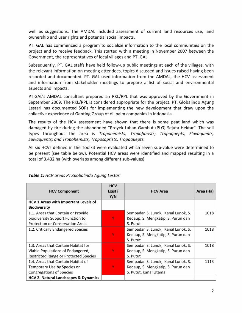
All six HCVs defined in the Toolkit were evaluated which seven sub‐value were determined to
be present (see table below). Potential HCV areas were identified and mapped resulting in a
total of 3.432 ha (with overlaps among different sub‐values).
Table 1: HCV areas PT.Globalindo Agung Lestari
HCV Component
HCV
Exist?
Y/N
HCV Area Area (Ha)
HCV 1.Areas with Important Levels of
Biodiversity
1.1. Areas that Contain or Provide
biodiversity Support Function to
Protection or Conservation Areas
Y
Sempadan S. Lunok, Kanal Lunok, S.
Kedaup, S. Mengkatip, S. Purun dan
S. Putut
1018
1.2. Critically Endangered Species
Y
Sempadan S. Lunok, Kanal Lunok, S.
Kedaup, S. Mengkatip, S. Purun dan
S. Putut
1018
1.3. Areas that Contain Habitat for
Viable Populations of Endangered,
Restricted Range or Protected Species
Y
Sempadan S. Lunok, Kanal Lunok, S.
Kedaup, S. Mengkatip, S. Purun dan
S. Putut
1018
1.4. Areas that Contain Habitat of
Temporary Use by Species or
Congregations of Species
Y
Sempadan S. Lunok, Kanal Lunok, S.
Kedaup, S. Mengkatip, S. Purun dan
S. Putut, Kanal Utama
1113
HCV 2. Natural Landscapes & Dynamics
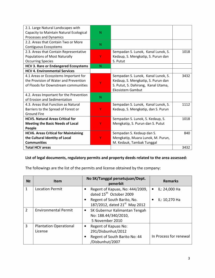
3
2.1. Large Natural Landscapes with
Capacity to Maintain Natural Ecological
Processes and Dynamics
N
2.2. Areas that Contain Two or More
Contiguous Ecosystems N
2.3. Areas that Contain Representative
Populations of Most Naturally
Occurring Species
Y
Sempadan S. Lunok, Kanal Lunok, S.
Kedaup, S. Mengkatip, S. Purun dan
S. Putut
1018
HCV 3. Rare or Endangered Ecosystems N
HCV 4. Environmental Services
4.1 Areas or Ecosystems Important for
the Provision of Water and Prevention
of Floods for Downstream communities Y
Sempadan S. Lunok, Kanal Lunok, S.
Kedaup, S. Mengkatip, S. Purun dan
S. Putut, S. Dahirang, Kanal Utama,
Ekosistem Gambut
3432
4.2. Areas Important for the Prevention
of Erosion and Sedimentation N
4.3. Areas that Function as Natural
Barriers to the Spread of Forest or
Ground Fire
Y
Sempadan S. Lunok, Kanal Lunok, S.
Kedaup, S. Mengkatip, dan S. Purun
1112
HCV5. Natural Areas Critical for
Meeting the Basic Needs of Local
People
Y
Sempadan S. Lunok, S. Kedaup, S.
Mengkatip, S. Purun dan S. Putut
1018
HCV6. Areas Critical for Maintaining
the Cultural Identity of Local
Communities
Y
Sempadan S. Kedaup dan S.
Mengkatip, Muara Lunok, M. Purun,
M. Kedauk, Tambak Tunggal
840
Total HCV areas 3432
List of legal documents, regulatory permits and property deeds related to the area assessed:
The followings are the list of the permits and license obtained by the company:
№ Item No SK/Tanggal persetujuan/Dept.
penerbit Remarks
1
Location Permit • Regent of Kapuas, No: 444/2009,
dated 15th
October 2009
• Regent of South Barito, No.
187/2012, dated 21st
May 2012
• IL: 24,000 Ha
• IL: 10,270 Ha
2 Environmental Permit • SK Gubernur Kalimantan Tengah
No: 188.44/340/2010,
5 November 2010
3 Plantation Operational
License
• Regent of Kapuas No:
291/Disbunhut/2012
• Regent of South Barito No: 44
/Disbunhut/2007
In Process for renewal
4
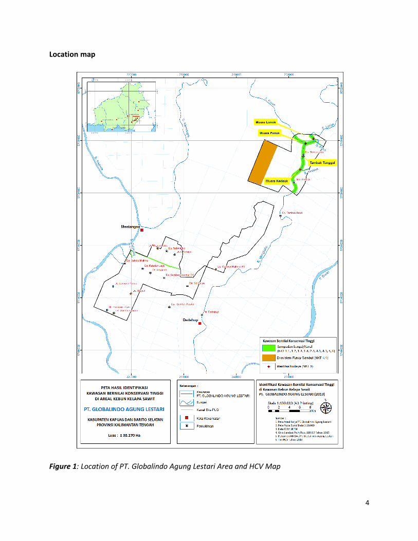
Location map
Figure 1: Location of PT. Globalindo Agung Lestari Area and HCV Map
5
The area proposed for new planting area by PT. GAL are the unplanted areas in the location
permit of PT. GAL, for which agreement have been obtained from the owners of the land
through the FPIC (free, prior and informed consent)process.
PT. GAL’s development plan had incorporated the findings from SEIA (AMDAL), HCV
Assessments and Social Impact Assessments when implementing the operational plans. As part
of the process of free, prior and informed consent (FPIC), procedures to ensure that there is
participation in the social and environmental harmony in the development of the oil palm
planting project by PT. GAL, consultation with the relevant stakeholders is to provide
opportunities for communication and sharing the information, opinions and suggestions
between the PT. GAL and the affected stakeholders to move forward for the benefit and
common progress. PT. GAL has established standard operating procedures for land acquisition
and compensation procedures based on the principle of free, prior and informed consent. The
company has also established the complaint and grievance procedures so that the problem
solving process is done through discussion and mutual deliberation.
The proposed schedule for the remaining new plantings is described below:
TDT 2014 2015 2016 2017 Total
Compensation 17,869.65 1000 18,869.65
Land Clearing & Infrastructure 17,869.65 100 900
Planting Inti 13 464.80 100 700 14,264.80
Plasma 4 404.85 200 4 604.85
2. SEIA and HCV Management & Planning Personnel
Organizational information and contact persons.
Company name PT. Globalindo Agung Lestari
Office Address Artha Graha Building 10
th Floor,
Jl. Jend Sudirman Kav 52 ‐ 53
Jakarta Indonesia 12190
Telephone/Fax Phone : 021‐5151938
Fax : 021‐5151917
Contact Person Director – Young Lee Chern
Email Address: [email protected]
Group Sustainability Manager – Dr Faizal Amri Amran
Email Address: [email protected]
Geographical Location Latitude 114°24’56.6028” to 114°45’42.6132”
Longitude 02°21'23.0256” to 02°40’44.49” Central
Kalimantan
6
Personnel involved in planning and implementation
The process of HCV and SIA and the preparation of management and monitoring plans for PT.
GAL was implemented in phases involving several parties: Estate Department, Human
Resources, Program Assurance, Agronomy Service Department, Legal and Plasma support
service and Land Acquisition Department and the whole process is in accordance with the plans
facilitated by an independent consultants from PT Sonokeling Akreditas Nusantara. The details
of the parties involved in the HCV and SIA development and preparation of management and
monitoring plans are summarized in Appendix 2.
The implementation of the HCV and SIA management and monitoring plans in the field will be
implemented by experienced personnel who possess the required level of competency,
knowledge and technical skills. Program Assurance Department, CSR department and Human
Resources, stationed at the location, will provide support in these activities. The Estate
Manager is directly responsible on the implementation of the plans of management and
monitoring. In addition, the Senior Estate Manager is accountable in fulfilling of the
requirements for the plan and as well as responsible in analyzing the input results from the
monitoring plans. The Group Manager is accountable and responsible to ensure that the Overall
Development Plan including the management of HCV and SIA is implemented according to the
time plan and budget. The detail of the responsibilities and roles of the HCV and SIA
development and preparation of management plans and monitoring are summarized in the
“Summary Report of SEIA and HCV Assessments PT Globalindo Agung Lestari” document.
The Head Office, Estate Department, Human Resources, and Program Assurance Department
will provide the overall support in the implementation of the development plan.
7
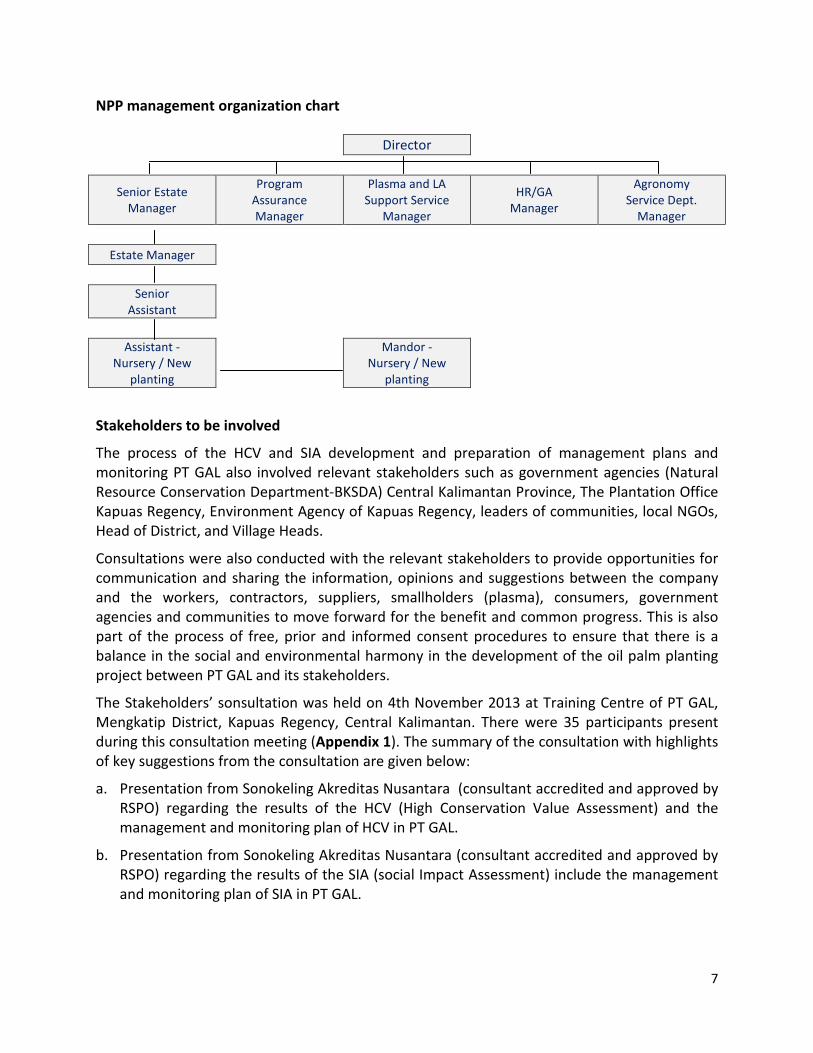
NPP management organization chart
Director
Senior Estate
Manager
Program
Assurance
Manager
Plasma and LA
Support Service
Manager
HR/GA
Manager
Agronomy
Service Dept.
Manager
Estate Manager
Senior
Assistant
Assistant ‐
Nursery / New
planting
Mandor ‐
Nursery / New
planting
Stakeholders to be involved
The process of the HCV and SIA development and preparation of management plans and
monitoring PT GAL also involved relevant stakeholders such as government agencies (Natural
Resource Conservation Department‐BKSDA) Central Kalimantan Province, The Plantation Office
Kapuas Regency, Environment Agency of Kapuas Regency, leaders of communities, local NGOs,
Head of District, and Village Heads.
Consultations were also conducted with the relevant stakeholders to provide opportunities for
communication and sharing the information, opinions and suggestions between the company
and the workers, contractors, suppliers, smallholders (plasma), consumers, government
agencies and communities to move forward for the benefit and common progress. This is also
part of the process of free, prior and informed consent procedures to ensure that there is a
balance in the social and environmental harmony in the development of the oil palm planting
project between PT GAL and its stakeholders.
The Stakeholders’ sonsultation was held on 4th November 2013 at Training Centre of PT GAL,
Mengkatip District, Kapuas Regency, Central Kalimantan. There were 35 participants present
during this consultation meeting (Appendix 1). The summary of the consultation with highlights
of key suggestions from the consultation are given below:
a. Presentation from Sonokeling Akreditas Nusantara (consultant accredited and approved by
RSPO) regarding the results of the HCV (High Conservation Value Assessment) and the
management and monitoring plan of HCV in PT GAL.
b. Presentation from Sonokeling Akreditas Nusantara (consultant accredited and approved by
RSPO) regarding the results of the SIA (social Impact Assessment) include the management
and monitoring plan of SIA in PT GAL.
8
Key Issues raised for discussion during the Stakeholders consultation’ include:
a. Local communities in the area surrounding PT GAL support the operational activities of PT
GAL, in principle.
b. The people in the villages around the concession of PT GAL, are hoping for jobs
opportunities/contracts and local employment.
c. Concern over public expectations on the increase in the price of land and access to land
following the development of PT GAL.
d. Concerns over river pollution concerns that may be caused by the activities of the oil palm
plantations.
Summary of Management and Mitigation Plans (SEIA)
The SEIA assessment and preparation of the management and monitoring Plan for PT. GAL
were prepared under the Cooperation Agreement between PT. GAL and AMDAL consultant
Pusat Penelitian Lingkungan Hidup Universitas Plangkaraya (PPLH – UNPAR) . The preparation
of such report refers to the result of identification and analysis of Social Impact Assessment in
the area of PT. GAL, Kapuas Regency and South Barito Regency, Central Kalimantan Province
and the frame of reference of the agreed work.
The Management and Mitigation Plan as per SIA Assessment and AMDAL document of PT GAL
is described as following:
a. Social management should be oriented towards the management and mitigation of social
matters involving the local communities. Efforts to manage these social matters to answer
the needs of the community include the management and development of cooperatives
and farmers Plasma Scheme, increase revenue and stability of income.
b. The aim of social management should be oriented to achieve social cohesion. Where the
management has not yet developed optimal social communication with the local
community or where the social impact analysis related to the degree of proximity between
the management and the public showed the reactive (negative relationship patterns), these
situations should be used as a basis for evaluating and developing social cohesion
improvements for the social management of the communities around the project. However,
where the social situation is conducive, it will ensure the smooth operation of the project.
c. Human resource oriented and strengthening the local economy. PT GAL management needs
to respond to the needs of the local community for employment in the project by
establishing a special recruitment mechanism. In view of the limited experience and
knowledge among the local people in the area to carry out the required work, the Company
needs to develop an agreement on the terms of recruitment, training, problem solving and
termination of employment that involves government officials and representatives of rural
communities. This agreement by both parties covers the labor recruitment and resolution of
employment issues that may arise after recruitment. In addition, community empowerment
9
and strengthening of local economies could be developed through education scholarship
assistance, social services and free medicine, technical training in agriculture and industry.
d. The Company, in partnership with communities and local governments around the village
area can also propose and support joint requests conveyed to the government at district
and provincial levels, on matters such as road improvement in the district and villages, as
well as construction of public facilities.
Company Social Impact Management for Social sustainability of local communities
I. Impact to human capital
a. Job opportunities
b. Job opportunities
• Collect data for the current means of livelihood
• Provide information for the job opportunities and qualifications required.
• Ensure announcements on the job opportunities are easily accessible to all
• Give priority to members of local communities in filling available job vacancies in
accordance with the qualifications or skills that they have.
• Provide training to new workers to equip them with the competency to fulfill their
job requirements.
c. Improvement on the level of community education
• Collect data on the number of available education facilities and infrastructure
• Identify and record the highest level of education received by the community.
• Identify the number of people that have and have not received formal education.
d. Increased public awareness of good agricultural practice
• Give training on “good agricultural practices” to the local communities especially
who have Plasma Scheme with Company.
• Build a co‐operative partnership with Koperasi.
e. Development of alternative income generating activities to safeguard their economic
standing after post‐development of the project
• Identify the number of affected communities that can be absorbed into the
workforce by the plantation company
• Identify potential areas that could be developed into other alternative economic
development program
• Plan a community development program and the progress shall be monitored to
ensure improvement of the economic status of the community.
II. Impact to natural capital
f. Companies’ participation in managing water quality
• Proper management of domestic and scheduled waste.
10
• Routine quality monitoring of waste water discharged into rivers.
• Communicate with community on techniques of waste handling
• Monitoring the water quality of natural rivers
• Socialize the management of the riparian areas with local community and village
official.
g. Land acquisition should also receive community approval
• Inventory of community land ownership
• Conduct participatory mapping with the related parties in delineation of land
ownership for the purpose of land acquisition.
• Establish land acquisition agreement with the respective legal owner of the land
without any pressure or coercion.
• Related parties or government authorities should be involved in solving any land
acquisition issues.
h. Social Impact Management to social sustainability on internal estate communities
• Provide a healthy and safety working environment
Sustainability Department provides leadership and support for PT GAL management
in the environmental, occupational health and safety aspects.
III. Provision of facilities for workers
a. Available housing for workers are to be equipped with basic facilities and adequate
electricity and water supply.
b. Clinic and doctor/paramedic is available
c. Provide training on proper care and maintenance of housing and other supporting
facilities, maintaining clean environment, housekeeping, zero burning and conservation
of natural resources.
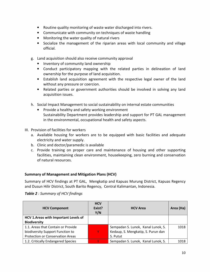
Summary of Management and Mitigation Plans (HCV)
Summary of HCV findings at PT GAL, Mengkatip and Kapuas Murung District, Kapuas Regency
and Dusun Hilir District, South Barito Regency, Central Kalimantan, Indonesia.
Table 2 : Summary of HCV findings
HCV Component
HCV
Exist?
Y/N
HCV Area Area (Ha)
HCV 1.Areas with Important Levels of
Biodiversity
1.1. Areas that Contain or Provide
biodiversity Support Function to
Protection or Conservation Areas
Y
Sempadan S. Lunok, Kanal Lunok, S.
Kedaup, S. Mengkatip, S. Purun dan
S. Putut
1018
1.2. Critically Endangered Species Y Sempadan S. Lunok, Kanal Lunok, S. 1018
11
Kedaup, S. Mengkatip, S. Purun dan
S. Putut
1.3. Areas that Contain Habitat for
Viable Populations of Endangered,
Restricted Range or Protected Species
Y
Sempadan S. Lunok, Kanal Lunok, S.
Kedaup, S. Mengkatip, S. Purun dan
S. Putut
1018
1.4. Areas that Contain Habitat of
Temporary Use by Species or
Congregations of Species
Y
Sempadan S. Lunok, Kanal Lunok, S.
Kedaup, S. Mengkatip, S. Purun dan
S. Putut, Kanal Utama
1113
HCV 2. Natural Landscapes & Dynamics
2.1. Large Natural Landscapes with
Capacity to Maintain Natural Ecological
Processes and Dynamics
N
2.2. Areas that Contain Two or More
Contiguous Ecosystems N
2.3. Areas that Contain Representative
Populations of Most Naturally
Occurring Species
Y
Sempadan S. Lunok, Kanal Lunok, S.
Kedaup, S. Mengkatip, S. Purun dan
S. Putut
1018
HCV 3. Rare or Endangered Ecosystems N
HCV 4. Environmental Services
4.1 Areas or Ecosystems Important for
the Provision of Water and Prevention
of Floods for Downstream communities Y
Sempadan S. Lunok, Kanal Lunok, S.
Kedaup, S. Mengkatip, S. Purun dan
S. Putut, S. Dahirang, Kanal Utama,
Ekosistem Gambut.
3432
4.2. Areas Important for the Prevention
of Erosion and Sedimentation N
4.3. Areas that Function as Natural
Barriers to the Spread of Forest or
Ground Fire
Y
Sempadan S. Lunok, Kanal Lunok, S.
Kedaup, S. Mengkatip, dan S. Purun
1112
HCV5. Natural Areas Critical for
Meeting the Basic Needs of Local
People
Y
Sempadan S. Lunok, S. Kedaup, S.
Mengkatip, S. Purun dan S. Putut
1018
HCV6. Areas Critical for Maintaining
the Cultural Identity of Local
Communities
Y
Sempadan S. Kedaup dan S.
Mengkatip, Muara Lunok, M. Purun,
M. Kedauk, Tambak Tunggal
840
Total HCV areas 3432
12
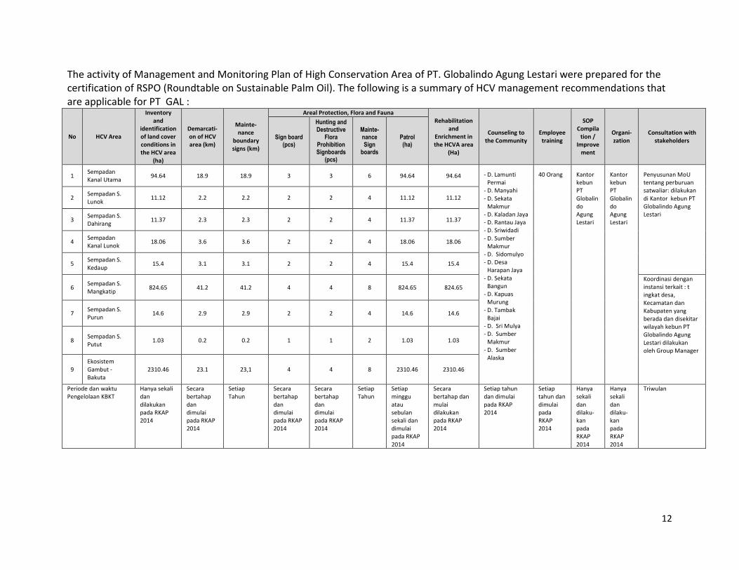
The activity of Management and Monitoring Plan of High Conservation Area of PT. Globalindo Agung Lestari were prepared for the
certification of RSPO (Roundtable on Sustainable Palm Oil). The following is a summary of HCV management recommendations that
are applicable for PT GAL :
No HCV Area
Inventory
and
identification
of land cover
conditions in
the HCV area
(ha)
Demarcati-
on of HCV
area (km)
Mainte-
nance
boundary
signs (km)
Areal Protection, Flora and Fauna
Rehabilitation
and
Enrichment in
the HCVA area
(Ha)
Counseling to
the Community
Employee
training
SOP
Compila
tion /
Improve
ment
Organi-
zation
Consultation with
stakeholders Sign board
(pcs)
Hunting and Destructive
Flora Prohibition Signboards
(pcs)
Mainte-nance Sign
boards
Patrol (ha)
1 Sempadan
Kanal Utama 94.64 18.9 18.9 3 3 6 94.64 94.64 ‐ D. Lamunti
Permai
‐ D. Manyahi
‐ D. Sekata
Makmur
‐ D. Kaladan Jaya
‐ D. Rantau Jaya
‐ D. Sriwidadi
‐ D. Sumber
Makmur
‐ D. Sidomulyo
‐ D. Desa
Harapan Jaya
‐ D. Sekata
Bangun
‐ D. Kapuas
Murung
‐ D. Tambak
Bajai
‐ D. Sri Mulya
‐ D. Sumber
Makmur
‐ D. Sumber
Alaska
40 Orang Kantor
kebun
PT
Globalin
do
Agung
Lestari
Kantor
kebun
PT
Globalin
do
Agung
Lestari
Penyusunan MoU
tentang perburuan
satwaliar: dilakukan
di Kantor kebun PT
Globalindo Agung
Lestari
2 Sempadan S.
Lunok 11.12 2.2 2.2 2 2 4 11.12 11.12
3 Sempadan S.
Dahirang 11.37 2.3 2.3 2 2 4 11.37 11.37
4 Sempadan
Kanal Lunok 18.06 3.6 3.6 2 2 4 18.06 18.06
5 Sempadan S.
Kedaup 15.4 3.1 3.1 2 2 4 15.4 15.4
6 Sempadan S.
Mangkatip 824.65 41.2 41.2 4 4 8 824.65 824.65
Koordinasi dengan
instansi terkait : t
ingkat desa,
Kecamatan dan
Kabupaten yang
berada dan disekitar
wilayah kebun PT
Globalindo Agung
Lestari dilakukan
oleh Group Manager
7 Sempadan S.
Purun 14.6 2.9 2.9 2 2 4 14.6 14.6
8 Sempadan S.
Putut 1.03 0.2 0.2 1 1 2 1.03 1.03
9
Ekosistem
Gambut ‐
Bakuta
2310.46 23.1 23,1 4 4 8 2310.46 2310.46
Periode dan waktu
Pengelolaan KBKT
Hanya sekali
dan
dilakukan
pada RKAP
2014
Secara
bertahap
dan
dimulai
pada RKAP
2014
Setiap
Tahun
Secara
bertahap
dan
dimulai
pada RKAP
2014
Secara
bertahap
dan
dimulai
pada RKAP
2014
Setiap
Tahun
Setiap
minggu
atau
sebulan
sekali dan
dimulai
pada RKAP
2014
Secara
bertahap dan
mulai
dilakukan
pada RKAP
2014
Setiap tahun
dan dimulai
pada RKAP
2014
Setiap
tahun dan
dimulai
pada
RKAP
2014
Hanya
sekali
dan
dilaku‐
kan
pada
RKAP
2014
Hanya
sekali
dan
dilaku‐
kan
pada
RKAP
2014
Triwulan
13
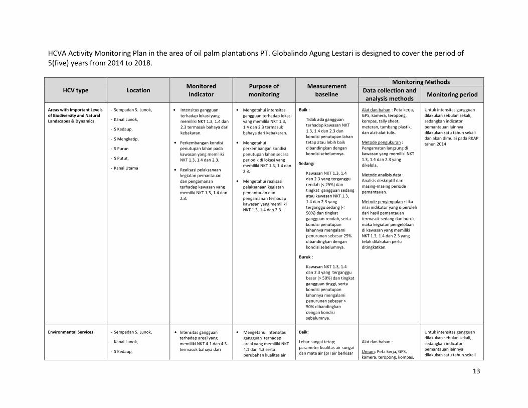
HCVA Activity Monitoring Plan in the area of oil palm plantations PT. Globalindo Agung Lestari is designed to cover the period of
5(five) years from 2014 to 2018.
HCV type Location Monitored
Indicator
Purpose of
monitoring
Measurement
baseline
Monitoring Methods
Data collection and
analysis methods Monitoring period
Areas with Important Levels
of Biodiversity and Natural
Landscapes & Dynamics
‐ Sempadan S. Lunok,
‐ Kanal Lunok,
‐ S Kedaup,
‐ S Mengkatip,
‐ S Purun
‐ S Putut,
‐ Kanal Utama
• Intensitas gangguan
terhadap lokasi yang
memiliki NKT 1.3, 1.4 dan
2.3 termasuk bahaya dari
kebakaran.
• Perkembangan kondisi
penutupan lahan pada
kawasan yang memiliki
NKT 1.3, 1.4 dan 2.3.
• Realisasi pelaksanaan
kegiatan pemantauan
dan pengamanan
terhadap kawasan yang
memilki NKT 1.3, 1.4 dan
2.3.
• Mengetahui intensitas
gangguan terhadap lokasi
yang memiliki NKT 1.3,
1.4 dan 2.3 termasuk
bahaya dari kebakaran.
• Mengetahui
perkembangan kondisi
penutupan lahan secara
periodik di lokasi yang
memiliki NKT 1.3, 1.4 dan
2.3.
• Mengetahui realisasi
pelaksanaan kegiatan
pemantauan dan
pengamanan terhadap
kawasan yang memiliki
NKT 1.3, 1.4 dan 2.3.
Baik :
Tidak ada gangguan
terhadap kawasan NKT
1.3, 1.4 dan 2.3 dan
kondisi penutupan lahan
tetap atau lebih baik
dibandingkan dengan
kondisi sebelumnya.
Sedang:
Kawasan NKT 1.3, 1.4
dan 2.3 yang terganggu
rendah (< 25%) dan
tingkat gangguan sedang
atau kawasan NKT 1.3,
1.4 dan 2.3 yang
terganggu sedang (<
50%) dan tingkat
gangguan rendah, serta
kondisi penutupan
lahannya mengalami
penurunan sebesar 25%
dibandingkan dengan
kondisi sebelumnya.
Buruk :
Kawasan NKT 1.3, 1.4
dan 2.3 yang terganggu
besar (> 50%) dan tingkat
gangguan tinggi, serta
kondisi penutupan
lahannya mengalami
penurunan sebesar >
50% dibandingkan
dengan kondisi
sebelumnya.
Alat dan bahan : Peta kerja,
GPS, kamera, teropong,
kompas, tally sheet,
meteran, tambang plastik,
dan alat‐alat tulis.
Metode pengukuran :
Pengamatan langsung di
kawasan yang memiliki NKT
1.3, 1.4 dan 2.3 yang
dikelola.
Metode analisis data :
Analisis deskriptif dari
masing‐masing periode
pemantauan.
Metode penyimpulan : Jika
nilai indikator yang diperoleh
dari hasil pemantauan
termasuk sedang dan buruk,
maka kegiatan pengelolaan
di kawasan yang memiliki
NKT 1.3, 1.4 dan 2.3 yang
telah dilakukan perlu
ditingkatkan.
Untuk intensitas gangguan
dilakukan sebulan sekali,
sedangkan indicator
pemantauan lainnya
dilakukan satu tahun sekali
dan akan dimulai pada RKAP
tahun 2014
Environmental Services ‐ Sempadan S. Lunok,
‐ Kanal Lunok,
‐ S Kedaup,
• Intensitas gangguan
terhadap areal yang
memiliki NKT 4.1 dan 4.3
termasuk bahaya dari
• Mengetahui intensitas
gangguan terhadap
areal yang memiliki NKT
4.1 dan 4.3 serta
perubahan kualitas air
Baik:
Lebar sungai tetap;
parameter kualitas air sungai
dan mata air (pH air berkisar
Alat dan bahan :
Umum: Peta kerja, GPS,
kamera, teropong, kompas,
Untuk intensitas gangguan
dilakukan sebulan sekali,
sedangkan indicator
pemantauan lainnya
dilakukan satu tahun sekali
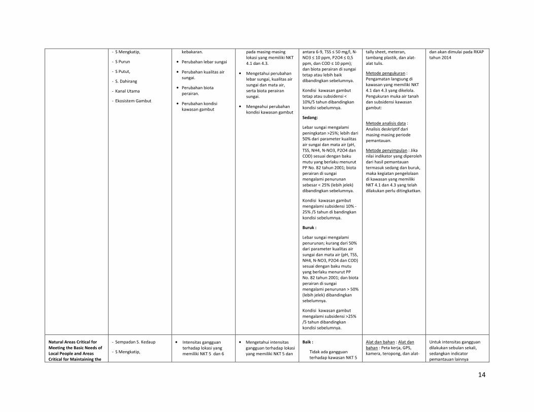
14
‐ S Mengkatip,
‐ S Purun
‐ S Putut,
‐ S. Dahirang
‐ Kanal Utama
‐ Ekosistem Gambut
kebakaran.
• Perubahan lebar sungai
• Perubahan kualitas air
sungai.
• Perubahan biota
perairan.
• Perubahan kondisi
kawasan gambut
pada masing‐masing
lokasi yang memiliki NKT
4.1 dan 4.3.
• Mengetahui perubahan
lebar sungai, kualitas air
sungai dan mata air,
serta biota perairan
sungai.
• Mengeahui perubahan
kondisi kawasan gambut
antara 6‐9, TSS ≤ 50 mg/l, N‐
NO3 ≤ 10 ppm, P2O4 ≤ 0,5
ppm, dan COD ≤ 10 ppm);
dan biota perairan di sungai
tetap atau lebih baik
dibandingkan sebelumnya.
Kondisi kawasan gambut
tetap atau subsidensi <
10%/5 tahun dibandingkan
kondisi sebelumnya.
Sedang:
Lebar sungai mengalami
peningkatan >25%; lebih dari
50% dari parameter kualitas
air sungai dan mata air (pH,
TSS, NH4, N‐NO3, P2O4 dan
COD) sesuai dengan baku
mutu yang berlaku menurut
PP No. 82 tahun 2001; biota
perairan di sungai
mengalami penurunan
sebesar < 25% (lebih jelek)
dibandingkan sebelumnya.
Kondisi kawasan gambut
mengalami subsidensi 10% ‐
25% /5 tahun di bandingkan
kondisi sebelumnya.
Buruk :
Lebar sungai mengalami
penurunan; kurang dari 50%
dari parameter kualitas air
sungai dan mata air (pH, TSS,
NH4, N‐NO3, P2O4 dan COD)
sesuai dengan baku mutu
yang berlaku menurut PP
No. 82 tahun 2001; dan biota
perairan di sungai
mengalami penurunan > 50%
(lebih jelek) dibandingkan
sebelumnya.
Kondisi kawasan gambut
mengalami subsidensi >25%
/5 tahun dibandingkan
kondisi sebelumnya.
tally sheet, meteran,
tambang plastik, dan alat‐
alat tulis.
Metode pengukuran :
Pengamatan langsung di
kawasan yang memiliki NKT
4.1 dan 4.3 yang dikelola.
Pengukuran muka air tanah
dan subsidensi kawasan
gambut:
Metode analisis data :
Analisis deskriptif dari
masing‐masing periode
pemantauan.
Metode penyimpulan : Jika
nilai indikator yang diperoleh
dari hasil pemantauan
termasuk sedang dan buruk,
maka kegiatan pengelolaan
di kawasan yang memiliki
NKT 4.1 dan 4.3 yang telah
dilakukan perlu ditingkatkan.
dan akan dimulai pada RKAP
tahun 2014
Natural Areas Critical for
Meeting the Basic Needs of
Local People and Areas
Critical for Maintaining the
‐ Sempadan S. Kedaup
‐ S Mengkatip,
• Intensitas gangguan
terhadap lokasi yang
memiliki NKT 5 dan 6
• Mengetahui intensitas
gangguan terhadap lokasi
yang memiliki NKT 5 dan
Baik :
Tidak ada gangguan
terhadap kawasan NKT 5
Alat dan bahan : Alat dan
bahan : Peta kerja, GPS,
kamera, teropong, dan alat‐
Untuk intensitas gangguan
dilakukan sebulan sekali,
sedangkan indicator
pemantauan lainnya
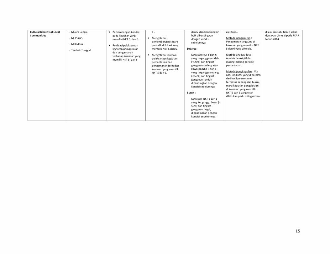
15
Cultural Identity of Local
Communities
‐ Muara Lunok,
‐ M. Purun,
‐ M Kedauk
‐ Tambak Tunggal
• Perkembangan kondisi
pada kawasan yang
memiliki NKT 5 dan 6.
• Realisasi pelaksanaan
kegiatan pemantauan
dan pengamanan
terhadap kawasan yang
memilki NKT 5 dan 6
6 .
• Mengetahui
perkembangan secara
periodik di lokasi yang
memiliki NKT 5 dan 6.
• Mengetahui realisasi
pelaksanaan kegiatan
pemantauan dan
pengamanan terhadap
kawasan yang memiliki
NKT 5 dan 6.
dan 6 dan kondisi lebih
baik dibandingkan
dengan kondisi
sebelumnya.
Sedang:
Kawasan NKT 5 dan 6
yang terganggu rendah
(< 25%) dan tingkat
gangguan sedang atau
kawasan NKT 5 dan 6
yang terganggu sedang
(< 50%) dan tingkat
gangguan rendah
dibandingkan dengan
kondisi sebelumnya.
Buruk :
Kawasan NKT 5 dan 6
yang terganggu besar (>
50%) dan tingkat
gangguan tinggi,
dibandingkan dengan
kondisi sebelumnya.
alat tulis.,
Metode pengukuran :
Pengamatan langsung di
kawasan yang memiliki NKT
5 dan 6 yang dikelola.
Metode analisis data :
Analisis deskriptif dari
masing‐masing periode
pemantauan.
Metode penyimpulan : Jika
nilai indikator yang diperoleh
dari hasil pemantauan
termasuk sedang dan buruk,
maka kegiatan pengelolaan
di kawasan yang memiliki
NKT 5 dan 6 yang telah
dilakukan perlu ditingkatkan.
dilakukan satu tahun sekali
dan akan dimulai pada RKAP
tahun 2014
16
Internal responsibility
The statement of acceptance of responsibility for assessment.
The document is summary of assessment result of HCV, SIA, AMDAL, PT. Globalindo Agung
Lestari and has been approved by the management of PT. Globalindo Agung Lestari.
Prepared By Approved By
Dr. Faizal Amri Amran Young Lee Chern
Head Sustainability Director
17
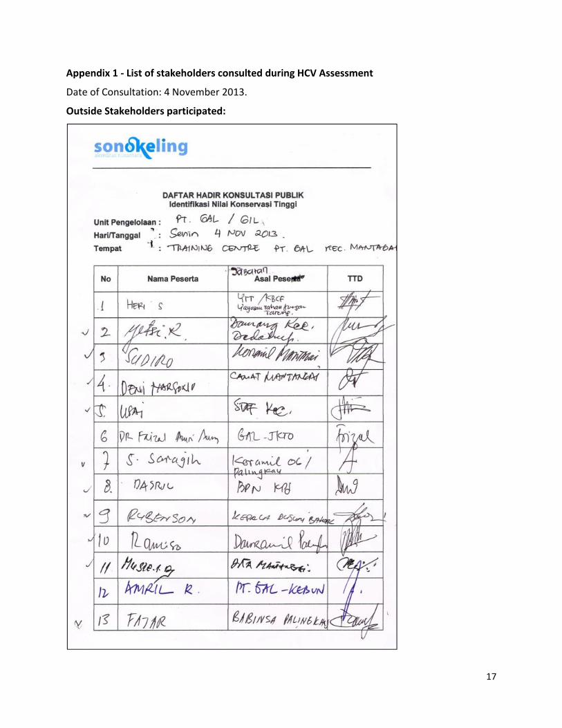
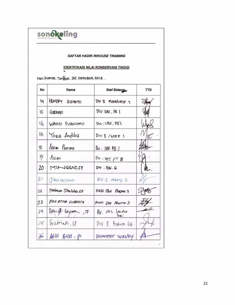
Appendix 1 - List of stakeholders consulted during HCV Assessment
Date of Consultation: 4 November 2013.
Outside Stakeholders participated:
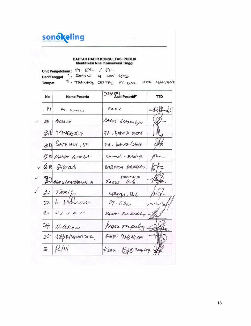
18
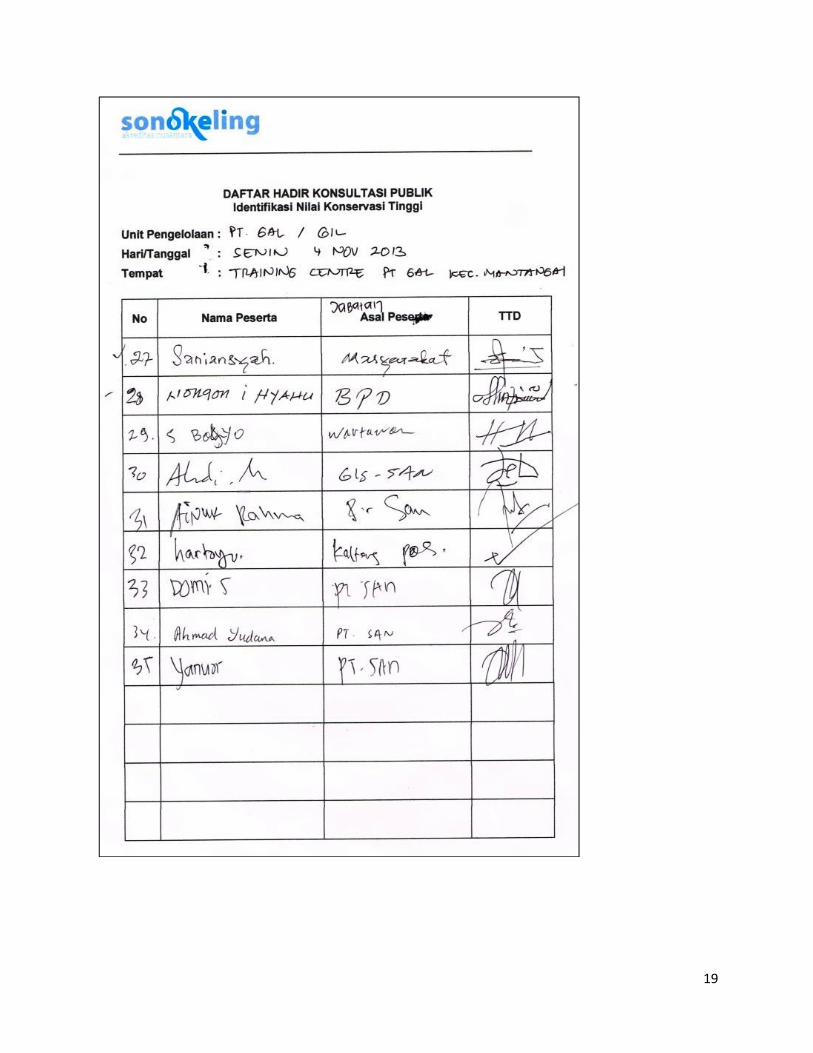
19
20
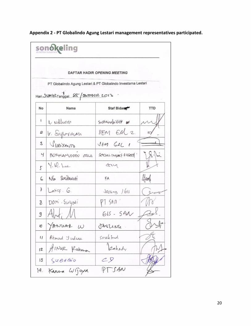
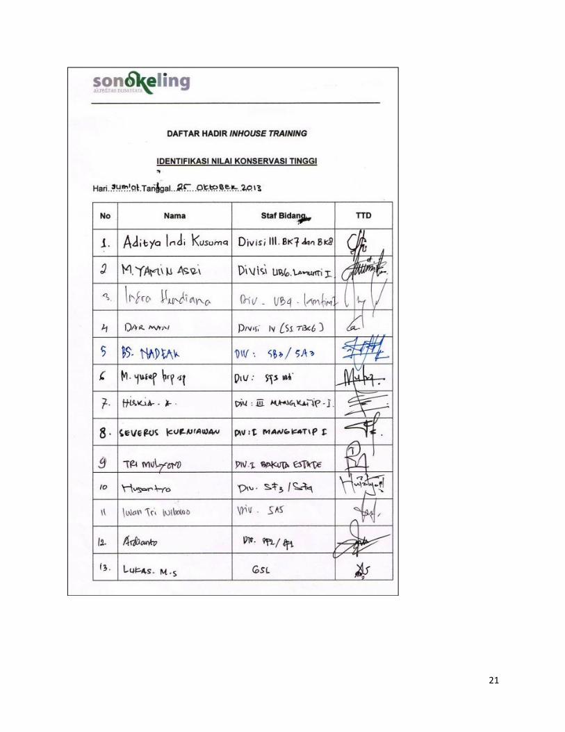
Appendix 2 - PT Globalindo Agung Lestari management representatives participated.
21
22


![UNLIMITED FIRE DESIGN · 2019. 7. 16. · 15.5 L [US] 4.0 gal / [UK] 3.3 gal 24.0 L [US] 6.34 gal / [UK] 5.28 gal 24.0 L [US] 6.34 gal / [UK] 5.28 gal 24.0 L [US] 6.34 gal / [UK]](https://img.pdfslide.us/doc/110x75/60cd4b6e3e1e6e269d46acb8/unlimited-fire-design-2019-7-16-155-l-us-40-gal-uk-33-gal-240-l-us.jpg)