Embed Size (px)
Citation preview
VARIABILITY IN PLEISTOCENE TO RECENT SEDIMENTATION FROM THE
CARBONATE MOUND PROVINCES IN THE PORCUPINE SEABIGHT,
NORTHEASTERN ATLANTIC: IMPLICATIONS FOR CARBONATE MOUND
GROWTH AND DEVELOPMENT.
Dissertation zur Erlangung
des Doktorgrades
am Fachbereich Geowissenschaften
der Universität Bremen
vorgelegt von
Alexandra L. Jurkiw B.Sc (hons)
Bremen, Dezember 2005
i

ii

Gutachter:
Herr Priv.-Doz Dr Dierk Hebbeln
Herr Prof. Dr. Jörn Peckmann
iii

iv

ABSTRACT
The Porcupine Seabight (PSB) on the Irish continental margin contains three distinct
carbonate mound provinces with many of the individual mounds being colonised by
the cold-water azooxanthellate corals Lophelia pertusa and Madrepora oculata. The
oceanographic regime in the PSB is one of the main controls on the location and
development of these mounds. For these sea floor structures bottom currents play an
important role and nowadays in the PSB the Mediterranean Outflow Water (MOW)
appears to be crucial for the living cold-water coral ecosystems on these carbonate
mounds.
The variability in present day bottom current speeds on Propeller Mound were studied
from modern sedimentation. The dominant current direction in the Porcupine
Seabight is from south to north, although at Propeller Mound the currents are
deflected in a southwesterly direction. Grain size and compositional analyses of box
core surfaces taken from the seafloor adjacent to and from Propeller Mound in the
Hovland Mound Province show that the intensity of these currents varies locally.
Highest current speeds occur to the west of the mound and on the mound surface,
winnowing away finer sediment fractions (clay-fine silt) and leaving coarse sortable
silt and sand lag deposits. Coarse grains are absent from the seafloor to the east of the
mound. Local forcing of bottom currents is likely due to the elevated topography of
the mound and tidal currents in the area. Sediments from Propeller Mound contain
elevated calcium carbonate contents (50%) compared to background sediments (39%)
what is proportional to the volume of coarse bioclastic material present.
The hydrodynamic variability recorded in Pleistocene drift sediments was studied in a
more southerly mound province. Analysis of core MD-01-2450 from the Belgica
Mound Province documents drift sedimentation in an off-mound location reaching far
beyond 200 kyr B.P. An hiatus representing >160 kyr is present, separating an upper
silty drift body containing abundant coarse ice rafted debris (IRD) from a finer
grained glacial unit below. This hiatus is represented as a coarse sandy unit
interpreted as a debris flow or slump. The sedimentary record indicates that glacial
v
periods in the PSB were periods of reduced bottom water circulation, with variability
in the size range of IRD delivered to the seafloor.
Changes in the geological and biological record in Propeller Mound are related to
changes in hydrodynamics associated with glacial and interglacial cycles. Down-core
variability in grain-size and bioclastic composition through Propeller Mound suggests
that current speeds have not been stable in the on-mound environment through time.
Sediments aged between 0.27 and 1.5 Ma (Marine Isotope Stages 9 to 50) show that
the sediment composition on the mound has changed considerably and repetitively
through time. Four sedimentary facies have been identified in the mound and are
related to current intensities and glacial – interglacial cycles. Fine grained mudstones
and wackestones are deposited during glacial periods and coarse coral grainstones and
packstones are the result of concentrating bioclastic remains through winnowing
during interstadials. These units are formed by relatively high current speeds and
often represent hiatuses. An indication of a fluctuating current regime is correlative
with the faunal assemblage recorded in the sediment, with corals dominating
interstadial/interglacial units and suspended sediment tolerant bryozoans occurring in
the finer grained sections of the core. The different facies units are stacked and
repeated; indicating that Propeller Mound has been able to continuously re-establish
itself as an active mound community, despite the influence of a fluctuating current
regime during the last 1.5 Ma. Calculated sediment accumulation rates of 1.12 cm/ky
for the cored section and 7 cm/ky for the un-penetrated mound section have
implications for previously proposed mound growth models. The values indicate that
a very rapid ‘booster stage’ must be recorded in the unpenetrated depths of the
mound, and that Propeller Mound has entered the ‘coral bank’ or ‘burial’ stage with a
shift to lower sediment accumulation rates. It is likely that the dominant sediment type
preserved in the unpenetrated section is likely to be a wackestone, with fewer hiatuses
and occurrences of grain- and packstones than in the cored interval.
vi
ZUSAMMENFASSUNG
Am Irischen Kontinentalhang in der Porcupine Seabight (PSB), befinden sich drei
Karbonathügelgebiete, in denen viele der einzelne Hügel durch die
Kaltwasserkorallen Lophelia pertusa und Madrepora oculata kolonisiert sind. Das
ozeanographische System der PSB ist eine der Haupeinflussfaktoren bezüglich der
Position und der Entwicklung dieser Karbonathügel. Für diese Strukturen sind die
Bodenströmungen von großer Bedeutung und heutzutage spielt in der PSB vor allem
das Mittelmeerausstromwasser (MOW) eine wichtige Rolle für die dort lebenden
Kaltwasserkorallenökosysteme auf den Karbonathügeln.
Korngrößenanalysen und Untersuchungen der Kernoberflächen von Kastengreifern
vom Propeller Mound in der Hovland Mound Province und vom umgebenden
Meeresboden, zeigen das die Intensitäten dieser Bodenwasserströmungen lokal
unterschiedlich sind. Die höchsten Strömungsgeschwindigkeiten befinden sich
westlich und auf der Oberseite des Karbonathügels und erodieren feinere Sedimente
(Ton bis feine Siltfraktion), lassen aber die gröbere sortierte Silt- und Sandfraktion
liegen. Östlich des Hügels gibt es keine Ablagerungen von groben Sedimenten.
Lokale Anstiege der Bodenwasserströmungen lassen sich auf die erhöhte Topographie
am Karbonathügel und auf Gezeitenströmungen zurückführen. Sedimente vom
Propeller Mound besitzen im Vergleich zu anderen Sedimenten, durch den höheren
Anteil von groben bioklastischen Materials, einen höheren Gehalt an
Kalziumkarbonat (~50% im Gegensatz zu 39% in den umgebenden Sedimenten).
Veränderungen in der Hydrodynamik, wie sie in Driftsedimenten aufgezeichnet
werden, wurden in einer weiter südlich gelegenen Karbonathügelprovinz untersucht.
Sedimentologische Analysen des „off-mound“ Kerns MD-01-2450 aus der Belgica
Mound Province, dokumentieren die Ablagerung von Driftsedimenten weit über die
letzten 200.000 Jahre hinaus. Ein Hiatus in der stratigraphischen Abfolge repräsentiert
>160.000 Jahre und trennt zwei unterschiedliche Sedimentschichten: Eine obere
Schicht aus siltigen Driftsedimenten mit einem hohen IRD Gehalt, und eine
unterlagernde feinkörnige glaziale Schicht. Der Hiatus wird repräsentiert durch eine
grobkörnige sandige Schicht, welche als Turbidit oder Hangrutschung interpretiert
vii

wird. Die sedimentäre Abfolge zeigt, dass in der Porcupine Seabight während
glazialer Abschnitte niedrige Bodenwasserströmungen vorherrschten.
Schwankungen in der Korngröße und der bioklastischen Zusammensetzung innerhalb
des untersuchten Kerns vom Propeller Mound führen zu der Annahme, dass die
Bodenwasserströmungsgeschwindigkeiten im Laufe der Zeit variierten. Die
Sedimentabfolge zwischen 0.27 und 1.5 Ma (marine Isotope Phasen 9 bis 50) zeigt,
dass sich die Zusammensetzung der Sedimente wiederholt im Laufe der Zeit geändert
hat. Vier sedimentäre Fazies, die auf Bodenwasserströmungen und glaziale-
interglaziale Abschnitte zurückzuführen sind, konnten am Propeller Mound
identifiziert werden. Feinkörnige ‚Mudstones’ und Wackestones’ haben sich während
glazialer Zeiten abgelagert, die grobkörnigen mit Korallen angereicherten‚
Grainstones’ und ‚Packstones’ stammen aus interstadialen Zeiten. Diese Einheiten
wurden durch hohe Bodenwasserströmungsgeschwindigkeiten und geringe
Sedimentationsraten geformt und repräsentieren häufig Hiatusse. Ein Hinweis auf die
schwankenden Strömungsgeschwindigkeiten lässt sich in den biologischen
Ablagerungen im Sediment nachweisen. Kaltwasserkorallen dominieren die
zwischeneiszeitlichen/interglazialen Sedimentschichten, während Bryozoen in den
feineren Schichten des Kerns vorkommen. Die Abfolge dieser vier Faziestypen in den
Kernen vom Propeller Mound wiederholt sich mehrmals. Daraus lässt sich schließen,
dass sich der Propeller Mound trotz der Einflüsse der schwankenden
Bodenwasserströmungen, im Laufe der letzten 1.5 Ma immer wieder aktiv und
kontinuierlich aufgebaut hat. Kalkulierte Sedimentationsraten von 1.12cm/kyr für den
Kern des beprobten Abschnitts des Propeller Mounds und 7cm/kyr für den
unbeprobten Teil, unterstützen ältere Karbonathügelwachstumsmodelle. Die Werte
zeigen zum Einen, dass eine sehr schnelle „Booster-Stage“ in einer noch nicht
beprobten Tiefe des Hügels vorhanden sein muss und zum Anderen, dass der
Propeller Mound mit dem Übergang zu langsameren Sedimentationsraten die „Coral-
Bank“- oder „Burial“-Stadien erreicht hat. Es ist anzunehmen, dass das dominierende
Sediment in den noch unbeprobten Schichten des Propeller Mounds ein
„Wackestone“ ist. Im Gegensatz zu den beprobten Schichten ist außerdem mit
weniger „Grainstone“ oder „Packstone“ Ablagerungen und einem geringeren
Hiatusvorkommen zu rechnen.
viii
CONTENTS
ABSTRACT…………………………………………………………………...............v
ZUSAMMENFASSUNG…………………………………………………...………..vii
CHAPTER 1: Introduction………………………………………………………...…..1
AIMS……………………………………………………………………………...…...2
REGIONAL SETTING………………………………………………………..….…...2
The Porcupine Seabight: Physiography………………...………………....…..2
The Porcupine Seabight: Geological History ……………………………...….4
The Porcupine Seabight: Modern Sedimentation………………………..……5
The Porcupine Seabight: Oceanographic Regime……………………..……...6
The Porcupine Seabight: Carbonate Mounds …………………………..……..7
The Cold-Water Corals…………………………………………………..……8
Carbonate Mounds in the Porcupine Seabight………………………..………9
1. Belgica Mound Province (BMP)…………………………………..………11
2. Hovland Mound Province (HMP)………………………………..………..11
3. Magellan Mound Province (MMP) ………………………………..………12
Propeller Mound – a Hovland Mound……………………………………...12
Carbonate Mound Growth and Development ………………………..………12
CHAPTER 2: Materials and Methods……………………………………………...15
SEDIMENT CORE TREATMENT…………….………………………………..15
Opening procedure of cores………………………………………………...15
Visual core descriptions…………………………………………………….16
Subsampling………………………………………………………………...16
Petrographic description/grain type analysis ………………………………18
Stable Isotope Analysis……………………………………………………..18
DATING……………………………………………………………………………19
Radiocarbon measurements……………..…………………………………...19
Coccolith biostratigraphy………………...…………………………………..19
U/TH dating on coral fragments…………..…………………………………20
TOTAL ORGANIC CARBON AND CaCO3 CONTENTS……………………….20
ix

X-RAY FLOURESCENCE SPECTROMETRY (XRF)…………………………...20
GRAIN SIZE ANALYSES…………………………………………………………21
Box Core grain size analyses……………………………………………….21
Gravity Core Analysis ………………………………………………………21
Coulter LS2000……………………………………………………………..21
Malvern Laser Particle Sizer Mastersizer 2000……………………………22
CHAPTER 3: Glaciomarine drift sedimentation and bottom current variability:
Belgica Mound Province, Porcupine Seabight…….….…………………………...…23
ABSTRACT………………………………………………………………………...24
INTRODUCTION………………………………………………………………….24
REGIONAL SETTING…………………………………………………………….25
Physiography……………………………………………………………….25
Present day bottom-water circulation……………………………………….25
Sedimentation…………………………………………..……………………26
DATA AND METHODS…………………………………………………………..28
RESULTS…………………………………………………………………………..29
Unit 1 (0 – 532 cm): homogenous sandy mud……………………………...30
Unit 2 (518-532 cm): poorly sorted silty sands…………………………….30
Unit 3 (532-1180 cm): moderately well sorted sandy clayey silt…………..31
DISCUSSION ………………………………………………………………………31
Events and Processes…………………………………………………………...35
Drift…………………………………………………………………………35
Debris Flow and Slump…………………………………………………….35
Bottom current activity……………………………………………………..36
Hemipelagic deposition…………………………………………………….37
IRD………………………………………………………………………….37
CONCLUSIONS…………………………………………………………………...38
ACKNOWLEDGEMENTS………………………………………………………..39
CHAPTER 4: Modern surface sediment from Propeller Mound, Porcupine
Seabight…………………………………………………………………………...….40
ABSTRACT………………………………………………………………………...40
INTRODUCTION………………………………………………………………….41
x

REGIONAL SETTING…………………………………………………………….42
Physiography and hydrography………………….…………………………42
Sedimentation………………………………………………………………42
DATA AND METHODS…………………………………………………………..43
RESULTS…………………………………………………………………………..46
Box core surface descriptions……………………………..………………..46
On-mound……..……………………………….……………………………46
Off-Mound…………………………………………………………….…….46
CaCO3 and TOC contents…..………………………………………………48
Grain Size Distribution……………………………………………………..48
Bulk Sediment analyses……………………………………………………..49
Carbonate Sediments……………………………………………………….49
Siliciclastic Sediments ………………………………………………………49
DISCUSSION ………………………………………………………………………51
Sediment supply to Propeller Mound ………………………………………51
I. Carbonate sediment supply………………………………………………51
II. Siliciclastic sediment supply……………………………………………..52
III. Sediment texture and transport…………………………………………52
i) Carbonate Sediment……………………………………………………………..53
ii) Siliciclastic Sediment…………………………………………………….53
Are bottom currents acting at Propeller Mound?...........................................54
Turbidite and debris flows………………………………………………..….56
CONCLUSIONS…………………………………………………………………...57
ACKNOWLEDGEMENTS………………………………………………………...58
CHAPTER 5: Variation in Carbonate Mound Sediments: Significance for the
Pleistocene Development of Propeller Mound, Porcupine Seabight...………………59
ABSTRACT………………………………………………………………………...60
INTRODUCTION………………………………………………………………….60
REGIONAL SETTING…………………………………………………………….61
Physiography and oceanographic regime………………………………….61
Sedimentation……………………………………………………………….62
Carbonate Mound Fauna…………………………………………………...64
DATA AND METHODS…………………………………………………………..64
xi

RESULTS…………………………………………………………………………..66
Biostratigraphy……………………………………………………………..66
Sedimentology ………………………………………………………………68
Facies 1: mudstone…………………………………………………………68
Facies 2: wackestone……………………………………………………….68
Facies 3: packstone…………………………………………………………69
Facies 4: grainstone………………………………………………………..69
Benthic foraminiferal stable isotope analysis ( 18O)……………………….72
DISCUSSION ………………………………………………………………………73
Sedimentary Succession…………………………………………………….74
Faunal Variability…………………………………………………………..75
Sediment Age and its Implications for Mound Growth Models….…………76
CONCLUSIONS………………………………………...…………………………...77
ACKNOWLEDGEMENTS……………………………..…………………………...79
CHAPTER 6:
Conclusions…………………………………………………..………………………80
Further work………………………………………………………………….81
ACKNOWLDEGEMENTS…………………………………………..……………...82
REFERENCES………………………………………………………...……………..83
xii

CHAPTER 1: Introduction
The carbonate mound provinces of the European North East Atlantic Margin have
been intensely studied in the past decade (e.g. De Mol et al., 2002; De Stigter et al.,
2001; Masson et al., 2003; Wilson and Herbon, 1998). Geological interest expanded
in the early nineties when scientists postulated relationships between carbonate
mounds (and their related cold-water coral ecosystems) and oceanographic conditions
(Freiwald, 2002; Mortensen et al., 2001) or hydrocarbon seeps on the seafloor
(Hovland et al., 1994). Since then, the corals and the structures they build have been
the subject of several international European research projects. Scientists from various
European institutions have attempted to contribute to the understanding of the onset of
the growth of these structures, their stabilisation, and what role oceanography,
bacteria, corals, hydrocarbons and argillaceous sediments may play in their
development. These cold-water carbonate reef environments have been discovered
from North West Africa to the Barents Sea, and their importance has been heightened
by the recognition of their high biodiversity and relationship to North Atlantic
fisheries.
The carbonate mounds addressed in this study occur in the Porcupine Seabight (PSB)
off the coast of south western Ireland where they are found in three mound provinces:
the Belgica, Hovland and Magellan Mound Provinces. These provinces have been
delineated on the basis of different mound morphologies, and are thought to share a
common initiation period during the Early Pliocene (De Mol, 2002). The dominant
mound building organisms in the PSB today are the cold-water azooxanthellate corals
Lophelia pertusa and Madrepora oculata (Freiwald, 2002; Huvenne et al., 2002a).
Several different models for carbonate mound growth and development in the PSB
have been postulated (Henriet et al., 1998; 2002; De Mol, 2002; Rüggeberg et al., in
press: Dorschel et al., 2005). These have been based on seismic and side scan sonar
studies and analyses of short (< 6m) core from the mound surfaces. All studies have
shown that hydrodynamics are a controlling factor for mound development, and
evidence of bottom current activity in the mound provinces today is interpreted from
1

scoured moats, drop-stone pavements, outcropping hardgrounds, drift sediment bodies
and dunes and ripples on the seafloor (Hovland et al., 1994; Wheeler et al., 1998a;
Henriet et al., 1998; 2002; De Mol et al., 2002; Rüggeberg et al., submitted,
Rüggeberg et al., 2005; Van Rooij et al., 2003; Huvenne et al., 2002a; 2003;
Huvenne, 2003; Dorschel et al., 2005; Foubert et al., 2005).
The sediments used in this study have been sourced from Propeller Mound, (the
largest carbonate mound in the Hovland Mound Province) and from the seafloor
adjacent to Challenger Mound (in the Belgica Mound Province).
AIMS
The aims of this thesis are:
1) To investigate the hydrodynamic variability recorded in Pleistocene drift
sediments from the Belgica Mound Province (Chapter 3).
2) To determine the variability in bottom current speed over Propeller Mound
from modern drift sediments (Chapter 4).
3) To relate changes in the geological and biological record from Propeller
Mound to hydrodynamic changes in the PSB driven by glacial-interglacial
cycles, as well as presenting new age data for Propeller Mound with
consequences for the application for previously proposed mound growth
strategies (Chapter 5).
REGIONAL SETTING
The Porcupine Seabight: Physiography
The PSB is a NE-SW oriented amphitheatre shaped embayment on the Irish Atlantic
shelf 150 km long, 65 km across in the north and widening to 100 km in the south
(Figure 1.1). Water depths gradually increase from 300 m in the north to more than
2000 m in the south where the basin opens out onto the Porcupine Abyssal Plain. The
2

Slyne Ridge
Porcupine Bank
PorcupineAbyssalPlain
Goban Spur
MMP
BMP
HMP
GollumChannelSystem
PorcupineSeabight
Ireland
Figure 1.1: Location of the Porcupine Seabight on the North Atlantic margin,southwest of Ireland. Also shown are the location of the three carbonate moundprovinces, Belgica Mound Province (BMP), Hovland Mound Province (HMP)and Magellan Mound Province (MMP).
average slope of the basin is approximately 0.5˚, although steeper inclinations of 2-3˚
occur along its western and eastern flanks.
The PSB is bounded to the north by the Slyne Ridge, to the west by the Porcupine
Ridge, to the east by the Irish Mainland Shelf and merges to the southeast with the
Goban Spur. The Gollum Channel system in the southeast cuts through the slope with
deep E-W oriented canyons (Beyer et al., 2003). The shape of the Seabight is
controlled by reactivated, down-to-basement normal faults (Moore and Shannon,
1995), and almost 9 km of sedimentary fill thickening from north to south has been
deposited since basin formation.
The Porcupine Seabight: Geological History
The development of the PSB was initiated by rifting in the Mesozoic (Naylor and
Anstey, 1987). This produced several small rift basins with continental alluvial,
fluvial, red-bed clastic and evaporite deposits (Shannon et al., 1995). Minor rifting
and continued subsidence followed in the Late Jurassic, with the deposition of marine
shales (Johnston et al., 2001). Continued rifting throughout the Late Jurassic
determined the shape of the modern Porcupine Seabight (Shannon, 1991), and
sedimentation was variable, with lacustrine and non-marine siliciclastic deposition in
the north, (Sinclair, 1995), while the high subsidence rate allowed the development of
a marginal marine, muddy shelf system with a high clastic input to develop (Johnston
et al., 2001; Robinson and Canham, 2001).
Minor rifting and thermal subsidence of the basin in the Aptian and Albian developed
thick overlying marine carbonates and shale deposited in anoxic conditions, with local
clastic fans, deltas, turbidite or mass-flow deposits, channel and marine shelf sands
(Sinclair, 1995; Johnston et al., 2001). Further uplift occurred at the Palaeocene-
Eocene boundary, followed by renewed subsidence in the Early Eocene resulting in
enhanced sedimentation in the Porcupine Seabight Basin (Jones et al., 2001). Fully
marine deposition was established in the Porcupine Basin by the end of the Albian
(Sinclair, 1995).
4
The Lower Tertiary was a period of lowstand conditions with the development of
local deltaic deposits and submarine fans. These sediments are overlain by units
deposited in increasing water depths and more tranquil conditions, and mark a
transition from carbonate to clastic sedimentation (Shannon et al., 1995). From the
Late Eocene to the present, the Porcupine Basin and surrounding margins have been
entirely below sealevel (Jones et al., 2001), with the deposition of deltas in the north
and submarine fans in the south (McDonnell and Shannon, 2001). Fully marine
conditions were also present in the Oligocene and resulted in the deposition of shales
and thin limestones (McDonnell and Shannon, 2001). A strengthening of bottom
currents in the basin in the Early Miocene is marked by a basin-wide unconformity,
and is correlative with events elsewhere in the North Atlantic (McDonnell and
Shannon, 2001; Stoker et al., 2002). Further marine shale deposition took place in the
middle to Late Miocene. Uplift of continental areas in the Early Pliocene caused
changes in the oceanographic conditions in the PSB with the establishment of modern
circulation patterns (Stoker et al., 2002). The carbonate mounds growing in the PSB
today are based on the regional Early Pliocene unconformity identified in seismic data
(McDonnell and Shannon, 2001). Glacial and interglacial events during the
Pleistocene have deposited continental material in otherwise marine carbonates (Rice
et al., 1990; Rüggeberg et al., in press; Dorschel et al., 2005).
The Porcupine Seabight: Modern Sedimentation
The modern sedimentary regime in the PSB is characterised by a relatively low
sediment supply, deep water deposition and no shoreline within the basin (Tate,
1993). Deposition is dominated by pelagic to hemi-pelagic carbonates with low
sedimentation rates (Freiwald et al., 2002; Swennen et al., 1998). Modern sediment
supply is from the Celtic and Irish shelves, with limited sediment provided by the
Porcupine Bank (Rice et al., 1991). The other possible source of sediment, the Gollum
Channel system, is thought to be inactive in the present day (Wheeler et al., 1998b).
Reworked foraminiferal sands dominate the eastern margin of the PSB (Rice et al.,
1991) and have also been recovered from the northern margin (Rüggeberg et al.,
submitted; Rüggeberg et al., in press; Dorschel et al., 2005).Carbonate mounds have
been identified in 3 regions of the Seabight and are thought to be related to water
5

mass properties and local currents (Hovland and Thomsen, 1997; Henriet et al., 1998;
De Mol, 2002; Van Rooij et al., 2003). These will be discussed separately in more
detail later.
In the present day the margin is influenced by strong along-slope and turbidity
currents, resulting in considerable redistribution of glacial sediments ( Rice et al.,
1991; De Mol, 2002; Huvenne, 2003; Van Rooij, 2004; Rüggeberg et al., in press).
Evidence for the presence of modern drift activity comes from textural analysis of
side scan sonar imagery and seismic analysis, with striated and rippled sands and sand
sheets and waves identified on the seafloor (Kenyon et al., 1998; Chachkine and
Akhmetzhanov et al., 1998; Akhmetzhanov et al., 2001; De Mol, 2002; Huvenne et
al., 2002b; Van Rooij et al., 2003; Beyer et al., 2003; Foubert et al., 2005). The
volume of sediment transported and re-deposited by these bottom currents is
substantial, burying structures several tens of meters in height (Huvenne et al., 2003;
Van Rooij, 2004). Small turbidite sequences are predicted to occur on the
southeastern margin of the PSB, with some evidence of debris flows (De Mol, 2002;
Van Rooij et al., 2003).
The Porcupine Seabight: Oceanographic Regime
Surface waters in the PSB average a temperature of 14-16˚C with a salinity of 35.5 ‰
(White et al., 1998). These values persist to ~ 50 m water depth below which Eastern
North Atlantic Water (ENAW) is identifiable by lower salinity and temperatures
down to approximately 600 m (Rice et al., 1991; Vermeulen, 1996; White, in press).
Mediterranean Outflow Water (MOW), a highly saline and oxygen depleted water-
mass occurs below this depth down to 1000 m (Rice et al., 1991; Van Aken, 2000;
White, in press). Scatter in data at the boundaries of these water masses has been
suggested to be a result of mixing through internal tides (Rice et al., 1991; De Mol et
al., 2002; Mohn and Beckmann, 2002).
Currents in the eastern PSB flow in a northerly direction (Rice et al., 1991; Hall and
McCave, 1998; White, in press). Measured bottom current speeds from previous work
on the eastern margin average a velocity of 4 cm/s between 500 and 1000 m (Pingree
6
and Le Cann, 1989; Pingree and Le Cann, 1990), while calculations of current speed
from observed bedforms suggest that velocities may occasionally reach more than 100
cm/s (Akhmetzhanov et al., 2001), which is are supported by video footage of coarse
surface sediments (Huvenne et al., 2002a; Foubert et al., 2005). Present-day current
speeds are inferred to be highest on the south eastern margin of the basin, due to the
combination of the northerly slope current and superimposed internal waves and tides
(Davies and Xing, 2001; Mohn and Beckmann, 2002; Mohn et al., 2002; Huvenne et
al., 2002a). Localised increases in current speeds are anticipated in the carbonate
mound provinces due to current focussing at topographic highs (Trasvina-Castro et
al., 2003; Turnewitsch et al., 2004).
Bottom currents in the PSB are thought to have been moulding surface sediments
since the Miocene (Van Rooij et al., 2003), and their intensity is suggested as being
controlled by the MOW (Schoenfeld, 2002; Loewemark et al., 2004). The influence of
MOW on the PSB is reduced during glacial periods, with associated lowered sea
levels restricting the volume of MOW flowing from the Mediterranean to the Atlantic
through the Straits of Gibraltar (Schoenfeld and Zahn, 2000).
The Porcupine Seabight: Carbonate Mounds
Carbonate mounds have occurred in the geological past from the late Proterozoic to
the present day in a variety of settings. Carbonate mounds are not located all over the
world’s oceans today, suggesting that their occurrence is constrained by local
conditions. Their prescence has been attributed to particular conditions such as seeps,
diapirism, faults and vents, upwelling and particular isobaths (Monty, 1995; Hovland
et al., 1998; Henriet et al., 1998) resulting in groups or clusters of mounds.
The cold-water carbonate mounds on the European North Atlantic margin range from
structures less than 1 m to greater than 200 m in height (Freiwald and Henrich, 1997;
De Mol et al., 2002; Huvenne et al., 2003; Van Gaever et al., 2004). They have been
identified as seafloor expressions from side scan sonar and reflection seismic studies
(Berndt et al., 2000; van Weering et al., 2003; De Mol et al., 2002; Huvenne et al.,
2002a; Huvenne et al., 2002b; Huvenne et al., 2003; Van Rooij et al., in press). On
7
seismic profiles, the mounds tend to be distinct but low amplitude expressions
compared to the surrounding seafloor located above a high amplitude reflector.
The sediment of the carbonate mounds is composed of calcium carbonate, with a
minor component of siliciclastic grains (Dorschel et al., in press). Cores through the
mounds show intensely bioturbated sediments containing a large amount of bioclastic
material sourced from the same organisms observed on the mound surfaces (De Mol
et al., 1998; Saoutkine, 1998; Sumida and Kennedy, 1998; Swennen et al., 1998;
Mazurenko, 1998; Wilson and Herbon, 1998, Akhmetzanov et al., 1998; De Mol et
al., 1999; Mazurenko, 2000; De Mol et al., 2002; Rüggeberg et al., in press; Dorschel
et al., 2005). Along the Eastern North Atlantic margin, the cold-water azooxanthellate
corals Lophelia pertusa and Madrepora oculata contribute most of the coarse
bioclastic material. The high frequency of unconformities and lack of a continuous
isotopic record in recovered cores from the mounds indicates that large volumes of
sediment have been removed and this has been related to shifts in the local
hydrodynamic regime (Rüggeberg et al., in press; Dorschel et al., 2005).
Along the Atlantic Margin the occurrence of the dominant mound building fauna is
apparently constrained by the presence of MOW, which influences temperature,
salinity, and the dispersal of larvae to this environment (Freiwald, 2002). In the
present day, the corals occur in areas where current speeds are sufficient to prevent
the settling of fine particles on their polyps, but not so strong as to cover the colonies
with sand and coarser grains, or knock them over (Wilson, 1979; Mikkelsen et al.,
1982; Freiwald, 2002; Mortensen et al., 1995; Freiwald and Henrich, 1997; Roberts
et al., 2003). A wide variety of other organisms is associated with these corals;
polychaetes, foraminifers, bryozoa, brachiopods, molluscs, crustaceans, hydroids and
echinoids: often settling on them post mortem and contributing bioclastic material to
the surrounding seafloor.
The Cold-Water Corals
The azooxanthellate corals Lophelia pertusa and Madrepora oculata are the most
common corals occurring in the carbonate mounds of the NE Atlantic (Mortensen et
al., 1995; Freiwald and Wilson, 1998). These corals are not restricted in their location
8

by the photic zone and have a ‘cosmopolitan’ distribution wherever other
environmental constraints are met. These corals require a hard substrate for larval
settlement and colonisation, low local sedimentation rates and low water temperatures
(between 4 and 12°C) (Freiwald and Wilson, 1998). Some association of the coral’s
occurrence has been made with areas of high surface productivity (Frederiksen et al.,
1992).
The corals tend to be located on raised substrates such as seafloor outcrops, iceberg
plough-marks, hardgrounds or even anthropogenic structures (e.g. pipelines or subsea
cables), (Hovland et al., 1998; Freiwald et al., 1999; Bell and Smith, 1999; Freiwald
et al., 2002) where they may form dense frameworks. These frameworks range in size
from individual corals to small colonies approximately 1 m in height, and range in
width from 1.5 to 2 m (Freiwald and Wilson, 1998). As the colonies continue to grow
and increase in size, bioeroding organisms attack the bases in the centre of the colony
and initiate some collapse of the structure, producing coral rubble. This rubble forms
a new substrate for colonisation. As the rubble is colonised and the colonies continue
to growth, thickets typically 6-8 m in diameter form and continue to spread until they
reach a ‘coral patch’ stage (Wilson, 1979). The continued cycle of coral settling,
growth and rubble formation leads to a final ‘coral bank’ stage (Teichert, 1958). The
baffling of suspended sediments by these structures forms the deep water coral build-
ups seen in the NE Atlantic today (Freiwald, 2002). These are characterised as
structures with some vertical relief (generally > 1 m) with colonies of living corals on
their uppermost flanks (Mortensen et al., 1995). These corals are growing on a
framework of dead corals, partially infilled by hemipelagic sediments to form
mounded structures (Figure 1.2).
Carbonate Mounds in the Porcupine Seabight
The earliest known occurrence of carbonate mounds in the PSB is from the Late
Cretaceous (PK3 sequence of (Moore and Shannon (1995)). These were mounded
structures occurring on the basin margins on a carbonate ramp, rooted on
calciturbidites or slump masses. These mounds vary in size and shape through the
Cretaceous sequence and the authors liken them to mound structures forming
elsewhere in Europe at this time. Evidence for strong currents (required for reef
building organisms) is supplied by topographic lows cutting into the carbonate
9

Figure 1.2: Examples of cold water corals on Propeller Mound, Hovland Mound Province. A:Thicket of live coral (white) growing on dead rubble (grey). B: Closer view showing livingLophelia pertusa colonising dead rubble partially buried by surface sediments. Both imagescopyright IFREMER.
A
B
sediment forming large channel structures. The Cretaceous mounds were
subsequently buried by low energy sediment when conditions were no longer
favourable for coral growth.
Today, the PSB supports an active system of carbonate mounds. Like their Late
Cretaceous precursors, they are isolated, deep marine biohermal build-ups. They also
vary in size and shape, are seated on unconformities, have erosional channels
associated with them and in some areas have been buried by – or are being buried by
fine grained marine sediment (De Mol et al., 2002; Huvenne et al., 2002a; Dorchel et
al., in press; Rüggeberg et al., submitted). It is thought that these mounds share a
common initiation period during the Early Pliocene and are all situated on a regional
unconformity (McDonnell and Shannon, 2001).
There are three modern carbonate mound ‘provinces’ in the PSB, each displaying
particular characteristics (De Mol et al., 2002; Huvenne et al., 2003). Examples of
seismic profiles through each mound province are shown in Figure 1.3.
1. Belgica Mound Province (BMP)
This is the most southerly mound province in the PSB, occurring on the south eastern
margin of the basin. The mounds are typically high (up to 150 m), with their down-
slope side exposed at the seafloor, but uppermost flank almost entirely buried by
sediment. Living corals are present in the BMP today.
2. Hovland Mound Province (HMP)
This is the central mound province, and is characterised by large (up to 200 m high)
conical mounds or elongate ridges associated with deep moat structures on the
seafloor. Estimations of sedimentation rates in this mound province indicate that the
mounds are being buried by drift sediments, and coral growth is not as prolific as that
in the BMP (Dorschel et al., in press). Propeller Mound, the main focus of this study
is located in this province.
11
3. Magellan Mound Province (MMP)
This is the northernmost mound province in the PSB. It is a densely populated mound
province, with more than 1000 small (<100 m) mounds, most of which have been
buried by drift sediments (Huvenne et al., 2003). There is some expression of the
mounds at the seafloor, as well as limited coral growth (Huvenne et al., 2005).
Propeller Mound – a Hovland Mound
Propeller Mound is the largest carbonate mound in the HMP. It is an asymmetric tri-
lobate structure composed of several amalgamated mounds and drift sediments. The
crest of the mound is located at 660 m water depth, with a height of 140 m above the
seafloor. Analysis of seismic profiles has shown that the mound is approximately 280
m high from crest to base (De Mol et al., 2002), dwarfing surrounding mounds by up
to 80 m. Propeller Mound has steep flanks, ranging from about 12° to 60° in
inclination. Steepest slopes occur on the western side of the mound, and gentler slopes
on the east.
At Propeller Mound, current activity is inferred from the occurrence of dropstone
pavements and outcropping hardgrounds (Freiwald and shipboard party, 2002;
Dorschel et al., 2005). The mound is bounded by a moat on its western flank which
has been attributed to continuous erosion (Freiwald, 2000; De Mol, 2002; Freiwald
and shipboard party, 2002; Huvenne et al., 2002a; Van Rooij et al., 2003). A NW –
SE trending drift sediment wedge is interpreted from the bathymetric profile to the
west of Propeller Mound by Freiwald and shipboard party, (2002).
Carbonate Mound Growth and Development
Carbonate mound growth in the PSB is thought to have initiated at ~5.3 Ma
(Ferdelman et al., 2005). All the mounds are set on the same erosional unconformity,
suggesting that their initiation was coeval (McDonnell and Shannon, 2001; De Mol,
2002). Furthermore it is likely that their growth was triggered by an instantaneous
event providing optimal conditions for the growth of the mound building organisms.
Assuming that the corals Lophelia pertusa and Madrepora oculata were present from
the initiation of mound growth through to the present day, several specific
12
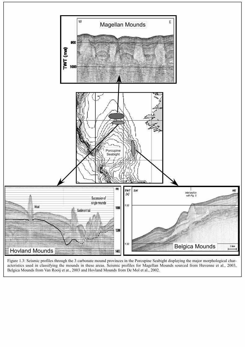
Belgica MoundsHovland Mounds
PorcupineSeabight
Figure 1.3: Seismic profiles through the 3 carbonate mound provinces in the Porcupine Seabight displaying the major morphological char-acteristics used in classifying the mounds in these areas. Seismic profiles for Magellan Mounds sourced from Huvenne et al., 2003,Belgica Mounds from Van Rooij et at., 2003 and Hovland Mounds from De Mol et al., 2002.
Magellan Mounds
environmental parameters would have to have been met for this to occur. The mound
building corals require a hard substrate for colonisation, the presence of bottom
currents to supply food and prevent burial by sediments, and optimal temperature and
salinity conditions (Freiwald and Henrich, 1997; Mortensen et al., 2001).
Hovland et al., (1994) suggested that the mounds initiated growth due to
chemosynthetic symbiosis of organisms dependant on hydrocarbon seepage along
fault planes through to the seafloor, although Henriet et al., (1998) suggested that gas
hydrate crystals in seafloor sediment are more likely to have provided an energy
source for the colonising organisms. This may have occurred in other locations (e.g.
Norway, Hovland et al., 1998; Hovland and Risk, 2003) or in other deep-sea
communities (e.g. Gulf of Mexico, MacDonald et al., 2003), however, no conclusive
evidence to support this hypothesis for the PSB has been found (De Mol et al., 2002;
Ferdelman et al., 2005).
The cause for mound initiation is still unknown and models for mound development
have been proposed on the basis of seismic and sedimentological studies. De Mol
(2002) and Henriet et al., (2002) suggest a system comparable to tropical reef
development, with a trigger stage of initiation, a booster stage of rapid vertical
accretion, a coral bank stage of equilibrium with the environment and a final burial
stage where the mounds are overwhelmed by the surrounding sediment. In addition,
Rüggeberg et al., (in press) and Dorschel et al., (2005) have identified a dependence
between growth and erosion of the mounds in the PSB and glacial and interglacial
cycles. In both studies coral growth is predicted to stop during glaciations due to
cooler temperatures, high sediment supply and lowered bottom current speeds, while
erosion and winnowing of sediment follows during transitions to interglacials.
Resettlement of the mounds and vertical growth is most pronounced during
interstadials.
14
CHAPTER 2: Materials and Methods
SEDIMENT CORE TREATMENT
This thesis studied 1 piston core, 5 gravity cores and 13 box cores retrieved from the
flank of Challenger Mound in the Belgica Mound Province and from Propeller Mound
and the surrounding seafloor in the Hovland Mound Province (Table 2.1). These were
collected during cruises POS-292, POS-265, M61/3 and MD-123 Geosciences Leg 2
on board the R/V Poseidon, R/V Meteor and R/V Marion Dufresne respectively
(Freiwald and shipboard party, 2000; Freiwald and shipboard party, 2002; Ratmeyer
et al., 2004; Van Rooij et al., 2001). Additional references are made to data acquired
from gravity cores analysed by Dorschel et al., 2005. The gravity cores taken by R/V
Poseidon and R/V Meteor (GeoB cores) were cut into one meter sections, whereas the
piston and gravity cores from the R/V Marion Dufresne (MD-cores) were cut into 1.5
m sections. Both types of core were split into working and archive halves and all
cores are stored at 4˚C for further analysis and treatment at the core repository at the
University of Bremen.
All data acquired from the cores by instrumental analysis is accessible from the
PANGEA data base (http//pangea.de).
Opening procedure of cores
Conventional opening procedures were applied to off-mound cores at the University
of Bremen. On-mound cores were given special attention due to the disturbance of the
sediment by large bioclasts. The on-mound cores were first frozen at -18˚C for 72
hours before being cut with a diamond bladed rock saw. Immediately after cutting, the
frozen cutting fluid and upper surface of the core halves were removed with a knife to
preserve sedimentological structures without significant damage.
15

Visual core descriptions
All gravity and piston core sections were visually described after opening, with
sedimentary structures, lithological contacts and fossils, coring disturbance and colour
changes noted. On-mound cores typically contain large bioclasts dominated by the
azooxanthellate corals Lophelia pertusa and Madrepora oculata in a matrix composed
of foraminifera, coccoliths and terrigenous material. Preservation of bioclastic
material is variable along the length of the cores. Off-mound cores are dominated by
hemi-pelagic material, with few large bioclasts. Large lithic fragments are
encountered at some depths, and the majority of sediment is composed of silty sands.
Box core surfaces were first photographed before a description was made of the biota,
carbonate and siliciclastic grain size and type, and sedimentary structures. This was
carried out on deck immediately after recovery. As for the gravity cores, on-mound
cores contained significant quantities of bioclastic material, and off-mound cores were
dominated by hemi-pelagic sediment with lithic fragments present.
Subsampling
Box–core sampling was carried out immediately after recovery. 10 cm2 sub-samples
of the uppermost 0.5 cm were then taken for grain size analysis, grain identification,
and total organic carbon (TOC) and calcium carbonate content measurements.
Gravity and piston cores were sub-sampled with 10 cm3 syringes with the exception
of MD-01-2460G which was sub-sampled with a hammer at 10 cm intervals due to
the desiccation of the core during storage. Sub-samples were collected for grain size,
grain type, isotopic and stratigraphic analyses. All samples were weighed and freeze
dried at -50˚C. Sampling intervals for the GEOB cores were at 5 cm, and at 10 cm for
the MD cores. Higher sampling densities were used in areas of rapid textural or
compositional change for all core types.
A sub-sample set was wet sieved at 63 m and 125 m, and used for isotopic analysis
and dating. The > 125 m fraction was also described using a binocular microscope at
x10 magnification to identify grain types. Samples for bulk analysis were ground and
homogenised using an agate mortar.
16

CoreNo.
Latitude
Longitude
WaterDepth(m)Recovery(cm)
CoreType
Location
GEOB8059-1
GEOB8073-1
GEOB6718-1
GEOB9245-1
GEOB8074-1
GEOB8040-1
GEOB8047-1
GEOB6708-1
GEOB6721-1
GEOB8045-1
GEOB6717-1
GEOB9246-3
GEOB8039-1
GEOB8069-1
GEOB8070-1
GEOB8071-1
MD-01-2450
MD-01-2460G
5209.20N
5208.75N
5209.58N
5208.84N
5208.43N
5208.52N
5209.34N
5209.25N
5209.22N
5209.17N
5209.10N
5208.99N
5208.19N
5209.40N
5208.79N
5208.48N
5122.52N
5208.97N
1246.88W
1247.11W
1244.10W
1247.14W
1245.88W
1245.30W
1246.40W
1246.19W
1246.31W
1246.13W
1246.23W
1246.20W
1246.09W
1246.87W
1247.21W
1246.05W
1143.81W
1246.22W
804
761
890
769
784
809
795
742
696
682
686
750
850
777
760
761
944
710
32 37 27 40 26 2223 31 22 30surface
24 24 382
447
575
1196
1380
BoxCore
GravityCore
CalypsoCore
HovlandMound
Province
BelgicaMound
Province
Table2.1:Overviewofcoresusedinthisthesis
SAMPLE ANALYSIS
Petrographic description/grain type analysis
A total of 389 sub-samples of the >125 m fraction was described using a binocular
microscope at x10 magnification with a visual estimate made of % quartz and lithic
fragments, planktic and benthic foraminifera as well as the occurrence of other
biogenic grains. Large rock fragments recovered from the box cores were used to aid
lithic and mineral identification. This semi-quantitative analysis was used to identify
processes that occur during deposition through an interpretation of the occurrence of
particular components, and to correlate with data retrieved from other analyses.
Stable Isotope Analysis
Oxygen and carbon isotopic measurements were made on ~5 specimens of 2 benthic
foraminiferal species: Cibicides wuellerstorfi and Cibicides kullenbergi selected from
the >125 m size fraction. For the GEOB cores 8069-1, 8071-1 and 8070-1 this was
done at 5 cm intervals, with a higher sampling density taken at well defined
lithological boundaries. For cores MD-01-2450 and MD01-2460G a 10 cm sampling
interval was applied. A lack of benthic foraminifera below ~6 m depth in core MD-
01-2450 resulted in an incomplete record, hence a second suite of 10 to 40 specimens
of the planktic foraminifer Neoglobigerina pachyderma were picked for analysis.
Determinations were made using a Finnigan MAT 251 mass spectrometer. The
isotopic composition of the carbonate sample was measured on the CO2 gas evolved
by treatment with phosphoric acid at a constant temperature of 75ºC. For all stable
isotope measurements a working standard (Burgbrohl CO2 Gas) was used, which had
been calibrated against PDB by using NBS 18, 19 and 20 standards. Consequently all 18O and 13C data given here are relative to the PDB standard. Analytical standard
deviation is about +/- 0.07 % PDB for 18O and +/- 0.05 % PDB for 13C (Isotope Lab
Bremen University). References to isotopic values for the GEOB cores 6728-1, 6729-
1 and 6730-1 in Chapter 5 are derived from Dorschel et al. (2005).
18

DATING
Radiocarbon measurements
Accelerator Mass Spectrometry (AMS) 14C dating was carried out on mono-specific
samples (9 – 12 mg) of the planktic foraminifer Neogloboquadrina pachyderma
(either dextral or sinistral) picked from the >125 m fraction of MD-01-2450. Ages
were determined at the Leibniz Laboratory for Age Determination and Isotope
Research at the University of Kiel (Nadeau et al., 1997). All AMS 14C ages were
corrected for 13C and calibrated to kilo-years before present (kyr B.P.) using CalPal
(Weninger et al., 2004).
Coccolith biostratigraphy
Coccolith biostratigraphy was applied to sediments older than those within the range
of radiocarbon dating. In MD-01-2450 this was below 6 m in depth and samples were
taken every meter. Dissolution of carbonate at these depths along the core resulted in
only one approximate age being identified. For core MD-01-2460G areas for
biostratigraphic dating were identified on the basis of lithological change. Analyses
were carried out by Dr. K.H. Baumann at the University of Bremen. A detailed
description is given in Chapter 5.
For preparation of coccolith samples a combined dilution/filtering technique as
described by Andruleit, 1996 was used. A sediment sample (about 60 mg) was
brought into suspension and further diluted with a rotary splitter. The suspension was
filtered onto polycarbonate membrane filters (Schleicher & SchuellTM, 0.4 µm pore
size) and dried in an oven at 40°C. A small piece of the filter (1x1 cm) was cut out
and mounted onto an aluminium stub. Coccoliths were searched for by means of a
scanning electron microscope (SEM) at a magnification of 2000x or 3000x. At least
200 specimens were counted for each sample in order to determine their relative
abundances and their stratigraphic changes.
19

U/TH dating on coral fragments
Fragments of the coral Lophelia pertusa were taken from several depths of MD-01-
2460G (141, 396, 725, 930, 1177, 1345 cm). However the aragonite skeletons were
found to be in advanced stages of dissolution either due to extended periods of
exposure at the seafloor or due to their age (postulated they were more than 0.3 Ma
old) and no dates were able to be recovered from them. No data from these samples
exist for the pangea database.
TOTAL ORGANIC CARBON AND CaCO3 CONTENTS
These analyses were conducted on box core surface samples only. To determine total
carbon (TC) content, analyses on 25 mg of sub-sample for each location were
performed on a Heraeus-CHN-elementary analyser . In subsequent analyses, samples
were pre-treated with HCl to remove calcium carbonate and dried on a hotplate at
80ºC to determine the total organic carbon (TOC) content. The bulk carbonate
percentage (% CaCO3) was then calculated from the TC content of the sediment
measured with the CHN analyser on untreated samples using the equation:
CaCO3 % = (TC % - TOC %) x 8.33
X-RAY FLOURESCENCE SPECTROMETRY (XRF)
Elemental composition of all the cores was determined using the CORTEX-XRF
scanner at the ODP core repository, Bremen. For GEOB cores scans were run for 30
counts at 20 kV with 5 cm spacing along the whole length of split core apart from at
depths of high coral concentration which prevented measurement. In these incidences,
a measurement was made as closely as possible to the original depth. For core MD-
01-2450 measurements were made at a 5 cm sampling interval, then re-run at a 1 cm
interval for the uppermost 6 m to delineate higher frequency fluctuations in this
section.
The data were processed using Toolbox, the associated Kevex software, and yielded
curves for the elements K, Ca, Ti, Mn, Fe, Cu, Sr, V, Cr, Co, Ni, Zn, and Pb. In our
study we have referred only to the Ca and Fe curves. The Ca curve was used as an
20

indication for total CaCO3 in the core, and Fe as a proxy for the influx of terrigenous
material (Paelike et al., 2001). Results are presented as percentages of the total
element counts (% TC). This normalizing procedure reduces noise levels and largely
avoids artifacts related to variations in grain-size distribution and surface roughness.
GRAIN SIZE ANALYSES
Box Core grain size analyses
Particle size analysis was performed using a Coulter LS2000 on all the surface
samples over a size range from 0.375 – 2000 m. Samples were first treated to
remove excess salt by washing, mechanical agitation and settling undisturbed for
several days. This resulted in grains layered according to size fraction. The samples
were then freeze dried before subdivision to obtain a smaller sub-sample with all
grain sizes represented. Two sample sets were prepared by sieving a few milligrams
of bulk sediment over a 2000 m sieve directly into a glass chamber where they were
mechanically dispersed with water. Organic carbon, carbonate and biogenic opal were
removed prior to the grain size analysis by treatment with excess H2O2, HCl, and
NaOH respectively for one sample set. The second sample set was untreated and was
also measured to enable a calculation of siliciclastic and carbonate grain size
distribution. From the raw data the grain size distribution of the different size
fractions were calculated and they are presented as % volume of sediment. Testing of
several sub-samples was done until samples yielded similar results, indicating that the
results were robust to the processing steps.
Gravity Core Analysis
Coulter LS2000
Grain size distribution curves for MD-01-2460G were determined using a Coulter
LS2000 using a 10 cm sampling interval along the length of the 13.8 m long core.
Analyses were run on carbonate free sediment in the size range from 0.375 – 2000 m
only. Samples were prepared from several mg of freeze dried bulk sediment sieved
through a 2000 m mesh. This sediment was mechanically dispersed in water before
treatment with excess H2O2 to remove organic carbon, HCl to remove carbonate and
21

NaOH to remove biogenic silica. Analyses were repeated several times to establish
repeatability before statistical calculations of the different grain size classes.
Malvern Laser Particle Sizer Mastersizer 2000
Particle size analyses were performed on samples from MD-01-2450 using the
Malvern Laser Particle Sizer Mastersizer 2000 by M. Kozachenko at the Coastal and
Marine Resources Centre, University College of Cork, Ireland. A sampling interval of
10 cm was used, with a higher density taken in areas of rapid lithological change.
Representative sub-samples were taken for analysis with each sub-sample dispersed in
10% sodium polyphosphate solution made with distilled water and shaken for 24
hours with an automatic flask shaker in order to achieve a perfect dispersion of all
particles within the sample. All sub-samples were sieved and only the fraction < 2
mm (2000 µm) was used for analysis. Each sub-sample was measured 5-10 times and
the average result taken to represent the sample.
Particle size distributions were statistically analysed to produce the following
variables: percentage clay (% < 2 µm), percentage silt (% 2-63 µm), percentage
sortable silt (% 10-63 µm), percentage sand (% 63-2000 µm), IRD index (% > 150
µm) and mean sortable silt size.
22
CHAPTER 3: Glaciomarine drift sedimentation and bottom current
variability: Belgica Mound Province, Porcupine Seabight
To be submitted to Earth and Planetary Science Letters
Alexandra Jurkiw (corresponding author)
RCOM – Research Center Ocean Margins, University of Bremen, Leobener Str. D-
28334 Bremen, Germany.
Email: [email protected]
Max Kozachenko
Coastal and Marine Resources Centre, ERI, University College Cork, Naval Base,
Haulbowline, Cobh, Cork, Ireland
Tel: +353 (21) 4904054
Fax: +353 (21) 4703132
Email: [email protected]
Dierk Hebbeln
MARUM – Center for Marine Environmental Studies, University of Bremen,
Leobener Str. D-28334 Bremen, Germany.
Tel: +49 (0) 421 218 9079
Fax: +49 (0) 421 218 8916
Email: [email protected]
Anneleen Foubert
Renard Centre of Marine Geology, Universiteit Gent, Geology and Soil Sciences
Krijgslaan 281-S8 Gent 9000, Belgium
Tel: +32 (0) 9264 4591
Fax: +32 (0) 9264 4967
Email: [email protected]
Keywords: Belgica Mounds, drift, glaciomarine, Porcupine Seabight
23

ABSTRACT
Lithological, grain size, isotopic and geochemical studies have been conducted on an
11.75 m long core recovered from the Porcupine Seabight off the coast of south
western Ireland. The sedimentary record covers parts of the last glacial (~35 kyr B.P.
to ~21 kyr B.P. with an average sedimentation rate of ~38 cm/kyr) and an older,
underlying section (>200 kyr. B.P.), separated by a hiatus. The lower part of the core
provides evidence of an older glacial period, with significantly reduced water mass
ventilation and an absence of coarse ice rafted debris, while the upper section has
higher average grain sizes and calcium carbonate contents. The results of grain size
analysis along the core indicate that sedimentation was affected by bottom current
activity, with variation in current speed and sediment supply through time.
INTRODUCTION
In addition to the vertical particle flux through the water column continental margins
are commonly affected by both downslope and alongslope sediment transport
processes. Sediment can be supplied by debris or turbidity flows and later on
gradually reworked into drift bodies by bottom current activity. The composition of
the drift reflects the regional setting and may be used to infer syn-depositional
processes, while changes in the sediment grain size may reflect variations in bottom
current intensity. Bottom currents are extremely size selective in terms of erosion as
well as deposition (McCave et al., 1995; Weltje and Prins, 2003) and transported
grains are typically <60 m (Prins et al., 2002; Weltje and Prins, 2003).
The Porcupine Seabight (PSB) is thought to have been a site of active bottom current
flow since the Miocene, with the erosion of channels and formation of drift bodies
interpreted from seismic profiles (Van Rooij et al., 2003). Bottom current activity in
the PSB today is postulated to be driven by the Mediterranean Outflow Water
(MOW), a highly saline and oxygen depleted water mass (Schoenfeld, 2002b;
Loewemark et al., 2004). Lowered sealevels during glacial periods are thought to
have restricted the flow of MOW from the Mediterranean to the Atlantic through the
Straits of Gibraltar (Schoenfeld and Zahn, 2000). Some of the effects of this in the
PSB are discussed by (Dorschel et al., in press; Rüggeberg et al., in press).
24
Previous studies in the PSB have concentrated predominantly on the distribution and
biology of the carbonate mounds on the seafloor (Rice et al., 1991; Hovland et al.,
1994; Henriet et al., 1998; Freiwald et al., 1999; De Mol et al., 2002; Huvenne et al.,
2003). Some have suggested a relationship between the occurrence of these mounds
and the activity of bottom currents and the presence of the MOW (Rice et al., 1991;
Freiwald et al., 1999; Van Rooij, 2004; Dorschel et al., in press; Rüggeberg et al., in
press).
Understanding how significant the variability in current intensity has been through
glacial/interglacial events and what changes have occurred in sediment supply and
accumulation during these times may provide some insight to the factors determining
the location of such carbonate mounds in the PSB. This paper aims to describe
sediment accumulating in a carbonate mound province and to interpret processes
having operated in the PSB during the Late Pleistocene from the sedimentary record.
REGIONAL SETTING
Physiography
The PSB (Figure 3.1) occurs off the west coast of Ireland. It is a NE-SW oriented
sedimentary basin formed in the Mid- to Late Jurassic on a failed rift (Shannon,
1991). The modern PSB is approximately 150 km long and varies in width from 65
km in the north to 100 km in the south. Its bathymetric depth increases from 300 m in
the north to over 2000 m in the south. The PSB is bound by three shallow platforms:
the Slyne Ridge in the north, the Irish Mainland Shelf to the east and the Porcupine
Ridge in the west (Croker and Shannon, 1995) .
Present day bottom-water circulation
Two main water masses can be recognised in the study area today: Eastern North
Atlantic Water occurs below the surface current down to a core of minimum salinity
between 500-600 m depth, below which highly saline MOW is found from 800 to
1000 m (Rice et al., 1991; Van Aken, 2000; White, in press). Scatter in data at the
boundaries of these water masses has been suggested as a result of mixing through
25
internal tides, (Rice et al., 1991; De Mol et al., 2002; Mohn and Beckmann, 2002).
The results of hydrodynamic modelling and current meter deployment indicate that
currents in the PSB generally flow in a northerly direction long the eastern margin
(Rice et al., 1991; White, 2001; Hall and McCave, 1998). Measured current speeds
average 4 cm/s between 500 and 1000 m water depth (Pingree and Le Cann, 1989;
Pingree and Le Cann, 1990). However, higher current speeds of up to 100 cm/s have
been inferred from calculations based on the geometry and scale of observed
bedforms (Akhmetzhanov et al., 2001) and from the coarseness of the sediment
surface texture observed in side scan sonar and sea floor images (Huvenne et al.,
2002a; Foubert et al., 2005). The northerly slope current is likely to be affected by
internal waves and tides in the Seabight, resulting in an increase in current velocities
locally (Mohn and Beckmann, 2002; Mohn et al., 2002; Huvenne et al., 2002a). The
effects of this would be highest in the south eastern flank of the basin.
Sedimentation
The influx of terrigenous material to the PSB today is low (Tate, 1993), and is likely
to have a provenance from the Irish and Celtic shelves, with a limited contribution
from the Porcupine Bank (Rice et al., 1991). The Gollum Channel system in the south
of the PSB is thought to be inactive today, although it may have transported sediment
to the southeast of the basin in the past (Wheeler et al., 1998b).
Reworking of sediments by bottom currents has been discussed by Van Rooij et al.
(2003) through the identification of drift bodies in seismic profiles. This concurs with
observations made during core and sediment analyses in which reworked
foraminiferal sands have been recovered (Rice et al., 1991; Rüggeberg et al.,
submitted; Rüggeberg et al., in press; Dorschel et al., in press), and with analyses of
other seismic and side scan sonar data sets (Kenyon et al., 1998; Akhmetzhanov et al.,
2001; De Mol, 2002; Huvenne et al., 2002b Van Rooij et al., 2003; Beyer et al., 2003;
Foubert et al., 2005).
26

Slyne Ridge
Porcupine Bank
PorcupineAbyssalPlain
Goban Spur
BMP
GollumChannelSystem
PorcupineSeabight
Ireland
Figure 3.1: Location of the Porcupine Seabight on the European North Atlanticmargin, southwest of Ireland. Also shown are the location of the Belgica MoundProvince (BMP) and core MD-01-2450.
MD-01-2450
Three carbonate mound provinces occur within the PSB (Hovland et al., 1994; De
Mol et al., 2002), and these mounds contribute some coarse bioclastic material to the
seafloor in their immediate surroundings (Dorschel et al., in press; Rüggeberg et al.,
in press). The core in this study samples the seafloor in the Belgica Mound Province
in the southeast of the PSB.
DATA AND METHODS
All the samples analysed here were obtained from core MD-01-2450, a piston core
retrieved on R/V Marion Dufresne Cruise MD 123-Geosciences, Leg 2, 2001. The
core is 11.75 m long and was taken from 944 m water depth at 51°22,5’N and
11°43,8’W. The core was logged descriptively before sub-sampling with syringes for
grain size, isotopic and stratigraphic analyses. Samples were taken at 10 cm intervals
from 5 cm onwards, with additional samples taken for grain size analysis in areas of
rapid textural change. Sub-samples were wet sieved at 63 m and 125 m, and used
for isotopic analysis and dating. The >125 m fraction was also described using a
binocular microscope at x10 magnification to identify grain types and the occurrence
of foraminifera.
The age model for core MD-01-2450 is based on 6 Accelerator Mass Spectrometry
(AMS) 14C ages determined from 9 – 12 mg samples of Neoglobigerina pachyderma
from the grain size fraction >125 m. Analyses were performed at the Leibniz
Laboratory for Age Determination and Isotope Research at the University of Kiel
(Nadeau et al., 1997). A correction for 13C was applied and corrected ages were
translated to calendar years using CalPal (Weninger et al., 2004). Additional
stratigraphic information was provided from coccolith biostratigraphy.
Stable isotope measurements were made at the University of Bremen Isotope
Laboratory (Germany) on a Finnigan MAT 251 mass spectrometer. The
measurements were performed on either 5 specimens of Cibicides wuellerstorfi, 5
specimens of Cibicides kullenbergi, or 20 specimens of Neogloboquadrina
pachyderma. Acid temperature was maintained at 75ºC during analysis. The standard
deviation of the isotope values calibrated against PDB by using carbonate standards
NBS 18, 19 and 20 is +/- 0.07 % PDB for 18O and +/- 0.05 % PDB for 13C.
28

A Malvern Laser Particle Sizer (Mastersizer 2000) was used to compare the grain size
distribution of the sediment contained in the core. Grain size analyses were performed
on bulk sediment at 10 cm intervals for the complete core and at a higher resolution
across textural boundaries. Samples were dispersed in 10% sodium polyphosphate
solution prepared using distilled water. The suspension was agitated for 24 hours after
which it was sieved and the <2000 µm fraction taken for analysis. Measurements
were repeated 5-10 times and the results averaged before subdivision into the
following grain size classes: clay (% < 2 µm), silt (% 2-63 µm), sortable silt (%10-63
m), sand (% 63-2000 µm), ice rafted detritus (IRD) index (% > 150 µm) and mean
sortable silt size. A low incidence of foraminifera throughout most of the core meant
that the size range >150 m could be used as an indicator of IRD.
Ca and Fe elemental composition of MD-01-2450 was obtained by a non-destructive
XRF (X-Ray Fluorescence) scanner (Jansen et al., 1998) using a 30 s count time and
20 kV. The entire core was scanned using a 5 cm interval, and the uppermost 6 m
were rescanned at 1 cm spacing for a higher frequency record. The recorded spectrum
was analysed using the KEVEX™ software, Toolbox©. The percentage of Ca and Fe
are used as indicators of the relative contribution of marine CaCO3 and terrigenous
material respectively (Pälike et al., 2001), and are displayed as a percentage of total
counts (%TC).
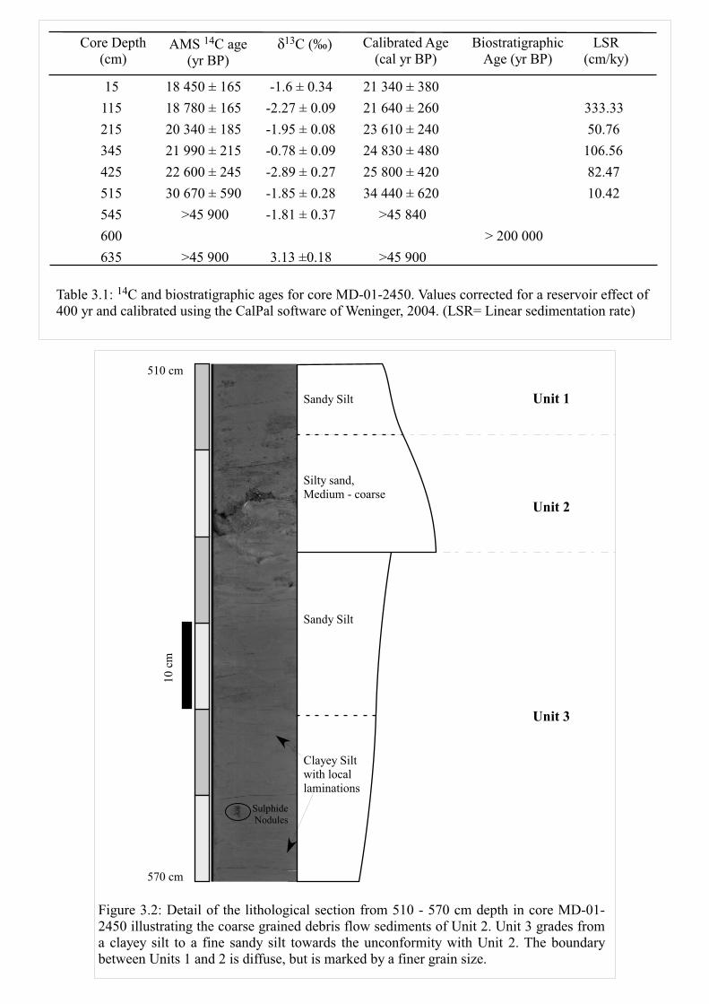
RESULTS
Using stable isotope data, XRF analyses and particle size curves, the core can be
divided into 3 lithofacies (Units 1-3) based on lithology, bioturbation, internal
structures and texture. Although Units 1 and 3 are composed of a mixture of sand, silt
and clay, a distinction is made between them on the basis of the Ca and Fe curves, the
sand content and the 13C curve. Unit 2 is lithologically distinct from the over and
underlying units.
The age dating for the uppermost section (0 - 515 cm) of the core revealed a
continuous sequence of six calibrated AMS 14C ages ranging from 34.4 kyr B.P at 515
cm to 21.3 kyr B.P. at 15 cm (Table 3.1). Thus, this part of the core represents parts of
29

marine isotope stages (MIS) 2 and 3. Beneath Unit 2 the sediments were too old to be
dated by the radiocarbon method, but the coccolith assemblage points to an age of
more than 200 kyr B.P.
Unit 1 (0 – 532 cm): homogenous sandy mud
This unit is composed of a poorly sorted olive grey sandy clayey silt (Figure 3.2) with
37 – 80 % silt, 5 – 23 % sand and 8 – 16 % clay. Its IRD content ranges between 0.8
% and 35 % with values mostly >10 %. Sortable silt values average 32%, with a
maximum of 44 % and minimum of 18 %. The average mean sortable silt size is
highest in this unit, with a value of 28 m and a range in size from 25 to 32 m
(Figure 3.3). No sedimentary layering is apparent, and bioturbation is indicated by
mottling and homogenisation of the sediment. Smear slides indicate that quartz is
extremely common, with lithic clasts, including limestone fragments present.
Foraminifera and bioclastic debris also occur, and are noticeably more prevalent than
in underlying Unit 3, particularly agglutinating benthic foraminifera. Sulphide
nodules occur as sand sized grains and are less common, and much smaller than those
of Unit 3. Ca values are between 12 and 26 %TC, and Fe shows higher values from
33 to 41 %TC. Planktic 18O data fluctuate between 2.88 and 4.17 ‰PDB, and as in
Unit 2, 13C values have a considerably higher average than in Unit 3, ranging
between – 0.69 and 0.17 ‰ PDB (Figure 3.4). Benthic foraminifer values show fewer
fluctuations, with 18O ranging from 3.2 to 3.9 ‰PDB, and 13C ranging from 0.8 to
1.3 ‰PDB.
Unit 2 (518-532 cm): poorly sorted silty sands
This is the thinnest unit in the core and is composed of very poorly sorted olive brown
to yellowish ochre brown stacked sequences of sediment grading from clayey silty
sand to clayey sandy silt (Figure 3.2). There is no indication of bioturbation. Particle
size curves indicate a high proportion of IRD (44 %), up to 16 % sand, 35 – 43 % silt
and minor amounts of clay (7 – 14 %). Sortable silt averages 19.7%, ranging from a
maximum of 16 to 24%. Average mean sortable silt size is 27 m, with a range from
25-29 m (Figure 3.3). Smear slides show a predominance of quartz grains, with
some lithic clasts as well as a high proportion of planktic and benthic foraminifera and
30

comminuted shell debris. Diversity in foraminiferal species is high, particularly in
benthic specimens. Ca values range between 13 – 26 %TC and Fe is slightly higher at
33 – 39 %TC. The 18O values of N. pachyderma vary within a narrow range between
3.4 and 3.44 ‰ and benthic 18O values range between 2.4 and 3.4 ‰ PDB. A very
prominent signal is displayed by the 13C values of N. pachyderma marked by a sharp
increase from -0.9 ‰ PDB at the top of Unit 3 to 0.19 ‰ PDB within Unit 2 (Figure
3.4). Benthic 13C values are fairly constant at about 1.2 ‰ PDB. The contact with
Unit 1 is gradational.
Unit 3 (532-1180 cm): moderately well sorted sandy clayey silt
Unit 3 is composed of an olive grey clayey silt to sandy clayey silt with some sections
of faint varve-like alternating silt- and clay- rich laminae on a millimetre scale.
Throughout the unit there are sulphidic laminae and nodular sulphides up to 12 mm in
diameter (Figure 3.2). Bioturbation is rare, but where present it is intense and has
almost totally homogenised the sediment. Particle size curves reveal 54 – 80 % silt, a
smaller component of clay (<30 %), up to 24 % sand, and between 0% and 10 % IRD
(Figure 3.3). Sortable silt averages 30.7 %, although values range from 14 to 42 %.
From bulk analyses, mean sortable silt size averages 24 m, and ranges from 19 to 31
m. Smear slides indicate that this unit is almost devoid of biogenic grains, and is
dominated by quartz and lithic particles. Benthic foraminifera are almost entirely
absent, with trace occurrence of planktic specimens. The diversity of species is low,
but increases gradually towards the boundary with Unit 2. The Ca values are < 25
%TC, whereas the Fe counts are higher with a lower variability (35 – 42 %TC). 18O
values for the planktic foraminifera N. pachyderma fluctuate between 3.22 - 4.31 ‰
PDB, whereas the respective values for 13C show are between -0.98 and -0.28 ‰
PDB (Figure 3.4). Almost all data sets show some variability with similar values at
the base of the core and close to the boundary to Unit 2. The contact with the
overlying Unit 2 is sharp and erosional.
DISCUSSION
A subdivision of the core into units allows the examination of the processes having
occurred at the seafloor of the PSB during parts of the Late Pleistocene. The variation
31
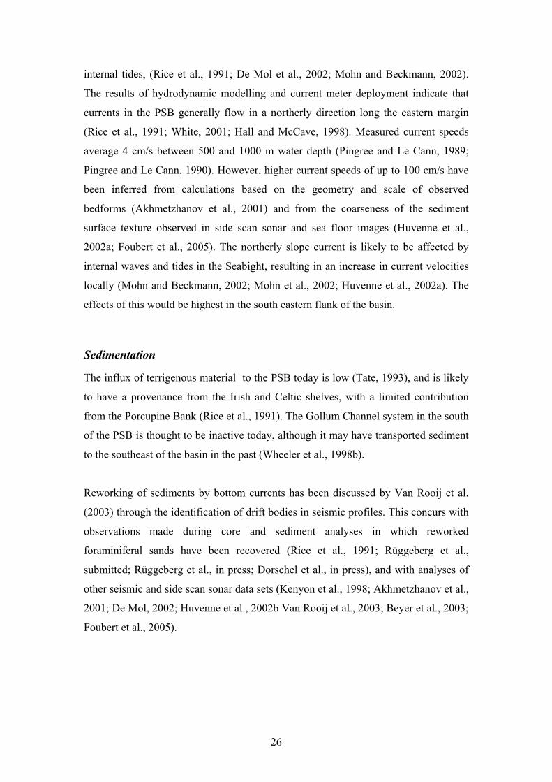
Core Depth(cm)
15115215345
515425
545600635
18 450 ± 16518 780 ± 16520 340 ± 18521 990 ± 215
30 670 ± 59022 600 ± 245
>45 900
>45 900
AMS 14C age(yr BP)
333.3350.76106.56
10.4282.47
LSR(cm/ky)
21 340 ± 38021 640 ± 26023 610 ± 24024 830 ± 480
34 440 ± 62025 800 ± 420
>45 840
>45 900
Calibrated Age(cal yr BP)
-1.6 ± 0.34-2.27 ± 0.09-1.95 ± 0.08-0.78 ± 0.09
-1.85 ± 0.28-2.89 ± 0.27
-1.81 ± 0.37
3.13 ±0.18
δ13C (‰)
> 200 000
BiostratigraphicAge (yr BP)
Table 3.1: 14C and biostratigraphic ages for core MD-01-2450. Values corrected for a reservoir effect of400 yr and calibrated using the CalPal software ofWeninger, 2004. (LSR= Linear sedimentation rate)
510 cm
10cm
570 cm
Clayey Siltwith locallaminations
Sandy Silt
Silty sand,Medium - coarse
Sandy Silt Unit 1
Unit 2
Unit 3
SulphideNodules
Figure 3.2: Detail of the lithological section from 510 - 570 cm depth in core MD-01-2450 illustrating the coarse grained debris flow sediments of Unit 2. Unit 3 grades froma clayey silt to a fine sandy silt towards the unconformity with Unit 2. The boundarybetween Units 1 and 2 is diffuse, but is marked by a finer grain size.
MIS 2
MIS 3
2.54.5 3.5
Plankticδ18O (‰PDB)
4.2 2.23.2
Benthicδ18O (‰PDB)
302010
Ca(% Total Counts)
1.50.7 1.1
Benthicδ13C (‰PDB)
-0.9 0.3-0.1-0.5
Plankticδ13C (‰PDB)
32 4436 40
Fe(% Total Counts)
21.34
21.64
23.61
24.83
25.8
34.44
>200
0
100
200
300
400
500
600
700
800
900
Unit3
Unit1
Depth(cm)
Age(ka)
1000
1100
Figure 3.4: Stratigraphy, planktic and benthic δ18O and δ13C isotope records and Ca and Fe content (%Total Counts) for core MD-01-2450. Unit boundaries and Marine Isotope Stages (MIS) indicated.
MIS 2
MIS 3
10 20 30 400 10 20 30 400 10 20 30 0 10 20 30 4030 50 70 90 21 25 332917
% Clay % Silt % Sand % IRD % Sortable Silt Mean SortableSilt Size (μm)
21.34
21.64
23.61
24.83
25.8
34.44
>200
Age ka
0
100
200
300
400
500
600
700
800
900
1000
1100
Depth(cm)
Unit3
Unit1
Figure 3.3: Grain size distributions for MD-01-2450 showing volume % of clay fraction (<2 μm),silt (2-63 μm), sand (63-150 μm), IRD (>150 μm), sortable silt (10 - 63 μm) and mean sortable siltsize (μm). Marine isotope stages (MIS) and unit boundaries indicated.

in lithology recovered is suggestive of a range of processes and conditions acting at
the time of deposition, Unit 3, the moderately sorted sandy silt can be interpreted as a
hemipelagic-glaciomarine drift, with predominantly fine sediment and few incidences
of coarser, IRD enriched zones. The small scale lamination indicates that bottom
currents were active during deposition. The low abundance of foraminifera in this unit
might be explained by low surface productivity often associated during glacials with
sea ice coverage (although the IRD input is rather modest) (Maslin et al., 1995;
Thomas et al., 1995; Jennings et al., 1996; Chapman et al., 2000; Presti et al., 2003;
Spielhagen et al., 2005), or with dilution through a high influx of terrigenous material
(Thomas et al., 1995; Robinson et al., 1995) or by dissolution of calcite by corrosive
bottom waters.
Unit 2, with its erosive contact to Unit 3 and stacked graded beds is interpreted to be
the remains of a debris flow or slump having occurred locally and cutting down into
Unit 3. These sediments are similar in composition to that of both the over and
underlying units; however the increase in foraminiferal and other biogenic remains
indicates that much material had originated from elsewhere, possibly the upper slope.
The absence of bioturbation and the thinness of the unit support the interpretation of a
sudden event, sorting and mixing sediment from both the immediate sea floor and the
shelf.
The sediment of Unit 1 is of both hemipelagic and glaciomarine origin. The grain size
distribution and homogenous bioturbated character of the sediment indicates
predominantly hemipelagic sedimentation, although with a higher proportion of
coarse IRD. The slightly higher mean sortable silt size than in Unit 3 suggests that
redistribution of sediments into drifts by stronger bottom currents occurred here. The
occurrence of agglutinating foraminifera in Unit 1 may also be an indicator for higher
current speeds. Elsewhere, a supply of sediment with which to compose their tests has
been identified as a limiting factor for their presence (Thomas et al., 1995). Some of
the coarser grain size is attributable to sediment fluxes associated with European Ice
Rafting and Heinrich Events 2 and 3 (Snoeckx et al., 1999; Scourse et al., 2000;
Auffret et al., 2002). Alternatively, the proximity of ice sheets to the sampling site
may influence the grain size of the IRD. Coarser IRD is likely to be entrained and
34

deposited close to ice of a terrestrial or shelfal origin, whereas finer grained IRD is
anticipated more distally to the ice front, or below areas covered by sea-ice.
EVENTS AND PROCESSES
Drift
The modern sediments in this area are interpreted to be mounded or confined drifts
(McDonnell and Shannon, 2001; De Mol, 2002; Van Rooij et al., 2003), although
apart from Van Rooij et al., (in press), their internal structure has not been studied in
much detail. Low current speeds are thought to have operated during the deposition of
both glaciomarine drift bodies recorded in MD-01-2450. Variability in current
intensity may have resulted in the silt-clay laminae seen in Unit 3 and although a
slightly higher comparative mean sortable silt size occurs in Unit 1, persistent
bioturbation has homogenised the sediment. Low current speeds during glacial
periods in the PSB are suggested to be related to a decrease in the influence of MOW,
thought to be the driving mechanism behind the bottom currents in this location.
Debris Flow and Slump
Unit 2, the debris flow deposit, contains a high incidence of coarse lithic clasts and
biogenic material compared to Units 1 and 3. The event may have been triggered by
loading of the upper slope by glaciomarine deposits or by turbidity currents moving
sediment off the shelf through cold dense water formation (Bart et al., 1999; Weaver
et al., 2000; Dowdeswell et al., 2002). The increase in biogenic content suggests that
some shelfal material is included in this unit, or that enhanced productivity was
occurring through MIS 3 compared to Unit 3. Interpretations of side scan sonar
images in this area by Vermeulen (1996) suggest that periodically active slump folds
operate here. Further evidence of debris flows and slumping is provided by Van Rooij
et al., (2003).
Microfossil dating of Unit 3 failed to reveal any definitive age beyond >200 ky at 6 m
due to a lack of nannofossils. Thus, there has been significant erosion between the two
drift units, with at least 170 ky of deposition missing. Using the most conservative of
35

the sedimentation rates calculated for Unit 3, this may equate to approximately 17 m
of sediment being removed between Unit 3 and Unit 1, or otherwise a lengthy period
of non-deposition.
Bottom current activity
A strong northward bottom current operating in the eastern PSB in the present day has
been described by several authors (Pingree and Le Cann, 1989; Rice et al., 1994; Hall
and McCave, 1998). Although no direct current measurements exist at the coring site,
measurements on this eastern flank of the Porcupine Seabight record a mean flow of 4
cm/s at 1000 m water depth (Pingree and Le Cann, 1989; 1990). Seabed photographs
and side scan sonar imagery show variability in present day seafloor morphology
(Chachkine and Akhmetzhanov, 1998; Krylov, 1998), and seismic interpretations
suggest that drift bodies and sediment waves have been present for a considerable
length of time (Wheeler et al., 1998a, McDonnell and Shannon, 2001; De Mol, 2002;
Huvenne et al., 2002a; Van Rooij et al., 2003; Van Rooij et al., in press). De Mol et
al., (1999) and Beyer et al., (2003) suggest that a contourite current operates in this
area between 500 and 1000 m at the present day and indicate this may have been
present since the Early Miocene. The origin of the flow is attributed to MOW entering
the PSB from the south and circulating in an anticylconic direction (New et al., 2001).
Variation of its effects in the PSB through glacial/interglacial cycles has previously
been noted by Schoenfeld (2002a), Loewemark et al., (2004) and Dorschel et al., (in
press), Dorschel et al., (2005).
Sediment particle size studies of North Atlantic sediments have shown that there is a
relationship between mean sortable silt size and bottom current velocity (McCave et
al., 1995; Weltje and Prins, 2003). The entire core records a sequence of sediment
strongly influenced by fluctuating bottom current intensities. The on average higher
mean sortable silt sizes in Units 1 and 2 compared to Unit 3 suggests that less intense
currents were operating during the deposition of the older unit.
An increase in sortable silt size towards the Unit 3 and 2 boundary possibly reflects a
gradual progression to enhanced bottom water circulation driven by MOW. The
coeval increase in % Ca and slight increase in grainsize toward this boundary may be
36

an indication of associated renewed ventilation in the Seabight, with melting icebergs
and enhanced down-slope movement of coarser material in Unit 2. The higher Ca
values are also caused by the better preserved foraminifera and nannofossils which are
in turn indicative of less corrosive bottom waters. Although isotopic values still
indicate cold conditions in Unit 1, bottom currents are slightly more intense than in
Unit 3 and sediments gradually coarsen as a response to winnowing and from coarse
IRD input from drifting ice. The occasionally highly silty laminae in Unit 3 may be an
expression of distal deposits of episodic high energy turbidity currents. Rapid and
continuous deposition of this type would prevent benthic faunas from settling, thus
preserving the laminations.
As for Unit 3, bottom currents operated in glacial periods during the deposition of
Unit 1, but were more intense during MIS 3 than MIS 2. The coarser grain size and
more frequent bioturbation do not preserve any lamination and the greater
preservation of biogenic material indicate that bottom waters were better ventilated
than during the deposition of Unit 3. The coarse grain size of the IRD component is
likely to be a result of influxes of material from iceberg melting rather than bottom
current entrainment.
Hemipelagic deposition
This area of the sea floor appears to have been subject to the slow accumulation of
fine-grained sediment in a glaciomarine environment. The effects of glaciation in Unit
3 are interpreted from the lowered current velocities and low foraminiferal abundance
related to reduced productivity associated with proximity to ice sheets and dissolution
of CaCO3 in a poorly ventilated and cold basin. Unit 1, however, although still
dominated by fine sediment contains a significantly larger volume of IRD.
IRD
Based on the grain size distribution of the sediments in Units 1 and 2, and the
composition of sediment in Unit 3 with its scarcity of foraminifera and nannofossils,
we suggest that most of the coarser grains (>150 µm) in all Units have been sourced
from IRD. In Units 1 and 2 this material would have been provided by continuous
deposition from sea ice, as well as from fluctuations of both European Ice Rafting
37

Events 2 and 3 and Heinrich Events 2 and 3 (Snoeckx et al., 1999; Scourse et al.,
2000; Auffret et al., 2002). The higher Ca values associated with Unit 1 are related to
both the higher incidence of foraminiferal carbonate preserved in this section, with a
minor contribution from limestone eroded by the BIIS from the Irish landmass
(Scourse et al., 2000; Richter et al., 2001). In Unit 3, fine grained IRD would have
entered the study area from ice rafting, meltwater plumes or from turbidity flows
transporting ice or glacially derived material from the shelf to the basin floor
(Stevens, 1990; Powell, 1990).
CONCLUSIONS
The Late Pleistocene drift sequences preserved in the eastern PSB show that
conditions in the PSB have been variable and strongly influenced by glacial events.
Variability recorded in chemical properties, sediment composition, grain-size and
stable isotope values reflect changes in oceanographic conditions in the PSB as a
response to northern hemisphere glaciations during MIS 2 and 3 and earlier, undated
events.
Three distinct sedimentary units have been identified. Two glaciomarine drift units
are separated by a debris flow, interpreted to have removed at least 17 m of sediment
representing a timespan of approximately 160 kyr. Both drift units have formed as a
result of the interaction of shelfal material, IRD and bottom currents. The contrasting
grain-size between the two units reflects the variable sediment provenance and bottom
current regime under which they were deposited. The coarser grained nature of the
uppermost drift body is a result of direct ice rafting of material from the European Ice
sheets.
Glacial periods are recorded in both units and are interpreted from small transported
grain size, a high IRD content in some units, lowered carbonate preservation and low
foraminiferal abundance. The lower Ca % of Unit 3 is attributed to poor ventilation of
the PSB and higher corrosiveness of bottom waters during its deposition than in Units
1 and 2.
38

ACKNOWLEDGEMENTS
This work was supported by the EU 5th framework projects ECOMOUND and
GEOMOUND. Technical support has been provided by the Research Center Ocean
Margins (RCOM) at the University of Bremen, Coastal and Marine Resources Centre,
(University College Cork) and the Renard Centre of Marine Geology (University of
Ghent).
39

CHAPTER 4: Modern surface sediment from Propeller Mound,
Porcupine Seabight
To be submitted to Earth and Planetary Science Letters
Alexandra Jurkiw (corresponding author)
RCOM – Research Center Ocean Margins, University of Bremen, Leobener Str. D-
28334 Bremen, Germany.
Email: [email protected]
Dierk Hebbeln
MARUM – Center for Marine Environmental Studies, University of Bremen,
Leobener Str. D-28334 Bremen, Germany.
Tel: +49 (0) 421 218 65650
Fax: +49 (0) 421 218 65505
Email: [email protected]
Boris Dorschel
University College Cork, Department of Geology
Tel: +353 (0) 214 903 696
Fax: +353 (0) 214 271 565
Email: [email protected]
Keywords: carbonate mound, Propeller Mound, Porcupine Seabight, bottom current,
drift, surface sediment
ABSTRACT
Sedimentological analyses were conducted on surface sediments collected by box
corer from Propeller Mound, a cold-water coral covered carbonate mound in the
Hovland Mound Province in the Porcupine Seabight. These samples have been used
to determine sedimentological changes around the mound in relation to morphological
setting and bottom current regime. Coarse biogenic carbonate prevails on the mound
and in knoll-type environments identified on the surrounding seafloor, whereas the
40
influence of hemipelagic sedimentation increases away from the mound. Winnowed
lag deposits of coarse, non-carbonate material were recovered from the seafloor to the
west of the mound and on the mound top, suggesting that strong bottom currents have
been active here, or that Propeller Mound formed a barrier between turbidites from
the shelf and the eastern study region. Current focusing due to topographic relief at
the crest of mound is likely to have enhanced the accumulation of coarser grains here.
INTRODUCTION
The Porcupine Seabight (PSB) is characterised by a variety of sedimentary facies.
Drift deposits have been identified on its eastern (Van Rooij et al., 2003) and northern
margins (Huvenne et al., 2003; Huvenne, 2003), and are thought to be driven by the
North Atlantic ‘shelf-edge’ current and the Mediterranean Outflow Water (White, in
press). Carbonate mounds also occur in the PSB (Hovland et al., 1994; Henriet et al.,
1998; De Mol et al., 2002; Huvenne et al., 2002). These range in height from less than
a meter, to several hundreds of meters in height and support a diverse range of
organisms.
Understanding the factors that constrain the livelihood of the carbonate mounds is
vital to the preservation of their associated ecosystems which are dominated by cold-
water corals. Although considerable work has been published identifying their
location, size and range or charaterising surface images from seismic, side scan sonar
studies and video footage (Hovland et al., 1994; Wheeler et al., 1998a; Henriet et al.,
1998; Huvenne et al., 2002; Van Rooij et al., 2003; Foubert et al., 2005), only little
work has been done on sedimentological data from these areas, (Dorschel et al., 2005;
Rüggeberg et al., in press; Rüggeberg et al., 2005; Van Rooij et al., in press) . There is
evidence of bottom current activity in the vicinity of the mounds, with scoured moats,
dropstone pavements and eroded sections documented (Hovland et al., 1994; De Mol
et al., 2002; Van Rooij et al., 2003; Dorschel et al., 2005).
An objective of this study is to describe the modern surface sediments and establish if
there is variability in grain size distribution in these surface sediments over Propeller
Mound in the Hovland Mound Province. We also describe the variability between the
41
carbonate and siliciclastic component of the sediment and relate the grain-size
distributions to hydrodynamic conditions at the seafloor.
REGIONAL SETTING
Physiography and hydrography
The Porcupine Seabight off the southwest coast of Ireland is bounded by the
Porcupine Bank, the Slyne Ridge, the Irish Shelf and the Goban Spur (Figure 4.1). Its
breadth expands from 65 km in the north to 100 km in the south with a coeval
increase in water depth from 300 m in the north to more than 2000 m in the south.
The current oceanographic profile is defined by two main water masses. Eastern
North Atlantic Water (ENAW) occurs down to approximately 750 m water depth
where it is underlain by Mediterranean Outflow Water (MOW), a water mass of
higher salinity extending to a water depth of approximately 1000 m (Rice et al., 1991;
Van Aken, 2000; White, in press). Bottom currents are active at the seafloor today
(Van Rooij et al., 2003) and are driven by the incursion of MOW into the PSB (Mohn,
2000). Along the eastern margin of the PSB, these currents flow from south to north
with an average speed of 4 cm/s (Pingree and Le Cann, 1989; Pingree and Le Cann,
1990; Rice et al., 1991). The currents weaken in the north of the Seabight and change
direction to the southwest (White, in press). There is evidence of locally higher
current speeds throughout the Seabight in the form of coarse surface sediments
(Huvenne et al., 2002; Foubert et al., 2005), sediment waves (Akhmetzhanov et al.,
2001), channels and drift sediment wedges (Van Rooij et al., 2003). Some of these
increases in speed are driven by internal waves and tides (Rice et al., 1991; Mohn et
al., 2002; De Mol et al., 2002).
Sedimentation
Present day sedimentation in the PSB is dominated by pelagic to hemi-pelagic
sedimentation with low sedimentation rates (Swennen et al., 1998). Reworking of
foraminiferal sands by bottom currents has been observed in cores from the northern
and eastern margins of the PSB (Rice et al., 1991; Dorschel et al., 2005; Rüggeberg et
42

al., in press) and glacial dropstones and finer grained ice rafted debris (IRD) have
been described from several locations at the seafloor (Freiwald et al., 1999; Auffret et
al., 2002). There is limited input of terrigenous sediments from the Celtic and Irish
shelf areas and the Porcupine Bank today (Rice et al., 1991) and the Gollum Channel
system in the southeast of the PSB is not an active conduit for sediments at present
(Wheeler et al., 1998b).
Propeller Mound is located in the Hovland Mound Province (HMP), one of three
carbonate mound provinces situated in the PSB (De Mol et al., 2002; Huvenne et al.,
2003). The mound is characterised by its steep flanks (12° to 60° inclination), tri-
lobate shape and features suggesting bottom current activity - namely eroded
channels or ‘moats’ at its base (Freiwald and shipboard party, 2000; Freiwald and
shipboard party, 2002; Huvenne et al., 2002; Van Rooij, 2004) dropstone pavements
and outcropping hardgrounds (Freiwald and shipboard party, 2002). Living colonies
of Lophelia pertusa, Madrepora oculata and Desmophylum cristagalli have been
observed on the mound’s uppermost flanks (Freiwald and shipboard party, 2002). The
sediment recovered from Propeller Mound is composed mainly of coarse
authochtonous carbonate in a sandy-silty matrix (Dorschel et al., 2005; Rüggeberg et
al., in press).
DATA AND METHODS
Fourteen box cores from Propeller Mound (on-mound) and from the surrounding sea
floor (off-mound) were collected by the German research vessels R.V. Poseidon and
R.V. Meteor (Freiwald and shipboard party, 2000; Freiwald and shipboard party,
2002; Ratmeyer et al., 2004). Their locations are listed in Table 4.1 and surface
photographs are shown in Figure 4.2. The cores are classified according to their
position on Propeller Mound - ‘on-mound’ from the mound surface, ‘off-mound’
from the seafloor adjacent to the mound and ‘knoll-type’ if the core was retrieved
from areas of low topographic relief on the seafloor with a higher relative carbonate
content.
The surfaces of the box cores were described on deck directly after recovery. The
surface was sampled to a depth of 0.5 cm, providing a bulk sample which was split for
43

Ireland
Slyne Ridge
Porcupine Bank
HMP
Irish MainlandShelf
PorcupineAbyssal Plain
-12.8 -12.78 -12.76 -12.74
52.14
52.15
52.16
52.17
900 m
800 m
800 m
800m 800 m
700 m
North
Longitude W
LatitudeN Propeller
Mound
Figure 4.1: Bathymetric map showing the Porcupine Seabight (PSB) southwest of Ireland. PropellerMound is located in the Hovland Mound Province (HMP) and was mapped during the R/V Poseidoncruise POS 265 (Freiwald and Shipboard Party, 2000).
Core No.GEOB 8059-1 52 09.20N 12 46.88Woff-mound 32.7 0.36804GEOB 8073-1 52 08.75N 12 47.11Woff-mound 41.2 0.41761GEOB 6718-1 52 09.58N 12 44.10Woff-mound 39.4 0.63890GEOB 9245-1 52 08.84N 12 47.14Woff-mound 40.7 0.61769GEOB 8074-1 52 08.43N 12 45.88Wknoll 46.0 0.63784
GEOB 8040-1 52 08.52N 12 45.30Wknoll 63.6 0.57809GEOB 8047-1 52 09.34N 12 46.40Wknoll 55.3 0.36795
GEOB 6708-1 52 09.25N 12 46.19Won-mound 38.0 0.49742GEOB 6721-1 52 09.22N 12 46.31Won-mound 44.2 0.43696GEOB 8045-1 52 09.17N 12 46.13Won-mound 69.7 0.40682GEOB 6717-1 52 09.10N 12 46.23Won-mound 77.2 0.43686GEOB 9246-3 52 08.99N 12 46.20Won-mound 46.2 0.40750
Latitude LongitudeEnvironment CaCO3 % TOC %Water Depth
Table 4.1: CaCO3 % and TOC % for core locations showing geographic position, water depth(m) and mound depositional environment
GEOB 8039-1 52 08.19N 12 46.09Wknoll 47.0 0.47850
particle size analysis, grain identification and total organic carbon (TOC) and calcium
carbonate measurements (% CaCO3). Identification of grain type was made on sub-
samples after sieving over 63 m mesh. Examination of the grains was performed
using a binocular microscope at x10 magnification and visual estimates were made of
the percentage contribution of various bioclastic and siliciclastic grains.
To determine total carbon (TC) content, analyses on 25 mg of sub-sample for each
location were performed on a Heraeus-CHN-elementary analyser. In subsequent
analyses the calcium carbonate was removed by pre-treating the samples with 6 N
HCl and drying on a hotplate at 80ºC, thus determining the total organic carbon
(TOC) content. The bulk carbonate percentage was then calculated from the TC and
the TOC contents using the following equation:
CaCO3 % = (TC % - TOC %) x 8.33
Grain size distribution curves for the carbonate and siliciclastic sediment fractions
were determined by measurements made using a Coulter LS2000. The bulk surface
samples contained excess salt which had to be removed by washing the sediment with
water and mechanically agitating it before allowing the samples to settle for several
days. This process was repeated until all salt was removed from samples, and resulted
in grains being layered according to size fraction. The bulk sediment was then freeze
dried and cut vertically to produce a sub-sample containing a representation of the
grain sizes present. Two sample sets were prepared in this manner. All sub-samples
were sieved to remove grains > 2000 m and mechanically dispersed with water. One
sample set was treated with excess H2O2, HCl, and NaOH to remove organic carbon,
carbonate and biogenic silica respectively. The second sample set was left untreated.
The grain size analyses were run between 3 - 10 times to ensure repeatability.
Statistical analysis of the data produced percent volume of the different grain size
fractions for carbonate and carbonate free sediment.
45

RESULTS
Box core surface descriptions
The box core surfaces are predominantly composed of unconsolidated light brown
grey to greyish brown and occasionally olive fine sandy silt with clay. An overview of
the composition of biogenic clast types in the samples is given in Table 4.2. Among
the non-bioclastic grains quartz is the dominant component in all locations.
On-mound
On-mound surfaces typically contain coral material (dominated by L. pertusa, M.
oculata and Desmophyllum sp.) ranging in size from several millimetres up to 20 cm.
These are either partially buried by the surrounding hemipelagic sediment or are fully
exposed on the surface. Dead coral fragments are heavily bored, and are white to grey
in colour, or have heavily oxidised surfaces and are colonised by a variety of
organisms whose remains compose various proportions of the sediment (Table 4.2).
The distribution of these macrofaunal remains on Propeller Mound is patchy, with
areas of living coral and zones of hemipelagic sediment cover with no large faunal
remains. Coral bearing zones proliferate on the top of the mound and the western
flanks. Where large bioclastic remains are rare, the surface sediments are composed of
sandy silt or sandy silty clay containing planktic foraminifera, pteropods and
siliciclastic material. This hemipelagic ooze occurs in the North between the NE and
NW spurs of Propeller Mound, and also forms the matrix material burying large
bioclasts and lithoclasts. Bioturbation is evident in the ooze sediment, with burrows
ranging from <1 – 10 mm in diameter. Large lithoclasts up to 20 cm in length occur
on-mound and in box core surfaces at the base of the mound and are highly angular or
well rounded (e.g. GEOB 8039-1, Figure 4.2).
Off-Mound
In off-mound environments the box core surfaces contain very few large bioclastic
remains (Table 4.2, Figure 4.2). In general, the sediment surface is an unconsolidated
sandy silty clay containing abundant planktic foraminifera, pteropods and siliciclastic
material with rare benthic foraminifera and echinoid or bivalve remains. Non -
46

GEOB 6717-1
GEOB 6708-1 GEOB 6718-1
GEOB 8040-1
GEOB 9246-3GEO 8073-1
GEOB 9245-1
GEOB 8045-1
GEOB 8059-1
GEOB 6721-1
52.14
52.15
52.16
52.17
900 m
800 m
800 m
800m 800 m
700 m
North
LatitudeN
-12.8 -12.78 -12.76 -12.74Longitude W
GEOB 8074-1
GEOB 8047-1
Figure 4.2: Location of box cores over Propeller Mound and photographs of recovered sediment surfaces.The 780 m water depth contour is indicated in bold to emphasise the outline of Propeller Mound.
GEOB 8039-1
Sample ID
GEOB 8059-1GEOB 8073-1GEOB 6718-1GEOB 9245-1GEOB 8074-1GEOB 8047-1GEOB 8040-1
GEOB 6708-1GEOB 6721-1GEOB 8045-1GEOB 6717-1 on-mound 45 30 5 7 5 3 5GEOB 9246-3 on-mound 30 20 7 10 2 4 20
on-moundon-moundon-mound
53545
604525
255
5210
222
113
251010
Environment
off-moundoff-moundoff-moundoff-moundknollknollknoll
Coral
0000351520
ForaminiferaPlanktic
60809090456030
Benthic
37225310
Mollusc
0.10202320
Echinoderm
0.10.10.10325
Undifferentiated
6.82.93.905510
Lithic
3010285125
Components (% of Bulk Sediment)
Table 4.2: Bulk analysis of sediment >63μm to show percentage contribution of various skele-tal components. Undifferentiated skeletal components comprise crustaceans, chitons, brachio-pods, bryozoa, otholiths and sponge spicules
GEOB 8039-1 knoll 30 40 5 10 5 0 10

calcified worm tubes up to 15 cm in length and foraminifera on elevated stalks above
the soft surface were recovered in some locations (Freiwald and shipboard party,
2000). The surfaces of these box cores are highly bioturbated, with burrow diameters
ranging from < 1 – 30 mm in diameter. Coarser lithoclastic material also occurs in
some locations with fragments ranging in size up to > 20 cm. Several of the locations
recovered unexpectedly large amounts of coral rubble (north and southeast), in similar
volumes to that seen in on-mound locations, with a comparable related bioclastic
assemblage. We have termed these ‘knoll type’ locations.
CaCO3 and TOC contents
Analytical results for the CaCO3 and TOC contents are shown in Table 4.1. Calcium
carbonate values fluctuate from 32.7 % to 77.2 % (average 47.6 %). Off-mound
locations display lowest CaCO3 values, averaging 39 %. Higher values occur on-
mound, averaging 50 %, with a peak of 77.2 % at site GEOB 6717-1. The knoll-type
locations also record high values with an average of 55 %, considerably higher than
that measured in typical off-mound locations. All these values are within the range of
those obtained for down-core measurements from long sediment cores collected at
and around Propeller Mound (Dorschel et al., in press; Rüggeberg et al., in press).
TOC measurements over the area are generally low, ranging from 0.35 % at GEOB
8047-1 to 0.63 % at GEOB 8074-1 to the southeast of Propeller Mound. Generally,
values tend to be higher in off-mound areas. These off-mound locations average 0.53
% TOC, and are similar for knoll-type locations, with an average of 0.52 %. The on-
mound average is lower at 0.43 %.
Grain Size Distribution
Grain size distributions of the surface sediments show variation linked to the
morphological setting of the sample location (Figure 4.3). Mean grain sizes for all
environments and size categories are summarised in Table 4.3. Comparisons of the
grain size distributions for bulk and decalcified samples indicate that carbonate and
siliciclastic material are not evenly distributed in all the size classes.
48

Bulk Sediment analyses
Coarsest sediments occur in on-mound and knoll-type locations. These sediments are
silty sands with a mean modal size in the sand fraction (~315 m) and a second mode
in the silt fraction (~17 m). A similar trend can also be seen in the off-mound
sediment to the west of Propeller Mound where the bimodal distribution has
corresponding modes at 157 and 28 m. Finest sediments occur in the deeper waters
to the east of the mound
.
Carbonate Sediments
The carbonate fraction in all environments is bimodal. Carbonate dominates the
coarse (sand) fraction in on-mound and knoll locations, with the mound top and
western margins composed of the coarsest carbonate material.
In off-mound samples the carbonate sand content is lower. The distribution is
common for hemipelagic sediments dominated by fine and sortable silts with
foraminiferal sand and clay. Exceptions occur at GEOB 9245-1 and GEOB 8073-1
where sediment is dominated by sand.
Siliciclastic Sediments
As for the carbonate fraction, the siliciclastic sediments also show variability in their
size distribution. There are two distinct sandy zones. One is well defined as the top of
Propeller Mound, where a peak in the sand fraction occurs at > 105 m, and the other
is situated on the seafloor to its west, with a peak in the same size range. A decrease
in volume % occurs in all samples between the grain size range of 66 and 105 m.
In the on-mound and knoll-type samples the mean siliciclastic grain size is
considerably lower than that of the carbonate fraction (with the exception of GEOB
6721-1). Again, there is an apparent bimodal distribution, particularly in the locations
on the western tops and flanks of the mound. Lowest sand volume and lowest mean
grain size occur to the east of the mound crest and in eastern off-mound locations.
Knoll-type locations are dominated by sortable silt. Large lithic fragments interpreted
49

Core No.
GEOB 8059-1GEOB 8073-1GEOB 6718-1GEOB 9245-1
GEOB 8047-1GEOB 8074-1
GEOB 8040-1 5.29 10.85 1.17 19.09 25.81 26.14 17.74GEOB 6708-1 6.52 13.49 17.57 24.41 28.38 26.14 71.15GEOB 6721-1 2.37 4.79 38.88 9.77 30.12 38.08 266.03GEOB 8045-1 4.17 9.89 1.67 14.53 22.80 13.61 21.30GEOB 6717-1 2.56 6.48 0.40 13.33 26.96 16.40 18.72GEOB 9246-3 3.90 10.26 19.56 20.06 26.85 23.81 111.67GEOB 8039-1 6.71 14.84 6.81 24.61 27.92 28.70 40.26
Clay Fine Silt Sand4.836.647.034.30
6.949.20
9.1913.4414.498.38
12.0619.28
35.2116.476.2626.89
7.623.28
VolumeVolume Mean Mode
Sortable Silt
18.0922.2232.8719.69
18.0922.22
28.9829.7031.2330.86
27.6125.37
28.7031.5137.9743.72
28.7011.84
Mean GrainSize
158.0981.5628.43107.26
58.1419.14
GEOB 8059-1GEOB 8073-1GEOB 6718-1GEOB 9245-1
GEOB 8047-1GEOB 8074-1
GEOB 8040-1 2.22 8.16 49.50 3.77 40.60 55.13 477.95GEOB 6708-1 1.24 7.90 22.25 6.65 31.99 10.29 175.12GEOB 6721-1 4.04 13.22 13.78 13.13 26.50 10.29 165.80GEOB 8045-1 2.86 5.57 60.89 3.32 33.13 60.52 217.79GEOB 6717-1 3.76 10.78 60.92 1.77 30.07 10.29 395.13GEOB 9246-3 1.16 2.63 49.43 n/a n/a n/a 372.18GEOB 8039-1 1.48 5.64 40.35 0.82 42.12 60.52 266.38
Core No.
1.731.934.873.58
n/a1.90
9.4110.1419.4512.60
2.788.92
9.4122.019.9214.57
58.5920.52
Clay Fine Silt SandVolume
12.177.085.119.96
0.0314.68
33.7033.2711.5929.56
10.2910.29
60.5260.5210.2910.29
10.2934.59
Volume Mean ModeSortable Silt
34.9683.6941.9546.35
483.56118.64
Mean GrainSize
SILICICLASTIC GRAINS
CARBONATE GRAINS
Table 4.3: Grain size parameters for siliciclastic and carbonate sediment showingvolume % clay, fine silt, sand and sortable silt, as well as mean and modal sortablesilt sizes. Mean grain sizes also shown.
to be dropstones from the last glacial can be seen in photographs from the mound
surface and from the base of the southeastern mound flank.
DISCUSSION
Recent sedimentation in the Porcupine Seabight is controlled by the interaction
between bottom water circulation, sediment supply and autochthonus carbonate
production. Sediment sampling and ROV and side scan sonar images in the Hovland
Mound Province indicate that this is an area of ‘living’ coral mounds with active
bottom current flow (Freiwald and shipboard party, 2000; Freiwald and shipboard
party, 2002; Huvenne et al., 2002a, Rüggeberg et al., 2005). In addition, formerly
active sedimentary processes, such as the input of ice-rafted material during the last
glacial, still leave a visible impact on the surface sediments. For Propeller Mound
these processes have resulted in three sedimentary zones that can be distinguished on
the basis of grain size analysis, calcium carbonate and organic carbon content
variability and surface sediment texture: on-mound, off-mound and knoll-type (Figure
4.4).
The on-mound and knoll-type regions are characterised by on average higher CaCO3
contents and a greater carbonate grain size reflecting the higher incidence of coarse
bioclastic remains than in the off-mound locations. The siliciclastic sediments at and
around Propeller Mound are of both hemipelagic and glaciomarine origin, with
variations in sediment coarseness apparently dependant on the location of the
sampling site.
Sediment supply to Propeller Mound
I. Carbonate sediment supply
The composition of the carbonate sediments varies significantly across the study area,
with the majority of the CaCO3 occurring in the sand fraction. In off-mound locations
this is dominated by planktic foraminifera, and in on-mound and knoll environments
it is from autochtonous production by either prolific coral growth or the large
diversity of carbonate producing organisms associated with the coral ecosystem.
51

Local variability in coarse bioclastic distributions is expected due to the slumping of
fossil material, exposure through erosion and from environmental constraints
determining optimal growth positions for the fauna.
In all Propeller Mound environments, the components < 63 m are likely to be
hemipelagic in origin, and composed of coccoliths and fragmented foraminifera, as is
also common for other hemipelagic sediments (McCave et al., 1995). Additionally, in
on-mound and knoll-type environments a considerable amount of this fraction
originates from bioerosion, micritisation, degradation of macrozoobenthic remains,
chemical and microbiological precipitation (Monty, 1995; Beuck and Freiwald, 2005).
The relative amount of planktic foraminifera is lower in on-mound locations
compared to off-mound sites. This is partially a dilution factor due to the occurrence
of other biogenic material. The amount and diversity of benthic foraminifera is higher
on-mound, and a description of the benthic foraminiferal assemblage is given by
Rüggeberg et al., (submitted).
II. Siliciclastic sediment supply
Modern sediment supply to the PSB is mainly by hemipelagic sedimentation of
suspended matter and by settling from intermediate and benthic nepheloid layers,
which has been noted to occur in other locations in the PSB (Rice et al., 1990;
Vermeulen, 1996). As bottom currents are generally not strong enough to transport
grains greater than 63 m (McCave, 1984), the large lithic clasts (e.g. at GEOB 8039-
1) and coarser sands must have been emplaced by other means: either by glacial
events or by turbidity currents. The large clasts found on top of Propeller Mound are
obviously not transported by turbidity currents and, thus, must be deposited as ice-
rafted detritus during glacial periods.
III. Sediment texture and transport
The two sets of grain size analyses allow us to determine if different current regimes
have operated over Propeller Mound in its recent history and if these effects have
resulted in a different record in the carbonate and non-carbonate sediments. From the
grain-size distribution curves (Figure 4.3) it is possible to determine whether the
bottom sediment deposits were formed by erosional or depositional processes.
52

i) Carbonate Sediment
As shown above, coarsest carbonate material occurs in on-mound and knoll
environments as a direct reflection of the autochtonous production by biota in these
locations. Additionally, we suggest that coarse carbonate material reaches the lower
slopes and seafloor adjacent to Propeller Mound by slumping and debris flows
(Dorschel et al., 2005). The lower slope gradient on the eastern flank of Propeller
Mound may be a result of such down-slope sediment movement, with limited current
activity moving it away, or stronger currents in the west incising a deeper moat at the
base of the mound.
Allochtonous sediment preserved on Propeller Mound and the seafloor around it
reveal more about the current intensities operating here. In all locations there is
evidence of retention of hemipelagic carbonate grains, although on the seafloor to the
east and between the northern ‘spurs’ of Propeller Mound, a broader range of
‘transportable’ carbonate material is retained. It is possible that lower current
intensities in these locations have not winnowed the fine fraction away. Dilution
effects of siliciclastic material and coarser particles enhance an apparent lower
occurrence of these fine carbonate grains to the west and at the crestal areas of
Propeller Mound.
ii) Siliciclastic Sediment
It is more likely that the siliciclastic component can serve as a better indicator for
hydrodynamic activity than the carbonate sediment. Grains greater than 63 m in size
are often interpreted as ice rafted detritus on the Atlantic Margin (Manighetti and
McCave, 1995b; Hall and McCave, 1998) and at Propeller Mound today are likely to
be transported by debris flows and turbidity currents to its lower flanks, or were
emplaced during glaciations. As in the carbonate fraction, transportable grains are
retained in all locations indicating that present day conditions are accumulative rather
than erosive. This has also been suggested from bedforms seen in sidescan sonar
(Huvenne et al., 2002a) and seismic studies (De Mol et al., 2002). Although there is
only a small range in variability in the average sortable silt size for the different
locations, the mean size tends to be highest on the western side of Propeller Mound,
indicating that current speeds may be slightly higher in this region. However, the
53

pattern of sediment textural variations for the fraction greater than 63 m across the
study area is one of a sand enriched zone on the western off-mound and crestal on-
mound locations. This suggests that different processes have affected the eastern and
western sides of the mound.
Are bottom currents acting at Propeller Mound?
Apart from direct measurements, indicators of bottom currents may be discerned from
seafloor structures or from the grain size distributions. Current activity in a marine
setting has been described by mean grain size of sediments at a particular location
(McCave et al., 1995). The sortable silt fraction between 10 – 63 m is interpreted to
be the most useful parameter in palaeocurrent speed determination as the grains
behave in a non-cohesive manner. This proxy has been applied in several other studies
in the North Atlantic (Yokokawa and Franz, 2002; Baas, 1997; Austin and Evans,
2000). For the siliciclastic fraction, the volume of sediment in this size range is
between 9 and 32 %. Bottom currents transporting fine sand/silt are interpreted as
having velocities peaking at 25-30 cm/s (Masson et al., 2002), within the range of
those previously measured in the Hovland Mound Province (Freiwald and shipboard
party, 2000).
The morphology of the seafloor adjacent to Propeller Mound provides evidence for
bottom current activity. A moat on the western flank of Propeller Mound has been
interpreted to be an erosive feature (Freiwald and shipboard party, 2000; Freiwald and
shipboard party, 2002; Huvenne et al., 2003; Van Rooij et al., 2003). A NW – SE
trending drift sediment wedge is interpreted from the bathymetric profile to the west
of Propeller Mound by Freiwald and shipboard party, (2002). Outcropping
hardgrounds (Dorschel et al., 2005) and the occurrence of a dropstone pavement
(Freiwald and shipboard party, 2002) may indicate that winnowing and removal of
significant volumes of sediment have occurred here.
Highest concentrations of the living corals Lophelia pertusa, Madrepora oculata, and
Desmophyllum cristagalli are found along the exposed southerly plateau of Propeller
Mound (Freiwald and shipboard party, 2000). Their occurrence is thought to be
constrained by hydrodynamics, food supply and the presence of a hard substrate for
54

1 10 100 1000
2
4
6GEOB 6708-1
1 10 100 1000
2
4
6GEOB 6718-1
1 10 100 1000
2
4
6GEOB 8040-1
1 10 100 1000
2
4
6GEOB 6717-1
1 10 100 1000
2
4
6GEOB 9246-3
1 10 100 1000
2
4
6GEOB 8073-1
1 10 100 1000
2
4
6GEOB 9245-1
1 10 100 1000
2
4
6GEOB 8045-1
1 10 100 1000
2
4
6GEOB 8059-1
1 10 100 1000
2
4
6GEOB 6721-1
52.14
52.15
52.16
52.17
900 m
800 m
800 m800m 800 m
700 m
North
LatitudeN
-12.8 -12.78 -12.76 -12.74Longitude W1 10 100 1000
2
4
6GEOB 8074-1
1 10 100 1000
2
4
6GEOB 8047-1
Figure 4.3: Grain size distribution measured on a Coulter LS 2000 for bulk, decarbonated and car-bonate surface samples for box core surface sediment samples over Propeller Mound. X-axis:grainsize (μm), Y-axis: % Volume of total analysed sediment volume. The 780 m water depth con-tour has been bolded to show the outline of Propeller Mound.
Bulk Carbonate freeCarbonate
1 10 100 1000
2
4
6GEOB 8039-1
900 m
800 m
800 m
800m
800 m
800 m
700 m
PropellerMound
Knoll
Knoll Off-moundHemipelagic sedimentwith no lag deposits
On-mound
Off-moundHemipelagic sedimentwith sandy lag deposits
-12.8 -12.78 -12.76 -12.74Longitude W
52.14
52.15
52.16
52.17
LatitudeN North
Figure 4.4: Sedimentary zonation over Propeller Mound showing on-mound and knollbioclastic carbonate dominated areas and off-mound region. Line separates hemipelagic sedi-ment on the seafloor to the east from coarser sediments on the western mound area and sea-floor.

colonisation (Freiwald and Wilson, 1998; Freiwald et al., 1999). An association
between high current velocities and coral mounds has been noted in many studies
from the PSB (Freiwald and Wilson, 1998; Freiwald et al., 1999; De Mol, 2002; Van
Rooij et al., 2003; Dorschel et al., 2005). Living coral on the tops of the mounds in the
PSB today suggests that currents are still active, providing requisite conditions for
coral growth, and ensuring that polyps are not buried by sediment. Steep slopes (here,
the flanks of Propeller Mound) may enhance current velocities (Faugeres et al., 1993;
Faugeres et al., 1998; Trasvina-Castro et al., 2003; Turnewitsch et al., 2004) and this
may also explain why there is an increase in sand content on top of the mound.
The grain size distributions displayed by the non-carbonate fraction show peaks in
coarse material to the west of and on Propeller Mound. These may be ‘lag’ deposits of
ice rafted debris winnowed by stronger currents in the past (McCave et al., 1995;
Manighetti and McCave, 1995a), now mixed with hemipelagic and finer grains by
bioturbation and moderate current activity. The absence of these peaks in the eastern
region of the study area could be a reflection of lower currents speeds in the past
compared to the west, or even lower current speeds at the present day, with retention
of hemipelagic sediment covering evidence of past winnowing. If this was the case,
Propeller Mound itself must form a barrier to bottom current flow. Local
hydrodynamics are expected to play a role in current forcing at Propeller Mound. The
shape of the seafloor in the HMP is also likely to direct bottom currents in a different
orientation to those measured in the south eastern PSB. Elsewhere in the PSB,
variability in bottom current speeds and directions have been attributed to seasonal
and tidal influences (Rice et al., 1994; White, 2003; White, in press) and it is probable
that this may occur within the study region too.
Turbidite and debris flows
The movement of coarse sediment from the shelf to the seafloor in the PSB
throughout its history has been discussed by several workers (e.g. Knutz et al., 2001;
Auffret et al., 2002), and the direction of flow movement proposed by Rüggeberg et
al., (2005) could provide another explanation for the coarser sediment to the west of
Propeller Mound. Material moved off the shelf during sea level lowstands would have
been prevented from reaching the eastern side of Propeller Mound by the mound
56

itself. Many hiatuses have been recorded from on-mound cores (Dorschel et al.,
2005), and these may have had the capacity to enrich coarser material near the mound
base, as e.g. in the moat at its western flank or in the southeast. Winnowing since
these events has resulted in the multimodal distribution displayed by the non-
carbonate sediments with peaks in the sand fraction.
CONCLUSIONS
The distribution of sediments recovered from Propeller Mound and the surrounding
seafloor is the result of an interaction between bottom currents of varying speeds,
mound growth and sediment input. The present sea level high-stand is characterised
by a low terrigenous sediment supply to the PSB and redistribution of sediments by
bottom currents.
Three distinct sedimentary environments have been identified in the Propeller Mound
region: on-mound, off-mound and knoll-type. All these display a strong hemipelagic
signal, and a high siliciclastic component. On-mound and knoll type environments
have high CaCO3 contents and coarser grain sizes compared to off-mound
environments, mainly as a result of their high biodiversity. It is likely that knoll-type
locations have formed by slumping of material from on-mound locations which has
subsequently been recolonised by corals, or may represent smaller mounds growing
adjacent to Propeller Mound.
Lag deposits of siliciclastic sediment occur on the seafloor to the west of Propeller
Mound and at the mound crest. This distribution may be attributed to winnowing by
bottom currents concentrating sand grains, or by turbidite emplacement of coarse
shelfal material from the Porcupine Bank on the seafloor to the west of the mound. A
reason for the lack of the lag deposits in the eastern study area is speculative;
Propeller Mound could act as a barrier to the flow of either turbiditic material or
bottom currents from the west, or the effects of topographic forcing of currents may
be greatly reduced in locations to the east of the mound because of their greater
distance from it. Coarse sediment lags on the crest of the mound are likely to be the
result of current focussing due to topographic relief.
57

ACKNOWLEDGEMENTS
This work was supported by the EU 5th framework projects ECOMOUND,
MOUNDFORCE and ACES. Technical support was provided by the Research Center
Ocean Margins (RCOM) at the University of Bremen. A thank you is also extended to
the crew and scientific shipboard parties of R.V. Meteor and R.V. Poseidon.
58

CHAPTER 5: Variation in Carbonate Mound Sediments:
Significance for the Pleistocene Development of Propeller Mound,
Porcupine Seabight
To be submitted to Sedimentary Geology
Alexandra Jurkiw (corresponding author)
RCOM – Research Center Ocean Margins, University of Bremen, Leobener Str. D-
28334 Bremen, Germany.
Email: [email protected]
Karl-Heinz Baumann
University of Bremen, Department of Geosciences, PO Box 330440, D-28334
Bremen, Germany
Tel: +49 (0) 421 218 7142
Fax: +49 (0) 421 218 7431
Email: [email protected]
Dierk Hebbeln
MARUM – Center for Marine Environmental Studies, University of Bremen,
Leobener Str. D-28334 Bremen, Germany.
Tel: +49 (0) 421 218 65650
Fax: +49 (0) 421 218 65505
Email: [email protected]
Boris Dorschel
University College Cork, Department of Geology, Donovans Road, Cork, Ireland
Tel: +353 (0) 214903696
Fax: +353 (0) 214271565
Email: [email protected]
59

Keywords: cold-water carbonate, Propeller Mound, Porcupine Seabight,
azooxanthellate coral
ABSTRACT
Variations in the lithology and faunal assemblages in cores from Propeller Mound in
the Hovland Mound province of the northern Porcupine Seabight (NE-Atlantic) are
used to characterise the Pleistocene development of a carbonate mound. Based on
lithologic, isotopic and grain size data the core could be divided into four sedimentary
facies types, which reflect different hydrodynamic settings. During glacial periods,
the reduced influence of Mediterranean Outflow Water led to decreased bottom
current speeds and less favourable conditions for coral growth. The re-establishment
of more vigorous interglacial current conditions often resulted in hiatuses followed by
periods of coral growth. However, most effective mound growth was restricted to
interstadials when bottom current strength allowed both coral growth and the
deposition of pelagic sediments. Interestingly, the recovered sediment column of 13.8
m with a basal age of ~1.5 Ma accounts for an estimated 30% of the whole mound
history, although it represents only ~5% of the mound thickness. Thus, in the earlier
part of the development of Propeller Mound, mound growth must have been much
faster.
INTRODUCTION
Carbonate mounds are known throughout geological history and there are examples
from many different environments. Modern carbonate mound systems occur in
several locations in the North Atlantic Ocean, although those in the Porcupine
Seabight (PSB) off the coast of south western Ireland have been the most intensely
studied in recent years. Here, the mounds occur in three provinces: the Belgica,
Hovland and Magellan Mound Provinces, distinguishable from one another by
variation in mound morphology and geographic location. The carbonate mounds in
the PSB range in height from <1 m to 200 m, and are either solitary conical structures,
or complex composite mounds. A significant portion of the mounds is buried by
seafloor sediment (De Mol et al., 2002; Van Rooij et al., 2003). It is thought that these
mounds share a common initiation period during the Early Pliocene (De Mol, 2002).
60

The majority of the published work on these systems to date has been seismic or side-
scan sonar based, or has dealt with surface sediment or mound ecology (e.g. Hovland
et al., 1994; De Mol et al., 2002; Huvenne et al., 2002; Henriet et al., 2002; Huvenne
et al., 2003; Huvenne, 2003; Rüggeberg et al., submitted; Foubert et al., 2005).
Although models for mound growth exist (Hovland and Thomsen, 1997; Henriet et
al., 1998; Henriet et al., 2002) and cyclical development related to coral growth and
hydrodynamics has been postulated (De Mol, 2002), this has only been applied
directly to observations of sediments recovered from short (< 6 m) cores from the
carbonate mounds (Dorschel et al., in press; Dorschel et al., 2005; Rüggeberg et al., in
press). This study presents a view into the internal structure of one mound in the
HMP using longer a longer core (13.8 m) with the aim of reconstructing some of the
processes driving its formation and establishing a relationship between the
sedimentary units preserved and the hydrodynamics prevailing in the PSB during its
growth.
REGIONAL SETTING
Physiography and oceanographic regime
Propeller Mound is located in the Hovland Mound Province (HMP), one of three
carbonate mound locations in the PSB off the south west coast of Ireland (Figure 5.1).
The PSB is bounded to the north by the Slyne Ridge, to the west by the Porcupine
Ridge, to the east by the Irish Mainland Shelf that merges to the southeast with the
Goban Spur. The Seabight is 150 km long with a N-S orientation, widening from 65
km in the north to 100 km in south. The PSB also deepens southwards, from 300 m in
the north to more than 2000 m in the south. Water depths in the HMP range from 653
m at the summit of Propeller Mound to 920 m. This depth range places the HMP
within the zone of influence of two water masses, Eastern North Atlantic Water
(ENAW) which occurs down to approximately 750 m water depth and Mediterranean
Outflow Water occurring down to 1000 m (Rice et al., 1991; Van Aken, 2000; White,
in press). The MOW is warmer and more saline than the ENAW and is thought to
drive bottom currents in the PSB at depths between 600 and 1000 m, with a reduction
(or absence) of flow during glacial periods (Schoenfeld and Zahn, 2000).
61
Bottom currents in the south eastern PSB flow in a northerly direction with an average
velocity of 4 cm/s at 1000 m (Pingree and Le Cann, 1989; Pingree and Le Cann,
1990; Rice et al., 1991). Calculations of current speeds from observed bedforms
suggests that speeds may occasionally be higher (Akhmetzhanov et al., 2001),
possibly enhanced locally by internal waves and tides (Rice et al., 1991; Mohn et al.,
2002; De Mol et al., 2002).
Sedimentation
Pelagic to hemipelagic sediments dominate the carbonate mound regions of the PSB
today, with low sedimentation rates (Swennen et al., 1998; Freiwald and Party, 2002).
Although modern terrigenous input is low (Tate, 1993), some material is supplied
from the Celtic and Irish shelves, with limited sediment provided by the Porcupine
Bank (Rice et al., 1991). Ice rafted debris (IRD), a relict of the Atlantic Margin’s
Pleistocene glacial history is mixed with these sediments and has been observed in
several locations in the Porcupine Seabight (Freiwald et al., 1999; Auffret et al.,
2002). Since these times, bottom currents have redistributed and winnowed these
sediments (Rice et al., 1991; Dorschel et al., 2005; Rüggeberg et al., in press).
Analyses of seismic profiles have shown that Propeller Mound is the largest mound in
the HMP today, being approximately 280 m high from crest to base with steep flanks,
ranging from about 12° to 60° in inclination (De Mol et al., 2002). It is a ‘composite’
mound developed by the amalgamation of several smaller mounds and drift
sediments. The sediment contains mostly > 50% CaCO3 mainly sourced from the
remains of organisms observed on the mound (Dorschel et al., in press; Rüggeberg et
al., 2005), and typical of other modern carbonate mounds in the northeast Atlantic
(Swennen et al., 1998; Sumida and Kennedy, 1998; Saoutkine, 1998; De Mol et al.,
1998; Mazurenko, 1998; Wilson and Herbon, 1998; Akhmetzanov et al., 1998; De
Mol et al., 1999; Mazurenko, 2000; De Mol et al., 2002; Rüggeberg et al., 2005;
Dorschel et al., 2005). The mound sediments are typically heavily bioturbated and
contain evidence of numerous unconformities or hiatuses through a strongly
fragmented stable isotope and stratigraphic record (Dorschel et al., 2005; Rüggeberg
et al., in press). The removal of the sedimentary record from Propeller Mound has
62

Ireland
Slyne Ridge
Porcupine Bank
HMP
Irish MainlandShelf
PorcupineAbyssal Plain
900 m
800 m
800 m
800m 800 m
700 m
-12.8 -12.78 -12.76 -12.74Longitude W
52.14
52.15
52.16
52.17
LatitudeN North
PropellerMound
GEOB 8071-1
GEOB 6728-1GEOB 6729-1
GEOB 6730-1
GEOB 8069-1
MD-01-2460G
Figure 5.1: Bathymetric map showing the Porcupine Seabight (PSB) southwest of Ireland. PropellerMound is located in the Hovland Mound Province (HMP) and was mapped during the R/V Poseidoncruise POS 265 (Freiwald and shipboard party, 2000). Locations of gravity and box cores indicated.The 780 m water depth contour is indicated in bold to emphasise the outline of Propeller Mound.
PSB

been attributed to fluctuations in the intensity of the MOW through glacial and
interglacial cycles by Dorschel et al., (2005).
Carbonate Mound Fauna
The fauna associated with carbonate mounds is mainly dependant on environmental
forcing in terms of the current regime, food supply and water mass properties. In the
PSB the dominant mound building fauna are the azooxanthellate corals Lophelia
pertusa and Madrepora oculata. Their occurrence is apparently constrained by the
presence of MOW, which influences bottom current speeds and temperature/salinity
in this environment (Freiwald, 2002). In the present day, these corals occur in areas
where current speeds are sufficient to prevent the settling of fine particles on their
polyps, but not too strong so as to cover the colonies with sand and coarser grains, or
knock them over (Wilson, 1979; Mikkelsen et al., 1982; Mortensen et al., 1995;
Freiwald and Henrich, 1997; Freiwald, 2002; Roberts et al., 2003). A wide variety of
other organisms is associated with these corals such as polychaetes, foraminifers,
bryozoa, brachiopods, molluscs, crustaceans, hydroids and echinoids. Usually these
organisms settle post mortem on the corals.
DATA AND METHODS
The six gravity cores investigated for this study were collected from Propeller Mound
by R/V Marion-Dufresne, R/V Poseidon and R/V Meteor. Their locations are shown
in Figure 5.1. All cores were visually described after splitting. Sub-sampling for
stable oxygen isotope and grain size analysis was carried out on core MD-01-2460G
at 10 cm intervals. Cores GEOB 8069-1 and GEOB 8071-1 were sub-sampled with
syringes at 5 cm intervals for stable oxygen isotope analysis. Isotope data for cores
GEOB 6728-1, GEOB 6729-1, and GEOB 6730-1 are taken from Dorschel et al.,
(2005).
Stable isotopes were measured using a Finnigan MAT 251 mass spectrometer at the
University of Bremen Isotope Laboratory using phosphoric acid at a constant
temperature of 75ºC to evolve CO2 gas. Calibration to PDB was done using a
working standard (Burgbrohl CO2 Gas) which had been calibrated using carbonate
standards NBS 18, 19 and 20. The analytical accuracy is about +/- 0.07 ‰ PDB for
64

18O. All isotope measurements were carried out on ~5 specimens of 2 benthic
foraminiferal species: either Cibicides wuellerstorfi or Cibicides kullenbergi from the
125-250 µm grain size fraction.
In addition, depths for biostratigraphic dating were identified on the basis of
lithological change in core MD-01-2460G. Sediment samples were prepared for
viewing by Scanning Electron Microscope (SEM) according to the technique
described by Andruleit (1996). 60 mg of dry bulk sediment was brought into
suspension and wet split using a rotary sample divider. This was then filtered onto
polycarbonate membranes (Schleicher & SchuellTM, 0.4 µm pore size). After drying
in an oven at 40°C, a 1 cm2 piece of the filter was mounted onto an aluminium stub
and examined under an SEM at a magnification of 2000x or 3000x. In excess of 500
coccolith specimens were identified in all but a few samples. At least 200 specimens
were counted for each sample in order to establish their relative abundance and
stratigraphic changes. The coccolithophorid species involved in this study are mainly
members of the family Noelaerhabdaceae (including the genera Gephyrocapsa,
Pseudoemiliania and Reticulofenestra). The taxonomy of this group is complex,
mainly due to the proliferation of species names and morphotypes (e.g., Pujos-Lamy,
1977; Samtleben, 1980; Pujos and Giraudeau, 1993; Bollmann, 1997; Flores et al.,
1999). It has been shown that Gephyrocapsa species can be distinguished by the
combination of morphological parameters such as coccolith size, bridge angle,
roundness, and pore-size (e.g., Breheret, 1978; Samtleben, 1980). Additional size
criteria have been applied to the entire Gephyrocapsa complex (e.g. Matsuoka and
Okada, 1990). Most of the morphological characteristics are not inter-correlated and
can be easily measured. Hence we have adopted the scheme of Su (1996), Baumann
and Freitag, (2004) and Samtleben et al. (own unpubl. data) for the morphological
features of gephyrocapsids and reticulofenestrids.
Particle size analysis was carried out on bulk sediment samples from core MD-01-
2460G using a Coulter LS2000 Laser Particle Sizer. Freeze dried samples were sieved
to remove the 2000 µm size fraction and dispersed with water before organic carbon,
carbonate and biogenic silica were removed with excess H2O2, HCl, and NaOH
65
respectively. Volume % sand, sortable silt, IRD (ice rafted detritus, >125 m) and
mean sortable silt size were extracted from the results by statistical analysis.
The relative Ca content of the sediment was used as a proxy for the amount of CaCO3
in the cores (Paelike et al., 2001). This was determined using the computer controlled
non- destructive CORETEX scanner (Jansen et al., 1998). The cores were scanned at
5 cm intervals, omitting depths with high densities of coral fragments which prevent
sufficient coupling between the tool and the core surface for measurement.
Measurements were made for 30 s at 20 kV and the collected data were analysed
using Toolbox©, the accompanying software. Ca values are displayed as a percentage
of total counts of all elements detected by the scanner.
RESULTS
Biostratigraphy
Coccolithophorids were observed in all samples of core MD-01-2460G. Coccoliths of
the genus Gephyrocapsa are generally the most abundant taxa, with Calcidiscus
leptoporus, Coccolithus pelagicus, Pseudoemilinia lacunosa, Syracosphaera spp. and
a few other species contributing to a minor part of the assemblages. The age ranges of
different intervals are shown in Figure 5.2, and reveal the oldest ages recovered for
on-mound sediments from Propeller Mound.
The uppermost 0 - 178 cm contain an upper Pleistocene coccolith assemblage,
characterised by relatively high numbers, low species diversity and an overwhelming
dominance of small- and medium-sized Gephyrocapsa. These samples contain neither
Emiliania huxleyi, which has a first occurrence age (FO) of about 270 ka (Thiersten et
al., 1977), nor Pseudoemiliania lacunosa. (Thiersten et al., 1977) identified the
globally synchronous last occurrence (LO) of P. lacunosa at the middle of isotope
stage 12. This together with the occurrence of G. caribbeanica, G. margereli and G.
protohuxleyi, all are considered here to be extinct forms, point to a stratigraphic
datum of this core section between 450 ka and 270 ka, most probably marine isotope
stage 9.
66

A significant increase in the numbers of G. caribbeanica between 178 cm and 300
cm, as well as the occurrence of P. lacunosa at 300 cm indicate this interval as having
been deposited during the mid-Brunhes epoch. The temporal occurrence of G.
carbbeanica is described in a few recent studies (e.g., Bollmann et al., 1998; Flores et
al., 1999; Baumann and Freitag, 2004). This species evolved, increased in abundance
and then decreased quickly before becoming extinct within a short time. The species’
evolutionary adaptation was likely to be the cause for its dominance during the mid-
Brunhes (Bollmann et al., 1998). By correlation with the occurrence of P. lacunosa
this section can be interpreted as being deposited during isotope stages 13 to 15.
The interval from 328 cm to 1000 cm is characterized by slightly lower abundances of
coccoliths in comparison to those observed in the uppermost interval. G. caribbeanica
remains a dominant species along with small gephyrocapsids, whereas other species
(e.g. C. pelagicus, C. leptoporus, P. lacunosa) are recorded only in very low
abundances. In some samples, variations of G. caribbeanica, e.g. those with closed or
nearly closed central areas and very flat bridges, appear to be very similar to some
types of Reticulofenestra productella, which are characterised by irregular central
laths on closed central areas. It is important to note for stratigraphic purposes that
Reticulofenestra asanoi occurs in rare amounts below 748 cm. The LO of this species
is well established (Sato and Takayama, 1992; Su, 1996) as an event occurring at
about 0.8 to 0.9 Ma in low and high latitudes. Small-sized Gephyrocapsa species
dominate the following interval from 1100 cm to 1200 cm. Although some medium-
sized species are still present, this section can most probably be assigned to the so-
called ‘interval of small gephyrocapsids’. Most of the varieties of medium to large
Gephyrocapsa temporally disappear or greatly reduce their abundance between 1.1
Ma and 0.9 Ma (e.g., Matsuoka and Okada, 1990; Flores et al., 1999).
Rare specimens of Helicosphaera sellii occur in the lowest part of the core (below
1200 cm). Although the LO of this species seems to be non-synchronous, its presence
in the sediments studied indicate this core section to be older than 1.2 Ma to 1.4 Ma
(e.g. Matsuoka and Okada, 1990; Su, 1996), in agreement with the occurrence of large
(3.5 - >6 µm) G. lumina in the samples. This species differs from G. oceanica in
having a wider rim with a small or closed central area, whereas its larger size and
larger bridge angle make it distinguishable from G. caribbeanica. Based on our own
67

biometric results (Samtleben et al., unpubl.), the FO of G. lumina is estimated to be at
1.65 Ma and the LO at about 1.25 Ma. Since the average coccolith size of this species
has changed through time, the estimated age range of the lowermost section (1200 cm
to 1380 cm) of core MD-01-2460G is about 1.4 Ma to 1.5 Ma.
Sedimentology
The amount of bioclastic material (>125 m) is variable along the core. Based on the
amount and relationship of the grains to each other we identified four sedimentary
facies (Figure 5.3): (1) mudstone: hemipelagic and pelagic sediment containing less
than 10% bioclasts, (2) wackestone: hemipelagic and pelagic matrix supporting more
than 10% bioclasts, (3) packstone: grain supported bioclasts with intergranular filling
of hemipelagic and pelagic sediments and (4) grainstone: grain supported bioclastic
grains with minor infilling of hemipelagic sediment. The Propeller Mound cores
GEOB 6728-1, GEOB 6729-1, and GEOB 6730-1 studied by Dorschel et al., (2005),
Rüggeberg et al., (in press) and Rüggeberg et al., (submitted) were also subdivided on
this basis (Figure 5.4). The facies units are separated from one another by distinct
hiatuses indicated by changes in colour and or clast concentration. These hiatuses may
be angular, rugose or horizontal (Figure 5.3).
Facies 1: mudstone
This is typically composed of a sandy clayey silt varying in colour from light grey to
grey and occasionally olive brown. Units are bioturbated, particularly at the upper and
lower boundaries and no sedimentary structures are evident. This facies contains
azooxanthelate coral debris accompanied by foraminifera, molluscs and bryozoans. It
is one of the main mound facies, and units range in thickness from 5 cm to 1 m.
Facies 2: wackestone
Like Facies 1, it is a sandy clayey silt, though tends to be slightly coarser grained with
less clay and more sortable silt present. Sediment is grey to olive grey and olive
brown. Bioturbation is common, particularly above and below unit boundaries.
Azooanthellate corals are the dominant bioclast in this facies. Foraminifera, molluscs
68

and some bryozoans also occur. This facies is typically between 10 and 150 cm thick;
though in some instances it may be as thin as 1 – 2 cm. This is the dominant mound
facies.
Facies 3: packstone
This facies is characterised by a high percentage of bioclastic debris of coralline,
molluscan and bryozoal material with a light grey to grey sandy to silty matrix. The
units are typically thin (2-4 cm) with no bioturbation preserved. Peaks in siliciclastic
sand and IRD content roughly correspond to the occurrence of this facies type.
Facies 4: grainstone
This is the thinnest and least common facies unit, averaging 2 cm and occurring in
only 3 of the 6 cores (GEOB 8069-1, GEOB 6730-1 and MD-01-2460G). The
sediment is grey and composed of bioclastic material, dominated by coral and
molluscan debris. Sedimentary features such as clast alignment, reverse grading and
angular depositional angles are preserved in some instances. This facies is separated
from units above and below by sharp boundaries and no bioturbation.
The bioclastic component of the sediment in all facies is dominated by fragments of
the azooxanthellate corals Lophelia pertusa and Madrepora oculata varying in size
from <2 mm up to 7 cm in length. Variability in the corals along the core is evident,
with some units containing thickened ‘robust’ corals, whereas in others corals are
‘thin’ walled and extremely fragile. The preservation of corals along the core is also
variable, with some intervals dominated by highly corroded specimens whereas others
contain well preserved coral fragments with their internal structures intact. This
observation is irrespective of the species of coral or facies type. Although the volume
of bioclastic material is fairly constant along MD-01-2460G, the volume of the
various bioclastic components is variable (Figure 5.2).
On the basis of the mean sortable silt size distribution in the decalcified sediments,
core MD-01-2460G can be split into an upper (0-898 cm) and a lower (898-1380 cm)
69

Ca
40 60 80
XRF
3.5 2.5 1.5
δ18O
Stable Istopes
0 30 60 90
Coral
0 20 40
Mollusc
0 15 30 45
Bryozoa
80 100
BenthicForam.
10 20
(%) TotalBioclasts
Bioclastic components(% total clasts>125μm)
0 10 20 30
Sand
0 10 20
IRD
20 40 60
SortableSilt
15 25 35
MeanSortableSilt (μm)
Grain Size(Volume %)
? MIS 90.27 - 0.45
?MIS 13-15
0.8 - 0.9
1.4 - 1.5
0.9 - 1.1
0.48 - 0.61
?MIS 20-22
?MIS 25-31
?MIS 45-50
Age (My)/MIS
Depth(m)
0
1
2
3
4
5
6
7
8
9
10
11
12
13
Facies
Figure 5.2: Lithology, stratigraphy, Ca content (% Total Counts), benthic oxygen isotope record(‰), non-carbonate grain size analyses and bioclastic components of MD-01-2460G. Facies sub-divisions explained in text. Hiatuses in sedimentary record indicated by horizontal lines infacies column. Glacial and interglacial ranges as identified by Dorschel et al., 2005 indicated inoxygen isotope curve.
Facies 1 Facies 2 Facies 3 Facies 4
MD-01-2460G(1158-1178 cm)Facies 4
GEOB 8069-1(128-148 cm)Facies 1
GEOB 8069-1(42-62 cm)Facies 2
GEOB 8069-1(198-218 cm)Facies 3
20 cm
Figure 5.3: Sediment images showing textural variability in on-mound cores representingdifferent stages of mound development. Note distinct hiatuses typical of Facies 1 and 2between units marked by colour changes and rugosity of boundaries
Facies4
Facies4

3 2 1GEOB 6728-2
3 2GEOB 6729-2
3 2 1GEOB 6730-1
3 2 1GEOB 8069-1
3 2 1GEOB 8071-1
3.5 1.52.5MD-01-2460G
Depth(m)
1
2
3
4
5
6
7
8
9
10
11
12
13
13.8
Facies distribution and Oxygen Isotopes (‰) for On-Mound Cores
Figure 5.4: Facies subdivisions in all on-mound cores and oxygen isotope data(oxygen isotope data for GEOB cores 6728-2, 6729-2 and 6730-1 from Dorschelet al., 2005. Description of facies discussed in text.
Facies 1
Facies 2
Facies 3
Facies 4
Facies subdivisions for on-mound cores. Correspondingimages shown in Figure 5.3.

unit. Both units display a coarsening upward trend in mean sortable silt size, with
similar size ranges. The upper unit contains more sand than the lower unit, ranging
from 0.25 to 30.24 % by volume. The sandiest zones also correspond to intervals of
increased IRD (>125 m). IRD grains can be as large as 6 cm, with IRD enrichments
correlating with heavier 18O values at some depths (Figure 5.2).
In the upper unit the mean sortable silt size increases gradually from 18.3 m at 898
cm to a maximum of 29.6 m at 88 cm before decreasing again to 20.3 m at the top.
The volume of sortable silt roughly follows this pattern. The lower interval also
displays an upward increase in mean sortable silt size from 19.1 m at 1378 cm to
29.6 m at 988 cm before decreasing again slightly towards 898 cm. The volume of
sortable silt is slightly lower than in the upper unit. The sand content is extremely low
in this interval, ranging from 0 to 11.36 % by volume. IRD content corresponds to
peaks in the sand volume, and the amount present is even lower than in the overlying
sediment. Peaks occur at 988 and 1118 cm, and correspond to facies unit boundaries
in the sedimentary record.
The Ca content in the core is high, averaging ~70% TC (total counts) with values
ranging from 41% TC at 660 cm to 88% TC at 1005 cm. Application of the
relationship calculated by Dorschel et al., (2005a) for discrete CaCO3 weight %
measurements and XRF intensities for on-mound cores from Propeller Mound gives a
range of Ca weight % of 47 – 103% for core MD-01-2460G. Fluctuations in Ca
appear more related to the 18O record of the cores than to the type of facies
subdivision (Figure 5.2).
Benthic foraminiferal stable isotope analysis ( 18O)
Biostratigraphic age ranges indicate that core MD-01-2460G spans marine isotope
stages 9, 13 to 15, 20 to 22, 31 to 33 and 45 to 50, however it is not possible to
correlate our data with existing isotope curves for the North Atlantic due to the high
frequency of hiatuses in the record. In accordance with earlier observations for
Propeller Mound cores (Dorschel et al., 2005) predominantly interstadial values (2 to
3‰ PDB) are preserved with only short fluctuations of the curve to truly glacial
(>3‰ PDB) or interglacial (< 2‰ PDB) values.
72
DISCUSSION
As a detailed stratigraphy of Propeller Mound cannot be established, and a correlation
between MD-01-2460G and other GEOB cores is not possible due to the fragmented
nature of the geological records, the available data do not allow a reconstruction of
the paleoceanographic history at the site on a well defined glacial/interglacial or other
time scale. As suggested by the stable oxygen isotope data, almost only interstadial
sediments are preserved at Propeller Mound. Nevertheless, the repetition of
sedimentary facies in the downcore record from Propeller Mound allows some
conclusions to be drawn about its development.
The four sedimentary facies identified in the cores can be interpreted as representing
changes in the hydrodynamics operating at the mound surface during deposition. The
repetition of these facies downcore suggests that particular depositional conditions
were also recurring and that the growth of Propeller Mound has not been stable
through time. The individual facies may reflect the different stages of carbonate
mound development as outlined by Henriet et al., (2002) and De Mol, (2002) using
the tropical reef growth strategies of Neumann and Macintyre, (1985).
Facies 1, the mudstone, is interpreted to have been deposited in a low energy
environment in which conditions were not suited to prolific coral growth. It is linked
to the ‘give up’ phase of Neumann and Macintyre, (1985) and the ‘burial stage’ of
Henriet et al., (2002). During the deposition of this unit bottom current speeds were
not strong enough to remove sediment from the coral polyps or to transfer food to
them, resulting in death.
Facies 2 is the living coral bank stage of Henriet et al., (2002) or ‘keep up’ of
Neumann and Macintyre, (1985) as described by De Mol, (2002). Bottom currents are
strong enough to provide optimal growth conditions for the mound fauna, and
although sediment is being baffled by the coral framework, enough is being removed
to avoid siltation of the corals.
73

Facies 3 and 4 are interpreted to reflect higher energy conditions than Facies 1 and 2,
with dense concentrations of bioclastic material and little or no hemipelagic matrix
material preserved. In Facies 4, the framework has been destroyed and highly
fragmented clasts are all that remain of the original structures. Horizontal alignment
of clasts and reverse grading of large coral and molluscan fragments indicate that
currents were even strong and persistent enough to sort material. Although deposits
like these have been attributed to debris flows in other carbonate environments
(Titschak et al., 2005), due to the position of the core at the crest of Propeller Mound
it is unlikely to be the cause here. Facies 3 may represent the ‘start up’ or ‘trigger’
phase, in which a hard substrate is provided for colonisation by fauna – whereas
Facies 4 is a purely destructive stage of mound development preceding faunal re-
establishment.
Sedimentary Succession
The repetition of the various facies types is an expression of hydrodynamic variability
in the PSB through glacial – interglacial cycles. The age range of core MD-01-2460G
covers numerous glacial/interglacial periods, hence we can expect as many shifts in
the sedimentary sequence. Dorschel et al., (2005) reasoned that weak bottom currents
and a lack of coral growth in the PSB are typical for glacial stages when the advection
of MOW to the PSB was strongly reduced or had even ceased. Several such events
have occurred through the time period covered by core MD-01-2460G, and we
envisage the deposition of mudstones at these times. Considering the fact that the
background sedimentation in this region was much higher in glacial compared to
interglacial conditions, these Facies 1 sediments should be the most common on
Propeller Mound. However, they only account for a minor part of the investigated
record. The lack of a true glacial 18O throughout the core affirms an argument for the
removal of sediments from Propeller Mound.
A certain contribution of IRD is typical for glacial sediments in this part of the North
Atlantic. In core MD-01-2460G IRD peaks correlate well with Facies 3 and 4. It is
likely that these IRD peaks are not purely the result of individual ice-rafting events,
but that these are lag deposits formed by the winnowing of finer sediment from the
core associated with the re-establishment of a more vigorous bottom current regime
74

during interglacials. This process has been termed ‘deglacial sweeping’ by Dorschel
et al., (2005), and it has removed many meters of sediment resulting in condensed
layers containing coarse material from several millennia (Facies 3 and 4). In turn,
these condensed layers can provide the hard substrate for corals to settle on and to
grow, thereby baffling hemipelagic sediments and contributing to the vertical
accretion of Propeller Mound (Facies 3 to 2). Optimal living conditions for the corals
exist under interglacial conditions with a strong MOW advection, as can be seen from
the present distribution of cold-water corals at the surface of numerous other
carbonate mounds in the Porcupine Seabight (De Mol et al., 2005; Foubert et al.,
2005; Huvenne et al., in press). However, the apparent lack of interglacial sediments
on Propeller Mound, reflected by the “intermediate” stable oxygen isotope data, is
probably due to strong winnowing under the vigorous current regime in such
interglacial settings. Thus, continuous mound growth is probably restricted to
interstadials, when MOW advection is still strong enough to support coral growth but
weak enough to allow for sustained deposition of fine-grained sediments resulting in
thick Facies 2 deposits.
The facies development in the six sediment cores from Propeller Mound is marked by
repetition of Facies 1 to 4 reflecting mound growth and erosion. The high variability
in the facies thickness between the cores is a function of the high spatial variability
observed on the present mound surface. This also explains the discontinuous records
preserved in each individual core not fitting into a well defined glacial/interglacial
time frame.
Faunal Variability
In addition to the sedimentary facies variability, changes in the benthic faunal
assemblage also indicate that the hydrodynamic environment was not constant
throughout the deposition of the sedimentary record, however, with the most obvious
changes occurring on longer time scales than the inferred glacial/interglacial cycles.
Faunal variations within the longest core, MD-01-2460G, occur as vertical transitions
from one assemblage to another. From surface box core images and ROV video
footage it is apparent that there are lateral transitions in faunal distribution occurring
on the surface of Propeller Mound today with living coral colonies occurring on the
75

mound flanks and not on its crest (Freiwald and shipboard party, 2000; Freiwald and
shipboard party, 2002; Huvenne et al., 2002). Thus, the observed changes downcore
could reflect temporal or spatial variability in the environmental setting.
The faunal succession is characterised by a transition from a coral-bryozoan-
foraminifera dominated assemblage at the base of the core to a coral-mollusc-
foraminifer dominated assemblage at the top. Although, there is no clear link between
the relative abundances of the individual organism groups and the sequence of facies
in the core, these faunal changes may also be interpreted in terms of changing bottom
current conditions. A higher contribution of bryozoans as has been observed at the
base of the core and between 8.5 and 11 m core depth could indicate generally lower
current speeds, however, still strong enough to support coral growth. Unlike the
corals, the bryozoans are more resistant to burial by sediment, and are able to feed in
low current speed environments (Holbourne et al., 2002). This interpretation is partly
in agreement with the long-term pattern displayed by the mean sortable silt size that
indicates that there have been two main periods (below and above 898 cm core depth)
of a long-term increase in current strength through these intervals.
Sediment Age and its Implications for Mound Growth Models
The sediment accumulation rates at Propeller Mound are likely to vary between the
different facies types and would require a very high-resolution isotopic and
biostratigraphic analysis for their determination. The average sediment accumulation
rate calculated over the whole length of MD-01-2460G is 1.21 cm/ky, which is
comparable to the data of Dorschel et al., (2005).
The new biostratigraphic ages obtained for this longest core through Propeller Mound
have a direct implication for the application of an existing carbonate mound growth
model in the PSB (Henriet et al., 2002). The base of MD-012460G is dated as being
~1.5 Ma old. Based on seismic studies it is assumed that most of the carbonate
mounds in the PSB had initiated growth at the same time during the Pliocene (De Mol
et al., 2002; McDonnell and Shannon, 2001). This age has been confirmed during a
recent IODP cruise during which Challenger Mound in the eastern Porcupine
Seabight had been drilled (Ferdelman et al., 2005) and the mound base has been
76

estimated as having an age of 5.3 Ma. Assuming the same age for the base of
Propeller Mound at 280 m below the surface, our data show that the 13.8 m of MD-
01-2460G account for a disproportionate amount of Propeller Mound’s age.
Approximately 30% of the mound’s age is contained within the uppermost 5% of the
mound’s sedimentary record (Figure 5.5).
These data indicate that the vertical growth rate of Propeller Mound must have
changed significantly during its development, supporting the sequence of mound
growth stages proposed by (Henriet et al., 2002). Following a ‘trigger’ stage
associated with initial mound growth, this model also comprises a ‘booster’ stage
marked by rapid mound growth. The existence of such a ‘booster’ stage is strongly
supported by the age determinations made on core MD-01-2460G and is contained
within the unpenetrated depth of the mound. In Henriet´s model the ‘booster’ stage is
followed by a ‘coral bank’ stage and finally by a ‘burial’ stage, both of which have
lower sediment accumulation rates that the younger stages. The repetition of facies
and the number of hiatuses in the core combined with low on-mound sediment
accumulation rates in the cored section suggest that Propeller Mound has already
passed into the later ‘life’ stages. Dorschel et al., (in press) calculated higher
sedimentation rates for the off-mound environment compared to Propeller Mound,
reasoning that Propeller Mound is in a declining stage.
CONCLUSIONS
The sedimentary record of Propeller Mound is regularly interrupted by well defined
hiatuses reflecting hydrodynamic changes associated with glacial-interglacial cycles
in the PSB. A progression of repeated sedimentary facies and changes in the dominant
biological assemblage were able to be identified and related to the intensity of bottom
current flow. The repetition of these facies indicates that the ‘coral bank stage’ on
Propeller Mound has repeatedly re-established itself over the last 1.5 Ma to produce
sediments of a similar composition despite the large amount of change associated with
environmental fluctuations.
77

Propeller MoundHeight: 280 m True VerticalAge at Base: 5.3 My
MD-01-2460GPenetration Depth: 13.8mAge at Top: 0.27 MyAge at Base: 1.5 MySedimentation rate: 1.12 cm/ky
Length of unpenetrated section: 266.2 mAge of unpenetrated interval: 3.8 MySedimentation rate: 7.00 cm/ky
Figure 5.5: Schematic diagram of Propeller mound showing sedimentation rate from MD-01-2460G and inferredsedimentation rate of the unpenetrated section (Base of Propeller Mound to Base of MD-01-2460G) using theonset of mound growth age from IODP 307, 2005.
An average sediment accumulation rate of 1.12 cm/ky was calculated for the cored
interval of Propeller Mound and a higher rate of 7 cm/ky was determined for the un-
penetrated section. The higher sedimentation rate in the un-cored interval supports
mound growth strategy of Henriet et al., (2002) with a rapid ‘booster’ stage during
Propeller Mound’s early development and a decrease in rates expected in the later
‘coral bank’ and ‘burial’ stages which Propeller Mound has already entered.
ACKNOWLEDGEMENTS
This work was supported by the EU 5th framework projects ECOMOUND,
MOUNDFORCE and ACES. We would like to thank M. Segl for stable isotope
analyses. A thank you is also extended to the crew and scientific shipboard parties of
R.V. Marion Dufresne, R.V. Meteor and R.V. Poseidon.
79
CHAPTER 6: Conclusions
Cores taken from on-mound and off-mound locations in the PSB provide an analysis
of hydrodynamic variations and glaciomarine influences on sedimentation in this area
for the last 1500 ka. Bottom current speeds vary between glacial and interglacial
periods, with sediments deposited during glacials characterised by finer grain sizes
than those deposited during interglacials. In the off-mound environment the high
resolution record indicates that there may also be significant variability in grain size
between different glacial events. We have related this to either the intensity of
glaciation or to the proximity and type of ice coverage.
In on-mound sediments variability in current speeds drives the development of the
carbonate mounds, controlling the size of sediment deposited and the type and
abundance of organisms present. The high frequency of hiatuses, variable thickness of
the internal units and the ages preserved in different on-mound cores means that
correlation of events is not possible. However, it is possible to identify a repetition of
four distinct sedimentary facies in all on-mound cores from Propeller Mound. Each of
these facies can be ascribed to a different stage in mound development, from the
formation of a hard substrate for larval colonisation, to settlement of larvae and re-
establishment of a sediment baffling framework. This is followed by optimal mound
growth conditions during periods of moderate current activity, and finally, mound
demise with a decrease in current speeds during glacials and subsequent smothering
of corals by fine sediment. Our results also provide support for the ‘mound booster
stage’ of Henriet et al. (2002), with a significantly higher sediment accumulation rate
calculated for the un-penetrated section of Propeller Mound compared to that of the
cored sediments. This unsampled section is thought to be composed of a bioclastic
wackestone similar in composition to the dominant mound facies.
Modern surface sediments from Propeller Mound reveal that bottom currents in a
small geographic area may be significantly variable. Current focussing at the mound
crest and higher current speeds to one side of Propeller Mound result in winnowing,
forming a ‘lag’ of coarser sediment. The seafloor in the lee of the mound is
considerably finer grained than the seafloor in the stoss side. This is either due to no
80

coarse sediment being transported to this area, or is an artefact of the lack of
winnowing to concentrate coarser grains in this area. The distribution of current
speeds over a carbonate mound will constrain where living corals may occur. Speeds
that are too high may transport too much sediment and bury the corals, larvae may not
settle or the coral framework will break up. Too low current velocities will prevent
coral growth through an insufficient food supply and by smothering of polyps by fine
sediment.
Further work
Current meter and sediment trap deployment in the carbonate mound areas would
provide further information on the range of current speeds and volume of sediment
moved by them. High resolution biostratigraphy for on-mound cores may provide a
better constraint on the timing and duration of the different depositional events
preserved in them. A detailed study of the biological assemblage variations in on-
mound sediments would also be beneficial, providing a data set from which
environmental and hydrodynamic conditions can be inferred. Furthermore, applying
these methods to cores from other mound provinces in the PSB will provide an insight
into whether or not the same processes have occurred in all regions and to what extent
current speeds are controls on the sedimentary record here. Analysis of the long cores
retrieved by ODP in 2005 will be invaluable to solve some of these issues.
81

ACKNOWLEDGEMENTS
Firstly I would like to thank Dr. Dierk Hebbeln at the University of Bremen for having
supported my research, participation in various conferences, workgroup meetings and
cruises. I am grateful for his help with the German language. Jörn Peckmann is
acknowledged for undertaking the role of my second supervisor.
I would also like to thank Dr. Boris Dorschel, with whom I shared an office for 3 years,
and Drs. Jan Berend Stuut, Claudia Wienberg and Valerie Epplé for their help with
language, integrating into a new environment and German culture.
The following staff and students at the University of Bremen are thanked for their
assistance with analyses and scientific discussion: Drs Jan Berend Stuut, Burkhard
Schramm, Marco Mohtadi, Boris Dorschel, Karl-Heinz Baumann, Monika Segl, Barbara
Donner; and at the ODP repository, Heike Pfletschinger, Alexius Wülbers and Walter
Hale. The captains and crew of R/V Poseidon (POS 292, 2002) and R/V Meteor (M61/3,
2004) are thanked for their cooperation during my participation of research cruises on
board their vessels.
From other institutions I thank Anneleen Foubert, Prof. Dr. Jean Pierre Henriet, Dr.
Andres Rüggeberg, Prof. Andre Freiwald, Tim Beck and Lydia Beuck for discussion and
review of text and ideas.
This work would not have been possible without the patience, encouragement and
support of Dr. Jim Daniels.
Thank you
Alexandra L. Jurkiw
December 2005
82

REFERENCES
Akhmetzanov, A.M., van Weering, T.C.E., Kenyon, N.H. and Ivanov, M.K., 1998.
Carbonate mounds and reefs at Rockall Troughs and Porcupine Margins. In: B.
De Mol (Editor), Geosphere-Biosphere Coupling: Carbonate Mud Mounds and
Cold Water Reefs International Conference and Sixth Post Cruise meeting of the
Training Through Research Programme, Gent, Belgium, 7-11 February 1998, pp.
45-46.
Akhmetzhanov, A.M. Kenyon, N., Nielsen, T., Habgood, E., Ivanov, M., Henriet, J.P.,
Shashkin, P., 2001. Deep sea bottom current depositional systems with active
sand transport on the North-Eastern Atlantic Margin. In: A.M. Akhmetzhanov and
A.E. Suzyumov (Editors), Geological Processes on Deep Water european
Margins. International Conference and 10th Anniversary Training Through
Research Post Cruise Meeting, 28 January - 3 February 2001,
Moscow/Mozhenka, Russia. IOC Workshop Report, 175, UNESCO, 11.
Andruleit, H., 1996. A filtration technique for quantative studies of coccoliths.
Micropaleontology, 42: 403-406.
Auffret, G. Zaragosi, S., Dennielou, B., Cortijo, E., Van Rooij, D., Grousset, F., Pujol, C.,
Eynaud, F., Siegert, M., 2002. Terrigenous fluxes at the Celtic margin during the
last glacial cycle. Marine Geology, 188(1-2): 79-108.
Austin, W.E.N. and Evans, J.R., 2000. Benthic foraminifera and sediment grain size
variability at intermediate water depths in the Northeast Atlantic during the late
Pliocene - early Pleistocene. Marine Geology, 170: 423-441.
Bart, P.J., De Batist, M. and Jokat, W., 1999. Interglacial collapse of the Crary Trough
Mouth Fan, Weddell Sea, Antarctica: implications for Antarctic glacial history.
Journal of Sedimentary Research, 69: 1276-1289.
Baumann, K.H. and Freitag, T., 2004. Pleistocene fluctuations in the Benguela Current
system as revealed by coccolith assemblages. Marine Micropaleontology, 52:
195-215.
83

Bell, N. and Smith, J., 1999. Coral growing on North Sea oil rigs. Nature, 402: 601.
Beuck, L. and Freiwald, A., 2005. Bioerosion patterns in a deep-water Lophelia pertusa
(Scleractinia) thicket (Propeller Mound, northern Porcupine Seabight). In: A.
Freiwald and J.M. Roberts (Editors), Cold Water Corals and Ecosystems.
Springer Verlag, Berlin Heidelberg, pp. 915-936.
Beyer, A., Schenke, H.W., Klenke, M. and Niederjasper, F., 2003. High resolution
bathymetry of the eastern slope of the Porcupine Seabight. Marine Geology,
198(1-2): 27-54.
Bollmann, J., 1997. Morphology and biogeography of the genus Gephryocapsa
coccoliths in Holocene sediments. Marine Micropaleontology, 29: 319-350.
Bollmann, L., Baumann, K.H. and Thiersten, H.R., 1998. Global sdominance of
Gephryocapsa coccoliths in the late Pleistocene: selective dissolution, evolution
or global environment change. Paleoceanography, 13: 517-529.
Breheret, J.G., 1978. Formes nouvellesquarternaires et actuelles de la famille des
Gephryocapsaceae (Coccolithophorides). C.R.Acad. Sci., Ser.D, 287: 447-449.
Chachkine, P. and Akhmetzhanov, A., 1998. Subbottom currents on the Porcupine
Margin- study by side-scan sonars. In: B. De Mol (Editor), Geosphere-biosphere
coupling: Carbonate Mud mounds and Cold Water Reefs. IOC Workshop Report.
UNESCO, pp. 30.
Chapman, M.R., Shackleton, N.J. and Duplessy, J.-C., 2000. Sea surface temperature
variability during the last glacial-interglacial cycle: assessing the magnitude and
pattern of climate change in the North Atlantic. Palaeogeography,
Palaeoclimatology, Palaeoecology, 157(1-2): 1-25.
Croker, P.F. and Shannon, P.M., 1995. The petroleum geology of Ireland's offshore
basins: Introduction. In: Croker P.F. and S. P.M. (Editors), The petroleum
geology of Ireland's offshore basins. Geological Society Special Publication, pp.
1-8.
Davies, A.M. and Xing, J., 2001. Modelling processes influencing shelf edge currents,
mixing, across shelf exchange, and sediment movement at the shelf edge.
Dynamics of Atmospheres and Oceans, 34: 291-326.
84

De Mol, B., 2002. Development of coral banks in Porcupine Seabight (SW Ireland): A
multidisciplinary approach. PhD Thesis, University of Ghent, Ghent. p. 363.
De Mol, B., Friend, P., Akhmetzhanov, A., Ivanov, M., de haas, H., Belen'kaya, I.,
Stadnitskaia, A., 1999. Porcupine Seabight: short visit. In: N. Kenyon, M. Ivanov
and A. Akhmetzhanov (Editors), Geological Processes on the Northeast Atlantic
Margin. IOC Technical Series. UNESCO, pp. 34-47.
De Mol, B. Kozachenko, M., Wheeler, A., Alvarez, H., Henriet, J-P., Olu-LeRoy, K., in
press. Therese Mound: a case study of coral bank development in the Belgica
Mound Province, Porcupine Seabight. International Journal of Earth Sciences.
De Mol, B., Swennen, R. and Henriet, J.P., 1998. Sedimentology and Geochemical
Characteristics of a Core taken from a 'Hovland Mound', Geosphere-Biosphere
Coupling: Carbonate Mud Mounds and Cold Water Reefs International
Conference and Sixth Post Cruise meeting of the Training Through Research
Programme, Gent, Belgium, 7-11 February 1998, pp. 26-27.
De Mol, B., Van Rensbergen, P., Pillen, S., Van Herreweghe, K., Van Rooij, D.,
McDonnell, A., Huvenne, V., Ivanov, M., Swennen, R, Henriet, J. P., 2002. Large
deep-water coral banks in the Porcupine Basin, southwest of Ireland. Marine
Geology, 188(1-2): 193-231.
De Stigter, H., de Haas, H. and shipboard party 2001. Cold water corals along the SE and
SW Rockall trough margins. PELAGIA cruise 'M2001' Leg 1 of cruise 64PE182,
Texel Peterhead 25 June to 9 July, 2001.
Dorschel, B., Hebbeln, D., Rüggeberg, A. and Dullo, C., in press. Carbonate Budget of a
cold-water coral carbonate mound: Propeller Mound, Porcupine Seabight.
International Journal of Earth Sciences.
Dorschel, B., Hebbeln, D., Rüggeberg, A., Dullo, W.-C. and Freiwald, A., 2005. Growth
and erosion of a cold-water coral covered carbonate mound in the Northeast
Atlantic during the Late Pleistocene and Holocene. Earth and Planetary Science
Letters, 233: 33-44.
Dowdeswell, J.A., Cofaigh, C.O., Taylor, J., Kenyon, N.H., Mienert, J. , Wilken, M.,
2002. On the architecture of high-latitude continental margins: the influence of
ice-sheet and sea-ice processes in the Polar North Atlantic. In: Dowdeswell J.A.
85

and C. C. (Editors), Glacier Influenced Sedimentation on High-Latitude
Continental Margins. Special Publications. Geological Society, London, pp.33-54.
Faugeres, J.C., Imbert, P., Mezerais, M.L. and Cremer, M., 1998. Seismic patterns of a
muddy contourite fan (Vema Channel, South Brazilian Basin) and a sandy distal
turbidite deep-sea fan (Cap Ferret system, Bay of Biscay): a comparison.
Sedimentary Geology, 115(1-4): 81-110.
Faugeres, J.C., Mezerais, M.L. and Stow, D.A.V., 1993. Contourite drift types and their
distribution in the North and South Atlantic Ocean basins. Sedimentary Geology,
82(1-4): 189-203.
Ferdelman, T., Kano, A. and IODP Expedition 307 shipboard party, 2005. IODP
Expedition 307 Preliminary Report: Modern Carbonate Mounds, Porcupine
Drilling, sites 1316-1318, 25 April - 30 May 2005. pp. 58.
Flores, J.A., Gersonde, R. and Sierro, F.J., 1999. Pleistocene fluctuations in the Agulhas
Current Retroflection based on the calcareous plankton record. Marine
Micropaleontology, 37: 1-22.
Foubert, A. , Beck, T., Wheeler, A., Opderbecke, J., Grehan, A., Klages, M., Thiede, J.,
Henriet, J.P., Polarstern ARK-XIX/3a scientific party, 2005. New view of the
Belgica Mounds, Porcupine Seabight, NE Atlantic: Preliminary Results from the
Polarstern ARK-XIX/3a ROV cruise. In: A. Freiwald and M. Roberts (Editors),
Deep-water corals and Ecosystems, Erlangen Earth Conference Series, Springer
Verlag, Heidelberg, pp. 403-415.
Frederiksen, R., Jensen, A. and Westerberg, H., 1992. The distribution of the
scleractinian coral Lophelia pertusa around the Faroe Islands and relation to tidal
mixing. Sarsia, 77(2): 157-171.
Freiwald, A. and shipboard party, 2000. Cruise report R.V. Poseidon 265 Faroe Islands -
Cork.
Freiwald, A., 2002. Reef-Forming Cold-Water Corals. In: G. Wefer et al. (Editors),
Ocean Margin Systems. Springer Verlag, Berlin Heidelberg, pp. 365-385.
Freiwald, A. and Henrich, R., 1997. Anatomy of a deep-water coral reef mound from
Stjernsund, West Finnmark, Northern Norway. In: N.P. James and J.A.D. Clarke
86

(Editors), Cool water Carbonates, SEPM Special Publication 56, Tulsa, pp. 141-
161.
Freiwald, A., Huhnerbach, V., Lindberg, B., Wilson, J.B. and Campbell, J., 2002. The
Sula Reef Complex, Norwegian shelf. Facies, 47: 179-200.
Freiwald, A. and shipboard party, 2002. Cruise Report RV Poseidon Cruise 292
Reykjavik - Galway.
Freiwald, A. and Wilson, J.B., 1998. Taphonomy of modern, deep, cold temperate water
coral reefs. Historical Biology, 13: 37-52.
Freiwald, A., Wilson, J.B. and Henrich, R., 1999. Grounding Pleistocene icebergs shape
recent deep-water coral reefs. Sedimentary Geology, 125(1-2): 1-8.
Hall, I.R. and McCave, I.N., 1998. Glacial - interglacial variation in organic carbon burial
on the slope of the N.W. European Continental Margin (48˚-50ºN). Progress in
Oceanography, 42: 37-60.
Henriet, J.P,, De Mol, B., Pillen, S., Vanneste, M., Van Rooij, D., Versteeg, W., Croker,
P.F., Shannon, P.M., Unnithan, V., Bouriak, S., Chachkine, P., Belgica 97
Shipboard Party., 1998. Gas hydrate crystals may help build reefs. Nature,
391(6668): 648-649.
Henriet, J.P., Guidard, S. and Team, O.P., 2002. Carbonate Mounds as a Possible
Example for Microbial Activity in Geological Processes. In: G. Wefer et al.
(Editors), Ocean Margin Systems. Springer, Berlin Heidelberg, pp. 439-455.
Holbourne, A., Kuhnt, W. and James, N., 2002. Late Pleistocene bryozoan reef mounds
of the Great Australian Bight: Isotope stratigraphy and benthic foraminiferal
record. Palaeoceanography, 17(3): 1-11.
Hovland, M., Croker, P.F. and Martin, M., 1994. Fault-associated seabed mounds
(carbonate knolls?) off western Ireland and north-west Australia. Marine and
Petroleum Geology, 11(2): 232-246.
Hovland, M., Mortensen, P.B., Brattegard, T., Strass, P. and Rokoengen, K., 1998.
Ahermatypic coral banks off Mid-Norway: Evidence for a link with seepage of
light hydrocarbons. Palaios, 13(2): 189-200.
Hovland, M. and Risk, M., 2003. Do Norwegian deep-water coral reefs rely on seeping
fluids? Marine Geology, 198(1-2): 83-96.
87
Hovland, M. and Thomsen, E., 1997. Cold-water corals - Are they hydrocarbon seep
related? Marine Geology, 137(1-2): 159-164.
Huvenne, V.A.I., 2003. Spatial geophysical analysis of the Magellan carbonate build-ups
and the interaction with sedimentary processes: key to a genetic interpretation?,
University of Ghent, Ghent. pp. 285.
Huvenne, V.A.I., Bailey, W.R., Shannon, P.M., Naeth, J., di Primo, R., Henriet, J.P.,
Horsfield, B., de Haas, H., Wheeler, A., Olu-LeRoy, K., in press. International
Journal of Earth Sciences.
Huvenne, V.A.I., Blondel, P. and Henriet, J.P., 2002a. Textural analyses of sidescan
sonar imagery from two mound provinces in the Porcupine Seabight. Marine
Geology, 189 (3-4): 323-341.
Huvenne, V.A.I., Croker, P.F. and Henriet, J.P., 2002b. A refreshing 3D view of an
ancient sediment collapse and slope failure. Terra Nova, 14: 33-40.
Huvenne, V.A.I., De Mol, B. and Henriet, J.P., 2003. A 3D seismic study of the
morphology and spatial distribution of buried coral banks in the Porcupine Basin,
SW of Ireland. Marine Geology, 198(1-2): 5-25.
Jansen, J.H.F., Van der Gaast, S.J., Koster, B. and Vaars, A.J., 1998. CORTEX, a
shipboard XRF-scanner for element analyses in split sediment cores. Mar. Geol.,
Vol., 151(1-4): 143-153.
Jennings, A.E., Tedesco, K.A., Andrews, J.T. and Kirby, M.E., 1996. Shelf erosion and
glacial ice proximity in the Labrador Sea during and after Heinrich events (H-3 or
4 to H-0) as shown by foraminifera. In Andrews J.T., Austin W.E.N., Bergsten
H., Jennings A.E. (eds) 1996, Late Quaternary Palaeoceanography of the North
Atlantic Margins. Geological Society Special Publication, 111: 29-49.
Johnston, S., Dore, A.G. and Spencer, A.M., 2001. The Mesozoic evoution of the
southern North Atlantic region and its relationship to basin development in the
south Porcupine Basin, offshore Ireland. In: H.P.D.W. Shannon P.M., Corcoran
D.V. (Editor), The Petroleum Exploration of Ireland's Offshore Basins.
Geological Society London Special Publication, pp. 237-263.
Jones, S.M., White, N. and Lovell, B., 2001. Cenozoic and Cretaceous transient uplift in
the Porcupine Basin and its relationship to a mantle plume. In: H.P.D.W. Shannon
88

P.M., Corcoran D.V. (Editor), The Petroleum Exploration of Ireland's Offshore
Basins. Geological Society London Special Publication, pp. 345-360.
Kenyon, N., Ivanov, M., Akhmetzhanov, A. and New, A., 1998. The current swept
continental slope and giant carbonate mounds to the west of Ireland. In: B. De
Mol (Editor), Geosphere-biosphere coupling: Carbonate Mud Mounds and Cold
Water Reefs. IOC Workshop Report. UNESCO, pp. 24.
Knutz, P., Austin, W.E.N. and Jones, E.J.W., 2001. MIllenial-scale depositional cycles
related to British Ice Sheet variability and North Atlanticpaleocirculationsince 45
kyr B.P., Barra Fan, U.K. margin. Palaeoceanography, 16(1): 53-64.
Krylov, O.V., 1998. Distribution of corals and bottom current in the Porcupine Seabight
and on the Porcupine Bank, NE Atlantic (from underwater TV and sidescan sonar
survey). In: B. De Mol (Editor), Geoshpere-biosphere coupling: Carbonate Mud
Mounds and Cold Water Reefs. IOC Workshop Report. UNESCO, pp. 33.
Loewemark, L., Schonfeld, J., Werner, F. and Schafer, P., 2004. Trace fossils as a
paleoceanographic tool: evidence from Late Quaternary sediments of the
southwestern Iberian margin. Marine Geology, 204(1-2): 27-41.
MacDonald, I.R., Sager, W.W. and Peccini, M.B., 2003. Gas hydrate and chemosynthetic
biota in mounded bathymetry at mid-slope hydrocarbon seeps: Northern Gulf of
Mexico. Marine Geology, 198: 133-158.
Manighetti, B. and McCave, I.N., 1995a. Depositional fluxes, palaeoproductivity, and ice
rafting in the NE Atlantic over the past 30 ka. Paleoceanography, 10(3): 579-592.
Manighetti, B. and McCave, I.N., 1995b. Late glacial and Holocene palaeocurrents
around Rockall Bank, NE Atlantic Ocean. Paleoceanography, 10(3): 611-626.
Maslin, M., Shackleton, N. and Pflaumann, U., 1995. Surface water temperature, salinity,
and density changes in the northeast Atlantic during the last 45,000 years:
Heinrich events, deep water formation, and climatic rebounds. Paleoceanography,
10(3): 527-544.
Masson, D.G., Bett, B. J., Billett, D. S. M., Jacobs, C. L., Wheeler, A. J., Wynn, R. B.,
2003. The origin of deep-water, coral-topped mounds in the northern Rockall
Trough, Northeast Atlantic. Marine Geology, 194(3-4): 159-180.
89

Masson, D.G., Howe, J.A. and Stoker, M.S., 2002. Bottom-current sediment waves,
sediment drifts and contourites in thr nortern Rockall Trough. Marine Geology,
192: 215-237.
Matsuoka, H. and Okada, H., 1990. Time-progressive morphologic changes inthe genus
Gephryocapsa in the Quaternary sequence of the tropical IndianOcean, Site 709.
Proc. ODP Sci. Results, 115: 255-270.
Mazurenko, L.L., 1998. Fine Sediment from different morphological features of the
Porcupine Seabight Basin Floor. In: B. De Mol (Editor), Geosphere-Biosphere
Coupling: Carbonate Mud Mounds and Cold Water Reefs International
Conference and Sixth Post Cruise meeting of the Training Through Research
Programme, Gent, Belgium, 7-11 February 1998, pp. 34-35.
Mazurenko, L.L., 2000. Lithological characteristics of Holocene - Late Pleistocene
sediments from carbonate mounds of the Porcupine Seabight basin. In: G.
Akhmanov et al. (Editors), Geological Processes on European continental margins
International Conference and Eighth Post-Cruise Meeting of the Training-
Through-Research Programme. Intergovernmental Oceanographic Commision
Workshop Report, Granada, Spain, pp. 6.
McCave, I.N., 1984. Erosion, transport and deposition of fine-grained marine sediments.
In: D.A.V. Stow and D.J.W. Piper (Editors), Fine-Grained Sediments: Deep
Water Processes and Facies. Geologial Society Special Publications. Blackwell
Scientific Publications, Oxford, pp. 35-69.
McCave, I.N., Manighetti, B. and Robinson, S.G., 1995. Sortable silt and fine sediments
size/composition slicing: Parameters for paleocurrent speed and
palaeoceanography. Paleoceanography, 10(3): 593-610.
McDonnell, A. and Shannon, P.M., 2001. Comparative Tertiary stratigraphic evolution of
the Porcupine and Rockall basins. In: H.P.D.W. Shannon P.M., Corcoran D.V.
(Editor), The Petroleum Exploration of Ireland's Offshore Basins. Geological
Society Special Publication, London, pp. 323-344.
Mikkelsen, N., Erlenkeuser, H., Killingley J, S. and Berger, W.H., 1982. Norwegian
corals: radiocarbon and stable isotopes in Lophelia pertusa. Boreas, 11(2): 163-
171.
90

Mohn, C., 2000. Über Wassermassen und Strömungen im Bereich des europäischen
Kontinentalrandes westlich von Irland. PhD Thesis, University of Hamburg,
Hamburg.pp. 133.
Mohn, C., Bartsch, J. and Meincke, J., 2002. Observations of the mass and flow field at
Porcupine Bank. Ices Journal of Marine Science, 59: 380-392.
Mohn, C. and Beckmann, A., 2002. Numerical studies on flow amplification at an
isolated shelfbreakbank, with application to Porcupine Bank. Continental Shelf
Research, 22(9): 1325-1338.
Monty, C.L.V., 1995. The rise and nature of carbonate mud mounds: An introductory
actualistic approach. In: C.L.V. Monty, D.W.J. Bosence, P.H. Bridges and B.R.
Pratt (Editors), Carbonate Mud Mounds Their Origin and Evolution, International
Association of Sedimentologists Special Publication. Blackwell Science, pp. 11-
48.
Moore, J.G. and Shannon, P.M., 1995. The Cretaceous succession in the Porcupine basin,
offshore Ireland: facies distribution and hydrocarbon potential. In: P.F. Croker
and P.M. Shannon (Editors), The Petroleum Geology of Ireland's Offshore
Basins. Geological Society Special Publication, pp. 345-370.
Mortensen, P.B., Hovland, M., Brattegard, T. and Farestveit, R., 1995. Deep-water
bioherms of the scleractinian coral Lophelia pertusa (L) at 64°N on the
Norwegian Shelf - Structure and associated megafauna. Sarsia, 80(2): 145-158.
Mortensen, P.B., Hovland, M.T., Fossa, J.H. and Furevik, D.M., 2001. Distribution,
abundance and size of Lophelia pertusa coral reefs in mid-Norway in relation to
seabed characteristics. Journal of the Marine Biological Association of the United
Kingdom, 81(4): 581-597.
Nadeau, M.J., Schleicher, M., Grootes, P.M., Erlenkeuser, H., Gottolong, A., Mous,
D.J.W., Sarnthein, M., Willkom, N. 1997. The Leibniz-Labor AMS Facility at the
Christian-Albrechts University, Kiel, Germany. Nuclear Instruments & Methods
in Physics Research, 123: 22-30.
Naylor, D. and Anstey, N.A., 1987. A reflection seismic study of the Porcupine Basin,
offshore west Ireland. Irish Journal of Earth Sciences, 8: 187-210.
91

Neumann, A.C. and Macintyre, I.G., 1985. Reef response to sealevel rise: keep up, catch
up or give up. In: C. Gabrie, J.L. Tuffart and B. Salvat (Editors), 5th International
Coral Reef Congress, Tahiti, pp. 105-110.
New, A.L., Barnard, S., Herrmann, P. and Molines, J.M., 2001. On the origin and
pathway of the saline inflow to the Nordic Seas: insights from models. Progress in
Oceanography, 48(2-3): 255-287.
Paelike, H., Shackelton, N.J. and Roehl, U., 2001. Astronomical forcing in Late Eocene
marine sediments. Earth and Planetary Science Letters, 193: 589-602.
Pingree, R.D. and Le Cann, B., 1989. Celtic and Amorican slope and shelf residual
currents. Progress in Oceanography, 23: 303-338.
Pingree, R.D. and Le Cann, B., 1990. Structure, strength and seasonality of the slope
currents in the Bay of Biscay region. Journal of the Marine Biological Association
of the United Kingdom, 70: 857-885.
Powell, R.D., 1990. Glaciomarine processes at grounding-line fans and their growth to
ice-contact deltas. In: J.A. Dowdeswell and J.D. Scourse (Editors), Glaciomarine
Environments: Processes and Sediments. Geological Society Special Publications,
pp. 53-73.
Presti, M., DeSantis, L., Busetti, M. and Harris, P.T., 2003. Late Pleistocene and
Holocene sedimentation on the George V Continental Shelf, East Antarctica.
Deep Sea Res. Part II Topical Studies in Oceanography, 50(8-9): 1441-1461.
Prins, M.A., Bouwer, L.M., Beets, C.J., Troelstra, S.R. and G.J., W., 2002. Ocean
circulation and iceberg discharge in the glacial North Atlantic: Inferences from
unmixing of sediment sizedistributions. Geology, 30(6): 555-558.
Pujos, A. and Giraudeau, J., 1993. Reparation des Noelrhabdaceae (nanofossiles
calcaires) dans e Quarternaire moyen et superieur des oceans Atlantic et
Pacifique. Oceanologica Acta, 16(4): 349-362.
Pujos-Lamy, A., 1977. Emiliana et Gephryocapsa (Nannoplancton calcaire): Biometrie et
interet biostratigraphique dans le Pleistocene superieur marin des Acores. Rev.
Espanola de Micropaleontol., 9: 69-84.
92
Ratmeyer, V. and shipboard party, 2006. Report and preliminary results of RV METEOR
cruise M61/3, Cork - Ponta Delgada, 04.06. - 21.06.2004. Berichte, Fachbereich
Geowissenschaften, Universität Bremen, no. 247, 6 pages.
Rice, A.L., Billett, D.S.M., Thurston, M.H. and Lampitt, R.S., 1991. The Institute of
Oceanographic Sciences Biology programme in the Porcupine Seabight:
background and general introduction. Journal of the Marine Biological
Association of the United Kingdom, 71: 281-310.
Rice, A.L., Thurston, M.H. and Bett, B.J., 1994. The Iosdl Deepseas Program -
Introduction and photographic evidence for the presence and absence of a
seasonal input of phytodetritus at contrasting abyssal sites in the Northeastern
Atlantic. Deep-Sea Research Part I-Oceanographic Research Papers, 41(9): 1305-
1320.
Rice, A.L., Thurston, M.H. and New, A.L., 1990. Dense aggregations of the hexactinellid
sponge, Pheronema carpenteri, in the Porcupine Seabight (northeast Atlantic
Ocean), and possible causes. Progress in Oceanography, 24: 179-196.
Richter, T.O., Lassen, S., van Weering, T.C.E. and de Haas, H., 2001. Magnetic
susceptibility patterns and provenance of ice-rafted material at Feni Drift, Rockall
Trough: implications for the history of the British-Irish ice sheet. Marine
Geology, 173(1-4): 37-54.
Roberts, J.M., Long, D., Wilson, J.B., Mortensen, P.B. and Gage, J.D., 2003. The cold-
water coral Lophelia pertusa (Scleractinia) and enigmatic seabed mounds along
the north-east Atlantic margin: are they related? Marine Pollution Bulletin, 46(1):
7-20.
Robinson, A.J. and Canham, A.C., 2001. Reservoir characteristics of the Upper Jurassic
sequence in the 35/8-2 discovery, Porcupine Basin. In: H.P.D.W. Shannon P.M.,
Corcoran D.V. (Editor), The Petroleum Exploration of Ireland's Offshore Basins.
Geological Society London, Special Publications, pp. 301-321.
Robinson, S.G., Maslin, M.A. and McCave, I.N., 1995. Magnetic susceptibility variations
in Upper Pleistocene deep-sea sediments of the NE Atlantic: implications for ice
rafting and palaeocirculation at the last glacial maximum. Paleoceanography,
10(2): 221-250.
93

Rüggeberg, A., Dorschel, B., Dullo, W.C., Hebbeln, D., submitted. Benthic foraminiferal
assemblages from Propeller Mound, Northern Porcupine Seabight. Marine
Micropaleontology.
Rüggeberg, A., Dorschel, B., Dullo, W.C., Hebbeln, D., 2005. Sedimentary patterns in
the vicinity of a carbonate mound in the Hovland Mound province, northern
Porcupine Seabight. In: Freiwald, A. and Roberts, M (eds), Cold water Corals and
Ecosystems, Erlangen Earth Conference Series. Springer Verlag, Heidelberg. pp
87-112.
Rüggeberg, A., Dullo, W.C., Dorschel, B., Hebbeln, D., in press. Environmental changes
and growth history of a cold-water carbonate mound (Propeller Mound, Porcupine
Seabight). International Journal of Earth Sciences.
Samtleben, C., 1980. Die Evolution der Coccolithophoriden-Gattung Gephryocapsa nach
Befunden im Atlantik. Palaeont. Z., 54: 91-127.
Saoutkine, A., 1998. Influence of surface water temperature oscillations on the
development of deep-water coral build ups in the Porcupine Basin (North
Atlantic). In: B. De Mol (Editor), Geosphere-Biosphere Coupling: Carbonate Mud
Mounds and Cold Water Reefs International Conference and Sixth Post Cruise
meeting of the Training Through Research Programme, Gent, Belgium, 7-11
February 1998, pp. 25-26.
Sato, T. and Takayama, T., 1992. A statigraphical significant new species of calcareous
nannofossil Reticulofenestra asanoi. In: K. Ishizaki and T. Saito (Editors),
Centenary off Japanese Micropaleontology. Terra Scientific, Tokyo, pp. 457-460.
Schoenfeld, J., 2002a. A new benthic foraminiferal proxy for near-bottom current
velocities in the Gulf of Cadiz, northeastern Atlantic Ocean. Deep-Sea Research
Part I-Oceanographic Research Papers, 49(10): 1853-1875.
Schoenfeld, J., 2002b. Recent benthic foraminiferal assemblages in deep high-energy
environments from the Gulf of Cadiz (Spain). Marine Micropaleontology, 44(3-
4): 141-162.
Schoenfeld, J. and Zahn, R., 2000. Late Glacial to Holocene history of the Mediterranean
Outflow. Evidence from benthic foraminiferal assemblages and stable isotopes at
94

the Portuguese margin. Palaeogeography Palaeoclimatology Palaeoecology,
159(1-2): 85-111.
Scourse, J.D., Hall, I.R., McCave, I.N., Young, J.R. and Sugdon, C., 2000. The origin of
Heinrich Layers: evidence from H2 for European precursor events. Earth and
Planetary Science Letters, 182: 187-195.
Shannon, P.M., 1991. The development of Irish offshore sedimentary basins. Journal of
the Geological Society, London, 148: 181-189.
Shannon, P.M., Williams, B.P.J. and Sinclair, I.K., 1995. Tectonic controls on Upper
Jurrasic to Lower Cretaceous reservoir architecture in the Jeanne d'Arc Basin,
with some comparisons from the Porcupine and Moray Firth Basins. In: P.F.
Croker and P.M. Shannon (Editors), The Petroleum Geology of Ireland's Offshore
Basins. Geological Society Special Publication, pp. 467-490.
Sinclair, I.K., 1995. Sequence stratigraphic response to Aptian - Albian rifting in
conjugate margin basins: a comparison of the Jeanne d'Arc Basin, offshore
Newfoundland, and the Porcupine Basin, offshore Ireland. In: R.A. Scrutton, M.S.
Stoker, G.B. Shimmield and A.W. Tudhope (Editors), The Tectonics,
Sedimentation and Palaeoceanographyof the North Atlantic Region. Geological
Society Special Publication, pp. 29-49.
Snoeckx, H., Grousset, F., Revel, M. and Boelaert, A., 1999. European contribution of
ice-rafted sand to Heinrich layers H3 and H4. Mar. Geol., 158( 1-4): 197-208.
Spielhagen, R.F., Erlenkeuser, H. and Siegert, M., 2005. History of freshwater runoff
across the Laptev Sea (Arctic) during the last deglaciation. Global and Planetary
Change, 48 (1-3): 187-207
Stevens, R.L., 1990. Proximal and distal glaciomarine deposits in southwestern Sweden:
contrasts in sedimentation. In: J.A. Dowdeswell and J.D. Scourse (Editors),
Glaciomarine Environments: Processes and Sediments. Geological Society
Special Publications No. 53, pp. 307-316.
Stoker, M.S., Nielsen, T., van Weering, T.C.E. and Kuijpers, A., 2002. Towards an
understanding of the Neogene tectonostratigraphic framework of the NE Atlantic
margin between Ireland and the Faroe Islands. Marine Geology, 188(1-2): 233-
248.
95
Su, X., 1996. Development of late Tertiary and Quaternary coccolith assemblages in the
northeast Atlantic. GEOMAR Report, pp. 48.
Sumida, P. and Kennedy, R., 1998. Biological Data. In: N.H. Kenyon, M.K. Ivanov and
A.M. Akhmetzhanov (Editors), Cold water carbonate mounds and sediment
transport on the Northeast Atlantic margin IOC Technical Series No. 52.
UNESCO, pp. 102-106.
Swennen, R., Cronin, B.T., Ivanov, M., Kozlova, E., Wheeler, A. J., Akhmetzhanov,
A.M., Sautkin, A., Van Rooij, D., Zaragosi, S., Mazurenko, L., Degryse, C.,
Sumida, P., Satur, N., Kennedy, R., Akhmanov, G., Belen'kaya, I., Pillen, S.,
Naumov, Y., Stadnitskaya, A., De Mol, B., Balashova, A., Saprykina, A. 1998.
Bottom sampling results. In: N. Kenyon, M. Ivanov and A.M. Akhmetzhanov
(Editors), Cold Water Carbonate Mounds and Sediment Transport on the
Northeast Atlantic Margin. IOC Technical Series. UNESCO, Paris, pp. 59-97.
Tate, M.P., 1993. Structural framework and tectonostratigraphic evolution of the
Porcupine Seabight Basin, offshore western Ireland. Marine and Petroleum
Geology, 10: 95-123.
Teichert, C., 1958. Cold and deep-water coral banks. Bulletin of the American
Association of Petroleum Geologists, 42(5): 1064-1082.
Thierstein, H.R., Geitzenauaer, K.R., Molfino, B. and Shackelton, N.J., 1977. Global
synchroneity of late Quaternary coccolith datum levels: Validation by oxygen
isotopes. Geology, 5: 400-404.
Thomas, E., Booth, L., Maslin, M. and Shackleton, N.J., 1995. Northeastern Atlantic
benthic foraminifera during the last 45,000 years - Changes in productivity seen
from the bottom up. Paleoceanography, 10(3): 545-562.
Titschak, J., Bromley, R.G. and Freiwald, A., 2005. Plio-Pleistocene cliff-bound wedge-
shaped warm-temperate carbonate deposits from Rhodes (Greece):
Sedimentology and Facies. Sedimentary Geology, 180(1-2): 29-56.
Trasvina-Castro, A. Gutierrez de Velasco, G., Valle-Levinson, A., Gonzalez-Armas, R.,
Muhlia, A., Cosio, M.A., 2003. Hydrographic observations of the flow in the
vicinity of a shallow seamount top in the Gulf of California. Estuarine, Coastal
and Shelf Science, 57: 149-162.
96

Turnewitsch, R., Reyss, J.L., Chapman, D.C., Thomson, J. and Lampitt, R.S., 2004.
Evidence for a sedimentary fingerprint of an asymmetric flow field surrounding a
short seamount. Earth and Planetary Science Letters, 222: 1023-1036.
Van Aken, H.M., 2000. The hydrography of the mid-latitude Northeast Atlantic Ocean II:
The intermediate water masses. Deep Sea Research, 47: 789-824.
Van Gaever, S., Vanreusel, A., Hughes, J.A., Bett, B. and Kiriakoulakis, K., 2004. The
macro- and micro-scale patchiness of meiobenthos associated with the Darwin
Mounds (north-east Atlantic). Journal of the Marine Biological Association of the
United Kingdom, 84(3): 547-556.
Van Rooij, D., 2004. An integrated study of Quaternary sedimentary processes on the
eastern slope of the Porcupine Seabight, SW of Ireland. PhD. Thesis, University
of Ghent, Ghent, 330 pp.
Van Rooij, D., Blamart, D., Wheeler, A., Richter, T., Henriet, J.P., Kozachenko, M., in
press. Quaternary drift sediment dynamics in the Belgica Mound Province,
Porcupine Seabight: ice-rafting events and contour current processes.
International Journal of Earth Sciences.
Van Rooij, D., Blamart, D. and Unnithan, V., 2001. Cruise Report MD123-Geosciences:
Leg 2, part GEOMOUND. Porcupine Basin and Rockall Trough, off Western
Ireland, September 7-11, 2001.
Van Rooij, D., De Mol, B., Huvenne, V., Ivanov, M. and Henriet, J.P., 2003. Seismic
evidence of current-controlled sedimentation in the Belgica mound province,
upper Porcupine slope, southwest of Ireland. Marine Geology, 195: 31-53.
van Weering, T.C.E., de Haas, H., de Stigter, H.C., Lykke-Andersen, H. and Kouvaev, I.,
2003. Structure and development of giant carbonate mounds at the SW and SE
Rockall Trough margins, NE Atlantic Ocean. Marine Geology, 198(1-2): 67-81.
Vermeulen, N.J., 1996. Hydrography, Surface Geology and Geomorphology of the Deep
Water Sedimentary Basins to the West of Ireland. Atlantic Irish Regional Survey
Publication. Marine Sciences Series, (2): pp. 41.
Weaver, P.P.E., Wynn, R.B., Kenyon, N.H. and Evans, J., 2000. Continential margin
sedimentation, with special reference to the north-east Atlantic margin.
Sedimentology, 47(239-256).
97

Weltje, G.J. and Prins, M.A., 2003. Muddled or mixed? Inferring palaeoclimate from size
distributions of deep-sea clastics. Sedimentary Geology, 162: 39-62.
Weninger, B., Joeris, O. and Danzeglocke, U., 2004. Calpal: Cologne Radiocarbon
Calibration and Paleoclimate Research Package, Cologne.
Wheeler, A., Degryse, C., Limonov, A. and Kenyon, N., 1998a. OREtech sidescan sonar
data - The Northern Porcupine Seabight. In: N. Kenyon, M. Ivanov and A.
Akhmetzhanov (Editors), Cold water carbonate mounds and sediment transport on
the Northeast Atlantic margin. Intergovernmental Oceanographic Commision
technical series. UNESCO, pp. 40-54.
Wheeler, A.J., Cronin, B.T., Kenyon, N.H., Satur, N., Sautkin, A., Devoy, R.J. 1998b.
Channel Architecture and activity in the Gollum Channel, Porcupine Seabight. In:
B. De Mol (Editor), Geosphere Biosphere Coupling: Carbonate Mud Mounds and
Cold Water Reefs. IOC Workshop Report. UNESCO, Paris, pp. 30-31.
White, M., 2003. Comparison of near seabed currents at two locations in the Porcupine
Seabight- implications for benthic fauna. Journal of the Marine Biological
Association of the United Kingdom, 83: 682-686.
White, M., in press. Benthic dynamic at the carbonate mound regions of the Porcupine
Seabight continental margin. International Journal of Earth Sciences.
White, M., Mohn, C. and Orren, M.J., 1998. Nutrient distributions across the Porcupine
Bank. Ices Journal of Marine Science, 55: 1082-1094.
Wilson, J.B., 1979. "Patch" development of the deep-water coral Lophelia pertusa (L.) on
the Rockall bank. Journal of the Marine Biological Association of the United
Kingdom, 59: 165-177.
Wilson, J.B. and Herbon, C.V., 1998. Deep-water corals and associated faunas on
carbonate mounds, north slope of Porcupine Bank and the south east slope of
Rockall Bank. In: B. De Mol (Editor), Geosphere-Biosphere Coupling: Carbonate
Mud Mounds and Cold Water Reefs International Conference and Sixth Post
Cruise meeting of the Training Through Research Programme, Gent, Belgium, 7-
11 February 1998, pp. 43-44.
98
Yokokawa, M. and Franz, S., 2002. Changes in grain size and magnetic fabric at Blake-
Bahama Outer Ridge during the late Pleistocene (marine isotope stages 8-10).
Marine Geology, 189: 123-144.
99