Embed Size (px)
Citation preview

396 ¢ U.S. Coast Pilot 7, Chapter 8 14 OCT 2018
18600
1864018620
18623
18603
18643
18605
18622
18626
18628
125°
125°
124°
124°
123°
123°
42°42°
41°41°
40°40°
39°39°
38°38°
General Index of Chart Coverage in Chapter 8(see catalog for complete coverage)
C A L I F O R N I A
O R E G O N
Bodega Head
Point Cabrillo
Cape Vizcaino
Point Delgada
Trinidad Head
KLAMATH RIVER
Cape Mendocino
NOYO RIVER
Point Arena
Point Reyes
Bolinas Point
TOMALES BAY
Punta Gorda
N O R T H P A C I F I C O C E A N
EurekaHUMBOLDT BAY
Point St. George Crescent City
San Francisco

14 OCT 2018 U.S. Coast Pilot 7, Chapter 8 ¢ 397
San Francisco Bay to Point St. George, California(1) ENC - US2WC06M Chart - 18010
(2) This chapter describes Bodega Bay, Tomales Bay, Noyo River and Anchorage, Shelter Cove, Humboldt Bay, and numerous other small coves and bays. The only deep-draft harbor is Humboldt Bay, which has the largest city along this section of the coast, Eureka. The other important places, all for small craft, are Bodega Harbor, Noyo River, Shelter Cove, and Crescent City Harbor. The coast is rugged and often mountainous, with many detached rocks. The principal dangers, all marked, are Blunts Reef, Redding Rock, and St. George Reef.
(3) COLREGS Demarcation Lines
(4) The lines established for this part of the coast are described in 33 CFR 80.1144 through 80.1152, Chapter 2.
(5) Blue, fin and humpback whales
(6) All whales are protected under the Marine Mammal Protection Act (MMPA) and, when in Sanctuary waters, under the National Marine Sanctuaries Act (NMSA). Certain large whales, including blue, fin and humpback whales, are also listed as endangered under the Endangered Species Act (ESA). See Chapter 3 for more information.
(7) Weather, San Francisco Bay to Point St. George
(8) Winter storms and a strong spring pressure gradient between the subtropical high and the Aleutian Low make these two seasons very windy. Speeds of 20 to 30 knots occur 15 to 20 percent of the time. Gales occur about 5 percent of the time off Point Arena and north of Cape Mendocino. Fronts and storms cause varying wind directions, but since many lows pass well offshore and to the north, winds are often out of a Southerly direction. Strong winds inhibit radiation or winter fog formation. It is most likely south of Eureka in the early morning after a night of clear skies and light winds. At times, this type of fog can plague Humboldt Bay. South winds help keep winter temperatures mild for these latitudes. Daytime highs in the mid-fifties (11.7° to 13.9°C) and nighttime lows around 40°F (4.4°C) are common; this compares with highs in the upper thirties (3° to 4°C) and lows in the mid-twenties (-5° to -2.8°C) along the East Coast. The storms that pass near or through the area make winter the rainy season. December through January is the height of
the season, and precipitation of 0.1 inch (2.54 mm) or more can be expected on about 10 to 11 days per month south of Cape Mendocino and on up to 20 days to the north. Snow falls occasionally along this north coast.
(9) Winds in spring are more variable than in winter, as the subtropical high builds and the Aleutian Low shrinks. The change takes place gradually from north to south. Northwest through north winds become more common while south winds are not quite so prevalent. With the decrease in storm activity, rain falls on only about 6 or 7 days per month. Temperatures rise by about 4° or 5°F (-15.6° or -15.0°C) over winter averages by April. Visibilities are at their best during March and April. The pressure gradient keeps strong winds frequent.
(10) By summer, the high has taken control along this coast. However, south winds continue to occur frequently in the north. Northwest through north winds are most common and are reinforced by the sea breeze. Wind speeds of 20 to 30 knots occur 10 to 20 percent of the time, attesting to this reinforcement. They are most likely north of Cape Mendocino, where gales occur 5 to 10 percent of the time. These speeds do not inhibit the formation of advection fog, which plagues the area from July through September. Visibilities drop below 1 mile (2 km) on about 10 to 15 days per month south of Point Delagada and 5 to 10 days per month to the north. Sound signals fill the air 30 to 50 percent of the time during August, which is the worst month. At coastal stations, visibilities drop below 0.5 mile (0.9 km) on 10 to 20 days per month. Fog is particularly dangerous in shoal-ridden Humboldt Bay. Point Reyes and Point Arena are the foggiest spots, while Point St. George appears to be the least foggy. Fog and low stratus often blanket the waters around Point Reyes for weeks at a time, permitting little sunshine. As a result, Point Reyes has close to the lowest average midsummer temperature of any observing site in the United States. In general along the coast, daytime temperatures average in the low to midsixties (16.7° to 19.4°C), while nighttime lows drop into the low fifties (11° to 12° C). This compares with an average July high of 85°F (29°C)and a low of 67° F (19°C) in New York. Rain is of little concern.
(11) Autumn brings a gradual return to winter conditions. Fog becomes less frequent. This is a gradual change in sheltered regions like Humboldt Bay, where radiation fog is likely. Temperatures fall off by 2° or 3°F (-17.2° or -16.7°C) on the average by October. Winds become a mix of south and north, with north gaining the edge, as fall turns toward winter. Gales are infrequent, and winds blow 20 to 30 knots 10 to 15 percent of the time.
398 ¢ U.S. Coast Pilot 7, Chapter 8 14 OCT 2018
(12) ENCs - US3CA14M, US5CA96M Charts - 18640, 18643
(13) From Point Reyes, the coast trends in a general north direction for 10 miles as a broad white sand beach backed by high grassy sand dunes, and then curves northwest for 6 miles in high yellow cliffs, terminating in Tomales Point. The large white building at the radio station, 7 miles northeast of Point Reyes, is prominent.
(14) The Greater Farallones National Marine Sanctuary has been established to protect and preserve the natural, cultural and historical resources in the waters surrounding the Farallon Islands, including offshore of the Marin and Sonoma county coasts to Bodega Head. The sanctuary boundary includes the estuarine waters of Bolinas Lagoon, Tomales Bay, Estero Americano, Estero de San Antonio and Bodega Bay but not Bodega Harbor. Visitor use is encouraged for boating, diving, snorkeling, fishing, swimming, kayaking and wildlife viewing. (See 15 CFR 922.80 through 922.85, Chapter 2, for limits and regulations.)
(15) Bodega Bay, a broad opening between Tomales Point and Bodega Head, affords shelter from northwest weather at its north end, but is dangerous in south or west weather. The summit of Bodega Head is rounding and grassy, with steep rocky cliffs on the south and west ends. Low Bodega Rock and foul ground extend from 0.2 to 0.7 mile southeast of the south face of Bodega Head.
(16) Bodega Marine Life Refuge is just north of Bodega Head. Its sea perimeter begins at 38°18'40"N., 123°04'04"W. and extends offshore around Mussel Point to 38°19'23"N., 123°04'22"W. The refuge extends from the shoreline, at the line of mean high water (tide), a distance of 1,000 feet offshore. Within these perimeters all marine plants and invertebrates are protected. Established by an act of the California legislature in 1965, the refuge is managed by the University of California at Davis.
(17) University of California Bodega Marine Laboratory is on Horseshoe Cove about 1.3 miles northwest of Bodega Head Light. Two large white buildings at the site are reported to be prominent and lighted at night.
(18) Bodega Head Light (38°18'01"N., 123°03'14"W.), 110 feet above the water, is shown from a post with a red and white diamond-shaped daymark on the southeast end of Bodega Head.
(19) Lighted buoys mark the entrance to Bodega Bay.(20)
Danger(21) In good weather small boats having local knowledge
sometimes use the passage between Bodega Head and Bodega Rock. The passage is unsafe whenever breakers from heavy ground swells reduce the width of the passage. Large breaking waves can occur inside the 30-foot depth contour line northwest and southwest of Bodega Rock.
The safest part of the passage between Bodega Head and Bodega Rock is along the deeper part of the passage. When the width of the passage is reduced by breakers, mariners entering Bodega Bay should pass south of Bodega Harbor Approach Lighted Gong Buoy BA.
(22) COLREGS Demarcation Lines
(23) The lines established for Bodega and Tomales Bays are described in 33 CFR 80.1144, Chapter 2.
(24) Tomales Bay enters the south part of Bodega Bay
east of Tomales Point, and extends southeast for 12 miles with an average width of 0.5 mile. The channel with depths of 3 to over 10 feet is marked by buoys and daybeacons for about 4 miles to deeper water inside the bay. The shoals and channels within the bay are subject to continual change, local knowledge is advised. An unmarked rock covered 10 feet is near the center of the bay, 0.8 mile southeast of Pelican Point in about 38°10'47"N., 122°55'08"W. In 2006, a partially submerged metal pipe was reported near the entrance to Tomales Bay in about 38°14'21"N., 122°59'09"W. Mariners are advised to transit the area with caution.
(25) The entrance bar is dangerous and should not be attempted by strangers. A 6-knot current may be encountered on a spring tide at the entrance to the bay. The shallow area on the entrance bar frequently becomes rough, and it is reported that the sudden appearance of breakers in a calm sea is common. Because such waves appear with little warning, they are called “sneaker waves.” These waves occur primarily during the ebb tide, but the entire bar area can become rough owing to strong afternoon winds. Boatmen should plan to leave the area before the tide turns or be prepared to remain outside until the rough water subsides, or to go to another harbor such as Bodega.
(26) Fish, clams, mussels, and oysters are taken from Tomales Bay by commercial and sport fishermen. Oyster farms occupy large sections of tide flats south of Toms Point. A small-craft facility on the bay can make hull and engine repairs and is equipped with a travel lift and a crane, each capable of handling craft up to 15 tons. Long piers used by sport fishermen extend out into the bay at several places. Berths with electricity, gasoline, water, ice, winter boat storage, marine supplies, and launching ramps are available.
(27) Tomales Bay is part of the Point Reyes/Farallon Islands National Marine Sanctuary.
(28) Bodega Harbor, in the north part of Bodega Bay, is an important commercial fishing base and, in season, an active sports fishing and recreation harbor. During salmon season more than 500 fishing craft either anchor just outside in the shelter of the north part of the bay or dock at the numerous marinas inside the harbor.
(29) A dredged channel leads from Bodega Bay to facilities along the north and northeast sides of the harbor at the town of Bodega Bay. The channel has a
14 OCT 2018 U.S. Coast Pilot 7, Chapter 8 ¢ 399
turning basin just inside the entrance, at the north end of the harbor and along the northeast side of the harbor. (See Notice to Mariners and latest editions of charts for controlling depths.) The entrance is protected by jetties—the south jetty is marked by a light and a sound signal. The channel inside is marked by daybeacons, lights and a lighted range.
(30) Transient berths with electricity, gasoline, diesel fuel, ice, water, and some marine supplies and provisions can be obtained in the harbor. The marina at Spud Point on the west side of the harbor has the largest lift in the area, which can handle boats up to 20 tons. Hull, engine, and electronic repairs, launching ramps, and winter dry and wet storage are available in the harbor. A channel marked by private buoys and a light, leads from the main channel just southwest of the outer turning basin to a marina at the northwest side of the harbor.
(31) Coast Guard
(32) Bodega Bay Coast Guard Station is on the east side of the channel, 0.8 mile above the entrance.
(33) ENC - US3CA14M Chart - 18640
(34) The coast from Bodega Head for 52 miles to Point Arena trends in a general northwest direction. There are some dangers, but they do not extend over a mile offshore, and in thick weather the 30-fathom curve may be followed with safety. In the summer the rocks are generally marked by kelp, which extends in some cases to the 10-fathom curve, but during the winter gales much of the kelp is torn away.
(35) In clear weather the mountains may be readily seen, and at times are visible when the lower land is shut in by
haze or fog. In thick weather soundings should be taken frequently, as the currents are extremely irregular both in direction and velocity.
(36) Protection from the prevailing northwest winds of summer may be had at several places, but there is no shelter from the winter winds, which are usually accompanied by a heavy west swell.
(37) North of Bodega Head, the cliffs are about 200 feet high for 2 miles, and then are succeeded by a broad sand beach 2 miles long backed by sand dunes 120 feet high. From this point the coast north consists of abrupt rocky cliffs, broken by gulches, to the mouth of the Russian River, 10 miles north of Bodega Head.
(38) Numerous rocks, 20 to 130 feet high, are within 0.3 miles of the shore, but some extend as much as a mile offshore. Gull Rock, 100 feet high, is 1.7 miles southeast of the mouth of Russian River and 0.3 mile offshore. About 0.5 mile northwest of Gull Rock and 400 yards offshore is a large arched rock, 85 feet high, with a flat top. This is the largest arched rock on this part of the coast.
(39) Duncans Landing, 6 miles north of Bodega Head, is a fair small-boat landing in northwest weather.
(40) The spit making out from the south point of Russian River has been partially reinforced by a short rock jetty, but the mouth of the river is closed by a shallow bar. The bold sharp point immediately to the south of the river appears as an island from the south; it is connected to the mainland by a roadway. Many summer resorts are on the shores of Russian River; at the settlement of Jenner there is a landing. Gasoline and water can be obtained nearby.
(41) Ross Mountain, 3 miles inland and north of Russian River, is the highest knob on the ridge. A few clusters of trees are near its summit; the slopes are bare of trees and the gulches are wooded.
(42) From Russian River for 6.5 miles to Fort Ross Cove, the coast is high, consisting of bare steep spurs from Ross
(36.0010)
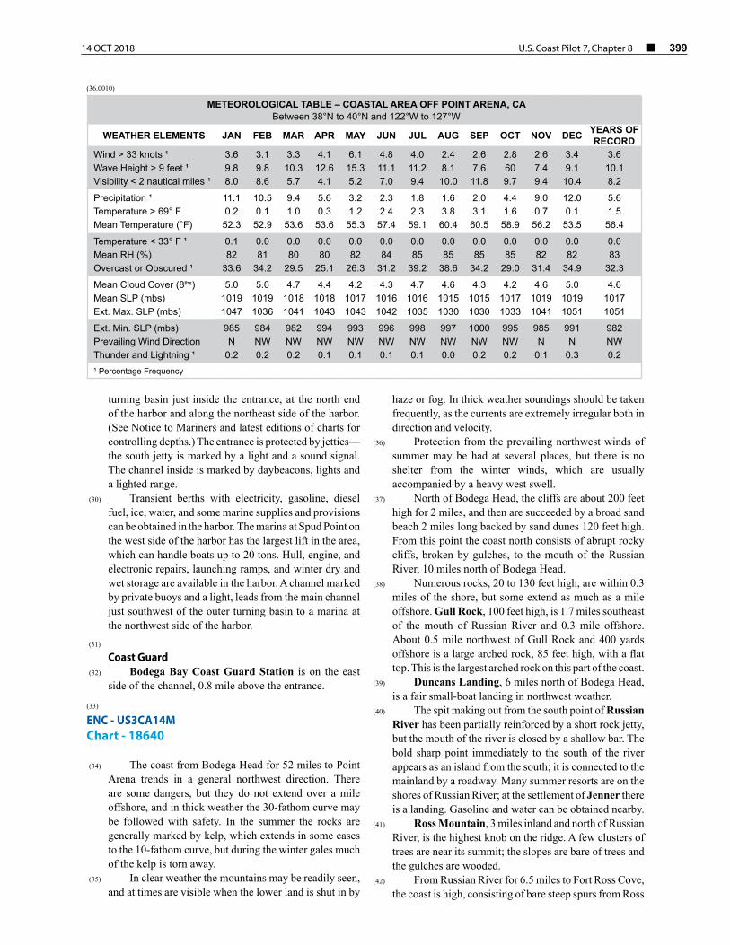
METEOROLOGICAL TABLE – COASTAL AREA OFF POINT ARENA, CABetween 38°N to 40°N and 122°W to 127°W
WEATHER ELEMENTS JAN FEB MAR APR MAY JUN JUL AUG SEP OCT NOV DEC YEARS OF RECORD
Wind > 33 knots ¹ 3.6 3.1 3.3 4.1 6.1 4.8 4.0 2.4 2.6 2.8 2.6 3.4 3.6Wave Height > 9 feet ¹ 9.8 9.8 10.3 12.6 15.3 11.1 11.2 8.1 7.6 60 7.4 9.1 10.1Visibility < 2 nautical miles ¹ 8.0 8.6 5.7 4.1 5.2 7.0 9.4 10.0 11.8 9.7 9.4 10.4 8.2
Precipitation ¹ 11.1 10.5 9.4 5.6 3.2 2.3 1.8 1.6 2.0 4.4 9.0 12.0 5.6Temperature > 69° F 0.2 0.1 1.0 0.3 1.2 2.4 2.3 3.8 3.1 1.6 0.7 0.1 1.5Mean Temperature (°F) 52.3 52.9 53.6 53.6 55.3 57.4 59.1 60.4 60.5 58.9 56.2 53.5 56.4
Temperature < 33° F ¹ 0.1 0.0 0.0 0.0 0.0 0.0 0.0 0.0 0.0 0.0 0.0 0.0 0.0Mean RH (%) 82 81 80 80 82 84 85 85 85 85 82 82 83Overcast or Obscured ¹ 33.6 34.2 29.5 25.1 26.3 31.2 39.2 38.6 34.2 29.0 31.4 34.9 32.3
Mean Cloud Cover (8ths) 5.0 5.0 4.7 4.4 4.2 4.3 4.7 4.6 4.3 4.2 4.6 5.0 4.6Mean SLP (mbs) 1019 1019 1018 1018 1017 1016 1016 1015 1015 1017 1019 1019 1017Ext. Max. SLP (mbs) 1047 1036 1041 1043 1043 1042 1035 1030 1030 1033 1041 1051 1051
Ext. Min. SLP (mbs) 985 984 982 994 993 996 998 997 1000 995 985 991 982Prevailing Wind Direction N NW NW NW NW NW NW NW NW NW N N NWThunder and Lightning ¹ 0.2 0.2 0.2 0.1 0.1 0.1 0.1 0.0 0.2 0.2 0.1 0.3 0.2¹ Percentage Frequency

400 ¢ U.S. Coast Pilot 7, Chapter 8 14 OCT 2018
Mountain. Sunken Reef extends 0.8 mile from shore 4.5 miles northwest of Russian River.
(43) Fort Ross Reef, 5.7 miles northwest of Russian River and nearly 1 mile southeast of Fort Ross Cove, consists of pinnacle rocks 35 feet high, 600 yards offshore, and connected with the beach by a reef which is partially marked by kelp.
(44) Fort Ross Cove, 15.5 miles north of Bodega Head and 33 miles north of Point Reyes, affords good shelter in northwest weather. The holding ground is poor, and the anchorage is constricted by a rock that uncovers in the middle of the cove and a rock about 50 yards north of it that is covered 14 feet. The cove is divided into two bights, the west one being slightly the larger. The anchorage is suitable for small vessels only, and if used by strangers should be entered with caution.
(45) Fort Ross was first settled by the Russians in 1812, and the old Russian church is still standing. The buildings have been restored, and the area is now a State Historical Monument. There are no landing facilities.
(46) From Fort Ross Cove the coast extends northwest and is nearly straight. It is bold and wooded to the crests of the hills which closely approach the coast, and is cut by numerous gulches and bordered by many inshore rocks. The 30-fathom curve is at an average distance of 0.7 mile offshore from Fort Ross Cove for 20 miles to near Gualala River.
(47) Salt Point, 5 miles north of Fort Ross Cove, is 35 feet high, very rocky, and bare of trees; it is bordered by outlying rocks for 200 yards. The 30-fathom curve is less than 0.5 mile off this point.
(48) Fisk Mill Cove, 2.5 miles north of Salt Point, affords fair shelter for small vessels in northwest weather. The bottom is rocky, but there are no hidden dangers.
(49) Horseshoe Point, 3 miles north of Salt Point, is a cliff 180 feet high, with a depression of 60 feet immediately behind it. It is bare of trees and the summit is marked by several projecting rocks.
(50) From Horseshoe Point the coast trends northwest for 12.5 miles to Gualala River and consists of cliffs, about 60 feet high, bordered by numerous outlying rocks. The tree line is from 0.1 to 0.5 mile back from the edge of the cliffs.
(51) Fisherman Bay, 26.5 miles northwest of Bodega Head, is a fair shelter for small craft in northwest weather. There are two covered rocks marked by kelp 350 yards off the south point of the bay. There is a general store at the village of Stewarts Point on the north side of the bay.
(52) Gualala Point, 16 miles southeast of Point Arena and 1 mile south of Gualala River, is 42 feet high, about 300 yards offshore, and connected with the bluff by a rocky reef covered with sand. Sand dunes extend behind the bluff for 600 yards.
(53) Local magnetic disturbance
(54) Differences of as much as 8° from normal variation have been reported near Gualala Point, and a difference of as much as 4° near Saunders Reef.
(55) Gualala River intersects the coast 15 miles southeast
of Point Arena. A long sand beach extends a mile south from the mouth. The white hotel building at Gualala can be seen from the west and southwest.
(56) Robinson Reef lies north of the mouth of Gualala River and 1.1 miles north of Gualala Point. It consists of a cluster of 25 or more visible rocks about 600 yards offshore, with a covered rock 70 yards west-northwest of the outer rock.
(57) Havens Anchorage, 12 miles southeast of Point Arena and 4 miles northwest of Gualala Point, offers shelter for small vessels from the prevailing northwest winds south of Fish Rocks. The cove is constricted by rocks and ledges extending 250 yards southeast from the west head. Strangers should approach the anchorage with caution. During the summer the anchorage is used extensively by fishing boats in northwest weather.
(58) Fish Rocks, two rocky islets 4.2 miles northwest of Gualala Point, are connected at low water with the shore and surrounded by numerous smaller rocks. The outer rock is 150 feet high and the inner 100 feet high and 100 yards offshore. A rock 40 feet high lies 175 yards southeast of the outer rock.
(59) Havens Neck, 145 feet high and prominent, is 0.6 mile northwest of Fish Rocks. It is bare of trees and connected with the bluffs by a narrow neck.
(60) Gualala Mountain, 5 miles inland northeast of Havens Neck, is heavily wooded and prominent in clear weather. Sail Rock, 44 feet high, is a sharp, pyramidal rock 800 yards offshore, 2.8 miles northwest of Fish Rocks. From off Point Arena it resembles a small vessel under sail. Saunders Reef, 4.5 miles northwest of Fish Rocks, is 0.5 mile offshore. It shows several rocks that uncover and is well marked by kelp. Foul ground extends between it and the shore.
(61) Arena Cove, 2.5 miles southeast of Point Arena, is a slight indentation affording shelter to small vessels in northwest weather. The south head is a high yellow cliff that under favorable circumstances is visible for a considerable distance. A wharf is at the head of the cove. A 3-ton hoist is on the wharf; gasoline, diesel fuel, and water are available. Some groceries may be had. A white lookout tower with a red roof on a steel structure is prominent. A lighted bell buoy is 0.6 mile southwest from the end of the wharf. To enter, make the lighted bell buoy, then bring the end of the wharf to bear 074° and stand in on this course. This leads about 150 feet south of a rock covered 16 feet that lies 300 yards 264° from the end of the wharf. In thick weather during the summer in approaching the cove from north or south, the edge of the kelp may be followed which will lead to within 300
14 OCT 2018 U.S. Coast Pilot 7, Chapter 8 ¢ 401
yards of the lighted bell buoy. The town of Point Arena is on the highway 1 mile east of the landing.
(62) A breaker is reported in a heavy southwest swell 0.8 mile west-southwest of the north point of Arena Cove, and scattered kelp extends almost out to that position.
(63) Point Arena, 68 miles northwest of Point Reyes, consists of a long level plateau, diminishing in height to the end of the 60-foot-high point. It is the first prominent point north of Point Reyes. The point is bare of trees for about a mile from the shore.
(64) Point Arena Light (38°57'17"N., 123°44'26"W.), 155 feet above the water, is shown from a 115-foot white cylindrical tower with black gallery at the extremity of the point. A reef that usually shows breakers extends about 0.6 mile northwest from the extremity of the point.
(65) Arena Rock, 1.4 miles north of Point Arena Light, is covered 13 feet and shows a breaker except in very smooth weather. A covered rock which rises abruptly from deep water and breaks only in heavy weather is 200 yards north of Arena Rock.
(66) Caution
(67) Vessels approaching Point Arena from north in thick weather are advised to keep outside the 40-fathom curve because Arena Rock is only 0.8 mile inside the 30-fathom curve and shoaling near it is abrupt.
(68) ENCs - US3CA15M, US5CA15M Chart - 18620
(69) From Point Arena the coast extends in a general north-northwest direction for 50 miles and then trends northwest for nearly 35 miles to Punta Gorda, thence north-northwest for 10 miles to Cape Mendocino. The south portion is less bold and rugged than the north portion, and the mountains are neither as high nor as close to the coast. The dangers are all included within the 30-fathom curve, and except for Blunts Reef and the other reefs in the vicinity of Cape Mendocino, do not extend more than a mile offshore. Several submarine valleys with depths greater than 50 fathoms come within 0.5 to 2 miles of the shore between Point Delgada and Cape Mendocino; the currents are irregular in this area.
(70) From Cape Mendocino to Trinidad Head, the coast trends in a north-northeast direction for 40 miles and, with the exception of the rocks off False Cape, the dangers are within 0.5 mile of the shore. The land is generally low with sandy beaches, broken by the mouths of the Eel and Mad Rivers and the entrance to Humboldt Bay. The only marked elevations north of False Cape are Table Bluff and Buhne Point.
(71) In clear weather the mountains are good landmarks and can frequently be seen when the lower land is obscured by fog or haze.
(72) Between Point Arena and Cuffeys Cove, protection from the prevailing northwest winds of summer may be had in a few places, but there is none from south or west.
(73) From Point Arena the cliffs of the point extend 0.5 mile northeast to the mouth of Garcia River, from which sand dunes and beaches extend north for 4 miles. Beyond this point for 40 miles to Ten Mile River Beach the coast is rugged, with high, bold cliffs bordered by numerous outlying rocks.
(74) Elk Rock, 8.5 miles north of Point Arena, is 95 feet high and 0.5 mile offshore.
(75) ENC - US5CA92M Chart - 18626
(76) Nose Rock, 10.3 miles north of Point Arena and 0.7 mile offshore from Elk, is 24 feet high. Casket Rock, 700 yards northeast of Nose Rock, is the outermost of three large rocks west of a 150-foot cliff fronting the village of Elk.
(77) Cuffeys Cove, 11 miles north of Point Arena, is a small anchorage affording fair shelter in northwest winds. Cuffeys Inlet, just west of the cove, is an excellent anchorage for small boats in north and west weather. Caution is necessary to avoid the many covered and visible rocks in the approaches to the cove and inlet. A small kelp-covered rock that uncovers lies near the center of the entrance to the inlet. The cove is covered with patches of kelp during most of the year.
(78) From Cuffeys Cove for 3 miles to Navarro River, the coast consists of cliffs 200 feet high, bordered by outlying rocks. Although the mouth of the river is nearly always closed by a bar with only 1 or 2 feet of water over it, the entrance has fair shelter from northwest winds. Navarro Head, 405 feet high, is on the north bank of the river.
(79) ENC - US5CA93M Chart - 18628
(80) Salmon Point, the south entrance point to Whitesboro Cove, 1.2 miles north of Navarro River, is a treeless cliff 109 feet high. Detached rocks extend west of the point for 0.2 mile, with Bull Rock, a covered ledge, usually showing a breaker 0.5 mile northwest of the extremity of the point. In a heavy swell, breakers show between it and the visible rocks off the point. Whitesboro Cove is rocky, exposed to northwest and west winds, and seldom used as an anchorage.
(81) Albion Cove, 16.5 miles north of Point Arena, affords good shelter in north weather. The south point at the entrance rises to a knoll 179 feet high; low rocks extend nearly 500 yards west of the point. The north point is a rocky islet 80 feet high lying close to the point which has the same elevation; both are bare. Small visible rocks lie 200 yards west of the islet, and covered rocks, showing breakers in a moderate swell, extend out more than 500 yards west-southwest from it. Mooring Rock, in about the middle of the cove, is 30 feet high, pyramidal in shape,

402 ¢ U.S. Coast Pilot 7, Chapter 8 14 OCT 2018
and marked by a light and and a mariner radio activated sound signal, initiated by keying the microphone five times on VHF-FM channel 81A. Small rocks extend from Mooring Rock to the north shore. A lighted whistle buoy marks the entrance to the cove.
(82) The village of Albion is on both high banks of Albion River. Several small piers on the river serve the commercial and sport fishermen. Gasoline, diesel oil, water, ice, fishing supplies, and a launching ramp are available. The river is crossed by a fixed highway bridge that has a clearance of 118 feet, 0.1 mile above the mouth.
(83) COLREGS Demarcation Lines
(84) The lines established for the Albion River are described in 33 CFR 80.1146, Chapter 2.
(85) Between Albion Cove and Colby Reef, breakers are
seen in a heavy swell nearly 0.5 mile from shore; vessels should not approach closer than 1 mile.
(86) Stillwell Point, 1.6 miles north of Albion Cove, is a bold, sharp 190-foot cliff. A 141-foot-high rocky islet lies close inshore on its northwest side. A yellow slide is on the south face of Stillwell Point. Colby Reef, 0.5 mile offshore west of Stillwell Point, is a shoal rocky patch. Numerous other dangers are just inside the 20-fathom curve along this stretch of coast.
(87) Little River, 19 miles north of Point Arena, offers shelter in the entrance cove. The reefs and rocks surrounding the cove are well marked by kelp, and a heavy undertow is felt when in the vicinity of the rocks. The northwest shore of the cove is bluff, rocky, and bare of trees for over 0.5 mile. The entrance is marked by a bell buoy, but the channel narrows to 60 yards by covered rocks north of the inner visible rock. The beach area at Little River is a State Park.
(88) The 2-mile coast between Little River and Mendocino Bay is a broad tableland with a seaward face of cliffs, 40 to 60 feet high, bordered by numerous low rocks. The tree line is over 0.5 mile from the cliffs.
(89) Mendocino Bay, 21 miles north of Point Arena, affords fair shelter in northwest weather, but vessels are obliged to leave in south or west weather. In heavy southwest gales the sea breaks clear across the entrance. The south point at the entrance is a rocky, irregular cliff 100 feet high, bordered by numerous rocks extending 150 yards offshore. A knoll 156 feet high is 300 yards inshore from the point. A reef covered 3 fathoms extends 500 yards northwest of the outermost visible rock. This area should be avoided when there is any swell running. The north point is a broken cliff 60 feet high, bordered by numerous rocks close inshore. A whistle buoy marks the entrance to the bay.
(90) Big River enters in the northeast part of Mendocino Bay. The town of Mendocino is on the north shore of the bay. Water is available.
(91) Russian Gulch, 2 miles north of Mendocino, is a small cove occasionally used as an anchorage by
small craft with local knowledge as it affords excellent protection. A State Park is at the head of the cove. The concrete arch highway bridge across Russian Gulch should show well from south to west. An important danger is a submerged rock 400 yards northwest of the south entrance point, surrounded by a reef covered 1¼ fathoms.
(92) Point Cabrillo, 3 miles north of the town of Mendocino and 24 miles north of Point Arena, is a flat-topped point 50 to 60 feet high terminating seaward in nearly vertical cliffs; numerous low rocks extend offshore over 200 yards, and the 30-fathom curve is barely 0.2 mile outside of them. The point is bare except for a few trees at the houses near the light.
(93) Point Cabrillo Light (39°20'55"N., 123°49'34"W.), 81 feet above the water, is shown from a 47-foot white octagonal frame tower on a dwelling on the point.
(94) From Point Cabrillo the coast trends north for 9 miles to Laguna Point as a nearly straight line of bluffs, with numerous rocks close under the cliffs. It is moderately high, partly wooded to the face of the cliffs, and is broken by several indentations and small streams. The 30-fathom curve is an average distance of 1 mile from shore.
(95) Caspar Anchorage, a mile north of Point Cabrillo, is a small cove at the mouth of Caspar Creek. Fair shelter, except from west, is afforded, but the anchorage is constricted and seldom used. The village of Caspar is on the north bank of the creek near its mouth.
(96) ENC - US5CA92M Chart - 18626
(97) From Caspar Creek for 4 miles to Noyo Anchorage the coast consists of broken irregular cliffs, 40 to 60 feet high, with numerous rocks extending 400 yards offshore. These are fairly well fringed by kelp, especially in summer.
(98) Noyo Anchorage, 5 miles north of Point Cabrillo, affords fair shelter from north or south. The anchorage is limited to an area about 400 yards long and less than 200 yards wide, with depths of 3½ to 6½ fathoms. Buoys mark the entrance to the anchorage.
(99) Noyo River enters the east side of Noyo Anchorage. A jetty with a light and sound signal is on the north side of the entrance and a small jetty, with a light off the seaward end, is on the south side of the entrance. A dredged channel leads between the jetties to Noyo Basin, about 0.6 mile above the entrance—the basin has reported depths of 10 feet. The basin is protected by a breakwater which is marked on its outer end by a light. The river above the first sharp bend affords excellent protection for small boats. A fixed highway bridge with a clearance of 97 feet crosses the river about 300 yards east of the mouth. Overhead power cables crossing the river have a least clearance of 80 feet.
(100) Hazardous bar conditions are common at the entrance to Noyo River. Mariners should monitor

14 OCT 2018 U.S. Coast Pilot 7, Chapter 8 ¢ 403
VHF-FM channel 16 for safety broadcast/advisories concerning the Noyo River and are encouraged to contact the Coast Guard prior to transiting the entrance.
(101) The Coast Guard has established Noyo River Entrance Small Boat Warning Light on the north side of the river in about 39°25'40"N., 123°48'20"W. The light is equipped with two quick flashing yellow lights that will be activated when seas exceed 8 feet in height and are considered hazardous for small boats. Mariners are cautioned that if the lights are not flashing, there is no guarantee that sea conditions are favorable.
(102) Caution is necessary in entering to avoid the reefs and a rock on the south side of the entrance. Heavy west or southwest swells form breakers at the entrance to the river; once inside there is good shelter. With west winds and seas, heavy surge is felt in the river as far as Noyo Basin.
(103) COLREGS Demarcation Lines
(104) The lines established for the Noyo River are described in 33 CFR 80.1148, Chapter 2.
(105) Coast Guard
(106) The Noyo River Coast Guard Station is located on the south bank of the river, just below Noyo Basin. The station monitors VHF-FM channel 16 or can be reached at 707–964–6612.
(107) A Storm Warning Flag System consisting of a series of square flags and triangular pennants, will be displayed on a pole that is located on the southwest end of the Noyo River Coast Guard Station dock and will be visible to mariners from both directions. The flags will indicate that winds and/or sea conditions forecast for the area may pose a hazard to boaters. (See illustration; Chapter 1.) Flags are flown at select Coast Guard stations to supplement other weather notification sources. Light signals corresponding to these flags are not displayed at night. In all cases, mariners should rely upon National Weather Service Broadcasts as their primary source of government provided weather information.
(108) The lower section of Noyo River is the principal
commercial and sport fishing center of this section of the coast. Many fishing boats are based here. Most of the facilities extend along both banks of the river to about 0.5 mile above the entrance. Water and ice can be obtained at several fishhouses with wharves having depths from 4 to 8 feet alongside. Berths, gasoline, diesel fuel, water, ice, marine supplies, and launching ramps are available at the facilities along the river and at Fort Bragg. Machine shops and marine railways can handle vessels up to 45 feet for hull and engine repairs. The phone number for the Noyo Basin Harbormaster is 707–964–4719.
(109) From Noyo River, for 0.7 mile to Fort Bragg, the coast consists of rocky cliffs, 40 to 60 feet high, bordered by rocks and sunken ledges extending 100 to 400 yards offshore.
(110) Fort Bragg, 30 miles north of Point Arena, is the largest coast town between San Francisco and Eureka. It is near the head of a cove formerly known as Soldiers Harbor. The former loading wharf has been removed; lumber is now shipped out by rail and truck. Groceries can be obtained, and minor repairs made.
(111) The cove is constricted by the rocks and ledges extending from both the north and south, leaving only a limited area for small boats to anchor. A rocky reef, partly bare at high water, extends southwest from the north head and breaks the force of the swell from northwest. In west weather the cove is wide open. Since Noyo River gives better protection, the cove is seldom used.
(112) For 3 miles from Fort Bragg to Laguna Point, the coast is moderately low and rocky and cut by two small streams; the tree line is within 0.2 mile of the beach.
(113) Laguna Point, 8.5 miles north of Point Cabrillo, is near the south end of Ten Mile River Beach. It is a small, projecting cliff, 30 feet high, flat-topped, and bare of trees for 600 yards. It is noticeable only when close inshore. A bare reef extends 300 yards northwest from the point. The cove immediately north of Laguna Point is exposed and only available for small boats. It affords fair protection in south weather and is occasionally used in winter.
(114) Bald Hill (chart 18620), 2.5 miles southeast of Laguna Point, is a prominent landmark; its summit and southwest slope are bare of timber.
(115) ENCs - US3CA15M, US5CA15M Chart - 18620
(116) For 0.5 mile north of Laguna Point the bluffs are low, thence a straight sand beach extends for 3 miles to the mouth of Ten Mile River. The beach is backed by sand dunes for 0.5 mile inland; the tree line is about 1.5 miles from the beach. The concrete highway bridge over Ten Mile River is conspicuous from the west.
(117) From Ten Mile River the coast extends in a general northwest direction for 52 miles to Punta Gorda. This stretch of the coast is particularly bold and rugged, bordered by numerous rocks, and is heavily timbered as far as Point Delgada. North of Point Delgada the tops of the ridges are generally bare or only partly covered with trees and brush. The cliffs along the shore range from 40 to 100 feet in height. The high, rugged mountains in the vicinity of the coast, which reach elevations of 3,000 to 4,000 feet, are prominent.
(118) Kibesillah Rock, 1.2 miles north of Ten Mile River and 0.4 mile off the line of the cliffs, is the outermost danger for many miles north and south. It is small and washed over almost continuously even in ordinary weather. Other rocks and rocky islets up to 80 feet high are inside of Kibesillah Rock.
(119) Bells Mountain, 4.5 miles north of Ten Mile River and 0.5 mile inland, is bare on top with a few trees on the oceanside.

404 ¢ U.S. Coast Pilot 7, Chapter 8 14 OCT 2018
(120) Switzer Rock, 5.5 miles north of Ten Mile River and 0.3 mile offshore, is small with deep water close around it; every large swell washes over the rock. A covered rock marked by a breaker is 170 yards southeast of Switzer Rock.
(121) Gordon Hill, 6.5 miles north of Ten Mile River, is bare to the summit and terminates seaward in 60-foot-high Abalone Point, which is bordered by low outlying rocks.
(122) Hardy Rock, 9.5 miles north of Ten Mile River and 0.4 mile offshore, is a small 47-foot-high islet.
(123) From Abalone Point the coast trends northwest for 4 miles to Cape Vizcaino, which is a broad, irregular line of precipitous cliffs, 100 feet high, very broken, and bordered by low rocks, 200 to 300 yards offshore.
(124) Island Knob, a rocky lime-covered islet, lies close-to and almost connected with Cape Vizcaino. A covered rock marked by a breaker is 275 yards west of the islet. Cottaneva Rock, 20 feet high, is 500 yards southeast of Island Knob and 275 yards offshore. Several smaller rocks lie inside of it and two others about 160 yards northwest.
(125) Cahto Peak, 11.5 miles east of Cape Vizcaino, is prominent in clear weather.
(126) Between Cape Vizcaino and Point Delgada are several small exposed landings available for use only in the summer and in smooth weather.
(127) Sea Lion Rock, a mile north of Cape Vizcaino and 500 yards offshore, is 5 feet high and inhabited by sea lions. Cottaneva Needle, 0.5 mile north of Sea Lion Rock, is a prominent black pinnacle rock 55 feet high.
(128) Double Cone Rock is 3.5 miles north of Cape Vizcaino and 300 yards offshore.
(129) Usal Rock, 5 miles north of Cape Vizcaino, is 45 feet high and black in color. It lies 200 yards off a small point of rocks.
(130) The mouth of Usal Valley is about a mile north of Usal Rock, and is a narrow, steep gulch, in front of which is a small area of flat land with a low beach. A small grassy hillock is just inside the gulch. The view up the valley is open for a very short time while passing.
(131) Big White Rock, 95 feet high, lies 7.7 miles north of Cape Vizcaino, and 125 yards offshore from the steep cliffs, which are bordered by numerous rocks. The rock is a prominent feature when the higher points of the land are in fog.
(132) Anderson Cliff, 10 miles north of Cape Vizcaino, is a projecting rocky spur 715 feet high, with one large rock and numerous smaller ones close inshore. Jackson Pinnacle, 1.1 miles north of Anderson Cliff, is a black rock 45 feet high, so close to the rocky beach that from seaward it is hard to distinguish from the bluff behind it. When seen from along shore, it is prominent.
(133) Cluster Cone Rock, a prominent 68-foot pinnacle, is the largest and whitest of a small cluster of 6 rocks, 200 yards offshore, lying 12.5 miles north of Cape Vizcaino.
(134) Morgan Rock, a large white-topped, block-shaped rock 57 feet high and 0.5 mile northwest of Cluster Cone
Rock, shows prominently. It is the largest of a group of rocks extending some 200 yards from a high rocky cliff and is particularly valuable as a landmark when higher land is covered by fog.
(135) Bear Harbor Ridge, a detached coastal ridge about a mile northwest of Cluster Cone Rock, has two peaks; the south one, 375 feet high, is the higher. It is the most prominent feature in this vicinity when viewed from the northwest. The seaward face of the ridge is marked by steep, loose slides.
(136) Needle Rock, 46 feet high, is 14.5 miles north of Cape Vizcaino; the rock blends into the bluff from offshore. A group of old mill buildings, a few houses, and an old landing platform about midway up the flat mark the abandoned landing.
(137) Small White Rock, 37 feet high, lies 5 miles north of Cluster Cone Rock and 4 miles south of Point Delgada. It is close inshore and just outside the low-water beach; once identified, this rock makes a valuable landmark.
(138) From just below Small White Rock to Point Delgada, the country is not timbered, but is covered with dense, low brush, which presents a uniform dark green appearance.
(139) A submarine ridge known as a Tolo Bank extends south from Point Delgada for about 7 miles. The depths are quite irregular; the least depth found is 9 fathoms.
(140) Caution
(141) The area just south of Shelter Cove is subject to slides which might deposit rocks along the shore.
(142) Point Delgada, 66 miles north of Point Arena, and
nearly 20 miles south of Punta Gorda, is a cliff-faced plateau making out about a mile from the general trend of the coast. The seaward face of the plateau is a mile long and bordered by numerous rocks. A lighted horn buoy is 1.1 miles southwest from the point, and a bell buoy is 0.8 miles southeast from the point. A paved airplane landing strip, approximately 3,500 feet and a 43-foot high lighthouse (unlit) which can be observed offshore during the day are on the point.
(143) Shelter Cove lies under the south face of Point Delgada and affords fair shelter in northwest weather, but is exposed and dangerous with south or southeast winds. Occasionally a swell runs in the cove. There are no wharves in the cove. Water may be obtained ashore, but must be carried down from the plateau. A marine supply store is on the bluff on the west side of the cove. Gasoline, diesel fuel, lubricants, ice, marine supplies, and provisions are available. A launching ramp is at the head of the cove. Shelter cove is used extensively as an offshore moorage for fishing boats. A pump-out station and dry winter storage are at Shelter Cove. Local boat launch service monitors VHF-FM channel 68. A paved road is maintained to the cove. Telephone service is available.
(144) The rocks covered 1 to 5 fathoms south of Point Delgada can be avoided in approaching Shelter Cove by

14 OCT 2018 U.S. Coast Pilot 7, Chapter 8 ¢ 405
staying over 200 yards south of the lighted whistle buoy and east of the bell buoy.
(145) From Point Delgada the coast extends northwest for 19 miles to Punta Gorda, and is backed by steep mountains covered with chaparral and trees. A black-sand beach, 0.8 miles north of Point Delgada, extends north for 4 miles. Kaluna Cliff overlooks the south end of the sand beach, and its steep face, scarred by frequent slides, is a noticeable landmark.
(146) King Peak, 4,090 feet high, the highest of three, is the well-known landfall generally called Three Peaks. It lies 8.5 miles north of Point Delgada, 2.5 miles from the coast, and in clear weather is visible seaward for about 75 miles.
(147) About 6 miles north from Point Delgada is the head of Delgada Canyon, a submarine valley; the 100-fathom curve lies within 0.5 mile of the beach. This valley extends in a north direction with an average width of 1 mile between the 100-fathom curves for 3.5 miles, and then expands, funnel-shaped, for 3 miles more. Over 400 fathoms are found at its mouth and 300 fathoms within 4 miles of the beach. The side slopes are steep.
(148) Big Flat is a narrow strip of low, flat land 7 miles northwest of Point Delgada. It is 2 miles long and is bordered by sand beaches. A few abandoned ranch houses and barns are at the south end of the flat. Shubrick Rock, low and small, lies 300 yards off the south end.
(149) About 11.5 miles northwest of Point Delgada is the head of Spanish Canyon, a submarine valley. The 100-fathom curve lies within 2 miles of the shore.
(150) Reynolds Rock, 10 feet high, is 14.5 miles northwest of Point Delgada. It is 550 yards offshore and, when seen from close inshore, appears as a double-headed rock over which the swell breaks in nearly all weather.
(151) Rodgers Break, 0.5 mile west of Reynolds Rock, is covered 1¾ fathoms. This pinnacle rock lies 4 miles southeast of Gorda Rock and 6.8 miles west-northwest of Big Flat; it seldom breaks and the top is occasionally seen in a heavy swell. A pinnacle rock covered 2½ fathoms lies about 0.5 mile northwest about the same distance offshore. It probably breaks in very heavy weather. This pinnacle and Rodgers Break are the outermost known dangers in this stretch of the coast.
(152) From Reynolds Rock northwest to Punta Gorda the shore is bordered by numerous rocks extending about 0.3 mile offshore. The sharp depression in the hills near the coast, caused by the gulch of Cooskie Creek, 3.5 miles south of Punta Gorda, is sometimes useful on dark nights to vessels close inshore in making the point from south.
(153) ENC - US5CA95M Chart - 18623
(154) Punta Gorda is a high, bold, rounding cape, 83 miles northwest of Point Arena and 11 miles south of Cape Mendocino. The seaward face rises to about 900 feet, 400 yards back from the beach, and terminates in a spur,
140 feet high, almost overhanging the sea. It is bare of trees except in the gulches. The gray rectangular structure of an abandoned lighthouse, 25 feet high, is south of the point. For over 1.5 miles north and about 2 miles south of the point, the beach is bordered by numerous rocks and shoals extending in some cases 0.6 mile offshore.
(155) The wind, sea, and currents off Punta Gorda are probably as strong as off any point on the coast; frequent and strong tide rips have been noted. Many times when the weather at Shelter Cove and even at Big Flat is clear and calm and the sea smooth, both the wind and the sea will pick up as Punta Gorda is approached, until just north of this point where strong breezes to moderate gales will be experienced. At other times clear weather south of this point will lead to fog north, or vice versa.
(156) Gorda Rock, 10 feet high and conical in shape, is 0.7 mile south of Punta Gorda and 0.6 mile offshore.
(157) Conical Rock, 20 feet high, is 100 yards off the point, and another 20-foot rock is 350 yards north from it; these rocks have foul ground between them.
(158) From Punta Gorda to Cape Mendocino the hills back of the coast are lower than those south; they are bare of trees and bordered by stretches of low, narrow, sandy flats with a narrow, low-water beach. The outlying rocks are not more than 0.7 mile offshore until about 2.5 miles south of Cape Mendocino, where they extend offshore to Blunts Reef, 2.5 miles west of the cape. Mattole Canyon, a narrow submarine valley, is 3 miles north of Punta Gorda where the 100-fathom curve is about 1 mile from the beach. Mendocino Canyon is 4.5 miles south of Cape Mendocino where the 100-fathom curve is about 2 miles from the beach.
(159) Christmas Rock, covered 1½ fathoms, is 0.9 mile northwest of Punta Gorda.
(160) Mattole River, 2 miles north of Punta Gorda, is not navigable. The north 360-foot-high head is bare and the south head, about the same height, is partly covered with oak trees. A prominent sand dune is on the south side at the entrance to the valley. Another large sand dune, 3.5 miles to the north, marks the north side of McNutt Gulch and should not be confused with the one at Mattole River.
(161) Mattole Point is 0.3 mile north of the river at the base of Moore Hill. Sea Lion Rock, 8 feet high, is 0.3 mile north of Mattole Point and 250 yards off the beach at the head of Mattole Canyon. A rock covered ½ fathom lies 0.4 mile northwest of Mattole Point.
(162) A rock, 16 feet high, is the largest of a cluster of small rocks 0.5 mile offshore and nearly 4 miles north of Punta Gorda. The Brothers, 8 feet high, consist of two small rocks, close together, 800 yards offshore and 1.5 mile north-northwest of Sea Lion Rock. Mussel Rocks, 0.9 mile north of The Brothers, form a ledge that projects 400 yards from the shore.
(163) Devils Gate Rock, 20 feet high, lies nearly 2.8 miles south of Cape Mendocino and 0.5 mile offshore. It is low and pyramidal, with a smaller rock close under the northwest face. A reef extends 200 yards west from the

406 ¢ U.S. Coast Pilot 7, Chapter 8 14 OCT 2018
rock; numerous rocks lie inshore. A rocky shoal covered 3½ fathoms lies 1.4 miles west of Devils Gate Rock.
(164) A rock which bares 1 foot is about 1.1 miles north-northwest of Devils Gate Rock and 0.8 mile offshore.
(165) Steamboat Rock, 30 feet high, lies 1.5 miles south of Cape Mendocino and 600 yards offshore. The upper part of the rock is white and the lower black, somewhat resembling a steamer with a low black hull and white upper works.
(166) Cape Mendocino, 185 miles north of San Francisco Bay entrance and 367 miles south of Columbia River entrance, is a mountainous headland, the famous landmark of the old Spanish navigators and the galleons from the West Indies. The cape is the turning point for nearly all vessels bound north or south. In view of the dangers in the vicinity, it should be approached with considerable caution in thick weather; the bottom and the currents are very irregular. It is in the latitude of great climatic change; the winds do not blow home so violently in the bight south of it, and the amount of rainfall increases rapidly to the north. Fog is more prevalent south. The strong northwest winds of summer are less violent south of the cape, which forms a parallel lee for vessels working their way north.
(167) The seaward face of Cape Mendocino is steep, rocky, and water worn toward the shoreline. To the northeast, the general appearance is rolling and grass-covered, except in the deep ravines and upon some of the steep hillsides where the north exposure is covered with forest or brush. For about 3 miles south of the cape, the beach is bordered by numerous rocks and sunken ledges extending in some cases to over 0.5 mile offshore.
(168) Sugar Loaf, 326 feet high, is 250 yards west of Cape Mendocino and is connected with it at low water by a narrow neck of rocks and shingle beach. This rock is a prominent feature in making the cape from either north or south, but in thick or hazy weather care should be
taken to avoid mistaking it for False Cape Rock, which it somewhat resembles, that is in a similar position off False Cape, 4.5 miles north of Cape Mendocino. False Cape Rock is about 216 feet high and is not so regular in outline as the Sugar Loaf, and, from the west or northwest, shows two large rocks, 95 and 54 feet high, immediately inside it, whereas the Sugar Loaf stands solitary and compact. As seen from the southwest, Sugar Loaf shows a cave on its southwest face, extending about one-third the height of the rock.
(169) Blunts Reef, 2.6 miles west of Cape Mendocino, is one of the outermost visible dangers in the area. The reef consists of two small black rocks awash about 230 yards apart. Blunts Reef Lighted Bell Buoy 40 (40°26'47"N., 124°29'59"W.), is 1.4 miles west of the outer rock.
(170) The area as far west as Blunts Reef Lighted Buoy 40 and for about 4 miles north and south of Cape Mendocino includes dangerous rocks and covered ledges. Vessels should not attempt the passage between Blunts Reef Lighted Bell Buoy 40 and the cape under any circumstances. A heavy west swell breaks even in 9 to 10 fathoms in this locality.
(171) From Cape Mendocino for 4.5 miles to False Cape, the coast is straight, bold, and bordered by a broad low-water beach.
(172) False Cape is a steep, bold headland, rising to a height of over 600 feet in less than 0.2 mile from the beach; it projects slightly from the general trend of the coast. It is covered with grass, but the gulches on its sides are wooded. The base of the cape is bordered by a narrow, low-water beach of shingle and sand. For about a mile on each side of the cape are numerous rocks and ledges, the outermost of which are about a mile from the beach.
(173) False Cape Rock, 216 feet high, lies 0.4 mile west of the cape; other rocky islets are between it and the shore. It is not as regularly shaped nor as high as the Sugar Loaf
(167.0010)
METEOROLOGICAL TABLE – COASTAL AREA OFF CAPE MENDOCINOBetween 40°N to 42°N and 124°W to 127°W
WEATHER ELEMENTS JAN FEB MAR APR MAY JUN JUL AUG SEP OCT NOV DEC YEARS OF RECORD
Wind > 33 knots ¹ 6.5 5.1 4.4 3.2 4.6 3.4 3.7 2.4 3.2 2.9 4.2 6.0 4.1Wave Height > 9 feet ¹ 10.8 8.8 10.7 5.5 9.9 7.4 8.8 5.9 6.9 5.0 7.7 11.3 8.2Visibility < 2 nautical miles ¹ 6.9 7.2 5.3 3.2 4.6 6.6 11.0 11.0 11.1 9.8 8.9 7.4 7.7
Precipitation ¹ 15.1 12.9 12.2 8.2 4.3 3.2 2.1 3.2 3.3 6.1 12.3 15.0 7.6Temperature > 69° F 0.0 0.0 0.0 0.1 0.2 0.8 0.9 2.2 1.7 0.8 0.2 0.0 0.6Mean Temperature (°F) 51.7 51.8 52.1 52.6 54.2 56.7 58.2 59.5 59.5 57.6 55.0 52.5 55.3
Temperature < 33° F ¹ 0.1 0.0 0.0 0.0 0.0 0.0 0.0 0.0 0.0 0.0 0.0 0.1 0.0Mean RH (%) 84 83 82 81 83 84 86 87 86 85 83 83 84Overcast or Obscured ¹ 38.8 39.8 35.8 31.6 31.4 32.4 40.4 40.5 35.5 33.2 36.5 37.5 36.1
Mean Cloud Cover (8ths) 5.4 5.5 5.3 4.9 4.8 4.6 4.8 4.8 4.3 4.5 5.2 5.4 4.9Mean SLP (mbs) 1018 1018 1018 1019 1019 1018 1017 1017 1015 1017 1018 1018 1018Ext. Max. SLP (mbs) 1042 1060 1047 1036 1050 1045 1043 1042 1044 1043 1037 1038 1060
Ext. Min. SLP (mbs) 960 982 984 985 992 992 998 993 990 987 978 984 960Prevailing Wind Direction S S N N N N N N N N N S NThunder and Lightning ¹ 0.3 0.8 0.2 0.3 0.1 0.2 0.1 0.0 0.2 0.4 0.5 0.4 0.3¹ Percentage Frequency

14 OCT 2018 U.S. Coast Pilot 7, Chapter 8 ¢ 407
off Cape Mendocino, and the top is much flatter. Mussel Rock, 7 feet high, is 0.8 mile north of False Cape Rock.
(174) ENCs - US3CA15M, US5CA15M Chart - 18620
(175) North of False Cape the hills decrease in height; 4 miles beyond the cape is the beginning of a stretch of sand beach and dunes, broken only by Table Bluff and Buhne Point, that extend to Trinidad Head.
(176) Centerville Beach, 4 miles north of False Cape, is not prominent from seaward. A white cross is on the 120-foot bluff just south of Centerville Beach. A number of buildings from a former U.S. Naval facility are on the bluffs 0.8 mile south of the village.
(177) Eel River empties 8 miles north of False Cape. This is a stream of considerable size and is occasionally entered by light-draft vessels, but the channel over the bar is continually shifting. The depth on the bar varies largely with the amount of water in the river, depending upon the character of the winter, and has been at times as much as 14 feet, but generally the depth is about 8 or 9 feet. The river is seldom entered except by fishing boats and other very small craft, and then only by those with local knowledge of the bar.
(178) Eel Canyon is a submarine valley extending in a northwest direction. It comes to a head 10 miles
northwest of Cape Mendocino. Vessels are cautioned against mistaking this valley for one of those south of the cape.
(179) ENC - US5CA94M Chart - 18622
(180) Table Bluff, 12 miles north of False Cape and 4.5 miles south of Humboldt Bay entrance, is a prominent feature from seaward. The west face is 0.5 mile long, 165 feet high, and very steep, and has a narrow sand beach under it.
(181) From Table Bluff for 4 miles to Humboldt Bay entrance the coast consists of a narrow sand spit.
(182) Humboldt Bay, 21 miles north of Cape Mendocino, is the first important harbor north of San Francisco and is used by vessels drawing up to 38 feet. Humboldt Bay is the second largest natural bay on the coast of California and as such contains many environmentally and economically important wetland habitats. In addition to being a nursery area for many species of commercially and recreationally important fish and invertebrates, Humboldt Bay also produces more than 50 percent of the oysters harvested in California. Due to Humboldt Bay’s location on the Pacific Flyway, it is also an important feeding, resting and nesting area for thousands of migratory shorebirds and waterfowl. Along Humboldt
Humboldt Bay, CaliforniaImage courtesy of U.S. Army Corps of Engineers
N
(183)

408 ¢ U.S. Coast Pilot 7, Chapter 8 14 OCT 2018
Bay’s shoreline, thousands of acres have been set aside by State, Federal and local agencies as wildlife habitat for a variety of threatened and endangered species. Humboldt Bay can be used as a harbor of refuge in impending bad weather, providing a vessel can get inside before the bar becomes impassable. The bay consists of two shallow basins, South Bay in the south and Arcata Bay in the north part, connected by a narrow channel about 5 miles long. Due to the sensitive nature of Humboldt Bay’s environment, extreme care should be taken to utilize all best management practices when transiting Humboldt Bay, fueling or transferring fuels or lubricants and transferring cargo.
(184) The redwood timber industry dominates Humboldt Bay. Large quantities of lumber and wood products are shipped to both foreign and domestic ports. General merchandise, gasoline, and fuel oil are received.
(185) Coast Guard Captain of the Port considers the following channels to be narrow channels or fairways for the purpose of enforcing the International and Inland Rules of the Road, Rule 9.
(186) a. Humboldt Bay Bar Channel.(187) b. Humboldt Bay Entrance Channel.(188) c. Fields Landing Channel.(189) d. North Bay Channel.(190) e. Eureka Channel; Outer and Inner Reaches.(191) f. Samoa Channel.(192) g. All other government maintained channels and
turning basins.(193)
Routes(194) A pilot should be engaged by deep-draft vessels and
by strangers if there is any sea on the bar. Because the bar is subject to change, the entrance ranges may not always mark the deepest channel.
(195) From South
(196) From a position 1.5 miles 260° from Blunts Reef Lighted Bell Buoy 40, steer 356½° for 5 miles, thence a 038½° course made good for 20 miles leads to Humboldt Bay Entrance Lighted Whistle Buoy HB. In thick weather, after passing False Cape Rock, all dangers will be cleared by keeping in a depth of over 15 fathoms until up with the lighted whistle buoy, where anchorage should be made until a pilot is obtained.
(197) From North
(198) From a position 3 miles west of Trinidad Head Light, a 187° course, made good for 17 miles, leads to Humboldt Bay Entrance Lighted Whistle Buoy HB. In thick weather the depths should not be shoaled to less than 20 fathoms between Turtle Rocks and Trinidad Head and, when south of the head, the depths should not be shoaled to less than 15 fathoms until up with the lighted whistle buoy, where a vessel should anchor until a pilot is obtained.
(199) From seaward
(200) In clear weather the high land of Cape Mendocino and Punta Gorda S, and Trinidad Head north of the entrance, are good landmarks. In thick weather soundings should be taken frequently, and upon getting depths of 30 fathoms or less great caution must be exercised until sure of the vessel’s position, when the course should be shaped for the lighted whistle buoy.
(201) Sailing craft during the prevailing northwest winds of summer should try to make the land in the vicinity of Trinidad Head; this gives a fair slant for the entrance and is an additional precaution against the irregular south set of the current. In thick weather soundings should be taken constantly when inside of 50 fathoms. Making the land north of the entrance avoids the irregular bottom and dangerous currents in the vicinity of Cape Mendocino.
(202) From the Humboldt Bay Entrance Lighted Whistle Buoy HB, make good a course of 105° following the Humboldt Bay Approach Range to the intersection with Humboldt Bay Entrance Range, thence a course of 140.3° on the entrance range into the bay. The entrance range parallels the south jetty and is only about 150 yards from it. The turn from the approach to the entrance range, 200 yards off the outer end of the south jetty, is rather abrupt and is difficult under certain conditions of wind, sea, and current. Inside the bay the channels are well marked by navigational aids.
(203) The approach to the bay is marked by a lighted whistle buoy and a bell buoy off the entrance, and approach range lights and a sound signal on the outer end of the North Spit. A light is shown near the seaward ends of the north and south jetties. The south jetty light has a sound signal. Range lights and lighted buoys mark the entrance channel inside the bar.
(204) NOTE: The approach range should not normally be used beyond its intersection with the entrance range. The entrance range should not normally be used seaward of the outer ends of the jetties. Both ranges are lighted 24 hours a day.
(205) Two jetties are at the entrance to the bay, 700 yards apart. The bar northwest of the south jetty is subject to considerable shifting and shoaling at times, especially during the winter.
(206) In the past Humboldt Bar was considered treacherous and dangerous, and many disasters have occurred there. Even with present improvements, mariners are still advised to use extreme caution on the bar and, because strong currents may be encountered, when approaching the abrupt turn at the outer end of the south jetty. The bar is smoothest during the last of the flood current, and it is often passable at this time and impassable 2 hours later, when the ebb current has set in. Mariners are advised to contact Coast Guard Station Humboldt Bay on VHF-FM channel 16 or 22A prior to transitting the bar. Caution should also be exercised inside the jetties due to the rapid change in the channel conditions.
14 OCT 2018 U.S. Coast Pilot 7, Chapter 8 ¢ 409
(207) Deep-draft vessels are usually taken in and out of the bay at high tide if there is any swell on the bar because of the shoaling in the entrance channel. During the summer months, vessels usually enter on both ingoing and outgoing tides. In winter, entry is usually made on the first or last of the ingoing tide or the first of the outgoing tide. Departure is made on the ingoing tide only, regardless of the time of year.
(208) The Coast Guard has established Humboldt Bay Entrance Small Boat Warning Sign at Coast Guard Station Humboldt Bay (40°45'59"N., 124°13'02"W.). The north-facing sign is equipped with two flashing yellow lights that will be activated when seas exceed 6 feet in height and are considered hazardous for small boats. A Hazardous Bar Conditions Advisory will also be broadcast when seas exceed 10 feet in height. Boaters are cautioned, however, that if the lights are not flashing, it is no guarantee that sea conditions are favorable.
(209) COLREGS Demarcation Lines
(210) The lines established for Arcata–Humboldt Bay are described in 33 CFR 80.1150, Chapter 2.
(211) Channels
(212) Federal project depths for Humboldt Bay are 48 feet over the bar and in the entrance channel, thence 38 feet in North Bay Channel to Eureka, thence 38 feet in the Eureka Channel outer reach and 26 feet in the inner reach. Project depth in Samoa Channel, including the turning basin, is 38 feet, and in Fields Landing Channel leading to South Bay, including the turning basin, is 26 feet. Maintenance dredging is performed regularly. (See Notice to Mariners and latest chart edition for controlling depths.)
(213) Prominent features
(214) From seaward Humboldt Bay can be identified by Humboldt Bay Entrance Lighted Whistle Buoy HB. Both north and south jetty tips are marked by lights. By day the tall stacks and the smoke from the pulp mill in the bay can usually be seen. North Spit has clumps of trees along the bay shore near the channel while South Spit is barren. The red bluff at Buhne Point on the east shore of the bay and a lighted radio tower about 1.0 mile east are conspicuous in entering the bay.
(215) South Bay, in the south part of Humboldt Bay, is
about 3 miles long and 2 miles wide. A marked channel on the east side of the bay leads to a lumber wharf on the east side of the channel at Fields Landing.
(216) Bucksport is on the east shore about 3 miles above the entrance. The two oil piers at Bucksport are used mainly by barges.
(217) Fairhaven is a small town on the west shore, about 3.5 miles above the entrance. The pier of a pulp company is here.
(218) Eureka, the principal town on the bay, is on the east shore, 4 miles north of the entrance. It handles much of the waterborne commerce on the bay. Eureka is the terminus of the North Coast Railroad Co.; a branch of the railroad continues to Arcata and Samoa.
(219) Samoa is a small settlement on the west shore opposite Eureka, about 5.5 miles above the entrance. A large pulp mill here ships a considerable amount of pulp.
(220) Arcata Bay, the north part of Humboldt Bay, is about 3 miles in diameter with low, marshy shore cut by sloughs. Arcata is on the north shore of the bay. The town has no serviceable wharves. The ruins of several old wharves are near the head of abandoned Arcata Channel.
(221) Anchorages
(222) There are no authorized anchorages in Humboldt Bay.
(223) Regulated navigation areas
(224) The Bar Channel and Entrance Channel of Humboldt Bay are included in a regulated navigation area. (See 33 CFR 165.1195, Chapter 2, for limits and regulations.)
(225) Bridges
(226) A fixed highway bridge crosses Humboldt Bay from Eureka to a point just above Samoa on the Samoa Peninsula. Clearances of the fixed spans are 40 feet from Eureka to Woodley Island; 30 feet from Woodley Island to Indian Island; and 45 feet from Indian Island to the Samoa Peninsula.
(227) Currents
(228) The tidal currents follow the general direction of the channels. In the main channel, the average velocity is less than 2 knots and the maximum does not exceed 3 knots. Between the jetties, the average velocity is about 2 knots, with a maximum of about 4 knots; during storm conditions, velocities can reach up to 5.5 knots. Current predictions are given in the Tidal Current Tables.
(229) Weather, Eureka
(230) The climate of Eureka is completely maritime, and high humidity prevails the entire year, which is divided into the “rainy” season and the “dry” season. The rainy season begins in October and continues through April. About 90 percent of the year’s precipitation falls during this period. The dry season extends from May through September and is marked by considerable fog or low cloudiness. On average, 23 of the 31 days in August will record fog where only 10 of the 31 days in March will note fog. Usually, however, the fog clears in the late forenoon and the early afternoons are generally sunny. On average, better than 38 inches (965 mm) of precipitation falls on an annual basis in Eureka and 152 of the 365 days of the year record some sort of precipitation. January is the wettest month and July, the driest. Snowfall is light

410 ¢ U.S. Coast Pilot 7, Chapter 8 14 OCT 2018
and averages less than one-half inch annually (13 mm) however, snowfall has been recorded in each of the months November through April. The greatest daily snowfall was two inches (51 mm) in February 1989.
(231) Temperatures are moderate the entire year. Although the highest ever recorded was 87°F (30.6°C) in October 1993, and the lowest 21°F (-6.1°C) in December 1972, the usual range is from a low of about 47°F (8.3°C) to a high of about 58°F (14.4°C). The daily range of temperature averages from about 10°F (-12.2°C) in the summer to 13°F (7°C) in the winter, and is occasionally not over 2° to 3°F (1° to 2°C).
(232) The principal industries are lumbering, fishing, and dairy farming. Owing to the low temperatures and lack of sunshine, there is very little truck farming, but the climate is nearly ideal for berries and flowers.
(233) <233-234 Deleted>(235)
Pilotage, Humboldt Bay(236) Pilotage is compulsory for foreign vessels under
registry and U.S. vessels under registry and enrollment. Pilotage is voluntary for all other vessels.
(237) Pilotage for ports in Humboldt Bay is available from Humboldt Bar Pilots. Arrangements for pilots are made by ship's agents.
(238) The pilots monitor VHF-FM channel 16. The pilot boat monitors VHF-FM channels 13 and 16, and the pilot and tug boat use 13, 18, and 77 as working frequencies. The pilot boat, TUG KOOS KING, is 65 feet long and has a black hull, buff and white house, and red stack with a white K.
(239) Pilots board vessels within 0.5 mile radius of Humboldt Bay Entrance Lighted Whistle Buoy HB (40°46.4'N., 124°16.2'W.) or 1.5 miles west of Humboldt
Bay Entrance Jetties. When boarding, pilots request vessels maintain a speed not to exceed 5 knots and rig the pilot ladder on the leeward side about 3 meters above the water; no man ropes.
(240) In the summer, vessels are entered on flood and ebb tidal currents; in the winter, vessels usually are entered on the first or last of the flood or first of the ebb. Vessels depart on flood tidal currents only, regardless of the time of year. Vessels with drafts over 30 feet, enter or depart on the last of the flood from November through March 30; night sailing depends on the bar condition before dark.
(241) Pilots report that strong currents create a north set in the Bar Channel from October to April. When vessels enter the jetties, this current has a tendency to twist vessels by setting the stern north and turning the bow south toward the south jetty. During or shortly after southeast, south, and southwest storms, currents in the Bar Channel and Entrance Channel are reported to attain a velocity of about 4 to 5.5 knots. Heavy swells about 8 to 10 feet high occur well inside the jetties when seas from the southwest are deflected, about midway along the north jetty.
(242) Towage
(243) Tugs up to 2,000 hp are available.(244)
Quarantine, customs, immigration and agricultural quarantine
(245) Eureka is a customs port of entry. (See Vessel Arrival Inspections, Chapter 3.)
(246) Quarantine is enforced in accordance with regulations of the U.S. Public Health Service. (See Public Health Service, Chapter 1.) The city has several hospitals.
(231.0010)
CLIMATOLOGICAL DATA – EUREKA, CA (40°48'N, 124°07'W) 59 feet (18 m)
WEATHER ELEMENTS JAN FEB MAR APR MAY JUN JUL AUG SEP OCT NOV DEC YEAR YEARS OF RECORD
TEMPERATURE (°F)
Mean 48.0 49.3 49.4 50.6 53.2 55.7 57.0 58.0 57.4 55.0 51.8 48.7 52.9 47Mean daily maximum 54.1 55.3 55.2 56.0 58.1 60.2 61.4 62.4 62.8 60.9 58 54.9 58.3 47Mean daily minimum 41.4 42.8 43.2 44.7 47.8 50.6 52.2 53.1 51.6 48.6 45.1 42.1 46.9 47Extreme (highest) 78 80 76 80 82 81 76 82 86 87 78 77 87 47Extreme (lowest) 26 27 30 34 36 41 46 47 42 32 29 21 21 47
PRECIPITATION (inches)
Mean amount 6.6 5.0 5.3 2.8 1.6 0.6 0.1 0.3 0.7 2.7 5.6 6.4 38.1 47Greatest amount 13.9 10.8 11.1 10.6 6.0 2.5 1.1 3.4 3.3 13.0 16.5 14.1 67.2 47Least amount 0.6 0.1 1.1 0.3 0.0 T 0.0 T T 0.0 0.2 0.5 21.0 47Maximum amount (24 hours) 3.7 4.8 2.9 2.3 1.4 1.1 0.8 1.5 1.4 5.0 2.7 3.3 5.0 47Mean number of days 17 16 19 14 12 9 7 7 8 12 15 16 152 32
SNOW
Mean amount 0.1 0.1 0.0 T 0.0 0.0 0.0 0.0 0.0 0.0 0.0 0.1 0.4 47Greatest amount 2.8 3.5 1.0 T 0.0 0.0 0.0 0.0 0.0 0.0 0.1 1.9 3.5 47Least amount 0.0 0.0 0.0 0.0 0.0 0.0 0.0 0.0 0.0 0.0 0.0 0.0 0.0 47Maximum amount (24 hours) 1.5 2.0 0.9 T 0.0 0.0 0.0 0.0 0.0 0.0 0.1 1.9 2.0 47Mean number of days 1 1 Miss Miss 0 0 0 0 0 0 0 Miss 2 32
VISIBILITY
Mean number of days with fog 13 11 10 12 13 16 22 23 21 21 15 15 192 32
* Sea level pressure is station pressure reduced to sea levelT = trace (not measurable) amount of precipitationMiss or blank is a missing valueThese tables were prepared by the National Climatic Data Center (NCDC), National Environmental Satellite, Data & Information Service (NESDIS), NOAA

14 OCT 2018 U.S. Coast Pilot 7, Chapter 8 ¢ 411
(247) Coast Guard
(248) Humboldt Bay Coast Guard Station is on North Spit.(249)
Harbor regulations(250) These regulations are prescribed by the Humboldt
Bay Harbor Recreation and Conservation District. The District operates a large marina on the south side of Woodley Island, just north of Eureka on the north side of Eureka Channel Inner Reach. A wharfinger, located at the Eureka Public Marina, has jurisdiction over fishing and pleasure craft using the facilities at the city-owned boat basin.
(251) Wharves
(252) The deep-draft facilities at Humboldt Bay are alongside the channels leading to Arcata Bay and at Fields Landing in South Bay. Only the deep-draft facilities are listed in the table. The alongside depths for the facilities are reported; for the latest depths, contact the private operators. All facilities have direct highway connections. One facility, Pacific Affiliates Eureka Wharf, has a railway connection. All facilities have water connections and some have electrical connections.
(254) Supplies
(255) Deep-draft vessels are usually bunkered at the berths by tank truck. Marine supplies and provisions, including water, are available at the port.
(256) Repairs
(257) There are no facilities for making major repairs to deep-draft vessels; the nearest such facilities are at the
Port of San Francisco. Complete hull and engine repairs are available for small craft. The Humboldt Bay Harbor, Recreation and Conservation District has a lift to 150 tons. The largest marine railway, located on the west side of the channel opposite Eureka, can handle craft up to 300 tons, 100 feet long, 30 feet wide, and with a 10-foot draft.
(258) Small-craft facilities
(259) Transient berths with electricity are available at the marina on the side side of Woodley Island and at Eureka Public Marina (40°48'14"N., 124°10'36"W.). Water, gasoline, diesel fuel, marine supplies, and launching ramps are available in Humboldt Bay.
(260) ENCs - US3CA15M, US5CA15M Chart - 18620
(261) North of the entrance to Humboldt Bay, the coast consists of sand dunes partly covered with timber for 11 miles to the mouth of Mad River. The first 7 miles forms the west shore of Humboldt Bay, and then the land behind the dunes is low and marshy as far as the river.
(262) From the mouth of Mad River, the sand dunes are 20 to 60 feet high and continue for 5.5 miles to Little River, a small shallow stream. The north point at the mouth of the stream is rocky, and from this point the coast consists of rocky cliffs extending beyond Trinidad Head.
(263) Coast Guard
(264) Humboldt Bay Coast Guard Air Station is at McKinleyville about 2.5 miles north of the mouth of Mad River.
(253)
Facilities at Humboldt Bay and Eureka
Name Location
Berthing Space (feet)
Depths*(feet)
Deck Height (feet)
MechanicalHandling Facilities
and Storage PurposeOwned/
Operated by:
Chevron Products Co.Eureka Terminal Wharf
40°46'41"N., 124°11'42"W.
400 24-30 10.5 • Tank storage(105,000 barrels)• Pipelines extend from wharf to storage tanks
Receipt of petroleum products by barge
Chevron Products Co.
Sierra Pacific IndustriesEureka Wharf
40°47'42"N., 124°11'15"W.
470 35 10 • Open storage (15 acres)• Wood chip loader and belt conveyor
Shipment of logs, lumber and wood chips
Eureka Forest Products, Inc/Sierra Industries, Inc.
Pacific AffiliatesEureka Wharf
40°48'05"N., 124°10'58"W.
1,000 35 11 • Open storage (40 acres)• Covered storage (40,000 ft2)
Receipt and shipment of conventional general cargo
David L Schneider/Pacific Affiliates, Inc.
Redwood Marine Terminal 1
40°48'13"N., 124°11'18"W.
1,147 35 20 • Open storage (148 acres)• Covered storage (60,000 ft2)
Shipment of logs, lumber and wood chips
Port of Humboldt Bay
California Redwood Chip Export Wharf
40°47'55"N., 124°11'26"W.
1,345 38 20 Open storage (100,000 tons) Shipment of wood chips Louisiana-Pacific Corp.
Fairhaven Terminal Co./Westfall Stevedore Co.Simpson Mill Wharf
40°47'18"N., 124°11'41"W.
500 38 15 • Open storage (64 acres)• Covered storage (160,000 ft2)
• Receipt and shipment of conventional general cargo and wood pulp• Receipt of lumber
Simpson Investment Co./Fairhaven Terminal Co. and Westfall Steve-dore Co.
Humbolt Bay Forest ProductsFields Landing Wharf
40°43'57"N., 124°13'09"W.
900 26 12 • Open storage (50 acres)• Three 12-ton crawler cranes• Covered storage (8,600 ft2)
Receipt and shipment of logs, lumber and wood chips
Humboldt Bay Forest Products, Inc.
* The depths given above are reported. For information on the latest depths contact the port authorities or the private operators.

412 ¢ U.S. Coast Pilot 7, Chapter 8 14 OCT 2018
(265) ENC - US5CA91M Chart - 18605
(266) Little River Rock, 126 feet high, is 0.8 mile northwest of the mouth of Little River, and 0.3 mile offshore. Several rocks and foul ground are between it and the beach, and a rock 4 feet high is about 100 yards northwest.
(267) From Little River Rock to Trinidad Head, the shore is bordered by numerous rocks and ledges extending 0.3 mile offshore.
(268) Pilot Rock, 93 feet high, is 0.5 mile south of Trinidad Head. It is of small extent, conical, and whitish in color, rising abruptly from depths of 48 to 50 feet on all sides. Pilot Rock is marked on its west side by a gong buoy.
(269) Trinidad Head is nearly 39 miles north-northeast of Cape Mendocino and 17.5 miles north of the entrance to Humboldt Bay. It rises to a height of 380 feet. The sides are steep and covered with chaparral. From north or south the head is generally raised as a dark, round-topped island. Near the north end it is joined to the mainland by a narrow neck, from the south side of which Little Head, a rocky knoll 125 feet high, projects into Trinidad Harbor. The white cross 200 yards north of the south point of Trinidad Head is fairly prominent.
(270) Trinidad Head Light (41°03'07"N., 124°09'05"W.), 193 feet above the water, is shown from a lighthouse near the southwest side of the head; a sound signal is at the light. A lighted whistle buoy is 1 mile west of the head.
(271) Trinidad Harbor, a small cove east of Trinidad Head, affords shelter in northwest weather, but is dangerous in west or south weather. The cove is small and is further constricted by several rocks, and, as a rule, there is always a swell even in north weather. It is used by fishing boats to a considerable extent during the summer, even though the holding ground is only fair. A white lighthouse structure, a memorial containing the original oil-burning light used at Trinidad Head until 1948, is at the center of the bluff on the north side of the harbor. A pier with a bait and tackle shop, and restaurant is located in the bight west of Little Head. A small marine railway near the foot of the pier is used for launching and retrieving small craft up to 25 feet long and 8½ feet wide. A beach boat launch is located on the east side of the marine railway. A water taxi is available during the summer months and a floating pier is provided to access the main pier during the months of May through September. Gasoline, marine supplies, and ice are available in Trinidad, a town on the north shore of the cove. The harbor monitors VHF-FM channel 78.
(272) Prisoner Rock, 220 yards east of Trinidad Head, is 42 feet high and the most prominent of the rocks in the cove. It consists of two rocks so close together that they are usually taken for one. From south they resemble an animal lying down with its head toward the west. A rock covered 7 feet is 150 yards north-northwest from them.
(273) Flat Rock, low and small, lies 350 yards east-northeast from Prisoner Rock; a rock covered 5 feet lies 150 yards south-southeast from it. A bell buoy is 175 yards west of a rock covered 9 feet, which lies 400 yards south-southeast of Prisoner Rock.
(274) Anchorage
(275) The best anchorage is in 42 feet, muddy bottom, about halfway between Prisoner Rock and Trinidad Head, with Flat Rock, bearing 073°, just open south of Prisoner Rock. A special anchorage is on the east side of Trinidad Head. (See 33 CFR 110.1 and 110.127c, Chapter 2, for limits and regulations.)
(276) Blank Rock, 111 feet high, lies 0.3 mile west of
Trinidad Head. Foul ground is between it and the head. A smaller rock is 150 yards north of Blank Rock. A rock awash and a ledge covered 15 feet are 275 yards south-southeast of Blank Rock.
(277) Flatiron Rock, 72 feet high, lies 0.3 mile northwest of Blank Rock. It is considerably larger than Blank Rock, with two rocky heads of about the same height. A covered rock lies 300 yards off its southwest face, and numerous ledges extend southeast toward the head.
(278) ENC - US3OR03M Chart - 18600
(279) From Trinidad Head for 5.5 miles to Rocky Point, the coast is rocky, with numerous outlying islets and ledges extending as much as 1.2 miles offshore and cliffs reaching elevations of over 100 feet. The mountains back of Trinidad Head are good landmarks for vessels approaching from seaward. North of Rocky Point, the beach is low and sandy, with several lagoons behind it, for nearly 11 miles to the south end of the Gold Bluffs. From this point to Point St. George, the coast is rocky, the cliffs being from 100 to 500 feet high and bordered by numerous rocks. The Klamath River breaks through the cliffs 16 miles south of Point St. George. From Point St. George for 65 miles to Cape Blanco, the coast trends in a general northwest direction with a shallow bight known as Pelican Bay immediately north of Point St. George. The beach is fringed by numerous rocks and ledges, but, with the exception of St. George, Rogue River, and Orford Reefs, these in general do not extend over a mile from shore. The 30-fathom curve follows the general trend of the coast, and in thick weather may be considered as the limit inside of which it is unsafe to approach, but in the vicinity of St. George, Rogue River, and Orford Reefs, the depths should not be shoaled to less than 50 fathoms.
(280) Green Rock, 108 feet high and of small extent, lies 1.5 miles north of Trinidad Head and nearly 600 yards offshore. The top is covered with grass. Numerous rocks lie inshore, and a rock awash lies 700 yards west of it. A rock covered 2¾ fathoms lies 0.5 mile west of Green Rock. It seldom breaks and rises abruptly from 15

14 OCT 2018 U.S. Coast Pilot 7, Chapter 8 ¢ 413
fathoms. Two covered rocks lie 0.5 and 0.8 mile north-northeast of Green Rock.
(281) White Rock, 118 feet high, lies 1.9 miles north of Trinidad Head. It is of small extent and is 250 yards off a wooded projecting head about the same height. Another rocky islet 129 feet high is 1 mile north of White Rock.
(282) Cone Rock, 17 feet high, is 3.8 miles north of Trinidad Head and over 1 mile offshore. It is conical in shape and of small extent. A smaller rock, 15 feet high, lies 0.5 mile east.
(283) Turtle Rocks, two rocks of small extent 20 and 29 feet high, are 1.5 miles north of Cone Rock and abreast of Rocky Point. east of Turtle Rocks the ground is foul, with two breakers 600 and 800 yards from the outer rock and numerous visible rocks extending to the beach. A bell buoy is 0.5 mile west of Turtle Rocks.
(284) Rocky Point, 5.5 miles north of Trinidad Head, is a bold feature with cliffs about 200 feet high, bordered by numerous rocks and ledges extending 200 to 300 yards offshore. The point is covered with oak and scrub pine for 0.5 mile back to the redwood forest; through this oak growth two rocky pinnacles about 250 feet high are visible.
(285) Rodgers Peak, 2,800 feet high and 6.3 miles east of Rocky Point, is heavily wooded and easily identified.
(286) North of Rocky Point the cliffs are succeeded by a low sandy beach for 4.5 miles to the north end of Big Lagoon. which is immediately behind the sand beach. Above Big Lagoon the cliff formation is resumed and extends 2 miles to Stone Lagoon.
(287) Sharp Point, 6.2 miles north of Rocky Point, is a sharp-pointed conical rock cliff about 400 feet high. Its light-gray color makes it readily distinguishable for a distance of 15 miles in clear weather from any direction. The beach in this area is bordered by numerous rocks extending about 0.8 mile offshore.
(288) Gold Bluffs, a 9-mile stretch of gravel and sand 100 to 500 feet high, begin about 9 miles north of Rocky Point. The south part is comparatively low and bordered by several outlying rocks; in about the middle the buffs are broken by two valleys.
(289) Mussel Point, 11.2 miles north of Rocky Point, is a light gray cliff about 300 feet high, with a small, flat top distinguishable at 10 to 12 miles in clear weather.
(290) Reading Rock, 94 feet high and of small extent, is 4.5 miles offshore west of Mussel Point. It is dark for about one-third the height and white above with a cleft on the south face. It is marked by a light, 98 feet above the water, shown from a house with a red and white diamond-shaped daymark.
(291) North of Gold Bluffs the coast becomes rocky, irregular, and broken, the bold cliffs being bordered by many rocks.
(292) A yellow clay slide extending from the top of a 900-foot slope to the beach is 9 miles north of Mussel Point. It is sharp at the top, broad at the base, and the highest and most prominent of the bluffs in that vicinity. It may be seen in clear weather for a distance of 15 to 18 miles.
(293) Split Rock is a slightly projecting head 3.5 miles north of the north end of Gold Bluffs; it is so named because of the cut on the north face.
(294) High Bluff is a slightly projecting head 0.8 mile north of Split Rock. It is prominent because of an enormous split or chasm on its north face; at the south edge of the cut the bluff is 340 feet high.
(295) White Rock, 107 feet high, lies 600 yards north of High Bluff and 300 yards offshore. Numerous rocks, covered and visible, lie between it and the beach. Its south face is very precipitous, and its west face is steep, sloping north. It can be distinguished by its color for several miles.
(296) Flint Rock Head, 177 feet high, is a detached rocky head connected with the cliffs by a low sandspit. It is at the south end of the Klamath River sand beach, 1.8 miles north of Split Rock. Its southwest face is precipitous. A rock awash lies 0.6 mile northwest from Flint Rock Head and 0.5 mile offshore.
(297) Klamath River mouth is 16 miles south of Point St. George and 30 miles north of Trinidad Head. It is a large river draining an extensive mountainous area. The entrance is no longer navigable, but there is small-craft traffic on the river. There are several float landings where sport fishing craft berth. Gasoline, water, ice, launching ramps, and marine supplies are available.
(298) The coast highway crosses the river at Klamath, a small town 2 miles inland. A fixed highway bridge, 3 miles above the mouth, has a clearance of 13 feet.
(299) Requa is a small village on the north shore of the river just inside the mouth with a hotel and private landings.
(300) Red Mountain, 8 miles east of the mouth of Klamath River, is visible for about 60 miles in clear weather.
(301) From the mouth of the Klamath River the coast curves northwest for 3 miles to the mouth of Wilson Creek. The cliffs are high, irregular, and jagged, and the hills above are covered with grass and chaparral. Numerous rocks extend about 300 yards offshore.
(302) A covered rock 0.6 mile offshore is 1.4 miles northwest of the mouth of Klamath River. A rock, 37 feet high, is 1 mile offshore, 2.6 miles northwest of the mouth of Klamath River, and about 1.5 miles south of Wilson Creek.
(303) False Klamath Rock, 203 feet high, reddish, and round-topped, is the most prominent rock on this part of the coast. It lies 650 yards west of the south point of the small cove into which Wilson Creek empties. Wilson Rock, awash, is 0.5 mile west of False Klamath Rock. A rock awash is 0.9 mile northwest of False Klamath Rock. Numerous covered rocks lie east and northeast of the line from this rock to another rock, 37 feet high, southwest of False Klamath Rock.
(304) From False Klamath Rock for 7 miles north the coast consists of bold rocky cliffs, much broken and bordered by numerous covered and exposed rocks. Beyond these, extending 3 miles to Crescent City, is a broad sand beach backed by flat cultivated land.
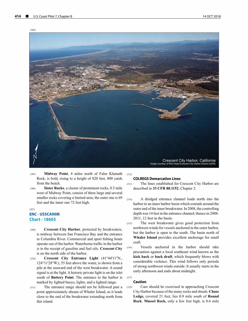
414 ¢ U.S. Coast Pilot 7, Chapter 8 14 OCT 2018
(305) Midway Point, 4 miles north of False Klamath Rock, is bold, rising to a height of 820 feet, 800 yards from the beach.
(306) Sister Rocks, a cluster of prominent rocks, 0.5 mile west of Midway Point, consist of three large and several smaller rocks covering a limited area; the outer one is 69 feet and the inner one 72 feet high.
(307) ENC - US5CA90M Chart - 18603
(308) Crescent City Harbor, protected by breakwaters, is midway between San Francisco Bay and the entrance to Columbia River. Commercial and sport fishing boats operate out of the harbor. Waterborne traffic in the harbor is in the receipt of gasoline and fuel oils. Crescent City is on the north side of the harbor.
(310) Crescent City Entrance Light (41°44'11"N., 124°11'28"W.), 55 feet above the water, is shown from a pile at the seaward end of the west breakwater. A sound signal is at the light. A historic private light is on the islet south of Battery Point. The entrance to the harbor is marked by lighted buoys, lights, and a lighted range.
(311) The entrance range should not be followed past a point approximately abeam of Whaler Island, as it leads close to the end of the breakwater extending north from this island.
(312) COLREGS Demarcation Lines
(313) The lines established for Crescent City Harbor are described in 33 CFR 80.1152, Chapter 2.
(314) A dredged entrance channel leads north into the
harbor to an inner harbor basin which extends around the outer end of the inner breakwater. In 2008, the controlling depth was 14 feet in the entrance channel; thence in 2008-2011, 12 feet in the basin.
(315) The west breakwater gives good protection from northwest winds for vessels anchored in the outer harbor, but the harbor is open to the south. The basin north of Whaler Island provides excellent anchorage for small craft.
(316) Vessels anchored in the harbor should take precaution against a local southeast wind known as the kick back or back draft, which frequently blows with considerable violence. This wind follows only periods of strong northwest winds outside. It usually starts in the early afternoon and ends about midnight.
(317) Caution
(318) Care should be exercised in approaching Crescent City Harbor because of the many rocks and shoals. Chase Ledge, covered 21 feet, lies 0.9 mile south of Round Rock. Mussel Rock, only a few feet high, is 0.6 mile
Crescent City Harbor, CaliforniaImage courtesy of Rick Hiser/Crescent City Harbor District (2008)
N
(309)

14 OCT 2018 U.S. Coast Pilot 7, Chapter 8 ¢ 415
southeast of Round Rock; a rock covered 8 feet, 700 yards to the south, breaks only in a heavy swell. Other covered rocks extend north to Whaler Island. Foul ground with many bare and covered rocks extends nearly a mile offshore along the low but rocky coast northwest of Crescent City Harbor for 3.5 miles to Point St. George. This area should be avoided.
(319) The long wharf in the west part of the harbor is used
by fishing vessels to offload fish. The remains of two other wharves, just east, were almost completely wiped out by the seismic sea wave which struck the harbor following the March 27, 1964, Alaska earthquake. The seismic wave caused considerable damage and changes to the harbor shoreline.
(320) The basin just north of Whaler Island is formed by the inner breakwater extending northwest from the island and the sand barrier from the island to the east shore. Citizens Dock, the Y-shaped pier at the north side of the harbor, extends out to a depth of about 9 feet. Several fishhouses are on the pier. Fishing boats unload their catch along both of the outer spurs of the pier. Water and ice are available on the pier. Gasoline and diesel fuel are available. The inner small-craft basin just north of Citizens Dock can accommodate about 250 boats with an additonal 100 boats at the small sport dock. Several mooring floats for commercial fishing boats are in the basin. Berths with electricity, gasoline, diesel fuel, water, ice, wet and dry winter storage, a pump-out station, a launching ramp and marine supplies are available.
(321) The harbormaster has an office at the basin north of Whaler Island. The harbormaster assigns berths and monitors VHF-FM channels 9 and 16, Monday through Friday from 0700 to 1700.
(322) A boatyard in the basin has lifts that can handle boats up to 110 feet, 270 tons. Engine repairs are available from several local firms.
(323) A Coast Guard vessel is stationed in the basin north of Whaler Island.
(324) Castle Rock, 2.3 miles northwest of Battery Point and 0.5 mile south of the south point of Point St. George, has a rather flat top, with a small knob near the east edge.
(325) Point St. George, 3 miles northwest of Battery Point, is low with several irregular and rocky hillocks near the beach. The seaward face is about a mile long in a northwest direction, with sand dunes and low land immediately behind it. The tree line is about 0.6 mile inland, with a few trees near the south end of the point. Numerous conspicuous rocks fringe the point up to 0.5 mile offshore. Brown Rock, 28 feet high, is near the outer end of the exposed rocks extending northwest from the point.
(326) St. George Channel, over a mile wide, is clear between the visible rocks fringing Point St. George and
the east rocks of St. George Reef. It is frequently used in clear weather by coastwise vessels.
(327) St. George Reef is composed of rocks and covered ledges extending 6.5 miles northwest and west from Point St. George. Nine visible rocks are in the group.
(328) Saint George Reef Light (41°50'14"N., 124°22'32"W.), 146 feet above the water, is shown from a gray tower on Northwest Seal Rock, the outermost rock of St. George Reef; the light is private.
(329) Star Rock, the southeast rock of the group, is 64 feet high. It is 1.7 miles west of the south Point St. George. Between Star and Northwest Seal Rocks are three rocks, Hump Rock, Whale Rock, and Southwest Seal Rock, almost in line, varying in height from 18 to 45 feet. South of these visible rocks are two covered ledges, Mansfield Break, and Jonathan Rock. The latter is 2.5 miles northwest of Star Rock and 3.2 miles southeast of Northwest Seal Rock. It breaks only in a heavy swell, and not continuously then; deep water surrounds it. Mansfield Break lies 2.3 miles south of Northwest Seal Rock and nearly 3.5 miles northwest of Star Rock. It is about 100 yards in extent, with 20 fathoms close-to and around it.
(330) Great Break, 0.5 mile southeast of Southwest Seal Rock, is about 150 yards in extent. A covered ledge that breaks at low water is 125 yards southwest of Southwest Seal Rock.
(331) Dragon Channel, which leads north of Jonathan Rock and between Mansfield Break and Great Break, is not recommended.
(332) East Rock and Long Rock are 2.1 and 1.6 miles, respectively, north of Star Rock.
(333) Flat Rock lies nearly midway between Long and Whale Rocks, and about 0.6 mile from the former. Mussel Rock is nearly 0.5 mile west of Long Rock; a covered ledge showing a breaker is 200 yards north of the rock. A covered rock that breaks in moderate swells is 330 yards northeast of Hump Rock.
(334) All the rocks of St. George Reef rise abruptly; soundings made in the vicinity give no warning of their presence. In thick weather, the greatest caution should be observed and the reef given a wide berth.
(335) ENC - US3OR03M Chart - 18600
(336) For about 10 miles north of Point St. George, the shores of Pelican Bay are composed of sand dunes, with a broad beach extending to the mouth of Smith River. Lake Talawa and Lake Earl are surrounded by low marshy land behind this stretch of dunes.
(337) A small rock about 10 feet high is 1.8 miles south of the mouth of Smith River, and nearly 0.5 mile offshore. A cluster of three low rocks is nearly a mile offshore and 0.9 mile north-northeast of the 10-foot rock.

416 ¢ U.S. Coast Pilot 7, Chapter 8 14 OCT 2018
(338) ENC - US5OR51M Chart - 18602
(339) From Smith River for 3.2 miles to the California-Oregon boundary, the coast is composed of low rocky cliffs, bordered by numerous rocks and ledges, covered and awash, and backed by a low narrow tableland. Several prominent rocky knolls rise from 100 to 200 feet above this tableland.
(340) Pyramid Point, a rocky knoll 222 feet high, marks the north point of Smith River.
(341) Prince Island, of small extent and 171 feet high, lies 0.1 mile offshore abreast Pyramid Point. Hunter Rock, 177 feet high, double-headed and somewhat smaller, is 0.3 mile north of Prince Island. Several other smaller rocks are in the vicinity.
(342) Cone Rock, 1.3 miles north of Prince Island and 0.6 mile offshore, is the most prominent of the visible dangers in this vicinity. It is 68 feet high and of small extent.

14 OCT 2018 U.S. Coast Pilot 7, Chapter 8 ¢ 417