Embed Size (px)
Citation preview
Non-Local Non-Local Characterization of Scenery ImagesCharacterization of Scenery Images: : Statistics, 3D Reasoning, and a Generative Statistics, 3D Reasoning, and a Generative
ModelModel
Tamar Avraham and Michael Lindenbaum
Technion
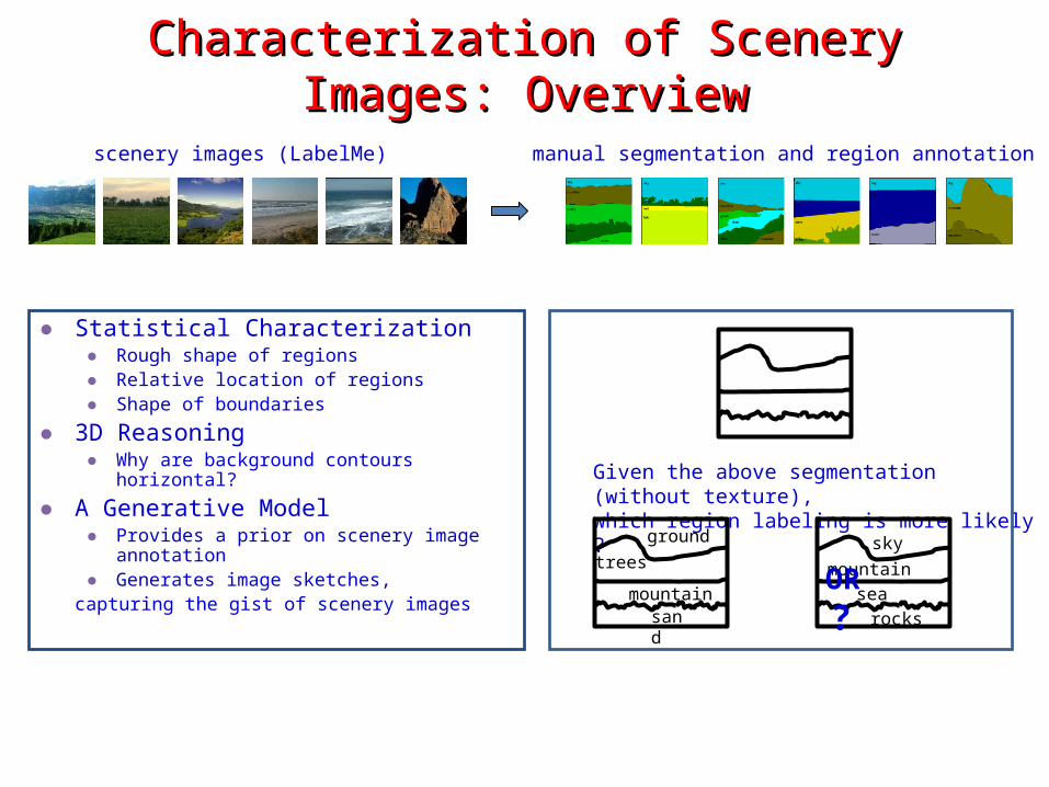
Characterization of Scenery Images: OverviewCharacterization of Scenery Images: Overview
● Statistical Characterization● Rough shape of regions ● Relative location of regions ● Shape of boundaries
● 3D Reasoning● Why are background contours horizontal?
● A Generative Model● Provides a prior on scenery image annotation● Generates image sketches,
capturing the gist of scenery images
manual segmentation and region annotation
Given the above segmentation (without texture), which region labeling is more likely ?
skymountain
sea
scenery images (LabelMe)
rocks
groundtrees
mountainsand
OR ?
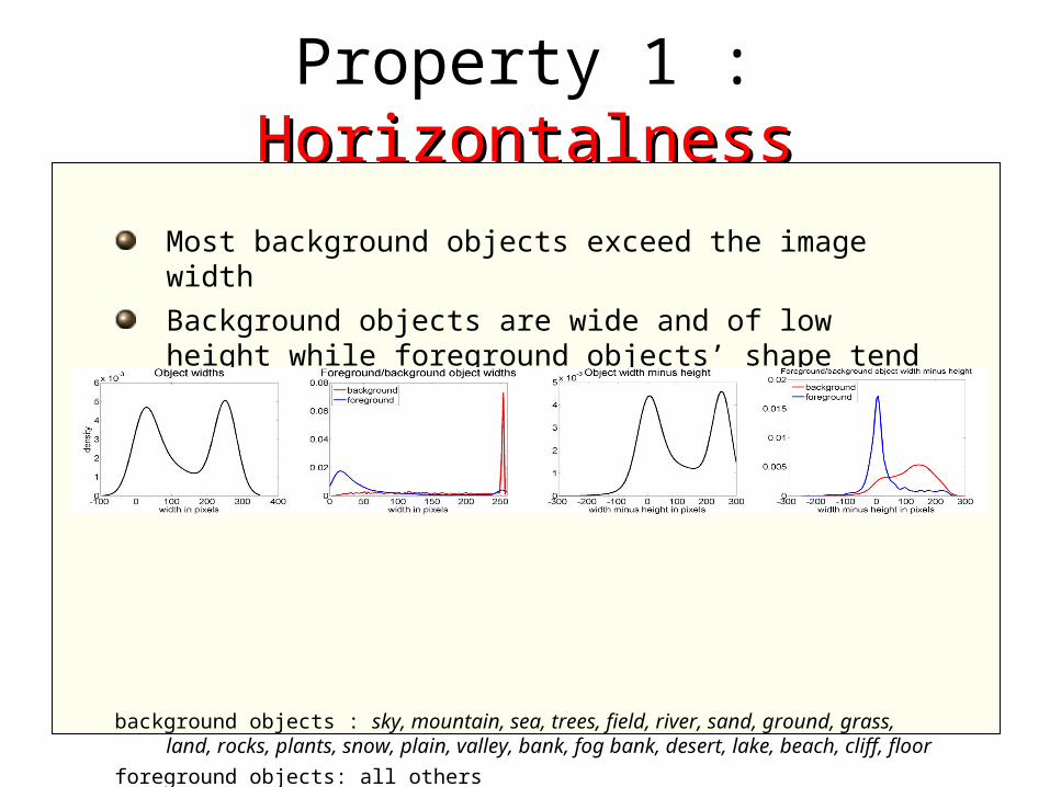
Property 1 : HorizontalnessHorizontalness
Most background objects exceed the image width
Background objects are wide and of low height while foreground objects’ shape tend to be isotropic
background objects : sky, mountain, sea, trees, field, river, sand, ground, grass, land, rocks, plants, snow, plain, valley, bank, fog bank, desert, lake, beach, cliff, floor
foreground objects: all others
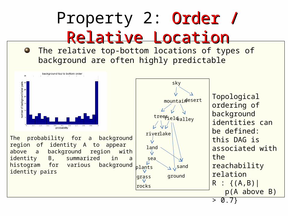
The relative top-bottom locations of types of background are often highly predictable
The probability for a background region of identity A to appear above a background region with identity B, summarized in a histogram for various background identity pairs
Topological ordering of background identities can be defined: this DAG is associated with the reachability relation R : {(A,B)| p(A above B) > 0.7}
sky
mountain desert
trees field valley
river lake
land
sand
sea
plants
groundgrass
rocks
Property 2: Order / Relative Order / Relative LocationLocation
Property 3: Boundary ShapeBoundary Shape
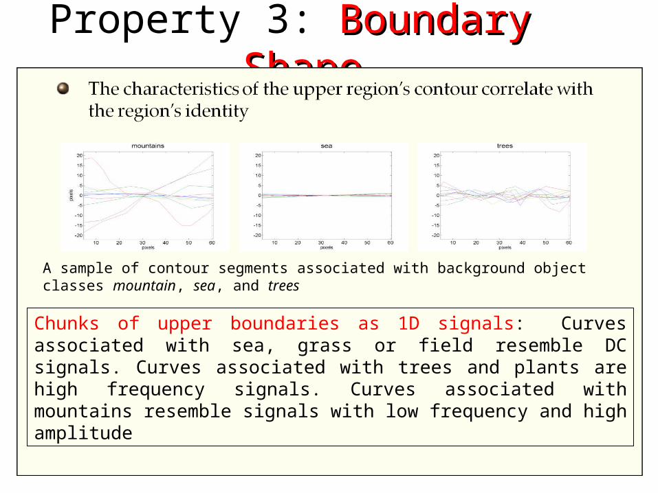
Chunks of upper boundaries as 1D signals: Curves associated with sea, grass or field resemble DC signals. Curves associated with trees and plants are high frequency signals. Curves associated with mountains resemble signals with low frequency and high amplitude
A sample of contour segments associated with background object classes mountain, sea, and trees
Flatland Flatland Flatland Flatland
3D Reasoning: Why are background regions horizontal?Why are background regions horizontal?Land regions whose contour tangents in aerial images are uniformly distributed
appear with strong horizontal bias in images taken by a photographer standing on the ground
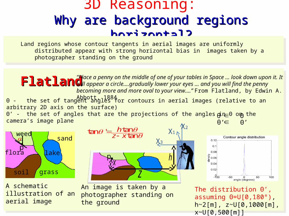
Land regions whose contour tangents in aerial images are uniformly distributed appear with strong horizontal bias in images taken by a photographer standing on the ground
Θ - the set of tangent angles for contours in aerial images (relative to an arbitrary 2D axis on the surface) Θ’ - the set of angles that are the projections of the angles in Θ on the camera’s image plane
”Place a penny on the middle of one of your tables in Space ... look down upon it. It will appear a circle....gradually lower your eyes ... and you will find the penny becoming more and more oval to your view....” From Flatland, by Edwin A. Abbott, 1884
lake
sand
grass
flora
soil
weed
p
px
zh
X1X2
X3
A schematic illustration of an aerial image
An image is taken by a photographer standing on the ground
tantan 'tan
hz x
The distribution Θ’, assuming Θ=U[0,180°), h~2[m], z~U[0,1000[m], x~U[0,500[m]]
θ’ Θ’ θ Θ
3D Reasoning cont.
Ground elevation and slope Ground elevation and slope statisticsstatistics
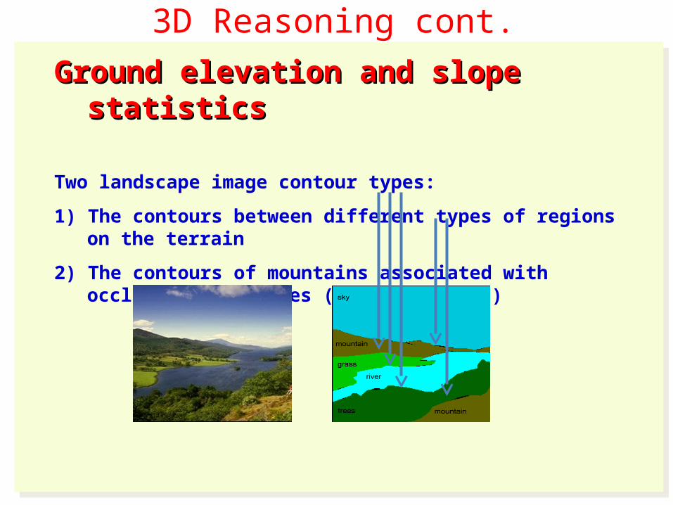
Two landscape image contour types:
1) The contours between different types of regions on the terrain
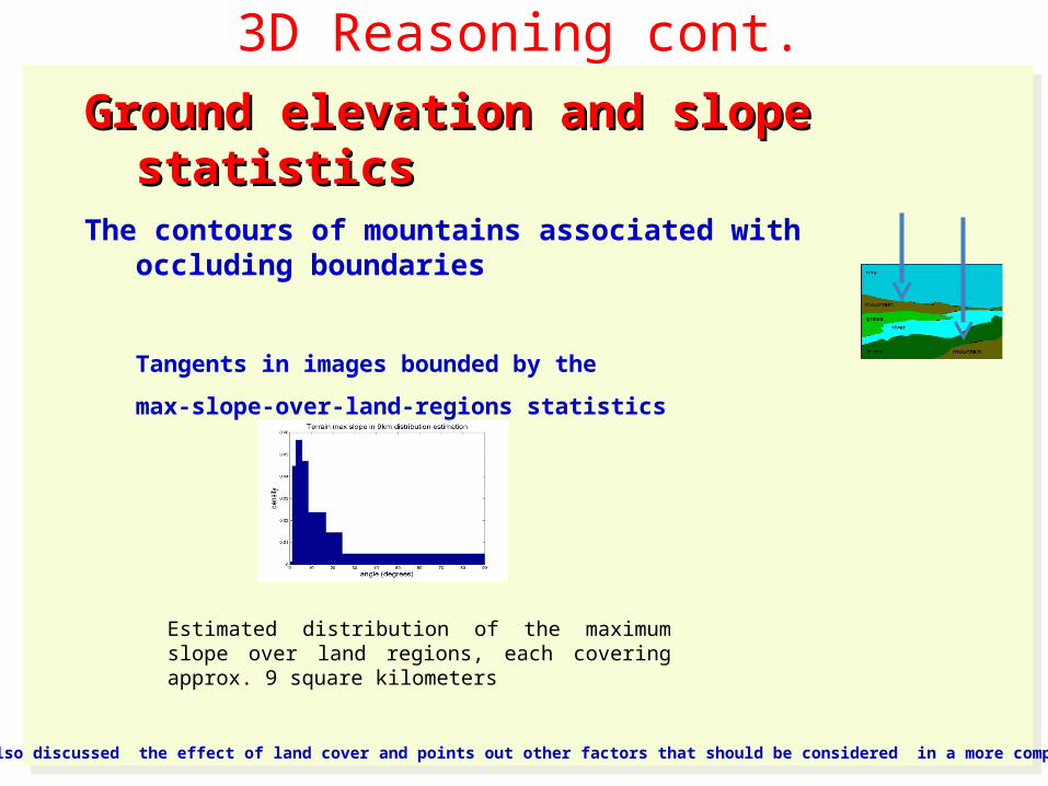
2) The contours of mountains associated with occluding boundaries (e.g., skylines)
Ground elevation and slope Ground elevation and slope statisticsstatistics
Two landscape image contour types:
1) The contours between different types of regions on the terrain
2) The contours of mountains associated with occluding boundaries (e.g., skylines)
3D Reasoning cont.
Ground elevation and slope Ground elevation and slope statisticsstatistics
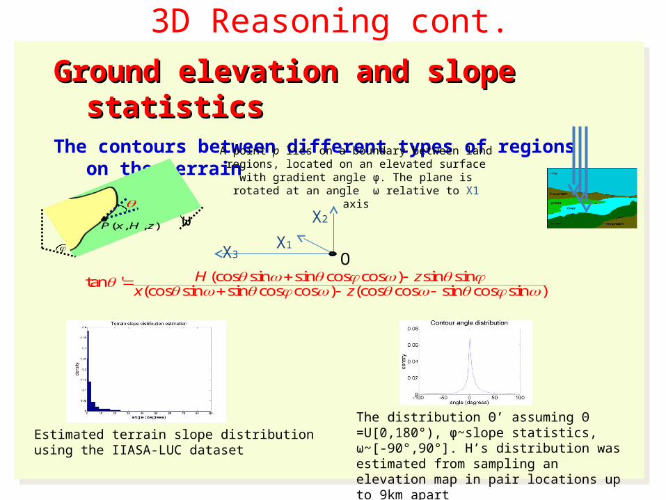
The contours between different types of regions on the terrain
Ground elevation and slope Ground elevation and slope statisticsstatistics
The contours between different types of regions on the terrain
(cos sin sin cos cos ) sin sintan '(cos sin sin cos cos ) (cos cos sin cos sin )
H zx z
The distribution Θ’ assuming Θ =U[0,180°), ϕ~slope statistics, ω~[-90°,90°]. H’s distribution was estimated from sampling an elevation map in pair locations up to 9km apart
A point p lies on a boundary between land regions, located on an elevated surface with gradient angle ϕ. The plane is rotated at an
angle ω relative to X1 axis
( , , )P x H z
X1
X2
X3 O
ω
Estimated terrain slope distribution using the IIASA-LUC dataset
3D Reasoning cont.
Ground elevation and slope Ground elevation and slope statisticsstatistics
The contours of mountains associated with occluding boundaries
Tangents in images bounded by the
max-slope-over-land-regions statistics
Ground elevation and slope Ground elevation and slope statisticsstatistics
The contours of mountains associated with occluding boundaries
Tangents in images bounded by the
max-slope-over-land-regions statistics
Estimated distribution of the maximum slope over land regions, each covering approx. 9 square kilometers
* The paper also discussed the effect of land cover and points out other factors that should be considered in a more complete analysis.
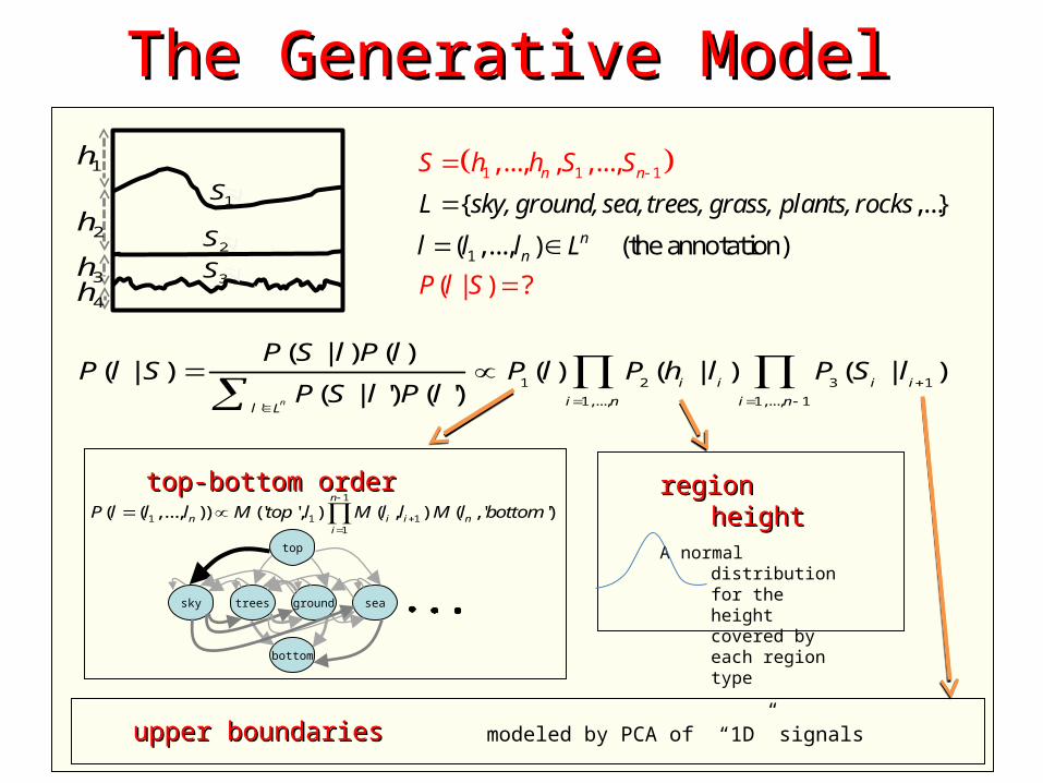
modeled by PCA of “1D” signals
The Generative ModelThe Generative Model
1
1 1 1
{ ,...}
( ,..., ) (the annot
,..., , ,.
atio
..,
( |
)
)
n
?
n
n
n
n
L sky, ground, sea, trees, grass, plants, rocks
l l l L
S h h S S
P l S
1h
2h
4h3h
1S
2S
3S
1 2 3 1
1,..., 1,..., 1'
( | ) ( )( | ) ( ) ( | ) ( | )
( | ') ( ')n
i i i i
i n i nl L
P S l P lP l S P l P h l P S l
P S l P l
top-bottom ordertop-bottom order
region heightregion heightA normal
distribution for the height covered by each region type
upper boundaries upper boundaries
1
1 1 11
( ( ,..., )) (' ', ) ( , ) ( , ' ')n
n i i ni
P l l l M top l M l l M l bottom
top
bottom
sky trees ground sea
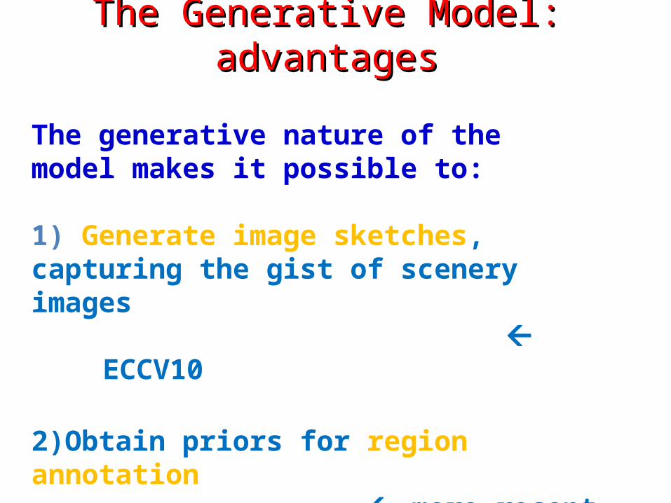
The generative nature of the model makes it possible to:
1) Generate image sketches, capturing the gist of scenery images
ECCV10
2)Obtain priors for region annotation
more recent work
The Generative Model: The Generative Model: advantagesadvantages
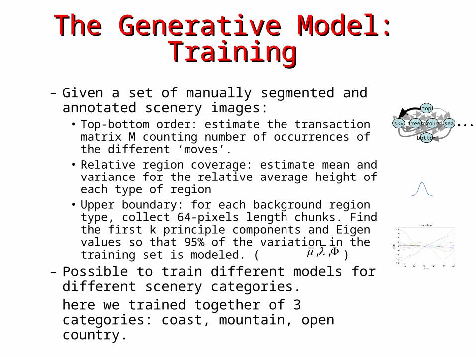
– Given a set of manually segmented and annotated scenery images:• Top-bottom order: estimate the transaction matrix M
counting number of occurrences of the different ‘moves’.
• Relative region coverage: estimate mean and variance for the relative average height of each type of region
• Upper boundary: for each background region type, collect 64-pixels length chunks. Find the first k principle components and Eigen values so that 95% of the variation in the training set is modeled. ( )
– Possible to train different models for different scenery categories.here we trained together of 3 categories: coast, mountain, open country.
The Generative Model: The Generative Model: TrainingTraining
top
bottom
sky treesground sea
, ,
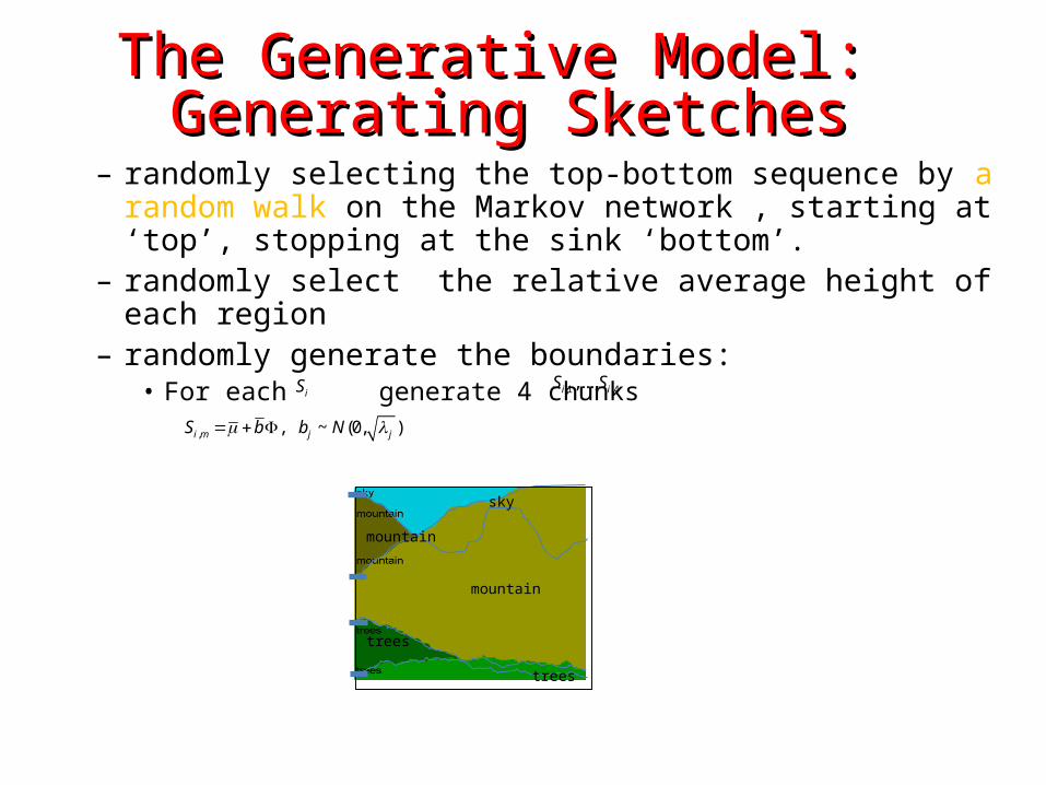
– randomly selecting the top-bottom sequence by a random walk on the Markov network , starting at ‘top’, stopping at the sink ‘bottom’.
– randomly select the relative average height of each region– randomly generate the boundaries:
• For each generate 4 chunks
The Generative Model: The Generative Model: Generating SketchesGenerating Sketches
Sky
mountain
mountain
trees
Trees
sky
mountain
mountain
trees
trees
, , ~ (0, )i m j jS b b N
,1 ,4,...,i iS SiS
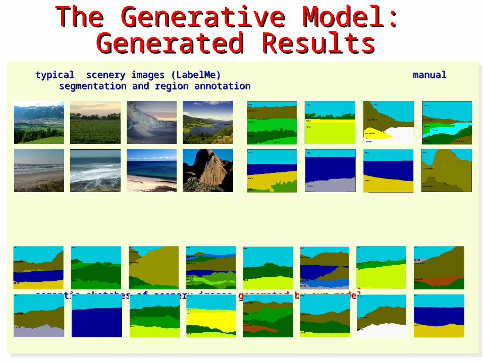
typical scenery images (LabelMe) manual segmentation and typical scenery images (LabelMe) manual segmentation and region annotationregion annotation
semantic sketches of scenery images semantic sketches of scenery images generated by our modelgenerated by our model
typical scenery images (LabelMe) manual segmentation and typical scenery images (LabelMe) manual segmentation and region annotationregion annotation
semantic sketches of scenery images semantic sketches of scenery images generated by our modelgenerated by our model
The Generative Model: The Generative Model: Generated ResultsGenerated Results
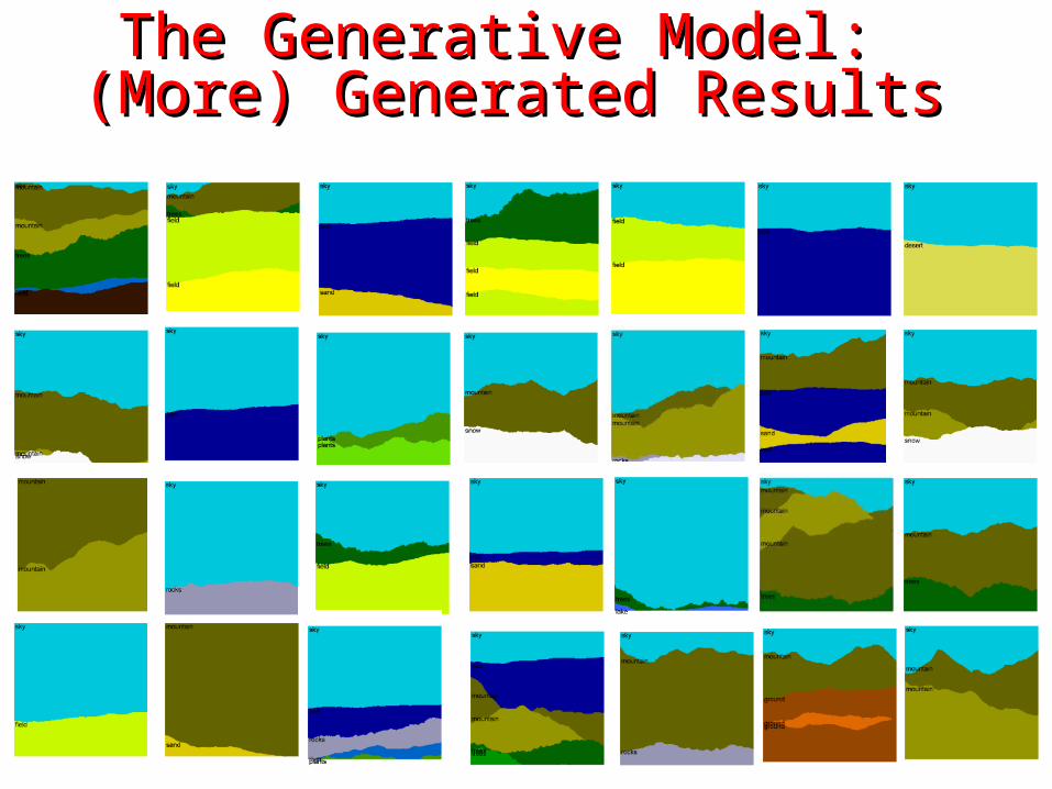
The Generative Model: The Generative Model: (More) Generated Results(More) Generated Results
Region ClassificationRegion Classification
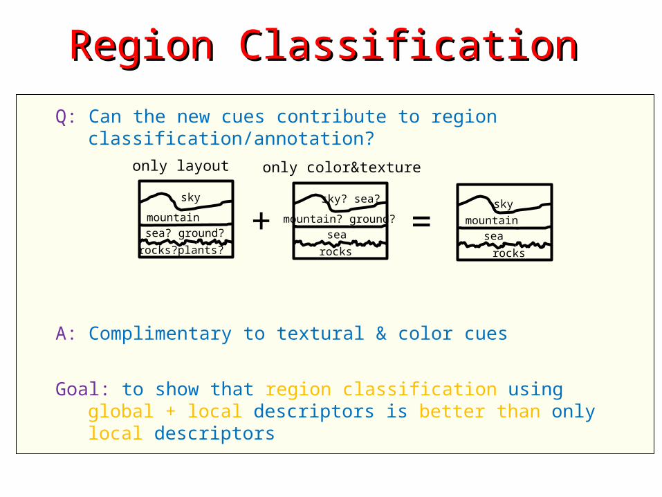
Q: Can the new cues contribute to region classification/annotation?
A: Complimentary to textural & color cues
Goal: to show that region classification using global + local descriptors is better than only local descriptors
sky
mountainsea? ground?
rocks?plants?
only layout
sky? sea?
mountain? ground?sea
rocks
only color&texture
+ =sky
mountainsea
rocks
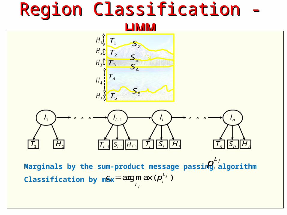
Region Classification - Region Classification - HMMHMM
Marginals by the sum-product message passing algorithm
Classification by max
1H
2H
4H
5H
1T
2T
3T
4T
5T
2S
3S
4S
5S
3H
1il
1iT 1iH 1iS
1l
1T 1H
il
iT iHiS
nl
nT nHnS
j
i
Lp
arg max( )j
i
j
L
iL
c p

Region Classification - Region Classification - DiscussionDiscussion
General object annotation and detection using context: G. Csurka and F. Perronnin. An efficient approach to semantic segmentation. IJCV, 2010. C. Desai, D. Ramanan, and C. Fowlkes. Discriminative models for multi-class object layout. ICCV, 2009. C. Galleguillos and S. Belongie. Context based object categorization:A critical survey. Comput. Vis. Image Understand, 2010. X. He, R. S. Zemel, and D. Ray. Learning and incorporating top-down cues in image segmentation. ECCV, 2006. S. Kumar and M. Hebert. A hierarchical field framework for unified context-based classification. ICCV, 2005. A. Rabinovich, A. Vedaldi, C. Galleguillos, E. Wiewiora,and S. Belongie. Objects in context. ICCV, 2007. J. Shotton, J. Winn, C. Rother, and A. Criminisi. Textonboost for image understanding: multi-class object recognition
and segmentation by jointly modeling appearance, shape and context. IJCV, 81(1):2–23, 2009.
Approximated inference needed (e.g., greedy iterative methods, loopy belief propagation)
Background region classification of scenery images: a 1D problem
Enables exact inference
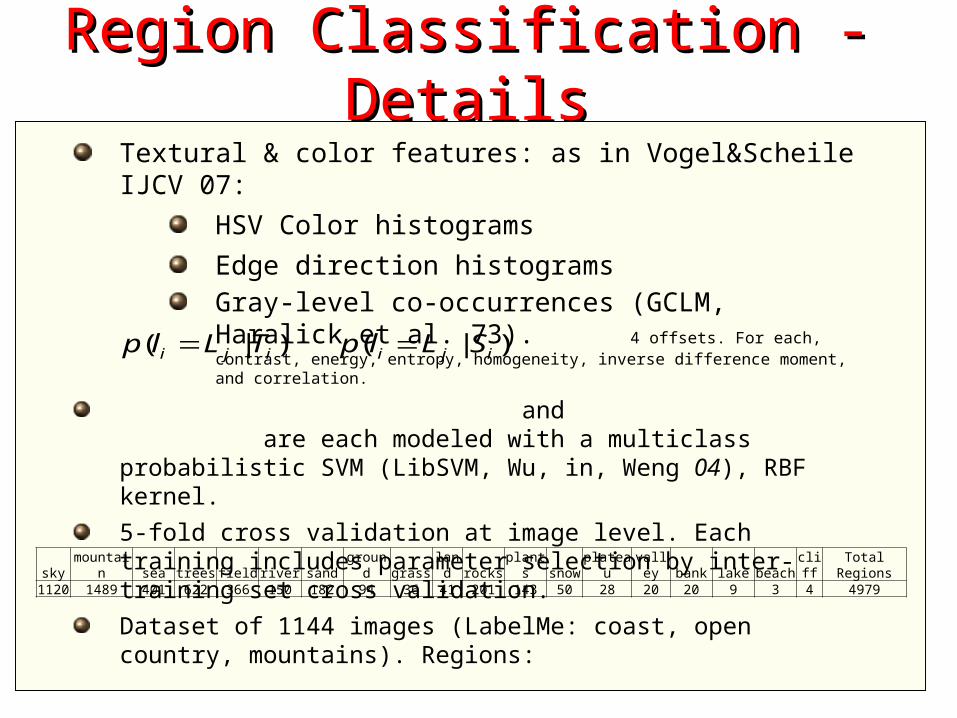
Region Classification - Region Classification - DetailsDetails
Textural & color features: as in Vogel&Scheile IJCV 07:
HSV Color histograms
Edge direction histogramsGray-level co-occurrences (GCLM, Haralick et al. 73). 4 offsets. For each, contrast, energy, entropy, homogeneity, inverse difference moment, and correlation.
and are each modeled with a multiclass probabilistic SVM (LibSVM, Wu, in, Weng 04), RBF kernel.
5-fold cross validation at image level. Each training includes parameter selection by inter-training set cross validation.
Dataset of 1144 images (LabelMe: coast, open country, mountains). Regions:
( | )i j ip l L T ( | )i j ip l L S
sky mountain sea trees field river sand ground grass land rocks plants snow plateau valley bank lake beach cliff Total Regions1120 1489 401 622 366 150 182 94 36 41 201 143 50 28 20 20 9 3 4 4979
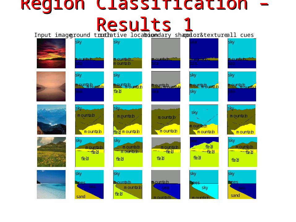
Region Classification – Region Classification – Results 1Results 1
ground truthInput image relative location boundary shape color&texture all cues
sky
mountainmountainsea
sky
mountainmountainmountainmountainsea
sky
mountainmountainfield
SKY
MOUNTAIN-TREESMOUNTAIN-TREESMOUNTAIN-TREESMOUNTAIN-TREESPLAIN-SAND
mountainmountainsea
MOUNTAIN-TREESMOUNTAIN-TREESMOUNTAIN-TREESMOUNTAIN-TREESWATER
sky
mountainmountain
sky
SKY
MOUNTAIN-PLANTSMOUNTAIN-ROCKSMOUNTAIN-ROCKSMOUNTAIN-ROCKSSKY
sky
mountainmountain
sea
SKY
MOUNTAIN-PLANTSMOUNTAIN-ROCKSMOUNTAIN-ROCKSMOUNTAIN-TREESWATER
sky
mountainsea
sky
mountainsea
sky
mountainmountain
SKY
MOUNTAIN-TREESMOUNTAIN-SAND
mountainsea
MOUNTAIN-TREESWATER
sea
mountainsea
WATER
MOUNTAIN-SANDWATER
sky
mountainsea
SKY
MOUNTAIN-SANDWATER
sky
treessea
sand
sky
treesseasand
sky
mountainmountain
field
SKY
MOUNTAIN-TREESMOUNTAIN-TREESPLAIN-SAND
mountainsea
mountain
MOUNTAIN-TREESWATERMOUNTAIN-TREES
sky
treessky
mountain
SKY
MOUNTAIN-TREESSKYMOUNTAIN-SNOW
sky
treessea
sand
SKY
MOUNTAIN-TREESWATERMOUNTAIN-SAND
sky
mountain
mountain
skymountainmountain
mountainmountainmountain
sky
mountain
mountainfield
SKYMOUNTAIN-TREESMOUNTAIN-TREES
MOUNTAIN-TREESMOUNTAIN-TREESPLAIN-ROCKS
mountain
mountain
MOUNTAIN-TREESMOUNTAIN-TREES
MOUNTAIN-TREESMOUNTAIN-TREESMOUNTAIN-TREES
sky
mountainmountain
SKYSKYSKY
MOUNTAIN-TREESMOUNTAIN-TREESMOUNTAIN-PLANTS
sky
mountain
mountain
SKYMOUNTAIN-TREESMOUNTAIN-TREES
MOUNTAIN-TREESMOUNTAIN-TREESMOUNTAIN-SNOW
sky
mountainfield
field
skymountain
fieldfield
sky
mountainmountain
field
SKYMOUNTAIN-TREES
MOUNTAIN-TREESPLAIN-SAND
mountainfield
field
MOUNTAIN-TREES
PLAIN-SANDPLAIN-SAND
sea
field
fieldfield
PLAIN-SANDPLAIN-TREES
PLAIN-TREESPLAIN-GROUND
sky
mountainfield
field
SKYMOUNTAIN-TREES
PLAIN-SANDPLAIN-SAND
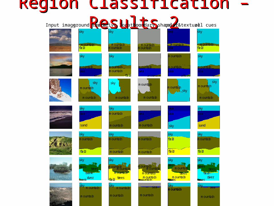
Region Classification – Region Classification – Results 2Results 2ground truthInput image relative location boundary shape color&texture all cues
sky
sea
sand
sky
sea
sand
sky
mountain
mountain
SKY
MOUNTAIN-TREES
MOUNTAIN-SAND
sea
mountain
WATER
MOUNTAIN-TREES
sea
sea
sky
WATER
WATER
MOUNTAIN-SAND
sky
sea
sand
SKY
WATER
MOUNTAIN-SAND
sky
mountainsea
sand
sky
mountainsea
sand
sky
mountainmountain
field
SKY
MOUNTAIN-TREESMOUNTAIN-TREES
PLAIN-SAND
mountainsea
mountain
MOUNTAIN-TREESWATER
MOUNTAIN-SAND
mountain
mountainsea
plants
MOUNTAIN-SAND
MOUNTAIN-SANDPLAIN-SAND
MOUNTAIN-PLANTS
sky
mountainsea
sand
SKY
MOUNTAIN-SANDWATER
MOUNTAIN-SAND
sky
mountain
mountain
sky
mountain
mountain
mountain
sky
MOUNTAIN-TREESSKY
MOUNTAIN-SAND
mountain
mountain
MOUNTAIN-TREES
MOUNTAIN-TREES
skymountain
SKYMOUNTAIN-ROCKS
SKY
skymountain
mountain
SKY
MOUNTAIN-SNOW
MOUNTAIN-ROCKS
skymountain
mountain
skymountainmountain
skymountain
mountain
SKYMOUNTAIN-TREESMOUNTAIN-SAND
sea
mountain
WATERMOUNTAIN-TREES
skymountainmountain
SKYMOUNTAIN-GROUNDMOUNTAIN-GROUND
sky sea
mountain
SKYWATERMOUNTAIN-SAND
sky
field
mountain
sky
field
mountain
sky
mountain
mountain
SKY
MOUNTAIN-SAND
MOUNTAIN-TREES
mountain
mountain
MOUNTAIN-TREES
MOUNTAIN-TREES
sky
field
field
SKY
PLAIN-GRASS
PLAIN-GRASS
sky
field
mountain
SKY
PLAIN-GROUND
MOUNTAIN-TREES
sky
mountainfield
sky
mountainfield
sky
mountainmountain
SKY
MOUNTAIN-TREESMOUNTAIN-SAND
mountainmountain
MOUNTAIN-TREESMOUNTAIN-TREES
sea
mountainsea
WATER
MOUNTAIN-SANDPLAIN-SAND
sky
mountainfield
SKY
MOUNTAIN-SANDPLAIN-SAND
sky
trees treesbankriver
bank
sky
treestreestreestrees
bankriver
bank
sky
mountainmountain
trees
mountain
field
SKY
MOUNTAIN-TREESMOUNTAIN-TREESMOUNTAIN-TREESMOUNTAIN-TREES
PLAIN-TREESMOUNTAIN-TREES
PLAIN-ROCKS
mountainmountain
mountainmountain
mountain
MOUNTAIN-TREESMOUNTAIN-TREESMOUNTAIN-TREESMOUNTAIN-TREES
MOUNTAIN-SANDMOUNTAIN-TREES
MOUNTAIN-TREES
sky
treesmountain
treesmountain
trees
SKY
MOUNTAIN-TREESMOUNTAIN-TREESMOUNTAIN-TREESMOUNTAIN-TREES
MOUNTAIN-TREESMOUNTAIN-GROUND
MOUNTAIN-TREES
sky
treestrees
fieldriver
trees
SKY
MOUNTAIN-TREESMOUNTAIN-TREESMOUNTAIN-TREESMOUNTAIN-TREES
PLAIN-GROUNDPLAIN-GROUND
PLAIN-TREES
sky
trees treesbankriver
bank
sky
treestreestreestrees
bankriver
bank
sky
mountainmountain
trees
mountain
field
SKY
MOUNTAIN-TREESMOUNTAIN-TREESMOUNTAIN-TREESMOUNTAIN-TREES
PLAIN-TREESMOUNTAIN-TREES
PLAIN-ROCKS
mountainmountain
mountainmountain
mountain
MOUNTAIN-TREESMOUNTAIN-TREESMOUNTAIN-TREESMOUNTAIN-TREES
MOUNTAIN-SANDMOUNTAIN-TREES
MOUNTAIN-TREES
sky
treesmountain
treesmountain
trees
SKY
MOUNTAIN-TREESMOUNTAIN-TREESMOUNTAIN-TREESMOUNTAIN-TREES
MOUNTAIN-TREESMOUNTAIN-GROUND
MOUNTAIN-TREES
sky
treestrees
fieldriver
trees
SKY
MOUNTAIN-TREESMOUNTAIN-TREESMOUNTAIN-TREESMOUNTAIN-TREES
PLAIN-GROUNDPLAIN-GROUND
PLAIN-TREES
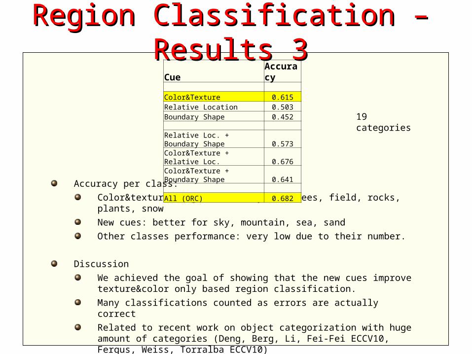
Accuracy per class:
Color&texture: higher accuracy for trees, field, rocks, plants, snow
New cues: better for sky, mountain, sea, sand
Other classes performance: very low due to their number.
Discussion
We achieved the goal of showing that the new cues improve texture&color only based region classification.
Many classifications counted as errors are actually correct
Related to recent work on object categorization with huge amount of categories (Deng, Berg, Li, Fei-Fei ECCV10, Fergus, Weiss, Torralba ECCV10)
Work in progress.
Region Classification – Region Classification – Results 3Results 3Cue Accuracy
Color&Texture 0.615Relative Location 0.503Boundary Shape 0.452
Relative Loc. + Boundary Shape 0.573Color&Texture + Relative Loc. 0.676Color&Texture + Boundary Shape 0.641
All (ORC) 0.682
19 categories
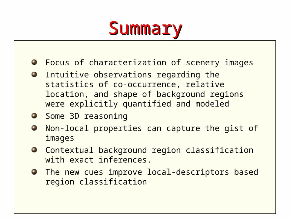
SummarySummary
Focus of characterization of scenery images
Intuitive observations regarding the statistics of co-occurrence, relative location, and shape of background regions were explicitly quantified and modeled
Some 3D reasoning
Non-local properties can capture the gist of images
Contextual background region classification with exact inferences.
The new cues improve local-descriptors based region classification
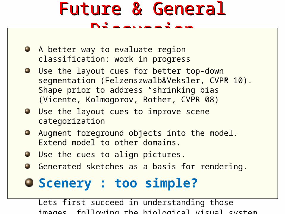
Future & General Future & General DiscussionDiscussion
A better way to evaluate region classification: work in progress
Use the layout cues for better top-down segmentation (Felzenszwalb&Veksler, CVPR 10). Shape prior to address “shrinking bias” (Vicente, Kolmogorov, Rother, CVPR 08)
Use the layout cues to improve scene categorization
Augment foreground objects into the model. Extend model to other domains.
Use the cues to align pictures.
Generated sketches as a basis for rendering.
Scenery : too simple?
Lets first succeed in understanding those images, following the biological visual system evolution

Thank You For Your Time