Embed Size (px)
Citation preview
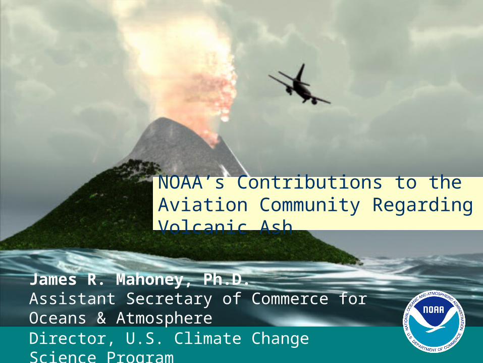
NOAA’s Contributions to the Aviation Community Regarding Volcanic Ash
James R. Mahoney, Ph.D.Assistant Secretary of Commerce for Oceans & AtmosphereDirector, U.S. Climate Change Science Program
June 21, 2004
2
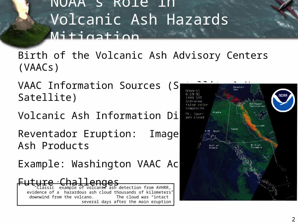
NOAA’s Role in Volcanic Ash Hazards Mitigation
Birth of the Volcanic Ash Advisory Centers (VAACs)
VAAC Information Sources (Satellite & Non-Satellite)
Volcanic Ash Information Dissemination
Reventador Eruption: Imagery & Sample Ash Products
Example: Washington VAAC Activity in 2003
Future Challenges
“Classic” example of volcanic ash detection from AVHRR, evidence of a hazardous ash cloud thousands of kilometers downwind from the volcano. The cloud was “intact” several days after the main
eruption
3
WellingtonDarwin
45 30 15 0 15 30 45 6060759010512013515016518016515013512010575
60
60
45
45
30
30
15
15
75
90
Tokyo
Washington
MontrealLondon
Anchorage
Buenos
Aires
Toulouse
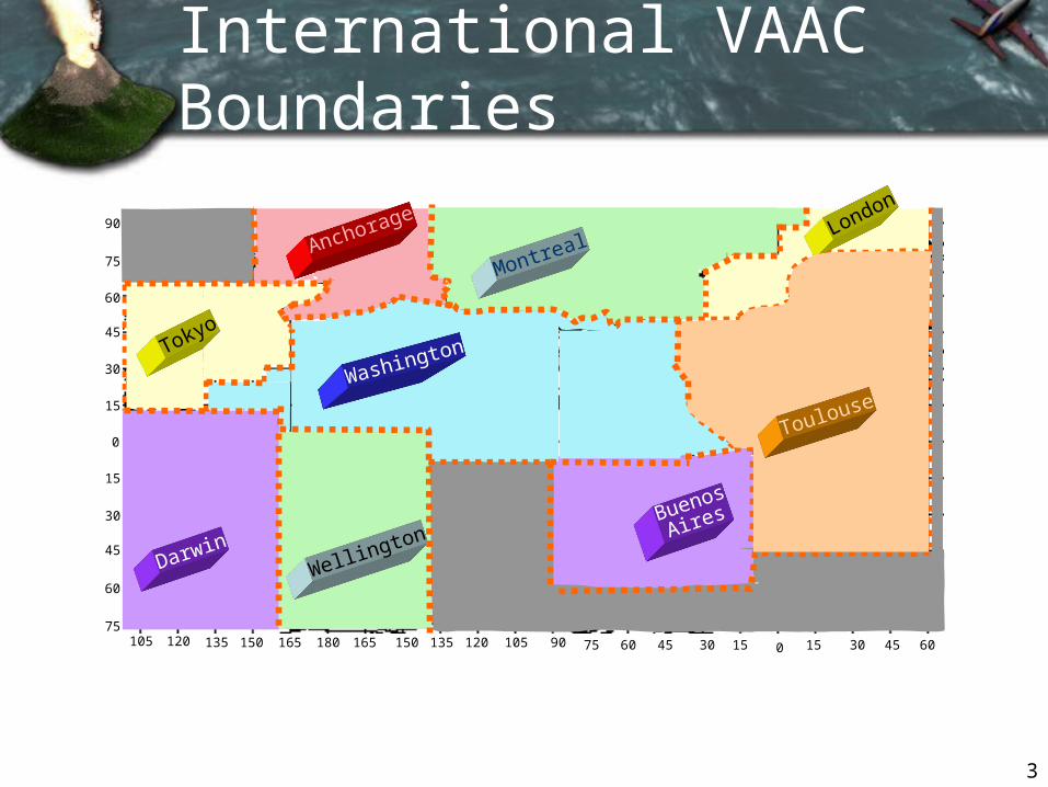
International VAAC Boundaries
0
4
VAACs
Pacific NW WFOs
Other U.S. government agencies including
AWC, DoD (AFWA), FEMA
ACCs FAA
Other VAACs
Airlines, Aviation community
MWOs
Washington & Anchorage VAAC Customers
VAAC = Volcanic Ash Advisory CenterMWO = Meteorological Watch OfficeWFO = Weather Forecast OfficeAWC = Aviation Weather CenterFAA = Federal Aviation Administration
DoD = Department of DefenseAFWA = Air Force Weather AgencyFEMA = Federal Emergency Management
AgencyACC = Area Control Center
Abbreviations:
5
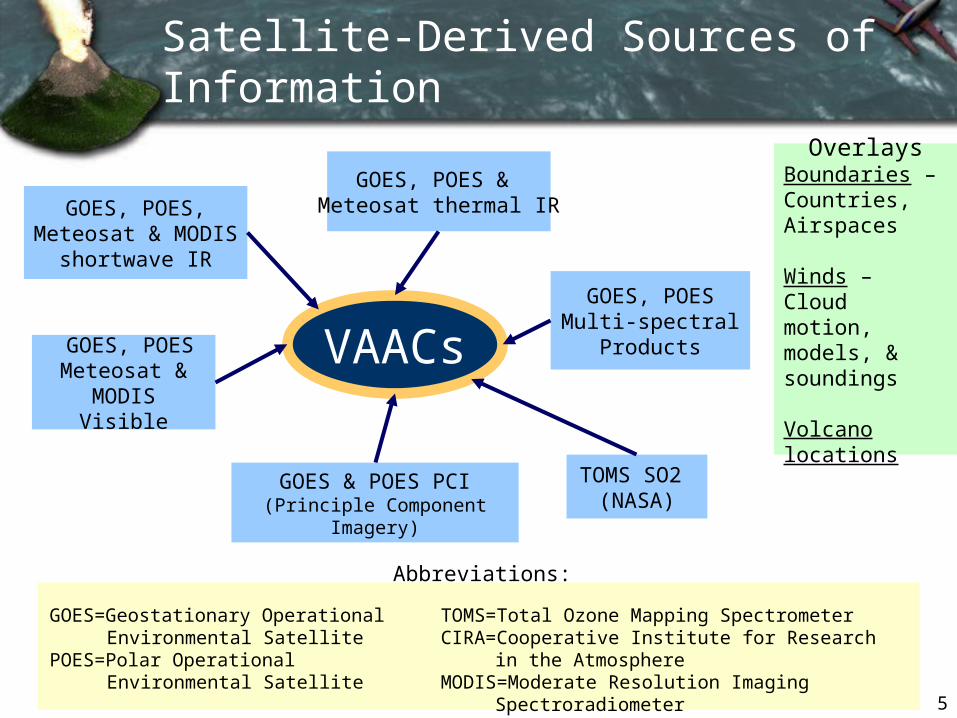
GOES, POES & Meteosat thermal IR
GOES & POES PCI (Principle Component
Imagery)
GOES, POESMeteosat &
MODIS Visible
GOES, POES Multi-spectral
Products
TOMS SO2 (NASA)
Satellite-Derived Sources of Information
GOES, POES, Meteosat & MODIS
shortwave IR
OverlaysBoundaries – Countries, Airspaces
Winds – Cloud motion, models, & soundings
Volcano locations
GOES=Geostationary Operational Environmental Satellite
POES=Polar Operational Environmental Satellite
TOMS=Total Ozone Mapping SpectrometerCIRA=Cooperative Institute for Research in the
AtmosphereMODIS=Moderate Resolution Imaging
Spectroradiometer
VAACs
Abbreviations:
6
Abbreviations:
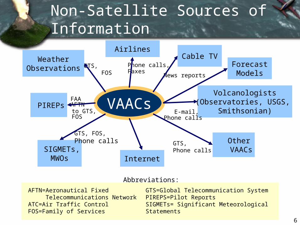
FAA AFTN
AirlinesCable TV
Phone calls,Faxes
News reports
Other VAACs
SIGMETs, MWOs
GTS, FOS,Phone calls
PIREPs
WeatherObservations GTS,
FOS
Volcanologists(Observatories, USGS,
Smithsonian)E-mail, Phone calls
GTS,Phone calls
to GTS, FOS
Internet
Non-Satellite Sources of Information
AFTN=Aeronautical Fixed Telecommunications Network
ATC=Air Traffic ControlFOS=Family of Services
GTS=Global Telecommunication SystemPIREPS=Pilot ReportsSIGMETs= Significant Meteorological Statements
VAACs
ForecastModels
7
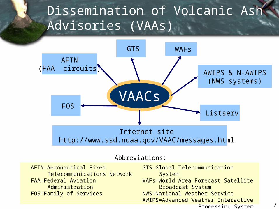
WAFs
Internet sitehttp://www.ssd.noaa.gov/VAAC/messages.html
FOS
AFTN(FAA circuits)
AWIPS & N-AWIPS(NWS systems)
GTS
Listserv
VAACs
Dissemination of Volcanic Ash Advisories (VAAs)
AFTN=Aeronautical Fixed Telecommunications Network
FAA=Federal Aviation AdministrationFOS=Family of Services
GTS=Global Telecommunication SystemWAFs=World Area Forecast Satellite
Broadcast SystemNWS=National Weather ServiceAWIPS=Advanced Weather Interactive
Processing System
Abbreviations:

8
Volcanic Ash Advisory (VAA) for Reventador Eruption
FVXX21 KWBC 031700VOLCANIC ASH ADVISORYISSUED: 2002NOV03/1700Z VAAC: WASHINGTON
VOLCANO: REVENTADOR 1502-01LOCATION: S0008W07762 AREA: ECUADOR
SUMMIT ELEVATION: 12139FT (3700M)
ADVISORY NUMBER: 2002/003
INFORMATION SOURCE: GOES-8 IMAGERY. GEOPHYSICAL INSTITUTE
ERUPTION DETAILS: ERUPTION AT 03/1245Z.
OBS ASH DATE/TIME: 03/1615Z
OBS ASH CLOUD: SFC/FL450 N0007W07742 N0002W07700 S0021W07658S0024W07733 N0007W07742 MOVING E 5-10 KNOTS. SFC/FL300 N0007W07742S0024W07733 S0041W07814 S0021W07833 N0007W07742 MOVING SW 20-30KNOTS.
FCST ASH CLOUD+6H: SEE SIGMETS AND VAFTAD
REMARKS: A LARGER ERUPTION OF THE VOLCANO CONTINUES. NOW THATASH IS MOVING TOWARDS THE EAST WE ESTIMATE THE ASH UP TO FL450. ASH UP TO FL300 IS MOVING TOWARDS THE SW. VISIBLE IMAGERYCONTINUES TO SHOW A LARGE DARK CLOUD OVERSPREADING THE TOP OFTHE VOLCANO.
NEXT ADVISORY: WILL BE ISSUED BY 2002NOV03/2300Z.
9
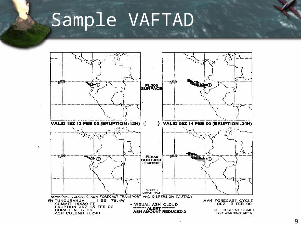
Sample VAFTAD
10
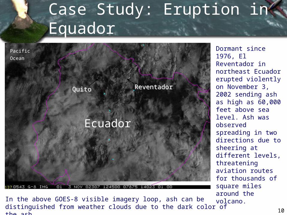
Case Study: Eruption in Equador
ReventadorReventador
Ecuador
Pacific
Ocean
Dormant since 1976, El Reventador in northeast Ecuador erupted violently on November 3, 2002 sending ash as high as 60,000 feet above sea level. Ash was observed spreading in two directions due to sheering at different levels, threatening aviation routes for thousands of square miles around the volcano.
QuitoQuito
In the above GOES-8 visible imagery loop, ash can be distinguished from weather clouds due to the dark color of the ash.
11
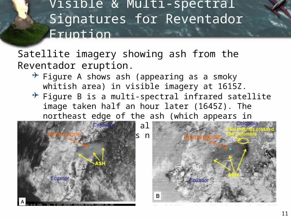
Visible & Multi-spectral Signatures for Reventador Eruption
Satellite imagery showing ash from the Reventador eruption.
Figure A shows ash (appearing as a smoky whitish area) in visible imagery at 1615Z.
Figure B is a multi-spectral infrared satellite image taken half an hour later (1645Z). The northeast edge of the ash (which appears in this multi-spectral algorithm as a dark gray/black area) has now extended into Colombia.
12
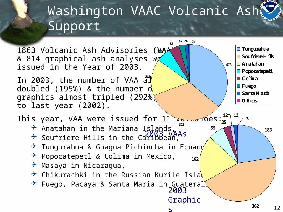
1863 Volcanic Ash Advisories (VAA) & 814 graphical ash analyses were issued in the Year of 2003.
In 2003, the number of VAA almost doubled (195%) & the number of graphics almost tripled (292%) compared to last year (2002).
This year, VAA were issued for 11 volcanoes: Anatahan in the Mariana Islands, Soufriere Hills in the Caribbean, Tungurahua & Guagua Pichincha in Ecuador, Popocatepetl & Colima in Mexico, Masaya in Nicaragua, Chikurachki in the Russian Kurile Islands as well as, Fuego, Pacaya & Santa Maria in Guatemala.
183
362
162
5525
12 123
673
623
289
111
8647 24 10
Tungurahua
Soufriere Hills
Anatahan
Popocatepetl
Colima
Fuego
Santa Maria
Others
2003 VAAs
2003 Graphics
Washington VAAC Volcanic Ash Support
13
Future Challenges
Meet the increasing requirements of aviation community through continued research & interagency collaboration in satellite-based volcanic ash detection including:
Accurate ash height assignments Detection & tracking of SO2 emissions Enhanced ash cloud forecasts Improved timeliness of eruption notification Graphical products for realtime cockpit use
Leverage off future satellite data streams with improved capabilities for enhanced volcanic ash detection & monitoring (e.g. NPOESS)
BACKUP SLIDES
15
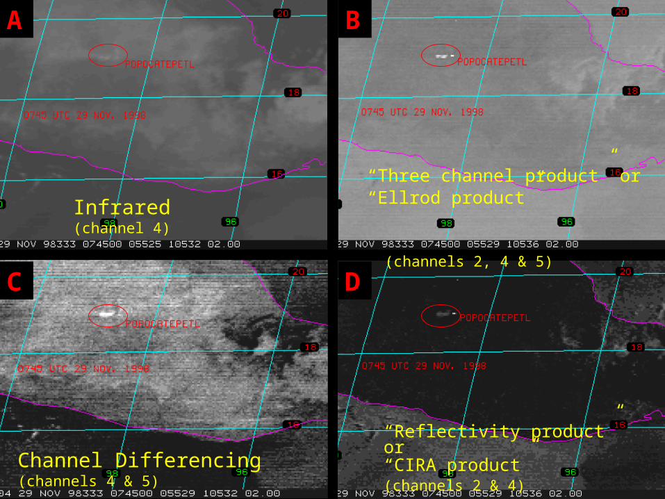
Infrared (channel 4)
“Three channel product” or “Ellrod product” (channels 2, 4 & 5)
Channel Differencing (channels 4 & 5)
“Reflectivity product” or “CIRA product” (channels 2 & 4)
A B
C D
16
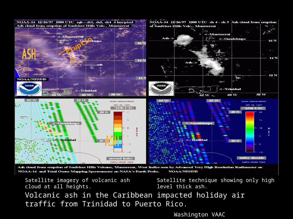
Satellite imagery of volcanic ash cloud at all heights.
Satellite technique showing only high level thick ash.
Eruption
Volcanic ash in the Caribbean impacted holiday air traffic from Trinidad to Puerto Rico.
Washington VAAC www.ssd.noaa.gov
17
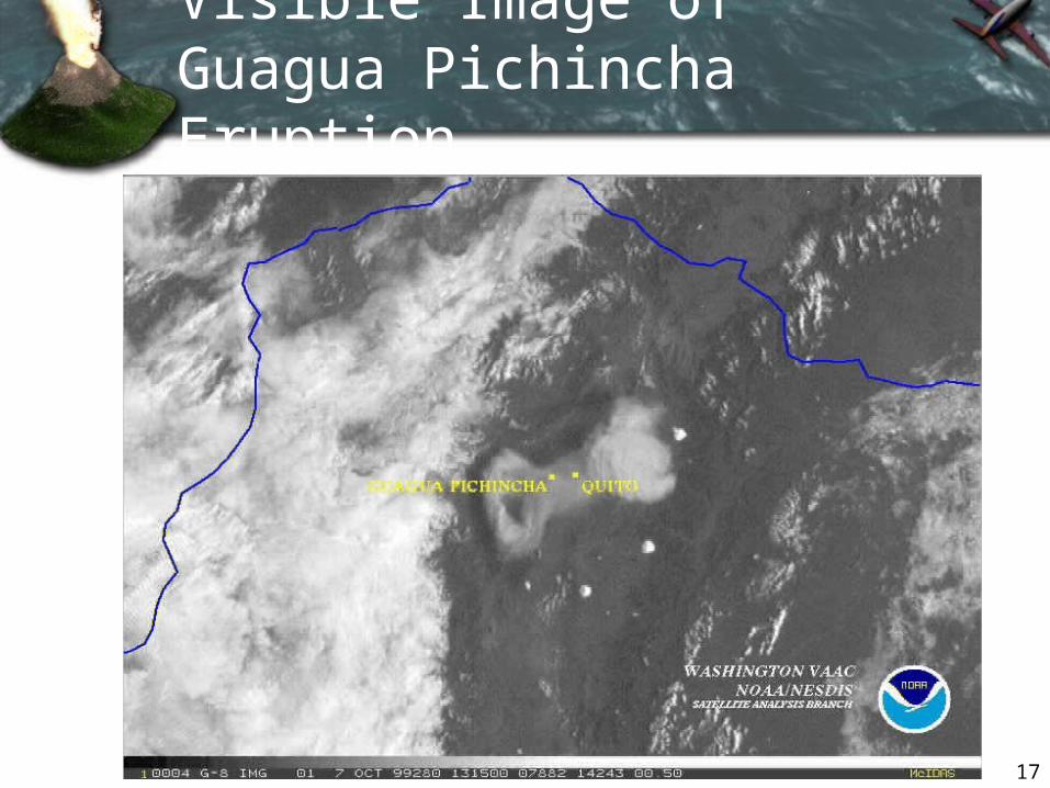
Visible Image of Guagua Pichincha Eruption