Embed Size (px)
Citation preview
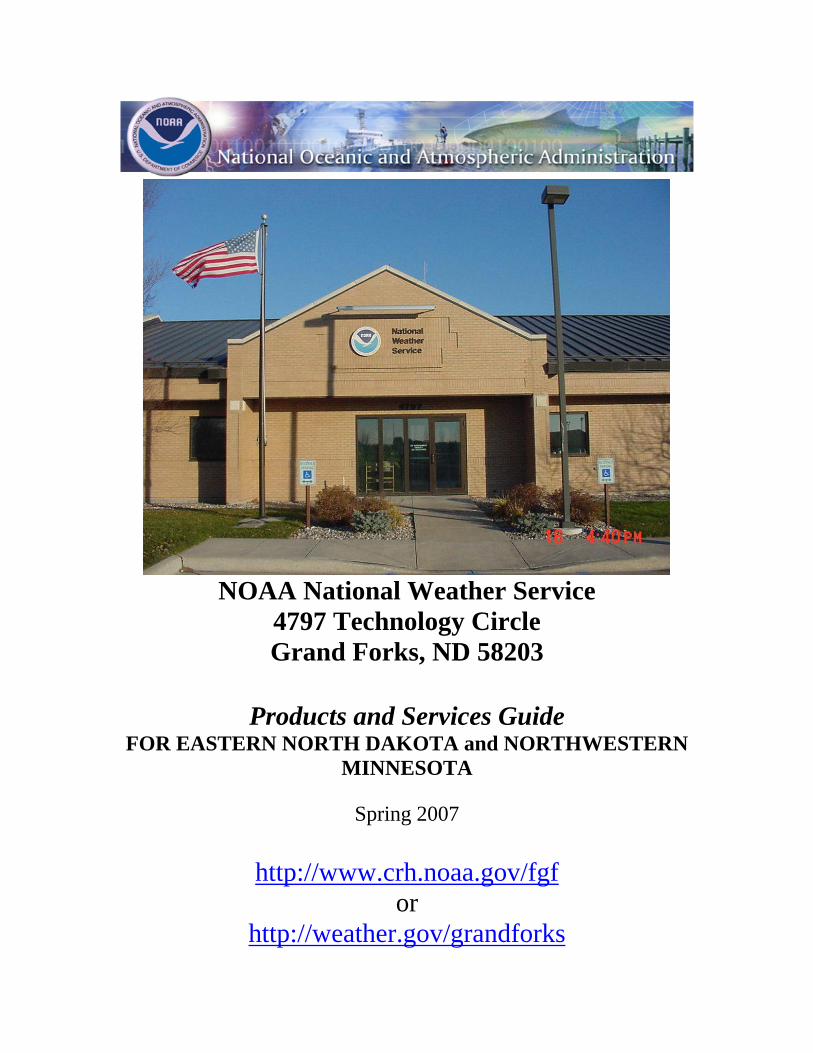
NOAA National Weather Service
4797 Technology Circle Grand Forks, ND 58203
Products and Services Guide
FOR EASTERN NORTH DAKOTA and NORTHWESTERN MINNESOTA
Spring 2007
http://www.crh.noaa.gov/fgf
or http://weather.gov/grandforks
2
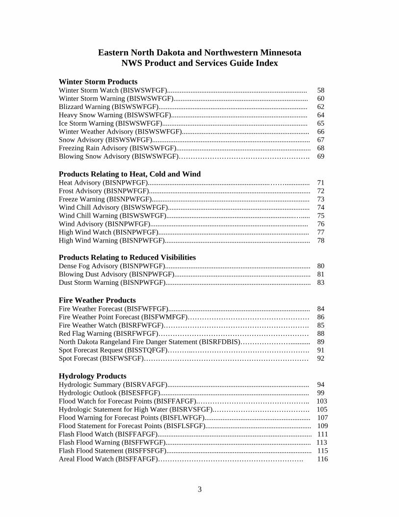
Eastern North Dakota and Northwestern Minnesota NWS Products and Services Guide Index
Page # Introduction to NOAA’s National Weather Service…………………………… 6 Telephone Numbers and E-mail Addresses……………………………………. 7 Communication of Weather Products…………………………………………... 9 Mass Media Dissemination…………………………………………………………..... 9 World Wide Web………………………………………………………………………. 9 Emergency Alert System………………………………………………………………. 11 NOAA Hazards All Weather Radio…………………………………………………… 11 National Warning System (NAWAS)…………………………………………………. 15 Emergency Managers’ Weather Information Network (EMWIN)……………………. 15 VTEC Coding………………………………………………………………………….. 16 Public Products Eastern ND and Northwestern MN Zone Forecast Product (BISZFPFGF)....................... 20 Area Forecast Discussion (BISAFDFGF)………………..……………………………… 22 Point Forecast Matrix (BISPFMFGF)…………………………………………………… 23 Short Term Forecast (BISNOWFGF)................................................................................. 25 Area Weather Outlook (BISRWSFGF).............................................................................. 26 Climate Report Grand Forks (BISCLIGFK) and Fargo (BISCLIFAR)…………………. 27 Monthly Climate Report Grand Forks (BISCLMGFK) and Fargo (BISCLMFAR)…….. 29 Pine to Prairie Weather Roundup(BISOPUFGF)............................................................... 31 Morning/Evening Temperature and Precipitation Summary (BISRTPFGF)………….… 34 Cooperative Weather Observations (BISHYDFGF)…………………………………...... 35 Public Information Statement (BISPNSFGF).................................................................... 36 Record Report (BISRERFGF,BISRERGFK,BISRERFAR)......................................................................... 37 Radar Free Text Message (BISFTMMVX)……………………………………………… 38 Civil Emergency Message (BISCEMFGF)........................................................................ 39 Preliminary Earthquake Report (BISEQRFGF)…………………………………………. 40 Tabular State Forecast Product for ND and MN (BISSFTND) and (MSPSFTMN)…….. 41 Child Abduction Emergency Message-Amber Alert (BISCAEFGF)…………………… 43 North Dakota Road Report (BISSTOND)……………………………………………….. 44 Hazardous Weather Outlook (BISHWOFGF).................................................................... 46 Summer Severe Weather Products Tornado and Severe Thunderstorm Watch (BISSELx)...................................................... 48 Watch Outline Update (BISWOUFGF)…………………………………………………. 50 Watch County Notification (BISWCNFGF)…………………………………………….. 52 Tornado Warning (BISTORFGF)...................................................................................... 53 Severe Thunderstorm Warning (BISSVRFGF)................................................................. 54 Severe Weather Statement (BISSVSFGF)......................................................................... 55 Local Storm Report (BISLSRFGF).................................................................................... 56
3
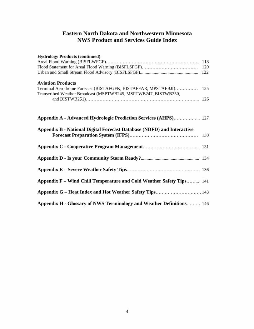
Eastern North Dakota and Northwestern Minnesota NWS Product and Services Guide Index
Winter Storm Products Winter Storm Watch (BISWSWFGF).............................................................................. 58 Winter Storm Warning (BISWSWFGF)........................................................................... 60 Blizzard Warning (BISWSWFGF)................................................................................... 62 Heavy Snow Warning (BISWSWFGF)............................................................................ 64 Ice Storm Warning (BISWSWFGF)................................................................................. 65 Winter Weather Advisory (BISWSWFGF)....................................................................... 66 Snow Advisory (BISWSWFGF)........................................................................................ 67 Freezing Rain Advisory (BISWSWFGF)........................................................................... 68 Blowing Snow Advisory (BISWSWFGF)………………………………………………. 69 Products Relating to Heat, Cold and Wind Heat Advisory (BISNPWFGF).................................................................... …….............. 71 Frost Advisory (BISNPWFGF).......................................................................................... 72 Freeze Warning (BISNPWFGF)........................................................................................ 73 Wind Chill Advisory (BISWSWFGF)............................................................................... 74 Wind Chill Warning (BISWSWFGF)....................................................................... …..... 75 Wind Advisory (BISNPWFGF)........................................................................................ 76 High Wind Watch (BISNPWFGF).................................................................................... 77 High Wind Warning (BISNPWFGF)................................................................................. 78 Products Relating to Reduced Visibilities Dense Fog Advisory (BISNPWFGF)................................................................................. 80 Blowing Dust Advisory (BISNPWFGF)............................................................................ 81 Dust Storm Warning (BISNPWFGF)................................................................................. 83 Fire Weather Products Fire Weather Forecast (BISFWFFGF)............................................................................... 84 Fire Weather Point Forecast (BISFWMFGF)…………………………………………… 86 Fire Weather Watch (BISRFWFGF)……………………………………………………. 85 Red Flag Warning (BISRFWFGF)……………………………………………………… 88 North Dakota Rangeland Fire Danger Statement (BISRFDBIS)…………………........... 89 Spot Forecast Request (BISSTQFGF)………..…………………………………………. 91 Spot Forecast (BISFWSFGF)…………………………………………………………… 92 Hydrology Products Hydrologic Summary (BISRVAFGF)............................................................................... 94 Hydrologic Outlook (BISESFFGF)................................................................................... 99 Flood Watch for Forecast Points (BISFFAFGF).……………………………………….. 103 Hydrologic Statement for High Water (BISRVSFGF).…………………………………. 105 Flood Warning for Forecast Points (BISFLWFGF)........................................................... 107 Flood Statement for Forecast Points (BISFLSFGF)........................................................... 109 Flash Flood Watch (BISFFAFGF)...................................................................................... 111 Flash Flood Warning (BISFFWFGF)................................................................................. 113 Flash Flood Statement (BISFFSFGF)................................................................................. 115 Areal Flood Watch (BISFFAFGF)……………………………………………………. 116
4
Eastern North Dakota and Northwestern Minnesota NWS Product and Services Guide Index
Hydrology Products (continued) Areal Flood Warning (BISFLWFGF)……………………………………………………. 118 Flood Statement for Areal Flood Warning (BISFLSFGF)………………………………. 120 Urban and Small Stream Flood Advisory (BISFLSFGF)................................................... 122 Aviation Products Terminal Aerodrome Forecast (BISTAFGFK, BISTAFFAR, MPSTAFBJI)…………… 125 Transcribed Weather Broadcast (MSPTWB245, MSPTWB247, BISTWB250,
and BISTWB251)………………………………………………………………... 126
Appendix A - Advanced Hydrologic Prediction Services (AHPS)……………... 127 Appendix B - National Digital Forecast Database (NDFD) and Interactive
Forecast Preparation System (IFPS)……………………………………… 130 Appendix C - Cooperative Program Management………………………………. 131 Appendix D - Is your Community Storm Ready?................................................... 134 Appendix E – Severe Weather Safety Tips………………………………………… 136 Appendix F – Wind Chill Temperature and Cold Weather Safety Tips……... 141 Appendix G – Heat Index and Hot Weather Safety Tips………………………… 143 Appendix H - Glossary of NWS Terminology and Weather Definitions……… 146
5
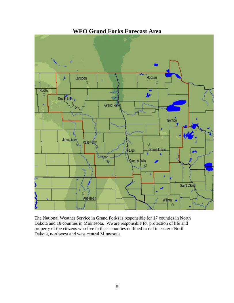
WFO Grand Forks Forecast Area
The National Weather Service in Grand Forks is responsible for 17 counties in North Dakota and 18 counties in Minnesota. We are responsible for protection of life and property of the citizens who live in these counties outlined in red in eastern North Dakota, northwest and west central Minnesota.
6
INTRODUCTION This guide was designed by NOAA’s National Weather Service (NWS) in Grand Forks as a reference for emergency managers, media and other users in eastern North Dakota, northwest and west central Minnesota. It contains information on various types of weather, hydrologic forecasts and warning products, fire weather forecasts, and includes examples of their headings and content. There are also definitions of frequently used terms and safety tips for various weather hazards. This guide will be updated periodically to reflect continuing changes and enhancements. If you have questions or comments on this guide or any NWS product or service, please call the NWS in Grand Forks at 701-772-0720. The Meteorologist in Charge (MIC) David McShane, the Warning Coordination Meteorologist (WCM) Gregory Gust, in addition to the entire WFO Grand Forks staff will be glad to address any of your questions or concerns. Disclaimer: This guide is a resource only. The information contained within is derived from local, regional and national policies and is current as of January 2007.
NWS MISSION
The NWS provides weather, hydrologic, and climate forecasts and warnings for the United States, its territories, adjacent waters and ocean areas, for the protection of life and property and the enhancement of the national economy. NWS data and products form a national information database and infrastructure which can be used by other governmental agencies, the private sector, the public and the global community.
7
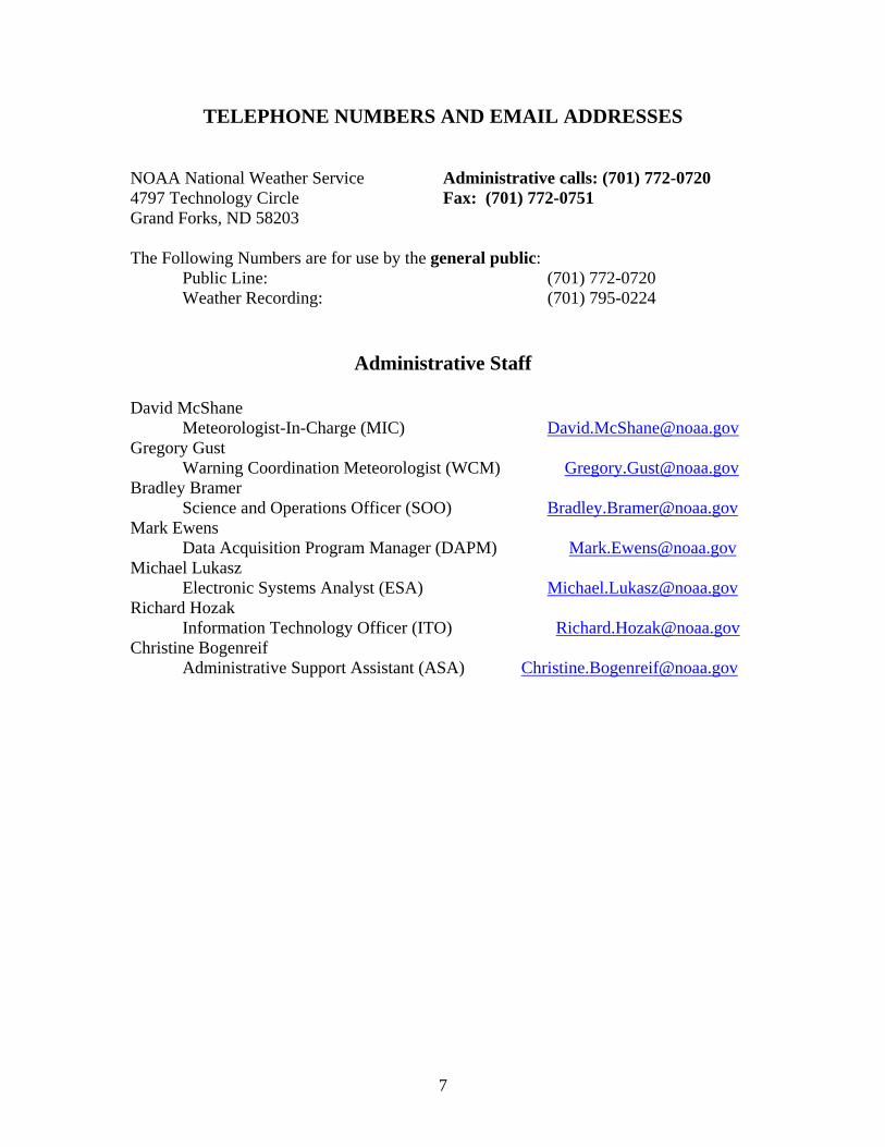
TELEPHONE NUMBERS AND EMAIL ADDRESSES
NOAA National Weather Service Administrative calls: (701) 772-0720 4797 Technology Circle Fax: (701) 772-0751 Grand Forks, ND 58203 The Following Numbers are for use by the general public: Public Line: (701) 772-0720 Weather Recording: (701) 795-0224
Administrative Staff
David McShane Meteorologist-In-Charge (MIC) [email protected] Gregory Gust Warning Coordination Meteorologist (WCM) [email protected] Bradley Bramer Science and Operations Officer (SOO) [email protected] Mark Ewens Data Acquisition Program Manager (DAPM) [email protected] Michael Lukasz Electronic Systems Analyst (ESA) [email protected] Richard Hozak Information Technology Officer (ITO) [email protected] Christine Bogenreif Administrative Support Assistant (ASA) [email protected]
8
ADJACENT NWS OFFICES TELEPHONE NUMBERS AND CONTACT INFORMATION
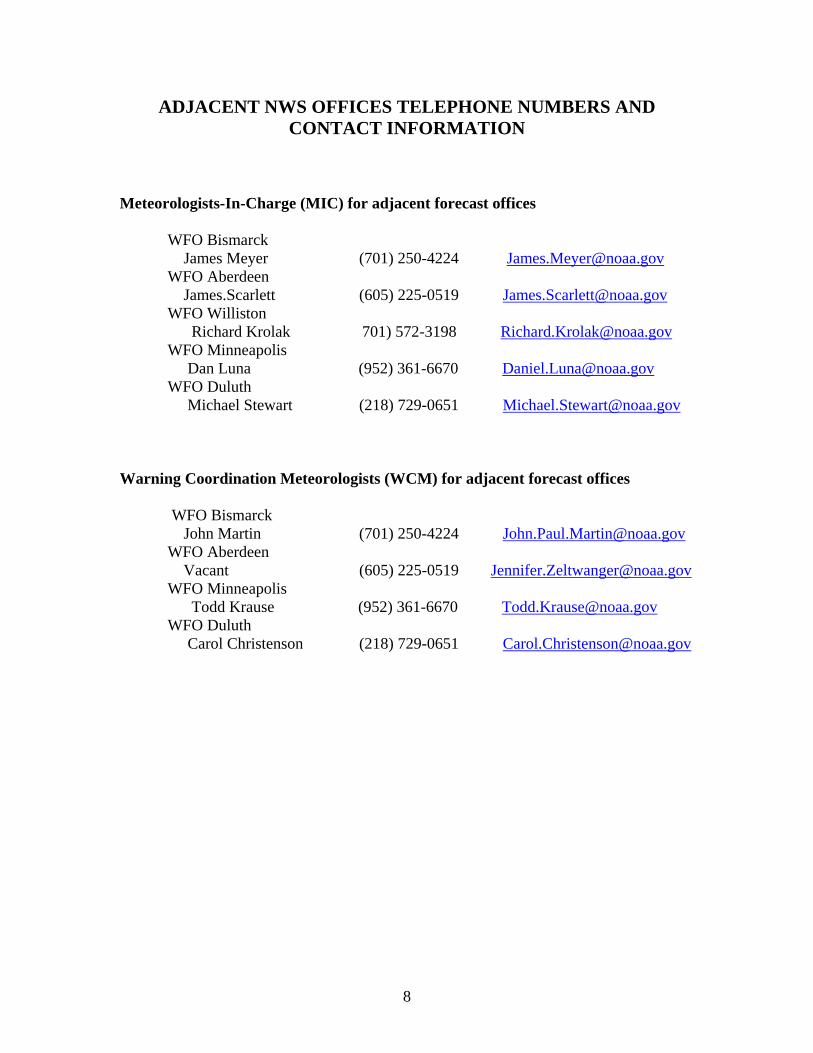
Meteorologists-In-Charge (MIC) for adjacent forecast offices WFO Bismarck James Meyer (701) 250-4224 [email protected] WFO Aberdeen James.Scarlett (605) 225-0519 [email protected] WFO Williston Richard Krolak 701) 572-3198 [email protected] WFO Minneapolis Dan Luna (952) 361-6670 [email protected] WFO Duluth Michael Stewart (218) 729-0651 [email protected]
Warning Coordination Meteorologists (WCM) for adjacent forecast offices
WFO Bismarck John Martin (701) 250-4224 [email protected] WFO Aberdeen Vacant (605) 225-0519 [email protected] WFO Minneapolis Todd Krause (952) 361-6670 [email protected] WFO Duluth Carol Christenson (218) 729-0651 [email protected]
9
COMMUNICATIONS OF WEATHER PRODUCTS Mass Media Dissemination The NWS disseminates weather products to media customers utilizing news services such as the Associated Press as well as through private vendors. The products are identified using either a seven, eight, or nine character name, cccNNNxxx, where ccc is the state liaison forecast office, NNN is the product name, and xxx is the originating forecast office I.D. An example of this code is BISZFPFGF, where BIS represents the Bismarck NWS Forecast Office, ZFP is for the Zone Forecast Product, and FGF is the I.D. for the Grand Forks NWS Forecast Office. World Wide Web Over the past few years, weather information available over the internet has greatly increased. Each NWS office has their own web page, which includes a large amount of information, including the latest forecasts and warnings, current conditions, river forecasts, as well as links to local radar and satellite data. Additional weather information is available from universities, other government agencies and private companies. No link or mention of a particular internet site or vendor constitutes an endorsement by NOAA’s National Weather Service. Since there is a brief delay from when a product is released to when it gets to the web and because internet servers can go down without notice, you should not rely solely on the web for short-fused warnings or for updates in rapidly changing weather situations. In addition to the formal web site address, the NWS recently instituted an easier way to find your local weather office web site, by using weather.gov/office name. Both ways to find area NWS office web sites are listed below. Both web addresses will take you to the same site. NWS Grand Forks web site is www.crh.noaa.gov/fgf or weather.gov/grandforks NWS Bismarck web site is www.crh.noaa.gov/bis or weather.gov/bismarck NWS Duluth web site is www.crh.noaa.gov/dlh or weather.gov/duluth NWS Chanhassen web site is www.crh.noaa.gov/mpx or weather.gov/twincities NWS Aberdeen web site is www.crh.noaa.gov/abr or weather.gov/aberdeen Environment Canada web site is www.weatheroffice.ec.gc.ca/canada_e.html
10
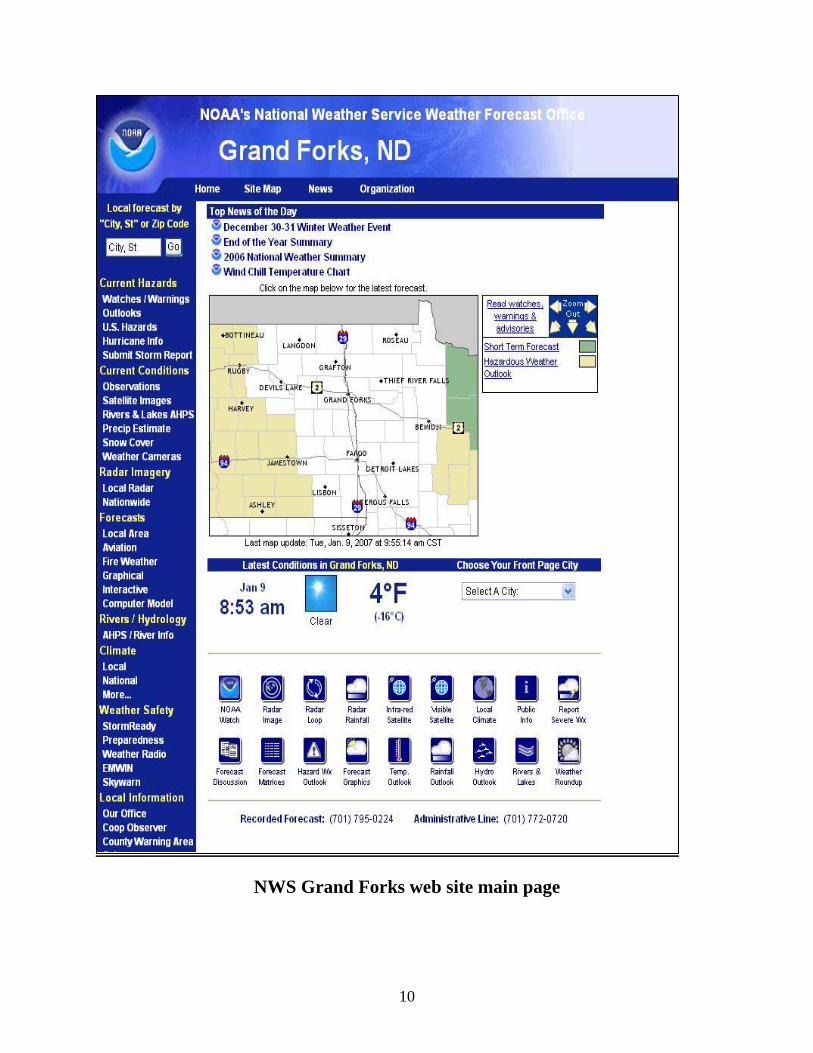
NWS Grand Forks web site main page
11
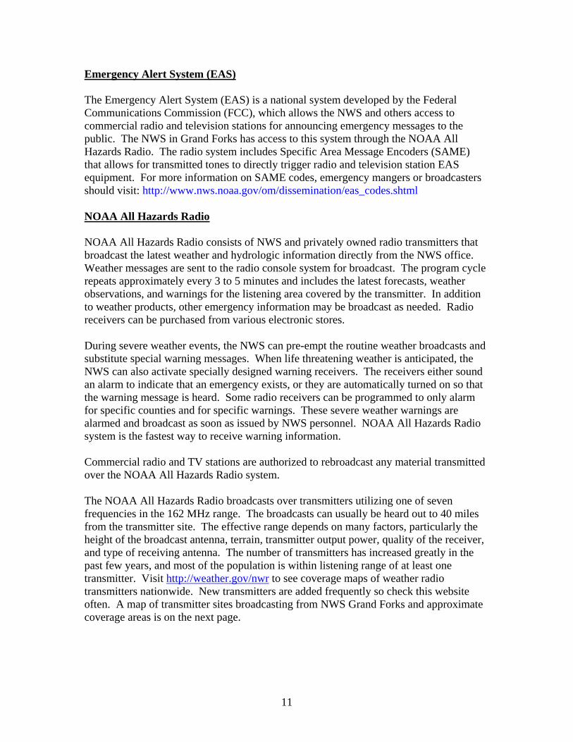
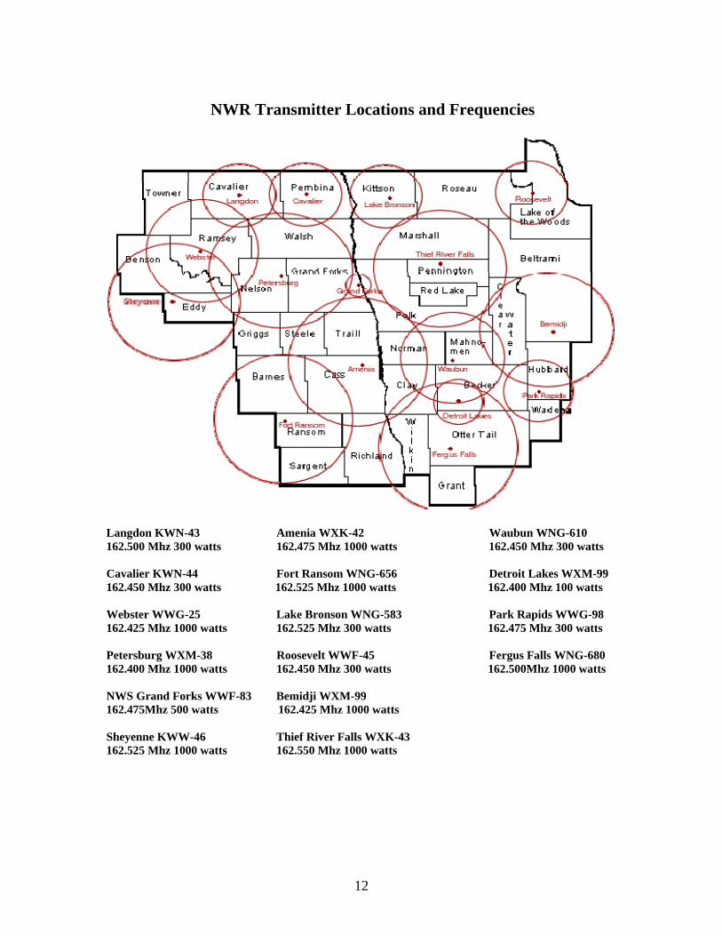
Emergency Alert System (EAS) The Emergency Alert System (EAS) is a national system developed by the Federal Communications Commission (FCC), which allows the NWS and others access to commercial radio and television stations for announcing emergency messages to the public. The NWS in Grand Forks has access to this system through the NOAA All Hazards Radio. The radio system includes Specific Area Message Encoders (SAME) that allows for transmitted tones to directly trigger radio and television station EAS equipment. For more information on SAME codes, emergency mangers or broadcasters should visit: http://www.nws.noaa.gov/om/dissemination/eas_codes.shtml NOAA All Hazards Radio NOAA All Hazards Radio consists of NWS and privately owned radio transmitters that broadcast the latest weather and hydrologic information directly from the NWS office. Weather messages are sent to the radio console system for broadcast. The program cycle repeats approximately every 3 to 5 minutes and includes the latest forecasts, weather observations, and warnings for the listening area covered by the transmitter. In addition to weather products, other emergency information may be broadcast as needed. Radio receivers can be purchased from various electronic stores. During severe weather events, the NWS can pre-empt the routine weather broadcasts and substitute special warning messages. When life threatening weather is anticipated, the NWS can also activate specially designed warning receivers. The receivers either sound an alarm to indicate that an emergency exists, or they are automatically turned on so that the warning message is heard. Some radio receivers can be programmed to only alarm for specific counties and for specific warnings. These severe weather warnings are alarmed and broadcast as soon as issued by NWS personnel. NOAA All Hazards Radio system is the fastest way to receive warning information. Commercial radio and TV stations are authorized to rebroadcast any material transmitted over the NOAA All Hazards Radio system. The NOAA All Hazards Radio broadcasts over transmitters utilizing one of seven frequencies in the 162 MHz range. The broadcasts can usually be heard out to 40 miles from the transmitter site. The effective range depends on many factors, particularly the height of the broadcast antenna, terrain, transmitter output power, quality of the receiver, and type of receiving antenna. The number of transmitters has increased greatly in the past few years, and most of the population is within listening range of at least one transmitter. Visit http://weather.gov/nwr to see coverage maps of weather radio transmitters nationwide. New transmitters are added frequently so check this website often. A map of transmitter sites broadcasting from NWS Grand Forks and approximate coverage areas is on the next page.
12
Langdon KWN-43 Amenia WXK-42 Waubun WNG-610 162.500 Mhz 300 watts 162.475 Mhz 1000 watts 162.450 Mhz 300 watts Cavalier KWN-44 Fort Ransom WNG-656 Detroit Lakes WXM-99 162.450 Mhz 300 watts 162.525 Mhz 1000 watts 162.400 Mhz 100 watts Webster WWG-25 Lake Bronson WNG-583 Park Rapids WWG-98 162.425 Mhz 1000 watts 162.525 Mhz 300 watts 162.475 Mhz 300 watts Petersburg WXM-38 Roosevelt WWF-45 Fergus Falls WNG-680 162.400 Mhz 1000 watts 162.450 Mhz 300 watts 162.500Mhz 1000 watts NWS Grand Forks WWF-83 Bemidji WXM-99 162.475Mhz 500 watts 162.425 Mhz 1000 watts Sheyenne KWW-46 Thief River Falls WXK-43 162.525 Mhz 1000 watts 162.550 Mhz 1000 watts
NWR Transmitter Locations and Frequencies
13
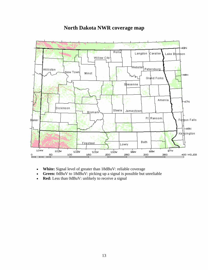
North Dakota NWR coverage map
• White: Signal level of greater than 18dBuV: reliable coverage • Green: 0dBuV to 18dBuV: picking up a signal is possible but unreliable • Red: Less than 0dBuV: unlikely to receive a signal
14
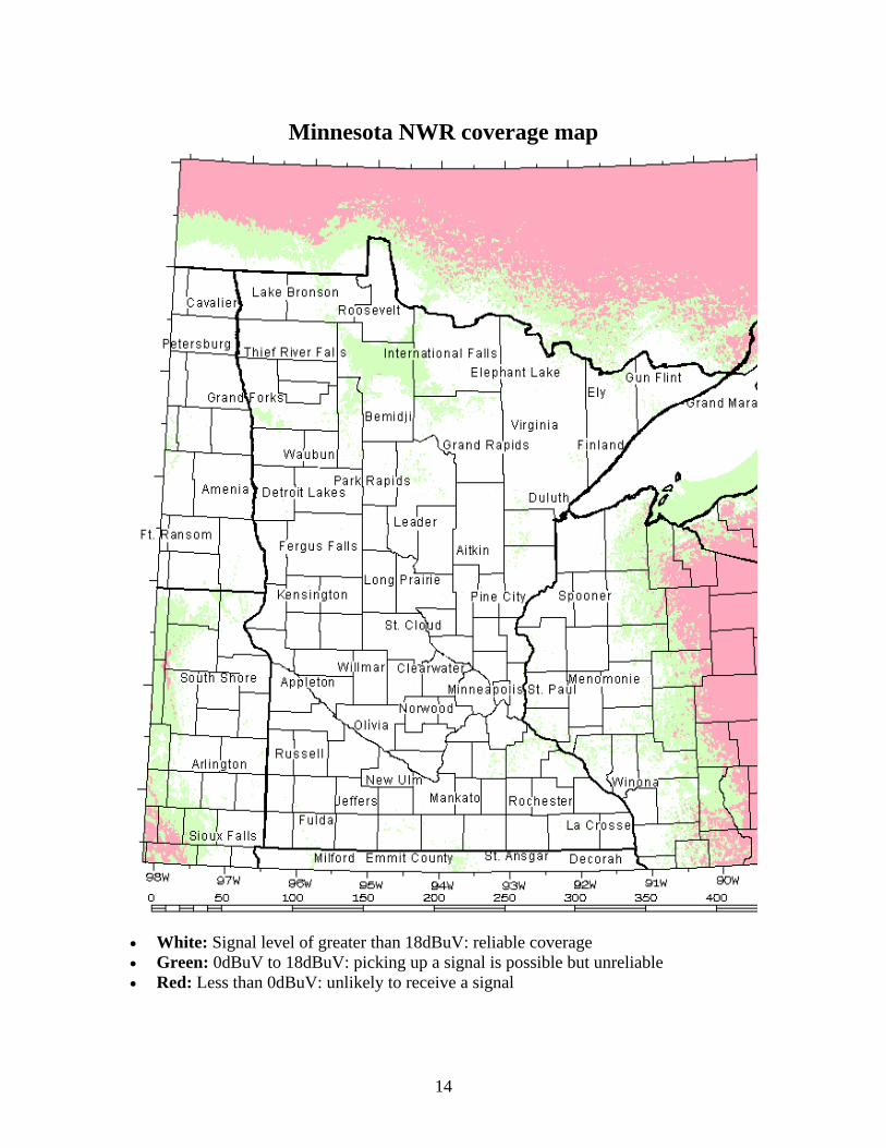
• White: Signal level of greater than 18dBuV: reliable coverage • Green: 0dBuV to 18dBuV: picking up a signal is possible but unreliable • Red: Less than 0dBuV: unlikely to receive a signal
Minnesota NWR coverage map
15
National Warning System (NAWAS) Funded by the Federal Emergency Management Agency (FEMA), the National Warning System (NAWAS) is a comprehensive party-line network of telephone circuits connecting more than 1,500 state and federal warning points throughout the United States. Although NAWAS is a national system, the day-to-day operation is under the control of individual states. Each state has its own plan for the use of NAWAS during weather emergencies. NAWAS is used to warn the public, through local governments, about potential loss of life and/or property. Such threatening situations are not limited to weather or hydrologic events. The warning message can also include information on dam breaks, earthquakes, volcanoes, major fires, other civil emergencies and terrorist attacks. The NWS in Grand Forks uses NAWAS to relay all weather warnings to state police posts that service particular areas. These state police posts then relay the warning to local city or county police. Emergency Managers’ Weather Information Network (EMWIN) The Emergency Managers’ Weather Information Network (EMWIN) is a low cost method for receiving NWS information. The system, including a small satellite dish, is purchased by the user. The data is received free of charge using a small satellite dish receiving system connected to a home or office personal computer. The data is accessed and displayed using windows based point and click software. The latest weather and flood warnings, watches, forecasts, statements, observations, and other data are automatically stored, along with some weather graphics like the radar summary and some satellite imagery. The data are available nationwide directly from satellites and the system can be purchased by anyone. For more information, contact the NWS office in Grand Forks or access the EMWIN home page at http://www.weather.gov/emwin/index.htm
16
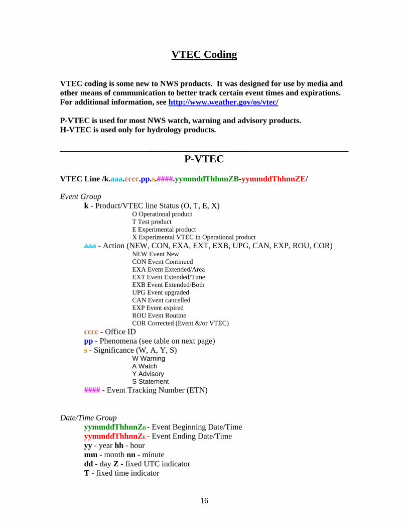
VTEC Coding
VTEC coding is some new to NWS products. It was designed for use by media and other means of communication to better track certain event times and expirations. For additional information, see http://www.weather.gov/os/vtec/ P-VTEC is used for most NWS watch, warning and advisory products. H-VTEC is used only for hydrology products. ________________________________________________________________________
P-VTEC VTEC Line /k.aaa.cccc.pp.s.####.yymmddThhnnZB-yymmddThhnnZE/ Event Group
k - Product/VTEC line Status (O, T, E, X) O Operational product
T Test product E Experimental product X Experimental VTEC in Operational product
aaa - Action (NEW, CON, EXA, EXT, EXB, UPG, CAN, EXP, ROU, COR) NEW Event New
CON Event Continued EXA Event Extended/Area EXT Event Extended/Time EXB Event Extended/Both UPG Event upgraded CAN Event cancelled EXP Event expired ROU Event Routine COR Corrected (Event &/or VTEC)
cccc - Office ID pp - Phenomena (see table on next page) s - Significance (W, A, Y, S)
W Warning A Watch Y Advisory S Statement
#### - Event Tracking Number (ETN) Date/Time Group
yymmddThhnnZB - Event Beginning Date/Time yymmddThhnnZE - Event Ending Date/Time yy - year hh - hour mm - month nn - minute dd - day Z - fixed UTC indicator T - fixed time indicator
17
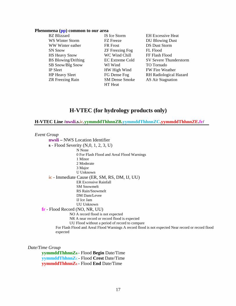
Phenomena (pp) common to our area BZ Blizzard WS Winter Storm WW Winter eather SN Snow HS Heavy Snow BS Blowing/Drifting SB Snow/Blg Snow IP Sleet HP Heavy Sleet ZR Freezing Rain
IS Ice Storm FZ Freeze FR Frost ZF Freezing Fog WC Wind Chill EC Extreme Cold WI Wind HW High Wind FG Dense Fog SM Dense Smoke HT Heat
EH Excessive Heat DU Blowing Dust DS Dust Storm FL Flood FF Flash Flood SV Severe Thunderstorm TO Tornado FW Fire Weather RH Radiological Hazard AS Air Stagnation
H-VTEC (for hydrology products only) H-VTEC Line /nwsli.s.ic.yymmddThhnnZB.yymmddThhnnZC.yymmddThhnnZE.fr/ Event Group
nwsli – NWS Location Identifier s - Flood Severity (N,0, 1, 2, 3, U)
N None 0 For Flash Flood and Areal Flood Warnings 1 Minor 2 Moderate 3 Major U Unknown
ic - Immediate Cause (ER, SM, RS, DM, IJ, UU) ER Excessive Rainfall SM Snowmelt RS Rain/Snowmelt DM Dam/Levee IJ Ice Jam UU Unknown
fr - Flood Record (NO, NR, UU) NO A record flood is not expected NR A near record or record flood is expected UU Flood without a period of record to compare
For Flash Flood and Areal Flood Warnings A record flood is not expected Near record or record flood expected
Date/Time Group
yymmddThhnnZB - Flood Begin Date/Time yymmddThhnnZC - Flood Crest Date/Time yymmddThhnnZE - Flood End Date/Time
18
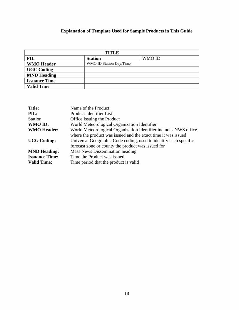
Explanation of Template Used for Sample Products in This Guide
TITLE PIL Station WMO ID WMO Header WMO ID Station Day/Time UGC Coding MND Heading Issuance Time Valid Time Title: Name of the Product PIL: Product Identifier List Station: Office Issuing the Product WMO ID: World Meteorological Organization Identifier WMO Header: World Meteorological Organization Identifier includes NWS office where the product was issued and the exact time it was issued UCG Coding: Universal Geographic Code coding, used to identify each specific forecast zone or county the product was issued for MND Heading: Mass News Dissemination heading Issuance Time: Time the Product was issued Valid Time: Time period that the product is valid
19
Eastern North Dakota and Northwestern Minnesota NWS Product and Services Guide
Public Products Eastern ND and Northwestern MN Zone Forecast Product Area Forecast Discussion Point Forecast Matrix Short Term Forecast Area Weather Outlook Climate Report for Grand Forks and Fargo Monthly Climate Report for Grand Forks and Fargo Pine to Prairie Weather Roundup Evening/Morning Temperature and Precipitation Summary Cooperative Weather Observations Public Information Statement Record Event Report Radar Free Text Message Civil Emergency Message Preliminary Earthquake Report Tabular State Forecast Product for ND and MN Child Abduction Emergency Message-Amber Alert North Dakota Road Report Hazardous Weather Outlook
20
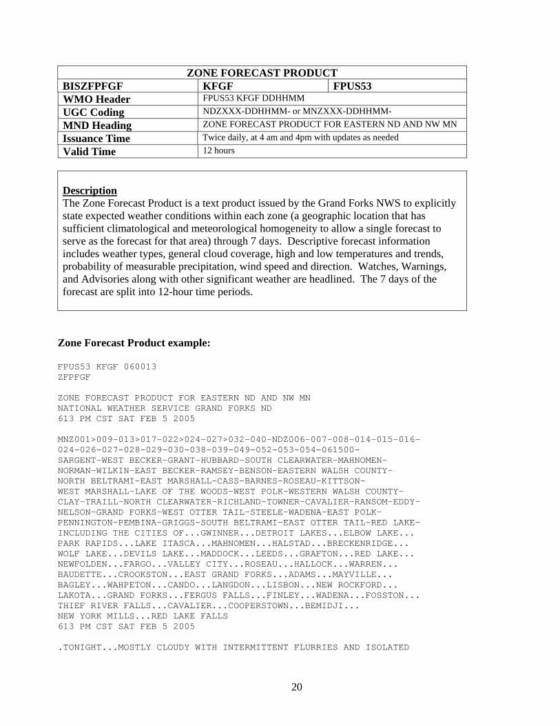
ZONE FORECAST PRODUCT BISZFPFGF KFGF FPUS53 WMO Header FPUS53 KFGF DDHHMM UGC Coding NDZXXX-DDHHMM- or MNZXXX-DDHHMM- MND Heading ZONE FORECAST PRODUCT FOR EASTERN ND AND NW MN Issuance Time Twice daily, at 4 am and 4pm with updates as needed Valid Time 12 hours
Description The Zone Forecast Product is a text product issued by the Grand Forks NWS to explicitly state expected weather conditions within each zone (a geographic location that has sufficient climatological and meteorological homogeneity to allow a single forecast to serve as the forecast for that area) through 7 days. Descriptive forecast information includes weather types, general cloud coverage, high and low temperatures and trends, probability of measurable precipitation, wind speed and direction. Watches, Warnings, and Advisories along with other significant weather are headlined. The 7 days of the forecast are split into 12-hour time periods.
Zone Forecast Product example:
FPUS53 KFGF 060013 ZFPFGF ZONE FORECAST PRODUCT FOR EASTERN ND AND NW MN NATIONAL WEATHER SERVICE GRAND FORKS ND 613 PM CST SAT FEB 5 2005 MNZ001>009-013>017-022>024-027>032-040-NDZ006-007-008-014-015-016- 024-026-027-028-029-030-038-039-049-052-053-054-061500- SARGENT-WEST BECKER-GRANT-HUBBARD-SOUTH CLEARWATER-MAHNOMEN- NORMAN-WILKIN-EAST BECKER-RAMSEY-BENSON-EASTERN WALSH COUNTY- NORTH BELTRAMI-EAST MARSHALL-CASS-BARNES-ROSEAU-KITTSON- WEST MARSHALL-LAKE OF THE WOODS-WEST POLK-WESTERN WALSH COUNTY- CLAY-TRAILL-NORTH CLEARWATER-RICHLAND-TOWNER-CAVALIER-RANSOM-EDDY- NELSON-GRAND FORKS-WEST OTTER TAIL-STEELE-WADENA-EAST POLK- PENNINGTON-PEMBINA-GRIGGS-SOUTH BELTRAMI-EAST OTTER TAIL-RED LAKE- INCLUDING THE CITIES OF...GWINNER...DETROIT LAKES...ELBOW LAKE... PARK RAPIDS...LAKE ITASCA...MAHNOMEN...HALSTAD...BRECKENRIDGE... WOLF LAKE...DEVILS LAKE...MADDOCK...LEEDS...GRAFTON...RED LAKE... NEWFOLDEN...FARGO...VALLEY CITY...ROSEAU...HALLOCK...WARREN... BAUDETTE...CROOKSTON...EAST GRAND FORKS...ADAMS...MAYVILLE... BAGLEY...WAHPETON...CANDO...LANGDON...LISBON...NEW ROCKFORD... LAKOTA...GRAND FORKS...FERGUS FALLS...FINLEY...WADENA...FOSSTON... THIEF RIVER FALLS...CAVALIER...COOPERSTOWN...BEMIDJI... NEW YORK MILLS...RED LAKE FALLS 613 PM CST SAT FEB 5 2005 .TONIGHT...MOSTLY CLOUDY WITH INTERMITTENT FLURRIES AND ISOLATED
21
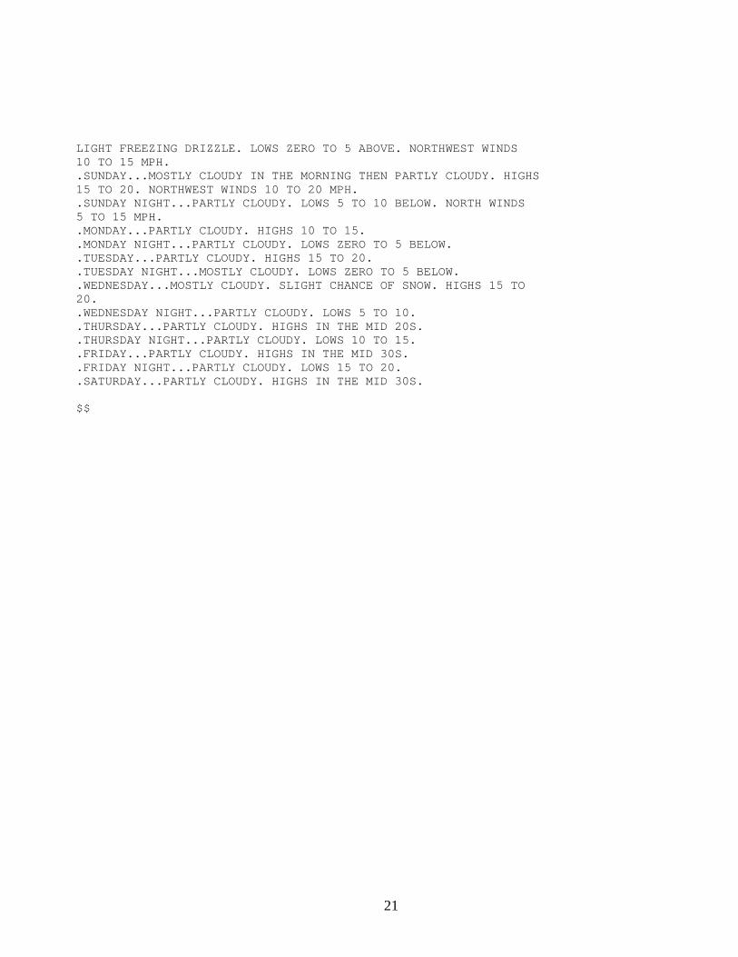
LIGHT FREEZING DRIZZLE. LOWS ZERO TO 5 ABOVE. NORTHWEST WINDS 10 TO 15 MPH. .SUNDAY...MOSTLY CLOUDY IN THE MORNING THEN PARTLY CLOUDY. HIGHS 15 TO 20. NORTHWEST WINDS 10 TO 20 MPH. .SUNDAY NIGHT...PARTLY CLOUDY. LOWS 5 TO 10 BELOW. NORTH WINDS 5 TO 15 MPH. .MONDAY...PARTLY CLOUDY. HIGHS 10 TO 15. .MONDAY NIGHT...PARTLY CLOUDY. LOWS ZERO TO 5 BELOW. .TUESDAY...PARTLY CLOUDY. HIGHS 15 TO 20. .TUESDAY NIGHT...MOSTLY CLOUDY. LOWS ZERO TO 5 BELOW. .WEDNESDAY...MOSTLY CLOUDY. SLIGHT CHANCE OF SNOW. HIGHS 15 TO 20. .WEDNESDAY NIGHT...PARTLY CLOUDY. LOWS 5 TO 10. .THURSDAY...PARTLY CLOUDY. HIGHS IN THE MID 20S. .THURSDAY NIGHT...PARTLY CLOUDY. LOWS 10 TO 15. .FRIDAY...PARTLY CLOUDY. HIGHS IN THE MID 30S. .FRIDAY NIGHT...PARTLY CLOUDY. LOWS 15 TO 20. .SATURDAY...PARTLY CLOUDY. HIGHS IN THE MID 30S. $$
22
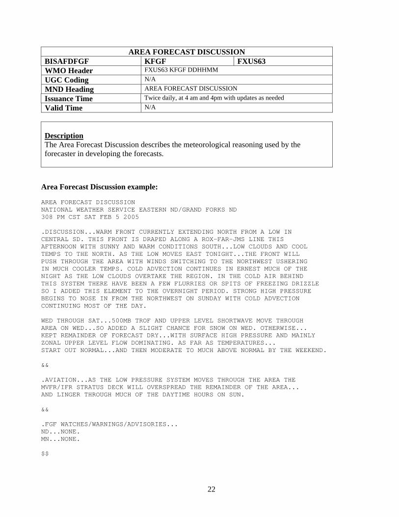
AREA FORECAST DISCUSSION BISAFDFGF KFGF FXUS63 WMO Header FXUS63 KFGF DDHHMM UGC Coding N/A MND Heading AREA FORECAST DISCUSSION Issuance Time Twice daily, at 4 am and 4pm with updates as needed Valid Time N/A
Description The Area Forecast Discussion describes the meteorological reasoning used by the forecaster in developing the forecasts. Area Forecast Discussion example: AREA FORECAST DISCUSSION NATIONAL WEATHER SERVICE EASTERN ND/GRAND FORKS ND 308 PM CST SAT FEB 5 2005 .DISCUSSION...WARM FRONT CURRENTLY EXTENDING NORTH FROM A LOW IN CENTRAL SD. THIS FRONT IS DRAPED ALONG A ROX-FAR-JMS LINE THIS AFTERNOON WITH SUNNY AND WARM CONDITIONS SOUTH...LOW CLOUDS AND COOL TEMPS TO THE NORTH. AS THE LOW MOVES EAST TONIGHT...THE FRONT WILL PUSH THROUGH THE AREA WITH WINDS SWITCHING TO THE NORTHWEST USHERING IN MUCH COOLER TEMPS. COLD ADVECTION CONTINUES IN ERNEST MUCH OF THE NIGHT AS THE LOW CLOUDS OVERTAKE THE REGION. IN THE COLD AIR BEHIND THIS SYSTEM THERE HAVE BEEN A FEW FLURRIES OR SPITS OF FREEZING DRIZZLE SO I ADDED THIS ELEMENT TO THE OVERNIGHT PERIOD. STRONG HIGH PRESSURE BEGINS TO NOSE IN FROM THE NORTHWEST ON SUNDAY WITH COLD ADVECTION CONTINUING MOST OF THE DAY. WED THROUGH SAT...500MB TROF AND UPPER LEVEL SHORTWAVE MOVE THROUGH AREA ON WED...SO ADDED A SLIGHT CHANCE FOR SNOW ON WED. OTHERWISE... KEPT REMAINDER OF FORECAST DRY...WITH SURFACE HIGH PRESSURE AND MAINLY ZONAL UPPER LEVEL FLOW DOMINATING. AS FAR AS TEMPERATURES... START OUT NORMAL...AND THEN MODERATE TO MUCH ABOVE NORMAL BY THE WEEKEND. && .AVIATION...AS THE LOW PRESSURE SYSTEM MOVES THROUGH THE AREA THE MVFR/IFR STRATUS DECK WILL OVERSPREAD THE REMAINDER OF THE AREA... AND LINGER THROUGH MUCH OF THE DAYTIME HOURS ON SUN. && .FGF WATCHES/WARNINGS/ADVISORIES... ND...NONE. MN...NONE. $$
23
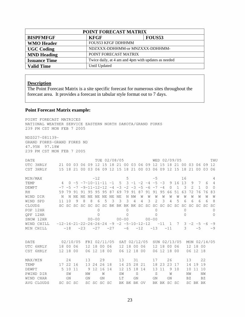
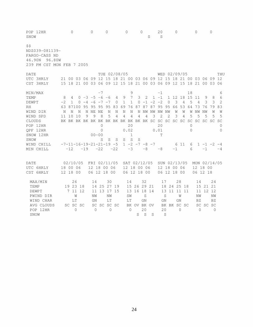
POINT FORECAST MATRIX BISPFMFGF KFGF FOUS53 WMO Header FOUS53 KFGF DDHHMM UGC Coding NDZXXX-DDHHMM-or MNZXXX-DDHHMM- MND Heading POINT FORECAST MATRIX Issuance Time Twice daily, at 4 am and 4pm with updates as needed Valid Time Until Updated
Description The Point Forecast Matrix is a site specific forecast for numerous sites throughout the forecast area. It provides a forecast in tabular style format out to 7 days. Point Forecast Matrix example: POINT FORECAST MATRICES NATIONAL WEATHER SERVICE EASTERN NORTH DAKOTA/GRAND FORKS 239 PM CST MON FEB 7 2005 NDZ027-081139- GRAND FORKS-GRAND FORKS ND 47.95N 97.18W 239 PM CST MON FEB 7 2005 DATE TUE 02/08/05 WED 02/09/05 THU UTC 3HRLY 21 00 03 06 09 12 15 18 21 00 03 06 09 12 15 18 21 00 03 06 09 12 CST 3HRLY 15 18 21 00 03 06 09 12 15 18 21 00 03 06 09 12 15 18 21 00 03 06 MIN/MAX -12 5 -5 16 4 TEMP 4 0 -5 -7-10-11-11 -1 5 3 -1 -2 -4 -5 -3 9 16 13 9 7 6 4 DEWPT -7 -5 -7 -9-11-12-12 -4 -3 -2 -3 -5 -6 -7 -4 0 1 3 2 1 0 0 RH 59 79 91 91 95 95 95 87 69 79 91 87 91 91 95 66 51 63 72 76 76 83 WIND DIR N N NE NE NE NE NE NE NE N NW W W W W W W W W W W W WIND SPD 11 10 9 8 8 6 5 3 3 3 4 4 3 2 3 4 5 6 6 6 6 8 CLOUDS SC SC SC SC SC SC SC BK BK BK BK SC SC SC SC SC SC SC SC SC SC SC POP 12HR 0 0 0 0 0 QPF 12HR 0 0 0 0 0 SNOW 12HR 00-00 00-00 00-00 WIND CHILL -12-16-21-22-26-26-24 -9 -2 -5-10-12-12 -11 1 7 3 -2 -5 -6 -9 MIN CHILL -18 -23 -27 -27 -6 -12 -13 -11 3 -5 -9 DATE 02/10/05 FRI 02/11/05 SAT 02/12/05 SUN 02/13/05 MON 02/14/05 UTC 6HRLY 18 00 06 12 18 00 06 12 18 00 06 12 18 00 06 12 18 00 CST 6HRLY 12 18 00 06 12 18 00 06 12 18 00 06 12 18 00 06 12 18 MAX/MIN 24 13 29 13 31 17 26 13 22 TEMP 17 22 16 13 24 26 18 14 25 28 21 18 23 23 17 14 19 19 DEWPT 5 10 11 9 12 16 14 12 15 18 14 13 11 9 10 10 11 10 PWIND DIR SW NW W SW S S W NW NW WIND CHAR GN GN GN LT GN GN GN BZ BZ AVG CLOUDS SC SC SC SC SC SC SC BK BK BK OV BK BK SC SC SC BK BK
24
POP 12HR 0 0 0 0 0 20 0 0 0 SNOW S S $$ NDZ039-081139- FARGO-CASS ND 46.90N 96.80W 239 PM CST MON FEB 7 2005 DATE TUE 02/08/05 WED 02/09/05 THU UTC 3HRLY 21 00 03 06 09 12 15 18 21 00 03 06 09 12 15 18 21 00 03 06 09 12 CST 3HRLY 15 18 21 00 03 06 09 12 15 18 21 00 03 06 09 12 15 18 21 00 03 06 MIN/MAX -7 9 -1 18 6 TEMP 8 4 0 -3 -5 -6 -6 4 9 7 3 2 1 -1 1 12 18 15 11 9 8 6 DEWPT -2 1 0 -4 -6 -7 -7 0 1 1 0 -1 -2 -2 0 3 4 5 4 3 3 2 RH 63 87100 95 95 95 95 83 69 76 87 87 87 95 95 66 53 64 73 76 79 83 WIND DIR N N N N NE NE N N N N N NW NW NW NW W W W NW NW W W WIND SPD 11 10 10 9 9 8 5 4 4 4 4 4 3 2 2 3 4 5 5 5 5 5 CLOUDS BK BK BK BK BK BK BK BK BK BK BK BK SC SC SC SC SC SC SC SC SC SC POP 12HR 0 20 20 0 0 QPF 12HR 0 0.02 0.01 0 0 SNOW 12HR 00-00 1 T SNOW S S S S S S WIND CHILL -7-11-16-19-21-21-19 -5 1 -2 -7 -8 -7 6 11 6 1 -1 -2 -4 MIN CHILL -12 -19 -22 -22 -3 -8 -8 -1 6 -1 -4 DATE 02/10/05 FRI 02/11/05 SAT 02/12/05 SUN 02/13/05 MON 02/14/05 UTC 6HRLY 18 00 06 12 18 00 06 12 18 00 06 12 18 00 06 12 18 00 CST 6HRLY 12 18 00 06 12 18 00 06 12 18 00 06 12 18 00 06 12 18 MAX/MIN 26 14 30 14 32 17 28 14 24 TEMP 19 23 18 14 25 27 19 15 26 29 21 18 24 25 18 15 21 21 DEWPT 7 11 12 11 13 17 15 13 16 18 14 13 11 11 11 11 12 12 PWIND DIR W NW NW SW S S W NW NW WIND CHAR LT GN LT LT GN GN GN BZ BZ AVG CLOUDS SC SC SC SC SC SC SC BK OV BK OV BK BK SC SC SC SC SC POP 12HR 0 0 0 0 20 20 0 0 0 SNOW S S S S
25
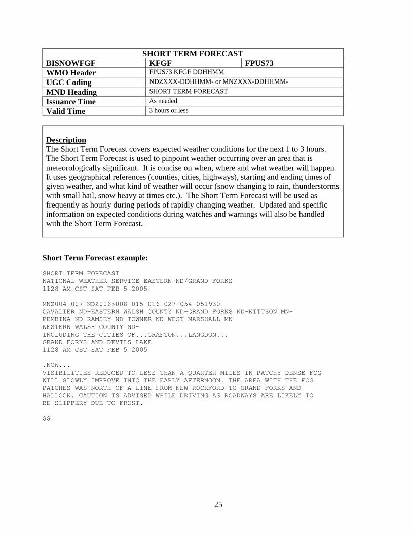
SHORT TERM FORECAST BISNOWFGF KFGF FPUS73 WMO Header FPUS73 KFGF DDHHMM UGC Coding NDZXXX-DDHHMM- or MNZXXX-DDHHMM- MND Heading SHORT TERM FORECAST Issuance Time As needed Valid Time 3 hours or less
Description The Short Term Forecast covers expected weather conditions for the next 1 to 3 hours. The Short Term Forecast is used to pinpoint weather occurring over an area that is meteorologically significant. It is concise on when, where and what weather will happen. It uses geographical references (counties, cities, highways), starting and ending times of given weather, and what kind of weather will occur (snow changing to rain, thunderstorms with small hail, snow heavy at times etc.). The Short Term Forecast will be used as frequently as hourly during periods of rapidly changing weather. Updated and specific information on expected conditions during watches and warnings will also be handled with the Short Term Forecast. Short Term Forecast example: SHORT TERM FORECAST NATIONAL WEATHER SERVICE EASTERN ND/GRAND FORKS 1128 AM CST SAT FEB 5 2005 MNZ004-007-NDZ006>008-015-016-027-054-051930- CAVALIER ND-EASTERN WALSH COUNTY ND-GRAND FORKS ND-KITTSON MN- PEMBINA ND-RAMSEY ND-TOWNER ND-WEST MARSHALL MN- WESTERN WALSH COUNTY ND- INCLUDING THE CITIES OF...GRAFTON...LANGDON... GRAND FORKS AND DEVILS LAKE 1128 AM CST SAT FEB 5 2005 .NOW... VISIBILITIES REDUCED TO LESS THAN A QUARTER MILES IN PATCHY DENSE FOG WILL SLOWLY IMPROVE INTO THE EARLY AFTERNOON. THE AREA WITH THE FOG PATCHES WAS NORTH OF A LINE FROM NEW ROCKFORD TO GRAND FORKS AND HALLOCK. CAUTION IS ADVISED WHILE DRIVING AS ROADWAYS ARE LIKELY TO BE SLIPPERY DUE TO FROST. $$
26
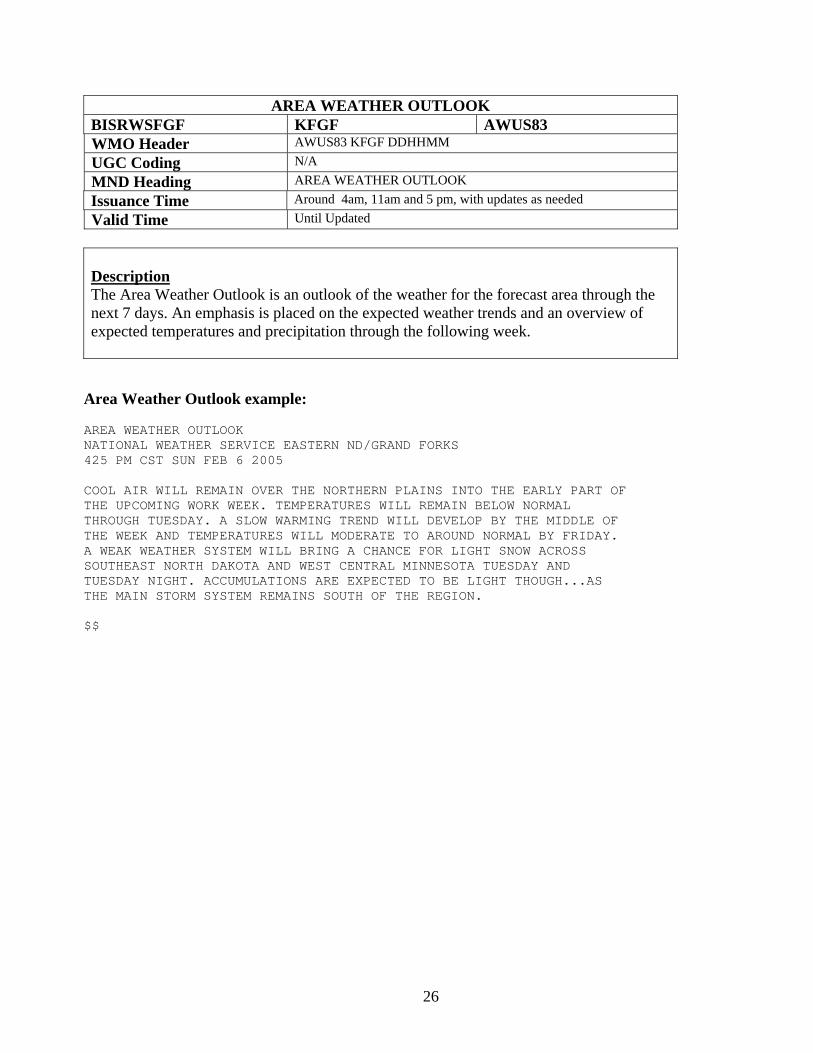
AREA WEATHER OUTLOOK BISRWSFGF KFGF AWUS83 WMO Header AWUS83 KFGF DDHHMM UGC Coding N/A MND Heading AREA WEATHER OUTLOOK Issuance Time Around 4am, 11am and 5 pm, with updates as needed Valid Time Until Updated
Description The Area Weather Outlook is an outlook of the weather for the forecast area through the next 7 days. An emphasis is placed on the expected weather trends and an overview of expected temperatures and precipitation through the following week.
Area Weather Outlook example: AREA WEATHER OUTLOOK NATIONAL WEATHER SERVICE EASTERN ND/GRAND FORKS 425 PM CST SUN FEB 6 2005 COOL AIR WILL REMAIN OVER THE NORTHERN PLAINS INTO THE EARLY PART OF THE UPCOMING WORK WEEK. TEMPERATURES WILL REMAIN BELOW NORMAL THROUGH TUESDAY. A SLOW WARMING TREND WILL DEVELOP BY THE MIDDLE OF THE WEEK AND TEMPERATURES WILL MODERATE TO AROUND NORMAL BY FRIDAY. A WEAK WEATHER SYSTEM WILL BRING A CHANCE FOR LIGHT SNOW ACROSS SOUTHEAST NORTH DAKOTA AND WEST CENTRAL MINNESOTA TUESDAY AND TUESDAY NIGHT. ACCUMULATIONS ARE EXPECTED TO BE LIGHT THOUGH...AS THE MAIN STORM SYSTEM REMAINS SOUTH OF THE REGION. $$
27
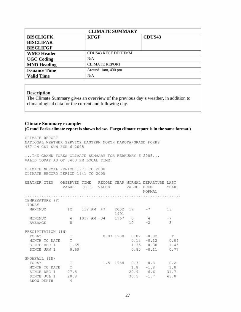
CLIMATE SUMMARY BISCLIGFK BISCLIFAR BISCLIFGF
KFGF CDUS43
WMO Header CDUS43 KFGF DDHHMM UGC Coding N/A MND Heading CLIMATE REPORT Issuance Time Around 1am, 430 pm Valid Time N/A
Description The Climate Summary gives an overview of the previous day’s weather, in addition to climatological data for the current and following day.
Climate Summary example: (Grand Forks climate report is shown below. Fargo climate report is in the same format.) CLIMATE REPORT NATIONAL WEATHER SERVICE EASTERN NORTH DAKOTA/GRAND FORKS 437 PM CST SUN FEB 6 2005 ...THE GRAND FORKS CLIMATE SUMMARY FOR FEBRUARY 6 2005... VALID TODAY AS OF 0400 PM LOCAL TIME. CLIMATE NORMAL PERIOD 1971 TO 2000 CLIMATE RECORD PERIOD 1941 TO 2005 WEATHER ITEM OBSERVED TIME RECORD YEAR NORMAL DEPARTURE LAST VALUE (LST) VALUE VALUE FROM YEAR NORMAL .................................................................. TEMPERATURE (F) TODAY MAXIMUM 12 119 AM 47 2002 19 -7 13 1991 MINIMUM 4 1037 AM -34 1967 0 4 -7 AVERAGE 8 10 -2 3 PRECIPITATION (IN) TODAY T 0.07 1988 0.02 -0.02 T MONTH TO DATE T 0.12 -0.12 0.04 SINCE DEC 1 1.65 1.35 0.30 1.45 SINCE JAN 1 0.69 0.80 -0.11 0.77 SNOWFALL (IN) TODAY T 1.5 1988 0.3 -0.3 0.2 MONTH TO DATE T 1.8 -1.8 1.0 SINCE DEC 1 27.5 20.9 6.6 31.7 SINCE JUL 1 28.8 30.5 -1.7 43.8 SNOW DEPTH 4
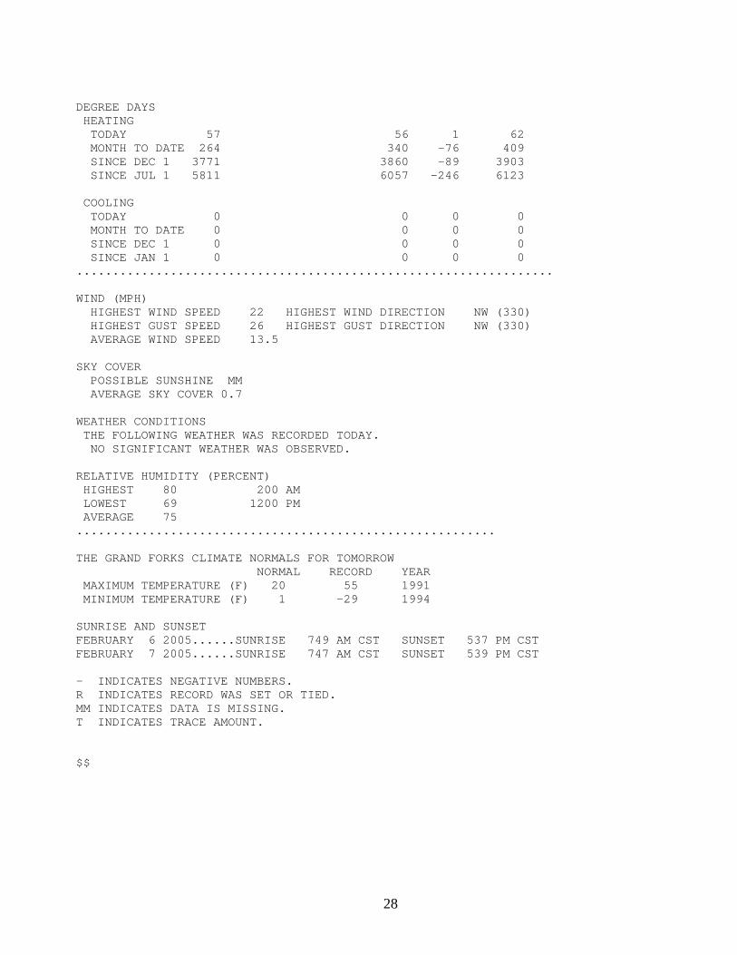
28
DEGREE DAYS HEATING TODAY 57 56 1 62 MONTH TO DATE 264 340 -76 409 SINCE DEC 1 3771 3860 -89 3903 SINCE JUL 1 5811 6057 -246 6123 COOLING TODAY 0 0 0 0 MONTH TO DATE 0 0 0 0 SINCE DEC 1 0 0 0 0 SINCE JAN 1 0 0 0 0 .................................................................. WIND (MPH) HIGHEST WIND SPEED 22 HIGHEST WIND DIRECTION NW (330) HIGHEST GUST SPEED 26 HIGHEST GUST DIRECTION NW (330) AVERAGE WIND SPEED 13.5 SKY COVER POSSIBLE SUNSHINE MM AVERAGE SKY COVER 0.7 WEATHER CONDITIONS THE FOLLOWING WEATHER WAS RECORDED TODAY. NO SIGNIFICANT WEATHER WAS OBSERVED. RELATIVE HUMIDITY (PERCENT) HIGHEST 80 200 AM LOWEST 69 1200 PM AVERAGE 75 .......................................................... THE GRAND FORKS CLIMATE NORMALS FOR TOMORROW NORMAL RECORD YEAR MAXIMUM TEMPERATURE (F) 20 55 1991 MINIMUM TEMPERATURE (F) 1 -29 1994 SUNRISE AND SUNSET FEBRUARY 6 2005......SUNRISE 749 AM CST SUNSET 537 PM CST FEBRUARY 7 2005......SUNRISE 747 AM CST SUNSET 539 PM CST - INDICATES NEGATIVE NUMBERS. R INDICATES RECORD WAS SET OR TIED. MM INDICATES DATA IS MISSING. T INDICATES TRACE AMOUNT. $$
29
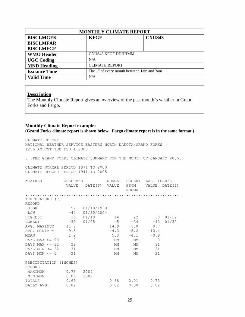
MONTHLY CLIMATE REPORT BISCLMGFK BISCLMFAR BISCLMFGF
KFGF CXUS43
WMO Header CDUS43 KFGF DDHHMM UGC Coding N/A MND Heading CLIMATE REPORT Issuance Time The 1st of every month between 1am and 3am Valid Time N/A
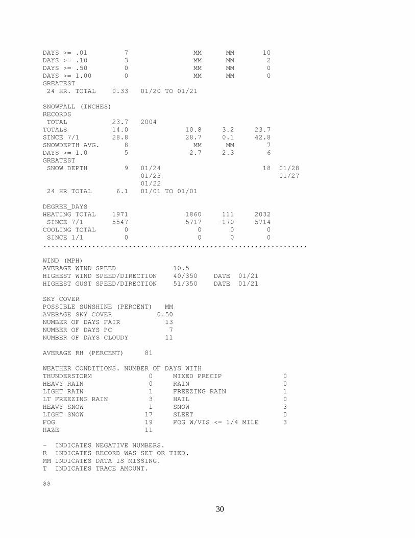
Description The Monthly Climate Report gives an overview of the past month’s weather in Grand Forks and Fargo. Monthly Climate Report example: (Grand Forks climate report is shown below. Fargo climate report is in the same format.) CLIMATE REPORT NATIONAL WEATHER SERVICE EASTERN NORTH DAKOTA/GRAND FORKS 1256 AM CST TUE FEB 1 2005 ...THE GRAND FORKS CLIMATE SUMMARY FOR THE MONTH OF JANUARY 2005... CLIMATE NORMAL PERIOD 1971 TO 2000 CLIMATE RECORD PERIOD 1941 TO 2005 WEATHER OBSERVED NORMAL DEPART LAST YEAR'S VALUE DATE(S) VALUE FROM VALUE DATE(S) NORMAL ................................................................ TEMPERATURE (F) RECORD HIGH 52 01/10/1990 LOW -44 01/30/2004 HIGHEST 36 01/18 14 22 30 01/12 LOWEST -39 01/05 -5 -34 -43 01/30 AVG. MAXIMUM 11.9 14.9 -3.0 8.7 AVG. MINIMUM -9.5 -4.3 -5.2 -10.4 MEAN 1.2 5.3 -4.1 -0.9 DAYS MAX >= 90 0 MM MM 0 DAYS MAX <= 32 29 MM MM 31 DAYS MIN <= 32 31 MM MM 31 DAYS MIN <= 0 21 MM MM 21 PRECIPITATION (INCHES) RECORD MAXIMUM 0.73 2004 MINIMUM 0.06 2002 TOTALS 0.69 0.68 0.01 0.73 DAILY AVG. 0.02 0.02 0.00 0.02
30
DAYS >= .01 7 MM MM 10 DAYS >= .10 3 MM MM 2 DAYS >= .50 0 MM MM 0 DAYS >= 1.00 0 MM MM 0 GREATEST 24 HR. TOTAL 0.33 01/20 TO 01/21 SNOWFALL (INCHES) RECORDS TOTAL 23.7 2004 TOTALS 14.0 10.8 3.2 23.7 SINCE 7/1 28.8 28.7 0.1 42.8 SNOWDEPTH AVG. 8 MM MM 7 DAYS >= 1.0 5 2.7 2.3 6 GREATEST SNOW DEPTH 9 01/24 18 01/28 01/23 01/27 01/22 24 HR TOTAL 6.1 01/01 TO 01/01 DEGREE_DAYS HEATING TOTAL 1971 1860 111 2032 SINCE 7/1 5547 5717 -170 5714 COOLING TOTAL 0 0 0 0 SINCE 1/1 0 0 0 0 ................................................................. WIND (MPH) AVERAGE WIND SPEED 10.5 HIGHEST WIND SPEED/DIRECTION 40/350 DATE 01/21 HIGHEST GUST SPEED/DIRECTION 51/350 DATE 01/21 SKY COVER POSSIBLE SUNSHINE (PERCENT) MM AVERAGE SKY COVER 0.50 NUMBER OF DAYS FAIR 13 NUMBER OF DAYS PC 7 NUMBER OF DAYS CLOUDY 11 AVERAGE RH (PERCENT) 81 WEATHER CONDITIONS. NUMBER OF DAYS WITH THUNDERSTORM 0 MIXED PRECIP 0 HEAVY RAIN 0 RAIN 0 LIGHT RAIN 1 FREEZING RAIN 1 LT FREEZING RAIN 3 HAIL 0 HEAVY SNOW 1 SNOW 3 LIGHT SNOW 17 SLEET 0 FOG 19 FOG W/VIS <= 1/4 MILE 3 HAZE 11 - INDICATES NEGATIVE NUMBERS. R INDICATES RECORD WAS SET OR TIED. MM INDICATES DATA IS MISSING. T INDICATES TRACE AMOUNT. $$
31
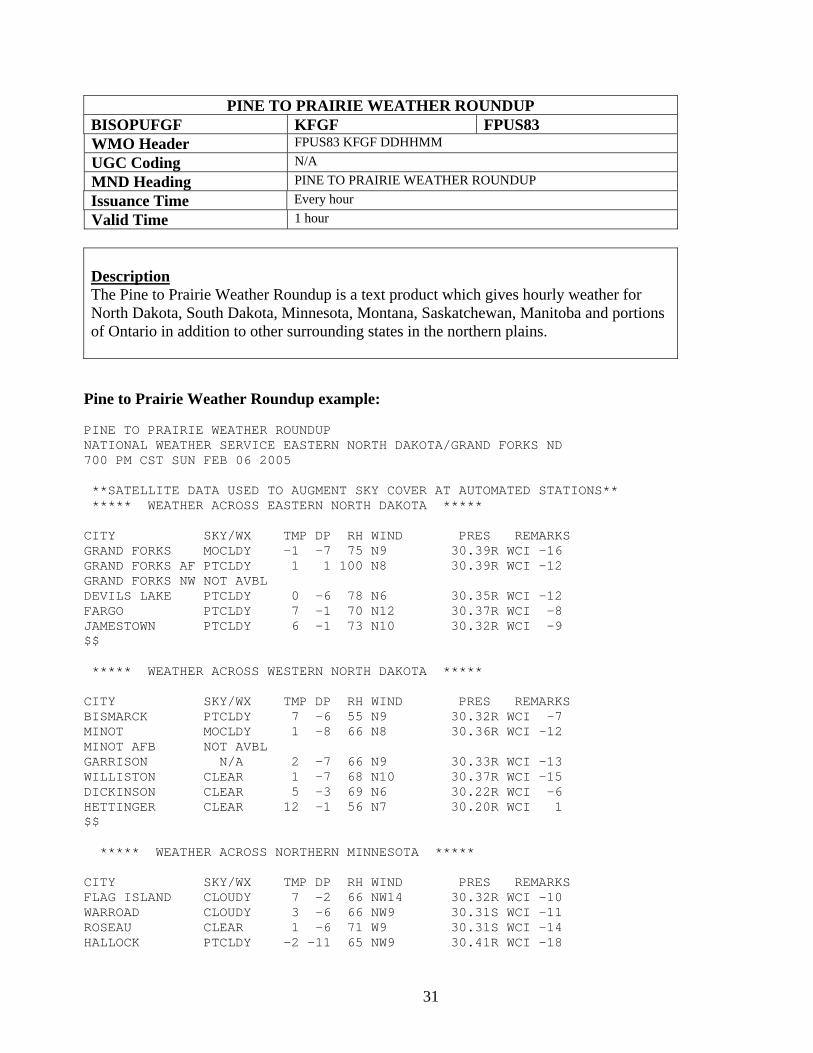
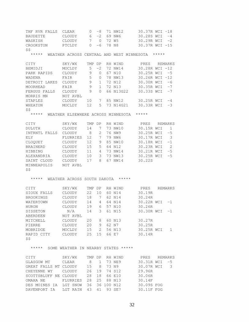
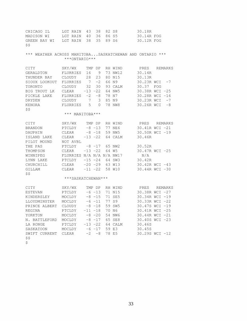
PINE TO PRAIRIE WEATHER ROUNDUP BISOPUFGF KFGF FPUS83 WMO Header FPUS83 KFGF DDHHMM UGC Coding N/A MND Heading PINE TO PRAIRIE WEATHER ROUNDUP Issuance Time Every hour Valid Time 1 hour
Description The Pine to Prairie Weather Roundup is a text product which gives hourly weather for North Dakota, South Dakota, Minnesota, Montana, Saskatchewan, Manitoba and portions of Ontario in addition to other surrounding states in the northern plains. Pine to Prairie Weather Roundup example: PINE TO PRAIRIE WEATHER ROUNDUP NATIONAL WEATHER SERVICE EASTERN NORTH DAKOTA/GRAND FORKS ND 700 PM CST SUN FEB 06 2005 **SATELLITE DATA USED TO AUGMENT SKY COVER AT AUTOMATED STATIONS** ***** WEATHER ACROSS EASTERN NORTH DAKOTA ***** CITY SKY/WX TMP DP RH WIND PRES REMARKS GRAND FORKS MOCLDY -1 -7 75 N9 30.39R WCI -16 GRAND FORKS AF PTCLDY 1 1 100 N8 30.39R WCI -12 GRAND FORKS NW NOT AVBL DEVILS LAKE PTCLDY 0 -6 78 N6 30.35R WCI -12 FARGO PTCLDY 7 -1 70 N12 30.37R WCI -8 JAMESTOWN PTCLDY 6 -1 73 N10 30.32R WCI -9 $$ ***** WEATHER ACROSS WESTERN NORTH DAKOTA ***** CITY SKY/WX TMP DP RH WIND PRES REMARKS BISMARCK PTCLDY 7 -6 55 N9 30.32R WCI -7 MINOT MOCLDY 1 -8 66 N8 30.36R WCI -12 MINOT AFB NOT AVBL GARRISON N/A 2 -7 66 N9 30.33R WCI -13 WILLISTON CLEAR 1 -7 68 N10 30.37R WCI -15 DICKINSON CLEAR 5 -3 69 N6 30.22R WCI -6 HETTINGER CLEAR 12 -1 56 N7 30.20R WCI 1 $$ ***** WEATHER ACROSS NORTHERN MINNESOTA ***** CITY SKY/WX TMP DP RH WIND PRES REMARKS FLAG ISLAND CLOUDY 7 -2 66 NW14 30.32R WCI -10 WARROAD CLOUDY 3 -6 66 NW9 30.31S WCI -11 ROSEAU CLEAR 1 -6 71 W9 30.31S WCI -14 HALLOCK PTCLDY -2 -11 65 NW9 30.41R WCI -18
32
THF RVR FALLS CLEAR 0 -8 71 NW12 30.37R WCI -18 BAUDETTE CLOUDY 6 -2 69 NW6 30.28S WCI -4 WASKISH CLOUDY 7 0 72 W5 30.29R WCI -2 CROOKSTON PTCLDY 0 -6 78 N8 30.37R WCI -15 $$ ***** WEATHER ACROSS CENTRAL AND WEST MINNESOTA ***** CITY SKY/WX TMP DP RH WIND PRES REMARKS BEMIDJI MOCLDY 5 -2 72 NW14 30.28R WCI -12 PARK RAPIDS CLOUDY 9 0 67 N10 30.25R WCI -5 WADENA FAIR 5 0 78 NW13 30.26R WCI -12 DETROIT LAKES CLOUDY 9 1 72 N12 30.30R WCI -6 MOORHEAD FAIR 9 1 72 N13 30.35R WCI -7 FERGUS FALLS CLOUDY 9 0 66 N13G22 30.33S WCI -7 MORRIS MN NOT AVBL STAPLES CLOUDY 10 7 85 NW12 30.25R WCI -4 WHEATON MOCLDY 12 5 73 N14G21 30.33R WCI -3 $$ ***** WEATHER ELSEWHERE ACROSS MINNESOTA ***** CITY SKY/WX TMP DP RH WIND PRES REMARKS DULUTH CLOUDY 14 7 73 NW10 30.15R WCI 1 INTRNTL FALLS CLOUDY 8 2 76 NW9 30.25R WCI -5 ELY FLURRIES 12 7 79 NW6 30.17R WCI 3 CLOQUET CLOUDY 12 9 85 NW10 30.18R WCI -1 BRAINERD CLOUDY 15 5 64 N12 30.23R WCI 2 HIBBING CLOUDY 11 4 73 NW14 30.21R WCI -5 ALEXANDRIA CLOUDY 10 3 73 NW13 30.25R WCI -5 SAINT CLOUD CLOUDY 17 8 67 NW14 30.22S MINNEAPOLIS NOT AVBL $$ ***** WEATHER ACROSS SOUTH DAKOTA ***** CITY SKY/WX TMP DP RH WIND PRES REMARKS SIOUX FALLS CLOUDY 22 10 60 N14 30.19R BROOKINGS CLOUDY 18 7 62 N14 30.24R WATERTOWN CLOUDY 14 4 64 N14 30.22R WCI -1 HURON CLOUDY 19 6 57 N10 30.26R SISSETON N/A 14 3 61 N15 30.30R WCI -1 ABERDEEN NOT AVBL MITCHELL CLOUDY 20 8 60 N13 30.27R PIERRE CLOUDY 20 9 62 N7 30.25R MOBRIDGE MOCLDY 15 2 56 N13 30.25R WCI 1 RAPID CITY CLOUDY 25 15 66 E7 30.14R $$ ***** SOME WEATHER IN NEARBY STATES ***** CITY SKY/WX TMP DP RH WIND PRES REMARKS GLASGOW MT CLEAR 8 1 73 NE9 30.31R WCI -5 GREAT FALLS MT CLOUDY 15 8 73 N9 30.07R WCI 3 CHEYENNE WY CLOUDY 26 19 74 S12 29.96R SCOTTSBLUFF NE CLOUDY 28 18 66 E10 30.06R OMAHA NE FLURRIES 28 25 88 N13 30.14F DES MOINES IA LGT SNOW 36 36 100 N12 30.09S FOG DAVENPORT IA LGT RAIN 43 41 93 SE7 30.11F FOG
33
CHICAGO IL LGT RAIN 43 38 82 S8 30.18R MADISON WI LGT RAIN 40 36 86 S5 30.14R FOG GREEN BAY WI LGT RAIN 38 35 89 S6 30.12R FOG $$ *** WEATHER ACROSS MANITOBA...SASKATCHEWAN AND ONTARIO *** ***ONTARIO*** CITY SKY/WX TMP DP RH WIND PRES REMARKS GERALDTON FLURRIES 16 9 73 NW12 30.14R THUNDER BAY CLOUDY 28 23 80 N15 30.13R SIOUX LOOKOUT FLURRIES 7 -2 66 N9 30.23R WCI -7 TORONTO CLOUDY 32 30 93 CALM 30.37 FOG BIG TROUT LK CLEAR -13 -22 64 NW5 30.38R WCI -25 PICKLE LAKE FLURRIES -2 -8 78 N7 30.28R WCI -16 DRYDEN CLOUDY 7 3 85 N9 30.23R WCI -7 KENORA FLURRIES 5 0 78 NW8 30.26R WCI -8 $$ *** MANITOBA*** CITY SKY/WX TMP DP RH WIND PRES REMARKS BRANDON PTCLDY -8 -13 77 NE6 30.41R WCI -21 DAUPHIN CLEAR -8 -18 59 NW5 30.50R WCI -19 ISLAND LAKE CLEAR -13 -22 64 CALM 30.46R PILOT MOUND NOT AVBL THE PAS PTCLDY -8 -17 65 NW2 30.52R THOMPSON CLEAR -13 -22 64 W5 30.47R WCI -25 WINNIPEG FLURRIES N/A N/A N/A NW17 N/A LYNN LAKE PTCLDY -15 -24 64 SW3 30.42R CHURCHILL CLEAR -20 -29 63 W13 30.42R WCI -43 GILLAM CLEAR -11 -22 58 W10 30.44R WCI -30 $$ ***SASKATCHEWAN*** CITY SKY/WX TMP DP RH WIND PRES REMARKS ESTEVAN PTCLDY -6 -13 71 N15 30.38R WCI -27 KINDERSLEY MOCLDY -8 -15 71 SE5 30.34R WCI -19 LLOYDMINSTER MOCLDY -6 -11 77 S9 30.33R WCI -22 PRINCE ALBERT CLOUDY -8 -18 59 SW5 30.47S WCI -19 REGINA PTCLDY -11 -18 70 N6 30.41R WCI -25 YORKTON MOCLDY -8 -20 54 NW6 30.44R WCI -21 N. BATTLEFORD MOCLDY -8 -17 65 SE8 30.40S WCI -23 LA RONGE PTCLDY -13 -22 64 CALM 30.46S SASKATOON MOCLDY -6 -17 59 E3 30.45S SWIFT CURRENT CLEAR -2 -8 78 E5 30.29S WCI -12 $$ $
34
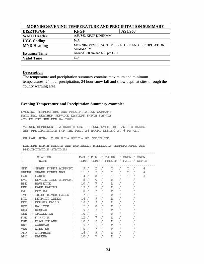
MORNING/EVENING TEMPERATURE AND PRECIPITATION SUMMARY BISRTPFGF KFGF ASUS63 WMO Header ASUS63 KFGF DDHHMM UGC Coding N/A MND Heading MORNING/EVENING TEMPERATURE AND PRECIPITATION
SUMMARY Issuance Time Around 630 am and 630 pm CST Valid Time N/A
Description The temperature and precipitation summary contains maximum and minimum temperatures, 24 hour precipitation, 24 hour snow fall and snow depth at sites through the county warning area.
Evening Temperature and Precipitation Summary example: EVENING TEMPERATURE AND PRECIPITATION SUMMARY NATIONAL WEATHER SERVICE EASTERN NORTH DAKOTA 625 PM CST SUN FEB 06 2005 :VALUES REPRESENT 12 HOUR HIGHS....LOWS OVER THE LAST 18 HOURS :AND PRECIPITATION FOR THE PAST 24 HOURS ENDING AT 6 PM CDT .BR FAR 0206 C DH18/TAIRZY/TAIRZI/PP/SF/SD :EASTERN NORTH DAKOTA AND NORTHWEST MINNESOTA TEMPERATURES AND :PRECIPITATION STATIONS :.................................................................. : STATION MAX / MIN / 24-HR / SNOW / SNOW : NAME TEMP/ TEMP / PRECIP / FALL / DEPTH :.................................................................. GFK : GRAND FORKS AIRPORT: 9 / 2 / T / T / 4 GRFN8: GRAND FORKS NWS : 11 / 3 / T / T / 4 FAR : FARGO : 14 / 8 / T / T / 3 DVL : DEVILS LAKE AIRPORT: 5 / 0 / M / / BDE : BAUDETTE : 10 / 7 / M / / PKD : PARK RAPIDS : 13 / 9 / M / / BJI : BEMIDJI : 10 / 7 / M / / TVF : THIEF RIVER FALLS : 7 / 1 / M / / DTL : DETROIT LAKES : 16 / 9 / M / / FFM : FERGUS FALLS : 16 / 9 / M / / HCO : HALLOCK : 7 / 0 / M / / ROX : ROSEAU : 9 / 3 / M / / CKN : CROOKSTON : 10 / 1 / M / / FSE : FOSSTON : 12 / 7 / M / / FGN : FLAG ISLAND : 10 / 9 / M / / RRT : WARROAD : 9 / 5 / M / / VWU : WASKISH : 10 / 7 / M / / JKJ : MOORHEAD : 16 / 9 / M / / ADC : WADENA : 10 / 7 / M / /
35
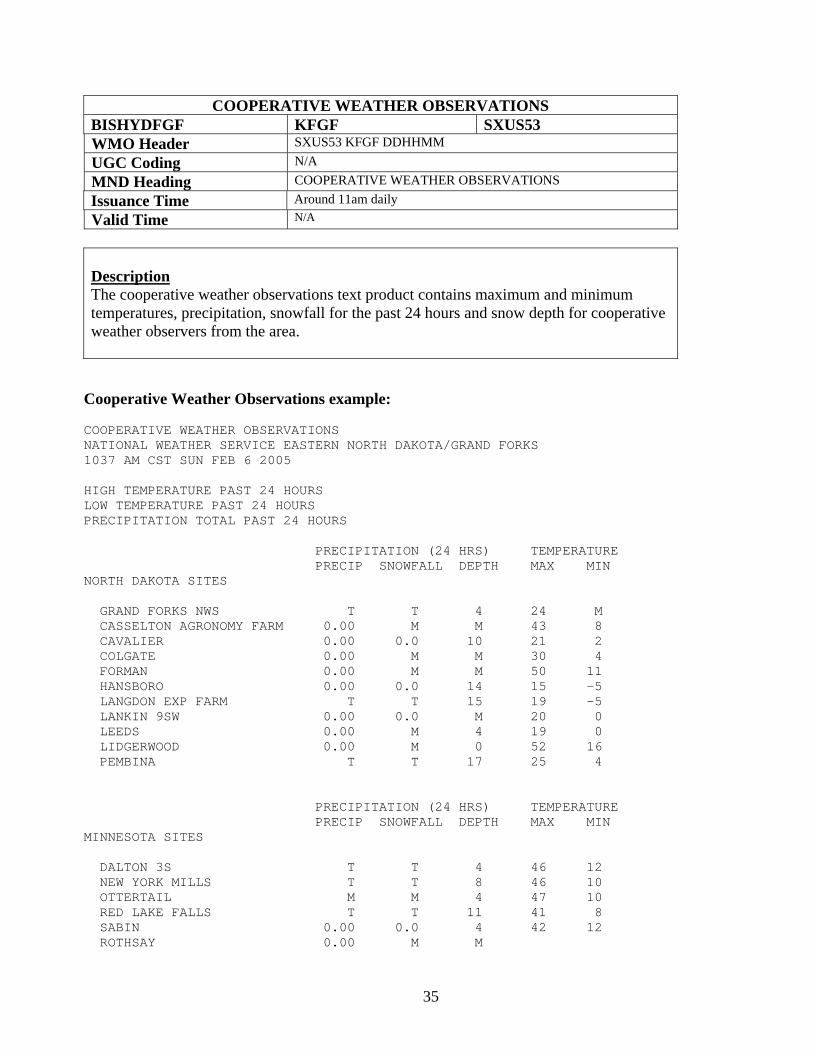
COOPERATIVE WEATHER OBSERVATIONS BISHYDFGF KFGF SXUS53 WMO Header SXUS53 KFGF DDHHMM UGC Coding N/A MND Heading COOPERATIVE WEATHER OBSERVATIONS Issuance Time Around 11am daily Valid Time N/A
Description The cooperative weather observations text product contains maximum and minimum temperatures, precipitation, snowfall for the past 24 hours and snow depth for cooperative weather observers from the area. Cooperative Weather Observations example: COOPERATIVE WEATHER OBSERVATIONS NATIONAL WEATHER SERVICE EASTERN NORTH DAKOTA/GRAND FORKS 1037 AM CST SUN FEB 6 2005 HIGH TEMPERATURE PAST 24 HOURS LOW TEMPERATURE PAST 24 HOURS PRECIPITATION TOTAL PAST 24 HOURS PRECIPITATION (24 HRS) TEMPERATURE PRECIP SNOWFALL DEPTH MAX MIN NORTH DAKOTA SITES GRAND FORKS NWS T T 4 24 M CASSELTON AGRONOMY FARM 0.00 M M 43 8 CAVALIER 0.00 0.0 10 21 2 COLGATE 0.00 M M 30 4 FORMAN 0.00 M M 50 11 HANSBORO 0.00 0.0 14 15 -5 LANGDON EXP FARM T T 15 19 -5 LANKIN 9SW 0.00 0.0 M 20 0 LEEDS 0.00 M 4 19 0 LIDGERWOOD 0.00 M 0 52 16 PEMBINA T T 17 25 4 PRECIPITATION (24 HRS) TEMPERATURE PRECIP SNOWFALL DEPTH MAX MIN MINNESOTA SITES DALTON 3S T T 4 46 12 NEW YORK MILLS T T 8 46 10 OTTERTAIL M M 4 47 10 RED LAKE FALLS T T 11 41 8 SABIN 0.00 0.0 4 42 12 ROTHSAY 0.00 M M
36
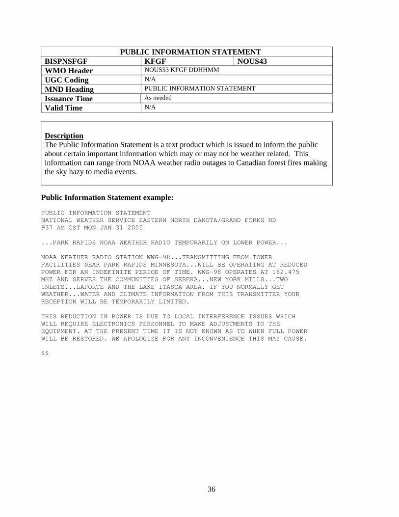
PUBLIC INFORMATION STATEMENT BISPNSFGF KFGF NOUS43 WMO Header NOUS53 KFGF DDHHMM UGC Coding N/A MND Heading PUBLIC INFORMATION STATEMENT Issuance Time As needed Valid Time N/A
Description The Public Information Statement is a text product which is issued to inform the public about certain important information which may or may not be weather related. This information can range from NOAA weather radio outages to Canadian forest fires making the sky hazy to media events.
Public Information Statement example: PUBLIC INFORMATION STATEMENT NATIONAL WEATHER SERVICE EASTERN NORTH DAKOTA/GRAND FORKS ND 937 AM CST MON JAN 31 2005 ...PARK RAPIDS NOAA WEATHER RADIO TEMPORARILY ON LOWER POWER... NOAA WEATHER RADIO STATION WWG-98...TRANSMITTING FROM TOWER FACILITIES NEAR PARK RAPIDS MINNESOTA...WILL BE OPERATING AT REDUCED POWER FOR AN INDEFINITE PERIOD OF TIME. WWG-98 OPERATES AT 162.475 MHZ AND SERVES THE COMMUNITIES OF SEBEKA...NEW YORK MILLS...TWO INLETS...LAPORTE AND THE LAKE ITASCA AREA. IF YOU NORMALLY GET WEATHER...WATER AND CLIMATE INFORMATION FROM THIS TRANSMITTER YOUR RECEPTION WILL BE TEMPORARILY LIMITED. THIS REDUCTION IN POWER IS DUE TO LOCAL INTERFERENCE ISSUES WHICH WILL REQUIRE ELECTRONICS PERSONNEL TO MAKE ADJUSTMENTS TO THE EQUIPMENT. AT THE PRESENT TIME IT IS NOT KNOWN AS TO WHEN FULL POWER WILL BE RESTORED. WE APOLOGIZE FOR ANY INCONVENIENCE THIS MAY CAUSE. $$

37
RECORD EVENT REPORT BISRERFGF,GFK,FAR KFGF SXUS73 WMO Header SXUS73 KFGF DDHHMM UGC Coding N/A MND Heading RECORD EVENT REPORT Issuance Time As needed Valid Time N/A
Description The Record Event Report is sent out when any record is tied or broken at one of the NWS offices or a site where the NWS has sufficient climatological records to establish a record (at least 30 years). This included the Grand Forks International Airport (GFK), the National Weather Service (FGF) and Fargo (FAR). This would include record highs/lows and record rain or snowfall. A Record Event Report will state what type of record has been broken, what the old record was, and what the new record is.
Record Event Report example: RECORD EVENT REPORT NATIONAL WEATHER SERVICE EASTERN NORTH DAKOTA/GRAND FORKS 915 AM CST MON JAN 17 2005 ...RECORD LOW TEMPERATURE AT GRAND FORKS AIRPORT... THE TEMPERATURE RECORDED AT THE GRAND FORKS AIRPORT WAS -37 DEGREES EARLY THIS MORNING WHICH IS A NEW RECORD LOW TEMPERATURE FOR JANUARY 17. THE PREVIOUS RECORD LOW TEMPERATURE FOR JANUARY 17 WAS -32 DEGREES WHICH WAS SET IN 1943. $$
38
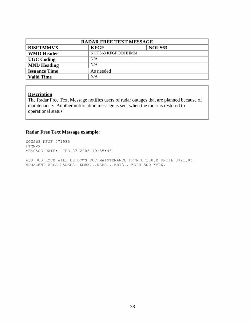
RADAR FREE TEXT MESSAGE BISFTMMVX KFGF NOUS63 WMO Header NOUS63 KFGF DDHHMM UGC Coding N/A MND Heading N/A Issuance Time As needed Valid Time N/A
Description The Radar Free Text Message notifies users of radar outages that are planned because of maintenance. Another notification message is sent when the radar is restored to operational status.
Radar Free Text Message example: NOUS63 KFGF 071935 FTMMVX MESSAGE DATE: FEB 07 2005 19:35:46 WSR-88D KMVX WILL BE DOWN FOR MAINTENANCE FROM 072000Z UNTIL 072130Z. ADJACENT AREA RADARS: KMBX...KABR...KBIS...KDLH AND KMPX.
39
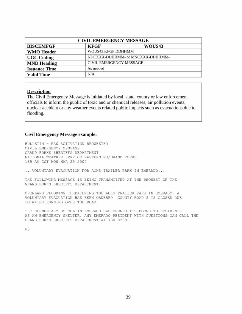
CIVIL EMERGENCY MESSAGE BISCEMFGF KFGF WOUS43 WMO Header WOUS43 KFGF DDHHMM UGC Coding NDCXXX-DDHHMM- or MNCXXX-DDHHMM- MND Heading CIVIL EMERGENCY MESSAGE Issuance Time As needed Valid Time N/A
Description The Civil Emergency Message is initiated by local, state, county or law enforcement officials to inform the public of toxic and or chemical releases, air pollution events, nuclear accident or any weather events related public impacts such as evacuations due to flooding.
Civil Emergency Message example: BULLETIN - EAS ACTIVATION REQUESTED CIVIL EMERGENCY MESSAGE GRAND FORKS SHERIFFS DEPARTMENT NATIONAL WEATHER SERVICE EASTERN ND/GRAND FORKS 135 AM CST MON MAR 29 2004 ...VOLUNTARY EVACUATION FOR ACKS TRAILER PARK IN EMERADO... THE FOLLOWING MESSAGE IS BEING TRANSMITTED AT THE REQUEST OF THE GRAND FORKS SHERIFFS DEPARTMENT. OVERLAND FLOODING THREATENING THE ACKS TRAILER PARK IN EMERADO. A VOLUNTARY EVACUATION HAS BEEN ORDERED. COUNTY ROAD 3 IS CLOSED DUE TO WATER RUNNING OVER THE ROAD. THE ELEMENTARY SCHOOL IN EMERADO HAS OPENED ITS DOORS TO RESIDENTS AS AN EMERGENCY SHELTER. ANY EMERADO RESIDENT WITH QUESTIONS CAN CALL THE GRAND FORKS SHERIFFS DEPARTMENT AT 780-8280. $$
40
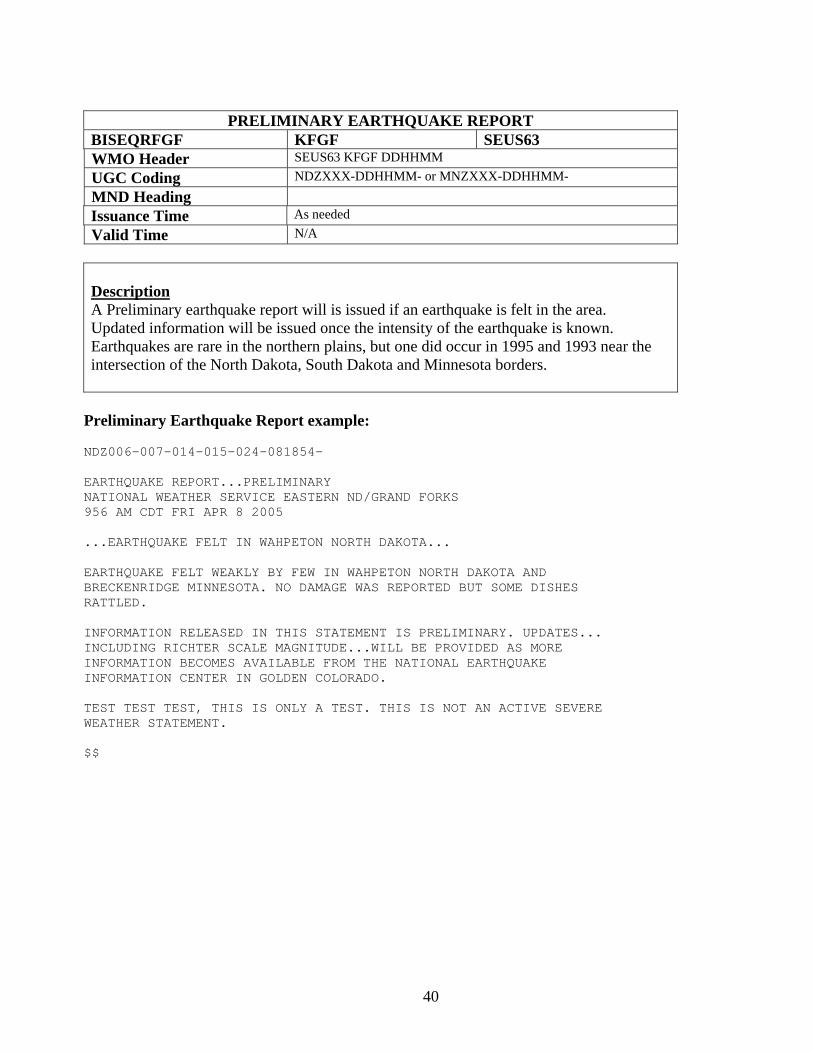
PRELIMINARY EARTHQUAKE REPORT
BISEQRFGF KFGF SEUS63 WMO Header SEUS63 KFGF DDHHMM UGC Coding NDZXXX-DDHHMM- or MNZXXX-DDHHMM- MND Heading Issuance Time As needed Valid Time N/A
Description A Preliminary earthquake report will is issued if an earthquake is felt in the area. Updated information will be issued once the intensity of the earthquake is known. Earthquakes are rare in the northern plains, but one did occur in 1995 and 1993 near the intersection of the North Dakota, South Dakota and Minnesota borders.
Preliminary Earthquake Report example: NDZ006-007-014-015-024-081854-
EARTHQUAKE REPORT...PRELIMINARY NATIONAL WEATHER SERVICE EASTERN ND/GRAND FORKS 956 AM CDT FRI APR 8 2005 ...EARTHQUAKE FELT IN WAHPETON NORTH DAKOTA... EARTHQUAKE FELT WEAKLY BY FEW IN WAHPETON NORTH DAKOTA AND BRECKENRIDGE MINNESOTA. NO DAMAGE WAS REPORTED BUT SOME DISHES RATTLED. INFORMATION RELEASED IN THIS STATEMENT IS PRELIMINARY. UPDATES... INCLUDING RICHTER SCALE MAGNITUDE...WILL BE PROVIDED AS MORE INFORMATION BECOMES AVAILABLE FROM THE NATIONAL EARTHQUAKE INFORMATION CENTER IN GOLDEN COLORADO. TEST TEST TEST, THIS IS ONLY A TEST. THIS IS NOT AN ACTIVE SEVERE WEATHER STATEMENT. $$
41
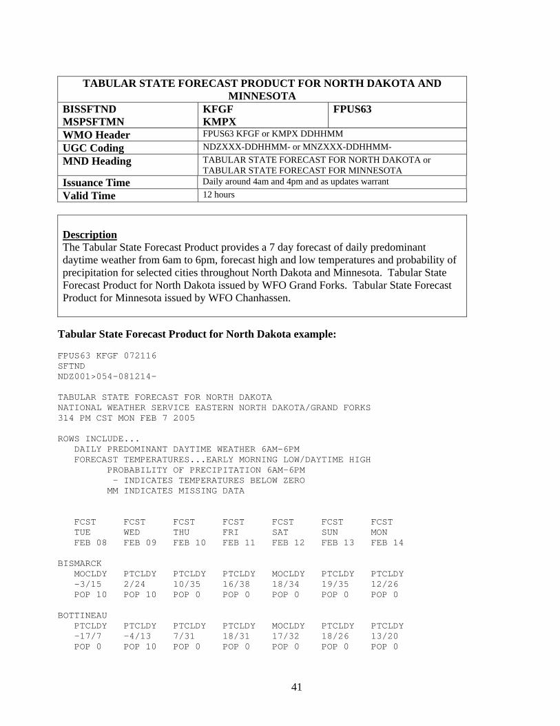
TABULAR STATE FORECAST PRODUCT FOR NORTH DAKOTA AND
MINNESOTA BISSFTND MSPSFTMN
KFGF KMPX
FPUS63
WMO Header FPUS63 KFGF or KMPX DDHHMM UGC Coding NDZXXX-DDHHMM- or MNZXXX-DDHHMM- MND Heading TABULAR STATE FORECAST FOR NORTH DAKOTA or
TABULAR STATE FORECAST FOR MINNESOTA Issuance Time Daily around 4am and 4pm and as updates warrant Valid Time 12 hours
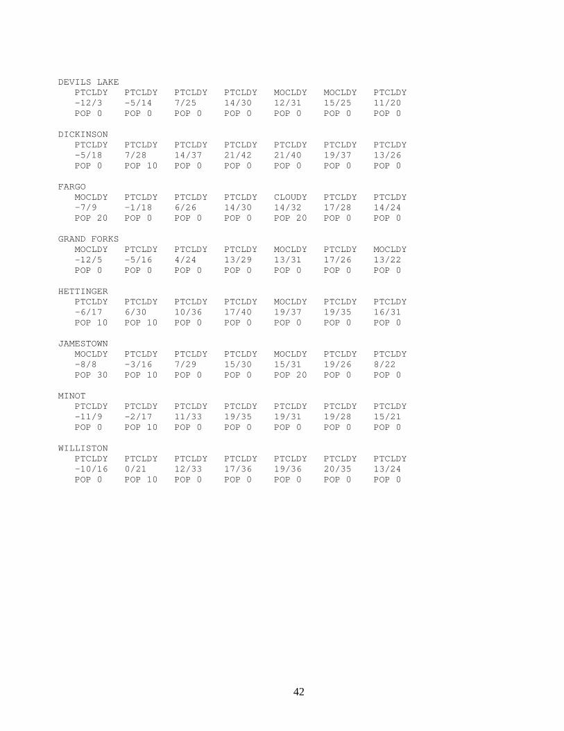
Description The Tabular State Forecast Product provides a 7 day forecast of daily predominant daytime weather from 6am to 6pm, forecast high and low temperatures and probability of precipitation for selected cities throughout North Dakota and Minnesota. Tabular State Forecast Product for North Dakota issued by WFO Grand Forks. Tabular State Forecast Product for Minnesota issued by WFO Chanhassen. Tabular State Forecast Product for North Dakota example: FPUS63 KFGF 072116 SFTND NDZ001>054-081214- TABULAR STATE FORECAST FOR NORTH DAKOTA NATIONAL WEATHER SERVICE EASTERN NORTH DAKOTA/GRAND FORKS 314 PM CST MON FEB 7 2005 ROWS INCLUDE... DAILY PREDOMINANT DAYTIME WEATHER 6AM-6PM FORECAST TEMPERATURES...EARLY MORNING LOW/DAYTIME HIGH PROBABILITY OF PRECIPITATION 6AM-6PM - INDICATES TEMPERATURES BELOW ZERO MM INDICATES MISSING DATA FCST FCST FCST FCST FCST FCST FCST TUE WED THU FRI SAT SUN MON FEB 08 FEB 09 FEB 10 FEB 11 FEB 12 FEB 13 FEB 14 BISMARCK MOCLDY PTCLDY PTCLDY PTCLDY MOCLDY PTCLDY PTCLDY -3/15 2/24 10/35 16/38 18/34 19/35 12/26 POP 10 POP 10 POP 0 POP 0 POP 0 POP 0 POP 0 BOTTINEAU PTCLDY PTCLDY PTCLDY PTCLDY MOCLDY PTCLDY PTCLDY -17/7 -4/13 7/31 18/31 17/32 18/26 13/20 POP 0 POP 10 POP 0 POP 0 POP 0 POP 0 POP 0
42
DEVILS LAKE PTCLDY PTCLDY PTCLDY PTCLDY MOCLDY MOCLDY PTCLDY -12/3 -5/14 7/25 14/30 12/31 15/25 11/20 POP 0 POP 0 POP 0 POP 0 POP 0 POP 0 POP 0 DICKINSON PTCLDY PTCLDY PTCLDY PTCLDY PTCLDY PTCLDY PTCLDY -5/18 7/28 14/37 21/42 21/40 19/37 13/26 POP 0 POP 10 POP 0 POP 0 POP 0 POP 0 POP 0 FARGO MOCLDY PTCLDY PTCLDY PTCLDY CLOUDY PTCLDY PTCLDY -7/9 -1/18 6/26 14/30 14/32 17/28 14/24 POP 20 POP 0 POP 0 POP 0 POP 20 POP 0 POP 0 GRAND FORKS MOCLDY PTCLDY PTCLDY PTCLDY MOCLDY PTCLDY MOCLDY -12/5 -5/16 4/24 13/29 13/31 17/26 13/22 POP 0 POP 0 POP 0 POP 0 POP 0 POP 0 POP 0 HETTINGER PTCLDY PTCLDY PTCLDY PTCLDY MOCLDY PTCLDY PTCLDY -6/17 6/30 10/36 17/40 19/37 19/35 16/31 POP 10 POP 10 POP 0 POP 0 POP 0 POP 0 POP 0 JAMESTOWN MOCLDY PTCLDY PTCLDY PTCLDY MOCLDY PTCLDY PTCLDY -8/8 -3/16 7/29 15/30 15/31 19/26 8/22 POP 30 POP 10 POP 0 POP 0 POP 20 POP 0 POP 0 MINOT PTCLDY PTCLDY PTCLDY PTCLDY PTCLDY PTCLDY PTCLDY -11/9 -2/17 11/33 19/35 19/31 19/28 15/21 POP 0 POP 10 POP 0 POP 0 POP 0 POP 0 POP 0 WILLISTON PTCLDY PTCLDY PTCLDY PTCLDY PTCLDY PTCLDY PTCLDY -10/16 0/21 12/33 17/36 19/36 20/35 13/24 POP 0 POP 10 POP 0 POP 0 POP 0 POP 0 POP 0
43
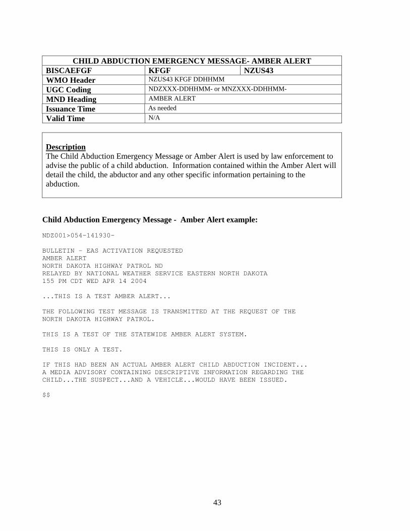
CHILD ABDUCTION EMERGENCY MESSAGE- AMBER ALERT
BISCAEFGF KFGF NZUS43 WMO Header NZUS43 KFGF DDHHMM UGC Coding NDZXXX-DDHHMM- or MNZXXX-DDHHMM- MND Heading AMBER ALERT Issuance Time As needed Valid Time N/A
Description The Child Abduction Emergency Message or Amber Alert is used by law enforcement to advise the public of a child abduction. Information contained within the Amber Alert will detail the child, the abductor and any other specific information pertaining to the abduction.
Child Abduction Emergency Message - Amber Alert example: NDZ001>054-141930- BULLETIN - EAS ACTIVATION REQUESTED AMBER ALERT NORTH DAKOTA HIGHWAY PATROL ND RELAYED BY NATIONAL WEATHER SERVICE EASTERN NORTH DAKOTA 155 PM CDT WED APR 14 2004 ...THIS IS A TEST AMBER ALERT... THE FOLLOWING TEST MESSAGE IS TRANSMITTED AT THE REQUEST OF THE NORTH DAKOTA HIGHWAY PATROL. THIS IS A TEST OF THE STATEWIDE AMBER ALERT SYSTEM. THIS IS ONLY A TEST. IF THIS HAD BEEN AN ACTUAL AMBER ALERT CHILD ABDUCTION INCIDENT... A MEDIA ADVISORY CONTAINING DESCRIPTIVE INFORMATION REGARDING THE CHILD...THE SUSPECT...AND A VEHICLE...WOULD HAVE BEEN ISSUED. $$
44
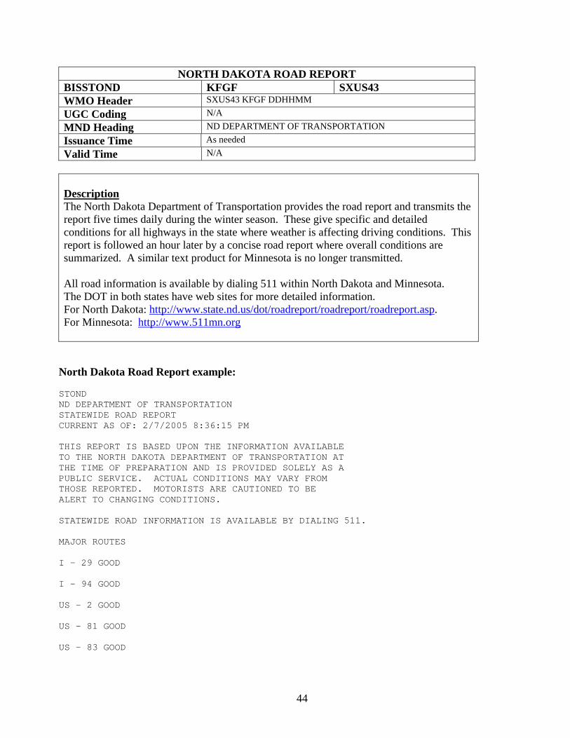
NORTH DAKOTA ROAD REPORT BISSTOND KFGF SXUS43 WMO Header SXUS43 KFGF DDHHMM UGC Coding N/A MND Heading ND DEPARTMENT OF TRANSPORTATION Issuance Time As needed Valid Time N/A
Description The North Dakota Department of Transportation provides the road report and transmits the report five times daily during the winter season. These give specific and detailed conditions for all highways in the state where weather is affecting driving conditions. This report is followed an hour later by a concise road report where overall conditions are summarized. A similar text product for Minnesota is no longer transmitted. All road information is available by dialing 511 within North Dakota and Minnesota. The DOT in both states have web sites for more detailed information. For North Dakota: http://www.state.nd.us/dot/roadreport/roadreport/roadreport.asp. For Minnesota: http://www.511mn.org North Dakota Road Report example: STOND ND DEPARTMENT OF TRANSPORTATION STATEWIDE ROAD REPORT CURRENT AS OF: 2/7/2005 8:36:15 PM THIS REPORT IS BASED UPON THE INFORMATION AVAILABLE TO THE NORTH DAKOTA DEPARTMENT OF TRANSPORTATION AT THE TIME OF PREPARATION AND IS PROVIDED SOLELY AS A PUBLIC SERVICE. ACTUAL CONDITIONS MAY VARY FROM THOSE REPORTED. MOTORISTS ARE CAUTIONED TO BE ALERT TO CHANGING CONDITIONS. STATEWIDE ROAD INFORMATION IS AVAILABLE BY DIALING 511. MAJOR ROUTES I - 29 GOOD I - 94 GOOD US - 2 GOOD US - 81 GOOD US – 83 GOOD
45
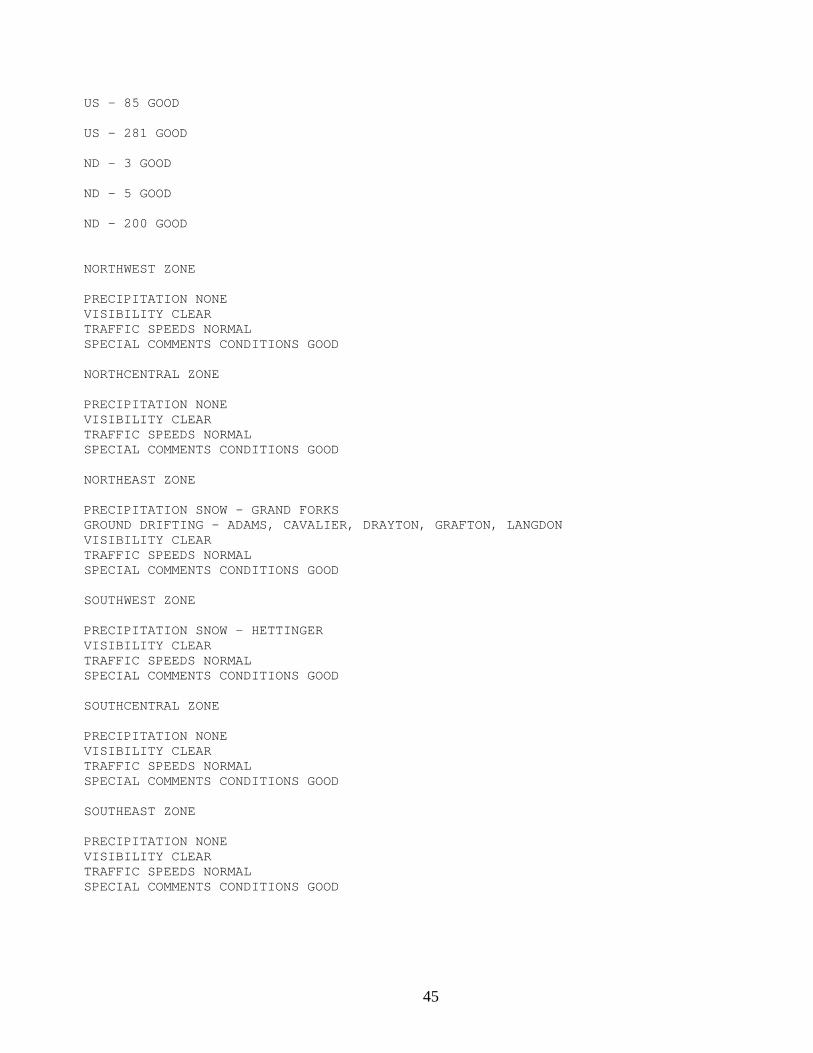
US – 85 GOOD US - 281 GOOD ND - 3 GOOD ND - 5 GOOD ND - 200 GOOD NORTHWEST ZONE PRECIPITATION NONE VISIBILITY CLEAR TRAFFIC SPEEDS NORMAL SPECIAL COMMENTS CONDITIONS GOOD NORTHCENTRAL ZONE PRECIPITATION NONE VISIBILITY CLEAR TRAFFIC SPEEDS NORMAL SPECIAL COMMENTS CONDITIONS GOOD NORTHEAST ZONE
PRECIPITATION SNOW - GRAND FORKS GROUND DRIFTING - ADAMS, CAVALIER, DRAYTON, GRAFTON, LANGDON VISIBILITY CLEAR TRAFFIC SPEEDS NORMAL SPECIAL COMMENTS CONDITIONS GOOD SOUTHWEST ZONE PRECIPITATION SNOW - HETTINGER VISIBILITY CLEAR TRAFFIC SPEEDS NORMAL SPECIAL COMMENTS CONDITIONS GOOD SOUTHCENTRAL ZONE PRECIPITATION NONE VISIBILITY CLEAR TRAFFIC SPEEDS NORMAL SPECIAL COMMENTS CONDITIONS GOOD SOUTHEAST ZONE PRECIPITATION NONE VISIBILITY CLEAR TRAFFIC SPEEDS NORMAL SPECIAL COMMENTS CONDITIONS GOOD
46
HAZARDOUS WEATHER OUTLOOK BISHWOFGF KFGF FLUS43 WMO Header FLUS43 KFGF DDHHMM UGC Coding NDZXXX-DDHHMM- or MNZXXX-DDHHMM- MND Heading HAZARDOUS WEATHER OUTLOOK Issuance Time Daily around 6am, and updated as needed Valid Time 24 hours, or if updates warrant
Description The Hazardous Weather Outlook (HWO) is used to alert users (media, emergency management and the public) of potential winter weather, severe weather, fire weather, non-precipitation or flood hazards that may occur within the next 7 days. It is designed to be a “heads up” to expected hazardous weather and its potential impact. The hazards that are included in the products include any current advisory, watch or warning in days one through seven (with the exception of short term events like severe thunderstorms or tornadoes and flash flooding). The first section will be for Day One, and the second section for Day 2 through Day 7.
Hazardous Weather Outlook example:
HAZARDOUS WEATHER OUTLOOK NATIONAL WEATHER SERVICE EASTERN ND/GRAND FORKS 612 AM CST MON FEB 7 2005 MNZ001>009-013>017-022>024-027>032-040-NDZ006>008-014>016-024- 026>030-038-039-049-052>054-071511- BARNES ND-BENSON ND-CASS ND-CAVALIER ND-CLAY MN-EAST BECKER MN- EAST MARSHALL MN-EAST OTTER TAIL MN-EAST POLK MN- EASTERN WALSH COUNTY ND-EDDY ND-GRAND FORKS ND-GRANT MN-GRIGGS ND- HUBBARD MN-KITTSON MN-LAKE OF THE WOODS MN-MAHNOMEN MN-NELSON ND- NORMAN MN-NORTH BELTRAMI MN-NORTH CLEARWATER MN-PEMBINA ND- PENNINGTON MN-RAMSEY ND-RANSOM ND-RED LAKE MN-RICHLAND ND-ROSEAU MN- SARGENT ND-SOUTH BELTRAMI MN-SOUTH CLEARWATER MN-STEELE ND-TOWNER ND- TRAILL ND-WADENA MN-WEST BECKER MN-WEST MARSHALL MN- WEST OTTER TAIL MN-WEST POLK MN-WESTERN WALSH COUNTY ND-WILKIN MN- INCLUDING THE CITIES OF...BEMIDJI...DETROIT LAKES...DEVILS LAKE... FARGO...FERGUS FALLS...GRAFTON...GRAND FORKS...LANGDON...AND ROSEAU... 612 AM CST MON FEB 7 2005 THIS HAZARDOUS WEATHER OUTLOOK IS FOR EASTERN ND...WEST CENTRAL AND NORTHWEST MN. .DAY ONE...TODAY AND TONIGHT NO HAZARDOUS WEATHER IS EXPECTED AT THIS TIME. .DAYS TWO THROUGH SEVEN...TUESDAY THROUGH SUNDAY NO HAZARDOUS WEATHER IS EXPECTED AT THIS TIME. .SPOTTER INFORMATION STATEMENT... SPOTTER ACTIVATION IS NOT ANTICIPATED.
47
Eastern North Dakota and Northwestern Minnesota NWS Product and Services Guide
Summer Severe Weather Products Tornado and Severe Thunderstorm Watch Watch Outline Update Watch County Notification Tornado Warning Severe Thunderstorm Warning Severe Weather Statement Local Storm Report
48
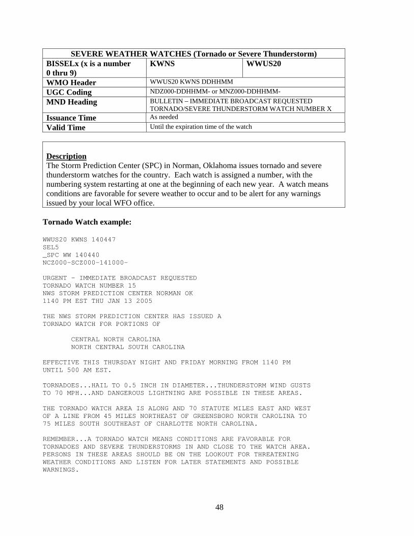
SEVERE WEATHER WATCHES (Tornado or Severe Thunderstorm) BISSELx (x is a number 0 thru 9)
KWNS WWUS20
WMO Header WWUS20 KWNS DDHHMM UGC Coding NDZ000-DDHHMM- or MNZ000-DDHHMM- MND Heading BULLETIN – IMMEDIATE BROADCAST REQUESTED
TORNADO/SEVERE THUNDERSTORM WATCH NUMBER X Issuance Time As needed Valid Time Until the expiration time of the watch
Description The Storm Prediction Center (SPC) in Norman, Oklahoma issues tornado and severe thunderstorm watches for the country. Each watch is assigned a number, with the numbering system restarting at one at the beginning of each new year. A watch means conditions are favorable for severe weather to occur and to be alert for any warnings issued by your local WFO office.
Tornado Watch example:
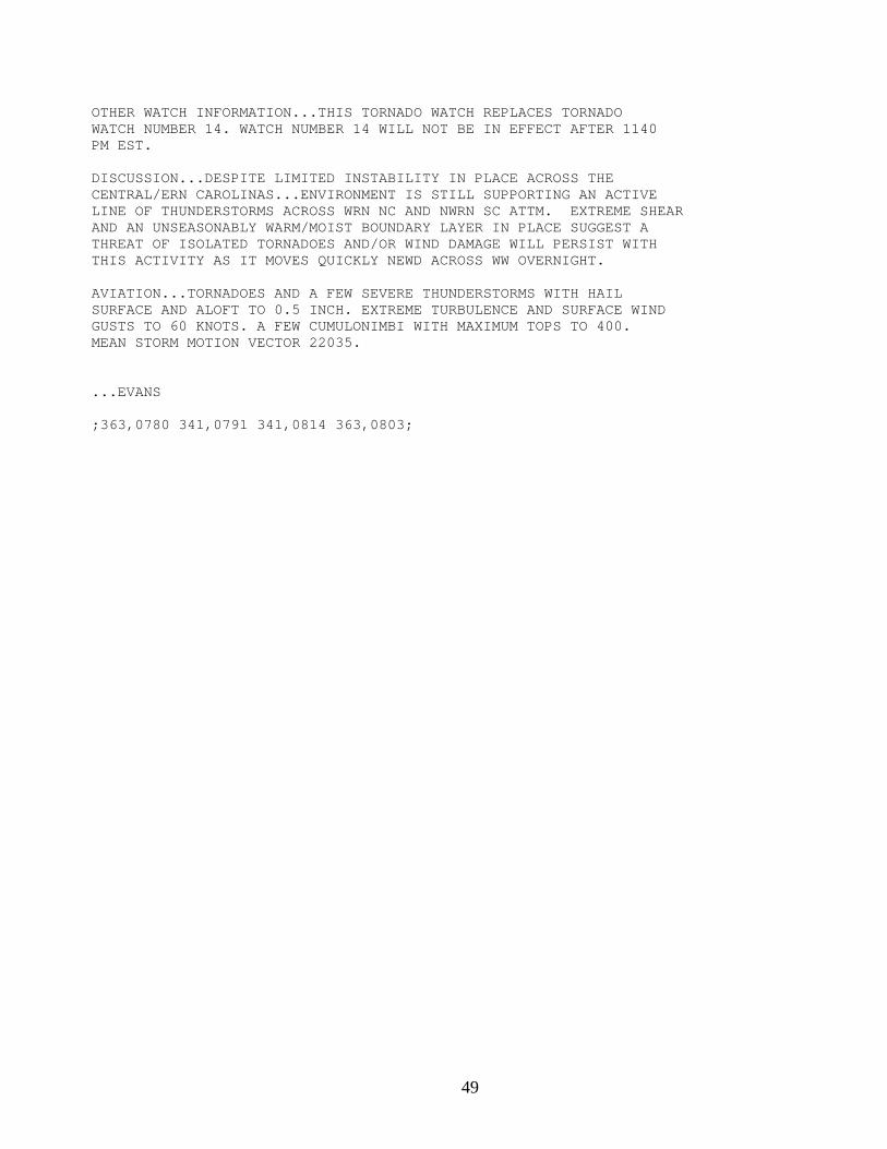
WWUS20 KWNS 140447 SEL5 _SPC WW 140440 NCZ000-SCZ000-141000- URGENT - IMMEDIATE BROADCAST REQUESTED TORNADO WATCH NUMBER 15 NWS STORM PREDICTION CENTER NORMAN OK 1140 PM EST THU JAN 13 2005 THE NWS STORM PREDICTION CENTER HAS ISSUED A TORNADO WATCH FOR PORTIONS OF CENTRAL NORTH CAROLINA NORTH CENTRAL SOUTH CAROLINA EFFECTIVE THIS THURSDAY NIGHT AND FRIDAY MORNING FROM 1140 PM UNTIL 500 AM EST. TORNADOES...HAIL TO 0.5 INCH IN DIAMETER...THUNDERSTORM WIND GUSTS TO 70 MPH...AND DANGEROUS LIGHTNING ARE POSSIBLE IN THESE AREAS. THE TORNADO WATCH AREA IS ALONG AND 70 STATUTE MILES EAST AND WEST OF A LINE FROM 45 MILES NORTHEAST OF GREENSBORO NORTH CAROLINA TO 75 MILES SOUTH SOUTHEAST OF CHARLOTTE NORTH CAROLINA. REMEMBER...A TORNADO WATCH MEANS CONDITIONS ARE FAVORABLE FOR TORNADOES AND SEVERE THUNDERSTORMS IN AND CLOSE TO THE WATCH AREA. PERSONS IN THESE AREAS SHOULD BE ON THE LOOKOUT FOR THREATENING WEATHER CONDITIONS AND LISTEN FOR LATER STATEMENTS AND POSSIBLE WARNINGS.
49
OTHER WATCH INFORMATION...THIS TORNADO WATCH REPLACES TORNADO WATCH NUMBER 14. WATCH NUMBER 14 WILL NOT BE IN EFFECT AFTER 1140 PM EST. DISCUSSION...DESPITE LIMITED INSTABILITY IN PLACE ACROSS THE CENTRAL/ERN CAROLINAS...ENVIRONMENT IS STILL SUPPORTING AN ACTIVE LINE OF THUNDERSTORMS ACROSS WRN NC AND NWRN SC ATTM. EXTREME SHEAR AND AN UNSEASONABLY WARM/MOIST BOUNDARY LAYER IN PLACE SUGGEST A THREAT OF ISOLATED TORNADOES AND/OR WIND DAMAGE WILL PERSIST WITH THIS ACTIVITY AS IT MOVES QUICKLY NEWD ACROSS WW OVERNIGHT. AVIATION...TORNADOES AND A FEW SEVERE THUNDERSTORMS WITH HAIL SURFACE AND ALOFT TO 0.5 INCH. EXTREME TURBULENCE AND SURFACE WIND GUSTS TO 60 KNOTS. A FEW CUMULONIMBI WITH MAXIMUM TOPS TO 400. MEAN STORM MOTION VECTOR 22035. ...EVANS ;363,0780 341,0791 341,0814 363,0803;
50
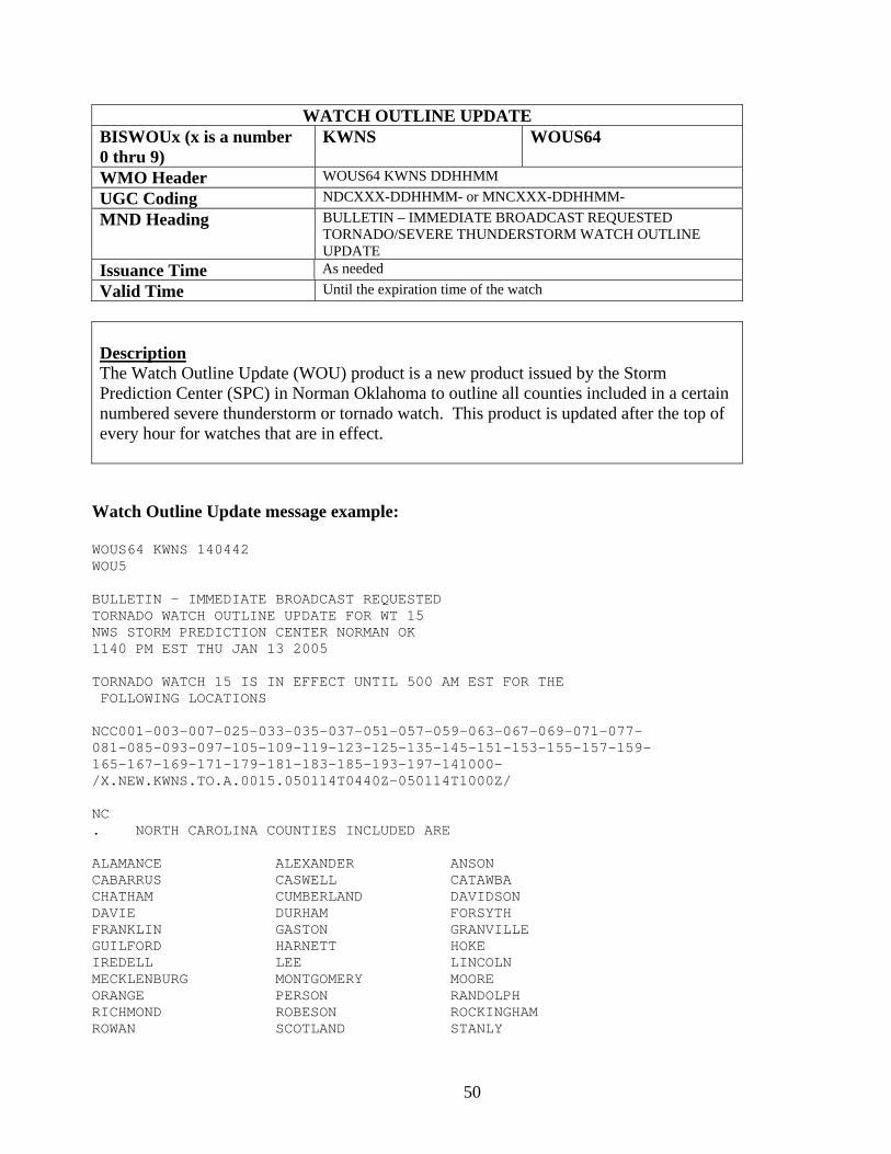
WATCH OUTLINE UPDATE BISWOUx (x is a number 0 thru 9)
KWNS WOUS64
WMO Header WOUS64 KWNS DDHHMM UGC Coding NDCXXX-DDHHMM- or MNCXXX-DDHHMM- MND Heading BULLETIN – IMMEDIATE BROADCAST REQUESTED
TORNADO/SEVERE THUNDERSTORM WATCH OUTLINE UPDATE
Issuance Time As needed Valid Time Until the expiration time of the watch
Description The Watch Outline Update (WOU) product is a new product issued by the Storm Prediction Center (SPC) in Norman Oklahoma to outline all counties included in a certain numbered severe thunderstorm or tornado watch. This product is updated after the top of every hour for watches that are in effect.
Watch Outline Update message example:
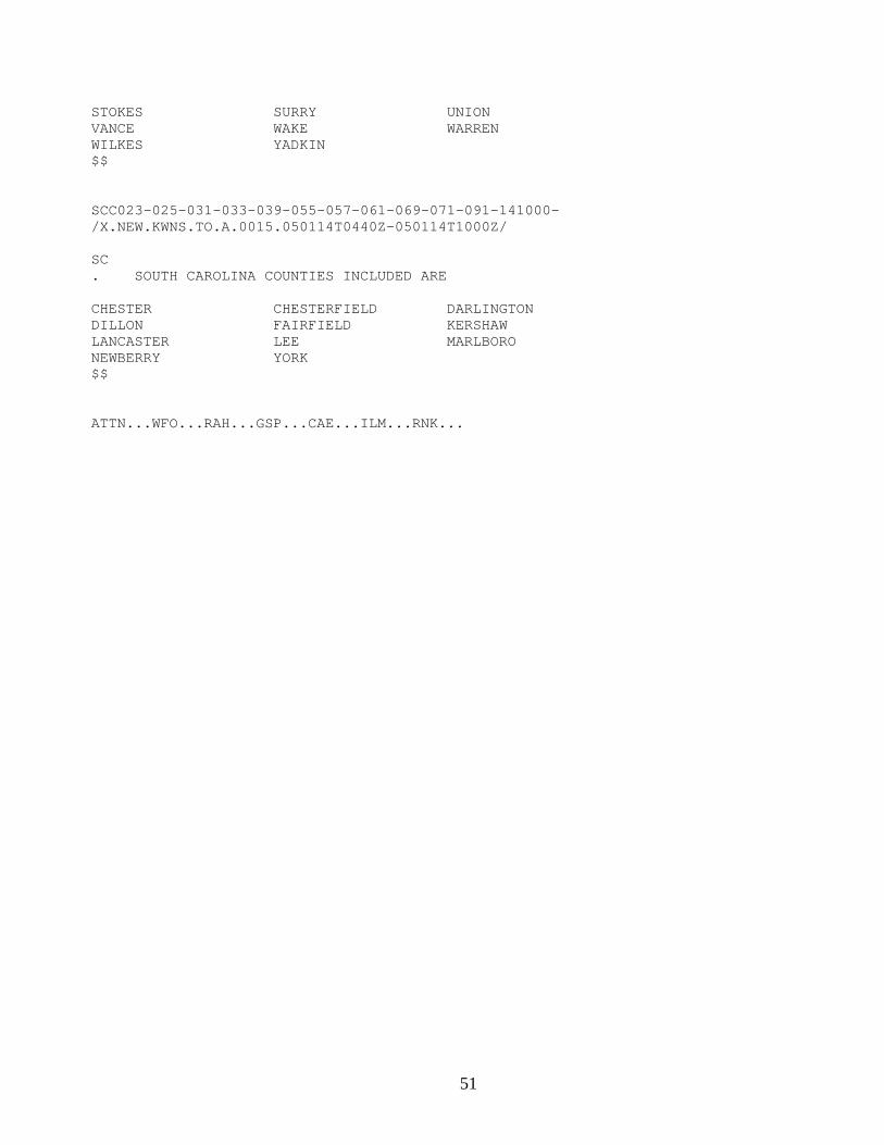
WOUS64 KWNS 140442 WOU5 BULLETIN - IMMEDIATE BROADCAST REQUESTED TORNADO WATCH OUTLINE UPDATE FOR WT 15 NWS STORM PREDICTION CENTER NORMAN OK 1140 PM EST THU JAN 13 2005 TORNADO WATCH 15 IS IN EFFECT UNTIL 500 AM EST FOR THE FOLLOWING LOCATIONS NCC001-003-007-025-033-035-037-051-057-059-063-067-069-071-077- 081-085-093-097-105-109-119-123-125-135-145-151-153-155-157-159- 165-167-169-171-179-181-183-185-193-197-141000- /X.NEW.KWNS.TO.A.0015.050114T0440Z-050114T1000Z/ NC . NORTH CAROLINA COUNTIES INCLUDED ARE ALAMANCE ALEXANDER ANSON CABARRUS CASWELL CATAWBA CHATHAM CUMBERLAND DAVIDSON DAVIE DURHAM FORSYTH FRANKLIN GASTON GRANVILLE GUILFORD HARNETT HOKE IREDELL LEE LINCOLN MECKLENBURG MONTGOMERY MOORE ORANGE PERSON RANDOLPH RICHMOND ROBESON ROCKINGHAM ROWAN SCOTLAND STANLY
51
STOKES SURRY UNION VANCE WAKE WARREN WILKES YADKIN $$ SCC023-025-031-033-039-055-057-061-069-071-091-141000- /X.NEW.KWNS.TO.A.0015.050114T0440Z-050114T1000Z/ SC . SOUTH CAROLINA COUNTIES INCLUDED ARE CHESTER CHESTERFIELD DARLINGTON DILLON FAIRFIELD KERSHAW LANCASTER LEE MARLBORO NEWBERRY YORK $$ ATTN...WFO...RAH...GSP...CAE...ILM...RNK...

52
WATCH COUNTY NOTIFICATION BISWCNFGF KFGF WWUS63 WMO Header WWUS63 KFGF DDHHMM UGC Coding NDCXXX-DDHHMM- or MNCXXX-DDHHMM- MND Heading WATCH COUNTY NOTIFICATION FOR WATCH XX Issuance Time As needed Valid Time Until the expiration time of the watch
Description The Watch County Notification (WCN) product is a new product issued by WFO Grand Forks. Once SPC issues the Watch Outline Update message (WOU), then WFO Grand Forks will issue a WCN to outline counties in our forecast area in a tornado or severe thunderstorm watch. The WCN product is also issued to cancel, extend in time, or extend in area portions of a watch.
Watch County Notification message example:
WATCH COUNTY NOTIFICATION FOR SEVERE THUNDERSTORM WATCH 145 WEATHER SERVICE EASTERN ND/GRAND FORKS 1048 AM CDT WED OCT 27 2004 MNC027-069-089-107-119-167-NDC017-035-067-077-091-097-099-271647- /T.CAN.KFGF.SV.A.9004.000000T0000Z-041027T1605Z/ THE NATIONAL WEATHER SERVICE HAS CANCELED SEVERE THUDERSTORM WATCH 145 FOR THE FOLLOWING AREAS. IN NORTHWEST MINNESOTA CLAY KITTSON MARSHALL NORMAN POLK IN WEST CENTRAL MINNESOTA WILKIN IN NORTHEAST NORTH DAKOTA GRAND FORKS PEMBINA WALSH IN SOUTHEAST NORTH DAKOTA CASS RICHLAND STEELE TRAILL $$
53
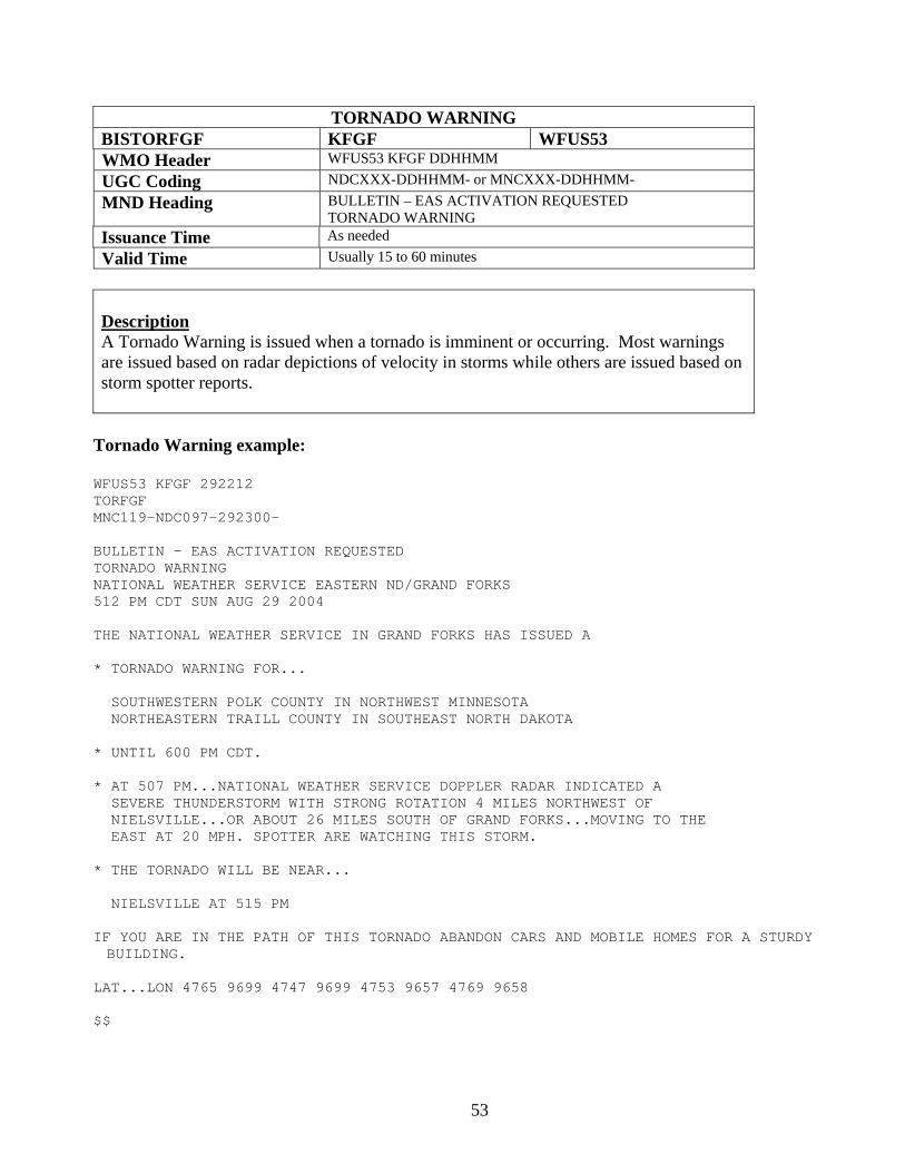
TORNADO WARNING BISTORFGF KFGF WFUS53 WMO Header WFUS53 KFGF DDHHMM UGC Coding NDCXXX-DDHHMM- or MNCXXX-DDHHMM- MND Heading BULLETIN – EAS ACTIVATION REQUESTED
TORNADO WARNING Issuance Time As needed Valid Time Usually 15 to 60 minutes
Description A Tornado Warning is issued when a tornado is imminent or occurring. Most warnings are issued based on radar depictions of velocity in storms while others are issued based on storm spotter reports.
Tornado Warning example:
WFUS53 KFGF 292212 TORFGF MNC119-NDC097-292300- BULLETIN - EAS ACTIVATION REQUESTED TORNADO WARNING NATIONAL WEATHER SERVICE EASTERN ND/GRAND FORKS 512 PM CDT SUN AUG 29 2004 THE NATIONAL WEATHER SERVICE IN GRAND FORKS HAS ISSUED A * TORNADO WARNING FOR... SOUTHWESTERN POLK COUNTY IN NORTHWEST MINNESOTA NORTHEASTERN TRAILL COUNTY IN SOUTHEAST NORTH DAKOTA * UNTIL 600 PM CDT. * AT 507 PM...NATIONAL WEATHER SERVICE DOPPLER RADAR INDICATED A SEVERE THUNDERSTORM WITH STRONG ROTATION 4 MILES NORTHWEST OF NIELSVILLE...OR ABOUT 26 MILES SOUTH OF GRAND FORKS...MOVING TO THE EAST AT 20 MPH. SPOTTER ARE WATCHING THIS STORM. * THE TORNADO WILL BE NEAR... NIELSVILLE AT 515 PM IF YOU ARE IN THE PATH OF THIS TORNADO ABANDON CARS AND MOBILE HOMES FOR A STURDY BUILDING.
LAT...LON 4765 9699 4747 9699 4753 9657 4769 9658 $$
54
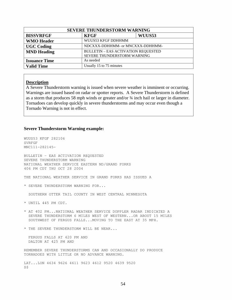
SEVERE THUNDERSTORM WARNING BISSVRFGF KFGF WUUS53 WMO Header WUUS53 KFGF DDHHMM UGC Coding NDCXXX-DDHHMM- or MNCXXX-DDHHMM- MND Heading BULLETIN – EAS ACTIVATION REQUESTED
SEVERE THUNDERSTORM WARNING Issuance Time As needed Valid Time Usually 15 to 75 minutes
Description A Severe Thunderstorm warning is issued when severe weather is imminent or occurring. Warnings are issued based on radar or spotter reports. A Severe Thunderstorm is defined as a storm that produces 58 mph winds or greater and/or ¾ inch hail or larger in diameter. Tornadoes can develop quickly in severe thunderstorms and may occur even though a Tornado Warning is not in effect.
Severe Thunderstorm Warning example:
WUUS53 KFGF 282106 SVRFGF MNC111-282145- BULLETIN - EAS ACTIVATION REQUESTED SEVERE THUNDERSTORM WARNING NATIONAL WEATHER SERVICE EASTERN ND/GRAND FORKS 406 PM CDT THU OCT 28 2004 THE NATIONAL WEATHER SERVICE IN GRAND FORKS HAS ISSUED A * SEVERE THUNDERSTORM WARNING FOR... SOUTHERN OTTER TAIL COUNTY IN WEST CENTRAL MINNESOTA * UNTIL 445 PM CDT. * AT 402 PM...NATIONAL WEATHER SERVICE DOPPLER RADAR INDICATED A SEVERE THUNDERSTORM 6 MILES WEST OF WESTERN...OR ABOUT 15 MILES SOUTHWEST OF FERGUS FALLS...MOVING TO THE EAST AT 35 MPH. * THE SEVERE THUNDERSTORM WILL BE NEAR... FERGUS FALLS AT 420 PM AND DALTON AT 425 PM AND REMEMBER SEVERE THUNDERSTORMS CAN AND OCCASIONALLY DO PRODUCE TORNADOES WITH LITTLE OR NO ADVANCE WARNING. LAT...LON 4634 9626 4611 9623 4612 9520 4639 9520 $$
55
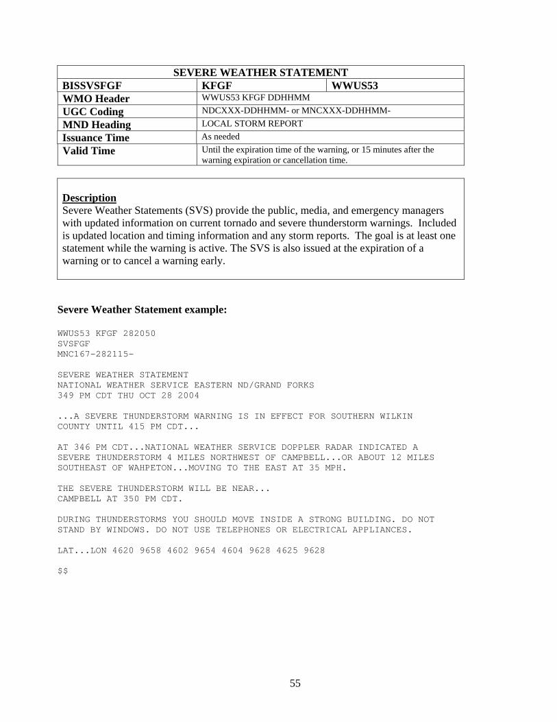
SEVERE WEATHER STATEMENT BISSVSFGF KFGF WWUS53 WMO Header WWUS53 KFGF DDHHMM UGC Coding NDCXXX-DDHHMM- or MNCXXX-DDHHMM- MND Heading LOCAL STORM REPORT Issuance Time As needed Valid Time Until the expiration time of the warning, or 15 minutes after the
warning expiration or cancellation time.
Description Severe Weather Statements (SVS) provide the public, media, and emergency managers with updated information on current tornado and severe thunderstorm warnings. Included is updated location and timing information and any storm reports. The goal is at least one statement while the warning is active. The SVS is also issued at the expiration of a warning or to cancel a warning early.
Severe Weather Statement example:
WWUS53 KFGF 282050 SVSFGF MNC167-282115- SEVERE WEATHER STATEMENT NATIONAL WEATHER SERVICE EASTERN ND/GRAND FORKS 349 PM CDT THU OCT 28 2004 ...A SEVERE THUNDERSTORM WARNING IS IN EFFECT FOR SOUTHERN WILKIN COUNTY UNTIL 415 PM CDT... AT 346 PM CDT...NATIONAL WEATHER SERVICE DOPPLER RADAR INDICATED A SEVERE THUNDERSTORM 4 MILES NORTHWEST OF CAMPBELL...OR ABOUT 12 MILES SOUTHEAST OF WAHPETON...MOVING TO THE EAST AT 35 MPH. THE SEVERE THUNDERSTORM WILL BE NEAR... CAMPBELL AT 350 PM CDT. DURING THUNDERSTORMS YOU SHOULD MOVE INSIDE A STRONG BUILDING. DO NOT STAND BY WINDOWS. DO NOT USE TELEPHONES OR ELECTRICAL APPLIANCES. LAT...LON 4620 9658 4602 9654 4604 9628 4625 9628 $$
56
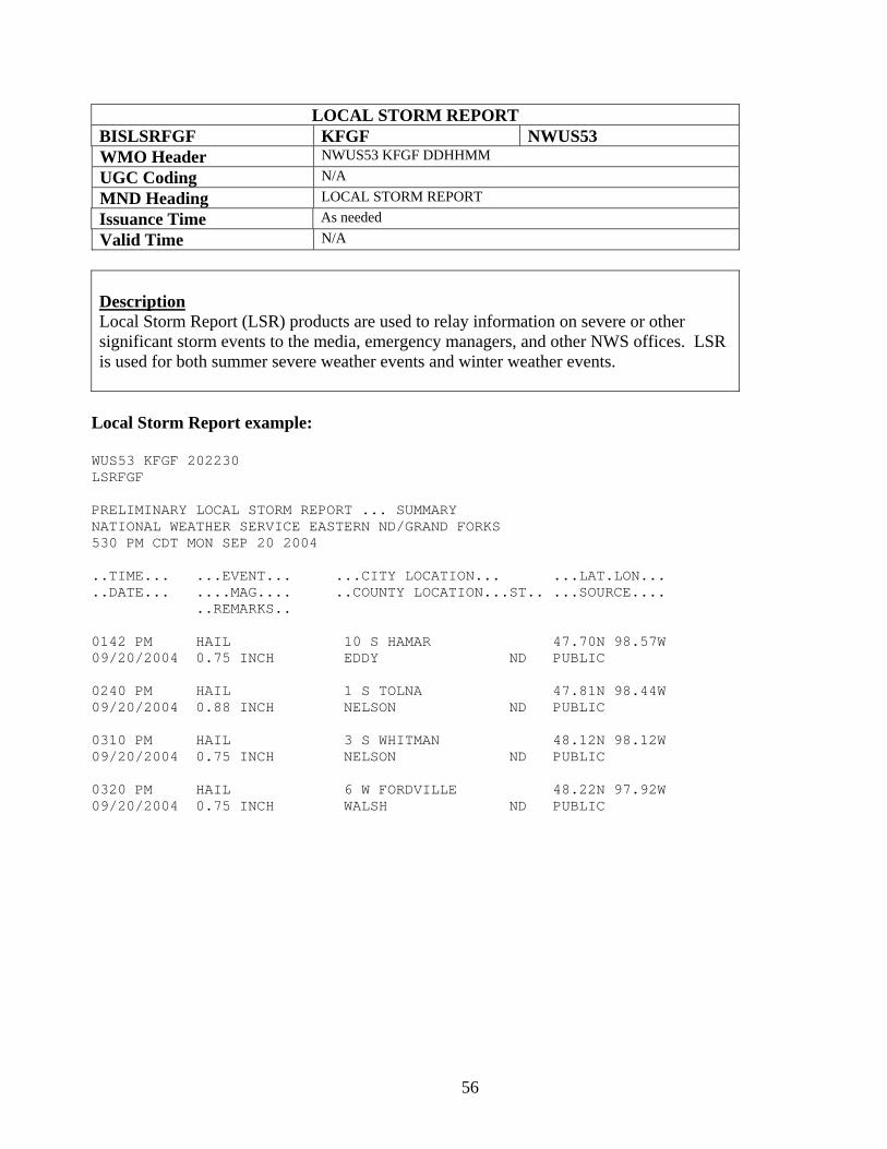
LOCAL STORM REPORT BISLSRFGF KFGF NWUS53 WMO Header NWUS53 KFGF DDHHMM UGC Coding N/A MND Heading LOCAL STORM REPORT Issuance Time As needed Valid Time N/A
Description Local Storm Report (LSR) products are used to relay information on severe or other significant storm events to the media, emergency managers, and other NWS offices. LSR is used for both summer severe weather events and winter weather events.
Local Storm Report example:
WUS53 KFGF 202230 LSRFGF PRELIMINARY LOCAL STORM REPORT ... SUMMARY NATIONAL WEATHER SERVICE EASTERN ND/GRAND FORKS 530 PM CDT MON SEP 20 2004 ..TIME... ...EVENT... ...CITY LOCATION... ...LAT.LON... ..DATE... ....MAG.... ..COUNTY LOCATION...ST.. ...SOURCE.... ..REMARKS.. 0142 PM HAIL 10 S HAMAR 47.70N 98.57W 09/20/2004 0.75 INCH EDDY ND PUBLIC 0240 PM HAIL 1 S TOLNA 47.81N 98.44W 09/20/2004 0.88 INCH NELSON ND PUBLIC 0310 PM HAIL 3 S WHITMAN 48.12N 98.12W 09/20/2004 0.75 INCH NELSON ND PUBLIC 0320 PM HAIL 6 W FORDVILLE 48.22N 97.92W 09/20/2004 0.75 INCH WALSH ND PUBLIC
57
Eastern North Dakota and Northwestern Minnesota NWS Product and Services Guide
Winter Storm Products Winter Storm Watch Winter Storm Warning Blizzard Warning Heavy Snow Warning Ice Storm Warning Winter Weather Advisory Snow Advisory Freezing Rain Advisory Blowing Snow Advisory
58
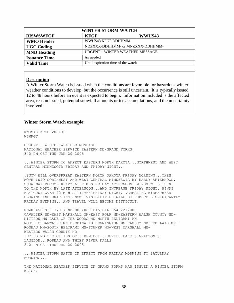
WINTER STORM WATCH BISWSWFGF KFGF WWUS43 WMO Header WWUS43 KFGF DDHHMM UGC Coding NDZXXX-DDHHMM- or MNZXXX-DDHHMM- MND Heading URGENT – WINTER WEATHER MESSAGE Issuance Time As needed Valid Time Until expiration time of the watch
Description A Winter Storm Watch is issued when the conditions are favorable for hazardous winter weather conditions to develop, but the occurrence is still uncertain. It is typically issued 12 to 48 hours before an event is expected to begin. Information included is the affected area, reason issued, potential snowfall amounts or ice accumulations, and the uncertainty involved.
Winter Storm Watch example:
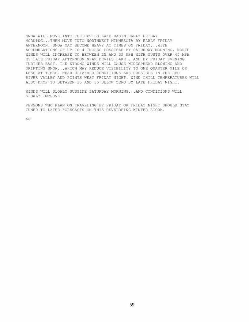
WWUS43 KFGF 202138 WSWFGF URGENT - WINTER WEATHER MESSAGE NATIONAL WEATHER SERVICE EASTERN ND/GRAND FORKS 340 PM CST THU JAN 20 2005 ...WINTER STORM TO AFFECT EASTERN NORTH DAKOTA...NORTHWEST AND WEST CENTRAL MINNESOTA FRIDAY AND FRIDAY NIGHT... .SNOW WILL OVERSPREAD EASTERN NORTH DAKOTA FRIDAY MORNING...THEN MOVE INTO NORTHWEST AND WEST CENTRAL MINNESOTA BY EARLY AFTERNOON. SNOW MAY BECOME HEAVY AT TIMES FRIDAY AFTERNOON. WINDS WILL TURN TO THE NORTH BY LATE AFTERNOON...AND INCREASE FRIDAY NIGHT. WINDS MAY GUST OVER 40 MPH AT TIMES FRIDAY NIGHT...CREATING WIDESPREAD BLOWING AND DRIFTING SNOW. VISIBILITIES WILL BE REDUCE SIGNIFICANTLY FRIDAY EVENING...AND TRAVEL WILL BECOME DIFFICULT. MNZ004>009-013>017-NDZ006>008-015-016-054-221200- CAVALIER ND-EAST MARSHALL MN-EAST POLK MN-EASTERN WALSH COUNTY ND- KITTSON MN-LAKE OF THE WOODS MN-NORTH BELTRAMI MN- NORTH CLEARWATER MN-PEMBINA ND-PENNINGTON MN-RAMSEY ND-RED LAKE MN- ROSEAU MN-SOUTH BELTRAMI MN-TOWNER ND-WEST MARSHALL MN- WESTERN WALSH COUNTY ND- INCLUDING THE CITIES OF...BEMIDJI...DEVILS LAKE...GRAFTON... LANGDON...ROSEAU AND THIEF RIVER FALLS 340 PM CST THU JAN 20 2005 ...WINTER STORM WATCH IN EFFECT FROM FRIDAY MORNING TO SATURDAY MORNING... THE NATIONAL WEATHER SERVICE IN GRAND FORKS HAS ISSUED A WINTER STORM WATCH.
59
SNOW WILL MOVE INTO THE DEVILS LAKE BASIN EARLY FRIDAY MORNING...THEN MOVE INTO NORTHWEST MINNESOTA BY EARLY FRIDAY AFTERNOON. SNOW MAY BECOME HEAVY AT TIMES ON FRIDAY...WITH ACCUMULATIONS OF UP TO 4 INCHES POSSIBLE BY SATURDAY MORNING. NORTH WINDS WILL INCREASE TO BETWEEN 25 AND 35 MPH WITH GUSTS OVER 40 MPH BY LATE FRIDAY AFTERNOON NEAR DEVILS LAKE...AND BY FRIDAY EVENING FURTHER EAST. THE STRONG WINDS WILL CAUSE WIDESPREAD BLOWING AND DRIFTING SNOW...WHICH MAY REDUCE VISIBILITY TO ONE QUARTER MILE OR LESS AT TIMES. NEAR BLIZZARD CONDITIONS ARE POSSIBLE IN THE RED RIVER VALLEY AND POINTS WEST FRIDAY NIGHT. WIND CHILL TEMPERATURES WILL ALSO DROP TO BETWEEN 25 AND 35 BELOW ZERO BY LATE FRIDAY NIGHT. WINDS WILL SLOWLY SUBSIDE SATURDAY MORNING...AND CONDITIONS WILL SLOWLY IMPROVE. PERSONS WHO PLAN ON TRAVELING BY FRIDAY OR FRIDAY NIGHT SHOULD STAY TUNED TO LATER FORECASTS ON THIS DEVELOPING WINTER STORM. $$
60
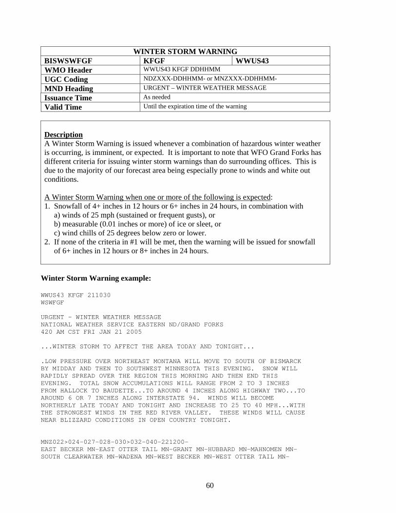
WINTER STORM WARNING BISWSWFGF KFGF WWUS43 WMO Header WWUS43 KFGF DDHHMM UGC Coding NDZXXX-DDHHMM- or MNZXXX-DDHHMM- MND Heading URGENT – WINTER WEATHER MESSAGE Issuance Time As needed Valid Time Until the expiration time of the warning
Description A Winter Storm Warning is issued whenever a combination of hazardous winter weather is occurring, is imminent, or expected. It is important to note that WFO Grand Forks has different criteria for issuing winter storm warnings than do surrounding offices. This is due to the majority of our forecast area being especially prone to winds and white out conditions. A Winter Storm Warning when one or more of the following is expected: 1. Snowfall of 4+ inches in 12 hours or 6+ inches in 24 hours, in combination with a) winds of 25 mph (sustained or frequent gusts), or b) measurable (0.01 inches or more) of ice or sleet, or c) wind chills of 25 degrees below zero or lower. 2. If none of the criteria in #1 will be met, then the warning will be issued for snowfall of 6+ inches in 12 hours or 8+ inches in 24 hours.
Winter Storm Warning example:
WWUS43 KFGF 211030 WSWFGF URGENT - WINTER WEATHER MESSAGE NATIONAL WEATHER SERVICE EASTERN ND/GRAND FORKS 420 AM CST FRI JAN 21 2005 ...WINTER STORM TO AFFECT THE AREA TODAY AND TONIGHT... .LOW PRESSURE OVER NORTHEAST MONTANA WILL MOVE TO SOUTH OF BISMARCK BY MIDDAY AND THEN TO SOUTHWEST MINNESOTA THIS EVENING. SNOW WILL RAPIDLY SPREAD OVER THE REGION THIS MORNING AND THEN END THIS EVENING. TOTAL SNOW ACCUMULATIONS WILL RANGE FROM 2 TO 3 INCHES FROM HALLOCK TO BAUDETTE...TO AROUND 4 INCHES ALONG HIGHWAY TWO...TO AROUND 6 OR 7 INCHES ALONG INTERSTATE 94. WINDS WILL BECOME NORTHERLY LATE TODAY AND TONIGHT AND INCREASE TO 25 TO 40 MPH...WITH THE STRONGEST WINDS IN THE RED RIVER VALLEY. THESE WINDS WILL CAUSE NEAR BLIZZARD CONDITIONS IN OPEN COUNTRY TONIGHT. MNZ022>024-027-028-030>032-040-221200- EAST BECKER MN-EAST OTTER TAIL MN-GRANT MN-HUBBARD MN-MAHNOMEN MN- SOUTH CLEARWATER MN-WADENA MN-WEST BECKER MN-WEST OTTER TAIL MN-
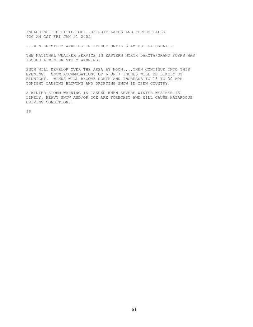
61
INCLUDING THE CITIES OF...DETROIT LAKES AND FERGUS FALLS 420 AM CST FRI JAN 21 2005 ...WINTER STORM WARNING IN EFFECT UNTIL 6 AM CST SATURDAY... THE NATIONAL WEATHER SERVICE IN EASTERN NORTH DAKOTA/GRAND FORKS HAS ISSUED A WINTER STORM WARNING. SNOW WILL DEVELOP OVER THE AREA BY NOON....THEN CONTINUE INTO THIS EVENING. SNOW ACCUMULATIONS OF 6 OR 7 INCHES WILL BE LIKELY BY MIDNIGHT. WINDS WILL BECOME NORTH AND INCREASE TO 15 TO 30 MPH TONIGHT CAUSING BLOWING AND DRIFTING SNOW IN OPEN COUNTRY. A WINTER STORM WARNING IS ISSUED WHEN SEVERE WINTER WEATHER IS LIKELY. HEAVY SNOW AND/OR ICE ARE FORECAST AND WILL CAUSE HAZARDOUS DRIVING CONDITIONS. $$
62
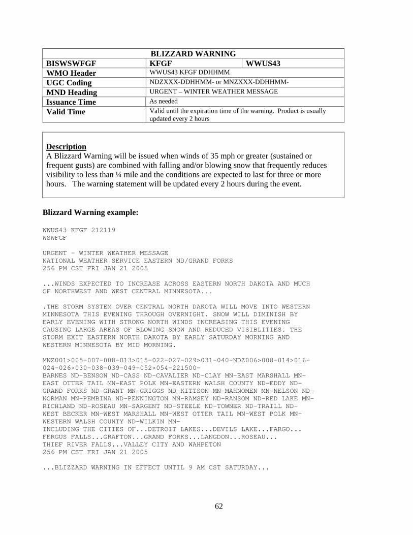
BLIZZARD WARNING BISWSWFGF KFGF WWUS43 WMO Header WWUS43 KFGF DDHHMM UGC Coding NDZXXX-DDHHMM- or MNZXXX-DDHHMM- MND Heading URGENT – WINTER WEATHER MESSAGE Issuance Time As needed Valid Time Valid until the expiration time of the warning. Product is usually
updated every 2 hours
Description A Blizzard Warning will be issued when winds of 35 mph or greater (sustained or frequent gusts) are combined with falling and/or blowing snow that frequently reduces visibility to less than ¼ mile and the conditions are expected to last for three or more hours. The warning statement will be updated every 2 hours during the event.
Blizzard Warning example:
WWUS43 KFGF 212119 WSWFGF URGENT - WINTER WEATHER MESSAGE NATIONAL WEATHER SERVICE EASTERN ND/GRAND FORKS 256 PM CST FRI JAN 21 2005 ...WINDS EXPECTED TO INCREASE ACROSS EASTERN NORTH DAKOTA AND MUCH OF NORTHWEST AND WEST CENTRAL MINNESOTA... .THE STORM SYSTEM OVER CENTRAL NORTH DAKOTA WILL MOVE INTO WESTERN MINNESOTA THIS EVENING THROUGH OVERNIGHT. SNOW WILL DIMINISH BY EARLY EVENING WITH STRONG NORTH WINDS INCREASING THIS EVENING CAUSING LARGE AREAS OF BLOWING SNOW AND REDUCED VISIBLITIES. THE STORM EXIT EASTERN NORTH DAKOTA BY EARLY SATURDAY MORNING AND WESTERN MINNESOTA BY MID MORNING. MNZ001>005-007-008-013>015-022-027-029>031-040-NDZ006>008-014>016- 024-026>030-038-039-049-052>054-221500- BARNES ND-BENSON ND-CASS ND-CAVALIER ND-CLAY MN-EAST MARSHALL MN- EAST OTTER TAIL MN-EAST POLK MN-EASTERN WALSH COUNTY ND-EDDY ND- GRAND FORKS ND-GRANT MN-GRIGGS ND-KITTSON MN-MAHNOMEN MN-NELSON ND- NORMAN MN-PEMBINA ND-PENNINGTON MN-RAMSEY ND-RANSOM ND-RED LAKE MN- RICHLAND ND-ROSEAU MN-SARGENT ND-STEELE ND-TOWNER ND-TRAILL ND- WEST BECKER MN-WEST MARSHALL MN-WEST OTTER TAIL MN-WEST POLK MN- WESTERN WALSH COUNTY ND-WILKIN MN- INCLUDING THE CITIES OF...DETROIT LAKES...DEVILS LAKE...FARGO... FERGUS FALLS...GRAFTON...GRAND FORKS...LANGDON...ROSEAU... THIEF RIVER FALLS...VALLEY CITY AND WAHPETON 256 PM CST FRI JAN 21 2005 ...BLIZZARD WARNING IN EFFECT UNTIL 9 AM CST SATURDAY...

63
THE NATIONAL WEATHER SERVICE IN EASTERN NORTH DAKOTA/GRAND FORKS HAS ISSUED A BLIZZARD WARNING. EXPECT NORTH WINDS TO INCREASE TO 30 MPH WITH GUST TO 45 MPH. VISIBLITITES WILL BE REDUCED TO NEAR ZERO AT TIMES IN LIGHT SNOW AND BLOWING SNOW. VENTURING OUTDOORS IN A BLIZZARD CAN BE LIFE THREATENING. AVOID THE RISK AND STAY AT HOME. $$

64
HEAVY SNOW WARNING BISWSWFGF KFGF WWUS43 WMO Header WWUS43 KFGF DDHHMM UGC Coding NDZXXX-DDHHMM- or MNZXXX-DDHHMM- MND Heading URGENT – WINTER WEATHER MESSAGE Issuance Time As needed Valid Time Until the expiration time of the warning
Description A Heavy Snow Warning is issued when snowfall of 6+ inches in 12 hours or 8+ inches in 24 hours is expected without significant winds (less than 25 mph). If strong winds are expected, then a winter storm or blizzard warning will be issued.
Heavy Snow Warning example:
WWUS43 KFGF 211030 WSWFGF URGENT - WINTER WEATHER MESSAGE NATIONAL WEATHER SERVICE EASTERN ND/GRAND FORKS 420 AM CST FRI JAN 21 2005 ...WINTER STORM TO AFFECT THE AREA TODAY AND TONIGHT... .LOW PRESSURE WILL BRING HEAVY SNOW TO AREA TODAY AND TONIGHT WITH TOTAL SNOWFALL OF 8 TO 14 INCHES BY SATURDAY MORNING. WINDS WILL REMAIN LIGHT DURING THE EVENT, SO WIDESPREAD BLOWING SNOW IS NOT ANTICIPATED.
MNZ022>024-027-028-030>032-040-221200- EAST BECKER MN-EAST OTTER TAIL MN-GRANT MN-HUBBARD MN-MAHNOMEN MN- SOUTH CLEARWATER MN-WADENA MN-WEST BECKER MN-WEST OTTER TAIL MN- INCLUDING THE CITIES OF...DETROIT LAKES AND FERGUS FALLS 420 AM CST FRI JAN 21 2005 ...HEAVY SNOW WARNING IN EFFECT UNTIL 6 AM CST SATURDAY... THE NATIONAL WEATHER SERVICE IN EASTERN NORTH DAKOTA/GRAND FORKS HAS ISSUED A WINTER STORM WARNING. SNOW WILL DEVELOP OVER THE AREA BY NOON....THEN CONTINUE INTO TONIGHT. SNOW ACCUMULATIONS OF 10 TO 14 INCHES WILL OCCUR BY SATURDAY MORNING.
WINDS WILL BE LIGHT DURING THE EVENT SO BLOWING SNOW IS NOT EXPECTED. A HEAVY SNOW WARNING IS ISSUED WHEN SEVERE WINTER WEATHER IS LIKELY. HEAVY SNOW IS FORECAST AND WILL CAUSE HAZARDOUS DRIVING CONDITIONS. $$
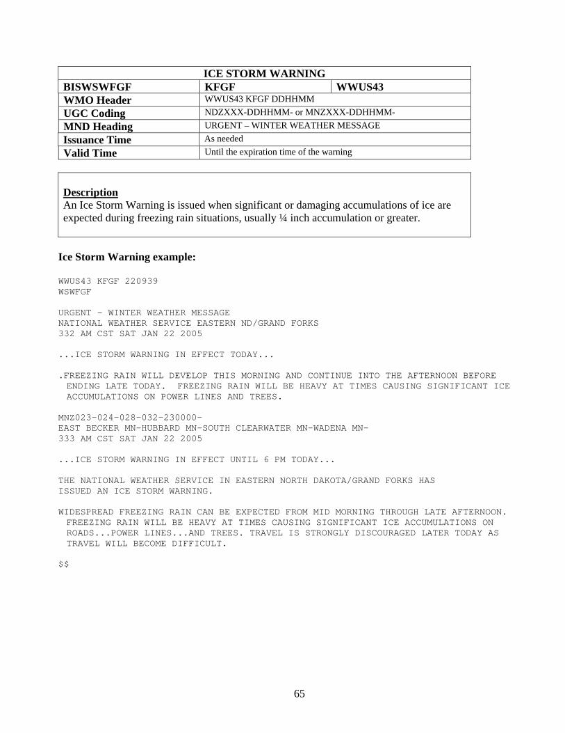
65
ICE STORM WARNING BISWSWFGF KFGF WWUS43 WMO Header WWUS43 KFGF DDHHMM UGC Coding NDZXXX-DDHHMM- or MNZXXX-DDHHMM- MND Heading URGENT – WINTER WEATHER MESSAGE Issuance Time As needed Valid Time Until the expiration time of the warning
Description An Ice Storm Warning is issued when significant or damaging accumulations of ice are expected during freezing rain situations, usually ¼ inch accumulation or greater.
Ice Storm Warning example:
WWUS43 KFGF 220939 WSWFGF URGENT - WINTER WEATHER MESSAGE NATIONAL WEATHER SERVICE EASTERN ND/GRAND FORKS 332 AM CST SAT JAN 22 2005 ...ICE STORM WARNING IN EFFECT TODAY... .FREEZING RAIN WILL DEVELOP THIS MORNING AND CONTINUE INTO THE AFTERNOON BEFORE ENDING LATE TODAY. FREEZING RAIN WILL BE HEAVY AT TIMES CAUSING SIGNIFICANT ICE ACCUMULATIONS ON POWER LINES AND TREES.
MNZ023-024-028-032-230000- EAST BECKER MN-HUBBARD MN-SOUTH CLEARWATER MN-WADENA MN- 333 AM CST SAT JAN 22 2005 ...ICE STORM WARNING IN EFFECT UNTIL 6 PM TODAY... THE NATIONAL WEATHER SERVICE IN EASTERN NORTH DAKOTA/GRAND FORKS HAS ISSUED AN ICE STORM WARNING. WIDESPREAD FREEZING RAIN CAN BE EXPECTED FROM MID MORNING THROUGH LATE AFTERNOON. FREEZING RAIN WILL BE HEAVY AT TIMES CAUSING SIGNIFICANT ICE ACCUMULATIONS ON ROADS...POWER LINES...AND TREES. TRAVEL IS STRONGLY DISCOURAGED LATER TODAY AS TRAVEL WILL BECOME DIFFICULT.
$$
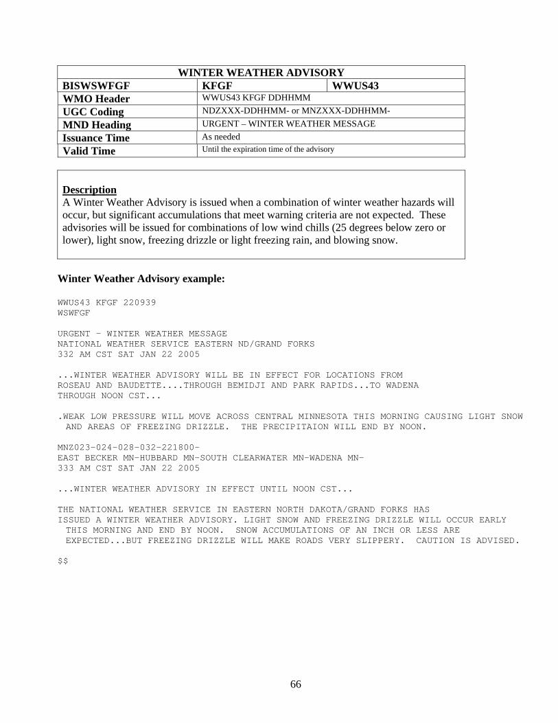
66
WINTER WEATHER ADVISORY BISWSWFGF KFGF WWUS43 WMO Header WWUS43 KFGF DDHHMM UGC Coding NDZXXX-DDHHMM- or MNZXXX-DDHHMM- MND Heading URGENT – WINTER WEATHER MESSAGE Issuance Time As needed Valid Time Until the expiration time of the advisory
Description A Winter Weather Advisory is issued when a combination of winter weather hazards will occur, but significant accumulations that meet warning criteria are not expected. These advisories will be issued for combinations of low wind chills (25 degrees below zero or lower), light snow, freezing drizzle or light freezing rain, and blowing snow.
Winter Weather Advisory example:
WWUS43 KFGF 220939 WSWFGF URGENT - WINTER WEATHER MESSAGE NATIONAL WEATHER SERVICE EASTERN ND/GRAND FORKS 332 AM CST SAT JAN 22 2005 ...WINTER WEATHER ADVISORY WILL BE IN EFFECT FOR LOCATIONS FROM ROSEAU AND BAUDETTE....THROUGH BEMIDJI AND PARK RAPIDS...TO WADENA THROUGH NOON CST... .WEAK LOW PRESSURE WILL MOVE ACROSS CENTRAL MINNESOTA THIS MORNING CAUSING LIGHT SNOW AND AREAS OF FREEZING DRIZZLE. THE PRECIPITAION WILL END BY NOON.
MNZ023-024-028-032-221800- EAST BECKER MN-HUBBARD MN-SOUTH CLEARWATER MN-WADENA MN- 333 AM CST SAT JAN 22 2005 ...WINTER WEATHER ADVISORY IN EFFECT UNTIL NOON CST... THE NATIONAL WEATHER SERVICE IN EASTERN NORTH DAKOTA/GRAND FORKS HAS ISSUED A WINTER WEATHER ADVISORY. LIGHT SNOW AND FREEZING DRIZZLE WILL OCCUR EARLY THIS MORNING AND END BY NOON. SNOW ACCUMULATIONS OF AN INCH OR LESS ARE EXPECTED...BUT FREEZING DRIZZLE WILL MAKE ROADS VERY SLIPPERY. CAUTION IS ADVISED.
$$
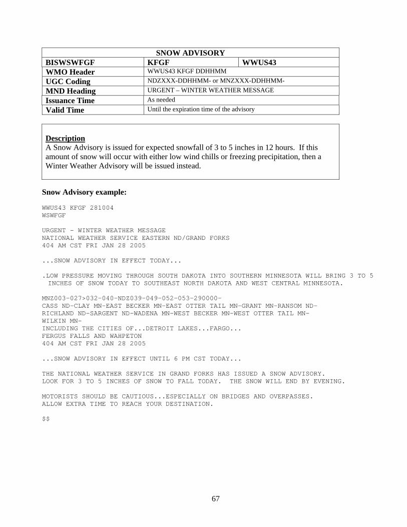
67
SNOW ADVISORY BISWSWFGF KFGF WWUS43 WMO Header WWUS43 KFGF DDHHMM UGC Coding NDZXXX-DDHHMM- or MNZXXX-DDHHMM- MND Heading URGENT – WINTER WEATHER MESSAGE Issuance Time As needed Valid Time Until the expiration time of the advisory
Description A Snow Advisory is issued for expected snowfall of 3 to 5 inches in 12 hours. If this amount of snow will occur with either low wind chills or freezing precipitation, then a Winter Weather Advisory will be issued instead.
Snow Advisory example: WWUS43 KFGF 281004 WSWFGF URGENT - WINTER WEATHER MESSAGE NATIONAL WEATHER SERVICE EASTERN ND/GRAND FORKS 404 AM CST FRI JAN 28 2005 ...SNOW ADVISORY IN EFFECT TODAY... .LOW PRESSURE MOVING THROUGH SOUTH DAKOTA INTO SOUTHERN MINNESOTA WILL BRING 3 TO 5 INCHES OF SNOW TODAY TO SOUTHEAST NORTH DAKOTA AND WEST CENTRAL MINNESOTA.
MNZ003-027>032-040-NDZ039-049-052-053-290000- CASS ND-CLAY MN-EAST BECKER MN-EAST OTTER TAIL MN-GRANT MN-RANSOM ND- RICHLAND ND-SARGENT ND-WADENA MN-WEST BECKER MN-WEST OTTER TAIL MN- WILKIN MN- INCLUDING THE CITIES OF...DETROIT LAKES...FARGO... FERGUS FALLS AND WAHPETON 404 AM CST FRI JAN 28 2005 ...SNOW ADVISORY IN EFFECT UNTIL 6 PM CST TODAY... THE NATIONAL WEATHER SERVICE IN GRAND FORKS HAS ISSUED A SNOW ADVISORY. LOOK FOR 3 TO 5 INCHES OF SNOW TO FALL TODAY. THE SNOW WILL END BY EVENING. MOTORISTS SHOULD BE CAUTIOUS...ESPECIALLY ON BRIDGES AND OVERPASSES. ALLOW EXTRA TIME TO REACH YOUR DESTINATION. $$
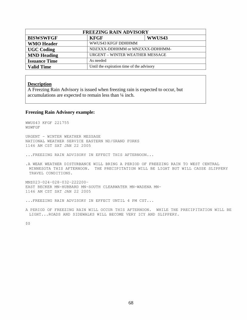
68
FREEZING RAIN ADVISORY BISWSWFGF KFGF WWUS43 WMO Header WWUS43 KFGF DDHHMM UGC Coding NDZXXX-DDHHMM or MNZXXX-DDHHMM- MND Heading URGENT – WINTER WEATHER MESSAGE Issuance Time As needed Valid Time Until the expiration time of the advisory
Description A Freezing Rain Advisory is issued when freezing rain is expected to occur, but accumulations are expected to remain less than ¼ inch.
Freezing Rain Advisory example:
WWUS43 KFGF 221755 WSWFGF URGENT - WINTER WEATHER MESSAGE NATIONAL WEATHER SERVICE EASTERN ND/GRAND FORKS 1146 AM CST SAT JAN 22 2005 ...FREEZING RAIN ADVISORY IN EFFECT THIS AFTERNOON... .A WEAK WEATHER DISTURBANCE WILL BRING A PERIOD OF FREEZING RAIN TO WEST CENTRAL MINNESOTA THIS AFTERNOON. THE PRECIPITATION WILL BE LIGHT BUT WILL CAUSE SLIPPERY TRAVEL CONDITIONS.
MNZ023-024-028-032-222200- EAST BECKER MN-HUBBARD MN-SOUTH CLEARWATER MN-WADENA MN- 1146 AM CST SAT JAN 22 2005 ...FREEZING RAIN ADVISORY IN EFFECT UNTIL 4 PM CST... A PERIOD OF FREEZING RAIN WILL OCCUR THIS AFTERNOON. WHILE THE PRECIPITATION WILL BE LIGHT...ROADS AND SIDEWALKS WILL BECOME VERY ICY AND SLIPPERY.
$$
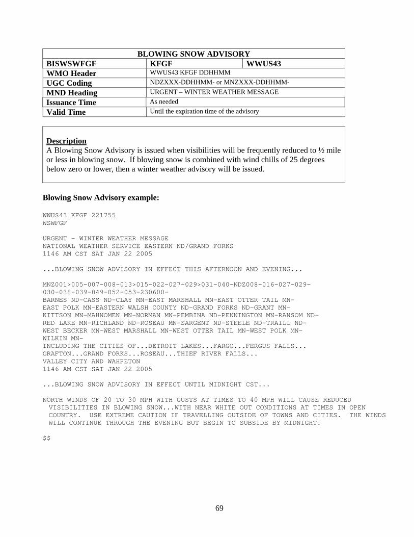
69
BLOWING SNOW ADVISORY BISWSWFGF KFGF WWUS43 WMO Header WWUS43 KFGF DDHHMM UGC Coding NDZXXX-DDHHMM- or MNZXXX-DDHHMM- MND Heading URGENT – WINTER WEATHER MESSAGE Issuance Time As needed Valid Time Until the expiration time of the advisory
Description A Blowing Snow Advisory is issued when visibilities will be frequently reduced to ½ mile or less in blowing snow. If blowing snow is combined with wind chills of 25 degrees below zero or lower, then a winter weather advisory will be issued.
Blowing Snow Advisory example:
WWUS43 KFGF 221755 WSWFGF URGENT - WINTER WEATHER MESSAGE NATIONAL WEATHER SERVICE EASTERN ND/GRAND FORKS 1146 AM CST SAT JAN 22 2005 ...BLOWING SNOW ADVISORY IN EFFECT THIS AFTERNOON AND EVENING... MNZ001>005-007-008-013>015-022-027-029>031-040-NDZ008-016-027-029- 030-038-039-049-052-053-230600- BARNES ND-CASS ND-CLAY MN-EAST MARSHALL MN-EAST OTTER TAIL MN- EAST POLK MN-EASTERN WALSH COUNTY ND-GRAND FORKS ND-GRANT MN- KITTSON MN-MAHNOMEN MN-NORMAN MN-PEMBINA ND-PENNINGTON MN-RANSOM ND- RED LAKE MN-RICHLAND ND-ROSEAU MN-SARGENT ND-STEELE ND-TRAILL ND- WEST BECKER MN-WEST MARSHALL MN-WEST OTTER TAIL MN-WEST POLK MN- WILKIN MN- INCLUDING THE CITIES OF...DETROIT LAKES...FARGO...FERGUS FALLS... GRAFTON...GRAND FORKS...ROSEAU...THIEF RIVER FALLS... VALLEY CITY AND WAHPETON 1146 AM CST SAT JAN 22 2005 ...BLOWING SNOW ADVISORY IN EFFECT UNTIL MIDNIGHT CST... NORTH WINDS OF 20 TO 30 MPH WITH GUSTS AT TIMES TO 40 MPH WILL CAUSE REDUCED VISIBILITIES IN BLOWING SNOW...WITH NEAR WHITE OUT CONDITIONS AT TIMES IN OPEN COUNTRY. USE EXTREME CAUTION IF TRAVELLING OUTSIDE OF TOWNS AND CITIES. THE WINDS WILL CONTINUE THROUGH THE EVENING BUT BEGIN TO SUBSIDE BY MIDNIGHT.
$$
70
Eastern North Dakota and Northwestern Minnesota NWS Product and Services Guide
Products Relating to Heat, Cold and Wind Heat Advisory Frost Advisory Freeze Warning Wind Chill Advisory Wind Chill Warning Wind Advisory High Wind Watch High Wind Warning
71
HEAT ADVISORY BISNPWFGF KFGF WWUS73 WMO Header WWUS73 KFGF DDHHMM UGC Coding NDZXXX-DDHHMM- or MNZXXX-DDHHMM- MND Heading URGENT – WEATHER MESSAGE Issuance Time As needed Valid Time Until the expiration time of the advisory
Description The Excessive Heat Advisory is issued if the daytime heat index of 105 to 115 degrees F for 3 hours may significantly impact public safety.
Heat Advisory Example:
URGENT - WEATHER MESSAGE NATIONAL WEATHER SERVICE EASTERN ND/GRAND FORKS 400 AM CST TUE JUL 28 2004 ...SULTRY WEATHER IS EXPECTED ACROSS THE AREA TODAY... .STAGNANT HIGH PRESSURE ALONG WITH VERY HIGH MOISTURE CONTENT IN THE AIR WILL HELP HEAT INDEX VALUES RISE TO AROUND 110 DEGREES BY AFTERNOON. A COLD FRONT WILL PASS THROUGH THE REGION LATE TONIGHT...AND COOL TEMPERATURES INTO THE 70S TOMORROW. MNZ001>009-013>017-022>024-027>032-040-NDZ008-016-027-029-030-039- 053-290400- CASS ND-CLAY MN-EAST BECKER MN-EAST MARSHALL MN-EAST OTTER TAIL MN- EAST POLK MN-EASTERN WALSH COUNTY ND-GRAND FORKS ND-GRANT MN- HUBBARD MN-KITTSON MN-LAKE OF THE WOODS MN-MAHNOMEN MN-NORMAN MN- NORTH BELTRAMI MN-NORTH CLEARWATER MN-PEMBINA ND-PENNINGTON MN- RED LAKE MN-RICHLAND ND-ROSEAU MN-SOUTH BELTRAMI MN- SOUTH CLEARWATER MN-STEELE ND-TRAILL ND-WADENA MN-WEST BECKER MN- WEST MARSHALL MN-WEST OTTER TAIL MN-WEST POLK MN-WILKIN MN- INCLUDING THE CITIES OF...GRAFTON...WAHPETON...GRAND FORKS...FARGO... THIEF RIVER FALLS...ROSEAU...FERGUS FALLS...DETROIT LAKES AND BEMIDJI 630 PM CST TUE JAN 18 2004
...HEAT ADVISORY IN EFFECT TODAY... TEMPERATURES BY NOON WILL APPROACH 95 THIS AFTERNOON. THE TEMPERATURE COUPLED WITH HIGH HUMIDITY WILL PRODUCE A HEAT INDEX NEAR 110 THIS AFTERNOON. A COLD FRONT WILL PASS THROUGH THE REGION LATE TONIGHT...PRODUCING SOME THUNDERSTORMS AND MUCH COOLER WEATHER FOR TOMORROW. $$
72
FROST ADVISORY BISNPWFGF KFGF WWUS73 WMO Header WWUS73 KFGF DDHHMM UGC Coding NDZXXX-DDHHMM- or MNZXXX-DDHHMM- MND Heading URGENT – WEATHER MESSAGE Issuance Time As needed Valid Time Until the expiration time of the advisory
Description The Frost Advisory is issued if winds are light and overnight low temperatures drop into the lower to middle 30s during the growing season. Frost develops under conditions similar to dew, except temperatures at the surface fall to freezing. Just above the surface, temperatures may be warmer. Frost Advisory example: URGENT - WEATHER MESSAGE NATIONAL WEATHER SERVICE EASTERN ND/GRAND FORKS 240 PM CST TUE AUG 28 2004 ...FROST WILL BE WIDESPREAD TONIGHT... .HIGH PRESSURE WILL CREST OVER THE AREA OVERNIGHT...PROVIDING THE REGION WITH CLEAR SKIES AND LIGHT WINDS OVERNIGHT. FROST IS EXPECTED OVER THE REGION TONIGHT...SO TAKE PRECAUTIONS AND COVER ANY TENDER VEGETATION. MNZ001>009-013>017-022>024-027>032-040-NDZ008-016-027-029-030-039- 053-291200- CASS ND-CLAY MN-EAST BECKER MN-EAST MARSHALL MN-EAST OTTER TAIL MN- EAST POLK MN-EASTERN WALSH COUNTY ND-GRAND FORKS ND-GRANT MN- HUBBARD MN-KITTSON MN-LAKE OF THE WOODS MN-MAHNOMEN MN-NORMAN MN- NORTH BELTRAMI MN-NORTH CLEARWATER MN-PEMBINA ND-PENNINGTON MN- RED LAKE MN-RICHLAND ND-ROSEAU MN-SOUTH BELTRAMI MN- SOUTH CLEARWATER MN-STEELE ND-TRAILL ND-WADENA MN-WEST BECKER MN- WEST MARSHALL MN-WEST OTTER TAIL MN-WEST POLK MN-WILKIN MN- INCLUDING THE CITIES OF...GRAFTON...WAHPETON...GRAND FORKS...FARGO... THIEF RIVER FALLS...ROSEAU...FERGUS FALLS...DETROIT LAKES AND BEMIDJI 240 PM CST TUE AUG 28 2004
...FROST ADVISORY IN EFFECT TONIGHT... TEMPERATURES WILL FALL TO AROUND 32 DEGREES BY MORNING AS CLEAR SKIES COMBINE WITH LIGHT WINDS...AND ALLOW THE MERCURY TO PLUNGE TO CHILLY LEVELS. BE SURE TO COVER UP ANY SENSITIVE PLANTS TO AVOID LOSING CROPS TO THE FROST. $$
73
FREEZE WARNING BISNPWFGF KFGF WWUS73 WMO Header WWUS73 KFGF DDHHMM UGC Coding NDZXXX-DDHHMM- or MNZXXX-DDHHMM- MND Heading URGENT – WEATHER MESSAGE Issuance Time As needed Valid Time Until the expiration time of the warning
Description The Freeze Warning is issued if winds are light and overnight low temperatures drop to 30 degrees F or colder during the growing season. Frost develops under conditions similar to dew, except temperatures at the surface fall to freezing. Just above the surface, temperatures may be warmer. Freeze Warning example: URGENT - WEATHER MESSAGE NATIONAL WEATHER SERVICE EASTERN ND/GRAND FORKS 240 PM CST WED AUG 29 2004 ...A HARD FREEZE IS EXPECTED TONIGHT... .HIGH PRESSURE WILL CREST OVER THE AREA OVERNIGHT...PROVIDING THE REGION WITH CLEAR SKIES AND LIGHT WINDS OVERNIGHT. TEMPERATURES WILL FALL INTO THE MIDDLE 20S ACROSS THE REGION...AND A HARD FREEZE IS EXPECTED. TAKE THE PROPER PRECAUTIONS AND COVER ANY TENDER VEGETATION. MNZ001>009-013>017-022>024-027>032-040-NDZ008-016-027-029-030-039- 053-301200- CASS ND-CLAY MN-EAST BECKER MN-EAST MARSHALL MN-EAST OTTER TAIL MN- EAST POLK MN-EASTERN WALSH COUNTY ND-GRAND FORKS ND-GRANT MN- HUBBARD MN-KITTSON MN-LAKE OF THE WOODS MN-MAHNOMEN MN-NORMAN MN- NORTH BELTRAMI MN-NORTH CLEARWATER MN-PEMBINA ND-PENNINGTON MN- RED LAKE MN-RICHLAND ND-ROSEAU MN-SOUTH BELTRAMI MN- SOUTH CLEARWATER MN-STEELE ND-TRAILL ND-WADENA MN-WEST BECKER MN- WEST MARSHALL MN-WEST OTTER TAIL MN-WEST POLK MN-WILKIN MN- INCLUDING THE CITIES OF...GRAFTON...WAHPETON...GRAND FORKS...FARGO... THIEF RIVER FALLS...ROSEAU...FERGUS FALLS...DETROIT LAKES AND BEMIDJI 240 PM CST TUE AUG 28 2004
...FREEZE WARNING IN EFFECT TONIGHT... TEMPERATURES WILL FALL INTO THE MIDDLE 20S BY MORNING AS CLEAR SKIES COMBINE WITH LIGHT WINDS...AND ALLOW THE MERCURY TO PLUNGE TO CHILLY LEVELS. BE SURE TO COVER UP ANY SENSITIVE PLANTS TO AVOID LOSING CROPS TO THE HARDE FREEZE WHICH IS EXPECTE TONIGHT. $$
74
WIND CHILL ADVISORY BISWSWFGF KFGF WWUS43 WMO Header WWUS43 KFGF DDHHMM UGC Coding NDZXXX-DDHHMM- or MNZXXX-DDHHMM- MND Heading URGENT – WINTER WEATHER MESSAGE Issuance Time As needed Valid Time Until the expiration time of the advisory
Description The Wind Chill Advisory is issued when wind chill index values range from 25 to 40 below zero, and winds are greater than 10 mph. Since increased wind speeds accelerate heat loss from exposed skin, wind chills in this range can be life-threatening.
Wind Chill Advisory example:
URGENT - WEATHER MESSAGE NATIONAL WEATHER SERVICE EASTERN ND/GRAND FORKS 240 PM CST FRI FEB 11 2005 ...WIND CHILL ADVISORY UNTIL NOON CST... NDZ006-007-014-015-024-026-028-054-111800- BENSON ND-CAVALIER ND-EDDY ND-GRIGGS ND-NELSON ND-RAMSEY ND- TOWNER ND-WESTERN WALSH COUNTY ND- INCLUDING THE CITIES OF...DEVILS LAKE AND LANGDON 713 AM CST SAT JAN 22 2005 ...WIND CHILL ADVISORY IN EFFECT UNTIL NOON CST... THE NATIONAL WEATHER SERVICE IN EASTERN NORTH DAKOTA/GRAND FORKS HAS ISSUED A WIND CHILL ADVISORY. TEMPERATURES IN THE 5 TO 10 BELOW RANGE THIS MORNING COMBINED WITH THE WIND WILL CAUSE WIND CHILL VALUES OF 25 BELOW TO 40 BELOW ZERO. $$
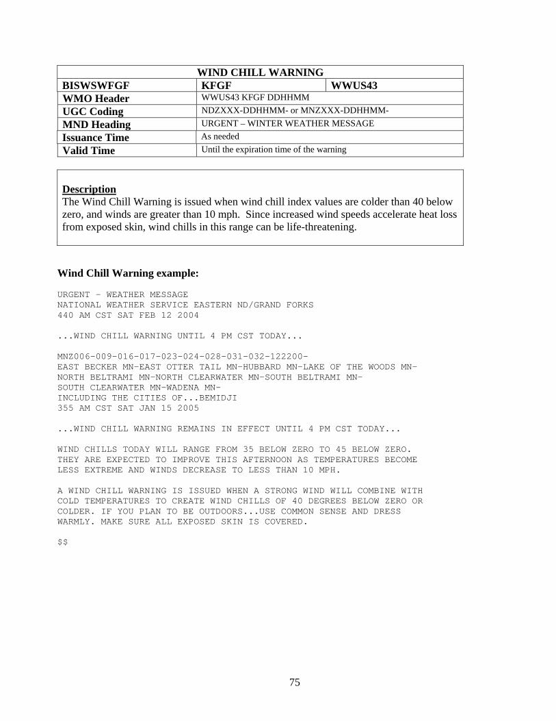
75
WIND CHILL WARNING BISWSWFGF KFGF WWUS43 WMO Header WWUS43 KFGF DDHHMM UGC Coding NDZXXX-DDHHMM- or MNZXXX-DDHHMM- MND Heading URGENT – WINTER WEATHER MESSAGE Issuance Time As needed Valid Time Until the expiration time of the warning
Description The Wind Chill Warning is issued when wind chill index values are colder than 40 below zero, and winds are greater than 10 mph. Since increased wind speeds accelerate heat loss from exposed skin, wind chills in this range can be life-threatening. Wind Chill Warning example: URGENT - WEATHER MESSAGE NATIONAL WEATHER SERVICE EASTERN ND/GRAND FORKS 440 AM CST SAT FEB 12 2004 ...WIND CHILL WARNING UNTIL 4 PM CST TODAY... MNZ006-009-016-017-023-024-028-031-032-122200- EAST BECKER MN-EAST OTTER TAIL MN-HUBBARD MN-LAKE OF THE WOODS MN- NORTH BELTRAMI MN-NORTH CLEARWATER MN-SOUTH BELTRAMI MN- SOUTH CLEARWATER MN-WADENA MN- INCLUDING THE CITIES OF...BEMIDJI 355 AM CST SAT JAN 15 2005 ...WIND CHILL WARNING REMAINS IN EFFECT UNTIL 4 PM CST TODAY... WIND CHILLS TODAY WILL RANGE FROM 35 BELOW ZERO TO 45 BELOW ZERO. THEY ARE EXPECTED TO IMPROVE THIS AFTERNOON AS TEMPERATURES BECOME LESS EXTREME AND WINDS DECREASE TO LESS THAN 10 MPH. A WIND CHILL WARNING IS ISSUED WHEN A STRONG WIND WILL COMBINE WITH COLD TEMPERATURES TO CREATE WIND CHILLS OF 40 DEGREES BELOW ZERO OR COLDER. IF YOU PLAN TO BE OUTDOORS...USE COMMON SENSE AND DRESS WARMLY. MAKE SURE ALL EXPOSED SKIN IS COVERED. $$
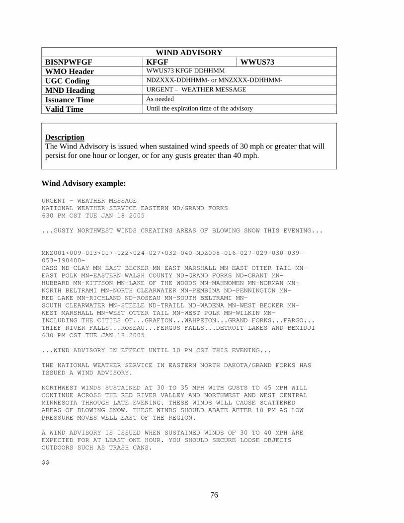
76
WIND ADVISORY BISNPWFGF KFGF WWUS73 WMO Header WWUS73 KFGF DDHHMM UGC Coding NDZXXX-DDHHMM- or MNZXXX-DDHHMM- MND Heading URGENT – WEATHER MESSAGE Issuance Time As needed Valid Time Until the expiration time of the advisory
Description The Wind Advisory is issued when sustained wind speeds of 30 mph or greater that will persist for one hour or longer, or for any gusts greater than 40 mph.
Wind Advisory example:
URGENT - WEATHER MESSAGE NATIONAL WEATHER SERVICE EASTERN ND/GRAND FORKS 630 PM CST TUE JAN 18 2005 ...GUSTY NORTHWEST WINDS CREATING AREAS OF BLOWING SNOW THIS EVENING... MNZ001>009-013>017-022>024-027>032-040-NDZ008-016-027-029-030-039- 053-190400- CASS ND-CLAY MN-EAST BECKER MN-EAST MARSHALL MN-EAST OTTER TAIL MN- EAST POLK MN-EASTERN WALSH COUNTY ND-GRAND FORKS ND-GRANT MN- HUBBARD MN-KITTSON MN-LAKE OF THE WOODS MN-MAHNOMEN MN-NORMAN MN- NORTH BELTRAMI MN-NORTH CLEARWATER MN-PEMBINA ND-PENNINGTON MN- RED LAKE MN-RICHLAND ND-ROSEAU MN-SOUTH BELTRAMI MN- SOUTH CLEARWATER MN-STEELE ND-TRAILL ND-WADENA MN-WEST BECKER MN- WEST MARSHALL MN-WEST OTTER TAIL MN-WEST POLK MN-WILKIN MN- INCLUDING THE CITIES OF...GRAFTON...WAHPETON...GRAND FORKS...FARGO... THIEF RIVER FALLS...ROSEAU...FERGUS FALLS...DETROIT LAKES AND BEMIDJI 630 PM CST TUE JAN 18 2005 ...WIND ADVISORY IN EFFECT UNTIL 10 PM CST THIS EVENING... THE NATIONAL WEATHER SERVICE IN EASTERN NORTH DAKOTA/GRAND FORKS HAS ISSUED A WIND ADVISORY. NORTHWEST WINDS SUSTAINED AT 30 TO 35 MPH WITH GUSTS TO 45 MPH WILL CONTINUE ACROSS THE RED RIVER VALLEY AND NORTHWEST AND WEST CENTRAL MINNESOTA THROUGH LATE EVENING. THESE WINDS WILL CAUSE SCATTERED AREAS OF BLOWING SNOW. THESE WINDS SHOULD ABATE AFTER 10 PM AS LOW PRESSURE MOVES WELL EAST OF THE REGION. A WIND ADVISORY IS ISSUED WHEN SUSTAINED WINDS OF 30 TO 40 MPH ARE EXPECTED FOR AT LEAST ONE HOUR. YOU SHOULD SECURE LOOSE OBJECTS OUTDOORS SUCH AS TRASH CANS. $$
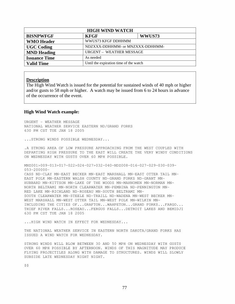
77
HIGH WIND WATCH BISNPWFGF KFGF WWUS73 WMO Header WWUS73 KFGF DDHHMM UGC Coding NDZXXX-DDHHMM- or MNZXXX-DDHHMM- MND Heading URGENT – WEATHER MESSAGE Issuance Time As needed Valid Time Until the expiration time of the watch
Description The High Wind Watch is issued for the potential for sustained winds of 40 mph or higher and/or gusts to 58 mph or higher. A watch may be issued from 6 to 24 hours in advance of the occurrence of the event.
High Wind Watch example:
URGENT - WEATHER MESSAGE NATIONAL WEATHER SERVICE EASTERN ND/GRAND FORKS 630 PM CST TUE JAN 18 2005 ...STRONG WINDS POSSIBLE WEDNESDAY... .A STRONG AREA OF LOW PRESSURE APPROACHING FROM THE WEST COUPLED WITH DEPARTING HIGH PRESSURE TO THE EAST WILL CREATE THE VERY WINDY CONDITIONS ON WEDNESDAY WITH GUSTS OVER 60 MPH POSSIBLE. MNZ001>009-013>017-022>024-027>032-040-NDZ008-016-027-029-030-039- 053-200000- CASS ND-CLAY MN-EAST BECKER MN-EAST MARSHALL MN-EAST OTTER TAIL MN- EAST POLK MN-EASTERN WALSH COUNTY ND-GRAND FORKS ND-GRANT MN- HUBBARD MN-KITTSON MN-LAKE OF THE WOODS MN-MAHNOMEN MN-NORMAN MN- NORTH BELTRAMI MN-NORTH CLEARWATER MN-PEMBINA ND-PENNINGTON MN- RED LAKE MN-RICHLAND ND-ROSEAU MN-SOUTH BELTRAMI MN- SOUTH CLEARWATER MN-STEELE ND-TRAILL ND-WADENA MN-WEST BECKER MN- WEST MARSHALL MN-WEST OTTER TAIL MN-WEST POLK MN-WILKIN MN- INCLUDING THE CITIES OF...GRAFTON...WAHPETON...GRAND FORKS...FARGO... THIEF RIVER FALLS...ROSEAU...FERGUS FALLS...DETROIT LAKES AND BEMIDJI 630 PM CST TUE JAN 18 2005 ...HIGH WIND WATCH IN EFFECT FOR WEDNESDAY... THE NATIONAL WEATHER SERVICE IN EASTERN NORTH DAKOTA/GRAND FORKS HAS ISSUED A WIND WATCH FOR WEDNESDAY. STRONG WINDS WILL BLOW BETWEEN 30 AND 50 MPH ON WEDNESDAY WITH GUSTS OVER 60 MPH POSSIBLE BY AFTERNOON. WINDS OF THIS MAGNITUDE MAY PRODUCE FLYING PROJECTILES ALONG WITH DAMAGE TO STRUCTURES. WINDS WILL SLOWLY SUBSIDE LATE WEDNESDAY NIGHT NIGHT. $$
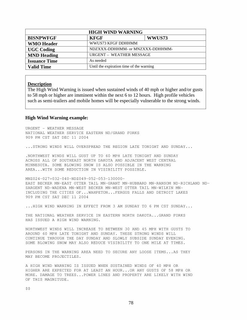
78
HIGH WIND WARNING BISNPWFGF KFGF WWUS73 WMO Header WWUS73 KFGF DDHHMM UGC Coding NDZXXX-DDHHMM- or MNZXXX-DDHHMM- MND Heading URGENT – WEATHER MESSAGE Issuance Time As needed Valid Time Until the expiration time of the warning
Description The High Wind Warning is issued when sustained winds of 40 mph or higher and/or gusts to 58 mph or higher are imminent within the next 6 to 12 hours. High profile vehicles such as semi-trailers and mobile homes will be especially vulnerable to the strong winds.
High Wind Warning example:
URGENT - WEATHER MESSAGE NATIONAL WEATHER SERVICE EASTERN ND/GRAND FORKS 909 PM CST SAT DEC 11 2004 ...STRONG WINDS WILL OVERSPREAD THE REGION LATE TONIGHT AND SUNDAY... .NORTHWEST WINDS WILL GUST UP TO 60 MPH LATE TONIGHT AND SUNDAY ACROSS ALL OF SOUTHEAST NORTH DAKOTA AND ADJACENT WEST CENTRAL MINNESOTA. SOME BLOWING SNOW IS ALSO POSSIBLE IN THE WARNING AREA...WITH SOME REDUCTION IN VISIBILITY POSSIBLE. MNZ024-027>032-040-NDZ049-052-053-130000- EAST BECKER MN-EAST OTTER TAIL MN-GRANT MN-HUBBARD MN-RANSOM ND-RICHLAND ND- SARGENT ND-WADENA MN-WEST BECKER MN-WEST OTTER TAIL MN-WILKIN MN- INCLUDING THE CITIES OF...WAHPETON...FERGUS FALLS AND DETROIT LAKES 909 PM CST SAT DEC 11 2004 ...HIGH WIND WARNING IN EFFECT FROM 3 AM SUNDAY TO 6 PM CST SUNDAY... THE NATIONAL WEATHER SERVICE IN EASTERN NORTH DAKOTA...GRAND FORKS HAS ISSUED A HIGH WIND WARNING. NORTHWEST WINDS WILL INCREASE TO BETWEEN 30 AND 45 MPH WITH GUSTS TO AROUND 60 MPH LATE TONIGHT AND SUNDAY. THESE STRONG WINDS WILL CONTINUE THROUGH THE DAY SUNDAY AND SLOWLY SUBSIDE SUNDAY EVENING. SOME BLOWING SNOW MAY ALSO REDUCE VISIBILITY TO ONE MILE AT TIMES. PERSONS IN THE WARNING AREA NEED TO SECURE ANY LOOSE ITEMS...AS THEY MAY BECOME PROJECTILES. A HIGH WIND WARNING IS ISSUED WHEN SUSTAINED WINDS OF 40 MPH OR HIGHER ARE EXPECTED FOR AT LEAST AN HOUR...OR ANY GUSTS OF 58 MPH OR MORE. DAMAGE TO TREES...POWER LINES AND PROPERTY ARE LIKELY WITH WIND OF THIS MAGNITUDE. $$
79
Eastern North Dakota and Northwestern Minnesota NWS Product and Services Guide
Products Relating to Reduced Visibilities Dense Fog Advisory Blowing Dust Advisory Dust Storm Warning
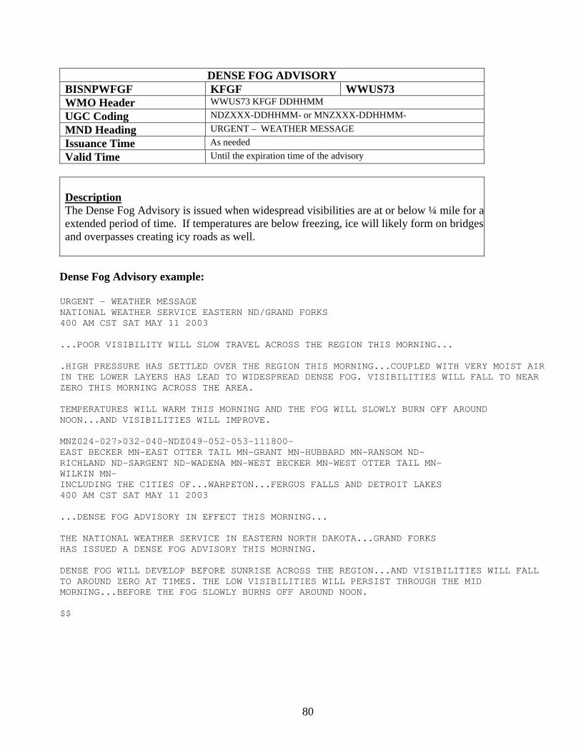
80
DENSE FOG ADVISORY BISNPWFGF KFGF WWUS73 WMO Header WWUS73 KFGF DDHHMM UGC Coding NDZXXX-DDHHMM- or MNZXXX-DDHHMM- MND Heading URGENT – WEATHER MESSAGE Issuance Time As needed Valid Time Until the expiration time of the advisory
Description The Dense Fog Advisory is issued when widespread visibilities are at or below ¼ mile for aextended period of time. If temperatures are below freezing, ice will likely form on bridges and overpasses creating icy roads as well.
Dense Fog Advisory example:
URGENT - WEATHER MESSAGE NATIONAL WEATHER SERVICE EASTERN ND/GRAND FORKS 400 AM CST SAT MAY 11 2003 ...POOR VISIBILITY WILL SLOW TRAVEL ACROSS THE REGION THIS MORNING... .HIGH PRESSURE HAS SETTLED OVER THE REGION THIS MORNING...COUPLED WITH VERY MOIST AIR IN THE LOWER LAYERS HAS LEAD TO WIDESPREAD DENSE FOG. VISIBILITIES WILL FALL TO NEAR ZERO THIS MORNING ACROSS THE AREA. TEMPERATURES WILL WARM THIS MORNING AND THE FOG WILL SLOWLY BURN OFF AROUND NOON...AND VISIBILITIES WILL IMPROVE. MNZ024-027>032-040-NDZ049-052-053-111800- EAST BECKER MN-EAST OTTER TAIL MN-GRANT MN-HUBBARD MN-RANSOM ND- RICHLAND ND-SARGENT ND-WADENA MN-WEST BECKER MN-WEST OTTER TAIL MN- WILKIN MN- INCLUDING THE CITIES OF...WAHPETON...FERGUS FALLS AND DETROIT LAKES 400 AM CST SAT MAY 11 2003 ...DENSE FOG ADVISORY IN EFFECT THIS MORNING... THE NATIONAL WEATHER SERVICE IN EASTERN NORTH DAKOTA...GRAND FORKS HAS ISSUED A DENSE FOG ADVISORY THIS MORNING. DENSE FOG WILL DEVELOP BEFORE SUNRISE ACROSS THE REGION...AND VISIBILITIES WILL FALL TO AROUND ZERO AT TIMES. THE LOW VISIBILITIES WILL PERSIST THROUGH THE MID MORNING...BEFORE THE FOG SLOWLY BURNS OFF AROUND NOON. $$
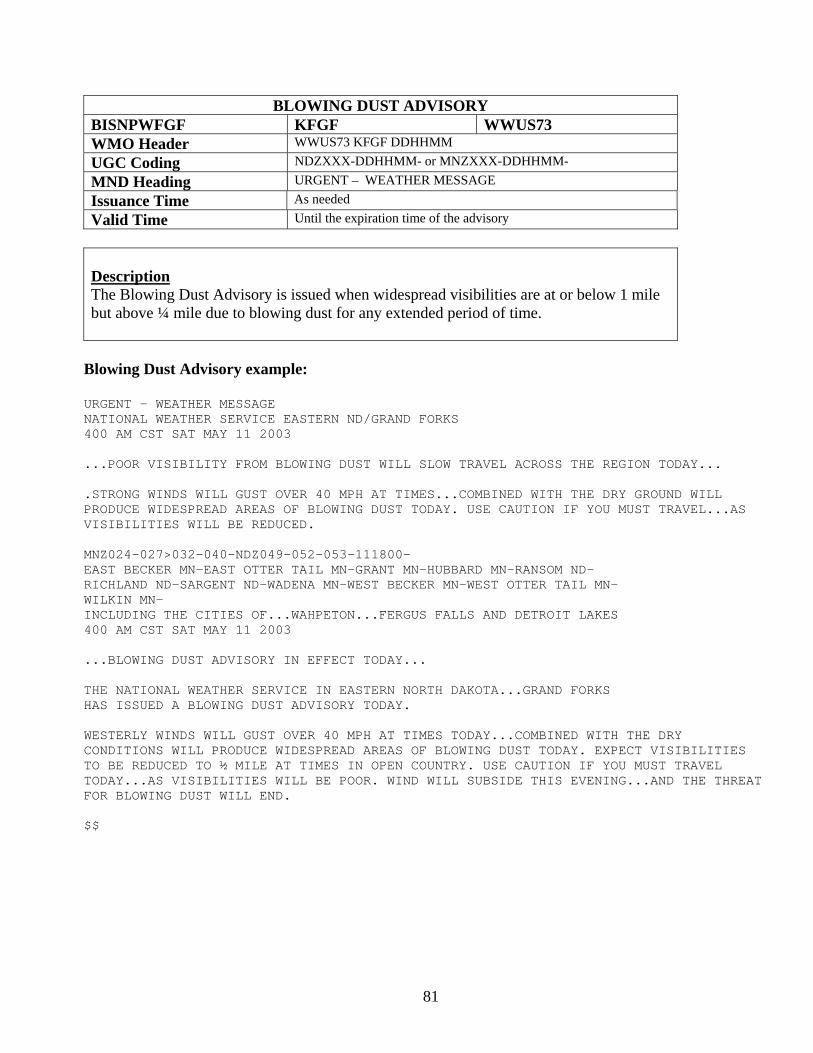
81
BLOWING DUST ADVISORY BISNPWFGF KFGF WWUS73 WMO Header WWUS73 KFGF DDHHMM UGC Coding NDZXXX-DDHHMM- or MNZXXX-DDHHMM- MND Heading URGENT – WEATHER MESSAGE Issuance Time As needed Valid Time Until the expiration time of the advisory
Description The Blowing Dust Advisory is issued when widespread visibilities are at or below 1 mile but above ¼ mile due to blowing dust for any extended period of time.
Blowing Dust Advisory example:
URGENT - WEATHER MESSAGE NATIONAL WEATHER SERVICE EASTERN ND/GRAND FORKS 400 AM CST SAT MAY 11 2003 ...POOR VISIBILITY FROM BLOWING DUST WILL SLOW TRAVEL ACROSS THE REGION TODAY... .STRONG WINDS WILL GUST OVER 40 MPH AT TIMES...COMBINED WITH THE DRY GROUND WILL PRODUCE WIDESPREAD AREAS OF BLOWING DUST TODAY. USE CAUTION IF YOU MUST TRAVEL...AS VISIBILITIES WILL BE REDUCED. MNZ024-027>032-040-NDZ049-052-053-111800- EAST BECKER MN-EAST OTTER TAIL MN-GRANT MN-HUBBARD MN-RANSOM ND- RICHLAND ND-SARGENT ND-WADENA MN-WEST BECKER MN-WEST OTTER TAIL MN- WILKIN MN- INCLUDING THE CITIES OF...WAHPETON...FERGUS FALLS AND DETROIT LAKES 400 AM CST SAT MAY 11 2003 ...BLOWING DUST ADVISORY IN EFFECT TODAY... THE NATIONAL WEATHER SERVICE IN EASTERN NORTH DAKOTA...GRAND FORKS HAS ISSUED A BLOWING DUST ADVISORY TODAY. WESTERLY WINDS WILL GUST OVER 40 MPH AT TIMES TODAY...COMBINED WITH THE DRY CONDITIONS WILL PRODUCE WIDESPREAD AREAS OF BLOWING DUST TODAY. EXPECT VISIBILITIES TO BE REDUCED TO ½ MILE AT TIMES IN OPEN COUNTRY. USE CAUTION IF YOU MUST TRAVEL TODAY...AS VISIBILITIES WILL BE POOR. WIND WILL SUBSIDE THIS EVENING...AND THE THREAT FOR BLOWING DUST WILL END. $$
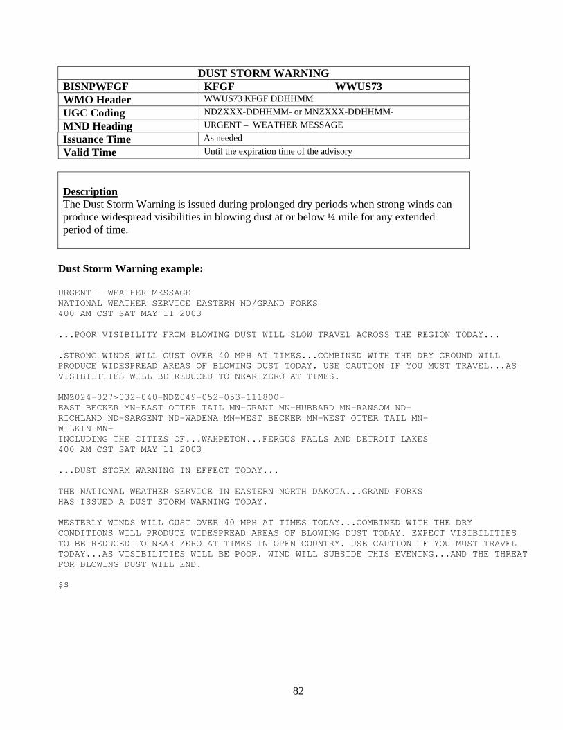
82
DUST STORM WARNING BISNPWFGF KFGF WWUS73 WMO Header WWUS73 KFGF DDHHMM UGC Coding NDZXXX-DDHHMM- or MNZXXX-DDHHMM- MND Heading URGENT – WEATHER MESSAGE Issuance Time As needed Valid Time Until the expiration time of the advisory
Description The Dust Storm Warning is issued during prolonged dry periods when strong winds can produce widespread visibilities in blowing dust at or below ¼ mile for any extended period of time.
Dust Storm Warning example:
URGENT - WEATHER MESSAGE NATIONAL WEATHER SERVICE EASTERN ND/GRAND FORKS 400 AM CST SAT MAY 11 2003 ...POOR VISIBILITY FROM BLOWING DUST WILL SLOW TRAVEL ACROSS THE REGION TODAY... .STRONG WINDS WILL GUST OVER 40 MPH AT TIMES...COMBINED WITH THE DRY GROUND WILL PRODUCE WIDESPREAD AREAS OF BLOWING DUST TODAY. USE CAUTION IF YOU MUST TRAVEL...AS VISIBILITIES WILL BE REDUCED TO NEAR ZERO AT TIMES. MNZ024-027>032-040-NDZ049-052-053-111800- EAST BECKER MN-EAST OTTER TAIL MN-GRANT MN-HUBBARD MN-RANSOM ND- RICHLAND ND-SARGENT ND-WADENA MN-WEST BECKER MN-WEST OTTER TAIL MN- WILKIN MN- INCLUDING THE CITIES OF...WAHPETON...FERGUS FALLS AND DETROIT LAKES 400 AM CST SAT MAY 11 2003 ...DUST STORM WARNING IN EFFECT TODAY... THE NATIONAL WEATHER SERVICE IN EASTERN NORTH DAKOTA...GRAND FORKS HAS ISSUED A DUST STORM WARNING TODAY. WESTERLY WINDS WILL GUST OVER 40 MPH AT TIMES TODAY...COMBINED WITH THE DRY CONDITIONS WILL PRODUCE WIDESPREAD AREAS OF BLOWING DUST TODAY. EXPECT VISIBILITIES TO BE REDUCED TO NEAR ZERO AT TIMES IN OPEN COUNTRY. USE CAUTION IF YOU MUST TRAVEL TODAY...AS VISIBILITIES WILL BE POOR. WIND WILL SUBSIDE THIS EVENING...AND THE THREAT FOR BLOWING DUST WILL END. $$
83
Eastern North Dakota and Northwestern Minnesota NWS Product and Services Guide
Fire Weather Products Fire Weather Forecast Fire Weather Point Forecast Fire Weather Watch Red Flag Warning North Dakota Rangeland Fire Danger Statement Spot Forecast Request Spot Forecast
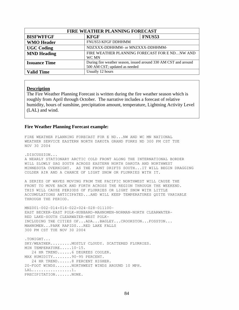
84
FIRE WEATHER PLANNING FORECAST BISFWFFGF KFGF FNUS53 WMO Header FNUS53 KFGF DDHHMM UGC Coding NDZXXX-DDHHMM- or MNZXXX-DDHHMM- MND Heading FIRE WEATHER PLANNING FORECAST FOR E ND…NW AND
WC MN Issuance Time During fire weather season, issued around 330 AM CST and around
500 AM CST; updated as needed Valid Time Usually 12 hours
Description The Fire Weather Planning Forecast is written during the fire weather season which is roughly from April through October. The narrative includes a forecast of relative humidity, hours of sunshine, precipitation amount, temperature, Lightning Activity Level (LAL) and wind.
Fire Weather Planning Forecast example:
FIRE WEATHER PLANNING FORECAST FOR E ND...NW AND WC MN NATIONAL WEATHER SERVICE EASTERN NORTH DAKOTA GRAND FORKS ND 300 PM CST TUE NOV 30 2004 .DISCUSSION... A NEARLY STATIONARY ARCTIC COLD FRONT ALONG THE INTERNATIONAL BORDER WILL SLOWLY SAG SOUTH ACROSS EASTERN NORTH DAKOTA AND NORTHWEST MINNESOTA OVERNIGHT. AS THE FRONT DRIFTS SOUTH...IT WILL BEGIN DRAGGING COLDER AIR AND A CHANCE OF LIGHT SNOW OR FLURRIES WITH IT. A SERIES OF WAVES MOVING FROM THE PACIFIC NORTHWEST WILL CAUSE THE FRONT TO MOVE BACK AND FORTH ACROSS THE REGION THROUGH THE WEEKEND. THIS WILL CAUSE PERIODS OF FLURRIES OR LIGHT SNOW WITH LITTLE ACCUMULATIONS ANTICIPATED...AND WILL KEEP TEMPERATURES QUITE VARIABLE THROUGH THE PERIOD. MNZ001-002-014>016-022>024-028-011100- EAST BECKER-EAST POLK-HUBBARD-MAHNOMEN-NORMAN-NORTH CLEARWATER- RED LAKE-SOUTH CLEARWATER-WEST POLK- INCLUDING THE CITIES OF...ADA...BAGLEY...CROOKSTON...FOSSTON... MAHNOMEN...PARK RAPIDS...RED LAKE FALLS 300 PM CST TUE NOV 30 2004 .TONIGHT... SKY/WEATHER.........MOSTLY CLOUDY. SCATTERED FLURRIES. MIN TEMPERATURE.....10-15. 24 HR TREND......6 DEGREES COOLER. MAX HUMIDITY........90-95 PERCENT. 24 HR TREND......8 PERCENT HIGHER. 20-FOOT WINDS.......NORTHWEST WINDS AROUND 10 MPH. LAL.................1. PRECIPITATION.......NONE.
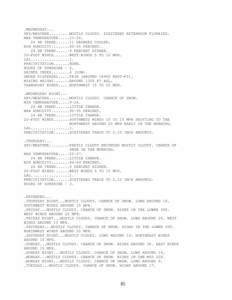
85
.WEDNESDAY... SKY/WEATHER.........MOSTLY CLOUDY. SCATTERED AFTERNOON FLURRIES. MAX TEMPERATURE.....21-26. 24 HR TREND......11 DEGREES COOLER. MIN HUMIDITY........60-65 PERCENT. 24 HR TREND......9 PERCENT HIGHER. 20-FOOT WINDS.......WEST WINDS 5 TO 10 MPH. LAL.................1. PRECIPITATION.......NONE. HOURS OF SUNSHINE - 2. HAINES INDEX........4 (LOW). SMOKE DISPERSAL.....FAIR (AROUND 18900 KNOT-FT). MIXING HEIGHT.......AROUND 1300 FT AGL. TRANSPORT WINDS.....NORTHWEST 15 TO 20 MPH. .WEDNESDAY NIGHT... SKY/WEATHER.........MOSTLY CLOUDY. CHANCE OF SNOW. MIN TEMPERATURE.....9-14. 24 HR TREND......LITTLE CHANGE. MAX HUMIDITY........90-95 PERCENT. 24 HR TREND......LITTLE CHANGE. 20-FOOT WINDS.......SOUTHWEST WINDS 10 TO 15 MPH SHIFTING TO THE NORTHWEST AROUND 20 MPH EARLY IN THE MORNING. LAL.................1. PRECIPITATION.......SCATTERED TRACE TO 0.10 INCH AMOUNTS. .THURSDAY... SKY/WEATHER.........PARTLY CLOUDY BECOMING MOSTLY CLOUDY. CHANCE OF SNOW IN THE MORNING. MAX TEMPERATURE.....22-27. 24 HR TREND......LITTLE CHANGE. MIN HUMIDITY........64-69 PERCENT. 24 HR TREND......4 PERCENT HIGHER. 20-FOOT WINDS.......WEST WINDS 5 TO 15 MPH. LAL.................1. PRECIPITATION.......SCATTERED TRACE TO 0.10 INCH AMOUNTS. HOURS OF SUNSHINE - 3. .EXTENDED... .THURSDAY NIGHT...MOSTLY CLOUDY. CHANCE OF SNOW. LOWS AROUND 18. SOUTHWEST WINDS AROUND 15 MPH. .FRIDAY...MOSTLY CLOUDY. CHANCE OF SNOW. HIGHS IN THE LOWER 30S. WEST WINDS AROUND 20 MPH. .FRIDAY NIGHT...MOSTLY CLOUDY. CHANCE OF SNOW. LOWS AROUND 20. WEST WINDS AROUND 15 MPH. .SATURDAY...MOSTLY CLOUDY. CHANCE OF SNOW. HIGHS IN THE LOWER 30S. NORTHWEST WINDS AROUND 20 MPH. .SATURDAY NIGHT...MOSTLY CLOUDY. LOWS AROUND 16. NORTHEAST WINDS AROUND 10 MPH. .SUNDAY...MOSTLY CLOUDY. CHANCE OF SNOW. HIGHS AROUND 30. EAST WINDS AROUND 15 MPH. .SUNDAY NIGHT...MOSTLY CLOUDY. CHANCE OF SNOW. LOWS AROUND 16. .MONDAY...MOSTLY CLOUDY. CHANCE OF SNOW. HIGHS IN THE MID 20S. .MONDAY NIGHT...MOSTLY CLOUDY. CHANCE OF SNOW. LOWS AROUND 9. .TUESDAY...MOSTLY CLOUDY. CHANCE OF SNOW. HIGHS AROUND 17.
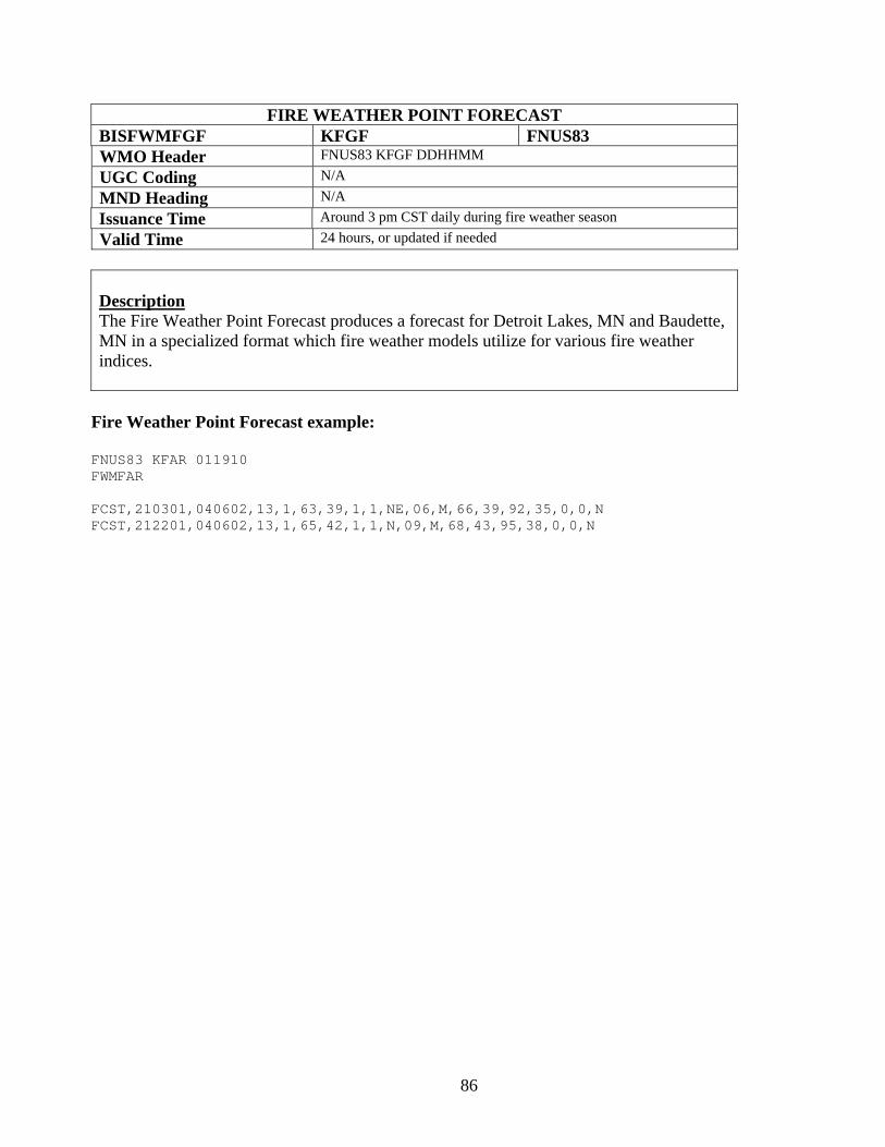
86
FIRE WEATHER POINT FORECAST BISFWMFGF KFGF FNUS83 WMO Header FNUS83 KFGF DDHHMM UGC Coding N/A MND Heading N/A Issuance Time Around 3 pm CST daily during fire weather season Valid Time 24 hours, or updated if needed
Description The Fire Weather Point Forecast produces a forecast for Detroit Lakes, MN and Baudette, MN in a specialized format which fire weather models utilize for various fire weather indices.
Fire Weather Point Forecast example:
FNUS83 KFAR 011910 FWMFAR FCST,210301,040602,13,1,63,39,1,1,NE,06,M,66,39,92,35,0,0,N FCST,212201,040602,13,1,65,42,1,1,N,09,M,68,43,95,38,0,0,N
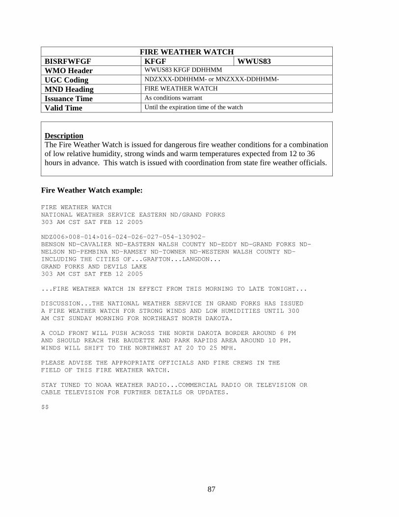
87
FIRE WEATHER WATCH BISRFWFGF KFGF WWUS83 WMO Header WWUS83 KFGF DDHHMM UGC Coding NDZXXX-DDHHMM- or MNZXXX-DDHHMM- MND Heading FIRE WEATHER WATCH Issuance Time As conditions warrant Valid Time Until the expiration time of the watch
Description The Fire Weather Watch is issued for dangerous fire weather conditions for a combination of low relative humidity, strong winds and warm temperatures expected from 12 to 36 hours in advance. This watch is issued with coordination from state fire weather officials.
Fire Weather Watch example:
FIRE WEATHER WATCH NATIONAL WEATHER SERVICE EASTERN ND/GRAND FORKS 303 AM CST SAT FEB 12 2005 NDZ006>008-014>016-024-026-027-054-130902- BENSON ND-CAVALIER ND-EASTERN WALSH COUNTY ND-EDDY ND-GRAND FORKS ND- NELSON ND-PEMBINA ND-RAMSEY ND-TOWNER ND-WESTERN WALSH COUNTY ND- INCLUDING THE CITIES OF...GRAFTON...LANGDON... GRAND FORKS AND DEVILS LAKE 303 AM CST SAT FEB 12 2005 ...FIRE WEATHER WATCH IN EFFECT FROM THIS MORNING TO LATE TONIGHT... DISCUSSION...THE NATIONAL WEATHER SERVICE IN GRAND FORKS HAS ISSUED A FIRE WEATHER WATCH FOR STRONG WINDS AND LOW HUMIDITIES UNTIL 300 AM CST SUNDAY MORNING FOR NORTHEAST NORTH DAKOTA. A COLD FRONT WILL PUSH ACROSS THE NORTH DAKOTA BORDER AROUND 6 PM AND SHOULD REACH THE BAUDETTE AND PARK RAPIDS AREA AROUND 10 PM. WINDS WILL SHIFT TO THE NORTHWEST AT 20 TO 25 MPH. PLEASE ADVISE THE APPROPRIATE OFFICIALS AND FIRE CREWS IN THE FIELD OF THIS FIRE WEATHER WATCH. STAY TUNED TO NOAA WEATHER RADIO...COMMERCIAL RADIO OR TELEVISION OR CABLE TELEVISION FOR FURTHER DETAILS OR UPDATES. $$
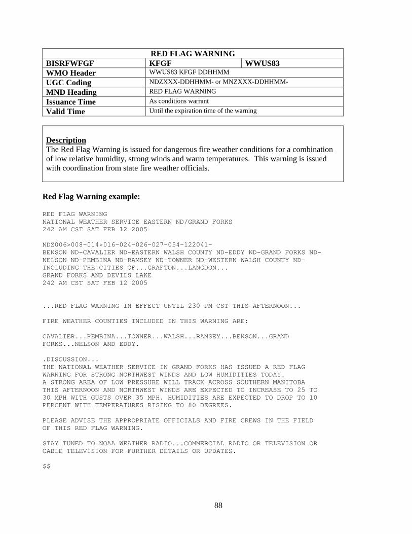
88
RED FLAG WARNING BISRFWFGF KFGF WWUS83 WMO Header WWUS83 KFGF DDHHMM UGC Coding NDZXXX-DDHHMM- or MNZXXX-DDHHMM- MND Heading RED FLAG WARNING Issuance Time As conditions warrant Valid Time Until the expiration time of the warning
Description The Red Flag Warning is issued for dangerous fire weather conditions for a combination of low relative humidity, strong winds and warm temperatures. This warning is issued with coordination from state fire weather officials.
Red Flag Warning example:
RED FLAG WARNING NATIONAL WEATHER SERVICE EASTERN ND/GRAND FORKS 242 AM CST SAT FEB 12 2005 NDZ006>008-014>016-024-026-027-054-122041- BENSON ND-CAVALIER ND-EASTERN WALSH COUNTY ND-EDDY ND-GRAND FORKS ND- NELSON ND-PEMBINA ND-RAMSEY ND-TOWNER ND-WESTERN WALSH COUNTY ND- INCLUDING THE CITIES OF...GRAFTON...LANGDON... GRAND FORKS AND DEVILS LAKE 242 AM CST SAT FEB 12 2005 ...RED FLAG WARNING IN EFFECT UNTIL 230 PM CST THIS AFTERNOON... FIRE WEATHER COUNTIES INCLUDED IN THIS WARNING ARE: CAVALIER...PEMBINA...TOWNER...WALSH...RAMSEY...BENSON...GRAND FORKS...NELSON AND EDDY. .DISCUSSION... THE NATIONAL WEATHER SERVICE IN GRAND FORKS HAS ISSUED A RED FLAG WARNING FOR STRONG NORTHWEST WINDS AND LOW HUMIDITIES TODAY. A STRONG AREA OF LOW PRESSURE WILL TRACK ACROSS SOUTHERN MANITOBA THIS AFTERNOON AND NORTHWEST WINDS ARE EXPECTED TO INCREASE TO 25 TO 30 MPH WITH GUSTS OVER 35 MPH. HUMIDITIES ARE EXPECTED TO DROP TO 10 PERCENT WITH TEMPERATURES RISING TO 80 DEGREES. PLEASE ADVISE THE APPROPRIATE OFFICIALS AND FIRE CREWS IN THE FIELD OF THIS RED FLAG WARNING. STAY TUNED TO NOAA WEATHER RADIO...COMMERCIAL RADIO OR TELEVISION OR CABLE TELEVISION FOR FURTHER DETAILS OR UPDATES. $$
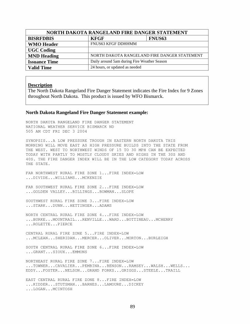
89
NORTH DAKOTA RANGELAND FIRE DANGER STATEMENT BISRFDBIS KFGF FNUS63 WMO Header FNUS63 KFGF DDHHMM UGC Coding MND Heading NORTH DAKOTA RANGELAND FIRE DANGER STATEMENT Issuance Time Daily around 5am during Fire Weather Season Valid Time 24 hours, or updated as needed
Description The North Dakota Rangeland Fire Danger Statement indicates the Fire Index for 9 Zones throughout North Dakota. This product is issued by WFO Bismarck. North Dakota Rangeland Fire Danger Statement example: NORTH DAKOTA RANGELAND FIRE DANGER STATEMENT NATIONAL WEATHER SERVICE BISMARCK ND 505 AM CDT FRI DEC 3 2004 SYNOPSIS...A LOW PRESSURE TROUGH IN EASTERN NORTH DAKOTA THIS MORNING WILL MOVE EAST AS HIGH PRESSURE BUILDS INTO THE STATE FROM THE WEST. WEST TO NORTHWEST WINDS OF 15 TO 30 MPH CAN BE EXPECTED TODAY WITH PARTLY TO MOSTLY CLOUDY SKIES AND HIGHS IN THE 30S AND 40S. THE FIRE DANGER INDEX WILL BE IN THE LOW CATEGORY TODAY ACROSS THE STATE. FAR NORTHWEST RURAL FIRE ZONE 1...FIRE INDEX=LOW ...DIVIDE...WILLIAMS...MCKENZIE FAR SOUTHWEST RURAL FIRE ZONE 2...FIRE INDEX=LOW ...GOLDEN VALLEY...BILLINGS...BOWMAN...SLOPE SOUTHWEST RURAL FIRE ZONE 3...FIRE INDEX=LOW ...STARK...DUNN...HETTINGER...ADAMS NORTH CENTRAL RURAL FIRE ZONE 4...FIRE INDEX=LOW ...BURKE...MOUNTRAIL...RENVILLE...WARD...BOTTINEAU...MCHENRY ...ROLETTE...PIERCE CENTRAL RURAL FIRE ZONE 5...FIRE INDEX=LOW ...MCLEAN...SHERIDAN...MERCER...OLIVER...MORTON...BURLEIGH SOUTH CENTRAL RURAL FIRE ZONE 6...FIRE INDEX=LOW ...GRANT...SIOUX...EMMONS NORTHEAST RURAL FIRE ZONE 7...FIRE INDEX=LOW ...TOWNER...CAVALIER...PEMBINA...BENSON...RAMSEY...WALSH...WELLS... EDDY...FOSTER...NELSON...GRAND FORKS...GRIGGS...STEELE...TRAILL EAST CENTRAL RURAL FIRE ZONE 8...FIRE INDEX=LOW ...KIDDER...STUTSMAN...BARNES...LAMOURE...DICKEY ...LOGAN...MCINTOSH
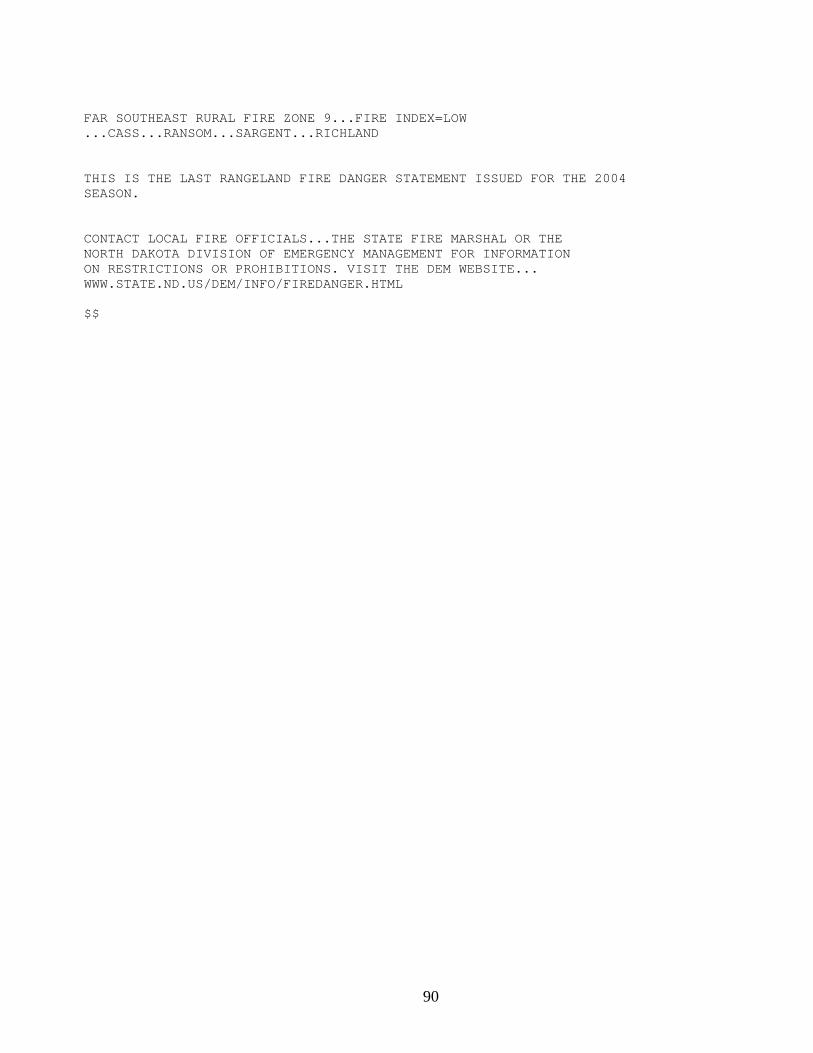
90
FAR SOUTHEAST RURAL FIRE ZONE 9...FIRE INDEX=LOW ...CASS...RANSOM...SARGENT...RICHLAND THIS IS THE LAST RANGELAND FIRE DANGER STATEMENT ISSUED FOR THE 2004 SEASON. CONTACT LOCAL FIRE OFFICIALS...THE STATE FIRE MARSHAL OR THE NORTH DAKOTA DIVISION OF EMERGENCY MANAGEMENT FOR INFORMATION ON RESTRICTIONS OR PROHIBITIONS. VISIT THE DEM WEBSITE... WWW.STATE.ND.US/DEM/INFO/FIREDANGER.HTML $$
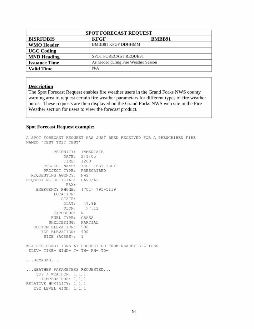
91
SPOT FORECAST REQUEST BISRFDBIS KFGF BMBB91 WMO Header BMBB91 KFGF DDHHMM UGC Coding MND Heading SPOT FORECAST REQUEST Issuance Time As needed during Fire Weather Season Valid Time N/A
Description The Spot Forecast Request enables fire weather users in the Grand Forks NWS county warning area to request certain fire weather parameters for different types of fire weather burns. These requests are then displayed on the Grand Forks NWS web site in the Fire Weather section for users to view the forecast product.
Spot Forecast Request example:
A SPOT FORECAST REQUEST HAS JUST BEEN RECEIVED FOR A PRESCRIBED FIRE NAMED "TEST TEST TEST" PRIORITY: IMMEDIATE DATE: 2/1/05 TIME: 1200 PROJECT NAME: TEST TEST TEST PROJECT TYPE: PRESCRIBED REQUESTING AGENCY: NWS REQUESTING OFFICIAL: DAVE/AL FAX: EMERGENCY PHONE: (701) 795-5119 LOCATION: STATE: DLAT: 47.96 DLON: 97.12 EXPOSURE: N FUEL TYPE: GRASS SHELTERING: PARTIAL BOTTOM ELEVATION: 900 TOP ELEVATION: 900 SIZE (ACRES): 1 WEATHER CONDITIONS AT PROJECT OR FROM NEARBY STATIONS ELEV= TIME= WIND= T= TW= RH= TD= ...REMARKS... ...WEATHER PARAMETERS REQUESTED... SKY / WEATHER: 1,1,1 TEMPERATURE: 1,1,1 RELATIVE HUMIDITY: 1,1,1 EYE LEVEL WIND: 1,1,1
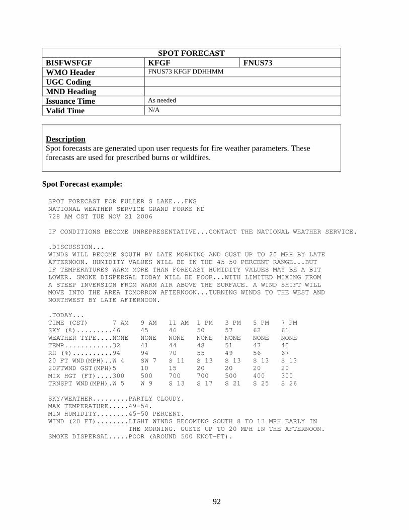
92
SPOT FORECAST BISFWSFGF KFGF FNUS73 WMO Header FNUS73 KFGF DDHHMM UGC Coding MND Heading Issuance Time As needed Valid Time N/A
Description Spot forecasts are generated upon user requests for fire weather parameters. These forecasts are used for prescribed burns or wildfires. Spot Forecast example: SPOT FORECAST FOR FULLER S LAKE...FWS NATIONAL WEATHER SERVICE GRAND FORKS ND 728 AM CST TUE NOV 21 2006 IF CONDITIONS BECOME UNREPRESENTATIVE...CONTACT THE NATIONAL WEATHER SERVICE. .DISCUSSION... WINDS WILL BECOME SOUTH BY LATE MORNING AND GUST UP TO 20 MPH BY LATE AFTERNOON. HUMIDITY VALUES WILL BE IN THE 45-50 PERCENT RANGE...BUT IF TEMPERATURES WARM MORE THAN FORECAST HUMIDITY VALUES MAY BE A BIT LOWER. SMOKE DISPERSAL TODAY WILL BE POOR...WITH LIMITED MIXING FROM A STEEP INVERSION FROM WARM AIR ABOVE THE SURFACE. A WIND SHIFT WILL MOVE INTO THE AREA TOMORROW AFTERNOON...TURNING WINDS TO THE WEST AND NORTHWEST BY LATE AFTERNOON. .TODAY... TIME (CST) 7 AM 9 AM 11 AM 1 PM 3 PM 5 PM 7 PM SKY (%).........46 45 46 50 57 62 61 WEATHER TYPE....NONE NONE NONE NONE NONE NONE NONE TEMP............32 41 44 48 51 47 40 RH (%)..........94 94 70 55 49 56 67 20 FT WND(MPH)..W 4 SW 7 S 11 S 13 S 13 S 13 S 13 20FTWND GST(MPH)5 10 15 20 20 20 20 MIX HGT (FT)....300 500 700 700 500 400 300 TRNSPT WND(MPH).W 5 W 9 S 13 S 17 S 21 S 25 S 26 SKY/WEATHER.........PARTLY CLOUDY. MAX TEMPERATURE.....49-54. MIN HUMIDITY........45-50 PERCENT. WIND (20 FT)........LIGHT WINDS BECOMING SOUTH 8 TO 13 MPH EARLY IN THE MORNING. GUSTS UP TO 20 MPH IN THE AFTERNOON. SMOKE DISPERSAL.....POOR (AROUND 500 KNOT-FT).
93
Eastern North Dakota and Northwestern Minnesota NWS Product and Services Guide
Hydrology Products Hydrologic Summary Hydrologic Outlook Flood Watch for Forecast Points Hydrologic Statement for High Water Flood Warning for Forecast Points Flood Statement for Forecast Points Flash Flood Watch Flash Flood Warning Flash Flood Statement Areal Flood Watch Areal Flood Warning Flood Statement for Areal Flood Warning Urban and Small Stream Flood Advisory
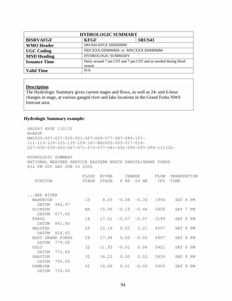
94
HYDROLOGIC SUMMARY
BISRVAFGF KFGF SRUS43 WMO Header SRUS43 KFGF DDHHMM UGC Coding NDCXXX-DDMMHH- or MNCXXX-DDHHMM- MND Heading HYDROLOGIC SUMMARY Issuance Time Daily around 7 am CST and 7 pm CST and as needed during flood
season Valid Time N/A
Description The Hydrologic Summary gives current stages and flows, as well as 24- and 6-hour changes in stage, at various gauged river and lake locations in the Grand Forks NWS forecast area.
Hydrologic Summary example:
SRUS43 KFGF 110133 RVAFGF MNC005-007-027-029-051-057-069-077-087-089-107- 111-113-119-125-135-159-167-NDC003-005-017-019- 027-035-039-063-067-071-073-077-081-091-095-097-099-111332- HYDROLOGIC SUMMARY NATIONAL WEATHER SERVICE EASTERN NORTH DAKOTA/GRAND FORKS 832 PM CDT SAT JUN 10 2006 FLOOD RIVER CHANGE FLOW OBSERVATION STATION STAGE STAGE 6 HR 24 HR CFS TIME ...RED RIVER WAHPETON 10 8.43 -0.08 -0.34 1994 SAT 8 PM DATUM 942.97 HICKSON NA 15.96 -0.15 -0.44 2856 SAT 7 PM DATUM 877.06 FARGO 18 17.01 -0.07 -0.07 3199 SAT 8 PM DATUM 861.80 HALSTAD 26 10.16 0.03 0.21 4057 SAT 8 PM DATUM 826.65 EAST GRAND FORKS 28 17.94 0.00 -0.02 4907 SAT 8 PM DATUM 779.00 OSLO 32 11.93 -0.01 0.04 5421 SAT 8 PM DATUM 772.65 DRAYTON 32 14.23 0.00 0.02 5839 SAT 8 PM DATUM 755.00 PEMBINA 42 16.96 0.01 -0.02 5909 SAT 8 PM DATUM 739.45
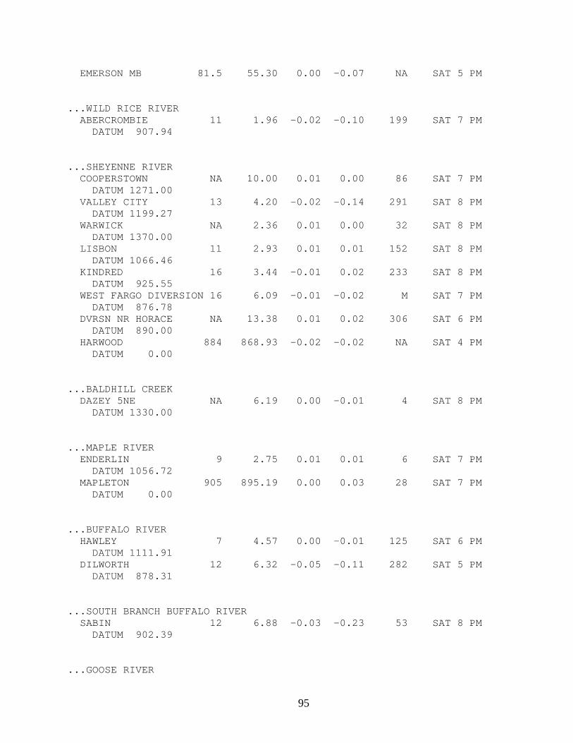
95
EMERSON MB 81.5 55.30 0.00 -0.07 NA SAT 5 PM ...WILD RICE RIVER ABERCROMBIE 11 1.96 -0.02 -0.10 199 SAT 7 PM DATUM 907.94 ...SHEYENNE RIVER COOPERSTOWN NA 10.00 0.01 0.00 86 SAT 7 PM DATUM 1271.00 VALLEY CITY 13 4.20 -0.02 -0.14 291 SAT 8 PM DATUM 1199.27 WARWICK NA 2.36 0.01 0.00 32 SAT 8 PM DATUM 1370.00 LISBON 11 2.93 0.01 0.01 152 SAT 8 PM DATUM 1066.46 KINDRED 16 3.44 -0.01 0.02 233 SAT 8 PM DATUM 925.55 WEST FARGO DIVERSION 16 6.09 -0.01 -0.02 M SAT 7 PM DATUM 876.78 DVRSN NR HORACE NA 13.38 0.01 0.02 306 SAT 6 PM DATUM 890.00 HARWOOD 884 868.93 -0.02 -0.02 NA SAT 4 PM DATUM 0.00 ...BALDHILL CREEK DAZEY 5NE NA 6.19 0.00 -0.01 4 SAT 8 PM DATUM 1330.00 ...MAPLE RIVER ENDERLIN 9 2.75 0.01 0.01 6 SAT 7 PM DATUM 1056.72 MAPLETON 905 895.19 0.00 0.03 28 SAT 7 PM DATUM 0.00 ...BUFFALO RIVER HAWLEY 7 4.57 0.00 -0.01 125 SAT 6 PM DATUM 1111.91 DILWORTH 12 6.32 -0.05 -0.11 282 SAT 5 PM DATUM 878.31 ...SOUTH BRANCH BUFFALO RIVER SABIN 12 6.88 -0.03 -0.23 53 SAT 8 PM DATUM 902.39 ...GOOSE RIVER
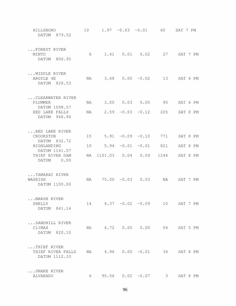
96
HILLSBORO 10 1.97 -0.03 -0.01 60 SAT 7 PM DATUM 879.52 ...FOREST RIVER MINTO 6 1.41 0.01 0.02 27 SAT 7 PM DATUM 806.95 ...MIDDLE RIVER ARGYLE 4E NA 3.68 0.00 -0.02 13 SAT 6 PM DATUM 828.53 ...CLEARWATER RIVER PLUMMER NA 3.00 0.03 0.05 95 SAT 6 PM DATUM 1098.57 RED LAKE FALLS NA 2.59 -0.03 -0.12 205 SAT 8 PM DATUM 948.94 ...RED LAKE RIVER CROOKSTON 15 5.91 -0.09 -0.10 771 SAT 8 PM DATUM 832.72 HIGHLANDING 10 5.94 -0.01 -0.01 821 SAT 8 PM DATUM 1141.57 THIEF RIVER DAM NA 1101.03 0.04 0.09 1244 SAT 8 PM DATUM 0.00 ...TAMARAC RIVER WASKISH NA 75.00 -0.03 0.03 NA SAT 7 PM DATUM 1100.00 ...MARSH RIVER SHELLY 14 4.37 -0.02 -0.09 10 SAT 7 PM DATUM 841.14 ...SANDHILL RIVER CLIMAX NA 4.72 0.00 0.00 54 SAT 5 PM DATUM 820.10 ...THIEF RIVER THIEF RIVER FALLS NA 4.96 0.00 -0.01 34 SAT 8 PM DATUM 1112.33 ...SNAKE RIVER ALVARADO 6 95.56 0.02 -0.07 3 SAT 8 PM
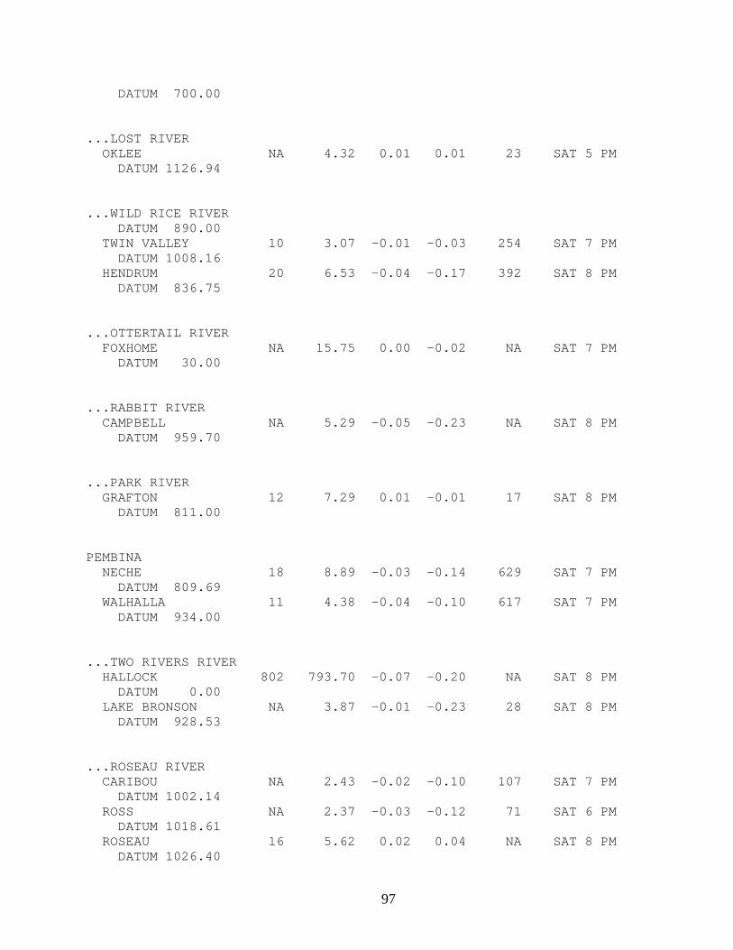
97
DATUM 700.00 ...LOST RIVER OKLEE NA 4.32 0.01 0.01 23 SAT 5 PM DATUM 1126.94 ...WILD RICE RIVER DATUM 890.00 TWIN VALLEY 10 3.07 -0.01 -0.03 254 SAT 7 PM DATUM 1008.16 HENDRUM 20 6.53 -0.04 -0.17 392 SAT 8 PM DATUM 836.75 ...OTTERTAIL RIVER FOXHOME NA 15.75 0.00 -0.02 NA SAT 7 PM DATUM 30.00 ...RABBIT RIVER CAMPBELL NA 5.29 -0.05 -0.23 NA SAT 8 PM DATUM 959.70 ...PARK RIVER GRAFTON 12 7.29 0.01 -0.01 17 SAT 8 PM DATUM 811.00 PEMBINA NECHE 18 8.89 -0.03 -0.14 629 SAT 7 PM DATUM 809.69 WALHALLA 11 4.38 -0.04 -0.10 617 SAT 7 PM DATUM 934.00 ...TWO RIVERS RIVER HALLOCK 802 793.70 -0.07 -0.20 NA SAT 8 PM DATUM 0.00 LAKE BRONSON NA 3.87 -0.01 -0.23 28 SAT 8 PM DATUM 928.53 ...ROSEAU RIVER CARIBOU NA 2.43 -0.02 -0.10 107 SAT 7 PM DATUM 1002.14 ROSS NA 2.37 -0.03 -0.12 71 SAT 6 PM DATUM 1018.61 ROSEAU 16 5.62 0.02 0.04 NA SAT 8 PM DATUM 1026.40
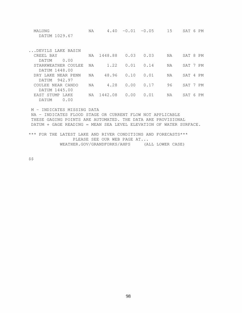
98
MALUNG NA 4.40 -0.01 -0.05 15 SAT 6 PM DATUM 1029.67 ...DEVILS LAKE BASIN CREEL BAY NA 1448.88 0.03 0.03 NA SAT 8 PM DATUM 0.00 STARKWEATHER COULEE NA 1.22 0.01 0.14 NA SAT 7 PM DATUM 1448.00 DRY LAKE NEAR PENN NA 48.96 0.10 0.01 NA SAT 4 PM DATUM 942.97 COULEE NEAR CANDO NA 4.28 0.00 0.17 96 SAT 7 PM DATUM 1445.00 EAST STUMP LAKE NA 1442.08 0.00 0.01 NA SAT 6 PM DATUM 0.00 M - INDICATES MISSING DATA NA - INDICATES FLOOD STAGE OR CURRENT FLOW NOT APPLICABLE THESE GAGING POINTS ARE AUTOMATED. THE DATA ARE PROVISIONAL DATUM + GAGE READING = MEAN SEA LEVEL ELEVATION OF WATER SURFACE. *** FOR THE LATEST LAKE AND RIVER CONDITIONS AND FORECASTS*** PLEASE SEE OUR WEB PAGE AT... WEATHER.GOV/GRANDFORKS/AHPS (ALL LOWER CASE) $$
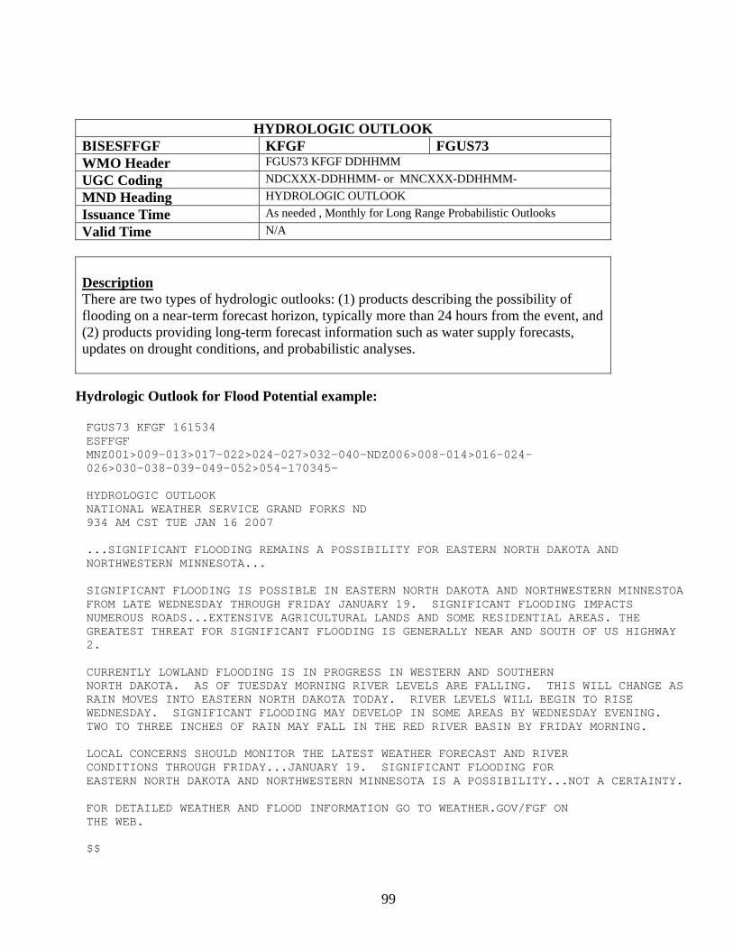
99
HYDROLOGIC OUTLOOK BISESFFGF KFGF FGUS73 WMO Header FGUS73 KFGF DDHHMM UGC Coding NDCXXX-DDHHMM- or MNCXXX-DDHHMM- MND Heading HYDROLOGIC OUTLOOK Issuance Time As needed , Monthly for Long Range Probabilistic Outlooks Valid Time N/A
Description There are two types of hydrologic outlooks: (1) products describing the possibility of flooding on a near-term forecast horizon, typically more than 24 hours from the event, and (2) products providing long-term forecast information such as water supply forecasts, updates on drought conditions, and probabilistic analyses.
Hydrologic Outlook for Flood Potential example: FGUS73 KFGF 161534 ESFFGF MNZ001>009-013>017-022>024-027>032-040-NDZ006>008-014>016-024- 026>030-038-039-049-052>054-170345- HYDROLOGIC OUTLOOK NATIONAL WEATHER SERVICE GRAND FORKS ND 934 AM CST TUE JAN 16 2007 ...SIGNIFICANT FLOODING REMAINS A POSSIBILITY FOR EASTERN NORTH DAKOTA AND NORTHWESTERN MINNESOTA... SIGNIFICANT FLOODING IS POSSIBLE IN EASTERN NORTH DAKOTA AND NORTHWESTERN MINNESTOA FROM LATE WEDNESDAY THROUGH FRIDAY JANUARY 19. SIGNIFICANT FLOODING IMPACTS NUMEROUS ROADS...EXTENSIVE AGRICULTURAL LANDS AND SOME RESIDENTIAL AREAS. THE GREATEST THREAT FOR SIGNIFICANT FLOODING IS GENERALLY NEAR AND SOUTH OF US HIGHWAY 2. CURRENTLY LOWLAND FLOODING IS IN PROGRESS IN WESTERN AND SOUTHERN NORTH DAKOTA. AS OF TUESDAY MORNING RIVER LEVELS ARE FALLING. THIS WILL CHANGE AS RAIN MOVES INTO EASTERN NORTH DAKOTA TODAY. RIVER LEVELS WILL BEGIN TO RISE WEDNESDAY. SIGNIFICANT FLOODING MAY DEVELOP IN SOME AREAS BY WEDNESDAY EVENING. TWO TO THREE INCHES OF RAIN MAY FALL IN THE RED RIVER BASIN BY FRIDAY MORNING. LOCAL CONCERNS SHOULD MONITOR THE LATEST WEATHER FORECAST AND RIVER CONDITIONS THROUGH FRIDAY...JANUARY 19. SIGNIFICANT FLOODING FOR EASTERN NORTH DAKOTA AND NORTHWESTERN MINNESOTA IS A POSSIBILITY...NOT A CERTAINTY. FOR DETAILED WEATHER AND FLOOD INFORMATION GO TO WEATHER.GOV/FGF ON THE WEB. $$
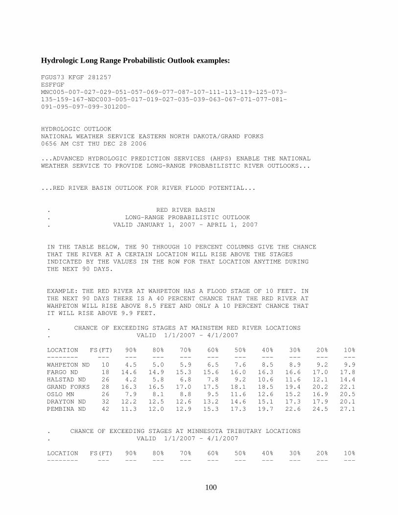
100
Hydrologic Long Range Probabilistic Outlook examples: FGUS73 KFGF 281257 ESFFGF MNC005-007-027-029-051-057-069-077-087-107-111-113-119-125-073- 135-159-167-NDC003-005-017-019-027-035-039-063-067-071-077-081- 091-095-097-099-301200- HYDROLOGIC OUTLOOK NATIONAL WEATHER SERVICE EASTERN NORTH DAKOTA/GRAND FORKS 0656 AM CST THU DEC 28 2006 ...ADVANCED HYDROLOGIC PREDICTION SERVICES (AHPS) ENABLE THE NATIONAL WEATHER SERVICE TO PROVIDE LONG-RANGE PROBABILISTIC RIVER OUTLOOKS... ...RED RIVER BASIN OUTLOOK FOR RIVER FLOOD POTENTIAL... . RED RIVER BASIN . LONG-RANGE PROBABILISTIC OUTLOOK . VALID JANUARY 1, 2007 - APRIL 1, 2007 IN THE TABLE BELOW, THE 90 THROUGH 10 PERCENT COLUMNS GIVE THE CHANCE THAT THE RIVER AT A CERTAIN LOCATION WILL RISE ABOVE THE STAGES INDICATED BY THE VALUES IN THE ROW FOR THAT LOCATION ANYTIME DURING THE NEXT 90 DAYS. EXAMPLE: THE RED RIVER AT WAHPETON HAS A FLOOD STAGE OF 10 FEET. IN THE NEXT 90 DAYS THERE IS A 40 PERCENT CHANCE THAT THE RED RIVER AT WAHPETON WILL RISE ABOVE 8.5 FEET AND ONLY A 10 PERCENT CHANCE THAT IT WILL RISE ABOVE 9.9 FEET. . CHANCE OF EXCEEDING STAGES AT MAINSTEM RED RIVER LOCATIONS . VALID 1/1/2007 - 4/1/2007 LOCATION FS(FT) 90% 80% 70% 60% 50% 40% 30% 20% 10% -------- --- --- --- --- --- --- --- --- --- --- WAHPETON ND 10 4.5 5.0 5.9 6.5 7.6 8.5 8.9 9.2 9.9 FARGO ND 18 14.6 14.9 15.3 15.6 16.0 16.3 16.6 17.0 17.8 HALSTAD ND 26 4.2 5.8 6.8 7.8 9.2 10.6 11.6 12.1 14.4 GRAND FORKS 28 16.3 16.5 17.0 17.5 18.1 18.5 19.4 20.2 22.1 OSLO MN 26 7.9 8.1 8.8 9.5 11.6 12.6 15.2 16.9 20.5 DRAYTON ND 32 12.2 12.5 12.6 13.2 14.6 15.1 17.3 17.9 20.1 PEMBINA ND 42 11.3 12.0 12.9 15.3 17.3 19.7 22.6 24.5 27.1 . CHANCE OF EXCEEDING STAGES AT MINNESOTA TRIBUTARY LOCATIONS . VALID 1/1/2007 - 4/1/2007 LOCATION FS(FT) 90% 80% 70% 60% 50% 40% 30% 20% 10% -------- --- --- --- --- --- --- --- --- --- ---
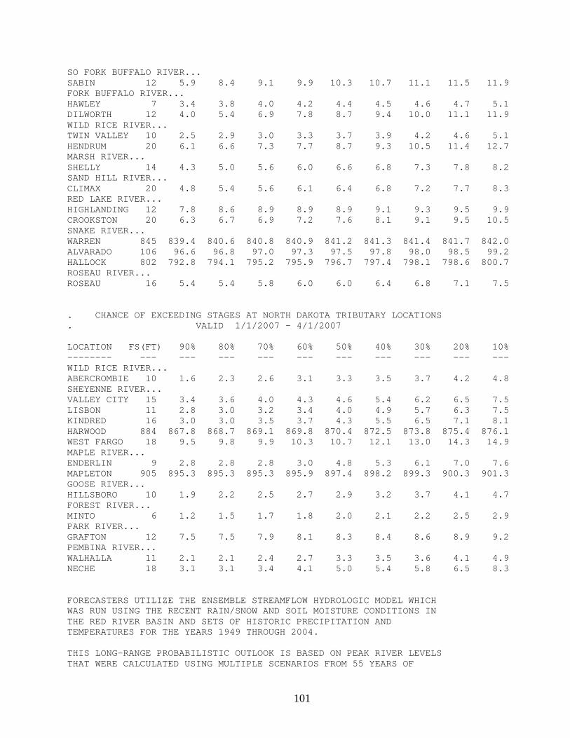
101
SO FORK BUFFALO RIVER... SABIN 12 5.9 8.4 9.1 9.9 10.3 10.7 11.1 11.5 11.9 FORK BUFFALO RIVER... HAWLEY 7 3.4 3.8 4.0 4.2 4.4 4.5 4.6 4.7 5.1 DILWORTH 12 4.0 5.4 6.9 7.8 8.7 9.4 10.0 11.1 11.9 WILD RICE RIVER... TWIN VALLEY 10 2.5 2.9 3.0 3.3 3.7 3.9 4.2 4.6 5.1 HENDRUM 20 6.1 6.6 7.3 7.7 8.7 9.3 10.5 11.4 12.7 MARSH RIVER... SHELLY 14 4.3 5.0 5.6 6.0 6.6 6.8 7.3 7.8 8.2 SAND HILL RIVER... CLIMAX 20 4.8 5.4 5.6 6.1 6.4 6.8 7.2 7.7 8.3 RED LAKE RIVER... HIGHLANDING 12 7.8 8.6 8.9 8.9 8.9 9.1 9.3 9.5 9.9 CROOKSTON 20 6.3 6.7 6.9 7.2 7.6 8.1 9.1 9.5 10.5 SNAKE RIVER... WARREN 845 839.4 840.6 840.8 840.9 841.2 841.3 841.4 841.7 842.0 ALVARADO 106 96.6 96.8 97.0 97.3 97.5 97.8 98.0 98.5 99.2 HALLOCK 802 792.8 794.1 795.2 795.9 796.7 797.4 798.1 798.6 800.7 ROSEAU RIVER... ROSEAU 16 5.4 5.4 5.8 6.0 6.0 6.4 6.8 7.1 7.5 . CHANCE OF EXCEEDING STAGES AT NORTH DAKOTA TRIBUTARY LOCATIONS . VALID 1/1/2007 - 4/1/2007 LOCATION FS(FT) 90% 80% 70% 60% 50% 40% 30% 20% 10% -------- --- --- --- --- --- --- --- --- --- --- WILD RICE RIVER... ABERCROMBIE 10 1.6 2.3 2.6 3.1 3.3 3.5 3.7 4.2 4.8 SHEYENNE RIVER... VALLEY CITY 15 3.4 3.6 4.0 4.3 4.6 5.4 6.2 6.5 7.5 LISBON 11 2.8 3.0 3.2 3.4 4.0 4.9 5.7 6.3 7.5 KINDRED 16 3.0 3.0 3.5 3.7 4.3 5.5 6.5 7.1 8.1 HARWOOD 884 867.8 868.7 869.1 869.8 870.4 872.5 873.8 875.4 876.1 WEST FARGO 18 9.5 9.8 9.9 10.3 10.7 12.1 13.0 14.3 14.9 MAPLE RIVER... ENDERLIN 9 2.8 2.8 2.8 3.0 4.8 5.3 6.1 7.0 7.6 MAPLETON 905 895.3 895.3 895.3 895.9 897.4 898.2 899.3 900.3 901.3 GOOSE RIVER... HILLSBORO 10 1.9 2.2 2.5 2.7 2.9 3.2 3.7 4.1 4.7 FOREST RIVER... MINTO 6 1.2 1.5 1.7 1.8 2.0 2.1 2.2 2.5 2.9 PARK RIVER... GRAFTON 12 7.5 7.5 7.9 8.1 8.3 8.4 8.6 8.9 9.2 PEMBINA RIVER... WALHALLA 11 2.1 2.1 2.4 2.7 3.3 3.5 3.6 4.1 4.9 NECHE 18 3.1 3.1 3.4 4.1 5.0 5.4 5.8 6.5 8.3 FORECASTERS UTILIZE THE ENSEMBLE STREAMFLOW HYDROLOGIC MODEL WHICH WAS RUN USING THE RECENT RAIN/SNOW AND SOIL MOISTURE CONDITIONS IN THE RED RIVER BASIN AND SETS OF HISTORIC PRECIPITATION AND TEMPERATURES FOR THE YEARS 1949 THROUGH 2004. THIS LONG-RANGE PROBABILISTIC OUTLOOK IS BASED ON PEAK RIVER LEVELS THAT WERE CALCULATED USING MULTIPLE SCENARIOS FROM 55 YEARS OF
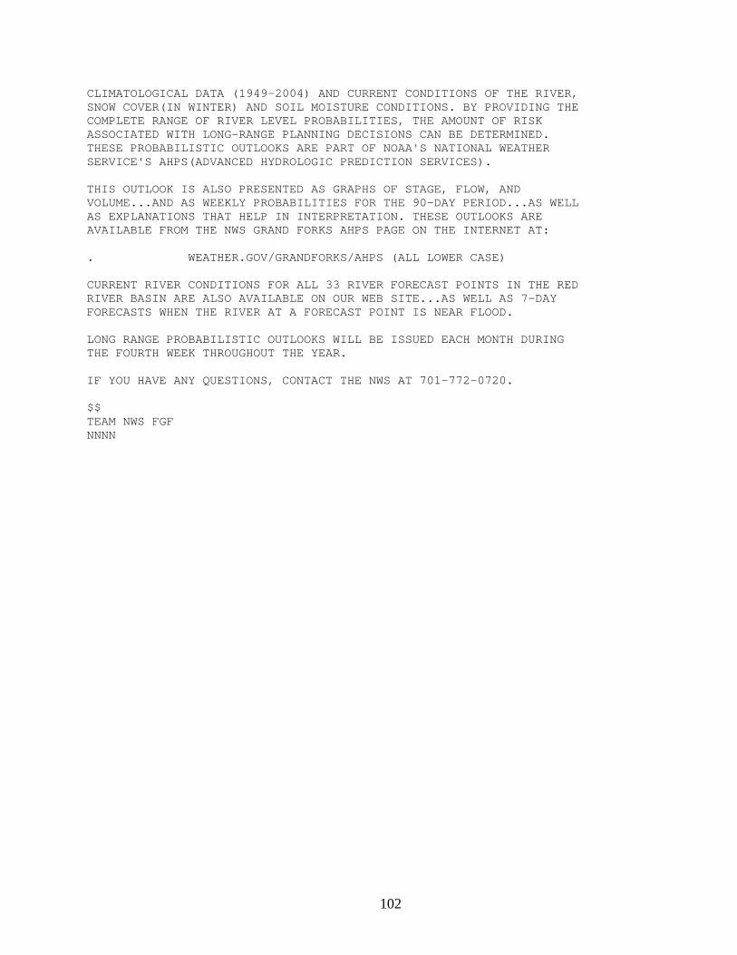
102
CLIMATOLOGICAL DATA (1949-2004) AND CURRENT CONDITIONS OF THE RIVER, SNOW COVER(IN WINTER) AND SOIL MOISTURE CONDITIONS. BY PROVIDING THE COMPLETE RANGE OF RIVER LEVEL PROBABILITIES, THE AMOUNT OF RISK ASSOCIATED WITH LONG-RANGE PLANNING DECISIONS CAN BE DETERMINED. THESE PROBABILISTIC OUTLOOKS ARE PART OF NOAA'S NATIONAL WEATHER SERVICE'S AHPS(ADVANCED HYDROLOGIC PREDICTION SERVICES). THIS OUTLOOK IS ALSO PRESENTED AS GRAPHS OF STAGE, FLOW, AND VOLUME...AND AS WEEKLY PROBABILITIES FOR THE 90-DAY PERIOD...AS WELL AS EXPLANATIONS THAT HELP IN INTERPRETATION. THESE OUTLOOKS ARE AVAILABLE FROM THE NWS GRAND FORKS AHPS PAGE ON THE INTERNET AT: . WEATHER.GOV/GRANDFORKS/AHPS (ALL LOWER CASE) CURRENT RIVER CONDITIONS FOR ALL 33 RIVER FORECAST POINTS IN THE RED RIVER BASIN ARE ALSO AVAILABLE ON OUR WEB SITE...AS WELL AS 7-DAY FORECASTS WHEN THE RIVER AT A FORECAST POINT IS NEAR FLOOD. LONG RANGE PROBABILISTIC OUTLOOKS WILL BE ISSUED EACH MONTH DURING THE FOURTH WEEK THROUGHOUT THE YEAR. IF YOU HAVE ANY QUESTIONS, CONTACT THE NWS AT 701-772-0720. $$ TEAM NWS FGF NNNN
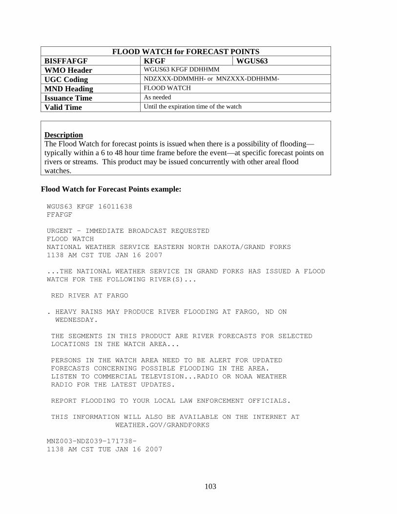
103
FLOOD WATCH for FORECAST POINTS BISFFAFGF KFGF WGUS63 WMO Header WGUS63 KFGF DDHHMM UGC Coding NDZXXX-DDMMHH- or MNZXXX-DDHHMM- MND Heading FLOOD WATCH Issuance Time As needed Valid Time Until the expiration time of the watch
Description The Flood Watch for forecast points is issued when there is a possibility of flooding—typically within a 6 to 48 hour time frame before the event—at specific forecast points on rivers or streams. This product may be issued concurrently with other areal flood watches.
Flood Watch for Forecast Points example:
WGUS63 KFGF 16011638 FFAFGF URGENT - IMMEDIATE BROADCAST REQUESTED FLOOD WATCH NATIONAL WEATHER SERVICE EASTERN NORTH DAKOTA/GRAND FORKS 1138 AM CST TUE JAN 16 2007 ...THE NATIONAL WEATHER SERVICE IN GRAND FORKS HAS ISSUED A FLOOD WATCH FOR THE FOLLOWING RIVER(S)... RED RIVER AT FARGO . HEAVY RAINS MAY PRODUCE RIVER FLOODING AT FARGO, ND ON WEDNESDAY. THE SEGMENTS IN THIS PRODUCT ARE RIVER FORECASTS FOR SELECTED LOCATIONS IN THE WATCH AREA... PERSONS IN THE WATCH AREA NEED TO BE ALERT FOR UPDATED FORECASTS CONCERNING POSSIBLE FLOODING IN THE AREA. LISTEN TO COMMERCIAL TELEVISION...RADIO OR NOAA WEATHER RADIO FOR THE LATEST UPDATES. REPORT FLOODING TO YOUR LOCAL LAW ENFORCEMENT OFFICIALS. THIS INFORMATION WILL ALSO BE AVAILABLE ON THE INTERNET AT WEATHER.GOV/GRANDFORKS MNZ003-NDZ039-171738- 1138 AM CST TUE JAN 16 2007
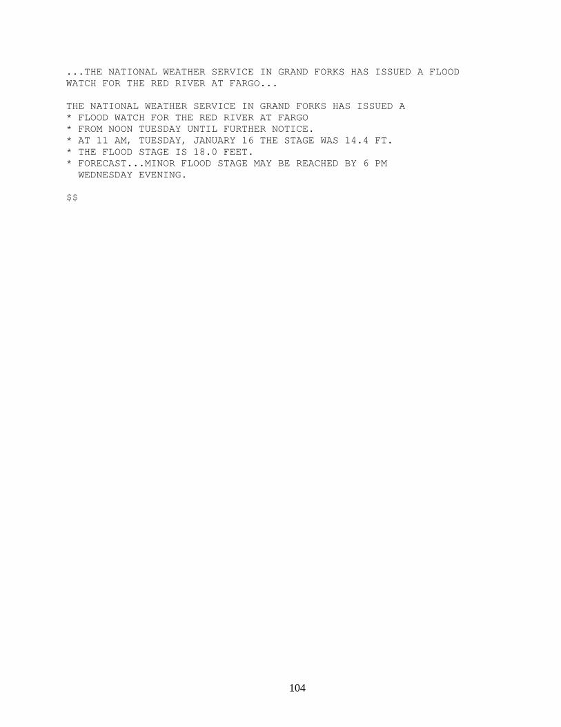
104
...THE NATIONAL WEATHER SERVICE IN GRAND FORKS HAS ISSUED A FLOOD WATCH FOR THE RED RIVER AT FARGO... THE NATIONAL WEATHER SERVICE IN GRAND FORKS HAS ISSUED A * FLOOD WATCH FOR THE RED RIVER AT FARGO * FROM NOON TUESDAY UNTIL FURTHER NOTICE. * AT 11 AM, TUESDAY, JANUARY 16 THE STAGE WAS 14.4 FT. * THE FLOOD STAGE IS 18.0 FEET. * FORECAST...MINOR FLOOD STAGE MAY BE REACHED BY 6 PM WEDNESDAY EVENING. $$
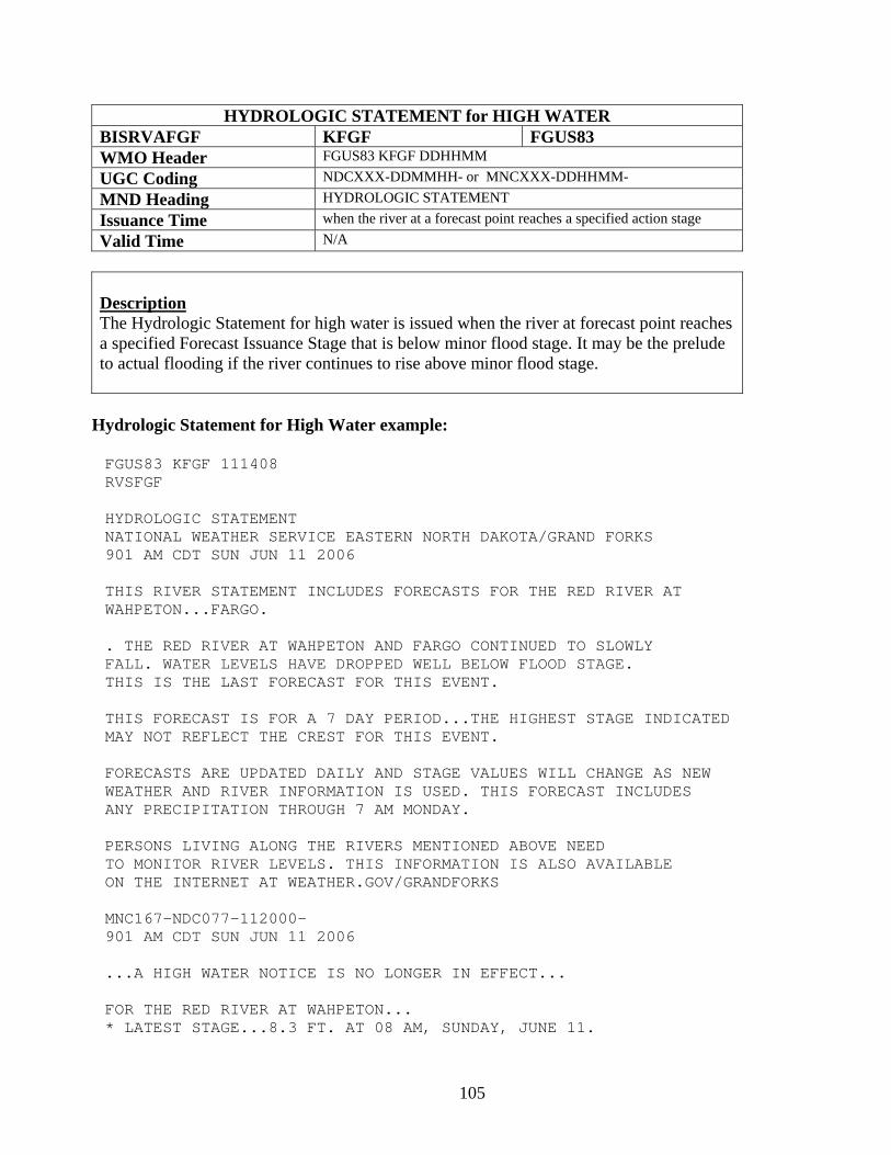
105
HYDROLOGIC STATEMENT for HIGH WATER BISRVAFGF KFGF FGUS83 WMO Header FGUS83 KFGF DDHHMM UGC Coding NDCXXX-DDMMHH- or MNCXXX-DDHHMM- MND Heading HYDROLOGIC STATEMENT Issuance Time when the river at a forecast point reaches a specified action stage Valid Time N/A
Description The Hydrologic Statement for high water is issued when the river at forecast point reaches a specified Forecast Issuance Stage that is below minor flood stage. It may be the prelude to actual flooding if the river continues to rise above minor flood stage.
Hydrologic Statement for High Water example:
FGUS83 KFGF 111408 RVSFGF HYDROLOGIC STATEMENT NATIONAL WEATHER SERVICE EASTERN NORTH DAKOTA/GRAND FORKS 901 AM CDT SUN JUN 11 2006 THIS RIVER STATEMENT INCLUDES FORECASTS FOR THE RED RIVER AT WAHPETON...FARGO. . THE RED RIVER AT WAHPETON AND FARGO CONTINUED TO SLOWLY FALL. WATER LEVELS HAVE DROPPED WELL BELOW FLOOD STAGE. THIS IS THE LAST FORECAST FOR THIS EVENT. THIS FORECAST IS FOR A 7 DAY PERIOD...THE HIGHEST STAGE INDICATED MAY NOT REFLECT THE CREST FOR THIS EVENT. FORECASTS ARE UPDATED DAILY AND STAGE VALUES WILL CHANGE AS NEW WEATHER AND RIVER INFORMATION IS USED. THIS FORECAST INCLUDES ANY PRECIPITATION THROUGH 7 AM MONDAY. PERSONS LIVING ALONG THE RIVERS MENTIONED ABOVE NEED TO MONITOR RIVER LEVELS. THIS INFORMATION IS ALSO AVAILABLE ON THE INTERNET AT WEATHER.GOV/GRANDFORKS MNC167-NDC077-112000- 901 AM CDT SUN JUN 11 2006 ...A HIGH WATER NOTICE IS NO LONGER IN EFFECT... FOR THE RED RIVER AT WAHPETON... * LATEST STAGE...8.3 FT. AT 08 AM, SUNDAY, JUNE 11.
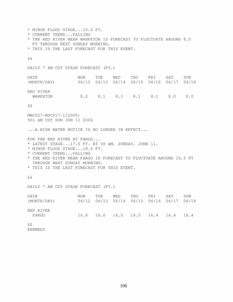
106
* MINOR FLOOD STAGE...10.0 FT. * CURRENT TREND...FALLING * THE RED RIVER NEAR WAHPETON IS FORECAST TO FLUCTUATE AROUND 8.0 FT THROUGH NEXT SUNDAY MORNING. * THIS IS THE LAST FORECAST FOR THIS EVENT. && DAILY 7 AM CDT STAGE FORECAST (FT.) DATE MON TUE WED THU FRI SAT SUN (MONTH/DAY) 06/12 06/13 06/14 06/15 06/16 06/17 06/18 RED RIVER WAHPETON 8.2 8.1 8.1 8.1 8.1 8.0 8.0 $$ MNC027-NDC017-112000- 901 AM CDT SUN JUN 11 2006 ...A HIGH WATER NOTICE IS NO LONGER IN EFFECT... FOR THE RED RIVER AT FARGO... * LATEST STAGE...17.0 FT. AT 08 AM, SUNDAY, JUNE 11. * MINOR FLOOD STAGE...18.0 FT. * CURRENT TREND...FALLING * THE RED RIVER NEAR FARGO IS FORECAST TO FLUCTUATE AROUND 16.5 FT THROUGH NEXT SUNDAY MORNING. * THIS IS THE LAST FORECAST FOR THIS EVENT. && DAILY 7 AM CDT STAGE FORECAST (FT.) DATE MON TUE WED THU FRI SAT SUN (MONTH/DAY) 06/12 06/13 06/14 06/15 06/16 06/17 06/18 RED RIVER FARGO 16.8 16.6 16.5 16.5 16.4 16.4 16.4 $$ KENNEDY
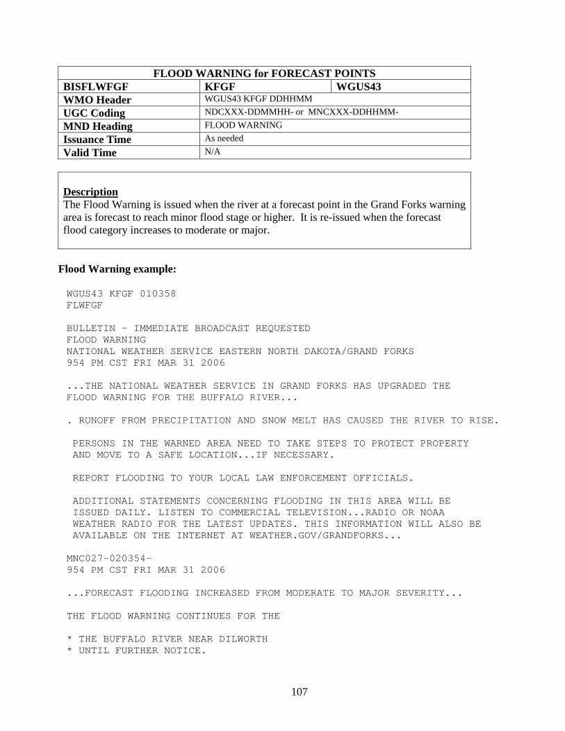
107
FLOOD WARNING for FORECAST POINTS BISFLWFGF KFGF WGUS43 WMO Header WGUS43 KFGF DDHHMM UGC Coding NDCXXX-DDMMHH- or MNCXXX-DDHHMM- MND Heading FLOOD WARNING Issuance Time As needed Valid Time N/A
Description The Flood Warning is issued when the river at a forecast point in the Grand Forks warning area is forecast to reach minor flood stage or higher. It is re-issued when the forecast flood category increases to moderate or major.
Flood Warning example:
WGUS43 KFGF 010358 FLWFGF BULLETIN - IMMEDIATE BROADCAST REQUESTED FLOOD WARNING NATIONAL WEATHER SERVICE EASTERN NORTH DAKOTA/GRAND FORKS 954 PM CST FRI MAR 31 2006 ...THE NATIONAL WEATHER SERVICE IN GRAND FORKS HAS UPGRADED THE FLOOD WARNING FOR THE BUFFALO RIVER... . RUNOFF FROM PRECIPITATION AND SNOW MELT HAS CAUSED THE RIVER TO RISE. PERSONS IN THE WARNED AREA NEED TO TAKE STEPS TO PROTECT PROPERTY AND MOVE TO A SAFE LOCATION...IF NECESSARY. REPORT FLOODING TO YOUR LOCAL LAW ENFORCEMENT OFFICIALS. ADDITIONAL STATEMENTS CONCERNING FLOODING IN THIS AREA WILL BE ISSUED DAILY. LISTEN TO COMMERCIAL TELEVISION...RADIO OR NOAA WEATHER RADIO FOR THE LATEST UPDATES. THIS INFORMATION WILL ALSO BE AVAILABLE ON THE INTERNET AT WEATHER.GOV/GRANDFORKS... MNC027-020354- 954 PM CST FRI MAR 31 2006 ...FORECAST FLOODING INCREASED FROM MODERATE TO MAJOR SEVERITY... THE FLOOD WARNING CONTINUES FOR THE * THE BUFFALO RIVER NEAR DILWORTH * UNTIL FURTHER NOTICE.
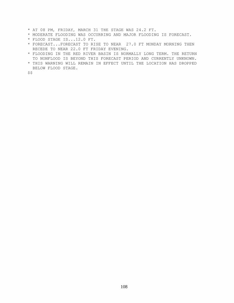
108
* AT 08 PM, FRIDAY, MARCH 31 THE STAGE WAS 24.2 FT. * MODERATE FLOODING WAS OCCURRING AND MAJOR FLOODING IS FORECAST. * FLOOD STAGE IS...12.0 FT. * FORECAST...FORECAST TO RISE TO NEAR 27.0 FT MONDAY MORNING THEN RECEDE TO NEAR 22.0 FT FRIDAY EVENING. * FLOODING IN THE RED RIVER BASIN IS NORMALLY LONG TERM. THE RETURN TO NONFLOOD IS BEYOND THIS FORECAST PERIOD AND CURRENTLY UNKNOWN. * THIS WARNING WILL REMAIN IN EFFECT UNTIL THE LOCATION HAS DROPPED BELOW FLOOD STAGE. $$
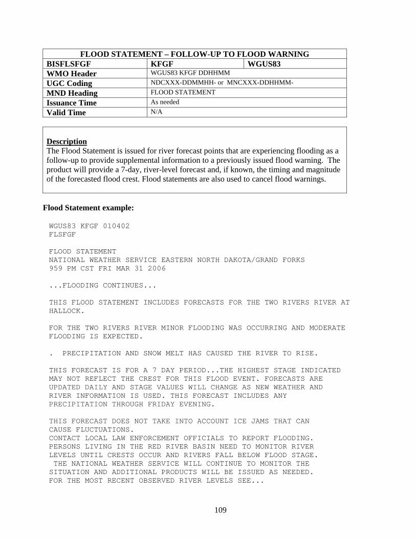
109
FLOOD STATEMENT – FOLLOW-UP TO FLOOD WARNING BISFLSFGF KFGF WGUS83 WMO Header WGUS83 KFGF DDHHMM UGC Coding NDCXXX-DDMMHH- or MNCXXX-DDHHMM- MND Heading FLOOD STATEMENT Issuance Time As needed Valid Time N/A
Description The Flood Statement is issued for river forecast points that are experiencing flooding as a follow-up to provide supplemental information to a previously issued flood warning. The product will provide a 7-day, river-level forecast and, if known, the timing and magnitude of the forecasted flood crest. Flood statements are also used to cancel flood warnings.
Flood Statement example:
WGUS83 KFGF 010402 FLSFGF FLOOD STATEMENT NATIONAL WEATHER SERVICE EASTERN NORTH DAKOTA/GRAND FORKS 959 PM CST FRI MAR 31 2006 ...FLOODING CONTINUES... THIS FLOOD STATEMENT INCLUDES FORECASTS FOR THE TWO RIVERS RIVER AT HALLOCK. FOR THE TWO RIVERS RIVER MINOR FLOODING WAS OCCURRING AND MODERATE FLOODING IS EXPECTED. . PRECIPITATION AND SNOW MELT HAS CAUSED THE RIVER TO RISE. THIS FORECAST IS FOR A 7 DAY PERIOD...THE HIGHEST STAGE INDICATED MAY NOT REFLECT THE CREST FOR THIS FLOOD EVENT. FORECASTS ARE UPDATED DAILY AND STAGE VALUES WILL CHANGE AS NEW WEATHER AND RIVER INFORMATION IS USED. THIS FORECAST INCLUDES ANY PRECIPITATION THROUGH FRIDAY EVENING. THIS FORECAST DOES NOT TAKE INTO ACCOUNT ICE JAMS THAT CAN CAUSE FLUCTUATIONS. CONTACT LOCAL LAW ENFORCEMENT OFFICIALS TO REPORT FLOODING. PERSONS LIVING IN THE RED RIVER BASIN NEED TO MONITOR RIVER LEVELS UNTIL CRESTS OCCUR AND RIVERS FALL BELOW FLOOD STAGE. THE NATIONAL WEATHER SERVICE WILL CONTINUE TO MONITOR THE SITUATION AND ADDITIONAL PRODUCTS WILL BE ISSUED AS NEEDED. FOR THE MOST RECENT OBSERVED RIVER LEVELS SEE...
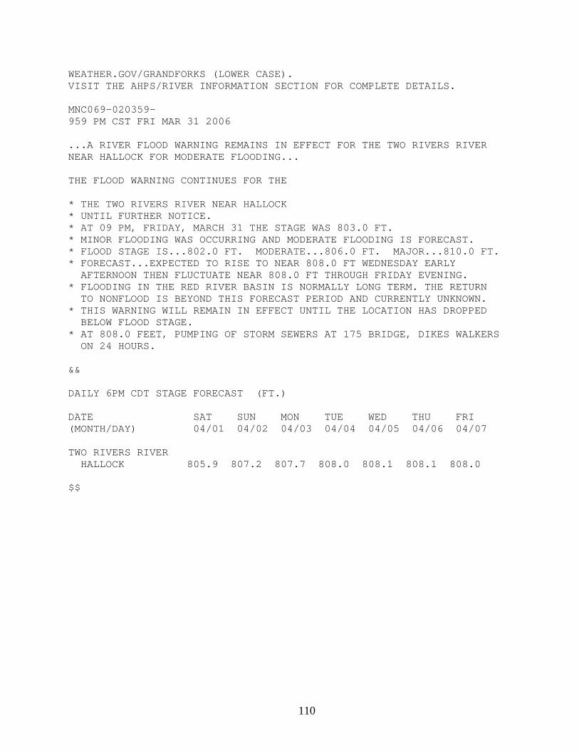
110
WEATHER.GOV/GRANDFORKS (LOWER CASE). VISIT THE AHPS/RIVER INFORMATION SECTION FOR COMPLETE DETAILS. MNC069-020359- 959 PM CST FRI MAR 31 2006 ...A RIVER FLOOD WARNING REMAINS IN EFFECT FOR THE TWO RIVERS RIVER NEAR HALLOCK FOR MODERATE FLOODING... THE FLOOD WARNING CONTINUES FOR THE * THE TWO RIVERS RIVER NEAR HALLOCK * UNTIL FURTHER NOTICE. * AT 09 PM, FRIDAY, MARCH 31 THE STAGE WAS 803.0 FT. * MINOR FLOODING WAS OCCURRING AND MODERATE FLOODING IS FORECAST. * FLOOD STAGE IS...802.0 FT. MODERATE...806.0 FT. MAJOR...810.0 FT. * FORECAST...EXPECTED TO RISE TO NEAR 808.0 FT WEDNESDAY EARLY AFTERNOON THEN FLUCTUATE NEAR 808.0 FT THROUGH FRIDAY EVENING. * FLOODING IN THE RED RIVER BASIN IS NORMALLY LONG TERM. THE RETURN TO NONFLOOD IS BEYOND THIS FORECAST PERIOD AND CURRENTLY UNKNOWN. * THIS WARNING WILL REMAIN IN EFFECT UNTIL THE LOCATION HAS DROPPED BELOW FLOOD STAGE. * AT 808.0 FEET, PUMPING OF STORM SEWERS AT 175 BRIDGE, DIKES WALKERS ON 24 HOURS. && DAILY 6PM CDT STAGE FORECAST (FT.) DATE SAT SUN MON TUE WED THU FRI (MONTH/DAY) 04/01 04/02 04/03 04/04 04/05 04/06 04/07 TWO RIVERS RIVER HALLOCK 805.9 807.2 807.7 808.0 808.1 808.1 808.0 $$
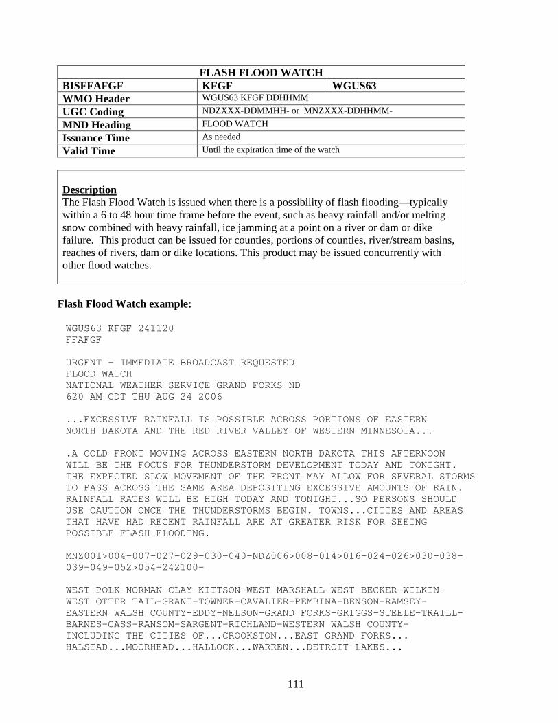
111
FLASH FLOOD WATCH BISFFAFGF KFGF WGUS63 WMO Header WGUS63 KFGF DDHHMM UGC Coding NDZXXX-DDMMHH- or MNZXXX-DDHHMM- MND Heading FLOOD WATCH Issuance Time As needed Valid Time Until the expiration time of the watch
Description The Flash Flood Watch is issued when there is a possibility of flash flooding—typically within a 6 to 48 hour time frame before the event, such as heavy rainfall and/or melting snow combined with heavy rainfall, ice jamming at a point on a river or dam or dike failure. This product can be issued for counties, portions of counties, river/stream basins, reaches of rivers, dam or dike locations. This product may be issued concurrently with other flood watches.
Flash Flood Watch example:
WGUS63 KFGF 241120 FFAFGF URGENT - IMMEDIATE BROADCAST REQUESTED FLOOD WATCH NATIONAL WEATHER SERVICE GRAND FORKS ND 620 AM CDT THU AUG 24 2006 ...EXCESSIVE RAINFALL IS POSSIBLE ACROSS PORTIONS OF EASTERN NORTH DAKOTA AND THE RED RIVER VALLEY OF WESTERN MINNESOTA... .A COLD FRONT MOVING ACROSS EASTERN NORTH DAKOTA THIS AFTERNOON WILL BE THE FOCUS FOR THUNDERSTORM DEVELOPMENT TODAY AND TONIGHT. THE EXPECTED SLOW MOVEMENT OF THE FRONT MAY ALLOW FOR SEVERAL STORMS TO PASS ACROSS THE SAME AREA DEPOSITING EXCESSIVE AMOUNTS OF RAIN. RAINFALL RATES WILL BE HIGH TODAY AND TONIGHT...SO PERSONS SHOULD USE CAUTION ONCE THE THUNDERSTORMS BEGIN. TOWNS...CITIES AND AREAS THAT HAVE HAD RECENT RAINFALL ARE AT GREATER RISK FOR SEEING POSSIBLE FLASH FLOODING. MNZ001>004-007-027-029-030-040-NDZ006>008-014>016-024-026>030-038- 039-049-052>054-242100- WEST POLK-NORMAN-CLAY-KITTSON-WEST MARSHALL-WEST BECKER-WILKIN- WEST OTTER TAIL-GRANT-TOWNER-CAVALIER-PEMBINA-BENSON-RAMSEY- EASTERN WALSH COUNTY-EDDY-NELSON-GRAND FORKS-GRIGGS-STEELE-TRAILL- BARNES-CASS-RANSOM-SARGENT-RICHLAND-WESTERN WALSH COUNTY- INCLUDING THE CITIES OF...CROOKSTON...EAST GRAND FORKS... HALSTAD...MOORHEAD...HALLOCK...WARREN...DETROIT LAKES...
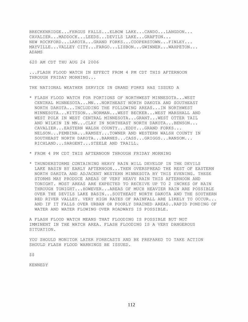
112
BRECKENRIDGE...FERGUS FALLS...ELBOW LAKE...CANDO...LANGDON... CAVALIER...MADDOCK...LEEDS...DEVILS LAKE...GRAFTON... NEW ROCKFORD...LAKOTA...GRAND FORKS...COOPERSTOWN...FINLEY... MAYVILLE...VALLEY CITY...FARGO...LISBON...GWINNER...WAHPETON... ADAMS 620 AM CDT THU AUG 24 2006 ...FLASH FLOOD WATCH IN EFFECT FROM 4 PM CDT THIS AFTERNOON THROUGH FRIDAY MORNING... THE NATIONAL WEATHER SERVICE IN GRAND FORKS HAS ISSUED A * FLASH FLOOD WATCH FOR PORTIONS OF NORTHWEST MINNESOTA...WEST CENTRAL MINNESOTA...MN...NORTHEAST NORTH DAKOTA AND SOUTHEAST NORTH DAKOTA...INCLUDING THE FOLLOWING AREAS...IN NORTHWEST MINNESOTA...KITTSON...NORMAN...WEST BECKER...WEST MARSHALL AND WEST POLK IN WEST CENTRAL MINNESOTA...GRANT...WEST OTTER TAIL AND WILKIN IN MN...CLAY IN NORTHEAST NORTH DAKOTA...BENSON... CAVALIER...EASTERN WALSH COUNTY...EDDY...GRAND FORKS... NELSON...PEMBINA...RAMSEY...TOWNER AND WESTERN WALSH COUNTY IN SOUTHEAST NORTH DAKOTA...BARNES...CASS...GRIGGS...RANSOM... RICHLAND...SARGENT...STEELE AND TRAILL. * FROM 4 PM CDT THIS AFTERNOON THROUGH FRIDAY MORNING * THUNDERSTORMS CONTAINING HEAVY RAIN WILL DEVELOP IN THE DEVILS LAKE BASIN BY EARLY AFTERNOON...THEN OVERSPREAD THE REST OF EASTERN NORTH DAKOTA AND ADJACENT WESTERN MINNESOTA BY THIS EVENING. THESE STORMS MAY PRODUCE AREAS OF VERY HEAVY RAIN THIS AFTERNOON AND TONIGHT. MOST AREAS ARE EXPECTED TO RECEIVE UP TO 2 INCHES OF RAIN THROUGH TONIGHT...HOWEVER...AREAS OF MUCH HEAVIER RAIN ARE POSSIBLE OVER THE DEVILS LAKE BASIN...SOUTHEAST NORTH DAKOTA AND THE SOUTHERN RED RIVER VALLEY. VERY HIGH RATES OF RAINFALL ARE LIKELY TO OCCUR... AND IF IT FALLS OVER URBAN OR POORLY DRAINED AREAS..RAPID PONDING OF WATER AND WATER FLOWING OVER ROADWAYS IS POSSIBLE. A FLASH FLOOD WATCH MEANS THAT FLOODING IS POSSIBLE BUT NOT IMMINENT IN THE WATCH AREA. FLASH FLOODING IS A VERY DANGEROUS SITUATION. YOU SHOULD MONITOR LATER FORECASTS AND BE PREPARED TO TAKE ACTION SHOULD FLASH FLOOD WARNINGS BE ISSUED. $$ KENNEDY
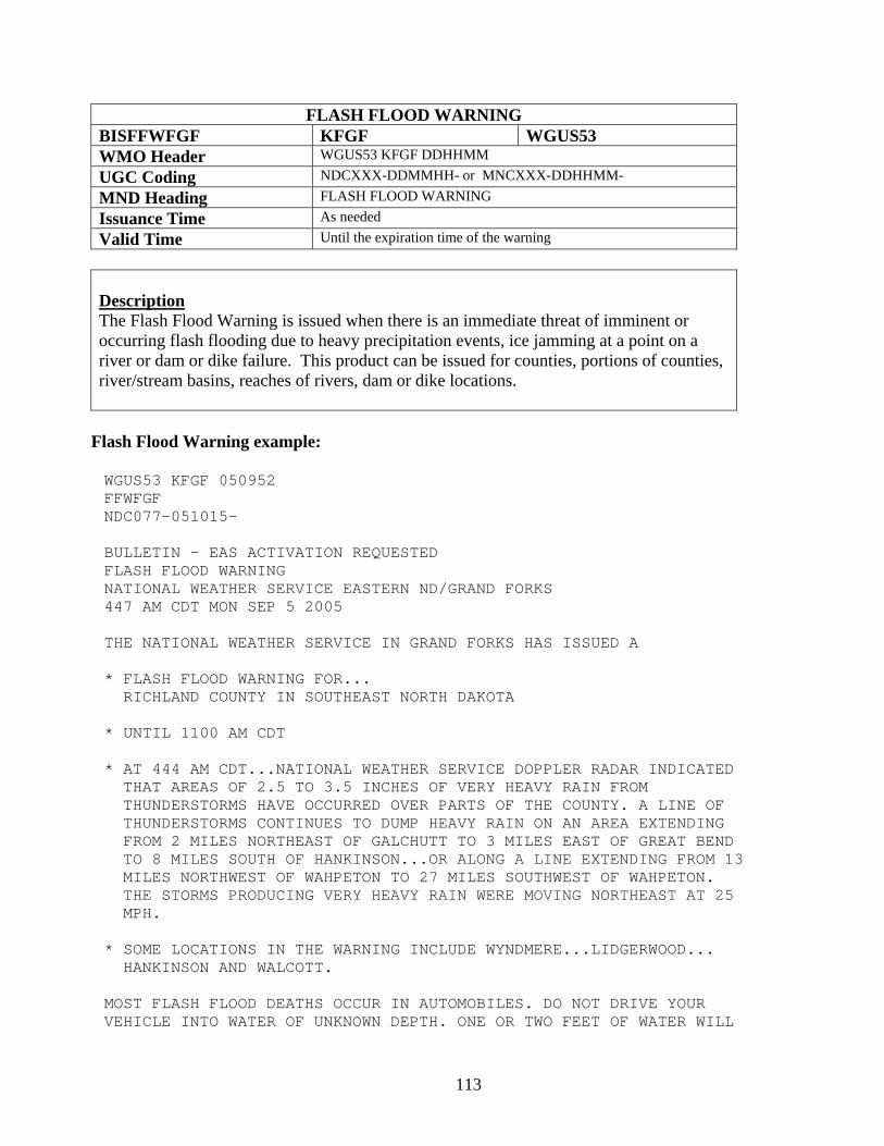
113
FLASH FLOOD WARNING BISFFWFGF KFGF WGUS53 WMO Header WGUS53 KFGF DDHHMM UGC Coding NDCXXX-DDMMHH- or MNCXXX-DDHHMM- MND Heading FLASH FLOOD WARNING Issuance Time As needed Valid Time Until the expiration time of the warning
Description The Flash Flood Warning is issued when there is an immediate threat of imminent or occurring flash flooding due to heavy precipitation events, ice jamming at a point on a river or dam or dike failure. This product can be issued for counties, portions of counties, river/stream basins, reaches of rivers, dam or dike locations.
Flash Flood Warning example:
WGUS53 KFGF 050952 FFWFGF NDC077-051015- BULLETIN - EAS ACTIVATION REQUESTED FLASH FLOOD WARNING NATIONAL WEATHER SERVICE EASTERN ND/GRAND FORKS 447 AM CDT MON SEP 5 2005 THE NATIONAL WEATHER SERVICE IN GRAND FORKS HAS ISSUED A * FLASH FLOOD WARNING FOR... RICHLAND COUNTY IN SOUTHEAST NORTH DAKOTA * UNTIL 1100 AM CDT * AT 444 AM CDT...NATIONAL WEATHER SERVICE DOPPLER RADAR INDICATED THAT AREAS OF 2.5 TO 3.5 INCHES OF VERY HEAVY RAIN FROM THUNDERSTORMS HAVE OCCURRED OVER PARTS OF THE COUNTY. A LINE OF THUNDERSTORMS CONTINUES TO DUMP HEAVY RAIN ON AN AREA EXTENDING FROM 2 MILES NORTHEAST OF GALCHUTT TO 3 MILES EAST OF GREAT BEND TO 8 MILES SOUTH OF HANKINSON...OR ALONG A LINE EXTENDING FROM 13 MILES NORTHWEST OF WAHPETON TO 27 MILES SOUTHWEST OF WAHPETON. THE STORMS PRODUCING VERY HEAVY RAIN WERE MOVING NORTHEAST AT 25 MPH. * SOME LOCATIONS IN THE WARNING INCLUDE WYNDMERE...LIDGERWOOD... HANKINSON AND WALCOTT. MOST FLASH FLOOD DEATHS OCCUR IN AUTOMOBILES. DO NOT DRIVE YOUR VEHICLE INTO WATER OF UNKNOWN DEPTH. ONE OR TWO FEET OF WATER WILL
114
FLOAT MOST CARS DOWNSTREAM. BE ESPECIALLY CAUTIOUS AT NIGHT WHEN THE DANGERS OF FLASH FLOODING ARE HARD TO RECOGNIZE. LAT...LON 4661 9725 4595 9721 4595 9659 4660 9681 $$ GV
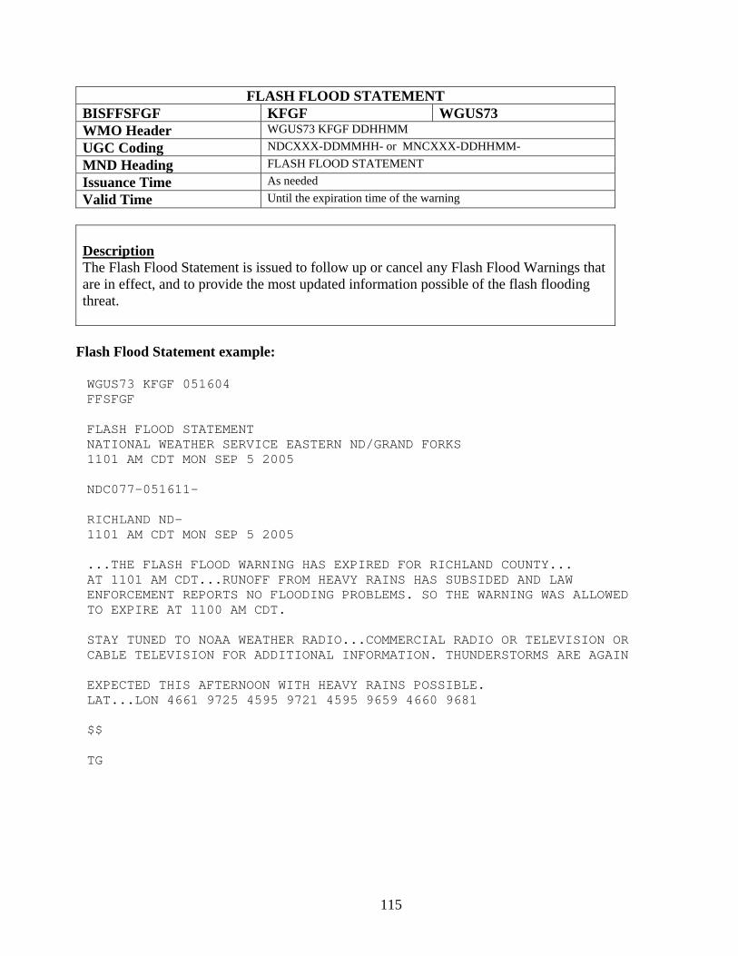
115
FLASH FLOOD STATEMENT BISFFSFGF KFGF WGUS73 WMO Header WGUS73 KFGF DDHHMM UGC Coding NDCXXX-DDMMHH- or MNCXXX-DDHHMM- MND Heading FLASH FLOOD STATEMENT Issuance Time As needed Valid Time Until the expiration time of the warning
Description The Flash Flood Statement is issued to follow up or cancel any Flash Flood Warnings that are in effect, and to provide the most updated information possible of the flash flooding threat.
Flash Flood Statement example:
WGUS73 KFGF 051604 FFSFGF FLASH FLOOD STATEMENT NATIONAL WEATHER SERVICE EASTERN ND/GRAND FORKS 1101 AM CDT MON SEP 5 2005 NDC077-051611- RICHLAND ND- 1101 AM CDT MON SEP 5 2005 ...THE FLASH FLOOD WARNING HAS EXPIRED FOR RICHLAND COUNTY... AT 1101 AM CDT...RUNOFF FROM HEAVY RAINS HAS SUBSIDED AND LAW ENFORCEMENT REPORTS NO FLOODING PROBLEMS. SO THE WARNING WAS ALLOWED TO EXPIRE AT 1100 AM CDT. STAY TUNED TO NOAA WEATHER RADIO...COMMERCIAL RADIO OR TELEVISION OR CABLE TELEVISION FOR ADDITIONAL INFORMATION. THUNDERSTORMS ARE AGAIN EXPECTED THIS AFTERNOON WITH HEAVY RAINS POSSIBLE. LAT...LON 4661 9725 4595 9721 4595 9659 4660 9681 $$ TG
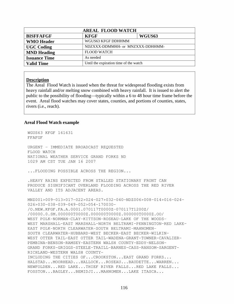
116
AREAL FLOOD WATCH BISFFAFGF KFGF WGUS63 WMO Header WGUS63 KFGF DDHHMM UGC Coding NDZXXX-DDMMHH- or MNZXXX-DDHHMM- MND Heading FLOOD WATCH Issuance Time As needed Valid Time Until the expiration time of the watch
Description The Areal Flood Watch is issued when the threat for widespread flooding exists from heavy rainfall and/or melting snow combined with heavy rainfall. It is issued to alert the public to the possibility of flooding—typically within a 6 to 48 hour time frame before the event. Areal flood watches may cover states, counties, and portions of counties, states, rivers (i.e., reach).
Areal Flood Watch example
WGUS63 KFGF 161631 FFAFGF URGENT - IMMEDIATE BROADCAST REQUESTED FLOOD WATCH NATIONAL WEATHER SERVICE GRAND FORKS ND 1029 AM CST TUE JAN 16 2007 ...FLOODING POSSIBLE ACROSS THE REGION... .HEAVY RAINS EXPECTED FROM STALLED STATIONARY FRONT CAN PRODUCE SIGNIFICANT OVERLAND FLOODING ACROSS THE RED RIVER VALLEY AND ITS ADJACENT AREAS. MNZ001>009-013>017-022>024-027>032-040-NDZ006>008-014>016-024- 026>030-038-039-049-052>054-170030- /O.NEW.KFGF.FA.A.0001.070117T0000Z-070117T1200Z/ /00000.0.SM.000000T0000Z.000000T0000Z.000000T0000Z.OO/ WEST POLK-NORMAN-CLAY-KITTSON-ROSEAU-LAKE OF THE WOODS- WEST MARSHALL-EAST MARSHALL-NORTH BELTRAMI-PENNINGTON-RED LAKE- EAST POLK-NORTH CLEARWATER-SOUTH BELTRAMI-MAHNOMEN- SOUTH CLEARWATER-HUBBARD-WEST BECKER-EAST BECKER-WILKIN- WEST OTTER TAIL-EAST OTTER TAIL-WADENA-GRANT-TOWNER-CAVALIER- PEMBINA-BENSON-RAMSEY-EASTERN WALSH COUNTY-EDDY-NELSON- GRAND FORKS-GRIGGS-STEELE-TRAILL-BARNES-CASS-RANSOM-SARGENT- RICHLAND-WESTERN WALSH COUNTY- INCLUDING THE CITIES OF...CROOKSTON...EAST GRAND FORKS... HALSTAD...MOORHEAD...HALLOCK...ROSEAU...BAUDETTE...WARREN... NEWFOLDEN...RED LAKE...THIEF RIVER FALLS...RED LAKE FALLS... FOSSTON...BAGLEY...BEMIDJI...MAHNOMEN...LAKE ITASCA...
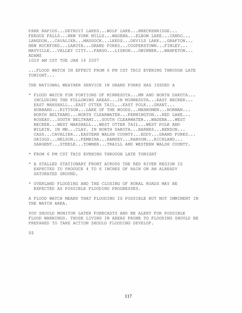
117
PARK RAPIDS...DETROIT LAKES...WOLF LAKE...BRECKENRIDGE... FERGUS FALLS...NEW YORK MILLS...WADENA...ELBOW LAKE...CANDO... LANGDON...CAVALIER...MADDOCK...LEEDS...DEVILS LAKE...GRAFTON... NEW ROCKFORD...LAKOTA...GRAND FORKS...COOPERSTOWN...FINLEY... MAYVILLE...VALLEY CITY...FARGO...LISBON...GWINNER...WAHPETON... ADAMS 1029 AM CST TUE JAN 16 2007 ...FLOOD WATCH IN EFFECT FROM 6 PM CST THIS EVENING THROUGH LATE TONIGHT... THE NATIONAL WEATHER SERVICE IN GRAND FORKS HAS ISSUED A * FLOOD WATCH FOR PORTIONS OF MINNESOTA...MN AND NORTH DAKOTA... INCLUDING THE FOLLOWING AREAS...IN MINNESOTA...EAST BECKER... EAST MARSHALL...EAST OTTER TAIL...EAST POLK...GRANT... HUBBARD...KITTSON...LAKE OF THE WOODS...MAHNOMEN...NORMAN... NORTH BELTRAMI...NORTH CLEARWATER...PENNINGTON...RED LAKE... ROSEAU...SOUTH BELTRAMI...SOUTH CLEARWATER...WADENA...WEST BECKER...WEST MARSHALL...WEST OTTER TAIL...WEST POLK AND WILKIN. IN MN...CLAY. IN NORTH DAKOTA...BARNES...BENSON... CASS...CAVALIER...EASTERN WALSH COUNTY...EDDY...GRAND FORKS... GRIGGS...NELSON...PEMBINA...RAMSEY...RANSOM...RICHLAND... SARGENT...STEELE...TOWNER...TRAILL AND WESTERN WALSH COUNTY. * FROM 6 PM CST THIS EVENING THROUGH LATE TONIGHT * A STALLED STATIONARY FRONT ACROSS THE RED RIVER REGION IS EXPECTED TO PRODUCE 4 TO 6 INCHES OF RAIN ON AN ALREADY SATURATED GROUND. * OVERLAND FLOODING AND THE CLOSING OF RURAL ROADS MAY BE EXPECTED AS POSSIBLE FLOODING PROGRESSES. A FLOOD WATCH MEANS THAT FLOODING IS POSSIBLE BUT NOT IMMINENT IN THE WATCH AREA. YOU SHOULD MONITOR LATER FORECASTS AND BE ALERT FOR POSSIBLE FLOOD WARNINGS. THOSE LIVING IN AREAS PRONE TO FLOODING SHOULD BE PREPARED TO TAKE ACTION SHOULD FLOODING DEVELOP. $$
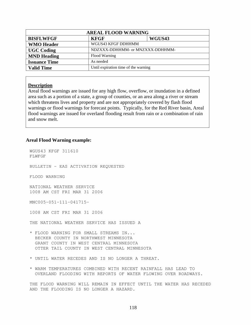
118
AREAL FLOOD WARNING BISFLWFGF KFGF WGUS43 WMO Header WGUS43 KFGF DDHHMM UGC Coding NDZXXX-DDHHMM- or MNZXXX-DDHHMM- MND Heading Flood Warning Issuance Time As needed Valid Time Until expiration time of the warning
Description Areal flood warnings are issued for any high flow, overflow, or inundation in a defined area such as a portion of a state, a group of counties, or an area along a river or stream which threatens lives and property and are not appropriately covered by flash flood warnings or flood warnings for forecast points. Typically, for the Red River basin, Areal flood warnings are issued for overland flooding result from rain or a combination of rain and snow melt.
Areal Flood Warning example: WGUS43 KFGF 311610 FLWFGF BULLETIN - EAS ACTIVATION REQUESTED FLOOD WARNING NATIONAL WEATHER SERVICE 1008 AM CST FRI MAR 31 2006 MNC005-051-111-041715- 1008 AM CST FRI MAR 31 2006 THE NATIONAL WEATHER SERVICE HAS ISSUED A * FLOOD WARNING FOR SMALL STREAMS IN... BECKER COUNTY IN NORTHWEST MINNESOTA GRANT COUNTY IN WEST CENTRAL MINNESOTA OTTER TAIL COUNTY IN WEST CENTRAL MINNESOTA * UNTIL WATER RECEDES AND IS NO LONGER A THREAT. * WARM TEMPERATURES COMBINED WITH RECENT RAINFALL HAS LEAD TO OVERLAND FLOODING WITH REPORTS OF WATER FLOWING OVER ROADWAYS. THE FLOOD WARNING WILL REMAIN IN EFFECT UNTIL THE WATER HAS RECEDED AND THE FLOODING IS NO LONGER A HAZARD.

119
LAT...LON 4580 9620 4581 9580 4615 9580 4615 9521 4712 9522 4711 9614 $$ FGFOPS
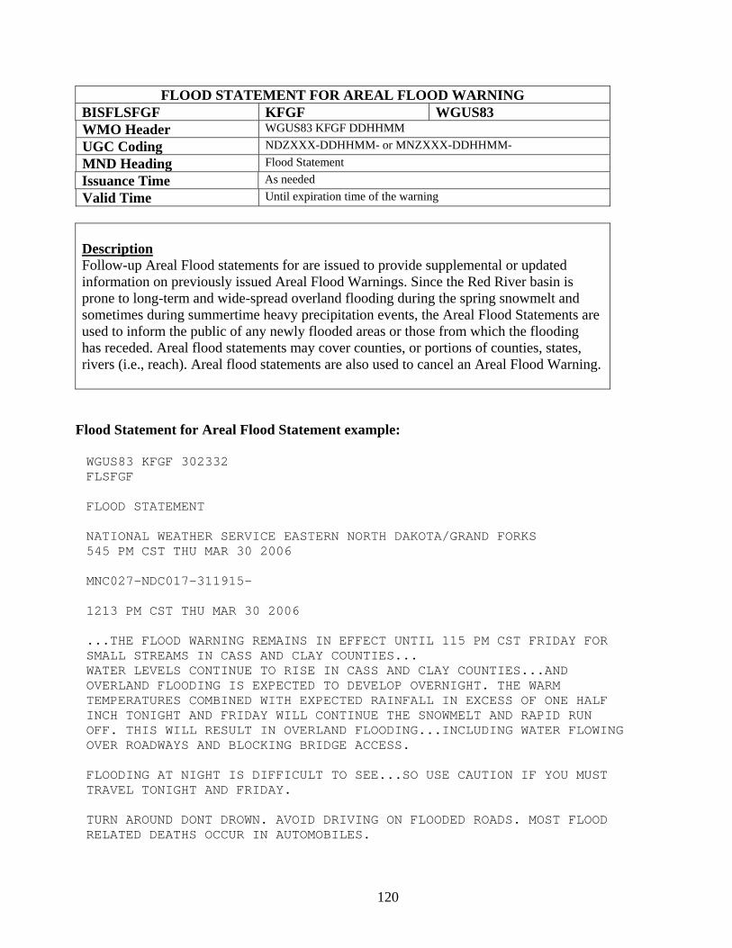
120
FLOOD STATEMENT FOR AREAL FLOOD WARNING BISFLSFGF KFGF WGUS83 WMO Header WGUS83 KFGF DDHHMM UGC Coding NDZXXX-DDHHMM- or MNZXXX-DDHHMM- MND Heading Flood Statement Issuance Time As needed Valid Time Until expiration time of the warning
Description Follow-up Areal Flood statements for are issued to provide supplemental or updated information on previously issued Areal Flood Warnings. Since the Red River basin is prone to long-term and wide-spread overland flooding during the spring snowmelt and sometimes during summertime heavy precipitation events, the Areal Flood Statements are used to inform the public of any newly flooded areas or those from which the flooding has receded. Areal flood statements may cover counties, or portions of counties, states, rivers (i.e., reach). Areal flood statements are also used to cancel an Areal Flood Warning.
Flood Statement for Areal Flood Statement example: WGUS83 KFGF 302332 FLSFGF FLOOD STATEMENT NATIONAL WEATHER SERVICE EASTERN NORTH DAKOTA/GRAND FORKS 545 PM CST THU MAR 30 2006 MNC027-NDC017-311915- 1213 PM CST THU MAR 30 2006 ...THE FLOOD WARNING REMAINS IN EFFECT UNTIL 115 PM CST FRIDAY FOR SMALL STREAMS IN CASS AND CLAY COUNTIES... WATER LEVELS CONTINUE TO RISE IN CASS AND CLAY COUNTIES...AND OVERLAND FLOODING IS EXPECTED TO DEVELOP OVERNIGHT. THE WARM TEMPERATURES COMBINED WITH EXPECTED RAINFALL IN EXCESS OF ONE HALF INCH TONIGHT AND FRIDAY WILL CONTINUE THE SNOWMELT AND RAPID RUN OFF. THIS WILL RESULT IN OVERLAND FLOODING...INCLUDING WATER FLOWING OVER ROADWAYS AND BLOCKING BRIDGE ACCESS. FLOODING AT NIGHT IS DIFFICULT TO SEE...SO USE CAUTION IF YOU MUST TRAVEL TONIGHT AND FRIDAY. TURN AROUND DONT DROWN. AVOID DRIVING ON FLOODED ROADS. MOST FLOOD RELATED DEATHS OCCUR IN AUTOMOBILES.

121
THE FLOOD WARNING WILL REMAIN IN EFFECT UNTIL THE WATER HAS RECEDED AND THE FLOODING IS NO LONGER A HAZARD. LAT...LON 4670 9760 4667 9624 4709 9625 4718 9762 $$ TEAM HYDRO FGF
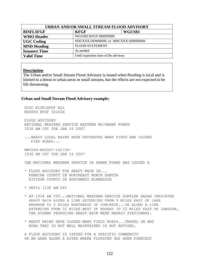
122
URBAN AND/OR SMALL STREAM FLOOD ADVISORY BISFLSFGF KFGF WGUS83 WMO Header WGUS83 KFGF DDHHMM UGC Coding NDCXXX-DDMMHH- or MNCXXX-DDHHMM- MND Heading FLOOD STATEMENT Issuance Time As needed Valid Time Until expiration time of the advisory
Description The Urban and/or Small Stream Flood Advisory is issued when flooding is local and is limited to a threat to urban areas or small streams, but the effects are not expected to be life threatening.
Urban and Small Stream Flood Advisory example:
ZCZC BISFLSFGF ALL WGUS83 KFGF 161636 FLOOD ADVISORY NATIONAL WEATHER SERVICE EASTERN ND/GRAND FORKS 1036 AM CST TUE JAN 16 2007 ...HEAVY LOCAL RAINS HAVE SATURATED MANY FIEDS AND CLOSED FIED ROADS... MNC069-NDC067-161730- 1036 AM CST TUE JAN 16 2007 THE NATIONAL WEATHER SERVICE IN GRAND FORKS HAS ISSUED A * FLOOD ADVISORY FOR HEAVY RAIN IN... PEMBINA COUNTY IN NORTHEAST NORTH DAKOTA KITTSON COUNTY IN NORTHWEST MINNESOTA * UNTIL 1130 AM CST * AT 1036 AM CST...NATIONAL WEATHER SERVICE DOPPLER RADAR INDICATED HEAVY RAIN ALONG A LINE EXTENDING FROM 9 MILES EAST OF LAKE BRONSON TO 3 MILES NORTHEAST OF CONCRETE...OR ALONG A LINE EXTENDING FROM 32 MILES WEST OF ROSEAU TO 22 MILES EAST OF LANGDON. THE STORMS PRODUCING HEAVY RAIN WERE NEARLY STATIONARY. * HEAVY RAINS HAVE CLOSED MANY FIELD ROADS...TRAVEL ON ANY ROAD THAT IS NOT WELL MAINTAINED IS NOT ADVISED. A FLOOD ADVISORY IS ISSUED FOR A SPECIFIC COMMUNITY OR AN AREA ALONG A RIVER WHERE FLOODING HAS BEEN FORECAST
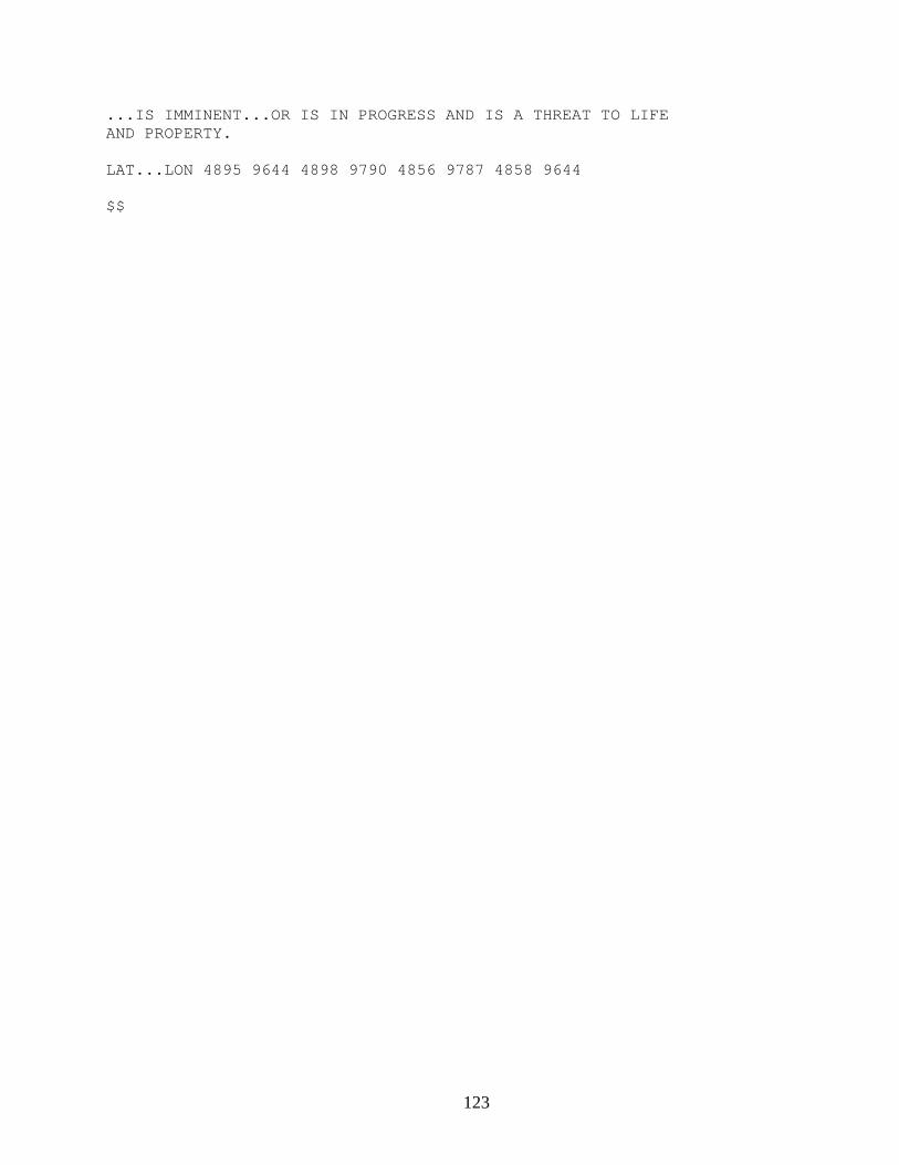
123
...IS IMMINENT...OR IS IN PROGRESS AND IS A THREAT TO LIFE AND PROPERTY. LAT...LON 4895 9644 4898 9790 4856 9787 4858 9644 $$
124
Eastern North Dakota and Northwestern Minnesota NWS Product and Services Guide
Aviation Products Terminal Aerodrome Forecast (TAF) Transcribed Weather Broadcast (TWEB)
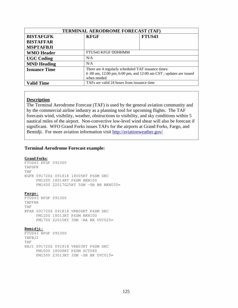
125
TERMINAL AERODROME FORECAST (TAF) BISTAFGFK BISTAFFAR MSPTAFBJI
KFGF FTUS43
WMO Header FTUS43 KFGF DDHHMM UGC Coding N/A MND Heading N/A Issuance Time There are 4 regularly scheduled TAF issuance times:
6 :00 am, 12:00 pm, 6:00 pm, and 12:00 am CST ; updates are issued when needed
Valid Time TAFs are valid 24 hours from issuance time
Description The Terminal Aerodrome Forecast (TAF) is used by the general aviation community and by the commercial airline industry as a planning tool for upcoming flights. The TAF forecasts wind, visibility, weather, obstructions to visibility, and sky conditions within 5 nautical miles of the airport. Non-convective low-level wind shear will also be forecast if significant. WFO Grand Forks issues TAFs for the airports at Grand Forks, Fargo, and Bemidji. For more aviation information visit http://aviationweather.gov/
Terminal Aerodrome Forecast example:
Grand Forks: FTUS43 KFGF 092300 TAFGFK TAF KGFK 091720z 091818 18005KT P6SM SKC FM1200 18014KT P6SM BKN100 FM1600 22017G25KT 5SM –SN BR BKN030= Fargo: FTUS43 KFGF 092300 TAFFAR TAF KFAR 091720Z 091818 VRB04KT P6SM SKC FM1200 18013KT P6SM BKN100 FM1700 22015KT 3SM –RA BR OVC025= Bemidji: FTUS43 KFGF 092300 TAFBJI TAF KBJI 091720Z 091818 VRB03KT P6SM SKC FM1000 18008KT P6SM SCT080 FM1500 23013KT 3SM –SN BR OVC015=
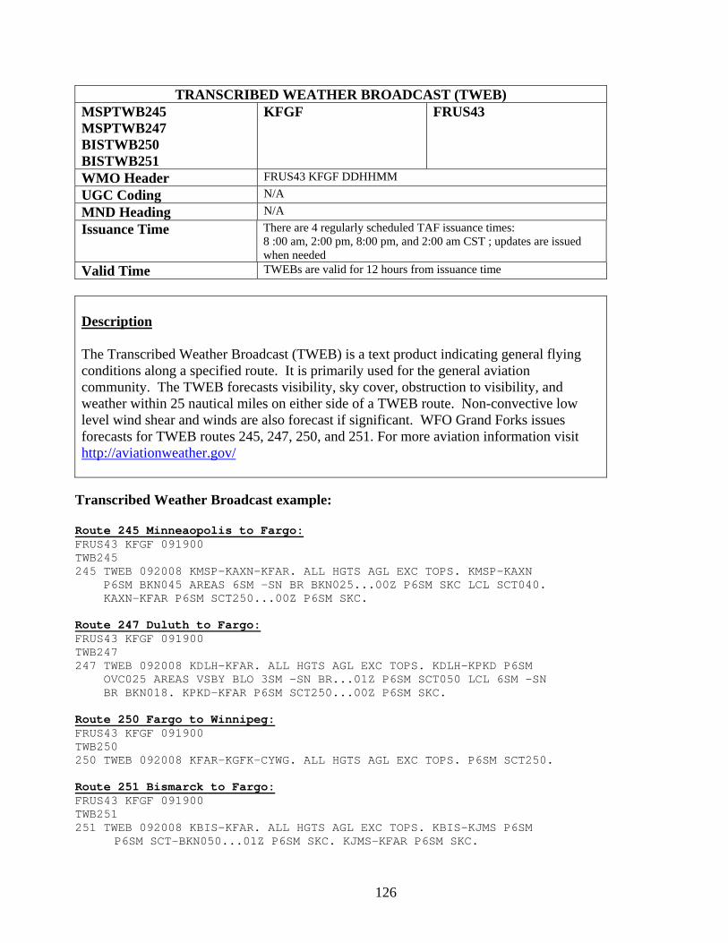
126
TRANSCRIBED WEATHER BROADCAST (TWEB) MSPTWB245 MSPTWB247 BISTWB250 BISTWB251
KFGF FRUS43
WMO Header FRUS43 KFGF DDHHMM UGC Coding N/A MND Heading N/A Issuance Time There are 4 regularly scheduled TAF issuance times:
8 :00 am, 2:00 pm, 8:00 pm, and 2:00 am CST ; updates are issued when needed
Valid Time TWEBs are valid for 12 hours from issuance time
Description The Transcribed Weather Broadcast (TWEB) is a text product indicating general flying conditions along a specified route. It is primarily used for the general aviation community. The TWEB forecasts visibility, sky cover, obstruction to visibility, and weather within 25 nautical miles on either side of a TWEB route. Non-convective low level wind shear and winds are also forecast if significant. WFO Grand Forks issues forecasts for TWEB routes 245, 247, 250, and 251. For more aviation information visit http://aviationweather.gov/
Transcribed Weather Broadcast example: Route 245 Minneaopolis to Fargo: FRUS43 KFGF 091900 TWB245 245 TWEB 092008 KMSP-KAXN-KFAR. ALL HGTS AGL EXC TOPS. KMSP-KAXN P6SM BKN045 AREAS 6SM -SN BR BKN025...00Z P6SM SKC LCL SCT040. KAXN-KFAR P6SM SCT250...00Z P6SM SKC. Route 247 Duluth to Fargo: FRUS43 KFGF 091900 TWB247 247 TWEB 092008 KDLH-KFAR. ALL HGTS AGL EXC TOPS. KDLH-KPKD P6SM OVC025 AREAS VSBY BLO 3SM -SN BR...01Z P6SM SCT050 LCL 6SM -SN BR BKN018. KPKD-KFAR P6SM SCT250...00Z P6SM SKC. Route 250 Fargo to Winnipeg: FRUS43 KFGF 091900 TWB250 250 TWEB 092008 KFAR-KGFK-CYWG. ALL HGTS AGL EXC TOPS. P6SM SCT250. Route 251 Bismarck to Fargo: FRUS43 KFGF 091900 TWB251 251 TWEB 092008 KBIS-KFAR. ALL HGTS AGL EXC TOPS. KBIS-KJMS P6SM P6SM SCT-BKN050...01Z P6SM SKC. KJMS-KFAR P6SM SKC.
127
Appendix A - Advanced Hydrologic Prediction Services (AHPS)
http://www.crh.noaa.gov/ahps2/index.php?wfo=fgf
What is AHPS?
Advanced Hydrologic Prediction Services (AHPS) are a new and essential component of our Climate, Water, and Weather Services. AHPS is a web-based suite of accurate and information-rich forecast products. They display the magnitude and uncertainty of occurrence of floods or droughts, from hours to days and months, in advance. These graphical products are useful information and planning tools for many economic and emergency managers. These new products will enable government agencies, private institutions, and individuals to make more informed decisions about risk based policies and actions to mitigate the dangers posed by floods and droughts.
Why AHPS?
Weather influences our economic and social lives in many ways. Severe weather can have impact on revenues and profits of businesses, large and small. Weather can also disrupt and disorganize communities. As our nation's population grows and infrastructure costs increase, natural disasters can threaten social stability. Weather forecasting was initially developed in response to the need of societies to protect themselves from storms, severe heat and cold, floods, etc., and minimize consequent economic losses. It is estimated that inland flooding claims 133 lives and property losses from flooding exceed $4 billion in an average year in the U.S. The National Weather Service (NWS) is our nation's agency entrusted with the mission to protect life and property and to enhance the economy.
Brief Background
Impelled by experiences with major floods in 1993 in the Midwest, the Des Moines river basin was selected as a test site for AHPS product development. The successful demonstration of AHPS on the Des Moines river was favorably received by local water resource and emergency management agencies. The devastating floods in the upper Midwest and Plains states in 1997 provided an increased sense of urgency. Since then, the NWS has finalized plans to expand implementation of AHPS to our offices in Wisconsin, Minnesota, Michigan, Iowa, Missouri and North Dakota covering different river basins in coming years. The expansion also includes tributaries within the Ohio River basin in parts of Kentucky, Ohio, and western Pennsylvania.
While floods are impossible to prevent completely and there is no way to guarantee protection of property, the NWS and other federal, state, and local agencies have proved the loss of life can be greatly reduced with better forecasting.
128
How are AHPS Products Developed?
Using sophisticated computer models and large amounts of data from a wide variety of sources such as super computers, automated gauges, geostationary (GOES) satellites, Doppler radars, weather observation stations, and the computer and communications system, called the Advanced Weather Interactive Processing System (AWIPS), the NWS provides hydrologic forecasts for almost 4,000 locations across the United States. These forecasts are developed by our River Forecast centers and distributed by our field offices for a wide range of customers.
What are the Components of AHPS?
The current group of AHPS products covers forecast periods ranging from hours to months. It also includes valuable information about the chances of flood or drought. This information is presented through user-friendly graphical products. The products are identified by the logo. The information, such as the flood forecast level to which a river will rise and when it is likely to reach its peak or crest, is shown through hydrographs. Other information include: 1.) the chance or probability of a river exceeding minor, moderate, or major flooding, 2.) the chance of a river exceeding certain level, volume, and flow of water at specific points on the river during 90 day periods, and 3.) a map of areas surrounding the forecast point that provides information about major roads, railways, landmarks, etc. likely to be flooded, the levels of past floods, etc.
An additional feature of the AHPS Web site is a map of the river basin and various points along the river for which information is available.
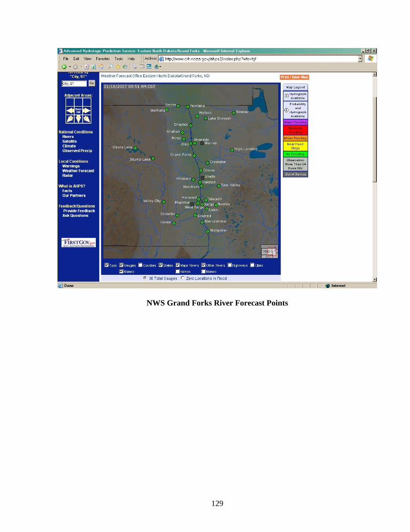
129
NWS Grand Forks River Forecast Points
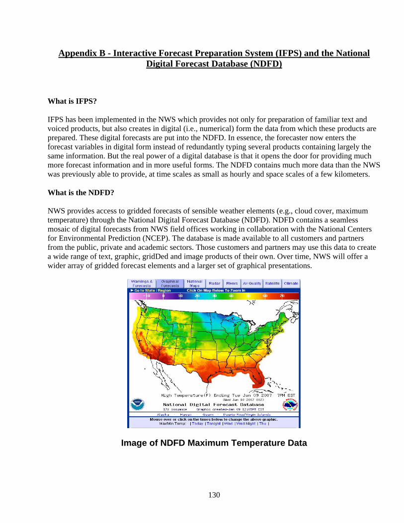
130
Appendix B - Interactive Forecast Preparation System (IFPS) and the National Digital Forecast Database (NDFD)
What is IFPS?
IFPS has been implemented in the NWS which provides not only for preparation of familiar text and voiced products, but also creates in digital (i.e., numerical) form the data from which these products are prepared. These digital forecasts are put into the NDFD. In essence, the forecaster now enters the forecast variables in digital form instead of redundantly typing several products containing largely the same information. But the real power of a digital database is that it opens the door for providing much more forecast information and in more useful forms. The NDFD contains much more data than the NWS was previously able to provide, at time scales as small as hourly and space scales of a few kilometers.
What is the NDFD?
NWS provides access to gridded forecasts of sensible weather elements (e.g., cloud cover, maximum temperature) through the National Digital Forecast Database (NDFD). NDFD contains a seamless mosaic of digital forecasts from NWS field offices working in collaboration with the National Centers for Environmental Prediction (NCEP). The database is made available to all customers and partners from the public, private and academic sectors. Those customers and partners may use this data to create a wide range of text, graphic, gridDed and image products of their own. Over time, NWS will offer a wider array of gridded forecast elements and a larger set of graphical presentations.
Image of NDFD Maximum Temperature Data
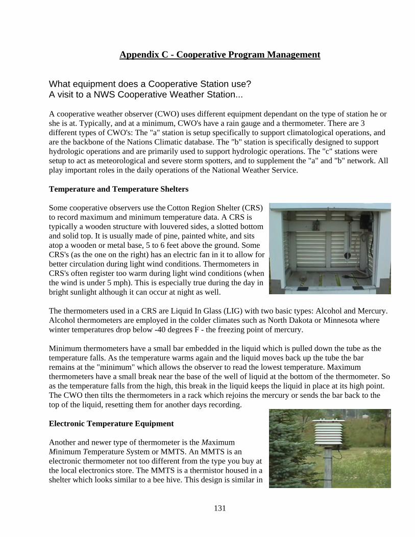
131
Appendix C - Cooperative Program Management
What equipment does a Cooperative Station use? A visit to a NWS Cooperative Weather Station...
A cooperative weather observer (CWO) uses different equipment dependant on the type of station he or she is at. Typically, and at a minimum, CWO's have a rain gauge and a thermometer. There are 3 different types of CWO's: The "a" station is setup specifically to support climatological operations, and are the backbone of the Nations Climatic database. The "b" station is specifically designed to support hydrologic operations and are primarily used to support hydrologic operations. The "c" stations were setup to act as meteorological and severe storm spotters, and to supplement the "a" and "b" network. All play important roles in the daily operations of the National Weather Service.
Temperature and Temperature Shelters
Some cooperative observers use the Cotton Region Shelter (CRS) to record maximum and minimum temperature data. A CRS is typically a wooden structure with louvered sides, a slotted bottom and solid top. It is usually made of pine, painted white, and sits atop a wooden or metal base, 5 to 6 feet above the ground. Some CRS's (as the one on the right) has an electric fan in it to allow for better circulation during light wind conditions. Thermometers in CRS's often register too warm during light wind conditions (when the wind is under 5 mph). This is especially true during the day in bright sunlight although it can occur at night as well.
The thermometers used in a CRS are Liquid In Glass (LIG) with two basic types: Alcohol and Mercury. Alcohol thermometers are employed in the colder climates such as North Dakota or Minnesota where winter temperatures drop below -40 degrees F - the freezing point of mercury.
Minimum thermometers have a small bar embedded in the liquid which is pulled down the tube as the temperature falls. As the temperature warms again and the liquid moves back up the tube the bar remains at the "minimum" which allows the observer to read the lowest temperature. Maximum thermometers have a small break near the base of the well of liquid at the bottom of the thermometer. So as the temperature falls from the high, this break in the liquid keeps the liquid in place at its high point. The CWO then tilts the thermometers in a rack which rejoins the mercury or sends the bar back to the top of the liquid, resetting them for another days recording.
Electronic Temperature Equipment
Another and newer type of thermometer is the Maximum Minimum Temperature System or MMTS. An MMTS is an electronic thermometer not too different from the type you buy at the local electronics store. The MMTS is a thermistor housed in a shelter which looks similar to a bee hive. This design is similar in
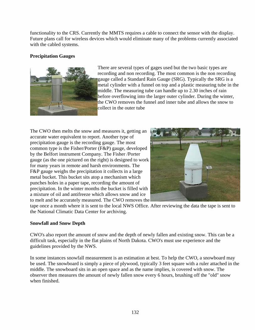
132
functionality to the CRS. Currently the MMTS requires a cable to connect the sensor with the display. Future plans call for wireless devices which would eliminate many of the problems currently associated with the cabled systems.
Precipitation Gauges
There are several types of gages used but the two basic types are recording and non recording. The most common is the non recording gauge called a Standard Rain Gauge (SRG). Typically the SRG is a metal cylinder with a funnel on top and a plastic measuring tube in the middle. The measuring tube can handle up to 2.30 inches of rain before overflowing into the larger outer cylinder. During the winter, the CWO removes the funnel and inner tube and allows the snow to collect in the outer tube
The CWO then melts the snow and measures it, getting an accurate water equivalent to report. Another type of precipitation gauge is the recording gauge. The most common type is the Fisher/Porter (F&P) gauge, developed by the Belfort instrument Company. The Fisher /Porter gauge (as the one pictured on the right) is designed to work for many years in remote and harsh environments. The F&P gauge weighs the precipitation it collects in a large metal bucket. This bucket sits atop a mechanism which punches holes in a paper tape, recording the amount of precipitation. In the winter months the bucket is filled with a mixture of oil and antifreeze which allows snow and ice to melt and be accurately measured. The CWO removes the tape once a month where it is sent to the local NWS Office. After reviewing the data the tape is sent to the National Climatic Data Center for archiving.
Snowfall and Snow Depth
CWO's also report the amount of snow and the depth of newly fallen and existing snow. This can be a difficult task, especially in the flat plains of North Dakota. CWO's must use experience and the guidelines provided by the NWS.
In some instances snowfall measurement is an estimation at best. To help the CWO, a snowboard may be used. The snowboard is simply a piece of plywood, typically 3 feet square with a ruler attached in the middle. The snowboard sits in an open space and as the name implies, is covered with snow. The observer then measures the amount of newly fallen snow every 6 hours, brushing off the "old" snow when finished.
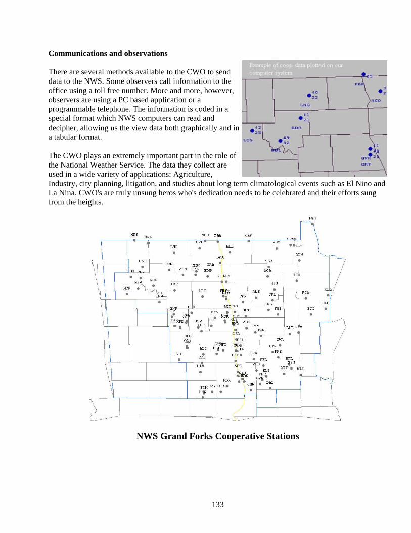
133
Communications and observations
There are several methods available to the CWO to send data to the NWS. Some observers call information to the office using a toll free number. More and more, however, observers are using a PC based application or a programmable telephone. The information is coded in a special format which NWS computers can read and decipher, allowing us the view data both graphically and in a tabular format.
The CWO plays an extremely important part in the role of the National Weather Service. The data they collect are used in a wide variety of applications: Agriculture, Industry, city planning, litigation, and studies about long term climatological events such as El Nino and La Nina. CWO's are truly unsung heros who's dedication needs to be celebrated and their efforts sung from the heights.
NWS Grand Forks Cooperative Stations
134
Appendix D – Storm Ready Program
About StormReady
Ninety percent of all presidentially declared disasters are weather related, leading to around 500 deaths per year and nearly $14 billion in damage. StormReady, a program started in 1999 in Tulsa, OK, helps arm America's communities with the communication and safety skills needed to save lives and property– before and during the event. StormReady helps community leaders and emergency managers strengthen local safety programs. For StormReady information, from national to our local area, visit the location of interest below. North Dakota: www.crh.noaa.gov/bis/stormready.htm Northwestern Minnesota: www.crh.noaa.gov/fgf/stormready/mnstmrdy.html National Storm Ready web page: www.stormready.noaa.gov/
About StormReady
StormReady prepares communities with an action plan that responds to the threat of all types of severe weather -- from tornadoes to tsunamis.
The entire community - from the mayor, emergency managers, to business leaders and civic groups - can take the lead on becoming StormReady. Local National Weather Service forecast offices work with communities to complete an application and review process. To be officially StormReady, a community must:
• Establish a 24-hour warning point and emergency operations center; • Have more than one way to receive severe weather forecasts and warnings and to alert the
public; • Create a system that monitors local weather conditions; and • Promote the importance of public readiness through community seminars;
135
• Develop a formal hazardous weather plan, which includes training severe weather spotters and holding emergency exercises.
Storm Ready Recognition Process
An advisory board, comprised of a National Weather Service Meteorologist In Charge (MIC) and Warning Coordination Meteorologist (WCM), and state and local emergency managers, will review applications from municipalities and visit the locations to verify the steps made in the process to become StormReady. StormReady communities must stay freshly prepared, because the designation is only valid for two years.
136
Appendix E – Severe Weather Terms and Safety Tips
Thunderstorms and Lightning
Some thunderstorms can be seen approaching, while others hit without warning. It is important to learn and recognize the danger signs and to plan ahead.
BEFORE
Learn the thunderstorm danger signs:
Dark, towering, or threatening clouds. Distant lightning and thunder.
Have disaster supplies on hand:
Flashlight with extra batteries Portable, battery-operated radio and extra batteries First aid kit and manual Emergency food and water Non-electric can opener Essential medicines Cash and credit cards Sturdy shoes
Check for hazards in the yard. Dead or rotting trees and branches can fall during a severe thunderstorm and cause injury and damage.
Make sure that all family members know how to respond after a thunderstorm. Teach family members how and when to turn off gas, electricity and water. Teach children how and when to call 9-1-1, police, fire department, and which radio station to
tune for emergency information.
Severe Thunderstorm Watches and Warnings
A severe thunderstorm watch is issued by the National Weather Service when the weather conditions are such that a severe thunderstorm (damaging winds 58 miles per hour or more, or hail three-fourths of an inch in diameter or greater) is likely to develop. This is the time to locate a safe place in the home and tell family members to watch the sky and listen to the radio or television for more information.
A severe thunderstorm warning is issued when a severe thunderstorm has been sighted or indicated by weather radar. At this point, the danger is very serious and everyone should go to a safe place, turn on a battery-operated radio or television, and wait for the "all clear" by the authorities.
137
Tornadoes are spawned by thunderstorms and flash flooding can occur with thunderstorms. When a "severe thunderstorm warning" is issued, review what actions to take under a "tornado warning" or a "flash flood warning."
Develop an emergency communication plan. In case family members are separated from one another during a thunderstorm (a real possibility during the day when adults are at work and children are at school), have a plan for getting back together.
Ask an out-of-state relative or friend to serve as the "family contact". After a disaster, it's often easier to call long distance. Make sure everyone knows the name, address, and phone number of the contact person.
Contact your local emergency management office or American Red Cross chapter for more information on thunderstorms and lightning.
DURING
If indoors:
Secure outdoor objects such as lawn furniture that could blow away or cause damage or injury. Listen to a battery operated radio or television for the latest storm information. Do not handle any electrical equipment or telephones because lightning could follow the wire.
Television sets are particularly dangerous at this time. Avoid bathtubs, water faucets, and sinks because metal pipes can transmit electricity.
If outdoors:
Attempt to get into a building or car. If no structure is available, get to an open space and squat low to the ground as quickly as
possible. (If in the woods, find an area protected by low clump of trees--never stand underneath a single large tree in the open.) Be aware of the potential for flooding in low-lying areas. Crouch with hands on knees.
Avoid tall structures such as towers, tall trees, fences, telephone lines, or power lines. Stay away from natural lightning rods such as golf clubs, tractors, fishing rods, bicycles, or
camping equipment. Stay from rivers, lakes, or other bodies of water. If you are isolated in a level field or prairie and you feel your hair stand on end (which indicates
that lightning is about to strike), bend forward, putting your hands on your knees. A position with feet together and crouching while removing all metal objects is recommended. Do not lie flat on the ground.
If in a car:
Pull safely onto the shoulder of the road away from any trees that could fall on the vehicle. Stay in the car and turn on the emergency flashers until the heavy rains subside. Avoid flooded roadways.
138
Estimating the Distance from a Thunderstorm
Because light travels much faster than sound, lightning flashes can be seen long before the resulting thunder is heard. Estimate the number of miles you are from a thunderstorm by counting the number of seconds between a flash of lightning and the next clap of thunder. Divide this number by five.
Important: You are in danger from lightning if you can hear thunder. Knowing how far away a storm is does not mean that you're in danger only when the storm is overhead.
Hail
Hail is produced by many strong thunderstorms. Hail can be smaller than a pea or as large as a softball and can be very destructive to plants and crops. In a hailstorm, take cover immediately. Pets and livestock are particularly vulnerable to hail, so bring animals into a shelter.
AFTER
Check for Injuries
A person who has been struck by lightning does not carry an electrical charge that can shock other people. If the victim is burned, provide first aid and call emergency medical assistance immediately. Look for burns where lightning entered and exited the body. If the strike cause the victim's heart and breathing to stop, give cardiopulmonary resuscitation (CPR) until medical professionals arrive and take over.
Remember to help your neighbors who may require special assistance--infants, elderly people, and people with disabilities.
Report downed utility wires.
Drive only if necessary. Debris and washed-out roads may make driving dangerous.
Tornadoes
What Is A Tornado?
A tornado is a rotating column of air in contact with the ground. It is spawned by a thunderstorm and produced when cool air overrides a layer of warm air, forcing the warm air to rise rapidly. The damage from a tornado is a result of the high wind velocity and wind-blown debris. Tornado season in the northern plains is from May through September, with the tornado peak in June/July and August. Tornadoes tend to occur in the afternoons and evenings: over 80 percent of all tornadoes strike between noon and midnight.
When a tornado threatens, individuals need to have a safe place to go and time to get there. Even with advances in meteorology, warning times may be short or sometimes not possible. Lives are saved when individuals receive and understand the warning, know what to do, and know the safest place to go.
139
Before a Tornado: How to Plan
Conduct tornado drills each tornado season.
Designate an area in the home as a shelter, and practice having everyone in the family go there in response to a tornado threat.
Discuss with family members the difference between a "tornado watch" and a "tornado warning." Contact your local emergency management office or American Red Cross chapter for more information on tornadoes.
Develop an emergency communication plan
In case family members are separated from one another during a tornado (a real possibility during the day when adults are at work and children are at school), have a plan for getting back together. Ask an out-of-state relative or friend to serve as the "family contact." After a disaster, it's often easier to call long distance. Make sure everyone in the family knows the name, address, and phone number of the contact person.
Tornado Watches and Warnings
A tornado watch is issued by the National Weather Service when tornadoes are possible in your area. Remain alert for approaching storms. This is time to remind family members where the safest places within your home are located, and listen to the radio or television for further developments.
A tornado warning is issued when a tornado has been sighted or indicated by weather radar.
Mobile Homes Mobile homes are particularly vulnerable. A mobile home can overturn very easily even if precautions have been taken to tie down the unit. When a tornado warning is issued, take shelter in a building with a strong foundation. If shelter is not available, lie in ditch or low-lying area a safe distance away.
Tornado Danger Signs Learn these tornado danger signs:
An approaching cloud of debris can mark the location of a tornado even if a funnel is not visible. Before a tornado hits, the wind may die down and the air may become very still. Tornadoes generally occur near the trailing edge of a thunderstorm. It is not uncommon to see
clear, sunlit skies behind a tornado.
Floods and Flash Floods Floods are among the most frequent and costly of natural disasters, both in terms of hardship and economic loss. As much as 90 percent of the damage related to natural disasters is caused
140
by floods. On the average, each year over 300,000 Americans are driven from their homes by floods; 140 persons are killed; and around $5 billion worth of property is damaged or destroyed. Floods in Our Region Most of our flooding is the result of snowmelt. Although recent years have seen an increase in summer floods caused by heavy rains from thunderstorms. Factors that determine the degree of spring time flooding include: • above normal soil moisture during the late fall season • greater than normal winter precipitation • depth of frost that inhibits infiltration of water into the ground • late development of spring thaw • spring thaw and spring rains occurring at the same time • ice jams
Flood Safety Rules Before the flood: - Keep materials on hand such as sandbags, plywood, plastic sheeting and lumber. - Keep first aid supplies at hand. - Keep a stock of food that requires little cooking and no refrigeration; electric power may be lost. - Keep a portable radio, emergency cooking equipment, lights and flashlights in working order. - Know your elevation above flood stage. When you receive a flood warning: - Store drinking water in clean bathtubs and in various containers. Water service may be interrupted. - If forced to leave your home, and time permits, move essential items to safe ground; fill fuel tanks to keep from floating away; grease immovable machinery. During a flood: - Avoid areas subject to sudden flooding. - Do not attempt to cross a flowing stream where water is above your knees. - Do not attempt to drive over a flooded road - you can be stranded or trapped. The depth of water is not always obvious. As little as 2 feet of water can wash away most cars. After a flood: - Do not use fresh flood that has come in contact with flood waters. - Boil drinking water before using. Wells should be pumped out and the water tested for purity before drinking. - Do not visit disaster areas; your presence might hamper rescue and other emergency operations.
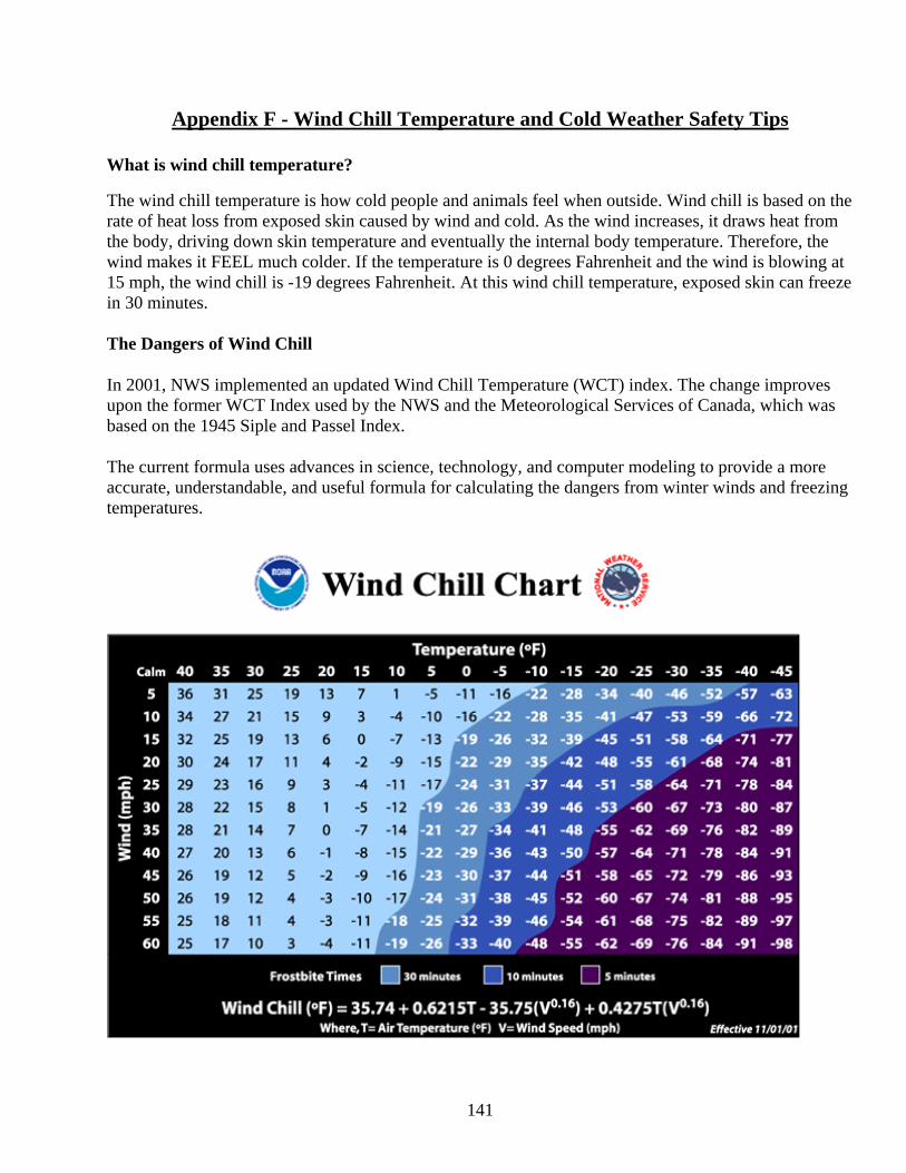
141
Appendix F - Wind Chill Temperature and Cold Weather Safety Tips What is wind chill temperature? The wind chill temperature is how cold people and animals feel when outside. Wind chill is based on the rate of heat loss from exposed skin caused by wind and cold. As the wind increases, it draws heat from the body, driving down skin temperature and eventually the internal body temperature. Therefore, the wind makes it FEEL much colder. If the temperature is 0 degrees Fahrenheit and the wind is blowing at 15 mph, the wind chill is -19 degrees Fahrenheit. At this wind chill temperature, exposed skin can freeze in 30 minutes. The Dangers of Wind Chill
In 2001, NWS implemented an updated Wind Chill Temperature (WCT) index. The change improves upon the former WCT Index used by the NWS and the Meteorological Services of Canada, which was based on the 1945 Siple and Passel Index.
The current formula uses advances in science, technology, and computer modeling to provide a more accurate, understandable, and useful formula for calculating the dangers from winter winds and freezing temperatures.
142
What is FROSTBITE? You have frostbite when your body tissue freezes. The most susceptible parts of the body are fingers, toes, ear lobes, or the tip of the nose. Symptoms include a loss of feeling in the extremity and a white or pale appearance. Get Medical attention immediately for frostbite. The area should be SLOWLY re-warmed. What is HYPOTHERMIA? Hypothermia occurs when body temperature falls below 95 degrees Fahrenheit. Determine this by taking your temperature. Warning signs include uncontrollable shivering, memory loss, disorientation, incoherence, slurred speech, drowsiness, and exhaustion. Get medical attention immediately. If you can't get help quickly, begin warming the body SLOWLY. Warm the body core first, NOT the extremities. Warming extremities first drives the cold blood to the heart and can cause the body temperature to drop further--which may lead to heart failure. Get the person into dry clothing and wrap in a warm blanket covering the head and neck. Do not give the person alcohol, drugs, coffee, or any HOT beverage or food. WARM broth and food is better. About 20% of cold related deaths occur in the home. Young children under the age of two and the elderly, those more than 60 years of age, are most susceptible to hypothermia. Hypothermia can set in over a period of time. Keep the thermostat above 69 degrees Fahrenheit, wear warm clothing, eat food for warmth, and drink plenty of water (or fluids other than alcohol) to keep hydrated. NOTE: Alcohol will lower your body temperature. Tips on How to Dress During Cold Weather The best way to avoid hypothermia and frostbite is to stay warm and dry indoors. When you must go outside, dress appropriately. Wear several layers of loose-fitting, lightweight, warm clothing. Trapped air between the layers will insulate you. Remove layers to avoid sweating and subsequent chill. Outer garments should be tightly woven, water repellent, and hooded. Wear a hat, because half of your body heat can be lost from your head. Cover your mouth to protect your lungs from extreme cold. Mittens, snug at the wrist, are better than gloves. Try to stay dry and out of the wind.
Avoid Overexertion
Your heart is already working overtime in cold weather. The strain from the cold and the hard labor of shoveling heavy snow, walking through drifts or pushing a car may cause a heart attack. Sweating from overexertion could lead to a chill and hypothermia.
Web site for more weather safety tips visit: http://www.nws.noaa.gov/om/winter/
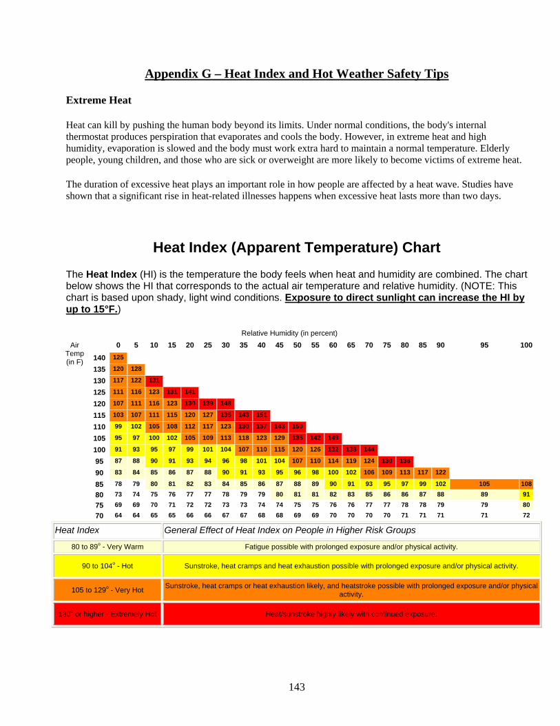
143
Appendix G – Heat Index and Hot Weather Safety Tips
Extreme Heat
Heat can kill by pushing the human body beyond its limits. Under normal conditions, the body's internal thermostat produces perspiration that evaporates and cools the body. However, in extreme heat and high humidity, evaporation is slowed and the body must work extra hard to maintain a normal temperature. Elderly people, young children, and those who are sick or overweight are more likely to become victims of extreme heat.
The duration of excessive heat plays an important role in how people are affected by a heat wave. Studies have shown that a significant rise in heat-related illnesses happens when excessive heat lasts more than two days.
Heat Index (Apparent Temperature) Chart
The Heat Index (HI) is the temperature the body feels when heat and humidity are combined. The chart below shows the HI that corresponds to the actual air temperature and relative humidity. (NOTE: This chart is based upon shady, light wind conditions. Exposure to direct sunlight can increase the HI by up to 15°F.)
Relative Humidity (in percent) Air
Temp (in F)
0 5 10 15 20 25 30 35 40 45 50 55 60 65 70 75 80 85 90 95 100
140 125 135 120 128 130 117 122 131 125 111 116 123 131 141 120 107 111 116 123 130 139 148 115 103 107 111 115 120 127 135 143 151 110 99 102 105 108 112 117 123 130 137 143 150 105 95 97 100 102 105 109 113 118 123 129 135 142 149 100 91 93 95 97 99 101 104 107 110 115 120 126 132 138 144 95 87 88 90 91 93 94 96 98 101 104 107 110 114 119 124 130 136 90 83 84 85 86 87 88 90 91 93 95 96 98 100 102 106 109 113 117 122 85 78 79 80 81 82 83 84 85 86 87 88 89 90 91 93 95 97 99 102 105 108
80 73 74 75 76 77 77 78 79 79 80 81 81 82 83 85 86 86 87 88 89 91
75 69 69 70 71 72 72 73 73 74 74 75 75 76 76 77 77 78 78 79 79 80
70 64 64 65 65 66 66 67 67 68 68 69 69 70 70 70 70 71 71 71 71 72
Heat Index General Effect of Heat Index on People in Higher Risk Groups
80 to 89o - Very Warm Fatigue possible with prolonged exposure and/or physical activity.
90 to 104o - Hot Sunstroke, heat cramps and heat exhaustion possible with prolonged exposure and/or physical activity.
105 to 129o - Very Hot Sunstroke, heat cramps or heat exhaustion likely, and heatstroke possible with prolonged exposure and/or physical activity.
130o or higher - Extremely Hot Heat/sunstroke highly likely with continued exposure.
144
Awareness Information
Heat exhaustion: Cool, moist, pale, or flushed skin; heavy sweating; headache; nausea or vomiting; dizziness; and exhaustion. Body temperature may be normal, or is likely to be rising.
Heat stroke: Hot, red skin; changes in consciousness; rapid, weak pulse; and rapid, shallow breathing. Body temperature can be very high -sometimes as high as 105 degrees F. If the person was sweating from heavy work or exercise, skin may be wet; otherwise, it will feel dry.
How to Treat a Heat Emergency
Heat stroke: Heat stroke is a life-threatening situation. Help is needed fast. Call 9-1-1 or your local emergency number. Move the person to a cooler place. Quickly cool the body. Immerse victim in a cool bath, or wrap wet sheets around the body and fan it. Watch for signals of breathing problems. Keep the person lying down and continue to cool the body any way you can. If the victim refuses water, is vomiting, or there are changes in the level of consciousness, do not give anything to eat or drink.
Heat cramps: Get the person to a cooler place and have him or her rest in a comfortable position. Lightly stretch the affected muscle and replenish fluids. Give a half glass of cool water every 15 minutes. Do not give liquids with alcohol or caffeine in them, as they can cause further dehydration, making conditions worse.
Heat exhaustion: Get the person out of the heat and into a cooler place. Remove or loosen tight clothing and apply cool, wet cloths, such as towels or sheets. If the person is conscious, give cool water to drink. Make sure the person drinks slowly. Give a half glass of cool water every 15 minutes. Let the victim rest in a comfortable position, and watch carefully for changes in his or her condition.
What to Do During Extreme Heat
Slow down. Avoid strenuous activity. Reduce, eliminate or reschedule strenuous activities. High-risk individuals should stay in cool places. Get plenty of rest to allow your natural "cooling system" to work. If you must do strenuous activity, do it during the coolest part of the day, which is usually in the morning between 4:00 a.m. and 7:00 a.m. Many heat emergencies are experienced by people exercising or working during the hottest part of the day.
Avoid extreme temperature changes. A cool shower immediately after coming in from hot temperatures can result in hypothermia, particularly for elderly and very young people.
Dress appropriately: Wear loose-fitting, lightweight, light-colored clothing that will cover as much skin as possible. Lightweight, light-colored clothing reflects heat and sunlight and helps maintain normal body temperature. Cover as much skin as possible to avoid sunburn and over-warming effects of sunlight on your body.
Protect face and head by wearing a wide-brimmed hat. A hat will keep direct sunlight off your head and face. Sunlight can burn and warm the inner core of your body.
145
Drink plenty of fluids even if you do not feel thirsty. Injury and death can occur from dehydration, which can happen quickly and unnoticed. Symptoms of dehydration are often confused with other causes. Persons who have epilepsy or heart, kidney, or liver disease; who are on fluid-restrictive diets; or who have a problem with fluid retention should consult a doctor before increasing liquid intake.
Take frequent breaks if you must work outdoors. Frequent breaks, especially in a cool area or to drink fluids, can help people tolerate heat better.
Drink plenty of water regularly and often. Your body needs water to keep cool. Water is the safest liquid to drink during heat emergencies.
Avoid drinks with alcohol or caffeine in them. They can make you feel good briefly, but make the heat's effects on your body worse. This is especially true about beer, which actually dehydrates the body.
Eat small meals and eat more often. Large, heavy meals are more difficult to digest and cause your body to increase internal heat to aid digestion, worsening overall conditions. Avoid foods that are high in protein, such as meats and nuts, which increase metabolic heat.
NEVER leave children or pets alone in closed vehicles. Temperatures inside a closed vehicle can reach over 140 degrees F within minutes. Exposure to such high temperatures can kill in minutes.
146
Appendix H – Glossary of NWS Terminology and Weather Definitions The following is broken down into five basic areas for easier understanding: 1. Precipitation Probabilities: What do they mean? 2. Sky Conditions Terms 3. Wind Terms 4. Warm Season Weather Terms 5. Cold Season Weather Terms 6. Non-Precipitation Weather Terms 7. General Weather Terms
147
1. Precipitation Probabilities: What do they mean? Technically, the Probability of Precipitation (POP) is defined as the likelihood of occurrence (expressed as a percent) of a measurable amount of liquid precipitation (or water equivalent of frozen precipitation) during a specified period of time at any given point in the forecast area. Measurable precipitation is 0.01 inch (0.2 mm) or greater and the period of time is 12 hours, unless specified otherwise. Example: If the forecast calls for a 40 percent chance of rain for a particular county then any given point in that county has a 4 in 10 chance of at least 0.01 inch of rain. It does not necessarily mean that 40 percent of the county will receive 0.01 inch of rain. It does mean that for the given weather pattern, 4 times out of 10, there will be at least 0.01 inch of rain somewhere in the county (it may be one point or even the entire county). The following are precipitation probabilities used by the National Weather Service and a brief explanation of each. POP Percent Expressions of Uncertainty Areal Qualifiers 20 PERCENT SLIGHT CHANCE ISOLATED 30-40 PERCENT CHANCE SCATTERED 50 PERCENT GOOD CHANCE SCATTERED 60-70 PERCENT LIKELY NUMEROUS 80-90-100 PERCENT (none used) OCCASIONAL or PERIODS 2. Sky Condition Terms Most forecasts include information about the state of the sky. However, it may be omitted if its inclusion would unnecessarily complicate or lengthen a forecast or can be inferred from the precipitation forecast. Below are the basic terms the National Weather Service uses to describe sky condition: Predominant or Average Descriptive Term Opaque Cloud Cover CLEAR or SUNNY 0/10 to 1/10 coverage MOSTLY SUNNY or MOSTLY CLEAR 1/10 to 3/10 coverage PARTLY CLOUDY or PARTLY SUNNY 3/10 to 7/10 coverage MOSTLY CLOUDY 7/10 to 8/10 coverage CLOUDY 9/10 to 10/10 coverage
148
3. Wind Terms Wind direction and speed will be included in the zone forecast. The late afternoon zone forecast will include this information for that night and the next day. The early morning zone forecast will add this information for today, tonight and the next day. Following is a summary of wind direction, speed, and intensity. A. Direction: Will be with reference from TRUE NORTH and will be given to eight points of the compass. B. Speed (mph): It is generally not practical to describe all the variations in wind speed, so a range of low-to-high speeds are given. The normal maximum range for sustained wind speeds is in 10 mph increments. Wind speed values are rounded to the nearest 5 mph to keep the forecast simple. C. Intensity: Descriptive Term Sustained Wind Speed LIGHT or LIGHT AND VARIABLE 0 to 5 mph (no term) 5 to 15 mph BREEZY, BRISK, BLUSTERY 15 to 25 mph WINDY 20 to 30 mph VERY WINDY 30 to 40 mph STRONG, DANGEROUS, HIGH 40 mph or greater Note: A high wind warning will be issued for sustained winds of 40 mph or more. 4. Warm Season Weather Terms It is very important that the difference between a Severe Thunderstorm or Tornado WATCH or WARNING be understood. The term WATCH implies that people should be alert for the possibility of severe weather and have a plan of action in case a storm threatens. When a WARNING is issued by the National Weather Service, this means that a severe thunderstorm and/or tornado has been detected by radar or observed by trained storm spotters (SKYWARN). People in the path of the storm are expected to take action to protect life and property when the term WARNING is heard. Following is a list of watches, warnings and advisories that the National Weather Service issues and the criteria used for issuing them:
149
Tornado Watch - Conditions are favorable for the development of tornadoes in and close to the watch area. Watches are usually in effect for 6 hours or more and covers an area about the size of the eastern third of North Dakota. Tornado Warning - Tornado is indicated by radar or sighted by storm spotters. The warning will include where the tornado was in reference to a larger city and what towns will be in its path. Severe Thunderstorm Watch - Conditions are favorable for the development of severe thunderstorms in and close to the watch area. Watches last for about 6 hours or more and cover an area about the size of the eastern third of North Dakota. Severe Thunderstorm Warning - Issued when a thunderstorm is producing or is expected to produced hail ¾ inch or larger and/or winds equal or exceeding 58 mph (50 knots). The warning will include where the severe thunderstorm was in reference to a larger city and what towns will be in its path. Urban and Small Stream Flood Advisory - Alerts the public to flooding which is generally only an inconvenience (not life-threatening) to those living in the affected area. Issued when heavy rain will cause flooding of streets and low-lying places in urban streams are expected to reach or exceed bankfull. Some damage to homes or roads could occur. Flood Watch - Indicates that flooding or flash flooding is a possibility in or close to the watch area. Those in the affected area are urged to be ready to take action if a flood warning or flash flood warning is issued or flooding is observed. Flash Flood Warning - Signifies a dangerous situation where rapid flooding of rivers, small streams, or urban areas occurs. Very heavy rain that falls in a short time period can lead to flooding, depending on local terrain, ground cover, degree of urbanization, degree of man- made changes to river banks, and initial ground or river conditions. Flood Warning - Signifies a situation where flooding of rivers, streams, or urban areas occurs over an area. Very heavy rain that falls in a short time period can lead to flooding, depending on local terrain, ground cover, degree of urbanization, degree of man- made changes to river banks, and initial ground or river conditions. Rapid snow melt can also cause flooding over a large area 5. Cold Season Weather Terms The following advisories will be issued to ALERT the public of situations that may cause difficult, but not impossible traveling conditions. Snow Advisory - Issued when snowfall is expected to reach 3 to 5 inches but is not expected to be greater than 5 inches. May be used for a 1 to 3 inch snowfall occurring at the beginning or end of the snow season when travel may be difficult. Winter Weather Advisory - Issued when a combination of winter weather events is expected to occur such as snow, blowing snow and very cold wind chill temperatures.
150
Freezing Rain Advisory - Will be used when less than ¼ of an inch of freezing rain is expected. Blowing Snow Advisory - Issued when wind-driven snow reduces visibility to one half mile and hampers travel. Strong winds create blowing snow by picking up old or new snow. Winter Storm Watch - Issued when conditions are favorable for the development of hazardous weather elements such as heavy snow and/or blizzard conditions, or significant accumulations of freezing rain. These conditions may occur singly, or in combination with others. Watches are usually issued 24 to 48 hours in advance of the event(s). Winter Storm Warning - Issued when heavy snow and some windiness is imminent or very likely, perhaps in combination with sleet and/or freezing rain/drizzle. Winter Storm Warnings are usually issued for up to a 12 hour duration, but can be extended out to 24 hours. Heavy Snow Warning - Issued for snowfalls of 6 inches or more in 12 hours or less. Can also be issued for snowfalls of 8 inches or more in 24 hours. Winds must be light (10 mph). If winds were strong then heavy snow and blowing snow would require a winter storm warning. Blizzard Warning - Issued for winter storms with sustained winds or frequent gusts to 35 mph or greater. Considerable falling and/or blowing snow must reduce visibility to less than ¼ mile for at least 3 hours. Ice Storm Warning - Issued when damaging accumulations of ice are expected during freezing rain situations, with walking and driving becoming extremely dangerous. Significant ice accumulations are usually ¼ inch or greater. 6. Non-Precipitation Terms
The following terms are used to make the public AWARE of weather situations that are not necessarily associated with precipitation, but need to be highlighted. Dense Fog Advisory - Used when dense fog covers a widespread area and reduces visibility to ¼ mile or less. Wind Chill Advisory - Informs the public that wind chills will be 25 to 40 below zero for a sustained period of time. Winds are expected to be at least 10 mph or greater. Frost Advisory - Issued in growing season to indicate formation of widespread frost. Freeze Warning - used during the growing season when temperatures are expected to drop well below freezing over a large area, regardless of whether frost forms or not. Wind Advisory - Sustained winds of 30 mph but less than 40 mph are expected to last for 3 hours or more.
151
Heat Advisory - Issued when daytime heat indices of 105 degrees Fahrenheit or above are expected along with nighttime low of 80 degrees F or above for two or more consecutive days. This advisory would be issued when the heat becomes an inconvenience, and only a problem for a minor portion of the population. Heat Index - The apparent temperature that describes the combined effect of high temperatures and high levels of humidity (see chart in this book). The following terms are used to WARN the public on non-precipitation events that could be a threat to life or property. Wind Chill Warning - Used when wind chill factors are expected to reach 40 below zero Fahrenheit or colder and wind speeds are 10 mph or greater. High Wind Warning - Issued for sustained winds of 40 mph or greater lasting 1 hour or longer, or any wind gust of 58 mph or greater. Excessive Heat Watch - Issued when conditions are favorable for the development of heat indices in excess of 105 degrees F during the daytime hours in combination with nighttime low temperatures of 80 degrees F or higher, for two consecutive days. Excessive Heat Warning - Issued when the heat index equals or exceeds 120 degrees Fahrenheit for 3 hours or longer. In these cases, the heat becomes dangerous for a large portion of the population. 7. General Weather Terms Following are weather terms frequently used by the National Weather Service. All temperatures are in Fahrenheit. Advisory - Highlights special weather conditions that are less serious than a warning. They are for events that may cause significant inconvenience and, if caution is not exercised, could lead to situations that may threaten life and/or property. AWIPS - Advanced Weather Interactive Processing System. This new high-speed computer work station and communication network is the centerpiece of the modernization of the National Weather Service. AWIPS will continue to help improve the accuracy and timeliness of warnings and forecasts by permitting forecasters to analyze fast-breaking storms and speed up the communication of warnings and forecasts to their customers. IFPS – Interactive Forecast Preparation System. This piece of software allows NWS forecasters to provide a gridded forecast of all weather elements. These weather elements are then converted into many different images and text products for the public.
152
Blizzard - A severe weather condition characterized by, strong winds greater than 35 mph, snow, and blowing snow causing near zero visibility. When these conditions persist after snow has stopped falling, it is called a ground blizzard. Central Region Headquarters (CRH) - The supervisory office for the 14-state Central Region of the National Weather Service. CRH provides supervisory direction; technical. program and equipment support for NWS field offices. Climate - The average weather conditions in an area over a period of years (usually a 30-year period computed every 10 years). The climate of an area is composed of many elements, such as temperature, precipitation, wind speed and direction, relative humidity, sunshine, etc. Knowing the average values of these elements at a location for different times of the year, along with the extreme values, is the most common way the climate of a location is described. County Warning Area and Forecast Area - The area for which a National Weather Service office is responsible for general weather forecast products; including short- term forecasts and severe weather warnings. Degree-day - Gauges the amount of heating or cooling needed for a building using 65 degrees as a baseline. To compute heating/cooling degree-days, the average temperature for a day is taken and referenced to 65 degrees. An average temperature of 50 yields 15 heating degree-days while an average of 75 would yield 10 cooling degree-days. Electrical, natural gas, power, heating, and air conditioning industries utilize degree-day information to calculate their needs. To compute growing degree-days one would use a reference of 50 degrees. Every degree that is above 50 is a growing degree-day. Dense Fog Advisory - Used when dense fog covers a widespread area and reduces visibility to ¼ mile or less. Doppler - The National Weather Service Doppler radar is a Weather Surveillance Radar (WSR-88D) system developed in 1988. About 120 systems have been installed at Weather Forecast Offices across the country. An additional 24 systems will be installed at Department of Defense sites. This powerful and sensitive Doppler system generates many useful products for meteorologist, among them: precipitation intensities, atmospheric air motion, turbulence, and precipitation estimates. Doppler Effect - Named for German scientist Christian Doppler who discovered the effect. The Doppler effect enables weather service radars to detect motion within and around storms. Doppler found that an object moving toward you will compress light, sound, or radio waves, while an object moving away will elongate them. This change is the frequency change heard with passing planes, trains, etc. Downburst - A strong downdraft, initiated by a thunderstorm, that induces an outburst of damaging straight-line winds on or near the ground. Downbursts may last from anywhere from a few minutes in small scale microburst on up to 20 minutes or more in larger, longer living larger downbursts, called macrobursts. Wind speeds in downbursts can reach 150 mph, which is in the range of a strong tornado.
153
Flash Flood - A dangerous and sudden flood that threatens lives and property and usually occurs after heavy rain. May also occur after an ice jam breaks up or after a dam fails. Flood Stage - The level at which a river leaves its banks. Flood Plain - The portion of a river valley that has been inundated by the river during historic floods. Fog - A cloud on the ground that reduces visibility. Freeze - A condition occurring over a widespread area when the surface air temperature remains below freezing for a time sufficient to cause damage to certain agricultural crops. Frost - A covering of ice produced by water condensation occurring on surfaces below freezing. Funnel Cloud - A rotating column of air that does not touch the ground. Freezing Drizzle/Rain - Describes the effect of drizzle or rain freezing upon impact on objects that have a temperature of 32 degrees of less. GOES - Geostationary Operational Environmental Satellite. A satellite that observes the United States and adjacent ocean areas from vantage points 22,233 miles above the equator. GOES satellites provide continuous day and night weather observations and detect emergency signals from aircraft, ships and land-based users in distress. Greenhouse Effect - The effect produced as certain atmospheric gases allow incoming solar radiation to pass through to the Earth’s surface, but prevents the outgoing (infrared) radiation, which is re- radiated back to Earth. Hail - Precipitation in the form of balls or lumps usually consisting of concentric layers of ice. A thunderstorm is classified as severe when it produces hail ¾ of an inch or larger in diameter. Heat Index - The apparent temperature that describes the combined effect of high temperatures and high levels of humidity. Heavy Snow - In this part of the country, heavy snow is defined as snowfall accumulations of 6 inches or more in 12 hours or 8 inches or more in 24 hours. Humidity - The amount of water vapor in the air. The higher the temperature, the more water vapor the air can hold. Hydrology - The science dealing with the waters of the Earth, their distribution on the surface and underground, and the cycle involving evaporation, precipitation, flow to seas, etc. Knot - A unit of speed equal to one nautical mile per hour or 1.15 miles per hour. Meteorology - The scientific study of the atmospheric and weather.
154
Macroburst - A thunderstorm downdraft with an affected outflow area of at least 2.5 miles wide and peak winds lasting between 5 and 20 minutes. Intense macrobursts may cause tornado-like damage. Microburst - A special type of downburst, or downdraft, from a thunderstorm. A microburst is a thunderstorm downdraft with an affected outflow area of less than 2.5 miles wide and peak winds lasting less than 5 minutes. Microbursts may induce dangerous horizontal and vertical wind shears which can adversely affect aircraft performance. NCDC - National Climatic Data Center. The world’s largest active archive or weather data. Data are received from a wide variety of sources and is available by many means of dissemination. NEXRAD - Next Generation Radar (see Doppler Radar). NOAA - National Oceanic and Atmospheric Administration. An agency of the Department of Commerce (DOC) that conducts research and gathers data about the global oceans, atmosphere, space, and sun, and applies this knowledge to science and service that benefits the nation. The National Weather Service is one of five major line offices. NOAA Weather Radio - The voice of the National Weather Service (NWS). It provides continuous broadcasts of the latest weather information directly from NWS offices across the United States. The NOAA Weather Radio broadcast from more that 380 locations throughout the country of severe high-band FM frequencies ranging from 162.40 to 162.55 Megahertz. A special radio receiver, available at electronic stores, is needed to receive the broadcast. NRC - National Research Council. Organized the National Academy of Sciences in 1916. The council conducted a study for the National Weather Service to review the weather service’s modernization effort. NWS - National Weather Service. A U.S. government agency under NOAA which is under the Department of Commerce. The NWS is responsible for providing the nation with accurate and timely weather, climate and hydrological information for the protection of life and property. This includes severe weather, hurricane and flood watches and warnings, short term weather forecasts and long-lead climate outlooks. Precipitation - All types of condensed water vapor (whether liquid, freezing or frozen) which fall to the Earth’s surface. Rain - Indicates a nearly steady and uniform fall or precipitation over an area for several hours, as opposed to the term “showers” which implies intermittent and scattered rainfall of a more unstable nature. Relative Humidity - The amount of water vapor in the air compared with the amount the air can hold at the current temperature. For instance, 50 percent relative humidity means the air can hold half the water vapor that it is capable of holding.
155
River Basin - The drainage area of a river and its tributaries. RFC - River Forecast Center. Thirteen regional RFC centers are the first-echelon offices that prepare river and flood forecasts and some warnings for approximately 3,000 communities. The basic product of this service is the flood forecast. This includes forecasts of height of the flood crest, as well as times when the river is expected to overflow its banks (flood stage) and when it will recede within its banks. Severe Thunderstorm - A thunderstorm that produces either of the following: winds of 58 mph or greater (these speeds can result in structural or tree damage), hail ¾ of an inch in diameter or greater, or a tornado. Sleet - Describes solid grains of ice formed by the freezing of raindrops or the re- freezing of largely melted snowflakes. These grains usually bounce upon impact with the ground or pavement. Snow Squalls - Short periods of moderate to heavy snowfall accompanied by strong, gusty surface winds and possibly lightening. Snow accumulation may be significant. Snow Showers - A short duration of moderate snowfall. Some accumulation is possible. Snow Flurries - Intermittent light snowfall of short duration with no measurable accumulation. Temperature - The degree of hotness or coldness of the ambient air as measured by any suitable instrument. Tornado - A violently rotating column of air that is touching the ground. The visible cloud portion of a tornado may not extend all the way to the ground. UV Index - Ultraviolet Index. Forecast of the ultraviolet intensity at the Earth’s surface over the one-hour period around midday. Ultraviolet exposure levels are presented on a scale of zero (minimal) to over ten (very high). U.S. Department of Commerce - This cabinet-level agency has the mission of improving the economic opportunities of Americans. It focuses on three paths to enhance the country’s trading position: The National Export Strategy; the dynamic development of civilian technology; and sustained economic growth. Warning - Issued to warn the public that a hazardous weather element is imminent or has a very high probability of occurrence. Watch - Alerts the public to the possibility of severe weather, or some other hazardous weather element. it is intended to provide enough lead time so those who need to set their plans in motion can do so. Wind Chill - An apparent temperature that describes the combined effect of wind and low air temperatures on exposed skin.