Embed Size (px)
Citation preview
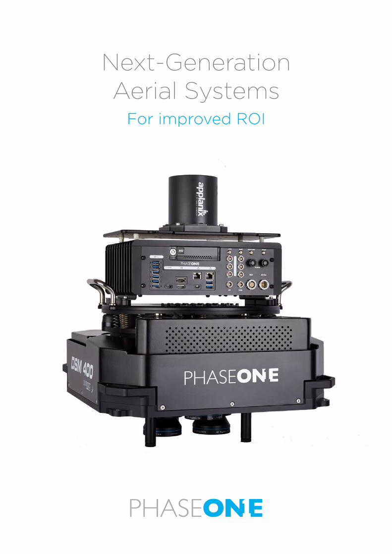
Next-Generation Aerial Systems
For improved ROI
Next-generation aerial systems for wide aerial coveragePhase One continuously expands its offering and designs the exact solutions to meet the requirements of
the developing geospatial market. Our new generation aerial systems specifically address the challenges of
imaging data acquisition projects, helping you to increase productivity, and reduce time and costs. The new
generation Phase One Aerial Systems are integrated with the most advanced iX Controller MK5, including
the precision GNSS-inertial unit for even higher efficiency.
IMU unit SoftwareiX Controller MK5
iX Capture iX PlaniX Flight
PAS 280 MK2 PAS 150/100 MK2
2
280MP Aerial SystemThe standard in large format aerial imaging
With over 20,000 pixels across, compact size, and
weight, the 280MP Aerial System provides higher return on investment compared to any other large
format system available on the market.
The 280MP Aerial System offers the highest image capture rate and dynamic range, increasing the overall
quality and accuracy of the final photogrammetric
products.
The iXM-RS 280F provides a large format option that
easily integrates with the DSM400 gyrostabilized
mount, creating a compact and lightweight system
for use in a wider range of aircraft.
The iXM-RS 280F is a dual-lens metric camera, with
90mm lenses for capturing RGB information, and
providing superior image quality. The 280MP camera
generates a central projection image from two 150MP
nadir images with equal ground resolution.
The aerial system is comprised of our iX Controller
MK5 with GNSS-inertial; an IMU unit; a Somag gyro-
stabilized mount (DSM 400) and the Phase One flight
planning and management software (iX Plan and iX
Flight, as well as iX Capture).
• Backside illuminated (BSI) CMOS sensor
• Wide dynamic range
• Improved light sensitivity
• More flying hours per day and more flights achievable per year
• Maintains object resolution in lowlight conditions
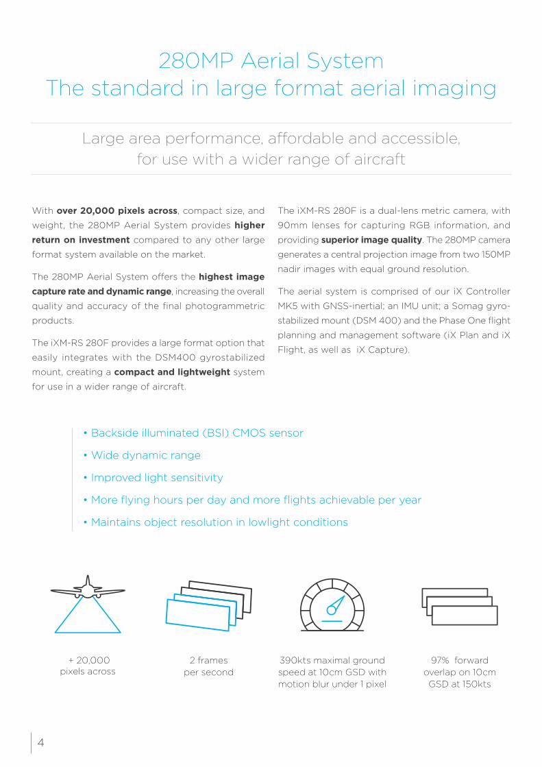
Large area performance, affordable and accessible, for use with a wider range of aircraft
390kts maximal ground speed at 10cm GSD with motion blur under 1 pixel
97% forward overlap on 10cm GSD at 150kts
2 frames per second
+ 20,000 pixels across
4
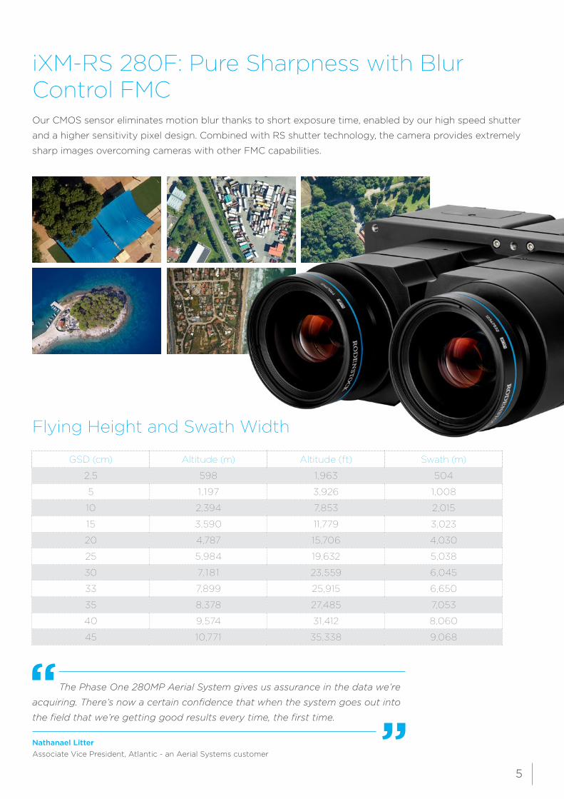
iXM-RS 280F: Pure Sharpness with Blur Control FMC Our CMOS sensor eliminates motion blur thanks to short exposure time, enabled by our high speed shutter
and a higher sensitivity pixel design. Combined with RS shutter technology, the camera provides extremely
sharp images overcoming cameras with other FMC capabilities.
Flying Height and Swath Width
GSD (cm) Altitude (m) Altitude (ft) Swath (m)
2,5 598 1,963 504
5 1,197 3,926 1,008
10 2,394 7,853 2,015
15 3,590 11,779 3,023
20 4,787 15,706 4,030
25 5,984 19,632 5,038
30 7,181 23,559 6,045
33 7,899 25,915 6,650
35 8,378 27,485 7,053
40 9,574 31,412 8,060
45 10,771 35,338 9,068
The Phase One 280MP Aerial System gives us assurance in the data we’re
acquiring. There’s now a certain confidence that when the system goes out into
the field that we’re getting good results every time, the first time.
Nathanael LitterAssociate Vice President, Atlantic - an Aerial Systems customer
5
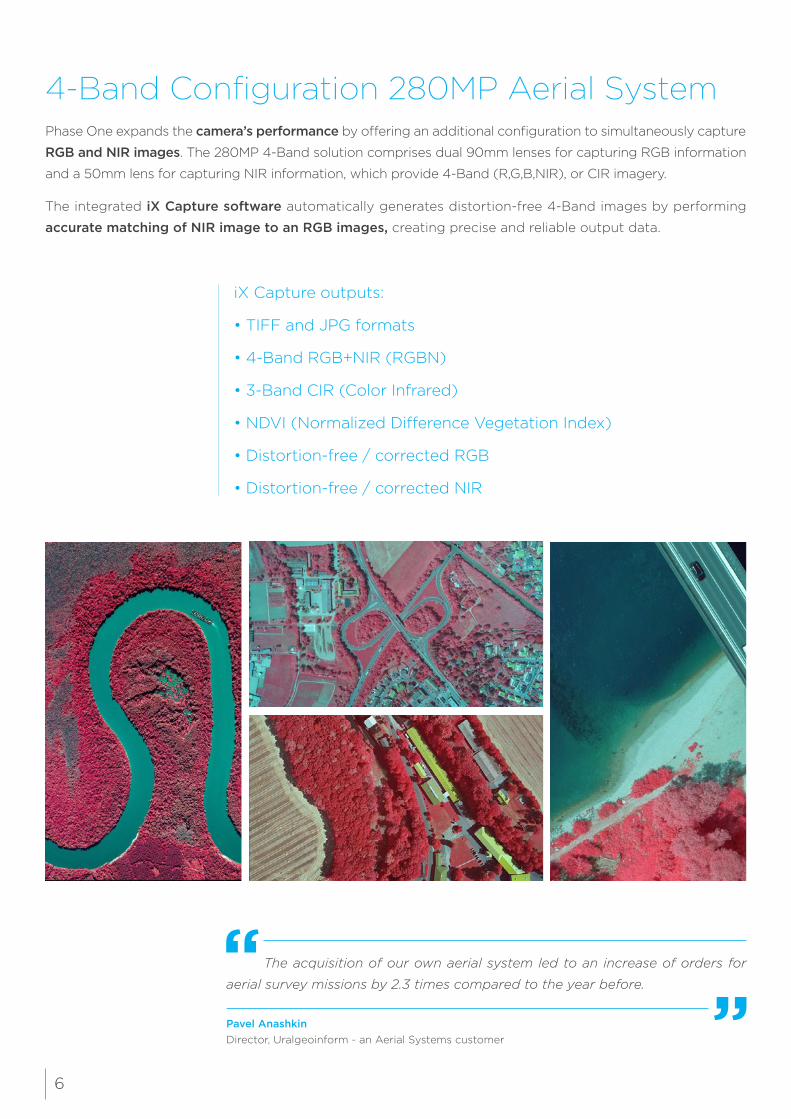
4-Band Configuration 280MP Aerial SystemPhase One expands the camera’s performance by offering an additional configuration to simultaneously capture
RGB and NIR images. The 280MP 4-Band solution comprises dual 90mm lenses for capturing RGB information
and a 50mm lens for capturing NIR information, which provide 4-Band (R,G,B,NIR), or CIR imagery.
The integrated iX Capture software automatically generates distortion-free 4-Band images by performing
accurate matching of NIR image to an RGB images, creating precise and reliable output data.
iX Capture outputs:
• TIFF and JPG formats
• 4-Band RGB+NIR (RGBN)
• 3-Band CIR (Color Infrared)
• NDVI (Normalized Difference Vegetation Index)
• Distortion-free / corrected RGB
• Distortion-free / corrected NIR
The acquisition of our own aerial system led to an increase of orders for
aerial survey missions by 2.3 times compared to the year before.
Pavel AnashkinDirector, Uralgeoinform - an Aerial Systems customer
6
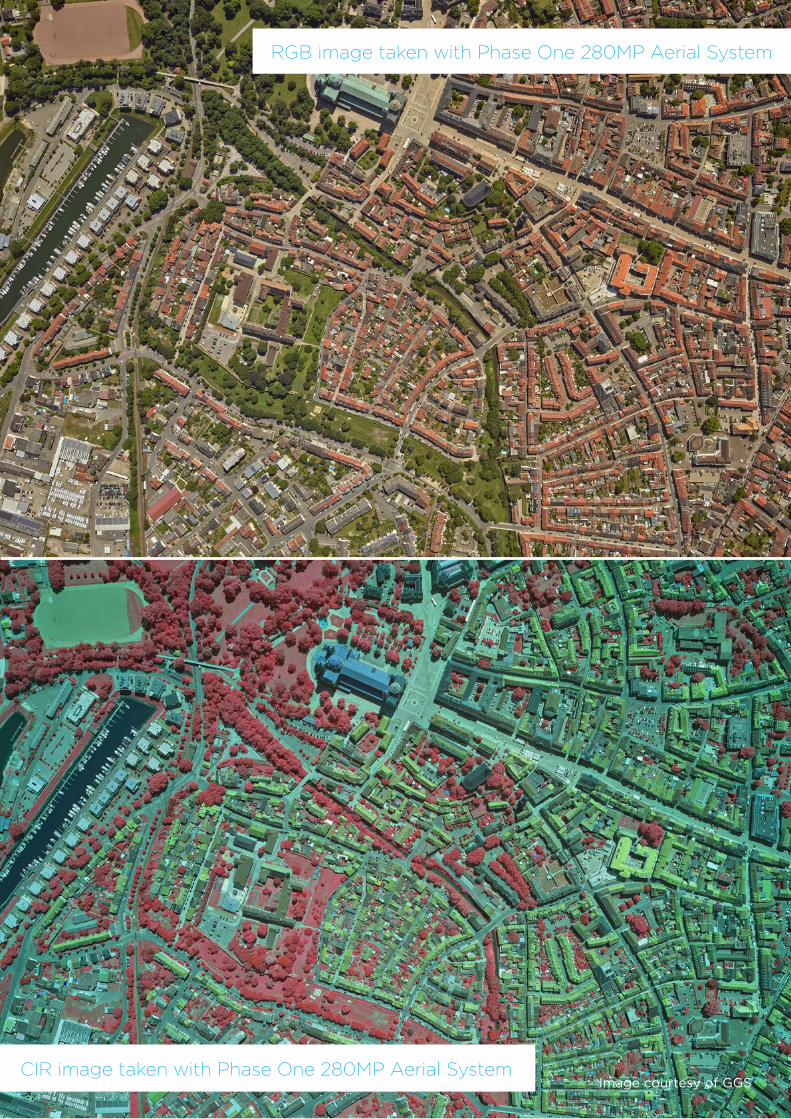
RGB image taken with Phase One 280MP Aerial System
CIR image taken with Phase One 280MP Aerial SystemImage courtesy of GGS
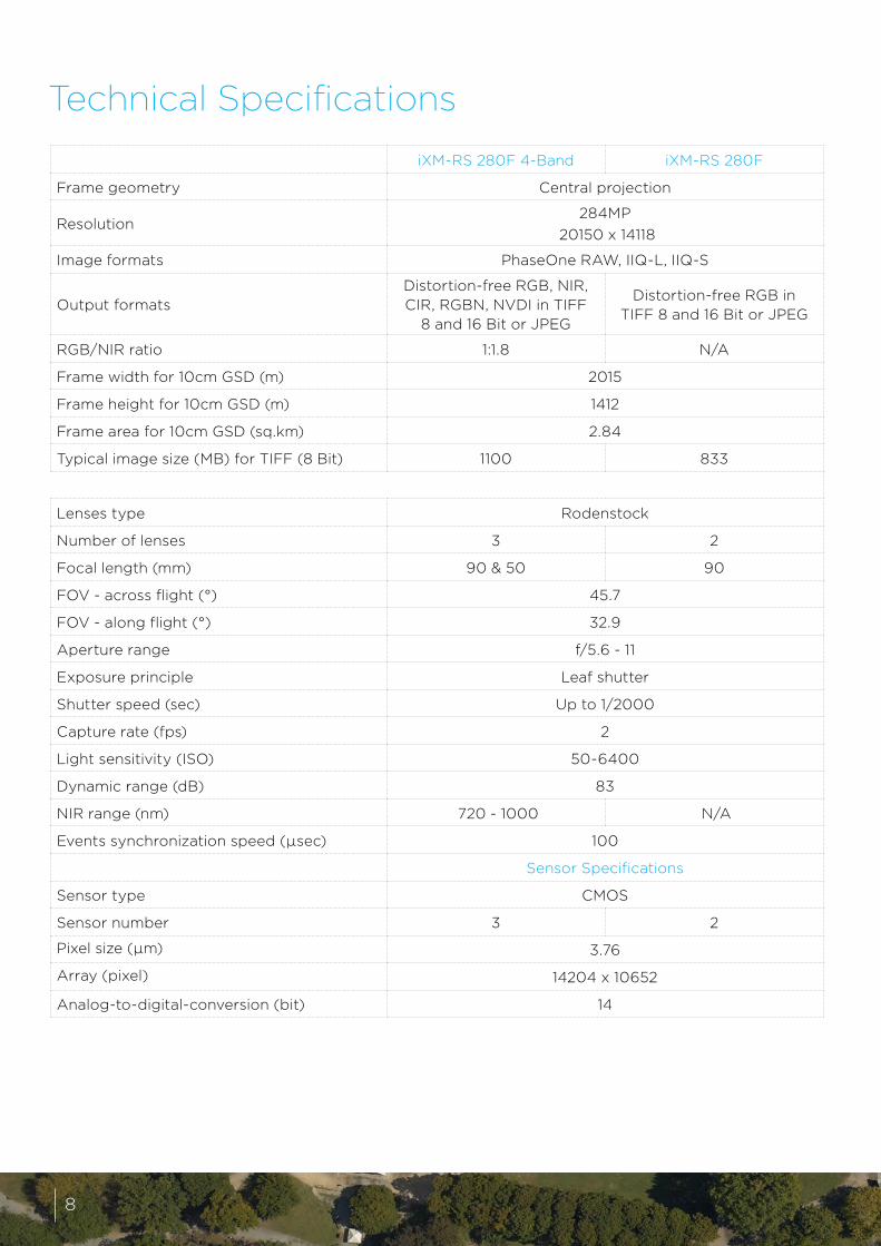
Technical Specifications
iXM-RS 280F 4-Band iXM-RS 280F
Frame geometry Central projection
Resolution284MP
20150 x 14118
Image formats PhaseOne RAW, IIQ-L, IIQ-S
Output formatsDistortion-free RGB, NIR, CIR, RGBN, NVDI in TIFF
8 and 16 Bit or JPEG
Distortion-free RGB in TIFF 8 and 16 Bit or JPEG
RGB/NIR ratio 1:1.8 N/A
Frame width for 10cm GSD (m) 2015
Frame height for 10cm GSD (m) 1412
Frame area for 10cm GSD (sq.km) 2.84
Typical image size (MB) for TIFF (8 Bit) 1100 833
Lenses type Rodenstock
Number of lenses 3 2
Focal length (mm) 90 & 50 90
FOV - across flight (°) 45.7
FOV - along flight (°) 32.9
Aperture range f/5.6 - 11
Exposure principle Leaf shutter
Shutter speed (sec) Up to 1/2000
Capture rate (fps) 2
Light sensitivity (ISO) 50-6400
Dynamic range (dB) 83
NIR range (nm) 720 - 1000 N/A
Events synchronization speed (µsec) 100
Sensor Specifications
Sensor type CMOS
Sensor number 3 2
Pixel size (µm) 3.76
Array (pixel) 14204 x 10652
Analog-to-digital-conversion (bit) 14
8
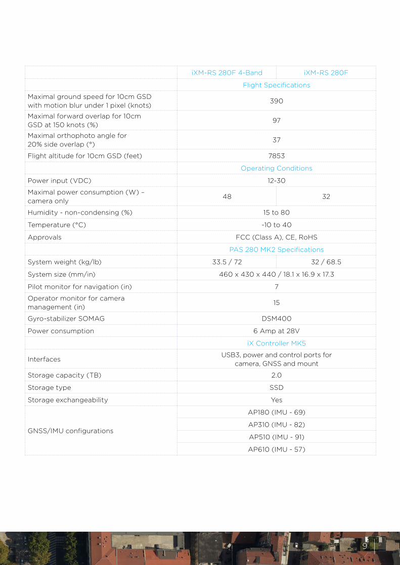
iXM-RS 280F 4-Band iXM-RS 280F
Flight Specifications
Maximal ground speed for 10cm GSD with motion blur under 1 pixel (knots)
390
Maximal forward overlap for 10cm GSD at 150 knots (%)
97
Maximal orthophoto angle for 20% side overlap (°)
37
Flight altitude for 10cm GSD (feet) 7853
Operating Conditions
Power input (VDC) 12-30
Maximal power consumption (W) – camera only
48 32
Humidity - non-condensing (%) 15 to 80
Temperature (°C) -10 to 40
Approvals FCC (Class A), CE, RoHS
PAS 280 MK2 Specifications
System weight (kg/lb) 33.5 / 72 32 / 68.5
System size (mm/in) 460 x 430 x 440 / 18.1 x 16.9 x 17.3
Pilot monitor for navigation (in) 7
Operator monitor for camera management (in)
15
Gyro-stabilizer SOMAG DSM400
Power consumption 6 Amp at 28V
iX Controller MK5
InterfacesUSB3, power and control ports for
camera, GNSS and mount
Storage capacity (TB) 2.0
Storage type SSD
Storage exchangeability Yes
GNSS/IMU configurations
AP180 (IMU - 69)
AP310 (IMU - 82)
AP510 (IMU - 91)
AP610 (IMU - 57)
9
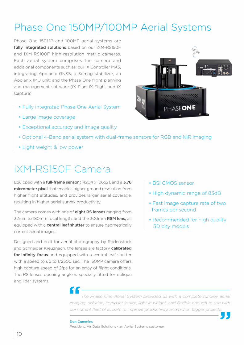
Phase One 150MP/100MP Aerial SystemsPhase One 150MP and 100MP aerial systems are
fully integrated solutions based on our iXM-RS150F
and iXM-RS100F high-resolution metric cameras.
Each aerial system comprises the camera and
additional components such as: our iX Controller MK5,
integrating Applanix GNSS; a Somag stabilizer, an
Applanix IMU unit; and the Phase One flight planning
and management software (iX Plan; iX Flight and iX
Capture).
• Fully integrated Phase One Aerial System
• Large image coverage
• Exceptional accuracy and image quality
• Optional 4-Band aerial system with dual-frame sensors for RGB and NIR imaging
• Light weight & low power
iXM-RS150F CameraEquipped with a full-frame sensor (14204 x 10652), and a 3.76 micrometer pixel that enables higher ground resolution from
higher flight altitudes, and provides larger aerial coverage,
resulting in higher aerial survey productivity.
The camera comes with one of eight RS lenses ranging from
32mm to 180mm focal length, and the 300mm RSM lens, all
equipped with a central leaf shutter to ensure geometrically
correct aerial images.
Designed and built for aerial photography by Rodenstock
and Schneider Kreuznach, the lenses are factory calibrated for infinity focus and equipped with a central leaf shutter
with a speed to up to 1/2500 sec. The 150MP camera offers
high capture speed of 2fps for an array of flight conditions.
The RS lenses opening angle is specially fitted for oblique
and lidar systems.
• BSI CMOS sensor
• High dynamic range of 83dB
• Fast image capture rate of two frames per second
• Recommended for high quality 3D city models
The Phase One Aerial System provided us with a complete turnkey aerial
imaging solution, compact in size, light in weight, and flexible enough to use with
our current fleet of aircraft, to improve productivity, and bid on bigger projects.
Don CumminsPresident, Air Data Solutions - an Aerial Systems customer
10
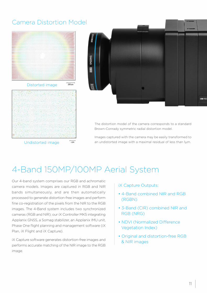
Camera Distortion Model
Distorted image
Undistorted image
The distortion model of the camera corresponds to a standard
Brown-Conrady symmetric radial distortion model.
Images captured with the camera may be easily transformed to
an undistorted image with a maximal residual of less than 1µm.
4-Band 150MP/100MP Aerial SystemOur 4-band system comprises our RGB and achromatic
camera models. Images are captured in RGB and NIR
bands simultaneously, and are then automatically
processed to generate distortion-free images and perform
fine co-registration of the pixels from the NIR to the RGB
images. The 4-Band system includes two synchronized
cameras (RGB and NIR); our iX Controller MK5 integrating
Applanix GNSS, a Somag stabilizer, an Applanix IMU unit,
Phase One flight planning and management software (iX
Plan, iX Flight and iX Capture).
iX Capture software generates distortion-free images and
performs accurate matching of the NIR image to the RGB
image.
iX Capture Outputs:
• 4-Band combined NIR and RGB (RGBN)
• 3-Band (CIR) combined NIR and RGB (NRG)
• NDVI (Normalized Difference Vegetation Index)
• Original and distortion-free RGB & NIR images
11
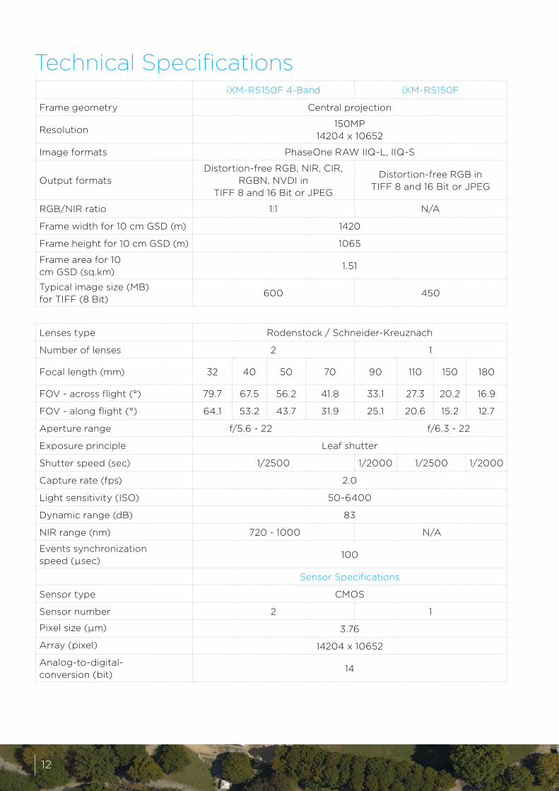
iXM-RS150F 4-Band iXM-RS150F
Frame geometry Central projection
Resolution150MP
14204 x 10652
Image formats PhaseOne RAW IIQ-L, IIQ-S
Output formatsDistortion-free RGB, NIR, CIR,
RGBN, NVDI in TIFF 8 and 16 Bit or JPEG
Distortion-free RGB in TIFF 8 and 16 Bit or JPEG
RGB/NIR ratio 1:1 N/A
Frame width for 10 cm GSD (m) 1420
Frame height for 10 cm GSD (m) 1065
Frame area for 10 cm GSD (sq.km)
1.51
Typical image size (MB) for TIFF (8 Bit)
600 450
Lenses type Rodenstock / Schneider-Kreuznach
Number of lenses 2 1
Focal length (mm) 32 40 50 70 90 110 150 180
FOV - across flight (°) 79.7 67.5 56.2 41.8 33.1 27.3 20.2 16.9
FOV - along flight (°) 64.1 53.2 43.7 31.9 25.1 20.6 15.2 12.7
Aperture range f/5.6 - 22 f/6.3 - 22
Exposure principle Leaf shutter
Shutter speed (sec) 1/2500 1/2000 1/2500 1/2000
Capture rate (fps) 2.0
Light sensitivity (ISO) 50-6400
Dynamic range (dB) 83
NIR range (nm) 720 - 1000 N/A
Events synchronization speed (µsec)
100
Sensor Specifications
Sensor type CMOS
Sensor number 2 1
Pixel size (µm) 3.76
Array (pixel) 14204 x 10652
Analog-to-digital-conversion (bit)
14
Technical Specifications
12
(*) Weight of controller and GNSS are not included
iXM-RS150F 4-Band iXM-RS150F
Flight Specifications
Maximal ground speed for 5cm GSD with motion blur under 1 pixel (knots)
240
Maximal forward overlap for 5cm GSD at 150 knots (%)
93
Maximal orthophoto angle for 20% side overlap (°)
27 for 90mm focal lens
Flight altitude for 5cm GSD (feet)
3926 for 90mm focal length
Operating Conditions
Power input (VDC) 12-30
Maximal power consumption (W) – camera only
32 16
Humidity - non-condensing (%) 15 to 80
Temperature (°C) -10 to 40
Approvals FCC (Class A), CE, RoHS
PAS 150 MK2 Specifications
System weight (kg/lb) 31 / 68.5 8.5 / 19*
System size (mm/in)460 x 430 x 440 /
18.1 x 16.9 x 17.3290 x 275 x 121 / 11.4 x 10.8 x 4.7
Pilot monitor for navigation (in) 7
Operator monitor for camera management (in)
15
Gyro-stabilizer SOMAG DSM400 CSM40
Power consumption 6 Amp at 28V
iX Controller MK5
Interfaces USB3, power and control ports for camera, GNSS and mount
Storage capacity (TB) 2.0
Storage type SSD
Storage exchangeability Yes
Weight (kg/lb) 5.6 /12.3
Size (mm/in) 290 x 109 x 225 / 11.4 x 4.3 x 8.9
GNSS/IMU configurations
AP180 (IMU - 69)
AP310 (IMU - 82)
AP510 (IMU - 91)
AP610 (IMU - 57)
13
14
15
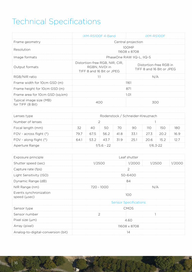
iXM-RS100F 4-Band iXM-RS100F
Frame geometry Central projection
Resolution100MP
11608 x 8708
Image formats PhaseOne RAW IIQ-L, IIQ-S
Output formatsDistortion-free RGB, NIR, CIR,
RGBN, NVDI in TIFF 8 and 16 Bit or JPEG
Distortion-free RGB in TIFF 8 and 16 Bit or JPEG
RGB/NIR ratio 1:1 N/A
Frame width for 10cm GSD (m) 1161
Frame height for 10cm GSD (m) 871
Frame area for 10cm GSD (sq.km) 1.01
Typical image size (MB) for TIFF (8 Bit)
400 300
Lenses type Rodenstock / Schneider-Kreuznach
Number of lenses 2 1
Focal length (mm) 32 40 50 70 90 110 150 180
FOV - across flight (°) 79.7 67.5 56.2 41.8 33.1 27.3 20.2 16.9
FOV - along flight (°) 64.1 53.2 43.7 31.9 25.1 20.6 15.2 12.7
Aperture Range f/5.6 - 22 f/6.3-22
Exposure principle Leaf shutter
Shutter speed (sec) 1/2500 1/2000 1/2500 1/2000
Capture rate (fps) 2
Light Sensitivity (ISO) 50-6400
Dynamic Range (dB) 84
NIR Range (nm) 720 - 1000 N/A
Events synchronization speed (µsec)
100
Sensor Specifications
Sensor type CMOS
Sensor number 2 1
Pixel size (µm) 4.60
Array (pixel) 11608 x 8708
Analog-to-digital-conversion (bit) 14
Technical Specifications
16
iXM-RS100F 4-Band iXM-RS100F
Flight Specifications
Maximal ground speed for 5cm GSD with motion blur under 1 pixel (knots)
240
Maximal forward overlap for 5cm GSD at 150 knots (%)
91
Maximal orthophoto angle for 20% side overlap (°)
27 for 90mm focal lens
Flight altitude for 5cm GSD (Feet) 3209 for 90mm focal length
Operating Conditions
Power input (VDC) 12-30
Maximal Power consumption (W) – camera only
32 16
Humidity - non-condensing (%) 15 to 80
Temperature (°C) -10 to 40
Approvals FCC (Class A), CE, RoHS
PAS 100 MK2 Specifications
System weight (kg/lb) 31 / 68.5 8.5 / 19*
System size (mm/in)460 x 430 x 440 /
18.1 x 16.9 x 17.3290 x 275 x 121 / 11.4 x 10.8 x 4.7
Pilot monitor for navigation (in) 7
Operator monitor for camera management (in)
15
Gyro-stabilizer SOMAG DSM400 CSM40
Power consumption 6 Amp at 28V
iX Controller MK5
Interfaces USB3, power and control ports for camera, GNSS and mount
Storage capacity (TB) 2.0
Storage type SSD
Storage exchangeability Yes
Weight (kg/lb) 5.6 /12.3
Size (mm/in) 290 x 109 x 225 / 11.4 x 4.3 x 8.9
GNSS/IMU configurations
AP180 (IMU - 69)
AP310 (IMU - 82)
AP510 (IMU - 91)
AP610 (IMU - 57)
(*) Weight of controller and GNSS are not included
17
IMU
un
itG
yro
Sta
bili
zed
M
ou
nts
There are different GNSS-Inertial configurations. The choice of the configuration is based on your
intended application and accuracy requirements. High-altitude flying for direct georeferencing
applications will usually require the iX Controller MK5-AP610 configuration while low-altitude flying
for aero triangulation applications will usually use the iX Controller MK5-AP310 configuration.
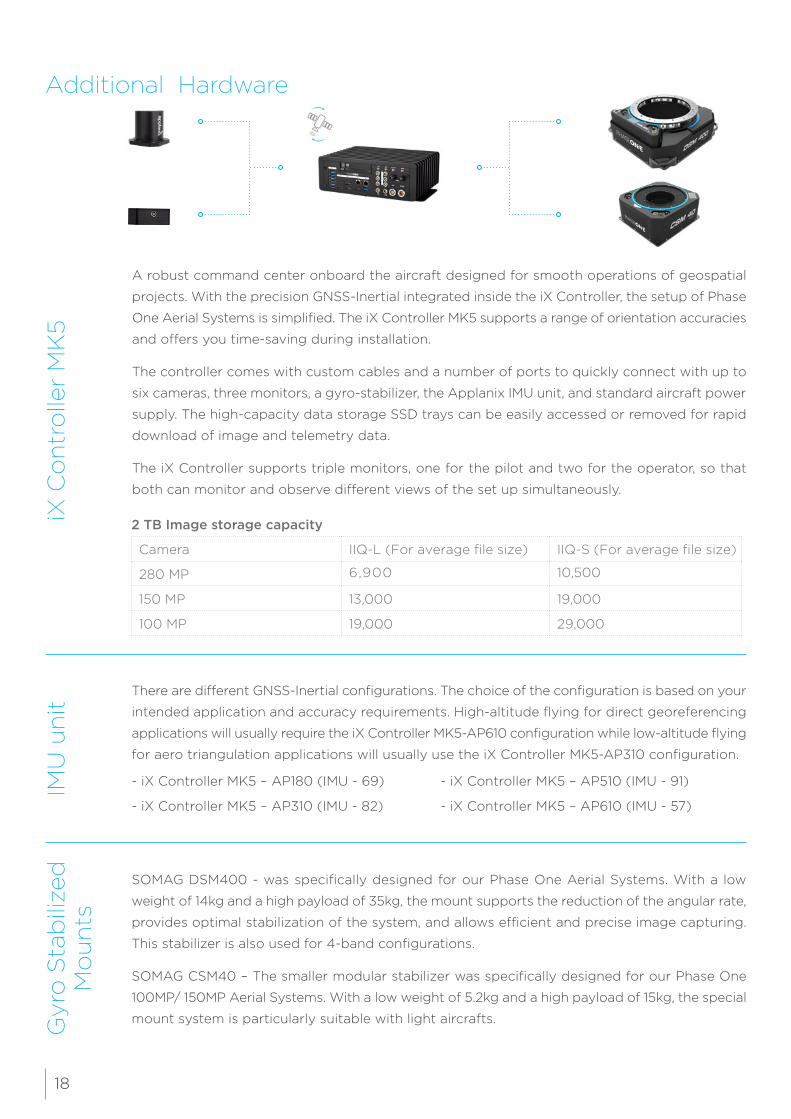
SOMAG DSM400 - was specifically designed for our Phase One Aerial Systems. With a low
weight of 14kg and a high payload of 35kg, the mount supports the reduction of the angular rate,
provides optimal stabilization of the system, and allows efficient and precise image capturing.
This stabilizer is also used for 4-band configurations.
SOMAG CSM40 – The smaller modular stabilizer was specifically designed for our Phase One
100MP/ 150MP Aerial Systems. With a low weight of 5.2kg and a high payload of 15kg, the special
mount system is particularly suitable with light aircrafts.
Additional HardwareiX
Co
ntr
olle
r M
K5
A robust command center onboard the aircraft designed for smooth operations of geospatial
projects. With the precision GNSS-Inertial integrated inside the iX Controller, the setup of Phase
One Aerial Systems is simplified. The iX Controller MK5 supports a range of orientation accuracies
and offers you time-saving during installation.
The controller comes with custom cables and a number of ports to quickly connect with up to
six cameras, three monitors, a gyro-stabilizer, the Applanix IMU unit, and standard aircraft power
supply. The high-capacity data storage SSD trays can be easily accessed or removed for rapid
download of image and telemetry data.
The iX Controller supports triple monitors, one for the pilot and two for the operator, so that
both can monitor and observe different views of the set up simultaneously.
2 TB Image storage capacity
Camera IIQ-L (For average file size) IIQ-S (For average file size)
280 MP 6,900 10,500
150 MP 13,000 19,000
100 MP 19,000 29,000
- iX Controller MK5 – AP180 (IMU - 69)
- iX Controller MK5 – AP310 (IMU - 82)
- iX Controller MK5 – AP510 (IMU - 91)
- iX Controller MK5 – AP610 (IMU - 57)
18
Software PackageiX
Cap
ture
iX F
ligh
tiX
Pla
n
“From flight planning to image delivery”
“Provides real-time feedback and confidence in correct image capturing”
“Reduces aerial survey operational costs and increasing productivity”
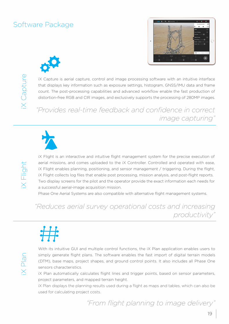
iX Flight is an interactive and intuitive flight management system for the precise execution of
aerial missions, and comes uploaded to the iX Controller. Controlled and operated with ease,
iX Flight enables planning, positioning, and sensor management / triggering. During the flight,
iX Flight collects log files that enable post processing, mission analysis, and post-flight reports.
Two display screens for the pilot and the operator provide the exact information each needs for
a successful aerial-image acquisition mission.
Phase One Aerial Systems are also compatible with alternative flight management systems.
With its intuitive GUI and multiple control functions, the iX Plan application enables users to
simply generate flight plans. The software enables the fast import of digital terrain models
(DTM), base maps, project shapes, and ground control points. It also includes all Phase One
sensors characteristics.
iX Plan automatically calculates flight lines and trigger points, based on sensor parameters,
project parameters, and mapped terrain height.
iX Plan displays the planning results used during a flight as maps and tables, which can also be
used for calculating project costs.
iX Capture is aerial capture, control and image processing software with an intuitive interface
that displays key information such as exposure settings, histogram, GNSS/IMU data and frame
count. The post-processing capabilities and advanced workflow enable the fast production of
distortion-free RGB and CIR images, and exclusively supports the processing of 280MP images.
19
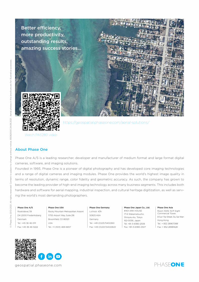
https://geospatial.phaseone.com/aerial-solutions/
Watch PAS280 video
© P
has
e O
ne
2013
-20
21. A
ll ri
gh
ts r
eser
ved
. Co
nte
nt
is s
ub
ject
to
ch
ang
e w
ith
ou
t n
oti
ce. 8
508
200
0 2
4.0
8.2
021
. A
eria
l ph
oto
s in
th
is b
roch
ure
are
fo
r ill
ust
rati
ve p
urp
ose
s.
Better efficiency,more productivity,outstanding results,amazing success stories...
About Phase One
Phase One A/S is a leading researcher, developer and manufacturer of medium format and large format digital
cameras, software, and imaging solutions.
Founded in 1993, Phase One is a pioneer of digital photography and has developed core imaging technologies
and a range of digital cameras and imaging modules. Phase One provides the world’s highest image quality in
terms of resolution, dynamic range, color fidelity and geometric accuracy. As such, the company has grown to
become the leading provider of high-end imaging technology across many business segments. This includes both
hardware and software for aerial mapping, industrial inspection, and cultural heritage digitization, as well as serv-
ing the world’s most demanding photographers.
Phase One A/S
Roskildevej 39
DK-2000 Frederiksberg
Denmark
Tel.: +45 36 46 0111
Fax: +45 36 46 0222
Phase One USA
Rocky Mountain Metropolitan Airport
11755 Airport Way, Suite 216
Broomfield, CO 80021
USA
Tel.: +1 (303) 469-6657
Phase One Germany
Lichtstr. 43h
50825 Köln
Germany
Tel.: +49 (0)221/5402260
Fax: +49 (0)221/54022622
Phase One Japan Co., Ltd.
#401 ARK HOUSE
17-6 Wakamatsucho
Shinjuku-ku, Tokyo
162-0056, Japan
Tel: +81-3-6380-2506
Fax: +81-3-6380-2507
Phase One Asia
Room 1009, 10/F Eight Commercial Tower,
8 Sun Yip Street, Siu Sai Wan
Hong Kong
Tel.: + 852 28967088
Fax: + 852 28981628
geospatial.phaseone.com