Embed Size (px)
Citation preview
PS 5.8 – Photogrammetry and Remote Sensing Eminnur Ayhan, Özlem Erden, Gülçin Atay, Esra Tunç Digital Orthophoto Generation with Aerial Photos and Satellite Images And Analyzing of Factors which Affect Accuracy Shaping the Change XXIII FIG Congress Munich, Germany, October 8-13, 2006
1/14
Digital Orthophoto Generation with Aerial Photos and Satellite Images and Analyzing of Factors which Affect Accuracy
Eminnur AYHAN, Özlem ERDEN, Gülçin ATAY and Esra TUNÇ, Turkey
Key words: Digital orthophoto, accuracy, DEM, land characteristic, satellite image, aerial photograph SUMMARY With the development of technology Digital photogrammetry has been started to be used widely in almost all area about mapping. Especially digital orthophotos which are a photogrammetric products, are being used common by lots of private sectors because of theirs easy interpretability. This has increased the demand on maps and has led to the need of researching on about accuracies. The resolution and the scale of the used aerial photos or satellite images, the quality and the scale of the DEM (Digital Elevation Model) and land topography are some of the factors that affect the accuracy of the orthophotos. The affects of the DEM and land topography on orthophoto accuracy have been investigated in this study. Firstly the affects of DEM on orthophoto maps which are produced either by aerial photos or satellite images has been investigated. Secondly, to determine the affect of topography on the process, some scanned aerial photos and the panchromatic (PAN) band of IKONOS satellite have been used. These scanned aerial photos are belong to the different regions in Turkey like Trabzon, Aydın, Tekirdağ ve Siirt, with different scales and resolutions (14μm-21μm) and they also represent different topography properties (rough, flat). Then the orthophoto maps, generated by using these inputs, have been compared with each other through their accuracies and coherences.
PS 5.8 – Photogrammetry and Remote Sensing Eminnur Ayhan, Özlem Erden, Gülçin Atay, Esra Tunç Digital Orthophoto Generation with Aerial Photos and Satellite Images And Analyzing of Factors which Affect Accuracy Shaping the Change XXIII FIG Congress Munich, Germany, October 8-13, 2006
2/14
Digital Orthophoto Generation with Aerial Photos and Satellite Images and Analyzing of Factors which Affect Accuracy
Eminnur AYHAN, Özlem ERDEN, Gülçin ATAY and Esra TUNÇ, Turkey
1. INTRODUCTION The advance of computer technology in Digital Photogrammetry, Remote Sensing, Geographical Information Systems, Real Time 3D Digital Model and Visualization Systems have enhanced undoubtedly in recent years. The applications of this realistic method of real time visualization could be seen in many fields (engineering, urban and city planning, architecture, design, science and art) (Alexandrov, 2004). Besides, up to date and spatial information can be provided by the help of digital photogrammetry using aerial photos and satellite images.The orthophoto maps of digital photogrametric production , which are produced by using aerial photographs and satellite images, can supply fast and economical map production. Especially the orthophoto maps that are produced by using satellite images, by means of developing technology, are advancing for being economical alternatives to classic maps.Even the updating of digital vector products takes a short time, at first step the production takes too much time (Akdeniz, 2004). Ortophotos are photographs that have been corrected for distortions due to tilting of the camera during the photographic survey, distortions from the camera lens, and relief distortions. Orthophotos display all the valuable information of a photograph, but unlike a photograph, true distances, angles and areas can be measured directly (Rossi,2004). To use these orthophoto images as a map, it is of great importance to provide orthophoto images in high level of accuracy. A qualified orthophoto can be generated with the compound of selecting the right parameters, operator’s talent and operator’s experience. The quality of DEM which is another factor affects the quality of the orthophoto image can be change through scanning resolution, control parameters used in image matching, quality of photograph, density of DEM points and land characteristics. The planimetric spacing (density) of the DEM posts also control the accuracy of the surface model. Increasing the resolution of the DEM and decreasing the spacing between neighbouring points not only increases the file size and generation time, but also noticeably the detail that is recorded and reduces the effect of smoothing (Smith, 1997). In this study the affects of data which are used during orthophoto generation, on the accuracy of orthophoto image has been investigated. 2. METHODOLOGY In that study five different regions has been determined through their topography structures. Aerial photos in different scales, different properties and different resolutions have been used with Ikonos PAN band, and with DEM which were produced by different methods to produce
PS 5.8 – Photogrammetry and Remote Sensing Eminnur Ayhan, Özlem Erden, Gülçin Atay, Esra Tunç Digital Orthophoto Generation with Aerial Photos and Satellite Images And Analyzing of Factors which Affect Accuracy Shaping the Change XXIII FIG Congress Munich, Germany, October 8-13, 2006
3/14
digital orthophoto images. The affects of these data on orthophoto images were researched. The regions and their properties which were used in this study is illustrated in Table 1.
Table 1: Working areas and their properties
Area Topography Scale Grey Tone Used DEM 1(Trabzon) Rough Small Infrared Available
2 (Aydın) Flat Medium Colored Generated from a stereo model
3 (Tekirdağ) Flat Large Black-white Generated from a stereo model
4 (Siirt) Flat Large Black-white Generated from a stereo model
5 (Trabzon) Rough+ Flat PAN Black-white Generated from a stereo model
The images have been oriented and rectified with using Z/I Imaging which is a Digital Photogrammetric Software. Specially Image Station Digital Measuration (ISDM) and Image Station Photogrammetric Manager (ISPM) modules have been used for orientating and rectifying the images. Orthophoto generation, which is the next step, has been generated with Image Station Base Rectifier (ISBR) module. The properties of the Aerial-Photos used in this application have been shown in Table 2.
Table 2: The properties of the Aerial-Photos used in application
City Scale Grey Tone Image Resolution
1-Trabzon 1/16000 Infrared 21μm 2-Aydın 1/10000 Coloured 21μm 3-Tekirdağ 1/5000 Black-white 14μm 4-Siirt 1/5000 Black-white 21μm
2.1. Working Area-1 A roughly place belong to Trabzon City has been chosen as Working Area 1. Together with its roughness, it has been urbanized and densely vegetated area. For this area, an aerial photo which is in 1/16000 scale, which is infrared and which has 21μm resolution, has been used. Both the calibration information which belongs to the camera, and photograph information have been used as input data for ISPM module. Besides this, projection information and datum information of the area have been recognized with the same module. Then, all orientations (interior, relative and absolute) of the project have been done in ISDM module. 7 control points have been used during absolute orientation. The homogeneity of the points’
PS 5.8 – Photogrammetry and Remote Sensing Eminnur Ayhan, Özlem Erden, Gülçin Atay, Esra Tunç Digital Orthophoto Generation with Aerial Photos and Satellite Images And Analyzing of Factors which Affect Accuracy Shaping the Change XXIII FIG Congress Munich, Germany, October 8-13, 2006
4/14
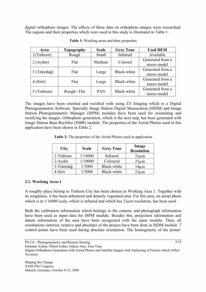
distributions and the clearness of the points have been considered while choosing these points. The DEM in Figure 1 has been generated with the help of high altitude information belong to the 1/1000 scaled present time map which is belong to the region 1. Then, Digital Terrain Model (DTM) has been produced by using the generated DEM. Ortho photo processing has been achieved in Z/I Imaging software by using DEM, DTM and aerial photo in ISBR module.
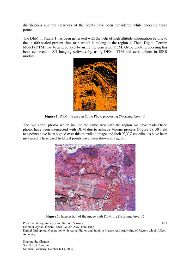
Figure 1: DTM file used in Ortho Photo processing (Working Area -1) The two aerial photos which include the same area with the region we have made Ortho photo, have been intersected with DEM due to achieve Mosaic process (Figure 2). 30 field test points have been signed over this mozaiked image and their X,Y,Z coordinates have been measured. These used field test points have been shown in Figure 3.
Figure 2: Intersection of the image with DEM file (Working Area 1 )
PS 5.8 – Photogrammetry and Remote Sensing Eminnur Ayhan, Özlem Erden, Gülçin Atay, Esra Tunç Digital Orthophoto Generation with Aerial Photos and Satellite Images And Analyzing of Factors which Affect Accuracy Shaping the Change XXIII FIG Congress Munich, Germany, October 8-13, 2006
5/14
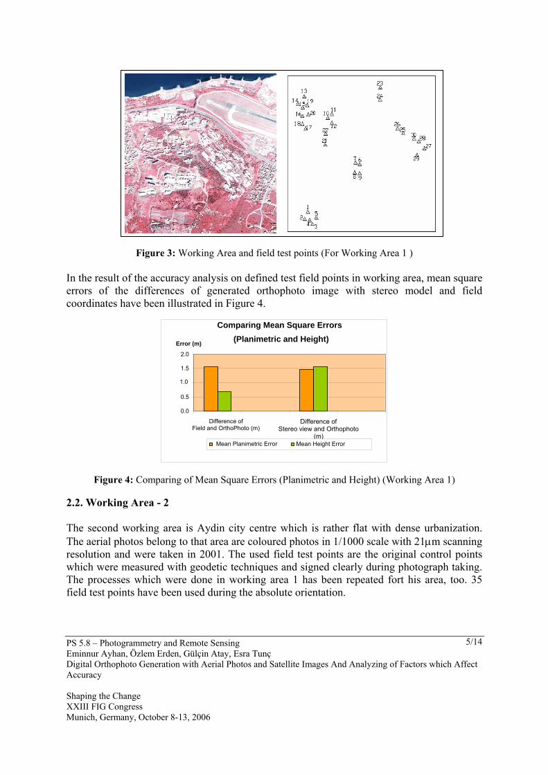
Figure 3: Working Area and field test points (For Working Area 1 )
In the result of the accuracy analysis on defined test field points in working area, mean square errors of the differences of generated orthophoto image with stereo model and field coordinates have been illustrated in Figure 4.
Figure 4: Comparing of Mean Square Errors (Planimetric and Height) (Working Area 1) 2.2. Working Area - 2 The second working area is Aydin city centre which is rather flat with dense urbanization. The aerial photos belong to that area are coloured photos in 1/1000 scale with 21μm scanning resolution and were taken in 2001. The used field test points are the original control points which were measured with geodetic techniques and signed clearly during photograph taking. The processes which were done in working area 1 has been repeated fort his area, too. 35 field test points have been used during the absolute orientation.
Comparing Mean Square Errors(Planimetric and Height)
0.0 0.5
1.0 1.5 2.0
Difference of Field and OrthoPhoto (m)
Difference of Stereo view and Orthophoto
(m)
Error (m)
Mean Planimetric Error Mean Height Error
PS 5.8 – Photogrammetry and Remote Sensing Eminnur Ayhan, Özlem Erden, Gülçin Atay, Esra Tunç Digital Orthophoto Generation with Aerial Photos and Satellite Images And Analyzing of Factors which Affect Accuracy Shaping the Change XXIII FIG Congress Munich, Germany, October 8-13, 2006
6/14
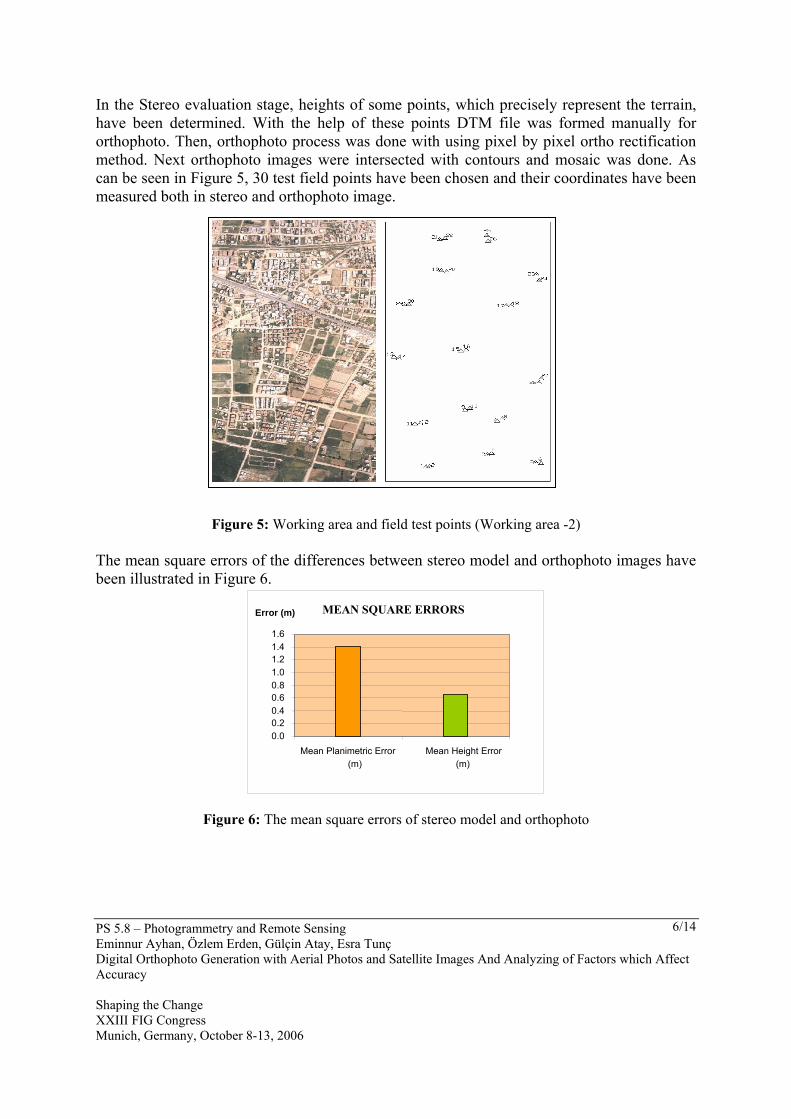
In the Stereo evaluation stage, heights of some points, which precisely represent the terrain, have been determined. With the help of these points DTM file was formed manually for orthophoto. Then, orthophoto process was done with using pixel by pixel ortho rectification method. Next orthophoto images were intersected with contours and mosaic was done. As can be seen in Figure 5, 30 test field points have been chosen and their coordinates have been measured both in stereo and orthophoto image.
Figure 5: Working area and field test points (Working area -2) The mean square errors of the differences between stereo model and orthophoto images have been illustrated in Figure 6.
Figure 6: The mean square errors of stereo model and orthophoto
MEAN SQUARE ERRORS
0.00.20.40.60.81.01.21.41.6
Mean Planimetric Error (m)
Mean Height Error (m)
Error (m)
PS 5.8 – Photogrammetry and Remote Sensing Eminnur Ayhan, Özlem Erden, Gülçin Atay, Esra Tunç Digital Orthophoto Generation with Aerial Photos and Satellite Images And Analyzing of Factors which Affect Accuracy Shaping the Change XXIII FIG Congress Munich, Germany, October 8-13, 2006
7/14
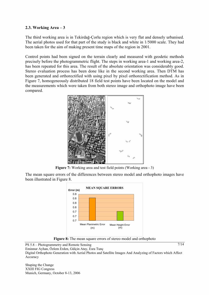
2.3. Working Area – 3 The third working area is in Tekirdağ-Çorlu region which is very flat and densely urbanised. The aerial photos used for that part of the study is black and white in 1/5000 scale. They had been taken for the aim of making present time maps of the region in 2001. Control points had been signed on the terrain clearly and measured with geodetic methods precisely before the photogrammetric flight. The steps in working area-1 and working area-2, has been repeated for this area. The result of the absolute orientation was considerably good. Stereo evaluation process has been done like in the second working area. Then DTM has been generated and orthorectified with using pixel by pixel orthorectification method. As in Figure 7, homogeneously distributed 18 field test points have been located on the model and the measurements which were taken from both stereo image and orthophoto image have been compared.
Figure 7: Working area and test field points (Working area - 3)
The mean square errors of the differences between stereo model and orthophoto images have been illustrated in Figure 8.
Figure 8: The mean square errors of stereo model and orthophoto
MEAN SQUARE ERRORS
0.70.7
0.70.8
0.8
0.80.8
Mean Planimetric Error (m)
Mean Height Error(m)
Error (m)
PS 5.8 – Photogrammetry and Remote Sensing Eminnur Ayhan, Özlem Erden, Gülçin Atay, Esra Tunç Digital Orthophoto Generation with Aerial Photos and Satellite Images And Analyzing of Factors which Affect Accuracy Shaping the Change XXIII FIG Congress Munich, Germany, October 8-13, 2006
8/14
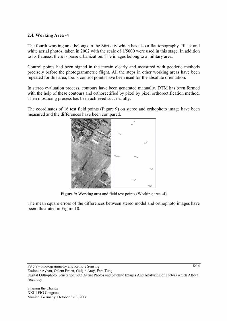
2.4. Working Area -4 The fourth working area belongs to the Siirt city which has also a flat topography. Black and white aerial photos, taken in 2002 with the scale of 1/5000 were used in this stage. In addition to its flatness, there is parse urbanization. The images belong to a military area. Control points had been signed in the terrain clearly and measured with geodetic methods precisely before the photogrammetric flight. All the steps in other working areas have been repeated for this area, too. 8 control points have been used for the absolute orientation. In stereo evaluation process, contours have been generated manually. DTM has been formed with the help of these contours and orthorectified by pixel by pixel orthorectification method. Then mosaicing process has been achieved successfully. The coordinates of 16 test field points (Figure 9) on stereo and orthophoto image have been measured and the differences have been compared.
Figure 9: Working area and field test points (Working area -4) The mean square errors of the differences between stereo model and orthophoto images have been illustrated in Figure 10.
PS 5.8 – Photogrammetry and Remote Sensing Eminnur Ayhan, Özlem Erden, Gülçin Atay, Esra Tunç Digital Orthophoto Generation with Aerial Photos and Satellite Images And Analyzing of Factors which Affect Accuracy Shaping the Change XXIII FIG Congress Munich, Germany, October 8-13, 2006
9/14
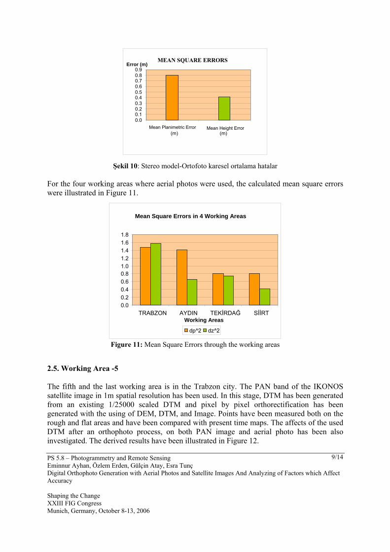
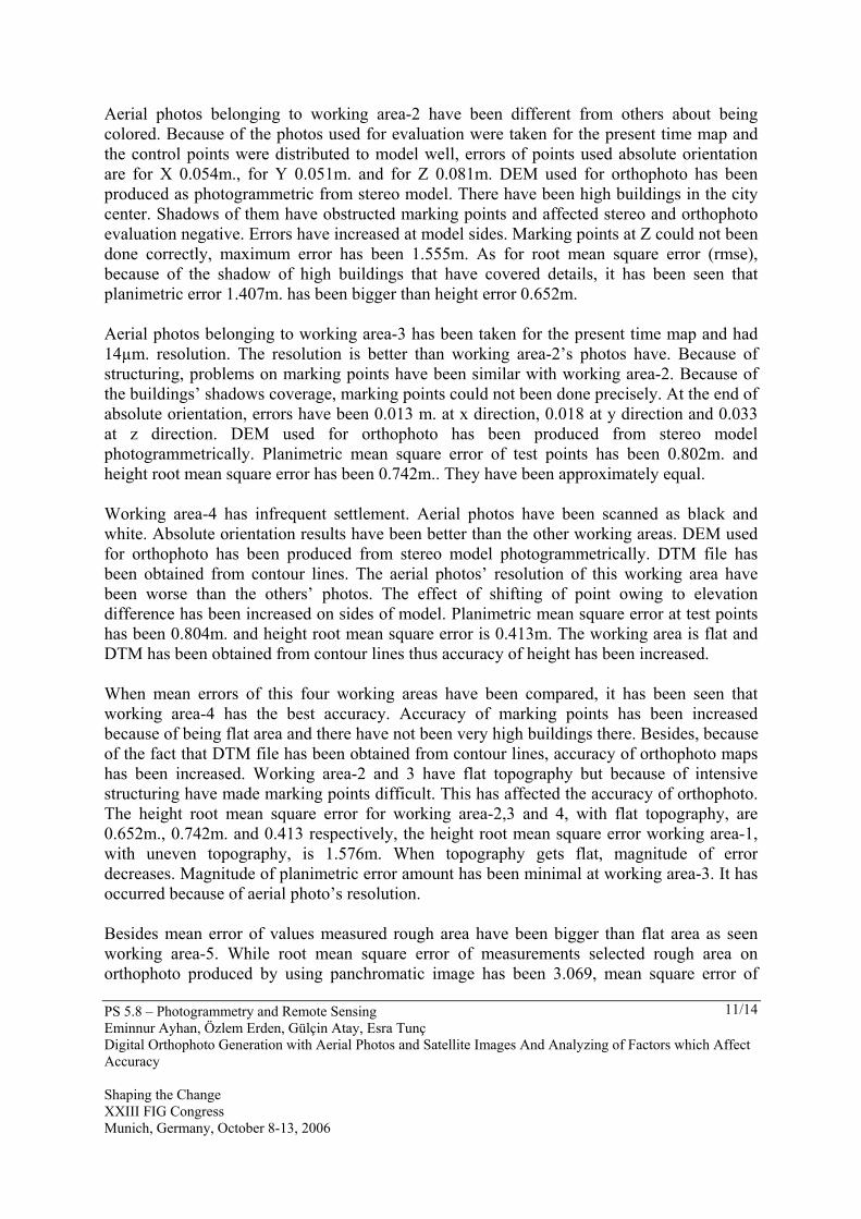
Şekil 10: Stereo model-Ortofoto karesel ortalama hatalar For the four working areas where aerial photos were used, the calculated mean square errors were illustrated in Figure 11.
Figure 11: Mean Square Errors through the working areas
2.5. Working Area -5 The fifth and the last working area is in the Trabzon city. The PAN band of the IKONOS satellite image in 1m spatial resolution has been used. In this stage, DTM has been generated from an existing 1/25000 scaled DTM and pixel by pixel orthorectification has been generated with the using of DEM, DTM, and Image. Points have been measured both on the rough and flat areas and have been compared with present time maps. The affects of the used DTM after an orthophoto process, on both PAN image and aerial photo has been also investigated. The derived results have been illustrated in Figure 12.
MEAN SQUARE ERRORS
0.00.10.20.30.40.50.60.70.80.9
Mean Planimetric Error (m)
Mean Height Error (m)
Error (m)
Mean Square Errors in 4 Working Areas
0.0 0.2 0.4 0.6 0.8 1.0 1.2 1.4 1.6 1.8
TRABZON AYDIN TEKİRDAĞ SİİRTWorking Areas
dp^2 dz^2

PS 5.8 – Photogrammetry and Remote Sensing Eminnur Ayhan, Özlem Erden, Gülçin Atay, Esra Tunç Digital Orthophoto Generation with Aerial Photos and Satellite Images And Analyzing of Factors which Affect Accuracy Shaping the Change XXIII FIG Congress Munich, Germany, October 8-13, 2006
10/14
Figure 12: Mean Square Errors on Terrain and Orthophoto (Working Area 5)
3. RESULTS AND DISCUSSION In this study, the accuracies of orthophoto maps produced at 5 areas have been compared. The images belonging to different areas have differences about scale, gray tone, topography structure, used DEM at obtained models’ average errors. All of these are the components that have direct effect on orthophoto maps’ accuracy. To determine the accuracies of orthopoto maps at 5 working areas, aerial photos 30 test points in Trabzon, 30 points in Aydın, 18 points in Tekirdağ, 16 points in Siirt; and also 13 test points belongs to Trabzon Ikonos panchromatic band image have been selected. Test points have been selected from among points to be selected easily on photo like road, ground corners and so errors in readings have been reduced. But at some working areas selecting details has been limited because of intensive structuring. For obligatory situations building corners have been selected as test points. This situation has been affected the results negative. DEM data obtained from terrestrial measurements has been used at working area-1. At other working areas because of the fact that scales of aerial photos have been large, DEM obtained from stereo model has been used for orthophoto. At working area-1 because of the small scale and having near infrared character, the accuracy of orthophoto map has been affected negative. To evaluate stereo model from a near infrared image has harder and more difficult than a panchromatic image. Difficulties on marking points have affected the coordinates. Because of small scale has reduced resolution of the image, so the details have been determined approximately. In forming model process from being used control points which are on side of model have big error so that maximum dx difference between geodetic measurement coordinates and orthophoto coordinates is 2,892m. dz difference between geodetic measurement coordinates and stereo model coordinates is 2.90m. The errors of X,Y,Z have increased on sides of model.
MEAN SQUARE ERRORS
0.0 0.5 1.0 1.5 2.0 2.5 3.0 3.5
Rough FlatTopography
Errors(m)
Rough Flat
PS 5.8 – Photogrammetry and Remote Sensing Eminnur Ayhan, Özlem Erden, Gülçin Atay, Esra Tunç Digital Orthophoto Generation with Aerial Photos and Satellite Images And Analyzing of Factors which Affect Accuracy Shaping the Change XXIII FIG Congress Munich, Germany, October 8-13, 2006
11/14
Aerial photos belonging to working area-2 have been different from others about being colored. Because of the photos used for evaluation were taken for the present time map and the control points were distributed to model well, errors of points used absolute orientation are for X 0.054m., for Y 0.051m. and for Z 0.081m. DEM used for orthophoto has been produced as photogrammetric from stereo model. There have been high buildings in the city center. Shadows of them have obstructed marking points and affected stereo and orthophoto evaluation negative. Errors have increased at model sides. Marking points at Z could not been done correctly, maximum error has been 1.555m. As for root mean square error (rmse), because of the shadow of high buildings that have covered details, it has been seen that planimetric error 1.407m. has been bigger than height error 0.652m. Aerial photos belonging to working area-3 has been taken for the present time map and had 14µm. resolution. The resolution is better than working area-2’s photos have. Because of structuring, problems on marking points have been similar with working area-2. Because of the buildings’ shadows coverage, marking points could not been done precisely. At the end of absolute orientation, errors have been 0.013 m. at x direction, 0.018 at y direction and 0.033 at z direction. DEM used for orthophoto has been produced from stereo model photogrammetrically. Planimetric mean square error of test points has been 0.802m. and height root mean square error has been 0.742m.. They have been approximately equal. Working area-4 has infrequent settlement. Aerial photos have been scanned as black and white. Absolute orientation results have been better than the other working areas. DEM used for orthophoto has been produced from stereo model photogrammetrically. DTM file has been obtained from contour lines. The aerial photos’ resolution of this working area have been worse than the others’ photos. The effect of shifting of point owing to elevation difference has been increased on sides of model. Planimetric mean square error at test points has been 0.804m. and height root mean square error is 0.413m. The working area is flat and DTM has been obtained from contour lines thus accuracy of height has been increased. When mean errors of this four working areas have been compared, it has been seen that working area-4 has the best accuracy. Accuracy of marking points has been increased because of being flat area and there have not been very high buildings there. Besides, because of the fact that DTM file has been obtained from contour lines, accuracy of orthophoto maps has been increased. Working area-2 and 3 have flat topography but because of intensive structuring have made marking points difficult. This has affected the accuracy of orthophoto. The height root mean square error for working area-2,3 and 4, with flat topography, are 0.652m., 0.742m. and 0.413 respectively, the height root mean square error working area-1, with uneven topography, is 1.576m. When topography gets flat, magnitude of error decreases. Magnitude of planimetric error amount has been minimal at working area-3. It has occurred because of aerial photo’s resolution. Besides mean error of values measured rough area have been bigger than flat area as seen working area-5. While root mean square error of measurements selected rough area on orthophoto produced by using panchromatic image has been 3.069, mean square error of
PS 5.8 – Photogrammetry and Remote Sensing Eminnur Ayhan, Özlem Erden, Gülçin Atay, Esra Tunç Digital Orthophoto Generation with Aerial Photos and Satellite Images And Analyzing of Factors which Affect Accuracy Shaping the Change XXIII FIG Congress Munich, Germany, October 8-13, 2006
12/14
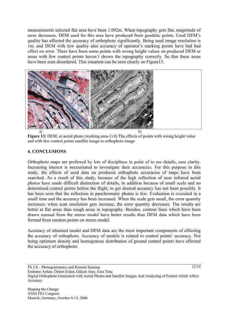
measurements selected flat area have been 1.092m. When topography gets flat, magnitude of error decreases. DEM used for this area have produced from geodetic points. Used DEM’s quality has affected the accuracy of orthophoto significantly. Being used image resolution is 1m. and DEM with low quality also accuracy of operator’s marking points have had bad effect on error. There have been some points with wrong height values on produced DEM or areas with few control points haven’t shown the topography correctly. So that these areas have been seen disordered. This situation can be seen clearly on Figure13.
a) b) Figure 13: DEM; a) aerial photo (working area-1) b) The effects of points with wrong height value and with few control points satellite image to orthophoto image 4. CONCLUSIONS Orthophoto maps are preferred by lots of disciplines in point of to see details, ease clarity. Increasing interest is necessitated to investigate their accuracies. For this purpose in this study, the effects of used data on produced orthophoto accuracies of maps have been searched. As a result of this study, because of the high reflection of near infrared aerial photos have made difficult distinction of details, in addition because of small scale and no determined control points before the flight, to get desired accuracy has not been possible. It has been seen that the reflection in panchromatic photos is few. Evaluation is executed in a small time and the accuracy has been increased. When the scale gets small, the error quantity increases; when scan resolution gets increase, the error quantity decreases. The results are better at flat areas than rough areas in topography. Besides, contour lines which have been drawn manual from the stereo model have better results than DEM data which have been formed from random points on stereo model. Accuracy of obtained model and DEM data are the most important components of affecting the accuracy of orthophoto. Accuracy of models is related to control points’ accuracy. Not being optimum density and homogenous distribution of ground control points have affected the accuracy of orthophoto.
PS 5.8 – Photogrammetry and Remote Sensing Eminnur Ayhan, Özlem Erden, Gülçin Atay, Esra Tunç Digital Orthophoto Generation with Aerial Photos and Satellite Images And Analyzing of Factors which Affect Accuracy Shaping the Change XXIII FIG Congress Munich, Germany, October 8-13, 2006
13/14
When used large scale high resolution image, high accuracy DEM and control points, high accuracy orthophoto maps will be produced. The resolution of used aerial photos is higher than Ikonos satellite panchromatic band image. For high accuracy works, aerial photos are perfect. But to get aerial photos and preparation phases are costly and take up little time. So, if high precision is not important for a study, orthophoto images produced from satellite images are ideal. REFERENCES Akdeniz, H., The Opportunities That Digital Orthophotos Can Supply In Urban Planning,
XXth ISPRS Congress, 12-23 July 2004, İstanbul, PS WG VII/4, http://www.isprs.org/istanbul2004/comm7/papers/112.pdf,
Alexandrov, A., Hristova, T., Ivanova, K., Koeva, M., Madzharova, T. and Petrova V., H., Aplication Of Quickbird Satellite Imagery For Updating Cadastral Information, Xth ISPRS Congress, 12-23 July 2004, İstanbul, Commission II, http://www.isprs.org/istanbul2004/comm2/papers/160.pdf
Rossi, Tiffiny Ann, Application Of Digital Photogrammetric Methods İn The Of Land Cover Change On The Coastal Dunes Of Warren Dunes State Park, Berrien Country, Master Thesis,The Michigan State University, Michigan, 2004
Sivri, Tayfur, Investigating The Accuracies Of Digital Orthophoto Maps Producted at Different Regions, Master Thesis , K.T.Ü., The Graduate School of Natural and Applied Sciences, Trabzon, 2004
Smith, M.J., Smith, D.G., Tragheim D.G. and Holt, M., DEMs And Ortho-İmages From Aerial Photographs, Photogrammetric Record, 15 (1997) 945-950
BIOGRAPHICAL NOTES Eminnur Ayhan is an Assistant Professor at Karadeniz Technical University (KTU), Turkey. She graduated from the Department of Geodesy and Photogrammetry Engineering at Karadeniz Technical University (KTU) in 1983. She got her M.Eng. degree in 1985 and Ph.D. degree in 1996 from the same department. She is currently working at the Department of Geodesy and Photogrammetry Engineering at KTU. Her interest areas are Photogrammetry, Close-Range Photogrammetry, Remote Sensing, Image Processing, Classification and Radar. Özlem Erden is Ms.C. student at Karadeniz Technical University (KTU), Turkey. She graduated from the Department of Geodesy and Photogrammetry Engineering at Karadeniz Technical University (KTU) in 2003. Her interest areas are Photogrammetry, Digital Photogrammetry, Close-Range Photogrammetry, GIS and Remote Sensing. Gülçin ATAY is a Ph. D. student at Karadeniz Technical University (KTU), Turkey. She graduated from the Department of Geodesy and Photogrammetry Engineering at Karadeniz Technical University (KTU) in 2001. Her interest areas are Remote Sensing, Digital Image Processing and Photogrammetry.
PS 5.8 – Photogrammetry and Remote Sensing Eminnur Ayhan, Özlem Erden, Gülçin Atay, Esra Tunç Digital Orthophoto Generation with Aerial Photos and Satellite Images And Analyzing of Factors which Affect Accuracy Shaping the Change XXIII FIG Congress Munich, Germany, October 8-13, 2006
14/14
Esra Tunç is a Ph. D student at Karadeniz Technical University (KTU), Turkey. She graduated from the Department of Geodesy and Photogrammetry Engineering at Karadeniz Technical University (KTU) in 2000. She got her M. Sc degree from the Department of Geodesy and Photogrammetry Engineering at Karadeniz Technical University (KTU) in 2003. Her interest areas are Photogrammetry, Close-Range Photogrammetry, Remote Sensing, Geographical Information Systems, SAR, and Radar. CONTACTS Eminnur Ayhan Karadeniz Technical University Department of Geodesy and Photogrammetry Engineering 61080 Trabzon TURKEY. Tel. + 90 462 3772799 Fax:+ 90 462 3280918 Email: [email protected] Özlem Erden Karadeniz Technical University Department of Geodesy and Photogrammetry Engineering 61080 Trabzon TURKEY. Tel : + 90 462 3772764 Fax: + 90 462 3280918 Email: [email protected] Gülçin Atay Karadeniz Technical University Department of Geodesy and Photogrammetry Engineering 61080 Trabzon TURKEY. Tel.:+ 90 462 3772766 Fax: + 90 462 3280918 Email: [email protected] Esra Tunç Karadeniz Technical University Department of Geodesy and Photogrammetry Engineering 61080 Trabzon TURKEY. Tel.: + 90 462 3772795 Fax:+ 90 462 3280918 Email: [email protected]