Embed Size (px)
Citation preview

NEW YORK STATE
FRESHWATER WETLANDS
DELINEATION MANUAL
JULY 1995
Steve Browne, AlbanyScott Crocoll, LathamDiane Goetke, Albany
Nancy Heaslip, SchenectadyTed Kerpez, New PaltzKen Kogut, Ray BrookSteve Sanford, AlbanyDan Spada, Ray Brook
TABLE OF CONTENTS
Page
PREFACE . . . . . . . . . . . . . . . . . . . . . . . . . . . . . . . . . . . . . . . . . . . . . . . . . . . . . . . . . . . . . . . . . . . . . . 1.Organization of the Manual . . . . . . . . . . . . . . . . . . . . . . . . . . . . . . . . . . . . . . . . . . . . . . . . . . . . . . 2.Use of the Manual . . . . . . . . . . . . . . . . . . . . . . . . . . . . . . . . . . . . . . . . . . . . . . . . . . . . . . . . . . . . . 2.Using Other Publications . . . . . . . . . . . . . . . . . . . . . . . . . . . . . . . . . . . . . . . . . . . . . . . . . . . . . . . . 2.
PART I. TECHNICAL CRITERIA FOR NEW YORK STATE WETLAND DELINEATION: . . 3.Hydrophytic Vegetation . . . . . . . . . . . . . . . . . . . . . . . . . . . . . . . . . . . . . . . . . . . . . . . . . . . . . . . 3.
Plant Indicator Status Categories . . . . . . . . . . . . . . . . . . . . . . . . . . . . . . . . . . . . . . . . . . . . . . 4.Hydrophytic Vegetation Criterion . . . . . . . . . . . . . . . . . . . . . . . . . . . . . . . . . . . . . . . . . . . . . 5.Dominant Vegetation . . . . . . . . . . . . . . . . . . . . . . . . . . . . . . . . . . . . . . . . . . . . . . . . . . . . . . . 5.Vegetation Field Indicators of Wetland (adapted from Tiner 1993) . . . . . . . . . . . . . . . . . . . . . 5.
Wetland Hydrology . . . . . . . . . . . . . . . . . . . . . . . . . . . . . . . . . . . . . . . . . . . . . . . . . . . . . . . . . . . 6.Wetland Hydrology Criterion . . . . . . . . . . . . . . . . . . . . . . . . . . . . . . . . . . . . . . . . . . . . . . . . . 7.Hydrologic Field Indicators of Wetland . . . . . . . . . . . . . . . . . . . . . . . . . . . . . . . . . . . . . . . . . 7.
Primary Hydrologic Indicators . . . . . . . . . . . . . . . . . . . . . . . . . . . . . . . . . . . . . . . . . . . 8.Secondary Hydrologic Indicators . . . . . . . . . . . . . . . . . . . . . . . . . . . . . . . . . . . . . . . . . . 9.
Hydric Soils . . . . . . . . . . . . . . . . . . . . . . . . . . . . . . . . . . . . . . . . . . . . . . . . . . . . . . . . . . . . . . . . 10.Hydric Soil Criterion . . . . . . . . . . . . . . . . . . . . . . . . . . . . . . . . . . . . . . . . . . . . . . . . . . . . . . 10.
NTCHS Criteria for Hydric Soils . . . . . . . . . . . . . . . . . . . . . . . . . . . . . . . . . . . . . . . . 10.Soil Types . . . . . . . . . . . . . . . . . . . . . . . . . . . . . . . . . . . . . . . . . . . . . . . . . . . . . . . . . . . . . . 11.
Hydric Organic Soils . . . . . . . . . . . . . . . . . . . . . . . . . . . . . . . . . . . . . . . . . . . . . . . . . 11.Hydric Mineral Soils . . . . . . . . . . . . . . . . . . . . . . . . . . . . . . . . . . . . . . . . . . . . . . . . . . 12.
Soil Field Indicators of Wetland . . . . . . . . . . . . . . . . . . . . . . . . . . . . . . . . . . . . . . . . . . . . . 14.Summary of Technical Criteria for New York State Wetland Delineation . . . . . . . . . . . . . . . . 16.
PART II. METHODS FOR IDENTIFICATION AND DELINEATION OF WETLAND BOUNDARIES . . . . . . . . . . . . . . . . . . . . . . . . . . . . . . . . . . . . . . . . . . . . . . 16.
Pre-inspection Procedures . . . . . . . . . . . . . . . . . . . . . . . . . . . . . . . . . . . . . . . . . . . . . . . . . . . . . 16.Field Delineation Methods . . . . . . . . . . . . . . . . . . . . . . . . . . . . . . . . . . . . . . . . . . . . . . . . . . . . . 18.
Routine Delineation Procedure . . . . . . . . . . . . . . . . . . . . . . . . . . . . . . . . . . . . . . . . . . . . . . . 18.Flagging the Boundary . . . . . . . . . . . . . . . . . . . . . . . . . . . . . . . . . . . . . . . . . . . . . . . . . . . . 22.Complex or Controversial Wetland Sites . . . . . . . . . . . . . . . . . . . . . . . . . . . . . . . . . . . . . . . 22.
Offsite "Delineations" of Wetland Boundaries . . . . . . . . . . . . . . . . . . . . . . . . . . . . . . . . . . . . . 22.Disturbed and Problematic Area Wetlands . . . . . . . . . . . . . . . . . . . . . . . . . . . . . . . . . . . . . . . . 23.
Disturbed Areas . . . . . . . . . . . . . . . . . . . . . . . . . . . . . . . . . . . . . . . . . . . . . . . . . . . . . . . . . 23.Delineations in Disturbed Areas . . . . . . . . . . . . . . . . . . . . . . . . . . . . . . . . . . . . . . . . . . . . . . 24.Problematic Wetland Areas . . . . . . . . . . . . . . . . . . . . . . . . . . . . . . . . . . . . . . . . . . . . . . . . . 28.Delineations in Problematic Wetland Areas . . . . . . . . . . . . . . . . . . . . . . . . . . . . . . . . . . . . . 30.

LITERATURE CITED . . . . . . . . . . . . . . . . . . . . . . . . . . . . . . . . . . . . . . . . . . . . . . . . . . . . . . . . . . . 32.
TABLES . . . . . . . . . . . . . . . . . . . . . . . . . . . . . . . . . . . . . . . . . . . . . . . . . . . . . . . . . . . . . . . . . . . . . . 33.Table 1. Adaptations of Plans that Grow in Permanently or Periodically Flooded
or Saturated Soils . . . . . . . . . . . . . . . . . . . . . . . . . . . . . . . . . . . . . . . . . . . . . . . . 33.Table 2. Wetland Delineation Information Sources . . . . . . . . . . . . . . . . . . . . . . . . . . . . . . . . . . . 34.Table 3. Recommended Equipment and Materials for On-site Delineations. . . . . . . . . . . . . . . . . . 35.
GLOSSARY . . . . . . . . . . . . . . . . . . . . . . . . . . . . . . . . . . . . . . . . . . . . . . . . . . . . . . . . . . . . . . . . . . . 36.
APPENDIX A: FIELD FORMS . . . . . . . . . . . . . . . . . . . . . . . . . . . . . . . . . . . . . . . . . . . . . . . . . . . . . 45.
APPENDIX B: SELECTED WETLAND REFERENCES . . . . . . . . . . . . . . . . . . . . . . . . . . . . . . . . . 47.
APPENDIX C: NATIONAL LIST OF PLANT SPECIES THAT OCCUR IN WETLANDS . . . . . . . 52.
APPENDIX D: NEW YORK HYDRIC SOILS . . . . . . . . . . . . . . . . . . . . . . . . . . . . . . . . . . . . . . . . . 52.
APPENDIX E: GENERALIZED SOIL PROFILE . . . . . . . . . . . . . . . . . . . . . . . . . . . . . . . . . . . . . . . 53.
APPENDIX F: FIELD KEY TO NEW YORK STATE WETLAND DELINEATION . . . . . . . . . . . . 54.

1.
NEW YORK STATE FRESHWATER WETLANDSDELINEATION MANUAL
PREFACE
New York State's freshwater wetlands are protected under Article 24 of the Environmental ConservationLaw, commonly known as the Freshwater Wetlands Act (the Act or Article 24). The Act directs the Departmentof Environmental Conservation (the Department or DEC) and the Adirondack Park Agency (the Agency orAPA) to "preserve, protect and conserve freshwater wetlands and the benefits derived therefrom, to prevent thedespoliation and destruction of freshwater wetlands, and to regulate use and development of such wetlands tosecure the natural benefits of freshwater wetlands, consistent with the general welfare and beneficial economic,social and agricultural development of the state [§24-0103]."
Under the Act, wetlands are defined as lands and submerged lands commonly known as swamps, sloughs,bogs and flats which support wetland vegetation. Wetland vegetation is categorized into wetland trees, wetlandshrubs and wet meadow vegetation that... "depend on permanent or seasonal flooding [wetland hydrology] orsufficiently water-logged soils [hydric soils] to give them a competitive advantage over other [vegetation]."Emergent, rooted floating-leaved, free-floating, submergent and bog mat plants that ordinarily grow in standingwater are also categorized as wetland vegetation under Article 24. Additionally, the law describes threeinstances where wetland vegetation is absent from a wetland area: 1) permanently wet conditions which containdead upland vegetation; 2) areas substantially enclosed by wetlands; and 3) the waters which overlie anywetland area [§24-0107(1)].
Wetlands protected under Article 24 are known as New York State "regulated" wetlands. The regulatedarea includes the wetlands themselves as well as a protective buffer or "adjacent area" extending 100 feetlandward of the wetland boundary. The adjacent area can be extended further in certain situations [§24-0701(2)]. Title 3 of the Act mandates that all freshwater wetlands with an area 12.4 acres or greater be depictedon a set of maps promulgated by DEC. Wetlands less than 12.4 acres in size may also be mapped if they haveunusual local importance or are located within the Adirondack Park. It is critical to note that the wetlandboundaries as shown on the maps are the "...approximate location of the actual boundaries of thewetlands...[§24-0301(3)]" (emphasis added). The boundaries of a regulated wetland are more preciselyestablished through the process of delineation. The DEC and the APA are required to provide such delineationspursuant to §24-0301(7). Delineation, in this manual, means the more precise depiction of the boundary of awetland than is possible on the 1:24,000 maps promulgated by DEC and APA.
Within the "Blue Line" of the Adirondack Park, the responsibility for administering the Act (includingdetermining the existence and extent of freshwater wetlands and regulating activities in and/or near them) resideswith the APA. The Agency also administers the Adirondack Park Agency Act (Executive Law, Article 27,Section 801 et seq.) which also defines wetlands and provides for their protection. Wetlands within theAdirondack Park are regulated under the Adirondack Park Agency Act and the Freshwater Wetlands Act whenthe wetland area is one acre in size or larger, or of any size when the wetland is adjacent to and has freeinterchange at the surface with a permanent water body, such as a stream, pond or lake. Contact theAdirondack Park Agency [Box 99, Ray Brook, New York 12977, (518) 891-4050] with any questionsregarding the use or application of this manual within the Adirondack Park or for any questions related toAgency wetlands jurisdiction.

2.
Organization of the Manual
The Manual is divided into three major parts: Preface, Part I - Technical Criteria for New York StateWetland Delineation, and Part II - Methods for Identification and Delineation of Wetland Boundaries.References, a glossary of technical terms, and appendices are included at the end of the manual.
Use of the Manual
This Manual describes the methodologies employed by the DEC and the APA to delineate the boundariesof regulated freshwater wetlands in New York State. The Manual describes technical criteria, field indicatorsand other sources of information useful for wetland boundary delineation for areas subject to Article 24regulation. The information is also applicable to wetlands regulated under the other New York laws such asArticle 15 (ie. wetlands contiguous to navigable waters pursuant to §15-0505). Emphasis for delineation is onthe upper boundary of wetlands (i.e. wetland-upland boundary) and not on the lower boundary between wetlandsand deepwater habitats.
This Manual makes use of methods and information found in "Technical Report Y-87-1, Corps ofEngineers Wetlands Delineation Manual" (1987). The Manual describes practical and efficient methods ofdelineating freshwater wetlands boundaries. Delineation methods outlined herein are relatively quick and canbe accomplished under most weather conditions and at most times of the year (except perhaps during extremesnow or ice cover), and will provide for legally defensible and reproducible wetland boundaries.
Alternative methods are offered to provide users with a selection to suit a range of circumstances.Wetland delineators need not become slaves to the Manual. However, to depart from methods outlinedin this Manual is to enter the realm of "Best Professional Judgement" and the reasons for doing so mustbe well documented.
Using Other Publications
Individuals responsible for wetland boundary delineation should become familiar with available technicalliterature on wetlands, especially for their geographic region. Such literature includes: taxonomic plant manualsand field guides; scientific journals dealing with botany, ecology, and wetlands in particular; technicalgovernment reports on wetlands; proceedings of wetland workshops, conferences, and symposia; and the USFish and Wildlife Service's (FWS) national wetland plant database which contains habitat information on about7,000 plant species. Appendix B presents examples of the first four sources of information. In addition, theFWS's National Wetlands Inventory (NWI) maps provide information on locations of hydrophytic plantcommunities that may be studied in the field to improve one's knowledge of such communities in particularregions. NWI maps labeled with an asterisk are field verified and can offer the most accurate information toa field delineator.

3.
PART I. TECHNICAL CRITERIA FOR NEW YORK STATE WETLAND DELINEATION:
Wetland ecosystems generally possess three essential characteristics: (1) hydrophytic vegetation, (2) hydricsoils, and (3) wetland hydrology, the driving force creating all wetlands. The use of these characteristics astechnical criteria for wetland delineation purposes is described in the following sections.
The hydrophytic vegetation criterion is mandatory under New York State's Freshwater Wetlands Act[except as listed in §24-0107(8)(b),(c), and (d)]. Hydric soils and wetland hydrology provide additionalinformation and should be used as needed to document the presence of a wetland and the location of itsboundary.
For some freshwater wetlands that are consistently "wet" (submergent, emergent, floating-leaved, openwater and bog wetlands), wetland hydrology and hydric soils are implicit. For freshwater wetlands thatfrequently lack standing water (shrub swamps, deciduous swamps, coniferous swamps, wet meadows),vegetation alone may not be adequately diagnostic for identification of a wetland boundary. In these wetlandtypes, field verification of wetland hydrology and/or hydric soils might be required to demonstrate that the plantsfound at that location actually do "... depend upon seasonal or permanent flooding (hydrology) or sufficientlywater-logged soils (hydric soils) to give them a competitive advantage over other [plants] [§24-0107.1(a)(1),(2) and (6)]."
Presence of the three technical criteria, listed in this Part, may not always be apparent at the time a fieldinspection is conducted. To help determine whether any of the three wetland criteria are satisfied, variousphysical properties or other signs may be observable in the field. Also, good baseline information may beavailable from site-specific studies and inspections, published reports, or other written material on wetlands.In the following sections, background information, scientific criteria and field indicators for each of the threecriteria are presented to help the user identify wetland boundaries.
Hydrophytic Vegetation
For purposes of this Manual, hydrophytic vegetation means macrophytic plant life that meets the definitionof wetland vegetation in the Freshwater Wetlands Act as described above. In addition, delineators should referto the "National List of Plant Species that Occur in Wetlands."
This list is published by the U.S. Fish and Wildlife Service (FWS) in cooperation with U.S. Army Corpsof Engineers (ACOE), Environmental Protection Agency (EPA), and the Natural Resources ConservationService (NRCS), formerly called the U.S. Soil Conservation Service. The list includes nearly 7,000 vascularplant species found in U.S. wetlands (Reed 1988). Out of this number, only about 27 percent of the plants are"obligate wetland" species that nearly always occur in wetlands under natural conditions. This means that themajority of plant species growing in wetlands also grow in non-wetlands to some degree.
The list of wetland plant species separates vascular plants into four basic groups (commonly called"wetland indicator status") based on a plant species' frequency of occurrence in wetlands:

4.
Plant Indicator Status Categories
(1) OBLIGATE WETLAND PLANTS (OBL) that occur almost always (estimated probability >99%)in wetlands under natural conditions;
(2) FACULTATIVE WETLAND PLANTS (FACW) that usually occur in wetlands (estimatedprobability 67-99%), but occasionally are found in non-wetlands;
(3) FACULTATIVE PLANTS (FAC) that are equally likely to occur in wetlands or non-wetlands(estimated probability 34-66%); and
(4) FACULTATIVE UPLAND PLANTS (FACU) that usually occur in non-wetlands but occasionallyare found in wetlands (estimated probability 1-33%).
If a species occurs almost always (estimated probability >99%) in non-wetlands under natural conditions,it is considered an OBLIGATE UPLAND PLANT (UPL). These UPL plants do not usually appear on thewetland plant list; they are listed only when found in wetlands with a higher probability in a particular regionof the country. If a species is not on the list, it is most probably an upland plant.
When in doubt about an unlisted species, that species should be treated as neutral and the boundarydelineation based upon other dominant or sub-dominant vegetation present, along with soils and/or hydrologyas necessary.
The "National List of Plant Species that Occur in Wetlands" uses a plus (+) or minus (-) sign to specifya higher or lower portion of a particular wetland indicator frequency for the three facultative-type indicators;for purposes of identifying hydrophytic vegetation according to this manual, however, FACW+, FACW-, andFAC+ are included in the FACW and FAC categories, respectively, in the hydrophytic vegetation criterion.
The "National List of Plant Species That Occur in Wetlands" has been subdivided into regional and statelists. New York State's wetland plants list should be used when evaluating whether the hydrophytic vegetationcriterion is satisfied for the purposes of delineating wetland boundaries in New York State. New York's plantlist was published in 1986 and revised in 1989. Since the lists are periodically updated, delineators shouldcontact the FWS or NRCS to ensure the most current version is used for wetland boundary delineations.
Individuals who conduct wetland delineations must identify the dominant and sub-dominant vegetation ineach stratum (trees, shrubs, herbs and vines) of a plant community. Plant identification requires use of fieldguides or more technical taxonomic manuals (see Appendix B for sample list). When necessary, a delineatorshould seek help with identification of difficult species. Once a plant is identified to genus and species, thedelineator should then consult the appropriate Federal list of plants that occur in wetlands in New York Stateto determine the "wetland indicator status" of the plant. The information will then be used to help determine ifhydrophytic vegetation is present.
5.
Hydrophytic Vegetation Criterion
Dominant Vegetation
Dominance, as used in this manual, is based strictly upon the abundance of a species that can be visuallyestimated or measured in the field. When identifying dominant vegetation within a given plant community, oneshould consider dominance within each stratum. All dominants are treated equally in characterizing the plantcommunity as a whole to determine whether hydrophytic vegetation is present. For each stratum in the plantcommunity, dominant species are considered to be those with 20 percent or more areal coverage in the plantcommunity.
Percent areal canopy coverage for trees and shrubs and percent areal ground coverage for herbs arecommonly used measures of dominance. Dominant species can also be identified using other acceptedapproaches. For example, calculation of frequency, density, importance value, etc. are also valid measures ofdominance not covered in this manual. Basal area calculation, a commonly used dominance measure for trees,is covered in this Manual on page 20. Under most circumstances, visual estimation of percent coverage isquick, convenient and adequate for evaluating plant communities. These methods are described in Part II.
When present, vegetative strata for which dominants should be determined include:
(1) TREES usually $5.0 inches diameter at breast height [dbh] and 20 feet or taller;
(2) SHRUBS AND SAPLINGS usually 3 to 20 feet tall, including multi-stemmed plants, bushy shrubsand small trees and saplings;
(3) HERBS herbaceous plants including graminoids, forbs, ferns, fern allies, herbaceous vines, and treeand shrub seedlings; and
(4) WOODY VINES
Bryophytes (mosses, horned liverworts, and true liverworts) may also represent an important componentof some wetlands. There are no national, state or regional plant lists that include the wetland indicator statusof these non-vascular plants. However, some bryophytes including Sphagnum species are often abundant insome wetlands including shrub bogs, moss-lichen wetlands, and wooded swamps, and are considered by mostwetland scientists to be obligate wetland plants.
Vegetation Field Indicators of Wetland (adapted from Tiner 1993)
Having established the dominant species for each stratum, hydrophytic vegetation is considered presentif any of the following are present:
(1) FACW or wetter species comprise more than 50 percent of the dominant species of the plantcommunity and no FACU or UPL species are dominant, or;
(2) OBL perennial species collectively represent at least 10 percent areal cover in the plantcommunity and are evenly distributed throughout the community and not restricted to depressionalmicrosites, or;
Many plants growing in wetlands develop morphological adaptations in response to inundation or soil saturation. Examples include1
pneumatophores, buttressed tree trunks, multiple trunks, adventitious roots, shallow root systems, floating stems, floating leaves,polymorphic leaves, hypertrophied lenticels, inflated leaves, stems or roots, and aerenchyma (air-filled) tissue in roots and stems (see Table1 for examples).
6.
(3) One or more dominant plant species in the community has one or more of the followingmorphological adaptations: hypertrophied lenticels, buttressed stems or trunks, multiple trunks,adventitious roots, shallow root systems, or other locally applicable adaptation, or;1
(4) The presence of unbroken expanses of peat mosses (Sphagnum spp.) and other regionallyapplicable species of bryophytes over persistently saturated soil.
Indicators are listed in order of decreasing reliability. Although all are valid indicators, some are strongerthan others. When a decision is based on an indicator appearing in the lower portion of the list, carefullyevaluate the parameter to ensure that the proper decision was reached.
The presence of any of the above-listed hydrophytic vegetation characteristics typically indicates awetland. Thus, an area that exhibits any of these indicators can be considered a wetland without detailedexamination of hydrology and/or soils, provided significant unusual hydrologic modifications are not evident.
In some areas, particularly in transition zones dominated by FAC species, the wetland boundary may beparticularly difficult to delineate using vegetation alone.
If none of the above vegetation indicators of wetland is found, but more than 50 percent of thedominant species of all strata are FAC or some combination of FAC and wetter species (includingOBL, FACW+, FACW-, FAC+); then investigation and verification of hydrology and/or hydric soilsis required to locate a wetland boundary.
Wetland Hydrology
Of the three technical criteria of wetland identification, wetland hydrology can be the most difficult toverify with certainty in the field.
Permanent or periodic inundation or soil saturation to the surface, at least seasonally, are the driving forcesbehind wetland formation. The presence of water to the root zones for two weeks or more during the growingseason (ie. soil temperatures above biologic zero [41 ]) typically creates anaerobic conditions in the soil. Theseo
conditions affect the types of plants that can grow and the types of soils that develop. In other words, wetlandhydrology is exhibited in the species of plants growing at the site and recorded in the morphological soilfeatures.
Many factors influence the wetness of an area including: precipitation, stratigraphy, topography, soilpermeability, and plant cover. Most wetlands usually have at least a seasonal abundance of water. This watermay come from direct precipitation, overbank flooding, surface water runoff due to precipitation or snow melt,groundwater discharge, or tidal flooding. The frequency and duration of inundation and soil saturation varywidely from permanent to seasonal or irregular flooding or saturation. Many wetlands are found along rivers,lakes, and estuaries where flooding is likely to occur, while other wetlands form in isolated depressionssurrounded by upland where surface water collects. Still others develop on slopes of varying steepness, insurface water drainageways or where groundwater discharges to the land surface in spring or seepage areas.
7.
The frequency and duration of inundation or soil saturation are important characteristics in separatingwetlands from non-wetlands. Duration usually is the more important factor. Low-lying areas in a floodplainor marsh have longer and more frequent periods of inundation and saturation than most areas at higherelevations. Floodplain configuration may significantly affect the duration of inundation by facilitating rapidrunoff or by causing poor drainage. Soil permeability related to the texture of the soil also influences theduration of inundation or soil saturation. For example, clayey soils absorb water more slowly than sandy orloamy soils, and therefore have slower permeability and remain saturated much longer. Type and amount ofplant cover affect both degree of inundation and duration of saturated soil conditions.
Wetland Hydrology Criterion
When defining hydrology, one considers soil saturation to the surface or complete inundation. Therefore,for the purposes of this Manual, hydrologic criteria are based on hydric soils characteristics of soil saturationand inundation. (See "Hydric Soil Criteria" listed on page 10.)
To determine whether the wetland hydrology criterion is met, wetland delineators can consult availablerecorded data and aerial photographs and investigate field indicators that provide direct or indirect evidence ofinundation or soil saturation. (See Table 2 for information about recorded hydrologic data and aerialphotography).
Hydrologic Field Indicators of Wetland
At some times of the year and in some types of wetlands, wetland hydrology is obvious since standingwater or inundated or saturated soils are readily observable. Yet in many instances, especially along theuppermost boundary of wetlands, hydrology is not nearly so apparent. Another complicating factor is thatindicators of flooding can extend well beyond a wetland boundary, into low-lying upland areas flooded by someunusual event. Consequently, hydrologic indicators alone are generally not sufficient for delineating wetlandboundaries. Despite this limitation, hydrologic indicators are useful in determining the presence of wetlands insome situations such as sites dominated by FAC vegetation. Signs of hydrology can help to confirm that suchan area meets the definition of a wetland.
If significant drainage or groundwater alteration has occurred, then it is necessary to determine whetherthe area in question is effectively drained and is now non-wetland or is only partly drained and remains wetlanddespite some hydrologic modification. Effectively drained areas should not be considered wetland if the areawas drained legally, such as under a NYS wetlands permit, or if the area drained naturally, such as a result ofa beaver dam wash out, with subsequent drying of a site. Areas appearing on a NYS regulatory wetlands mapthat have been drained under the agricultural exemption or in violation of Article 24 should still be treated asregulated wetlands if there is sufficient evidence that these areas once supported hydrophytic vegetation.Guidance for determining whether such an area should be considered wetland is found in the section on disturbedareas (page 23).
In the absence of visible evidence of significant hydrologic modification, wetland hydrology is presumedto occur in an area having hydrophytic vegetation and hydric soils.
Some hydrologic indicators can be assessed quickly in the field. Although they are not necessarilyindicative of hydrologic events during the growing season or in wetlands alone, they do provide evidence thatinundation or soil saturation has occurred at some time. You should use professional judgement in decidingwhether the hydrologic indicators demonstrate that the wetland hydrology criterion has been satisfied. Whenconsidering these indicators, it is important to be aware of recent extreme flooding events and heavy rainfall

8.
periods that could cause low-lying non-wetlands to exhibit some of these signs. It is best to avoid, if possible,field inspections during and immediately after these events. If it can not be avoided, then these events must beconsidered when delineating a wetland boundary. Also, remember that hydrology varies seasonally and annuallyas well as daily, and that at some times of the year (e.g. late summer in New York) water tables are at theirlowest points. During these low water periods, signs of soil saturation and flooding may be difficult to find inmany wetlands. The following indicators can be assessed quickly in the field.
Primary Hydrologic Indicators[taken from "Data Form: Routine Wetland Determination" (1987 COE Wetlands Delineation Manual)]
Indicators are listed in order of decreasing reliability. Although all are valid indicators, some are strongerthan others. When a boundary decision is based on an indicator appearing in the lower portion of the list,evaluate the specific indicator carefully, in conjuction with other information found on the site, to ensure thatthe decision is justified.
Any one of the following primary hydrologic characteristics (along with hydrophytic vegetation) indicatesthe presence of a wetland:
(1) Visual observation of inundation - The most obvious and revealing hydrologic indicator may beobserving the areal extent of inundation. However, both seasonal conditions and recent weather conditionsshould be considered when investigating an area because these conditions can affect whether surface wateris present on a non-wetland site.
(2) Visual observation of soil saturation - In some cases, saturated soils are obvious, since the groundsurface is soggy or mucky under foot. In many cases, however, examination of this indicator requiresdigging a hole to a depth of 18 inches and observing the standing water level after sufficient time fordrainage into the hole. The required time will vary depending on soil texture. In some cases, the highestlevel where water flows into the hole can be observed by examining the wall of the hole. This levelrepresents the depth to the water table. The depth to saturated soils will always be nearer the surface thanthe depth to the water table due to capillary fringe movement of water through the soil. In some heavy claysoils, water may not rapidly accumulate in the hole even when the soil is saturated. If water is observedat the bottom of the hole but has not filled to a 12-inch depth, examine the sides of the hole and determinethe shallowest depth at which water is entering the hole. Saturated soils may also be detected by a"squeeze test", which involves taking a soil sample from within 18 inches of the surface (actual depthdepends on soil permeability) and squeezing the sample. If you can squeeze water from the sample, thesoil is saturated at the depth of the sample at that particular time. When applying the soil saturationindicator, both the season of the year and the preceding weather conditions must be considered.
(3) Water marks - Water marks are found most commonly on woody vegetation but may also beobserved on other vegetation. They often occur as stains on bark or other fixed objects (e.g., bridgepillars, buildings, and fences). When several water marks are present, the highest usually reflects themaximum extent of recent inundation.
(4) Drift lines - This indicator is typically found adjacent to streams or other sources of water flow inwetlands. Evidence consists of deposition of debris in a line on the soil surface or debris entangled inabove-ground vegetation or other fixed objects. Debris usually consists of remnants of vegetation(branches, stems, and leaves), sediment, litter, and other water-borne materials deposited more or lessparallel to the direction of water flow. Drift lines provide an indication of the minimum portion of the area

9.
inundated during a flooding event; the maximum level of inundation is generally at a higher elevation thanthat indicated by a drift line.
(5) Water-borne sediment deposits - Plants and other vertical objects often have thin layers, coatings,or depositions of mineral or organic matter on them after inundation. This evidence may remain for aconsiderable period before it is removed by precipitation or subsequent inundation. Sediment depositionon vegetation and other objects provides an indication of the minimum inundation level. When sedimentsare primarily organic (e.g., fine organic material and algae), the detritus may become encrusted on orslightly above the soil surface after the water dries.
(6) Wetland drainage patterns - Many wetlands (e.g., floodplain wetlands) have characteristicmeandering or braided drainage patterns that are readily recognized in the field or on aerial photographsand occasionally on topographic maps.
Be aware that drainage patterns also occur in upland areas after periods of considerableprecipitation; therefore, topographic position must also be considered when applying this indicator.
Secondary Hydrologic Indicators
Any two or more of the following secondary hydrologic characteristics (along with hydrophyticvegetation) indicates the presence of a wetland.
(1) Oxidized zones around living roots and rhizomes (rhizospheres) - Some plants are able to survivesaturated soil conditions (ie., a reducing environment) because they can transport oxygen to their rootzones. Look for iron oxide concretions (orangish or reddish brown in color) forming along the channelsof living roots and rhizomes as evidence of soil saturation (anaerobic conditions) for a significant periodduring the growing season.
(2) Water-stained leaves - Forested wetlands that are inundated early in the year will frequently havewater-stained leaves in depressional areas on the forest floor. These leaves are darkened, generally grayishor blackish in color, as a result of being underwater for significant periods.
(3) Surface-scoured areas - Surface scouring occurs along floodplains where overbank flooding erodessediments (e.g., at the bases of trees). Trees, shrubs and persistent herbaceous plants reclining in thedirection of water flow are indicators of surface scour. The absence of leaf litter from the soil surface is,at times, an indication of surface scouring. Forested wetlands that contain standing waters for relativelylong duration will occasionally have areas of bare or essentially bare soil, sometimes associated with localdepressions.
(4) Dead vegetation - The presence of dead non-wetland vegetation, which has succumbed due to soilsaturation or inundation is often an indication of natural or human-induced alteration of the hydrologicregime.
In the absence of any one primary hydrologic indicator or any two of the secondary indicators, andif more than 50 percent of the dominant plant species of all strata are FAC or any combination ofFAC or wetter species (including OBL, FACW+, FACW-, and FAC+ species), and there is noindication of recent significant hydrologic modification, then investigation and verification of hydricsoils is required to locate a wetland boundary. If the area has been significantly disturbedhydrologically, refer to the section on disturbed areas (page 22).
10.
Hydric Soils
Hydric soils are defined as soils that are saturated, flooded, or ponded long enough during the growingseason to develop anaerobic conditions in the upper part. In general, as defined by "Soil Taxonomy" (USDASoil Survey Staff 1975), hydric soils are flooded, ponded, or saturated usually for more than two weeks duringthe period when soil temperatures are above biologic zero (41 F). These soils usually support hydrophyticN
vegetation. The National Technical Committee on Hydric Soils (NTCHS) has developed criteria for hydric soilsand a list of the Nation's hydric soils (USDA Soil Conservation Service [NTCHS], 1991); New York's soils listwas published January 1988 and revised in March 1989.
Hydric Soil Criterion(from the USDA Soil Conservation Service, National Technical Committee for Hydric Soils [NTCHS], 1991):
The following criteria developed by NTCHS were designed to generate a list of hydric soils based on soilattributes found in the NRCS "Soil Interpretations Record". They are not meant for on-site identification orverification of hydric soils. Field indicators of hydric soils (see page 14) are designed for on-site identificationof soils that meet the hydric soil definition and criteria. Therefore the hydric soils criteria are presented herefor academic and illustrative purposes only.
NTCHS Criteria for Hydric Soils
(1) All Histosols except Folists; or
(2) Soils in Aquic Suborder, Aquic Subgroups, Albolls Suborder, Salorthids Great Group, or Pell GreatGroups of Vertisols, Pachic Subgroups, or Cumulic Subgroups that are:
a. somewhat poorly drained and have a frequently occurring water table at less than 0.5 feet from thesurface for a significant period (usually more than 2 weeks) during the growing season, or
b. poorly drained or very poorly drained and have either:
(i) a frequently occurring water table at less than 0.5 feet from the surface for a significant period(usually more than 2 weeks) during the growing season if textures are coarse sand, sand or fine sandin all layers within 20 inches, or for other soils;
(ii) a frequently occurring water table at less than 1.0 feet from the surface for a significant period(usually more than 2 weeks) during the growing season if permeability is equal to or greater than 6.0inches/hour in all layers within 20 inches; or
(iii) a frequently occurring water table at less than 1.5 feet from the surface for a significant period(usually more than 2 weeks) during the growing season if permeability is less than 6.0 inches/hourin any layer within 20 inches, or
(3) Soils that are freqently ponded for long duration or very long duration during the growing season, or
(4) Soils that are frequently flooded for long duration or very long duration during the growing season."
(Note: Long duration is defined as inundation for a single event that ranges from fourteen days to one month;very long duration is defined as inundation for a single event that is greater than one month; frequently flooded

11.
is defined as flooding likely to occur often under usual weather conditions - more than 50 percent chance offlooding in any year or more than 50 times in 100 years. Other technical terms in the NTCHS criteria for hydricsoils are generally defined in the glossary.)
Soil Types
All soils are separated into two major types on the basis of composition: organic soils and mineral soils.In general, soils with at least 18 inches of organic material in the upper part of the soil profile and soils withorganic material resting on bedrock are considered organic soils (Histosols). Soils largely composed of sand,silt, and/or clay are mineral soils. (For technical definitions, see "Soil Taxonomy," U.S.D.A. Soil Survey Staff1975.)
Hydric Organic Soils
Accumulation of organic matter results from prolonged anaerobic soil conditions associated with longperiods of submergence and/or soil saturation during the growing season. These saturated conditions impedeaerobic decomposition (oxidation) of the bulk organic materials such as leaves, stems, and roots, and encouragetheir accumulation as peat or muck. Consequently, most organic soils are characterized as very poorly drainedsoils (Tiner & Veneman 1989).
Hydric organic soils are subdivided into three groups based on the presence of identifiable plant material:
(1) muck (Saprists) in which two-thirds or more of the material is decomposed and less than one-thirdof the plant fibers are identifiable;
(2) peat (Fibrists) in which less than one-third of the material is decomposed and more than two-thirdsof the plant fibers are still identifiable; and
(3) mucky peat or peaty muck (Hemists) in which the ratio of decomposed to identifiable plant matteris more nearly even (U.S.D.A. Soil Survey Staff 1975).
Hydric organic soils can be easily recognized as black-colored muck and/or as black to dark brown-coloredpeat. In mucks, almost all of the plant remains have been decomposed beyond recognition. When rubbed,mucks feel greasy and leave hands dirty. In contrast, the plant remains in peats show very little decompositionand the original constituent plants can be recognized fairly easily. When peat material is rubbed between thefingers, most plant fibers will remain identifiable, leaving hands relatively clean.
Between the extremes of mucks and peats, organic soils with partially decomposed plant fibers arerecognized. In peaty mucks up to two-thirds of the plant fibers can be destroyed by rubbing between the fingers,while in mucky peats up to two-thirds of the plant remains are still recognizable after rubbing.
Many organic soils also emit an odor of rotten eggs. Such odors are only detected in water-logged soilsthat are essentially permanently saturated and have sulfidic material within a few inches of the soil surface.Under saturated conditions, the sulfates in water are biologically reduced to hydrogen sulfide as organicmaterials accumulate, and the "rotten-egg" odor is produced.
Hydric Mineral Soils
12.
Soils without a significant organic material component are classified as mineral soils. Some mineral soilsmay have thick organic surface layers due to heavy seasonal rainfall or a high water table, yet they are stillcomposed largely of mineral matter (Ponnamperuma 1972). Mineral soils that are covered with standing(ponded) water or are saturated for extended periods during the growing season are classified as hydric mineralsoils. Soil saturation may result from low-lying topographic position, ground-water seepage, or the presenceof soils or layers with low permeability (e.g., clay, confining bed-rock or hardpan).
Due to their wetness during the growing season, hydric mineral soils usually develop certain morphologicalproperties that can be readily observed in the field. Prolonged anaerobic soil conditions cause a chemicalreduction of some soil components, mainly iron oxides and manganese oxides. This reduction affects solubility,movement, and aggregation of these oxides which is reflected in the soil color and other physical characteristicsthat usually indicate the presence of hydric soils. The two most widely recognized features that reflect wetnessin mineral soils are gleying and mottling.
Gleyed soils are predominantly neutral gray in color and occasionally greenish or bluish gray. In gleyedsoils, the distinctive colors result from a process known as gleization, the segregation or removal of reduced ironand manganese from the soil. Gleying immediately below the A-horizon is an indication of a markedly reducedsoil (for a description of soil horizons see "Generalized soil profile" Appendix E). Mineral soils gleyed to thesurface layer are hydric soils. Mineral soils that are always saturated are usually uniformly gleyed throughoutthe saturated area. Gleying can occur in both mottled and unmottled soils. Gleyed soils also often showevidence of rust-colored, oxidized zones (rhizospheres) around living roots.
Some non-hydric soils have gray layers (called an E-horizon) immediately below the surface layer that aregray for reasons other than saturation (e.g., leaching due to organic acids). These soils often have brighter (e.g.,brownish or reddish) layers below the gray layer and can be recognized as non-hydric on that basis.
Mottles are spots or blotches of different colors or shades of colors interspersed with the dominant(matrix) color. Mineral soils that are alternately saturated and oxidized (aerated) during the year are usuallymottled in the part of the soil that is seasonally wet. The abundance, size, and color of the mottles usuallyreflect the duration of the saturation period and indicate whether or not the soil is hydric. Soils that havebrightly colored mottles and a low chroma matrix are indicative of a fluctuating water table. Mineral soils thatare predominantly grayish with brown or yellow mottles are usually saturated for long periods during thegrowing season and are classified as hydric. Soils that are predominantly brown or yellow with gray mottlesare saturated for shorter periods and may or may not be hydric.
Soil colors are emphasized in the process of wetland delineation because they often reveal much about asoil's wetness regime. Scientists and others examining soils can determine approximate colors by comparinga soil sample with the Munsell Soil Color Charts (Kollmorgen Corporation, 1975). The standardized Munsellsoil colors are identified by three components: hue, value and chroma:
(1) Hue is related to one of the main spectral colors: red, yellow, green, blue, or purple, or variousmixtures of these principal colors;
(2) Value refers to the degree of lightness;
(3) Chroma notation indicates the color strength or purity.

13.
Low chroma colors (two or less) such as black, various shades of gray, and the darker shades of brownand red are often diagnostic of hydric soils. Soil colors should be determined in soils that are or have beenmoistened. The chroma notations in the Munsell Charts are for soils in a moistened condition.
Hydric mineral soils usually have one of the following color features in the horizon immediately below theA-horizon:
(1) matrix chroma of 2 or less in mottled soils, or
(2) matrix chroma of 1 or less in unmottled soils.
Mineral soils that are never saturated are usually bright-colored and not mottled. However, in some hydric soils,mottles may not be visible due to masking by organic matter (Parker, et al. 1984).
Hydric mineral soils can be quite difficult to recognize. In general, a thick dark surface layer, grayish(gleyed) subsurface and subsoil colors, the presence of orange or reddish brown (iron) and/or dark reddishbrown or black (manganese) mottles or concretions near the surface, and the wet condition of the soil indicatesthe presence of a hydric mineral soil.
Care should be taken when identifying the thick, dark surface layer. It can occur under wet or dryconditions. Usually, under wet conditions, the layer is greasy and saturated. Under dry conditions, it is oftenvery fibrous.
The grayish subsurface and subsoil colors and thick, dark surface layers are the best indicators of currentwetness, since the orange-colored mottles are very insoluble and once formed, may remain indefinitely as relictmottles of former wetness (Diers and Anderson 1984).
Be aware that the colors of certain topsoils might not indicate the true hydrologic condition. Activitiessuch as cultivation and soil enrichment affect the original soil color. Hence, the soil colors below the A-horizon(usually below 10 inches) often need examination. Also, beware of problematic hydric soils that have colorsother than those described above; see Problem Wetland Delineations section, page 28.

Histic epipedon contains (a) a minimum of 20 percent organic matter when no clay is present or (b) a minimum of 30 percent2
organic matter when clay content is 60 percent or greater. Soils with histic epipedons are inundated or saturated for sufficient periods togreatly retard aerobic decomposition of organic matter, and are considered hydric soils. In general, an histic epipedon is a thin surface layerof peat or muck if the soil has not been plowed (U.S.D.A. Soil Survey Staff 1975);
14.
Soil Field Indicators of Wetland(adapted from Tiner, 1993)
Several field indicators are available for determining whether a given soil meets the definition of hydricsoils. Other factors to consider in recognizing hydric soils include obligate wetland plants, topography, observedor recorded inundation or soil saturation, and evidence of human alterations, e.g., drainage and filling. Any oneof the following typically indicates that hydric soils are present:
(1) Organic soils (all Histosols except Folists) present; or
(2) Histic epipedon (e.g., organic surface layer 8-16 inches thick) present. Histic epipedon is a layer2
at or near the surface of a hydric mineral soil that is saturated with water for 30 consecutive days or more inmost years; or
(3) Sulfidic material (H S, odor of "rotten eggs") present within 12 inches of the soil surface; or2
(4) Gleyed, low chroma (ie. chroma 2 or less with mottles or chroma 1 or less with or withoutmottles) horizon or dominant ped faces present immediately below (within 1 inch) the surface layer andwithin 18 inches of the soil surface; or
(5) Nonsandy soils with a low chroma matrix (chroma of 2 or less) within 18 inches of the soil surfaceand one of the following present within 12 inches of the surface:
a. iron and/or manganese concretions or nodules. During the oxidation-reduction process, iron andmanganese in suspension are sometimes segregated as oxides to concretions or soft masses. Concretionsare local concentrations of chemical compounds (e.g., iron oxide) in the form of a grain or nodule ofvarying size, shape, hardness, and color (Buckman and Brady 1969). Manganese concretions are usuallyblack or dark brown, while iron concretions are usually yellow, orange or reddish brown. In hydric soils,these concretions are also usually accompanied by soil colors described above;
b. distinct or prominent oxidized rhizospheres along several living roots;
c. low chroma mottles; or
(6) Sandy soils with one of the following present:
a. thin surface layer (1 inch or greater) of peat or muck where a leaf litter surface mat is present;
b. surface layer of peat or muck of any thickness where a leaf litter surface mat is absentOrganic matter tends to accumulate above or in the surface horizon of sandy soils that are inundated orsaturated to the surface for a significant portion of the growing season. The mineral surface layergenerally appears darker than the mineral material immediately below it due to organic matter interspersedamong or adhering to sand particles. Because organic matter also accumulates on upland soils, in someinstances it may be difficult to distinguish a surface organic layer associated with a wetland site from litter
15.
and duff associated with an upland site unless the species composition of the organic materials isdetermined;
c. a surface layer (A-horizon) having a low chroma matrix (chroma of 1 or less and value of 3 orless) greater than 4 inches thick;
d. vertical organic streaking or blotchiness within 12 inches of the surface.Organic matter is moved downward through sand as the water table fluctuates. This often occurs morerapidly and to a greater degree in certain sections of a sandy soil containing a high content of organicmatter. Thus, the sandy soil appears vertically streaked with darker areas. When soil from a darker areais rubbed between the fingers, the dark organic matter stains the fingers;
e. easily recognized (distinct or prominent) high chroma mottles occupy at least 2 percent of the lowchroma subsoil matrix within 12 inches of the surface;
f. organic concretions within 12 inches of the surface;
g. easily recognized (distinct or prominent) oxidized rhizospheres along living roots within 12 inchesof the surface;
h. a cemented layer (orstein) within 18 inches of the soil surface.As organic matter is moved downward through some sandy soils, it may accumulate at the pointrepresenting the most commonly occurring depth to the water table. This organic matter may becomeslightly cemented with aluminum. Spodic horizons often occur at depths of 12 to 30 inches below themineral surface. Wet spodosols (formerly called "groundwater podzolic soils") usually have thick, darksurface horizons that are high in organic matter with thick, dull gray E-horizons above a very dark-colored(black) spodic horizon. Not all soils with spodic horizons meet the hydric soil criterion (see "Spodosols"page 30); or
(7) Other regionally applicable, field-verifiable soil properties associated with prolonged seasonalhigh water tables.
Note: In recently deposited sandy material, such as accreting sand bars, it may be impossible to find anyof the above indicators. Such cases are considered natural, problem area wetlands and the determination ofhydric soil should be based on knowledge of local hydrology. See "Floodplain and Sandy Soils" page 29.
Summary of Technical Criteria for New York State Wetland Delineation
The hydrophytic vegetation criterion must be verified when conducting a wetland boundary delineation.In addition, investigation and verification of hydrology and/or hydric soils is needed to locate a wetlandboundary where none of the five "Vegetation Indicators of Wetland" are found but more than 50 percent of thedominant species of all strata are FAC or some combination of FAC and wetter species (including OBL,FACW+, FACW-, FAC+). "Hydrologic Indicators of Wetland" include primary and secondary indicators.Hydric soils are determined through observation of soil composition, colors, morphology, etc.
16.
PART II. METHODS FOR IDENTIFICATION AND DELINEATION OF WETLAND
BOUNDARIES
Pre-inspection Procedures
The following steps are recommended before conducting a site inspection for the purposes of a wetlandboundary delineation. In applying these procedures, relevant available information on wetlands in the area ofconcern is collected and reviewed prior to a site investigation. Table 2 lists primary data sources.
Step 1. Locate the area of interest on a New York State Freshwater Wetlands Map and U.S. GeologicalSurvey (USGS) topographic map (if available) and approximate where the area falls in relation to mappedwetland areas. If the area to be delineated contains or is adjacent to the boundary of a mapped wetland (ie.within approximately 500 feet), proceed to Step 2. If there is no mapped wetland in the immediate vicinity, notewhether marsh or swamp symbols or lakes, ponds, rivers, and other waterbodies are present within the area oneither the wetland map or the USGS map. If they are, then there is a good chance that a wetland is present.Further information may be required to ascertain whether a wetland that meets statutory requirements underArticle 24 occurs on the site.
Proceed to Step 2.
Step 2. Review NRCS soil survey maps where available. The NRCS in cooperation with the NationalTechnical Committee for Hydric Soils (NTCHS) has prepared a list of the Nation's hydric soils. Individual statelists have also been prepared. The national and state lists identify those soil series that meet the hydric soilrecords in NRCS's soils database. These lists are periodically updated.
The NRCS also maintains lists of hydric soil map units for many counties in the United States. These listsmay be obtained from local NRCS district offices and are the preferred lists to use when locating areas of hydricsoils. An hydric soil map unit list identifies all map units that are either named by a hydric soil or have apotential of having hydric soil inclusions. The list provides the map unit symbol, the name of the hydric soilpart or parts of the map unit, information on the hydric soil composition of the map unit, and probable landscapeposition of hydric soils in the map unit delineation. The county lists also include map units named bymiscellaneous land types or higher levels in "Soil Taxonomy" that meet hydric soil criteria.
Before conducting a wetland delineation, locate the area of concern on a soil survey map and identify thesoil map units for the area. The list of hydric soils should be consulted to determine whether the soil map unitsare hydric. The hydric soils locations and other information should be compiled and made available for the fieldinvestigation.
Proceed to Step 3.
Step 3. Review recent aerial photos of the project area, if available. Aerial photographs may providedirect evidence of inundation or soil saturation in an area. Inundation (flooding or ponding) is best observedduring the early spring when snow and ice are gone and leaves of deciduous trees and shrubs are not yet present.This allows detection of wet soil conditions that would be obscured by the tree or shrub canopy at full leaf-out.Early spring is also the best season for aerial photography of marshes.
When possible, photography from multiple dates should be examined. A "one-date" photograph will reflectconditions only at that time and may give no indication of other situations which may be typical of the site.
17.
During photo interpretation, look for one or more signs of wetlands. For example: (1) hydrophyticvegetation; (2) surface water; (3) saturated soils; (4) flooded or drowned out crops; (5) stressed crops due towetness; (6) greener crops in dry years; (7) differences in vegetation patterns due to different planting dates.
Accurate photo interpretation of some wetland types requires considerable expertise. In general, evergreenforested wetlands and temporarily flooded wetlands may be confusing. It is difficult to see beneath the canopyof some evergreen dominated forests. Temporarily flooded wetlands are also difficult to determine unlessmultiple date photography exists. Referring to other sources, such as NWI maps, soil surveys or professionalphotogrammetrists may also be helpful with air photo interpretation.
Proceed to Step 4.
Step 4. Review available site-specific information. Recorded hydrologic data usually provides both shortand long-term information on the frequency and duration of flooding. Recorded data include stream gauge data,lake gauge data, flood predictions, and historical flood records. Use of these data are commonly limited to areasadjacent to streams and other similar areas. Recorded data may be available from the following sources:
(1) USACOE district offices (data for major waterbodies and for site-specific areas from planning anddesign documents)
(2) USGS (stream and tidal gauge data)(3) State, county and local agencies (flood data)(4) NRCS state offices (small watershed projects data)(5) Private developers or landowners (site-specific hydrologic data, which may include water table or
groundwater well data).
In some cases, information on vegetation, soils, and hydrology for the project area has been collected andmaps drawn during previous visits to the area by department personnel, environmental consultants or others.
After reviewing this information, proceed to Step 5.
Step 5. Based on a review of existing information, determine whether NYS-regulated wetlands may existon or near the subject area.
If there is no evidence of a regulated wetland, then no inspection of the site is necessary.
If a wetland may exist, or if after examining the available reference material you are still unsure whethera regulated wetland occurs in the area, then a field inspection of the site should be conducted.
Proceed to Step 6.
Step 6. When an onsite inspection is necessary, compile and review all pertinent background informationbefore going to the subject site. This information will be helpful in determining the nature and extent of thewetland and what type of field methods may be employed.
Also, examine available information and decide whether there is evidence of sufficient natural or human-induced alteration to significantly modify all or a portion of the area's vegetation, soils, and/or hydrology. Ifsuch disturbance is noted, identify the limits of affected areas for on-site evaluation. The presence of disturbedareas within the area of interest will affect the type and extent of data collection needed to delineate a wetland

18.
boundary and investigate the wetland disturbance if necessary. See page 23 for disturbed area delineationprocedures.
Field Delineation Methods
In most cases, wetland delineations can be conducted without rigorous sampling of vegetation and soils.The routine delineation outlined in this manual is based on the plant community assessment procedure foundin the Federal Manual. The routine approach requires identification of representative plant communities in thesubject area. If needed, soils and hydrology are examined. After identifying wetland and non-wetlandcommunities, the wetland boundary is delineated. All pertinent observations on the three wetland criteria shouldbe recorded on an appropriate data sheet such as the one found in Appendix A on pages 43-44. Recommendedequipment and materials for conducting field delineations are listed in Table 3.
Routine Delineation Procedure
Following are steps you must take to delineate an area identified as a wetland.
Step 1. As you conduct your on-site investigation, identify and record plant community types present inthe wetland and adjacent area. Record plants, animals, signs of hydrology and hydric soils and sketch theapproximate location of each plant community, including those in the adjacent area on a data form. Take noteof geological, elevational and other physical changes across the site.
Proceed to Step 2.
Step 2. Determine whether disturbed conditions are present at the subject site by considering thepossibility or evidence of the following:
(1) Does it appear that site conditions have been altered by human activities, possibly without benefitof required permits?
(2) Are site conditions altered as a result of catastrophic climatological or other natural environmentaloccurrences such as fires, floods, beaver dam washout, prolonged droughts, etc.?
(3) Are site conditions altered as a result of legally conducted, unregulated farming activities (ie.plowing, draining, clearing of non-tree vegetation)?
(4) Does the existing vegetation appear to be in a state of flux (ie. dominant plants are not reproducing,plants lack vigor, etc.), responding to an ongoing on- or off-site perturbation?
If the answer to any of these questions is YES, proceed to the section on Disturbed Area Wetlands(page 23).
If any significantly disturbed areas are observed in the project area, identify their limits. These areasshould be evaluated separately for wetland delineation purposes (usually after evaluating undisturbedareas).
If the answer to all of these questions is NO, normal conditions are assumed to be present.
Proceed to Step 3.
To determine basal area for individual trees, one can measure directly using a basal area tape or indirectly using a a diameter tape3
with a measurement of diameter at breast height (dbh) and converting diamter to basal area using the formula A = B d /4 (where A = basal2
area, B = 3.1416, and d = dbh). Calculate the total basal area for each tree species within the 30-foot radius by adding the basal area valuesof each individual of that species. Calculate the total basal area value of all trees in the 30-foot radius by adding the total basal area forall species. Dominant trees species are those whose total basal area immediately exeeds 20 percent or more of the total basal area in the30-foot radius. Techniques not described in this manual are also available to determine basal area using a basal area factor prism or anangle gauge.
19.
Step 3. Determine if normal environmental conditions exist that could make wetland boundary delineationdifficult. Consider the following:
(1) Is the area presently lacking hydrophytic vegetation or hydrologic indicators due to seasonal, annualor longer-term fluctuations in precipitation, surface water, or groundwater levels?
(2) Are hydrophytic vegetation indicators lacking or difficult to find or identify due to seasonalfluctuations in temperature (e.g., winter die-back, seasonality of plant growth, snow or ice cover)?
If the answer to either of these questions is YES, or uncertain, proceed to the section on ProblematicWetland Areas (page 28).
If the answers is NO, then the existing conditions are conducive to normal wetlands delineationprocedures.
Proceed to Step 4.
Step 4. Using the the list of "Vegetation Field Indicators of Wetland" found on pages 5-6, do a quickvisual assessment of the apparent dominant species present in the wetland, and pick a location that is most likelyto be on or close to the wetland boundary. At this spot, visually estimate percent areal cover of each speciesand determine the dominant plant species (20 percent of more areal cover in the plant community) from eachof the vegetative strata and record them on the data form. For the herb (and if appropriate, bryophyte) stratumvisually estimate the percent areal ground coverage of individual species within an approximate 5 foot radiusaround the selected spot and record on the data form. For woody vines, note those growing (originating) withinthe 5 foot radius. For the tree and shrub strata, visually estimate canopy cover of species within an approximate30 foot radius of the same spot as that used for the herb stratum. If there are no leaves on the trees (or at anyother time), one can use relative basal area or other scientifically acceptable measure to determine dominance3
for the tree species.
Proceed to Step 5.
Step 5. Record the indicator status of dominant species on the data form. Indicator status is obtainedfrom the interagency Federal list of plants occurring in wetlands for New York State.
Proceed to Step 6.
Step 6. Determine whether the hydrophytic vegetation criterion is met (see the "Vegetation FieldIndicators of Wetland" listed on page 5).
If hydrophytic vegetation is definitely present, proceed to Step 9.

20.
If hydrophytic vegetion may be present [ie. more than 50 percent of the dominant species of all strataare FAC or some combination of FAC and wetter species (including OBL, FACW+, FACW-, FAC+)],proceed to Step 7 (hydrology indicators) or Step 8 (hydric soils indicators).
If hydrophytic vegetation is not present and the area has not been substantially altered and the lackof vegetation is not due to annual or seasonal conditions, then the area is not a New York State regulatedwetland.
Step 7. Determine whether any of the "Hydrologic Field Indicators of Wetland" listed on page 7 arepresent. Record observations and other evidence on a field data form.
If at least one of the primary indicators or two of the secondary indicators is present, the area is awetland.
If signs of hydrology are not present, proceed to Step 8.
Step 8. Determine whether any of the "Soil Field Indicators of Wetland" listed on page 14 are present.
Using a soil auger, probe, or spade, make a hole at least 18 inches deep at a representative location in theplant community type not yet determined to be regulated wetland. Examine soil characteristics, compareto the indicators listed, and record the data.
If soils match any hydric soil indicators, then the area is a wetland. Proceed to Step 9.
If not, the area may be still be a wetland. Become familiar with problematic hydric soils that do notpossess good hydric field indicators, such as red parent material soils, some sandy soils, and somefloodplain soils, so that these hydric soils are not misidentified as nonhydric soils. See the discussion ofProblem Wetland Delineations found on page 28 to determine if this category applies.
If no hydric soils indicators are present and the area does not fit the description of a problem areawetland, then the area is not a wetland.
Step 9. Delineate the wetland-nonwetland boundary. The wetland boundary is located where there isdiscernible change in the vegetation from a community predominated by wetland species to one predominatedby upland species. Quite commonly, a change in vegetative community is accompanied by changes in hydrologyand/or soils. Where the change in community is abrupt or occurs along a discrete interface, the observeddifference in vegetation is sufficient for boundary delineation. When the change in vegetation is very gradualand a clear wetland/upland boundary is not present, hydric soils and/or hydrologic indicators may be necessaryto delineate the wetland boundary.
Under these circumstances, it is useful to first go to the outer edge of an area that you are confident iswetland and carefully characterize the vegetative community. Follow the same procedure at the inner edge ofthe area that you are confident is upland. Somewhere between the edges of what is clearly wetland and whatis clearly upland plant communities lies the wetland boundary. The wetland boundary must be identified bycarefully examining the vegetation within this transition area, and in many cases, the hydrology and/or soilsmust also be examined.
Within the transition area, choose a spot that you think is probably close to the wetland boundary basedupon the relative abundances of wetland and upland indicator species. You may be able to further refine thewetland/upland boundary line by identifying the outer limit of any wetland hydrology field indicators observed.

21.
If this is not possible, or if preferred, soils can also be used to refine the boundary line. Using hydric soilsindicators involves digging a pit where you believe the wetland boundary to be located. If characteristics ofhydric soils are observed, the area you have clearly identified as wetland on the basis of vegetation is, in factwetland.
However, the actual wetland boundary may be located somewhat closer to the known upland plantcommunity. Therefore, additional soil pits may be needed closer to the known upland community. If hydricsoils are encountered all the way up to what you have identified as the edge of a clearly upland community, andthe hydrophytic vegetation criterion is met, this edge will serve as the wetland boundary and flags should beplaced along that edge. If non-hydric soils are encountered within the transition zone, the wetland boundaryshould be located between soil pits with hydric soil characteristics and those with non-hydric soil characteristics.Flagging the Boundary
Consider how the boundary will be identified; the color of flagging tape or markers to be used and thefrequency and permanence of markers. A good rule of thumb is that you should be able to see the last markerwhen you place the next marker. Also, when placing markers, it is advisable to consider the permanence of thevegetation (woody vs. herbaceous) and the potential for vandalism.
To assist those who may survey your flagged boundary, especially where the boundary is convoluted orotherwise complicated, please consider sequentially numbering and initialling the flags. When flagging, be sureto close loops on themselves or to property boundaries.
Step 10. Draw a rough sketch of the wetland boundary on the data form. Note structures, landmarks,benchmarks, etc. and their approximate distances from the wetland boundary. Delineators can learn and usepacing methods to roughly approximate distances.
Proceed to Step 11.
Step 11. As one moves along the wetland boundary, the plant community in the immediate vicinity of thewetland boundary may change substantially (ie. covertype changes from wooded swamp to wet meadowvegetation). If this is the case, then repeat Steps 1 through 10 for each new wetland type.
Complex or Controversial Wetland Sites
This manual has been written for the wetland delineator who completes normal, routine wetland boundarydelineations. There may be times when the method outlined in this Manual is not comprehensive enough to meetthe demands of a legal challenge. In these cases a comprehensive method of more rigorous field delineation maybe needed.
The 1987 "Federal Manual for Identifying and Delineating Jurisdictional Wetlands" provides the wetlanddelineator with additional methods for delineating wetland boundaries whenever the need arises. These methodsinclude the "Intermediate-level Onsite Determination Method" and the "Comprehensive Onsite DeterminationMethod."
Offsite "Delineations" of Wetland Boundaries

22.
There may be times when an onsite inspection of the wetland boundary is not necessary because reliableinformation on hydrology, hydric soils, hydrophytic vegetation, and other physical characteristics of the wetlandis known. Offsite delineations will be rare but might include sites where the wetland boundary is known to bethe edge of a pond or lake. Shorelines that have been backfilled or bulkheaded are often distinct boundariesbetween wetland and upland that can be readily seen on aerial or regular photography.
The accuracy of the offsite delineation depends on the quality of the information used and on one's abilityand experience in interpreting data from the area in question. Where reliable, site-specific data are known, theoffsite wetland delineation can be reasonably accurate.
The "Pre-inspection Procedures," Steps 1 through 5, found on pages 16-17, may be used to gatherappropriate reliable information to conduct an offsite wetland delineation.
Disturbed and Problematic Area Wetlands
During field investigations, you will undoubtedly encounter significantly disturbed or altered areas, as wellas natural areas where conducting delineations is difficult. Disturbed areas include situations where fieldindicators of wetlands are obliterated or absent due to recent change. Also, certain wetlands, under naturalconditions, are difficult to identify. Such wetlands may lack field indicators for one or more of the technicalcriteria for wetlands, or occur on difficult-to-identify hydric soils. These wetlands are considered problem areawetlands. The following sections discuss these difficult and confounding situations, and present procedures fordistinguishing wetlands from non-wetlands and for determining whether certain areas had been regulatedwetlands prior to the disturbance.
When you encounter a disturbed wetland, identify which of the three wetland identification criteria hasbeen altered: vegetation, soils and/or hydrology. You can then proceed to the appropriate section below todetermine whether hydrophytic vegetation, hydric soil and/or wetland hydrology existed at the site before thedisturbance.
The general procedure for evaluating each of the three wetland identification criteria is essentially the sameand requires:
(1) describing the nature of the disturbance;
(2) determining the effect of the disturbance on the vegetation, soils and/or hydrology;
(3) describing what likely occurred on the site before the disturbance; and
(4) determining if before the disturbance the site met wetland identification criteria.
Disturbed Areas
Disturbed wetland areas have been modified to varying degrees by human activities or by natural events.Such activities and events change the character of the area, often making it difficult to identify fieldcharacteristics of one or more wetland identification criteria. Disturbed wetlands include those subjected todeposition of fill, removal or other alteration of vegetation, conversion to agricultural land and silvicultureplantations, dam construction and impoundment, and channeling and drainage systems that significantly modifyan area's hydrology.
23.
As you consider the effects of natural events (e.g., wash out of a beaver dam) you must also consider therelative permanence of the change and impacts to wetland function. In cases where recent human activities havecaused these changes, it may be necessary, for legal purposes, to determine the date of the alteration ordisturbance.
If the activity occurred before the effective date of regulation or as the result of a permit, it may not benecessary to conduct a wetland boundary delineation for regulatory purposes. In this case only the remainingwetland boundary should be delineated. The wetland just outside of the disturbed area can simply be delineatedusing the routine or other appropriate method.
If the alteration was carried out in violation of Article 24, it may be necessary to determine the nature andextent of the wetland disturbance and perhaps to delineate the former boundary of the wetland for restorationor mitigation purposes.
Delineations in Disturbed Areas
The following procedures are used to determine whether a disturbed area met the definition of wetlandbefore alteration. Each of the three wetland identification criteria is considered separately. If, for example, onlythe vegetation appears to have been disturbed (i.e., by cutting, clearing or grading), then only those sectionspertaining to hydrophytic vegetation need be consulted (Step 2). Once a determination is made concerninghydrophytic vegetation, one can return to the routine wetland delineation method and proceed from there. Ifalterations have affected soils and/or hydrology, procedures outlined in Steps 3 and 4 should be followed.
Field indicators for one or more of the three technical criteria for wetland identification are usually absentfrom disturbed wetlands and it may be necessary to determine whether the "missing" indicator(s) existed beforealteration. Review existing information for the area (e.g., aerial photos, NYS Freshwater wetlands maps, NWImaps, soil surveys, hydrologic data, permit records, and previous site inspection reports) and contactknowledgeable persons familiar with the area to build supportive evidence.
When a significantly disturbed condition is detected during an onsite inspection, the following steps shouldbe taken to determine if the "missing" indicator(s) was present before alteration.
Step 1. Determine whether vegetation, soils, and/or hydrology have been significantly altered at the site.
If a human activity or natural event altered only the vegetation, proceed to Step 2; the soils, proceedto Step 3; the hydrology, proceed to Step 4.
Step 2. Determine whether hydrophytic vegetation previously occurred:
(1) Examine the area and describe the type of alteration that occurred. Look for evidence of selectiveharvesting, clearcutting, bulldozing, recent conversion to agriculture, or other activities (e.g. burning,discing, the presence of buildings, dams, levees, roads, and parking lots). Estimate the approximatedate the alteration occurred, if possible.
(2) Generally describe how the recent activities and events have affected the plant communities.Consider the following:
a. Has all or a portion of the area been cleared of vegetation?
24.
b. Has only one layer of the plant community (e.g., trees) been removed?
c. Has selective harvesting resulted in the removal of some species?
d. Has the vegetation been burned, mowed, or heavily grazed?
e. Has the vegetation been covered by fill, dredged material, or structures?
f. Have increased water levels resulted in the death of all or some of the vegetation?
(3) If it is obvious that a portion of the wetland has been filled, then the remaining portion of the wetlandor a similar undisturbed local or regional wetland may be important as a reference site to ascertainwetland type and boundary location of the filled portion. However, because of the meandering natureof many wetland boundaries, it is more critical to ascertain the actual presence of buried hydrophyticvegetation and hydric soils or wetland hydrology. Develop a list of species that occurred at thedisturbed site from onsite and previously compiled information, if possible, and determine thepresence and dominance of hydrophytic vegetation. If site specific data do not exist, evaluate aneighboring undisturbed area (reference site) with similar soil, hydrologic and topographiccharacteristics to the area in question prior to the alteration. If a wetland is not located adjacent tothe site, you may need to travel to the next nearest wetland of a similar ecological type to determineprobable wetland characteristics of the disturbed site. Be sure to record the location and majorcharacteristics (vegetation, soils, hydrology and topography) of the reference site. Sample thevegetation in the reference site to determine whether hydrophytic vegetation is present and dominant.Aerial photographs may also help to determine what had been the extent of wetland vegetation at thedisturbed site. Dig a series of holes through the fill to find the outer limit of what may have beenwetland. If the fill is very thick there may be a need for power excavating equipment to determinethe location of the buried wetland boundary.
(4) Determine whether hydrophytic vegetation was present at the project area before alteration by filling.Examine the available data and determine whether indicators of hydrophytic vegetation wereformerly present (see "Vegetation Field Indicators of Wetland" on page 5). Five conditions canpotentially exist. These are:
a. Hydrophytic vegetation not dominant on the reference area, no evidence of hydrophyticvegetation in test holes and evidence that the filled area was not cleared or graded prior tofilling >>> Area not likely to be a wetland.
b. Hydrophytic vegetation not dominant on the reference area, no evidence of hydrophyticvegetation in test holes and evidence that the filled area was cleared or graded prior to filling>>> Proceed to Steps 3 and/or 4.
c. Hydrophytic vegetation not dominant on reference area and evidence of hydrophyticvegetation present in test holes >>> Proceed to Steps 3 and/or 4.
d. Hydrophytic vegetation dominant on reference area and evidence of hydrophytic vegetationpresent in test holes >>> Area likely to be a wetland.
e. Hydrophytic vegetation dominant on reference area and no evidence of hydrophyticvegetation in test holes >>> Proceed to Steps 3 and/or 4.

25.
If indicators of hydrophytic vegetation are lacking or insufficient at the disturbed site, but thereference site are other evidence indicates that a wetland might have existed at the disturbed site, thenproceed to Step 3 and/or Step 4 to investigate the presence of hydric soils and/or hydrologic indicators.
If indicators and/or evidence of hydrophytic vegetation are found, the hydrophytic vegetationcriterion has been met and the area should be considered wetland. Proceed to Steps 3 and 4 to gatherfurther evidence to be used if restoration or remediation of the area is required.
Step 3. Determine whether hydric soils previously existed:
(1) Examine the area and describe the type of soil alteration that occurred. Estimate the approximatedate the alteration occurred, if possible. Look for evidence of:
a. deposition of dredged or fill material or natural sedimentation.
b. nonwoody debris at the surface. This can only be applied in areas where the original soils donot contain rocks. Non-woody debris includes items such as rocks, bricks, and concretefragments.
c. plowing of subsurface soil horizons. Has the area recently been plowed below the A-horizonor to depths greater than 10 inches?
d. removal of surface layers. Has the surface soil layer been removed by scraping or naturallandslides? Look for bare soil surfaces with exposed plant roots or scrape scars on the surface.
e. human structures. Are buildings, dams, levees, roads, or parking lots, or other structurespresent?
(2) Generally describe how the recent activities and events have affected soils. Consider the following:
a. Has the soil been buried? If so, record the depth of fill material and determine whether theoriginal soil was left intact or disturbed.
(Note: The presence of a typical sequence of soil horizons or layers in the buried soil is an indication thatthe soil is still intact.)
b. Has the soil been mixed at a depth below the A-horizon or greater than 10 inches? If so, it willbe necessary to examine the soil at a depth immediately below the disturbed zone.
c. Has the soil been sufficiently altered to change its permeability, etc.? Describe these changes.If a hydric soil has been drained to some extent, refer to Step 4 below to determine whether soilis effectively drained or is still hydric.
(3) Investigate and characterize the soils that existed prior to disturbance at the site. Consider thefollowing:
a. Buried Soils. Look for decomposing vegetation between soil layers and the presence of buriedhydric soil layers. It may be impossible to examine the original soil without digging. Ifpossible, dig a hole through the fill material until the original soil is encountered. Fill material
26.
will usually be a different color or texture than the original soil (except when fill material hasbeen obtained from similar areas onsite). When fill material has been placed over the originalsoil without physically disturbing the soil, examine and characterize the buried soils. Dig 18inches into the original soil and look for indicators of hydric soils. Record pertinent soilcharacteristics such as color of the soil matrix, presence of an organic layer, presence ofmottles or gleying, and/or presence of iron and manganese concretions.
(Note: When the fill material is too thick, it might be necessary to use heavy equipment to expose buriedsoils.)
b. Plowed Soils. Determine the depth to which the soil has been disturbed by plowing. Look forhydric soil characteristics just below this depth.
c. Removed Surface Layers. Dig a hole 18 inches deep and determine whether the entire surfacelayer (A-horizon) has been removed. If so, examine the soil immediately below the top of thesubsurface layer (B-horizon) for hydric soil characteristics. As an alternative, examine anundisturbed soil of the same soil series occurring at the same topographic position in animmediately adjacent undisturbed reference area. Look for hydric soil indicators immediatelybelow the A-horizon and within 18 inches of the surface. Record and use these data todetermine the presence of hydric soils.
(4) Determine whether hydric soils were present at the project area prior to alteration. Examine theavailable data and determine whether indicators of hydric soils were formerly present (see "HydricSoil Field Indicators of Wetland" on page 14).
If no indicators of hydric soils are found at the disturbed site, but the reference site or other evidenceindicates that a wetland might have existed at the disturbed site, then proceed to Step 4 to investigate thepresence of hydrologic indicators.
If indicators and/or evidence of hydric soils are found, the hydric soil criterion has been met.Continue to Step 4 if hydrology was altered, or proceed to Step 5.
Step 4. Determine whether wetlands hydrology existed before alteration or whether wetland hydrologystill exists (i.e., is the area effectively drained?). To determine whether wetland hydrology existed before thealteration or still exists:
(1) Examine the area and describe the type of alteration that occurred. Estimate the approximate datethe alteration occurred, if possible. Look for evidence of:
a. Dams. Has recent construction of a dam or some natural event (e.g., beaver activity orlandslide) caused the area to become wetter or drier?
(Note: This activity could have occurred at a considerable distance from the site. Be aware of andconsider the impacts of major dams in the watershed above the project area.)
b. Levees, dikes, and similar structures. Have levees or dikes been recently constructed thatprevent the area from periodic overbank flooding?
c. Ditches. Have ditches been recently constructed causing the area to drain more rapidly?

27.
d. Channelization. Have feeder streams recently been channeled sufficiently to alter the frequencyand/or duration of inundation?
e. Filling of channels and/or depressions (land-leveling). Have natural channels or depressionsbeen recently filled?
f. Diversion of water. Has an upstream drainage pattern been altered so as to divert water fromthe area?
g. Groundwater withdrawal. Has prolonged and intensive pumping of groundwater for irrigationor other purposes significantly lowered the water table and/or altered drainage patterns?
(2) Describe the effects of the alteration on the area's hydrology. Consider the following and generallydescribe how the observed alteration affected the project area:
a. Is the area more or less frequently inundated than before alteration? To what degree and why?
b. Is the duration of inundation and soil saturation different than before alteration? How muchdifferent and why?
(3) Investigate and characterize the hydrology that existed before disturbance at the site. Fieldhydrologic indicators onsite or in a neighboring reference area may be useful. Look for water markson trees or other structures, drift lines, and debris deposits, etc. If adjacent undisturbed areas arein the same topographic position, have the same soils (check soil survey map), and are similarlyinfluenced by the same sources of inundation, look for wetland hydrology indicators in these areas.
(4) Determine whether hydrology was (and still is) present at the project area before alteration. Examinethe available data and determine whether indicators of hydrology were formerly present (see"Hydrologic Field Indicators of Wetland" on page 7).
If no indicators of hydrology are found at the disturbed site, but the reference site or other evidenceindicates that a wetland might have existed at the disturbed site, then proceed to Step 5.
If indicators and/or evidence of hydric soils are found, the hydrology criterion has been met.Proceed to Step 5.
Step 5. Record final decision about the presence and location of the wetland based on all availableinformation on the site.
Return to the applicable step of the onsite determination method to continue delineating the remainderof the undisturbed wetland if applicable.
Problematic Wetland Areas
Certain types of wetlands and/or conditions may make wetland identification difficult because fieldindicators of the three wetland identification criteria may be masked or absent, at least at certain times of theyear. For example, wetland delineations during frozen and snow-covered conditions and during significantdroughts are extraordinarily difficult and will likely require you to revisit a site during more favorableconditions.
28.
The following wetlands are considered problem area wetlands and not disturbed wetlands because thedelineation difficulties are generally due to normal environmental conditions and not the result of humanactivities or catastrophic natural events. Human-constructed wetlands are also included in this section becausetheir delineation presents problems similar to some of the natural problem area wetlands.
(1) Wetlands on glacial till - Sloping wetlands occur in glaciated areas where thin soils cover relativelyimpermeable glacial till or where layers of till have different hydraulic characteristics that permit groundwaterseepage. Such areas are seldom, if ever, flooded, but downslope groundwater movement keeps the soilssaturated long enough to produce anaerobic and reducing soil conditions during the growing season. Thispromotes development of hydric soils and hydrophytic vegetation. Indicators of wetland hydrology may belacking during the drier portion of the growing season. Hydric soil indicators also may be lacking becausecertain areas are so rocky that it is difficult to examine soil characteristics within 18 inches of the surface.
(2) Interdunal swale wetland - Along the New York coastline, seasonally wet swales supportinghydrophytic vegetation are located within sand dune complexes on barrier islands and beaches. Some of theswales are inundated or saturated to the surface for considerable periods during the growing season, while othersare wet for only the early part of the season. In some cases, swales may be flooded irregularly by the tides.These wetlands have sandy soils that generally lack field indicators of hydric soil. In addition, indicators ofwetland hydrology may be absent during the drier part of the growing season.
(3) Vegetated flats - Vegetated flats are characterized by a marked seasonal periodicity in plant growth.They are dominated by annual OBL species, such as wild rice (Zizania aquatica), and/or perennial OBLspecies, such as spatterdock (Nuphar luteum), that have leaves and stems that break down rapidly during thewinter, providing no visible evidence of the plant on the wetland surface at the beginning of the next growingseason. During winter and early spring, these areas lack vegetative cover and resemble mud flats; therefore,they do not appear to qualify as wetlands. But during the growing season the vegetation becomes increasinglyevident, qualifying the area as wetland. In evaluating these areas, which occur both in coastal and interior partsof the state, you must consider the time of year and the seasonality of the vegetation. Again, one must becomefamiliar with the ecology of these wetland types (see Appendix B for readings).
(4) Wetlands created as a result of disturbance - These wetlands include human-induced wetlands,beaver-created wetlands, and other natural wetlands. Wetlands may be purposely or accidentally created byhuman activities (e.g., road impoundments, undersized culverts, irrigation, and seepage from earthen damimpoundments). Many of these areas will have indicators of wetland hydrology and hydrophytic vegetation aswell as dead or dying vegetation (§24-0107b,c). But the area may lack typical field characteristics of hydricsoils, depending on how long the soils were inundated and/or saturated. Since these wetlands may be relativelynew, field indicators may not be present. If these wetlands are on the NYS regulatory wetland maps (or,pursuant to 6NYCRR Part 664, are within 50 meters and function as a unit with a mapped wetland) and canreasonably be expected to persist over time without human intervention, then its appropriate to include them inthe delineated area. If these areas do not appear on the regulatory maps, delineation of the wetland boundaryin this area may be unnecessary. Contact the DEC regional wetland mapping coordinator, or within theAdirondack Park, the Adirondack Park Agency, to determine the status of the wetland area in question.
(5) Floodplain and sandy soils (Entisols) - Entisols are usually young or recently formed soils that havelittle or no evidence of pedogenically developed horizons (U.S.D.A. Soil Survey Staff 1975). These soils aretypical of floodplains in New York State, but are also found in glacial outwash plains and other areas. Theyinclude sandy soils of riverine islands, bars, and banks and finer-textured soils of floodplain terraces. Wet sandyentisols (with loamy fine sand and coarser textures in horizons within 20 inches of the surface) may lacksufficient organic matter and clay to develop hydric colors. When these soils have a hue between 10YR and
29.
10Y and distinct or prominent mottles present, a matrix chroma of 3 or less is needed to identify the soil ashydric.
(6) Red parent material soils - Hydric mineral soils derived from red parent materials (e.g., weatheredclays, Triassic sandstones, and Triassic shales) may lack the low chroma colors characteristics of most hydricmineral soils. In these soils, the hue is redder that 10YR because of parent materials that remain red aftercitrate-dithionite extraction, so the low chroma requirement for hydric soil is waived (U.S.D.A. SoilConservation Service 1982). Red soils are common in glacial areas where older landscapes of red shales andsandstones have been exposed. These red soils occur in New York in the Catskills, western Lake Ontario plainand east of the Alleghany Hills. Become familiar with these hydric soils and learn how to recognize them in thefield (see "Soil Taxonomy," U.S.D.A. Soil Survey Staff 1975 and county soils surveys.)
(7) Coniferous forested wetlands - Wetlands dominated by conifer trees occur in many parts of the state.In dense stands, conifers may even preclude the establishment of other species and a vigorous understory. Insome cases the trees are OBL, FACW and FAC species, e.g., black spruce (Picea mariana), balsam fir (Abiesbalsamea), northern white cedar (Thuja occidentalis), Atlantic white cedar (Chamaecyparis thyoides), easternlarch (Larix laricina). In other cases, however, the dominant conifer trees in the plant community have anindicator status of FACU, as listed in the "National List of Plant Species that Occur in Wetlands," e.g., redspruce (Picea rubens), white spruce (P. glauca), eastern white pine (Pinus strobus), red pine (P. resinosa),pitch pine (P. rigida) and eastern hemlock (Tsuga canadensis). These plant communities are regularly foundand seem to thrive in areas of inundated and saturated soils in certain locations in New York State. Therefore,we can assume that regional and local physiological differences in these species must account for their obvioustolerance of frequent or permanent wet soil conditions. In these situations, the listed indicator status may beincorrect for the species in question in that local area. To determine if such coniferous forested areas meet thedefinition of wetland, soils and hydrology may need to be examined. The landscape position of these areas suchas depressions, drainageways, bottomlands, flats in sloping terrain, seepage slopes and hummock and hollowtopography may provide clues to the liklihood of wetland.
(8) Spodosols (evergreen forest soils) - These soils, usually associated with coniferous forests, arecommon in northern temperate regions of New York State. Spodosols have a gray eluvial E-horizon overlyinga diagnostic spodic horizon of accumulated (sometimes weakly cemented) organic matter and aluminum(U.S.D.A. Soil Survey Staff 1975). A process called podzolization is responsible for creating these two soillayers. Organic acids from the leaf litter on the soil surface move down through the soil with rainfall, cleaningthe sand grains in the first horizon then coating the sand grains with organic matter and iron oxides in the secondlayer. Some vegetation produce organic acids that speed podzolization including eastern hemlock (Tsugacanadensis), spruces (Picea spp.), pines (Pinus spp.), larches (Larix spp.), and oaks (Quercus spp.) (Buol, etal. 1980). To the untrained observer, the gray leached layer may be mistaken as a field indicator of hydric soil,but if one looks below the spodic horizon the brighter matrix colors often distinguish nonhydric spodosols fromhydric ones. The wet spodosols (formerly called "groundwater podzolic soils") usually have thick dark surfacehorizons, dull gray E-horizons with dark organic vertical streaking, and low chroma subsoils. Become familiarwith these soils and their diagnostic properties (see "Soil Taxonomy," U.S.D.A. Soil Survey Staff 1975 andcounty soil surveys).
(9) Ditches and other narrow linear wetlands - Ditching can cause a wetland area to become drier.Vegetation in ditches and other linear wetlands is often sparse and may consist of a relatively small number ofemergent and submergent species. Ditches and linear wetlands often connect wetland areas.
(10) Sparsely vegetated floodplains - These are areas along river banks or bars that may have littlevegetation but are inundated often enough to have some wetlands vegetation. The soils often do not exhibit thecharacteristic field indicators of hydric soils, however, and thereby pose delineation problems.
30.
Delineations in Problematic Area Wetlands
Application of these steps is necessary only after a site investigation reveals a problematic area wetlandwhere identification of wetland field indicators is difficult because they are lacking, obscured, or otherwiseatypical. Specific procedures to be used will vary according to the nature of the area, site conditions, andaffected criteria. A delineation must be based on the best available evidence including: (1) information obtainedfrom such sources as aerial photos, wetland maps, soil survey maps, and hydrologic records; (2) field datacollected during an onsite inspection; and (3) basic knowledge of the ecology of the particular wetland type andassociated environmental conditions. It is imperative that the wetland delineator use an extra degree of bestprofessional judgement when delineating these difficult wetland areas.
Step 1. Identify each criterion in question and determine the reason for further consideration. Considerhow environmental conditions have affected the criterion in question.
Proceed to Step 2.
Step 2. Document available information on each criterion in question. Examine the available informationand consider personal experience and knowledge of wetland ecology and the range of normal environmentalconditions of the area. Document all evidence of wetland indicators found, if any.
Proceed to Step 3.
Step 3. Determine whether each wetland criterion in question is met or would be met under normalcircumstances. If environmental conditions prevent the manifestation of hydrophytic vegetation, for example,an additional site visit may be necessary.
If sufficient evidence of wetland exists, use the field indicators of wetland found in Part I and theroutine method of wetland delineation found in Part II to delineate the wetland boundary. If a reasonableinvestigation of the area in question reveals no evidence that the area meets the definition of a wetland,then the area is non-wetland.
31.
LITERATURE CITED
Buckman, H.O., and N.C. Brady. 1969. The Nature and Properties of Soils. Macmillian Publishing Company,Ontario, Canada.
Buol, S.W., F.D. Hole, and R.J. McCracken. 1980. Soil Genesis and Classification. The Iowa State University Press,Ames, IA. 406 pp.
Diers, R., and J.L. Anderson. 1984. PART I. Development of Soil Mottling. Soil Survey Horizons (Winter):9-12.
Kollmorgen Corporation. 1975. Munsell Soil Color Charts. Macbeth Division of Kollmorgen Corp., Baltimore, MD.
New York State. 1975. Freshwater Wetlands Act. Article 24 of the Environmental Conservation Law, McKinney'sConsolidated Laws of New York, Book 17 1/2.
Parker, W.B., S. Faulkner, B.Gambrell, and W.H. Patrick, Jr. 1984. Soil Wetness and Aeration in Relation to PlantAdaptation for Selected Hydric Soils in the Mississippi and Pearl River Deltas. Inv: Proceedings of Workshopon Characterization, Classification, and Utilization of Wetland Soils. (March 26-April 1, 1984). International RiceResearch Institute, Los Banos, Laguna, Philippines.
Ponnamperuma, F.N. 1972. The Chemistry of Submerged Soils. Advances in Agronomy 24: 29-96.
Reed, P. B., Jr.1988. National List of Plant Species That Occur in Wetlands: National Summary. U.S. Fish andWildlife Service, Washington, DC. Biol.Rpt. 88(24). 244 pp.
Soil Survey Staff. 1975. Soil Taxonomy. A Basic System of Soil Classification for Making and Interpreting SoilSurveys. U.S. Department of Agriculture, Soil Conservation Service, Washington, DC. Agriculture Handbook No. 436.754 pp.
Tiner, R.W. 1993. The Primary Indicators Method - A Pratical Approach to Wetland Recognition andDelineation in the United States. Wetlands 13(1): 50-64.
Tiner, R.W. and P.L.M. Veneman. 1989. Hydric Soils of New England. University of Massachusetts CooperativeExtension Communications Center. 27 pp.
U.S. Army Corps of Engineers. 1987. Corps of Engineers Wetlands Delineation Manual. Department of the Army.Tech. Rept. Y-87-1. 99 pp. plus Appendices.
U.S.D.A. Soil Conservation Service. 1982. Hydric Soils of the United States. Washington, DC. National BulletinNo. 430-2-7. (January 4, 1982)
U.S.D.A. Soil Conservation Service. 1987. Hydric Soils of the United States. 1987. In cooperation with the NationalTechnical Committee for Hydric Soils. USDA-SCS, Washington, DC.
U.S.F.W.S., U.S.E.P.A., U.S.D.A.S.C.S. and U.S.A.C.E. 1989. Federal Manual for Delineating JurisdictionalWetlands. An Interagency Cooperative Publication. 75 pp. plus Appendices.
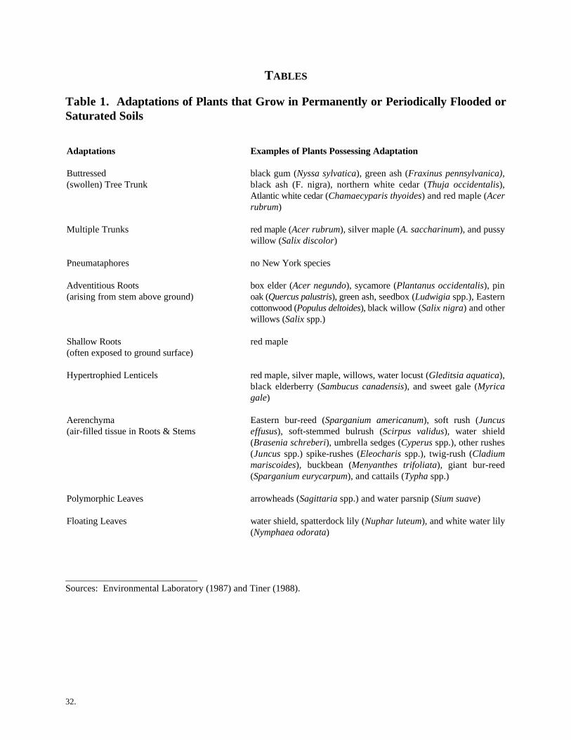
32.
TABLES
Table 1. Adaptations of Plants that Grow in Permanently or Periodically Flooded orSaturated Soils
Adaptations Examples of Plants Possessing Adaptation
Buttressed black gum (Nyssa sylvatica), green ash (Fraxinus pennsylvanica),(swollen) Tree Trunk black ash (F. nigra), northern white cedar (Thuja occidentalis),
Atlantic white cedar (Chamaecyparis thyoides) and red maple (Acerrubrum)
Multiple Trunks red maple (Acer rubrum), silver maple (A. saccharinum), and pussywillow (Salix discolor)
Pneumataphores no New York species
Adventitious Roots box elder (Acer negundo), sycamore (Plantanus occidentalis), pin(arising from stem above ground) oak (Quercus palustris), green ash, seedbox (Ludwigia spp.), Eastern
cottonwood (Populus deltoides), black willow (Salix nigra) and otherwillows (Salix spp.)
Shallow Roots red maple (often exposed to ground surface)
Hypertrophied Lenticels red maple, silver maple, willows, water locust (Gleditsia aquatica),black elderberry (Sambucus canadensis), and sweet gale (Myricagale)
Aerenchyma Eastern bur-reed (Sparganium americanum), soft rush (Juncus(air-filled tissue in Roots & Stems effusus), soft-stemmed bulrush (Scirpus validus), water shield
(Brasenia schreberi), umbrella sedges (Cyperus spp.), other rushes(Juncus spp.) spike-rushes (Eleocharis spp.), twig-rush (Cladiummariscoides), buckbean (Menyanthes trifoliata), giant bur-reed(Sparganium eurycarpum), and cattails (Typha spp.)
Polymorphic Leaves arrowheads (Sagittaria spp.) and water parsnip (Sium suave)
Floating Leaves water shield, spatterdock lily (Nuphar luteum), and white water lily(Nymphaea odorata)
____________________________Sources: Environmental Laboratory (1987) and Tiner (1988).

33.
Table 2. Wetland Delineation Information Sources
Data Name Source
Topographic Maps (mostly 1:24,000; 1:63,350 U.S. Geological Survey (USGS)for Alaska) (Call 1-800-USA-MAPS)
County Soil Survey Reports U.S.D.A. Natural Resources Conservation Service (NRCS)District Offices (Unpublished reports--local district offices)
National Hydric Soils List NRCS National OfficeState Hydric Soils ListCounty Hydric Soil Map Unit List NRCS State Offices
NRCS District Offices
National Insurance Agency Flood Maps Federal Emergency Management Agency
National Wetlands Inventory Maps U.S. Fish and Wildlife Service (FWS)(mostly 1:24,000; 1:63,350 for Alaska (Call 1-800-USA-MAPS)
Local Wetland Maps State and local agencies
Land Use and Land Cover Maps USGS (1-800-USA-MAPS)
Aerial Photographs Various sources--USGS, U.S.D.A. Agricultural Stabilizationand State agencies, and private sources
Satellite Imagery EOSAT Corporation, SPOT Corporation, and others
National List of Plant Species That Occur in Government Printing OfficeWetlands (Stock No. 024-010-00682-0) Superintendent of Documents
Washington, D.C. 20402
Regional Lists of Plants that Occur in Wetlands National Technical Information Service5285 Port Royal Head, Springfield, VA 22161(703) 487-4650
National Wetland Plant Database FWS
Stream Gauge Data COE District Offices and USGS
Soil Drainage Guides NRCS District Offices
Environmental Impact Statements and Assessments Various Federal and State agencies
Published Reports Federal and State agencies, universities, and others
Local Expertise Universities, consultants, and others
Site-specific Plans and Engineering Private developersDesigns

34.
Table 3. Recommended equipment and materials for on-site delineations.
Equipment Materials
Soil auger, probe, or spade Data sheets and clipboard
Sighting compass Field notebook
Pen or pencil Base (topographic) map
Penknife Aerial photographs
Hand lens National Wetlands Inventory map
Vegetation sampling frame* Soil survey or other soil map
Camera/Film Appropriate Federal interagency wetland plants list
Binoculars County hydric soil map unit list
Tape measure Munsell soil color book
Prism or angle gauge Plant identification field guides/manuals
Diameter tape National List of Scientific Plant Names
Vasculum (for plant collection) Flagging tape/wire flags/wooden stakes
Calculator* Plastic bags (for collecting plants and soil samples as needed
* Needed only for more comprehensive methods found in the 1987 Federal Delineation Manual
35.
GLOSSARY
Adaptation - The condition of showing fitness for a particular environment, as applied to characteristics of a structure,function, or entire organism; a modification of a species that makes it more fit for reproduction and/or existence underthe conditions of its environment.
Adventitious roots - Roots found on plant stems in positions where roots normally do not occur.
Aerenchymous tissue (Aerenchyma) - A type of plant tissue in which cells are unusually large, resulting in large airspaces in the plant organ; such tissues are often referred to as spongy and usually provide increased buoyancy.
Aerobic - A condition in which molecular oxygen is a part of the environment.
Anerobic - A condition in which molecular oxygen is absent (or effectively so) from the environment.
Annual - Occurring yearly or, as in annual plants, living for only one year.
Areal cover - A measure of dominance that defines the degree to which above ground portions of plants cover theground surface; it is possible for the total areal cover for all strata combined in a community or for single stratum toexceed 100 percent because: 1) most plant communities consist of two or more vegetative strata; 2) areal cover isestimated by vegetative layer; and 3) foliage within a single layer may overlap.
Basal area - The cross-sectional area of a tree trunk measured in square inches, square centimeters, etc.; basal areais normally measured at 4.5 feet above ground level and is used as a measure of dominance; the most commonly usedtool for measuring basal area is a diameter tape or a D-tape (then convert to basal area).
Bench mark - A fixed, more or less permanent reference point or object of known elevation; the U.S. GeologicalSurvey (USGS) installs brass caps in bridge abutments or otherwise permanently sets bench marks at convenientlocations nationwide; the elevations on these marks are referenced to the National Geodetic Vertical Datum (NGVD),also commonly known as mean sea level (MSL); locations of these bench marks on USGS topographic maps are shownas small triangles; since the marks are sometimes destroyed by construction or vandalism, the existence of any benchmark should be field verified before planning work which relies on a particular reference point; the USGS or local statesurveyors office can provide information on the existence, exact location and exact elevation of bench marks.
Bog - A peatland dominated by ericaceous shrubs (Family Ericaceae), sedges, and peat moss (Sphagnum spp.) andusually having a saturated water regime or a forested peatland dominated by evergreen trees (usually spruces and firs)and/or larch (Larix laricina).
Bryophytes - A major taxonomic group of nonvascular plants comprised of true liverworts, horned liverworts, andmosses.
Buried Soil - Soil covered by an alluvial, loessal, or other deposit (including human-made), usually to a depth greaterthan the thickness of the solum.
Buttressed - The swollen or enlarged bases of trees developed in response to conditions of prolonged inundation.
Capillary fringe - A zone immediately above the water table in which water is drawn upward from the water table bycapillary action.
Chemical reduction - Any process by which one compound or ion acts as an electron donor; in such cases, the valencestate of the electron donor is decreased.
Chroma - The relative purity or saturation of a color; intensity of distinctive hue as related to grayness; one of the threevariables of color.
36.
Comprehensive Method- A more rigorous field delineation methodology needed for complex, controversial sites wherecomplete documentation of the delineation procedure is required. The 1987 "Federal Manual for Identifying andDelineating Jurisdictional Wetlands" provides the wetland delineator with these methods which include the"Intermediate-level Onsite Determination Method" and the "Comprehensive Onsite Determination Method."
Concretion - A localized concentration of chemical compounds (e.g., calcium carbonate and iron oxide) in the formof a grain or nodule of varying size, shape, hardness, and color; concretions of significance in hydric soils are usuallyiron oxides and manganese oxides occurring at or near the soil surface, which have developed under conditions offluctuating water tables.
Contour - An imaginary line of constant elevation on the ground surface; the corresponding line on a map is calleda "contour line."
Criteria - Technical requirements upon which a judgment or decision may be based.
Deepwater habitat - Any open water area in which the mean water depth exceeds 6.6 feet at mean low water infreshwater areas, or the maximum depth of emerging vegetation, whichever is greater.
Density - The number of individuals per unit area.
Detritus - Fragments of plant parts found on the soil surface or in water; when fused together by algae or soil particles,this detritus is an indicator that the soil surface was recently inundated.
Diameter at breast height (dbh) - The width of a plant stem (e.g. tree trunk) as measured at 4.5 feet above the groundsurface.
Dike - An embankment (usually of earth) constructed to keep water in or out of a given area.
Disturbed area - An area where vegetation, soil, and/or hydrology have been significantly altered, thereby making awetland determination difficult.
Disturbed condition - As used herein, this term refers to areas in which indicators of one or more characteristics(vegetation, soil, and/or hydrology) have been sufficiently altered by man's activities or natural events so as to make itmore difficult to recognize whether or not the wetland identification criteria are met.
Dominance - As used in this manual, dominance is based strictly upon the abundance of a species that can be visuallyestimated or measured in the field. Dominant species are considered to be those with 20 percent or more areal coveragein the plant community.
Dominance measure - The means or method by which dominance is established, including areal coverage and basalarea; the total dominance measure is the sum total of the dominance measure values for all species comprising a givenstratum.
Drained, effectively - A condition where ground or surface water has been removed by artificial means to the point thatan area no longer meets the wetland hydrology criterion.
Drift line - An accumulation of water-carried debris along a contour or at the base of vegetation that provides directevidence of prior inundation and often indicates the directional flow of flood waters.
Duff - The matted, partly decomposed, organic surface layer of forested soils.
Duration (of inundation/soil saturation) - The length of time that water stands above the soil surface (inundation) orthat water fills most soil pores near the soil surface (saturation); as used herein, "duration" refers to a period during thegrowing season.
37.
Entisols - Soils of slight or recent development; common along rivers and floodplains.
Evergreen (plant) - Retaining its leaves at the end of the growing season and usually remaining green through thewinter.
Facultative species - Species that can occur both in wetlands and uplands; there are three subcategories of facultativespecies: (1) facultative wetland plants (FACW) that usually occur in wetlands (estimated probability 67-99 percent),but occasionally are found in nonwetlands, (2) facultative plants (FAC) that are equally likely to occur in wetlands ornonwetlands (estimated probability 34-66 percent), and (3) facultative upland plants (FACU) that usually occur innonwetlands (estimated probability 67-99 percent), but occasionally are found in wetlands (estimated probability 1-33percent).
Fern allies - A group of nonflowering vascular plants comprised of clubmosses (Family Lycopodiaceae), smallclubmosses (Family Selaginellaceae), and quillwrorts (Family Isoetaceae).
Fibrists - Organic soils (peats) in which plant remains show very little decomposition and retain their original shape;more than two-thirds of the fibers remain after rubbing the materials between the fingers.
Flooded - A condition in which the soil surface is temporarily covered with flowing water from any source, such asstreams overflowing their banks, runoff from adjacent or surrounding slopes, inflow from high tides, or any combinationof sources.
Flooding, frequent - Flooding is likely to occur often during usual weather conditions (i.e., more than a 50 percentchance of flooding in any year, or more than 50 times in 100 years).
Flora - A list or manual of all plant species that may occur in an area.
Forbs - Broad-leaved herbs in contrast to bryophytes, ferns, fern allies, and graminoids.
Frequency (of inundation or soil saturation) - The periodicity of coverage of an area by surface water or saturationof the soil; it is usually expressed as the number of years the soil is inundated or saturated during part of the growingseason of the prevalent vegetation (e.g., 50 years per 100 years) or as a 1-, 2-, 5-year, etc., inundation frequency.
Gleization - A process in saturated or nearly saturated soils which involves the reduction of iron, its segregation intomottles and concretions, or its removal by leaching from the gleyed horizon.
Gleyed - A soil condition resulting from gleization which is manifested by the presence of neutral grey, bluish orgreenish colors through the soil matrix or in mottles (spots or streaks) among other colors.
Graminoids - Grasses (Family Gramineae or Poaceae) and grasslike plants such as sedges (Family Cyperaceae) andrushes (Family Juncaceae).
Groundwater - That portion of the water below the surface of the ground whose pressure is greater than atmosphericpressure.
Growing season - The portion of the year when soil temperatures are above biologic zero (41 F) as defined by "Soilo
Taxonomy"; the following growing season months are assumed for each of the soil temperature regimes: (1) thermic(February-October); (2) mesic (March-October); (3) frigid (May-September); (4) cryic (June-August); (5) pergelic (July-August); (6) isohyperthermic (January-December); (7) hyperthermic (February-December), (8) isothermic (January-December) and (9) isomesic (January-December).
Hardpan - A very dense soil layer caused by compaction or cementation of soil particles by organic matter, silica,sesquioxides, or calcium carbonate, for example.
38.
Hemists - Organic soils (mucky peats and peaty mucks) in which plant remains show a fair amount of decomposition;between one-third and two-thirds of the fibers are still visible upon rubbing the material between the fingers.
Herb - Nonwoody (herbaceous) plants including graminoids (grass and grasslike plants), forbs, ferns, fern allies, andnonwoody vines; for the purposes of this manual, seedlings of woody plants that are less than three feet in height arealso considered herbs.
Herb stratum - Any vegetative layer of a plant community that is composed predominantly of herbs.
Histic epipedon - An 8- to 16-inch soil layer at or near the surface that is saturated for 30 consecutive days or moreduring the growing season in most years and contains a minimum of 20 percent organic matter when no clay is presentor a minimum of 30 percent of organic matter when 60 percent or more clay is present; generally a thin horizon of peator muck if the soil has not been plowed.
Histosols - An order in "Soil Taxonomy" (Soil Survey Staff 1975) composed of organic soils (mucks and peats) thathave organic soil materials in more than half of the upper 32 inches or that are of any thickness if overlying rock.
Horizon, soil - A distinct layer of soil, more or less parallel with the soil surface, having similar properties such ascolor, texture, and permeability; the soil profile is subdivided into the following major horizons: A-horizon,characterized by an accumulation of organic material; B-horizon, characterized by relative accumulation of clay, iron,organic matter, or aluminum; and the C-horizon, the undisturbed and unaltered parent material. (Note: Some soilshave an E-horizon, characterized by leaching of organic and other material.)
Hue - A characteristic of color related to one of the main spectral colors (red, yellow, green, blue, or purple), or variouscombinations of these principle colors; one of the three variables of color; each color chart in the Munsell Soil ColorCharts (Kollmorgen Corporation 1975) represents a specific hue.
Human-induced wetland- Any wetland area that has been purposely or accidentally created by some activity ofhumans.
Hydric soil - A soil that is saturated, flooded, or ponded long enough during the growing season to develop anaerobicconditions in the upper part.
Hydrology - The science dealing with the properties, distribution, and circulation of water.
Hydrophyte - Any macrophyte that grows in water or on a substrate that is at least periodically deficient in oxygen asa result of excessive water content; plants typically found in wetlands and other aquatic habitats.
Hydrophytic vegetation - Plant life growing in water or on a substrate that is at least periodically deficient in oxygenas a result of excessive water content.
Hypertrophied lenticels - An exaggerated (oversized) pore on the stem of woody plants through which gases areexchanged between the plant and the atmosphere; serving to increase oxygen to plant roots during periods of inundationor soil saturation.
Indicator - An event, entity, or condition that typically characterizes a prescribed environment or situation; indicatorsdetermine or aid in determining whether or not certain stated circumstances exist or criteria are satisfied.
Inundation - A condition in which water temporarily or permanently covers a land surface.
Levee - A natural or human-made feature of the landscape that restricts movement of water into or through an area.
Litter - The undecomposed plant and animal material found above the duff layer on the forest floor.
39.
Long duration (flooding) - A duration class in which inundation for a single event ranges from 14 days to 1 month.
Macrophyte - Any plant species that can be readily observed without the aid of optical magnification, including allvascular plant species and bryophytes (e.g., Sphagnum spp.), as well as large algae (e.g., Chara spp., and Fucus spp.).
Map unit - A portion of a map that depicts an area having some common characteristic.
Matrix, soil - The natural soil material composed of both mineral and organic matter; matrix color refers to thepredominant color of the soil in a particular horizon. The portion of a given soil having the dominant color, in mostcases, the matrix will be the portion of the soil having more than 50 percent of the same color.
Mineral soil - Any soil consisting primarily of mineral (sand, silt, and clay) material, rather than organic matter.
Morphological adaptation - A structural feature that aids in fitting a species to its particular environment (e.g.,buttressed bases, adventitious roots, and hypertrophied lenticels).
Morphological features - Properties related to the external structure of soil (such as color and texture) or plants.
Moss-lichen wetland - A wetland dominated by mosses (mainly peat mosses) and lichens with little or no tallervegetative species.
Mottles - Spots or blotches of different color or shades of color interspersed within the dominant matrix color in a soillayer; distinct mottles are readily seen and easily distinguished from the color of the matrix; prominent mottles areobvious and mottling is one of the outstanding features of the horizon.
Nonhydric soil - A soil that has developed under predominantly aerobic soil conditions.
Nonpersistent vegetation - Plants that break down readily after the growing season; no evidence of previous year'sgrowth at beginning of next growing season.
Nonwetland - Any area that has sufficiently dry conditions that hydrophytic vegetation, hydric soils, and/or wetlandhydrology are lacking; it includes upland as well as former wetlands that are effectively drained.
Normal environmental conditions or circumstances - Refers to conditions that are normally present, without theinfluence of human disturbance or intervention, or catastrophic natural events.
Obligate wetland species - A plant species that is nearly always found in wetlands; its frequency of occurrence inwetlands is 99 percent or more.
Offsite determination method - A technique for delineating a wetland boundary in the office with the help of site-specific information.
Onsite determination method - A technique for delineating a wetland boundary using evidence gathered in the field.
Organic soil - See Histosols.
Overbank flooding - Any situation in which inundation occurs as a result of the water level of a river or stream risingabove bank level.
Oxidation-reduction process - A complex of biochemical reactions in soil that influences the valence state of elementsand their ions found in the soil; long periods of soil saturation during the growing season tend to elicit anaerobicconditions that shift the overall process to a reducing condition.
40.
Oxidized rhizospheres - Oxidized zones of iron (rust colored) and manganese (black colored) surrounding living rootsand rhizomes of hydrophytic plants.
Parent material - The unconsolidated and more or less weathered mineral or organic matter from which the soil profileis developed.
Pedogenic - Related to soil-building processes occurring within the soil.
Perennial (plant) - Living for many years.
Periodically - Used herein, to define detectable regular or irregular saturated soil conditions or inundation, resultingfrom ponding of groundwater, precipitation, overland flow, or stream flooding that occur(s) with hours, days, weeks,months, or even years between events.
Permanently flooded - A water regime condition where standing water covers the land surface throughout the year (butmay be absent during extreme droughts).
Permeability - The quality of the soil that enables water to move downward through the profile, measured as thenumber of inches per hour that water moves downward through the saturated soil.
Physiological adaption - A peculiarity of the basic physical and chemical activities that occur in cells and tissues ofa species, which results in it being better fitted to its environment (e.g. ability to absorb nutrients under low oxygentensions).
Plant community - The plant populations existing in a shared habitat or environment.
Pneumatophore - Modified roots (called "knees") rising above ground that may function as a respiratory organ inspecies subjected to frequent inundation or soil saturation.
Podzolization - The process by which sesquioxides (aluminum and iron) are leached from the A-horizon andprecipitated in the B-horizon, often resulting in a leached layer, the E-horizon.
Polymorphic (leaves)- Two or more different types of leaves formed on plants; in wetland plants, polymorphic leavesmay develop due to extended flooding.
Ponded - A condition in which free water covers the soil surface, for example, in a closed depression; the water isremoved only by percolation, evaporation, or transpiration.
Poorly drained - A condition in which water is removed from the soil so slowly that the soil is saturated periodicallyduring the growing season or remains wet for long periods greater than seven days.
Problem area wetland - A wetland that is difficult to identify because indicators of wetland plants, hydrology and/orhydric soils are lacking or obscurred as a result of normal environmental conditions.
Profile - Vertical section of the soil through all its horizons and extending into the parent material.
Range - The set of conditions throughout which an organism (e.g., plant species) naturally occurs.
Reduction - The process of changing an element from a higher to a lower oxidation state as in the reduction of ferric(Fe3+) iron into ferrous iron (Fe2+).
Relative basal area - An estimate of basal area for trees, such as produced by the Bitterlich sampling technique.
Rhizosphere - The zone of soil in which interactions between living plant roots and microorganisms occur.
41.
Sapling - Woody vegetation between 0.4 and 5.0 inches in diameter at breast height and between 3 and 20 feet inheight, exclusive of woody vines.
Saprists - Organic soils (mucks) in which most of the plant material is decomposed and the original constituents cannotbe recognized; less than one-third of the fibers remain visible upon rubbing the material between the fingers.
Saturated - A condition in which all easily drained voids (pores) between soil particles are temporarily or permanentlyfilled with water, significant saturation during the growing season is considered to be usually one week or more.
Seedling - A young tree that is generally less than three feet high.
Shrub - Woody vegetation usually greater than 3 feet but less than 20 feet tall, including multi-stemmed, bushy shrubsand small trees and saplings. (Note: Woody seedlings less than three feet tall are considered part of the herbaceouslayer.)
Soil - Unconsolidated material on the earth's surface that supports or is capable of supporting plants.
Soil horizon - See "Horizon, soil".
Soil matrix - See "Matrix, soil".
Soil permeability - The ease with which gases, liquids, or plant roots penetrate or pass through a layer of soil.
Soil pore - An area within soil occupied by either air or water, resulting from the arrangement of individual soilparticles or peds.
Soil profile - A vertical section of the soil through all its horizons and extending into the parent material.
Soil series - A group of soils having horizons similar in differentiating characteristics and arrangements in the soilprofile, except for texture of the surface layer.
Soil structure - The combination of arrangement of primary soil particles into secondary particles, units, or peds.
Soil surface - The upper limits of the soil profile; for mineral soils, the upper limits of the highest mineral horizon (A-horizon); for organic soils, the upper limit of undecomposed organic matter.
Soil texture - The relative proportions of the various sizes of particles (silt, sand and clay) in a soil.
Somewhat poorly drained - A condition in which water is removed slowly enough that the soil is wet forsignificant periods during the growing season.
Spodic horizon - A subsurface layer of soil characterized by the accumulation of aluminum oxides (with or withoutiron oxides) and organic matter; a diagnostic horizon for Spodosols.
Stratigraphy - A term referring to the origin, composition, distribution, and succession of geologic strata (layers).
Strata or stratum, vegetative - A layer of vegetation used to determine dominant species in a plant community.
Suborder (soils) - Second highest taxonomic level of the current U.S. soil classification system.
Substrate - nonsoil.
Surface water - Water present above the substrate or soil surface.
42.
Temperate region - The geographic area having a climate that is neither very hot nor very cold.
Topography - The configuration of a surface, including its relief and the position of its natural and man-madefeatures.
Transpiration - The process in plants by which water is released into the gaseous environment (atmosphere),primarily through stomata.
Tree - A woody plant 5 inches or greater in diameter at breast height and 20 feet or taller.
Typical - That which normally, usually, or commonly occurs.
Unconsolidated parent material - Material from which a soil develops.
Upland - Any area that does not qualify as a wetland because the associated hydrologic regime is not sufficientlywet to elicit development of vegetation, soils, and/or hydrologic characteristics associated with wetlands. Suchareas occurring in floodplains are more appropiately termed nonwetlands.
Value (soil color) - The relative lightness or intensity of color, approximately a function of the square root of thetotal amount of light, one of the three variables of color.
Vascular (plant) - Possessing a well-developed system of conducting tissue to transport water, mineral salts, andfoods within the plant.
Vegetation - The sum total of macrophytes that occupy a given area.
Very long duration (flooding) - A duration class in which inundation for a single event is greater than one month.
Very poorly drained - A condition in which water is removed from the soil so slowly that free water remains at oron the surface during most of the growing season.
Water mark - A line on vegetation or other upright structures that represents the maximum height reached in aninundation event.
Water table - The zone of saturation at the highest average depth during the wettest season; it is at least six inchesthick and persists in the soil for more than a few weeks.
Wetlands - As used herein, areas that under normal circumstances have hydrophytic vegetation, hydric soils, andwetland hydrology.
Wetland boundary delineation- The process by which a wetland's uppermost (upland) edge is identified.
Wetland hydrology - In general terms, permanent or periodic inundation or prolonged soil saturation sufficient tocreate anaerobic conditions in the soil.
Wetland indicator status - The exclusiveness with which a plant species occurs in wetlands; the different indicatorcategories (i.e., facultative species, and obligate wetland species) are defined elsewhere in this glossary.
Wooded swamp - A wetland dominated by trees; a forested wetland.
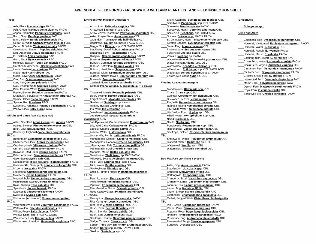
APPENDIX A: FIELD FORMS - FRESHWATER WETLAND PLANT LIST AND FIELD INSPECTION SHEET
Trees Emergent/Wet Meadow/Understory ____Skunk Cabbage Symplocarpus foetidus OBL Bryophytes
____Ash, Black Fraxinus nigra FACW ____Arrow Arum Peltandra virginica OBL ____Spearmint Mentha spicata FACW ____Sphagnum spp.____Ash, Green Fraxinus pennsylvanica FACW ____Arrowhead Sagittaria spp. OBL ____Speedwell, Marsh Veronica americana OBL____Aspen, Trembling Populus tremuloides FACU ____Arrow-leaved Tearthumb Polygonum sagittatum OBL ____Spikerush Eleocharis spp. OBL/FACW+ Ferns and Allies____Birch, Gray Betula populifolia FAC ____Aster, Purple Stem Aster puniceus OBL ____Spiraea Spiraea spp. FAC & FACW____Birch, Yellow Betula allechaniensis FAC ____Groundsel-Tree Baccharis halimifolia FAC ____St. Johnswort, Marsh Triadenum virginicum OBL____Cedar, A. White Chamaecyparis thyoides OBL ____Bedstraws Galium sp. mostle FACW & OBL ____Swamp Candles Lysimachia terrestris OBL____Cedar, N. White Thuja occidentalis FACW ____Beggar Tick Bidens spp. OBL/FAC/FACW ____Sweet Flag Acorus calamus OBL____Cottonwood, Eastern Populus deltoides FAC ____Blackberry, Dwarf Rubus pubescens FACW ____Three-square Scirpus americanus OBL____Elm, American Ulmus americana FACW ____Bluegrass, Fowl Poa palustris FACW ____Turtlehead Chelone glabra OBL____Fir, Balsam Abies balsamea FAC ____Bluejoint Calamagrostis canadensis FACW ____Vervain Verbena sp. FACW____Gum, Black Nyssa sylvatica FAC ____Boneset Eupatorium perfoliatum FACW ____Water-horehound (Bugleweed) Lycopus spp. OBL____Hemlock, Eastern Tsuga canadensis FACU ____Bulrush, Common Scirpus atrovirens OBL ____Water Plantain Alisma spp. OBL____Hornbeam, American Carpinus caroliniana FAC ____Bulrush, Soft Stem Scirpus validus OBL ____Waterwillow Decodon verticillatus OBL____Larch, Eastern Larix laricina FACW ____Bulrush, Hard Stem Scirpus acutus OBL ____Willow Herb Epilobium spp. OBL/FAC/FACW____Maple, Red Acer rubrum FAC ____Burreed, Giant Sparganium eurycarpum OBL ____Woolgrass Scirpus cyperinus spp. FACW____Maple, Silver Acer saccharinum FACW ____Burreed, Narrow-leaved Sparganium emersum OBL ____Yellow-eyed Grass Xyris sp. OBL____Oak, Burr Quercus macrocarpa FAC ____Burreeds Sparganium spp. OBL____Oak, Pin Quercus palustris FACW ____Cardinal Flower Lobelia cardinalis FACW Floating Leaved/Submergent____Oak, Swamp White Quercus bicolor FACW ____Cattails Typha latifolia, T. angustifolia, T.x glauca____Pine, Eastern White Pinus strobus FACU OBL ____Bladderworts Utricularia spp. OBL____Poplar, Balsam Populus balsamifera FACW ____Cinquefoil, Marsh Potentilla palustris OBL ____Chara Chara spp. OBL*____Shadbush, Serviceberry Amelanchier arborea FAC ____Dock, Swamp Rumex verticillatus OBL ____Coontail Ceratophyllum demersum OBL____Spruce, Black Picea mariana FACW ____Forget-me-not Myosotis scorpioides OBL ____Duckweed, Lesser Lemna minor OBL____Spruce, Red P. rubens FACU ____Goldenrod Solidago spp. various ____Frog's-Bit Hydrocharis morus-ranae OBL____Sycamore, American Platanus occidentalis FACW ____Hedgey-Hyssop Gratiola sp. OBL ____Hearts, Floating Nymphoides cordata OBL____Willow, Black Salix nigra FACW ____Iris, Wild Iris versicolor OBL ____Lily, White Water Nymphaea odorata OBL
Shrubs and Vines (see also Bog Mat) ____Joe-Pye-Weed, Spotted Eupatorium ____Milfoil, Water Myriophyllum spp. OBL
____Alder, Speckled Alnus incana ssp. rugosa FACW ____Joe-Pye-Weed, Green-stemmed E. purpureum FAC ____Nitella Nitella spp. OBL*____Azalea, Swamp Rhododendron viscosum OBL ____Lily, Wild Calla Calla palustris FACW ____Pondweeds Potomogeton spp. OBL____Birch, Low Betula pumila OBL ____Lobelia, Ontario Lobelia kalmii OBL ____Ribbongrass Vallisneria americana OBL____Blueberry, Highbush Vaccinium corymbosum ____Lobelia, Water L. dortmanna OBL ____Saxifrage, Golden Chrysosplenium americanumFACW ____Loosestrife, Purple Lythrum salicaria FACW OBL____Buttonbush Cephalanthus occidentalis OBL ____Mannagrass, Slender Glyceria melicaria OBL ____Smartweed, Water Polygonum amphibium OBL____Chokeberry, Black Aronia melanocarpa FAC ____Mannagrass, Canada Glyceria canadensis OBL ____Starwort, Water Callitriche sp. OBL____Cranberry-bush Viburnum trilobum FACW ____Mannagrass, Pale Torreyochloa pallida OBL ____Watermeal Wolffia spp. OBL____Currant, Black Ribes americanum FACW ____Mannagrass, Fowl Glyceria striata OBL ____Watershield Brasenia schreberi OBL____Dogwood, Red Osier Cornus sericea FACW ____Marigold, Marsh Caltha palustris OBL____Elder, American Sambucus canadensis FACW ____Meadowrue Thalictrum sp. FAC/FACW____Gale, Sweet Myrica gale OBL ____Milkweed, Swamp Asclepias incarnata OBL Bog Mat (Use only if mat is present)____Gooseberries Ribes lacustre, R.glandulosum FACW ____Millet, Wild Echinochloa spp. FACW____Honeysuckle, Swamp Fly Lonicera oblongifolia OBL ____Mint, Water Mentha aquatica OBL ____Aster, Bog Aster nemoralis FACW____Inkberry Ilex glabra FACW ____Monkeyflower Mimulus spp. OBL ____Bladderwort Utricularia spp. OBL____Leatherleaf Chamaedaphne calyculata OBL ____Orchid, Purple Fringed Platanthera psychodes ____Bogbean Menyanthes trifolia OBL____Maleberry Lyonia ligustrina FACW FACW ____Cottongrass Eriophorum spp. OBL____Mountainholly Nemopanthus mucronatus OBL ____Parsnip, Water Sium sauve OBL ____Cranberry, Small Vaccinium oxycoccos OBL____Pepperbush, Sweet Clethra alnifolia FAC ____Pickerelweed Pontederia cordata OBL ____Cranberry, Large Vaccinium macrocarpon OBL____Rose, Swamp Rosa palustris OBL ____Pipewort Eriocaulon septangulare OBL ____Labrador Tea Ledum groenlandicum OBL____Spicebush Lindera benzoin FACW ____Reed-Meadow Grass Glyceria grandis OBL ____Laurel, Bog Kalmia polifolia OBL____Sweetbells Leucothoe racemosa FACW ____Reed Canary Grass Pharlaris arundinacea ____Laurel, Sheep Kalmia angustifolia FAC____Sweetgale Myrica gale OBL FACW/OBL ____Leatherleaf Chamaedaphne calyculata OBL____Viburnum, (Arrowwood) Viburnum recognitum ____Reedgrass Phragmites australis FACW ____Orchid, Fringed White Platanthera blephariglottisFACW ____Rice Cut-grass Leersia oryzoides OBL OBL____Viburnum, (Wildraisin) Viburnum cassinoides FACW ____Rice, Wild Zizania aquatica spp. OBL ____Pink, Grass Calopogon tuberosus FACW____Water-willow Decodon verticillatus OBL ____Rush, River Scirpus fluviatilis OBL ____Pitcher Plant Sarracenia purpurea OBL____Willow, Pussy Salix discolor FACW ____Rush, Slender Juncus debilis OBL ____Pogonia, Rose Pogonia ophioglossoides OBL____Willows Salix spp. FAC/FACW/OBL ____Rush, Soft Juncus effusus FACW ____Rhodora Rhododendron canadense FACW____Winterberry, Holly Ilex verticillata FACW ____Saxifrage, Swamp Saxifraga pennsylvanica OBL ____Rosemary, Bog Andromeda glaucophylla OBL____Witch-hazel, American Hamamelis virginiana FAC ____Sedge, Tussock Carex stricta OBL ____Few-seeded Sedge Carex oligosperma OBL
____Jewelweed Impatiens capensis FACW ____Lily, Yellow Pond Nuphar spp. OBL
maculatumFACW ____Naiad Najas spp. OBL
____Sedge, Three-way Dulichium arundinaceum OBL ____Sundews Drosera spp. OBL____Sedges Carex spp. mostly FACW & OBL____Skullcap Scutellaria spp. OBL
____Smartweed Polygonum spp. OBL/FACW
____Clubmoss, Bog Lycopodium inundatum OBL____Horsetail, Variegated Equisetum variegatum FACW____Horsetail, Water E. fluviatile OBL____Horsetail, Rough E. hyemale FACW____Horsetail, Marsh E. palustre FACW____Scouring-rush, Dwarf E. scirpoides FAC____Chain Fern, Netted Lorinseria areolata FACW____Chain Fern, Virginia Anchistea virginica OBL____Cinnamon Fern Osmunda cinnamomea FACW____Clinton's Fern Dryopteris clintoniana FACW____Crested Shield Fern D. cristata FACW____Interrupted Fern Osmunda claytoniana FAC____Marsh Fern Thelypteris palustris FACW____Ostrich Fern Matteuccia struthiopteris FACW____Royal Fern Osmunda regalis OBL____Sensitive Fern Onoclea sensibilis FACW

44.
45.
APPENDIX B
SELECTED WETLAND REFERENCES
I. WETLAND FIELD GUIDES
Burkhalter, A.P., L.M. Curtis, R.L. Lazor, M.L. Beach, and J.C. Hudson. 1973. Aquatic Weed Identification andControl Manual. Bureau of Aquatic Plant Research and Control, Florida Department of Natural Resources,Tallahassee, FL. 100 pp.
Fairbrothers, D.E., E.T. Moul, A.R. Essbach, D.N. Riemer, D.A. Schallock. 1979. Aquatic Vegetation of NewJersey. Extension Service, College of Agriculture, Rutgers-The State University, New Brunswick, NJ. ExtensionBulletin No. 382. 107 pp.
Hotchkiss, N. 1964. Pondweeds and Pondweedlike Plants of Eastern North America. U.S. Fish and WildlifeService, Washington, DC. Circular 187. 30 pp.
___________. 1965. Bulrushes and Bulrushlike Plants of Eastern North America. USDI, Fish and WildlifeService, Washington, DC. Circular 221. 19 pp.
___________. 1970. Common Marsh Plants of the United States and Canada. U.S. Fish and Wildlife Service,Washington, DC. Resources Publication No. 93.
___________. 1972. Common Marsh, Underwater and Floating-leaved Plants of the United States andCanada. Dover Publications, New York, NY.
Lyon, J.G. 1993. Practical Handbook for Wetland Identification and Delineation. Lewis Publishers, BocaRaton. 157 pp.
Magee, D.W. 1981. Freshwater Wetlands: A Guide to Common Indicator Plants of the Northeast. Universityof Massachusetts Press, Amherst, MA. 245 pp.
Otto, N.E. 1980. Aquatic Pests on Irrigation Systems, Identification Guide. (2nd. ed.) Department of theInterior, Water and Power Resources Service, Denver, CO. 90 pp.
Prescott, G.W. 1969. How to Know the Aquatic Plants. Brown Co., Dubuque, IA. 171 pp.
Schlosser, D.W. 1986. A Field Guide to Valuable Underwater Aquatic Plants of the Great Lakes. MichiganState University, East Lansing, MI. 32pp.
Tiner, R.W. Jr. 1987. A Field Guide to Coastal Wetland Plants of the Northeastern United States. Universityof Massachusetts Press, Amherst, MA. 285 pp.
__________. 1988, Field Guide to Nontidal Wetland Identification. Maryland Department of NaturalResources, Water Resources Administration, Annapolis, MD. and U.S. Fish and U.S. Fish and Wildlife Service,Region 5, Newton Corner, MA. 283 pp. plus 198 color plates.
U.S. Army Corps of Engineers. 1977. Wetland Plants of the Eastern United States. North Atlantic Corps ofEngineers Division, New York, NY. Publ. No. 200-1-1.

46.
_____________________________. 1979. Supplement to Wetland Plants of the Eastern United States. NorthAtlantic Division, New York, NY. NADP-200-1-1, Suppl. 1.
II. WETLAND PLANT TAXONOMIC MANUALS AND CHECKLISTS
Fassett, N.C. 1975. A Manual of Aquatic Plants. University of Wisconsin Press, Madison, WI. 405 pp.
Hotchkiss, N. 1950. Checklist of Marsh and Aquatic Plants of the United States. USDI, Fish and WildlifeService, Washington, DC. Wildlife Leaflet No. 210. 34 pp.
Muenscher, W.D. 1972. Aquatic Plants of the United States. Cornell University Press, Ithaca, NY.
III. OTHER FIELD GUIDES FOR PLANT IDENTIFICATION
Brown, L. 1976. Weeds in Winter. Houghton Mifflin Co., Boston, MA.
Cobb, B. 1963. A Field Guide to the Ferns and Their Related Families of Northeastern and Central NorthAmerica. Houghton Mifflin Co., Boston, MA. 281 pp.
Courtenay, B. and J.H. Zimmerman. 1972. Wildflowers and Weeds. Van Nostrand Reinhold Company, NewYork, NY. 144 pp.
Grimm, W.C. 1957. The Book of Shrubs. Bonanza Books, NY. 522 pp.
Harlow, W.H. 1941. Fruit Key and Twig Key to Trees and Shrubs. Dover Publications, New York, NY.
Harrington, H.D. 1977. How to Identify Grasses and Grasslike Plants. The Swallow Press, Inc., Chicago. IL. 142 pp.
Knoble, E. 1977. Field Guide to the Grasses, Sedges, and Rushes of the United States. (Reprint). DoverPublishing, Inc., NY. 83 pp.
Little, E.L. 1985. The Audubon Society Field Guide to North American Trees: Eastern Region. Alfred A.Knopf, Inc., New York, NY.
Newcomb, L. 1977. Newcomb's Wildflower Guide. Little, Brown and Co., Boston, MA.
Niering, W.A. and W.C. Olmstead. 1979. The Audubon Society Field Guide to North American Wildlowers:Eastern Region. Alfred A. Knopf, Inc., New York, NY.
Petrides, G.A. 1958. A Field Guide to the Trees and Shrubs. Houghton Mifflin Co., Boston, MA.
Peterson, R.T. and M. McKenny. 1968. A Field Guide to Wildflowers of Northeastern and North CentralNorth America. Houghton Mifflin Co., Boston, MA.
Rickett, H.W. 1979. Wild Flowers of the United States. VOLUMES I-VI PLUS INDEX. The New YorkBotanical Garden, McGraw-Hill Book Company, New York, NY. Vol. I-559 pp., Vol. II-688 pp., Vol. III-553 pp.,Vol. IV-801 pp., Vol. V-666 pp., Vol. VI-784 pp., Index-152 pp.
Trelease, W. 1931. Winter Botany. Dover Publications, New York, NY.

47.
IV. OTHER PLANT TAXONOMIC MANUALS, CHECKLISTS, AND ATLASES
Ahmadjian, V. 1979. Flowering Plants of Massachusetts. Univerity of Massachusetts Press, Amherst, MA. 582pp.
Batson, W.T. 1977. Genera of the Eastern Plants: A Guide to the Genera of Native and CommonlyIntroduced Ferns and Seed Plants of Eastern North America. John Wiley and Sons, NY.
Britton, N.L., and H.A. Brown. 1970. An Illustrated Flora of the Northern United States and Canada,Volumes 1, 2, and 3. Dover Publications, Inc., New York, NY. Vol. 1-680 pp., Vol. 2-735 pp., Vol. 3-637 pp.
Gleason, H.A. and A. Cronquist. 1963. Manual of Vascular Plants of Northeastern United States and AdjacentCanada. D. Van Nostrand Co., New York, NY.
Harlow, W.M. 1957. Trees of the Eastern and Central United States and Canada. Dover Publications, Inc.New York, NY. 288 pp.
Hitchcock, A.S. 1971. Manual of the Grasses of the United States. Dover Publications, New York, NY. (TwoVols.).
Little, E.L. 1971. Atlas of United States Trees, Volume, I. Conifers and Important Hardwoods. USDA, ForestService, Washington, DC. Miscellaneous Publ. No. 1146. 9 pp. 200 maps.
_________________. 1979. Checklist of United States Trees (Native and Naturalized). USDA, Forest Service,Washington, DC. Agriculture Handbook No. 541. 375 pp.
Preston, J. 1976, North American Trees. The Iowa State University Press, Ames, IA. 399 pp.
Sargent, C.S. 1965. Trees of North America. Dover Publications, New York, NY. (Two Vols.).
Wiegand, K.M., and A.J. Eames. 1926. The Flora of the Cayuga Lake Basin, New York. Cornell UniversityAgricultural Experiment Station, Cornell University Press, Ithaca, NY. Memoir No. 92. 491 pp.
V. HYDRIC SOILS PUBLICATIONS
Bouma, J. 1983. Hydrology and Soil Genesis of Soils with Aquic Moisture Regimes. In: L.P. Wilding, N.E.Smeck, and G.F. Hall (editors), Pedogenesis and Soil Taxonomy. I. Concepts and Interactions. Elsevier SciencePublishers, B.V. Amsterdam. pp. 253-281.
Diers, R., and J.L. Anderson. 1984. Part I. Development of Soil Mottling. Soil Survey Horizons (Winter): 9-12.
International Rice Research Institute. 1985. Wetland Soils: Characterization, Classification and Utilization. Manila, Philippines.
Mausbach, M.J. 1994. Classification of Wetland Soils for Wetland Identification. Soil Survey Horizons(Spring): 17-25.
Ponnamperuma, F.N. 1972. The Chemistry of Submerged Soils. Advances in Agronomy 24:29-96.
Soil Survey Staff. 1988. Keys to Soil Taxonomy (Fourth Printing). Cornell University, Ithaca, NY. SMSSTechnical Monograph No. 6.

48.
Tiner, R.W. and P.L.M. Veneman. 1987. Hydric Soils of New England. University of Massachusetts CooperativeExtension, Amherst, MA. Bulletin C-183. 27 pp.
VI. OTHER SOILS MANUALS
Black, C.A. 1968. Soil-plant Relationships. John Wiley & Sons, Inc. New York, NY.
Birkehead, P.W. 1984. Soils and Geomorphology. Oxford University Press, New York, NY. 372 pp.
Brady, Nyle C. 1974. The Nature and Properties of Soils. MacMillan Publishing Co., Inc. 639 pp.
Buol, S.W., F.D. Hole, and R.J. McCracken. 1980. Soil Genesis and Classification. The Iowa State UniversityPress, Ames, IA. 406 pp.
Kollmorgen Corporation. 1975. Munsell Soil Color Charts. Macbeth Division of Kollmorgen Corporation,Baltimore, MD.
USDA, Soil Conservation Service. 1983. National Soils Handbook. Department of Agriculture, Washington,DC.
_______________________________. 1984. Soil Survey Manual. Department of Agriculture, Washington, DC.
USDA, Soil Survey Staff. 1972. Soil Series of the United States, Puerto Rico, and the Virgin Islands: TheirTaxonomic Classification. Department of Agriculture, Washington, DC.
VII. PLANT-SOIL STUDY REPORTS
Allen, S.D., F.C. Golet, A.F. Davis, and T.E. Sokoloski. 1989. Soil-vegetation Correlations in Transition Zonesof Rhode Island Red Maple Swamps. U.S. Fish and Wildlife Service, Washington, DC.
VIII. COMMUNITY PROFILE AND ECOLOGICAL CHARACTERIZATIONREPORTS
Damman, A.W. H. and T.W. French. 1987. The Ecology of Peat Bogs in the Glaciatetd Northeastern UnitedStates: A Community Profile. U.S. Fish and Wildlife Service, Washington, DC. Biol. Rpt. 85 (7.16). 100 pp.
Fish and Wildlife Service. 1981. Fish and Wildlife Resources of the Great Lakes Coastal Wetlands Within theUnited States. VOLUMES 1-6 U.S. Fish and Wildlife Service, Washington, DC. Vol. 1-480 pp., Vol. 2-1351 pp.,Vol. 3-530 pp., Vol. 4-834 pp., Vol. 5-1676 pp., Vol. 6-901 pp.
Glaser, P.H. 1987. The Ecology of Patterned Boreal Peatlands of Northern Minnesota: A CommunityProfile. U.S. Fish and Wildlife Service, Washington, DC. Biol. Rpt. 85 (7.14). 98 pp.
Herdendorf, C.E. 1987. The Ecology of Coastal Marshes of Western Lake Erie: A Community Profile. U.S.Fish and Wildlife Service, Washington, DC. Biol. Rpt. 85 (7.9). 240 pp.
_________________., C.N. Raphael, and E. Jawarski. 1986. The Ecology of Lake St. Clair Wetlands: ACommunity Profile. U.S. Fish and Wildlife Service, Washington, DC. Biol. Rpt. 85 (7.7). 187 pp.

49.
Odum, W.E., T.J. Smith III, J.K. Hoover, and C.C. McIvor. 1984. The Ecology of Tidal Freshwater Marshes ofthe United States East Coast: A Community Profile. U.S. Fish and Wildlife Service, Washington, DC. Publ. No.FWS/OBS-83/17. 176 pp.
Wharton, C.H., W.M. Kitchens, E.C. Pendleton, and T.W. Sipe. 1982. The Ecology of Bottom-land HardwoodSwamps of the Southeast: A Community Profile. U.S. Fish and Wildlife Service, Washington, DC. Publ. No.FWS/OBS-81/37.
IX. OTHER WETLAND BOOKS OF INTEREST
Good, R.E., D.F. Whigham, R.L. Simpson (editors). 1978. Freshwater Wetlands. Academic Press, New York,NY.
Hall, L.C. 1968. Bibliography of Freshwater Wetlands Ecology and Management. Department of NaturalResources, Madison, WI. Res. Rpt. No. 33.
Hook, D.D. 1978. Plant Life in Anaerobic Environments. Ann Arbor Science Publishers, Inc., Ann Arbor, MI. 2564 pp.
Kozlowski, T.T. (editor) 1984. Flooding and Plant Growth. Academic Press, Inc., Orlando, FL. 356 pp.
Laderman, A.D. (editor) 1987. Atlantic White Cedar Wetlands. Westview Press, Inc., Boulder, CO.
McCormick, J. 1970. The Pine Barrens: A Preliminary Ecological Inventory. New Jersey State Museum,Trenton, NJ. Research Report No. 2. 100 pp.
Mitsch, W.J. and J.G. Gosselink. 1986. Wetlands. Van Nostrand Reinhold Co., Inc., New York, NY.
Niering, W.A. 1984. Wetlands. Alfred A. Knopf, Inc., New York, NY.
Office of Technology Assessment. 1984. Wetlands: Their Use and Regulation. U.S. Congress, Washington,DC.
Tiner, R.W., Jr. 1984. Wetlands of the United States: Current Status and Recent Trends. U.S. Fish andWildlife Service, Washington, DC.
_____________________. 1985. Wetlands of New Jersey. U.S. Fish and Wildlife Service, Newton Corner, MA. 117 pp.
Wolf, R.B., L.C. Lee, and R.R. Sharitz. 1986. Wetland Creation and Restoration in the United States from1970 to 1985: An Annotated Bibliography. SPECIAL ISSUE. Wetlands 6(1):1-87.
50.
APPENDIX C
NATIONAL LIST OF PLANT SPECIES THAT OCCUR IN WETLANDS:1988 NEW YORK
For a copy of this document, please contact:US Fish and Wildlife ServiceSuite 101, Monroe Building9720 Executive Center Drive
St. Petersburg, FL 33702
OR
US Government Printing OfficeWashington, DC 20402
APPENDIX D
NEW YORK HYDRIC SOILS AND SOILS WITH POTENTIAL HYDRICINCLUSIONS
MARCH 22, 1989 (revised)
For a copy of this document, please contact:Natural Resouces Conservation Service
James M. Hanley Federal Building100 S. Clinton Street, Room 771
Syracuse, NY 13260

51.
APPENDIX E
A soil profile (Figure 1) consists of various soil layers described from the surface downward. Most soils havetwo or more identifiable horizons. A soil horizon is a layer oriented approximately parallel to the soil surface, andusually is differentiated from contiguous horizons by characteristics that can be seen or measured in the field (e.g.,color, structure, texture, etc.). Most mineral soils have A-, B-, and C-horizons, and many have surficial organiclayers (O-horizon).

52.

53.
APPENDIX FFIELD KEY TO NEW YORK STATE WETLAND DELINEATION
(see Manual for more detailed explanation)
Vegetation Field Indicators of Wetland(adapted from Tiner 1993)
Having established the dominant species for each stratum, hydrophytic vegetation is considered present if anyof the following are present:
(1) FACW or wetter species comprise more than 50 percent of the dominant species of the plant communityand no FACU or UPL species are dominant, or;
(2) OBL perennial species collectively represent at least 10 percent areal cover in the plant community andare evenly distributed throughout the community and not restricted to depressional microsites, or;
(3) One or more dominant plant species in the community has one or more of the following morphologicaladaptations: hypertrophied lenticels, buttressed stems or trunks, multiple trunks, adventitious roots,shallow root systems, or other locally applicable adaptation, or;
(4) The presence of unbroken expanses of peat mosses (Sphagnum spp.) and other regionally applicablespecies of bryophytes over persistently saturated soil.
The presence of any of the above-listed hydrophytic vegetation characteristics typically indicates a wetland. Thus, an area that exhibits any of these indicators can be considered a wetland without detailed examination ofhydrology and/or soils, provided significant unusual hydrologic modifications are not evident.
In some areas, particularly in transition zones dominated by FAC species, the wetland boundary may beparticularly difficult to delineate using vegetation alone.
If none of the above vegetation indicators of wetland is found, but more than 50 percent of the dominantspecies of all strata are FAC or some combination of FAC and wetter species (including OBL, FACW+,FACW-, FAC+); then investigation and verification of hydrology and/or hydric soils is required tolocate a wetland boundary.
Primary Hydrologic Indicators[taken from "Data Form: Routine Wetland Determination (1987 COE Wetlands Delineation Manual)]
Any one of the following primary hydrologic characteristics (along with hydrophytic vegetation) indicates thepresence of a wetland:
1. Visual observation of inundation. 2. Visual observation of soil saturation.3. Water marks.4. Drift lines.5. Water-borne sediment deposits. 6. Wetland drainage patterns.

54.
Secondary Hydrologic Indicators
Any two or more of the following secondary hydrologic characteristics (along with hydrophytic vegetation)indicates the presence of a wetland.
1. Oxidized zones around living roots and rhizomes (rhizospheres.)2. Water-stained leaves.3. Surface-scoured areas.4. Dead vegetation.
In the absence of any one of the primary hydrologic indicators or any two of the secondary indicators, AND ifmore than 50 percent of the dominant plant species of all strata at the site are any combination of OBL, FACW, orFAC species (including FACW+, FACW-, FAC+), AND there is no indication of recent significant hydrologicmodification, THEN investigation and verification of hydric soils is required to locate a wetland boundary. If thearea has been significantly disturbed hydrologically, refer to the section on disturbed areas (page 23).
Soil Field Indicators of Wetland(adapted from Tiner, 1993)
Several field indicators are available for determining whether a given soil meets the definition of hydric soils. Any one of the following typically indicates that hydric soils are present:
1. Organic soils (all Histosols except Folists) present; or2. Histic epipedon (e.g., organic surface layer 8-16 inches thick) present; or,3. Sulfidic material (H S, odor of "rotten eggs") present within 12 inches of the soil surface; or,2
4. Gleyed, low chroma (ie. chroma 2 or less with mottles or chroma 1 or less with or without mottles)horizon or dominant ped faces present immediately below (within 1 inch) the surface layer and within 18inches of the soil surface; or,
5. Nonsandy soils with a low chroma matrix (chroma of 2 or less) within 18 inches of the soil surface andone of the following present within 12 inches of the surface:(a) iron and manganese concretions or nodules. (b) distinct or prominent oxidized rhizospheres along several living roots; (c) low chroma mottles; or,
6. Sandy soils with one of the following present:(a) thin surface layer (1 inch or greater) of peat or muck where a leaf litter surface mat is present;(b) surface layer of peat or muck of any thickness where a leaf litter surface mat is absent;(c) a surface layer (A-horizon) having a low chroma matrix (chroma of 1 or less and value of 3 or
less) greater than 4 inches thick;(d) vertical organic streaking or blotchiness within 12 inches of the surface;(e) easily recognized (distinct or prominent) high chroma mottles occupy at least 2 percent of the low
chroma subsoil matrix within 12 inches of the surface;(f) organic concretions within 12 inches of the surface;(g) easily recognized (distinct or prominent) oxidized rhizospheres along living roots within 12 inches
of the surface;(h) a cemented layer (orstein) within 18 inches of the soil surface; or,
7. Other regionally applicable, field-verifiable soil properties associated with prolonged seasonal highwater tables.