Embed Size (px)
Citation preview

Final ReportNovember 2006
New York Avenue Corridor StudyFinal Report
November 2006
New LookNew LifeNew York Avenue Corridor

Final ReportNovember 2006
Table of Contents
1. Introduction & Executive Summary
2. Transportation Issues
3. Land Use Issues
4. Urban Design Issues
5. Community Input
6. Recommendations
7. Potential Land Acquisitions
8. Environmental Analysis
9. Proposed Financing Plan
10. Next Steps
Project Team
District of Columbia
• Department of Transportation
• Office of Planning
• Department of Housing andCommunity Development
Consultant Team
• URS Corporation
• HNTB Architects EngineersPlanners
• Cambridge Systematics, Inc.
• Justice and SustainabilityAssociates, LLC
• Parsons Brinckerhoff Quade &Douglas, Inc.
• Economic Research Associates

Final ReportNovember 2006
List of Tables & Figures
Chapter 1Figure 1.1: Major Study Area Roadways Page 1-5Figure 1.2: Detailed Study Area Page 1-6
Chapter 2Figure 2.1: Existing Average Daily Traffic Volumes Page 2-5Figure 2.2: Existing Public Transportation Services Page 2-6Figure 2.3: Traffic Accidents Page 2-7Figure 2.4: Year 2025 Average Daily Traffic Volumes Page 2-8
Chapter 3Figure 3.1: Parks, Trails, and Open Spaces Page 3-4Figure 3.2: Major Neighborhoods and Residential Areas Page 3-5Figure 3.3: Major Commercial Areas Page 3-6Figure 3.4: Major Industrial and Employment Areas Page 3-7Figure 3.5: Mixed Use Areas and Institutions Page 3-8Figure 3.6: Land Use Framework Page 3-9Figure 3.7: Historic and Special Resources Page 3-10Figure 3.8: Current Initiatives Page 3-11
Chapter 4Figure 4.1: Urban Design Opportunities Page 4-4
Chapter 6Figure 6.1: I-395 & New York Avenue Intersection: Comparison of Concepts Page 6-8,6-9Figure 6.2: New York Avenue & Florida Avenue Intersection: Comparison of Concepts in
Conjunction with At-Grade Semi-Circle Concept Page 6-10, 6-11Figure 6.3: Big Ideas Overview Page 6-12Figure 6.4: Zone 6: Framework Plan Page 6-13Figure 6.5: Zone 6: Section Views Page 6-14Figure 6.6: Zone 5: Framework Plan Page 6-15Figure 6.7: Zone 5: Section Views Page 6-16

Final ReportNovember 2006
List of Tables & Figures
Chapter 6Figure 6.8: Zone 4: Framework Plan Page 6-17Figure 6.9: Zone 4: Florida Avenue Interim Improvement Concept – At-Grade Semi-Circle Page 6-18Figure 6.10: Zone 4: Florida Avenue At-Grade Intersection Concept (G-3) Page 6-19Figure 6.11: Zone 4: Florida Avenue Bridge Concept (I-6) Page 6-20Figure 6.12: Zone 4: Florida Avenue Extended Tunnel Concept with Ramps at Florida Avenue Page 6-21Figure 6.13: Zone 4: Florida Avenue Extended Tunnel Concept without Ramps at Florida Avenue Page 6-22Figure 6.14: Zone 4: Florida Avenue Artistic Tunnel Concept Sketch Page 6-23Figure 6.15: Zone 4: Florida Avenue Artistic Bridge Concept Sketch Page 6-24Figure 6.16: Zone 4: Florida Avenue Traditional Bridge Concept Sketch Page 6-25Figure 6.17: Zone 3: Framework Plan Page 6-26Figure 6.18: Zone 3: Section Views Page 6-27Figure 6.19: Zone 3: Linear Park Concept View and Sketch Page 6-28Figure 6.20: Zone 3: Regional Bike Trail Linkage Concept Page 6-29Figure 6.21: Zone 3: Florida Ave. Extended Tunnel Concept with / without Ramps at Florida Ave. Page 6-30Figure 6.22: Zone 2: Framework Plan Page 6-31Figure 6.23: Zone 2: Montana Avenue Concept Sketch Page 6-32Figure 6.24: Zone 2: Bladensburg Road Concept Sketch Page 6-33Figure 6.25: Zone 2: Bladensburg Road Concept Plan Page 6-34Figure 6.26: Zone 1: Framework Plan Page 6-35Figure 6.27: Zone 1: Urban Boulevard Images Page 6-36
Chapter 7Figure 7.1: Land Acquisitions Table Page 7-3
Chapter 9Table 9.1: Project Cost Estimates by Zone Page 9-6,9-7

Final ReportNovember 2006
Introduction & Executive Summary Chapter 1
1.1 Study Purpose
The New York Avenue Corridor, from the District ofColumbia / Prince George’s County line to 7th Street, NW,has been identified in the District’s strategic transportationplan as a potential multimodal and intermodal corridor.Ideally, such a corridor would:
Over the several years that the Study has been underway,the consultant team has worked closely with the DistrictDepartment of Transportation, an OversightCommittee representing other District agencies, and withthe public to document existing conditions in the Corridor,to develop a vision for the Corridor, to develop a number ofproject concepts that could help to make that vision areality, and to refine those project concepts, through aseries of both quantitative and qualitative analyses.
These efforts have resulted in the Final Report, which isdescribed on the following pages.
• Provide multimodal transportation, includingautomobiles, public transit, railroad, bicycles andpedestrians, along with intermodal opportunities
• Facilitate smooth traffic flow• Ensure an ability to accommodate local and regional
vehicular transportation and transit needsforeseeable over the next thirty to fifty years
• Create capacity for major commercial and residentialdevelopment
• Avoid displacement of existing residents or exclusionof income diversity
In July 2002, the Government of the District of Columbiaretained the services of a consultant team to conduct astudy of the New York Avenue Corridor. This consultantteam, consisting of the firms URS, HNTB, CambridgeSystematics, ERA, Justice & Sustainability Associates, andPBQD, was charged with developing an innovative plan forthe Corridor, which meets, to the greatest extent possible,the purpose described above.
Page 1-1
The character and look of New York Avenuevaries as shown at three typical locations: westof North Capitol Street looking west (top),approaching Florida Avenue from the east(middle) and looking east at Montana Avenue(bottom).

Final ReportNovember 2006
Introduction Chapter 1
1.2 The Study Area
The New York Avenue Corridor (the Corridor) is located inthe northeast and northwest quadrants of the District andlinks the downtown area with Prince George’s County,Maryland. Designated as US 50 and Alt US 1, New YorkAvenue is the principal vehicular commuter thoroughfareinto the District from Interstate 95 and the Baltimore-Washington Parkway, as well as US 50.
Figure 1.1: Major Study Area Roadways shows New YorkAvenue beginning at the junction of US 50 and theBaltimore-Washington Parkway and continuing to andbeyond the northern terminus of I-395, paralleling Amtrak’sNortheast Corridor passenger line, a major national andregional rail corridor. Originally designed as one of themajor avenues in Pierre L’Enfant’s plan for the District, NewYork Avenue provides a first impression of Washington formany tourists and visitors.
Apart from its regional function, the Corridor acts as a majorlocal street for several residential neighborhoods. Theavenue also abuts and provides direct access to the largestconcentration of industrially zoned land in the District, andconnects prominent landmarks and institutions such as theNational Arboretum, Gallaudet University, DC Farmer’sMarket, Mt. Vernon Square, and the Convention Center.
The general study area for the project consists of about afive-mile stretch of New York Avenue and is bounded by11th Street NW on the west, the Maryland state line on theeast, Rhode Island Avenue, NE on the north and H Street,NE on the south.
For the purposes of transportation and urban designconsiderations, a primary study area approximately twoblocks in width on either side of the avenue was defined, asshown in Figure 1.2: Detailed Study Area.
Page 1-2
Residential block along 4th Street, NW (top),Bible Way Church (middle), commercial usealong New York Avenue (bottom).

Final ReportNovember 2006
Introduction Chapter 1
1.3 The Study Process
The Final Report was developed through a study processthat began with consideration and documentation ofexisting land use and transportation conditions in theCorridor. A number of studies and plans have beendeveloped over the years for the Corridor and for areasclose to the Corridor; these studies and plans werereviewed as well. Numerous interviews were conductedwith stakeholders, including private citizens, businessoperators, government agencies and major employers, inorder to identify their concerns for the Corridor today andtheir hopes for the Corridor in the future. These effortsprovided the Study Team with a solid basis upon which tobuild in preparing the Final Report.
Then, anticipated land use and transportation conditions inthe Corridor in the year 2025 were considered anddocumented. (These conditions are those which would beexpected to occur “naturally,” such as normal growth intraffic volumes and evolution of land uses in and around theCorridor.) Starting from this baseline, the Study Team wasable to identify both potential problems and potentialopportunities which could be addressed in the Final Report.As the Final Report took shape, potential land acquisitionswere identified and very preliminary environmentalanalyses were performed. Finally, a proposed financingplan, designed to ensure that the Final Report could beimplemented, was prepared.
Throughout the development of the Final Report, publicoutreach has been performed on several different levels, inaddition to the stakeholder interviews mentioned above.
A project website was established at the outset of theproject, and has been in operation since that time. Also,five public meetings have been held. The informationgleaned from the outreach effort has been instrumental inthe development of the Final Report.
Intermediate work products have been prepared throughoutthe course of the Study, documenting the results ofindividual tasks and providing “snapshots” of the evolutionof the Study. These intermediate work products include thefollowing:
• Detailed Project Plan• Rapid Assessment of Opportunities and Constraints• Traffic Analysis• Traffic Analysis Supplement: Alternatives at
New York and Florida Avenues• Traffic Analysis of Extended Tunnel Concepts• Task 5 Summary Memorandum (Project Concepts)• Florida Avenue Bridge: Urban Design Considerations• Land Acquisitions• Environmental Analysis• Proposed Financing Plan
Page 1-3
XM Radio building on Eckington Place (top),Entrance to the National Arboretum (middle),Washington Times Distribution Center (bottom).
Final ReportNovember 2006
Introduction Chapter 1
The information contained in these intermediate workproducts was summarized in the Draft Plan only to theextent necessary to provide appropriate context for theDraft Plan. This Final Report is based upon the Draft Plan,with some modifications made to address comments on theDraft Plan. Each of the intermediate work products, theDraft Plan, and an additional intermediate work productprepared after the completion of the Draft Plan (Task 11Technical Memorandum: Traffic Analysis of the ExtendedTunnel Concept) are available on the project web site; thereader is encouraged to review them for additionalinformation. The project website can be reached at:http://ddot.dc.gov/ddot/cwp/view,a,1247,q,560773.asp
Page 1-4
Final ReportNovember 2006
Introduction Chapter 1
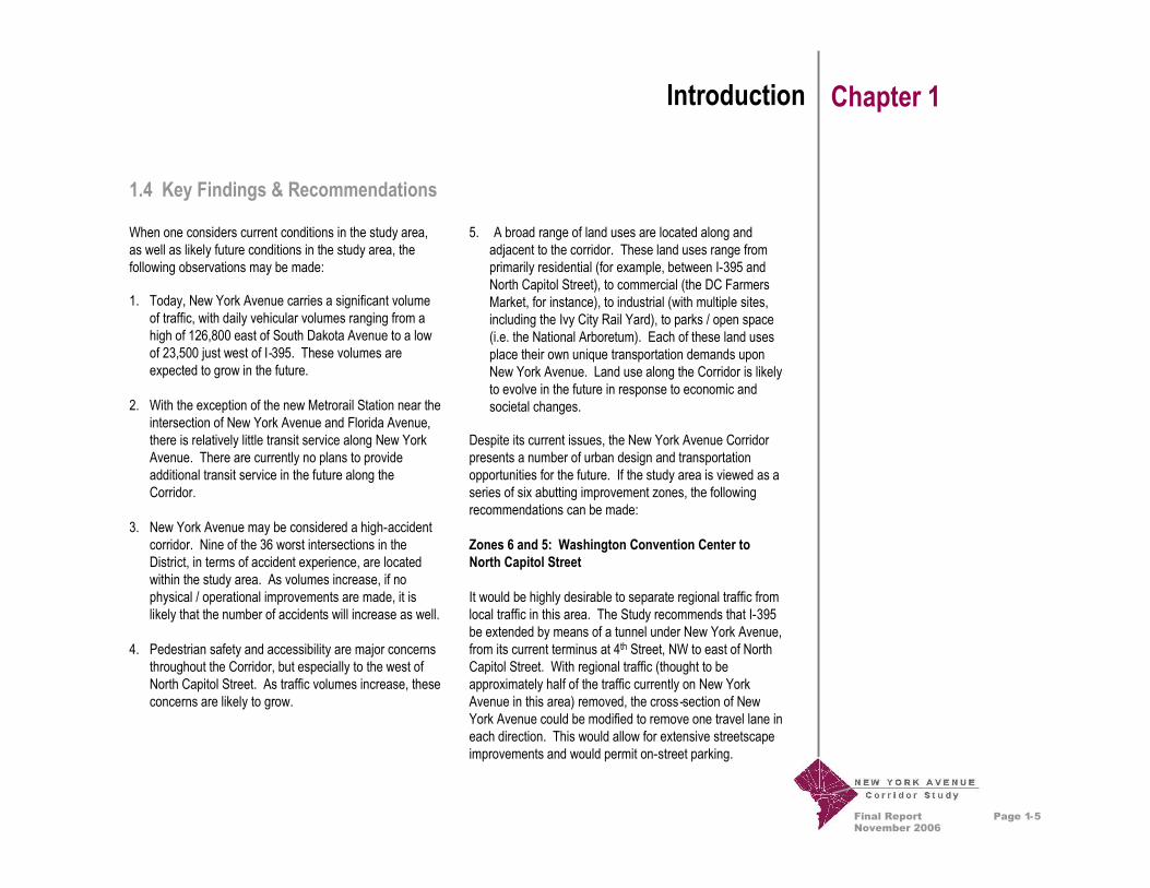
1.4 Key Findings & Recommendations
When one considers current conditions in the study area,as well as likely future conditions in the study area, thefollowing observations may be made:
Page 1-5
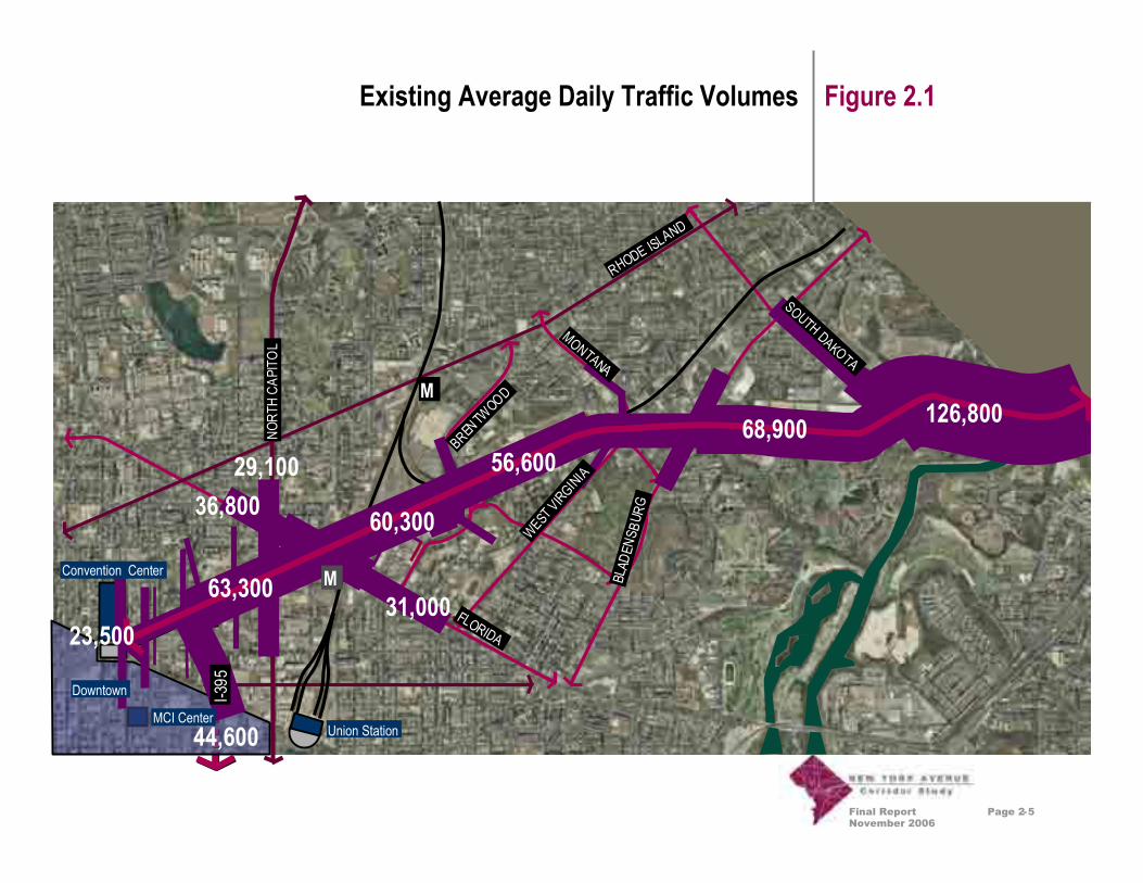
1. Today, New York Avenue carries a significant volumeof traffic, with daily vehicular volumes ranging from ahigh of 126,800 east of South Dakota Avenue to a lowof 23,500 just west of I-395. These volumes areexpected to grow in the future.
2. With the exception of the new Metrorail Station near theintersection of New York Avenue and Florida Avenue,there is relatively little transit service along New YorkAvenue. There are currently no plans to provideadditional transit service in the future along theCorridor.
3. New York Avenue may be considered a high-accidentcorridor. Nine of the 36 worst intersections in theDistrict, in terms of accident experience, are locatedwithin the study area. As volumes increase, if nophysical / operational improvements are made, it islikely that the number of accidents will increase as well.
4. Pedestrian safety and accessibility are major concernsthroughout the Corridor, but especially to the west ofNorth Capitol Street. As traffic volumes increase, theseconcerns are likely to grow.
5. A broad range of land uses are located along andadjacent to the corridor. These land uses range fromprimarily residential (for example, between I-395 andNorth Capitol Street), to commercial (the DC FarmersMarket, for instance), to industrial (with multiple sites,including the Ivy City Rail Yard), to parks / open space(i.e. the National Arboretum). Each of these land usesplace their own unique transportation demands uponNew York Avenue. Land use along the Corridor is likelyto evolve in the future in response to economic andsocietal changes.
Despite its current issues, the New York Avenue Corridorpresents a number of urban design and transportationopportunities for the future. If the study area is viewed as aseries of six abutting improvement zones, the followingrecommendations can be made:
Zones 6 and 5: Washington Convention Center toNorth Capitol Street
It would be highly desirable to separate regional traffic fromlocal traffic in this area. The Study recommends that I-395be extended by means of a tunnel under New York Avenue,from its current terminus at 4th Street, NW to east of NorthCapitol Street. With regional traffic (thought to beapproximately half of the traffic currently on New YorkAvenue in this area) removed, the cross-section of NewYork Avenue could be modified to remove one travel lane ineach direction. This would allow for extensive streetscapeimprovements and would permit on-street parking.

Final ReportNovember 2006
Introduction Chapter 1
Zone 4: North Capitol Street to Florida Avenue
Zone 4, and the intersection of New York Avenue andFlorida Avenue in particular, evoked the most extensivediscussion and debate among the members of the public,the Oversight Committee, and the participants in a designcharrette sponsored by the National Capital PlanningCommission. The Study recommends that the extended I-395 tunnel return to the surface between North CapitolStreet and Florida Avenue, with either an at-gradeintersection or a bridge at Florida Avenue. However, thereremain strong feelings that other options for this locationcould be preferable. These other options are discussed inChapter 6 of this Final Report.
Zone 3: Florida Avenue to Montana Avenue
In this Zone, New York Avenue would transition to aboulevard, with a linear park containing separate bicycleand pedestrian paths on the north side of the roadway.Some of the existing traffic signals would be removed, anda median with separate left turn lanes for westbound trafficwould be constructed. The bikeway would connect to theMetropolitan Branch Trail near Florida Avenue.
Page 1-6
Zone 2: Montana Avenue to Bladensburg Road
At the two intersections comprising the endpoints of thisZone, significant focal points would be created. At MontanaAvenue, urban design improvements would be made; trafficutilization would remain much as it currently is. AtBladensburg Road, New York Avenue would bereconstructed to pass below the existing intersection; theexisting intersection would be reconstructed to provide anappearance more in keeping with traditional grade-separated traffic circles found elsewhere in the District.The bikeway provided in Zone 3 would be extended throughZone 2.
Zone 1: Bladensburg Road to the Anacostia River
The primary intent in this Zone is to create an urbanboulevard and gateway image. Landscape improvementswould be used to soften the highway appearance of theroadway; shoulders would be converted to curbed areasand bikeways, with the bikeways connecting to theAnacostia Trails. Significant new welcome signing wouldalso be provided.

Final ReportNovember 2006
Major Study Area Roadways Figure 1.1
Page 1-5
MCI CenterUnion Station
Convention Center
Downtown
Rhode Island Ave.
South DakotaAve.
Blad
ensb
urg Rd
.
Florida Ave.
WestVirg
inia Ave.
Montana Ave.
Brentwoo
d Rd.
North
Capi
tolS
t.
New York Avenue
H Street
I-3 95
Kenilworth
Ave.
TO VIRGINIA
TO MARYLAND

Final ReportNovember 2006
Detailed Study Area Figure 1.2
Page 1-6
M
M
MCI CenterUnion Station
Convention Center
Downtown

Final ReportNovember 2006
Transportation Issues Chapter 2
2.1 Transportation Issues Today
Following an initial Public Meeting in October 2002 and anexisting conditions analysis, a series of issues and guidingprinciples emerged that defined a framework for exploringtransportation and urban design improvements along theCorridor.
This effort confirmed that the New York Avenue Corridorhas several distinct zones or segments with different landuse and transportation conditions. Accordingly, theadoption of one overall concept or strategy for the entireCorridor would not be appropriate. Rather, a combinationof land use, transportation and urban design changes thatare responsive to the local context must be considered.The following pages graphically illustrate and discuss theseissues and the specific considerations for the distinct zonesalong the Corridor. This chapter of the report addressestransportation issues. Chapter 3 addresses land use andChapter 4 covers urban design considerations.
Traffic: Figure 2.1: Existing Average Daily Traffic Volumesshows the volumes of vehicles per day on New YorkAvenue and major intersecting roadways in 2000. It isimportant to note that traffic volumes are at their highest atthe eastern end of the Corridor, with nearly 127,000vehicles per day, a volume consistent with a major urbanhighway. Traffic volumes drop to less than half that amountbetween Bladensburg Road and I-395 to volumes between57,000 and 69,000 vehicles per day. These volumes areconsistent with a major urban arterial. The next significantdrop occurs west of the I-395 junction, to less than 24,000vehicles per day, a value more consistent with a majorurban street.
Public Transportation: Figure 2.2: Existing PublicTransportation Services illustrates bus and rail transitcoverage, ranging from a high degree of choice andaccessibility in the western half of the study area to moresparse coverage and limited choice in the eastern half. Therelatively new New York Avenue – Florida Avenue –Gallaudet University Metro Station significantly increasestransit accessibility in the Corridor to those areas withinone-quarter and one-half mile walking distance of thestation.
New York Avenue has numerous trafficchallenges including conflicts from left-turningvehicles such as near the intersection ofBladensburg Road (top), inadequate intersectiondesign at I-395 (middle), and heavy volumes inresidential areas such as North Capitol (bottom).
Page 2-1
Final ReportNovember 2006
Transportation Issues Chapter 2
New York Avenue generally lacks qualityfacilities for pedestrians and has problems suchas narrow walkways too close to fast-movingtraffic such as at the Brentwood Parkwayoverpass (top) and no facilities for safelycrossing the roadway east of North Capitol(bottom).
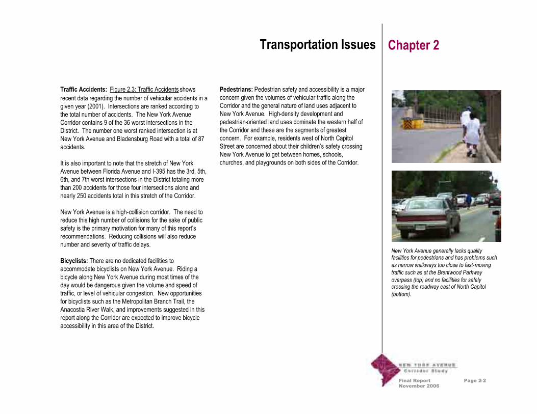
Traffic Accidents: Figure 2.3: Traffic Accidents showsrecent data regarding the number of vehicular accidents in agiven year (2001). Intersections are ranked according tothe total number of accidents. The New York AvenueCorridor contains 9 of the 36 worst intersections in theDistrict. The number one worst ranked intersection is atNew York Avenue and Bladensburg Road with a total of 87accidents.
It is also important to note that the stretch of New YorkAvenue between Florida Avenue and I-395 has the 3rd, 5th,6th, and 7th worst intersections in the District totaling morethan 200 accidents for those four intersections alone andnearly 250 accidents total in this stretch of the Corridor.
New York Avenue is a high-collision corridor. The need toreduce this high number of collisions for the sake of publicsafety is the primary motivation for many of this report’srecommendations. Reducing collisions will also reducenumber and severity of traffic delays.
Bicyclists: There are no dedicated facilities toaccommodate bicyclists on New York Avenue. Riding abicycle along New York Avenue during most times of theday would be dangerous given the volume and speed oftraffic, or level of vehicular congestion. New opportunitiesfor bicyclists such as the Metropolitan Branch Trail, theAnacostia River Walk, and improvements suggested in thisreport along the Corridor are expected to improve bicycleaccessibility in this area of the District.
Page 2-2
Pedestrians: Pedestrian safety and accessibility is a majorconcern given the volumes of vehicular traffic along theCorridor and the general nature of land uses adjacent toNew York Avenue. High-density development andpedestrian-oriented land uses dominate the western half ofthe Corridor and these are the segments of greatestconcern. For example, residents west of North CapitolStreet are concerned about their children’s safety crossingNew York Avenue to get between homes, schools,churches, and playgrounds on both sides of the Corridor.

Final ReportNovember 2006
Transportation Issues Chapter 2
2.2 Future Transportation Issues
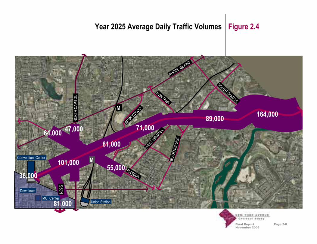
Traffic: Figure 2.4: Year 2025 Average Daily TrafficVolumes shows the same type of information as shown inFigure 2.1: Existing Average Daily Traffic Volumes, exceptthat the volumes shown in Figure 2.4 are those expected inthe study area in the year 2025 (assuming no substantivechanges in the physical characteristics of the roadway).Comparison of the two figures reveals that volumes areexpected to increase substantially along New York Avenue.For example, just west of Bladensburg Road, volumes areexpected to increase by 21 percent (a growth rate of 0.9percent per year). Just east of I-395, volumes are expectedto increase by 50 percent (a growth rate of 1.9 percent peryear). Volume growth on roadways intersecting New YorkAvenue is more variable, but is generally higher thangrowth along New York Avenue itself.
The projected increases in traffic volumes on New YorkAvenue are caused by a number of factors. One of thesefactors is an expected increase in population andemployment along the Corridor; a second is an expectedincrease, at a regional level, in population and employment.Finally, societal changes (including a decrease in theaverage size of households and an increase in number ofregistered motor vehicles per capita) would lead to highertraffic volumes, even if there were no changes in populationand employment.
Safety: While future accident rates cannot be predictedwith any certainty, it is fair to assume that, as volumes andcongestion increase along the New York Avenue Corridor,more accidents will occur. Even if accident rates(measured in accidents per vehicle-mile for roadwaysegments and accidents per entering vehicle forintersections) remain constant, the increase in volumewould likely lead to an increase in total numbers ofaccidents.
Transit: The scope of work for this project emphasizedlooking at New York Avenue as a multi-modal corridor.Although there is Metrobus service that crosses New YorkAvenue and a relatively new Metrorail station on the RedLine at New York and Florida Avenues, NE (see Figure 2.2:Existing Public Transportation Services), there is no transitservice that runs the length of the corridor. Citizens and theproject team inquired about instituting such a service.However, because of the low-density, auto-oriented landuses adjoining New York Avenue east of Florida Avenue,there was not enough foreseeable demand for this serviceto justify its expense. If plans for substantial residentialdevelopment east of the railroad bridge materialize,WMATA will evaluate the feasibility of enhancing transitservice along New York Avenue.
Page 2-3

Final ReportNovember 2006
Transportation Issues Chapter 2
Intermodal Transportation Center: Previous District plansincluded a new intermodal transportation center along NewYork Avenue, but based on further analysis, such a facilityat this location is not appropriate. New York Avenue is tooclose to downtown Washington for a center wherecommuters would transfer from cars to publictransportation. This function is already better accomplishedby the outlying stations on the Metrorail Orange and GreenLines and the MARC commuter rail Camden and Pennlines. Expansion of those stations and improvements tostation access would be more effective than building a newintermodal center along the New York Avenue Corridor.
A different type of intermodal transportation center isneeded in the District for tour buses. A tourist intermodalcenter could provide services for visitors; allow them totransfer between tour buses, Metrorail and the proposeddowntown circulator; and provide off-street tour busparking. An urban location such as New York Avenuewould be appropriate for such a center, but the UnionStation intermodal center already serves this purpose, aswell as being a regional and national railroad terminal. Anyadditional investments should enhance the existing UnionStation center instead of creating a new one.
Page 2-4
Final ReportNovember 2006
Existing Average Daily Traffic Volumes Figure 2.1
M
New York Ave
31,000
36,80029,100
44,600
RHODE ISLAND
SOUTH DAKOTA
BLAD
ENS B
URG
FLORIDA
WESTVIRGINIA
MONTANA
BRENTW
OOD
NORT
HCA
PITO
L
I-395
126,80068,900
60,300
63,300
56,600
23,500
MCI CenterUnion Station
Convention Center
Downtown
M
Page 2-5

Final ReportNovember 2006
M
M
M
MMMMM
M
Intercity Bus Terminal
RHODE ISLAND
SOUTH DAKOTA
BLAD
ENSB
URG
FLORIDA
WESTVIRG INIA
MONTANA
BRENTWOOD
NORT
HCA
PITO
L
Existing Public Transportation Services Figure 2.2
Metrorail and Metro Bus
Page 2-6
NEW YORK AVE
¼ Mile from Metro Station½ Mile from Metro Station

Final ReportNovember 2006
Districtwide Ranking
Traffic Accidents Figure 2.3
M
M
RHODE ISLAND
NEW YORK AVE
SOUTH DAKOTA
BLAD
ENS B
URG
FLORIDA
WESTVIRGINIA
MONTANA
BRENTW
OOD
NORT
HCA
PITO
L
I-395
121211
773030665533
Year 2001 Crash Data for the Top 40 intersections in DC
IntersectionRank
Number ofAccidents/Year 202325364950505687
3630271276531
25Accidents
87Accidents
36Accidents
NORT
HC
248Accidents
MCI CenterUnion Station
Convention Center
Downtown
Page 2-7
3636
2727
Final ReportNovember 2006
Year 2025 Average Daily Traffic Volumes Figure 2.4
Page 2-8
M
New York Ave
55,000
64,000 47,000
81,000
RHODE ISLAND
SOUTH DAKOTA
BLAD
ENS B
URG
FLORIDA
WESTVIRGINIA
MONTANA
BRENTW
OOD
NORT
HCA
PITO
L
I-395
164,00089,000
81,000
101,000
71,000
36,000
MCI CenterUnion Station
Convention Center
Downtown
M

Final ReportNovember 2006
Page 3-1
Land Use Issues Chapter 3
Transportation functionality is strongly influenced byadjacent land uses and how those uses interface with aparticular transportation facility. The type, density andconfiguration of land use and development drive thegeneration of local vehicular trips. How the New YorkAvenue Corridor functions is highly dependent upon theland uses adjacent to the Corridor, land uses near theCorridor and land uses remote from the Corridor thatdepend on the Corridor as a major connection. The degreeof access to adjoining properties and aesthetic character ofthe Corridor also directly influences the type and quality ofdevelopment attracted to the Corridor.
Most stakeholders interviewed during the course of thisStudy indicated that they believe there is a strongconnection between the poor level of transportation servicein the Corridor and the generally inferior quality ofdevelopment that adjoins it, particularly in the eastern halfof the Corridor. Based on these interviews and goodtransportation corridor planning practices, it can beconcluded that the quality and functionality of transportationinfrastructure along the New York Avenue must beimproved in order to attract a higher quality of developmentto the area. Accordingly, the effort of this Study is todevelop recommendations to enhance transportationfunctionality, land use and aesthetic quality in the Corridor,mindful of the impacts and benefits each has on the other.
The New York Avenue Corridor Study is being led by theDistrict Department of Transportation and partnering withthe District Office of Planning whose primary responsibilityis the establishment of land use policy in the District. Whilethe New York Avenue Corridor Study is not a general,
areawide strategic development planning study, it doesrecognize that transportation and land use decisions areintegrally linked, particularly with regard to decisions aboutaccess to properties immediately adjacent to New YorkAvenue. Therefore, while the Study does not recommendspecific land use changes, it does includerecommendations for coordinated urban design andtransportation improvements as part of an overall corridorenhancement strategy.
These recommendations are entirely consistent with the“Vision for Growing an Inclusive City,” a document recentlypublished by the Office of Planning as part of that agency’sefforts to update the DC Comprehensive Plan. For furtherinformation regarding how the New York Avenue CorridorStudy fits within the framework of the Comprehensive Plan,the reader is encouraged to review the “Vision” at thefollowing website: http://inclusivecity.org/.
For the New York Avenue Corridor Study, the primary focusof recommendations is within the two-block detailed studyarea immediately adjacent to the Corridor. Particularattention is given to redevelopment opportunities that couldbe created within the two block zone based on impacts toproperties resulting from proposed transportationimprovements.
The form and character of land use, planning initiatives, andreal estate market trends over a large area influence thetransportation functionality of the New York AvenueCorridor. The next several pages of this chapter illustratevarious land use issues that influence the transportationneeds and opportunities for the New York Avenue Corridor.
The New York Avenue Corridor features avariety of land uses. These range from auto-oriented commercial development, such as theuses around the Bladensburg Road intersection(top), to residential dwellings undergoingrenovation, such as this row house west of NorthCapitol (bottom).

Final ReportNovember 2006
Page 3-2
Land Use Issues Chapter 3
Open Space: Figure 3.1: Parks, Trails, and Open Spacesillustrates the network of green spaces and naturalamenities located within and near the New York AvenueCorridor. The area has many quality assets andopportunities to build upon. These include the AnacostiaRiver, the National Arboretum, Langston Golf Course, andmany smaller scale neighborhood parks, open spaces,green areas, and trails. New York Avenue could beenhanced to create stronger visual and pedestrian linkagesto these important amenities.
Residential: Figure 3.2: Major Neighborhoods andResidential Areas shows that residential uses are thedominant land uses overall in the larger study area. Atleast 18 identified neighborhoods are located near NewYork Avenue. Two of those neighborhoods, Northwest Oneand Mt. Vernon Square, directly adjoin New York Avenue.Other neighborhoods are separated from New York Avenueby commercial and industrial properties.
Commercial: Figure 3.3: Major Commercial Areas showsthe major clusters of commercial uses located along theCorridor. Most commercial uses in the Corridor areconcentrated in particular areas, such as the DC Farmer’sMarket, the Brentwood Shopping Center, and the plannedGateway Center at Fort Lincoln. There is also an area ofgeneral highway-oriented commercial uses that line NewYork Avenue stretching from the area around BladensburgRoad to beyond Montana Avenue. In addition, commercialuses are incorporated within a number of buildings facingNew York Avenue west of I-395.
Industrial: Figure 3.4: Major Industrial and EmploymentAreas shows the large concentration of industrial andwarehousing uses that dominate the eastern half of theNew York Avenue Corridor. Major facilities and employersinclude the Brentwood Post Office, the Ivy City Rail Yard,the Brentwood Metrorail Maintenance Facility, Hecht’sWarehouse, and the WMATA Bladensburg Bus Division.Many of the older, smaller warehouse and manufacturingbuildings are viewed as obsolete by today’s marketstandards and are either vacant or underutilized when theassessed value of improvements is compared to theassessed value of land. Many of these areas are likely toredevelop in the future and considerations for better truckaccess and neighborhood buffers will need to beincorporated with the recommendations of this Study.
Mixed Use: Figure 3.5: Mixed Use Areas and Institutionsshows that the remaining areas in the Corridor cangenerally be characterized as mixed use, such as the Mt.Vernon Triangle area, or institutional, such as GallaudetUniversity.
Figure 3.6: Land Use Framework shows a compositepicture of the pattern of existing land uses in the study area.
New York Avenue is home to many quality usesand buildings both new, such as the newSalvation Army Harbor Light Center (top), andold, such as the old Carnegie Library building(bottom).

Final ReportNovember 2006
Page 3-3
Land Use Issues Chapter 3
Historic Resources: Figure 3.7: Historic and SpecialResources shows the various historic districts, sites,streets, and other resources that contribute to the uniquecharacter and quality of the Corridor. Transportationimprovements must avoid or minimize impacts to theseresources. For example, Florida Avenue, NE in thewestern third of the study area is the boundary of theL’Enfant Plan historic District grid. Streets within this gridare considered special resources and modifications requireadditional design considerations and review.
Current Planning: In addition to the ongoing efforts toupdate the District’s Comprehensive Plan, the Office ofPlanning, other District agencies and private developershave a number of other initiatives, studies and projectsunderway that will influence future needs and opportunitiesin the New York Avenue Corridor. These are shown inFigure 3.8: Current Initiatives.
One possible improvement for the Corridoris to create infill redevelopment opportunitiesfor some currently underutilized commercialsites. A potential use for these areas couldbe new retail development at an appropriate,urban scale such as the examples shown(upper and lower left and bottom) fromAtlanta. This strategy would benefit localneighborhoods providing residents withbetter access to goods and services andwould benefit the District by capturingneeded sales tax dollars from commuterswho might patronize businesses on theirway home in the evening.

Final ReportNovember 2006
Page 3-4
Figure 3.1
1. Anacostia River and River Walk2. National Arboretum3. Langston Golf Course4. Mt. Olivet Cemetery5. Ft. Lincoln New Town6. Brentwood Reservoir7. Metropolitan Branch Trail (Future)8. Columbus Circle, Union Station9. Mt. Vernon Square10. Kenilworth Aquatic Gardens
26
5
4
39
M
8
7
M
MCI CenterUnion Station
Convention Center
Downtown
Parks, Trails, and Open Spaces
1
10

Final ReportNovember 2006
Page 3-5
Figure 3.2Major Neighborhoods and Residential Areas
Logan Circle/Shaw
NW One
Eckington
Mount Vernon Square
Near Northeast
Trinidad
Ivy CityTruxton Circle
North Capitol Street
Arboretum
Brentwood
LangdonSouth Central
Woodridge
Carver Terrace
Langston Dwellings
Gateway
Fort Lincoln
Residential Areas
M
M
MCI CenterUnion Station
Convention Center
Downtown

Final ReportNovember 2006
Page 3-6
Figure 3.3Major Commercial Areas
M
Commercial Areas
M
MCI CenterUnion Station
Downtown
Fort Lincoln Gateway
Bladensburg/Montana Commercial Zone
Brentwood Shopping Center
O Street MarketDC Farmers Market
MCI Center
Convention Center
Downtown

Final ReportNovember 2006
Page 3-7
Figure 3.4Major Industrial and Employment Areas
M
Industrial Areas
M
Brentwood Post Office
Ivy City Yard
WMATA Bladensburg Bus Division
Hecht Company Warehouse
DC Impound Lot
MCI CenterUnion Station
Convention Center
Downtown
The New York Avenue Corridor contains many olderindustrial and warehousing areas that are currently notfully utilized and have poor truck access.

Final ReportNovember 2006
Page 3-8
Figure 3.5Mixed Use Areas and Institutions
M
Mixed Use Areas
M
Downtown
Mixed Office/Industrial
Gallaudet University
Mixed Commercial/Entertainment
McKinleyTechnical
High School
Mt. Vernon Triangle
MCI CenterUnion Station
Convention Center

Final ReportNovember 2006
Page 3-9
Figure 3.6Land Use Framework
M
Parks/Open SpaceResidential AreasCommercial AreasIndustrial AreasMixed Use Areas
MCI CenterUnion Station
Convention Center
Downtown
M

Final ReportNovember 2006
Page 3-10
Figure 3.7Historic and Special Resources
Hecht Company Warehouse
Saint AloysiusCarnegie Library
Woodward & Lothrop Warehouse
Crummell School
ULine ArenaAugustaApartments
Boundaries ofL’Enfant FederalCity
LeDroit ParkHistoric District
U StreetHistoric District
Shaw/Blagden AllyHistoric Districts
Gallaudet UniversityHistoric District
National Arboretum
LangstonGolf Course
KenilworthAquatic Gardens
Union Station/Columbus Plaza
Mt. Vernon SquareHistoric District

Final ReportNovember 2006
Page 3-11
Figure 3.8Current Initiatives
2
8. McKinley Technical H.S.9. NY Ave. Metrorail/GSA Hdqtrs.10. North Capitol Main Street Plan11. Mt. Vernon Triangle12. Downtown13. Convention Center Area
Strategic Plan14. Maglev Proposed Alignment (to
Union Station)15. Amtrak Air Rights Development16. Station Place17. NoMa Corridor
8
7
56
4
3
11
12
13
1. Fort Lincoln/Costco2. Anacostia Waterfront Initiative3. Ivy City/Trinidad/Carver
Terrace/Langston DwellingsRevitalization Plan
4. H Street Main Street &Strategic Development Plan
5. Youth Service Center6. Crummell School7. Rhode IslandMetrorail Joint
Development
10
1
14
1516
9
17
Final ReportNovember 2006
Page 4-1
Urban Design Issues Chapter 4
4.1 Urban Design Goals
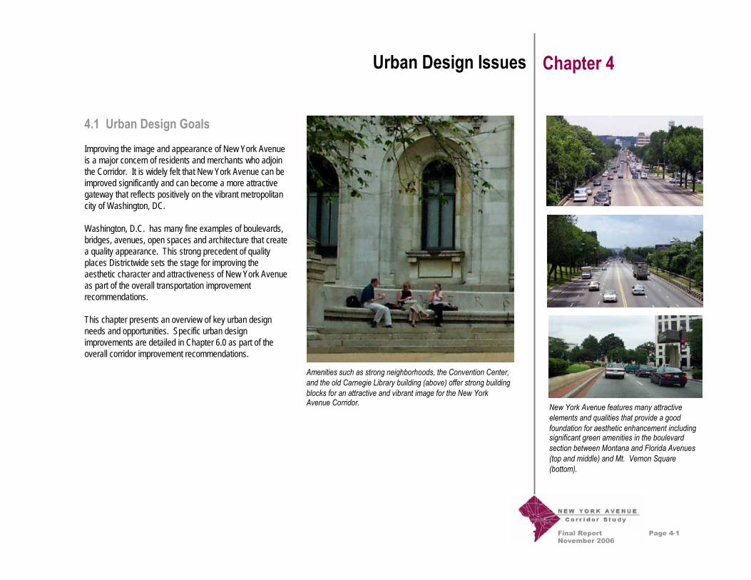
Improving the image and appearance of New York Avenueis a major concern of residents and merchants who adjointhe Corridor. It is widely felt that New York Avenue can beimproved significantly and can become a more attractivegateway that reflects positively on the vibrant metropolitancity of Washington, DC.
Washington, D.C. has many fine examples of boulevards,bridges, avenues, open spaces and architecture that createa quality appearance. This strong precedent of qualityplaces Districtwide sets the stage for improving theaesthetic character and attractiveness of New York Avenueas part of the overall transportation improvementrecommendations.
This chapter presents an overview of key urban designneeds and opportunities. Specific urban designimprovements are detailed in Chapter 6.0 as part of theoverall corridor improvement recommendations.
New York Avenue features many attractiveelements and qualities that provide a goodfoundation for aesthetic enhancement includingsignificant green amenities in the boulevardsection between Montana and Florida Avenues(top and middle) and Mt. Vernon Square(bottom).
Amenities such as strong neighborhoods, the Convention Center,and the old Carnegie Library building (above) offer strong buildingblocks for an attractive and vibrant image for the New YorkAvenue Corridor.

Final ReportNovember 2006
Page 4-2
Examples of the varying scales of Districtstreets and the different streetscape and urbandesign treatments in the District.
Urban Design Issues Chapter 4
Figure 4.1: Urban Design Opportunities gives an overviewof the opportunities for major urban design enhancementsalong New York Avenue. One overarching concept is totake advantage of the opportunity to use New York Avenueto connect major parks, green spaces, historic sites, andneighborhoods through enhancements along the Corridoritself and the establishment of design guidelines andaesthetic improvements at major intersections along theCorridor. In addition, corridor-wide improvements tolighting, signage, landscape, and other streetscapeconsiderations are also envisioned. The followingdescribes some of the major intersection concepts asillustrated in Figure 4.1.
Baltimore Washington Parkway, US 50, and theAnacostia River – Incorporate design elements that buildupon the strong boulevard landscape features andreference the river creating greater connectivity to these“green” resources. Introduction of pedestrian and bicyclefacilities along New York Avenue between the AnacostiaRiver and Bladensburg Road will improve accessibility tothe River and serve as an important signal to vehiculartraffic that they have left a highway environment andentered into an urban one.
South Dakota Avenue – Enhance the gateway potential ofthis interchange and include references to the Fort LincolnGateway commercial development.
Bladensburg Road – Establish a quality commercialgateway image and focal point at this intersection that willbenefit adjacent businesses and create redevelopmentopportunities. Incorporate design elements that enhancepedestrian safety and create strong connections to nearbyneighborhoods.
Montana Avenue – Create a strong focal point at thisintersection by building upon the historic traffic circledesign. Incorporate new streetscape elements thatreference nearby neighborhoods.
Brentwood Parkway Interchange – Build upon the “greenrelief” image this node offers and incorporate references tothe Farmers Market and Gallaudet while capturing views ofthe uptown neighborhoods.
Florida Avenue – Create an urban, pedestrian-friendlynode that emphasizes the surrounding neighborhoodcharacter and creates a sense of arrival to the historic edgeof the L’Enfant District plan. Create strong pedestrian linksbetween new development, the new Metrorail Station,surrounding properties, and neighborhoods. TheMetropolitan Branch Trail, running north and south alongthe west side of the Amtrak tracks and Metrorail Red Lineshould be integrated into this concept.
North Capitol Street – Enhance the neighborhoodcharacteristics of this area through strengtheningpedestrian connectivity, calming traffic and augmenting thestrong landscape elements already present along theavenue.

Final ReportNovember 2006
Page 4-3
Urban Design Issues Chapter 4
4.2 Urban Design Challenges
New York Avenue is a corridor of contrasts. While thereare a number of positive features and amenities that can beenhanced and built upon to create a more positive aestheticappearance, there are a number of areas and uses that donot contribute to a quality visual experience. In addition,the sheer volume and congestion of vehicles in the Corridoralso have an impact on the overall visual quality andexperience.
Examples of some of the aesthetic challengesthat need to be addressed along New YorkAvenue, including the need for improved treemaintenance, better attention to pedestrianamenities (far left) and better screening ofcommercial areas and control of commercialsignage (below).
Mt. Vernon Square – Create strong connections to Mt.Vernon Square, the old Carnegie Library building and thenew Convention Center through streetscape improvementsthat celebrate the point of arrival to downtown.
Corridor-Wide – Create new opportunities forredevelopment of properties along the Corridor and utilizenew buildings and streetscape improvements to reinforcefocal points and roadway edges.

Final ReportNovember 2006
Page 4-4
Figure 4.1Urban Design Opportunities
1. Anacostia River Crossing2. South Dakota Avenue3. Bladensburg Road4. Montana Avenue5. Brentwood Parkway6. Florida Avenue7. North Capitol Street8. Mt. Vernon Square M
M
Union Station
7 M6
4
5
8
23 1

Final ReportNovember 2006
Page 5-1
Community Input Chapter 5
5.1 Community Outreach
Community outreach and citizen engagement are importantaspects of the New York Avenue Corridor Study. Listeningto the opinions, needs and desires of multiple residents,business owners and other stakeholders concerning thefuture of the Corridor is a fundamental element indeveloping a final plan for the future of New York Avenue.To date, the Study process has involved the public inidentifying key issues, developing a vision statement, anddetermining the criteria by which to choose a preferredalternative for the Corridor. Community input has heavilyinfluenced the selection of preferred concepts.
The Study Team sought community input in the followingways:
Public Information: Websites, flyers and informationletters kept interested community members up to date andhave offered opportunities for feedback.
Public Meetings: Five general public meetings were heldon the following dates: October 2, 2002; May 20, 2003;June 17, 2003; January 10, 2004; and June 25, 2005.
Stakeholder Meetings: Several one-on-one meetings with16 individual business owners, 9 District agencyrepresentatives, and 48 community groups andneighborhood associations have occurred.
New York Avenue is a gateway to thenation's capital and several of itsunique neighborhoods. It is an urbangrowth corridor that is a safe andefficient means for providing accesswithin the District and between theDistrict and the region.
Attendees discuss concepts at the June 17th, 2003 publicmeeting.
Draft vision statement developed fromcommunity input at public meetings held onMay 20, 2003 and June 17, 2003.
NCPC Charrette: Although not part of this study, theNational Capital Planning Commission (NCPC), withsupport from DDOT and the U.S. General ServicesAdministration, hired consultants to conduct a designworkshop to examine transportation issues surrounding theNew York Avenue and Florida Avenue intersection. Thecharrette was conducted July 12 through July 14, 2006.
The following discussion highlights some of the recurringthemes that have emerged from this outreach process.

Final ReportNovember 2006
Page 5-2
Community Input Chapter 5
5.2 Recurring Themes
Transportation and Traffic• Enhance transit options along the Corridor and
promote its use.• Address environmental concerns, such as noise and
pollution caused by the large volume of trucks, busesand cars.
• Design for more exits between Bladensburg Roadand Baltimore-Washington Parkway, allowingresidents more choices of access into theirneighborhoods.
• Increase parking including investigating the feasibilityof constructing a parking garage at the east end ofthe Corridor connecting it with Metrorail to reducevehicular congestion on the Corridor.
• Regulate the speed to reduce the number ofaccidents, especially involving pedestrians, andreduce safety concerns. Consider a pedestrianoverpass for New York Avenue and safe paths forbicyclists.
• Increase tour bus parking. Buses often park inneighborhoods and idle while they wait.
Law Enforcement• Increase the presence and visibility of DC Police in
business districts and neighborhoods along theCorridor.
Land Use• Create more attractive land uses such as outlet
stores, restaurants, quality hotels, green space, anda library.
• Gallaudet University is an asset to the community. Ithas ongoing relations with the ANCs and civicorganizations.
• The National Arboretum should be better integratedinto the neighborhoods through community relatedlandscape projects and by providing better access tothis resource via public transportation.
• Address illegal waste dumping.• Spread out through the Corridor the Convention
Center truck yard.• Explore creating a hospitality district along the
Corridor.
Aesthetics• Enhance the Farmer’s Market visual appeal.• Improve tree canopy.• Include façade improvements to the revitalization of
local businesses.• Offer opportunities for neighborhood identity along
the Corridor.• An I-395 bridge over Florida Avenue is perceived as
a visual barrier.• An extension of I-395 in a tunnel beneath New York
Avenue may require large unattractive ventilationshafts.

Final ReportNovember 2006
Page 6-1
Recommendations Chapter 6
6.1 Introduction
Improvements to the New York Avenue Corridor can andshould achieve far more benefit to the District of Columbiathan merely improving traffic flow. Accordingly, the StudyTeam approached the development of recommendations bygiving attention to the integration of transportation,engineering, land use, urban design, and neighborhoodplanning issues. Public input and evaluation criteria guidedthe development of recommendations and helped setpriorities when trade-offs were necessary. The resultingrecommendations presented in this chapter of the FinalReport provide a number of tangible benefits, including:
• a meaningful and measurable improvement to thequality of life for adjoining neighborhoods,
• improved safety for pedestrians and bicyclists,• a greater range of viable transportation options,• a reduction in air and noise pollution for dwellings
that adjoin the Corridor,• a range of amenities, focal points and improved
identity that can attract quality development• sensible solutions to accommodate increasing traffic
demand generated from new development in theCorridor.
6.2 Guiding Principles
Working from the Evaluation Criteria discussed in AppendixA, the Study Team identified three major issues that guidedthe development of recommendations. These issues andtheir qualities are:
• Neighborhoods: Health, Connection and Vitality• Transportation: Safety, Connectivity, Choice and
Capacity• Appearance: Attractiveness, Quality and
Impressions
Through the course of the Study, three major conceptsemerged that capture the essential goals for improving theNew York Avenue Corridor over the next fifty years:
• Need: Promote Safety and NeighborhoodConnectivity
• Focus: Emphasize the Needs of District Residents• Tools: Use Intersection Improvements and Corridor
Enhancements as Agents for Change
These issues and concepts form the guiding principles forthe New York Avenue Corridor Study, address the StudyPurpose described in Chapter 1, build upon the overallvision statement for the Corridor, and set the framework forspecific Corridor enhancement options.
Using improvements at intersections to promotepositive change is one of the big ideas of theStudy. These improvements could range fromimproving the existing traffic circle at MontanaAvenue (top) to the potential to create a bridgeover Florida Avenue (bottom).

Final ReportNovember 2006
Page 6-2
Recommendations Chapter 6
6.3 Refinement of Alternatives
The guiding principles described above were then used tofurther evaluate the preliminary transportation conceptsdiscussed in Appendix C. This evaluation led the StudyTeam to agree that, for each location in the corridor, someof the alternatives had little or no support, and could thus beremoved from further consideration. The followingalternatives were retained for further analyses:
Bladensburg Road:
Montana Avenue:
Brentwood Parkway / 4th Street / 9th Street:
Florida Avenue:
I-395:
Because none of the remaining alternatives forBladensburg Road and Montana Avenue involved adiamond interchange, neither of the two concepts for the
area between these two intersections (each of whichinvolved interchanges) was studied further.
The Study Team then performed additional, more detailedanalyses of these alternatives. In some instances, theseanalyses revealed potential problems, leading to thedevelopment of modified alternatives which met the intentof the original alternative, to the extent possible, butaddressed the potential problems. The results of theseefforts are summarized below, and are discussed in greaterdetail in the remainder of this Chapter.
Bladensburg Road: Given the size of a grade-separatedtraffic circle necessary to provide safe/efficient traffic flowalong Bladensburg Road and in order to avoid excessivecondemnation of nearby private property, a single pointurban interchange (SPUI) was felt to be preferable. (SeeFigures 6.24 and 6.25, later in this chapter, for additionaldetails). Urban design treatments to provide a “virtualcircle” in conjunction with such a SPUI were developed.
Montana Avenue: In light of the modified SPUI proposedat Bladensburg Road, and the short distance availablebetween Bladensburg Road and Montana Avenue, it wasfelt that improving the existing traffic circle would be themost appropriate approach for this location. (Theseproposed improvements are depicted later in this chapter,in Figure 6.23.)
• Grade Separated Traffic Circle• Continuous Flow Intersection
• Improve Existing Traffic Circle• Grade Separated Traffic Circle
• Ramp Connections
• Grade Separated Traffic Circle• Improve 4-Leg Intersection
• Depressed Left Turn Lane• Tunnel Connection to New York Avenue (between
North Capitol Street & Florida Avenue)
Final ReportNovember 2006
Page 6-3
Recommendations Chapter 6
Brentwood Parkway / 4th Street / 9th Street: This locationis now under study/design by DDOT. The current conceptcalls for complete reconstruction of the 9th Street Bridge,and removal of the two ramps to and from westbound NewYork Avenue. All movements to and from New YorkAvenue, both eastbound and westbound, would be providedat an at-grade intersection, just east of the new structurereplacing the intersection where traffic from Mt. Olivet Rdand Brentwood Parkway now enter New York Avenue. Thisconcept is consistent with the emerging results of the NewYork Avenue Corridor Study, and has been incorporatedinto the Study.
Florida Avenue: Given the size of a grade-separatedtraffic circle necessary to provide safe/efficient traffic flowalong New York Avenue, it was agreed that a diamondinterchange should be investigated further for this location.In addition, both improving the existing at-grade intersectionand further extending the proposed I-395 tunnel (seediscussion of I-395 below) were carried forward.
I-395: Replace the existing intersection of New YorkAvenue and I-395 with a tunnel carrying I-395 beneath NewYork Avenue between 4th Street, NW and North CapitolStreet. This tunnel could come back to the surfacebetween North Capitol Street and Florida Avenue, orperhaps even further to the east. It was preferred over theDepressed Left Turn Lane alternative because it removedmore regional traffic from New York Avenue, therebyenhancing the safety and quality of life for the residentialneighborhood there. Further investigation of the mostappropriate means of connecting I-395 (from below thesurface) into New York Avenue in the vicinity of FloridaAvenue were then conducted.
After the public meeting on January 10, 2004, thereappeared to be a general consensus among governmentagencies and public participants that most of the preferredalternatives provided worthwhile improvements to theCorridor. However, there was no consensus about how tohandle the intersection at Florida Avenue. Because issuesat this intersection seemed intimately related to proposedchanges at I-395, an even more in-depth analysis wasrequired of these two intersections in an effort to reachconsensus. (Additional details about the optionsconsidered, including various at-grade intersectionconfigurations, bridging New York Avenue over FloridaAvenue, depressing Florida Avenue under New YorkAvenue, and relocating Florida Avenue to the west, may befound in Appendix B.)
In Figure 6.2, G-3 (8 lane intersection) is an At-Gradeintersection, 8 lanes across on New York Avenue (4 lanesin each direction). I-6 is a Bridge concept. I-395 traffic has2 lanes in each direction on a bridge over Florida Avenue.New York Avenue, parallel to I-395, but at ground level, hastwo thru lanes in each direction, and a right turn lane ineach direction on New York Avenue as it approachesFlorida Avenue. The Extended Tunnel is a tunnel originallydescribed in the New York Avenue Development Report,Washington, D.C. (November 19, 1996), which iscommonly referred to as “The Linton Report.” This I-395tunnel would come to the surface on New York Avenue tothe east of 4th Street, NE. Following the June 25, 2005Public Meeting, additional analyses of the Extended Tunnelconcept were performed. These analyses are discussed inthe Task 11 Technical Memorandum.

Final ReportNovember 2006
Page 6-4
Recommendations Chapter 6
The NCPC charrette consultants, as mentioned onPage 5-1, reviewed various concepts for the New YorkAvenue and Florida Avenue intersection. They concludedthat the I-395 tunnel extension was too expensive and toointrusive on New York Avenue east of North Capitol Street.They recommended closing I-395 between MassachusettsAvenue and New York Avenue as a more appropriate wayto remove regional traffic from New York Avenue.
This alternative was considered as part of the study you arenow reading. The regional travel demand model wasexecuted with the existing roadway network in onescenario, and with I-395 truncated at MassachusettsAvenue in a second scenario. Comparison of the two setsof traffic volume forecasts showed that removal of I-395was not expected to reduce traffic volumes on New YorkAvenue to any appreciable extent. Reduced to its simplestterms, other travel routes available are forecast to be soheavily traveled in 2025 that, even with elimination of the I-395 linkage, New York Avenue will still be an importantDistrict and regional roadway. Thus, there was concernthat the opinion favored by the NCPC charrette consultantswould not provide the desired traffic reductions for residentsliving between 4th Street, NW and North Capitol Street.
However, DDOT may wish to revisit this topic, incorporatinginto the travel demand model planned improvements to the11th Street Bridge and the South Capitol Street Bridge.Perhaps these new facility improvements might handlemore regional traffic if I-395 was closed betweenMassachusetts Avenue and New York Avenue, therebyproviding relief for New York Avenue residents.

Final ReportNovember 2006
Page 6-5
Recommendations Chapter 6
6.4 Improvements Overview
Given the diverse nature of the character and functionalityof the New York Avenue Corridor, the Study Teamdeveloped recommendations according to a series of siximprovement zones reflective of the unique characteristicsand needs of each zone. Figure 6.3: Big Ideas Overviewillustrates the principal recommendations for each of thezones.
The proposed recommendations for improvements to theNew York Avenue Corridor offer the opportunity to removea significant barrier to cross-neighborhood connectivitywhile providing the framework to greatly improve the qualityand character of commercial development and the image itimparts on residents, commuters and visitors alike. Thefollowing pages present an overview of recommendationsby zone. Figures 6.4 through 6.27 illustrate the specificrecommendations for each individual zone.
Zones 6 and 5: Washington Convention Center toNorth Capitol Street
Although many of the concepts and improvements in eachzone could be implemented in a phased manner over timeand are somewhat independent of each other, oneoverriding concept that drives a number of decisions andtrade-offs for the Corridor as a whole is the decision torecommend separating local traffic from regional traffic(traffic going to and from I-395). The concept that isrecommended, tunneling I-395 traffic under New YorkAvenue from east of New Jersey Avenue to east of NorthCapitol Street, or even further to the east, could removenearly half the traffic now traversing in front of residencesalong New York Avenue west of North Capitol Street. Thiswill greatly enhance the quality of life for theseneighborhoods as well as provide a great deal of trafficcongestion relief. This will also allow New York Avenuefrom the Convention Center to North Capitol Street to bemore of a “grand avenue” in the historic DC-style. Theseconcepts are illustrated in Figures 6.4 to 6.7.
Buildings such as the Convention Center andthe old Carnegie Library building (top), XMRadio (middle), and row houses at North Capitol(bottom) lend a diverse architectural image tothe Corridor.

Final ReportNovember 2006
Page 6-6
Recommendations Chapter 6
Zone 4: North Capitol Street to Florida Avenue
At some point on the Corridor, the new I-395 tunnelextension and New York Avenue will need to merge intoone roadway. Given traffic operations, urban design, landuse, the character of development, cost, and engineeringconsiderations, one logical zone for this is between NorthCapitol and Florida Avenue. (A second logical zone wouldbe between Penn Street, NE and Ninth Street, NE. This isdiscussed further below, in Zone 3.) If I-395 was to be“daylighted” in Zone 4, Florida Avenue could be addressedin two ways.
It may be desirable to keep regional traffic separate fromlocal traffic at Florida Avenue. If this concept was to beselected, the Study Team recommends creating a qualitypedestrian environment and an attractive setting thatcompliments on-going redevelopment efforts in the area.Recommendations include the option of creating a Bridge atFlorida Avenue that could provide a signature gatewayopportunity for the both the District and adjoiningneighborhoods. This concept is illustrated in Figure 6.11,and in Figures 6.14 to 6.16.
Zone 4, and the intersection of New York Avenue andFlorida Avenue in particular, evoked the most extensivediscussion and debate among the members of the publicand the Oversight Committee. There were strongly-heldopinions among some members of the Committee that anAt-Grade intersection, shown in Figure 6.10, would offer asuperior solution for this location. In addition, the NationalCapital Planning Commission (NCPC) recommendedextending the I-395 tunnel to the east of Florida Avenue andthe railroad tracks, due to the historical, urban design, and
pedestrian safety implications posed by a Bridge or At-Grade alternative. NCPC recommended that future studiesinvestigate whether more robust development andincreases in land value that would occur as a result of anExtended Tunnel might help finance this option or at leastmitigate its additional costs. The Extended Tunnel conceptis shown in Figures 6.12, 6.13, and 6.21.
It is important to note that the Final Report, while providinga blueprint for improvements to New York Avenue, does notclose the door to further discussion and refinement of thoseimprovements. Before any of the elements of the FinalReport could be implemented, detailed planning studies,involving substantial engineering and environmentalanalyses as called for in the National Environmental PolicyAct (NEPA) and implementing regulations, would need tobe performed. Such detailed planning studies would berequired to re-assess the recommendations of the FinalReport, even comparing those recommendations to a “nobuild” alternative.
During the time that this Study was being conducted, ashort-term improvement plan for the Florida Avenueintersection was developed by DDOT. For discussionpurposes, this improvement is referred to as the “At-GradeSemi-Circle” concept. This improvement, depicted inFigure 6.9, would improve traffic operations at this location;it is slated for construction by 2008.
Buildings such as the Hecht’s Company Warehouse (upperright) and Salvation Army Harbor Light Center (lower right) lend
a diverse architectural image to the Corridor.

Final ReportNovember 2006
Page 6-7
Recommendations Chapter 6
This short-term improvement concept would be compatiblewith the At-Grade concept (G-3), and with both ExtendedTunnel concepts (with and without ramps at FloridaAvenue), but would not be compatible with the Bridgeconcept (I-6) because the overpass would restrict left turnsand thru movements from southbound First Street, NE.Analyses of combinations of the At-Grade concept and theExtended Tunnel concepts with the At-Grade Semi-Circleconcept are summarized in Figures 6.2a and 6.2b.
Zone 3: Florida Avenue to Montana Avenue
Between Florida Avenue and Montana Avenue, the primaryconcept for New York Avenue is to reduce some of theintersections with traffic signals and improve those thatremain by adding a median and separated left turn lanes forwestbound traffic. As this will require widening of theroadway, it is recommended that this widening occur on thenorth side, into an area currently used primarily for truckparking. A linear park with separate bicycle and pedestrianpaths is proposed for the remaining land between the newroadway and existing railroad tracks.
The Extended Tunnel concept, which would call for I-395“daylighting” between Penn Street, NE and Ninth Street, NEand which is shown in Figures 6.12, 6.13, and 6.21, iscompletely compatible with the overall concept for Zone 3.
A major reconstruction of the Brentwood Parkway bridge iscurrently proposed under a separate project effort and thiscreates an opportunity to add urban design enhancementsto the bridge structure. Coordination with the Hecht’sCompany Warehouse will be needed to accommodatedisplaced truck parking areas currently located on the north
side of New York Avenue. These concepts are illustrated inFigures 6.17 to 6.21.
Zone 2: Montana Avenue to Bladensburg Road
At the Montana Avenue and Bladensburg Roadintersections, the primary concept is to create significantfocal points reflecting the heritage of DC’s urban trafficcircles. In the case of Montana Avenue, this involves littlechange to how traffic currently uses the intersection, butdoes include a number of urban design improvements andimprovements for pedestrians and cyclists. AtBladensburg Road, New York Avenue would bereconstructed to pass below the existing intersection.Rather than create a suburban-style highway interchange atthis location, the Study Team recommends an intersectionappearance more reminiscent of the traditional grade-separated DC traffic circles such as those that now exist atThomas Circle, Scott Circle, and Dupont Circle. Theseconcepts are illustrated in Figures 6.22 to 6.25.
Zone 1: Bladensburg Road to the Anacostia River
From Bladensburg Road to the Anacostia River (and theDC/Maryland boundary line), the Study Team recommendscreation of an urban boulevard and gateway image. Inaddition to the creation of a bicycle facility along this portionof the Corridor, the Study Team recommends softening thehighway appearance of the existing roadway throughlandscape improvements and conversion of shoulder areasto curbed zones and bikeways. The Study Team alsorecommends the installation of significant new welcomesigning. These concepts are illustrated in Figures 6.26 to6.27.

Final ReportNovember 2006
Page 6-8
I-395 & New York Avenue Intersection:Comparison of Concepts Figure 6.1a
Criterion No BuildDepressed LeftTurn Lane I-395 Tunnel
Vehicular TrafficV/C Ratio (1) 1.39 (1.28) 1.29 (1.03) 0.74 (0.81)Potential to divert traffic from Rhode Island Ave. and Kenilworth Ave.(compared to No Build) Neutral Somewhat Greater Much Greater
Pedestrian AccessibilityNumber of Ped. Barriers Eliminated 0 0 1Number of Ped. Barriers Created 0 0 0Number of Ped. Connections Improved 0 2 4Number of Ped. Connections Diminished 0 0 0
Aesthetics
Obstruction of Pedestrian Views (compared to No Build)NY Avenue west of Florida Avenue looking northeast N/A N/A N/ANY Avenue west of Florida Avenue looking southwest N/A N/A N/ANY Avenue east of Florida Avenue looking northeast N/A N/A N/ANY Avenue east of Florida Avenue looking southwest N/A N/A N/AFlorida Avenue south of NY Avenue looking northwest N/A N/A N/AFlorida Avenue south of NY Avenue looking southeast N/A N/A N/AFlorida Avenue north of NY Avenue looking northwest N/A N/A N/AFlorida Avenue north of NY Avenue looking southeast N/A N/A N/ANY Avenue & NJ Avenue, NW looking northeast N/A 0 0NY Avenue & NJ Avenue, NW looking southwest N/A 0 0First & O Street, NE (north of NY Avenue) looking south N/A N/A N/AFirst & O Street, NE (north of NY Avenue) looking west N/A N/A N/A
Residential PropertiesBlock Sides with Improved Views N/A 0 0Block Sides with Diminished Views N/A 0 0
Commercial PropertiesObstructed Views from Floors 1 and 2 N/A No NoObstructed Views from Higher Floors N/A No No
Note: All entries assume continued redevelopment of the area.N/A: Not Applicable(1) Computed by critical lane analysis.
Final ReportNovember 2006
Page 6-9
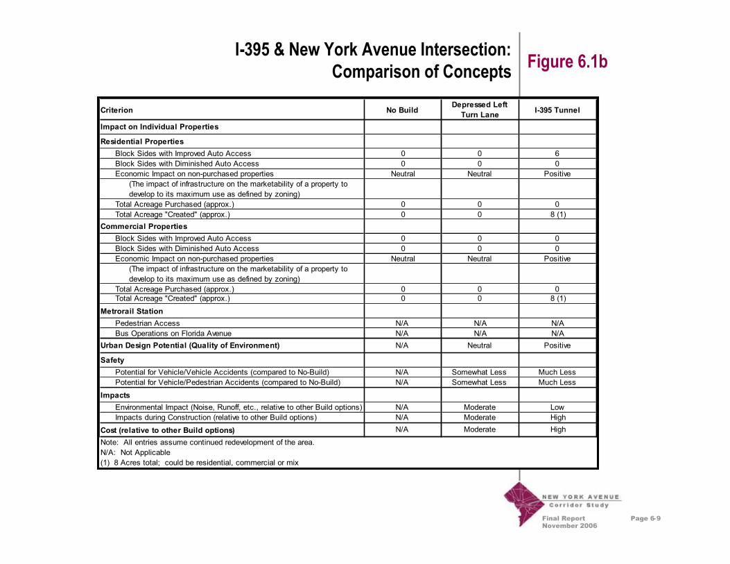
I-395 & New York Avenue Intersection:Comparison of Concepts Figure 6.1b
Criterion No BuildDepressed LeftTurn Lane I-395 Tunnel
Impact on Individual Properties
Residential PropertiesBlock Sides with Improved Auto Access 0 0 6Block Sides with Diminished Auto Access 0 0 0Economic Impact on non-purchased properties Neutral Neutral Positive
(The impact of infrastructure on the marketability of a property todevelop to its maximum use as defined by zoning)
Total Acreage Purchased (approx.) 0 0 0Total Acreage "Created" (approx.) 0 0 8 (1)
Commercial PropertiesBlock Sides with Improved Auto Access 0 0 0Block Sides with Diminished Auto Access 0 0 0Economic Impact on non-purchased properties Neutral Neutral Positive
(The impact of infrastructure on the marketability of a property todevelop to its maximum use as defined by zoning)
Total Acreage Purchased (approx.) 0 0 0Total Acreage "Created" (approx.) 0 0 8 (1)
Metrorail StationPedestrian Access N/A N/A N/ABus Operations on Florida Avenue N/A N/A N/A
Urban Design Potential (Quality of Environment) N/A Neutral Positive
SafetyPotential for Vehicle/Vehicle Accidents (compared to No-Build) N/A Somewhat Less Much LessPotential for Vehicle/Pedestrian Accidents (compared to No-Build) N/A Somewhat Less Much Less
ImpactsEnvironmental Impact (Noise, Runoff, etc., relative to other Build options) N/A Moderate LowImpacts during Construction (relative to other Build options) N/A Moderate High
Cost (relative to other Build options) N/A Moderate High
Note: All entries assume continued redevelopment of the area.N/A: Not Applicable(1) 8 Acres total; could be residential, commercial or mix
Final ReportNovember 2006
Page 6-10
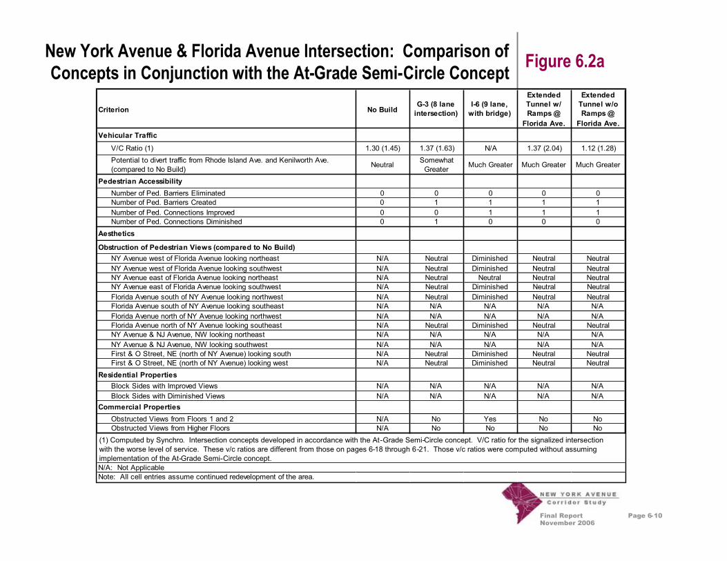
New York Avenue & Florida Avenue Intersection: Comparison ofConcepts in Conjunction with the At-Grade Semi-Circle Concept Figure 6.2a
Criterion No BuildG-3 (8 laneintersection)
I-6 (9 lane,with bridge)
ExtendedTunnel w/Ramps@Florida Ave.
ExtendedTunnel w/oRamps@Florida Ave.
Vehicular Traffic
V/C Ratio (1) 1.30 (1.45) 1.37 (1.63) N/A 1.37 (2.04) 1.12 (1.28)Potential to divert traffic from Rhode Island Ave. and Kenilworth Ave.(compared to No Build) Neutral Somewhat
Greater Much Greater Much Greater Much Greater
Pedestrian AccessibilityNumber of Ped. Barriers Eliminated 0 0 0 0 0Number of Ped. Barriers Created 0 1 1 1 1Number of Ped. Connections Improved 0 0 1 1 1Number of Ped. Connections Diminished 0 1 0 0 0
Aesthetics
Obstruction of Pedestrian Views (compared to No Build)NY Avenue west of Florida Avenue looking northeast N/A Neutral Diminished Neutral NeutralNY Avenue west of Florida Avenue looking southwest N/A Neutral Diminished Neutral NeutralNY Avenue east of Florida Avenue looking northeast N/A Neutral Neutral Neutral NeutralNY Avenue east of Florida Avenue looking southwest N/A Neutral Diminished Neutral NeutralFlorida Avenue south of NY Avenue looking northwest N/A Neutral Diminished Neutral NeutralFlorida Avenue south of NY Avenue looking southeast N/A N/A N/A N/A N/AFlorida Avenue north of NY Avenue looking northwest N/A N/A N/A N/A N/AFlorida Avenue north of NY Avenue looking southeast N/A Neutral Diminished Neutral NeutralNY Avenue & NJ Avenue, NW looking northeast N/A N/A N/A N/A N/ANY Avenue & NJ Avenue, NW looking southwest N/A N/A N/A N/A N/AFirst & O Street, NE (north of NY Avenue) looking south N/A Neutral Diminished Neutral NeutralFirst & O Street, NE (north of NY Avenue) looking west N/A Neutral Diminished Neutral Neutral
Residential PropertiesBlock Sides with Improved Views N/A N/A N/A N/A N/ABlock Sides with Diminished Views N/A N/A N/A N/A N/A
Commercial PropertiesObstructed Views from Floors 1 and 2 N/A No Yes No NoObstructed Views from Higher Floors N/A No No No No
N/A: Not ApplicableNote: All cell entries assume continued redevelopment of the area.
(1) Computed by Synchro. Intersection concepts developed in accordance with the At-Grade Semi-Circle concept. V/C ratio for the signalized intersection withthe worse level of service. These v/c ratios are different from those on pages 6-18 through 6-2
(1) Computed by Synchro. Intersection concepts developed in accordance with the At-Grade Semi-Circle concept. V/C ratio for the signalized intersectionwith the worse level of service. These v/c ratios are different from those on pages 6-18 through 6-21. Those v/c ratios were computed without assumingimplementation of the At-Grade Semi-Circle concept.

Final ReportNovember 2006
Page 6-11
New York Avenue & Florida Avenue Intersection: Comparison ofConcepts in Conjunction with the At-Grade Semi-Circle Concept Figure 6.2b
Criterion No Build G-3 (8 laneintersection)
I-6 (9 lane,with bridge)
ExtendedTunnel w/Ramps@Florida Ave.
ExtendedTunnel w/oRamps@Florida Ave.
Impact on Individual Properties
Residential PropertiesBlock Sides with Improved Auto Access N/A N/A N/A N/A N/ABlock Sides with Diminished Auto Access N/A N/A N/A N/A N/AEconomic Impact on non-purchased properties N/A N/A N/A N/A N/A
(The impact of infrastructure on the marketability of a property todevelop to its maximum use as defined by zoning)
Total Acreage Purchased (approx.) N/A N/A N/A N/A N/ATotal Acreage "Created" (approx.) N/A N/A N/A N/A N/A
Commercial PropertiesBlock Sides with Improved Auto Access 0 0 0 0 0Block Sides with Diminished Auto Access 0 4 4 4 4Economic Impact on non-purchased properties (1) N/A Positive Positive Positive PositiveTotal Acreage Purchased (approx.) 0 <2 <3 <2 <2Total Acreage "Created" (approx.) 0 0 <1 0 0
Metrorail StationPedestrian Access N/A Diminished Improved Diminished DiminishedBus Operations on Florida Avenue N/A Diminished Improved Improved Improved
Urban Design Potential (Quality of Environment) N/A Positive Very Positive Positive Positive
Safety
Potential for Vehicle/Vehicle Collisions (compared to No-Build) N/A SomewhatGreater
Much Less SomewhatGreater
Much Less
Potential for Vehicle/Pedestrian Collisions (compared to No-Build) N/ASomewhatGreater Much Less
SomewhatGreater Much Less
ImpactsEnvironmental Impact (Noise, Runoff, etc., relative to other Build options) N/A Moderate High Low LowImpacts during Construction (relative to other Build options) N/A Low Moderate High High
Cost (relative to other Build options) N/A Low HIgh Very High Very High(1) The impact of infrastructure on the marketability of a property to develop to its maximum use as defined by zoningN/A: Not ApplicableNote: All cell entries assume continued redevelopment of the area.

Final ReportNovember 2006
Page 6-12
SouthDakota
Bladensburg
Montana
Brentw
ood
Florida
North
Capitol
I-3957thS
treetNW
ZONE 2 ZONE 1ZONE 3ZONE 4ZONE 5ZONE 6
New
Jersey
Create UrbanBoulevard Entry
Create Focal Pointsat Intersections
Create aLinear Park
Transition toNeighborhoodAvenue
NeighborhoodAvenue
DowntownAvenue
Big Ideas Overview Figure 6.3

Final ReportNovember 2006
Page 6-13
Zone 6: Framework Plan Figure 6.4
ConventionCenter
Mt. VernonSquare
BibleWay
Church
A
B
C
DF
E
GFF
5thST
REET
NW
7thST
REET
NW
6thST
REET
NW
4thST
REET
NW
NEWJERSEY
Recommendations:A. Regional traffic is located in
tunnel under New YorkAvenue from New Jersey toNorth Capitol
B. New York Ave becomes an“address street” for newmixed-use development
C. Opportunity exists for newpublic square or park at 4thStreet NW to provide anamenity for the neighborhoodand new development
D. Former I-395 entrancebecomes a prominentredevelopment site since I-395 will be in tunnel below
E. Opportunity exists toreconstruct L Street toreconnect neighborhoods
F. New buildings can help defineNew York Avenue edge
G. Design guidelines for newdevelopment are needed toensure lively street edge andneighborhood compatibility
D
D

Final ReportNovember 2006
Page 6-14
Zone 6: Section Views Figure 6.5
Currently (upper left), New YorkAvenue from Mt. Vernon Square toNew Jersey offers a number of olderbuildings of with interestingarchitectural character as well as anumber of vacant sites attractive fordevelopment in support of theConvention Center and on-goingplanning efforts in the Mt. VernonTriangle area.
The recommendation of the New YorkAvenue Corridor Study is to create amore vibrant and enticing streetscapeand a pedestrian scale that invitespeople to walk from neighborhoodsand the Convention Center tobusiness establishments that areenvisioned to line this “DowntownAvenue.” A typical Section view isshown (lower left) illustrating theproposals to create broad pedestrianwalkways and ample separation ofpedestrians from vehicular trafficthrough the use of generouslandscape planting zones. A grassymedian is also proposed which canalso be used for left turn lanes atintersections.
TreesWalk New York AvenueEast-BoundMedian
Busin
ess Business
New York AvenueWest-Bound Trees Walk
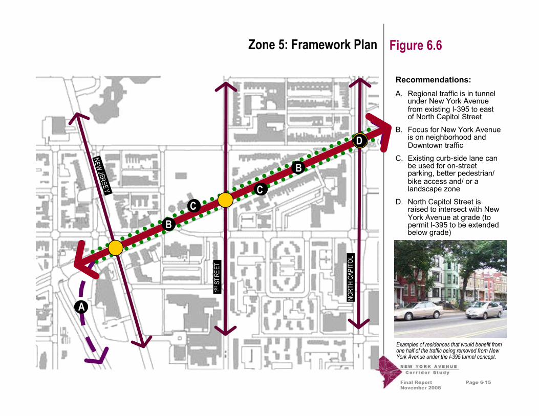
Final ReportNovember 2006
Page 6-15
Zone 5: Framework Plan Figure 6.6
Recommendations:A. Regional traffic is in tunnel
under New York Avenuefrom existing I-395 to eastof North Capitol Street
B. Focus for New York Avenueis on neighborhood andDowntown traffic
C. Existing curb-side lane canbe used for on-streetparking, better pedestrian/bike access and/ or alandscape zone
D. North Capitol Street israised to intersect with NewYork Avenue at grade (topermit I-395 to be extendedbelow grade)
Examples of residences that would benefit fromone half of the traffic being removed from NewYork Avenue under the I-395 tunnel concept.
NORT
HCA
PITO
L
1StST
REET
NEWJ ERSEY
A
C
B
BC
D

Final ReportNovember 2006
Page 6-16
Zone 5: Section Views Figure 6.7
Currently (upper left), traffic attemptingto use New York Avenue to connectwith I-395 in the vicinity of New JerseyAvenue creates a high degree ofcongestion and delay. This samevolume of traffic creates unsafeconditions for pedestrians and affectsthe quality of life as New York Avenuepasses through neighborhoodsbetween New Jersey Avenue andNorth Capitol Street (upper right).
The recommendation of the New YorkAvenue Corridor Study is to create a“Neighborhood Avenue” through thiszone by putting all the I-395-boundtraffic (about half the traffic volume) ina tunnel below New York Avenue.This would allow New York Avenue tobecome more of a residential street. Atypical section view is shown (lowerleft) illustrating the proposals to creatededicated parking or bicycle lanesfrom one of the traffic lanes that wouldno longer be needed and the creationof attractive, safe pedestrian walkingzones.
TreesWalk New York AvenueWest-Bound East-Bound
Parking/Bikes
Parking/Bikes Trees WalkYard Yard
Hous
e House
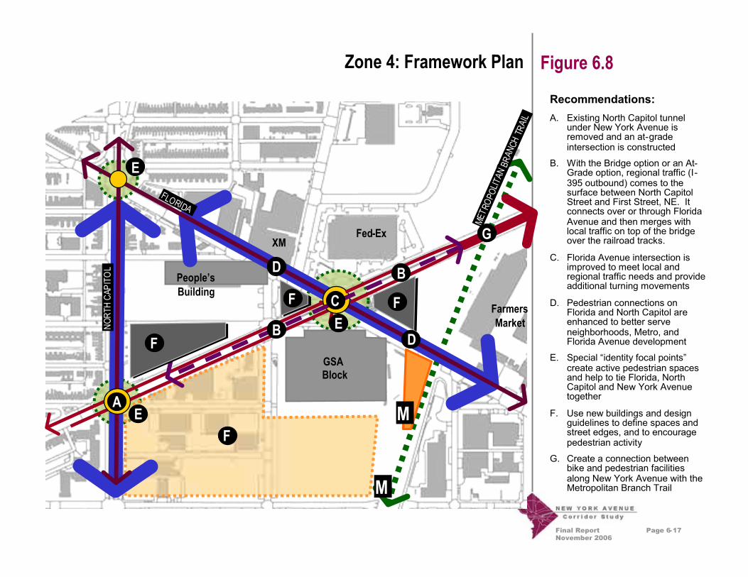
Final ReportNovember 2006
Page 6-17
Zone 4: Framework Plan Figure 6.8
Recommendations:A. Existing North Capitol tunnel
under New York Avenue isremoved and an at-gradeintersection is constructed
B. With the Bridge option or an At-Grade option, regional traffic (I-395 outbound) comes to thesurface between North CapitolStreet and First Street, NE. Itconnects over or through FloridaAvenue and then merges withlocal traffic on top of the bridgeover the railroad tracks.
C. Florida Avenue intersection isimproved to meet local andregional traffic needs and provideadditional turning movements
D. Pedestrian connections onFlorida and North Capitol areenhanced to better serveneighborhoods, Metro, andFlorida Avenue development
E. Special “identity focal points”create active pedestrian spacesand help to tie Florida, NorthCapitol and New York Avenuetogether
F. Use new buildings and designguidelines to define spaces andstreet edges, and to encouragepedestrian activity
G. Create a connection betweenbike and pedestrian facilitiesalong New York Avenue with theMetropolitan Branch Trail
M
GSABlock
Fed-ExXM
People’sBuilding
FarmersMarket
FLORIDA
B
D
E
B
D
F
F
NORT
HCA
PITO
L
F
F
E
E
A
C
MET R
OPOL
ITAN
BRAN
CHTR
AIL
M
G

Final ReportNovember 2006
Page 6-18
Zone 4: Florida Avenue Interim Improvement ConceptAt-Grade Semi-Circle
Figure 6.9
An interim improvement concept forthe New York Avenue / Florida Avenueintersection set to be constructed by2008.

Final ReportNovember 2006
Page 6-19
Zone 4: Florida Avenue At-Grade Intersection Concept (G-3) Figure 6.10
Notes:1. Does not assume reconstruction of New York Avenue /
Florida Avenue intersection as “At-Grade Semi-Circle.”
2. V/C computed by critical lane analysis.
*These v/c ratios differ from those in Figure 6.2a. The v/c ratios on this pagewere computed using critical lane analysis. They also assume the intersectionconfiguration shown, and not the At-Grade Semi-Circle which DDOT plans toimplement in 2008. The v/c ratios in Figure 6.2a assume implementation of theAt-Grade Semi-Circle.
*
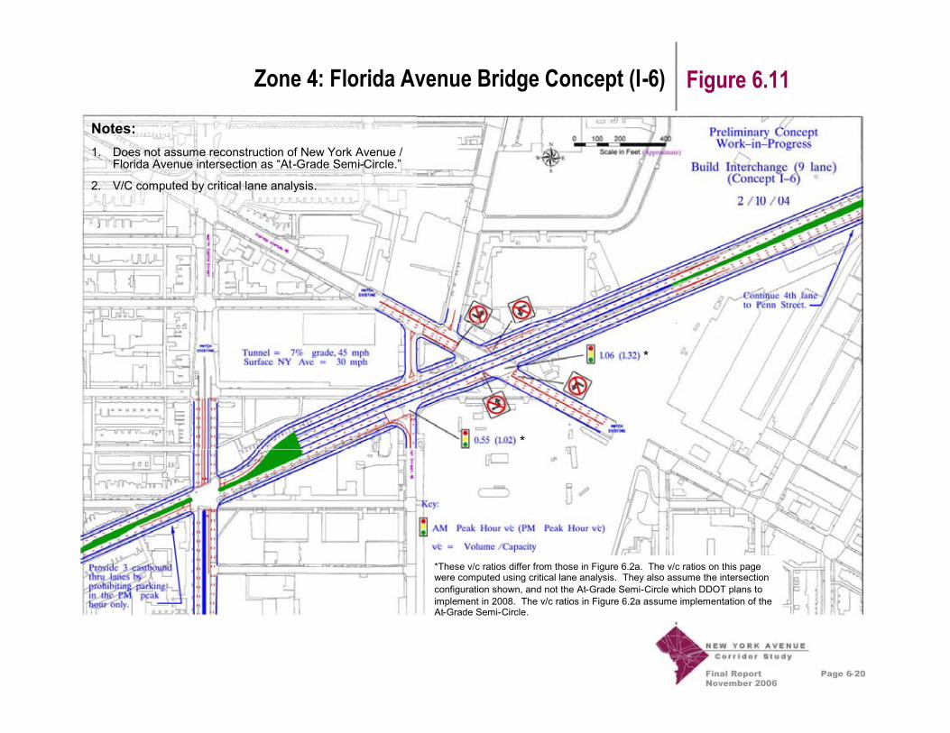
Final ReportNovember 2006
Page 6-20
Zone 4: Florida Avenue Bridge Concept (I-6) Figure 6.11
Notes:1. Does not assume reconstruction of New York Avenue /
Florida Avenue intersection as “At-Grade Semi-Circle.”
2. V/C computed by critical lane analysis.
*These v/c ratios differ from those in Figure 6.2a. The v/c ratios on this pagewere computed using critical lane analysis. They also assume the intersectionconfiguration shown, and not the At-Grade Semi-Circle which DDOT plans toimplement in 2008. The v/c ratios in Figure 6.2a assume implementation of theAt-Grade Semi-Circle.
*
*

Final ReportNovember 2006
Page 6-21
Zone 4: Florida Avenue Extended Tunnel ConceptWith Ramps at Florida Avenue – Sheet 1
Figure 6.12
Notes:1. Does not assume reconstruction of New York Avenue /
Florida Avenue intersection as “At-Grade Semi-Circle.”
2. V/C computed by critical lane analysis.
*These v/c ratios differ from those in Figure 6.2a. The v/c rat ios on this pagewere computed using critical lane analysis. They also assume the intersectionconfiguration shown, and not the At-Grade Semi-Circle which DDOT plans toimplement in 2008. The v/c ratios in Figure 6.2a assume implementation of theAt-Grade Semi-Circle.
*
*

Final ReportNovember 2006
Page 6-22
Figure 6.13Zone 4: Florida Avenue Extended Tunnel ConceptWithout Ramps at Florida Avenue – Sheet 1
Notes:1. Does not assume reconstruction of New York Avenue /
Florida Avenue intersection as “At-Grade Semi-Circle.”
2. V/C computed by critical lane analysis.
*These v/c ratios differ from those in Figure 6.2a. The v/c rat ios on this pagewere computed using critical lane analysis. They also assume the intersectionconfiguration shown, and not the At-Grade Semi-Circle which DDOT plans toimplement in 2008. The v/c ratios in Figure 6.2a assume implementation of theAt-Grade Semi-Circle.
*
*

Final ReportNovember 2006
Page 6-23
Zone 4: Florida Avenue Artistic Tunnel Concept Sketch Figure 6.14
One option to address anticipatedtraffic congestion from the I-395 tunnelextension as well as additional trafficfrom new development at FloridaAvenue is to have New York Avenuebridge over Florida Avenue, and toremove I-395 traffic from New YorkAvenue to the west of Florida Avenuevia a tunnel. The illustration to the leftshows an aerial view along FloridaAvenue looking northwest at New YorkAvenue.

Final ReportNovember 2006
Page 6-24
Zone 4: Florida Avenue Artistic Bridge Concept Sketch Figure 6.15One option to address anticipatedtraffic congestion from the I-395 tunnelextension as well as additional trafficfrom new development at FloridaAvenue is to have New York Avenuebridge over Florida Avenue. An artistic‘cable-stay’ bridge approach could beemployed that would provideunblocked views and a qualitypedestrian environment along FloridaAvenue. The illustration to the leftshows the pedestrian view alongFlorida Avenue looking northwest atNew York Avenue.
Artistic towers could be used to createa contemporary signature gateway tothe area (lower left). Pedestrian zonewall treatments at the bridge couldreference historic materials used atnearby railroad underpasses (below).Alternatively, retail establishmentscould be provided under the bridge toenliven the space.

Final ReportNovember 2006
Page 6-25
Zone 4: Florida Avenue Traditional Bridge Concept Sketch Figure 6.16
One option to address anticipatedtraffic congestion from the I-395 tunnelextension as well as additional trafficfrom new development at FloridaAvenue is to have New York Avenuebridge over Florida Avenue. Atraditional, conventionally supportedbridge design could be employed thatcould provide a monumental entryopportunity and a quality pedestrianenvironment. The illustration to the leftshows the pedestrian view alongFlorida Avenue looking northwest atNew York Avenue.
Bridge abutment treatments in acontemporary design in reference tothe Convention Center (below) couldbe used to create a signature gatewayto the area (lower left).

Final ReportNovember 2006
Page 6-26
Zone 3: Framework Plan Figure 6.17
Recommendations:A. Landscape median and left
turn lanes added forinbound traffic at keyintersections such as PennStreet, Brentwood Parkway/ Ninth Street Bridgeconnector, Kendall Street,and Fenwick Street, NE
B. New bridge constructed atNinth Street / BrentwoodParkway to replace existingbridge
C. New linear park andpromenade with bike andpedestrian ways is createdand offers prominent viewsto rail yard and the District
D. Use new buildings toreinforce street edge
E. Extend image to connect toneighborhoods andFarmers Market
F. Connect linear park toMetropolitan Branch Trailand Arboretum
G. With Extended Tunnelconcept, regional traffic(I-395 outbound) comes tothe surface betweenPenn Street, NE andNinth Street, NE
Ivy CityRail Yard
Hecht’s
GallaudetUniversity
FarmersMarket
FENWICK
K ENDALL
BREN
TWOO
DCurseen/MorrisPostal Center
Ivy CityNeighborhood
A
B
C
AC
D
E
D
D
E
E
F
F
G

Final ReportNovember 2006
Page 6-27
Zone 3: Section Views Figure 6.18
Currently (upper left), New YorkAvenue in the vicinity of the Hecht’sWarehouse presents the image of acongested avenue. The south side ofthe roadway (left side of the drawing)features a generous sidewalk area andmature trees that appear to be inreasonable condition. The north sideof the roadway features little or nolandscape or pedestrian areas andwhat trees that do exist are in poorcondition (below). Study Teamproposals include widening New YorkAvenue to accommodate a medianand one and two left turn lanes at keyintersections. The Study Teamrecommends widening New YorkAvenue to the north side (lower left)which would remove existing truckparking areas and a few minor buildingstructures. Instead, a linear park andpromenade is recommended and isillustrated in Figure 6.14.
Existing New York AvenueEast-Bound West-BoundTrees TreesWalk/Bike Truck Parking
New York AvenueEast-BoundTrees MedianWalk Linear ParkNew York Avenue
West-Bound WalkBike

Final ReportNovember 2006
Page 6-28
Zone 3: Linear Park Concept View and Sketch Figure 6.19Study Team members recommendtransforming the existing truck parkingarea on the north side of the roadway(upper left) into an inviting boulevardappearance with a linear park (lowerleft) and promenade that would offerDistrict views of the Ivy City Rail Yardand neighborhoods to the north(below).
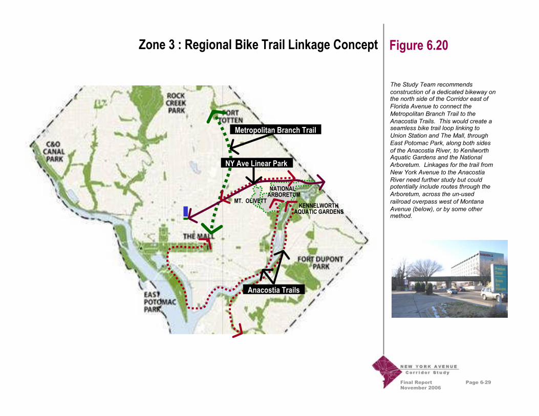
Final ReportNovember 2006
Page 6-29
Zone 3 : Regional Bike Trail Linkage Concept Figure 6.20
The Study Team recommendsconstruction of a dedicated bikeway onthe north side of the Corridor east ofFlorida Avenue to connect theMetropolitan Branch Trail to theAnacostia Trails. This would create aseamless bike trail loop linking toUnion Station and The Mall, throughEast Potomac Park, along both sidesof the Anacostia River, to KenilworthAquatic Gardens and the NationalArboretum. Linkages for the trail fromNew York Avenue to the AnacostiaRiver need further study but couldpotentially include routes through theArboretum, across the un-usedrailroad overpass west of MontanaAvenue (below), or by some othermethod.
Metropolitan Branch Trail
Anacostia Trails
NY Ave Linear Park
NATIONALARBORETUM
KENNELWORTHAQUATIC GARDENS
MT. OLIVETT
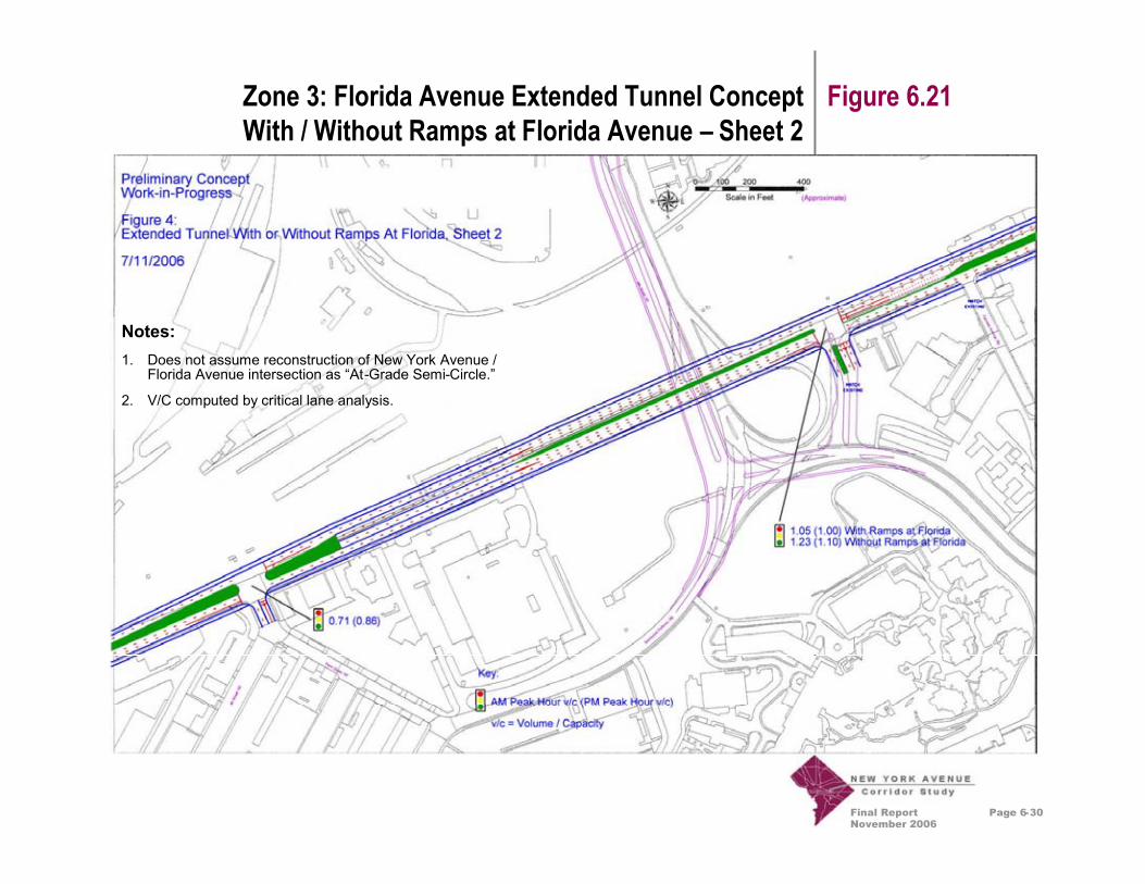
Final ReportNovember 2006
Page 6-30
Figure 6.21Zone 3: Florida Avenue Extended Tunnel ConceptWith / Without Ramps at Florida Avenue – Sheet 2
Notes:1. Does not assume reconstruction of New York Avenue /
Florida Avenue intersection as “At-Grade Semi-Circle.”
2. V/C computed by critical lane analysis.

Final ReportNovember 2006
Page 6-31
Zone 2: Framework Plan Figure 6.22
Recommendations:A. Create a new interchange
and focal point image atBladensburg Road
B. Enhance traffic circle imageat Montana Avenue
C. Improve landscape edgesalong roadway
D. Create architecturalguidelines overlay zone fornew buildings to encouragemore urban setbacks,heights, materials andpedestrian environment
E. Orient and site newbuildings to reinforce focalpoints and roadway edge
F. Extend image to connect toneighborhoods alongBladensburg Road,Montana Avenue, and WestVirginia Avenue
BLAD
ENSB
URG
MONTANAWESTVIR
GINIA
MONTANA
AB C
D
EE
E
E
EF
F
F
F
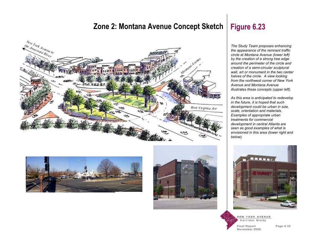
Final ReportNovember 2006
Page 6-32
Zone 2: Montana Avenue Concept Sketch Figure 6.23
The Study Team proposes enhancingthe appearance of the remnant trafficcircle at Montana Avenue (lower left)by the creation of a strong tree edgearound the perimeter of the circle andcreation of a semi-circular sculpturalwall, art or monument in the two centerhalves of the circle. A view lookingfrom the northwest corner of New YorkAvenue and Montana Avenueillustrates these concepts (upper left).
As this area is anticipated to redevelopin the future, it is hoped that suchdevelopment could be urban in size,scale, orientation and materials.Examples of appropriate urbantreatments for commercialdevelopment in central Atlanta areseen as good examples of what isenvisioned in this area (lower right andbelow).
West Virginia Ave
New York Avenue to
the Anacostia River
MontanaAvenue
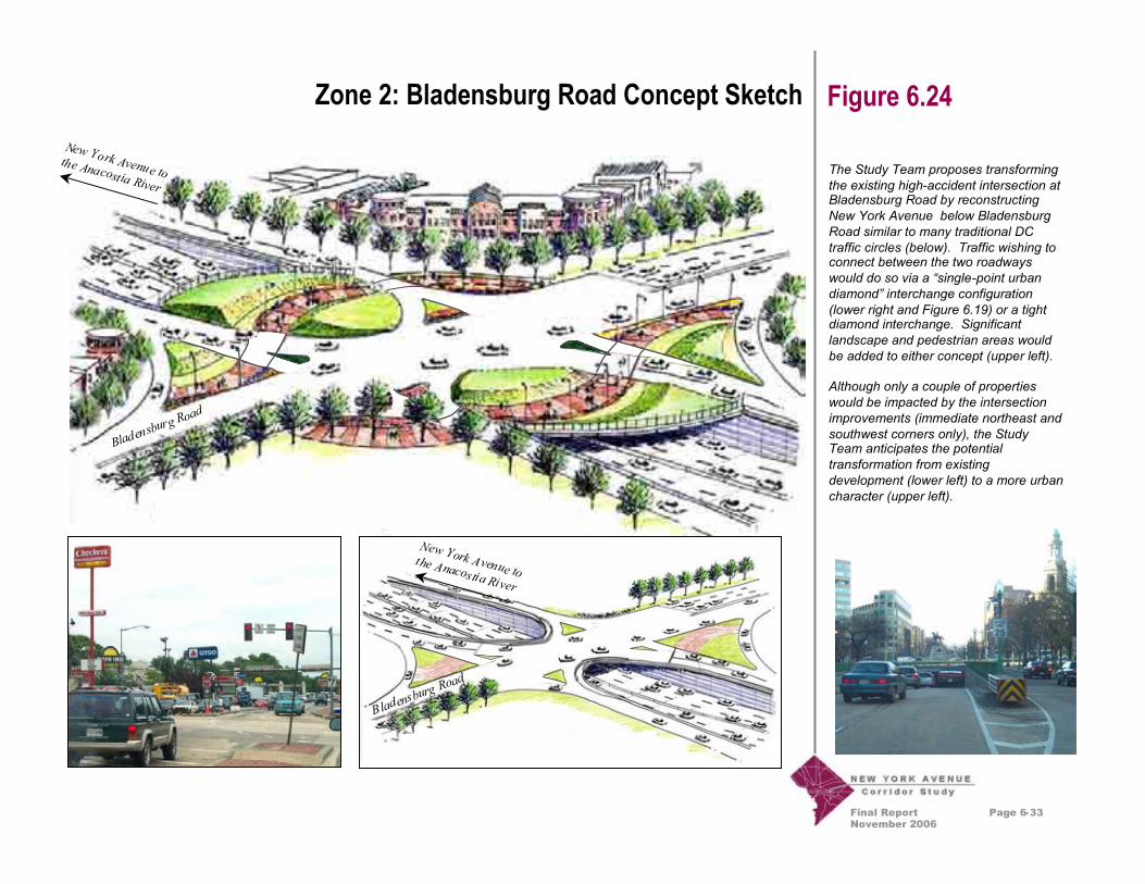
Final ReportNovember 2006
Page 6-33
Zone 2: Bladensburg Road Concept Sketch Figure 6.24
The Study Team proposes transformingthe existing high-accident intersection atBladensburg Road by reconstructingNew York Avenue below BladensburgRoad similar to many traditional DCtraffic circles (below). Traffic wishing toconnect between the two roadwayswould do so via a “single-point urbandiamond” interchange configuration(lower right and Figure 6.19) or a tightdiamond interchange. Significantlandscape and pedestrian areas wouldbe added to either concept (upper left).
Although only a couple of propertieswould be impacted by the intersectionimprovements (immediate northeast andsouthwest corners only), the StudyTeam anticipates the potentialtransformation from existingdevelopment (lower left) to a more urbancharacter (upper left).
Bladensb
urg Road
New York Avenue tothe Anacostia River
Bladensb
urg Road
New York Avenue tothe Anacostia River

Final ReportNovember 2006
Page 6-34
Zone 2: Bladensburg Road Concept Plan Figure 6.25
Recommendations:A. New York Avenue is
reconstructed below gradeto pass under BladensburgRoad
B. Create a new “single-pointurban diamond”interchange or “tightdiamond” interchange
C. Increase overpass deck forpedestrian and landscapeenhancements
D. Create a traffic circle imageusing plantings andpedestrian paving
E. Create opportunities fornew development thatresponds to circle
AA B CC
D
D
E
E
NORTH
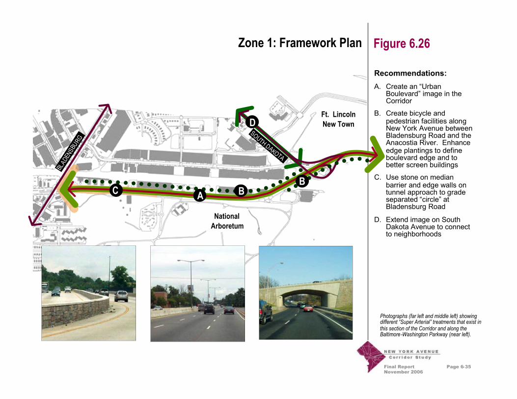
Final ReportNovember 2006
Recommendations:A. Create an “Urban
Boulevard” image in theCorridor
B. Create bicycle andpedestrian facilities alongNew York Avenue betweenBladensburg Road and theAnacostia River. Enhanceedge plantings to defineboulevard edge and tobetter screen buildings
C. Use stone on medianbarrier and edge walls ontunnel approach to gradeseparated “circle” atBladensburg Road
D. Extend image on SouthDakota Avenue to connectto neighborhoods
Page 6-35
Zone 1: Framework Plan Figure 6.26
Ft. LincolnNew Town
SOUTH DAKOTA
BLAD
ENSB
URG
A BB
C
D
Photographs (far left and middle left) showingdifferent “Super Arterial” treatments that exist inthis section of the Corridor and along theBaltimore-Washington Parkway (near left).
NationalArboretum

Final ReportNovember 2006
Page 6-36
Zone 1: Urban Boulevard Images Figure 6.27
Study Team members propose addinga number of “urban” design elementsto the super arterial portion of NewYork Avenue between the AnacostiaRiver and Bladensburg Road. Teammembers felt this zone needed toprovide a transition from the more ruraland natural appearing Baltimore-Washington Parkway to the urban DCavenue that is New York Avenue westof Montana Avenue. Although thiszone functions as a highway, there area number of design elements andtreatments that can be added to createa unique urban feeling. Some of theseideas include: raised planting zonesand a higher level of lighting (far left),articulated planting walls and terracedlandscape zones (upper right), use ofbrick for wall and overpass treatments(middle right), and use of stone, metaland concrete (lower right).

Final ReportNovember 2006
Page 7-1
Potential Land Acquisitions Chapter 7
7.1 Introduction
In general, at the eastern and western ends of the Corridor,the recommended improvements can be accommodatedwithin the existing roadway right-of-way. During the courseof this project, planners attempted to minimize the need toacquire active businesses or excessive amounts of land toaccommodate the proposed improvements. Overall, theconcepts proposed require approximately 6.6 acres of newright-of-way, but create an approximately 5.7 acre newdevelopment site on air-rights over I-395 south of itspresent intersection with New York Avenue.
The largest area of proposed land acquisition stretchesfrom west of Montana Avenue to east of Florida Avenue. Inthis portion of the Corridor, the addition of a wider medianand turn lanes would require the acquisition ofapproximately 4 acres of land. Since this would leave aremnant strip of land with little utility approximately 40 feetwide between the new right-of-way and the existing railroadright-of-way, it is recommended that this land be acquiredas well for a total of approximately 9 acres. A linear park isproposed for this undevelopable remnant property.
The character and right-of-way for New YorkAvenue changes widely from its eastern edge atFort Lincoln and the District Line (top), throughits middle section at Florida Avenue (middle) toits intersection with Mt. Vernon Square at theConvention Center (bottom).
The land acquisition estimates provided in this chapterwere developed assuming construction of the Bridgeconcept. In general, the anticipated land acquisitions wouldbe slightly less for the At-Grade and Extended Tunnelconcepts in Zone 4. The Extended Tunnel concept wouldnot require more land acquisition in Zone 3 than the Bridgeconcept, since the undevelopable remnant property isalready assumed to be taken and used for the linear park.The exact amount of property takings required for eachconcept, and the exact properties to be taken, will bedetermined during detailed planning studies.

Final ReportNovember 2006
Page 7-2
Potential Land Acquisitions Chapter 7
Examples of property needed for roadwayimprovements from portions of a vacant lot infront of the People’s Building (top), to an areaused for truck parking by Hechts (middle), to thehub-cap shop (bottom).
7.2 Land Acquisitions
Figure 7.1: Land Acquisitions Table on the following pagepresents an overview of the property impacts associatedwith the recommended improvements proposed for eachImprovement Zone. The following bullet points describethese calculations for each zone. Please note that acreagecalculations throughout this memorandum are for planningpurposes only and are based on take offs from sketch planconcepts. They are approximate only. No detailedengineering drawings or property surveys were available atthis preliminary planning stage.
Zone 1:• Land Acquired – One parcel of 0.5 acres.• Land Needed – 0.2 of the 0.5 acres.• Commercially Developable Remnants – Noremnants created.• Commercially Undevelopable Remnants – 0.3acres.
Zone 2:• Land Acquired – Parcels totaling 4 acres that arecurrently occupied by two restaurants and six othersmall businesses.• Land Needed – Only the front 24 feet of theseparcels are needed totaling 0.5 acres.• Commercially Developable Remnants – 3.5 acresof highly developable commercial property will beavailable.• Commercially Undevelopable Remnants – Noremnants created.
Zone 3:• Land Acquired – Parcels totaling 9 acres that arecurrently occupied by temporary parking, 2businesses and one motel.• Land Needed – Only the front 30 feet of theseparcels are needed totaling 4 acres.• Commercially Developable Remnants – Theremaining property depth is too narrow (40 feet) fordevelopment.• Commercially Undevelopable Remnants – 5 acres(40 feet by 5600 feet) remain and are proposed to beused for a linear park.
Zone 4:• Land Acquired –Parcels or portions of parcelstotaling 4.3 acres that are currently undeveloped(Jemal Block), have parking (FedEx Block), or arestaurant (Wendy’s Block).• Land Needed – 2.1 acres of these parcels areneeded.• Commercially Developable Remnants – The JemalBlock contains 1.8 acres of remaining developableland of the original 3 acre parcel.• Commercially Undevelopable Remnants – Theremaining 0.4 acres of the Wendy’s Block isundevelopable.
Zone 5:
• Commercially Developable Remnants – A new 5.7acre parcel is created in air-rights development overI-395.
Zone 6:• No land acquisitions proposed.

Final ReportNovember 2006
Page 7-3
Land Acquisitions Table Figure 7.1
Land Acquisitions TableStudy Team members attempted tolimit impacts and disruptions tobusinesses and residences in theconsideration of improvementalternatives. Where possible, ifadditional right-of-way was needed toaccommodate recommendedimprovements, this right-of-way wastaken from the side of the road withthe least number of impacts.
Even though in many cases the actualbuilding structure is not impacted, ifsome of the property, such as thefrontage, was needed for roadwayimprovements, then this was countedas an impact. Many of theseproperties, however, could remain inactive use (with alternativeaccommodations for parking) or couldbe re-used or assembled forredevelopment.
ImprovementZone La
ndAcquired
(acres)
LandNeeded
(acres)
Commercially
Developable
Remnants(acres)
Commercially
Undevelopable
Remnants(acres)
NewPark
Opportunity
(acres)
Zoning
Existing Uses Impacted NewDevelopment
OpportunityinDC
(acres)
Zone 1 0.5 0.2 0.3 0.0 0.0 C-M-2 Checkers Drive Thru Restaurant 0.0
Zone 2 4.0 0.5 3.5 0.0 0.0 C-M-22 Restaurants,4 Commercial Businesses 0.0
Zone 3 9.0 4.0 0.0 0.0 5.0 MTruck Parking, 1 Motel,2 Commercial Businesses 0.0
Zone 4 4.3 2.1 1.8 0.4 0.0 C-3-C 1 Restaurant 0.0
Zone 5 0.0 0.0 0.0 0.0 0.0 None 0.0
Zone 6 0.0 0.0 0.0 0.0 0.0An open tunnel trench whereI-395 now comes to the surfacewould be buried
5.5
Total 17.8 6.8 5.6 0.4 5.0 5.5
Notes:Land Acquired: Includes acreage of total parcel if business taken or more than 30% of vacant parcel taken.Zone 1: Commercially Developable Remnants: Assumes consolidation of Checkers remnant with adjoining parcels.Zone 2: Land Acquired: Land acquisitions could be reduced some through alternative engineering design.Zone 3: NewPark Opportunity: Due to narrow width (40 feet x 5600 feet), assumes conversion to linear park.Zone 4: Commercially Undevelopable Remnants: 1.8 is remnant of existing vacant 3.0 acre Jemal Block.Zone 4: At-Grade Option Land Needed: Land needed for the At-Grade Intersection Option would be 1.5 acres.Zone 6: NewDevelopment Opportunity: Includes new air-right development parcel over I-395.

Final ReportNovember 2006
Page 8-1
Environmental Analysis Chapter 8
8.1 Introduction
Environmental analyses of the recommendations of theFinal Report were performed at a preliminary level. Thislevel of detail is appropriate to identify potentialenvironmental concerns, but does not provide the level ofdetail required for an environmental assessment orenvironmental impact statement as defined by the NationalEnvironmental Policy Act (NEPA) and implementingregulations.

Final ReportNovember 2006
Page 8-2
Environmental Analysis Chapter 8
8.2 Impacts to the ManmadeEnvironment
The majority of the work proposed within the study area willremain within the New York Avenue right-of-way. However,there will be some impacts to the residential communityalong New York Avenue immediately west of North CapitolStreet. Although no property takings are contemplated,there will be impacts related to construction activities (i.e.dust, noise, temporary road closures, etc.) associated withthe proposal to extend I-395 in a tunnel beneath New YorkAvenue from 4th Street, NW to some point east of NorthCapitol Street. Once completed, there should besubstantial beneficial effects to this community by removingthe traffic destined to and from I-395 (and its associatednoise and air pollution) from this segment of New YorkAvenue, making it safer for pedestrians and enhancing itsquality as a residential area.
Although only indirect impacts are anticipated to theexisting residential communities surrounding New YorkAvenue, direct impacts can be expected to the commercialand industrial community within the study area. Somemixed commercial and industrial areas will be displaced bythis project. The intersection of New York Avenue andBladensburg Road, where improvements may be created,will potentially require widening the four corners adjacent tothe intersection. Three of these corners have gas stations.
Additionally, the businesses along New York Avenue nearthe Bladensburg Road intersection will likely experiencedisruptions to their access to New York Avenue during theperiod of construction, and may likely require the provisionof new access routes once the roadway improvements arecompleted.
As a result of the roadway widening, there may be a needto acquire portions of the railroad property, however themajority of work should remain within the existing roadwayright-of-way. Taking this area north of New York Avenue,as opposed to south of New York Avenue, minimizesadditional impacts to historic property, churches, an animalshelter, and National Park Service property.
The majority of displacements will occur just west of FloridaAvenue. Construction of the I-395 tunnel will causeimpacts to approximately two blocks, located west ofFlorida Avenue, east of North Capitol Street and boundedby P Street to the north and N Street to the south. The areaconsists of mostly small scale commercial establishmentsincluding a fast food restaurant and a gas station. Inaddition, there is a large FedEx building located east ofFlorida Avenue and north of New York Avenue. Acquisitionof some property may be required from this site, anddetailed engineering studies will be required to avoiddisplacement of the building itself.

Final ReportNovember 2006
Page 8-3
Environmental Analysis Chapter 8
8.3 Environmental Justice
Executive Order 12898, “Federal Actions to AddressEnvironmental Justice in Minority and Low-IncomePopulations,” provides the administrative foundation forensuring that the Federal government does not supportprograms, policies, and activities that have adisproportionate effect on minority and low-incomepopulations. Year 2000 Census tract information was usedto initiate the identification of minority and low-incomepopulations, which the U.S. Department of Transportationdefines as populations with significant concentrations ofAfrican-American, Hispanic, Asian, and Native Americanpeople, or populations with incomes at or below the federalpoverty level (DOT, 1997).
The New York Avenue Corridor study area consists of apredominantly minority population, according to the censusdata. Additionally, the majority of the area also has over 20percent of its population below the federally defined povertylevel. Therefore, the impacts of the proposed New YorkAvenue Corridor projects will unavoidably affect minorityand low-income populations. However, many of theimpacts are beneficial – such as removing regional trafficfrom the residential neighborhood immediately adjacent toNew York Avenue between North Capitol Street and 4thStreet, NW. Most of the adverse impacts of the proposedprojects will be temporary impacts associated withconstruction. Yet , with an already initiated combination ofpublic involvement and proposed streetscapeenhancements to the Corridor, many of these potentialimpacts can begin to be offset.
Disturbance limits for proposed activities have beenminimized to avoid as many as possible commercial andindustrial areas that provide economic support to the area,as well as to avoid any direct impacts to residentialdevelopments. Except for the temporary constructionimpacts previously mentioned, there are no anticipatedenvironmental health impacts and no natural or physicalimpacts within the study area.
During the public outreach activities conduced to date, anumber of concerns have been voiced by the public. Theseconcerns include truck traffic during construction, impactsof the proposed tunnel on existing neighborhoods, andenvironmental impacts due to increased traffic onresidential streets. These issues, and others that mayarise, such as indirect impacts, changes in property values,changes in neighborhood parking, changes in employmentopportunities, stormwater impacts on the Anacostia River,etc., will need to be fully explored during the NEPA processand accompanying detailed planning and engineeringefforts.

Final ReportNovember 2006
Page 8-4
Environmental Analysis Chapter 8
8.4 Impacts to the CulturalEnvironment
There are no expected adverse effects to the existinghistoric resources of the New York Avenue Corridor studyarea. No historic standing structures would be demolished,nor are there any anticipated archeological impacts as aresult of the improvements.
Much of the proposed work does fall within the L’EnfantHistoric area, but there will be a minimal area of surfaceimpacts to the roadway and its surroundings, except for thearea between Florida Avenue and North Capitol Street.Between Florida Avenue and North Capitol Street, theportal for the I-395 tunnel and a possible I-395 bridge overFlorida Avenue will have impacts on a variety of views andpotentially alter the operations of First Street, NE. Althoughsome of these impacts could be beneficial, there wasgeneral agreement that preventing the flow of vehicular orpedestrian traffic along First Street, NE between FloridaAvenue and N Street, NE would be an adverse impact.Further coordination with the District’s State HistoricPreservation Office (SHPO) will be required throughout theNEPA process.
8.5 Impacts to the NaturalEnvironment
Very minor impacts to the natural environment areanticipated during New York Avenue improvements. Fewnatural features exist within the projected areas ofdisturbance due to previous actions that have taken placealong the Corridor over a period of more than 100 years.The roadway widening may require some trees to be cutand will create an increase in impervious surface where theexisting tree line is adjacent to the railway and truck parkingfacility. However, the creation a pedestrian-cyclist park inthis area (that is now a barren truck parking area) maymitigate some of these impacts. Additionally, this area isnot within a floodplain and does not contain any waters ofthe US that would require a 404 permit.
At this time, no substantial improvements are proposed asfar to the east as the National Arboretum, the AnacostiaRiver, and adjacent wetlands. Therefore no impacts areanticipated to these important resources. However, asdiscussed in Figure 6.12, extension of the proposedbikeway could someday occur in this area.
Although it is not anticipated that the project will produceany increase in noise or air pollution outside of thetemporary construction impacts, further noise and airanalyses may be required during the NEPA process.

Final ReportNovember 2006
Page 8-5
Environmental Analysis Chapter 8
8.6 Hazardous Materials
Based on the scale and location of potential corridorimprovements, there are some locations within the studyarea where the results of this hazardous waste inventoryshould be more closely examined during future Phase I andPhase II Environmental Site Assessments. These areshown in the Environmental Analysis TechnicalMemorandum. These sites should not be taken as the onlylocations in which hazardous materials are a potentialenvironmental concern.
Although other identified sites are not immediately adjacentto New York Avenue and the proposed corridorimprovements, other factors play a role in hazardous wastecontamination issues such as the direction of groundwaterflow, the type of hazardous material contained, and thehistory of use of these materials and the site. For example,the largest land acquisition proposed for this project islocated in the area to the north of New York Avenue, east ofFlorida Avenue. It currently serves as a truck marshallingyard, and the history of use at the site should beinvestigated.
Final ReportNovember 2006
Page 9-1
Proposed Financing Plan Chapter 9
9.1 Introduction
The purpose of preparing a financing plan is to ensure thatthe recommendations of the Study, as described in thisFinal Report, are financially realistic. With this approach, itis hoped that the Final Report will be implementable in ashorter timeframe than might otherwise occur.
The proposed financing plan describes both conventionaland alternate means for funding the Final Reportimprovements. The unit cost estimates for design,construction, and contingency costs were developed usingthe Maryland State Highway Administration’s 2002 HighwayConstruction Cost Estimating Manual, which served as thebest and most readily available approximation for theDistrict of Columbia. In cases where state estimatescontained regional variations, the emphasis was placed ondata from regions adjacent to the District – comprisingMontgomery and Prince George’s Counties. Right-of-waycosts were generated using information on commercial landvalues from the CoStar Group, Inc. In order to reflect thehighly preliminary nature of the estimates, the guidingapproach was to select the most conservative values whereranges were provided.
Final ReportNovember 2006
Page 9-2
Proposed Financing Plan Chapter 9
9.2 Development of Cost Estimates
As a first step in deriving the cost estimates, the entireCorridor was divided into the six functionally independentstand-alone segments, or zones described in Chapter 6.The engineering cost estimates and a “best case” (i.e.,shortest timeframe) phasing timeline for the construction ofthe recommended improvements were developed for eachzone, resulting in a schedule of aggregated annualconstruction costs for the various segments over theestimated life cycle of the project. Total costs in constant2004 dollars were computed under three broad costcategories – preliminary engineering, construction, andright-of-way – for each of the project segments, as shown inTable 9.1: Project Cost Estimates by Zone. Using theabove methodology and assuming the “best case” 13-yeartotal duration project completion timeframe (based on aFiscal Year (FY) 2006, Quarter 2 start date and a FY 2019,Quarter 2 end date), the total cost of all corridorimprovements is estimated at about $955 million.
It should be noted that several factors not considered in thecost estimates—namely, financing costs, inflation, andultimate timeframe of completion—will increase the finalprice tag of the project by some indeterminate, albeitappreciable amount. It should also be noted that theinformation in Table 9.1 for Zone 4 is based upon the
Bridge concept (Concept I-6 in Figure 6.2a). The At-Gradeintersection concept (Concept G-3 in Figure 6.2a) wouldhave a lower cost; the Extended Tunnel concept wouldhave a higher cost. (As discussed in Chapter 6, theadditional cost of the Extended Tunnel is estimated to beapproximately $450 million, in 2004 dollars.)
Using a simple illustration of the effect of inflation alone, anaverage annual inflation rate of 2.5 percent would increasethe project cost to about $1.2 billion in year-of-expenditure(YOE) dollars by the time it is completed under the “bestcase” scenario of 13 years. A 3.0 percent annual inflationrate would yield a total price tag of about $1.25 billion inYOE dollars, while the use of a 4.0 percent annual inflationrate would result in a total estimated project cost of about$1.37 billion in YOE dollars.
These inflationary effects will increase if the project timelineis extended from the “best case” scenario. Additionally, theissue of finance costs also merits consideration. Thetradeoff here would be between the cost of the potentialfinancing charges versus the ability to construct the projectearlier, and hence reduce inflationary effects and accrueuser benefits earlier than would be the case if theconstruction period were to be extended.
Final ReportNovember 2006
Page 9-3
Proposed Financing Plan Chapter 9
9.3 Potential Funding Sources andStaging of Implementation
As a corollary step, the annual estimated funding needs forthe Corridor were related to available “conventional” fundingsources, and alternate phasing scenarios and “non-conventional” sources were explored as potential sourcesof additional funding. Aligning future resources withanticipated expenditures will likely require a variety of policyjudgments and iterative “what-if” calculations regardingproject schedule, general prioritization among the varioussegments of the Corridor, and overall project sequencingonce funding becomes available. A sample envelope ofpossibilities regarding alternative phasing scenarios canpotentially entail: (a) selective prioritization of only the mostsignificant, complex and time-sensitive segments forearliest construction phasing as funding becomes available;(b) deferring less complicated, beautification treatmentsuntil the priority segments are constructed and additionalfunding comes to fruition; (c) extending the timeframe forthe entire Corridor from an assumed best case scenario toa longer, yet still “acceptable” time period; and/or (d)positioning major, expensive construction activities at thecusp of opportunity points to take advantage of potentialfuture increases in Federal-aid highway apportionments.
It is very likely that a large, costly capital project such asthe New York Avenue Corridor will require the use of acombination of historically-available conventional and non-conventional, or innovative, revenue sources to finance itsconstruction. The normal processes of allocation of
conventional Federal-aid resources may not yield large newrevenues since the most recent 2003 Constrained LongRange Plan (CLRP) Update for the Washingtonmetropolitan area has no funding programmed for NewYork Avenue Corridor improvements (with the exception ofsome funding set aside for the 9th Street Bridge in the FY2004-2009 Transportation Improvement Program, or TIP),and the Corridor is presently on the District’s list of severalcompeting unfunded projects. However, the potential forincreased Federal-aid funding during future (2010 and2016) reauthorization cycles may offer more promise forthis revenue source.
Bond-generated revenue through the use of District issuedgeneral obligation bonds is expected to be one of the mostcommon and reliable sources of new revenues to approachthe breadth of commitments needed to fund the New YorkAvenue Corridor. It is likely that a mix of bond revenues tobe repaid in future years, along with crucial Federal funding,present the most viable means for partial, if not full,financing of this project.
While not as reliable or predictable, earmarkedtransportation improvement funds also present sometangible, although unknown potential for additional funding,as evidenced by the recent example of the South CapitolStreet Corridor earmark sponsored by Maryland’sCongressional delegation. Additionally, the use of tax

Final ReportNovember 2006
Page 9-4
Proposed Financing Plan Chapter 9
increment financing (TIF) which captures the marginalbenefits of public investments, has some limited potential tofund the less complicated beautification and urbanboulevard enhancement activities that will improve thestreetscape for nearby businesses. The creation of an airrights development in a portion of the Corridor couldgenerate a significant increment of funding, as well asfuture continuing tax revenues that could be dedicated tothe overall project.
In tandem with such conventional sources, some non-conventional means such as tolling/value pricing alsoprovide some promise for funding corridor improvements.Although tolling facilities would be politically difficult toimplement on an unlimited access, existing free facilitysuch as New York Avenue, several mitigating factors canmake this a more viable option. For instance, significantimprovements to roadway safety and the elimination ofbottlenecks could justify the use of tolls as equitable userfees. Moreover, the inclusion of nearby entry points to theDistrict as part of the entire tolling regime can deter thenegative spillover effects of drivers who elect to usealternate routes to avoid tolls. Significant interest in theapplication of value pricing is reflected by the work of theMetropolitan Washington Council of Government’s TaskForce on Value Pricing for Transportation in theWashington Region. In May 2004, the Task Forceidentified the New York Avenue Corridor as an element inthe regional variable pricing system of variably pricedhighway travel lanes that could be in operation by 2030 forthe Transportation Planning Board’s (TPB) RegionalMobility and Accessibility Study.
Although the creation of a regional framework for fundingthe Corridor is still in rather nascent stages today, it isconceivable that a more directed stance can develop overthe medium to long term that could provide more viabilitytoward revenue sharing. While the Corridor serves regionalmobility purposes as a gateway to the District, there areobvious administrative and political impediments towardenlisting the aid of other states. Although most of theexternal users of the Corridor are Maryland residents,license plate surveys could provide fair and objective datafor determining an appropriate apportionment of financialresponsibilities among Maryland, the District, and Virginia.
Of lesser viability to Corridor funding are homeland securitygrants which have largely been intended for emergencypreparedness training, equipment, technical assistance andoutreach. Also, smaller private-public partnerships, suchas aid from insurance companies who stand to ultimatelyaccrue benefits from reduced crash claims as a result ofsafety-related roadway improvements, may potentially yieldsome minimal revenue for initial planning and engineeringstudies, but not nearly enough to make a dent in theconstruction costs of a project of this scale. The possibilityof a Benefit Assessment District as a significant source offunding is also highly speculative and uncertain. Thismechanism was used by landowners near the intersectionof New York and Florida Avenues to fund a substantialportion of the new Metrorail Station there. If landownersbelieve that new roadway infrastructure would substantiallyenhance their property values, it could be used again.

Final ReportNovember 2006
Page 9-5
Proposed Financing Plan Chapter 9
In sum, the predictability and potentially high revenue yieldof traditional Federal-aid highway appropriations andgeneral obligation bonds make these the most likely mainsources of revenue. Of course, additional revenue createdfrom potential air rights development, tax incrementfinancing, regional revenue share mechanisms, tolling andother options may provide the opportunity for additionalrevenue if these mechanisms come to fruition and aresuccessfully implemented. At this point, the likelihood ofdependence on these sources is conceptual andpreliminary. As more detailed planning studies areperformed as part of the NEPA process, efforts should beundertaken to refine the value of the construction costsassociated with each element of the overall project. At thattime, more detailed financing strategies of these potentialsources will also need to be investigated.

Final ReportNovember 2006
Page 9-6
Project Cost Estimates by Zone Table 9.1
8.5034$183,008,000TOTAL
2.008$93,600,000Construction
5.7523$11,000,000Preliminary Engineering
0.753$78,408,000Right-of-WayZone 3
(Linear Park and AvenueEnhancements)
8.7535$108,560,000TOTAL **
3.0012$56,000,000Construction
5.5022$9,000,000Preliminary Engineering
1.004$43,560,000Right-of-Way
Zone 2(Bladensburg Road Intersection)
3.0012$6,400,000TOTAL
0.753$5,400,000Construction
2.259$1,000,000Preliminary Engineering
N/AN/A* N/ARight-of-WayZone 2
(Montana Avenue Intersection -Beautifications)
3.7515$30,600,000TOTAL
1.004$26,600,000Construction
2.7511$4,000,000Preliminary Engineering
N/AN/A* N/ARight-of-Way
Zone 1(Urban Boulevard Enhancements)
Duration(in Number of Years)
Duration(in Quarterly Periods)CostActivityProject

Final ReportNovember 2006
Page 9-7
Project Cost Estimates by Zone Table 9.1Continued
N/AN/A* N/ARight-of-WayZone 4
(Railroad OverpassReconstruction and Florida
Avenue Intersection)
4.7519$17,000,000Preliminary Engineering
3.5014$107,800,000Construction
7.7531$124,800,000TOTAL ***
In Zones 4 and 5 (I-395 Tunnel Extension & Local Street Restoration), the cumulative duration of activity is only 53 quarterly periods because preliminaryengineering, construction, and right-of-way acquisition activities overlap during nine quarterly periods.
****
In Zone 4 (Railroad Overpass Reconstruction and Florida Avenue Intersection), the cumulative duration of activity is only 31 quarterly periods becausepreliminary engineering and construction activities overlap during two quarterly periods.
***
In Zone 2 (Bladensburg Road Intersection), the cumulative activity is only 35 quarters because preliminary engineering and construction activities overlapduring three quarterly periods.
**
Zones 1 and 6 did not require any additional right-of-way acreage. In Zone 2, the Bladensburg Road Intersection portion required additional right-of-way, aswell as the I-395 Tunnel Extension & Local Street Restoration portion of Zones 4 and 5.
GRAND TOTAL $955,056,600
*
All Zones
3.7515$41,000,000TOTAL
1.004$35,000,000Construction
2.7511$6,000,000Preliminary Engineering
N/AN/A* N/ARight-of-Way
Zone 6(Urban Avenue Enhancements)
13.2553$460,688,000TOTAL ****
6.0024$326,400,000Construction
9.0036$50,000,000Preliminary Engineering
0.502$84,288,600Right-of-WayZones 4 and 5
(I-395 Tunnel Extension& Local Street Restoration)
Duration(in Number of Years)
Duration(in Quarterly Periods)CostActivityProject

Final ReportNovember 2006
Page 10-1
Next Steps Chapter 10
This concludes the New York Avenue Corridor Study. ThisReport will be used as the starting point for decisions toallocate funds to some or all of the improvements itrecommends and for the preliminary engineering andenvironmental analysis that will be necessary to advancesuch improvements. However, it will ultimately be up toresidents, businesses, and other stakeholders to motivatepoliticians to allocate funding for the projects outlined in thisreport.
The New York Avenue Corridor Study Final Report is theculmination of several years of effort on the part of theOversight Committee, and represents the best efforts ofthat Committee over that period of time, using the bestinformation available during that time. However, it isentirely possible the District will conclude that otherapproaches should be taken. (For example, the Districtmay decide that the results of the NCPC charrette shouldbe implemented at Florida Avenue.) If so, therecommendations of the New York Avenue Corridor StudyFinal Report could (and should) be re-examined andupdated at that time.

Appendix A
Excerpts from the Draft Plan
Chapter 6Preliminary Transportation Concepts
Chapter 7Evaluation Criteria

Draft Plan
New York Avenue Corridor StudyDraft PlanExcerpts
April 2005
New LookNew LifeNew York Avenue Corridor

Draft Plan
Table of Contents
1. Introduction
2. Transportation Issues
3. Land Use Issues
4. Urban Design Issues
5. Community Input
6. Preliminary Transportation Concepts
7. Evaluation Criteria
8. Recommendations
9. Potential Land Acquisitions
10. Environmental Analysis
11. Proposed Financing Plan
12. Next Steps
Project Team
District of Columbia
• Department of Transportation
• Office of Planning
• Department of Housing andCommunity Development
Consultant Team
• URS Corporation
• HNTB Architects EngineersPlanners
• Cambridge Systematics, Inc.
• Justice and SustainabilityAssociates, LLC
• Parsons Brinckerhoff QuadeDouglas, Inc.
• Economic Research Associates

Draft Plan
List of Tables & Figures
Chapter 6Figure 6.1: Different Facility Options Page 6-6Figure 6.2: Bladensburg Road: Grade-Separated Traffic Circle Page 6-7Figure 6.3: Bladensburg Road: Diamond Interchange Page 6-8Figure 6.4: Bladensburg Road: Continuous Flow Intersection Page 6-9Figure 6.5: Montana Avenue: Improve Existing Traffic Circle Page 6-10Figure 6.6: Montana Avenue: 4-Leg Intersection Page 6-11Figure 6.7: Montana Avenue: Grade-Separated Traffic Circle Page 6-12Figure 6.8: Montana Avenue: Diamond Interchange Page 6-13Figure 6.9: Brentwood Parkway / 4th Street / 9th Street: Ramp Connections Page 6-14Figure 6.10: Brentwood Parkway / 9th Street: Diamond Interchange Page 6-15Figure 6.11: Florida Avenue: Improve 4-Leg Intersection Page 6-16Figure 6.12: Florida Avenue: Grade-Separated Traffic Circle Page 6-17Figure 6.13: Florida Avenue: Diamond Interchange Page 6-18Figure 6.14: Florida Avenue: Harry Thomas Way Connector Page 6-19Figure 6.15: Florida Avenue: Diamond Interchange and Tunnel to I-395 Page 6-20Figure 6.16: I-395: Depressed Left Turn Lane Page 6-21Figure 6.17: I-395: Tunnel Connection to Florida Avenue Page 6-22
Chapter 7Figure 7.1: Evaluation Criteria Matrix Page 7-3

Draft Plan Page 6-1
Preliminary Transportation Concepts Chapter 6
6.1 Preliminary TransportationConcepts
One of the primary purposes of Task 5 of the New YorkAvenue Corridor Study was to develop preliminarytransportation concepts to be considered in thedevelopment of final transportation recommendations. Thischapter presents these concepts as presented to thecommunity at public meetings on May 20, 2003 and June17, 2003.
Most of the concepts presented in this chapter are nolonger relevant to the recommendations of the draft plan.They are presented here for historical perspective. If youare primarily interested in the current recommendations,please skip to Chapter 8.
Major transportation improvement options for the Corridorwere developed by exploring four distinct types of roadwayfacilities. These are illustrated in Figure 6.1: DifferentFacility Options and include: a local street option, aboulevard option, a super arterial option, and a reversiblelanes option.
In addition to the four roadway options, a minimalintervention option was explored that would involve onlyminor improvements to the existing New York Avenueinfrastructure.
From these options, overall corridor concepts weredeveloped and included the following:
Minimal Intervention Option
As the name implies, this concept would leave New YorkAvenue in its current configuration throughout most of thestudy area. Left turn lanes would be added at fiveintersections (Fairview, Kendall, Fenwick, 16th and 4th) inorder to improve traffic flow at those signalizedintersections. One or more pedestrian signals would alsobe added to the Corridor, in the area between I-395 andNorth Capitol Street.
On balance, this concept would provide approximately thesame vehicular traffic-carrying capacity as currently exists:traffic operations would be improved at the newly-widenedintersections, but would be diminished somewhat at thenew pedestrian signals. Non-motorized modes (bicycle andpedestrians) would benefit from the new pedestrian signals,but would otherwise be essentially unaffected by thisoption.
• Minimal Intervention• Boulevard Emphasis• Super Arterial Emphasis• Combination Super Arterial/Boulevard Emphasis• Reversible Lanes
Draft Plan Page 6-2
Transportation Concepts Chapter 6
Boulevard Emphasis Option
This concept would substantially modify both the operationand appearance of New York Avenue. With the provision ofa wide center median, virtually all intersections (with thepossible exception of Bladensburg) would be modified,either by creating additional lanes for turning vehicles,reconstruction of at-grade DC-style traffic circles, orreconstruction as grade-separated DC-style traffic circles.In addition, driveways and curb cuts would be limited, andtwo minor intersections would be eliminated (Fairview andFenwick), by dead-ending the side streets. If the FloridaAvenue intersection were to be reconstructed as a grade-separated traffic circle, a new at-grade intersection could becreated at North Capitol Street, replacing the existingdiamond interchange. Finally, a depressed left-turn lane,intended to carry traffic from westbound New York Avenueonto I-395, could be provided.
The net change in vehicular traffic-carrying capacity woulddepend upon the final configurations selected for keyintersections. On balance, however, the change would beexpected to be an increase in capacity, perhaps asubstantial increase. Non-motorized modes would benefitfrom improvements in facilities alongside New YorkAvenue, and from improved facilities to cross majorintersections.
Super Arterial Emphasis Option
As a “super arterial,” New York Avenue would both lookand function very differently than it does today. Under thisconcept, there would be no at-grade intersections, orprivate driveways from Florida Avenue to the District line.All access to the Corridor in this area would be made frominterchanges (which could include grade-separated trafficcircles) at Bladensburg, West Virginia-Montana, Brentwood,and Florida. All other existing intersections in this areawould be dead-ended, with improvements in nearby surfacestreets likely to be required, in order to provide access fromthose roadways to New York Avenue.
Starting in the vicinity of Florida Avenue, a tunnel wouldcarry through traffic to/from I-395, resulting in an at-gradeintersection at North Capitol Street. From North CapitolStreet to the west, existing New York Avenue would be ableto function more as a local street than an arterial, withexisting at-grade intersections remaining.
This option would provide the most substantial increase inthe vehicular traffic-carrying capacity of New York Avenueof any alternative under consideration. Non-motorizedmodes would be served by facilities separated from NewYork Avenue by concrete barriers, although not in as“friendly” a manner as would be possible under theBoulevard Emphasis option.
Draft Plan Page 6-3
Transportation Concepts Chapter 6
Super Arterial/Boulevard Emphasis Option
This option was developed in recognition of the fact that a“one size fits all” approach might not be desirable for theNew York Avenue Corridor. That is, there may be somesegments of the Corridor in which a super arterial might bethe best fit; in others, a boulevard might best meet theneeds of the District. The descriptions provided above forthe two components of this concept apply here as well.
Reversible Lanes
The existing median on New York Avenue would beremoved under this concept; it would be replaced by aseventh travel lane. This seventh lane, in the center of theroadway, would be used for westbound traffic in themorning peak period and for eastbound traffic in theevening peak period. During off-peak periods during theday, in the evenings, and on weekends, this new centerlane would function as a two-way left turn lane. Thisreversible lane would somewhat improve the vehiculartraffic-carrying capacity of the Corridor. Offsetting thisimprovement, to some extent, would be the probable needto restrict turning movements at some intersections duringpeak periods. Pedestrians and bicycles could still beaccommodated alongside the roadway, as they areproposed to be accommodated under the BoulevardEmphasis concept.
More detailed descriptions of how each of these conceptswould have been applied to individual locations within theCorridor may be found in the Task 5 SummaryMemorandum. These concepts were then evaluatedagainst each other using a set of criteria described in thenext chapter of this Draft Plan.

Draft Plan Page 6-4
Transportation Concepts Chapter 6
6.2 Intersection Options
Several of the general concepts have optional ways thatroadway junctions can be treated. For example, under theBoulevard Emphasis concept, intersections can be treatedas conventional signalized 4-leg intersections, at-gradetraffic circles, or grade-separated traffic circles. Under theSuper Arterial Emphasis Concept, all existing at-gradejunctions would then be converted into grade-separatedinterchanges.
The following paragraphs present some of the pros andcons of each intersection treatment option. Figures 6.2through 6.17 compare intersection treatment options foreach major intersection along the Corridor. Boulevard Emphasis – At-Grade Traffic Circles
• Reduces the number of accidents and improvestraffic movement at an intersection by removing left-turning vehicles from through lanes and providing leftturn lanes with a green arrow
• Maintains the “local street” feel of the roadway• Is transit and pedestrian friendly
• Does not consume large areas of land for theimprovement
• Does not significantly reduce congestion
• Reduces the severity of accidents at an intersection
• Adds green space and is aesthetically pleasing butrequires a large radius and land area
• Blends well with other corridors in DC• Could help stimulate quality development
• Offers opportunities for new focal points and greenspace improving the aesthetic character of theroadway
• May increase congestion
Illustrations showing a 4-Leg Intersection (top)and At-Grade Traffic Circle (bottom) at Montanaand New York Avenues
Boulevard Emphasis – 4 Leg Intersections

Draft Plan Page 6-5
Boulevard Emphasis – Grade-Separated Traffic Circles
• Reduces the severity of accidents at an intersection• Adds green space with less land area needed due to
a smaller radius of the circle
• Reduces congestion by allowing one of theintersecting roads to bypass the circle withoutdisrupting circle operations
• Less transit and pedestrian friendly than at-gradetraffic circle
• Offers opportunities for new focal points and greenspace, improving the aesthetic character of theroadway
Transportation Concepts Chapter 6
Super Arterial Emphasis – Grade-SeparatedInterchange
• Reduces the number of accidents at an intersection• Reduces congestion: allows traffic to move at higher
speeds and with less interruption than a corridor withsignalized intersections and access to businessesalong the main route
• Impacts nearby properties and neighborhoods• Properties adjacent to NY Avenue may be taken
(partially or completely)
• Business entrances may be relocated• Traffic wishing to access local businesses would be
redirected along frontage roads• Some roads that currently intersect New York
Avenue may have to be accessed thru a differentroute; therefore, traffic thru neighborhoods mayincrease
• Is not necessarily pedestrian or transit friendly
Illustrations showing a Grade-Separated TrafficCircle (top) and Grade-Separated Interchangeat Montana and New York Avenues

Draft Plan Page 6-6
Different Facility Options Figure 6.1
LOCAL STREET• 4 to 6 lanes wide (possibly including
parking at curb)• Wide sidewalks at curb with street trees
and landscaping
• No landscaped or wide medians
BOULEVARD
• Wide center median• Additional lanes at intersections for left
turns
• Limited number of driveways / curb cuts• Dedicated Bicycle and Sidewalk areas
SUPER ARTERIAL
• Up to 55 mph speed limit• No traffic signals
• Concrete median barrier between opposingtraffic and pedestrian areas
• Entry and Exit Ramps/Interchanges to localstreets
• No curb cuts or driveways to adjacentproperty
REVERSIBLE LANES
• Reduces traffic congestion by providingextra lane(s) in direction of rush-hour flow
• Minimizes the width of road by notdedicating lanes to fixed flow direction
• No medians – Signals control lane direction
• Landscape generally limited to sides of theroad
LOCAL STREET
BOULEVARD
SUPER ARTERIAL
REVERSIBLE LANES

Draft Plan
D
D
Figure 6.2
Boulevard Emphasis
AA
Concept Elements
A. New York Avenue crosses underneathBladensburg Road without stoppingbeneath a new overpass
B. New traffic circle constructed atBladensburg Road
C. Ramps connect Bladensburg Roadwith New York Avenue (all turningmovements now possible)
D. Only two properties with majorimpacts
B
C
C
C
C
Page 6-7
Bladensburg Road: Grade-Separated Traffic Circle

Draft Plan
Figure 6.3
Concept Elements
A. New York Avenue crosses overBladensburg Road on new overpass
B. Ramps connect to New York Avenueat signalized intersections
C. Left turns onto New York Avenuefrom Bladensburg Road added
D. Properties in vicinity of theinterchange are impacted by ramps
A
A
B
B
BB
C
C
D
D
D
D
Super Arterial Emphasis
Page 6-8
Bladensburg Road: Diamond Interchange

Draft Plan
Bladensburg Road: Continuous Flow Intersection Figure 6.4
Page 6-9
D
A
A
B C
BB
C
A. New York Ave and Bladensburgmainlines are pushed out toaccommodate new CFI turn lanegeometry
B. New ‘counter flow’ left turn lanesadded
C. New right turn lanes added parallel toleft turn lanes
D. Properties with major impacts
C
D
D

Draft Plan
Figure 6.5
Concept Elements
B
A. Intersection realigned to createtraffic circle at Montana – 3Lanes
B. Impacted Property
B
A
Minimal Intervention
Page 6-10
Montana Avenue: Improve Existing Traffic Circle

Draft Plan
Figure 6.6
Concept Elements
A
F
F
F
FG G
G
D
A. 3 Inbound through lanes remainB. 3 Outbound through lanes shift
southC. New intersection with MontanaD. 2 Left-turn lanes added to NY
AveE. New West Virginia intersectionF. Pavement removedG. Properties impacted
B
C
D
E
Minimal Intervention
Page 6-11
Montana Avenue: 4-Leg Intersection

Draft Plan
Figure 6.7
Concept ElementsA. NY Avenue 4 Lanes depressed
and shifted south (Could be 6Lanes)
B. Smaller traffic circle at Montanacreated – 3 lanes
C. Ramp connections – 2 laneseach direction
D. Removed pavementE. Impacted property
ABAC
C
C
D
EE
C
D
Boulevard Emphasis
Page 6-12
Montana Avenue: Grade-Separated Traffic Circle

Draft Plan
GG
Figure 6.8
Concept Elements
BB
A. NY Avenue shiftedsouth/ramped
B. New overpass at MontanaC. Montana Ave realignedD. New West Virginia Ave
intersectionE. NY Avenue connecting rampsF. Pavement removedG. Impacted property
FF
G
D
AAB
C
E E
E
E
Super Arterial Emphasis
Montana Avenue: Diamond Interchange
Page 6-13

Draft Plan
Figure 6.9
B
E
A
Concept ElementsA. New ramp constructed using
existing railroad underpass toconnect westbound New YorkAve with Farmer's Market
B. Improve Brentwood / 9th Streetintersection
C. Improve on ramp to New YorkAve
D. Existing ramp connections fromNew York Ave to Brentwoodoverpass remain
E. Impacted property
C
D
D
Boulevard Emphasis
Page 6-14
Brentwood Parkway / 4th Street / 9th Street: Ramp Connections
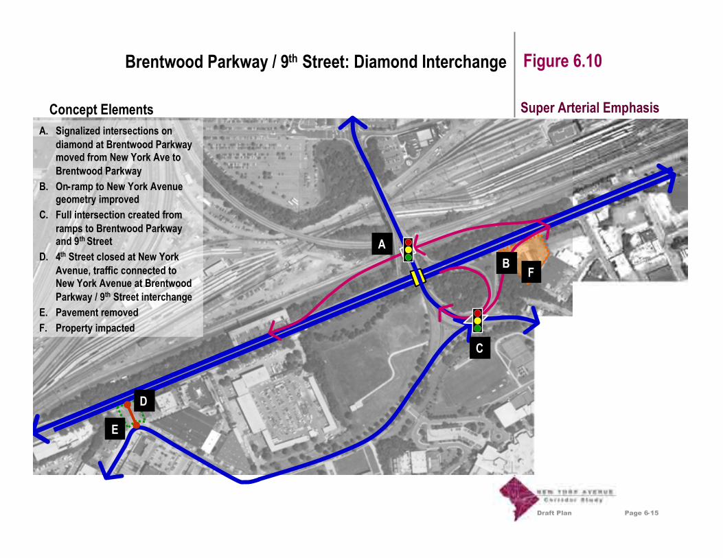
Draft Plan
Figure 6.10
Concept ElementsA. Signalized intersections on
diamond at Brentwood Parkwaymoved from New York Ave toBrentwood Parkway
B. On-ramp to New York Avenuegeometry improved
C. Full intersection created fromramps to Brentwood Parkwayand 9th Street
D. 4th Street closed at New YorkAvenue, traffic connected toNew York Avenue at BrentwoodParkway / 9th Street interchange
E. Pavement removedF. Property impacted
AB
C
D
F
Super Arterial Emphasis
E
Page 6-15
Brentwood Parkway / 9th Street: Diamond Interchange
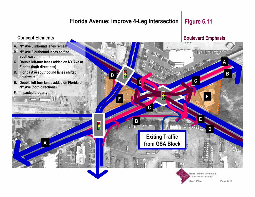
Draft Plan
Figure 6.11
Concept Elements
B
E
C
D
C
E
F
A
A
A. NY Ave 3 inbound lanes remainB. NY Ave 3 outbound lanes shifted
southeastC. Double left-turn lanes added on NY Ave at
Florida (both directions)D. Florida Ave southbound lanes shifted
southwestE. Double left-turn lanes added on Florida at
NY Ave (both directions)F. Impacted property
Exiting Trafficfrom GSA Block
B
F
D
Boulevard Emphasis
Page 6-16
Florida Avenue: Improve 4-Leg Intersection

Draft Plan
Figure 6.12
Concept Elements
B
B
A
C
DC
A. New traffic circleconstructed at FloridaAvenue (3 lanes each way)
B. Florida Ave depressed atNY Ave (3 lanes each way)
C. Ramp connections addedfrom Florida to circle
D. Eckington terminated atconnectors
E. 1st street terminated atconnectors
F. Impacted property
F
C
F
Exiting Trafficfrom GSA Block
E
Boulevard Emphasis
C
Page 6-17
Florida Avenue: Grade-Separated Traffic Circle

Draft Plan
Figure 6.13
Concept Elements
B
C
E
A. Maintain elevation of NY Ave westof tracks and bridge over FloridaAve and 1st Street NE
B. Florida Ave SE-bound lanes shiftto accommodate double left-turns
C. 1st Street NE connected withEckington
D. Eckington connected to New YorkAve ramp from Harry Thomas Way
E. Ramps connected to New York AveF. Pavement removedG. Property impacted
D
AE
A
B
E
F
G
Exiting Trafficfrom GSA Block
Super Arterial Emphasis
Page 6-18
Florida Avenue: Diamond Interchange

Draft Plan
Concept Elements
Figure 6.14
A
Harry Thomas Way
New York AvenueFlorida Avenue
A. Construct new ramp fromNew York Ave over rail tracksto connect with Harry ThomasWay, Eckington and FloridaAvenue
B. Connect to improvedintersection or diamondinterchange at Florida Ave
B
Super Arterial Emphasis
Page 6-19
Florida Avenue: Harry Thomas Way Connector

Draft Plan
Figure 6.15
Concept Elements
AB
A
A
D
EG
G
G
G
F
F
B
B
A. New York Ave bridges over Florida Ave andcomes back to grade west of 1st Street NE
B. New York Ave bridges over Florida Ave anddescends into tunnel to I-395 west of 1st St NE
C. Florida Ave connects into tunnel to I-395 westof 1st Street NE
D. Eckington connected to New York Ave rampfrom Harry Thomas Way
E. Ramps connected to New York AveF. 1st Street NE connected to O Street north of
New York Ave and dead-ended south of NewYork Ave
G. Property impacted
A
A
A
A
BB
C
C
E
Exiting Trafficfrom GSA Block
Super Arterial Emphasis
Page 6-20
Florida Avenue: Diamond Interchange and Tunnel to I-395

Draft Plan
Figure 6.16
Concept Elements
A. Left-turn movement onto I-395has free flow by depressing left-turn lanes beginning at NewJersey
B. Southbound 4th Street becomesright in/out only
C. Southbound 3rd Street is notconnected to I-395
A
C
Super Arterial/BoulevardEmphasis
B
Page 6-21
I-395: Depressed Left Turn Lane

Draft Plan
Figure 6.17
Concept ElementsA. Create new tunnel to connect I-
395 with New York Avenue in thevicinity of Florida Avenue
B. Return New York Avenue to alocal street from North Capitol to4th Street NW
C. New Jersey and 4th Street NWcan be returned to two-Waystreets
D. Intersections at New Jersey and4th street NW can be reduced
E. Pavement can be removed
Super Arterial Emphasis
B
A
D
C
E
A
B
C
DE
E
E
Page 6-22
I-395: Tunnel Connection to Florida Avenue

Draft Plan Page 7-1
Evaluation Criteria Chapter 7
As part of the Study process, specific evaluation criteriawere developed to guide the screening of varioustransportation improvement alternatives. These criteria,which are based on the Study Purpose as described inChapter 1, were created from community input and projectgoals, and were further refined at subsequent publicmeetings and through internal work sessions of the studyteam.
For purposes of this Draft Plan, the evaluation criteria aregrouped according to common topics. The following pagehighlights the major topics and key issues considered undereach category. Figure 7.1: Evaluation Criteria Matrix showshow the preliminary transportation concepts ranked by themajor topic categories. The rankings - good, fair and poor -indicate how well each concept achieves the goalsidentified for each overall topic area.
Accessibility• Provide good access for pedestrians, automobiles,
bicycles, transit (primarily bus) and trucks to andfrom adjacent properties and neighborhoods alongthe Corridor
• Provide good access for transit (primarily bus) andtruck freight to and from remote locations and supportthe Corridor as a regional thoroughfare
Aesthetics
• Create a positive visual impression along theCorridor that supports the goal of creating anaesthetically pleasing 'gateway' to the District
• Create opportunities for aesthetic improvements toproperties along the Corridor
Neighborhoods
• Retain and support existing residentialneighborhoods including historic landmarks,museums, churches and homes
• Minimize the need to acquire properties along theCorridor for transportation improvements
• Create positive opportunities for acquiring andredeveloping properties along the Corridor inconjunction with transportation improvements
• Minimize non-local traffic parking within adjacentneighborhoods
• Minimize cut-through traffic within adjacentneighborhoods
Safety
• Create safer conditions for pedestrians in theCorridor
• Create safer conditions for vehicles (automobiles,trucks and transit) in the Corridor
• Create safer conditions for bicyclists in the Corridor
Environment• Create opportunities to improve air quality along the
Corridor• Create opportunities to reduce noise pollution along
the Corridor• Minimize the amount of impervious surfaces along
the Corridor• Create more green space along the Corridor

Draft Plan Page 7-2
Evaluation Criteria Chapter 7
Funding And Constructability
• Create opportunities for regional cost-sharing to fundtransportation improvements
• Create transportation improvement options that canbe phased over time
• Seek transportation concepts that do not presentsignificant constructability challenges
• Seek concepts that allow for maximum use of federaldollars to fund transportation improvements
Cost
• Consider overall cost as a factor in selectingalternatives so that a preferred option can beimplemented
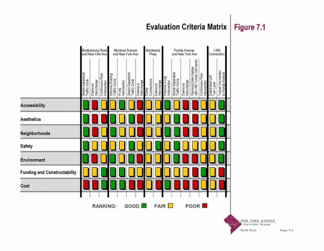

Appendix B
Summary of Potential Improvement Concepts for theNew York Avenue / Florida Avenue Intersection
Appendix BTable of Contents
Appendix B Summary of Potential Improvement Concepts for the New York Avenue /Florida Avenue Intersection
Appendix B.1 Potential Improvement Concepts Developed Prior to Submittal ofthe Draft Plan: Summary of Interchange Concepts and At-GradeIntersection Concepts (2/21/2005)
Appendix B.2 Potential Improvement Concepts Developed for Inclusion in theDraft Plan: Excerpts from Chapters 6 and 7 of the Draft Plan(4/29/2005)
Appendix B.3 Potential Improvement Concepts Developed Following Submittalof the Draft Plan: Incorporation of the Interim “At-Grade Semi-Circle” Concept at the Intersection of New York Avenue andFlorida Avenue into the Long Term Concepts Involving a Tunnelto I-395 (7/22/2005)
Appendix B.4 Potential Improvement Concepts Developed Following Submittalof the Draft Plan: Task 11 Technical Memorandum: ExtendedTunnel Concepts (9/13/2005)

Appendix B.1
Potential Improvement Concepts DevelopedPrior to Submittal of the Draft Plan:
Summary of Interchange Concepts andAt-Grade Intersection Concepts
(2/21/2005)

New York Avenue Corridor Study Florida Avenue Concepts
URS • HNTB • CS • ERA • JSA • PBQD 1
1. INTRODUCTION During the course of Task 5, numerous concepts were developed and evaluated for the junction of New York Avenue and Florida Avenue. The concept shown in the Draft Plan, a diamond interchange, was felt by the Study Team to be the best concept for this location. In addition, as noted in the Draft Plan, there was considerable feeling among members of the Oversight Committee that an at-grade intersection concept could be preferable to a grade-separated interchange concept. The following exhibits provide additional information about the concepts which were developed and evaluated. For the most part, the concepts vary in terms of width of pavement/structure required, extent of property impacts expected, and ability to accommodate anticipated traffic demands. On each exhibit, a volume-to-capacity ratio is shown for key intersections. The lower the volume-to-capacity ratio is, the better the concept functions, from a traffic perspective. All concepts include an extension of the I-395 tunnel beneath New York Avenue. Unless stated otherwise, this tunnel is assumed to daylight between North Capitol Street and Florida Avenue. It should be noted that these concepts are conceptual in nature, and are thus extremely preliminary.
2. INTERCHANGE CONCEPTS I-1 through I-6 Interchange concepts I-1 through I-6 all include the following:
• Westbound local and non-local New York Avenue traffic could be separated to the east of Florida Avenue.
• New York Avenue traffic destined for I-395 (non-local) could not pass through the
intersection of New York Avenue and Florida Avenue. Instead, this traffic could pass over Florida Avenue, and then descend into a tunnel to the east of North Capitol Street.
• Local New York Avenue traffic could intersect with Florida Avenue. This intersection
could be signalized.
• Traffic on 1st Street, NE could no longer be able to cross New York Avenue.
• Space for pedestrian refuge while crossing New York Avenue could be provided.
• The existing bridge above the railroad to the east of Florida Avenue could be widened.
• Both New York Avenue and Florida Avenue could require widening, and resulting property impacts could be significant.

New York Avenue Corridor Study Florida Avenue Concepts
URS • HNTB • CS • ERA • JSA • PBQD 2
Features unique to each concept include the following:
• For I-1:
o Left turns could be permitted from both New York Avenue and Florida Avenue.
o The intersection between New York Avenue and 1st Street, NE on the south side of New York Avenue could be signalized.
o The intersection between New York Avenue and 1st Street, NE on the north side
of New York Avenue could be right in / right out only.
o Interchange ramps could provide full access between I-395 and Florida Avenue.
• For I-2:
o Left turns could be permitted from New York Avenue only.
o The intersection between New York Avenue and 1st Street, NE on the south side of New York Avenue could be signalized.
o The intersection between New York Avenue and 1st Street, NE on the north side
of New York Avenue could be right in / right out only.
o Interchange ramps could provide full access between I-395 and Florida Avenue.
• For I-3:
o Left turns could be permitted from both New York Avenue and Florida Avenue.
o The intersection between New York Avenue and 1st Street, NE on both the north and south sides of New York Avenue could be right in / right out only.
o An interchange ramp could provide access from Florida Avenue to
southwestbound I-395.
o No access from northeastbound I-395 to Florida Avenue could be provided.
• For I-4:
o Left turns could be permitted from New York Avenue only.
o The intersection between New York Avenue and 1st Street, NE on both the north and south sides of New York Avenue could be right in / right out only.
o An interchange ramp could provide access from Florida Avenue to
southwestbound I-395.

New York Avenue Corridor Study Florida Avenue Concepts
URS • HNTB • CS • ERA • JSA • PBQD 3
o No access from northeastbound I-395 to Florida Avenue could be provided.
• For I-5:
o Left turns between New York Avenue and Florida Avenue could not be
permitted.
o The intersection between New York Avenue and 1st Street, NE on the south side of New York Avenue could be signalized.
o The intersection between New York Avenue and 1st Street, NE on the north side
of New York Avenue could be right in / right out only.
o Interchange ramps could provide full access between I-395 and Florida Avenue (as available due to the restricted left turns).
• For I-6:
o Left turns between New York Avenue and Florida Avenue could not be
permitted.
o The intersection between New York Avenue and 1st Street, NE on the south side of New York Avenue could be signalized.
o The intersection between New York Avenue and 1st Street, NE on the north side
of New York Avenue could be right in / right out only.
o Interchange ramps could provide full access between I-395 and Florida Avenue (as available due to the restricted left turns).
o Separate right turn lanes could be provided on New York Avenue.
I-7 This interchange concept shows an attempt at realigning Florida Avenue. The property impacts could be significant, and the relocated Florida Avenue’s geometry could be undesirable. I-8 This interchange concept lowers Florida Avenue instead of raising New York Avenue. Property impacts and grade changes along Florida Avenue could be significant. In particular, access to the New York Avenue Metrorail Station could be restricted to traffic on the southeastbound ramp.

New York Avenue Corridor Study Florida Avenue Concepts
URS • HNTB • CS • ERA • JSA • PBQD 4
I-9 This interchange concept continues the I-395 tunnel to a point east of Florida Avenue. There could therefore be no apparent overpass at the intersection of New York Avenue and Florida Avenue. With left turns prohibited for both New York Avenue and Florida Avenue, the property impacts could be far less than those of other alternates. Interchange ramps could still provide access between I-395 and Florida Avenue. Profile A very preliminary profile of I-395 was developed. The main purpose of the profile was to determine where along New York Avenue the underground portion of the I-395 grade separation would be far enough underground to permit roads to be built on top of the tunnel. The preliminary design permitted adequate bridge width to not interfere with the New York Avenue / Florida Avenue intersection while also adhering to AASHTO guidelines. This profile was developed using planning level data and is not to be used for detailed analyses or designs.
3. AT GRADE INTERSECTION CONCEPTS
G1 through G4 At Grade Intersection concepts G-1 through G-4 all include the following:
• Westbound local and non-local New York Avenue traffic could be separated to the west of Florida Avenue.
• New York Avenue traffic destined for I-395 (non-local) could pass through the
intersection of New York Avenue and Florida Avenue, and then descend into a tunnel to the east of North Capitol Street.
• New York Avenue traffic, both local and non-local, could intersect with Florida Avenue.
This intersection could be signalized.
• Space for pedestrian refuge while crossing New York Avenue could not be provided.
• Traffic on 1st Street, NE could no longer be able to cross New York Avenue.
• The existing bridge above the railroad to the east of Florida Avenue could be widened.
• Both New York Avenue and Florida Avenue could require widening, and subsequent property impacts could be significant.
• Interchange ramps could provide full access between I-395 and Florida Avenue (except
as noted with the turn restrictions).
• The intersection between New York Avenue and 1st Street, NE on both the north and south sides of New York Avenue could be right in / right out only.
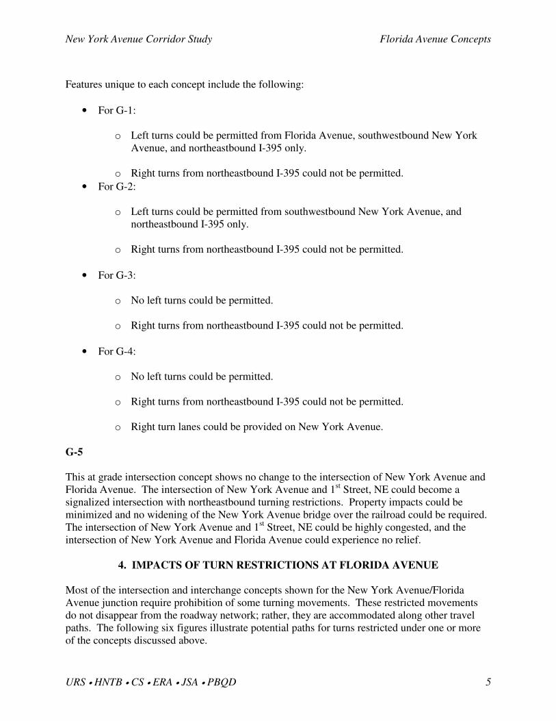
New York Avenue Corridor Study Florida Avenue Concepts
URS • HNTB • CS • ERA • JSA • PBQD 5
Features unique to each concept include the following:
• For G-1:
o Left turns could be permitted from Florida Avenue, southwestbound New York Avenue, and northeastbound I-395 only.
o Right turns from northeastbound I-395 could not be permitted.
• For G-2:
o Left turns could be permitted from southwestbound New York Avenue, and northeastbound I-395 only.
o Right turns from northeastbound I-395 could not be permitted.
• For G-3:
o No left turns could be permitted.
o Right turns from northeastbound I-395 could not be permitted.
• For G-4:
o No left turns could be permitted.
o Right turns from northeastbound I-395 could not be permitted.
o Right turn lanes could be provided on New York Avenue.
G-5 This at grade intersection concept shows no change to the intersection of New York Avenue and Florida Avenue. The intersection of New York Avenue and 1st Street, NE could become a signalized intersection with northeastbound turning restrictions. Property impacts could be minimized and no widening of the New York Avenue bridge over the railroad could be required. The intersection of New York Avenue and 1st Street, NE could be highly congested, and the intersection of New York Avenue and Florida Avenue could experience no relief.
4. IMPACTS OF TURN RESTRICTIONS AT FLORIDA AVENUE Most of the intersection and interchange concepts shown for the New York Avenue/Florida Avenue junction require prohibition of some turning movements. These restricted movements do not disappear from the roadway network; rather, they are accommodated along other travel paths. The following six figures illustrate potential paths for turns restricted under one or more of the concepts discussed above.


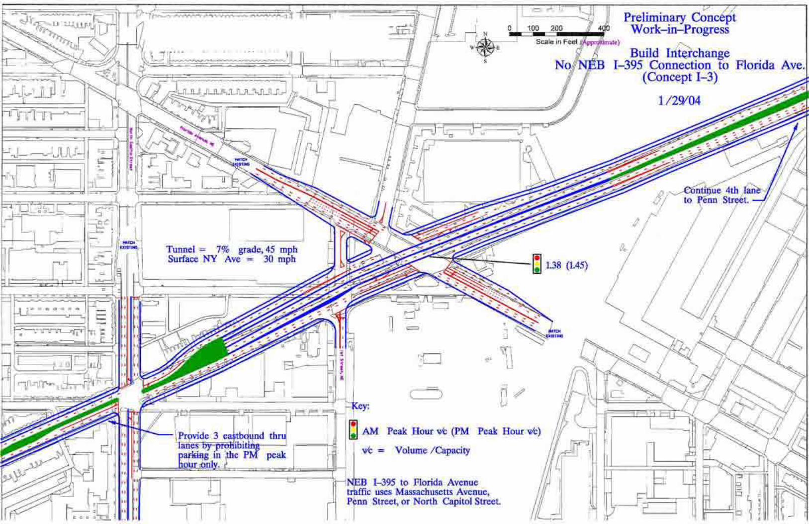
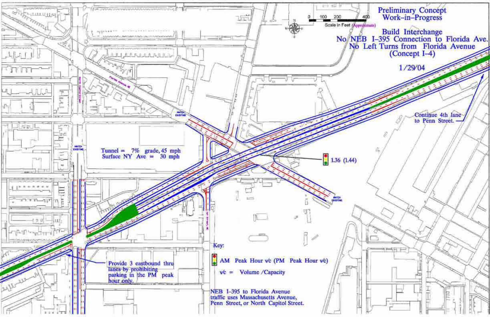


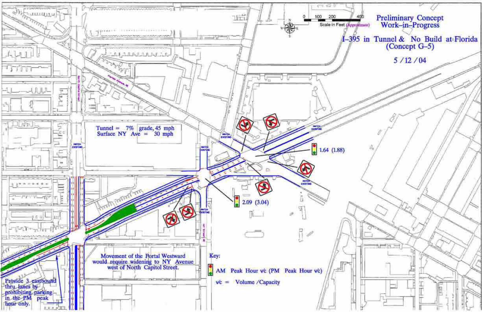

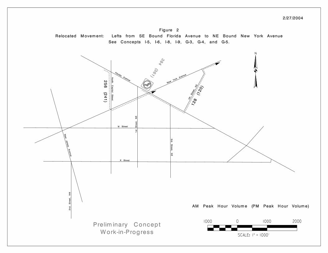


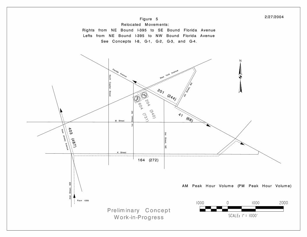

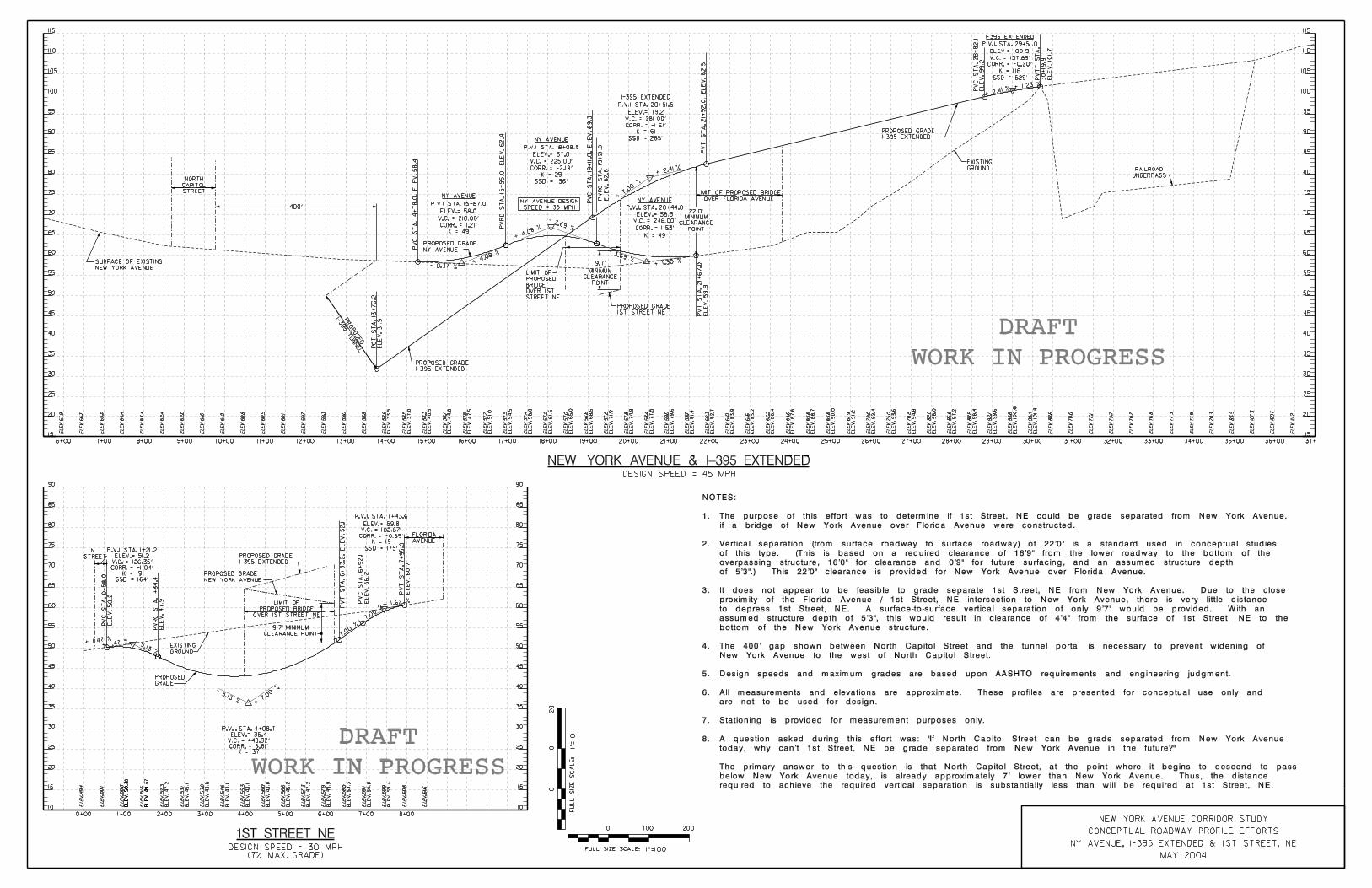

Appendix B.2
Potential Improvement Concepts Developedfor Inclusion in the Draft Plan:
Excerpts from Chapters 6 and 7of the Draft Plan
(4/29/2005)

Draft Plan Page 6-1
Preliminary Transportation Concepts Chapter 6
6.1 Preliminary TransportationConcepts
One of the primary purposes of Task 5 of the New YorkAvenue Corridor Study was to develop preliminarytransportation concepts to be considered in thedevelopment of final transportation recommendations. Thischapter presents these concepts as presented to thecommunity at public meetings on May 20, 2003 and June17, 2003.
Most of the concepts presented in this chapter are nolonger relevant to the recommendations of the draft plan.They are presented here for historical perspective. If youare primarily interested in the current recommendations,please skip to Chapter 8.
Major transportation improvement options for the Corridorwere developed by exploring four distinct types of roadwayfacilities. These are illustrated in Figure 6.1: DifferentFacility Options and include: a local street option, aboulevard option, a super arterial option, and a reversiblelanes option.
In addition to the four roadway options, a minimalintervention option was explored that would involve onlyminor improvements to the existing New York Avenueinfrastructure.
From these options, overall corridor concepts weredeveloped and included the following:
Minimal Intervention Option
As the name implies, this concept would leave New YorkAvenue in its current configuration throughout most of thestudy area. Left turn lanes would be added at fiveintersections (Fairview, Kendall, Fenwick, 16th and 4th) inorder to improve traffic flow at those signalizedintersections. One or more pedestrian signals would alsobe added to the Corridor, in the area between I-395 andNorth Capitol Street.
On balance, this concept would provide approximately thesame vehicular traffic-carrying capacity as currently exists:traffic operations would be improved at the newly-widenedintersections, but would be diminished somewhat at thenew pedestrian signals. Non-motorized modes (bicycle andpedestrians) would benefit from the new pedestrian signals,but would otherwise be essentially unaffected by thisoption.
• Minimal Intervention• Boulevard Emphasis• Super Arterial Emphasis• Combination Super Arterial/Boulevard Emphasis• Reversible Lanes

Draft Plan Page 6-2
Transportation Concepts Chapter 6
Boulevard Emphasis Option
This concept would substantially modify both the operationand appearance of New York Avenue. With the provision ofa wide center median, virtually all intersections (with thepossible exception of Bladensburg) would be modified,either by creating additional lanes for turning vehicles,reconstruction of at-grade DC-style traffic circles, orreconstruction as grade-separated DC-style traffic circles.In addition, driveways and curb cuts would be limited, andtwo minor intersections would be eliminated (Fairview andFenwick), by dead-ending the side streets. If the FloridaAvenue intersection were to be reconstructed as a grade-separated traffic circle, a new at-grade intersection could becreated at North Capitol Street, replacing the existingdiamond interchange. Finally, a depressed left-turn lane,intended to carry traffic from westbound New York Avenueonto I-395, could be provided.
The net change in vehicular traffic-carrying capacity woulddepend upon the final configurations selected for keyintersections. On balance, however, the change would beexpected to be an increase in capacity, perhaps asubstantial increase. Non-motorized modes would benefitfrom improvements in facilities alongside New YorkAvenue, and from improved facilities to cross majorintersections.
Super Arterial Emphasis Option
As a “super arterial,” New York Avenue would both lookand function very differently than it does today. Under thisconcept, there would be no at-grade intersections, orprivate driveways from Florida Avenue to the District line.All access to the Corridor in this area would be made frominterchanges (which could include grade-separated trafficcircles) at Bladensburg, West Virginia-Montana, Brentwood,and Florida. All other existing intersections in this areawould be dead-ended, with improvements in nearby surfacestreets likely to be required, in order to provide access fromthose roadways to New York Avenue.
Starting in the vicinity of Florida Avenue, a tunnel wouldcarry through traffic to/from I-395, resulting in an at-gradeintersection at North Capitol Street. From North CapitolStreet to the west, existing New York Avenue would be ableto function more as a local street than an arterial, withexisting at-grade intersections remaining.
This option would provide the most substantial increase inthe vehicular traffic-carrying capacity of New York Avenueof any alternative under consideration. Non-motorizedmodes would be served by facilities separated from NewYork Avenue by concrete barriers, although not in as“friendly” a manner as would be possible under theBoulevard Emphasis option.

Draft Plan Page 6-3
Transportation Concepts Chapter 6
Super Arterial/Boulevard Emphasis Option
This option was developed in recognition of the fact that a“one size fits all” approach might not be desirable for theNew York Avenue Corridor. That is, there may be somesegments of the Corridor in which a super arterial might bethe best fit; in others, a boulevard might best meet theneeds of the District. The descriptions provided above forthe two components of this concept apply here as well.
Reversible Lanes
The existing median on New York Avenue would beremoved under this concept; it would be replaced by aseventh travel lane. This seventh lane, in the center of theroadway, would be used for westbound traffic in themorning peak period and for eastbound traffic in theevening peak period. During off-peak periods during theday, in the evenings, and on weekends, this new centerlane would function as a two-way left turn lane. Thisreversible lane would somewhat improve the vehiculartraffic-carrying capacity of the Corridor. Offsetting thisimprovement, to some extent, would be the probable needto restrict turning movements at some intersections duringpeak periods. Pedestrians and bicycles could still beaccommodated alongside the roadway, as they areproposed to be accommodated under the BoulevardEmphasis concept.
More detailed descriptions of how each of these conceptswould have been applied to individual locations within theCorridor may be found in the Task 5 SummaryMemorandum. These concepts were then evaluatedagainst each other using a set of criteria described in thenext chapter of this Draft Plan.

Draft Plan Page 6-4
Transportation Concepts Chapter 6
6.2 Intersection Options
Several of the general concepts have optional ways thatroadway junctions can be treated. For example, under theBoulevard Emphasis concept, intersections can be treatedas conventional signalized 4-leg intersections, at-gradetraffic circles, or grade-separated traffic circles. Under theSuper Arterial Emphasis Concept, all existing at-gradejunctions would then be converted into grade-separatedinterchanges.
The following paragraphs present some of the pros andcons of each intersection treatment option. Figures 6.2through 6.17 compare intersection treatment options foreach major intersection along the Corridor. Boulevard Emphasis – At-Grade Traffic Circles
• Reduces the number of accidents and improvestraffic movement at an intersection by removing left-turning vehicles from through lanes and providing leftturn lanes with a green arrow
• Maintains the “local street” feel of the roadway• Is transit and pedestrian friendly
• Does not consume large areas of land for theimprovement
• Does not significantly reduce congestion
• Reduces the severity of accidents at an intersection
• Adds green space and is aesthetically pleasing butrequires a large radius and land area• Blends well with other corridors in DC• Could help stimulate quality development
• Offers opportunities for new focal points and greenspace improving the aesthetic character of theroadway• May increase congestion
Illustrations showing a 4-Leg Intersection (top)and At-Grade Traffic Circle (bottom) at Montanaand New York Avenues
Boulevard Emphasis – 4 Leg Intersections

Draft Plan Page 6-5
Boulevard Emphasis – Grade-Separated Traffic Circles
• Reduces the severity of accidents at an intersection• Adds green space with less land area needed due toa smaller radius of the circle
• Reduces congestion by allowing one of theintersecting roads to bypass the circle withoutdisrupting circle operations
• Less transit and pedestrian friendly than at-gradetraffic circle
• Offers opportunities for new focal points and greenspace, improving the aesthetic character of theroadway
Transportation Concepts Chapter 6
Super Arterial Emphasis – Grade-SeparatedInterchange
• Reduces the number of accidents at an intersection• Reduces congestion: allows traffic to move at higherspeeds and with less interruption than a corridor withsignalized intersections and access to businessesalong the main route• Impacts nearby properties and neighborhoods• Properties adjacent to NY Avenue may be taken(partially or completely)
• Business entrances may be relocated• Traffic wishing to access local businesses would beredirected along frontage roads• Some roads that currently intersect New YorkAvenue may have to be accessed thru a differentroute; therefore, traffic thru neighborhoods mayincrease• Is not necessarily pedestrian or transit friendly
Illustrations showing a Grade-Separated TrafficCircle (top) and Grade-Separated Interchangeat Montana and New York Avenues
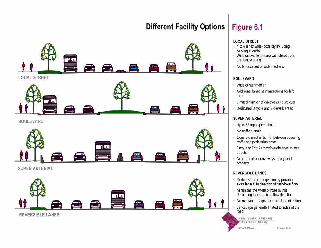
Draft Plan Page 6-6
Different Facility Options Figure 6.1LOCAL STREET• 4 to 6 lanes wide (possibly includingparking at curb)• Wide sidewalks at curb with street treesand landscaping
• No landscaped or wide medians
BOULEVARD• Wide center median• Additional lanes at intersections for leftturns
• Limited number of driveways / curb cuts• Dedicated Bicycle and Sidewalk areas
SUPER ARTERIAL• Up to 55 mph speed limit• No traffic signals
• Concrete median barrier between opposingtraffic and pedestrian areas• Entry and Exit Ramps/Interchanges to localstreets• No curb cuts or driveways to adjacentproperty
REVERSIBLE LANES• Reduces traffic congestion by providingextra lane(s) in direction of rush-hour flow• Minimizes the width of road by notdedicating lanes to fixed flow direction• No medians – Signals control lane direction
• Landscape generally limited to sides of theroad
LOCAL STREET
BOULEVARD
SUPER ARTERIAL
REVERSIBLE LANES

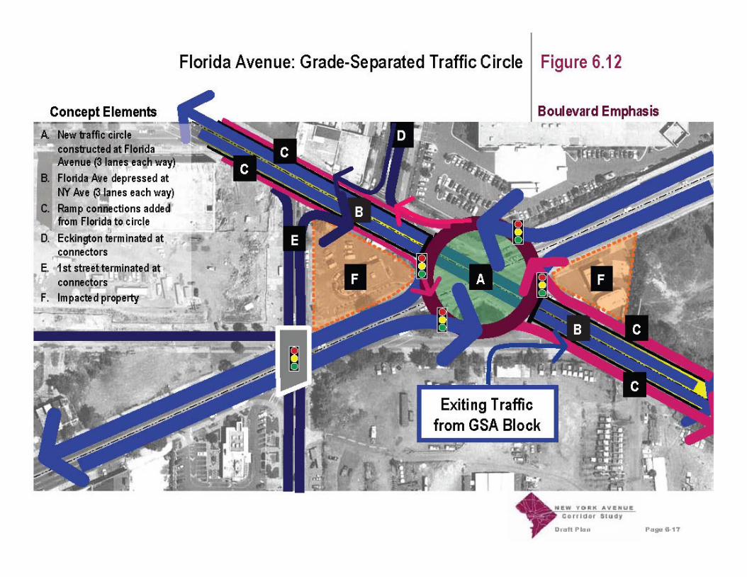

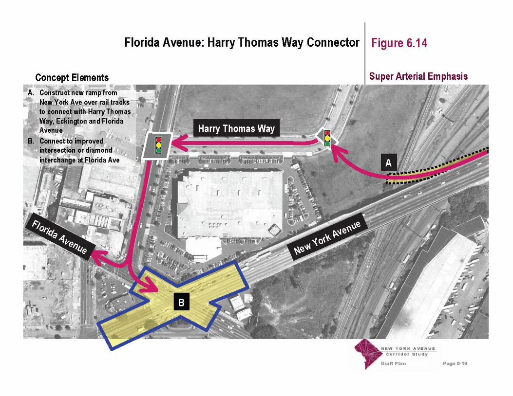


Draft Plan Page 7-1
Evaluation Criteria Chapter 7
As part of the Study process, specific evaluation criteriawere developed to guide the screening of varioustransportation improvement alternatives. These criteria,which are based on the Study Purpose as described inChapter 1, were created from community input and projectgoals, and were further refined at subsequent publicmeetings and through internal work sessions of the studyteam.
For purposes of this Draft Plan, the evaluation criteria aregrouped according to common topics. The following pagehighlights the major topics and key issues considered undereach category. Figure 7.1: Evaluation Criteria Matrix showshow the preliminary transportation concepts ranked by themajor topic categories. The rankings - good, fair and poor -indicate how well each concept achieves the goalsidentified for each overall topic area.
Accessibility• Provide good access for pedestrians, automobiles,bicycles, transit (primarily bus) and trucks to andfrom adjacent properties and neighborhoods alongthe Corridor
• Provide good access for transit (primarily bus) andtruck freight to and from remote locations and supportthe Corridor as a regional thoroughfare
Aesthetics• Create a positive visual impression along theCorridor that supports the goal of creating anaesthetically pleasing 'gateway' to the District• Create opportunities for aesthetic improvements toproperties along the Corridor
Neighborhoods• Retain and support existing residentialneighborhoods including historic landmarks,museums, churches and homes• Minimize the need to acquire properties along theCorridor for transportation improvements• Create positive opportunities for acquiring andredeveloping properties along the Corridor inconjunction with transportation improvements• Minimize non-local traffic parking within adjacentneighborhoods
• Minimize cut-through traffic within adjacentneighborhoods
Safety• Create safer conditions for pedestrians in theCorridor
• Create safer conditions for vehicles (automobiles,trucks and transit) in the Corridor
• Create safer conditions for bicyclists in the Corridor
Environment• Create opportunities to improve air quality along theCorridor• Create opportunities to reduce noise pollution alongthe Corridor• Minimize the amount of impervious surfaces alongthe Corridor• Create more green space along the Corridor
Draft Plan Page 7-2
Evaluation Criteria Chapter 7
Funding And Constructability• Create opportunities for regional cost-sharing to fundtransportation improvements• Create transportation improvement options that canbe phased over time• Seek transportation concepts that do not presentsignificant constructability challenges• Seek concepts that allow for maximum use of federaldollars to fund transportation improvements
Cost• Consider overall cost as a factor in selectingalternatives so that a preferred option can beimplemented
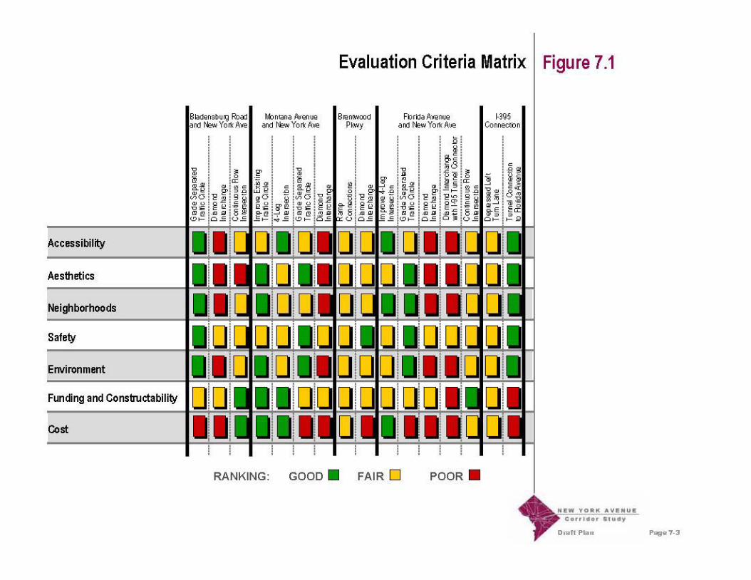

Appendix B.3
Potential Improvement Concepts DevelopedFollowing Submittal of the Draft Plan:
Incorporation of the Interim “At-Grade Semi-Circle”Concept at the Intersection of New York Avenue
and Florida Avenue into the Long Term ConceptsInvolving a Tunnel to I-395
(7/22/2005)

Explanation & Observations
An interim solution for congestion at the intersection of New York Avenue and Florida Avenuehas been proposed that uses the existing roadway system to create an at-grade semi-circle at thislocation. A schematic of this “interim concept” is attached.
The following is a description of a concept that incorporates the “at-grade semi-circle” conceptinto the “New York Avenue to I-395 tunnel” concept, and places northwestbound FloridaAvenue below New York Avenue. A schematic of this concept is also attached.
The “executive summary” is that this concept, from a highway engineering / traffic engineeringpoint of view, doesn’t seem to work as well as either the at-grade intersection concept or thebridge concept shown in the Draft Plan.
From a highway engineering perspective, here are some of the things we’ve discovered:
1. With this concept, the ramps to / from Florida Avenue connecting to New York Avenue tothe northeast aren’t feasible. (Strictly speaking, the ramp from southwestbound New YorkAvenue to Florida Avenue could be built, but aren’t recommended. It would be a very steepramp, and would pretty much eliminate FedEx’s parking.)
2. Northwestbound Florida Avenue was bowed to the east in order to give this option the bestchance of geometric feasibility. With this “bowing” and using a grade of 7% on FloridaAvenue (the same grade as currently exists on New York Avenue between Florida Avenueand the railroad tracks), northwestbound Florida Avenue is able to tie back into its existingelevation at the railroad underpass on the southeast side, and at First Street, NE on thenorthwest side. However, Eckington Place would need to be lowered approximately 6 feet.
3. To get from existing ground elevation at the New York Avenue / First Street, NE / O Streetintersection to the “bowed out” northwestbound Florida Avenue, O Street would need tostart dropping as it leaves First Street, NE. This could impact the elevation of the GSAaccess point by anywhere from 2 feet to 16 feet, depending upon just where the access pointis located.
4. Access from northwestbound Florida Avenue to the Metrorail Station might not be possiblebecause of the drop in elevation required on Florida Avenue to get under New YorkAvenue.
5. Both Florida Avenue and O Street would drop into a sump then rise back to grade again in arelatively short distance, and both would do so in the midst of a curve. While AASHTOallows geometry like this (combining significant grade changes with curves), it is notrecommended due to potential sight distance issues, particularly for trucks.

From a traffic engineering perspective, we’ve found the following:
1. Pedestrian accessibility would be problematic due the highly varied elevations between theroads within a small area, particularly for Metrorail patrons attempting to cross FloridaAvenue near the station.
2. The resulting intersection of northeastbound New York Avenue (surface) / northeastboundNew York Avenue (tunnel) / First Street, NE / O Street / southwestbound New YorkAvenue (continuing on the surface) / southwestbound New York Avenue (entering thetunnel) would operate very poorly, in part because the two northeastbound legs would haveto operate on separate signal phases. Preliminary capacity analyses show that, in 2025, thisintersection would have a volume-to-capacity ratio in the neighborhood of 1.76 in the AMpeak hour and 2.64 in the PM peak hour. (This is substantially worse than either the at-grade intersection option or the bridge option shown in the Draft Plan, especially in the PMpeak hour.)
3. The southwestbound approach to this intersection would be undesirable in the configurationshown on the attached concept plan. With the configuration shown, the leftmost lane onsouthwestbound New York Avenue, which is a thru lane up to First Street, NE, would berequired to turn left at that intersection; two new lanes to “feed” southwestbound New YorkAvenue (surface) would need to be added between the Florida Avenue structure and thesignalized intersection. All this means that significant turbulence would be created in thetraffic stream at this location while travelers on southwestbound New York Avenuejockeyed for position, within a relatively very short segment, to get into the proper lanes toreach their destinations.
A logical question to ask at this point would be: “If the southwestbound approach is undesirableas shown, why not change it so that it is desirable?” Accomplishing this, would requirewidening of New York Avenue over northwestbound Florida Avenue, which would meanlowering the grade on Florida Avenue still further to get under the widened New York Avenue.This would be undesirable, because it would extend the needed reconstruction ofnorthwestbound Florida Avenue beyond the railroad tracks to the southeast, and First Street tothe northwest.
Based upon the attachments and the preceding text, it is recommended that this option not becarried any further.
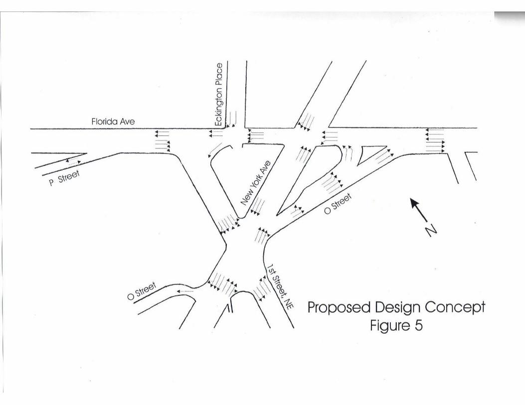


Appendix B.4
Potential Improvement Concepts DevelopedFollowing Submittal of the Draft Plan:
Task 11 Technical Memorandum:Extended Tunnel Concepts
(9/13/2005)

Final Task 11 Technical Memorandum:Traffic Analysis of the Extended Tunnel Concept
July 14, 2006
URS HNTB CS ERA JSA PBQD
ork Avenue Corridor Study
ew

In reply, please refer to: 20827660
July 14, 2006
Mr. Rick RybeckDeputy AdministratorTransportation Policy and Planning AdministrationDistrict Department of Transportation2000 14th Street, NW, 7th FloorWashington, D.C. 20009
Reference: New York Avenue Corridor StudyContract No. PO-KA-2002-R-0004-LSTechnical Memorandum 11
Dear Mr. Rybeck:
On behalf of the consultant team, URS is pleased to submit the Task 11 Technical Memorandumfor the New York Avenue Corridor Study. The document has been revised in accordance withour Contract and our ongoing discussions, as the Study has proceeded.
We look forward to continuing to work with you and the Oversight Committee. In themeantime, if you have any questions or desire further information, please do not hesitate tocontact me or other members of the consultant team.
Sincerely,
URS Corporation
Timothy A. Ryan, PEProject Manager
TAR:jpk

Final Task 11 Technical Memorandum:Traffic Analysis of the Extended Tunnel Concept
ork Avenue Corridor Study
ew
July 14, 2006
URS HNTB CS ERA JSA PBQD

New York Avenue Corridor Study Task 11 Technical Memorandum
URS HNTB CS ERA JSA PBQD i
TABLE OF CONTENTS
Page
1. Introduction.................................................................................................................................1
2. Development of Concepts...........................................................................................................2Introduction..........................................................................................................................2
New York Avenue / First Street, NE Intersection ...................................................2New York Avenue / Florida Avenue Intersection ...................................................3
Concept Profile ....................................................................................................................3Concept Plans.......................................................................................................................3
3. Intersection Capacity Analyses...................................................................................................9
4. Traffic Implications of Ramps To/From the I-395 Tunnel at Florida Avenue .........................11
5. Impacts of the Revised Tunnel Portal on Urban Planning Considerations ...............................14Zone 4 ................................................................................................................................14Zone 3 ................................................................................................................................14
6. Summary and Next Steps..........................................................................................................16Summary............................................................................................................................16Next Steps ..........................................................................................................................16

New York Avenue Corridor Study Task 11 Technical Memorandum
URS HNTB CS ERA JSA PBQD ii
LIST OF FIGURES
Figure Title Page
1A Extended Tunnel Profile, Sheet 1 ..................................................................................41B Extended Tunnel Profile, Sheet 2 ..................................................................................52 Extended Tunnel, With Ramps at Florida, Sheet 1........................................................63 Extended Tunnel, Without Ramps at Florida, Sheet 1...................................................74 Extended Tunnel, With or Without Ramps at Florida, Sheet 2 .....................................85 Relocated Movements: From Florida Avenue to I-395 (No Ramps at Florida) ..........126 Relocated Movements: From I-395 to Florida Avenue (No Ramps at Florida) ..........13
LIST OF TABLES
Table Title Page
1 Intersection Capacity Results for the Extended Tunnel Concepts.................................92 Intersection Capacity Results for Concepts I-6 and G-3 .............................................103 Zone 4 Right-of-Way Takings (New York Avenue / Florida Avenue Intersection) ...144 Zone 3 Right-of-Way Takings .....................................................................................15

New York Avenue Corridor Study Task 11 Technical Memorandum
URS HNTB CS ERA JSA PBQD 1
1. INTRODUCTION
During review of the New York Avenue Corridor Study Draft Plan, much discussionoccurred concerning the intersection of New York Avenue and Florida Avenue. Due to variousgeometric, property impact, and aesthetic preferences and constraints at this location it has beensuggested that alternatives to placing the I-395 tunnel portal at this location should be sought.
An Extended Tunnel Concept was initially considered during Task 5 of the Study(Prepare NYAC Project Concepts). At that time, it was agreed that the costs of such anExtended Tunnel were likely to be so great as to jeopardize the feasibility of the project and thatthe Concept should not be pursued further. However, given the level of public and agencyconcern with the future configuration of the New York Avenue/Florida Avenue intersection, itwas agreed that the possibility of extending the I-395 tunnel east of Florida Avenue should be re-considered, at a very conceptual level, prior to the preparation of the Final Report.
It was specifically requested that two Concepts be considered. These were:
An Extended Tunnel (with its portal east of Florida Avenue) that does not includeaccess between New York Avenue and the I-395 tunnel at Florida Avenue
An Extended Tunnel (with its portal east of Florida Avenue) that does includeaccess between New York Avenue and the I-395 tunnel at Florida Avenue.
The purpose of this Task 11 Technical Memorandum is to document the results of theconceptual engineering and traffic analyses performed with respect to these two Concepts.

New York Avenue Corridor Study Task 11 Technical Memorandum
URS HNTB CS ERA JSA PBQD 2
2. DEVELOPMENT OF CONCEPTS
Introduction
The intent of the analyses reported upon in this document is to identify, at a veryconceptual level, the physical feasibility of the two additional Concepts and to identify any majorconcerns with them. The schedule for completion of the Study and the resources available forthe completion of the Study allow for such conceptual analyses, but do not permit the same levelof analyses performed for the two primary Concepts presented in the Draft Plan (an At-GradeIntersection Concept and a Bridge Concept).
This document references several other documents produced during the course of theStudy, but generally does not repeat the information contained in them. In particular, the FinalTask 4 Technical Memorandum: Traffic Analysis, the Traffic Analysis Supplement – Alternativesat New York and Florida Avenues and the Draft Plan provide information important to anassessment of the two additional Concepts.
When comparing these other documents to this Task 11 Technical Memorandum, severaldifferences should be noted. These differences, and the reasons for them, are explained below.
New York Avenue / First Street, NE Intersection
In the preceding documents, this intersection was shown as a “right in/right out”intersection, with through movements on First Street, NE prohibited. The travel demandforecasts for the corridor for 2025 Build Conditions were based upon this configuration for thislocation. For the Bridge Concept at Florida Avenue, this reconfiguration of First Street, NE wasfelt to be necessary from an engineering design point of view. For the At-Grade IntersectionConcept, this reconfiguration of First Street, NE was not physically required from an engineeringdesign perspective, but was felt to be necessary from a traffic operations point of view. Giventhe extensive congestion anticipated at the New York Avenue/Florida Avenue intersection, itwas felt that having another major signalized intersection in such proximity would be unsound.
Because of the continuing concern expressed about this intersection, and because of theextensive redevelopment now planned for the “NOMA Corridor” (which could logically havethis intersection as its “front door”) the Office of Planning felt that the Extended TunnelConcepts would be preferred as it would leave the intersection of New York Avenue and FirstStreet, NE as a traditional four-legged intersection.
The travel demand forecasts for 2025 Build Conditions shown in Figures 8A and 8B ofthe Final Task 4 Technical Memorandum were post-processed for these analyses, in order toreflect this change. In essence, the turning volumes forecast for First Street, NE under 2025 NoBuild Conditions were superimposed on the 2025 Build volumes. It is important to note that,while this post-processing provides an estimate of future volumes which is appropriate for use ina corridor study of this sort, it does not provide a detailed assessment of current developmentplans for the NOMA Corridor.

New York Avenue Corridor Study Task 11 Technical Memorandum
URS HNTB CS ERA JSA PBQD 3
New York Avenue / Florida Avenue Intersection
In the preceding documents, in an effort to obtain the best possible operating condition atthis intersection and to minimize the number of lanes required, a number of turn restrictions wereshown. Because the relocation of the tunnel portal to the east reduces the number of requiredlanes, the two Extended Tunnel Concepts have been prepared with no such turn restrictions. Leftturns are shown as permitted on all four approaches to the intersection. This would be animprovement over present day conditions where left turn movements are not allowed.
The concerns stated above, regarding two major intersections spaced so closely together,are not addressed in this document. During detailed planning studies and design for this area,turn restrictions at one or both intersections would need to be investigated.
Concept Profile
A conceptual profile was prepared, continuing the I-395 Tunnel under Florida Avenueand under the railroad tracks, then rising to reach the surface of New York Avenue as quickly aspractical. This profile is provided in Figures 1A and 1B, and shows that the portal couldrealistically be located between Penn Street, NE and Ninth Street, NE. (A “flatter” profile,which would allow for more efficient traffic operation, should also be considered during detailedplanning and design studies; however, such a profile would be likely to require the portal to belocated to the east of Ninth Street, NE.) Consultants assumed minimum clearances below therailroad mainline tracks east of Florida Avenue and did not assume having to pass below a Mag-Lev rail tunnel that has been suggested by a separate study.
Concept Plans
Using the profile shown in Figures 1A and 1B, conceptual plans were prepared, and areshown in Figures 2 – 4. Figures 2 and 3 are different, in that Figure 2 shows ramps to/from theI-395 tunnel to/from the west, and Figure 3 shows no such ramps. Figure 4 is applicable to bothFigures 2 and 3; that is, there is no difference in geometric configuration in the vicinity of thetunnel portal for the two Concepts.
With the exception of the region between North Capitol Street and Brentwood Parkway,the previously proposed improvements to the New York Avenue Corridor (as documented in theDraft Plan) would remain unaffected by a change in the location of the I-395 tunnel portal.


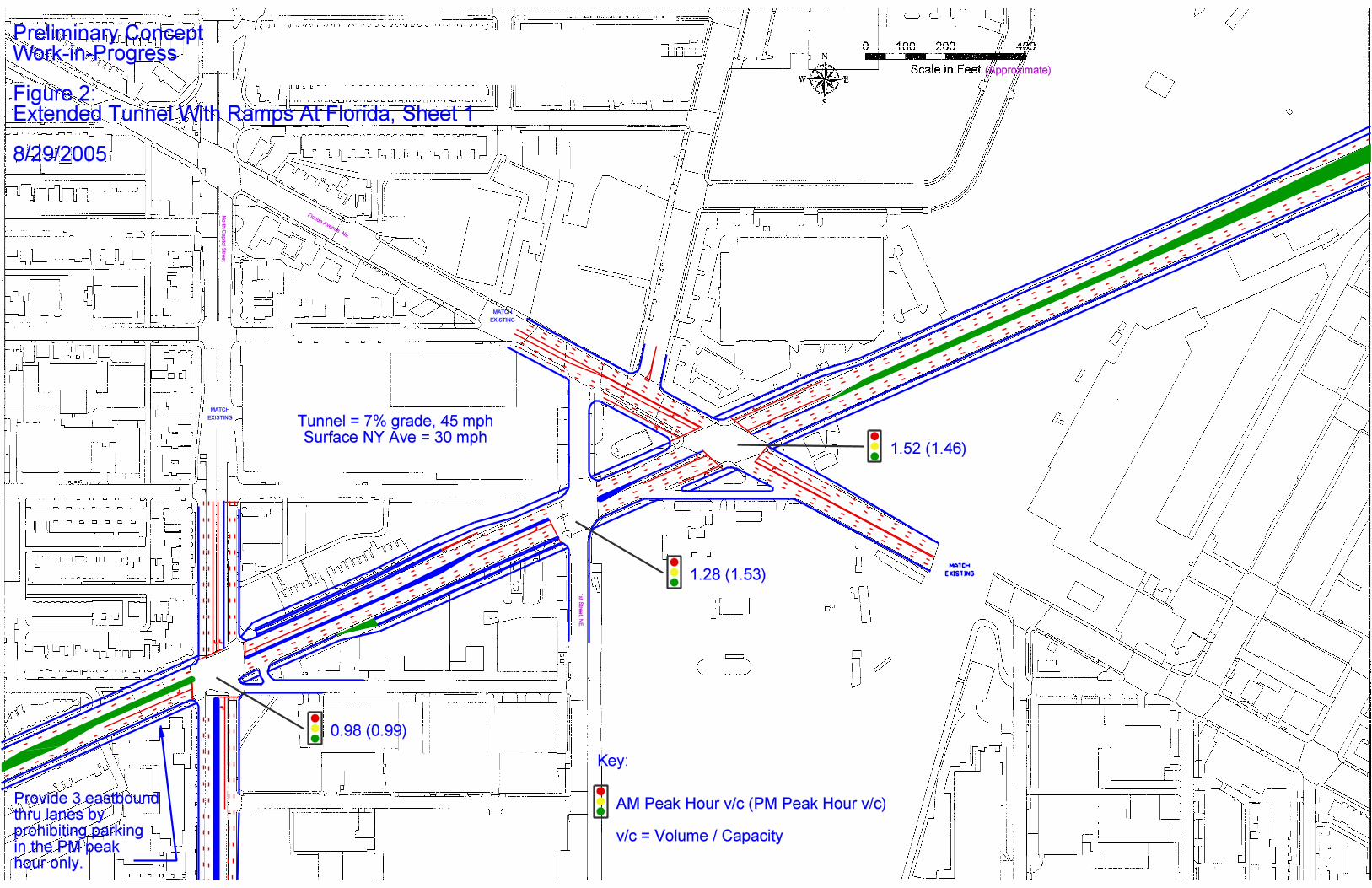
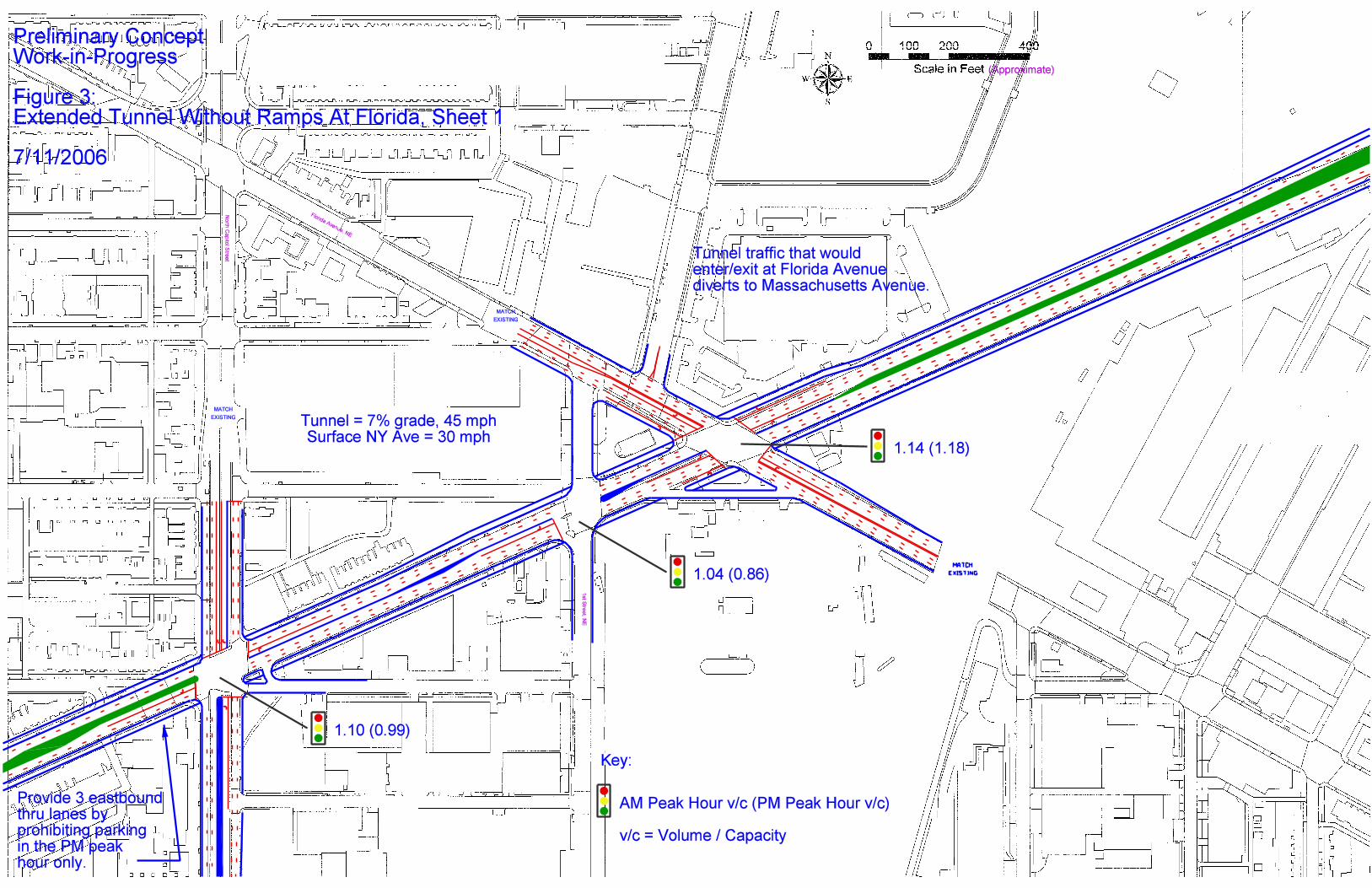


New York Avenue Corridor Study Task 11 Technical Memorandum
URS HNTB CS ERA JSA PBQD 9
3. INTERSECTION CAPACITY ANALYSES
Intersection capacity analyses were performed for the two Extended Tunnel Concepts, forthe affected intersections, for future build conditions (2025), using the post-processed turningmovement volumes. The results of these analyses are summarized in Table 1. It is important toremember that the post-processed volumes are based upon the premise that no turn restrictionsare required at any of the intersections. Thus, Table 1 shows “where traffic wants to go,” andprovides a base case against which other options involving turn restrictions could be compared.
Table 1: Intersection Capacity Results for the Extended Tunnel Concepts
With Ramps at Florida Without Ramps at Florida
AM Peak Hour PM Peak Hour AM Peak Hour PM Peak HourIntersection:New York Avenue @
v/c – LOS* v/c – LOS* v/c – LOS* v/c – LOS*
North Capitol Street 0.98 – E 0.99 – E 1.10 – F 0.99 – E
First Street, NE 1.28 – F 1.53 – F 1.04 – F 0.86 – D
Florida Avenue 1.52 – F 1.46 – F 1.14 – F 1.18 – F
Penn Street, NE 0.71 – B 0.86 – D 0.71 – B 0.86 – D
9th Street, NE 1.05 – F 1.00 – F 1.23 – F 1.10 – F
* v/c = volume-to-capacity ratio; LOS = level of service
Examination of Table 1 reveals the following:
The North Capitol Street intersection is expected to function at a more congestedlevel of service without the ramps at Florida Avenue, during the AM peak hour.Without the ramps, some of the traffic destined to I-395 from southeastboundFlorida Avenue would be expected to use North Capitol Street to access I-395 atMassachusetts Avenue, resulting in a worse LOS at North Capitol Street. (Whilethis diversion is expected to occur during the PM peak hour as well, thenorthbound North Capitol Street approach has a much higher volume thansouthbound North Capitol Street during that peak hour, and the southbounddiversion can be accommodated without worsening the LOS.)
The LOSs and v/c ratios for both First Street, NE and Florida Avenue would bebetter if no ramps were provided at Florida Avenue. What is not shown in thistable, however, is that the LOSs and v/c ratios are better because some traffic hasbeen redirected to Massachusetts Avenue, consequently worsening conditions atthat location.
Traffic not using North Capitol Street to reach I-395 would be expected to enterNew York Avenue via 9th Street, NE, and would enter the tunnel northeast ofPenn Street, NE. Traffic volumes, and consequently v/c ratios at 9th Street, NEwould therefore increase if ramps were not provided at Florida Avenue.

New York Avenue Corridor Study Task 11 Technical Memorandum
URS HNTB CS ERA JSA PBQD 10
A summary of the intersection capacity analyses for the two primary Concepts presentedin the Draft Plan, i.e. I-6 and G-3, is provided in Table 2 for comparison purposes.
Table 2: Intersection Capacity Results Concepts I-6 and G-3
Bridge: I-6 At-Grade Intersection: G-3
AM Peak Hour PM Peak Hour AM Peak Hour PM Peak HourIntersection:New York Avenue @
v/c – LOS* v/c – LOS* v/c – LOS* v/c – LOS*
North Capitol Street 1.10 – F 1.09 – F 1.10 – F 1.09 – F
First Street, NE Not Reported Not Reported Not Reported Not Reported
Florida Avenue 1.04 – F 1.27 – F 1.19 – F 1.37 – F
Penn Street, NE 0.99 – E 1.01 – F 0.99 – E 1.01 – F
9th Street, NE 1.05 – F 1.00 – F 1.05 – F 1.00 – F
* v/c = volume-to-capacity ratio; LOS = level of service
Comparison of Tables 1 and 2 reveals the following:
Conditions at 9th Street, NE would not vary under any of the Concepts thatprovide ramps to I-395 at Florida Avenue, but would be expected to be worse iframps were not provided at Florida Avenue.
The LOS and v/c ratios at Penn Street, NE would improve under the ExtendedTunnel Concepts, due both to the provision of left turns at Florida Avenue underthese conditions, and to the relocation of much of the I-395 traffic into the tunnel.
The LOS and v/c ratios at North Capitol Street would improve under theExtended Tunnel with Ramps at Florida Avenue Concept during both peak hours,and would improve under the Extended Tunnel without Ramps at Florida AvenueConcept during the PM peak hour (the AM peak hour would be the same as forConcepts I-6 and G-3).
The intersection of First Street, NE would function very differently under theExtended Tunnel Concepts than it would under Concepts I-6 and G-3 sinceConcepts I-6 and G-3 did not allow First Street, NE to provide thru or left turnmovements at New York Avenue.

New York Avenue Corridor Study Task 11 Technical Memorandum
URS HNTB CS ERA JSA PBQD 11
4. TRAFFIC IMPLICATIONS OF RAMPS TO/FROM THE I-395 TUNNEL ATFLORIDA AVENUE
The travel demand forecasts for 2025 Build Conditions included access to I-395 in thevicinity of Florida Avenue. Therefore, analysis of the Extended Tunnel Concept Without Rampsat Florida required that the 2025 Build turning movements be post-processed. In this case, someof the Florida Avenue traffic destined for I-395 was simply diverted to Massachusetts Avenuefrom Florida Avenue, as shown in Figure 5, while the rest was diverted outside the study area toenter I-395 from New York Avenue to the east of Penn Street, NE. I-395 traffic destined forFlorida Avenue was diverted to Florida Avenue from Massachusetts Avenue, as shown in Figure6.
While these diversions effectively reduce traffic volumes on New York Avenue at bothFirst Street, NE and Florida Avenue, they also increase traffic volumes on 9th Street, NE, NorthCapitol Street, K Street, NE, New Jersey Avenue, and Massachusetts Avenue. Although theeffects of the increased traffic on most of these roads is not quantitatively evaluated by thisstudy, they should be considered during detailed planning studies of the area.


New York Avenue Corridor Study Task 11 Technical Memorandum
URS HNTB CS ERA JSA PBQD 14
5. IMPACTS OF THE REVISED TUNNEL PORTAL ON URBAN PLANNINGCONSIDERATIONS
Zone 4
In review of the Draft Plan, one of the concerns raised by the Oversight Committee wasthe amount of developable land that would be consumed for roadway functions at theintersection of New York Avenue and Florida Avenue. The table below presents a comparisonof additional right-of-way needed for transportation improvements between the two priorConcepts in the Draft Plan and the two additional Extended Tunnel Concepts. Additional right-of-way needed is expressed in depth fronting along New York Avenue for the four quadrants ofthe intersection at Florida Avenue. It should be noted that the additional right-of-way identifiedunder the Extended Tunnel without Ramps Concept is to accommodate the addition of left turnlanes at First Street, NE and Florida Avenue. These turn lanes do not exist today, hence thechanges to the intersection.
Table 3: Zone 4 Right-of-Way Takings(New York Avenue / Florida Avenue Intersection)
Concept NorthwestQuadrant
SouthwestQuadrant
NortheastQuadrant
SoutheastQuadrant
Bridge (I-6) 90 feet 20 feet 50 feet 0 feet
At-GradeIntersection (G-3) 50 feet 20 feet 40 feet 0 feet
Extended Tunnelwith Ramps 30 feet 30 feet 20 feet 0 feet
Extended Tunnelwithout Ramps 10 feet 10 feet 10 feet 0 feet
Zone 3
In the Draft Plan, the section of New York Avenue between Penn Street NE and NinthStreet NE is shown with a wide median and a linear park on the north side of New York Avenue.With the Extended Tunnel Concepts, both the linear park and median can likely be maintained,but may be reduced in width to some degree to avoid the need for more extensive right-of-wayacquisition on the south side of New York Avenue. A quick review of preliminary concept planssuggests that the concept of creating a linear park with separate dedicated walkway and bikewaywith some intervening green space can still be achieved. The table below presents a comparisonof additional right-of-way needed for transportation improvements between the two priorConcepts in the Draft Plan and the two additional Extended Tunnel Concepts. Additional right-of-way needed is expressed in depth fronting New York Avenue at the mid-point between 4th
Street NE and 9th Street NE (in vicinity of the Howard Johnson Motel). It should be noted thatall Concepts would require the acquisition of the Howard Johnson Motel.

New York Avenue Corridor Study Task 11 Technical Memorandum
URS HNTB CS ERA JSA PBQD 15
Table 4: Zone 3 Right-of-Way Takings
Concept Northwest Side Southeast Side Median Width
Bridge (I-6) 30 feet 0 feet 25 feet
At-GradeIntersection (G-3) 30 feet 0 feet 25 feet
Extended Tunnelwith Ramps 50 feet 0 feet 0 feet (no median)
Extended Tunnelwithout Ramps 50 feet 0 feet 0 feet (no median)

New York Avenue Corridor Study Task 11 Technical Memorandum
URS HNTB CS ERA JSA PBQD 16
6. SUMMARY AND NEXT STEPS
Summary
Based upon the analyses presented above, the benefits of the Extended Tunnel Conceptsinclude:
Improved levels of service at several intersections along New York Avenuecompared with Concepts I-6 and G-3
Maintenance of First Street, NE as a thru street at New York Avenue
Possible signalization of the NOMA entrance with all movements provided
Reduced traffic at the intersection of Florida Avenue and New York Avenuewithout a Bridge
The drawbacks of the Extended Tunnel Concepts include:
Increased traffic volumes and potentially reduced levels of service at intersectionsalong 9th Street, NE, North Capitol Street, New Jersey Avenue, K Street, NE, andMassachusetts Avenue
A substantial increase in the cost of the I-395 tunnel
Next Steps
The results of the analyses described in this document will be used in development of theFinal Report.

Appendix C
Draft PlanComments and Responses
Draft Plan Comments and Responses
Page 1 of 4
On June 25, 2005, a Public Meeting for the New York Avenue Corridor Study was held. Thepurpose of the Public Meeting was to allow those interested in the Study to comment on theDraft Plan. At the meeting, and afterward, a number of comments were received; thesecomments may be found on the following pages.
Some of the comments were operational questions regarding the Draft Plan. (For example, oneindividual asked how traffic would access I-395 under one particular concept.) Questions suchas this were addressed at the Public Meeting, and are not discussed further here.
The remaining comments were considered by the Study Team, and it was found that, for themost part, the comments followed several dominant themes. These themes, and the Team’sresponses to them, are discussed below.
1. The intersection of New York Avenue and Florida Avenue should be a “Gateway” tothe District. Therefore, the preferred option would be to construct a traffic circle (at-grade or grade-separated) at New York Avenue’s intersections with North CapitolStreet and/or Florida Avenue. Accordingly, a bridge should not be built at this locationbecause it would not provide the “Gateway” image and would disrupt neighborhoodconnectivity.
A traffic circle at this location would have substantial property impacts, and thus is notrecommended by the Final Report. (This concept was considered during the Study, and isdiscussed further in Appendix A.) Two other concepts that do not include a bridge (an at-grade intersection and a longer tunnel) have been identified in the Final Report for furtherstudy as well.
While the Study Team agrees that the New York Avenue / Florida Avenue intersectionwould be a good location for a “Gateway” to the District, geometric and property constraintsat this location indicate that the New York Avenue intersections with Montana Avenue andBladensburg Road may provide more feasible "Gateway" treatments.
2. Additional concepts should be looked at in the vicinity of the New York Avenue /Florida Avenue intersection. For example:
Construct the concept proposed for Bladensburg Road at Florida Avenue. Depress Florida Avenue under New York Avenue and Eckington Place. Bring Florida Avenue out behind Gallaudet University to link at Penn Street. Maintain a full at-grade intersection at the New York Avenue/First Street, NE
intersection.
From a traffic flow perspective, the improvement concepts shown for Bladensburg Roadcould potentially work very well at Florida Avenue. However, geometric constraints at theNew York Avenue / Florida Avenue intersection, such as the proximity of the railroadoverpass and the multiple intersecting roads at this location, would make implementation ofthese concepts difficult, and would require significant property takings. Therefore, thisconcept is not recommended for this location in the Final Report.

Draft Plan Comments and Responses
Page 2 of 4
Similarly, while the “Depress Florida Avenue under New York Avenue” concept wasconsidered along with a number of others, it was determined by the Study Team that thisconcept would not be feasible. See Appendix A for further information.
Relocating Florida Avenue to link at Penn Street would divert thru traffic on Florida Avenue,and require it to follow a "dog-leg" on New York Avenue, thereby worsening congestion onNew York Avenue. It would also be inconsistent with the L'Enfant plan. Therefore, thisconcept is not recommended for this location in the Final Report.
Finally, with regard to preferences that the New York Avenue / First Street, NE intersectionbe a full at-grade intersection, at the level of analyses possible in the Study:
This would not appear to be feasible, from a geometric design standpoint, with thebridge concept.
While geometrically feasible with the at-grade intersection concept, such anintersection would be undesirable from a traffic engineering perspective.
With the extended tunnel concept, such an intersection would appear to be feasible.
This location will certainly be a focal point of the further analysis which will occur duringthe detailed planning studies which are required before construction of any of the conceptscould begin.
3. In Zone 3, the proposed closures of intersections with New York Avenue should bemodified.
Which intersections may ultimately be closed will be determined as the project movesthrough the detailed planning phase. A closer look will be taken at this section of New YorkAvenue, and the final decision as to which roads will be closed will be made based whichscenario has the most benefit, and the least negative impacts, on the community as a whole.
4. With regard to the New York Avenue / Bladensburg Road intersection, why depressNew York Avenue under Bladensburg Road? Why not the other way around? Willthere be local property access if New York Avenue is put in a tunnel beneathBladensburg Road?
The concept is shown as it is, with New York Avenue under Bladensburg Road, because thisscenario seemed to work better from a geometric and property impact standpoint. However,during more detailed planning studies, the concept may be adjusted. It is also planned thatproperty access along New York Avenue will be provided via service roads.
5. The Longer Tunnel concept should be studied further. The tunnel should extend to theBaltimore-Washington Parkway, which would provide a highway through the District,and would remove the heavy thru traffic from the City streets.
In regard to the Longer Tunnel, the Study Team prepared the Task 11 TechnicalMemorandum: Traffic Analysis of Extended Tunnel Concept. The results of this TechnicalMemorandum have been incorporated into the Final Report.

Draft Plan Comments and Responses
Page 3 of 4
The concept of completing a highway through the District has been studied numerous timesin the past, and was considered by the Study Team when developing concepts for the NewYork Avenue Corridor Study. This concept was not pursued in its purest form for tworeasons.
One of the goals of this study is to be economically feasible. However, constructionof a completed highway through the District may not be, at least not in the short-term.
Analysis of traffic data shows that only approximately 25% of the traffic using theNew York Avenue Corridor is "thru traffic" (that is, traffic with neither an origin nora destination within the District).
6. Charge thru traffic a toll.
This is an interesting idea, and one that was briefly considered by the Study Team during thecourse of this Study. However, it needs to be considered on a District-wide basis in order tobe effective. It was felt that if a toll was charged at one location, then traffic would be likelyto simply divert to other "non-tolled" routes, which would only relocate the problem, not fixit.
7. The New York Avenue Corridor Study should not just focus on cars. Bicycles,pedestrian access (including pedestrian bridges or tunnels), and transit (Light Rail orMetro Rail) should be considered more fully.
Bicycle and pedestrian access is one of the focuses of this document, and has beenincorporated in improvement concepts throughout the Corridor, where feasible. Proposedconcepts include connecting existing and proposed bicycle trails elsewhere in the District,and providing wide sidewalks and linear parks along New York Avenue.
The Study Team did consider pedestrian bridges and tunnels as a possible design feature atearly stages of this study. However, experience has shown that the public generally does notlike pedestrian bridges or tunnels, either because accessing these facilities requires walkingfurther out of their way, or because they feel the pedestrian bridges and tunnels are unsafe.Consequently, pedestrian bridges and tunnels that have been constructed are frequentlyunderutilized. Consideration of adding pedestrian bridges and tunnels to New York Avenuewas therefore dropped.
Additionally, the Study Team did consider providing rail access along New York Avenue.However, little demand currently exists for rail along this corridor, nor is there likely to bemuch demand in the foreseeable future.
Draft Plan Comments and Responses
Page 4 of 4
8. Recognize New York Avenue as an important commercial / industrial access roadwayfor the District, and plan improvements for it accordingly.
The Study Team agrees that New York Avenue is an important commercial / industrialaccess corridor. However, as stated in the Study Purpose section of the Final Report onPage 1-1, the Study Team intends that New York Avenue serve a variety of functions.
9. Coordinate the New York Avenue Corridor Study with other current studies. Expandthe timeframe of the study to look ahead more than twenty years.
DDOT has coordinated this effort with other studies, within the geographic limits of the NewYork Avenue Corridor Study. In particular, coordination with other agencies regarding theFlorida Avenue intersection area is ongoing. Expanding the geographic limits of the NewYork Avenue Corridor Study and/or the timeframe is not feasible at this late date in theStudy.
10. What is the likelihood of the Final Report actually being implemented? Is Federalfunding available?
It will ultimately be up to residents, businesses, and other stakeholders to motivate politiciansto allocate funding for the project. All improvements are eligible for federal aid. However,the magnitude of the funding needed to make recommended improvements for New YorkAvenue, in the context of the District’s other needs and in the context of historically availableamounts of Federal funds, leads the Study Team to conclude that there will not be enoughFederal funding to accomplish the tasks identified in this report.
11. Additional information regarding the costs, benefits, secondary impacts, design details,and construction impacts of improvements to New York Avenue is desired. Inparticular, ramifications for the NoMa Corridor should be explicitly considered.
Additional information is almost always requested in a planning effort such as the New YorkAvenue Corridor Study. At the scale of such a Study, only preliminary estimates of costs,benefits, and details can be developed. All concepts will be analyzed further during thedetailed planning studies which are required before construction of any of the concepts couldbegin. These detailed planning studies will involve substantial engineering andenvironmental analyses, as called for in the National Environmental Policy Act (NEPA) andimplementing regulations. At that time, the desired additional information will be provided.
12. Other
Finally, a number of comments referred to topics which are not usually addressed in aplanning study of this sort. Examples of such topics include current traffic operations,desires for traffic control signals, and undesirable activities by people in/near New YorkAvenue. In each of these instances, the topic is not addressed in the Final Report. However,DDOT has forwarded those comment to the appropriate staff within the District Government.


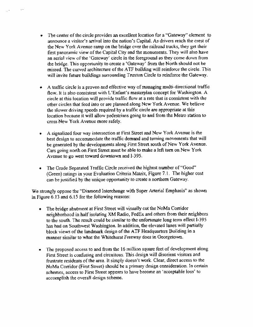


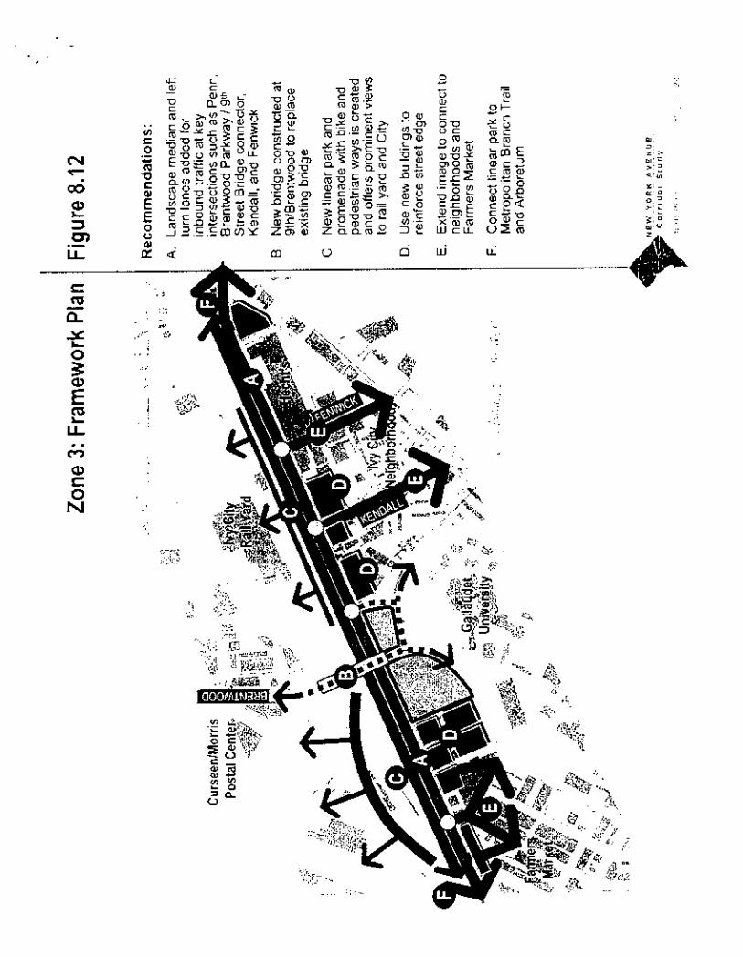


TURNING NEW YORK AVENUE INTO A YELLOW BRICK ROAD?
summary
The current high-traffic uses for New York Avenue make it a major functional artery forthe city which should grow as the region and its core city grow together. Fancifulnotions of converting it into some sort of tree-lined, better landscaped park for thegreater good of its fading surrounding neighborhoods are not only unrealistic butcounterproductive. In addition to being a major commuter route, it is in fact both theunfinished extension of I-395 for regional traffic, and the major "service entrance" tothe city's booming economy. It should be modernized to do those three jobs better,and possibly turned into a 2lst century fully-automated "toll road" that more than paysits way for our national capital city.
background
According to the draft plan recently made available, the DC government retained theservices of five consulting firms to conduct a team study of the five-mile New YorkAvenue Corridor in July of 2002. The objective of the million-dollar plus effort has beento produce a "vision" and an "innovative plan" to convert NYAve into an ideal"multimodal and intermodal corridor"which would:
o provide multimodal transportation, including automobiles, public transit, railroad,bicycles, and pedestrians, along with intermodal opportunities;
o facilitate smooth traffic flow;
o ensure an ability to accommodate local and regional vehiculartransportation and transit needs foreseeable over the next thirty to fiftyyears;
o create capacity for major commercial and residential development;
o avoid displacement of existing residents or exclusion of income diversity.
In working up a series of alternative designs for each of six different segments of a 4.6mile avenue, the team of consultants came up with "three major issues that guided thedevelopment of their recommendations. These issues and their qualities are:
o Neighborhoods: health, connection and vitality;
Page 1 of 23
6/22/2006http://www.narpac.org/REXLRNYA.HTM
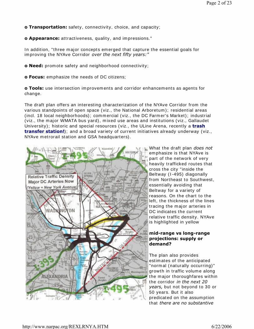
o Transportation: safety, connectivity, choice, and capacity;
o Appearance: attractiveness, quality, and impressions."
In addition, "three major concepts emerged that capture the essential goals forimproving the NYAve Corridor over the next fifty years:"
o Need: promote safety and neighborhood connectivity;
o Focus: emphasize the needs of DC citizens;
o Tools: use intersection improvements and corridor enhancements as agents forchange.
The draft plan offers an interesting characterization of the NYAve Corridor from thevarious standpoints of open space (viz., the National Arboretum); residential areas(incl. 18 local neighborhoods); commercial (viz., the DC Farmer's Market); industrial(viz., the major WMATA bus yard), mixed use areas and institutions (viz., GallaudetUniversity); historic and special resources (viz., the ULine Arena, recently a trashtransfer station!); and a broad variety of current initiatives already underway (viz.,NYAve metrorail station and GSA headquarters).
What the draft plan does notemphasize is that NYAve ispart of the network of veryheavily trafficked routes thatcross the city "inside theBeltway (I-495) diagonallyfrom Northeast to Southwest,essentially avoiding thatBeltway for a variety ofreasons. On the chart to theleft, the thickness of the linestracing the major arteries inDC indicates the currentrelative traffic density. NYAveis highlighted in yellow
mid-range vs long-rangeprojections: supply ordemand?
The plan also providesestimates of the anticipated"normal (naturally occurring)"growth in traffic volume alongthe major thoroughfares withinthe corridor in the next 20years, but not beyond to 30 or50 years. But it alsopredicated on the assumptionthat there are no substantive
Page 2 of 23
6/22/2006http://www.narpac.org/REXLRNYA.HTM

changes in the physical characteristics of the roadway. In essence, then, it is not aprojection of what is needed to match some desired or expected growth pattern for thecity and region, but an estimate of "what the traffic will bear", to coin a phrase, withthe modest changes proposed.
The chart below is reproduced (pilfered?) from the very professionally prepared DraftStudy Plan and shows the change in traffic volume as it proceeds from the PrinceGeorge's County Line (right center), westward to the Convention Center (lower leftcorner). NARPAC added emphasis to the National Arboretum (green) and the pre-maturely-terminated I-395 (yellow):
front door or back door?
The draft plan characterizes New York Avenue as the "principal vehicular commuterthoroughfare in DC from Interstate 95 and the Baltimore-Washington Expressway, aswell as Route 50" (from Annapolis, whish is not mentioned at all, either as Maryland'sCapital city, or as one of the most charming and historic waterfront cities (on theChesapeake Bay) on the East Coast). It notes that the route parallels Amtrak'sNortheast corridor passenger line "a major national and regional rail corridor".Unmentioned is that it is also part of the main tracks for CSX rail freight for the EasternSeaboard, not just from the Northeast, but from the Southeast as well.
The study team also asserts that NYAve "provides the first impression of Washingtonfor many tourists and visitors" and that "apart from its regional function, the corridoracts as a major local street for several residential neighborhoods". It alsoacknowledges that "the avenue also abuts and provides direct access to the largestconcentration of industrially zoned land in DC". To those of us who have lived in thenation's capital for years, NYAve is widely accepted as the kind of heavily traveled,strictly functional, truck-burdened, relatively unattractive, commercial/industrial
Page 3 of 23
6/22/2006http://www.narpac.org/REXLRNYA.HTM

roadways that lead into every large city virtually anywhere in the world.
The notion that this type of artery should be beautified and made neighborhood-friendly for some of the city's more run-down communities will strike many as a fool'serrand. This is particularly true when one realizes there are other convenient, far moreresidential avenues nearby, including Rhode Island Avenue to the north and WestVirginia Avenue and the newly refurbished H Street to the south. Together, those threemajor "urban streets" carry half the traffic volume of NYAve. Furthermore, there arefar more attractive "gateways" to the city, and most of them provide more directaccess to the visitors' parts of town from the major regional arteries. Were DCvisualized as one gigantic hotel serving the federal city, it seems irrefutable that NYAvewould be considered the primary "service entrance", not the ceremonial boulevard tothe grand foyer.
front yard or backyard?
The area around NYAve (well beyond the 2-block limit of the study's defined "corridor")is also, perhaps unfortunately but certainly understandably, not part of DC's "high-rentdistricts". Using the cluster analysis approach used extensively elsewhere on thisweb site, it is clear that the abutting neighborhoods are significantly below the citywideaverage in income, home ownership and value, education, two- parent households,and kids not in poverty. Perhaps more telling, population drop has exceeded the cityaverage, suggesting that many of those who can afford to leave are doing so. Is this abad thing, or a process of natural selection between residential areas and those doingthe city's less attractive commerce and industry?
The impression that this study is driven by some possibly misplaced effort at socialengineering is reinforced by the team's recognition that "transportation and land usedecisions are integrally linked". Interviews with local "stakeholders" indicated theirconviction that "there is a strong connection between the low level of transportationservice and the generally inferior quality of development that adjoins it". From suchinterviews the team concludes that "the quality and functionality of the transportationinfrastructure must be improved to attract a higher quality of development to thearea.". Where then do the railroad and bus service yards, the major FedEx packagedistribution center, the trash transfer stations, the rodent-infested farmers' market,and the commercial and industrial warehouses go? And for that matter, how do oureconomy's essential heavy commercial and construction trucks get to them? How dothey get to the rest of the city which is the throes of a remarkably robust renovation?
regional vs local?
In fact, the traffic analysis using the widely accepted MWCOG model does not supportthe notion that much of the traffic is "local". Only 14% of all traffic either originates orterminates within the defined Corridor and virtually none of it originates and terminateswithin the corridor. More to the point, perhaps, a full 50% of the traffic either startedor ended their trips outside the corridor, while another 29% of traffic both originatesand terminates out DC limits. In short, NYAve is a primarily a regional artery whichalmost certainly should continue to evolve as such, but with an acceptable, if not aminimal, impact on those obliged by circumstances to continue to live nearby.
half a freeway leaves much to be desired
Page 4 of 23
6/22/2006http://www.narpac.org/REXLRNYA.HTM

Furthermore, the study plan seems to underplay one of DC's less than stellartransportation facts of life. In the days when building freeways within city limits wasmore popular, an interstate was planned to cross the city north of the Anacostia fromsouthwest to northeast. Designated I-395, it came into the city from the south, crossedthe downtown area underground toward the north, and came to an unceremonious endat New York Avenue just east of Mount Vernon Square (and the new ConventionCenter). Blocked from proceeding northeast by neighborhood activists, it dumps its"through-traffic" onto New York Avenue. This has not only annoyed the localneighborhoods, but has caused substantial inconvenience to regional traffic for which alonger trip around the subsequently built I-495 "Beltway" is not a economically viableoption. NARPAC photographed the northern entrance to the I-395 tunnel in an earlierdescription of the plight of DC's homeless, some of whom find shelter in thelandscaped area adjoining the tunnel entrance.
The fact that NYAve still functions primarily as a major, but badly outdated, regionalartery is a testament to the pyrrhic victory of activism over economic demand. The factthat this study is focused more on increasing its neighborhood friendliness rather thanits economic functionality is a further tribute to failed, or at least misguided, urbanplanning and leadership. The fact that another federal/local study on impending urbantraffic gridlock designates both NYAve and several of its intersecting streets as already"at or over-capacity" cast doubt on the realism of planners' emphasis on making thisregional artery safe and attractive for pedestrians, joggers and bikers. And the factthat the study doe not mention the roles of either I-395 or NYAve as primaryevacuation routes from the primary American urban terrorist target further suggestsexcessive interest in local parochial demands at the expense of the larger citywide,regional, and national interests. As in the cases of the ongoing Whitehurst Freeway'deconstruction' and South Capitol Street aggrandizement studies, it appearsthat both federal and local planning monies re being spent by consultants charged withanswering the wrong questions.
the rim of the topographic bowl
NARPAC has always been somewhat amused by the thought that the prime part of thenation's capital is situated in a "topographic bowl". Nevertheless, such a topographicfeature, modest though it may seem in the 21st Century, did describe the limits of theoriginal, and now sacred, L'Enfant plan, and Florida Avenue described its "northernboundaries". Since Florida Avenue may be the most important intersection (traffic-wise) with NYAve, it is inescapable that travelers on that route will be subject to thehills and valleys (!) that surround the bowl. In fact, as one enters DC across theAnacostia River that is still only a few feet above sea level, the avenue rises to crossthree consecutive "hills" (approaching 100 feet in elevation!), before "descending" intothe "bowl" which has a typical elevation of 40 feet. Those elevation changes do suggesthowever, whether intersections should be separated by bridges or tunnels/cuts, as willbe discussed subsequently.
trucks, trucks, trucks
When NARPAC thinks NYAve, we think trucks. Trucks that deliver the sustenance andremove the refuse from that Great Urban Hotel in the Bowl. When the study teamlooks at NYAve traffic, they apparently only see "vehicles". In all their attractive artist'ssketches, only cars or the occasional 2-axle utility van are shown. The mostcomprehensive readily available truck count was done by COG for the 28 major
Page 5 of 23
6/22/2006http://www.narpac.org/REXLRNYA.HTM

entry/exit points around DC. According to this analysis about 8% of all trucks enteringDC came across the northwestern face (i.e., Western Ave) while 57% came across thenortheastern face (i.e., Eastern Ave), 20 % came across Southern Ave on thesoutheastern face, and 15% across the major Potomac bridges from Virginia to thesouthwest. Four entry points were responsible for 52% of all trucks crossing DCborders. More important, they bore 61.5% of all the heavier (3-axle and up, single,and double units) trucks. NYAve accounted for more than a quarter of the total trucksin each category. In a different more recent tally of 16 different key intersectionswithin the city, NYAve at Bladensburg (see below) accounted for 28% of all the truckscounted. Lastly, a more detailed total vehicular count was made for this study effort,racking up a total of 2,104,800 vehicles of while a mere 178,900 were classified astrucks and only 63,000 of those meet NARPAC's standard for "heavy trucks". Butbecause of their larger size and weight, all trucks account for 38% of all the tonnageon the road and 15% of the total vehicular length. Those heavy trucks, in turn, accountfor two-thirds of the weight (and hence power, and emissions) and half of the length ofall trucks. 39% of these Big Mommas are 3- or 4-axle single units (think dump trucksand big-box trucks), and another 49% are the big 8-wheel twin-axle trailers pulled by10-wheel, 3-axle tractors. The photo below shows such an "18-wheeler" re-supplyingthe McDonald's at NYAve and First Street NE on a recent Sunday morning.
a six-part vision of an all-purpose New York Avenue
Notwithstanding NARPAC's idiosyncratic views, the study team has produced a visionand innovative plan for New York Avenue. It tapers down from a regional freewaywhere it enters DC from Prince George's County as both US Route 50 and Alternate USRoute 1 to an "urban street" as it merges with Massachusetts Avenue in front of thenew Convention Center. The following sections summarize the six distinctivelydesigned zones identified by the study team, moving west from the District Line, whereNew York Avenue crosses the upper reaches of the Anacostia River, toward Mt. VernonSquare (which essentially forms the northeast corner of "Downtown DC"). These zonesare shown on this study plan graphic:
Page 6 of 23
6/22/2006http://www.narpac.org/REXLRNYA.HTM

Zone 1: "Create an "Urban Boulevard"
Little change is proposed for this first mile and a half stretch as far as the roadconfiguration itself is concerned. It will remain three lanes in each direction with adivider. It currently carries something over 127,000 vehicles per day (vpd) that havejust sorted themselves out from several incoming routes including Route 50 (HansonHighway), Route 201 (Kenilworth Avenue) as well as the Baltimore-WashingtonParkway, predecessor to I-95 north. Shortly after entering DC, there is a majorinterchange with South Dakota Avenue which travels northwest parallel to EasternAvenue, and handles over 45,000 vpd, leaving a count of some 69,000 vpd headedwest into town. There were 36 accidents at this interchange in 2001.
According to the 2003 peak-hour traffic counts done for this study, morning rush is63% inbound, and afternoon rush is 72% outbound. By 2025, the total flow into DC isprojected to rise 29% to 164,000 vpd, with a proportional share diverting to SouthDakota Avenue, and 89,000 continuing west. It might be noted that both New YorkAvenue and South Dakota Avenue are already designated as "at, near, or overcapacity".
Elevation-wise, Route US-50 enters DC at about 2 feet above sea level, rises to about70 feet around the South Dakota interchange, and drops back to about 53 feet at theBladensburg intersection.
The plan proposes to generate the image of an "urban boulevard" by "creating bicycleand pedestrian facilities....and enhanced edge plantings to define the boulevard edgeand better screen buildings along the route". They also propose adding a number ofeye-catching "urban design elements" such as distinctive street lighting, ornamentalrailings, raised planters and decorative walls to pleasure the driver.
South of NYAve in this area lies the huge National Arboretum. The northern side is
Page 7 of 23
6/22/2006http://www.narpac.org/REXLRNYA.HTM

zoned entirely for industrial and commercial uses, and is flanked by a major branch ofthe rail line which turns northeast through Prince George's County.
The project cost estimate for this Zone 1 involved $4M in preliminary engineering, plussome $26.6M in construction of special "design elements" and the accommodating ofbicycles and pedestrians. No changes are proposed in the rights of way.
Zone 2: "Create Focal Points at Intersections"
This short distance of perhaps a quarter mile is characterized by two grade levelintersections only a short distance apart. The first and more important of the two isBladensburg Road, the latest incarnation of the original horse and carriage trail fromWashington to Baltimore and on North. There were 87 significant vehicular accidents atthis intersection in 2001, compared to some 36 at South Dakota Avenue, despite itshigher traffic flow. The traffic flow on NYAve currently drops to some 57,000 vpd as itcontinues beyond here, while Bladensburg carries some 27,000. By 2025, traffic onNYAve past this intersection is expected to rise 25% to 71,000.
Only a block or so further on, lies a smaller intersection with Montana/West VirginiaAves which has a traffic flow of only about 7,000 vpd, but also experienced 25vehicular accidents in 2001. The Montana Avenue intersection is perhaps 20 feet higherin elevation than the one at Bladensburg, as NYAve begins its climb to a "plateau" ofabout 100 feet in Zone 3. Bladensburg Road has also climbed a hill of about 95 feetfrom its 47 ft elevation at the "starburst" intersection with Florida and MarylandAvenues, H street, and Benning Road (the subject of yet another consultant-ladenstudy) before dropping back to some 52 feet at NYAve and then climbing back up toalmost 100 feet at South Dakota Avenue.
The planners suggest building a major new over-and-under intersection atBladensburg, while simply upgrading the appearance of the faux "circle" at MontanaAvenue. They also suggest improving the landscaping along the roadway edges, andcreating new architectural guidelines for any new commercial and industrial buildings,setbacks, and "pedestrian environment". An informative artist's sketch of this newunderpass is shown below. NARPAC finds it symbolic that there are no trucks in sight:
Page 8 of 23
6/22/2006http://www.narpac.org/REXLRNYA.HTM

The major new intersection would leave Bladensburg Road at grade level, whiledepressing NYAve below grade. Without explanation, this choice will tend topermanently limit NYAve to three lanes in each direction, while allowing Bladensburg,with far lower traffic rates, to expand more easily. Since this intersection is already in a"depression" along both NYAve and Bladensburg, one wonders why an overpass wasnot selected rather than an underpass for Bladensburg Road.
Costs are estimated to include $43.6M for right-of-way expansion, $9M forengineering, and $56M for construction. The "beautification" of the Montana Avenue"circle" would involve $6.4M. No new lanes are added for moving traffic, thoughstreamlining the Bladensburg Road intersection would clearly add to both safety andthrough-traffic capacity.
Zone 3: "Create an "Linear Park"
The mile and a half between the Montana Avenue intersection and the key FloridaAvenue interchange contains some of the most far-reaching changes to create a "linearpark" including two pedestrian walks, one bike trail, and essentially four potentialtraffic lanes devoted to trees, (some of which also serve as left turning lanes, sincevirtually all the commercial/industrial activity along this stretch is accessed by fourlesser roads on the south side of the avenue). East and West traffic would be separatedby a fixed, raised and planted median (which makes lane- direction-switching almostimpossible). An existing set-back on the south side, and some truck- parking areas onthe north side would be integrated into the new "linear park", but no lanes of movingtraffic would be added.
Two "inspiration points" would be added to the north side provide unfetteredpanoramas of the rail yards and main tracks, the large Brentwood postal facility (madefamous by the unsolved and lethal incident of anthrax in the mail), as well as aninteresting view of the newly refurbished McKinley Technical High School on the highground (almost a bluff!) in the Eckington neighborhood. Some local residents suggestthat parks in these neighborhoods tend to become homes for the homeless, and are
Page 9 of 23
6/22/2006http://www.narpac.org/REXLRNYA.HTM

essentially "zoned for the drug trade".
Traffic along this segment is estimated to be a bit higher at 60,300 vpd now, butexpected to grow (without explanation) by some 34% to 81,000 by 2025. This sectionof roadway is bordered by industrial and commercial zoning as well as one portion of"mixed use". Current rush hour traffic is 66% inbound in the morning, and 73%outbound in the afternoon, and would presumably rise to about 90% outbound duringan evacuation at any time. A fixed, obstacle- planted median seems to NARPAC to bethoroughly counterproductive.
Running east to west, NYAve has risen from 70-odd feet above sea-level at MontanaAve to about 100 feet by its minor bend, where it stays level until it passes over themajor CSX (and Metro) railroad tracks, and drops 35 to 40 feet into the Florida Avenueat-grade intersection. Half way along this stretch, drivers are surprised to find adilapidated overpass (looking about as bad as the average railroad bridge in DC) whichconnects Brentwood, north of the railroad tracks, with Ivy City, Trinidad, and GallaudetUniversity to the South.
Costs to fix up this zone are expected to exceed $183M, including total refurbishmentof the Brentwood Avenue overpass. Of those funds, $78M would go for right-of-wayexpansion, $11M for engineering, and $94M for new construction. Some minorimprovements to traffic capacity will result from changing access to local streets, butthe injection of "urban vitality" in the form of pedestrians, strollers, joggers, bikers,inspiration- (and other recreation-) seekers may well contribute to others risks anddistractions.
Zone 4: "Transition to a Neighborhood Avenue"
This quarter-mile "transition zone" appears to be the least well thought out part of theplanned renovation, as commuters and truck drivers plunge downhill from their "linearpark" fantasy, to face the avenue's most heavily trafficked grade-level intersectionswhich also rack up a good share of the avenue's accidents. Between Florida Avenueand the (below-grade) underpass for North Capital Street, redevelopment is in fullswing. It has already been fueled by the complete conversion of the old People's DrugStore warehouse into DC government offices, and the construction of the majorpackage sorting FedEx facility on the north side. Another large commercial enterprisewill soon be added on formerly residential properties in the wedge between NorthCapitol and O Streets and NYAve. It will soon be fueled even further on the south sideby the development by GSA of the full block facing the brand new NYAve MetroRailstation, (accessed from Florida Avenue) including the new federal headquarters for theATF.
This six-lane, virtually undivided (just a narrow curb-high median) section of NYAve,currently handles some 60,000 vpd (as Zone 3) essentially in a flat "valley" nominally55 feet above sea level, with traffic again expected to rise to some 34% to 81,000 by2025 with the proposed avenue changes. Equally important, however, is that traffic onthe undivided six-lane Florida Avenue is expected to increase 74% northwest-boundfrom 37,000 to 64,000 vpd, and 77% southeast-bound from 31,000 to 55,000 vpd.There is also a very large traffic exchange between the two avenues, as much as 30%during peak hours. Florida Avenue northward is already over capacity, and will becomeso southward as well. And the intersection is further complicated by the nearbytraverse of 1stStNE, which results in overlapping traffic and traffic signals.
Page 10 of 23
6/22/2006http://www.narpac.org/REXLRNYA.HTM
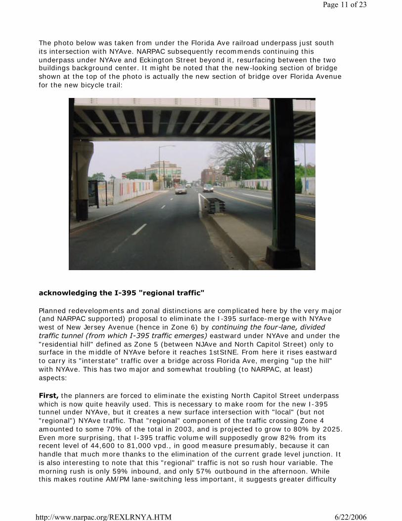
The photo below was taken from under the Florida Ave railroad underpass just southits intersection with NYAve. NARPAC subsequently recommends continuing thisunderpass under NYAve and Eckington Street beyond it, resurfacing between the twobuildings background center. It might be noted that the new-looking section of bridgeshown at the top of the photo is actually the new section of bridge over Florida Avenuefor the new bicycle trail:
acknowledging the I-395 "regional traffic"
Planned redevelopments and zonal distinctions are complicated here by the very major(and NARPAC supported) proposal to eliminate the I-395 surface-merge with NYAvewest of New Jersey Avenue (hence in Zone 6) by continuing the four-lane, dividedtraffic tunnel (from which I-395 traffic emerges) eastward under NYAve and under the"residential hill" defined as Zone 5 (between NJAve and North Capitol Street) only tosurface in the middle of NYAve before it reaches 1stStNE. From here it rises eastwardto carry its "interstate" traffic over a bridge across Florida Ave, merging "up the hill"with NYAve. This has two major and somewhat troubling (to NARPAC, at least)aspects:
First, the planners are forced to eliminate the existing North Capitol Street underpasswhich is now quite heavily used. This is necessary to make room for the new I-395tunnel under NYAve, but it creates a new surface intersection with "local" (but not"regional") NYAve traffic. That "regional" component of the traffic crossing Zone 4amounted to some 70% of the total in 2003, and is projected to grow to 80% by 2025.Even more surprising, that I-395 traffic volume will supposedly grow 82% from itsrecent level of 44,600 to 81,000 vpd., in good measure presumably, because it canhandle that much more thanks to the elimination of the current grade level junction. Itis also interesting to note that this "regional" traffic is not so rush hour variable. Themorning rush is only 59% inbound, and only 57% outbound in the afternoon. Whilethis makes routine AM/PM lane-switching less important, it suggests greater difficulty
Page 11 of 23
6/22/2006http://www.narpac.org/REXLRNYA.HTM
handling a major urban evacuation.
Second, the "local" traffic between Florida Avenue and the Convention Center is nowin separate grade-level lanes which cannot readily "mix". Complicated by a demand forcurbside parking for a short distance "over the hill", these lanes become less utilitarian,and cannot react to the larger AM/PM rush hour bias (72% in, 74% out). This isdiscussed further under Zone 5.
Third, there is no reason to believe that most of the trucks are "regional", even thoughmost of the cars may be "local" commuters. Trucks are likely to be turning off (or backonto) NYAve at every major intersection that allows them to penetrate the city to theirone or several destinations. Those turning intersections must be designed toaccommodate large trucks efficiently.
The cost estimate for this tunnel and local street restoration comes to a resounding$400.6M, including $84.2M for expanded rights of way, $50M for engineering, and$326.4M for actual construction. This is a full 48% of the total estimated costs of$955M.
back to Zone 4
In addition to adding the tunnel and removing the North Capitol Street underpass, theplanners intend to "improve the Florida Avenue intersection to meet local and regionaltraffic needs and provide additional turning movements", "enhance pedestrianconnections to better serve neighborhoods, Metro and Florida Avenue development",and provide "special 'identity focal points' to create active pedestrian spaces and helpto tie Florida, North Capitol, and NYAve together", whatever that may mean.
Three options are sketched out to separate Florida traffic from (some of) New York Avetraffic. The first suggests an "artistic tunnel" for a six-lane Florida avenue passingunder a 4-lane (??) New York Avenue, which leaves "local" NYAve traffic crossing atgrade level. The sketch indicates that NYAve has been elevated, not Florida depressed.The second option is an "artistic bridge" which appears to differ only in addingsidewalks to Florida Avenue as it passes under NYAve, plus making a dramaticstatement out of what would otherwise be your typical overpass. The third optionshows a "traditional bridge" that differs primarily by adding center supports under thebridge, and different-looking bridge abutment towers that repeat motifs from theConvention Center down the road. This option is shown below, with an insert showingthe Convention Center motifs:
Page 12 of 23
6/22/2006http://www.narpac.org/REXLRNYA.HTM

All three options show a six-lane Florida Avenue under a four-lane NYAve. With nothingbut sharp corner turns for traffic transferring from one avenue to the other, it isdifficult to discern the added "turning movements" whatever that may mean.Furthermore, NARPAC feels obliged to note again, there is not as truck, a bus, or a vanillustrated in any of the sketches, and the number of through lanes appears to be less,certainly not more, than exist now. Finally, none of the three sketches, all variations onthe same theme, offer any imaginative solutions to the complexities added by the closepresence of 1stStNE: it is apparently simply eliminated as a separate cross street forvehicles or pedestrians.
The costs of constructing a bridge at Florida Avenue, plus fixing up the railroadoverpass, are estimated at $124.8M, including some $17M for engineering.
Zone 5: "Become a Neighborhood Avenue"
To NARPAC, the least credible segment of this transportation planners' vision is thisattempt to revitalize a "neighborhood (residential?) avenue" between North Capitol andthe present terminus of I-395. It runs for a total of 2000 feet, complete with streetsidesidewalks and curbside parking, 13 vehicle entry and exit points (NoCapSt; N St (2);Tyler House entrance; 1stStNW; M St East; Kirby St; M St West; New Jersey Ave; 3rdSt; Bible Way Church parking entrance; I- 395; and 4th St), and at the very most, atotal of 80 to 100 front doors and front stoops.
As a matter of curiosity, NARPAC checked out the (already inflated) 2006 propertyassessments for the 26 well-tended row houses on the north side on NYAve betweenNorth Capitol and 1stStNW on "residential hill". Altogether they sit on only half an acreof land whose value is assessed at $2.2M, with improvements now reaching $6.2M.Multiplying this by four still yields a total value of only $25M. It may also be of interest
Page 13 of 23
6/22/2006http://www.narpac.org/REXLRNYA.HTM

that 42% of these homes are rented, and close to 20% have changed hands within thepast few years, six for between $200K to $400K. Hardly a community of long-time,deeply-invested neighbors. They are pictured below:
Traffic-wise, an increase of 53% in "local" traffic on NYAve is expected to pass betweenNorth Capitol Street, and Mt. Vernon Square, from 23,500 to 36,000 vpd by 2025.Rumbling beneath the avenue in the new tunnel by 2025 will be 81,000 vpd, which willsurely equate to more than one per second during the rush hours. How will thosenumbers project for the next 30 years? Surely modern residential buildings (replacingthe old ones currently there) would be far more habitable in the long run, and couldreadily be designed to include off-street parking, as well as off-main street front doors!NARPAC is convinced that the current quaint homes in Zone 5 should not seriouslycompromise the redevelopment of NYAve, and that the substitution of new higherdensity urban dwellings would be preferable, but only if such a demand really exists.Pressures to re-zone these two blocks are certain to grow, and may in fact be appliedby the newer homeowners (and speculators?).
Of equalinterest is the(questionable?)proposal toeliminate theNorth CapitolStreetunderpasswhich nowaccommodatessome 29,100vpd with astrong AM/PMdirectional shift,and a relatively
Page 14 of 23
6/22/2006http://www.narpac.org/REXLRNYA.HTM
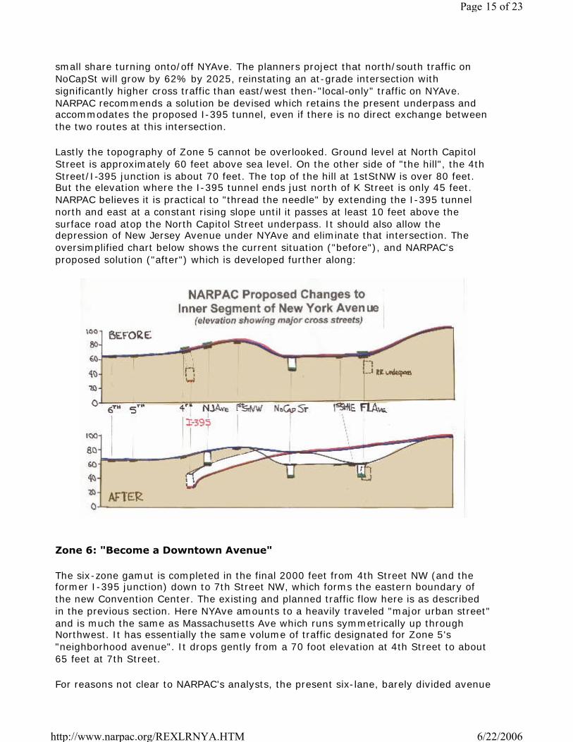
small share turning onto/off NYAve. The planners project that north/south traffic onNoCapSt will grow by 62% by 2025, reinstating an at-grade intersection withsignificantly higher cross traffic than east/west then-"local-only" traffic on NYAve.NARPAC recommends a solution be devised which retains the present underpass andaccommodates the proposed I-395 tunnel, even if there is no direct exchange betweenthe two routes at this intersection.
Lastly the topography of Zone 5 cannot be overlooked. Ground level at North CapitolStreet is approximately 60 feet above sea level. On the other side of "the hill", the 4thStreet/I-395 junction is about 70 feet. The top of the hill at 1stStNW is over 80 feet.But the elevation where the I-395 tunnel ends just north of K Street is only 45 feet.NARPAC believes it is practical to "thread the needle" by extending the I-395 tunnelnorth and east at a constant rising slope until it passes at least 10 feet above thesurface road atop the North Capitol Street underpass. It should also allow thedepression of New Jersey Avenue under NYAve and eliminate that intersection. Theoversimplified chart below shows the current situation ("before"), and NARPAC'sproposed solution ("after") which is developed further along:
Zone 6: "Become a Downtown Avenue"
The six-zone gamut is completed in the final 2000 feet from 4th Street NW (and theformer I-395 junction) down to 7th Street NW, which forms the eastern boundary ofthe new Convention Center. The existing and planned traffic flow here is as describedin the previous section. Here NYAve amounts to a heavily traveled "major urban street"and is much the same as Massachusetts Ave which runs symmetrically up throughNorthwest. It has essentially the same volume of traffic designated for Zone 5's"neighborhood avenue". It drops gently from a 70 foot elevation at 4th Street to about65 feet at 7th Street.
For reasons not clear to NARPAC's analysts, the present six-lane, barely divided avenue
Page 15 of 23
6/22/2006http://www.narpac.org/REXLRNYA.HTM

is reduced by the planners to two lanes in each direction, separated by a more formalmedian, and with double-tree-lined islands separating the curb from the sidewalks.Apparently, no parking or stopping will be allowed along these three blocks identifiedas hosting "business" on both sides. At 4th Street, outbound traffic would findresidential parking lanes replacing one row of trees as it courses through the newly re-asserted residential neighborhood. In the eyes of the transportation planners, NYAvehas now become an "address street" for new mixed-use development. And that's along way to go from the two remaining residential shells on the north side of NYAvebetween 5th and 6th Streets shown below:
The southern side of NYAve in Zone 6 is the boundary of the new high density planningeffort for the "Mount Vernon Triangle" (once referred to as "NOMA" for "North of MassAve) which also incorporates the old Wax Museum site. It should be noted that as partof this new development, in fact an extension of "downtown", K Street will berejuvenated into a major avenue from Mt. Vernon Square eastward at least as far aseasily the World's Ugliest Railroad Underpass. NARPAC would hazard a guess that thisextension of DC's most important (and widest) downtown boulevard (in the true senseof the word) is a far better candidate to become a prestigious "address street", whileNYAve seems destined to become more of a honky-tonk adjunct to the ConventionCenter along the same sidewalk.
It should be noted that almost 40% of the total accidents within this study zone arebetween North Capitol Street and 4th Street NW, presumably due to the larger numberof intersections, local traffic, and curbside parking.
The one intriguing element in this plan is the opportunity to create a sizeable new lotjust west of the Bible Way Church where I-395 traffic emerged from its tunnel to joinNYAve. This could add perhaps a full acre of taxable land to DC's limited inventory, andpermit reconnecting L Street from NYAve eastward across North Capitol to 1stStNE. Itis, in fact, a somewhat larger parcel than all the 26 row houses on the north side of"residential hill", including another set of houses facing north on N Street, and a few
Page 16 of 23
6/22/2006http://www.narpac.org/REXLRNYA.HTM
facing west on 1stStNW. Perhaps they should be redeveloped together.
The planners estimate $41M for redesigning and reconstructing the three blocks ofNYAve outbound from 7th to 4th Streets, NW, to sustain 33% less traffic but roughly300% more trees.
Overall Effectiveness of Planners' Preferred Options:
The study's "Task 4: Traffic Analysis" is an interesting effort to estimate the impact oftraffic growth if a) nothing is done to improve the streets; and b) the planners' choicesare in-place by 2025. There is also an interesting excursion to explore what happens ifI-395 is extended along NYAve and to join the inner end of the Washington-BaltimoreExpressway. The model used involves an iterative process, which, like most drivers,keep exploring their travel route options until all are equally unattractive. Hence, the"freeway" option attracts substantially more vehicles (almost double on manysegments) and appears to have been discarded for this reason! Instead, lesserexpansion is proposed, and as a result, the major intersections do not (quite) reachserious "overcapacity" within the next 20 years.
It seems to NARPAC that the planners are proposing a solution that is heavy onlandscaping, appearance and neighborhood friendliness, but one that will bechockablock within a very few years after its 13-year reconstruction is finished!Unfortunately, the study documents do not make clear just how robust the plannedgrowth for traffic into and through DC is compared to other estimates of regionalgrowth. NARPAC, with its normal skepticism, concludes that the proposed changes areprobably at best marginal, and overly influenced by neighborhood fear of change andinevitable urban growth.
NARPAC Alternative
Mercifully, NARPAC has not redesigned all six separate "zones". But its objectiveswould be much simpler and more functional:
Plan to modernize NYAve primarily as a commercial/industrial/commuter artery fromthe Pr. George's County Line to DC's expanding "Downtown" area at a pace consistentwith expected regional growth so that it can:
a) continue its essential function as the primary "service road" for heavyvehicles into and out of the nation's capital;
b) serve as the eastern extension of the never-completed I-395 for regional andcommuter traffic,
c) exert a minimal negative impact on the viable nearby neighborhoods fromthe standpoints of safety, connectivity, adverse environment or visual offensiveness;and d) where possible, encourage the use of other nearby streets and arteriesfor scenic parks, pedestrian and personal transport systems, artistic structures, andneighborhood residential living.
We suggest that there need be only two planning segments along this 4.6 mile, high-traffic artery, with the dividing line at Florida Avenue:
Page 17 of 23
6/22/2006http://www.narpac.org/REXLRNYA.HTM
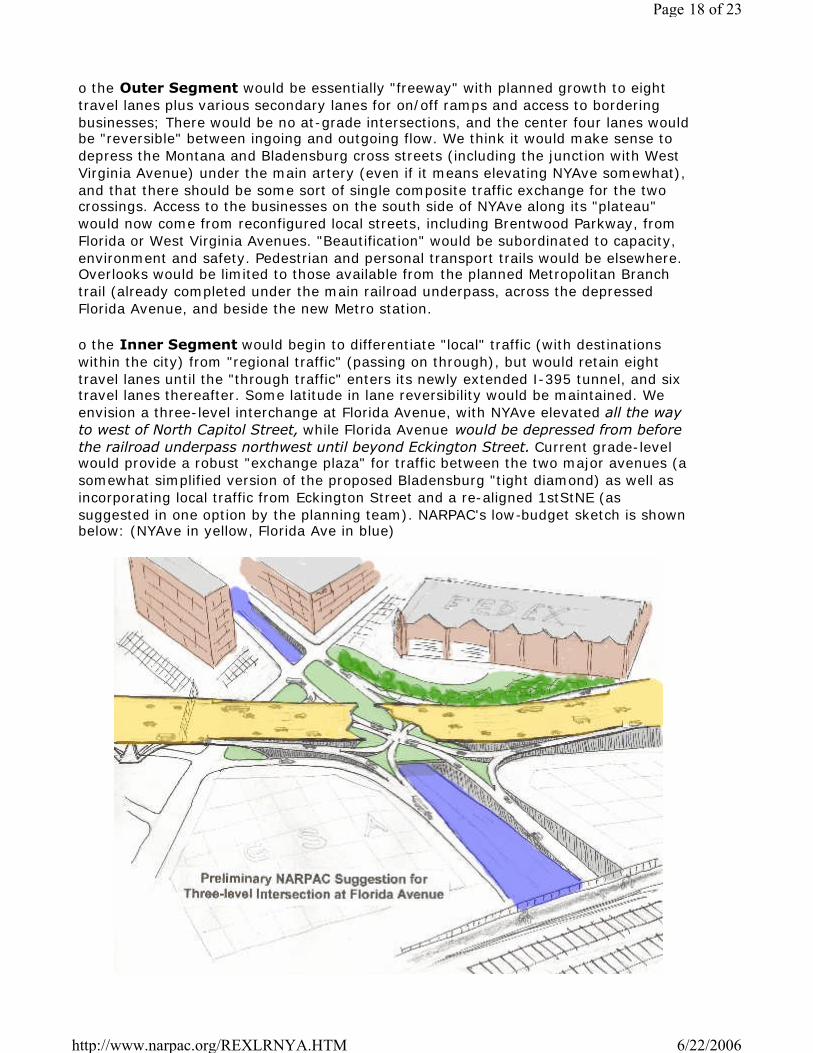
o the Outer Segment would be essentially "freeway" with planned growth to eighttravel lanes plus various secondary lanes for on/off ramps and access to borderingbusinesses; There would be no at-grade intersections, and the center four lanes wouldbe "reversible" between ingoing and outgoing flow. We think it would make sense todepress the Montana and Bladensburg cross streets (including the junction with WestVirginia Avenue) under the main artery (even if it means elevating NYAve somewhat),and that there should be some sort of single composite traffic exchange for the twocrossings. Access to the businesses on the south side of NYAve along its "plateau"would now come from reconfigured local streets, including Brentwood Parkway, fromFlorida or West Virginia Avenues. "Beautification" would be subordinated to capacity,environment and safety. Pedestrian and personal transport trails would be elsewhere.Overlooks would be limited to those available from the planned Metropolitan Branchtrail (already completed under the main railroad underpass, across the depressedFlorida Avenue, and beside the new Metro station.
o the Inner Segment would begin to differentiate "local" traffic (with destinationswithin the city) from "regional traffic" (passing on through), but would retain eighttravel lanes until the "through traffic" enters its newly extended I-395 tunnel, and sixtravel lanes thereafter. Some latitude in lane reversibility would be maintained. Weenvision a three-level interchange at Florida Avenue, with NYAve elevated all the wayto west of North Capitol Street, while Florida Avenue would be depressed from beforethe railroad underpass northwest until beyond Eckington Street. Current grade-levelwould provide a robust "exchange plaza" for traffic between the two major avenues (asomewhat simplified version of the proposed Bladensburg "tight diamond) as well asincorporating local traffic from Eckington Street and a re-aligned 1stStNE (assuggested in one option by the planning team). NARPAC's low-budget sketch is shownbelow: (NYAve in yellow, Florida Ave in blue)
Page 18 of 23
6/22/2006http://www.narpac.org/REXLRNYA.HTM

The elevated section of NYAve between the railroad overpass and "residential hill" (seeabove) would involve considerable "artistic engineering" with the hope of looking morelike the new Woodrow Wilson Bridge that the old Southeast Freeway. The large areaunder the bridge, i.e., the current NYAve roadbed, could provide local access and"connectivity "as well as a significant amount of high-density, robotic parking. Between1stStNE and NoCapSt, one could easily park 750 cars diagonally, nose-to-nose, in 3-level racks (see crude cutaway section above. All would bel within (relatively) easywalking distance of the new New York Avenue Metrorail station, and all theoffice/commercial buildings now planned to line each side of the avenue.
Driving west, the five-lane entrance cut to the I-395 tunnel would begin immediatelyafter crossing over North Capitol Street, and become a covered, downward slopingtunnel before passing under 1stStNW. Two "local lanes" would follow the current NYAvetrace over the top of "residential hill" and down the other side towards Mt. VernonSquare. Parking for the (new?) buildings lining each side of the hill (see abovediscussion re Zone 5) could be provided in the new median above the tunnel, if neededmore than trees. Traffic entering the tunnel from Prince George's County line wouldhave had no traffic lights to contend with inside DC. (NYAve in yellow, North CapitolStreet in blue, stacked parking in cut-out under NYAve):
If it is necessary or desirable to keep "hilltop residential zoning" in the rectangular areadefined by NJAve, and NoCapSt. at its ends, and M St and N St on its sides, rebuildingthat area , including "air rights" above the proposed extension of the I-395 tunnel,could be a fascinating neighborhood redevelopment. In addition, the Tyler Houseparking lot could be decked over to provide additional parking and attractive new frontaccess to re-built buildings now facing NYAve from the south. The housing on the northside of NYAve should be rebuilt to face M Street with parking underneath. Any (truly)displaced residents could easily be re-absorbed into as many as 250 (?) higher density
Page 19 of 23
6/22/2006http://www.narpac.org/REXLRNYA.HTM
city-view condos. Those redevelopments should easily pay for themselves, and perhapspay for part of the transportation reconstruction as well.
(It may also be possible to provide rush-hour and/or evacuation access to/from thenew section of the I-395 tunnel from/to the western end of NYAve (the Planners' Zone6), but we have not tried to design this.)
what about mass transit?
o NARPAC is always frustrated by the lack of interest in extending Metrorail inside DC.In our long-range world, direct links are needed from a) Cheverley to U Street, viaNYAve, as a major part of developing rail service to Annapolis, and b) fromStadium/Armory to U Street via NYAve as the eastern side of a new inner "CircleLine" (as in London) skirting Downtown. Both could well impact the area around thenew NYAve station. (See our discussion elsewhere of suggestions for robustmetrorail expansion
considering new technologies
Finally, NARPAC encourages the planners to include some of the emerging technologyoptions associated with long-term transportation, particularly urban transportation,issues. We would include the following, to name a few: lower emissions, quieter,vehicle engines; traffic and parking monitoring, controlling, enforcing, (and taxing)using RFID's (embedded in license plates?); potential use of robots to speed upcurbside pick-ups and deliveries; converting transportation infrastructure usage into anet revenue-producer; more efficient, variable use of existing traffic lanes and totalright-of-way width; exploiting the third dimension, as in "urban decks", "elevatedsidewalks", "air rights", and "underground parking (dirt rights)"; high-density roboticparking systems; "smart curbs" (indented, monitored, and remotely metered) forcontrolling the surge in delivery vehicles; and new developments in "personal transportsystems" (viz., segways).
Perhaps the most interesting of these in relationship to NYAve would be the possibilityof making all major commercial "gateways" to the city into E-Z Pass-like toll roads.Surely this would present an interesting forward-looking opportunity to use consultantsand federal study money to explore various implementation strategies.
making America's love affair profitable
NARPAC truly believes that vehicle ownership and use in America is an undeniableprivilege, and in most cases a demonstrable necessity. However, since these intrusivevehicles require, use, and wear out public space and infrastructure, they should andcan easily pay their way for using up and upgrading urban transportationinfrastructure. Hence, we would fully support any/all efforts to employ and automate:a) charging $A to $C per hour that every truck over X to Z tons is inside the city limits;b) expanding speeding, red light-running controls and fines; c) increasing parking feesand fines; d) charging $B cents per minute for every delivery truck temporarily parkedin restricted, indented-curb parking spaces; e) charging $D to $F per 8-hour day forevery private out-of-state vehicle parked in current old-fashioned off-street parkinglots, depending on its size and fuel consumption; f) charging $D/2 to $F/2 for every in-or out-of-state vehicle parked/stored in new city-owned high-density robotic parkingfacilities; and g) establishing a higher property tax rate for any vehicle(s)-owning
Page 20 of 23
6/22/2006http://www.narpac.org/REXLRNYA.HTM

homeowners without demonstrable off-street parking capacity.
In this case, the only new technology required is no longer untried but in increasinguse in the US and elsewhere. It is a cross between earlier aircraft IFF systems, currentair traffic control transponders, automated bar code readers in all stores and on allrailroad freight cars, the "smart- cards" transit riders "swipe" over metro turnstyles,and the latest automated EZ-Pass toll-taking devices used more and more widely byAmerican vehicles for all major roads, bridges and tunnels.
The "transponders" that give off their code number when pulsed now cost a fraction ofa dollar. The "receivers" that record that code number and transmit it to computerscosts less that $50 (perhaps no more than a parking meter?). Those receivers can bemade an integral part of typical overhead traffic signs. The transmission of the codenumber to the resolving computers is now virtually wireless. The computers requiredare no bigger than commercial desk-top units, and the billing systems are asautomated as in the credit card industry. The result is that not only Big Brother, buteven Uncle Tony can now know where that particular transponder is, and a great dealabout it: who owns the vehicle; where it's registered; how much it weighs; how big itis (dimensionally); how much fuel it consumes; and, of course, how much toxic gas(and even noise) it emits. There remains only the need for local legislation to requirethat all vehicles entering DC carry the transponders (NARPAC suggests embeddingthem in license plates in our analysis of automated parking garages), and to set arealistic schedule of fees.
Without pretending to have designed all the details, NARPAC does have a vision forhow very substantial revenues might be generated from New York Avenue's busytraffic. Consider three primary aspects of this technique: first a "toll" is charged whenany tagged vehicle enters DC, just as the EZ-Pass system does. Second, the time ofentry can be logged, and later matched to the time of exit through any otherinstrumented "gate" in the system. Third, the same system can be used to bill thevehicle for time spent in parking garages or other designated locations, such asreserved curbside delivery points. In addition, these tags lend themselves forregistering traffic offenses such as illegal parking, blocking the progress of publicvehicles, speeding, and even red- light running. Furthermore, varying rates can beapplied depending on the size, weight, and environmental damage wrought by anyparticular vehicle type. The table below shows the potential revenue generatingpotential of such a system. Six categories of vehicles are chosen to run the gamut fromlightweight, fuel-efficient urban friendly cars weighing from 1200 to 3500 pounds, upthrough the various common "eighteen wheelers" (tractors with 40-50 foot two-axletrailers) weighing between 20 and 40 tons.
Page 21 of 23
6/22/2006http://www.narpac.org/REXLRNYA.HTM

The "tolls" column indicates the entry toll charged, not far different from the bridgetolls used on bridges around New York. The"In Town" column shows typical "meterreadings" for the time spent by that vehicle within the DC limits. The "OK Pkg" columnshows the net revenues from the average time spent in authorized parking spots.These numbers seem low because a good share of the traffic was simply "passingthrough" town. Some plug numbers are used to guess at the number of traffic rulesthat might be violated by various vehicle classes in conjunction with the fines levied(also by vehicle class). The lavender column shows the average revenues that mightbe generated by each class of vehicles in one day. The average city-friendly car mightbe charged just under $9, while the average huge trailer truck delivering puppy chowin bulk to pet stores in Georgetown might be charged $80. That might equate to 0.2cents per pound of product delivered, which should not undermine the city's economy.or its puppies!
And finally, the green column shows the product in millions of dollars of a) the averagedaily fees times b) the number of vehicles estimated in each category on New YorkAvenue in recent years; times c) the number of days per year in a five-day week fortrucks and vans, and a six-day week for cars. The numbers really add up. Using theseprimitive guesses, it is not fanciful to gross a total of almost $250 million annually.Surely some share of that could be applied to the costs of upgrading New York Avenueand its associated nearby road network.
summary
The current high-traffic uses for New York Avenue make it a major functionalartery for the city which should grow as the region and its core city growtogether. Fanciful notions of converting it into some sort of tree-lined, betterlandscaped park for the greater good of its fading surrounding neighborhoodsare not only unrealistic but counterproductive. In addition to being a majorcommuter route, it is in fact both the unfinished extension of I-395 forregional traffic, and the major "service entrance" to the city's boomingeconomy. It should be modernized to do those three jobs better, and possibly
Page 22 of 23
6/22/2006http://www.narpac.org/REXLRNYA.HTM

turned into a 2lst century fully-automated "toll road" that more than pays itsway for our national capital city.
This page was updated on July 5, 2005
Please send us your feedback
| HOME PAGE | MAJOR ISSUES | CURRENT STATUS | RECENT ANALYSES | SITE MAP |EMAIL |
SEARCH THIS SITE
© copyright 2004 NARPAC, Inc. All rights reserved
Page 23 of 23
6/22/2006http://www.narpac.org/REXLRNYA.HTM

1 Why not move tunnel further east?2 Cost of Fly-Over?
3 Would cost savings from eliminating the Florida Avenue bridge offset the cost of extending the tunnel eastof the railroad tracks?
4 The tunnel / bridge transition appears to have a very steep grade. Over 4% ascent adds to air pollution.5 Other impacts of putting I-395 under New York Avenue?6 What impact will underground construction of tunnel have on 100-year old houses?7 What do you want to see in economic development terms?8 Did the consultant team talk with the Emergency Systems Management Administration?
9Will there be access via 1st Street, NE from K Street to New York Avenue and from K Street to FloridaAvenue? Will 1st Street, NE be closed?
10 Will properties be facing a wall? Where?11 H Street enter tunnel before North Capitol Street.12 Have to allow for mixing before you get to Florida Avenue.13 Downtown BID sees more density in this area. Need dedicated circulation on New York Avenue.14 Use the Georgetown project as a model for doing this project as painlessly as possible.15 No connections for local traffic?16 Parking doesn't appear to be considered.17 Go back to HWTA plan with I-95 cutting through City.18 Do not refashion traffic for the car.19 Traffic circle at New York Avenue and North Capitol Street?20 New York Avenue / Florida Avenue: build a pedestrian bridge over New York Avenue.21 Why don't you have more pedestrian tunnels?22 Could Bladensburg Road solution work at Florida Avenue?23 Bring Florida Avenue out behind Gallaudet to link at Penn Street. No access at New York Avenue.24 What likelihood of overpass happening now? It's been talked about for decades.25 Is there federal funding?26 KAC Study at US 50 and the B-W Parkway needs to be included within the New York Avenue study.27 Separating bikes from cars? Bikes disappeared from the presentation.
28 Between 4th Street, NW and North Capitol Street, ensure designated bike lanes. Bikes would be off streetalong lane or park.
29 Need to envision 10 times as much bike traffic.30 Why new buildings at F Street? Why develop?31 Where Wendy's sits is the problem.32 Put Eckington Place thru Wendy's.33 Eliminate left turns.
34New York Avenue & 1st Street, NW. During non-rush hour, need a left turn signal for EB New YorkAvenue traffic wishing to go NB on 1st Street, NW. Also, need a left turn signal for SB 1st Street, NWtraffic wishing to go EB on New York Avenue.
35 Traffic signal at Eckington / New York Avenue is not synched.36 1st and N is not a good place for a park due to substance abuse services nearby.
37 Linear park needs activity programming for public safety outcomes. Whole area is a big drug market.Also at Wendy's.
38 New York Avenue & North Capitol Street is a terrible intersection for pedestrians crossing. Service roadbacks up at Bell's Liquor store.
New York Avenue Corridor StudyJune 25, 2005 Public Meeting
Flip-Chart Notes

New York Avenue Corridor StudyJune 25, 2005 Public Meeting
Flip-Chart Notes
39Eliminate the left turn from WB New York Avenue into Kendall Street. Add one more "No Thru Traffic"sign. Left turn into Fenwick Street is okay. If a second entrance into Ivy City is needed, use 16th Street,NE instead of Kendall Street.
40 Fairview only. Use Fenwick for right turn.
41 Humane Society: Support isolating Ivy City from thru traffic. Forty foot grade behind Humane Society.Need buffer road behind D properties at Dream.
42 Perry School. Redevelopment at NW. Needs to be coordinated with tunnel dig.43 Boys & Girls Club44 Can there be a left turn from NB North Capitol Street onto WB P Street, NW during non-rush hours?
45 1st and Bates, NW is a difficult intersection for vehicles and pedestrians. Can DDOT place a 4-way stop atthat location to assist pedestrians crossing 1st Street, NW and vehicles traveling along Bates?
46 Bus stop on New York Avenue in front of Holy Redeemer Church backs traffic up. Can that stop beeliminated or moved east to M Street, NW?
47 Need traffic enforcement.
48 Why is traffic backed up from Bladensburg Road to the I-395 tunnel? Why can't a master signal computercontrol traffic demand? Why not use real-time information to determine traffic signal intervals?
49 Neither DDOT nor OP pay attention to parking. Automate parking. Plan needs a parking plan. Cannot putresidential parking on the street.
50 More houses of worship in this corridor than other corridors. Effects parking management.51 We should require traffic demand management related to churches.52 Private businesses have private transit services, but they are not coordinated or shared.53 What was NCPCs issue?54 Under the Plan, how would folks access I-395?55 What are the problems with the bridge?56 Will tunnel decrease traffic going south on 3rd and 4th?57 Can New Jersey Avenue become 2-way? What are the consequences?58 Will there be local property access if New York Avenue is put in a tunnel beneath Bladensburg Road?59 Interior U-turns should be included at New York Avenue and Bladensburg Road, like at DuPont Circle.60 Can at-grade intersection happen at North Capitol Street and New York Avenue without the tunnel?61 How wide would right-of-way be at New York Avenue and 1st Street: 2 lanes in both directions.62 What are next steps?63 Intermodal Center at Union Station is good. Intermodal centers and transfers should also be farther out.64 Should there be Light Rail or dedicated bus lanes along New York Avenue?65 What is the next best alternative?

1
Design cross section of New York Avenue between 5th St, NW and Mount Vernon Square should includea median, two travel lanes in each direction (total of four), and two parking lanes. Its layout should besimilar to, but not replicate, New York Avenue west of Mount Vernon Square; you'll want to recognize thatthe section west of the square may change as part of the redevelopment of the old convention center site.Something needs to be stated about using the design, materials, and landscape palette developed as partof the Mount Vernon Triangle Transportation and Public Realm Design Project that is underway currently.
2
Additional evaluation of the entrances and exits from the tunnel need to be looked into at New York andMassachusetts Avenues. Ask the the consultants to evaluate and recommend a short term upgrade atFreeway entrance/exit at New York Avenue to improve its appearance as one moves toward downtownwith freeway signage 'taming' and also some pedestrian safety upgrades. At Freeway entrance/exit atMassachusetts Avenue, evaluate the design provided by project public realm design consultants for thisintersection (drawing attached) and determine if there is a solution here that includes a safer and moredevelopment friendly design. Consider our goal to get a neighborhood park at this location and to buildnew developments over the freeway and on the sites on the north side of H Street.
3What is the impact on the intersection of Freeway entrance/exit at Massachusetts Avenue if entrance andexit closes at New York and freeway is tunneled. Would it be possible to consider an entry at one locationand exit at the other to spread out the impact of traffic?
4
OP, given its role in working closely with neighborhood residents, and in providing the primary urbandesign planning function to District Government, needs to see the bridge design for 9th Street NE. Thisneeds to be sent to Deborah Crain, Ward 5 Neighborhood Planner, and Patricia Zingsheim, Developmentand Urban Design Division, as soon as possible. This is an important element to the neighborhood and asa portal into the NYNoMa area and the downtown.
5 Consider bike connections in zones 3, 2, and 1.
6Study opportunities for access to properties south of New York Avenue between Montana Avenue andBladensburg Road. This could be a bridge over the depressed section of New York Avenue or an accessroad immediately south of properties fronting New York Avenue.
7 Extend 2nd St NE south past ATF to M street with DDOT easement over Akridge land or purchase ofAkridge land
8 Include access ramps on and off of 395 at Florida Avenue under the bridge and on the west side of Florida(see sketches from meeting). Include 1st Street, NE as through road under ramp as per sketch.
New York Avenue Corridor Study
July 15, 2005Comments Received from the District Office of Planning