Embed Size (px)
Citation preview

1
New traffic data sources – An overview1
BITRE April 2014
Summary
This paper provides a brief overview of new and alternative sources of road traffic-related data, their potential application and fit with existing data, and some of the potential hurdles to their greater application and use. New traffic data sources considered range from advanced road-side
measurement technologies (such as microwave, other wireless and acoustic vehicle detection sensors), to mobile (probe-based), cellular mobile phone (GSM)2 and GPS technologies, which can potentially provide more detailed estimates of traffic volumes and vehicle/traffic speeds. The paper also identifies and provides some background information about some significant data providers currently operating in this area (mainly based in the United States and Europe) as well as describing
some past and current relevant state- and privately-sponsored projects/initiatives.
As a broad generalisation, most conventional traffic data sources are based on stationary, fixed point measurement devices distributed across the network, (the exceptions being mobile floating car
surveys, which have traditionally been used to measure network traffic speeds, and diary based trip surveys). By contrast, new data sources are becoming increasingly mobile, and provide scope for
increased network coverage and more information about travel patterns, travel routes and travel speeds. In the US, several private sector specialist traffic data management businesses (e.g. INRIX and AirSage) provide aggregated traffic data derived from multiple sources. The US Department of
Transportation has also sponsored pioneering research into other transport data sources and has a joint project investigating real-time data capture and management with a view to improving the operation of transport networks.
Governments have an interest and a role in bringing together academic, private and public sector entities involved in collecting transport data to i) promote a better understanding of the range of
alternative data collection methodologies, their potential application to provide information about travel activity and transport network use, and any limitations or constraints on their use; ii) engage
private sector data providers to undertake pilot case studies to demonstrate the actual benefits of using alternative data collection methodologies; and iii) subject to agreement, develop a work plan to explore and expand new data sources in Australia. The potential benefits of promoting new and
alternative data sources include reducing the cost of collecting travel and transport-related data, expanding the range and increasing the accuracy of available transport-related data, and, ultimately, providing better real-time information for network managers and users and better informing long-term planning of future infrastructure needs.
1. Introduction
Road transport agencies collect a range of different traffic data for the purposes of managing day-to-day network operations, optimally responding to accidents and incidents, providing information to
travellers (both motorised and active) and longer-term network planning. The types of data typically collected to inform these needs include: real-time traffic speeds and network travel times, real-time incident reports, site-specific traffic counts and origin–destination (OD) travel matrices.
1 Paper prepared in support of proposed BITRE/IPA joint workshop: ‘Exploring New Sources of Traffic Data’, 26 May 2014, Sydney.
2 Cellular mobile phone location data is often referred to as GSM (Global System for Mobile Communications) location data. We adopt that convention in this paper.

2
The data collected for these purposes have historically been derived from one, or more, of the following sources:
- household travel surveys (survey respondent self-reported trips) - road traffic sensors (e.g. inductive loops, pneumatic strips and piezo-electric sensors) - road-side observers - traffic cameras.
These ‘conventional’ data collection mechanisms have been developed by road transport agencies
over many decades as the most cost-effective sources of data to manage operations and plan for future network needs. Like all data collections, there is generally a trade-off between collection cost, network coverage and data accuracy. Existing traffic data collections generally rely heavily on embedded vehicle detection equipment, such as loop inductors and in-road sensors, which can be relatively expensive to install and maintain. Many of these detectors are part of integrated, coordinated traffic management systems, such as SCATS3, which actively coordinate traffic signalling
according to current traffic conditions to optimise traffic flow.
Over the last decade, advances in information and communications technology (ICT), particularly wireless communications technology, and burgeoning uptake in mobile telephone4 and GPS-enabled devices, has created interest in how these new systems may be used to provide traffic data. Indeed there is a rapidly expanding literature exploring the suitability of alternative data sources for augmenting conventional traffic data sources. (Appendix A provides a review of selected recent research in this area.) Many of the most promising technologies are based on mobile wireless-based
technology devices such as:
- GPS-enabled mobile phones - GPS-enabled road mapping devices - Cellular based mobile phone (referred to here as GSM (Global System for Mobile
Communications) data) - Bluetooth devices.
As well, advances in wireless vehicle detection technology, such as Lidar5 and microwave vehicle
detection systems, can augment, or could eventually replace, conventional road sensor measurement technology.
This paper outlines some key developments regarding the new types of traffic data, summarising the technologies, emerging issues and recent applications. The paper has been prepared as background to a proposed joint BITRE/Infrastructure Partnerships Australia (IPA) workshop on alternative traffic data sources. Section 2 provides an overview of different technologies and potential traffic data applications of each source, commencing with a brief outline of conventional traffic data collection tools. Section 3 explores some of the potential hurdles to more widespread use of alternative traffic data sources, such as statistical validity and generalisability, and privacy. Section 4 provides a
stocktake of the major data providers in this space, with particular focus on those providers utilising GPS, GSM and/or Bluetooth source data in their collections. Most of the active data providers operating in this area are located in the United States or Europe. Section 4 outlines some of the recent government-sponsored investigative projects overseas, with a view to distilling lessons for
Australia. Section 5 provides directions for further exploring the potential of these data sources to provide relevant and informative traffic data across the Australian road network.
3 SCATS—Sydney Coordinated Adaptive Traffic System.
4 Ramli (2013), for example, reports there were 31 million mobile phone subscribers to Telstra, Optus and Vodafone’s Australian networks in mid-2013.
5 Lidar—light-based radar detection.

3
2. Traffic data collection technologies
There are potentially many technically diverse solutions with which to obtain traffic data, however, choice of a particular data collection methodology depends on the end needs and purposes of the data as well as on available resources. Large-area patterns of traffic flow may not need real-time information, whereas incident alerts, trip plans and congestion reports would. Also, different
sources of data can be combined to enhance information and/or minimise the cost of data collection.
Table 1 provides a summary of conventional and new data collection methods/technologies and use of data from different sources, aligned with key information requirements. Sections 2.1 and 2.2 provide a brief description of conventional traffic data collection methods and potential new traffic data collection technologies, respectively.
2.1 Conventional data sources
Conventional traffic data sources are defined here to include road surface traffic sensors, household travel surveys, floating car surveys and traffic cameras, including automatic number plate recognition (ANPR).
Road traffic sensors
In-pavement and surface-based road traffic sensors are used to record vehicle traffic counts, classified vehicle counts, vehicle speeds and provide real-time information to traffic management systems. Road traffic sensors are either embedded in the pavement or laid on the pavement surface
and typically provide a record of all vehicle movements at the point of the sensor. Single sensors generally record only vehicle movements. Multiple sensors, laid in combination, may be configured to not only count vehicle movements, but also measure vehicle speeds and classification (e.g. light
vehicles, heavy vehicles and sub-categories). In-pavement sensors are more commonly installed on high traffic volume roads at high traffic volume sites, for example signalised intersections in urban areas. Installation and repair of in-pavement road sensors generally requires intrusive road works,
causing delays to road users and congestion. Real-time information collected by road sensors are commonly used in adaptive traffic management systems, and are increasingly being used by road
agencies and private providers to provide real-time information about traffic condition and travel times to road users.
Common road traffic sensor technology includes:
Inductive loops
Pneumatic tubes
Piezo-electric sensors
Vehicle classifiers.

4
Table 1 Traffic data collection methods/technologies and information applications
Data/information application
Collection method Act
ive
net
wo
rk
man
agem
ent
Emer
gen
cy r
esp
on
se
Trav
elle
r in
form
atio
n
Net
wo
rk p
lan
nin
g
Conventional collections
Road sensors
Loop inductors
Piezo-electric strips
Pneumatic tubes
Vehicle classifiers
Household travel surveys (HTS)
Traffic cameras
New technology collections
Road-side sensors
Infrared sensors ?
Passive acoustic sensors ?
Microwave sensors ?
Lidar detection systems ?
Video image detection
RFID6
GPS-based HTS
Probe-based collection technologies
In-vehicle GPS ?
GSM (cellular mobile data) ?
Bluetooth devices ?
Note Appendix B provides a more detailed breakdown of data collection technologies and traffic data collection items.
Source Bachmann et al. (2013) and BITRE.
Inductive loops consist of one or more turns of insulated wire embedded in the surface of the road pavement, through which an electric current is passed, creating an electromagnetic field. Vehicle movements are recorded by measuring the change in inductance induced by a motor vehicle passing through the electromagnetic field. In Australia, inductive loops are primarily used to count vehicles and are the principle vehicle detection device used in adaptive traffic management systems.
Pneumatic tubes are hollow rubber tubes laid across roadways to collect (classified) vehicle counts and/or speed data. Classified counts and speed data require the use of multiple tubes spaced appropriately. One end of the tube is attached to a traffic counter/classifier and as vehicle tyres pass over the tube, they compress the tube triggering the air pressure inducer on the counter. Pneumatic
6 Radio-frequency identification.

5
tubes are most commonly used for short-term traffic surveys—i.e. survey periods typically of one or two weeks’ duration. Tubes are relatively inexpensive and installation is relatively easy, but they can get damaged easily and accuracy is best in light traffic conditions (Fekpe et al. 2004).
Piezo-electric sensors are typically tyre-based sensors either embedded in or placed on the surface of road, and operate by converting pressure placed on the surface into a measurable electric charge. Piezo-electric sensors are generally extremely accurate at measuring axle strikes and are typically used for vehicle counts, classification (speed and axle), weigh-in-motion (in combination with inductive loops), tolling and speed compliance monitoring.
Vehicle classification systems generally use a combination of one of more road traffic sensors and use a combination of vehicle speed and axle spacing to count and classify vehicles. In Australia, vehicle classifiers are generally concentrated on high traffic volume roads.
Other road sensor technologies typically used by road agencies in Australia include weigh-in-motion equipment—which are a combination of vehicle detector and axle mass measurement.
Household travel survey
Household travel surveys (HTS) are used to collect information to inform long-term strategic network planning and policy analysis. Typical information collected as part of HTS include origin–destination (OD) trip patterns by transport mode, trip purpose and time of day, as well as household demographic information to model travel choices. HTS are relatively expensive to conduct, and in Australia only the larger jurisdictions (New South Wales, Victoria and Queensland) undertake regular (annual) surveys, generally focussed on trips in the relevant capital city. Most HTS are based on trip diary records of respondents and under-reporting of trips is an issue. (GPS-based HTS are discussed in Section 2.2.)
Traffic cameras
Traffic cameras are used for a variety of purposes, including monitoring traffic conditions on key arterials (especially in tunnels), speed and red-light enforcement (combined with ANPR software), adaptive signal control, and incident detection and management. Traffic cameras are an integral component of the Smart Infrastructure/Intelligent Transport System (ITS) solutions being implemented on major highways and toll roads around the world (e.g. M1 Freeway in Melbourne). A network of road-side traffic cameras, together with number plate recognition software, can also provide some (limited) information on OD vehicle movement. Traffic camera feeds are increasingly being made available by road agencies via the internet to enable users to make more informed travel and route choices. For example, New South Wales’ Roads and Maritime Services provides ‘live’ traffic camera feeds via its Live Traffic page7 and Queensland Transport and Main Roads provides ‘live’ traffic camera feeds on its Traffic Cameras page.8
Floating car surveys
Floating car surveys have long been used by road agencies to collect information about average travel speeds and travel conditions across the network. Network coverage is subject to budgets—limiting the number and operational scope of survey vehicles, further, the method generally does not provide real-time information. GPS-data, by contrast, provides a real-time augmentation or replacement, with greater network coverage.
7 Live Traffic NSW (http://livetraffic.rta.nsw.gov.au/desktop.html#cameraview).
8 Queensland Department of Transport and Main Roads, Traffic cameras (http://www.tmr.qld.gov.au/Traffic-cameras-by-location/Traffic-cameras.aspx).

6
2.2 ‘New’ traffic data sources
New traffic data sources range from road-side wireless traffic sensor technologies, such as lidar and microwave radar technologies that measure traffic passing fixed points on the road network, to GPS, GSM and Bluetooth data sources, that can potentially provide real-time measures of traffic and road operating conditions across the entire network. As well as these sources, GPS-based HTS can provide more detailed, and potentially more accurate, travel survey responses. Each of these potential sources is described in more detail below.
Road-side traffic sensors
Road-side traffic sensors operate via wireless detection of vehicles at highway sites. They essentially provide a less-intrusive alternative to road pavement/surface based sensors. Common road-side traffic sensor technology includes:
Acoustic sensors
Microwave radar
Lidar and active infrared (side-fire) sensors
Video image detection
Radio Frequency Identification (RFID) tags
(Bluetooth sensor technology, generally limited to short-range (<100 metre) communications, is discussed separately below.)
Acoustic traffic sensors monitor vehicle noise, primarily tyre noise, and can count vehicles and measure vehicle speeds across multi-lane roads in high traffic environments. While some
researchers have found the accuracy of acoustic sensor counts and estimated vehicle speeds vary (FHWA 2013), they may be a more cost effective alternative to conventional in-pavement sensors where road and traffic conditions limit sensor service life, or where there are significant safety concerns associated with conventional sensors. Acoustic sensors may have higher setup costs and
may be less suitable for non-permanent count applications.
Microwave radar devices use high frequency radio waves to measure traffic flow rate, including by vehicle class. Microwave technology has the advantage of operating at high frequency (gigahertz) wavelengths, unimpeded by climatic conditions, e.g. rain, snow, and fog, and is equally able to operate during daytime and at night. At high frequency, the technology can trace vehicle profiles, thereby enabling vehicle classified count data. Limitations of the technology include vehicle
occlusion—i.e. vehicles being missed because they are partly or wholly occluded by a larger vehicle closer to the detector. Setup and calibration times affected early installations, limiting their general application to temporary count sites.
Lidar sensors use ultraviolet, visible, or near infrared light to image objects, including vehicles. Like microwave radar, the technology can be used to determine physical vehicle profiles with very high resolution, enabling both total and classification-based vehicle counts. Like microwave radar, the main limitations of lidar are vehicle occlusion and, in some cases, road profile occlusion.
Like lidar sensors, infrared vehicle detectors operate by transmitting a high energy beam across or down on the roadway and can detect vehicle numbers, height, width and length from the returned particles. The technology can provide measures of vehicle speeds and classification. However, local weather conditions are problematic, with measurement affected by heavy fog, dust and rain.
Video image detection (VID) systems use software to classify vehicles from video recordings of vehicle movements. Advanced systems can record traffic data, detect incidents and classify vehicle by length. However, vehicle classification is generally limited to daylight hours, unless the recording

7
sight is well lit. Night-time headlight detection algorithms can measure vehicle numbers but not
classify vehicles.
Radio Frequency Identification (RFID) is a generic term to identify systems (devices) which transmit their identity (serial number) wirelessly (Violino 2005). RFID tags are used to track goods in supply chains, for parts management in just-in-time production processes and in some automatic toll collection systems. RFID tags could potentially be used to measure OD freight/freight vehicle movements and freight vehicle travel times across a network, but this would require installation of
RFID readers across the network.
GPS-based Household Travel Surveys
Several studies have investigated the application of GPS devices for undertaking HTS, generally by including a small sample of GPS devices within an existing HTS. Recently, the Ohio Department of Transport and US Federal Highway Administration jointly undertook an investigation of a GPS-only HTS (Wargelin et al. 2012). The study concluded that the GPS-only household travel survey approach
is feasible, providing sufficient accuracy to support travel modelling—the main use of existing HTS—
and, further, that recorded trip numbers were far more accurate than the diary-based self-reporting approach used in traditional HTS. Additionally, the GPS information, recorded at one second
intervals, provides more detail on travel times, travel delay and travel routes. The limitations of GPS-only data collection relate to household compliance rates (e.g. ensuring all persons carried a device on survey days), device return rates and device loss. As far as BITRE is aware, there has been no large scale GPS-based HTS in Australia.
Mobile probe-type data sources
Mobile probe-type data sources, such as in-vehicle GPS, GSM (cellular mobile telephone) and Bluetooth devices, potentially offer the greatest scope for relatively inexpensive collection of traffic volume, speed and OD flows across the networks. These technologies and the data opportunities are explored in greater detail in Section 2.3.
2.3 GPS, GSM and Bluetooth technology traffic data opportunities
Like in-vehicle GPS devices, cellular telephone network (GSM) data can provide information about average travel speeds, travel delay and OD matrices (see for example, Steenbruggen et al. 2013, Rose 2006, Tao 2012, Herrera 2010, Jarv 2012, Tettamanti 2012). GSM data does not necessarily provide the same level of geographic accuracy as GPS data, and there may be multiple devices in a single vehicle. Differentiating in-vehicle use from non-vehicle users can also be an issue. Modern mobile phones also have the capability to provide GPS position and report GPS to the network, potentially providing more accurate personal/vehicular movement information.
Bluetooth devices
Bluetooth enabled devices provide short-range wireless communication capabilities, for distances of up to 100 metres. Bluetooth applications in transport take advantage of the unique device media access control (MAC) address. Traffic measurement applications will typically require installation of road-side measuring devices. So while the devices are mobile, measurements are limited to fixed
points on the road network.
Bluetooth devices can provide estimates of travel speeds/time (Araghi et al. 2012, Barcelo et al. 2010, Cox 2013 and Galas 2010), and with a network of Bluetooth measuring sites spread across the network, could be used to derive matrices of OD travel, and information about travel route. They have limited applicability at present to measuring total traffic volumes, as they will not be present in all vehicles and so vehicle expansion factors have to be estimated to compare Bluetooth with traffic data, but the increasing inclusion of Bluetooth technology in modern motor vehicles means that it
8
may be possible to more directly measure total traffic volumes across road network via Bluetooth in
the future.
Barceló et al. (2010) provide a description of the Bluetooth technology:
Bluetooth is the global standard protocol (IEEE 802.15.1) for exchanging information wirelessly
between mobile devices by using a 2.4-GHz short-range radio frequency bandwidth. The captured
code consists of a combination of six alphanumeric pairs (hexadecimal). The first three pairs are
allocated to the manufacturer (Nokia, Panasonic, Sony, etc.) and the type of device (i.e., phone,
hands free, Tom-Tom, Parrot, etc.), as allocated by IEEE; the last three define the MAC address, a
unique 48-bit address assigned to each wireless device by the service provider company. The
uniqueness of the MAC address makes it possible to use a matching algorithm to log the device
when it becomes visible to the sensor. The logged device is time-stamped, and when it is logged
again by another sensor at a different location, the difference in time stamps can be used to
estimate the travel time between the locations.
Barceló et al. (2010) go on to discuss the estimation of OD matrices using a network of Bluetooth
receivers. Carpenter et al. (2012) also investigate the derivation of OD matrices from Bluetooth data. Some data related issues (multiple detections, dropped signals and outliers) are also discussed in this article as well as in Kim et al. (2012) and Blogg et al. (2010) and references therein.
Figure 1 Bluetooth device measurement
Source: Kim et al. (2012, Figure 6.3).
GPS device data
In-vehicle GPS devices, employed by fleet operators and some private users, can provide real-time
measures of travel speeds (de Boer 2012, Obuhuma 2012), road operating conditions (Huber et al. undated) and, by tracing GPS device paths, average travel times across parts of the road network. GPS trace data can also provide OD information (Lin 2013). However, because GPS trace data is likely be more intensively employed by certain classes of road users, such data may not provide a representative OD sample suitable for more general use.
A device is located via GPS technology when that device sends signals directly to three or more satellites and the calculated position is sent either to that device’s receiver or to another receiver.
Figure 2 outlines the main architecture.

9
Figure 2 GPS device architecture
Notes: MSC – Mobile Switching Centre; AGPS – Assisted GPS.
Source: http://www.wpcentral.com/gps-vs-agps-quick-tutorial.
Using GPS, positions and time stamps are generally more accurate than positions obtained via GSM phone towers—position identification to a metre, or even finer accuracy, is achievable. With this
level of precision, vehicle speed and route traces can be accurately estimated. There are, however, some weaknesses and issues with this technology. For example:
signals can be degraded by obstacles;
the power load for transmission/reception can be high for small devices, and network overload can result from mass uptake; and
data for individual trips and locations need to be kept confidential.
GPS-enabled probe vehicles have been in use for a number of years (see Bayen et al. 2011) and have been proven as a traffic collection technology. Recent and emerging applications include the collection and mining of mass trip data by commercial operators, and ‘apps’ available to smartphone users to obtain road information. More discussion is provided in Herrera et al. (2010).
GSM data
Mobile phones and the associated towers transmit various types of signals in order to carry voice and data calls seamlessly. Included are roaming transmissions and handover signals. The various signals (and their intensities) can be used to locate a mobile phone in time and space. The two main data collection techniques are active monitoring and passive monitoring (Ahas et al. 2010). In active
data monitoring, phone/tower data is monitored in real time, and phones/users can be located and
routes traced. In passive data collections the records of the network companies are mined and
traces of phone positions reconstructed. Technical issues are non-trivial due in part to the geometry of towers and frequent handovers.
Figure 3, reproduced from Tettamanti et al. (2012), shows the reconstruction of a route using tower/phones signals. The right panel shows the actual data collected, and in the left-side panel, an ideal reconstruction of the route (in red) is shown. As can be seen, the raw signalling data will not always neatly translate into a path that can be mapped onto a street layer.

10
Figure 3 Cellular GSM data and travel route determination
A theoretical route (tessellated cell towers) A realistic route tessellated from cell towers
Steenbruggen et al. (2013) provide a useful summary of recent research covering mobile phones and their application to generate traffic information. The authors highlight the following issues:
Accuracy
Sampling issues, including representativeness and size
Privacy
Accuracy of mobile phone positioning is generally lower than that derived from GPS technology, and to date is un-proven as far as accurate speed measurements are concerned (Steenbruggen et al.
2013). Sampling issues include multiple network providers covering the same area, multiple mobile phones per vehicle, and filtering out non-vehicle occupant phone signals. As discussed in Steenbruggen et al. (2013), aggregated phone data does not entail the privacy concerns that
individual traces do, and in the latter, opt-in permissions may be required from the customers. Rose (2006) also provides an informative discussion.
2.4 Combining data sources—an expanded traffic monitoring
architecture
Traffic data collected from multiple sources require some degree of transformation (e.g. aggregation, averaging, scaling, etc.) and reinterpretation to provide actionable information for network managers, planners and travellers. Additionally, the timeliness requirements will differ across users—network operations management requires real-time information about high traffic volume locations and incidents occurring on the network, whereas transport planners’ needs, which are less immediate, include information about total network use and the factors influencing travel.
A range of academic papers have investigated methods for combining (fusing) data from different sources including Bachmann et al. (2012) and Sumalee et al. (2012), and for testing the accuracy of alternative source data—for example, Chase et al. (2012), Bachman et al. (2012). Typical ‘data fusion’ methods are based on various statistical averaging techniques, such as simple and weighted convex combinations, Kalman Filters, ordered average weighting and artificial neural network
estimation methods. For traffic management and traveller information purposes, these algorithms need to run in real-time to provide accurate and actionable information. Several of the larger transport data providers (e.g. INRIX, AirSage, etc.) already use various fusion methods to combine
GPS, GSM and other data with road sensor information (see discussion in Section 4). Bachmann et al. (2012) provide a (technical) summary of some of the more common algorithms used to fuse
disparate traffic data sources.

11
Bachmann et al. (2012) also illustrate a typical system architecture flow chart covering the collection and integration of data from different sources, which is reproduced in Figure 4. At the base of this diagram, and central to the architecture, is an integrated traffic database or data combination layer, capable of handling and fusing data from disparate sources and serving real-time information to network managers and road users.
Figure 4 Traffic monitoring architecture
Source Reproduced from Bachmann et al. (2013).
3. Other issues
Mass collection of time-stamped position data will require new methodologies for its storage, interrogation and summarization. A brief discussion on some of the emerging data-related issues is provided below.
Sampling (and data accuracy)
New data based on mobile phones, GPS enabled devices or Bluetooth transmission may be obtained from stationary road-side devices, real-time probe devices, or existing databases that store subscriber’s data. Examples of the latter technology are the huge databases of road trip data commercially held already, and which are available for real-time route planning and traffic analysis (TomTom).
Depending on the application, the representativeness of the sample of GPS-enabled vehicles may be a concern. A sample may be acceptable for trip-time estimation, but not for OD estimation (see Rose 2006). For accurate speed calculations, positions must be known to within a few metres. Mobile phone tower data for example, may not provide this level of accuracy, whereas GPS locations
generally could. The discussion in Section 2 mentioned that there are likely to be issues associated with distinguishing between multiple mobile devices in several vehicles versus multiple devices in a single vehicle, and that more comprehensive coverage would involve participation of, and
negotiation with, multiple mobile service providers.
12
Post-collection statistical analysis
Statistical issues involved with the analysis of new traffic data are diverse and subject to ongoing research. They include inferring origins and destinations of trips, matching location and time-stamped data with existing maps, merging or fusing various data sets into informative collations, classification (between modes) and validation of the data against gold standard data. Some of these issues are discussed in Steenbruggen et al. (2013). Multiple clean-up strategies may be required to manage the error characteristics of the different data streams and account for gaps in the data.
Information Privacy
Data based on GPS-enabled devices, which are generally registered to an individual, have potential to be mined for personal information. ANPR video images are also potentially subject to privacy concerns. Solutions—not yet proven—include encryption and the de-linking of MAC-based data from its registration details. Jeske (2013) and Steenbruggen et al. (2013) provide informative discussions of these issues.
In Australia, a number of legislative instruments throughout the states and territories relate to the safe use of personal information. Further Information can be obtained from their Privacy Commissioners or related Offices.
Intellectual Property Rights
Another challenge in dealing with alternative data sources is to encourage an environment of sharing data and protecting the intellectual property (IP) rights of agencies and private sector entities that collect and assemble data. Clearly identifying the IP rights of data providers and terms
of use for users, preferably in advance, will reduce the likelihood of later disputes and maximise data sharing. The US DOT Real-time Data Capture and Management Program cites several examples highlighting cases of poor and well-defined IP rights (RITA 2013).
Storage
Real-time road management data and GPS and GSM data sources generate large amounts of data and create a corresponding need for data storage. With advances in IT technology, various data storage models are possible, ranging from a centralised repository, where disparate data sets are
imported and combined, through to distributed models, where separate data sets are stored separately and combined on-the-fly.
4. ‘New data’ providers and new data initiatives
As part of this review, BITRE undertook a desktop-based stocktake of key data providers, with particular focus on companies that provide GPS, GSM and Bluetooth device data. Most of the major
data providers are based in the US and/or Europe and there do not yet appear to be any independent counterparts in Australia. Several of the larger providers (e.g. INRIX and AirSage) use data from multiple sources, including GPS, GSM and conventional source traffic data and combine them using data fusion techniques described earlier. There are also a range of crowd-sourcing platforms enabling road users to share traffic information from mobile devices, e.g. Waze, BeatTheTraffic, which are also included as a source.
The stocktake also revealed an increasing recognition by cellular mobile service providers of the potential market value of suitably aggregated data. For example, Verizon, the US telephony company, established a Precision Market Insights Division in late 2012 to market services based on
data-mining information collected from its cellular mobile users, including location data.

13
In Australia, there are some companies providing conventional traffic data collection services (e.g. Austraffic and Skyhigh Traffic Data) using various levels of technology, but none appears to be operating in the new data source space. Telstra and Optus do appear to be active in this space.
4.1 Private sector traffic data providers
This section provides a brief description of the major private-sector traffic data providers.
World-wide digital transport data and information service providers —including Apps
HERE (www.here.com, formerly NAVTEQ/Nokia Maps)
HERE provides mobile navigation services, including 3D maps, live traffic and public transport information. According to HERE, it draws on more than 80,000 data sources in 196 countries to make
2.7 million map updates per day and its services are used on more than 1 billion mobile devices and in in-dash navigation systems in many cars.
HERE uses NAVTEQ (www.navteq.com) digital maps, which are part of Nokia’s Location and Commerce division. NAVTEQ maps currently cover around 196 countries and are used in in-car navigation and other GPS devices.
INRIX (www.inrix.com)
INRIX is one of the leading providers of traffic services in the US and Europe. INRIX offers live traffic information, direction and driver services and flexible developer apps and tools.
According to the company website, INRIX currently serves more than 200 customers and industry partners, including the Ford Motor Company, MapQuest and Microsoft. INRIX’s traffic information covers 1 million miles of roads in North America and 1 million kilometres in 28 European countries.
INRIX’s Real-time Traffic Flow services are based on data sourced from real-time road sensor data blended with real-time data points from GPS-enabled commercial and consumer devices in taxis, service vehicles, airport shuttle services, cars, and heavy good vehicles (HGV). Using detailed
databases of past traffic flows, INRIX can predict future traffic flows by day of the week, season, holidays, current and forecast weather, accidents and road construction, as well as other events such as school schedules, sports games and concerts.
INRIX acquired ITIS Holdings—the UK based traffic information company—in 2011. ITIS Holdings helped Optus develop its Trafficview platform (see below).
AirSage (www.airsage.com)
AirSage collects mobile phone signal data, and transforms this into anonymised information about
how, when and where people move throughout the day. AirSage data can provide:
OD trip matrices for specified geographic areas
OD commuting (home–work) trip matrices for specified geographic areas
Route-based OD matrices for specified geographic areas.
Current coverage appears limited largely to the United States. StreetLight Data’s (see below) website indicates that AirSage has important relationships with two major nationwide US wireless carriers. AirSage does not appear to have an Australian presence.
TomTom (www.tomtom.com)
TomTom is a Dutch manufacturer of automotive navigation systems. Its products include:
in-vehicle navigation devices

14
in-dashboard navigation and vehicle control services
navigation software for mobile devices.
TomTom also offer a range of navigation services, such as traffic alerts, weather updates, speed camera locations (TomTom PLUS), travel conditions and congestion (TomTom HD Traffic), and fastest route (TomTom IQ Routes).
The data underpinning TomTom’s traffic data services come from a range of sources, including:
TomTom navigation device GPS data
GSM data
traditional road agency data—road sensors (inductive loops), cameras and other vehicle
surveillance devices.
Fusion algorithms are used to combine data from multiple sources.
TomTom also regularly produce regional urban traffic congestion indexes for cities where it collects traffic data, including an Australia and New Zealand report that provides estimates of congestion in the major capital cities (TomTom 2012).
TomTom includes TeleAtlas digital maps, the former Netherlands-based digital map data company, acquired by TomTom in 2008.
Google (maps.google.com) – including Waze (App) (www.waze.com)
Google provides colour-coded maps of traffic speeds across roads in their Google Maps product. The
data underlying the maps is sourced from third-party data sources and ‘crowd-sourced’ GPS data collected from Android-based smartphones. (Any user that has enabled "My Location" with Google Maps on their Android device is already beaming anonymised GPS data to Google.) In locations
where there are no Android handsets, Google reportedly uses third-party traffic data sources (Burgess 2012).
Waze crowd-sources traffic information from Waze app users and provides real-time information on road conditions and incidents back to users. Users participate in Waze by initiating the app when driving, which passively provides traffic and other road data back to the Waze system to provide other Waze drivers with live traffic information. Waze also allows users to report accidents, police traps or any other hazards. Google purchased Waze in June 2013, at which time Waze reported it had over 50 million users worldwide. However, inspection of Waze traffic volumes in Sydney and Melbourne suggests limited user uptake in Australia.
Scout GPS Navigation & Traffic (App) (https://play.google.com/store)
Suna GPS Traffic Updates (http://www.sunatraffic.com.au)
SUNA GPS Traffic Updates are transmitted across Melbourne, Sydney, Brisbane, Gold Coast, Adelaide, Perth and Canberra metropolitan areas.
Navigon USA ( App) (http://www.navigon.com/portal/sites.html)
MotionX GPS Drive ( App) (http://news.motionx.com)
BeatTheTraffic (www.beatthetraffic.com)
BeatTheTraffic provides real-time traffic information services and maps for most major cities in the US and Canada. Data is sourced from a mix of public and private agencies according to geographic location.
IBM – Smart Cities - Traffic

15
IBM is active in traffic management and are promoting solutions based on intelligent data mining
through its Smarter Planet campaign. It is not clear whether IBM currently collects traffic data.
Logica (www.logica.com.au)
Logica is an IT specialist service provider that has a significant business in developing and implementing integrated transport IT solutions. For example, the then LogicaCMG developed a Mobile Traffic System in 2004 to monitor traffic speed and provided road authorities with ability to manage traffic flows and congestion (Steenbruggen et al. 2012). The system was tested in the
Noord-Brabant region in the Netherlands and validated against data from floating cars, loop detectors and number plate surveys.
Verizon – Precision Market Insights Division
(business.verizonwireless.com/content/b2b/en/precision/precision-market-insights.html)
Verizon is an American telecommunications and broadband company, and purports to operate the largest 4G network in America. In October 2012, Verizon established the Precision Market Insights
division to market data acquired through its mobile phone network, suitably anonymised, to other
users (Leber 2013).
StreetLight Data (www.streetlight.com)
StreetLight Data is a data analytics company, providing readily usable information about
transportation and mobility. StreetLight Data uses multiple data sources for its products, including:
archival anonymised cellular data traffic flow data
archival anonymised GPS data US census and other demographic data
geospatial yellow pages open source maps
All data is anonymised and aggregated. AirSage is listed as a key business partner and was the key provider of anonymised cellular data for StreetLight Data’s analysis of user retail movements in California. StreetLight Data’s services currently appear to be limited to the United States.
Traffic Network Solutions – Deep Blue Sensor (www.deepbluesensor.com and www.trafficnow.eu)
Provider of Bluetooth road-side sensor equipment and virtual traffic control centre services.
Australasian digital transport data and GPS/GSM data providers
Austraffic (www.austraffic.com.au)
Austraffic provides traffic and transport data collection services for government and private sector clients, including OD surveys, travel time surveys and delay studies. Austraffic’s OD surveys utilise state-of-the-art video surveillance technology. As far as BITRE is aware, Austraffic does not collect digital location data.
SkyHigh Traffic Data (www.skyhightraffic.com.au)
SkyHigh Traffic Data provides traffic and transport data collection services for government and private sector clients, including OD surveys, travel time surveys and delay studies. As far as BITRE is aware, SkyHigh Traffic data does not collect digital location data.
GridTraq (www.gridtraqcentral.com.au)
GridTraq are a private Australian company that provides vehicle tracking and fleet management
services. GridTraq uses a proprietary GSM/GPS/GPRS hardware and NAVTEQ digital map content.
Mercurien (www.mercurien.com.au)

16
Mercurien is an Australian provider of in-vehicle data capture, analysis and application delivery
service, that provides vehicle location and use data. Mercurien has partnered with Telstra to develop cloud-based traffic management systems.
Intelematics Australia (www.intelematics.com.au)
Intelematics is a wholly owned member of the RACV Group, focussed primarily on in-vehicle telematics systems, including dash-based information and entertainment.
Telstra (www.telstra.com.au)
Telstra provides networking solutions across a range of applications/industries, with particular relevance to fleet management. Telstra also owns the Whereis traffic navigator, through a partnership with Australian Traffic Network. (Telstra announced in 2011 it would partner with Mercurien to develop cloud-based traffic management systems.)
Optus (www.optus.com.au)
Optus provides Trafficview to its subscribers (launched in 2009), which SMS alerts, real-time traffic
updates and alternative routes. Optus Trafficview uses a Cellular Floating Vehicle Data (CFVD), based on GSM data, to generate traffic information by anonymously processing vehicle data information from the Optus mobile network.
Vodafone (www.vodafone.com.au)
Vodafone is the third major mobile telephony network and service provider. It is not clear whether Vodafone is presently active in the mobile device/traffic data space.
Device location tracking applications
There is also a range of device location tracking applications that provide GPS location information for individual devices, but which could potentially provide crowd-sourced GPS location data.
Examples include:
Whereareyougps.com
MapME.net
Navizon.
4.2 State- and privately-sponsored new traffic data initiatives
Californian Mobile Millennium project
The Mobile Millennium project was developed by the California Center for Innovative Transportation (CCIT), the Nokia Research Center (NRC), and the University of California (UC) at Berkeley and launched in the (San Francisco) Bay Area (San Francisco and Oakland) in November 2008. The project involved members of the public downloading software for GPS-equipped cell phones, which effectively served as vehicle probes and stored vehicle speed and position information every three seconds. These measurements were sent wirelessly to a server for real-time processing. The data was then fed back to users in the form of information about traffic conditions and travel speeds, via smart phones and the world wide web. The project ran for almost two years and attracted more than 2,000 registered users.9
9 (Further details of the Mobile Millennium project are available at: http://traffic.berkeley.edu/.

17
The data collected through the project was also used by researchers to assess the accuracy and validity of using mobile phone source GPS information, as well as for a range of more complex traffic estimation tests (Bayen et al. 2011). The project also confirmed the practicality of data fusion techniques (Bayen et al. 2011, p. 667), an issue of relevance to government road agencies. However, the project final report notes that fragmentation of the GSM market means that no single provider has sufficient data to cover the entire network comprehensively. Because many of the entities operating in this space are competing vigorously, the challenge for government is to ‘create the
proper mechanisms to aggregate data at a global scale’ (Bayen et al. 2011, p. 667).
Mobile Millennium Stockholm project
The Mobile Millennium Stockholm project is an initiative to establish a platform for research and development within real-time traffic information and traffic management in Sweden.10 The project is
funded by the Swedish Transport Administration (Trafikverke) and is being undertaken with the cooperation of the University of California, Berkeley, which undertook the majority of the work for the Californian Mobile Millennium project. The main purpose of the project is to assimilate the
knowledge gained from the Californian Mobile Millennium project and develop new methods for data fusion, using data collected for traffic movements in Stockholm.
Real-time Data Capture and Management Program (RITA)
The Real-time Data Capture and Management (DCM) Program is a five-year initiative of the U.S. Department of Transportation, established in September 2009, to:
systematically capture real-time, multi-modal data from connected vehicles, devices, and
infrastructure; and
develop data environments that enable integration of high-quality data from multiple sources
for transportation management and performance measures (RITA 2013).
Key achievements to date include:
Exploration in nature of data management most likely to support application research and
development
Replacement of originally planned static database of well-organized research data replaced by a
cloud-based Research Data Exchange (RDE) concept, supporting real-time feeds and facilitating
stakeholder interaction.
The program has delivered a web-based prototype RDE that provides access to archived traffic and travel-related data for researchers, but as yet does not incorporate any real-time data feeds. Among the next steps are to move beyond archival data and include real-time data captured from a wider range of sources.11
10 The Mobile Millennium Stockholm project website is: www.mobilemillenniumstockholm.se.
11 Further information about the Real-time Data Capture and Management Program is available at: www.its.dot.gov/data_capture/data_capture.htm.

18
Figure 5 Real-time data capture management and application schema
Source: US DOT Mobility Program (http://www.its.dot.gov/presentations/16Data_Collection_Aggregation_Distribution_WDuring_TRB-2010_files/frame.htm).
Orange Telecom – ‘Data for Development Challenge’
The Orange Telecom ‘Data for Development Challenge’12 was an open data challenge for research teams, from anywhere around the world, to use four datasets of anonymous mobile (GSM) call
patterns of Orange's Ivory Coast subsidiary (approximately 2.5 billion records), to help address society development questions. One of the winning entries developed a system for exploring urban mobility and optimizing public transport using only GSM and open-source network data. (The
challenge did not involve linking GSM data back to conventional road traffic data.
NICTA (www.nicta.com.au)
NICTA is the Australia’s Information Communications Technology (ICT) Research Centre of Excellence and the nation’s largest organisation dedicated to ICT research. NICTA has seven large-scale research
groups and four business teams exploring commercial opportunities, one of which is focussed on Infrastructure, Transport and Logistics. Current NICTA projects that intersect with the new traffic data area include:
AutoMap – a project to automatically assemble digital asset data from a mix of video (e.g. road
signs), multi-spectral (e.g. vegetation) and multi-point data (e.g. power poles).
Intelligent Transport Systems
Intelligent Fleet Logistics
Decision Support for Incident Management – in collaboration with NSW Department of
Transport's Transport Management Centre (TMC), NICTA's is applying advanced machine
learning on big data to develop superior Decision Support for Incident Management.
NICTA would be well placed to contribute to any Australian initiative to review and/or combine data
from alternative sources.
12 Further information about the 'Data for Development Challenge’ is available at: www.d4d.orange.com.

19
5. Concluding remarks and recommendations
Recent and emerging technologies offer significant opportunities for collecting more information, more cost effectively, about personal travel activity and road use, that can better inform day-to-day network management, long-term infrastructure planning and road user travel choices. For example, advances in road-side detection technologies offer opportunities for lowering costs in collecting
(classified) vehicle traffic count type data. GPS, GSM and Bluetooth technologies provide opportunities for collecting more information about when and where vehicles use the road network.
International experience suggests, however, that while new technologies can provide additional information, few currently provide a direct substitute for traditional traffic data collection methods—an exception is use of GPS-sourced network traffic speeds in place of more expensive floating car surveys. Combined together, however, these separate data sources potentially provide a wider range of data suitable for real-time and long-term planning applications.
Governments’ interest in this space centres primarily on sourcing more information, more cheaply to better inform operational, planning and infrastructure investment decisions, and to provide road users with more accurate real-time information to help them make more informed travel choices.
As owners and managers of transport networks, governments already invest significant resources into collecting passenger travel and road traffic data using conventional means (e.g. household surveys, road-based sensors, etc.), and making that information available to the travelling public.
The availability of more detailed information and/or cheaper collection options can potentially improve network management and planning and/or have direct pecuniary benefits to governments
through reduced data collection costs.
Road-side sensor technologies (such as microwave, lidar, acoustic, RFID and Bluetooth road-side sensors) can augment or provide similar replacements for data collected using existing in-road traffic
data measurement technologies—loop detectors, pneumatic tubes, etc. Accordingly, decisions about the application of these technologies are arguably best left to individual road managers.
Mobile (probe-type) sourced data (e.g. derived from GPS and GSM) can potentially provide more detailed information about road use across the road network, complementing existing sources. However, there are a range of technical issues (e.g. locational accuracy, network coverage, road user
coverage and expansion factors) and commercial and legal hurdles (e.g. privacy, confidentiality, and commercialisation opportunities) that have to be resolved before this data can be utilised on a large scale. Overseas initiatives, such as the Californian Mobile Millennium project and the US Real-time
Data Capture and Management Program, have predominantly focussed on the large scale data opportunities potentially offered by GSM and GPS-sourced data.
In Australia, GSM and GPS data would also appear to offer potential to significantly augment existing traffic data collections, and provide more real-time movement data across large areas of the road network, that can help inform road users, network managers, and provide additional data to meet long-term network planning needs. Accordingly, it is recommended that the workshop agenda focus primarily on the mass data collection potential of GSM and GPS technologies. Focussing on mobile
data sources will also appeal to state/territory road management and transport planning agencies,
and build on the work of the Patronage Forecasting Symposium (June 2011).

20
Appendix A Literature Review
GPS Technology
Obuhuma et al. (2012)
A discussion of potential uses of GPS tracking:
Speed of flow
Route mapping
Provides detail on data algorithms, and several basic diagrams:
Herrera et al. 2010
Proof of concept for a traffic monitoring system based on GPS-enabled mobile phones.
Cohn et al. 2012
Data issues for FCD based on TomTom GPS . Presents some case studies.
deBoer et al. 2012
Benchmarks TomTom data against ANPR data and other references. Results show that FCD from TomTom GPS devices is highly accurate and usable for a wide range of applications.
Anderson et al. 2009
Personal GPS monitors are used for 7 days as a data collection method for the NTS.
Chen et al. 2010
Describes algorithms to distil OD data from personal GPS devices.
21
Hudson et al. 2012
Retrieval of the (GPS) location data from receivers, and testing of several methods of mapping the data.
Lin et al. 2013
This survey paper reviews relevant results on uncovering mobility patterns from GPS datasets. Specially, it covers the results about inferring locations of significance for prediction of future moves, detecting modes of transport, mining trajectory patterns and recognizing location based activities.
Tao et al. 2012
This paper presents a microscopic traffic simulation-based method for urban traffic state estimation using Assisted Global Positioning System (A-GPS) mobile phones.
Bluetooth Technology
Tsubota et al. 2011
Arterial tracking of traffic via blue tooth receivers. Focus on technicalities such as suitable definitions of “duration” and data cleaning issues.
Galas 2010
Briefly presented summary of recent project to install Bluetooth receivers and interrogate the data.
Araghi et al. 2012
Using Bluetooth for travel time estimation. Investigated alternative statistical methods for distinguishing between Bluetooth device signals recorded by motor vehicle and bicycles.
Barcelo et al. 2010
Investigation of the use of Bluetooth data to estimate both travel time and time-dependent OD matrices.
Data collected from small pilot project on the AP-7 Motorway north of Barcelona.
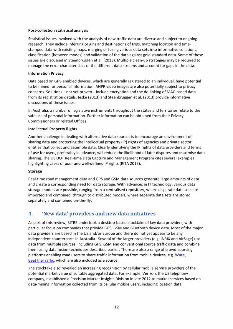
Cox 2013
Bluetooth receivers were installed inside SCATS signal controller cabinets at traffic signal and pedestrian crossing sites. A client interface is operational enabling extraction of basic reports.
Figure Comparison of road sensor and Bluetooth device-based hourly traffic counts
Source Reproduced from Cox (2013).

22
Porter et al. 2012
Objective of this project was to complete the research and development so that wide-scale implementation of a Bluetooth-based travel time data collection system may be started.
Blogg et al. 2010
This paper documents the findings of Qld TMR studies as well as insights into the data sampling and expansion of the MAC OD to traffic volumes.
GSM Technology
Tettamanti et al. 2012
Discussion of potential applications. Focuses thereafter on technical issues relating to mobile phone traces.
Steenbruggen et al. 2013
Focus on incident and traffic management. A systematic overview of the main studies and projects addressing the use of data derived from mobile phone networks.
Some history of mobile phone networks is given and a table of traffic study projects using Mobile phones is provided.
Lists some main issues:
— sample size and reliability — privacy — the role of private companies — the role of transportation agencies
Jarv et al. 2012
Uses the mobile network operator’s call detailed records of subscribers to study rush-hour traffic.
Caceres et al. 2007
Aim of this report is to assess the feasibility of using mobile phone location databases to infer OD matrices by means of phones that are switched on all the time.
Bar-Gera 2007
This paper examines the performance of a new operational system for measuring traffic speeds and travel times that is based on information from a cellular phone service provider.
Rose 2006
This review paper considers the state of practice in relation to using mobile phones as traffic probes, assesses the prospects for this data collection option and identifies unresolved issues which may have implications for obtaining real-time traffic information.
Ahas et al. 2010
Discusses an application for passive mobile phone tracking ( using existing network operator databases).
Floating car data
Messelodi et al. 2009
Outlines applications for floating car (video plus GPS) data.
Leduc 2008
Briefly summarises some floating car technologies.
Huber (undated)

23
Discusses the potential for extended floating car data.
Castillo et al. 2012
Theoretical work aimed at defining basic terms and estimating flows from ANPR
Castillo et al. 2013
Using plate-scanning as the main source of information estimation of vehicle route, OD and link flows
Unclassified
Jeske (undated)
Discusses the uses of GoogleTraffic and Waze App. Discusses hacking and authenticity issues
Bahga et al. 2013
Demonstrates the feasibility of ‘CloudTrack’ as a scalable platform for data driven intelligent transportation systems, based on new cloud-based programming models and data structures.
Empirical application: analysis of all vehicle movements of food supply chain.
Chintalacheruvu et al. 2012
Video based speed estimation and traffic counts.
Chang et al. 2012
Some background information on LIDAR. Focuses on infrastructure testing.
Kluger et al. 2013
The research team identified the following technologies as providing high potential to support the services provided by TMCs.
— Smart Phones — Cloud Computing — 4G Wireless — Connected Vehicles
Ran et al. 2012
Traces the development of transport models over the decades. Characteristic of the latest follow:
Fourth generation Models

24
High-resolution full vehicle trajectory data High-resolution sensor network Real-time traveller service request Real-time transportation service data Massive connection processing Information priority and compression Information security Network and large-scale solutions to existing theory and models Real-time large-scale optimization User-specific models Massive data processing Rich and effective user interface Cloud computing Distributed computing Supercomputer New forms of public transportation
Lomax 2012
In recent years, the Urban Mobility Report researchers have partnered with a private-sector historical speed provider—INRIX—to obtain nationwide speed data to generate estimates of mobility conditions across the nation.

25
Appendix B Technology and data collection opportunities
Table B.1 provides a more detailed cross-tabulation of alternative traffic data collection technologies and the traffic data collection possibilities available from each.
Table B.1 Traffic measurement technologies and traffic data possibilities
Vehicle counts Speed / travel time OD trips
Collection methods Arc
hiv
al c
ou
nts
Cla
ssif
ied
co
un
ts
Rea
l-ti
me
cou
nts
Veh
icle
sp
eed
Trav
el t
ime
Del
ay t
ime/
qu
eu
e
OD
tri
ps
OD
tri
ps
& r
ou
te
Tim
e-st
amp
ed O
D m
atri
ces
(in
cl. s
top
s, d
ela
ys)
Conventional collections
Road sensors
Loop inductors
Piezo-electric strips
Pneumatic tubes
Vehicle classifiers
Household travel surveys
Traffic cameras ?
New technology collections
Road-side sensors
Infrared sensors
Passive acoustic sensors
Microwave sensors
Lidar detection systems
Video image detection ?
RFIDa
? ? ?
GPS-based HTS
Probe-based collection technologies
In-vehicle GPS ?
GSM (cellular mobile data) ?
Bluetooth devices ?
a. Freight-only measures.

26
Bibliography
Ahas R, Silm S, Jarv O, Saluveer E, Tiru M 2010 ‘Using Mobile Positioning Data to Model Locations Meaningful to Users of Mobile Phones’ Journal of Urban Technology, Vol. 17, No. 1, 2010, 3–27
Aliari, Y. and Haghani, A. 2012, ‘Bluetooth Sensor Data and Ground Truth Testing of Reported Travel Times’, Transportation Research Record: Journal of the Transportation Research Board, No. 2308, pp. 167-172, Transportation Research Board of the National Academies, Washington D.C.
Anderson T, Abeywardana V, Wolf J and Lee M 2009, National Travel Survey GPS Feasibility Study, Final Report prepared for the Department for Transport, United Kingdom, December 2009.
Araghi B N, Christensen L T, Krishnan R and Lahrmann H 2012, ‘Application of Bluetooth Technology for Mode-Specific Travel Time Estimation on Arterial Roads: Potentials and Challenges’, Proceedings from the Annual Transport Conference at Aalborg University, Aalborg University, Copenhagen, Denmark.
Arnold J.A. 1998, ‘Surface Transportation and Global System Positioning Improvements: L5 and DGPS’, Public Roads, 62(4), pp. XX-XX.
Bachman, W., Oliveira, M. and Xu J. 2012, ‘Household-Level Global Positioning System Travel Data to Measure Regional Traffic Congestion’, Transportation Research Record: Journal of the Transportation Research Board, No. 2308, pp. 10-16, Transportation Research Board of the National Academies, Washington D.C.
Bachmann, C., Abdulhai, B., Roorda, M.J., and Moshiri B. 2012, ‘Multisensor Data Integration and Fusion in Traffic Operations and Management’, Transportation Research Record: Journal of the Transportation Research Board, No. 2308, pp. 27-36, Transportation Research Board of the National Academies, Washington D.C.
Bahga A and Madisetti V K 2013, ‘Cloud-Based Information Technology Framework for Data Driven Intelligent Transportation Systems’, Journal of Transportation Technologies, 3, pp. 131-141.
Barceló J, Montero L, Marqués L, and Carmona C 2010, ‘Travel Time Forecasting and Dynamic Origin–Destination Estimation for Freeways Based on Bluetooth Traffic Monitoring’, Transportation Research Record: Journal of the Transportation Research Board, No. 2175, pp. 19-27, Transportation Research Board of the National Academies, Washington D.C.
Bar-Gera H 2007, Evaluation of a cellular phone-based system for measurements of traffic speeds and travel times: A case study from Israel Transportation Research Part C 15 (2007) 380–391.
Bayen A M, Butler J and Patire A D 2011, Mobile Millennium Final Report, CCIT Research Report UCB-ITS-CWP-2011-6, California Center For Innovative Transportation Institute Of Transportation Studies University Of California, Berkeley. Report prepared for California Department of Transportation, Sacramento, United States.
Bayen, A M 2011, Mobile Millennium: GPS Mobile Phones as Traffic Probes, Technical Report CA11-1913 (pp. 753), California Department of Transportation, Sacramento, California, URL: http://bayen.eecs.berkeley.edu/sites/default/files/techreps/task_1930-tsm.pdf, Accessed: August 2013.
Burgess, R. 2012, ‘Google Maps gets real-time traffic, crowd sources Android GPS data’, TechSpot, 30 March 2012. URL: http://www.techspot.com/news/48015-google-maps-gets-real-time-traffic-crowdsources-android-gps-data.html, Accessed: 8 August 2013.
Caceres N, Wideberg JP and Benitez FG 2007, 'Deriving origin–destination data from a mobile phone network', IET Intell. Transp. Syst., 2007, 1, (1), pp. 15–26

27
Carpenter, C., Fowler, M., and Adler, T. 2012, ‘Generating Route-Specific Origin–Destination Tables Using Bluetooth Technology’, Transportation Research Record: Journal of the Transportation Research Board, No. 2308, pp. 96-102, Transportation Research Board of the National Academies, Washington D.C.
Castillo E, Ana Rivas A, Jiménez P and Menéndez J M 2012, ‘Observability in traffic networks. Plate scanning added by counting information’, Transportation, 39(6), pp. 1301-1333, Springer, U.S.
Castillo E, Ana Rivas A, Jiménez P and Menéndez J M 2013, ‘A Bayesian method for estimating traffic flows based on plate scanning’, Transportation, 40(1), pp. 173-201, Springer, U.S.
Chang J C, Tsai M K, Findley D J and Cunningham C M 2012, Infrastructure Investment Protection with LiDAR, Report prepared for North Carolina Department of Transportation, Raleigh, North Carolina.
Chase, R.T., Williams, W.M., Rouphail, N.M., and SangKey Kim 2012, ‘Comparative Evaluation of Reported Speeds from Corresponding Fixed-Point and Probe-Based Detection Systems’, Transportation Research Record: Journal of the Transportation Research Board, No. 2308, pp. 110-119, Transportation Research Board of the National Academies, Washington D.C.
Chen L, Lv M, Chen G, 2010 ‘A system for destination and future route prediction based on trajectory mining’ Pervasive and Mobile Computing 6 657–676.
Chintalacheruvu N and Muthukumar V 2012, ‘Video Based Vehicle Detection and Its Application in Intelligent Transportation System’, Journal of Transportation Technologies, 2, 305-314 .
Cohn N, Bischoff H,2012 ‘Explorative study to technique and applications and sample properties of GPS data’ NATMEC 2012, Dallas
Cox J. 2013, Development of a Permanent System To Record And Analyse Bluetooth Travel Time And Scats Lane Count Data AITPM 2013 National Conference.
de Boer G and Krootjes P 2012, ‘The Quality of Floating Car Data Benchmarked’, 19th ITS World Congress, Vienna, Austria, 22–26 October 2012.
Dezani H, Damiani F, Marranghello N, Viudes U, and Parra IA 2012, ‘Mobile application as a tool for urban traffic data collection and generation to Advanced Traveler Information Systems using Wi-Fi networks available in urban centers’, 2012 Intelligent Vehicles Symposium.
Fekpe E, Deepak G and Middleton, D 2004, Traffic Data for High-Volume Routes: Best Practices and Guidelines, Final Report prepared for Federal Highway Administration, Washington D.C. URL: www.fhwa.dot.gov/policyinformation/hpms/volumeroutes/index.cfm, Accessed: August 2013.
Federal Highway Administration, 2013, Traffic Monitoring Guide, April 2013
Galas J, 2010 ‘Traffic Data Collection With Bluetooth’ Illinois Department of Transportation Traffic Systems Centre
Herrera JC , Work DB, Herring R, Ban X, Jacobson Q and Bayen AB 2010, 'Evaluation of traffic data obtained via GPS-enabled mobile phones: The Mobile Century field experiment', Transportation Research Part C, 18, pp. 568–583.
Huber W, Lädke M and Ogger R undated, ‘Extended floating-car data for the acquisition of traffic information’, BMW Group, URL: http://www.bmwgroup.com/e/0_0_www_bmwgroup_com/forschung_entwicklung/publikationen/mobilitaet_verkehr/_pdf/XFCD_englisch.pdf, Accessed: August 2013.
Jarv O, Ahas R, Saluveer E, Derudder B and Witlox F 2012, ‘Mobile Phones in a Traffic Flow: A Geographical Perspective to Evening Rush Hour Traffic Analysis Using Call Detail Records’ PLoS ONE 7(11).

28
Jeske T undated, ‘Floating Car Data from Smartphones: What Google and Waze Know About You and How Hackers Can Control Traffic’, Institute for Security in Distributed Applications, Hamburg University of Technology, Hamburg, Germany.
Joan G. Hudson, Jennifer C. Duthie, Yatinkumar K. Rathod, Katie A. Larsen and Joel L. Meyer, 2012 ‘Using Smartphones to Collect Bicycle Travel Data in Texas’, University Transportation Center for Mobility™ Texas Transportation Institute, UTCM Project #11-35-69.
Leber, J. 2013, ‘How Wireless Carriers Are Monetizing Your Movements’, MIT Technology Review, April 2013. URL: http://www.technologyreview.com/news/513016/how-wireless-carriers-are-monetizing-your-movements/, Accessed: 8 August 2013.
Leduc G, 2008 ‘Road Traffic Data: Collection Methods and Applications’ European Commission Joint Research Centre Institute for Prospective Technological Studies JRC 47967 – 2008.
Lin M, Hsu WJ 2013 ‘Mining GPS data for mobility patterns: A survey’ Pervasive and Mobile Computing (In Press)
Lomax T, Turner S, Eisele B, Schrank D, Geng L and Shollar B, 2012, ‘Refining the Real-Timed Urban Mobility Report’, University Transportation Center for Mobility™, Texas Transportation Institute UTCM 11-06-73
M Blogg, Semler C, Hingorani M and Troutbeck R 2010, ‘Travel Time and Origin-Destination Data Collection using Bluetooth MAC Address Readers’, Australasian Transport Research Forum 2010 Proceedings
Messelodi S, Modena CM, Zanin M, De Natale FGB, Granelli F, Betterle E and Guarise A 2009, ‘Intelligent extended floating car data collection’, Expert Systems with Applications, 36, pp. 4213–4227.
Obuhuma, J. I., Moturi, C. A. 2012 ‘Use of GPS With Road Mapping For Traffic Analysis’, International Journal Of Scientific & Technology Research, 1(10).
Kim DS, Porter JD, Park SJ, Saeedi A and Magaña ME 2012 , ‘Wireless Data Collection System For Travel Time Estimation And Traffic Performance Evaluation’, Oregon State University FHWA-OR-RD-12-13.
Rahmani M, Koutsopoulos H.N. and Ranganathan A 2010, ‘Requirements and Potential of GPS-based Floating Car Data for Traffic Management: Stockholm Case Study’, 2010 13th International IEEE Annual Conference on Intelligent Transportation Systems, Madeira Island, Portugal, 19-22 September 2010.
Ramli D. 2013, ‘Increased costs ahead for mobile customers’, The Australian Financial Review, 20 August 2013, p. 25, Fairfax Media Publications, Sydney.
Ran B, Jin PJ , Boyce D, Qui TZ. Cheng QY 2012, ‘Perspectives on Future Transportation Research: Impact of Intelligent Transportation System Technologies on Next-Generation Transportation’, Modeling Journal of Intelligent Transportation Systems: Technology, Planning, and Operations, 16(4), pp. 226-242.
RITA—see U.S. Department of Transportation, Research and Innovative Technology Administration
Robert Kluger and Brian L. Smith 2013 ‘Next Generation Traffic Management Centers’, University of Virginia, Center for Transportation Studies UVA-2012-02
Rose G. 2006, ‘Mobile Phones as Traffic Probes: Practices, Prospects and Issues’, Transport Reviews, 26(3), pp. 275-291.

29
Steenbruggen J, Borzacchiello M T, Nijkamp P and Scholten H 2013, ‘Mobile phone data from GSM networks for traffic parameter and urban spatial pattern assessment: a review of applications and opportunities’, GeoJournal, 78, pp. 223–243
Sumalee, A., Wang, J., Jedwanna, K. and Suwansawat, S. 2012, ‘Probabilistic Fusion of Vehicle Features for Reidentification and Travel Time Estimation Using Video Image Data’, Transportation Research Record: Journal of the Transportation Research Board, No. 2308, pp. 73-82, Transportation Research Board of the National Academies, Washington D.C.
Takahiro Tsubota, Ashish Bhaskar, Edward Chung and Romain Billot, 2011, ‘Arterial traffic congestion analysis using Bluetooth Duration data’, Australasian Transport Research Forum 2011 Proceedings.
Tamás Tettamanti, Hunor Demeter and István Varga 2012, ‘Route Choice Estimation Based on Cellular Signaling Data’, Acta Polytechnica Hungarica, 9(4).
Tao S, Manolopoulos V, Rodriguez S and Rusu A 2012, ‘Real-Time Urban Traffic State Estimation with A-GPS Mobile Phones as Probes’, Journal of Transportation Technologies, 2, pp. 22-31.
TomTom 2012, TomTom Australia and New Zealand Congestion Index Annual Report 2012, TomTom BV, URL: http://www.tomtom.com/en_au/congestionindex/, Accessed: August 2012.
Annual report 2012
U.S. Department of Transportation, Research and Innovative Technology Administration 2013, Real-Time Data Capture and Management Program, URL: http://www.its.dot.gov/data_capture/data_capture.htm, Accessed: August 2013.
Violino R. 2005, ‘What is RFID?’, RFID Journal, URL: http://www.rfidjournal.com/articles/view?1339, Accessed: August 2013.
Wargelin L, Stopher P, Minser J, Tierney K, Rhindress M and O'Connor S 2012, GPS-Based Household Interview Survey for the Cincinnati, Ohio Region, Report prepared for the Ohio Department of Transportation Office of Research and Development and the U.S. Department of Transportation, Federal Highway Administration, Washington D.C. URL: http://www.dot.state.oh.us/DIvisions/Planning/SPR/Research/reportsandplans/Reports/2012/Planning/134421_FR.pdf, Accessed: August 2013.