Embed Size (px)
DESCRIPTION
GEOLOGICAL SYNTHESIS OF THE PALEOZOIC OF THE PERMIAN BASIN (PBGSP) CARBONIFEROUS GAS SHALE RESOURCES IN TEXAS (CGSR). NEW REGIONAL RESERVOIR PLAY CHARACTERIZATION PROGRAMS IN TEXAS & NEW MEXICO at the Bureau of Economic Geology. Principal Investigators: Stephen C. Ruppel & Robert G. Loucks. - PowerPoint PPT Presentation
Citation preview
NEW REGIONAL RESERVOIR PLAY CHARACTERIZATION PROGRAMS
IN TEXAS & NEW MEXICO
at the Bureau of Economic Geology
Principal Investigators: Stephen C. Ruppel & Robert G. Loucks
• GEOLOGICAL SYNTHESIS OF THE PALEOZOIC OF THE PERMIAN BASIN (PBGSP)
• CARBONIFEROUS GAS SHALE RESOURCES IN TEXAS (CGSR)
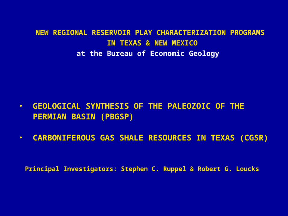
GEOGRAPHIC SCOPE
Permian Basin study area
Barnett shale study area
PROGRAM GOALS
• Produce a detailed, comprehensive history of Paleozoic depositional and reservoir systems in the Permian Basin
• Create spatially integrated data bases of depositional, stratigraphic, lithologic, and petrophysical properties
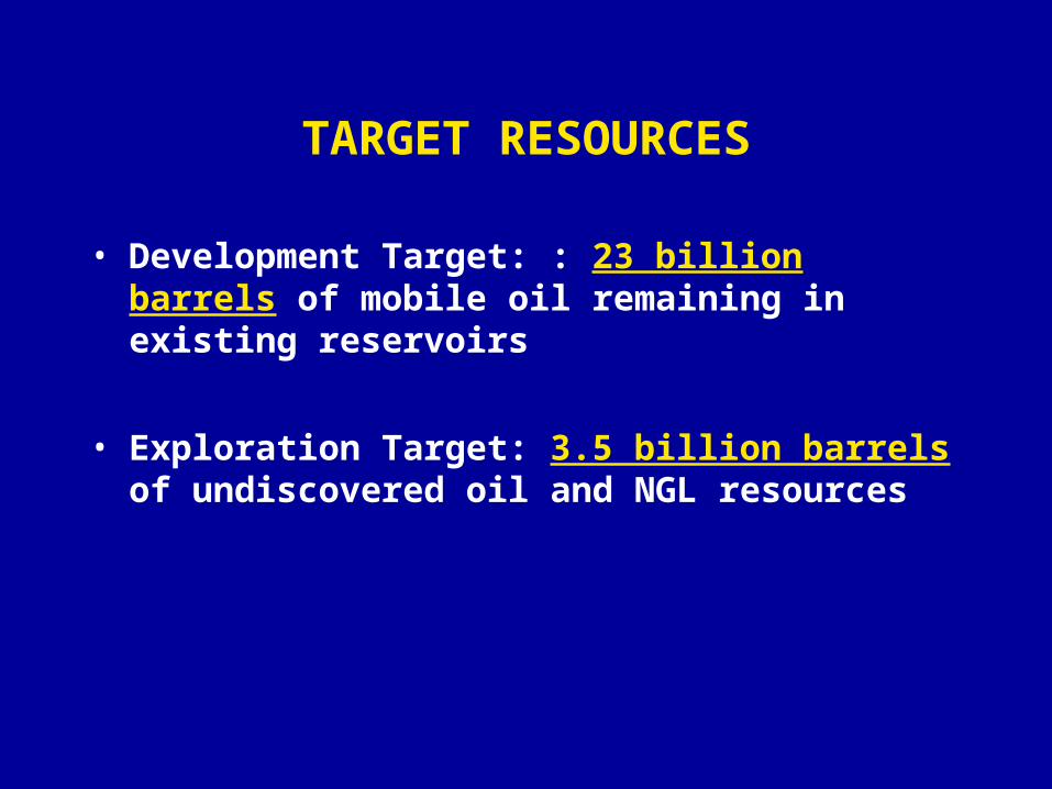
TARGET RESOURCES
• Development Target: : 23 billion barrels of mobile oil remaining in existing reservoirs
• Exploration Target: 3.5 billion barrels of undiscovered oil and NGL resources
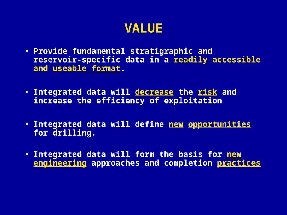
VALUE
• Provide fundamental stratigraphic and reservoir-specific data in a readily accessible and useable format.
• Integrated data will decrease the risk and increase the efficiency of exploitation
• Integrated data will define new opportunities for drilling.
• Integrated data will form the basis for new engineering approaches and completion practices
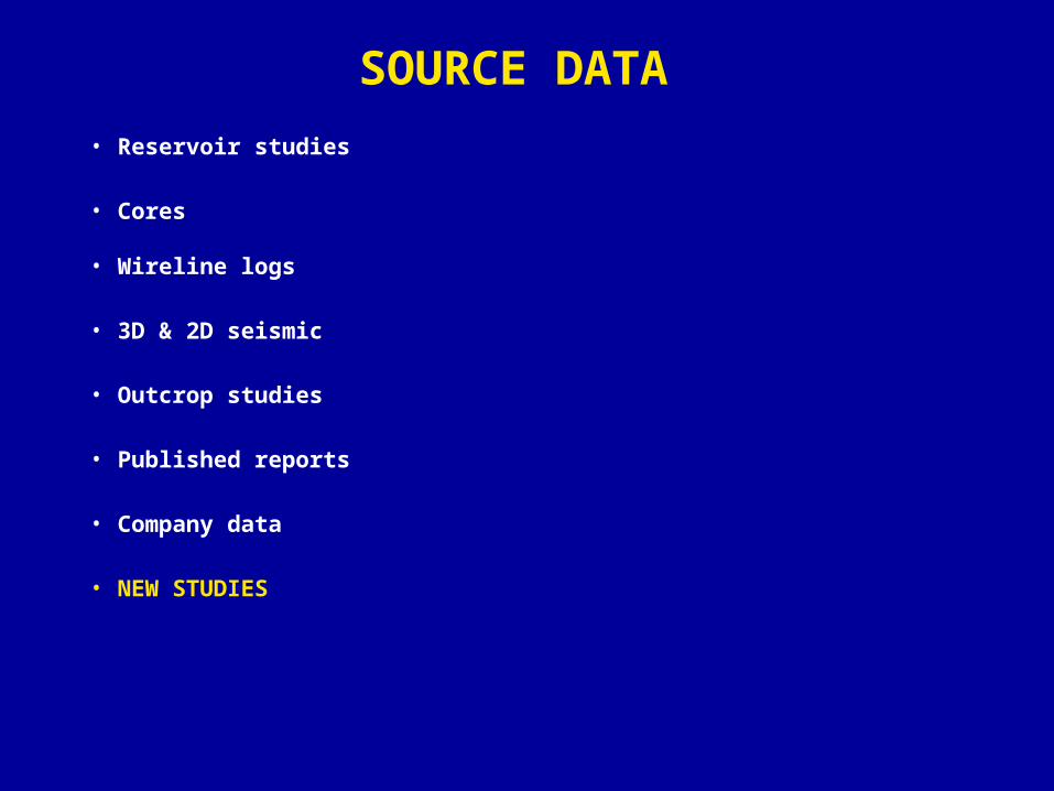
SOURCE DATA
• Reservoir studies
• Cores
• Wireline logs
• 3D & 2D seismic
• Outcrop studies
• Published reports
• Company data
• NEW STUDIES
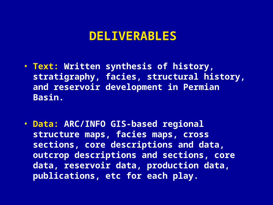
DELIVERABLES
• Text: Written synthesis of history, stratigraphy, facies, structural history, and reservoir development in Permian Basin.
• Data: ARC/INFO GIS-based regional structure maps, facies maps, cross sections, core descriptions and data, outcrop descriptions and sections, core data, reservoir data, production data, publications, etc for each play.
TEXT
• First-year report on depositional history and stratigraphy of the Cambrian-Permian
• Incremental play reports as completed.
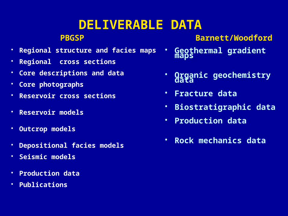
DELIVERABLE DATA
• Regional structure and facies maps
• Regional cross sections
• Core descriptions and data
• Core photographs
• Reservoir cross sections
• Reservoir models
• Outcrop models
• Depositional facies models
• Seismic models
• Production data
• Publications
• Geothermal gradient maps
• Organic geochemistry data
• Fracture data
• Biostratigraphic data
• Production data
• Rock mechanics data
PBGSP Barnett/Woodford
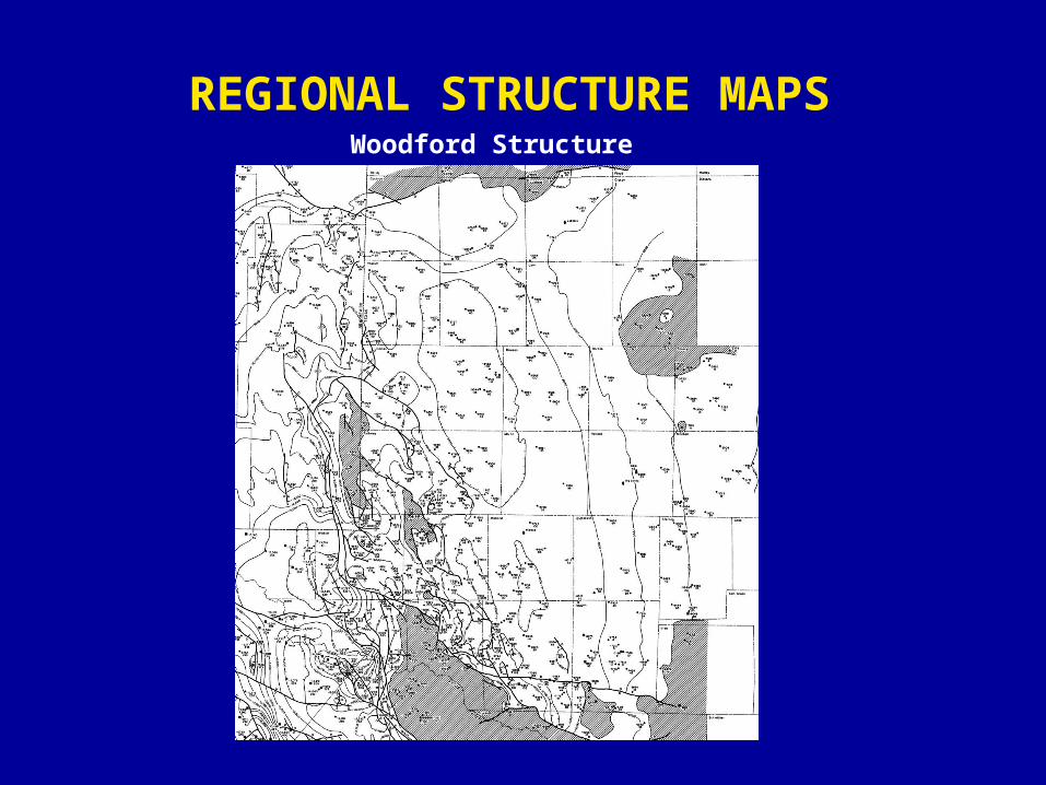
REGIONAL STRUCTURE MAPS Woodford Structure
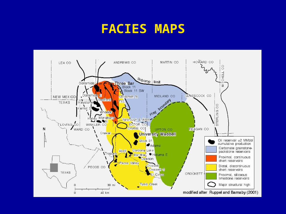
FACIES MAPS
.
SA
GB 1
Top GB
GB 2
GB 3
Mcknight
Holt/Leonardian 8
Holt/Leonardian 7
Glorieta
7680' 3260'4050'2120'3630'40504050'4840'8100'10940'5260'
5500
5000
4500
4000
3500
Eastland 39
5500
5000
4500
4000
3600
Gulf 835
5500
5000
4500
4000
3600
Forest 1
5500
5000
4500
4000
3600
Eastland 1
5500
5000
4500
4000
3600
Arco 9
5500
5000
4500
4000
3600
Arco 11
5500
5000
4500
4000
3600
Arco 51
3700
4000
4500
5000
Arco 87
4500
4000
5000
5500
Arco 14
5900
5800
5700
5600
5500
5400
5300
5200
5100
5000
4900
4800
4700
4600
4500
4400
4300
4200
4100
4000
3900
3800
3700
A 13
5500
5000
4500
4000
3600
Arco M-1
3700
4000
4500
5000
5500
ARCO CompanyRuth G. Palmer #13
FosterEctor County, TX, Elevation = 2955'
Sec. 45, BLK 42, T-1-S
ARCO CompanyMarcus Gist #14
JohnsonEctor County, TX, Elevation = 2957'
Sec. 44, BLK 42, T-1-S
ARCO CompanyJ. L. Johnson "O" #8
North Cowden CanyonEctor County, TX, Elevation = 2976'
Sec. 42, BLK 42, T-1-S
ARCO CompanyJ. L. Johnson "B" #51
Johnson & Johnson (Holt)Ector County, TX, Elevation = 2989'
Sec. 37, BLK 43, T-1-S
ARCO CompanyJ. L. Johnson "B" #87 WIW
JohnsonEctor County, TX, Elevation = 3000'
Sec. 37, BLK 43, T-1-S
ARCO CompanyJohnson Deep Unit #9Johnson (Holt-Penn)
Ector County, TX, Elevation = 2998'Sec. 39, BLK 43, T-1-S
ARCO CompanyJohnson Deep Unit #9Johnson (Holt-Penn)
Ector County, TX, Elevation = 'Sec. 34, BLK 43, T-1-S
ARCO CompanyJ. L. Johnson M-1
JohnsonEctor County, TX, Elevation = 3024'
Sec. 40, BLK 43, T-1-S
Forest Oil CompanyJ. L. Johnson Jr. #1
WildcatEctor County, TX, Elevation = 3043'
Sec. 41, BLK 43, T-1-S
Eastland CompanyJohnson #39
DonnellyEctor County, TX, Elevation =
Sec. 37, BLK 44, T-1-S
Gulf Oil CompanyC. A. Goldsmith #835
WildcatEctor County, TX, Elevation = 3080'
Sec. 38, BLK 44, T-1-S
ARCO CompanyJohnson Deep Unit #11
Johnson (Holt)Ector County, TX, Elevation = 3001'
Sec. 38, BLK 43, T-1-S
OXY Johnson Unit
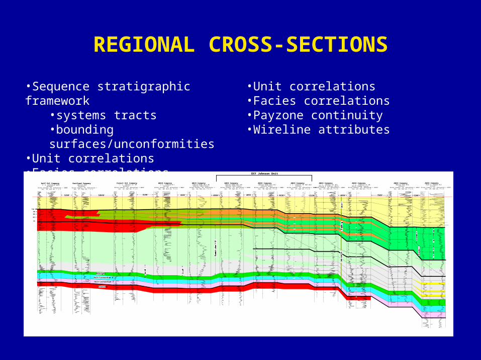
REGIONAL CROSS-SECTIONS
•Sequence stratigraphic framework•systems tracts•bounding surfaces/unconformities
•Unit correlations•Facies correlations
•Unit correlations•Facies correlations•Payzone continuity•Wireline attributes
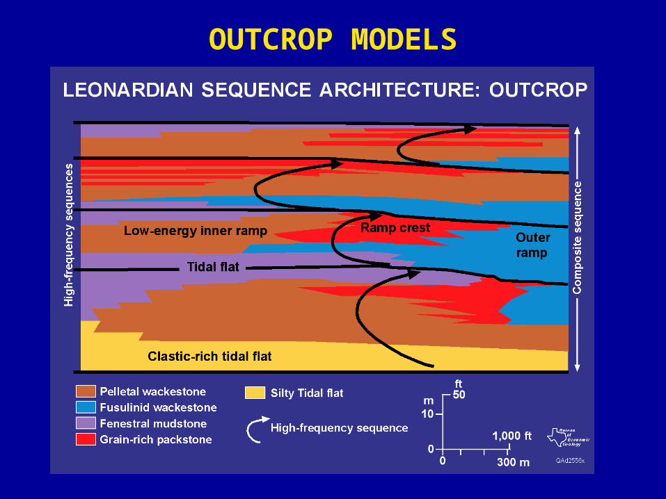
OUTCROP MODELS
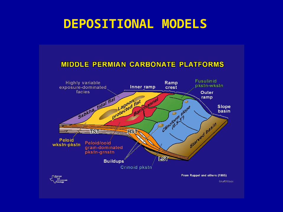
DEPOSITIONAL MODELS

RESERVOIR MODELS
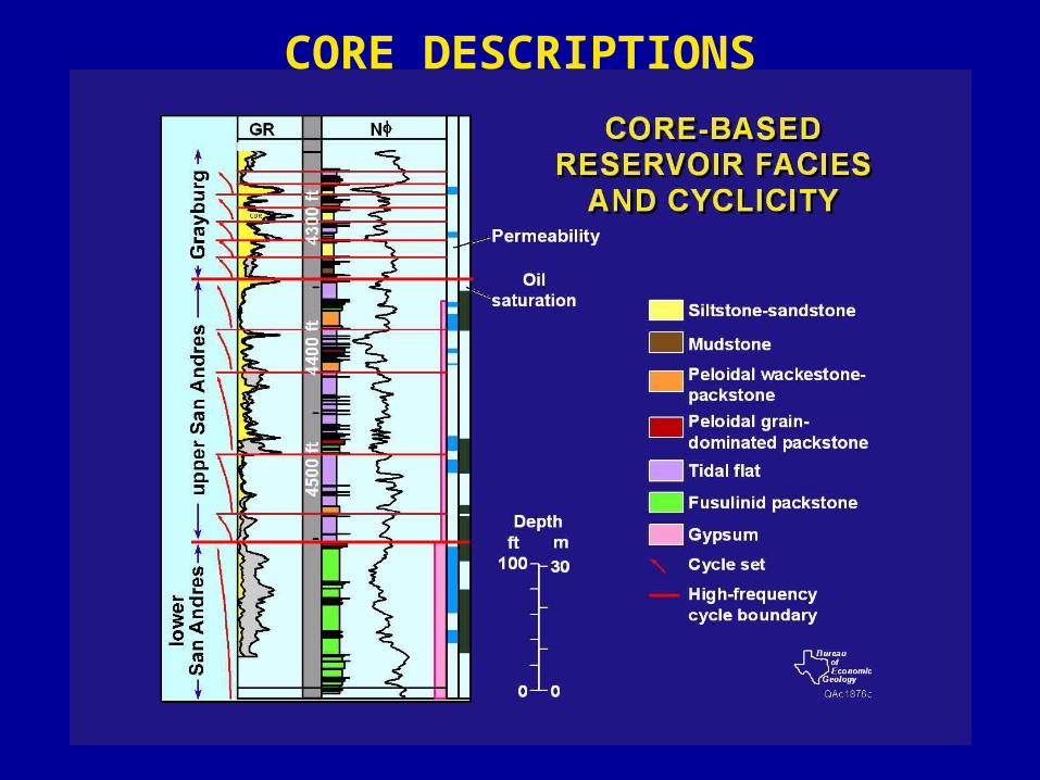
CORE DESCRIPTIONS
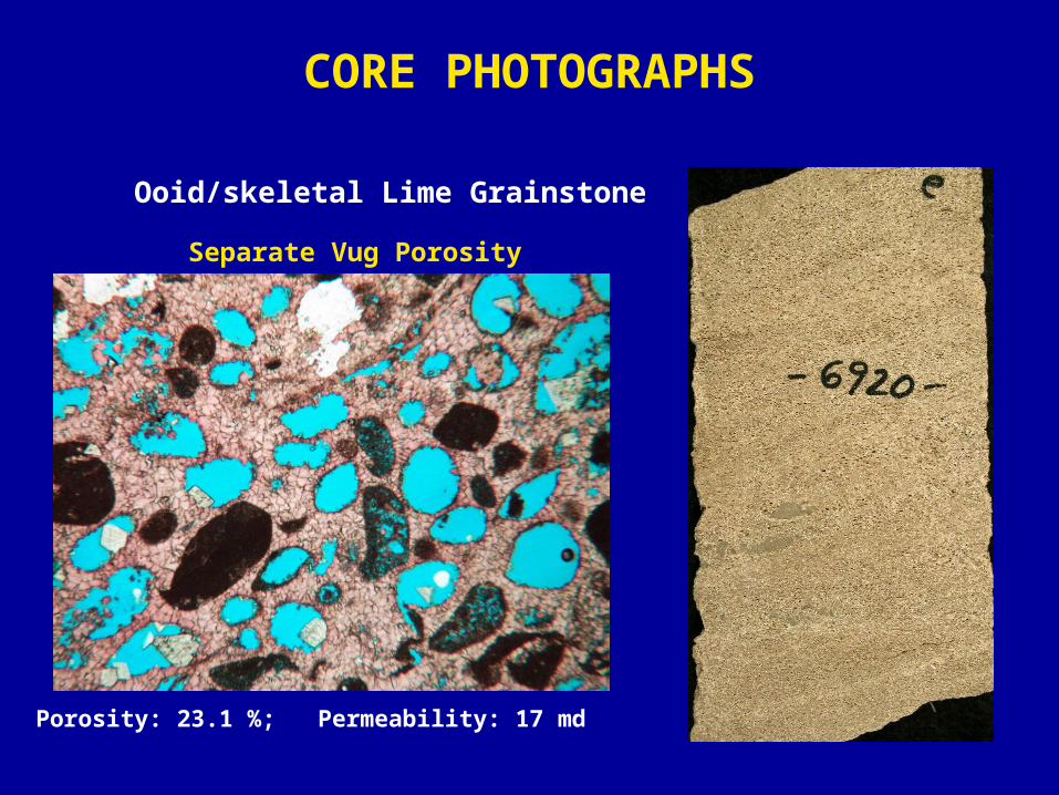
CORE PHOTOGRAPHS
Ooid/skeletal Lime Grainstone
Separate Vug Porosity
Porosity: 23.1 %; Permeability: 17 md
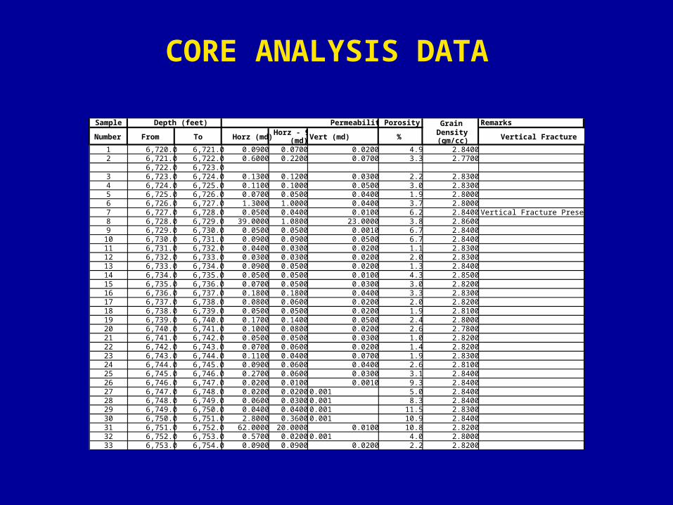
Sample Porosity Grain Remarks
Number From To Horz (md)Horz - 90
(md) Vert (md) %Density (gm/cc) Vertical Fracture
1 6,720.0 6,721.0 0.0900 0.0700 0.0200 4.9 2.84002 6,721.0 6,722.0 0.6000 0.2200 0.0700 3.3 2.7700
6,722.0 6,723.03 6,723.0 6,724.0 0.1300 0.1200 0.0300 2.2 2.83004 6,724.0 6,725.0 0.1100 0.1000 0.0500 3.0 2.83005 6,725.0 6,726.0 0.0700 0.0500 0.0400 1.9 2.80006 6,726.0 6,727.0 1.3000 1.0000 0.0400 3.7 2.80007 6,727.0 6,728.0 0.0500 0.0400 0.0100 6.2 2.8400 Vertical Fracture Present8 6,728.0 6,729.0 39.0000 1.0800 23.0000 3.8 2.86009 6,729.0 6,730.0 0.0500 0.0500 0.0010 6.7 2.8400
10 6,730.0 6,731.0 0.0900 0.0900 0.0500 6.7 2.840011 6,731.0 6,732.0 0.0400 0.0300 0.0200 1.1 2.830012 6,732.0 6,733.0 0.0300 0.0300 0.0200 2.0 2.830013 6,733.0 6,734.0 0.0900 0.0500 0.0200 1.3 2.840014 6,734.0 6,735.0 0.0500 0.0500 0.0100 4.3 2.850015 6,735.0 6,736.0 0.0700 0.0500 0.0300 3.0 2.820016 6,736.0 6,737.0 0.1800 0.1800 0.0400 3.3 2.830017 6,737.0 6,738.0 0.0800 0.0600 0.0200 2.0 2.820018 6,738.0 6,739.0 0.0500 0.0500 0.0200 1.9 2.810019 6,739.0 6,740.0 0.1700 0.1400 0.0500 2.4 2.800020 6,740.0 6,741.0 0.1000 0.0800 0.0200 2.6 2.780021 6,741.0 6,742.0 0.0500 0.0500 0.0300 1.0 2.820022 6,742.0 6,743.0 0.0700 0.0600 0.0200 1.4 2.820023 6,743.0 6,744.0 0.1100 0.0400 0.0700 1.9 2.830024 6,744.0 6,745.0 0.0900 0.0600 0.0400 2.6 2.810025 6,745.0 6,746.0 0.2700 0.0600 0.0300 3.1 2.840026 6,746.0 6,747.0 0.0200 0.0100 0.0010 9.3 2.840027 6,747.0 6,748.0 0.0200 0.0200 0.001 5.0 2.840028 6,748.0 6,749.0 0.0600 0.0300 0.001 8.3 2.840029 6,749.0 6,750.0 0.0400 0.0400 0.001 11.5 2.830030 6,750.0 6,751.0 2.8000 0.3600 0.001 10.9 2.840031 6,751.0 6,752.0 62.0000 20.0000 0.0100 10.8 2.820032 6,752.0 6,753.0 0.5700 0.0200 0.001 4.0 2.800033 6,753.0 6,754.0 0.0900 0.0900 0.0200 2.2 2.8200
Depth (feet) Permeability
CORE ANALYSIS DATA
F2G
San Andres Formation
F3
Sun Moss # 1574200
4300
4400
4400
4500
4600
Unocal Moss Unit # 9-17
4500
4600
4700
4500
4700
4600
4700
4600
4500
4800
4700
4600
Unocal Moss Unit # 16-14 Unocal Moss Unit # 8-12 Unocal Moss Unit # 6-16 Unocal Moss Unit # 6-20
4650'
4600'
4550'
4500'
4700'
Hdgrnd
4750'
4700'
4650'
4600'
4550'
4500'EFF1
Fo
W E
F1F2G
F
H
H
Grayburg4BGrayburg4AGrayburg3Grayburg2
Grayburg1Guadalupian13
E
F3
3,700 ' 2,700 '
F0
3,500 ' 3,400 ' 2,300 '
FINAEmmonsUnit
UNOCALMossUnit
PhillipsSouth CowdenUnit CoreSan Andres/GrayburgDepositional Axis
South Cowden Field
Clear ForkPlatform Margin
FINAColbertUnitTidal FlatSiltstone/SandstoneFusulinid WackestonePeloid Wackestone-Packstone
Mudstone
Intraclast Packstone-GrainstonePeloid-Ooid Grain-Dominated Packstone-Grainstone
ExplanationFCorrelation MarkersSequence BoundaryHigh-frequency Cycles
0 1000 20000 300 600FtMeters
60402000Ft00
10M V.E. = 12.5 XScale
Bureau ofEconomicGeology
Queen FormationGuadalupian16Ex E0
Ex
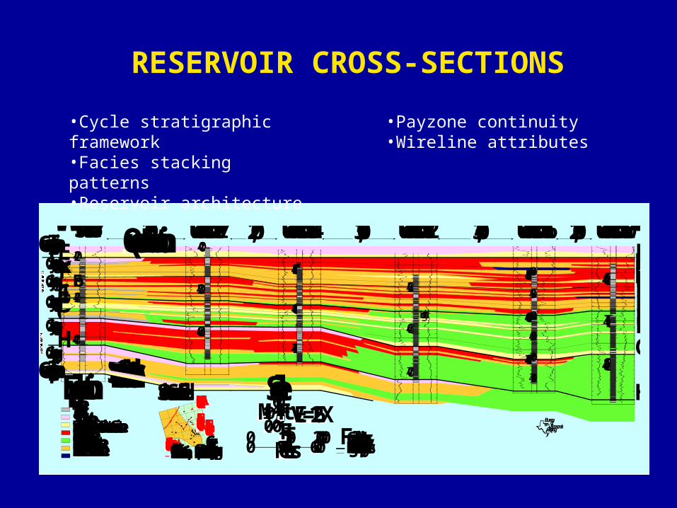
RESERVOIR CROSS-SECTIONS
•Cycle stratigraphic framework•Facies stacking patterns•Reservoir architecture
•Payzone continuity•Wireline attributes
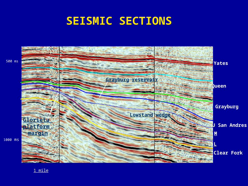
Yates
Queen
Grayburg
U San Andres
NW SE
Clear Fork
500 ms
1000 ms
1 mile
L
M
Lowstand wedgeGlorieta platform margin
Grayburg reservoir
SEISMIC SECTIONS
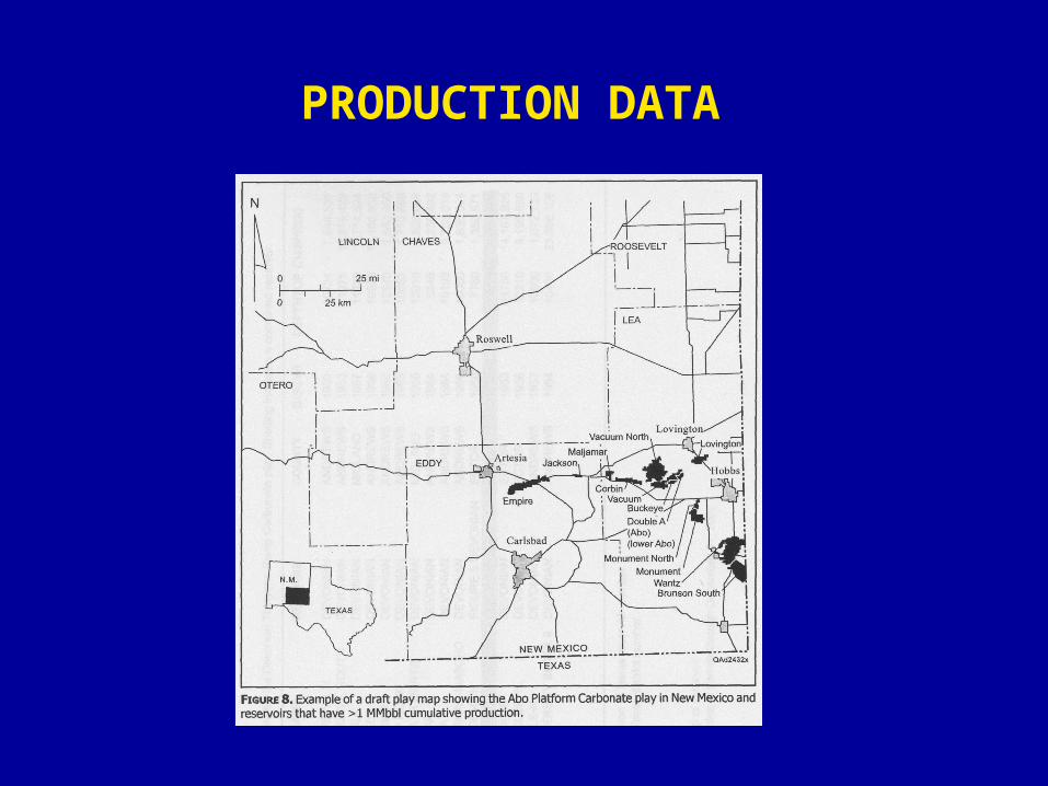
PRODUCTION DATA
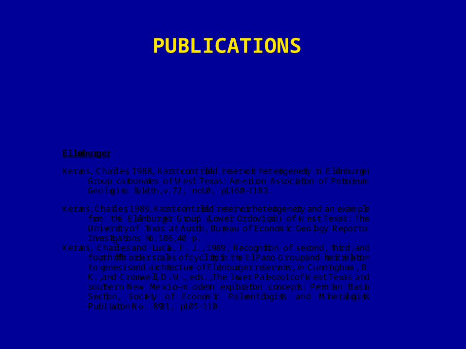
Ellenburger
Kerans, Charles, 1988, Karst-controlled reservoir heterogeneity in EllenburgerGroup carbonates of West Texas: American Association of P etroleumGeologists Bulletin, v. 72, no. 10, p. 1160–1183.
Kerans, Charles, 1989, Karst-controlled reservoir heterogeneity and an examplefrom the Ellenburger Group (Lower Ordovician) of W est Texas: TheUniversity of T exas at Austin, Bureau of Economic Geology Report ofInvestigations No. 186, 40 p.
Kerans, Charles and L ucia, F. J., 1989, Recognition of sec ond, third, andfourth/fifth order scales of cyclicity in the El Paso Group and their relationto genesis and architecture of Ellenburger reservoirs, in Cunningham, B.K., and Cromwell, D. W., eds., The lower Paleozoic of West Texas andsouthern New Mexico—modern exploration concepts: Permian BasinSection, Society of Economic Paleontologists and MineralogistsPublication No. 89-31, p. 105–110.
PUBLICATIONS
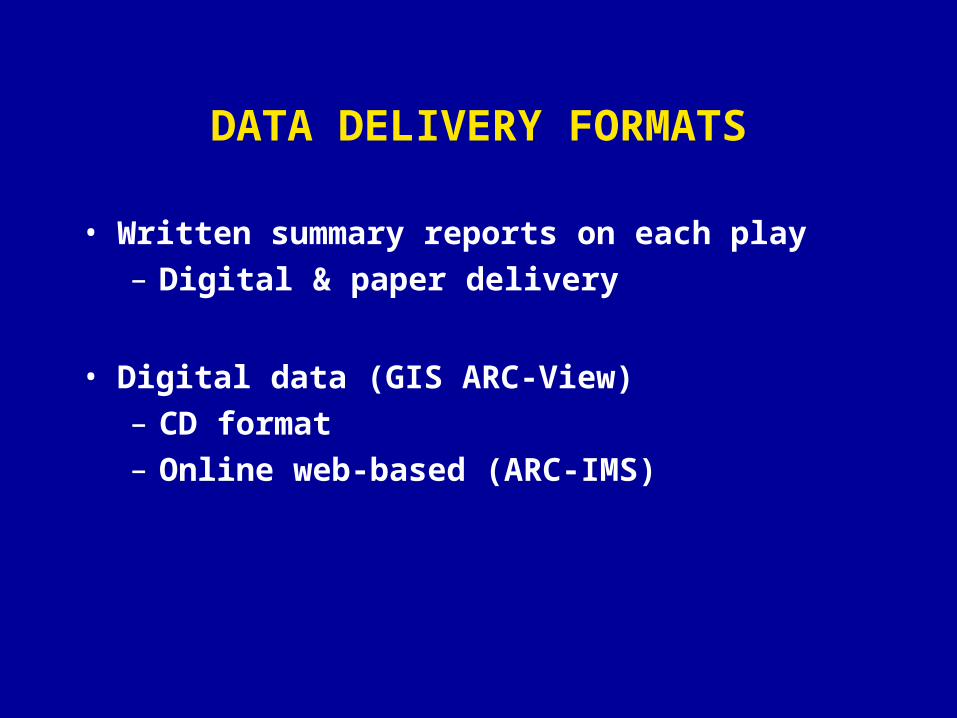
DATA DELIVERY FORMATS
• Written summary reports on each play– Digital & paper delivery
• Digital data (GIS ARC-View)– CD format– Online web-based (ARC-IMS)
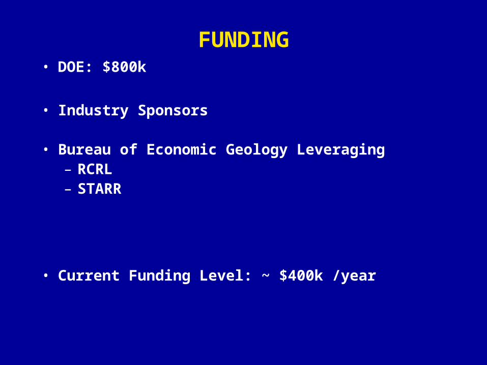
FUNDING• DOE: $800k
• Industry Sponsors
• Bureau of Economic Geology Leveraging– RCRL– STARR
• Current Funding Level: ~ $400k /year
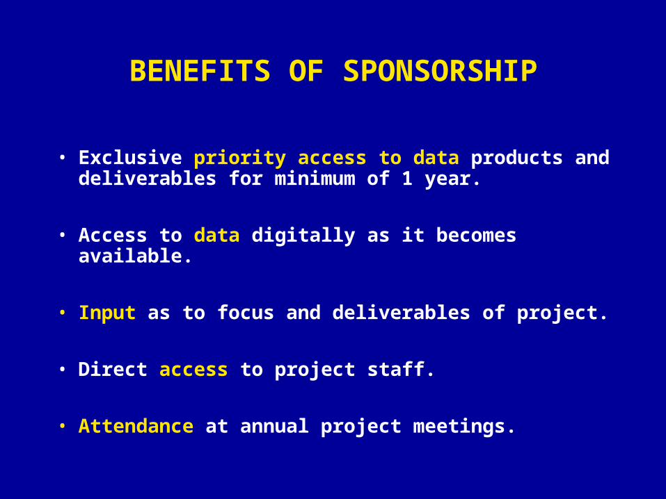
BENEFITS OF SPONSORSHIP
• Exclusive priority access to data products and deliverables for minimum of 1 year.
• Access to data digitally as it becomes available.
• Input as to focus and deliverables of project.
• Direct access to project staff.
• Attendance at annual project meetings.
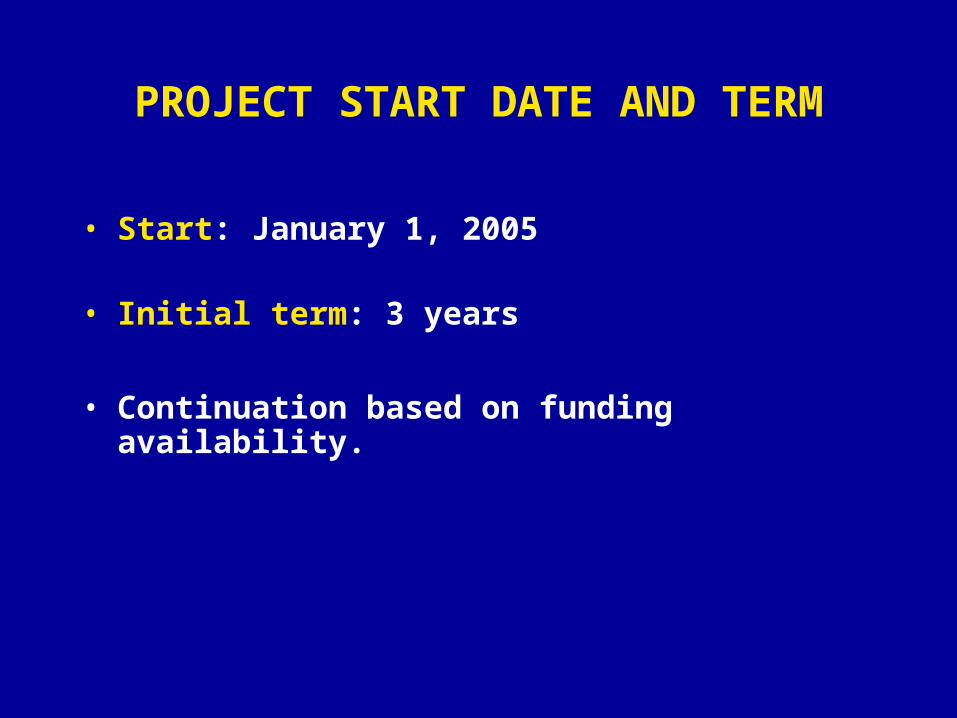
PROJECT START DATE AND TERM
• Start: January 1, 2005
• Initial term: 3 years
• Continuation based on funding availability.
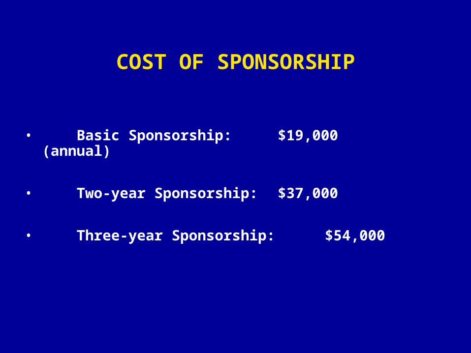
COST OF SPONSORSHIP
• Basic Sponsorship: $19,000 (annual)
• Two-year Sponsorship: $37,000
• Three-year Sponsorship: $54,000
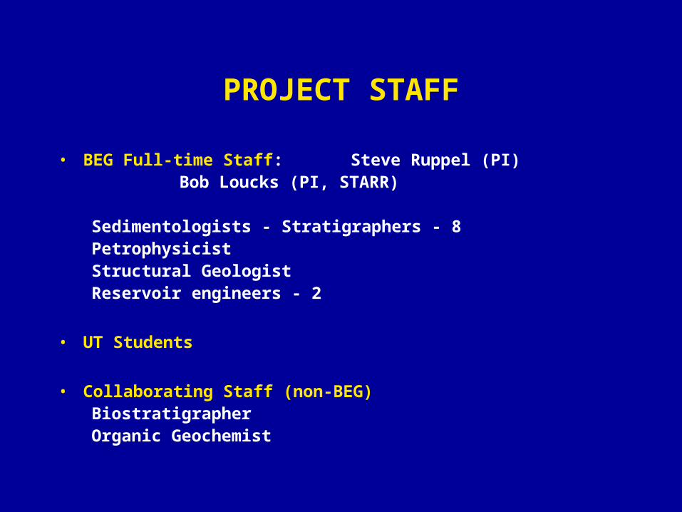
PROJECT STAFF
• BEG Full-time Staff: Steve Ruppel (PI) Bob Loucks (PI, STARR)
Sedimentologists - Stratigraphers - 8PetrophysicistStructural Geologist Reservoir engineers - 2
• UT Students
• Collaborating Staff (non-BEG)BiostratigrapherOrganic Geochemist
PROJECT CONTACTS
• Steve Ruppel– 512-471-2965– [email protected]
• Bob Loucks– 512-471-0366– [email protected]