Embed Size (px)
Citation preview
Page 1
New Jersey Coastal Zone Management Act Consistency Statement 1.0 Project Background A Coastal Zone Management Act Consistency Statement was prepared as part of the 2000 Environmental Impact Statement (EIS) documentation for the Raritan Bay and Sandy Hook Bay, Hurricane and Storm Damage Reduction Project, Port Monmouth, New Jersey (NJ), with a signed Record of Decision in 2008. The EIS covered two phases of the project; Phase I has been constructed. A Supplemental Draft Environmental Assessment is being prepared due to engineering design changes associated with Phase II, which this Statement addresses. Phase II of the project includes the construction of levees, floodwalls, road raising/grading, two pump stations, one storm gate, and three road closure gates in Middletown Township, Monmouth County, NJ. The majority of the project area falls within the boundary of Port Monmouth Road to the north, Pews Creek to the west, Compton Creek to the East, and Route 36 in the south. The proposed project is in partnership between the U.S. Army Corps of Engineers, New York District (District) and the NJDEP, Bureau of Coastal Engineering (BCE). 2.0 Introduction The Coastal Zone Management Act (CZMA) of 1972 (16 U.S.C. §§1451-1464) was enacted by Congress in an effort to balance the often competing demands of growth and development with the protection of coastal resources. Its stated purpose is to “...preserve, protect, and develop, where possible, to restore or enhance the resources of the nation’s coastal zone...” The Act established the framework for achieving this balance by encouraging the states to develop coastal zone management programs, consistent with minimum federal standards, designed to regulate land use activities that could impact coastal resources. The Coastal Zone Act Reauthorization Act Amendments of 1990 further strengthened the act by requiring the state programs to focus more on controlling land use activities and the cumulative effects of activities within designated coastal zones. The State of NJ administers its federally approved coastal zone program through the NJ Department of Environmental Protection (NJDEP) Land Use Regulation Program (LURP). Pursuant to the federal CZMA, NJ has defined its coastal zone boundaries and developed policies to be utilized to evaluate projects within the designated coastal zone, as set forth in New Jersey's Rules on Coastal Zone Management (CZM) (N.J.A.C. 7:7, 7:7E, dated July 18, 1994, last amended July 6, 2015). The Waterfront Development Law (N.J.S.A. 12:5-3) and related requirements (N.J.A.C. 7:7-23) provide the authority for issuance of permits for, among other activities, the placement or construction of structures, pilings, or other obstructions in any tidal waterway. The State’s Land Use Regulation Program in the review of permit applications and coastal decision-making employs NJ’s Rules on Coastal Zone Management; they address issues of location, use, and resources. NJ’s rules provide for a balance between economic development and coastal resource protection, recognizing that coastal management involves explicit consideration of a broad range of concerns, in contrast to other resource management programs that have a more limited scope of concern.

Page 2
The Port Monmouth project site is located within the coastal zone of NJ. The following assessment identifies the coastal zone management policies relevant to Phase II of the project. 3.0 Rules on Coastal Zone Management Decisions on uses and development of coastal resources require the consideration of a project with regard to its compliance with the Rules on Coastal Zone Management (N.J.A.C. 7:7). Depending on the proposed project’s location, purpose, design, and the surrounding region, different specific rules in each of the three steps may be applicable in the decision making process. An assessment of the proposed action’s compliance with the applicable coastal zone management rules follows. Many of the policies are not applicable to the proposed activity. Subchapter 9: Special Areas Special Areas that are naturally valuable, important for human use, hazardous, sensitive to impacted, or particular in their planning criteria, as to require special management rules. Special Areas are divided into four categories: (1) Special Water Areas, (2) Special Water’s Edge Areas, (3) Special Land Areas, and (4) Coast-wide Special Areas. 7:7-9.2 Shellfish habitat Raritan Bay, Pews and Compton Creeks are classified as Prohibited shellfish waters (e.g. harvest not allowed) Appendix B; NJDEP Shellfish Map Description - http://www.nj.gov/dep/landuse/download/Map_007.jpg; NJ Geo Web - http://www.nj.gov/dep/gis/geowebsplash.htm. Construction, operation and maintenance of several project features would occur within Pews Creek, and adjacent to Pews and Compton Creek and their tributaries as follows: a storm gate across Pews Creek; a coffer dam to maintain tidal inundation to the Pews Creek wetland during construction of the storm gate; levees, floodwalls and sheetpile walls in/around the wetlands of Pews and Compton Creeks; and splicing of sheetpile onto existing bulkhead adjacent to the Monmouth Cove Marina. The proposed activity would be consistent with this policy. 7:7-9.3 Surf clam areas This policy prohibits development that would destroy or contaminate surf clam areas. The area of the proposed action is not located in a surf clam area (http://www.nj.gov/dep/dsr/trends/pdfs/wildlife-surfclam.pdf) nor will it contaminate surface water. Therefore, this policy is not applicable. 7:7-9.4 Prime fishing areas This policy prohibits sand or gravel mining in prime fishing areas. The proposed action does not include mining and it is not located in prime fishing areas as defined in “New Jersey’s Recreational and Commercial Fishing Grounds of Raritan Bay, Sandy Hook Bay and Delaware Bay”. Therefore, this policy is not applicable. 7:7-9.5 Finfish migratory pathways
Page 3
Under New Jersey Rules, finfish migratory pathways are waterways (rivers, streams, creeks, bays, and inlets) which can be determined to serve as passageways for diadromous fish to or from seasonal spawning areas, including juvenile anadromous fish which migrate in autumn and those listed by H.E. Zich (1977) “New Jersey Anadromous Fish Inventory” NJDEP Miscellaneous Report No. 41, and including those portions of the Hudson and Delaware Rivers within the coastal zone boundary. Species of concern include: alewife or river herring (Alosa pseudoharengus), blueback herring (Alosa sapidissima), American shad (Alosa aspidissima), striped bass (Monroe saxatilis), Atlantic sturgeon (Acipenser xyrhynchus), shortnose sturgeon (Acipenser brevirostrum) and American eel (Anguilla rostrata). Development which lowers water quality to such an extent as to interfere with the movement of fish along finfish migratory pathways or to violate State and Delaware River Basin Commission water quality standards is prohibited. Activities associated with the project located within the Pews and Compton Creek watersheds do not include the installation of permanent, physical barriers that could affect seasonal migratory patterns of fish; a coffer dam would be constructed adjacent to Pews Creek to minimize temporary, daily impacts during construction of the storm gate. In addition, water quality should not be affected since soil and erosion control measures will be implemented during construction and the proposed project area would be stabilized with adequate vegetation. The project would be consistent with this policy. 7:7-9.6 Submerged vegetation habitat This policy prohibits or restricts dredging to protect water areas that support submerged vegetation. In New Jersey, submerged vegetation is most prevalent in the shallow portions of the Navesink, Shrewsbury, Manasquan and Metedeconk Rivers, and in Barnegat, Manahawkin and Little Egg Harbor Bays (http://www.nj.gov/dep/rpp/brp/dp/downloads/DPCC_Environmentally_Sensitive_Areas_Guida nce.pdf); the proposed activity would not take place in any of these locations. Therefore, this policy is not applicable. 7:7-9.7 Navigation channels According to this Rule, development which will cause terrestrial soil and shoreline erosion and siltation in navigation channels shall utilize appropriate mitigation measures. Development which will result in loss of navigability is prohibited. Any construction which will extend into a navigation channel is prohibited. The placement of structures within 50 feet of any authorized navigation channel is discouraged, unless it can be demonstrated that the proposed structure will not hinder navigation. A ferry terminal channel is located near the mouth of Compton Creek (NOAA Chart 12401); however, no activities associated within the project area would impact any major navigation channels. Navigation along the Raritan Bay primarily consists of recreational and small commercial crafts associated with marinas at the mouths of Pews and Compton Creeks. Monmouth Cove Marina is located adjacent to the mouth of Pews Creek and just north of Port Monmouth Road and is
Page 4
maintained by Monmouth County for recreational boating. The upstream limit of navigation for small recreational vessels is the Port Monmouth Road Bridge over Pews Creek. Activities associated with construction of the storm gate, bulkhead splicing, and levees/sheetpile wall would not reduce or limit navigation within the Pews Creek and will adhere to all United States Coast Guard (USCG) regulations to allow for the safe passage of vessels with minimal interference with existing boat traffic. 7:7-9.8 Canals This policy prohibits actions that would interfere with boat traffic in canals used for navigation. No canals are located in the vicinity of the project area. Therefore, this policy is not applicable. 7:7-9.9 Inlets Monmouth and East Keansburg. Its mouth is dredged periodically to the Monmouth Cove Marina. Stone jetties stabilize the bay entrance. Parallel bulkheads approximately 425 feet long stabilize the channel from the bay shoreline to the marina. Compton Creek separates Belford and Port Monmouth. A rock rubble jetty stabilizes the east side of the inlet. A concrete seawall protects the south side of the east channel bank. The west side of the inlet is protected by a timber terminal groin along the shoreline, and a wooden bulkhead landward. In areas, the bulkhead is backed by rock rubble. The depth inside the mouth of the creek is 8 feet mean low water (MLW) with a width of 75 feet. Outside of the mouth, the depth is 12 feet MLW with a width of 150 feet. The outer channel extends 1.3 miles into Sandy Hook Bay. Activities associated with the construction, maintenance and operation of the storm gate across Pews Creek would temporarily disrupt the flow of fresh and salt water; however, a coffer dam would be constructed adjacent to the Creek to minimize impacts and maintain flow from Raritan Bay to the Pews Creek wetland. Engineering measures would be installed during construction to control surface water runoff and erosion. This policy prohibits filling and discourages submerged infrastructure in coastal inlets. The proposed activity does not contain any inlets as defined by NJDEP. Therefore, he project would be consistent with this policy. 7:7-9.10 Marina moorings Activities associated with Contracts 2 and 3 are located adjacent to the Monmouth Cove Marina. Impacts on marina moorings as a result of the project would be minimized through engineering measures that would be installed during construction to control surface water runoff and erosion. Therefore, the project would be consistent with this policy. 7:7-9.11 Ports This policy prohibits actions that would interfere with port uses. The project area would not be located within a port and would not interfere with port uses. Therefore, this policy is not applicable. 7:7-9.12 Submerged infrastructure routes This policy prohibits any activity that would increase the likelihood of submerged infrastructure (pipelines, cables) damage or interfere with maintenance operations. A submerged infrastructure
Page 5
route is a corridor where a pipe or cable runs on or below a submerged land surface. NJ state law requires that the contractor call in a utility marking three days prior to beginning work. The utilities in the project area would either be cut and capped or re-routed. Sanitary sewer and water lines crossing the areas of construction would be sleeved, as needed. Sanitary, gas and water lines shall be cut off and by passed temporary during construction. Major relocation at the site shall be the overhead power and telecommunication lines. The utility poles in conflict with the project features would be relocated and the lines shall be re-routed. The proposed activity would be consistent with this policy. 7:7-9.13 Shipwreck and artificial reef habitats An artificial reef is a man-made imitation of a natural reef created by placing hard structures on the sea floor for the purpose of enhancing fish habitat and fish stock. In time, an artificial reef will attain many of the biological and ecological attributes of a natural reef. Artificial reefs do not include shore protection structures, pipelines or other structures not constructed for the sole purpose of fish habitat. There are no artificial reefs or constructed fish havens within the proposed project area. Artificial reefs in the waters of the state of New Jersey are located offshore and not in the back bays or tributaries. No activities associated with Phase II are proposed to occur in the Bay. Therefore, this policy is not applicable. 7:7-9.14 Wet borrow pits This includes, but is not limited to, flooded sand, gravel, and clay pits, and stone quarries. Where a wet borrow pit is also a wetland and/or wetlands buffer, the wetlands rule, N.J.A.C. 7:7-9.27, and/or wetlands buffers rule, N.J.A.C. 7:7-9.28, shall apply. The proposed project work area would be located adjacent to a wet borrow pit/sediment dewatering basin located east of the Marina and north of Port Monmouth Road. Wetlands were identified in association with this area; however during construction, the contractor would protect the sides of the basin while excavating for the floodwall foundation and all proposed activities would comply with applicable Freshwater Wetlands Protection Act Rules, N.J.A.C. 7:7A. In addition, activities would receive a water quality certificate and would comply with filling, grading, and revegetation requirements for banks at the immediate water’s edge. Therefore, the proposed project is consistent with this policy. 7:7-9.15 Intertidal and sub-tidal shallows The project is intended to provide flood relief in the Port Monmouth community in developed areas between Pews and Compton Creeks. The activities associated with the proposed project would permanently impact up to approximately 14.73 acres and temporarily impact up to approximately 16.19 acres of coastal marsh. Activities will be performed in a manner intended to limit impacts to the extent possible and still provide maximum flood protection. Through compliance with state and federal land use regulations, this use is consistent with the rationale to limit the disturbance of intertidal and subtidal shallows for water-dependent uses while preserving critical habitats.

Page 6
7:7-9.16 Dunes The purpose of these structures is to provide additional protection from flooding and shoreline erosion and meets the coastal engineering rule at N.J.A.C. 7:7-15.11. Therefore, the proposed project is consistent with this policy. 7:7-9.17 Over-wash areas As previously stated, Contracts 3 and 5 would include construction of a floodwall and levee terminating in a bayshore dune system with the intended purpose of improving flood protection and lessening shoreline erosion. Overwash areas may be impacted by the construction of the floodwall and levee; however shore protection structures which meet the coastal engineering rule at N.J.A.C. 7:7- 15.11(g) are consistent with the intent of this policy. 7:7-9.18 Coastal high hazard areas Portions of the project fall within the V zones as delineated on the FIRM prepared by FEMA. However, the intent of identifying high velocity areas is to limit residential and commercial development for public safety and does not apply to shore protection structures. This policy is therefore not applicable. 7:7-9.19 Erosion hazard areas Activities associated with Contracts 3 and 5 would occur in an area exposed to erosion and flooding during strong storm events and is characterized as an Erosion Hazard Area. However, these activities are part of a shore protection project which meets the coastal engineering rule, N.J.A.C.7:7-15.11. This project is therefore consistent with this policy. 7:7-9.20 Barrier island corridor This policy prohibits development on barrier island corridors. The area of the proposed action is not on a barrier island. Therefore, this policy is not applicable. 7:7-9.21 Bay islands This policy restricts development on bay islands. There are no bay island located in the vicinity of the proposed project. Therefore, this policy is not applicable. 7:7-9.22 Beaches This policy restricts development on beach areas. The proposed floodwall and levee in Contracts 3 and 5 would impact the bayfront beach where the end of the structures terminate and tie-in at the existing dune. The floodwall and levee however, consist of a shore protection structure which meets the use conditions of N.J.A.C. 7:7-15.11(g); therefore is an acceptable use and consistent with this policy. Additionally, the disturbed area at the tie-in shall be backfilled with sand, revegetated with dune plantings, and bounded with sand fence. 7:7-9.23 Filled water’s edge The location in Port Monmouth where the floodwall and levee are proposed is a waterfront area along Port Monmouth Road. The immediate area is relatively sparsely developed for the region
Page 7
and not known to be filled water’s edge areas. However, some minor filling may have occurred within area. The proposed floodwall and levee would not reduce or adversely affect the area currently or recently devoted to any water dependent use and complies with the Public Access rule (N.J.A.C. 7:7-16.9) as public access to the waterfront would be maintained. This project is therefore consistent with this policy. 7:7-9.24 Existing lagoon edges The area of the Monmouth Cove Marina would be considered as existing lagoon edge. The sides of the marina are currently bulkheaded and/or sheet piled. Therefore, construction of the floodwall adjacent to the Marina in Contract 3 is compatible with existing land and water uses, new retaining structures are consistent with the filling rule (N.J.A.C. 7:7-12.11), structural shore protection rule (N.J.A.C. 7:7-15.11) and complies with the requirements for impervious and vegetative cover (N.J.A.C. 7:7-13). 7:7-9.25 Flood hazard areas Flood hazard areas are areas subject to flooding from the flood hazard area design flood, as defined by the Department under the Flood Hazard Area Control Act rules at N.J.A.C. 7:13. Flood hazard areas include those areas mapped as such by the Department, areas defined or delineated as an A or a V zone by the Federal Emergency Management Agency (FEMA), and any unmapped areas subject to flooding by the flood hazard area design flood. Per the FEMA Flood Insurance Rate Map for Port Monmouth, Middletown Township, the floodwall is located in Flood Zone AE with a base flood elevation of 13 and Flood Zone VE with a base elevation of 14 feet. Since the proposed project is a shore protection project, the project must meet the requirements for this policy in that the project design must meet the applicable sections of the Flood Hazard Control Act Rules (Flood Hazard Area rules subchapter 10, as well as NJAC 7:13-11.1 (f) and (g), and 7:13-11.12). The proposed project has been designed to meet the applicable sections of the Flood Hazard Area Control Act Rules and, therefore complies with this policy. . 7:7-9.26 Riparian zones Atlantic Ocean or along any manmade lagoon, stormwater management basin, or oceanfront barrier island, spit or peninsula. Within the vicinity of the project area, riparian zones exist within a 150-foot offset from flood hazard area regulated waters (Pews Creek, Compton Creek and from Mean High Water Line (MHWL) of the Raritan Bay), per coordinated with NJDEP in March 2014. The floodwall and road closure gate to be constructed under Contract 3 will result in impacts to riparian zone vegetation. Impacts are primarily temporarily, 5.98 acres that will be restored upon completion of construction, as well as 1.09 acres off permanent impacts. For mitigation purposes, riparian zone impacts would be adjusted per New Jersey Department of Environmental Protection (NJDEP) authorized allowance of 9,000 square feet per watershed resulting in 5.58 and 0.67 acres of temporary and permanent impacts, respectively. The project has been designed
Page 8
to minimize impacts on environmental resources and avoid impacts on resources to the extent possible, and provide mitigation to compensate for unavoidable habitat loss. 7:7-9.27 Wetlands This policy limits development in wetlands. Wetlands area areas that are inundated or saturated by surface water or groundwater at a frequency and duration to support, and under normal circumstances do support, a prevalence of vegetation typically adapted for life in saturated soil conditions. Activities in freshwater wetlands are regulated under the Freshwater Wetlands Protection Act Rules (N.J.A.C. 7:7A). Coastal wetlands are mapped pursuant to the Wetlands Act of 1970 (N.J.S.A. 13:9-1 et seq.). Development is prohibited in coastal wetlands unless the activity is water dependent, has no prudent or feasible alternative, and would result in minimum alteration or impairment of natural tidal circulation, contour or the natural vegetation in the wetland. Based on the project alignment as of the Fall 2015, project features would impact coastal open water, coastal marsh, freshwater marsh, and riparian zones. The acres of permanent, direct and indirect impacts are shown in Table 6. Direct impacts represent impacts from the footprint of proposed structures, such as levees, floodwalls, vertical lift tide gate, road closure gates, etc. Indirect impacts represent areas where existing wetland hydrology may potentially be cut off depending on ability of tidal water to flow under the levees/floodwalls, although other wetland characteristics may remain; coordination with DLUR is ongoing to make a final determination on whether or not these impacts require mitigation. The acres of temporary impacts are shown in Table 7 and include temporary staging areas, vegetation free zones, drainage swales, etc.; these areas would be restored with vegetation. Impacts to Contract 3 are based on advanced designs submitted to DLUR for a construction permit and are therefore presented separately from the other contracts.
NJDEP DLUR rules allow for 9,000 square feet (approx. 0.21 acres) of riparian impacts in which mitigation is not required; DLUR agreed that this rule would be applied per watershed for Pews and Compton Creeks. Also, per NJDEP rules, mitigation is not required for transition area impacts (e.g., buffers) on a per acre basis. The transition area impacts are mitigated through providing appropriate width transition areas on the mitigation site; the mitigation site selected would provide a transition area of approximately 200 ft. from private property; therefore, acres of impacts to buffers are not presented.
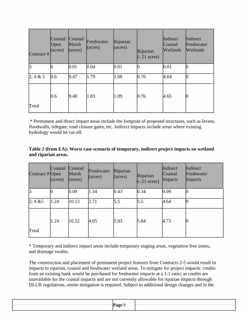
Table 1 (from EA): Worst case scenario of permanent, direct and indirect project impacts on wetland and riparian areas.
Page 9
Contract #
Coastal/Open (acres)
Coastal/Marsh (acres)
Freshwater (acres)
Riparian (acres)
Riparian (-.21 acres)
Indirect Coastal Wetlands
Indirect Freshwater Wetlands
3 0 0.01 0.04 0.01 0 0.01 0
2, 4 & 5 0.6 9.47 1.79 1.08 0.76 4.64 0
Total
0.6 9.48 1.83 1.09 0.76 4.65 0
* Permanent and direct impact areas include the footprint of proposed structures, such as levees,
floodwalls, tidegate, road closure gates, etc. Indirect impacts include areas where existing hydrology would be cut off.
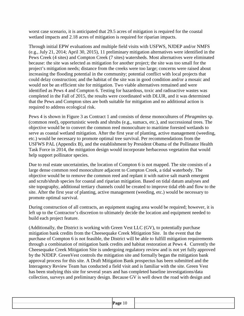
Table 2 (from EA): Worst case scenario of temporary, indirect project impacts on wetland and riparian areas.
Contract # Coastal/Open (acres)
Coastal/Marsh (acres)
Freshwater (acres)
Riparian (acres)
Riparian (-.21 acres)
Indirect Coastal Impacts
Indirect Freshwater Impacts
3 0 0.09 1.34 0.43 0.34 0.09 0
2, 4 &5 1.24 10.13 2.71 5.5 5.5 4.64 0
Total
1.24 10.22 4.05 5.93 5.84 4.73 0
* Temporary and indirect impact areas include temporary staging areas, vegetation free zones, and drainage swales. The construction and placement of permanent project features from Contracts 2-5 would result in impacts to riparian, coastal and freshwater wetland areas. To mitigate for project impacts: credits from an existing bank would be purchased for freshwater impacts at a 1:1 ratio; as credits are unavailable for the coastal impacts and are not currently allowable for riparian impacts through DLUR regulations, onsite mitigation is required. Subject to additional design changes and in the
Page 10
worst case scenario, it is anticipated that 29.5 acres of mitigation is required for the coastal wetland impacts and 2.18 acres of mitigation is required for riparian impacts.
Through initial EPW evaluations and multiple field visits with USFWS, NJDEP and/or NMFS (e.g., July 21, 2014; April 30, 2015), 11 preliminary mitigation alternatives were identified in the Pews Creek (4 sites) and Compton Creek (7 sites) watersheds. Most alternatives were eliminated because: the site was selected as mitigation for another project; the site was too small for the project’s mitigation needs; distance from the creeks were too large; concerns were raised about increasing the flooding potential in the community; potential conflict with local projects that could delay construction; and the habitat of the site was in good condition and/or a mosaic and would not be an efficient site for mitigation. Two viable alternatives remained and were identified as Pews 4 and Compton 6. Testing for hazardous, toxic and radioactive wastes was completed in the Fall of 2015, the results were coordinated with DLUR, and it was determined that the Pews and Compton sites are both suitable for mitigation and no additional action is required to address ecological risk.
Pews 4 is shown in Figure 3 as Contract 1 and consists of dense monocultures of Phragmites sp. (common reed), opportunistic weeds and shrubs (e.g., sumacs, etc.), and successional trees. The objective would be to convert the common reed monoculture to maritime forested wetlands to serve as coastal wetland mitigation. After the first year of planting, active management (weeding, etc.) would be necessary to promote optimal tree survival. Per recommendations from the USFWS PAL (Appendix B), and the establishment by President Obama of the Pollinator Health Task Force in 2014, the mitigation design would incorporate herbaceous vegetation that would help support pollinator species.
Due to real estate uncertainties, the location of Compton 6 is not mapped. The site consists of a large dense common reed monoculture adjacent to Compton Creek, a tidal waterbody. The objective would be to remove the common reed and replant it with native salt marsh emergent and scrub/shrub species for coastal and riparian mitigation. Based on tidal datum analyses and site topography, additional tertiary channels could be created to improve tidal ebb and flow to the site. After the first year of planting, active management (weeding, etc.) would be necessary to promote optimal survival.
During construction of all contracts, an equipment staging area would be required; however, it is left up to the Contractor’s discretion to ultimately decide the location and equipment needed to build each project feature.
(Additionally, the District is working with Green Vest LLC (GV), to potentially purchase mitigation bank credits from the Cheesequake Creek Mitigation Site. In the event that the purchase of Compton 6 is not feasible, the District will be able to fulfill mitigation requirements through a combination of mitigation bank credits and habitat restoration at Pews 4. Currently the Cheesequake Creek Mitigation Site is undergoing regulatory review and is not yet fully approved by the NJDEP. GreenVest controls the mitigation site and formally began the mitigation bank approval process for this site. A Draft Mitigation Bank prospectus has been submitted and the Interagency Review Team has conducted a field visit and is familiar with the site. Green Vest has been studying this site for several years and has completed baseline investigations/data collection, surveys and preliminary design. Because GV is well down the road with design and
Page 11
approvals, GV can efficiently secure approvals to develop this site as a standalone mitigation project for the District.)
7:7-9.28 Wetlands buffers A 150 ft. wetland buffer (transition area) were applied to delineated wetlands. The permanent and temporary impacted wetland buffers are 0.59 and 5.75 acres, respectively. Temporarily impacted wetlands and buffers would be restored and permanently impacted areas would be mitigated for at two sites near the project area. 7:7-9.29 Coastal bluffs There are no coastal bluffs located in the project area. Therefore, this policy is not applicable. 7:7-9.30 Intermittent stream corridors This policy restricts actions to intermittent stream corridors. The area of the proposed activity does not contain areas with intermittent stream corridors. Therefore, this policy is not applicable. 7:7-9.31 Farmland conservation areas This policy seeks to preserve large parcels of land used for farming. The area of the proposed activity does not contain lands used for farming. Therefore, this policy is not applicable. 7:7-9.32 Steep slopes The topography of the project area is relatively flat, and no steep slopes are present. Therefore the project is in compliance with this policy. 7:7-9.33 Dry borrow pits The area of the proposed project does not contain any dry borrow pits. Therefore, this policy is not applicable. 7:7-9.34 Historic and archaeological resources This policy protects the value of historic and archaeological resources and may require cultural resource surveys and other protective measures. Historic and archaeological resources include objects, structures, neighborhoods, districts, man-made features on the landscape or seascape or other features which are on or are eligible for inclusion on the New Jersey or National Register of Historic Places. The NYD has undertaken several cultural resources studies in connection with the Port Monmouth Hurricane and Storm Damage Reduction Project. Further studies are in being conducted in areas proposed for wetland mitigation. It is not anticipated that the relocation of osprey nests will impact significant cultural resources. All work is undertaken in coordinated with the NJHPO. 7:7-9.35 Specimen trees This policy seeks to protect specimen trees, as defined by NJDEP. Specimen trees are defined as the largest known individual trees of each species in New Jersey” or trees “with a circumference equal to or greater than 85 percent of the circumference of the record tree”. Therefore, this policy is not applicable.
Page 12
7:7-9.36 Endangered or threatened wildlife or plant species habitats This policy restricts development in habitats where endangered or threatened wildlife or plant species are known to occur on a seasonal or permanent basis; or habitats known to be critical in the life cycle of any wildlife or plant species identified as endangered, threatened or under active consideration for State or Federal listing. Coordination with the U.S. Fish and Wildlife Service (USFWS) under the Fish and Wildlife Coordination Act was initiated in 2014 for the project’s Phase II NEPA documentation update. A supplemental Planning Aid letter (PAL) identified the following federally listed species and species proposed for listing that may exist in the project area. The proposed activity is not anticipated to have direct or indirect impacts on any of the species:
• Piping plover (Charadrius melodus) - this species typically occurs in beach/sandy habitat on the shoreline, including nesting activities; the proposed activity would not occur on or near the beach/sandy habitat and there are no observed occurrences of plovers within 10 miles of the project area. No direct or indirect impacts are anticipated.
• Seabeach amaranth (Amaranthus pumilus) and Seabeach knotweed (Polygonum glaucum) - Seabeach amaranth were first recorded on the beach at Port Monmouth in August 2014 during District monitoring for endangered species required for Phase I construction; the plants were found after sand nourishment occurred on the Port Monmouth and Keansburg beaches, although the area in which the plants were found were not nourished with sand. Multiple plants were found on the beach in the area between the Monmouth Cove Marina and the fishing pier. Additional plants were observed in August 2015. In both years, the USFWS were notified and a buffer of 3 meters around the plant was maintained with post-and-string fencing and “Restricted Area” signs were placed on the fencing. Seabeach knotweed (Polygonum glaucum) - was observed for the first time by the District in September 2015 on the west side of the fishing pier on the Port Monmouth beach. The plants were observed following the completion of Phase I construction. For the construction of Phase II, Contracts 3 and 5 only have the potential to overlap with areas in which the amaranth and knotweed may grow during construction of the floodwalls north of Port Monmouth Road and adjacent to the beach/dune. Although it is unlikely that construction would take place in areas the plants may grow, equipment and personnel may utilize the beach to transport material. To prevent direct impacts to potential plants, the District would survey for seabeach amaranth and knotweed no more than one week prior to the start of Contracts 3 and 5 construction, if it occurs between May 15 - November 30. If the plants are found, fencing and signage would be placed as described in the preceding paragraph for seabeach amaranth and USFWS and the DLUR would be alerted. Overall, impacts are anticipated to be temporary and minor. This species was observed on the western portion of Port Monmouth beach for the first time in 2014. This species occurs in beach/sandy habitat and is immobile. The proposed activity would not take place in seabeach amaranth habitat; therefore no direct or indirect impacts are anticipated.
• Northern long-eared bat (Myotis septentrionalis) - In the USFWS PAL (Appendix B), the USFWS recommended a seasonal restriction which would prevent tree removal from April 1 through September 30 in areas of potential northern long-eared bat habitat. Upon additional coordination with the USFWS via an email between the District Ecologist (Ann Marie DiLorenzo) and the NLEB expert at the USFWS (Jeremy Markuson) on November
Page 13
23, 2015, it was determined that “...it's unlikely the project would result in adverse effects. For northern long-eared bats a time-of-year restriction on tree clearing activities is not warranted”. This determination was based on additional assessments of the project’s landscape and an approximate acreage of proposed tree cutting activities. Per Mr. Markuson: “...I find it unlikely that a northern long-eared bat would use the patches of forested habitat in the project area for roosting. However, northern long-eared bats may forage within or near the action area. Additionally, to address small scaled forest clearing activities we have conducted a spatial probability analysis using a simulation model to determine exposure risk to roosting northern long-eared bats. Based on the model results and the estimated occupancy of northern long-eared bats in New Jersey, tree clearing activities under 5 acres during the active season (April 1 - September 30) is discountable provided the activities do not occur within known occupied habitat (beyond 3 mi of any netting or acoustic detection, 1.5 mi of any known roost, and 5 mi of any known hibernaculum). Discountable effects are those extremely unlikely to occur. The tree clearing activities do not occur with any known occupied habitat. Therefore, impacts to NLEB are not anticipated.
• Rufa red knot (Calidris canutus rufa) - few red knots have been observed on beaches near the project area and sightings are primarily associated with fall migrations; the proposed activity would not occur on or near the beach/sandy habitat and is not anticipated to have direct or indirect impacts on this highly mobile species.
• Roseate tern (Sterna dougallii) - this species was last recorded breeding in NJ in the 1970’s. Individuals are occasionally sighted along the NJ coast during spring and fall migrations. Although the proposed activity is near the range of the tern, it is not anticipated to have a direct or indirect impact on this highly mobile species.
Coordination with the National Oceanic and Atmospheric Administration (NOAA) under the Endangered Species Act has been completed for the entire project, with the issuance of a Biological Opinion. For Phase II, impacts to sea turtles, Atlantic sturgeon and whales are not anticipated. The Landscape Project data (NJ GeoWeb) for the area of the proposed activity revealed the following:
· There is no mapped state or federally listed species for the following landscape project categories: freshwater mussel; Atlantic coastal; Delaware Bay; Marine; Pinelands; and Skyland.
· Proposed activities involving avian nesting structures are not located in potential vernal habitat.
· There are no Natural Heritage Priority Sites (http://www.nj.gov/dep/gis/landscape.html), which identifies the best habitat for rare natural communities, critical habitat, rare plant or animal species for federally listed species (http://ecos.fws.gov/crithab/) in the proposed activity area.
· All avian nesting structures are located in the Piedmont Plains Landscape. · The following species are located in areas mapped as NJ state listed
endangered/threatened wildlife species habitat on the NJDEP Landscape Maps in the area of the proposed activities (Appendix A). The proposed activity is not expected to cause a major adverse impact to any state threatened species due to: the mobility of all species

Page 14
and capability to avoid activities; the temporary and highly localized nature of the disturbance; and availability of habitat surrounding the structures.
o Osprey (Pandion haliaetus)/foraging/nesting/threatened species - relocation of nesting structures would not occur during osprey nesting activities (March 15-August 15), avoiding direct impacts. This activity would not remove the nesting platform from the area; therefore, nesting pairs may still utilize the structures. Relocating the nesting structures would benefit the osprey by minimizing adverse impacts associated with construction during critical breeding and nesting activities.
o Black skimmer (Rynchops niger)/foraging/endangered species o Black-crowned night-heron (Nycticorax nycticorax)/foraging/threatened
species o Least tern (Sternula antillarum)/foraging/endangered species o Snowy egret (Egretta thula)/foraging/species of special concern o Silver-bordered fritillary (Boloria selene myrina)
(butterfly)/breeding/courtship/threatened species 7:7-9.37 Critical wildlife habitats Critical wildlife habitats are specific areas known to serves an essential role in maintaining wildlife, particularly for wintering, breeding, and migrating. The project area is not known to serve as critical wildlife habitat. The general area 7:7-9.38 Public open space Public open space refers to lands owned or maintained by Federal, State, or local agencies and which are dedicated to the conservation of public recreation, natural resources, visual or physical public access, and/ or the protection and management of wildlife. Development that adversely affects existing public open space is discouraged. Development within existing public open space is conditionally acceptable, provided that the development is consistent with the character and purpose of public open space, as described by the park master plan when such a plan exists. All new development adjacent to public open space will be required to provide an adequate buffer area. Bayshore Waterfront Park owned and operated by Monmouth County Park System is a 227 acres park located on the beaches of Port Monmouth and sits adjacent to the Monmouth Cove Marina and includes the Seabrook-Wilson House, dating to the early 1700's. The building has been fully restored and now hosts Park System nature and history programs. The park also provides beach access, fishing, and boating. During design, to maintain level-ground access to the Henry Hudson Trail in Contract 4, it was determined that a walk-around trail around the floodwall was the best alternative to maintain access. This impact would be permanent and minor from current access. Since the impact from changing a straight line path to a curved, extended path is subjective, it could be considered beneficial or adverse.
Page 15
The Port Monmouth Hurricane and Storm Damage Reduction project is intended to provide relief from flooding and shoreline erosion in the Port Monmouth community including the Bayshore Waterfront Park. The floodwall and levee in Contracts 3 and 5 would not limit public access to the Park. Additionally, activities would be performed in a manner intended to limit impacts to the extent possible and still provide maximum flood protection. As such, the project is consistent with the goals of the Monmouth County Open Space Plan (adopted August 21, 2006) to preserve public land and to support future regional conservation and recreation needs throughout the county. Therefore, the proposed project is consistent with this policy. 7:7-9.39 Special hazard areas This policy defines special hazard areas as those with a known actual or potential hazard to public health, safety and welfare which includes areas where hazardous substances are used or have been disposed. No known contaminated areas are located within the project area. However, three known contaminated sites are located within the Pews Creek watershed. One is located at the Monmouth Cove Marina (known as Spy House Harbor), approximately 800 feet downstream of the proposed Pews Creek storm gate. The others are located over 0.3 miles from Pews Creek associated with residential areas upstream of the project area. These sites will not be impacted by the proposed project; therefore it is consistent with this policy. 7:7-9.40 Excluded Federal lands Federal lands are beyond jurisdiction of the New Jersey Coastal Zone. New Jersey has the authority to review activities on Federal lands if spillover impacts on New Jersey’s Coastal Zone may occur. Per the NJ Coastal management Program, Final Environmental Impact Statement (August 1980), no excluded Federal lands are in the area of the proposed activity. Therefore, this policy is not applicable. 7:7-9.41 Special Urban Areas (N.J.S.A.52:27D178) qualified to receive State aid to enable them to maintain and upgrade municipal services and offset local property taxes. The project site is not located in a special urban area. Therefore this policy does not apply. 7:7-9.42 Pinelands National Reserve and Pinelands Protection Area Parks and Recreation Act of 1978, Section 502 (P.L. 95-625), an approximately 1,000,000 acre area ranging from Monmouth County in the north, south to Cape May County and from Gloucester and Camden County on the west to the barrier islands of Island Beach State Park and Brigantine Island along the Atlantic Ocean on the east. The "Pinelands Area" is a slightly smaller area within the Pinelands National Reserve. It was designated for State regulation by the Pinelands Protection Act of 1979 (N.J.S.A. 13:18-1 et seq.). This project will neither directly nor indirectly impact the Pinelands National Reserve or Pinelands Protection area. This policy is therefore not applicable. 7:7-9.43 Hackensack Meadowlands District The project is not located within the Hackensack Meadowlands District. Therefore, this policy does not apply.
Page 16
7:7-9.44 Wild and scenic river corridors This policy recognizes the value of certain rivers in New Jersey by restricting development to compatible uses. The Raritan River and its tributaries are not designated as a National Wild and Scenic River System, nor have they been designated by Congress or State Legislature as a “study river” (http://www.state.nj.us/drbc/basin/wild.html; http://www.njaudubon.org/Portals/10/Education/PDF/NJ%20WATERS/NJWATERS_Raritan.pd f; and http://www.rivers.gov/documents/study-process.pdf). Therefore, this policy is not applicable. 7:7-9.45 Geodetic control reference marks Two USACE 3 1/2-inch brass disks were set for the project within the NY Waterway Parking lot in Belford, NJ bordering Compton Creek (AFH025 and AFH026). Two additional USACE disks (ACV581 and ACT966) were previously set adjacent to Pews Creek. No disturbance to any geodetic control reference marks is anticipated to accommodate construction. Therefore, the proposed project complies with this policy. 7:7-9.46 Hudson River Waterfront Area Bergen County to the Bayonne Bridge in Bayonne, Hudson County, inclusive of all land within the municipalities of Bayonne, Jersey City, Hoboken, Weehawken, West New York, Guttenberg, North Bergen, Edgewater and Fort Lee subject to the Waterfront Development The area of the proposed activity is not located Hudson River. Therefore, this policy is not applicable. 7:7-9.47 Atlantic City This policy applies to development in Atlantic City. The proposed activity is outside of Atlantic City. Therefore, this policy is not applicable. 7:7-9.48 Lands and Waters Subject to Public Trust Rights Lands and waters subject to public trust rights are tidal waterways and their shores, including both lands now or formerly below the mean high water line, and shores above the mean high water line. Tidal waterways and their shores are subject to the Public Trust Doctrine and are held in trust by the State for the benefit of all the people, allowing the public to fully enjoy these lands and waters for a variety of public uses. There are three public access points to the Bayshore. Public access would be maintained during construction of the project. 7:7-9.49 Dredged material management areas The proposed project is not located adjacent to a dredged material management area. Therefore this policy does not apply. SUBCHAPTER 10. STANDARDS FOR BEACH AND DUNE ACTIVITIES These standards apply to routine beach maintenance, emergency post storm beach restoration, dune creation and maintenance, and construction of boardwalks, none of which apply to the proposed activity. Therefore, these standards are not applicable.

Page 17
SUBCHAPTER 11. STANDARDS FOR CONDUCTING AND REPORTING THE RESULTS OF AN ENDANGERED OR THREATENED WILDLIFE OR PLANT SPECIES HABITAT IMPACT ASSESSMENT AND/OR ENDANGERED OR THREATENED WILDLIFE SPECIES HABITAT EVALUATION This section describes the standards for conducting an Endangered or Threatened Wildlife/Plant Species Habitat Impact Assessment and for conducting an Endangered or Threatened Wildlife Species Habitat Evaluation. These standards would be applicable at the time of coordination and permit applications for the overall Port Monmouth project feature construction. SUBCHAPTER 12. GENERAL WATER AREAS This section defines general water areas as those “which are located below either the spring high water line or the normal water level of non-tidal water that are subject to this Subchapter”. The General Water Areas policies are not applicable to any aspect of the proposed activity. SUBCHAPTER 13. REQUIREMENTS FOR IMPERVIOUS COVER AND VEGETATIVE COVER FOR GENERAL LAND AREAS AND CERTAIN SPECIAL AREAS 1. Impervious Cover Limits The site is located in Coastal Metropolitan Planning Area with a maximum allowable impervious cover of 80%. The total land area for the site is 4.4 acres. With the exclusion of Special Areas (wetlands and wetland buffers), the net land area is 1.23 acres. The existing (0.07 acres) and proposed (0.08 acres [see below]) of impervious cover on the site equals 0.15 acres or 12.1%. Therefore, the proposed project complies with this policy. [2,256 length of floodwall x 1.5 feet wide =3,384 square feet = 0.077 acres of proposed impervious surface] 2. Vegetation Preservation The area (in acres) on a site in the CAFRA area in which trees and/or herb/shrub vegetation shall be planted or preserved is calculated as follows: A total of 0.64 acres of the 1.23 net land acres (as determined above) is forested based on aerial photographic analysis. The Coastal Metropolitan Planning Area requires 10 percent tree preservation for the forested portion of the site and 0 percent tree preservation and/or planting for unforested portion of the site. Ten (10) percent of 0.64 acres is 0.06 acres of tree preservation within the forested portion of the site. SUBCHAPTER 14. GENERAL LOCATION RULES 7:7-14.1 Rule on location of linear development This rule sets conditions for acceptability of linear development (e.g., roads, walkways, pipelines). A linear development shall comply with the specific location rules to determine the most acceptable route, to the maximum extent practicable. Through most of the alignment of the proposed activity, paths were selected adjacent to roadways to minimize impacts to the maximum extent practicable. Therefore, the proposed project is consistent with this policy. 7:7-14.2 Basic location rule
Page 18
This rule states that NJDEP may reject or conditionally approve a project for safety, protection of certain property, or preservation of the environment. The specific stated criteria in the policy are to promote the public health, safety, and welfare; to protect public property, wildlife, and marine fisheries; and to preserve, protect, and enhance the natural environment. The Port Monmouth Hurricane and Storm Damage Reduction project is intended to provide flood relief in the Port Monmouth community in developed areas between Pews and Compton Creeks. Severe storms have historically impacted homes, commercial properties, and community infrastructure within the project area as a result of extensive flooding and shoreline erosion. This damage has resulted in substantial financial losses and is considered a significant constraint to commerce and regional development. The project has been designed to minimize impacts on environmental resources and avoid impacts on protected resources to the extent possible, and provide mitigation to compensate for unavoidable habitat loss. Therefore, the proposed activity would be consistent with this policy. 7:7-14.3 Secondary impacts Non-point air and water pollution are unavoidable impacts associated with most types of development. Population size will not be increased as a result of the proposed project. In accordance with state regulations, new development projects must include best management practices that are designed to reduce the effects of air and water pollution, especially those from non-point sources. These concerns will be addressed through the implementation of the Soil Erosion and Sediment Control Plan approved by the Freehold Soil Conservation District. Additionally, the proposed project will not increase the possibility of future development in the immediate area as the project areas is owned by the County of Monmouth. SUBCHAPTER 15. USE RULES Coastal engineering measures include a variety of non-structural, hybrid, and structural shore protection and storm damage reduction measures to manage water areas and protect the shoreline from the effects of erosion, storms, and sediment and sand movement. Beach nourishment, sand fences, pedestrian crossing of dunes, stabilization of dunes, dune restoration projects, dredged material management, living shorelines, and the construction of retaining structures such as bulkheads, gabions, revetments, and seawalls are all examples of coastal engineering measures. The proposed project includes the construction of floodwalls, levees, road closure gates, a storm gate, pump stations, interior drainage, road raising, and road re-grading, therefore, the Coastal Engineering Use Rule applies. The quantity of backfill material for all contracts is unknown at this time since not all design work is advanced to make this determination. This material will come from an existing facility that is fully permitted and authorized to provide the appropriate volume of clean material needed for construction. The project was designed to comply with the standards relevant to coastal engineering and provide maximum flood protection while minimizing impacts to natural resources and maintaining public access to the Bayfront. Therefore, the proposed activity would be consistent with this policy. SUBCHAPTER 16. RESOURCE RULES
Page 19
7:7-16.2 Marine fish and fisheries This rule sets standards of acceptability to cause minimal interference with the reproductive, spawning and migratory patterns of estuarine and marine animals. The finfish and shellfish resources of New Jersey provide valuable recreational experiences for residents and interstate visitors. The recreational and commercial landings of these species also contribute substantially to the State’s economy. Portions of the proposed activity area contain coastal wetlands and tidal creeks that could offer habitat to marine fish and fisheries. Most of the project features would require construction in a small portion of Pews Creek, as well as the wetlands adjacent to Pews and Compton Creeks. Construction would not directly or intentionally involve the catching, taking or harvesting of marine fish. It is anticipated that fish would avoid any equipment used to install the features in/adjacent to Pews Creek in Contract 2. A coffer dam would be construction to maintain tidal inundation to the Pews Creek wetland during construction of the storm gate; therefore any fish migration would not be obstructed. In cases where equipment operates in the wetlands during tidal inundation, it is unlikely fish would be encountered at the edge of the wetland where construction would take place in Contracts 4 and 5. During construction, slow moving/sessile marine animals living in the soil may be inadvertently collected or crushed; however it is anticipated that abundance or diversity of these animals would not be impacted because the size of the construction area and access paths would represent a small percentage compared to the surrounding habitat and animals present in the wetlands. Also, the nature of this disturbance would be temporary. Since minimal interference to estuarine and marine mammals is anticipated, the proposed activity is consistent with this policy. 7:7-16.3 Water Quality 1451 et seq., Federal, State, and local water quality requirements established under the Federal Clean Water Act, 33 U.S.C. §§ 1251 et seq., shall be the water resource standards of the coastal management program. These requirements include not only the minimum requirements imposed under the Clean Water Act but also the additional requirements adopted by states, localities, and interstate agencies pursuant to Section 510 of the Clean Water Act and such statutes as the New Jersey Water Pollution Control Act, N.J.S.A. 58:10A-1 et seq. An Engineering and Stormwater Management Report was developed for this project and provides detailed calculations and design relating to proposed best management practices. 7:7-16.4 Surface water use The project does not propose any withdrawals of surface or groundwater and the proposed project will not deplete the water table in any given area. The management of groundwater recharge will be handled by the approval of a stormwater management plan submitted to the NJDEP to obtain construction permits. The development is not anticipated to negatively affect existing ground water supply or quality. Therefore, the project is in compliance with this policy. 7:7-16.5 Groundwater use
Page 20
This rule sets standards for coastal development to limit effects on groundwater supplies. The proposed activity would not place a demand on groundwater supplies. Therefore, this policy is not applicable. 7:7-16.6 Storm-water management The project or activity shall comply with the Stormwater Management rules at N.J.A.C. 7:8. An Engineering and Stormwater Management Report was prepared and submitted to NJDEP. 7:7-16.7 Vegetation Coastal development shall preserve, to the maximum extent practicable, existing vegetation within a development site. Coastal development shall plant new vegetation, particularly appropriate coastal species, native to New Jersey to the maximum extent practicable. Construction of the proposed project features would result in minimal temporary and permanent disturbance of vegetation. The majority of the proposed alignment is located at the edge of wetlands. Within the project area, a 15-foot vegetation free zones (grasses only) would be maintained on either side of the floodwall and interior drainage ditches in addition to 10-foot wide temporary construction easements. Minor clearing of vegetation would be necessary to accommodate construction and the footprint of the project features; however existing vegetation would be preserved to the maximum extent practicable. Most of the project area has undergone prior disturbance. Invasive and nuisance species and monocultures of common reed were often observed. Revegetation plans include approved native plants and 7:7-16.8 Air quality Coastal development shall conform to all applicable State and Federal Regulations, standards and guidelines and be consistent with the strategies of New Jersey’s State Implementation Plan (SIP). The proposed development would not result in any air borne emissions that would violate State or Federal regulations. Emissions would be limited to exhaust from automobiles traveling to and from the site during construction and from construction equipment. The Federal government regulates automobile emissions, while technological improvements in heating and cooling units have resulted in decreased emissions and increased efficiency. Minimal impacts to air quality resulting from construction equipment and airborne dust would result from construction activities but these are considered short-term impacts and would not be present post construction. The proposed project, therefore, complies with this rule. 7:7-19.9 Public access Construction associated with Contracts 3 and 5 would not inhibit public access to the Bayfront. The proposed activity would be consistent with this policy. 7:7-16.10 Scenic Resources and Design Adverse impacts to scenic resources as a result of the constructed project features are expected to be of minimal significance to the surrounding natural and manmade landscape. Structures would be consistent with existing man-made structures in the general vicinity. Access to the shore front

Page 21
would continue to be maintained by stairs and walkways across the dune, ensuring continuous availability of the shore for aesthetic and scenic enjoyment of the shore front area. 7:7-16.11 Buffers and compatibility of uses Buffers are natural or man-made areas, structures, or objects that serve to separate distinct uses or areas. Compatibility of uses is the ability for uses to exist together without aesthetic or functional conflicts. Development shall be compatible with adjacent land and water uses to the maximum extent practicable. The proposed project features would be compatible with the surrounding area to the maximum extent possible while providing necessary flood protection for the surrounding area. Therefore, the project is in compliance with this rule. 7:7-16.12 Traffic Traffic is the movement of vehicles, pedestrians or ships along a route. Coastal development shall be designed, located and operated in a manner to cause the least possible disturbance to traffic systems. The proposed project will not adversely impact traffic in the surrounding street network. The safe, orderly flow of traffic will be ensured at all times and all appropriate safety procedures, uniformed traffic directors, personnel and devices will be implemented as necessary during construction. 7:7-16.13 Subsurface sewage disposal systems This rule sets standards for subsurface sewage disposal systems in the coastal zone. The proposed activity does not involve sewage disposal. Therefore, this policy is not applicable. 7:7-16.14 Solid and hazardous waste A material is a solid waste if it is "disposed of" by being discharged, deposited, injected, dumped, spilled, leaked or placed into or on any land or water so that such material or any constituent thereof may enter the environment or be emitted into the air or discharged into ground or surface waters. The proposed project would not require the disposal of solid or hazardous waste; therefore this policy does not apply.

Page 22
APPENDIX A NJDEP SPECIES BASED HABITAT DATA FOR PROPOSED ACTIVITY AREA
Data retrieved from the NJDEP Landscape Project GIS data – http://www.nj.gov/dep/gis/landscape.html LINKID COMMON
NAME SCIENTIFIC NAME
FEAT_LABEL CLASS NJ_STATUS
03_239236 Common Tern Sterna hirundo Foraging Aves Special Concern
03_239236 Black Skimmer
Rynchops niger Foraging Aves State Endangered
03_239236 Black-crowned Night-heron
Nycticorax nycticorax
Foraging Aves State Threatened
03_239236 Snowy Egret Egretta thula Foraging Aves Special Concern
03_239608 Common Tern Sterna hirundo Foraging Aves Special Concern
Black Skimmer
Rynchops niger Foraging Aves State Endangered
Black-crowned Night-heron
Nycticorax nycticorax
Foraging Aves State Threatened
Page 23
Snowy Egret Egretta thula Foraging Aves Special Concern
03_239092 Common Tern Sterna hirundo Foraging Aves Special Concern
Black Skimmer
Rynchops niger Foraging Aves State Endangered
Black-crowned Night-heron
Nycticorax nycticorax
Foraging Aves State Threatened
Snowy Egret Egretta thula Foraging Aves Special Concern
Osprey Pandion haliaetus Foraging Aves State Threatened
03_237279 no information
Breeding/ Courtship
03_253620 Silver-bordered Fritillary
Boloria selene myrina
Insecta State Threatened
03_91351 no information
no data no information
03_239496 Common Tern Sterna hirundo Foraging Aves Special Concern
03_239496 Black-crowned Night-heron
Nycticorax nycticorax
Foraging Aves State Threatened
03_239496 Osprey Pandion haliaetus Nest Aves State Threatened
03_239597 Common Tern Sterna hirundo Foraging Aves Special Concern
03_239597 Black Skimmer
Rynchops niger Foraging Aves State Endangered
03_239597 Black-crowned Night-heron
Nycticorax nycticorax
Foraging Aves State Threatened
03_239597 Osprey Pandion haliaetus Nest Aves State Threatened
Page 24
03_239230 Common Tern Sterna hirundo Foraging Aves Special Concern
03_239230 Least Tern Sternula antillarum
Foraging Aves State Endangered
03_239230 Black Skimmer
Rynchops niger Foraging Aves State Endangered
03_239230 Black-crowned Night-heron
Nycticorax nycticorax
Foraging Aves State Threatened
03_239230 Osprey Pandion haliaetus Nest Aves State Threatened
03_242157 Common Tern Sterna hirundo Foraging Aves Special Concern
03_242157 Black Skimmer
Rynchops niger Foraging Aves State Endangered
03_242157 Black-crowned Night-heron
Nycticorax nycticorax
Foraging Aves State Threatened
03_242157 Osprey Pandion haliaetus Nest Aves State Threatened
03_242127 Common Tern Sterna hirundo Foraging Aves Special Concern
03_242127 Black Skimmer
Rynchops niger Foraging Aves State Endangered
03_242127 Black-crowned Night-heron
Nycticorax nycticorax
Foraging Aves State Threatened
no data 03_241130 Common Tern Sterna hirundo Foraging Aves Special Concern
03_241130 Black-
crowned Night-heron
Nycticorax nycticorax
Foraging Aves State Threatened
03_242120 Common Tern Sterna hirundo Foraging Aves Special Concern
03_242120 Black Skimmer
Rynchops niger Foraging Aves State Endangered
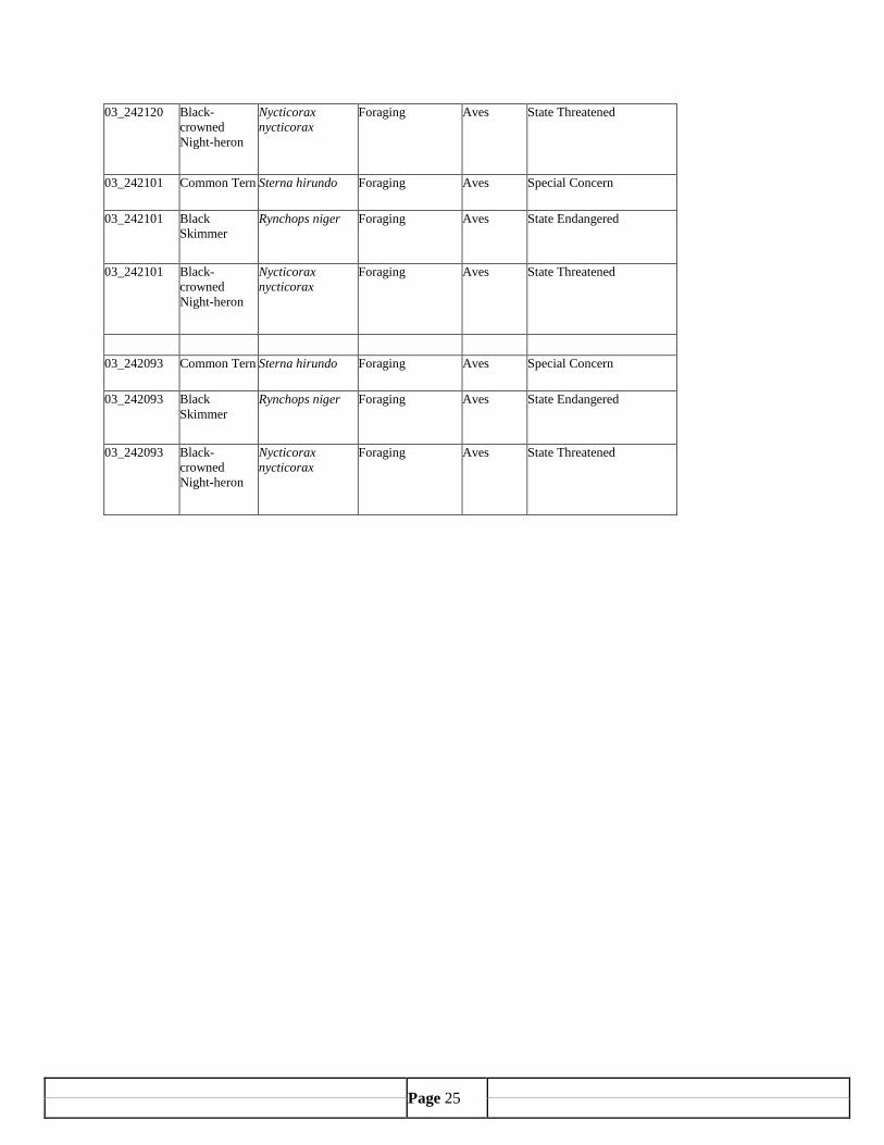
Page 25
03_242120 Black-crowned Night-heron
Nycticorax nycticorax
Foraging Aves State Threatened
03_242101 Common Tern Sterna hirundo Foraging Aves Special Concern
03_242101 Black Skimmer
Rynchops niger Foraging Aves State Endangered
03_242101 Black-crowned Night-heron
Nycticorax nycticorax
Foraging Aves State Threatened
03_242093 Common Tern Sterna hirundo Foraging Aves Special Concern
03_242093 Black Skimmer
Rynchops niger Foraging Aves State Endangered
03_242093 Black-crowned Night-heron
Nycticorax nycticorax
Foraging Aves State Threatened

Page 26
APPENDIX B
SHELLFISH CLASSIFICATION
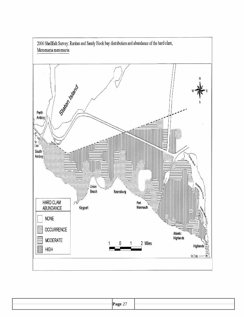
Page 27