Embed Size (px)
Citation preview

COASTAL ZONE MANAGEMENT ACT CONSISTENCY DETERMINATION FOR CALIFORNIA
Department of the Navy
United States Pacific Fleet
JANUARY 2013

CALIFORNIA CONSISTENCY DETERMINATION JANUARY 2013
This Page Intentionally Left Blank
CALIFORNIA CONSISTENCY DETERMINATION JANUARY 2013
i
TABLE OF CONTENTS
1 Introduction .......................................................................................................................................... 1 1.1 Previous Consistency Determinations .............................................................................................................. 2 1.2 Other Compliance Processes ............................................................................................................................ 2 2 PROPOSED FEDERAL AGENCY ACTION .................................................................................................... 3 2.1 Proposed Action ............................................................................................................................................... 3 2.2 Purpose of and Need for the Proposed Action ................................................................................................. 3 2.2.1 Training ............................................................................................................................................................. 4 2.2.2 Testing .............................................................................................................................................................. 5 2.3 Activities that May Affect California’s Coastal Zone ......................................................................................... 6 2.3.1 Study Area ........................................................................................................................................................ 6 2.3.2 Differences from Previous Consistency Determinations ................................................................................ 11 2.3.3 Effects Test ..................................................................................................................................................... 15 3 Enforceable Policies of the California Coastal Management Program ..................................................... 17 3.1 Enforceable Policies Not Applicable to the Proposed Action ......................................................................... 17 3.2 Enforceable Policies of the California Coastal Management Program Applicable to the Proposed Action ... 19
3.2.1 Article 2, Section 30210 – Access; Recreational Opportunities ................................................................. 19 3.2.1.1 Policy ................................................................................................................................................. 19 3.2.1.2 Consistency Review ........................................................................................................................... 19
3.2.2 Article 4, Section 30230 – Marine Resources; Maintenance ..................................................................... 20 3.2.2.1 Policy ................................................................................................................................................. 20 3.2.2.2 Consistency Review ........................................................................................................................... 20
3.2.2.2.1 Sea Turtles .................................................................................................................................... 20 3.2.2.2.2 Sensitive Habitats ......................................................................................................................... 30 3.2.2.2.3 Seabirds ........................................................................................................................................ 33 3.2.2.2.4 Commercial and Recreational Fish Stocks.................................................................................... 38 3.2.2.2.5 Marine Invertebrates ................................................................................................................... 45 3.2.2.2.6 Marine Mammals ......................................................................................................................... 48
3.2.3 Article 4, Section 30231 – Biological Productivity; Water Quality ............................................................. 62 3.2.3.1 Policy ................................................................................................................................................. 62 3.2.3.2 Consistency Review ........................................................................................................................... 62
3.2.4 Article 4, Section 30234.5 – Economic, Commercial, and Recreational importance of Fishing ................. 64 3.2.4.1 Policy ................................................................................................................................................. 64 3.2.4.2 Consistency Review ........................................................................................................................... 64
4 Statement of Consistency ..................................................................................................................... 66 5 References ............................................................................................................................................ 67
CALIFORNIA CONSISTENCY DETERMINATION JANUARY 2013
ii
LIST OF APPENDICES
APPENDIX A ‐ NAVY TRAINING AND TESTING ACTIVITIES IN SOUTHERN CALIFORNIA APPENDIX B ‐ TRAINING AND TESTING ACTIVITIES MATRICES APPENDIX C ‐ STANDARD OPERATING PROCEDURES, MITIGATION, AND MONITORING
LIST OF FIGURES FIGURE 1‐1: HAWAII‐SOUTHERN CALIFORNIA TRAINING AND TESTING STUDY AREA ........................................................................ 1 FIGURE 2‐1: SOUTHERN CALIFORNIA RANGE COMPLEX .............................................................................................................. 7 FIGURE 2‐2: SAN CLEMENTE ISLAND OFFSHORE TRAINING AREAS................................................................................................ 8 FIGURE 2‐3: SAN CLEMENTE ISLAND NEARSHORE TRAINING AREAS ............................................................................................. 9 FIGURE 2‐4 SOUTHERN CALIFORNIA TRAINING AREAS ............................................................................................................. 10 FIGURE 2‐5: SILVER STRAND TRAINING COMPLEX ................................................................................................................... 12 FIGURE 2‐6: NAVY PIERS AND SHIPYARDS IN SAN DIEGO .......................................................................................................... 13
LIST OF TABLES TABLE 2‐1: STRESSORS ANALYZED FOR REASONABLY FORESEEABLE EFFECTS ON COASTAL ZONE USES OR RESOURCES ......................... 16 TABLE 3‐1: ENFORCEABLE POLICIES OF THE CALIFORNIA COASTAL MANAGEMENT PROGRAM NOT APPLICABLE TO THE PROPOSED ACTION
............................................................................................................................................................................ 17 TABLE 3‐2: TOTAL ANNUAL MODEL‐PREDICTED IMPACTS ON SEA TURTLES OF TRAINING ACTIVITIES USING SONAR OR OTHER ACTIVE
NON‐IMPULSIVE ACOUSTIC SOURCES IN THE STUDY AREA ............................................................................................... 22 TABLE 3‐3: TOTAL ANNUAL MODEL‐PREDICTED IMPACTS ON SEA TURTLES OF TESTING ACTIVITIES USING SONAR OR OTHER ACTIVE NON‐
IMPULSIVE ACOUSTIC SOURCES IN THE STUDY AREA ....................................................................................................... 22 TABLE 3‐4: ANNUAL MODEL‐PREDICTED IMPACTS OF EXPLOSIONS ON SEA TURTLES FOR TRAINING ACTIVITIES UNDER PROPOSED ACTION
............................................................................................................................................................................ 23 TABLE 3‐5: ANNUAL MODEL‐PREDICTED IMPACTS OF EXPLOSIONS ON SEA TURTLES FOR TESTING ACTIVITIES UNDER PROPOSED ACTION
............................................................................................................................................................................ 23 TABLE 3‐6: ENDANGERED SPECIES ACT LISTED SEABIRD SPECIES IN THE STUDY AREA ..................................................................... 33 TABLE 3‐7: SOUTHERN CALIFORNIA MARINE MAMMAL SPECIES OCCURRENCES IN COASTAL ZONE .................................................. 49 TABLE 3‐8: LOWER AND UPPER CUTOFF FREQUENCIES FOR MARINE MAMMAL FUNCTIONAL HEARING GROUPS USED IN ACOUSTIC
ANALYSIS ............................................................................................................................................................... 51 TABLE 3‐9: ANNUAL EXPOSURES FROM MODELING ESTIMATES OF IMPULSIVE AND NON‐IMPULSIVE SOURCES UNDER THE PROPOSED
ACTION .................................................................................................................................................................. 54 TABLE 3‐10: ANNUAL EXPOSURE SUMMARY FOR PILE DRIVING AND REMOVAL UNDER BASELINE CONDITIONS AND THE PROPOSED
ACTION .................................................................................................................................................................. 56
CALIFORNIA CONSISTENCY DETERMINATION JANUARY 2013
iii
ACRONYMS AND ABBREVIATIONS 1
A‐A Air‐to‐Air ac. acre A‐S Air‐to‐Surface C.F.R. Code of Federal Regulations cm centimeter CZMA Coastal Zone Management Act DoD Department of Defense EIS Environmental Impact Statement EO Executive Order ESA Endangered Species Act ft. feet or foot GIS Geographic Information System GUNEX Gunnery Exercise In. inch km2 square kilometer m meter mi2 square mile MISSILEX Missile Exercise MMPA Marine Mammal Protection Act Navy Department of the Navy NEPA National Environmental Policy Act nm nautical mile nm2 square nautical mile NMFS National Marine Fisheries Service NOTMAR Notice to Mariners OPAREA Operating Area PTS Permanent Threshold Shift SOCAL southern California S‐S Surface‐to‐Surface SSTC Silver Strand Training Area TTS Temporary Threshold Shift U.S. United States U.S.C. U.S. Code USFWS U.S. Fish and Wildlife Service Yd. yard

CALIFORNIA CONSISTENCY DETERMINATION JANUARY 2013
iv
This Page Intentionally Left Blank
CALIFORNIA CONSISTENCY DETERMINATION JANUARY 2013
1
COASTAL ZONE MANAGEMENT ACT CONSISTENCY DETERMINATION FOR CALIFORNIA
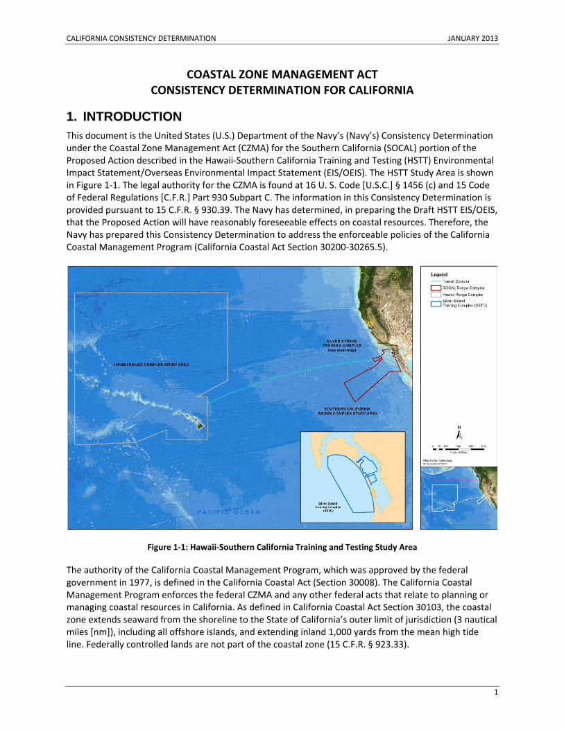
1. INTRODUCTION This document is the United States (U.S.) Department of the Navy’s (Navy’s) Consistency Determination under the Coastal Zone Management Act (CZMA) for the Southern California (SOCAL) portion of the Proposed Action described in the Hawaii‐Southern California Training and Testing (HSTT) Environmental Impact Statement/Overseas Environmental Impact Statement (EIS/OEIS). The HSTT Study Area is shown in Figure 1‐1. The legal authority for the CZMA is found at 16 U. S. Code [U.S.C.] § 1456 (c) and 15 Code of Federal Regulations [C.F.R.] Part 930 Subpart C. The information in this Consistency Determination is provided pursuant to 15 C.F.R. § 930.39. The Navy has determined, in preparing the Draft HSTT EIS/OEIS, that the Proposed Action will have reasonably foreseeable effects on coastal resources. Therefore, the Navy has prepared this Consistency Determination to address the enforceable policies of the California Coastal Management Program (California Coastal Act Section 30200‐30265.5).
Figure 1‐1: Hawaii‐Southern California Training and Testing Study Area
The authority of the California Coastal Management Program, which was approved by the federal government in 1977, is defined in the California Coastal Act (Section 30008). The California Coastal Management Program enforces the federal CZMA and any other federal acts that relate to planning or managing coastal resources in California. As defined in California Coastal Act Section 30103, the coastal zone extends seaward from the shoreline to the State of California’s outer limit of jurisdiction (3 nautical miles [nm]), including all offshore islands, and extending inland 1,000 yards from the mean high tide line. Federally controlled lands are not part of the coastal zone (15 C.F.R. § 923.33).
CALIFORNIA CONSISTENCY DETERMINATION JANUARY 2013
2
1.1 PREVIOUS CONSISTENCY DETERMINATIONS The Navy previously submitted Consistency Determinations for the Southern California (SOCAL) Range Complex EIS/OEIS and Silver Strand Training Complex (SSTC) EIS. For the SOCAL Range Complex Consistency Determination (August 2008), the Navy determined that the Proposed Action was consistent to the maximum extent practicable with enforceable policies of the California Coastal Management Program, based on the analysis contained in the SOCAL EIS/OEIS. California Coastal Commission (Commission) staff recommended that the Commission conditionally concur with the Navy’s Consistency Determination. At the Commission meeting in October 2008, the Navy provided information supporting its Consistency Determination. The Commission decision at the hearing (then provided by letter to the Navy) approved the Consistency Determination with adoption of nine conditions, eight of which addressed the proposed use of active sonar. The Navy responded that the Navy did not agree that the conditions were required for the proposed activities to be consistent to the maximum extent practicable with the enforceable policies of the CCMP. The Navy further determined that the conditions of concurrence, if implemented, would severely and negatively impact training. The Navy and the Commission met to discuss the Commission’s conditional concurrence, but did not reach an agreement. The Navy responded by letter in January 2009, addressing the Commission’s conditions and notifying the Commission of its intent to proceed with the proposed activities under the provisions of 15 C.F.R. §930.43.
For SSTC, in May 2010, the Navy submitted the SSTC Consistency Determination to the Commission, which determined that the SSTC Proposed Action was consistent to the maximum extent practicable with enforceable policies of the California Coastal Management Program. The Commission issued a conditional concurrence in August 2010, but the Navy responded that it did not agree with the conditions of concurrence. After attempting to resolve differences, the Navy submitted a final Consistency Determination Notification letter in November 2010 that addressed the Commission’s conditions, reaffirmed the Navy’s position that the conditions of concurrence proposed by the Commission were not necessary for the Proposed Action to be consistent to the maximum extent practicable with enforceable policies of the California Coastal Management Program, and notified the Commission of its intent to proceed with the proposed activities under the provisions of 15 C.F.R. §930.43. The Navy further determined that the conditions of concurrence, if implemented, would severely and negatively impact expanded training requirements, which were a fundamental need for the Proposed Action.
1.2 OTHER COMPLIANCE PROCESSES The Navy prepared the HSTT EIS/OEIS in accordance with the National Environmental Policy Act (NEPA) of 1969 (42 U.S.C. § 4321); the Council on Environmental Quality regulations for implementing the procedural provisions of NEPA (40 C.F.R. Parts 1500‐1508); Department of the Navy procedures for implementing NEPA (32 C.F.R. Part 775); Executive Order (EO) 12114, Environmental Effects Abroad of Major Federal Actions; and Department of Defense (DoD) regulations implementing EO 12114 (32 C.F.R. Part 187). In accordance with 50 C.F.R. Section 402.12, the Navy evaluated the potential effects of the Proposed Action on marine species and anadromous fish (which live in saltwater but spawn in freshwater) protected under the Endangered Species Act (ESA) and managed by the National Marine Fisheries Service (NMFS). The Navy has prepared a separate consultation package in accordance with legal requirements set forth under regulations implementing Section 7 of the ESA (50 C.F.R. Part 402; 16 U.S.C. § 1536) for listed species under the jurisdiction of the U.S. Fish and Wildlife Service (USFWS). In accordance with the Marine Mammal Protection Act (MMPA) (16 U.S.C. § 1371(a)(5)), the Navy has
CALIFORNIA CONSISTENCY DETERMINATION JANUARY 2013
3
submitted a request for Letters of Authorization to NMFS for the incidental taking of marine mammals, including those also covered by the ESA, resulting from the Proposed Action.
2. PROPOSED FEDERAL AGENCY ACTION 2.1 PROPOSED ACTION The Navy’s Proposed Action, described in Chapter 2 of the EIS/OEIS, is to conduct training and testing activities—which may include the use of active sonar and explosives—primarily within existing range complexes and ocean operating areas (OPAREAs); at Navy piers, ports, and shipyards; and at contractor shipyards located along the U.S. Pacific coast and in the Hawaiian Islands, as well as in the transit corridor1 between Southern California and Hawaii. The Proposed Action includes training and testing activities such as sonar maintenance and gunnery exercises conducted concurrently with ship transits and which may occur outside Navy range complexes and OPAREAs. The Proposed Action also includes pierside sonar testing conducted as part of overhaul, modernization, maintenance, and repair activities at Navy piers in Hawaii and Southern California. Training and testing activities on land areas within the study area (SCI and SSTC) are not part of the proposed action. Those land activities remain consistent with existing NEPA and CZMA documents.
2.2 PURPOSE OF AND NEED FOR THE PROPOSED ACTION Major conflicts, terrorism, lawlessness, and natural disasters continue to threaten the national security of the United States. The security, prosperity, and vital interests of the United States are increasingly tied to other nations because of the close relationships between the economy of the United States and the global economy. The Navy carries out training and testing activities to be able to protect the United States against its enemies, as well as to protect and defend the rights of the United States and its allies to move freely on the oceans, and in addition, to provide humanitarian assistance to failed states. The Navy operates on the world’s oceans and seas—the international maritime domain—on which 90 percent of the world’s trade and two‐thirds of its oil are transported. The majority of the world’s population also lives within a few hundred miles of an ocean.
The U.S. Congress established the National Command Authority after World War II to identify defense needs—based on the existing and emergent situations in the United States and overseas—that must be dealt with now or that may be dealt with in the future. The National Command Authority, which are comprised of the President and the Secretary of Defense, and their deputized alternates or successors, divide defense responsibilities among services. The heads (secretaries) of each service ensure that military personnel are trained, prepared, and equipped to meet those operational requirements.
Training and testing activities that prepare the Navy to fulfill its mission to protect and defend the United States and its allies potentially impact the environment. These activities may trigger legal requirements identified in many U.S. federal environmental laws, regulations, and EOs.
1 The transit corridor is the shortest route from San Diego, California to the center of the Hawaii Range Complex. During transit, ships and aircraft may, at times, conduct basic and routine unit level training, such as gunnery, bombing, and sonar training, as long as training does not interfere with the objective of reaching the intended destination.
CALIFORNIA CONSISTENCY DETERMINATION JANUARY 2013
4
2.2.1 TRAINING
Navy personnel first undergo entry‐level training, which varies according to their assigned warfare community (aviation, surface warfare, submarine warfare, and special warfare) and the community's unique requirements. Personnel then train within their warfare community at sea to prepare for deployment; each warfare community has primary mission areas (areas of specialized expertise that involve multiple warfare communities) that overlap with one another. Elements of each primary mission area are briefly described in the following section:
• Anti‐air warfare: Aircraft conduct anti‐air warfare through radar search, detection, identification, and engagement of airborne threats—generally by firing anti‐air missiles or cannons. Surface ships conduct anti‐air warfare through an array of modern anti‐aircraft weapon systems such as aircraft‐detecting radar, naval guns linked to radar‐directed fire‐control systems, surface‐to‐air missile systems, and radar‐controlled cannons for close‐in point defense. Impacts of overland air activities were analyzed in previous NEPA and CZMA documents, and remain valid;
• Amphibious warfare: Amphibious warfare training ranges from individual, crew, and small unit events to large task force exercises. Individual and crew training include amphibious vehicles and naval gunfire support training. Such training includes shore assaults, boat raids, airfield or port seizures, and reconnaissance. Large‐scale amphibious exercises involve ship‐to‐shore maneuver, naval fire support, such as shore bombardment, and air strike and close air support training; impacts of overland amphibious activities were analyzed in previous NEPA and CZMA documents, and remain valid;
• Strike warfare: Strike warfare training includes training of fixed‐wing attack aircraft pilots and aircrews in the delivery of precision‐guided munitions, nonguided munitions, rockets, and other ordnance against land‐based targets. Not all strike mission training events involve dropping ordnance and instead the event is simulated with video footage obtained by onboard sensors;
• Anti‐surface warfare: Anti‐surface warfare training includes surface‐to‐surface gunnery and missile exercises, air‐to‐surface gunnery and missile exercises, and submarine missile or exercise torpedo launch events;
• Anti‐submarine warfare: Anti‐submarine warfare training addresses basic skills such as detection and classification of submarines, distinguishing between sounds made by enemy submarines and those of friendly submarines, ships, and marine life. More advanced, integrated anti‐submarine warfare training exercises are conducted in coordinated, at‐sea training events involving submarines, ships, and aircraft. This training integrates the full spectrum of anti‐submarine warfare from detecting and tracking a submarine to attacking a target using either exercise torpedoes or simulated weapons;
• Electronic warfare: Typical electronic warfare training activities include threat avoidance training, signals analysis for intelligence purposes, and use of airborne and surface electronic jamming devices to defeat tracking and communications systems. Impacts of overland air activities were analyzed in previous NEPA and CZMA documents, and remain valid; and
• Mine warfare: Mine warfare training includes exercises in which ships, aircraft, submarines, underwater vehicles, or marine mammal detection systems search for mines. Personnel train to destroy or disable mines by attaching and detonating underwater explosives to the mine. Other neutralization techniques involve impacting the mine with a bullet‐like projectile or intentionally triggering the mine to detonate.
CALIFORNIA CONSISTENCY DETERMINATION JANUARY 2013
5
2.2.2 TESTING
The Navy researches, develops, tests, and evaluates new platforms, systems, and technologies. Many tests are conducted in realistic conditions at sea, and can range in scale from testing new software and targets to testing new ships and submarines. Testing activities may occur in pierside locations, and may occur independently of or in conjunction with training activities. Because each test is conducted by a specific component of the Navy’s research and acquisition community, which includes the Navy’s Systems Commands and the Navy’s scientific research organizations, the testing activities described in this Consistency Determination are organized by that particular organization as described below:
• Naval Air Systems Command Testing: Naval Air Systems Command testing activities generally fall in the primary mission areas used by the fleets. Naval Air Systems Command events include, but are not limited to, the testing of new aircraft platforms, weapons, and systems before those platforms, weapons and systems are delivered to the fleet. In addition to the testing of new platforms, weapons, and systems, the Naval Air Systems Command also conducts lot acceptance testing of weapons and systems, such as sonobuoys.
• Naval Sea Systems Command Testing: Naval Sea Systems Command testing activities are aligned with its mission of new ship construction, life cycle support, and other weapon systems development and testing. Each major category of NAVSEA activities is listed below:
o New Ship Construction Activities
o Life Cycle Activities
o Anti‐Surface Warfare/Anti‐Submarine Warfare Testing
o Mine Warfare Testing
o Ship Protection Systems and Swimmer Defense Testing
• Space and Naval Warfare Systems Command Testing: Space and Naval Warfare Systems Command is the information dominance systems command for the United States Navy. Space and Naval Warfare Systems Command is focused on developing and transitioning technologies in the area of command, control, communications, computers, intelligence, surveillance, and reconnaissance. This includes conducting research, development, test, and evaluation projects to support emerging technologies. These activities include, but are not limited to, the testing of unmanned undersea and surface vehicles, a wide variety of sensor systems, underwater surveillance technologies, and underwater communications.
• Office of Naval Research and Naval Research Laboratory Testing: As the Navy’s Science and Technology provider, the Office of Naval Research and the Naval Research Laboratory provide technology solutions for Navy and Marine Corps needs. The Office of Naval Research’s mission, defined by law, is to plan, foster, and encourage scientific research in recognition of its paramount importance as related to the maintenance of future naval power, and the preservation of national security. Further, it manages the Navy’s basic, applied, and advanced research to foster transition from science and technology to higher levels of research, development, test and evaluation. The Office of Naval Research explores science and technology in the areas of oceanographic and meteorological observations, modeling, and prediction in the battlespace environment; submarine detection and classification (anti‐submarine warfare); and mine warfare applications for detecting and neutralizing mines in both the ocean and littoral environment.
CALIFORNIA CONSISTENCY DETERMINATION JANUARY 2013
6
2.3 ACTIVITIES THAT MAY AFFECT CALIFORNIA’S COASTAL ZONE The Study Area of this Consistency Determination is the airspace, sea space, and undersea space of the SOCAL Range Complex and SSTC. Appendix A (Navy Training and Testing Activities) lists training and testing activities that would occur in the Study Area under the Proposed Action. For each training or testing activity, Appendix A provides a short description of the activity, identifies whether the activity would occur within the coastal zone, and identifies tempo, ordnance, and training areas used under current (baseline) conditions and under the Proposed Action.
2.3.1 STUDY AREA
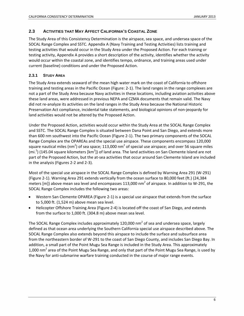
The Study Area extends seaward of the mean high water mark on the coast of California to offshore training and testing areas in the Pacific Ocean (Figure: 2‐1). The land ranges in the range complexes are not a part of the Study Area because Navy activities in these locations, including aviation activities above these land areas, were addressed in previous NEPA and CZMA documents that remain valid. The Navy did not re‐analyze its activities on the land ranges in the Study Area because the National Historic Preservation Act compliance, incidental take statements, and biological opinions of non‐jeopardy for land activities would not be altered by the Proposed Action.
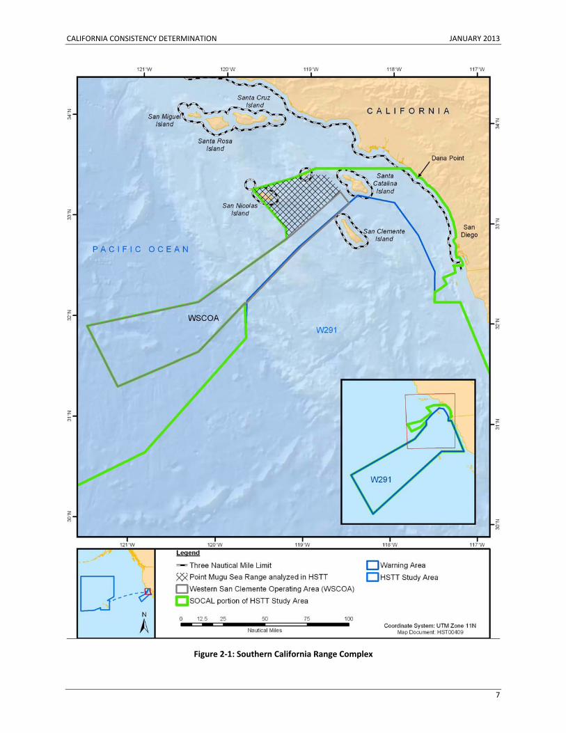
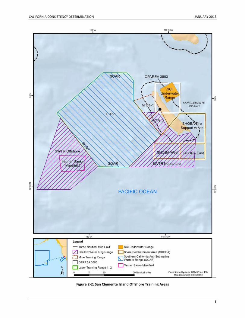
Under the Proposed Action, activities would occur within the Study Area at the SOCAL Range Complex and SSTC. The SOCAL Range Complex is situated between Dana Point and San Diego, and extends more than 600 nm southwest into the Pacific Ocean (Figure 2‐1). The two primary components of the SOCAL Range Complex are the OPAREAs and the special use airspace. These components encompass 120,000 square nautical miles (nm2) of sea space; 113,000 nm2 of special use airspace; and over 56 square miles (mi.2) (145.04 square kilometers [km2]) of land area. The land activities on San Clemente Island are not part of the Proposed Action, but the at‐sea activities that occur around San Clemente Island are included in the analysis (Figures 2‐2 and 2‐3).
Most of the special use airspace in the SOCAL Range Complex is defined by Warning Area 291 (W‐291) (Figure 2‐1). Warning Area 291 extends vertically from the ocean surface to 80,000 feet (ft.) (24,384 meters [m]) above mean sea level and encompasses 113,000 nm2 of airspace. In addition to W‐291, the SOCAL Range Complex includes the following two areas:
• Western San Clemente OPAREA (Figure 2‐1) is a special use airspace that extends from the surface to 5,000 ft. (1,524 m) above mean sea level.
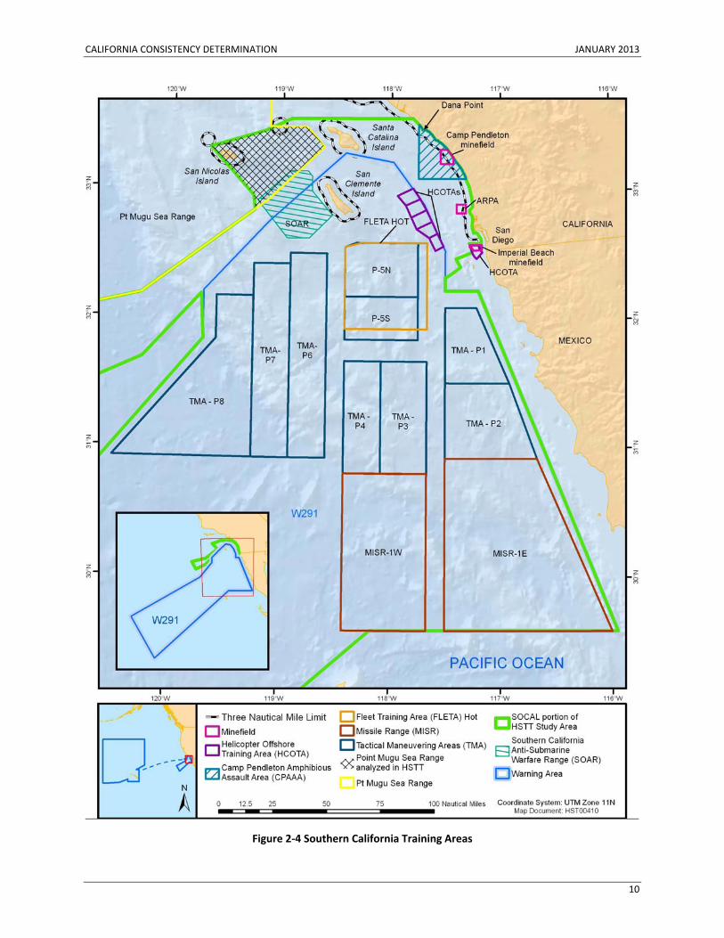
• Helicopter Offshore Training Area (Figure 2‐4) is located off the coast of San Diego, and extends from the surface to 1,000 ft. (304.8 m) above mean sea level.
The SOCAL Range Complex includes approximately 120,000 nm2 of sea and undersea space, largely defined as that ocean area underlying the Southern California special use airspace described above. The SOCAL Range Complex also extends beyond this airspace to include the surface and subsurface area from the northeastern border of W‐291 to the coast of San Diego County, and includes San Diego Bay. In addition, a small part of the Point Mugu Sea Range is included in the Study Area. This approximately 1,000 nm2 area of the Point Mugu Sea Range, and only that part of the Point Mugu Sea Range, is used by the Navy for anti‐submarine warfare training conducted in the course of major range events.
CALIFORNIA CONSISTENCY DETERMINATION JANUARY 2013
7
Figure 2‐1: Southern California Range Complex
CALIFORNIA CONSISTENCY DETERMINATION JANUARY 2013
8
Figure 2‐2: San Clemente Island Offshore Training Areas
CALIFORNIA CONSISTENCY DETERMINATION JANUARY 2013
9
Figure 2‐3: San Clemente Island Nearshore Training Areas
CALIFORNIA CONSISTENCY DETERMINATION JANUARY 2013
10
Figure 2‐4 Southern California Training Areas
CALIFORNIA CONSISTENCY DETERMINATION JANUARY 2013
11
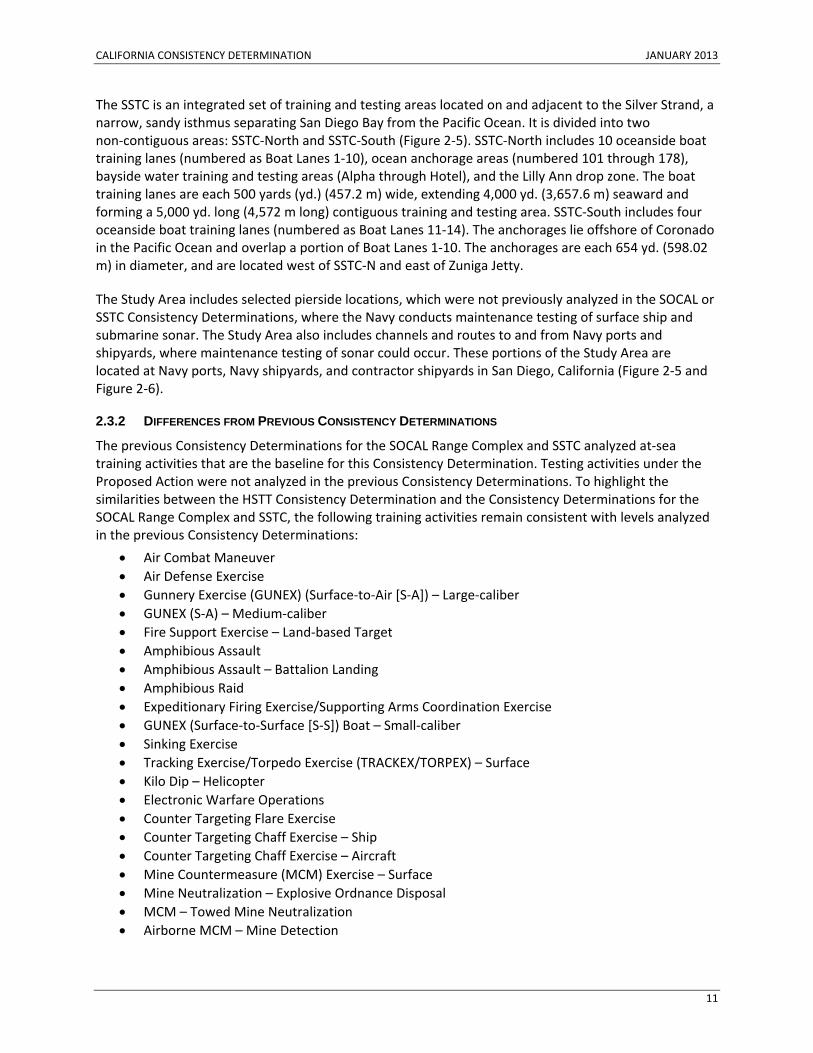
The SSTC is an integrated set of training and testing areas located on and adjacent to the Silver Strand, a narrow, sandy isthmus separating San Diego Bay from the Pacific Ocean. It is divided into two non‐contiguous areas: SSTC‐North and SSTC‐South (Figure 2‐5). SSTC‐North includes 10 oceanside boat training lanes (numbered as Boat Lanes 1‐10), ocean anchorage areas (numbered 101 through 178), bayside water training and testing areas (Alpha through Hotel), and the Lilly Ann drop zone. The boat training lanes are each 500 yards (yd.) (457.2 m) wide, extending 4,000 yd. (3,657.6 m) seaward and forming a 5,000 yd. long (4,572 m long) contiguous training and testing area. SSTC‐South includes four oceanside boat training lanes (numbered as Boat Lanes 11‐14). The anchorages lie offshore of Coronado in the Pacific Ocean and overlap a portion of Boat Lanes 1‐10. The anchorages are each 654 yd. (598.02 m) in diameter, and are located west of SSTC‐N and east of Zuniga Jetty.
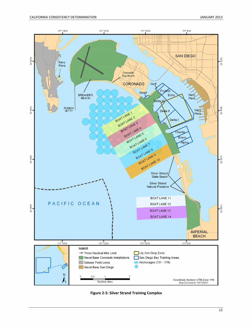
The Study Area includes selected pierside locations, which were not previously analyzed in the SOCAL or SSTC Consistency Determinations, where the Navy conducts maintenance testing of surface ship and submarine sonar. The Study Area also includes channels and routes to and from Navy ports and shipyards, where maintenance testing of sonar could occur. These portions of the Study Area are located at Navy ports, Navy shipyards, and contractor shipyards in San Diego, California (Figure 2‐5 and Figure 2‐6).
2.3.2 DIFFERENCES FROM PREVIOUS CONSISTENCY DETERMINATIONS
The previous Consistency Determinations for the SOCAL Range Complex and SSTC analyzed at‐sea training activities that are the baseline for this Consistency Determination. Testing activities under the Proposed Action were not analyzed in the previous Consistency Determinations. To highlight the similarities between the HSTT Consistency Determination and the Consistency Determinations for the SOCAL Range Complex and SSTC, the following training activities remain consistent with levels analyzed in the previous Consistency Determinations:
• Air Combat Maneuver • Air Defense Exercise • Gunnery Exercise (GUNEX) (Surface‐to‐Air [S‐A]) – Large‐caliber • GUNEX (S‐A) – Medium‐caliber • Fire Support Exercise – Land‐based Target • Amphibious Assault • Amphibious Assault – Battalion Landing • Amphibious Raid • Expeditionary Firing Exercise/Supporting Arms Coordination Exercise • GUNEX (Surface‐to‐Surface [S‐S]) Boat – Small‐caliber • Sinking Exercise • Tracking Exercise/Torpedo Exercise (TRACKEX/TORPEX) – Surface • Kilo Dip – Helicopter • Electronic Warfare Operations • Counter Targeting Flare Exercise • Counter Targeting Chaff Exercise – Ship • Counter Targeting Chaff Exercise – Aircraft • Mine Countermeasure (MCM) Exercise – Surface • Mine Neutralization – Explosive Ordnance Disposal • MCM – Towed Mine Neutralization • Airborne MCM – Mine Detection
CALIFORNIA CONSISTENCY DETERMINATION JANUARY 2013
12
Figure 2‐5: Silver Strand Training Complex
CALIFORNIA CONSISTENCY DETERMINATION JANUARY 2013
13
Figure 2‐6: Navy Piers and Shipyards in San Diego
CALIFORNIA CONSISTENCY DETERMINATION JANUARY 2013
14
• MCM – Mine Neutralization • Mine Laying • Marine Mammal System • Shock Wave Action Generator • Surf Zone Test Detachment/Equipment Test and Evaluation • Personnel Insertion/Extraction – Submarine • Personnel Insertion/Extraction – Non‐submarine • Underwater Demolition Multiple Charge – Mat Weave and Obstacle Loading • Underwater Demolition Qualification/Certification • Composite Training Unit Exercise • Joint Task Force Exercise/Sustainment Exercise • Integrated Anti‐submarine Warfare Course • Precision Anchoring • Small Boat Attack • Offshore Petroleum Discharge System • Elevated Causeway System
To highlight the differences between the HSTT Consistency Determination and previous Consistency Determinations for the SOCAL Range Complex and SSTC, the following training activities were analyzed in the previous Consistency Determinations, but would change (e.g., difference in scope, size, operation, intensity, frequency, or location) under the Proposed Action (see Appendix A, Table A‐1):
• Missile Exercise (MISSILEX) (Air‐to‐Air [A‐A]) • MISSILEX – Man‐portable Air Defense System • Maritime Security Operations • GUNEX (S‐S) Ship – Small‐caliber • GUNEX (S‐S) Ship – Medium‐caliber • GUNEX (S‐S) Ship – Large‐caliber • GUNEX (Air‐to‐Surface [A‐S]) Ship – Small‐caliber • MISSILEX (A‐S) • Bombing Exercise (A‐S) • Laser Targeting • TRACKEX/TORPEX – Submarine • TRACKEX/TORPEX – Helicopter • TRACKEX/TORPEX – Maritime Patrol Aircraft • TRACKEX/TORPEX – Maritime Patrol Advance Extended Echo Ranging Sonobuoys • MCM Exercise – MCM Sonar – Ship Sonar • Mine Neutralization – Remotely Operated Vehicle • Ship Anti‐submarine Warfare Readiness and Evaluation Measuring
The following training activities were not analyzed in previous Consistency Determinations and would be implemented under the Proposed Action:
• GUNEX (A‐A) – Medium‐caliber • GUNEX (S‐S) Boat – Medium‐caliber • MISSILEX (S‐S) • GUNEX (A‐S) – Medium‐caliber
CALIFORNIA CONSISTENCY DETERMINATION JANUARY 2013
15
• MISSILEX (A‐S) – Rocket • Submarine Mine Exercise • Maritime Homeland Defense/Security Mine Countermeasures • Group Sail • Submarine Navigation Exercise • Submarine Under Ice Certification • Surface Ship Sonar Maintenance • Submarine Sonar Maintenance
2.3.3 EFFECTS TEST
The effects test is the procedure where the action proponent (Navy), determines compliance with federal consistency requirements of the CZMA Section 307 (16 U.S.C. § 1456) and its implementing regulations (15 C.F.R. Part 930). Proposed Action activities must be evaluated for consistency with enforceable State of California (State) coastal zone policies if they have reasonably foreseeable effects on coastal zone uses or resources. Thus, elements of the Proposed Action must first be examined to determine whether they have reasonably foreseeable effects before determining whether those effects, if any, are consistent with the State's enforceable policies. Coastal zone resources include both resources permanently located in the coastal zone (e.g., benthic organisms) and mobile resources (e.g., marine mammals and sea turtles) that typically move into and out of the coastal zone as part of a natural cycle.
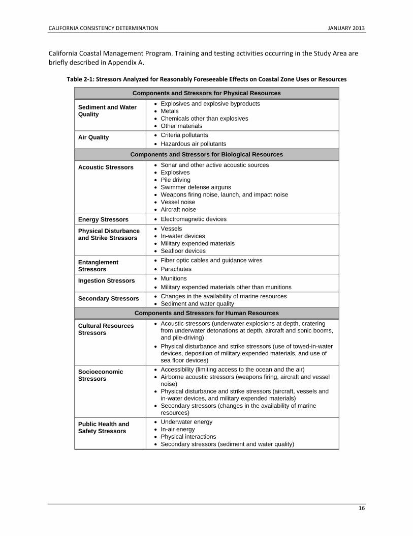
The Navy identified and evaluated aspects of its Proposed Action that could stress (i.e., stimuli that could stress or otherwise affect part of the environment) environmental resources. Table 2‐1 lists the stressors identified for analysis. The stressors indicate potential effects on physical, chemical, and biological resources that are considered coastal zone resources.
The effects test for the Proposed Action is based on the locations of training and testing activities relative to the coastal zone and the potential effects of stressors on coastal zone resources. Appendix A lists each training or testing activity under the Proposed Action, and describes the activity; identifies whether the activity occurs in the coastal zone; and identifies the annual number of activities, number of ordnance items expended per year (if any), and the training locations for the activity under both baseline (current) conditions and under the Proposed Action. The effects test checklist is provided as Appendix B. The effects test first identifies stressors associated with each training or testing activity (Table B‐1 and Table B‐2), and then identifies the stressors that could affect each resource (e.g., sediments and water quality, marine mammals, fish and socioeconomics). If a resource could be affected by a stressor, then the Proposed Action has reasonably foreseeable effects on that coastal zone resource.
The Navy has determined that the following elements of training and testing activities, which typically occur outside of the coastal zone, may affect coastal zone uses and resources: activities using sonar (e.g., anti‐submarine warfare tracking exercises and tests), activities using high‐explosive ordnance (e.g., air‐to‐surface missile exercises and tests), mine warfare activities using high explosives (e.g., mine neutralization tests), torpedo exercises and tests, and unmanned vehicle exercises and tests. Training and testing activities would typically occur in portions of the range complexes where they have historically occurred. Depending on the type of activity, the physical characteristics (e.g., water depth) of the coastal zone may make the coastal zone unsuitable for certain activities analyzed in this Consistency Determination. Because the Navy’s activities have reasonably foreseeable effects on coastal zone uses and resources, the Proposed Action has been reviewed for consistency with enforceable policies of the
CALIFORNIA CONSISTENCY DETERMINATION JANUARY 2013
16
California Coastal Management Program. Training and testing activities occurring in the Study Area are briefly described in Appendix A.
Table 2‐1: Stressors Analyzed for Reasonably Foreseeable Effects on Coastal Zone Uses or Resources
Components and Stressors for Physical Resources
Sediment and Water Quality
• Explosives and explosive byproducts • Metals • Chemicals other than explosives • Other materials
Air Quality • Criteria pollutants • Hazardous air pollutants
Components and Stressors for Biological Resources
Acoustic Stressors • Sonar and other active acoustic sources • Explosives • Pile driving • Swimmer defense airguns • Weapons firing noise, launch, and impact noise • Vessel noise • Aircraft noise
Energy Stressors • Electromagnetic devices
Physical Disturbance and Strike Stressors
• Vessels • In-water devices • Military expended materials • Seafloor devices
Entanglement Stressors
• Fiber optic cables and guidance wires • Parachutes
Ingestion Stressors • Munitions • Military expended materials other than munitions
Secondary Stressors • Changes in the availability of marine resources • Sediment and water quality
Components and Stressors for Human Resources
Cultural Resources Stressors
• Acoustic stressors (underwater explosions at depth, cratering from underwater detonations at depth, aircraft and sonic booms, and pile-driving)
• Physical disturbance and strike stressors (use of towed-in-water devices, deposition of military expended materials, and use of sea floor devices)
Socioeconomic Stressors
• Accessibility (limiting access to the ocean and the air) • Airborne acoustic stressors (weapons firing, aircraft and vessel
noise) • Physical disturbance and strike stressors (aircraft, vessels and
in-water devices, and military expended materials) • Secondary stressors (changes in the availability of marine
resources)
Public Health and Safety Stressors
• Underwater energy • In-air energy • Physical interactions • Secondary stressors (sediment and water quality)
CALIFORNIA CONSISTENCY DETERMINATION JANUARY 2013
17
3. ENFORCEABLE POLICIES OF THE CALIFORNIA COASTAL MANAGEMENT PROGRAM
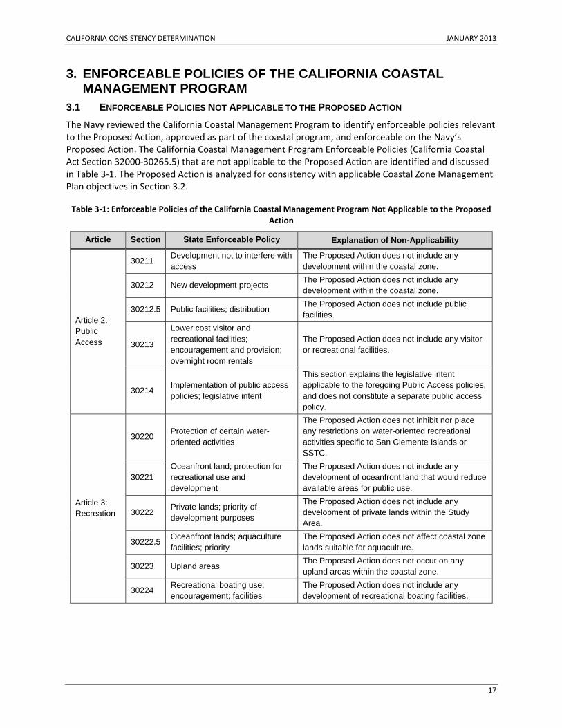
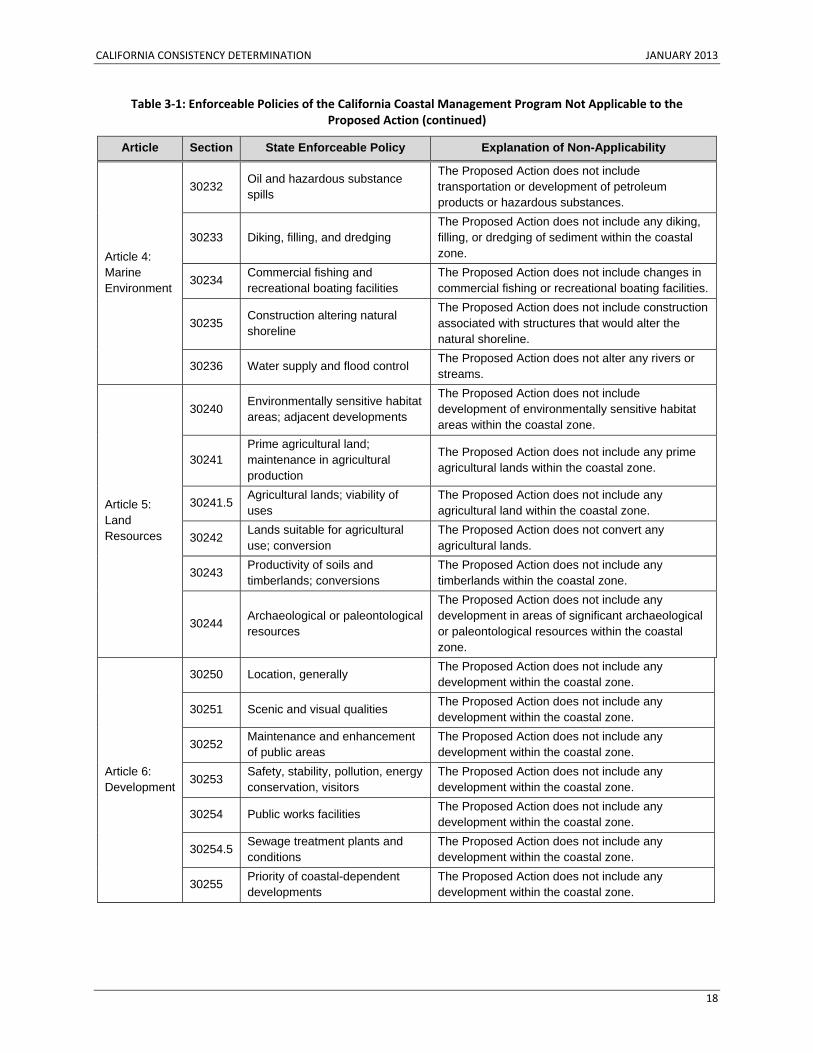
3.1 ENFORCEABLE POLICIES NOT APPLICABLE TO THE PROPOSED ACTION The Navy reviewed the California Coastal Management Program to identify enforceable policies relevant to the Proposed Action, approved as part of the coastal program, and enforceable on the Navy’s Proposed Action. The California Coastal Management Program Enforceable Policies (California Coastal Act Section 32000‐30265.5) that are not applicable to the Proposed Action are identified and discussed in Table 3‐1. The Proposed Action is analyzed for consistency with applicable Coastal Zone Management Plan objectives in Section 3.2.
Table 3‐1: Enforceable Policies of the California Coastal Management Program Not Applicable to the Proposed Action
Article Section State Enforceable Policy Explanation of Non-Applicability
Article 2: Public Access
30211 Development not to interfere with access
The Proposed Action does not include any development within the coastal zone.
30212 New development projects The Proposed Action does not include any development within the coastal zone.
30212.5 Public facilities; distribution The Proposed Action does not include public facilities.
30213
Lower cost visitor and recreational facilities; encouragement and provision; overnight room rentals
The Proposed Action does not include any visitor or recreational facilities.
30214 Implementation of public access policies; legislative intent
This section explains the legislative intent applicable to the foregoing Public Access policies, and does not constitute a separate public access policy.
Article 3: Recreation
30220 Protection of certain water-oriented activities
The Proposed Action does not inhibit nor place any restrictions on water-oriented recreational activities specific to San Clemente Islands or SSTC.
30221 Oceanfront land; protection for recreational use and development
The Proposed Action does not include any development of oceanfront land that would reduce available areas for public use.
30222 Private lands; priority of development purposes
The Proposed Action does not include any development of private lands within the Study Area.
30222.5 Oceanfront lands; aquaculture facilities; priority
The Proposed Action does not affect coastal zone lands suitable for aquaculture.
30223 Upland areas The Proposed Action does not occur on any upland areas within the coastal zone.
30224 Recreational boating use; encouragement; facilities
The Proposed Action does not include any development of recreational boating facilities.
CALIFORNIA CONSISTENCY DETERMINATION JANUARY 2013
18
Table 3‐1: Enforceable Policies of the California Coastal Management Program Not Applicable to the Proposed Action (continued)
Article Section State Enforceable Policy Explanation of Non-Applicability
Article 4: Marine Environment
30232 Oil and hazardous substance spills
The Proposed Action does not include transportation or development of petroleum products or hazardous substances.
30233 Diking, filling, and dredging The Proposed Action does not include any diking, filling, or dredging of sediment within the coastal zone.
30234 Commercial fishing and recreational boating facilities
The Proposed Action does not include changes in commercial fishing or recreational boating facilities.
30235 Construction altering natural shoreline
The Proposed Action does not include construction associated with structures that would alter the natural shoreline.
30236 Water supply and flood control The Proposed Action does not alter any rivers or streams.
Article 5: Land Resources
30240 Environmentally sensitive habitat areas; adjacent developments
The Proposed Action does not include development of environmentally sensitive habitat areas within the coastal zone.
30241 Prime agricultural land; maintenance in agricultural production
The Proposed Action does not include any prime agricultural lands within the coastal zone.
30241.5 Agricultural lands; viability of uses
The Proposed Action does not include any agricultural land within the coastal zone.
30242 Lands suitable for agricultural use; conversion
The Proposed Action does not convert any agricultural lands.
30243 Productivity of soils and timberlands; conversions
The Proposed Action does not include any timberlands within the coastal zone.
30244 Archaeological or paleontological resources
The Proposed Action does not include any development in areas of significant archaeological or paleontological resources within the coastal zone.
Article 6: Development
30250 Location, generally The Proposed Action does not include any development within the coastal zone.
30251 Scenic and visual qualities The Proposed Action does not include any development within the coastal zone.
30252 Maintenance and enhancement of public areas
The Proposed Action does not include any development within the coastal zone.
30253 Safety, stability, pollution, energy conservation, visitors
The Proposed Action does not include any development within the coastal zone.
30254 Public works facilities The Proposed Action does not include any development within the coastal zone.
30254.5 Sewage treatment plants and conditions
The Proposed Action does not include any development within the coastal zone.
30255 Priority of coastal-dependent developments
The Proposed Action does not include any development within the coastal zone.
CALIFORNIA CONSISTENCY DETERMINATION JANUARY 2013
19
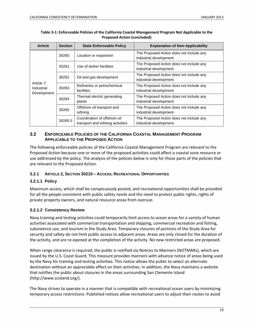
Table 3‐1: Enforceable Policies of the California Coastal Management Program Not Applicable to the Proposed Action (concluded)
Article Section State Enforceable Policy Explanation of Non-Applicability
Article 7: Industrial Development
30260 Location or expansion The Proposed Action does not include any industrial development.
30261 Use of tanker facilities The Proposed Action does not include any industrial development.
30262 Oil and gas development The Proposed Action does not include any industrial development.
30263 Refineries or petrochemical facilities
The Proposed Action does not include any industrial development.
30264 Thermal electric generating plants
The Proposed Action does not include any industrial development.
30265 Offshore oil transport and refining
The Proposed Action does not include any industrial development.
30265.5 Coordination of offshore oil transport and refining activities
The Proposed Action does not include any industrial development.
3.2 ENFORCEABLE POLICIES OF THE CALIFORNIA COASTAL MANAGEMENT PROGRAM APPLICABLE TO THE PROPOSED ACTION
The following enforceable policies of the California Coastal Management Program are relevant to the Proposed Action because one or more of the proposed activities could affect a coastal zone resource or use addressed by the policy. The analysis of the policies below is only for those parts of the policies that are relevant to the Proposed Action.
3.2.1 ARTICLE 2, SECTION 30210 – ACCESS; RECREATIONAL OPPORTUNITIES
3.2.1.1 Policy
Maximum access, which shall be conspicuously posted, and recreational opportunities shall be provided for all the people consistent with public safety needs and the need to protect public rights, rights of private property owners, and natural resource areas from overuse.
3.2.1.2 Consistency Review
Navy training and testing activities could temporarily limit access to ocean areas for a variety of human activities associated with commercial transportation and shipping, commercial recreation and fishing, subsistence use, and tourism in the Study Area. Temporary closures of portions of the Study Area for security and safety do not limit public access to adjacent areas. Areas are only closed for the duration of the activity, and are re‐opened at the completion of the activity. No new restricted areas are proposed.
When range clearance is required, the public is notified via Notices to Mariners (NOTMARs), which are issued by the U.S. Coast Guard. This measure provides mariners with advance notice of areas being used by the Navy for training and testing activities. This notice allows the public to select an alternate destination without an appreciable effect on their activities. In addition, the Navy maintains a website that notifies the public about closures in the areas surrounding San Clemente Island (http://www.scisland.org/).
The Navy strives to operate in a manner that is compatible with recreational ocean users by minimizing temporary access restrictions. Published notices allow recreational users to adjust their routes to avoid
CALIFORNIA CONSISTENCY DETERMINATION JANUARY 2013
20
temporary restricted areas. If civilian vessels are within a training or testing area at the time of a scheduled operation, Navy personnel would continue operations only where and when it is safe and possible to avoid the civilian vessels. If avoidance is not safe or possible, the Navy activity would be halted and may be relocated or delayed. In some instances where safety requires exclusive use of a specific area, nonparticipants in the area are asked to relocate to a safer area for the duration of the operation.
Accessibility, or restrictions in the availability of ocean space, would be a temporary condition. While mariners have a responsibility to be aware of conditions on the ocean, it is not expected that direct conflicts in accessibility would occur. The locations of restricted areas are published and available to mariners, who typically review such information before boating in any area. Restricted areas are typically avoided by experienced mariners. Prior to initiating a training or testing activity, the Navy would follow standard operating procedures to visually scan an area to ensure that nonparticipants are not present. If nonparticipants are present, the Navy would delay, move, or cancel its activity.
No impacts on public use or tourism within the coastal zone are anticipated because inaccessibility to areas of co‐use would be temporary and of short duration (hours). Based on the Navy’s standard operating procedures and the large expanse of the Study Area that would be available to the public, accessibility impacts would remain negligible. Thus, the Proposed Action would be consistent to the maximum extent practicable with Section 30210 of the California Coastal Act.
3.2.2 ARTICLE 4, SECTION 30230 – MARINE RESOURCES; MAINTENANCE
3.2.2.1 Policy
Marine resources shall be maintained, enhanced, and where feasible, restored. Special protection shall be given to areas and species of special biological or economic significance. Uses of the marine environment shall be carried out in a manner that will sustain the biological productivity of coastal waters and that will maintain healthy populations of all species of marine organisms adequate for long‐term commercial, recreational, scientific, and educational purposes.
3.2.2.2 Consistency Review
The Proposed Action includes activities that affect coastal resources. These activities include sonar activities, underwater detonations, temporary logistics‐over‐the‐shore training activities (i.e., pile‐driving), and amphibious landings in the coastal zone. Marine resources that could be affected by the Proposed Action include sensitive habitats (e.g., eelgrass and kelp), commercial and recreational fish stocks, and protected marine species (i.e., sea turtles, marine mammals, and abalones).
Based upon the analysis provided for each resource in this section, the Navy has determined that there are no population‐level impacts on any species of biological or economic significance as a result of the Proposed Action. Therefore, the Proposed Action is consistent to the maximum extent practicable with Section 30230 of the California Coastal Act.
3.2.2.2.1 Sea Turtles
In the Study Area, all five species of sea turtles (green [Chelonia mydas], hawksbill [Eretmochelys imbricate], loggerhead [Caretta caretta], olive ridley [Lepidochelys olivacea], and leatherback [Dermochelys coriacea] sea turtles) that may occur off Southern California are listed as endangered under ESA. No hawksbill sightings have been confirmed along the U.S. west coast in recent history (Eckert 1993; NMFS and USFWS 2007). If hawksbills are present in the Study Area, it would most likely
CALIFORNIA CONSISTENCY DETERMINATION JANUARY 2013
21
occur during an El Niño event, when waters along the California current are unusually warm (NMFS and USFWS 2007).
Sea turtles are highly migratory, and are present in coastal and open ocean waters of the Study Area. Most sea turtles prefer to live in warm waters because they are cold‐blooded reptiles. Leatherbacks are the exception, and are more likely to be found in colder waters at higher latitudes because of their unique ability to maintain an internal body temperature higher than that of the environment (Dutton 2006). Habitat use varies among species and within the life stages of individual species, correlating primarily with the distribution of preferred food sources, as well as the locations of nesting beaches.
Little information is available about a sea turtle’s stage of life after hatching. Open‐ocean juveniles spend an estimated 2 to 14 years drifting, foraging, and developing. After this period, juvenile hawksbill, olive ridley, loggerhead, and green turtles settle into coastal habitat, with individuals often remaining faithful to a specific home range until adulthood (Bjorndal and Bolten 1988; National Marine Fisheries Service and U.S. Fish and Wildlife 1991). Leatherback turtles remain primarily in the open ocean throughout their lives, except for mating in coastal waters and females going ashore to lay eggs. All species migrate long distances across large expanses of the open ocean, primarily between nesting and feeding grounds.
Stressors applicable to sea turtles under the Proposed Action include the following:
• Acoustic (sonar and other active sources, explosives, pile driving, swimmer defense airguns, vessel noise, and aircraft noise)
• Energy (electromagnetic devices) • Physical disturbance and strikes (vessels, in‐water devices, military expended materials, seafloor
devices) • Entanglement (fiber optic cables and guidance wires) • Ingestion (munitions and military expended materials other than munitions) • Secondary stressors (changes in availability of marine resources, sediment, and water quality)
Administration of ESA obligations associated with sea turtles are shared between NMFS and USFWS, depending on life stage and specific location of the sea turtle. NMFS has jurisdiction over sea turtles in the marine environment, and USFWS has jurisdiction over sea turtles on land. Because no activities analyzed in the Proposed Action occur on land, consultation with USFWS was not required for sea turtles. The Navy has determined that its activities would have no population‐level effects on sea turtles. In addition, the Navy has initiated formal consultation with NMFS on ESA‐listed sea turtles affected by the Proposed Action. Thus, with regard to sea turtles, the Proposed Action would be consistent to the maximum extent practicable with Section 30230 of the California Coastal Act.
Acoustic Stressors Navy Acoustic Effects Model For this analysis of Navy training and testing activities at sea, the Navy developed a set of software tools and compiled data for quantifying predicted acoustic impacts. These databases and tools collectively form the Navy Acoustics Effects Model. Details of the Navy Acoustics Effects Model processes and the description and derivation of the inputs are presented in the Technical Report (Determination of Acoustic Effects on Marine Mammals and Sea Turtles for Navy Training and Testing Events). The Navy Acoustics Effects Model for sea turtles follows the same approach and assumptions as for marine mammals, which is discussed later in Section 3.2.2.2.6, Marine Mammals.
CALIFORNIA CONSISTENCY DETERMINATION JANUARY 2013
22
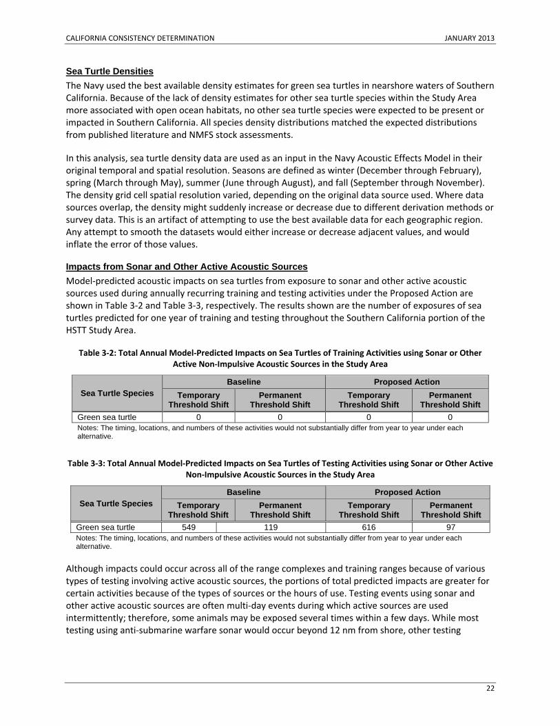
Sea Turtle Densities The Navy used the best available density estimates for green sea turtles in nearshore waters of Southern California. Because of the lack of density estimates for other sea turtle species within the Study Area more associated with open ocean habitats, no other sea turtle species were expected to be present or impacted in Southern California. All species density distributions matched the expected distributions from published literature and NMFS stock assessments.
In this analysis, sea turtle density data are used as an input in the Navy Acoustic Effects Model in their original temporal and spatial resolution. Seasons are defined as winter (December through February), spring (March through May), summer (June through August), and fall (September through November). The density grid cell spatial resolution varied, depending on the original data source used. Where data sources overlap, the density might suddenly increase or decrease due to different derivation methods or survey data. This is an artifact of attempting to use the best available data for each geographic region. Any attempt to smooth the datasets would either increase or decrease adjacent values, and would inflate the error of those values.
Impacts from Sonar and Other Active Acoustic Sources Model‐predicted acoustic impacts on sea turtles from exposure to sonar and other active acoustic sources used during annually recurring training and testing activities under the Proposed Action are shown in Table 3‐2 and Table 3‐3, respectively. The results shown are the number of exposures of sea turtles predicted for one year of training and testing throughout the Southern California portion of the HSTT Study Area.
Table 3‐2: Total Annual Model‐Predicted Impacts on Sea Turtles of Training Activities using Sonar or Other Active Non‐Impulsive Acoustic Sources in the Study Area
Sea Turtle Species Baseline Proposed Action
Temporary Threshold Shift
Permanent Threshold Shift
Temporary Threshold Shift
Permanent Threshold Shift
Green sea turtle 0 0 0 0 Notes: The timing, locations, and numbers of these activities would not substantially differ from year to year under each alternative.
Table 3‐3: Total Annual Model‐Predicted Impacts on Sea Turtles of Testing Activities using Sonar or Other Active Non‐Impulsive Acoustic Sources in the Study Area
Sea Turtle Species Baseline Proposed Action
Temporary Threshold Shift
Permanent Threshold Shift
Temporary Threshold Shift
Permanent Threshold Shift
Green sea turtle 549 119 616 97 Notes: The timing, locations, and numbers of these activities would not substantially differ from year to year under each alternative.
Although impacts could occur across all of the range complexes and training ranges because of various types of testing involving active acoustic sources, the portions of total predicted impacts are greater for certain activities because of the types of sources or the hours of use. Testing events using sonar and other active acoustic sources are often multi‐day events during which active sources are used intermittently; therefore, some animals may be exposed several times within a few days. While most testing using anti‐submarine warfare sonar would occur beyond 12 nm from shore, other testing
CALIFORNIA CONSISTENCY DETERMINATION JANUARY 2013
23
activities using active acoustic sources may occur closer to shore, specifically in nearshore SOCAL testing locations.
If a source uses a frequency within a sea turtle’s hearing range, and if the sea turtle is close enough to perceive the sound, the sea turtle may exhibit short‐term behavioral reactions, such as swimming away or diving to avoid the area around the source; or it may exhibit no reaction at all. A small number of sea turtles may experience temporary threshold shift (TTS), which could temporarily affect perception of sound within a limited frequency range. Sea turtles that reside during all or part of the year on a Navy range complex may be exposed several times throughout the year to sound from sonar and other active acoustic sources. Exposures to sonar and other active acoustic sources in open water areas would be intermittent and geographically variable. Pronounced reactions to acoustic stimuli could lead to a sea turtle expending energy and missing opportunities to forage or breed. In most cases, acoustic exposures are intermittent, which would allow time to recover from an incurred energetic cost, and would result in no long‐term consequence.
Because model‐predicted impacts are conservative and most impacts would be short‐term, potential impacts are not expected to result in substantial changes in behavior, growth, survival, annual reproductive success, lifetime reproductive success (fitness), or species recruitment. Although some individuals could experience long‐term impacts, population‐level impacts are not expected. The predicted impacts do not account for avoidance behavior at close range or for high sound levels approaching those that could cause a permanent threshold shift (PTS). Furthermore, cues preceding the event (e.g., vessel presence and movement, aircraft overflight) may cause some animals to leave the area before active sound sources begin transmitting. Avoidance behavior could reduce the sound exposure level experienced by a sea turtle, and therefore reduce the likelihood and degree of PTS and TTS predicted near sound sources. In addition, PTS and TTS threshold criteria for sea turtles are conservatively based on criteria developed for mid‐frequency marine mammals. Therefore, actual PTS and TTS impacts are expected to be substantially less than the predicted quantities.
Impacts from Explosives Table 3‐4 and Table 3‐5 present impacts of explosive detonations on sea turtles throughout the Southern California portion of the HSTT Study Area predicted by the Navy Acoustic Effects Model.
Table 3‐4: Annual Model‐Predicted Impacts of Explosions on Sea Turtles for Training Activities Under Proposed Action
Sea Turtle Species Impact
Threshold Shift GI Tract Injury
Slight Lung Injury Mortality
Temporary Permanent Green sea turtles 0 0 0 0 0
Table 3‐5: Annual Model‐Predicted Impacts of Explosions on Sea Turtles for Testing Activities Under Proposed Action
Sea Turtle Species Impact
Threshold Shift GI Tract Injury
Slight Lung Injury Mortality
Temporary Permanent Green sea turtles 0 0 0 0 0
CALIFORNIA CONSISTENCY DETERMINATION JANUARY 2013
24
As represented in Tables 3‐4 and 3‐5, the Navy predicts no impacts to green sea turtles from Navy proposed training and testing activities. Therefore, the Navy’s activities are not expected to result in substantial changes in behavior, growth, survival, annual reproductive success, lifetime reproductive success (fitness), or species recruitment. Accordingly, population‐level impacts are not expected.
Some sea turtles beyond the ranges of the above impacts may react if they hear a detonation. Events with single detonations, such as a bombing and missile exercise, are expected to elicit only short‐term startle reactions. If a sea turtle hears several detonations in a short period, such as during gunnery, firing, or sonobuoy exercises, it may react by avoiding the area. Any significant behavioral reactions could lead to a sea turtle expending energy and missing opportunities to secure resources. However, because most events would consist of a limited number of detonations and exposures would not occur over long periods, the sea turtle would have an opportunity to recover from an incurred energetic cost.
Impacts from Pile-Driving Pile‐driving activities could include impact or vibratory pile driving and vibratory pile removal, which would produce impulsive and continuous sounds underwater. This activity would involve intermittent impact pile driving of 24 inches (in.) (61 centimeters [cm]), in diameter, uncapped, steel pipe piles over approximately two weeks at a rate of approximately eight piles per day. Each pile takes about 10 minutes to drive. When training events that use the elevated causeway system are complete, the structure would be removed. The piles would be removed using vibratory methods over approximately six days. Crews can remove about 14 piles per day, each taking about six minutes to remove.
Based on the sound fields produced during the impact installation and vibratory removal, no injuries to sea turtles are predicted from sound exposures during pile‐driving and removal activities associated with Navy training. However, sea turtles may behaviorally respond to pile‐driving and removal. As part of previous consultations between the Navy and the NMFS for elevated causeway training activities, the Navy does not drive piles when sea turtles are observed within waters ensonified (an area filled with sound) by 180 dB, which is approximately 164 ft. (50 m) from the pile. To accomplish this, the Navy will continue with mitigation measures agreed to as part of previous elevated causeway training activities. These measures include the monitoring of a 150‐ft. (45.7‐m) safety buffer zone for the presence of sea turtles before, during, and after pile removal activities. If sea turtles are found in the area, pile removal activities would be halted until the sea turtles have voluntarily left the safety buffer.
The anticipated effects on sea turtles are avoidance of waters that are ensonified by the pile driving. Impacts on sea turtles on the bayside can be more precisely defined based on the temporary ensonfication of important eelgrass habitats (foraging areas for green sea turtles) within San Diego Bay during pile‐driving activities. Only a small percentage of piles would be driven within eelgrass habitat. The Bravo Lane eelgrass habitat in San Diego Bay is an area of only 17.5 acres (ac.) (0.071 km2). Furthermore, piles would be driven within a 1.13 ac. (0.005 km2)‐defined training lane within Bravo.
Given the extent of adjacent habitat and the population of turtles known to exist in adjacent habitat, effects on turtles of driving piles are expected to be temporary and local. Based on the limited occurrence (four events per year) and constrained nature of pile driving within turtle foraging areas (low intensity of the activity), the probability of impacts on turtles is low. Disturbance of sea turtles during elevated causeway system activities would include startle responses, avoidance behaviors, and removal of available eelgrass foraging habitats within San Diego Bay.
CALIFORNIA CONSISTENCY DETERMINATION JANUARY 2013
25
Impacts from Swimmer Defense Airguns Airguns are small compressed‐air devices (e.g., Sercel Mini‐G) that can introduce brief impulsive, broadband sounds into the marine environment. These sounds are probably within the audible range of most sea turtles. Sounds from airguns can cause PTS or TTS or behavioral responses. Single, small airguns would not cause direct trauma to sea turtles. Impulses from these small airguns lack the strong shock wave and rapid pressure increases of explosions that can cause primary blast injury or barotraumas. The behavioral response of sea turtles to the repeated firing of airguns has been studied for seismic survey airguns (e.g., oil and gas exploration). Sea turtles were shown to avoid higher‐level exposures or to be agitated when exposed to higher‐level sources. However, the airguns proposed for use in Navy testing are smaller, and are fired a limited number of times, so reactions would likely be lesser than those observed in studies.
Small airguns would release a limited number of impulses into waters around Navy piers in San Diego Bay. These waterways are industrial, and carry a high volume of vessel traffic in addition to Navy vessels. These areas tend to have high ambient noise levels and limited numbers of sea turtles present because of the high levels of human activity. Green sea turtles, the only species of sea turtle expected to occur in San Diego Bay, are not expected to occur around Navy piers in San Diego Bay. If sea turtles are present, they may be alerted or startled, avoid the immediate area, or not respond at all while the airgun is firing. Substantial behavioral impacts in these areas from the proposed use of the swimmer defense airgun are unlikely. Impulses from swimmer defense airguns are not predicted to cause any PTS or TTS impacts on sea turtles, and would not result in long‐term consequences to the species.
Impacts from Weapons Firing, Launch, and Impact Noise Sea turtles may be exposed to weapons firing and launch noise and sound from the impact of non‐explosive ordnance on the water’s surface. Gunfire noise would typically consist of a series of impulsive sounds. Because of the short term, transient nature of gunfire noise, animals may be exposed to multiple sounds over a short period. Launch noise would be transient and of short duration, lasting no more than a few seconds at any given location as a projectile travels. Many missiles and targets are launched from aircraft, which produces minimal noise in the water because of the altitude of the aircraft at launch. Any launch noise transmitted into the water would likely be due only to launches from vessels. Non‐explosive bombs, missiles, and targets could impact the water with great force and produce a short duration impulsive sound underwater that would depend on the size, weight, and speed of the object at impact.
Any behavioral reactions would likely be short‐term, and consist of brief startle reactions, avoidance, or diving. Any significant behavioral reactions could lead to a sea turtle expending energy and missing opportunities to secure resources. However, because most events would consist of a limited number of firings or launches and would not occur over long periods, a sea turtle would have an opportunity to recover from an incurred energetic cost. Although some individuals may be impacted by activities that include weapons firing, launch, and non‐explosive impact, population‐level impacts are not expected.
Impacts from Vessel Noise Vessel noise could disturb sea turtles, and potentially elicit an alerting, avoidance, or other behavioral reaction. Sea turtles are frequently exposed to research, ecotourism, commercial, government, and private vessel traffic. Some sea turtles may have habituated to vessel noise, and may be more likely to respond to the sight of a vessel rather than the sound of a vessel, although both may play a role in prompting reactions (Hazel et al. 2007). Any reactions are likely to be minor and short‐term avoidance reactions, leading to no long‐term consequences for the individual or population.
CALIFORNIA CONSISTENCY DETERMINATION JANUARY 2013
26
Sea turtles exposed to a passing Navy vessel may not respond at all, or they may exhibit a short‐term behavioral response such as avoidance or changing dive behavior. Short‐term reactions to vessels are not likely to disrupt major behavioral patterns or to result in serious injury to any sea turtles. Acoustic masking may result from vessel sounds, especially from non‐combatant ships. Acoustic masking may prevent an animal from perceiving biologically relevant sounds during the period of exposure, potentially resulting in missed opportunities to obtain resources. Long‐term impacts from training activities are unlikely because the density of Navy ships in the Study Area is low overall and Navy combatant vessels are designed to be quiet. Abandonment of habitat because of the Proposed Action is unlikely because of the low overall density of Navy vessels in the Study Area. No long‐term consequences for individuals or the population are expected.
Impacts from Aircraft Noise Aircraft noise could disturb sea turtles, and could elicit an alerting, avoidance, or other behavioral reaction. In most cases, exposure of a sea turtle to fixed‐wing or rotary‐wing aircraft would last for only seconds as the aircraft quickly passes overhead. Only animals at or near the surface at the time of an overflight would be exposed to appreciable sound levels. Take‐offs and landings occur at established airfields as well as on vessels at sea within the SOCAL Range Complex. Take‐offs and landings from Navy vessels could startle sea turtles; however, these events only produce in‐water noise at a given location for a brief period as the aircraft climbs to cruising altitude. Some sonic booms from aircraft could startle sea turtles, but these events are transient and happen infrequently at any given location within the SOCAL Range Complex. Repeated exposure to most individuals over short periods (days) is unlikely.
Sea turtles exposed to a passing Navy aircraft may not respond at all, or they may exhibit a short‐term behavioral response such as avoidance or changing dive behavior. Short‐term reactions to aircraft are not likely to disrupt major behavioral patterns or to result in serious injury to any sea turtles. Long‐term impacts from training activities are unlikely because the overall density of Navy aircraft in the Study Area is low. No long‐term consequences for individuals or the population are expected.
Energy Stressors Sea turtles use geomagnetic fields to navigate at sea, and therefore changes in those fields could impact their movement patterns (Lohmann and Lohmann 1996; Lohmann et al. 1997). Turtles in all life stages orient to the earth’s magnetic field to position themselves in oceanic currents; this helps them to locate seasonal feeding and breeding grounds and to return to their nesting sites. Experiments show that sea turtles can detect changes in magnetic fields, which may cause them to deviate from their original direction. For example, Lohmann and Lohmann (1996) found that loggerhead hatchlings tested in a magnetic field of 52 microteslas (a unit of measurement for magnetic field intensity) swam eastward and, when the field was decreased to 43 microteslas, the hatchlings swam westward. Sea turtles also use nonmagnetic cues for navigation and migration, and these additional cues may compensate for variations in magnetic fields.
If located in the immediate area (within about 650 ft. [198.1 m]) where electromagnetic devices are being used, sea turtles could deviate from their original movements, but the extent of this disturbance is likely to be inconsequential. The electromagnetic devices used in training activities are not expected to cause more than a short‐term behavioral disturbance to sea turtles because of the: (1) relatively low intensity of the magnetic fields generated (0.2 microtesla at 650 ft. [198.1 m] from the source), (2) very local potential impact area, and (3) temporary duration of the activities (hours). Potential impacts of exposure to electromagnetic stressors are not expected to result in substantial changes in an individual’s
CALIFORNIA CONSISTENCY DETERMINATION JANUARY 2013
27
behavior, growth, survival, annual reproductive success, lifetime reproductive success (fitness), or species recruitment, and are not expected to result in population‐level impacts.
Physical Disturbance and Strike Stressors The physical disturbance and strike stressors that may impact sea turtles include: (1) vessels, (2) in‐water devices, (3) military expended materials, and (4) seafloor devices. The way a physical disturbance may affect a sea turtle would depend in part on the relative size of the object, the speed of the object, the location of the sea turtle in the water column, and the behavioral reaction of the sea turtle.
Impacts from Vessels Vessel strikes are more likely in nearshore areas than in the open ocean portions of the SOCAL Range Complex because of the concentration of vessel movements in those areas. Any of the sea turtle species found in the SOCAL Range Complex can occur at or near the surface in open‐ocean and coastal areas, whether feeding or periodically surfacing to breathe. These species are distributed widely in all offshore portions of the Study Area. Given the concentration of Navy vessel movements near naval ports, piers and range areas, this training activity could overlap with sea turtles occupying these waters.
Under the Proposed Action, exposure to vessels used in training and testing activities could lead to injury or death if a sea turtle were struck. As demonstrated by scars on all species of sea turtles, they are not always able to avoid being struck; therefore, vessel strikes are a potential cause of mortality for these species. Although the likelihood of being struck is minimal, sea turtles that occur in an area used for Navy exercises are more likely to encounter vessels. Exposure to vessels may change an individual’s behavior, growth, survival, annual reproductive success, or lifetime reproductive success (fitness), but is not expected to result in population‐level impacts.
Impacts from In-Water Devices In‐water devices that are towed or operated at high speeds, such as remotely operated high‐speed targets and mine warfare systems, pose the greatest collision risk to sea turtles. Devices that move slowly through the water column have a very limited potential to strike a sea turtle because sea turtles in the water could avoid a slow‐moving object. Under the Proposed Action, in‐water devices used in training or testing activities may strike individual turtles, which could lead to injury or death. However, most devices move slowly through the water column and have a very limited potential to strike a sea turtle. Exposure to in‐water devices may change an individual’s behavior, growth, survival, annual reproductive success, or lifetime reproductive success (fitness), but is not expected to result in population‐level impacts.
Impacts from Military Expended Materials There is a remote possibility that an individual turtle at or near the surface may be struck by military expended material if they are in the target area at the point of physical impact. Expended munitions may strike the water surface with sufficient force to cause injury or mortality. While any species of sea turtle may move through the open ocean, most sea turtles will only surface occasionally. Sea turtles are generally at the surface for short periods, and spend most of their time submerged (Renaud and Carpenter 1994; Sasso and Witzell 2006). Furthermore, projectiles are aimed at targets, which will absorb the impact of the projectile. The probability of a strike is further reduced by Navy mitigation measures and standard operating procedures to avoid sea turtles (see Appendix C [Standard Operating Procedures, Mitigation, and Monitoring]). Exposure to military‐expended materials may change an
CALIFORNIA CONSISTENCY DETERMINATION JANUARY 2013
28
individual’s behavior, growth, survival, annual reproductive success, or lifetime reproductive success (fitness), but is not expected to result in population‐level impacts.
Impacts from Seafloor Devices Seafloor devices are placed on, dropped on, or moved along the seafloor, such as mine shapes, anchor blocks, anchors, bottom‐placed instruments, bottom‐crawling unmanned undersea vehicles, and bottom‐placed targets that are recovered (not expended). Exposure to seafloor devices used in training or testing activities could lead to injury or death if a sea turtle were struck. The potential for a sea turtle to be close to a seafloor device, and to therefore be exposed, is very low, because of the relative position of sea turtles within the water column and the wide distribution of habitats. Exposure to seafloor devices is not expected to change an individual’s behavior, growth, survival, annual reproductive success, or lifetime reproductive success (fitness), and is not expected to result in population‐level impacts.
Entanglement Stressors Impacts from Fiber Optic Cables and Guidance Wires A sea turtle that becomes entangled in nets, lines, ropes, or other foreign objects under water may suffer only a temporary hindrance to movement before it frees itself. The turtle may suffer minor injuries but recover fully, or it may die as a result of the entanglement. Based on the physical characteristics of guidance wires and fiber‐optic cables, these items pose a potential, although unlikely, entanglement risk to sea turtles. Except for a chance encounter with the guidance wire at the surface or in the water column while the fiber optic cable or guidance wire is sinking to the seafloor, a sea turtle would be vulnerable to entanglement only if its diving and feeding patterns place it in direct contact with the bottom. Bottom‐feeding sea turtles tend to forage in nearshore areas, and these wires are expended in deeper waters. The sink rates of fiber optic cables and guidance wires would rule out the possibility of them drifting great distances into nearshore and coastal areas where green, hawksbill, olive ridley, and loggerhead turtles are more likely to occur and feed on the bottom. The leatherback is more likely to co‐occur with these activities, given its preference for open ocean habitats, but this species is known to forage on jellyfish at or near the surface. Fiber optic cables and guidance wires are generally not expected to cause disturbance to sea turtles because: (1) the number of fiber optic cables and guidance wires expended is relatively low, decreasing the likelihood of encounter, (2) the physical characteristics of the fiber optic cables and guidance wires, and (3) the behavior of the species, as sea turtles are unlikely to become entangled in an object resting on the seafloor, and is not expected to result in population‐level impacts.
Impacts from Parachutes Parachutes or parachute lines may be a risk for sea turtles to become entangled, particularly while at the surface. A sea turtle would have to surface to breathe or grab prey from under the parachute, and swim into the parachute or its lines. If the parachute and its lines sink to the seafloor in an area where the bottom is calm, it would remain there undisturbed. Over time, it may become covered by sediment in most areas or colonized by attaching and encrusting organisms. If bottom currents are present, the canopy may billow and pose an entanglement threat to sea turtles that feed in benthic habitats (e.g., loggerhead sea turtles). Bottom‐feeding sea turtles tend to forage in nearshore areas rather than offshore, where most parachutes are expended. Therefore, sea turtles are not likely to encounter parachutes once they reach the seafloor. The potential for a sea turtle to encounter an expended parachute at the surface or in the water column is extremely low, and is even less probable at the seafloor, given the general improbability of a sea turtle being near the deployed parachute, as well as the general behavior of sea turtles.
CALIFORNIA CONSISTENCY DETERMINATION JANUARY 2013
29
Ingestion Stressors Green, loggerhead, olive ridley, and hawksbill turtles feed along the seafloor, and are more likely to encounter munitions and military expended materials of ingestible size that settle on the bottom than leatherbacks, which primarily feed at the surface. Furthermore, these four species typically use nearshore feeding areas, while leatherbacks are more likely to feed in the open ocean. Parachutes are not likely to be ingested because a bottom‐feeding turtle is not expected to attempt to ingest a large piece of material from the seafloor. Effects from ingestion of munitions or military expended materials used in training activities may cause short‐term or long‐term disturbance to an individual turtle because: (1) if a sea turtle were to incidentally ingest and swallow a whole item or a fragment of such materials, it could disrupt its feeding behavior or digestive processes; and (2) if the munition or military expended material is particularly large in proportion to the turtle ingesting it, the item could become permanently encapsulated by the stomach lining, with a rare chance that this could impede the turtle’s ability to feed or take in nutrients. Exposure to munitions or military expended materials may change an individual’s behavior, growth, survival, annual reproductive success, lifetime reproductive success (fitness), or species recruitment. However, munitions and other materials used in training activities are generally not expected to disturb sea turtles because: (1) sea turtles are not expected to encounter most small‐ and medium‐caliber munitions, their fragments, or other military expended materials on the seafloor because of the depth at which these items would be expended; and (2) a turtle would likely pass the item through its digestive tract and expel the item without impacting the individual. Exposure to munitions or military expended materials is not expected to result in population‐level impacts.
Secondary Stressors Stressors from Navy training and testing activities could have secondary or indirect impacts on turtles via changes in habitat, sediment, or water quality. The terms "indirect" and "secondary" do not imply reduced severity of environmental consequences, but instead describe how the stressor may impact an organism.
Impacts from Changes in Availability of Resources In addition to directly affecting sea turtles, underwater explosions could affect other species in the food web, including prey species upon which sea turtles feed. Prey might have behavioral reactions to underwater sound. For instance, prey species might exhibit a strong startle reaction to detonations that might include swimming to the surface or scattering away from the source. The abundance of prey species near the detonation point could be diminished for a short period before being repopulated by animals from adjacent waters. Many sea turtle prey items, such as jellyfish and sponges, have limited mobility and ability to react to pressure waves. Any of these scenarios would be temporary, only occurring during activities involving explosives, and no lasting effect on prey availability or the pelagic food web would be expected. The Navy avoids conducting training and testing activities in ESA‐listed coral habitats, which would minimize secondary effects on sea turtle species that rely on these habitats. Furthermore, most explosions occur at depths exceeding those that normally support seagrass beds.
Impacts from Sediment and Water Quality Degradation products of Royal Demolition Explosive are not toxic to marine organisms at realistic exposure levels (Rosen and Lotufo 2010). Relatively low solubility of most explosives and their degradation products means that concentrations of these contaminants in the marine environment are relatively low and readily diluted. Furthermore, while explosives and their degradation products were detectable in marine sediment approximately 6 to 12 in. (15.2 to 30.5 cm) from degrading ordnance, concentrations of these compounds were not statistically distinguishable from background beyond 3 to 6 ft. (0.91 to 1.83 m) from the degrading ordnance.
CALIFORNIA CONSISTENCY DETERMINATION JANUARY 2013
30
Metals are introduced into seawater and sediments by training and testing activities involving vessel hulks, targets, ordnance, munitions, and other military expended materials. Some metals bioaccumulate, and physiological impacts begin to occur only after several trophic transfers concentrate the toxic metals. Indirect impacts of metals on sea turtles via sediment and water involve concentrations several orders of magnitude lower than concentrations achieved via bioaccumulation. Sea turtles may be exposed by contact with the metal, contact with contaminants in the sediment or water, or ingestion of contaminated sediments. Concentrations of metals are orders of magnitude lower than concentrations in marine sediments. It is extremely unlikely that sea turtles would be indirectly impacted by toxic metals via water.
Polychlorinated biphenyls persist in the tissues of animals at the bottom of the food chain. Thereafter, consumers of those species tend to accumulate polychlorinated biphenyls at levels that may be many times higher than in water. In the past, polychlorinated biphenyls have been raised as an issue because they have been found in certain solid materials on vessels used as targets during vessel‐sinking exercises (e.g., insulation, wires, felts, and rubber gaskets). Currently, vessels used for sinking exercises are selected from a list of U.S. Navy‐approved vessels that have been cleaned in accordance with U.S. Environmental Protection Agency guidelines.
Properly functioning flares, missiles, rockets, and torpedoes combust most of their propellants, leaving benign or readily diluted soluble combustion by‐products (e.g., hydrogen cyanide). Operational failures allow propellants and their degradation products to be released into the marine environment. Missile and rocket fuel pose no risk of secondary impacts on sea turtles via sediment. The principal toxic components of torpedo fuel, propylene glycol dinitrate and nitrodiphenylamine, adsorb to sediments, have relatively low toxicity, and are readily degraded by biological processes. Various life stages of sea turtles could be indirectly impacted by propellants via sediment near the object (e.g., within a few inches), but potential effects would diminish rapidly as the propellant degrades.
3.2.2.2.2 Sensitive Habitats
Marine ecosystems in the Study Area depend almost entirely on the energy produced by photosynthesis of marine plants and algae (Castro and Huber 2000), which is the transformation of the sun’s energy into chemical energy. In surface waters of the open ocean and coastal waters, as well as within the portion of the water column illuminated by sunlight, marine algae and flowering plants provide oxygen, food, and habitat for many organisms (Dawes 1998). Marine vegetation along the California coast is represented by more than 700 varieties of seaweeds (such as corallines and other red algae, brown algae including kelp, and green algae), seagrasses (Leet et al. 2001; Wyllie‐Echeverria and Ackerman 2003), and canopy‐forming kelp species (Wilson 2002). In the Study Area, the two most productive and sensitive habitats are canopy‐forming kelp and eelgrass.
Kelp is the most conspicuous brown algae occurring extensively along the coast in the Study Area. Six species of canopy‐forming kelp occur in the coastal waters of the California coast: the giant kelp (Macrocystis pyrifera), bull kelp (Nereocystis luetkeana), elk horn kelp (Pelagophycus porra), feather boa kelp (Egregia menziesii), chain bladder kelp (Stephanocystis osmundacea), and winged kelp (Alaria marginata) (Dayton 1985). Kelp is managed by the California Department of Fish and Game, which issues exclusive leases to harvest designated beds for up to 20 years.
In the Study Area, eelgrass and surfgrass are the dominant native seagrasses (Wyllie‐Echeverria and Ackerman 2003). They provide suitable nursery habitat for commercially important organisms (e.g., crustaceans, fish, and shellfish) and also are a food source for numerous species (e.g., turtles) (Heck et
CALIFORNIA CONSISTENCY DETERMINATION JANUARY 2013
31
al. 2003; National Oceanic and Atmospheric Administration 2001). Seagrass beds also combat coastal erosion, promote nutrient cycling through the breakdown of detritus, and improve water quality (Dawes 1998). Potential effects on eelgrass in the Study Area are limited to bayside areas and a portion of the oceanside training lanes of SSTC.
The stressors on sensitive habitats vary in intensity, frequency, duration, and location within the Study Area. Based on general threats to marine vegetation, the applicable stressors on sensitive habitats from the Proposed Action are:
• Acoustic (explosives) • Physical disturbance and strikes (vessels, in‐water devices, military expended materials, seafloor
devices) • Secondary stressors (sediment and water quality)
The Proposed Action, with regard to sensitive habitats, would be consistent to the maximum extent practicable with Section 30230 of the California Coastal Act.
Acoustic Stressors Underwater and surface explosions from training and testing activities under the Proposed Action could physically damage marine vegetation in the Study Area. The potential for an explosion to injure or destroy marine vegetation would depend on the amount of vegetation present, the number of munitions used, and the net explosive weight of munitions. In locations where marine vegetation and explosions could overlap, vegetation on the surface of the water, in the water column, or rooted in the seafloor may be affected. Underwater explosions also may temporarily increase the turbidity of nearby waters, incrementally reducing the amount of light available to marine vegetation.
Under the Proposed Action, training and testing activities that use explosives do not generally occur near shorelines, bays, rivers, or estuaries. In addition, the majority of underwater explosions in the Study Area would likely occur over unvegetated seafloor because it is the predominant bottom‐type in the areas proposed for these activities. Eelgrass and other seagrasses found in portions of SSTC bayside occur in areas used for simulated explosives training. No testing activities involving underwater explosives would occur within the SSTC training areas.
Underwater and surface explosions conducted for training activities are not expected to cause any risk to kelp beds, eelgrass, or other marine vegetation because: (1) the relative coverage of marine algae and eelgrass is low, (2) the impact area of underwater explosions is very small relative to kelp beds and eelgrass distribution, and (3) seagrass does not occur in areas where the stressor occurs. Based on these factors, surface and underwater explosions are not expected to result in detectable changes in marine vegetation growth, survival, or propagation, and are not expected to result in population‐level impacts.
Physical Disturbance and Strike Stressors The types of physical stressors that could affect marine vegetation include: vessels, in‐water devices, military expended materials; and seafloor devices. The evaluation of effects of physical strike and disturbance stressors on marine vegetation focuses on elements of the Proposed Action that could cause damage to vegetation by an object that is moving through the water (e.g., vessels and in‐water devices), dropped into the water (e.g., military expended materials), or deployed on the seafloor (e.g., mine shapes, targets, and anchors).
CALIFORNIA CONSISTENCY DETERMINATION JANUARY 2013
32
Impacts from Vessels and In-Water Devices The potential impacts on marine vegetation of Navy vessels and in‐water devices used during training and testing activities are based on the vertical distribution of the vegetation. Vessels may impact vegetation by striking or disturbing vegetation on the sea surface or seafloor. Vegetation on the seafloor such as seagrasses and macroalgae may be disturbed by amphibious combat vehicles. Seagrasses are resilient to the lower levels of wave action that occur in sheltered estuarine shorelines, but are susceptible to vessel propeller scarring. Seafloor macroalgae may be present in locations where these vessels and in‐water devices occur, but the impacts would be minimal because of their resilience, distribution, and biomass.
Unlike most vessels used in offshore training activities that occur in deep water, amphibious vehicles are designed to move personnel and equipment from ship to shore in shallow water. In San Diego Bay, eelgrass beds are avoided to the maximum possible extent. Eelgrass bed damage is not likely but, if it occurs, the impacts would be minor, such as short‐term turbidity increases. Within SSTC, shallow‐water vessel movements in defined boat lanes would continue to occur with minimal impacts on marine vegetation because these boat lanes overlie cobble and bare substrates. The net impact of vessel, in‐water device, and towed in‐water device physical disturbances and strikes on marine vegetation during testing activities is expected to be negligible under the Proposed Action because of: (1) Navy protective measures; (2) the quick recovery of most vegetation types; (3) the short‐term nature of most vessel movements and local disturbances of the surface water, with some temporary increase in suspended sediment in shallow areas; and (4) the deployment of in‐water devices at depths where they would not likely come in contact with marine vegetation.
Impacts from Military Expended Materials Most types of expendable military training materials are deposited in the open ocean, and effects on kelp beds or eelgrass would be limited to nearshore activities. In the coastal zone, only projectiles (small and medium), target fragments, and countermeasures could be deposited in areas where shallow water vegetation such as seagrass and seafloor macroalgae could be impacted. The footprints of expended projectiles would be very small, and would not affect intertidal vegetation. Military expended materials used for training activities are not expected to affect marine algae or seagrass because: (1) the impact area of military expended materials is very small relative to marine algae distribution, and (2) macroalgae and seagrass overlap with areas where the stressor occurs is very limited. Based on these factors, military expended materials are not expected to result in detectable changes in the growth, survival, or propagation of marine algae and seagrass, and are not expected to have population‐level impacts.
Impacts from Seafloor Devices Seafloor device operation, installation, or removal could impact seagrass by physically removing vegetation (e.g., uprooting), crushing, temporarily increasing the turbidity (sediment suspended in the water) of waters nearby, or shading seagrass which may interfere with photosynthesis. For seafloor devices, the potential for overlap with seagrass in the Study Area is limited to elevated causeway system and causeway pier insertion and retraction activities and offshore petroleum discharge system training activities (which use sea water rather than petroleum products during training activities). The bayside Bravo training area contains an estimated 1.13 ac. (0.46 hectares) of eelgrass habitats; however, the designated Bravo Beach training lane is a previously disturbed and previously used zone within San Diego Bay. The Navy participates in mitigation programs for eelgrass restoration because of the disturbance in Bravo Beach training lane (U.S. Department of the Navy 2011).
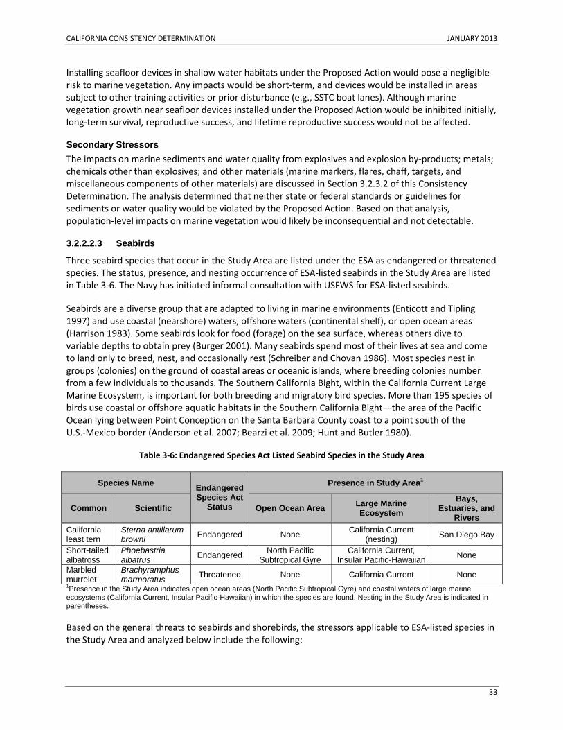
CALIFORNIA CONSISTENCY DETERMINATION JANUARY 2013
33
Installing seafloor devices in shallow water habitats under the Proposed Action would pose a negligible risk to marine vegetation. Any impacts would be short‐term, and devices would be installed in areas subject to other training activities or prior disturbance (e.g., SSTC boat lanes). Although marine vegetation growth near seafloor devices installed under the Proposed Action would be inhibited initially, long‐term survival, reproductive success, and lifetime reproductive success would not be affected.
Secondary Stressors The impacts on marine sediments and water quality from explosives and explosion by‐products; metals; chemicals other than explosives; and other materials (marine markers, flares, chaff, targets, and miscellaneous components of other materials) are discussed in Section 3.2.3.2 of this Consistency Determination. The analysis determined that neither state or federal standards or guidelines for sediments or water quality would be violated by the Proposed Action. Based on that analysis, population‐level impacts on marine vegetation would likely be inconsequential and not detectable.
3.2.2.2.3 Seabirds
Three seabird species that occur in the Study Area are listed under the ESA as endangered or threatened species. The status, presence, and nesting occurrence of ESA‐listed seabirds in the Study Area are listed in Table 3‐6. The Navy has initiated informal consultation with USFWS for ESA‐listed seabirds.
Seabirds are a diverse group that are adapted to living in marine environments (Enticott and Tipling 1997) and use coastal (nearshore) waters, offshore waters (continental shelf), or open ocean areas (Harrison 1983). Some seabirds look for food (forage) on the sea surface, whereas others dive to variable depths to obtain prey (Burger 2001). Many seabirds spend most of their lives at sea and come to land only to breed, nest, and occasionally rest (Schreiber and Chovan 1986). Most species nest in groups (colonies) on the ground of coastal areas or oceanic islands, where breeding colonies number from a few individuals to thousands. The Southern California Bight, within the California Current Large Marine Ecosystem, is important for both breeding and migratory bird species. More than 195 species of birds use coastal or offshore aquatic habitats in the Southern California Bight—the area of the Pacific Ocean lying between Point Conception on the Santa Barbara County coast to a point south of the U.S.‐Mexico border (Anderson et al. 2007; Bearzi et al. 2009; Hunt and Butler 1980).
Table 3‐6: Endangered Species Act Listed Seabird Species in the Study Area
Species Name Endangered Species Act
Status
Presence in Study Area1
Common Scientific Open Ocean Area Large Marine Ecosystem
Bays, Estuaries, and
Rivers California least tern
Sterna antillarum browni Endangered None California Current
(nesting) San Diego Bay
Short-tailed albatross
Phoebastria albatrus Endangered North Pacific
Subtropical Gyre California Current,
Insular Pacific-Hawaiian None
Marbled murrelet
Brachyramphus marmoratus Threatened None California Current None
1Presence in the Study Area indicates open ocean areas (North Pacific Subtropical Gyre) and coastal waters of large marine ecosystems (California Current, Insular Pacific-Hawaiian) in which the species are found. Nesting in the Study Area is indicated in parentheses.
Based on the general threats to seabirds and shorebirds, the stressors applicable to ESA‐listed species in the Study Area and analyzed below include the following:
CALIFORNIA CONSISTENCY DETERMINATION JANUARY 2013
34
• Acoustic stressors (sonar and other active acoustic sources, explosives, pile driving, vessel noise, and aircraft noise)
• Energy stressors (electromagnetic devices)
• Physical disturbance and strike (aircraft, vessels, in‐water devices, military expended materials)
• Ingestion (military expended materials other than munitions)
• Secondary stressors (air quality, water quality)
With regard to ESA‐listed seabirds, the Proposed Action would be consistent to the maximum extent practicable with Section 30230 of the California Coastal Act.
Acoustic Stressors Impacts from Sonar and Other Active Acoustic Sources Sonar and other underwater active acoustic sources could be used throughout the Study Area. Information about the impacts of sonar on seabirds and the ability of seabirds to hear underwater is virtually unknown. The exposure of seabirds to these sounds, other than pursuit diving species, is likely to be very limited because they spend a very short period under water (plunge‐diving or surface‐dipping) or forage only at the water surface. Pursuit divers may remain under water for minutes, increasing the potential for underwater sound exposure.
Seabirds that approach vessels while foraging would most likely be exposed to underwater active acoustic sources. If the presence of a ship attracts diving seabirds, the seabirds could be more likely to be exposed to an underwater sound if the ship is engaged in anti‐submarine warfare or mine warfare with active acoustic sources. However, most hull‐mounted sonar do not project sound behind the ship, opposite the direction of travel, so most seabirds diving in ship wakes would not be exposed to sonar. The potential for an ESA‐listed seabird species to be exposed to sonar and other active acoustic sources depends on whether it submerges during foraging and whether it forages in areas where these sound sources may be used. Although albatrosses forage in open ocean areas where sonar training and testing occurs, they would not be exposed to underwater sound because they forage at the surface. Least terns forage in coastal shallow waters where they could be exposed to sonar and other active acoustic sources, notably near ports and shipyards where sonar maintenance and testing occur. However, their plunge dives are brief, so the potential for exposure would be minimal. Most other sonar use occurs farther offshore, however, so the potential for an exposure would be low.
Short‐tailed albatrosses do not submerge while foraging, so they would not be exposed to underwater sound from sonar or other active acoustic sources. Least terns and marbled murrelet may briefly submerge while foraging, either during plunge‐diving (least terns) or pursuit diving (marbled murrelet), so these species could be exposed to underwater sound sonar and other active acoustic sources.
Impacts from Explosives A seabird close to an explosive detonation could be killed or injured. Blast injuries are usually most evident in the gas‐containing organs, such as those of the respiratory and gastrointestinal systems. Blasts can also damage pressure‐sensitive components of the auditory system. In general, the impacts of explosions would decline with increasing distance of the seabird from the explosion, and would range from lethal injury in the immediate vicinity of an explosion to short‐term behavioral impacts on the outer edges of the zone of influence.
CALIFORNIA CONSISTENCY DETERMINATION JANUARY 2013
35
Underwater detonations could affect diving seabirds and seabirds on the water surface. Studies show that birds are more susceptible to underwater explosions when they are submerged versus on the surface (Yelverton et al. 1973). Underwater detonations could have lethal impacts on seabirds in water if an impulse exceeds 36 pounds per square inch (in.2) (psi)– milliseconds (msec) (psi‐msec) (248 Pascal [Pa]‐second [sec]) for birds underwater or 100 psi‐msec (690 Pa‐sec) just below the water surface for birds at the water surface (Yelverton et al. 1973). These impulse levels correspond to onset mortality, or the level at which one percent of animals would not be expected to survive. Exposures to higher impulse levels would have greater likelihoods of mortality.
ESA‐listed seabirds are known to be present in areas where detonations would occur during training under the Proposed Action. While the available information on seabird distribution limits the Navy’s ability to quantify the impacts of explosions, the likelihood of an injurious exposure seems remote based on the very low density of seabirds. An exposure resulting in a short‐term behavioral response would be more likely to occur than an exposure that causes injury. Least terns could startle in the vicinity of explosive detonations from training at SSTC as they forage in areas where detonations occur. However, the explosives packages used in these foraging areas are restricted to less than 20 pounds net explosive weight. If a detonation occurred near least terns, impacts would likely be limited to short‐term startle reactions because the zones of impact around these smaller detonations are minimal. Protective measures, such as restricting underwater explosions if flocks of seabirds are rafting on the water’s surface inside a training area or if flocks of seabirds are migrating directly above the proposed activity site, minimize impacts on seabirds. Furthermore, the detonation area is monitored for 30 minutes prior to and 30 minutes after a detonation and successive detonations must be more than 30 minutes or less than 10 seconds apart, which further reduces the potential impact upon seabirds (see Appendix C, Standard Operating Procedures, Mitigation, and Monitoring).
Impacts from Pile Driving Noise from pile driving close to shore could have a short‐term adverse impact on nesting and nearshore foraging species. However, human activity such as vessel or boat movement, and equipment setting and movement, could cause seabirds to flee the activity area before the onset of pile driving. In‐air pile driving noise could elicit short‐term behavioral or physiological responses, but is not likely to disrupt major behavior patterns, such as migrating, breeding, feeding, or sheltering, or to seriously injure any seabirds.
One ESA‐listed seabird, the California least tern, is known to be present in areas where pile driving would occur during training under the Proposed Action. California least terns could be exposed to intermittent pile driving noise during the approximate two‐week period of each elevated causeway event. During the elevated causeway activity, however, any impact based on displacement from the activity area would be minimized due to the availability of suitable foraging habitat in adjacent boat training lanes at SSTC. Furthermore, an exposure resulting in a short‐term behavioral response would only be expected if the seabirds did not leave the area prior to the start of the elevated causeway activity. Repeated exposure of individual seabirds is unlikely based on the seabird’s capability to avoid or rapidly vacate an area of disturbance and availability of non‐impacted foraging habitats.
Impacts from Vessel Noise Harmful seabird and vessel interactions are commonly associated with commercial fishing vessels because birds are attracted to concentrated food sources around these vessels (Melvin et al. 1999; Dietrich and Melvin 2004). The concentrated food sources that attract seabirds to commercial fishing vessels are not present around Navy vessels. Although loud sudden noises can startle and flush birds,
CALIFORNIA CONSISTENCY DETERMINATION JANUARY 2013
36
Navy vessels are not expected to result in major acoustic disturbance of seabirds in the Study Area. Noises from Navy vessels are similar to or less than those of the general maritime environment. Birds respond to the physical presence of a vessel, regardless of the associated noise. Noise from Navy vessels has a very low potential to impact seabirds and would not have a major impact on seabird populations; therefore, this issue is not addressed further in the analysis of impacts on this resource.
Impacts from Aircraft Noise Seabirds would be exposed to fixed‐wing aircraft noise briefly (seconds) as an aircraft quickly passes overhead. Exposures would be infrequent based on the transitory and dispersed nature of the overflights; repeated exposures of individual seabirds over a short period (hours or days) are unlikely. If seabirds were to respond to an overflight, the responses would be limited to short‐term behavioral or physiological reactions (e.g., alert response, startle response, temporary increase in heart rate), and the general health of individual seabirds would not be compromised. Birds repeatedly exposed to aircraft noise often become habituated to the noise and do not respond behaviorally (National Park Service 1994; Larkin et al. 1996; Plumpton 2006).
Seabirds foraging or migrating through a training area in the open ocean may respond by avoiding areas of concentrated aircraft noise. Exposures of seabirds would be infrequent, based on the brief duration and dispersed nature of the overflights. Repeated exposures of individual seabirds over hours or days are unlikely. Startle or alert reactions to aircraft are not likely to disrupt major behavior patterns, such as migrating, breeding, feeding, or sheltering, or to seriously injure any seabirds. While behavioral or physiological impacts of airborne activity on individual seabirds may occur, none of these impacts are long‐lasting, and none are expected to adversely impact seabirds at the population level.
California least terns could be exposed to intermittent noise from aircraft operating from airfields located along the coast. If present in the open water areas where training activities involving aircraft overflights occur, short‐tailed albatross and marbled murrelet could be temporarily disturbed while foraging or migrating. Short‐term behavioral responses such as startle responses, head turning, or flight responses would be expected. Repeated exposures would be limited due to the transient nature of aircraft use and regular movement of seabirds. No long‐term or population‐level impacts are expected.
Energy Stressors Possible effects of electromagnetic fields on birds include behavioral responses such as temporary disorientation and change in flight direction (Larkin and Sutherland 1977, Wiltschko and Wiltschko 2005). Many bird species return to the same stopover, wintering, and breeding areas every year and often follow the same or very similar migration routes (Åkesson 2003). However, ample evidence exists that displaced birds can successfully reorient and find their way when one or more cues are removed (Haftorn et al. 1988; Åkesson 2003).
Birds that forage inshore could be exposed to these electromagnetic stressors because their habitat overlaps with some of the activities that occur in the nearshore portions of SOCAL Range Complex and SSTC. However, the electromagnetic fields generated would be distributed over time and location, and any influence on the surrounding environment would be temporary and local. More importantly, the electromagnetic devices used are typically towed by a helicopter, and any seabirds near the approaching helicopter likely would be dispersed by the sound and disturbance generated by the helicopter before any exposure could occur.
CALIFORNIA CONSISTENCY DETERMINATION JANUARY 2013
37
California least terns could be exposed to intermittent electromagnetic stressors in nearshore areas where training activities occur. If present in the open water areas where training activities involving electromagnetic stressors occur, short‐tailed albatross and marbled murrelet could be temporarily disturbed while foraging or migrating. Impacts on seabirds of potential exposure to electromagnetic fields would be temporary and inconsequential based on: (1) relatively low intensity of the magnetic fields generated, (2) very localized potential impact area, (3) temporary duration of the activities (hours), and (4) occurring only underwater. No long‐term or population‐level impacts are expected.
Physical Disturbance and Strike Stressors Impacts from Aircraft and Aerial Targets This section describes the potential impacts on seabirds from aircraft and aerial target strikes, vessels (disturbance and strike), and military expended material strikes. Aircraft include fixed‐wing and rotary‐wing aircraft; vessels include various sizes and classes of ships, submarines, and other boats, towed devices, unmanned surface vehicles, and unmanned underwater vehicles; and military expended materials include non‐explosive practice munitions, target fragments, parachutes, and other objects.
While bird strikes can occur wherever aircraft are operated, Navy data indicate that they occur most often over land or close to shore. The majority of birds fly below 3,000 ft. (914.4 m) and approximately 95 percent of migrating birds fly below 10,000 ft. (3,048 m) (U.S. Geological Survey 2006). Aircraft are more likely to encounter birds during aircraft takeoffs and landings than when the aircraft is engaged in level low‐altitude flight. Bird exposure to strike potential would be relatively brief as an aircraft quickly passes. Birds actively avoid interaction with aircraft; however, disturbances or strike of various bird species may occur from aircraft on a site‐specific basis. As a standard operating procedure, aircraft avoid large flocks of birds to minimize the personnel safety risk involved with a potential bird strike. Some seabird and aircraft strikes and associated seabird mortalities or injuries could occur in the Study Area under the Proposed Action; however, no increased risk of impacts on seabird populations would result from aircraft strikes. No long‐term or population‐level impacts are expected.
Impacts from Vessels Vessel movements could result in short‐term behavioral responses and low potential for injury or mortality from collisions, although because of the lower density of Navy vessels in pelagic waters, the generally intermittent and short duration of activities, and the high mobility of seabirds, the probability of seabird and vessel interaction is low. Birds would not be exposed to unmanned underwater vehicles or remotely operated vehicles because they are typically used on or near the seafloor. Other in‐water devices are typically towed by a helicopter. Most likely, any seabirds near an approaching helicopter would be dispersed by the sound of the helicopter and move away from the in‐water device before any exposure could occur.
Amphibious landings are the primary activity that could impact the California least tern. California least terns rest on the beaches of SSTC and typically forage in the waters near the beach. While they could be present, it is highly unlikely that a California least tern would be struck in this scenario because foraging or resting seabirds near an approaching amphibious vessel would likely be dispersed by the sound of the approaching vessel before it could come close enough to strike a seabird. Therefore, amphibious assaults would not pose a risk to California least terns in the Study Area. Furthermore, Naval Base Coronado’s Integrated Natural Resource Management Plan addresses ESA‐listed seabird species; the plan already includes project actions that avoid or minimize threats of military activities to terns.
CALIFORNIA CONSISTENCY DETERMINATION JANUARY 2013
38
Impacts from Military Expended Materials The potential impact of military expended material on seabirds in the Study Area depends on the ability of seabirds to detect and avoid foreign objects through their visual and auditory sensory systems and the relatively fast flying speeds and good maneuverability of most seabird species. The small number of bombs that would be expended in the Study Area annually, coupled with the often patchy distribution of seabirds, suggests that the probability of this type of strike on a seabird would be extremely low. The number of small‐caliber projectiles that would be expended annually during gunnery exercises is much higher. However, the total number of rounds expended is not a good indicator of strike probability during gunnery exercises because multiple rounds are fired at individual targets. Given the implementation of protective measures and the lower density of seabirds away from nesting or roosting areas, military expended materials dropped from aircraft under the Proposed Action would have a limited potential to affect seabirds.
Direct strikes from firing weapons or air‐launched devices (e.g. sonobouys, torpedoes) are a potential stressor to seabirds. Seabirds in flight, resting on the water’s surface, or foraging just below the water surface would be vulnerable to a direct strike. Strikes could injure or kill seabirds in the Study Area. However, there would not be long‐term population level impacts. The vast area over which training activities occur, combined with the ability of seabirds to flee disturbance, would make direct strikes unlikely. Individual seabirds may be affected, but strikes would have no impact on species or populations.
Ingestion Stressors Ordnance materials sink to the seafloor, and would not present an ingestion risk to seabirds. Seabirds could be exposed to materials such as chaff fibers, however, in the air or at the sea surface through direct contact or inhalation. Seabirds could also ingest some types of expended materials if the materials float on the sea surface. Other expended materials that could be ingested by seabirds include small plastic end caps and pistons associated with chaff and self‐protection flares. The concentration of military expended material in the Study Area is low and seabirds are patchily distributed (Schneider and Duffy 1985; Haney 1986; Fauchald et al. 2002). The overall likelihood that seabirds would be impacted by ingestion of military expended material under the Proposed Action is negligible.
Secondary Stressors The impacts on marine sediments and water quality from explosives and explosion by‐products; metals; chemicals other than explosives; and other materials (marine markers, flares, chaff, targets, and miscellaneous components of other materials) are discussed in Section 3.2.3.2 of this Consistency Determination. Indirect impacts on water or air quality under the Proposed Action would not affect ESA‐listed seabird species due to: (1) the temporary nature of impacts on water or air quality, (2) the distribution of temporary water or air quality impacts, (3) the wide distribution of seabirds in the Study Area, and (4) the dispersed spatial and temporal nature of the training and testing activities that may have temporary water or air quality impacts. No long‐term or population‐level impacts are expected.
3.2.2.2.4 Commercial and Recreational Fish Stocks
The Study Area is in a region of highly productive fisheries (Leet et al. 2001) within the California Current Large Marine Ecosystem. The portion of the California Bight in the Study Area is a transitional zone between cold and warm water masses, geographically separated by Point Conception. The California Bight is the coastal area south of Point Conception to the border with Mexico, and includes much of the Study Area. The cold‐water California Current Large Marine Ecosystem is rich in microscopic plankton (diatoms, krill, and other organisms), which form the base of the food chain in the
CALIFORNIA CONSISTENCY DETERMINATION JANUARY 2013
39
Study Area. Small coastal pelagic fishes depend on this plankton and, in turn, are fed on by larger species (such as highly migratory species).
Approximately 480 species of marine fish inhabit the southern California Bight, and numerous fish species use spawning, nursery, feeding, and seasonal grounds in nearshore, inshore (including bays and estuaries), and offshore waters of southern California (Cross and Allen 1993). The high fish diversity found in the Study Area occurs for several reasons: (1) the ranges of many temperate and tropical species extend into Southern California; (2) the area has complex bottom features and physical oceanographic features that include several water masses and a changeable marine climate (Allen et al. 2006; Horn and Allen 1978); and (3) the islands and coastal areas provide a diversity of habitats that include soft bottom, rocky reefs, kelp beds, and estuaries, bays, and lagoons.
Only one marine fish in the Study Area, steelhead trout (Oncorhynchus mykiss), is listed as endangered under the ESA. Steelhead trout are an anadromous form of rainbow trout, and are federally protected by the designation of distinct population segments, which are defined as populations or groups of populations that are discrete or separate from other populations of the same species and which are equivalent to evolutionarily significant units. NMFS listed the Southern California distinct population segment of steelhead as endangered in 1997 (National Marine Fisheries Service 1997). Critical habitat for 10 west coast steelhead distinct population segments has been designated, and the Southern California critical habitat includes the estuarine and freshwater habitat of San Juan Creek, Trabuco Creek, and San Mateo Creek.
The analysis of stressors from training and testing activities considers these components within the context of geographic location and overlap of marine fish resources. The stressors applicable to marine fish in the Study Area and analyzed below include the following:
• Acoustic (sonar and other active acoustic sources, explosives, pile‐driving, swimmer defense airguns, weapons firing, launch, and impact noise, vessel noise, and aircraft noise)
• Energy (electromagnetic devices)
• Physical disturbance and strikes (vessels, in‐water devices, military expended materials, and seafloor devices)
• Entanglement (fiber optic cables and guidance wires, and parachutes)
• Ingestion (munitions and military expended materials other than munitions)
• Secondary stressors (changes in availability of resources, sediment and water quality)
The Proposed Action, with regard to commercial and recreational fish stock, would be consistent to the maximum extent practicable with Section 30230 of the California Coastal Act.
Acoustic Stressors Impacts from Sonar and Other Active Acoustic Sources Non‐impulsive sources from the Proposed Action include sonar and other active acoustic sources, vessel noise, and subsonic aircraft noise. Potential acoustic effects of non‐impulsive sources on fish may be considered in four categories: (1) direct injury; (2) hearing loss; (3) auditory masking; and (4) physiological stress and behavioral reactions. Direct injury to fish from exposure to non‐impulsive sounds is highly unlikely to occur, and exposure to transient, non‐impulsive sources is unlikely to result in any hearing loss. Therefore, direct injury and hearing loss from exposure to non‐impulsive sound sources are not discussed further in this analysis.
CALIFORNIA CONSISTENCY DETERMINATION JANUARY 2013
40
The majority of fish species exposed to non‐impulsive sources would likely have no reaction or mild behavioral reactions. Overall, long‐term consequences for individual fish are unlikely in most cases because acoustic exposures are intermittent and unlikely to repeat over short periods. Since long‐term consequences for most individuals are unlikely, long‐term consequences for populations are not expected. The primary exposure to vessel and aircraft noise would occur around the Navy ranges, ports, and air bases. Vessel and aircraft overflight noise could expose steelhead trout to sound and general disturbance, potentially resulting in short‐term behavioral responses.
Steelhead trout could be exposed to non‐impulsive sound associated with training activities in the coastal areas of the SOCAL Range Complex and SSTC. Steelhead trout, which are anatomically similar to Atlantic salmon, are believed to be unable to detect the sounds produced by mid‐ or high‐frequency sonar or other active acoustic sources. Therefore acoustic impacts from these sources are not expected. Low‐frequency active sonar and other active acoustic sources are not typically operated in coastal or nearshore waters. If low frequency sources are used in coastal waters, then adult steelhead trout could be exposed to sound within their hearing range within these areas. If this did occur, steelhead trout could experience behavioral reactions, physiological stress, and auditory masking, although these impacts would be expected to be short‐term and infrequent based on the low probability of co‐occurrence between the activity and species. Long‐term consequences for the populations would not be expected.
Impacts from Explosives, Pile Driving, Swimmer Defense Airguns, and Weapons Firing, Launch, and Impact Noise Impulsive underwater sound sources include underwater detonations, above‐water explosions of explosive ordnance, swimmer defense airguns, pile driving, and noise from weapons firing, launches, or impacts with the water’s surface. Potential acoustic effects of impulsive sound sources on fish may be considered in four categories: (1) direct injury; (2) hearing loss; (3) auditory masking; and (4) physiological stress and behavioral reactions.
Potential impacts of explosions and impulsive sound sources on fish can range from no effect, brief acoustic effects, tactile perception, or physical discomfort, to slight injury to internal organs and the auditory system, to death of the animal (Keevin and Hempen 1997). Occasional behavioral reactions to intermittent explosions and impulsive sound sources are unlikely to cause long‐term consequences for individual fish or populations. Animals that experience hearing loss (PTS or TTS) from exposure to explosions or impulsive sound sources may have a reduced ability to detect relevant sounds such as predators, prey, or social vocalizations. It is uncertain whether some permanent hearing loss over a part of a fish’s hearing range would have long‐term consequences for that individual. If this did affect the fitness of a few individuals, it is unlikely to have long‐term consequences for the population. It is possible for fish to be injured or killed by an explosion; however, long‐term consequences for a loss of a few individuals is unlikely to have measureable effects on overall stocks or populations. Therefore, long‐term consequences to fish populations would not be expected.
Steelhead trout could be exposed to explosive energy and sound from training activities under the Proposed Action in the coastal areas of the SOCAL Range Complex and SSTC. Since steelhead trout spawn in rivers and the early life stages of the fish occur in riverine and estuarine environments, eggs and larvae would not be exposed to impulsive sound sources. Training activities involving impulsive sound sources in the SOCAL Range Complex and SSTC could impact steelhead trout, potentially resulting in short‐term behavioral or physiological responses, hearing loss, injury, or mortality. However, given the infrequent nature of training activities involving impulsive sound sources in the SOCAL Range Complex and SSTC and the rarity of the species, the likelihood of steelhead trout encountering an
CALIFORNIA CONSISTENCY DETERMINATION JANUARY 2013
41
explosive activity taking place anywhere within the range complex is remote. Impacts on designated steelhead trout critical habitat would not occur as activities do not overlap.
Energy Stressors Several different electromagnetic devices are used during training and testing activities. Many fish groups, including lamprey, elasmobranchs, eels, salmonids, stargazers, and others, have an acute sensitivity to electrical fields, known as electroreception (Bullock et al. 1983; Helfman et al. 2009). Electroreceptors are thought to aid in navigation, orientation, and migration of sharks and rays (Kalmijn 2000). In elasmobranchs, behavioral and physiological response to electromagnetic stimulus varies by species and age, and appears to be related to foraging behavior (Rigg et al. 2009). The distribution of electroreceptors on the head of these fishes, especially around the mouth, suggests that these sensory organs may be used in foraging. The ampullae of some fishes are sensitive to low frequencies (< 0.1–25 Hertz) of electrical energy (Helfman et al. 2009), which may be of physical or biological origin, such as muscle contractions
For any electromagnetically sensitive fishes near the source, the generation of electromagnetic fields during training activities could interfere with prey detection or navigation. They may also experience temporary disturbance of normal sensory perception or could experience avoidance reactions (Kalmijn 2000), resulting in alterations of behavior and avoidance of normal foraging areas or migration routes. Mortality from electromagnetic devices is not expected.
Electromagnetic devices would not pose a risk to fishes because (1) the range of impact (i.e., greater than earth’s magnetic field) is small (i.e., 13 ft. [4 m] from the source); (2) the electromagnetic components of these activities are limited to simulating the electromagnetic signature of a vessel as it passes through the water; and (3) the electromagnetic signal is temporally variable and would cover only a small spatial range during each activity. Some fishes could have a detectable response to electromagnetic exposure, but any impacts would be temporary, with no anticipated impact on an individual’s growth, survival, annual reproductive success, or lifetime reproductive success (i.e., fitness).
Steelhead trout generally inhabit shallow nearshore and coastal waters, and therefore could encounter electromagnetic devices used in training activities in the SOCAL Range Complex and SSTC. If located in the immediate area where electromagnetic devices are being used, steelhead trout could experience temporary disturbance in normal sensory perception during migratory or foraging movements, or avoidance reactions (Kalmijn 2000), but any disturbance would be inconsequential.
Physical Disturbance and Strike Stressors Physical disturbance and strike stressors from vessels, in‐water devices, military expended materials, and seafloor devices could affect all marine fish groups in the Study Area, although some fish groups are more susceptible to strike potential than others. The potential responses to physical strikes include behavioral changes such as avoidance, altered swimming speed and direction, physiological stress, and physical injury or mortality.
Based on the primarily nearshore distribution of steelhead trout and overlap of military expended materials use, potential strike risk would be greatest in the coastal areas of the SOCAL Range Complex and SSTC. While physical disturbance and strike stressors use could overlap with the occurrence of steelhead trout, the likelihood of a strike would be extremely low given the low abundance of steelhead trout in the Study Area and the dispersed nature of the activity. In addition, similar to other salmon species, steelhead trout can sense pressure changes in the water column and swim quickly (Baum 1997;
CALIFORNIA CONSISTENCY DETERMINATION JANUARY 2013
42
Popper and Hastings 2009), and are likely to escape any collision with vessels, in‐water devices, military expended materials, and seafloor devices. Therefore, the likelihood of a strike would be extremely low, with discountable effects.
Impacts from Vessels and In-Water Devices Exposure of fishes to vessel strikes is limited to those fish groups that are large, slow‐moving, and may occur near the surface. Despite their ability to detect approaching vessels using a combination of sensory cues (sight, hearing, lateral line), larger slow‐moving fishes (e.g., ocean sunfish, basking sharks, manta rays) cannot avoid all collisions, and some collisions result in mortality (Speed et al. 2008). These species are distributed widely in offshore and nearshore portions of the Study Area. Operational features of in‐water devices and their use substantially limit the exposure of fish to potential strikes. In‐water devices would not pose any strike risk to benthic fishes because the towed equipment is designed to stay off the bottom. The likelihood of strikes by vessels or in‐water devices on adult fish, which could result in injury or mortality, would be extremely low because these life stages are highly mobile. The use of in‐water devices may result in short‐term and local displacement of fishes in the water column. However, these behavioral reactions are not expected to result in substantial changes in an individual’s fitness, or species recruitment, and are not expected to result in population‐level impacts.
Impacts from Military Expended Materials While disturbance or strike from any of these objects as they sink through the water column is possible, it is not very likely for most expended materials because the objects generally sink through the water slowly and can be avoided by most fishes. In lieu of strike probability modeling, the number, size, and area of potential impact (or “footprints”) of each type of military expended material were analyzed. The application of this type of footprint analysis to fish follows the notion that a fish occupying the impact area is susceptible to potential impacts, either at the water surface or as military expended material falls through the water column and settles to the bottom. Furthermore, most of the projectiles fired during training and testing activities are fired at targets, and most projectiles hit those targets, so only a very small portion of those would hit the water with their maximum velocity and force.
Impacts from Seafloor Devices Seafloor devices could strike fish at the water surface or below the surface to the point where the projectile strikes the bottom. Fish at or just below the surface, as well as those on the bottom, would be most susceptible to injury from strikes because the velocity of these materials would rapidly decrease upon contact with the water and as it travels through the water column. Consequently, most water column fishes would have ample time to detect and avoid approaching devices as they fall through the water column. A small number of fish at or near the surface or resting on the bottom could be directly impacted if they are in the target area and near the point of physical impact at the time of seafloor device strike, but the likelihood of one of these objects striking a fish is low, and in the rare event that a strike occurred, population‐level impacts would not occur.
Entanglement Stressors Impacts from Fiber Optic Cables and Guidance Wires The Navy identified and analyzed three military expended materials types that could entangle fishes: fiber optic cables, torpedo guidance wires, and parachutes. For fishes that might encounter and become entangled in an expended torpedo wire, the breaking strength of guidance wire is low enough that the impact would be temporary and not likely to harm the individual. While most fish species are susceptible to entanglement in fishing gear that is designed to trap a fish by entangling it by its gills or spines (e.g., gill nets), only a limited number of fish species that possess certain features such as an
CALIFORNIA CONSISTENCY DETERMINATION JANUARY 2013
43
irregularly shaped or rigid rostrum (snout) (e.g., billfish) are susceptible to entanglement by military expended materials. A survey of marine debris entanglements found no fish entanglements in military expended materials in a 25‐year dataset (Ocean Conservancy 2010).
Fiber optic cables are brittle, break easily if bent, and do not easily form loops, so they pose a negligible entanglement risk. Additionally, the encounter rate and probability of impact from guidance wires and fiber optic cables are low, as few are expended and therefore, have limited overlap with sawfish or sturgeon. Guidance wires and parachutes are used relatively infrequently over a wide area, and are mobile for only a short period. Therefore, unlike discarded fishing gear, it is extremely unlikely that guidance wires and parachutes could interact.
While individual fish susceptible to entanglement could encounter fiber optic cables or guidance wires, the long‐term consequences of entanglement are unlikely for either individuals or populations because: (1) the encounter rate is low given the low number of items expended, (2) the types of fish that are susceptible to these items is limited, (3) the restricted overlap with susceptible fish, and (4) the properties of guidance wires and fiber optic cables reduce entanglement risk to fish. Potential impacts of exposure to guidance wires and fiber optic cables are not expected to substantially change an individual’s behavior, fitness, or species recruitment, and are not expected to result in population‐level impacts. Expended torpedo guidance wire would not co‐occur with the distribution and habitat of steelhead trout. The sink rates of these guidance wires would rule out the possibility of it drifting great distances into nearshore and coastal areas where steelhead trout are found, or into designated river or estuarine critical habitat.
Impacts from Parachutes Once a parachute is on the seafloor, a fish could become entangled in the parachute or its suspension lines while diving and feeding, especially in deeper waters where it is dark. If the parachute dropped in an area of strong bottom currents, it could billow open and pose a short‐term entanglement threat to large fish feeding on the bottom. Benthic fish with elongated spines could become caught on the parachute or lines. Most sharks and other smooth‐bodied fish are not expected to become entangled because their soft, streamlined bodies can more easily slip through potential snares. Given the size of the range complexes and the resulting widely scattered parachutes, fishes are not likely to encounter or become entangled in any parachutes or sonobuoy accessories. If a fish were to encounter and become entangled in any of these items, the growth, survival, annual reproductive success, or lifetime reproductive success of populations would not be impacted directly or indirectly.
Expended parachutes generally would not co‐occur with the distribution and critical habitat of steelhead trout. However, if an expended parachute were encountered, the steelhead trout, like all salmonids, is a strong swimmer with a streamlined body that is unlikely to become entangled in parachutes or lines. The impacts of entanglement with parachutes are discountable because of the low density of parachutes expended, the offshore location of activities and the body shape of steelhead trout, which makes it unlikely to become entangled.
Ingestion Stressors The Navy identified and analyzed three military expended materials types that have ingestion potential for fishes: non‐explosive practice munitions, military expended materials from high explosives, and military expended materials from non‐ordnance items (e.g., end caps, canisters, chaff, and accessory materials). The probability of fishes ingesting military expended materials depends on factors such as the size, location, composition, and the buoyancy of the expended material. These factors, combined
CALIFORNIA CONSISTENCY DETERMINATION JANUARY 2013
44
with the location and feeding behavior of fishes, were used to analyze the likelihood the expended material would be mistaken for prey and what the potential impacts would be if ingested. Most expended materials, such as large‐ and medium‐caliber ordnance, would be too large to be ingested by a fish, but other materials, such as small‐caliber munitions or some fragments of larger items, may be small enough to be swallowed by some fishes.
The potential impacts of ingesting military expended materials would be limited to individual cases where a fish might suffer a negative response, for example, ingesting an item too large, sharp, or pointed to pass through the digestive tract without causing damage. Based on available information, actual ingestion rates or responses of individual fishes cannot be accurately estimated. Nonetheless, the number of military expended materials ingested by fishes is expected to be very low and only an extremely small percentage of the total could be encountered by fishes. Certain feeding behavior along the seafloor exhibited by sturgeon, such as “suction feeding,” may increase the probability of ingesting military expended materials relative to other fishes; however, encounter rates would still remain low.
Secondary Stressors Stressors from Navy training and testing activities could pose secondary or indirect impacts on fishes via changes in availability of resources, and sediment and water quality.
Impacts from Changes in Availability of Resources In addition to physical impacts of an underwater blast, prey might have behavioral reactions to underwater sound. The sound of underwater explosions might induce startle reactions and temporary dispersal of schooling fishes if they are nearby. The abundances of fish and invertebrate prey species near the detonation point could be diminished for a short period before being repopulated by animals from adjacent waters. Alternatively, any prey species that would be directly injured or killed by the blast could draw in scavengers from the surrounding waters that would feed on those organisms, and in turn could be susceptible to becoming injured or killed by subsequent explosions. Any of these scenarios would be temporary, only occurring during activities involving explosives, and no lasting impact on prey availability or the pelagic food web would be expected. Indirect impacts of underwater detonations and high‐explosive ordnance use under the Proposed Action would not result in a decrease in the quantity or quality of fish populations or fish habitats in the Study Area.
Impacts from Sediment and Water Quality Degradation products of Royal Demolition Explosive are not toxic to marine organisms at realistic exposure levels (Rosen and Lotufo 2010). TNT and its degradation products impact developmental processes in fishes, and are acutely toxic to adults at concentrations similar to real‐world exposures (Halpern et al. 2008; Rosen and Lotufo 2010). Relatively low solubility of most explosives and their degradation products means that concentrations of these contaminants in the marine environment are relatively low and readily diluted. Furthermore, while explosives and their degradation products were detectable in marine sediment approximately 6 to 12 in (15.2 to 30.5 m) from degrading ordnance, the concentrations of these compounds were not statistically distinguishable from background beyond 3 to 6 ft. (0.9 to 1.8 m) from the degrading ordnance.
Certain metals are harmful to fishes at concentrations above background levels (e.g., cadmium, chromium, lead, mercury, zinc, copper, manganese, and many others) (Wang and Rainbow 2008). Some metals bioaccumulate, and physiological impacts begin to occur only after bioaccumulation concentrates the metals. Indirect impacts of metals on fishes via sediment and water involve concentrations several orders of magnitude lower than concentrations achieved via bioaccumulation.
CALIFORNIA CONSISTENCY DETERMINATION JANUARY 2013
45
Fishes may be exposed by contacting the metal, contacting contaminants in the sediment or water, or ingesting contaminated sediments. Concentrations of metals in sea water are orders of magnitude lower than concentrations in marine sediments. It is extremely unlikely that fishes would be indirectly impacted by toxic metals via the water.
The greatest risk to fishes from flares, missile, and rocket propellants is perchlorate, which is highly soluble in water, persistent, and impacts metabolic processes in many plants and animals. Fishes may be exposed by contacting contaminated water or ingesting contaminated sediments. Perchlorate is highly soluble, so it does not readily absorb to sediments. Therefore, missile and rocket fuels pose no risk of indirect impact on fishes via sediment. In contrast, the principal toxic components of torpedo fuel, propylene glycol dinitrate and nitrodiphenylamine, adsorb to sediments, have relatively low toxicity, and are readily degraded by biological processes. Various life stages of fishes could be indirectly impacted by propellants via the sediment near the object (e.g., within a few inches), but these potential impacts would diminish rapidly as the propellant degrades.
3.2.2.2.5 Marine Invertebrates
The black abalone (Haliotis cracherodii) was listed as endangered under the ESA on 13 February 2009 (National Marine Fisheries Service 2009). A dramatic decline in abundance, likely caused by a disease known as withering syndrome (explained in more detail below), prompted closure of both the commercial and recreational fisheries in California. The State of California imposed a moratorium on all abalone harvesting in central and Southern California in 1997 (Butler et al. 2009). A system of California Marine Protected Areas aids in enforcing these regulations. An Abalone Recovery Management Plan was adopted by the State of California in 2005.
NMFS prepared a status review for this species (NMFS 2009). Critical habitat was designated for black abalone by NMFS on 27 October 2011 (76 Federal Register 66806‐66844). Most of the designated critical habitat lies along the California coast north of the Study Area. Designated critical habitat includes rocky intertidal and subtidal habitats from the mean higher high water line to a depth of approximately 20 ft. (6.1 m), as well as the waters encompassed by these areas. Within the coastal zone, critical habitat occurs on Santa Catalina and Santa Barbara Islands. The specific areas proposed for designation off San Nicolas and San Clemente Islands were determined to be ineligible for designation because the Navy’s Integrated Natural Resources Management Plans provide benefits to black abalone in those areas. The Navy is consulting with NMFS on the black abalone.
The white abalone (Haliotis sorenseni) was listed as endangered under the ESA in June 2001 (NMFS 2001), and is recognized as one stock (Hobday and Tegner 2000). Overfishing in the 1970s reduced the population to such low densities that successful reproduction was severely restricted. White abalone survival and recovery continue to be negatively affected by reproductive failure (Hobday et al. 2001), as well as by rising sea surface temperatures (Vilchis et al. 2005) and diseases such as withering syndrome (Friedman et al. 2003).
The State of California suspended all forms of harvesting of the white abalone in 1996 and, in 1997, imposed an indefinite moratorium on the harvesting of all abalone in central and Southern California (NMFS 2008). Critical habitat is not designated for white abalone. NMFS determined that informing the public of the locations of critical habitat, which includes areas where white abalone still exist, would increase the risk of illegal harvesting of white abalone (NMFS 2001, 2008). Potential habitat may exist between Point Conception, California, and the California/Mexico border, with much of it occurring in the isolated, deep waters off the Channel Islands. The Navy is consulting with NMFS on the white abalone.
CALIFORNIA CONSISTENCY DETERMINATION JANUARY 2013
46
The following stressors were analyzed for potential effects on both species of abalone:
• Acoustic (sonar and other active acoustic sources, explosives) • Energy (electromagnetic) • Physical disturbance or strikes (vessels, in‐water and seafloor devices, military expended materials) • Entanglement (fiber optic cables, guidance wires, and parachutes) • Ingestion (military expended materials) • Secondary stressors (changes in availability of resources, sediment and water quality)
With regard to ESA‐listed abalone species, the Proposed Action would be consistent to the maximum extent practicable with Section 30230 of the California Coastal Act.
Acoustic Stressors Impacts from Sonar and Other Active Acoustic Sources Most marine invertebrates would not sense mid‐ or high‐frequency sounds, distant sounds, or aircraft noise transmitted through the air‐water interface. Most marine invertebrates would not be close enough to intense sound sources, such as some sonar, to experience impacts on sensory structures. Any marine invertebrate capable of sensing sound may alter its behavior if exposed to non‐impulsive sound, although it is unknown if responses to non‐impulsive sounds occur. Continuous noise, such as noise generated by vessels, may contribute to masking of relevant environmental sounds, such as reef noise. Because the distance over which most marine invertebrates are expected to detect any sounds is limited and vessels would be in transit, any sound exposures with the potential to cause masking or behavioral responses would be brief. Without prolonged proximate exposures, long‐term impacts are not expected. Although non‐impulsive underwater sounds produced during training activities may briefly impact individuals, intermittent exposures to non‐impulsive sounds are not expected to impact survival, growth, recruitment, or reproduction of widespread marine invertebrate populations.
Under the Proposed Action, ESA‐listed black and white abalone would not be expected to hear any sonar or any other active acoustic sources. Training and testing activities using sonar and other active acoustic sources are not proposed in ESA‐listed black or white abalone critical habitat designated in shallow waters within the SOCAL Range Complex. Any noise produced by transiting vessels would not destroy or impair any hard substrate that could be ESA‐listed black or white abalone habitat, nor would it be close enough to cause noise masking.
Impacts from Explosives Many corals and hardbottom invertebrates are sessile, fragile, and particularly vulnerable to shock wave impacts. Explosive impacts on benthic invertebrates are more likely when an explosive is large compared to the water depth or when an explosive is detonated at or near the bottom; however, most explosions would occur at or near the water surface, reducing the likelihood of bottom impacts. Underwater detonations during mine warfare training activities could create shock waves that may affect ESA‐listed black or white abalone. Underwater detonations, however, would typically occur over soft‐bottom substrate, which is not considered black or white abalone habitat. No critical habitat for ESA‐listed black or white abalone was designated on San Clemente Island, and locations of underwater explosions would not overlap with critical habitat.
Energy Stressors Little information exists about marine invertebrates’ susceptibility to electromagnetic fields. Marine invertebrates, including several commercially important species and federally managed species, could use magnetic cues (Normandeau et al. 2011). The primary use of magnetic cues seems to be navigation
CALIFORNIA CONSISTENCY DETERMINATION JANUARY 2013
47
and orientation. Human‐introduced electromagnetic fields could disrupt these cues and interfere with navigation, orientation, or migration. Because electromagnetic fields weaken exponentially with increasing distance from their source, large and sustained magnetic fields present greater exposure risks than small and transient fields, even if the small field is many times stronger than the earth’s magnetic field (Normandeau et al. 2011). Transient or moving electromagnetic fields may cause temporary disturbance to susceptible organisms’ navigation and orientation.
Species that do not occur within areas used for electromagnetic devices—including ESA‐listed black and white abalone and ESA‐candidate coral species—would not be exposed to the electromagnetic fields. Species that do occur within the areas listed above could be exposed to the electromagnetic fields. Electromagnetic devices used during training and testing activities do not overlap with designated critical habitat for black or white abalone. Therefore, electromagnetic devices would not affect black or white abalone critical habitat.
Physical Disturbance and Strike Stressors Exposures to physical disturbance and strike stressors occur primarily on the range complexes and OPAREAs within the Study Area. The Navy identified and analyzed three physical disturbance or strike substressors that could impact marine invertebrates: vessels, in‐water devices, military expended materials, and seafloor devices. Vessels and in‐water devices are unlikely to strike invertebrates other than plankton, while military expended materials and seafloor device strikes could impact resident benthic (seafloor) invertebrates.
Impacts from Vessels and In-Water Devices Species that do not occur near the surface—including ESA‐listed black and white abalone—would not be exposed to vessel or in‐water device strikes. In addition, these species would not be affected by amphibious landings because ESA‐listed black and white abalone inhabit rocky shores and hardbottom, which are not used for amphibious landings. There is no designated critical habitat on San Clemente Island, where the majority of amphibious landings would occur, and the majority of vessel movements would occur in the open ocean.
Impacts from Military Expended Materials The majority of military expended materials would be used in the open ocean. Some military training and testing materials may be expended in the nearshore waters of San Clemente Island during use of impact areas. The majority of fired ordnance would impact on land and would not be expected to affect ESA‐listed black or white abalone. Military expended materials would not be expected to affect black or white abalone because of the limited amount of military expended materials in nearshore waters. There is no designated critical habitat on San Clemente Island. The majority of military expended material in nearshore waters is chaff and flares, which pose a negligible risk to critical habitat.
Impacts from Seafloor Devices Seafloor devices could occur in potential black or white abalone habitat off San Clemente Island, but are not expected to affect either species because seafloor devices are typically placed in soft‐bottom areas. Critical habitat has not been designated for ESA‐listed black or white abalone off San Clemente Island, and seafloor devices would not be placed in designated critical habitat in the Study Area.
Entanglement Stressors ESA‐listed black and white abalone do not occur in areas offshore where torpedo launches would occur, and would not be exposed to fiber optic cables or guidance wires. Airborne mine neutralization activities
CALIFORNIA CONSISTENCY DETERMINATION JANUARY 2013
48
and fiber‐optic cables expended during training or testing activities could occur in the nearshore areas of SOCAL, where ESA‐listed abalone species are present. ESA‐listed abalone species, however, would not be affected by fiber‐optic cables because fiber‐optic cables would not be expected to entangle sessile marine invertebrates such as ESA‐listed abalone species. ESA‐listed abalone species are not susceptible to entanglement in parachutes because they are sessile marine invertebrates. No effect would be expected on critical habitat from entanglement.
Ingestion Stressors Most military expended materials and their fragments are too large to be ingested by marine invertebrates. The potential for marine invertebrates to encounter fragments of ingestible size increases as the military expended materials degrade into smaller fragments. If expended material is ingested by marine invertebrates, the primary risk is from a blocked digestive tract.
The most abundant military expended material of ingestible size is chaff. The materials in chaff are generally nontoxic in the marine environment, except in quantities substantially larger than those any marine invertebrate could reasonably be exposed to from normal usage. Literature reviews and controlled experiments suggest that chaff poses little environmental risk to marine organisms at concentrations that could reasonably occur from military training and testing (Arfsten et al. 2002, Spargo 1999).
Secondary Stressors Impacts on marine invertebrates, including zooplankton, eggs, and larvae, are likely within a very small radius of the ordnance (1 to 6 ft. [0.3 to 1.8 m]). These impacts may continue as the ordnance degrades over months to decades. Because most ordnance is deployed as projectiles, multiple unexploded or low‐order detonations would not accumulate on spatial scales of 1 to 6 ft. (0.3 to 1.8 m); therefore, potential impacts are likely to remain local and widely separated. Given these conditions, the possibility of population‐level impacts on marine invertebrates is inconsequential.
Because metals often concentrate in sediments, potential adverse indirect impacts are much more likely via sediment than via water. Despite the acute toxicity of some metals (e.g., hexavalent chromium or tributyltin) (Negri et al. 2002) concentrations above safe limits are rarely encountered even in live‐fire areas of Vieques where deposition of metals from Navy activities is very high. Pait et al. (2010) and others sampled in areas in which live ammunition and weapons were used. Marine invertebrates, eggs, or larvae could be indirectly impacted by metals via sediment within a few inches of the object.
Concentrations of metals in sea water are orders of magnitude lower than concentrations in marine sediments. Marine invertebrates probably would not be indirectly impacted by toxic metals via the water, or via sediment near the object (e.g., within a few inches); such impacts would be local and widely separated. Concentrations of metals in water are not likely to be high enough to cause injury or mortality to marine invertebrates. Therefore, indirect impacts of metals via water are likely to be inconsequential and not detectable. Given these conditions, population‐level impacts on marine invertebrates are likely to be inconsequential and not detectable.
3.2.2.2.6 Marine Mammals
Marine mammals in the United States are protected under the MMPA, and some species receive additional protection under the ESA. There are 43 marine mammal species known to exist in the Study Area, including 7 mysticetes (baleen whales), 29 odontocetes (dolphins and toothed whales), 6 pinnipeds (seals and sea lions), and the Southern sea otter. Among these species there are 72 stocks
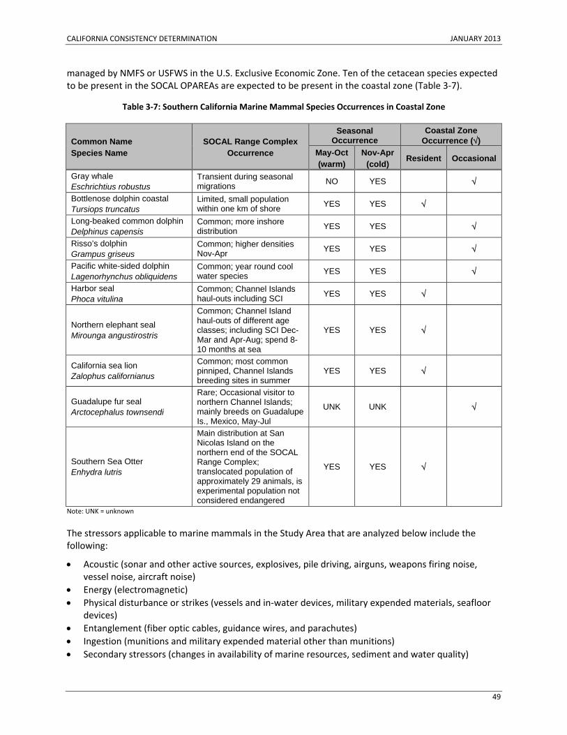
CALIFORNIA CONSISTENCY DETERMINATION JANUARY 2013
49
managed by NMFS or USFWS in the U.S. Exclusive Economic Zone. Ten of the cetacean species expected to be present in the SOCAL OPAREAs are expected to be present in the coastal zone (Table 3‐7).
Table 3‐7: Southern California Marine Mammal Species Occurrences in Coastal Zone
Common Name Species Name
SOCAL Range Complex Occurrence
Seasonal Occurrence
Coastal Zone Occurrence (√)
May-Oct (warm)
Nov-Apr (cold) Resident Occasional
Gray whale Eschrichtius robustus
Transient during seasonal migrations NO YES √
Bottlenose dolphin coastal Tursiops truncatus
Limited, small population within one km of shore YES YES √
Long-beaked common dolphin Delphinus capensis
Common; more inshore distribution YES YES √
Risso’s dolphin Grampus griseus
Common; higher densities Nov-Apr YES YES √
Pacific white-sided dolphin Lagenorhynchus obliquidens
Common; year round cool water species YES YES √
Harbor seal Phoca vitulina
Common; Channel Islands haul-outs including SCI YES YES √
Northern elephant seal Mirounga angustirostris
Common; Channel Island haul-outs of different age classes; including SCI Dec-Mar and Apr-Aug; spend 8-10 months at sea
YES YES √
California sea lion Zalophus californianus
Common; most common pinniped, Channel Islands breeding sites in summer
YES YES √
Guadalupe fur seal Arctocephalus townsendi
Rare; Occasional visitor to northern Channel Islands; mainly breeds on Guadalupe Is., Mexico, May-Jul
UNK UNK √
Southern Sea Otter Enhydra lutris
Main distribution at San Nicolas Island on the northern end of the SOCAL Range Complex; translocated population of approximately 29 animals, is experimental population not considered endangered
YES YES √
Note: UNK = unknown
The stressors applicable to marine mammals in the Study Area that are analyzed below include the following:
• Acoustic (sonar and other active sources, explosives, pile driving, airguns, weapons firing noise, vessel noise, aircraft noise)
• Energy (electromagnetic) • Physical disturbance or strikes (vessels and in‐water devices, military expended materials, seafloor
devices) • Entanglement (fiber optic cables, guidance wires, and parachutes) • Ingestion (munitions and military expended material other than munitions) • Secondary stressors (changes in availability of marine resources, sediment and water quality)
CALIFORNIA CONSISTENCY DETERMINATION JANUARY 2013
50
The Proposed Action, with regard to marine mammals, would be consistent to the maximum extent practicable with Section 30230 of the California Coastal Act.
Acoustic Stressors Effects of underwater sound range from direct injury (i.e., primary blast injury, barotrauma, auditory trauma, acoustic resonance, and bubble formation) to behavioral reactions. Assessing whether a sound may disturb or injure a marine mammal involves understanding the characteristics of the acoustic sources, the marine mammals that may be near the sound source, and the effects that sound may have on the physiology or behavior of those marine mammals. Furthermore, factors other than the received level of sound may affect an animal's reaction, such as the animal's physical condition, prior experience with the sound, and proximity to the source of the sound.
Navy Acoustic Effects Model A number of computer models and mathematical equations can be used to predict how energy spreads from a sound source (e.g. sonar or underwater detonation) to a receiver (e.g. dolphin or sea turtle). Assumptions in previous and current Navy models have intentionally erred on the side of overestimation when there are unknowns or when the addition of other variables was not likely to substantively change the final analysis. For example, because the ocean environment is extremely dynamic and information is often limited to a synthesis of data gathered over wide areas and requiring many years of research, known information tends to be an average of a seasonal or annual variation. El Niño Southern Oscillation events of the ocean‐atmosphere system are an example of dynamic change where unusually warm or cold ocean temperatures are likely to redistribute marine life and alter the propagation of underwater sound energy. Previous Navy modeling, therefore, made some assumptions indicative of a maximum theoretical propagation for sound energy (such as a perfectly reflective ocean surface and a flat seafloor). More complex computer models build upon basic modeling by factoring in additional variables in an effort to be more accurate by accounting for such things as bathymetry and an animal’s likely presence at various depths.
The Navy has developed a set of data and new software tools to quantify estimated marine mammal impacts from Navy activities. This new approach is the resulting evolution of the basic model previously used by the Navy, and reflects a more complex modeling approach as described below.
A quantitative analysis of impacts on a species requires data on the abundance and distribution of the species population in the potentially impacted area. The most appropriate unit of metric for this type of analysis is density, which is described as the number of animals present per unit area. There is no single source of density data for every area, species, and season because of the fiscal costs, resources, and effort involved in providing enough survey coverage to sufficiently estimate density. Therefore, to characterize the marine species density for the Study Area, the Navy compiled data from several sources. To develop a database of marine species density estimates, the Navy, in consultation with NMFS experts at the two science centers (Southwest Fisheries Science Center and Pacific Islands Fisheries Science Center), adopted a protocol to select the best available data sources based on species, area, and season. The resulting Geographic Information System (GIS) database includes one single spatial and seasonal density value for every marine mammal and sea turtle species present within the Study Area.
The Navy adopted a single frequency cutoff at each end of a functional hearing group's frequency range based on the most liberal interpretations of their composite hearing abilities. These are not the same as the values used to calculate weighting curves, but exceed the demonstrated or anatomy‐based
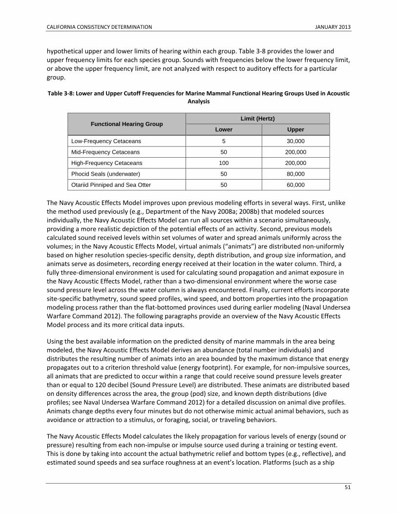
CALIFORNIA CONSISTENCY DETERMINATION JANUARY 2013
51
hypothetical upper and lower limits of hearing within each group. Table 3‐8 provides the lower and upper frequency limits for each species group. Sounds with frequencies below the lower frequency limit, or above the upper frequency limit, are not analyzed with respect to auditory effects for a particular group.
Table 3‐8: Lower and Upper Cutoff Frequencies for Marine Mammal Functional Hearing Groups Used in Acoustic Analysis
Functional Hearing Group Limit (Hertz)
Lower Upper
Low-Frequency Cetaceans 5 30,000
Mid-Frequency Cetaceans 50 200,000
High-Frequency Cetaceans 100 200,000
Phocid Seals (underwater) 50 80,000
Otariid Pinniped and Sea Otter 50 60,000
The Navy Acoustic Effects Model improves upon previous modeling efforts in several ways. First, unlike the method used previously (e.g., Department of the Navy 2008a; 2008b) that modeled sources individually, the Navy Acoustic Effects Model can run all sources within a scenario simultaneously, providing a more realistic depiction of the potential effects of an activity. Second, previous models calculated sound received levels within set volumes of water and spread animals uniformly across the volumes; in the Navy Acoustic Effects Model, virtual animals (“animats”) are distributed non‐uniformly based on higher resolution species‐specific density, depth distribution, and group size information, and animats serve as dosimeters, recording energy received at their location in the water column. Third, a fully three‐dimensional environment is used for calculating sound propagation and animat exposure in the Navy Acoustic Effects Model, rather than a two‐dimensional environment where the worse case sound pressure level across the water column is always encountered. Finally, current efforts incorporate site‐specific bathymetry, sound speed profiles, wind speed, and bottom properties into the propagation modeling process rather than the flat‐bottomed provinces used during earlier modeling (Naval Undersea Warfare Command 2012). The following paragraphs provide an overview of the Navy Acoustic Effects Model process and its more critical data inputs.
Using the best available information on the predicted density of marine mammals in the area being modeled, the Navy Acoustic Effects Model derives an abundance (total number individuals) and distributes the resulting number of animats into an area bounded by the maximum distance that energy propagates out to a criterion threshold value (energy footprint). For example, for non‐impulsive sources, all animats that are predicted to occur within a range that could receive sound pressure levels greater than or equal to 120 decibel (Sound Pressure Level) are distributed. These animats are distributed based on density differences across the area, the group (pod) size, and known depth distributions (dive profiles; see Naval Undersea Warfare Command 2012) for a detailed discussion on animal dive profiles. Animats change depths every four minutes but do not otherwise mimic actual animal behaviors, such as avoidance or attraction to a stimulus, or foraging, social, or traveling behaviors.
The Navy Acoustic Effects Model calculates the likely propagation for various levels of energy (sound or pressure) resulting from each non‐impulse or impulse source used during a training or testing event. This is done by taking into account the actual bathymetric relief and bottom types (e.g., reflective), and estimated sound speeds and sea surface roughness at an event’s location. Platforms (such as a ship
CALIFORNIA CONSISTENCY DETERMINATION JANUARY 2013
52
using one or more sound sources) are modeled as moving across an area whose size is representative of what would normally occur during a training or testing scenario. The model uses typical platform speeds and event durations. Moving source platforms either travel along a predefined track or move along straight‐line tracks from a random initial course, reflecting at the edges of a predefined boundary. Static sound sources are stationary in a fixed location for the duration of a scenario. Modeling locations were chosen based on historical data where activities have been ongoing and in an effort to include as much environmental variation within the Study Area as is reasonably available and can be incorporated into the model.
The Navy Acoustic Effects Model then predicts the energy received by each animat within the energy footprint of the event and calculates the number of animats that received levels of energy exposures that fall within defined impact thresholds. Predicted effects on the animats within a scenario are then tallied and the highest order effect (based on severity of criteria; e.g., PTS over TTS) predicted for a given animat is assumed. Each scenario, or each 24‐hour period for scenarios lasting greater than 24 hours, is independent of all others, so the same individual marine animal could be impacted during each independent scenario or 24‐hour period. In a few instances, although the activities themselves all occur within the Study Area, sound may propagate beyond the boundary of the Study Area. Exposures occurring outside the Study Area are counted as if they occurred within the Study Area. The Navy Acoustic Effects Model provides the initial predicted impacts on marine species (based on application of multiple conservative assumptions which are assumed to overestimate impacts), which are then further analyzed to produce final estimates used in the Navy’s MMPA take requests and ESA risk analyses.
Avoidance Behavior and Mitigation Measures as Applied to Sonar and Other Non-Impulse Sources Within the Navy Acoustic Effects Model, animats do not react to avoid sound or other disturbances. Furthermore, mitigation measures that reduce the likelihood of physiological impacts are not factored into the preliminary modeling results. Therefore, the Navy Acoustic Effects Model overestimates acoustic impacts, especially predicted physiological effects near the sound source.
Cetaceans can perceive the movement of a sound source (e.g., vessel, seismic source, etc.), often at distances of a kilometer or more (Au and Perryman 1985; Jansen et al. 2010; Palka and Hammond 2001; Richardson et al. 1995; Tyack et al. 2011; Watkins 1986; Wursig et al. 1998; Tyack 2009). The behavioral criteria used in this analysis acknowledge that a behavioral reaction is likely to occur at levels below those required to cause TTS, PTS, or higher order physiological impacts. At ranges and sound levels approaching those that could cause PTS, avoidance of the area immediately around an activity associated with a sound source (such as a low hovering helicopter) is assumed in most cases.
For example, if sound‐producing activities are preceded by vessel traffic or hovering aircraft, beaked whales are assumed to move beyond the range to PTS before sound transmission begins. The range to PTS for all systems is generally much less than 100 m (109.4 yd.). Because the Navy Acoustic Effects Model does not include avoidance behavior, the preliminary model estimates are based on unlikely behavior for these species‐ that they would tolerate staying in an area of high human activity.
Animal avoidance of the area immediately around an active acoustic system, coupled with mitigation measures designed to avoid exposing animals to high energy levels, would make the majority of model‐estimated PTS to mid‐frequency cetaceans unlikely. The maximum ranges to onset PTS for mid‐frequency cetaceans do not exceed 10 m (10.9 yd.) in any environment modeled for the most powerful non‐impulsive acoustic sources, hull‐mounted sonar. Ranges to PTS for low‐frequency cetaceans and high‐frequency cetaceans do not exceed 67 m (73.3 yd.) and 100 m (109.4 yd.), respectively. Vessel
CALIFORNIA CONSISTENCY DETERMINATION JANUARY 2013
53
speeds during anti‐submarine warfare activities normally exceed 10 knots, and sonar pings occur about every 50 seconds, so an animal would have to stay within a 20 m (21.9 yd.) radius in front of or alongside a moving ship for over three minutes (given the time between five pings) to experience PTS. In addition, the animal would have to remain unobserved; otherwise, implemented mitigation would result in the sonar transmissions being shut down, preventing any further exposure. Finally, most marine mammals (odontocetes) have directional hearing, with best hearing sensitivity when facing a sound source (Mooney et al. 2008 Popov and Supin 2009; Kastelein et al. 2005). An odontocete avoiding a source would be exposed in a less sensitive hearing orientation (its tail pointed toward the source), potentially reducing impacts.
As part of the modeling adjustments, beaked whales that were estimated to experience PTS from exposure to non‐impulse sources are assumed to move away, but are conservatively considered to remain within the range of TTS prior to the start of the sound‐producing activity. Given the proximity to the source required for model‐estimated PTS to mid‐frequency cetaceans and likely avoidance of the source’s vicinity, all model‐estimated PTS to mid‐frequency cetaceans are adjusted to be TTS because an animal probably would avoid the very short range to PTS effects (while remaining undetected). Marine mammals in other functional hearing groups, if present but not observed by lookouts, are assumed to leave the area near the sound source after the first 3–4 pings, thereby reducing sound exposure levels and the potential for PTS. The range to the onset of PTS does not exceed 67 m (73.3 yd.) for low‐frequency cetaceans and does not exceed 100 m (109.4 yd.) for high‐frequency cetaceans in any environment for the most powerful active acoustic sources, hull‐mounted sonar. Odontocetes, including high‐frequency cetaceans, may also minimize sound exposure due to their directional hearing. During the first few pings of an event, or after a pause in sonar operations, if animals are caught unaware and mitigation measures are not yet implemented (e.g., animals are at depth and not visible at the surface) they could receive enough acoustic energy to suffer PTS. Only these initial exposures resulting in model‐estimated PTS are expected to occur. The remaining model‐estimated PTS are considered to be TTS due to avoidance.
The Navy Acoustic Effects Model does not consider implemented standard mitigation measures (as presented in Appendix C [Standard Operating Procedures, Mitigation, and Monitoring]). To account for the implementation of mitigation measures, the acoustic effects analysis assumes a model‐estimated PTS would not occur if an animal at the water surface would likely be observed during those activities by dedicated Lookouts up to and during use of the sound source, considering the sightability of a species, the range to PTS for each hearing group and source, and mitigation effectiveness. The preliminary model‐estimated PTS numbers are reduced by the portion of animals that are likely to be seen (Mitigation Adjustment Factor x Sightability). Model‐predicted PTS effects are adjusted based on these factors and added to the model predicted TTS exposures.
Impacts to Marine Mammals from Acoustic Sources Table 3‐9 summarizes marine mammal total annual estimated exposures from Navy training and testing under the Proposed Action. These exposures are categorized in terms of Level B harassment, Level A harassment, and Mortality. Level B harassment for military readiness activities includes any act that disturbs or is likely to disturb a marine mammal or marine mammal stock by causing disruption of natural behavioral patterns including, but not limited to, migration, surfacing, nursing, breeding, feeding, or sheltering to a point where such behaviors are abandoned or significantly altered. For military readiness activities, Level A harassment includes any act that injures or has the significant potential to injure a marine mammal or marine mammal stock in the wild.
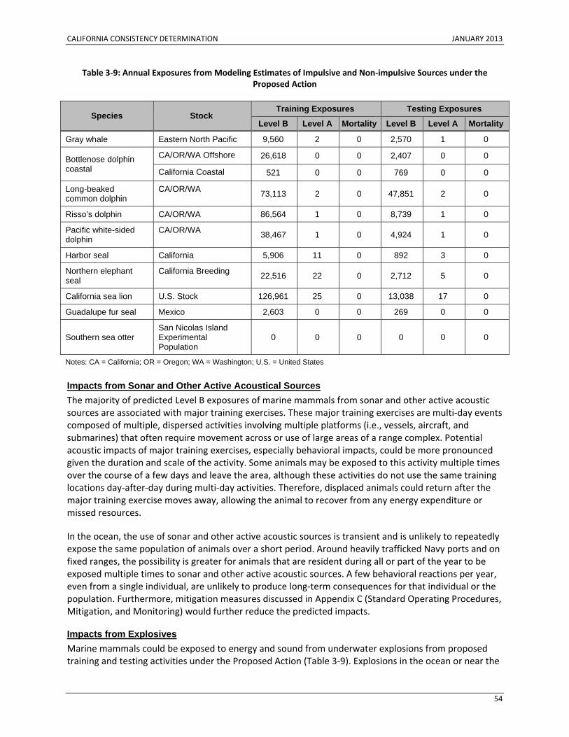
CALIFORNIA CONSISTENCY DETERMINATION JANUARY 2013
54
Table 3‐9: Annual Exposures from Modeling Estimates of Impulsive and Non‐impulsive Sources under the Proposed Action
Species Stock Training Exposures Testing Exposures
Level B Level A Mortality Level B Level A Mortality
Gray whale Eastern North Pacific 9,560 2 0 2,570 1 0
Bottlenose dolphin coastal
CA/OR/WA Offshore 26,618 0 0 2,407 0 0
California Coastal 521 0 0 769 0 0
Long-beaked common dolphin
CA/OR/WA 73,113 2 0 47,851 2 0
Risso’s dolphin CA/OR/WA 86,564 1 0 8,739 1 0
Pacific white-sided dolphin
CA/OR/WA 38,467 1 0 4,924 1 0
Harbor seal California 5,906 11 0 892 3 0
Northern elephant seal
California Breeding 22,516 22 0 2,712 5 0
California sea lion U.S. Stock 126,961 25 0 13,038 17 0
Guadalupe fur seal Mexico 2,603 0 0 269 0 0
Southern sea otter San Nicolas Island Experimental Population
0 0 0 0 0 0
Notes: CA = California; OR = Oregon; WA = Washington; U.S. = United States
Impacts from Sonar and Other Active Acoustical Sources The majority of predicted Level B exposures of marine mammals from sonar and other active acoustic sources are associated with major training exercises. These major training exercises are multi‐day events composed of multiple, dispersed activities involving multiple platforms (i.e., vessels, aircraft, and submarines) that often require movement across or use of large areas of a range complex. Potential acoustic impacts of major training exercises, especially behavioral impacts, could be more pronounced given the duration and scale of the activity. Some animals may be exposed to this activity multiple times over the course of a few days and leave the area, although these activities do not use the same training locations day‐after‐day during multi‐day activities. Therefore, displaced animals could return after the major training exercise moves away, allowing the animal to recover from any energy expenditure or missed resources.
In the ocean, the use of sonar and other active acoustic sources is transient and is unlikely to repeatedly expose the same population of animals over a short period. Around heavily trafficked Navy ports and on fixed ranges, the possibility is greater for animals that are resident during all or part of the year to be exposed multiple times to sonar and other active acoustic sources. A few behavioral reactions per year, even from a single individual, are unlikely to produce long‐term consequences for that individual or the population. Furthermore, mitigation measures discussed in Appendix C (Standard Operating Procedures, Mitigation, and Monitoring) would further reduce the predicted impacts.
Impacts from Explosives Marine mammals could be exposed to energy and sound from underwater explosions from proposed training and testing activities under the Proposed Action (Table 3‐9). Explosions in the ocean or near the
CALIFORNIA CONSISTENCY DETERMINATION JANUARY 2013
55
water surface can introduce loud, impulsive, broadband sounds into the marine environment. These sounds are likely to be within the audible range of most cetaceans, but the duration of individual sounds is very short. The sounds of explosions during Navy training and testing activities last less than a second, and most events involve only one or a few explosions. Furthermore, events are dispersed in time and throughout the Study Area. These factors reduce the likelihood of these sources causing substantial auditory masking in marine mammals.
Mitigation measures are not accounted for in estimating exposures to energy and sound from underwater explosions. Mitigation measures are described in Appendix C (Standard Operating Procedures, Mitigation, and Monitoring) of this Consistency Determination. When there is uncertainty in model input values, a conservative approach is chosen to assure that potential effects are not underpredicted. As a result, the Navy Acoustic Effects Model provides conservative predictions.
Modeling results and the record of having conducted the same or similar events for decades indicates injuries and mortality are unlikely. Given the short radii for the impact zones, range clearance procedures, and that it is unlikely for marine mammals to be in the area also suggests injuries and mortality are unlikely. Although the incident at SSTC on 4 March 20112 involving long‐beaked common dolphins was an unfortunate and extremely rare incident (given that it has never occurred before), it remains extremely unlikely that a similar event involving the use of explosives in a training event would re‐occur. Given this one occurrence, however, the Navy will request authorization under the MMPA for the annual incidental mortality of 26 small odontocetes (e.g., dolphins) or pinnipeds associated with Navy training and testing activities using explosives in the Study Area.
Impacts from Pile Driving Elevated causeway system is the one event under the Proposed Action, that includes pile driving. In this event, a temporary pier is constructed off the beach, and support pilings are driven into the sand and later removed. This event would occur in the nearshore waters of the SOCAL Range Complex at Camp Pendleton, at SSTC, or at the Bravo Beach training area on the south San Diego Bay side of SSTC. Marine mammals are rarely encountered within this southern portion of San Diego Bay, and given this lack of occurrence, exposures of marine mammals during elevated causeway training in the Bay are not expected. By assuming that all elevated causeway training would occur on the oceanside of SSTC or Camp Pendleton, exposure estimates may over‐represent actual potential exposures. For example, the estimates may be double of what they might actually be if half of the elevated causeway training was to occur within San Diego Bay.
Pile‐driving activities may cause nearshore species of marine mammals (e.g., coastal stock of bottlenose dolphins) to avoid the area near the event, although the activity potentially impacts a small area and happens infrequently (up to four times per year). The elevated causeway exposure assessment methodology is an estimate of the numbers of individuals potentially exposed to the effects of elevated causeway pile driving as an annual summation without consideration of successful implementation of
2 Despite the Navy’s excellent decades‐long track record, on 4 March 2011, it is clear that three long‐beaked common dolphins inadvertently died as a direct result of a training incident involving explosives at SSTC. Range clearance procedures had been implemented and there were no marine mammals in the area when the timed‐fuse countdown to detonation began. Personnel moved back from the site, and just before the detonation was to occur, dolphins were observed moving into the clearance zone. Due to the danger to personnel, the Navy could not attempt to divert those animals, stop the timer, or disarm the explosive.
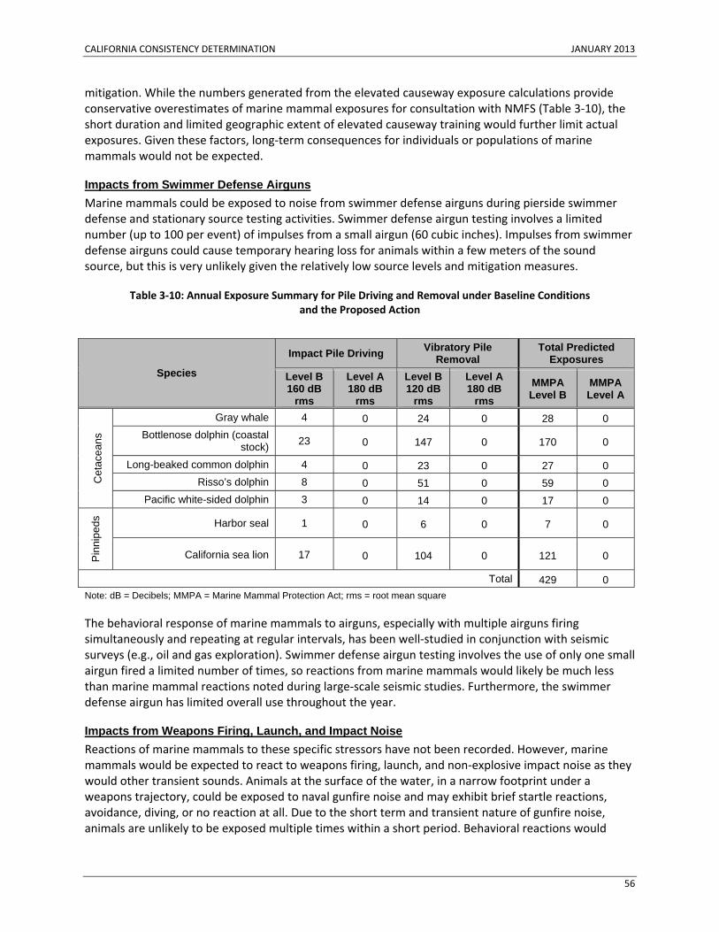
CALIFORNIA CONSISTENCY DETERMINATION JANUARY 2013
56
mitigation. While the numbers generated from the elevated causeway exposure calculations provide conservative overestimates of marine mammal exposures for consultation with NMFS (Table 3‐10), the short duration and limited geographic extent of elevated causeway training would further limit actual exposures. Given these factors, long‐term consequences for individuals or populations of marine mammals would not be expected.
Impacts from Swimmer Defense Airguns Marine mammals could be exposed to noise from swimmer defense airguns during pierside swimmer defense and stationary source testing activities. Swimmer defense airgun testing involves a limited number (up to 100 per event) of impulses from a small airgun (60 cubic inches). Impulses from swimmer defense airguns could cause temporary hearing loss for animals within a few meters of the sound source, but this is very unlikely given the relatively low source levels and mitigation measures.
Table 3‐10: Annual Exposure Summary for Pile Driving and Removal under Baseline Conditions and the Proposed Action
The behavioral response of marine mammals to airguns, especially with multiple airguns firing simultaneously and repeating at regular intervals, has been well‐studied in conjunction with seismic surveys (e.g., oil and gas exploration). Swimmer defense airgun testing involves the use of only one small airgun fired a limited number of times, so reactions from marine mammals would likely be much less than marine mammal reactions noted during large‐scale seismic studies. Furthermore, the swimmer defense airgun has limited overall use throughout the year.
Impacts from Weapons Firing, Launch, and Impact Noise Reactions of marine mammals to these specific stressors have not been recorded. However, marine mammals would be expected to react to weapons firing, launch, and non‐explosive impact noise as they would other transient sounds. Animals at the surface of the water, in a narrow footprint under a weapons trajectory, could be exposed to naval gunfire noise and may exhibit brief startle reactions, avoidance, diving, or no reaction at all. Due to the short term and transient nature of gunfire noise, animals are unlikely to be exposed multiple times within a short period. Behavioral reactions would
Species
Impact Pile Driving Vibratory Pile Removal
Total Predicted Exposures
Level B160 dB
rms
Level A 180 dB
rms
Level B 120 dB
rms
Level A180 dB
rms MMPA Level B
MMPA Level A
Cet
acea
ns
Gray whale 4 0 24 0 28 0 Bottlenose dolphin (coastal
stock) 23 0 147 0 170 0
Long-beaked common dolphin 4 0 23 0 27 0 Risso’s dolphin 8 0 51 0 59 0
Pacific white-sided dolphin 3 0 14 0 17 0
Pin
nipe
ds
Harbor seal 1 0 6 0 7 0
California sea lion 17 0 104 0 121 0
Total 429 0 Note: dB = Decibels; MMPA = Marine Mammal Protection Act; rms = root mean square
CALIFORNIA CONSISTENCY DETERMINATION JANUARY 2013
57
likely be short‐term (minutes) and are unlikely to lead to substantial long‐term consequences for individuals or populations.
Impacts from Vessel Noise Vessel movements involve transits to and from ports to various locations within the Study Area, and many ongoing and proposed training and testing activities within the Study Area involve maneuvers by various types of surface ships, boats, and submarines (collectively referred to as vessels). Auditory masking can occur due to vessel noise, potentially masking vocalizations and other biologically important sounds (e.g., sounds of prey or predators) that marine mammals may rely upon. Marine mammals have been recorded in several instances altering and modifying their vocalizations to compensate for the masking noise from vessels or other similar sounds. However, Navy vessels make up a very small percentage of the overall traffic and the rise of ambient noise levels in these areas is a problem related to all ocean users, including commercial and recreational vessels and shoreline development and industrialization.
Vessel noise could disturb marine mammals and elicit an alerting, avoidance, or other behavioral reaction. Based on studies of a number of species, mysticetes are not expected to be disturbed by vessels that maintain a reasonable distance from them, which varies with vessel size, geographic location, and tolerance levels of individuals. Odontocetes could have a variety of reactions to passing vessels, including attraction, increased traveling time, decrease in feeding behaviors, diving, or avoidance of the vessel, which may vary depending on their prior experience with vessels. For pinnipeds, data indicate tolerance of vessel approaches, especially for animals in the water. Navy vessels do not purposefully approach marine mammals and are not expected to elicit significant behavioral responses.
Vessel traffic related to the proposed training activity would pass near marine mammals only on an incidental basis. Navy mitigation measures include several provisions to avoid approaching marine mammals (see Appendix C [Standard Operating Procedures, Mitigation, and Monitoring] of this Consistency Determination for a detailed description of mitigation measures) which would further reduce any potential impacts of vessel noise. Long term consequences to individuals or populations of marine mammals are not expected to result from vessel noise associated with the proposed training events.
Impacts from Aircraft Noise Marine mammals may respond to both the physical presence and to the noise generated by aircraft, making it difficult to attribute causation to one or the other stimulus. In addition to noise produced, all low‐flying aircraft create shadows, which can cause animals at the surface to react. Helicopters may also produce a strong downdraft, a vertical flow of air that becomes a surface wind, which can also affect an animal's behavior at or near the surface.
It is unlikely that an individual would be exposed repeatedly for long periods as aircraft typically transit open ocean areas within the Study Area. The consensus of all the studies reviewed is that aircraft noise would cause only small temporary changes in the behavior of marine mammals. Specifically, marine mammals located at or near the surface when an aircraft flies overhead at low‐altitude may be startled, divert their attention to the aircraft, or avoid the immediate area by swimming away or diving. The sound from aircraft overflights resulting from the Proposed Action could expose mysticetes, odontocetes, pinnipeds, and sea otters to overflight noise. Short‐term reactions to aircraft are not likely to disrupt major behavior patterns such as migrating, breeding, feeding, and sheltering, or to seriously
CALIFORNIA CONSISTENCY DETERMINATION JANUARY 2013
58
injure any marine mammals. No long‐term consequences for individuals or populations would be expected.
Energy Stressors Neither regulations nor scientific literature provide threshold criteria to determine the significance of the potential effects from actions that generate an electromagnetic field. Data on the influence of magnetic fields and electromagnetic fields on cetaceans are inconclusive. Potential impacts on marine mammals from electromagnetic fields depend on the animal’s proximity to the source and the strength of the magnetic field.
Although it is not fully understood, based on the available evidence described above, it is probable that cetaceans use the earth’s magnetic field for movement or migration. If an animal was exposed to the moving electromagnetic field source and if sensitive to that source, this electromagnetic field could have an effect while near a cetacean and thereby impact that animal’s navigation. However, impacts would be temporary and minor, and natural behavioral patterns would not be significantly altered or abandoned based on the: (1) relatively low intensity of the magnetic fields generated (discussed above), (2) very local potential impact area, and (3) short duration of the activities (hours).
Physical Disturbance and Strike Stressors Impacts from Vessels To determine the appropriate number of MMPA incidental takes for potential Navy vessel strikes, the Navy assessed the probability of Navy vessels hitting individuals of different species of large whales that occur in the Study Area incidental to training and testing activities. To do this, the Navy considered unpublished ship strike data compiled and provided by NMFS’ Southwest Regional Office and Pacific Island Regional Office, unpublished Navy ship strike information collected by the Navy and reported to NMFS, and information in this application on trends in the amount of vessel traffic related to Navy training and testing activities in the Study Area. Navy policy (Chief of Naval Operations Instruction 3100.6 H) is to report all whale strikes by Navy vessels. That information has been, by informal agreement, provided to National Oceanographic and Atmospheric Administration on an annual basis. Only the Navy and the U.S. Coast Guard report vessel strikes in this manner, so all statistics are skewed by a lack of comprehensive reporting by all vessels that may experience vessel strikes.
Based on NMFS Southwest Regional Office data for Southern California, gray whales have the highest number of recorded strikes (and in all of California as well), with fin and humpback whales notably less, and blue whales the least. In the SOCAL Range Complex, the Navy has struck 16 marine mammals in a 20‐year period (1991‐2010) for an average of one per year (although statistically 0.8 per year [16 strikes/20 years]). In 16 of the last 20 years, there were zero to one whale strikes.
The Navy does not anticipate ship strikes of marine mammals within the Study Area from training and testing activities under the Proposed Action. However, to account for the accidental nature of ship strikes in general, and the potential risk from any vessel movement within the Study Area, the Navy is seeking take authorization in the event a Navy ship strike does occur within the Study Area during the five‐year period of NMFS’ final authorization. Based on the probabilities of whale strikes suggested by the data, the Navy is requesting takes by morality or injury of 15 large marine mammals over the five years of the NMFS authorization. This level of take would be no more than four large whales in any given year.
CALIFORNIA CONSISTENCY DETERMINATION JANUARY 2013
59
Impacts from In-Water Device Strikes Devices that could pose a collision risk to marine mammals are those operated at high speeds and that are unmanned. These are mainly limited to unmanned surface vehicles, such as high‐speed targets, and unmanned undersea vehicles such as light and heavy weight torpedoes. The Navy reviewed torpedo design features and a large number of previous anti‐submarine warfare torpedo exercises to assess the potential of torpedo strikes on marine mammals. The acoustic homing programs of U.S. Navy torpedoes are sophisticated, and would not confuse the acoustic signature of a marine mammal with a submarine or target. Review of the exercise torpedo records indicates there has never been an impact on a marine mammal or other marine organism. In thousands of exercises in which torpedoes were fired or in‐water devices used, there have been no recorded or reported instances of a marine species strike from a torpedo or any other in‐water device.
Devices such as unmanned underwater vehicles that move slowly through the water are highly unlikely to strike marine mammals because the mammal could easily avoid the object. Towed devices are unlikely to strike a marine mammal because of the observers on the towing platform and other standard safety measures employed when towing in‐water devices.
Impacts from Military Expended Material No strike from military expended materials has ever been reported or recorded, but the possibility of a strike still exists. While disturbance or strike from an item falling through the water column is possible, it is not very likely because the objects generally sink slowly through the water and can be avoided by most marine mammals. Therefore, the discussion of military expended materials strikes will focus on the potential of a strike at the surface of the water. To estimate the likelihood of a strike, a worst‐case scenario was calculated using the marine mammal with the highest average density in areas with the highest military expended material expenditures. These highest estimates would provide reasonable comparisons for all other areas and species. For all the remaining marine mammals with lower densities, this highest likelihood would overestimate the likelihood or probability of a strike.
The model results quantify the probability of a strike as a percentage for training activities under the Proposed Action. The results indicate with a reasonable level of certainty that marine mammals would not be struck by non‐explosive practice munitions or expended materials other than ordnance during training activities. Results range from zero, or a zero percent chance of a strike by a military expended material over the course of a year, to a high of approximately eight one‐hundredths of one percent (0.08 percent) chance of being struck by a military expended material. As discussed above, however, this does not take into account the influences of the model and the behavior of the species (short‐beaked common dolphins generally occur in large pods and are relatively easy to spot), which would lower the risk of a strike. Furthermore, Navy mitigation measures for some active sonobuoys (a large portion of the military expended material), require the area be clear of marine mammals before being deployed (see Appendix C).
Impacts from Seafloor Devices Objects falling through the water column will sink slower as they approach the bottom, and could be avoided by most marine mammals. The only seafloor device used during training and testing activities that could strike a marine mammal at or near the surface is an aircraft‐deployed mine shape, which is used during aerial mine laying activities. These devices are identical to non‐explosive practice bombs; the potential impacts of those devices are analyzed in the military expended material strike section.
CALIFORNIA CONSISTENCY DETERMINATION JANUARY 2013
60
Entanglement Stressors Fiber optic cables, guidance wires, and parachutes could entangle or could be encountered by marine mammals in the Study Area at the surface, in the water column, or along the seafloor, although the properties and sizes of these military expended materials makes entanglement unlikely. In addition, there has never been a reported or recorded instance of a marine mammal being entangled in military expended materials.
Impacts from Fiber Optic Cables and Guidance Wires A guidance wire will only be in the water column during the activity and while it sinks, so the likelihood of a marine mammal encountering and becoming entangled within the water column is extremely low. Those species that feed on the seafloor could encounter fiber optic cables and potentially become entangled, however the relatively few fiber optic cables being expended within the Study Area limit the potential for encounters. The physical characteristics of the fiber optic material render the fiber optic cable brittle and easily broken when kinked, twisted, or bent sharply (i.e., to a radius greater than 360 degrees). Thus, its physical properties would not allow the fiber optic cable to loop, greatly reducing or eliminating any issues of entanglement with regard to marine life. An animal would have to swim through loops or become twisted within the fiber optic cable or guidance wire to become entangled; given the properties of the expended fiber optic cables and guidance wires (low breaking strength and sinking rates) this seems unlikely.
Impacts from Parachutes Entanglement of a marine mammal in a parachute assembly at the surface or within the water column would be unlikely, because the parachute would have to land directly on an animal, or an animal would have to swim into it before it sinks. Once on the seafloor, if bottom currents are present, the canopy may temporarily billow and pose an entanglement threat to marine animals with bottom‐feeding habits; however, the probability of a marine mammal encountering a parachute assembly on the seafloor and accidentally being entangled in the canopy or suspension lines is low.
The possibility of odontocetes and pinnipeds becoming entangled exists when they are feeding on the bottom in areas where parachutes have been expended. This is unlikely because parachutes are used in events that generally occur in deeper waters where these species are not likely to be feeding on the bottom, though even if momentarily entangled, a marine mammal could free itself from the light‐weight fabric of a parachute. There has never been a recorded or reported instance of a marine mammal becoming entangled in a parachute.
Ingestion Stressors The amount of ordnance that an individual animal would encounter is generally low based on the patchy distribution of both the projectiles and an animal’s feeding habitat. In addition, an animal would not likely ingest every projectile it encountered. Furthermore, an animal may attempt to ingest a projectile and then reject it when it realizes it is not a food item. Even ingestion of certain items (hooks), if they do not become embedded in tissue, do not end up resulting in injury or mortality to the individual (Wells and Scott 2008). Therefore potential impacts of non‐explosive practice munitions ingestion would be limited to the unlikely event where a marine mammal might suffer a negative response from ingesting an item that becomes embedded in tissue or is too large to be passed through the digestive system.
The impacts of ingesting military expended materials other than ordnance would be limited to cases where an individual marine mammal might eat an indigestible item too large to be passed through the gut. The marine mammals would not be preferentially attracted to these military expended materials,
CALIFORNIA CONSISTENCY DETERMINATION JANUARY 2013
61
with the possible exception of parachutes that may appear similar to the prey of some species such as sperm whales and beaked whales. For the most part, these military expended materials would most likely only be incidentally ingested by individuals feeding on the bottom in the precise location where these items were deposited. Non‐munition military expended materials that would remain floating on the surface are too small to pose a risk of intestinal blockage to any marine mammal that happened to encounter it.
Secondary Stressors Stressors from Navy training and testing activities could pose indirect impacts on marine mammals by affecting their habitat or prey. These stressors include (1) explosives and by‐products, (2) metals, (3) chemicals, and (4) transmission of disease and parasites.
Indirect impacts of explosives and unexploded ordnance on marine mammals via sediment are possible in the immediate vicinity of the ordnance. Degradation of explosives proceeds through several pathways. Relatively low solubility of most explosives and their degradation products means that concentrations of these contaminants in the marine environment are relatively low and readily diluted. Furthermore, while explosives and their degradation products were detectable in marine sediment approximately 6 to 12 in. (0.15 to 0.3 m) from degrading ordnance, the concentrations of these compounds were not statistically distinguishable from background beyond 3 to 6 ft. (1 to 1.8 m) from the degrading ordnance. Taken together, marine mammals could be exposed to degrading explosives, but it would be within a very small radius of the explosive (1 to 6 ft. [0.3 to 1.8 m]).
Marine mammals may be exposed by contact with the metal, contact with contaminants in the sediment or water, or ingestion of contaminated sediments. Concentrations of metals in sea water are orders of magnitude lower than concentrations in marine sediments. It is extremely unlikely that marine mammals would be indirectly impacted by metals via the water and few marine mammal species feed primarily on the seafloor where they would come into contact with marine sediments.
The greatest risk to marine mammals from flares and from missile and rocket propellants that operationally fail is perchlorate, which is highly soluble in water, persistent, and impacts metabolic processes in many plants and animals. Marine mammals may be exposed by contact with contaminated water. However, rapid dilution would occur and toxic concentrations are unlikely to be encountered in seawater.
The U.S. Navy deploys trained Atlantic bottlenose dolphins (Tursiops truncatus) and California sea lions (Zalophus californianus) for integrated training involving two primary mission areas; to find objects such as inert mine shapes and to detect swimmers or other intruders around Navy facilities such as piers. During the past 40 years, the Navy Marine Mammal Program has deployed globally. To date, there have been no known instances of deployment‐associated disease transfer to or from Navy marine mammals. Navy animals are maintained under the control of animal handlers and are prevented from having sustained contact with indigenous animals. Due to the very short periods that the Navy marine mammals spend in the open ocean; the control that the trainers have over the animals; the collection and proper disposal of marine mammal waste; the exceptional screening and veterinarian care given to the Navy's animals; the visual monitoring for indigenous marine mammals; and an over 40‐year track record with zero known incidents, there is no scientific basis to conclude that the use of Navy marine mammals during training activities would have an impact on wild marine mammals.
CALIFORNIA CONSISTENCY DETERMINATION JANUARY 2013
62
3.2.3 ARTICLE 4, SECTION 30231 – BIOLOGICAL PRODUCTIVITY; WATER QUALITY
3.2.3.1 Policy
The biological productivity and the quality of coastal waters, streams, wetlands, estuaries, and lakes appropriate to maintain optimum populations of marine organisms and for the protection of human health shall be maintained and, where feasible, restored through, among other means, minimizing adverse effects of waste water discharges and entrainment, controlling runoff, preventing depletion of ground water supplies and substantial interference with surface water flow, encouraging waste water reclamation, maintaining natural vegetation buffer areas that protect riparian habitats, and minimizing alteration of natural streams.
3.2.3.2 Consistency Review
Effects of Navy training and testing activities on biological resources are addressed above with regard to California Coastal Act Policy 30230 (Section 3.2.1). The analysis determined that no population‐level impacts would be expected from the Proposed Action. Thus, the Proposed Action would not affect biological productivity in the coastal zone.
The Proposed Action would result in military expended materials that contain hazardous constituents that could affect water quality. Most activities involving military expended materials would be conducted more than 3 nm offshore. Military expended materials, however, may contain explosive materials, metals, fuels, batteries, or plastic that could be transported into the coastal zone by ocean currents or wind flow patterns. Therefore, despite the fact that most military expended materials would occur beyond 3 nm offshore, this section will evaluate potential effects on sediments and water quality for consistency with California Coastal Act Policy 30230. Potential impacts from military expended materials include:
• releasing materials into the water that subsequently disperse, react with seawater, or may dissolve over time;
• depositing materials on the ocean bottom and any subsequent interactions with sediments or the accumulation of such materials over time;
• depositing materials or substances on the ocean bottom and any subsequent interaction with the water column; and
• depositing materials on the ocean bottom and any subsequent disturbance of those sediments or their re‐suspension in the water column.
In general, materials that come to rest on the ocean floor either lodge in sediments, where there is little or no oxygen below 4 in. (10.2 cm), or remain on the ocean floor where they begin to react with seawater or become encrusted by marine organisms. As a result, rates of deterioration depend on the metal or metal alloy and the conditions in the immediate marine and benthic environment. If buried deep in ocean sediments, materials tend to decompose at much lower rates than when exposed to seawater. When metals are exposed to seawater, they begin to slowly corrode, a process that creates a layer of corroded material between the seawater and uncorroded metal. This layer of corrosion removes the metal from direct exposure to the corrosiveness of seawater, a process that further slows movement of the metals into the adjacent sediments and water column. Elevated levels of metals in sediments would be restricted to a small zone around the metal, and any release to the overlying water column would be diluted. In a similar fashion, as materials become covered by marine life, the direct exposure of the material to seawater decreases and the rate of corrosion decreases.
CALIFORNIA CONSISTENCY DETERMINATION JANUARY 2013
63
Potential impacts on sediments and water quality are the result of four stressors: (1) explosives and explosive byproducts, (2) metals, (3) chemicals other than explosives, and (4) a miscellaneous category of other materials. The term “stressor” is used because materials in these four categories may directly impact sediment and water quality by altering their physical and chemical characteristics. The following discussions are summaries for each stressor based on analysis in the HSTT EIS/OEIS.
Explosives and Explosive Byproducts: Over 98 percent of residual explosive materials would result from ordnance failures. In the event of an ordnance failure, the energetic materials it contained would remain mostly intact. The explosive materials in failed ordnance items would leach slowly because they would have little or no direct exposure to marine waters. Residual explosive materials deposited in sediments would be limited to small areas surrounding the ordnance item. Ocean currents would quickly disperse leached explosive materials in the water column, and residual explosive materials would not result in water toxicity.
Metals: Corrosion and biological processes (e.g., colonization by marine organisms) would reduce exposure of military expended materials to seawater, decreasing the rate of leaching. Most leached metals would bind to sediments and other organic matter. Sediments near military expended materials would contain some metals, but their concentrations would not be at harmful levels because of the bottom substrate composition. Metals in batteries are readily soluble, which would result in faster releases of metals if batteries are exposed to seawater once they are expended. Batteries are sealed, however, and the exterior metal casing can become encrusted by marine organisms or coated by corrosion. Batteries continue to operate until most of their metals are consumed.
Chemicals Other than Explosives: Solid propellants would leach perchlorates. Perchlorates are readily soluble, with a low affinity for sediments. Based on the small amount of residual propellant from training and testing activities, perchlorates would not be expected in concentrations that would be harmful to aquatic organisms in the water column or in marine sediments. OTTO Fuel II, used for torpedo propulsion, and its combustion byproducts would be introduced into the water column in small amounts. Torpedoes are typically recovered following training and testing activities, and OTTO Fuel II would not be expected to come into direct contact with marine sediments. Most combustion byproducts would form naturally occurring gases in the water column, and cyanide concentrations would be well below harmful concentrations.
Other Materials: Other military expended materials include plastics, marine markers, flares, and chaff. Some expended plastics from training and testing activities are unavoidable because they are used in ordnance or targets. Targets, however, would typically be recovered following training and testing activities. Chaff fibers are composed of non‐reactive metals and glass, and would be dispersed by ocean currents as they float and slowly sink toward the bottom. The fine, neutrally buoyant chaff streamers would act like particulates in the water, temporarily increasing the turbidity of the ocean’s surface.
Based on the general conclusions of studies on expended military ordnance and analysis provided in Section 3.1.2 of the HSTT EIS/OEIS, changes in sediments or water quality would only be observable within a small area (feet) around military expended materials. The majority of expended materials would be deposited beyond 3 nm from shore, and most of the components of military expended materials are inert and would corrode slowly. The majority of explosive materials, propellants, fuels, and batteries would be consumed during use of the ordnance or target. With the limited number of training and testing activities occurring within 3 nm, the Proposed Action would be consistent to the maximum extent practicable with Section 30231 of the California Coastal Act.
CALIFORNIA CONSISTENCY DETERMINATION JANUARY 2013
64
3.2.4 ARTICLE 4, SECTION 30234.5 – ECONOMIC, COMMERCIAL, AND RECREATIONAL IMPORTANCE OF FISHING
3.2.4.1 Policy
The economic, commercial, and recreational importance of fishing activities shall be recognized and protected.
3.2.4.2 Consistency Review
In the SOCAL Range Complex, groundfishes (e.g., flatfishes, skates, sharks, chimeras, rockfishes) are important recreational and commercial species. Highly migratory species (e.g., tuna, billfish, sharks, dolphinfish, and swordfish) and coastal pelagic species such as anchovies, mackerel, sardines, and squid also support extensive fisheries in the area. The harvest of coastal pelagic species is one of the largest fisheries in the SOCAL Range Complex in terms of landed biomass, volume, and revenue (California Department of Fish and Game 2010). In 2010, California ranked fourth in the nation for commercial fisheries landings (measured in pounds) (National Marine Fisheries Service 2011). For recreational fisheries, California ranked 14th in the nation in landings of finfish (bony and cartilaginous fish that use fins for locomotion).
Fishing activities occur at varying degrees of intensity and duration throughout the year within the SOCAL Range Complex. Fishing destinations are generally fluid, in response to changing fishing conditions, but a number of charter boats fish waters of the SOCAL Range Complex on a routine basis. Fishermen often fish for more than one species and land their catch in various ports depending on the season to maximize their economic return. A wide range of commercial fishing methods are used in this region that are fishery‐specific such as drift gillnets, longline gear, troll gear, trawls, seining, and traps or pots (Naval Undersea Warfare Center 2009). Sport fishermen pursue various fish species with almost exclusively rod and reel gear; some divers also spearfish or take invertebrates (mainly lobster) by hand within the SOCAL Range Complex.
The Navy has performed military activities within this region in the past, and has not barred fishing or recreational uses. Navy ships, fishermen, and recreational users operate within the area together, and keep a safe distance between each other. Navy exercise participants relocate as necessary to avoid conflicts with nonparticipants. Only specific areas within SOCAL Range Complex have been designated as danger zones or restricted areas. In addition to these areas, the Navy may temporarily establish an exclusion zone for the duration of a specific activity (e.g., an activity involving the detonation of explosives) to prevent non‐participating vessels and aircraft from entering an unsafe area. Exclusion zones typically have a radius of only a couple of miles (this varies depending on the activity), are surveyed before, during, and after the activity takes place, and end after the activity is completed. Should the Navy find nonparticipants present in an exclusion zone, the Navy would halt or delay (and reschedule, if necessary) all potentially hazardous activity until the nonparticipants have exited the exclusion zone. Upon completion of training, the range would be reopened and fishermen would be able to return to fish in the previously closed area. To help manage competing demands and maintain public access in the Study Area, the Navy conducts its offshore operations in a manner that minimizes restrictions on commercial fisherman.
These temporary range clearance procedures for safety purposes do not adversely affect commercial and recreational fishing activities because displacement is of short duration (hours). When range clearance is required because of safety concerns for the public, the Navy requests that the U.S. Coast Guard issue NOTMARs to warn the public of upcoming Navy activities. These measures provide mariners with advance notice of areas being used by the Navy for training and testing activities. The NOTMARs and postings on Navy websites are intended to prevent fishermen from expending time and fuel
CALIFORNIA CONSISTENCY DETERMINATION JANUARY 2013
65
resources transiting to a closed location. In 2009, the Navy completed a study to assess the effects of Navy activities on commercial and recreational fishing in the SOCAL Range Complex (Naval Undersea Warfare Center 2009). The SOCAL Fisheries Study reported the results of a survey of local fishermen, and identified several recommendations to improve communications between the Navy and commercial and recreational fishermen.
The Navy has been conducting training and testing activities within the coastal zone for decades, and has taken and will continue to take measures to prevent interruption of commercial and recreational fishing activities. Fishing activities would not be permanently inhibited by Navy activities. The Navy would require exclusive use of portions of nearshore waters for short durations (hours), but training and testing areas would be small. The Navy has conducted training and testing activities in the past, with little to no adverse effects on commercial or recreational fishing. Thus, the Proposed Action would be consistent to the maximum extent practicable with Section 30234.5 of the California Coastal Act.
CALIFORNIA CONSISTENCY DETERMINATION JANUARY 2013
66
4 STATEMENT OF CONSISTENCY The Navy has reviewed California’s Coastal Management Program, and has determined that the policies identified in Section 3.1 of this Consistency Determination do not apply to the Proposed Action. The Navy determined that all or parts of the policies reviewed in Section 3.2 of this Consistency Determination apply to the Proposed Action and are enforceable on the Navy.
The Navy conducted an effects test to analyze how and to what degree the Proposed Action would affect California coastal zone uses and resources, as defined in the applicable, enforceable policies. Results of the effects test, which considered training and testing activities that could occur within the coastal zone and activities that occur outside the coastal zone but could affect coastal zone resources, indicate that some activities could have temporary and local effects to California coastal zone uses and resources. Although some individual biological organisms may be affected, no population‐level effects would be expected as a result of the Proposed Action. The Navy would reduce the potential impacts of its proposed activities on coastal zone uses and resources by adhering to standard operating procedures and implementing environmental mitigation measures, as described in Appendix C of this Consistency Determination (Standard Operating Procedures, Mitigation, and Monitoring).
In addition, the Navy is consulting with NMFS for ESA‐listed marine mammals, sea turtles, steelhead trout, and abalones, and informally with USFWS for ESA‐listed seabirds. The Navy anticipates their concurrence on its Not Likely to Adversely Affect determinations for black abalone, white abalone, and steelhead trout, as well as for designated critical habitat for black abalone and steelhead trout.
Therefore, the Navy is consistent to the maximum extent practicable with the enforceable policies of the California Coastal Management Program.
CALIFORNIA CONSISTENCY DETERMINATION JANUARY 2013
67
5 REFERENCES Åkesson, S. & Hedenstrom, A. (2007). How migrants get there: Migratory performance and orientation.
[electronic version]. Bioscience, 57(2), 123‐133.
Åkesson, S. (2003). Avian long‐distance navigation: experiments with migratory birds. In Avian Migration (ed. P. Berthold, E. Gwinner and E. Sonnenschein), pp.471 ‐492. Berlin, Heidelberg: Springer‐Verlag.
Allen, L. G., Pondella, D. J., II & Horn, M. H. (Eds.). (2006). The Ecology of Marine Fishes: California and Adjacent Waters (pp. 660). Berkeley, CA: University of California Press.
Anderson, D. W., Henny, C. J., Godinez‐Reyes, C., Gress, F., Palacios, E. L., Santos del Prado, K. & Bredy, J. (2007). Size of the California Brown Pelican Metapopulation during a non‐El Niño year. (Open‐File Report 2007‐1299, pp. 35). Reston, VA: U.S. Geological Survey.
Arfsten, D., Wilson, C. & Spargo, B. (2002, July 25). Radio Frequency Chaff: The Effects of Its Use in Training on the Environment. Ecotoxicology and Environmental Safety, 53, 1‐11. 10.1006
Au, D. W. K. and W. L. Perryman (1985). "Dolphin habitats in the eastern tropical Pacific." Fishery Bulletin 83: 623‐643.
Baum, E. (1997). Maine Atlantic Salmon: A National Treasure (pp. 224). Hermon, ME: Atlantic Salmon Unlimited.
Bearzi, M., Saylan, C. A. & Feenstra, J. (2009). Seabird observations during cetacean surveys in Santa Monica Bay, California. Bulletin of Southern California Academy of Sciences, 108(2), 63‐69.
Bjorndal, K. A. & Bolten, A. B. (1988). Growth rates of immature green sea turtles, Chelonia mydas, on feeding grounds in the southern Bahamas. Copeia, 1988(3), 555‐564.
Bullock, T. H., Bodznick, D. A. & Northcutt, R. G. (1983). The Phylogenetic Distribution of Electroreception ‐ Evidence for Convergent Evolution of a Primitive Vertebrate Sense Modality. Brain Research Reviews, 6(1), 25‐46. 10.1016/0165‐0173(83)90003‐6.
Burger, A. E. (2001). Diving Depths of Shearwaters. The Auk, 118(3), 755‐759. Retrieved from http://www.jstor.org/stable/4089940
Butler, J., DeVogelaere, A., Gustafson, R., Mobley, C., Neuman, M., Richards, D., VanBlaricom, G. (2009). Status Review Report for Black Abalone (Haliotis cracherodii Leach, 1814). (pp. 135). Long Beach, CA: National Marine Fisheries Service.
California Department of Fish and Game (2010). Final 2009 California Commercial Landings, Table 15. 2012.
Castro, P. & Huber, M. E. (2000). Marine prokaryotes, protists, fungi, and plants. In Marine Biology (3rd ed., pp. 83‐103). McGraw‐Hill.
Cross, J. N. & Allen, L. G. (1993). Fishes. In M. D. Dailey, D. J. Reish and J. W. Anderson (Eds.), Ecology of the Southern California Bight: A Synthesis and Interpretation (pp. 459‐540). Berkeley, California: University of California Press.
Dawes, C. J. (1998). Marine Botany (2nd ed.). New York, NY: John Wiley and Sons, Inc.
Dayton, P. K. (1985). Ecology of kelp communities. Annual Review of Ecology and Systematics, 16, 215‐245. doi:10.1146/annurev.es.16.110185.001243.

CALIFORNIA CONSISTENCY DETERMINATION JANUARY 2013
68
Dietrich, K. & Melvin, E. (2004). Annotated Bibliography: Seabird Interactions with Trawl Fishing Operations and Cooperative Research. (pp. 4) Washington Sea Grant Program, University of Washington.
Dutton, P. (2006). Building our knowledge of the leatherback stock structure. SWoT Report‐State of the World's Sea Turtles, I, 10‐11. Retrieved from http://seaturtlestatus.org/report/swot‐volume‐1.
Eckert, K. L. (1993). The Biology and Population Status of Marine Turtles in the North Pacific Ocean. (NOAA‐TM‐NMFS‐SWFSC‐186, pp. 166) U.S. Department of Commerce, National Oceanic and Atmospheric Administration and National Marine Fisheries Service.
Enticott, J. & Tipling, D. (1997). Seabirds of the World: The Complete Reference (1st ed., pp. 234). Mechanicsburg, PA: Stackpole Books.
Fauchald, P., Erikstad, K. E. & Systad, G. H. (2002). Seabirds and marine oil incidents: is it possible to predict the spatial distribution of pelagic seabirds? [Electronic Version]. Journal of Applied Ecology, 39(2), 349‐360.
Friedman, C. S., Hendrick, R. P. & Moore, J. D. (2003). Tools for Management of Withering Syndrome in Abalone, Haliotis spp: PCR Detection and Feed‐based Therapeutic Treatment. (pp. 23) University of California, San Diego.
Haftorn, S., Mehlum, F. & Bech, C. (1988). Navigation to nest site in the snow petrel (Pagodroma nivea). The Condor, 90(2), 484‐486.
Halpern, B. S., McLeod, K. L., Rosenberg, A. A. & Crowder, L. B. (2008). Managing for cumulative impacts in ecosystem‐based management through ocean zoning. Ocean & Coastal Management, 51(3), 203‐211. doi: 10.1016/j.ocecoaman.2007.08.002.
Haney, J. C. (1986). Seabird Patchiness in Tropical Oceanic Waters: The Influence of Sargassum "Reefs". The Auk, 103, 141‐151.
Harrison, P. (1983). Seabirds, an Identification Guide (pp. 445). Boston, MA: Houghton Mifflin Company.
Hazel, J., Lawler, I. R., Marsh, H. & Robson, S. (2007). Vessel speed increases collision risk for the green sea turtle Chelonia mydas. Endangered Species Research, 3(2), 105‐113. doi: 10.3354/esr003105.
Heck, K. L., Jr, Hays, G. & Orth, R. J. (2003). Critical evaluation of the nursery role hypothesis for seagrass meadows. Marine Ecology Progress Series, 253, 123‐136.
Helfman, G. S., Collette, B. B., Facey, D. E. & Bowen, B. W. (2009). The Diversity of Fishes: Biology, Evolution, and Ecology (2nd ed., pp. 528). Malden, MA: Wiley‐Blackwell.
Hobday, A. J. & Tegner, M. (2000). Status Review of white abalone (Haliotis sorensenit) throughout its range in California and Mexico National Marine Fisheries Service (Ed.), NOAA Technical Memorandum. (pp. 1‐90). Available from http://www.nmfs.noaa.gov/pr/pdfs/statusreviews/whiteabalone.pdf.
Hobday, A. J., Tegner, M. J. & Haaker, P. L. (2001). Over‐exploitation of a broadcast spawning marine invertebrate: Decline of the white abalone. Reviews in Fish Biology and Fisheries, 10, 493‐514.
Horn, M. H. & Allen, L. G. (1978). A distributional analysis of California coastal marine fishes. Journal of Biogeography, 5(1), 23‐42. Retrieved from http://www.jstor.org/stable/3038105.
Hunt, G. L., Jr. & Butler, J. L. (1980). Reproductive ecology of Western gulls and Xantus' murrelets with respect to food resources in the Southern California Bight. CalCOFI Reports, XXI, 62‐67.
CALIFORNIA CONSISTENCY DETERMINATION JANUARY 2013
69
Jansen, J. K., Boveng, P. L., Dahle, S. P., Bengtson, J. L. (2010). Reaction of Harbor Seals to Cruise Ships. Journal on Wildlife Management 74(6): 1186‐1194.
Kalmijn, A. J. (2000). Detection and processing of electromagnetic and near‐field acoustic signals in elasmobranch fishes. Philosophical Transactions of the Royal Society of London Series B‐Biological Sciences, 355(1401), 1135‐1141. doi: 10.1098/rstb.2000.0654.
Kastelein, R. A., Verboom, W. C., Muijsers, M., Jennings, N. V. & van der Heul, S. (2005). Influence of Acoustic Emissions for Underwater Data Transmission on the Behaviour of Harbour Porpoises (Phocoena phocoena) in a Floating Pen. Marine Environmental Research, 59, 287 ‐ 307.
Keevin, T. M. & Hempen, G. (1997). The environmental effects of underwater explosions with methods to mitigate impacts (pp. 1‐102). U.S. Army Corps of Engineers St. Louis, Missouri.
Larkin, R. P. & Sutherland, P. J. (1977, February). Migrating birds respond to Project Seafarer's electromagnetic field. [electronic version]. Science, 195(4280), 777‐779. Retrieved from http://www.jstor.org/stable/1743979.
Larkin, R. P., Pater, L. L. & Tazik, D. J. (1996). Effects of military noise on wildlife: A literature review (pp. 1‐107).
Leet, W. S., Dewees, C. M., Klingbeil, R. & Larson, E. J. (Eds.) (2001). California's Living Marine Resources: A Status Report. California Department of Fish and Game.
Lohmann, K. J. & Lohmann, C. M. F. (1996). Detection of magnetic field intensity by sea turtles. Nature, 380, 59‐61. doi:10.1038/380059a0.
Lohmann, K. J., Witherington, B. E., Lohmann, C. M. F. & Salmon, M. (1997). Orientation, navigation, and natal beach homing in sea turtles. In P. L. Lutz and J. A. Musick (Eds.), The Biology of Sea Turtles (pp. 107‐136). Boca Raton, FL: CRC Press.
Melvin, E.F., J. K. Parrish, and L.L. Conquest. (1999). Novel tools to reduce seabird bycatch in coastal gillnet fisheries. Conservation Biology 13: 1386‐1397.
Mooney, T. A., Nachtigall, P. E.,Castellote, M., et al. (2008). Hearing pathways and directional sensitivity of the beluga whale, Delphinapterus leucas. Journal of Experimental Marine Biology and Ecology 362.
National Marine Fisheries Service & U.S. Fish and Wildlife Service (1991). Recovery Plan for U.S. Populations of Atlantic Green sea turtle Chelonia mydas. (pp. 52). Washington, DC: National Marine Fisheries Service.
National Marine Fisheries Service & U.S. Fish and Wildlife Service (2007). Hawksbill Sea Turtle (Eretmochelys imbricata) 5‐year Review: Summary and Evaluation. (pp. 90). Silver Spring, MD: National Marine Fisheries Service.
National Marine Fisheries Service (1997). Endangered and threatened species: Listing of several evolutionary significant units (ESUs) of west coast steelhead. [Final rule]. Federal Register, 62(159), 43937‐43954.
National Marine Fisheries Service (2001). Endangered and threatened species; Endangered status for white abalone. [Final Rule]. Federal Register, 66(103), 29046‐29055.
National Marine Fisheries Service (2008). White Abalone Recovery Plan (Haliotis sorenseni). Long Beach, CA: National Marine Fisheries Service, Southwest Regional Office.
CALIFORNIA CONSISTENCY DETERMINATION JANUARY 2013
70
National Marine Fisheries Service (2009). Endangered and threatened wildlife and plants; endangered status for black abalone. [Final Rule]. Federal Register, 74(9), 1937‐1946.
National Marine Fisheries Service (2011). Fisheries of the United States 2010, National Marine Fisheries Service, 2012, Retrieved from: http://www.pifsc.noaa.gov/wpacfin/hi/dar/Pages/hi_data_1.php.
National Oceanic and Atmospheric Administration (2001). Seagrasses: An Overview for Coastal Managers. (pp. 20) NOAA Coastal Services Center.
National Park Service (1994). Report on Effects of Aircraft Overflights on the National Park System. Prepared for Report to Congress.
Naval Undersea Warfare Center (2009). Southern California (SOCAL) Fisheries Study: Catch Statistics (2002‐2007), Fishing Access, and Fishermen Perception. Newport, Rhode Island, Department of the Navy.
Navy Undersea Warfare Command (NUWC) (2012). Determination of Acoustic Effects on Marine Mammals and Sea Turtles for the Phase II Hawaii and Southern California Training and Testing Environmental Impact Statement/Overseas Environmental Impact Statement.
Negri, A. P., Smith, L. D., Webster, N. S. & Heyward, A. J. (2002). Understanding ship‐grounding impacts on a coral reef: potential effects of anti‐foulant paint contamination on coral recruitment. Marine Pollution Bulletin, 44(2), 111‐117. doi: 10.1016/s0025‐326x(01)00128‐xO'Keefe 1984.
Normandeau, Exponent, T., T. & Gill, A. (2011). Effects of EMFs from Undersea Power.
Ocean Conservancy. (2010). Trash travels: from our hands to the sea, around the globe, and through time C. C. Fox (Ed.), International Coastal Cleanup report. (pp. 60) The Ocean conservancy.
Pait, A. S., Mason, A. L., Whitall, D. R., Christensen, J. D. & Hartwell, S. I. (2010). Chapter 5: Assessment of Chemical Contaminants in Sediments and Corals in Vieques L. J. Bauer and M. S. Kendall (Eds.), An Ecological Characterization of the Marine Resources of Vieques, Puerto Rico. (pp. 101‐150). Silver Spring, MD: NOAA MCCOS 110.
Palka, D.L. and P.S. Hammond. (2001). Accounting for responsive movement in line transect estimates of abundance.
Plumpton, D. (2006). Review of Studies Related to Aircraft Noise Disturbance of Waterfowl A Technical Report in Support of the Supplemental Environmental Impact Statement (SEIS) for Introduction of F/A‐18 E/F (Super Hornet) Aircraft to the East Coast of the United States. (pp. 93). Prepared for U.S. Department of the Navy.
Popov, V.V. and A. Y. Supin. (2009). Comparison of directional selectivity of hearing in a beluga whale and a bottlenose dolphin. Journal of the Acoustical Society of America 126(3). September.
Popper, A. N. & Hastings, M. C. (2009). The effects of anthropogenic sources of sound on fishes. Journal of Fish Biology, 75(3), 455‐489. 10.1111/j.1095‐8649.2009.02319.x.
Renaud, M. L. & Carpenter, J. A. (1994). Movements and submergence patterns of loggerhead turtles (Caretta caretta) in the Gulf of Mexico determined through satellite telemetry. Bulletin of Marine Science, 55(1), 1‐15.
Richardson, W. J., C.R.J. Green, C.I. Malme and D.H. Thomson. (1995). Marine Mammals and Noise. San Diego, CA, Academic Press.
CALIFORNIA CONSISTENCY DETERMINATION JANUARY 2013
71
Rigg, D. P., Peverell, S. C., Hearndon, M. & Seymour, J. E. (2009). Do elasmobranch reactions to magnetic fields in water show promise for bycatch mitigation? Marine and Freshwater Research, 60(9), 942‐948. doi: 10.1071/mf08180.
Rosen, G. & Lotufo, G. R. (2010). Fate and effects of composition B in multispecies marine exposures. Environmental Toxicology and Chemistry, 9999(12), 1‐8. doi: 10.1002/etc.153
Sasso, C. R. & Witzell, W. N. (2006). Diving behaviour of an immature Kemp's ridley turtle (Lepidochelys kempii) from Gullivan Bay, Ten Thousand Islands, south‐west Florida. Journal of the Marine Biological Association of the United Kingdom, 86, 919‐925.
Schneider, D. C. & Duffy, D. C. (1985). Scale‐dependent variability in seabird abundance. Marine Ecology Progress Series, 25, 211‐218.
Schreiber, R. W. & Chovan, J. L. (1986). Roosting by pelagic seabirds: Energetic, populational, and social considerations. [Electronic Version]. The Condor, 88(4), 487‐492.
Spargo, B. J. (1999). Environmental Effects of RF Chaff: A Select Panel Report to the Undersecretary of Defense for Environmental Security. Washington, DC, U. S. Department of the Navy, Naval Research Laboratory: 85.
Speed, C. W., Meekan, M. G., Rowat, D., Pierce, S. J., Marshall, A. D. & Bradshaw, C. J. A. (2008). Scarring patterns and relative mortality rates of Indian Ocean whale sharks. Journal of Fish Biology, 72(6), 1488‐1503. doi: 10.1111/j.1095‐8649.2008.01810.x.
Tyack, P. L. (2009). "Human‐generated sound and marine mammals." Physics Today: 39‐44.
Tyack, P., Zimmer, W., Moretti, D., Southall, B., Claridge, D., Durban, J., . . . Boyd, I. (2011). Beaked Whales Respond to Simulated and Actual Navy Sonar. [electronic version]. PLoS ONE, 6(3), 15. 10.1371/journal.pone.0017009.
U.S. Department of the Navy (2011). San Diego Bay Integrated Natural Resources Management Plan. San Diego, CA. Prepared by Tierra Data Systems, Escondido, CA.
United States Department of the Navy. 2008a. Hawaii Range Complex Environmental Impact Statement/Overseas Environmental Impact Statement (EIS/OEIS), May 9, 2008.
United States Department of the Navy. 2008b. Southern California Range Complex Environmental Impact Statement/Overseas Environmental Impact Statement (EIS/OEIS), December 15, 2008.
United States Geological Survey (2006, Last updated August 2006). Migration of Birds: Routes of Migration. In Northern Prairie Wildlife Research Center. [Web Page]. Retrieved from http://www.npwrc.usgs.gov/resource/birds/migratio/routes.htm, 05/29/2010.
Vilchis, L. I., Tegner, M. J., Moore, J. D., Friedman, C. S., Riser, K. L., Robbins, T. T. & Dayton, P. K. (2005). Ocean warming effects on growth, reproduction, and survivorship of southern California abalone. Ecological Applications, 15(2), 469‐480.
Wang, W. X. & Rainbow, P. S. (2008). Comparative approaches to understand metal bioaccumulation in aquatic animals. Comparative Biochemistry and Physiology C‐Toxicology & Pharmacology, 148(4), 315‐323. doi: 10.1016/j.cbpc.2008.04.003.
Watkins, W. A. (1986, October 1986). Whale reactions to human activities in Cape Cod waters. Marine Mammal Science, 2(4), 251‐262.
Wells, R. S. and M. D. Scott (2008). Common bottlenose dolphin Tursiops truncatus. In. Encyclopedia of Marine Mammals. W. F. Perrin, W. B. and J. G. M. Thewissen, Academic Press: 249‐255.
CALIFORNIA CONSISTENCY DETERMINATION JANUARY 2013
72
Wilson, C. (2002, Last updated September 2002). Giant Kelp (Macrocystis pyrifera). [Web page] California Department of Fish and Game. Retrieved from http://www.dfg.ca.gov/mlpa/response/kelp.pdf.
Wiltschko, W. & Wiltschko, R. (2005). Magnetic orientation and magnetoreception in birds and other animals. Journal of Comparative Physiology, 191, 675‐693. doi: 10.1007/s00359‐005‐0627‐7.
Würsig, B., S. K. Lynn, et al. (1998). "Behaviour of cetaceans in the northern Gulf of Mexico relative to survey ships and aircraft." Aquatic Mammals 24(1): 41‐50.
Wyllie‐Echeverria, S. & Ackerman, J. D. (2003). The seagrasses of the Pacific coast of North America. In E. P. Green and F. T. Short (Eds.), World Atlas of Seagrasses (pp. 199‐206). Berkeley, CA: University of California Press.
Yelverton, J., Richmond, D. & Fletcher E. (1973). Safe Distances from Underwater Explosions for Mammals and Birds. Prepared for Director Defense Nuclear Agency.
CALIFORNIA CONSISTENCY DETERMINATION JANUARY 2013
Appendix A
Navy Training and Testing Activities in Southern California

CALIFORNIA CONSISTENCY DETERMINATION JANUARY 2013
This Page Intentionally Left Blank
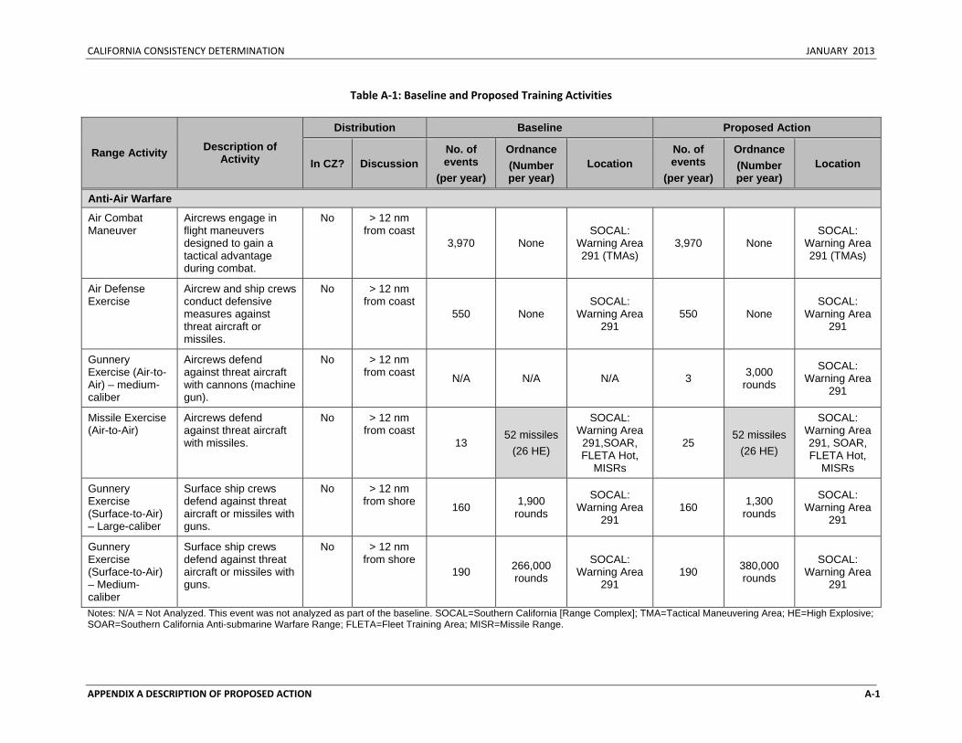
CALIFORNIA CONSISTENCY DETERMINATION JANUARY 2013
APPENDIX A DESCRIPTION OF PROPOSED ACTION A‐1
Table A‐1: Baseline and Proposed Training Activities
Range Activity Description of Activity
Distribution Baseline Proposed Action
In CZ? Discussion No. of events
(per year)
Ordnance (Number per year)
Location No. of events
(per year)
Ordnance (Number per year)
Location
Anti-Air Warfare
Air Combat Maneuver
Aircrews engage in flight maneuvers designed to gain a tactical advantage during combat.
No > 12 nm from coast
3,970 None SOCAL:
Warning Area 291 (TMAs)
3,970 None SOCAL:
Warning Area 291 (TMAs)
Air Defense Exercise
Aircrew and ship crews conduct defensive measures against threat aircraft or missiles.
No > 12 nm from coast
550 None SOCAL:
Warning Area 291
550 None SOCAL:
Warning Area 291
Gunnery Exercise (Air-to-Air) – medium-caliber
Aircrews defend against threat aircraft with cannons (machine gun).
No > 12 nm from coast N/A N/A N/A 3 3,000
rounds
SOCAL: Warning Area
291
Missile Exercise (Air-to-Air)
Aircrews defend against threat aircraft with missiles.
No > 12 nm from coast
13 52 missiles
(26 HE)
SOCAL: Warning Area 291,SOAR, FLETA Hot,
MISRs
25 52 missiles
(26 HE)
SOCAL: Warning Area 291, SOAR, FLETA Hot,
MISRs
Gunnery Exercise (Surface-to-Air) – Large-caliber
Surface ship crews defend against threat aircraft or missiles with guns.
No > 12 nm from shore 160 1,900
rounds
SOCAL: Warning Area
291 160 1,300
rounds
SOCAL: Warning Area
291
Gunnery Exercise (Surface-to-Air) – Medium-caliber
Surface ship crews defend against threat aircraft or missiles with guns.
No > 12 nm from shore
190 266,000 rounds
SOCAL: Warning Area
291 190 380,000
rounds
SOCAL: Warning Area
291
Notes: N/A = Not Analyzed. This event was not analyzed as part of the baseline. SOCAL=Southern California [Range Complex]; TMA=Tactical Maneuvering Area; HE=High Explosive; SOAR=Southern California Anti-submarine Warfare Range; FLETA=Fleet Training Area; MISR=Missile Range.
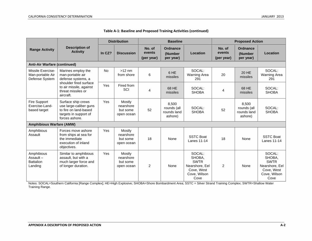
CALIFORNIA CONSISTENCY DETERMINATION JANUARY 2013
APPENDIX A DESCRIPTION OF PROPOSED ACTION A‐2
Table A‐1: Baseline and Proposed Training Activities (continued)
Range Activity Description of Activity
Distribution Baseline Proposed Action
In CZ? Discussion No. of events
(per year)
Ordnance (Number per year)
Location No. of events
(per year)
Ordnance (Number per year)
Location
Anti-Air Warfare (continued)
Missile Exercise-Man-portable Air Defense System
Marines employ the man-portable air defense systems, a shoulder fired surface to air missile, against threat missiles or aircraft.
No >12 nm from shore 6 6 HE
missiles
SOCAL: Warning Area
291 20 20 HE
missiles
SOCAL: Warning Area
291
Yes Fired from SCI 4 68 HE
missiles SOCAL: SHOBA 4 68 HE
missiles SOCAL: SHOBA
Fire Support Exercise-Land-based target
Surface ship crews use large-caliber guns to fire on land-based targets in support of forces ashore.
Yes Mostly nearshore but some
open ocean 52
8,500 rounds (all
rounds land ashore)
SOCAL: SHOBA 52
8,500 rounds (all
rounds land ashore)
SOCAL: SHOBA
Amphibious Warfare (AMW)
Amphibious Assault
Forces move ashore from ships at sea for the immediate execution of inland objectives.
Yes Mostly nearshore but some
open ocean 18 None SSTC Boat
Lanes 11-14 18 None SSTC Boat Lanes 11-14
Amphibious Assault – Battalion Landing
Similar to amphibious assault, but with a much larger force and of longer duration.
Yes Mostly nearshore but some
open ocean 2 None
SOCAL: SHOBA, SWTR
Nearshore, Eel Cove, West
Cove, Wilson Cove
2 None
SOCAL: SHOBA, SWTR
Nearshore, Eel Cove, West
Cove, Wilson Cove
Notes: SOCAL=Southern California [Range Complex]; HE=High Explosive; SHOBA=Shore Bombardment Area; SSTC = Silver Strand Training Complex; SWTR=Shallow Water Training Range.
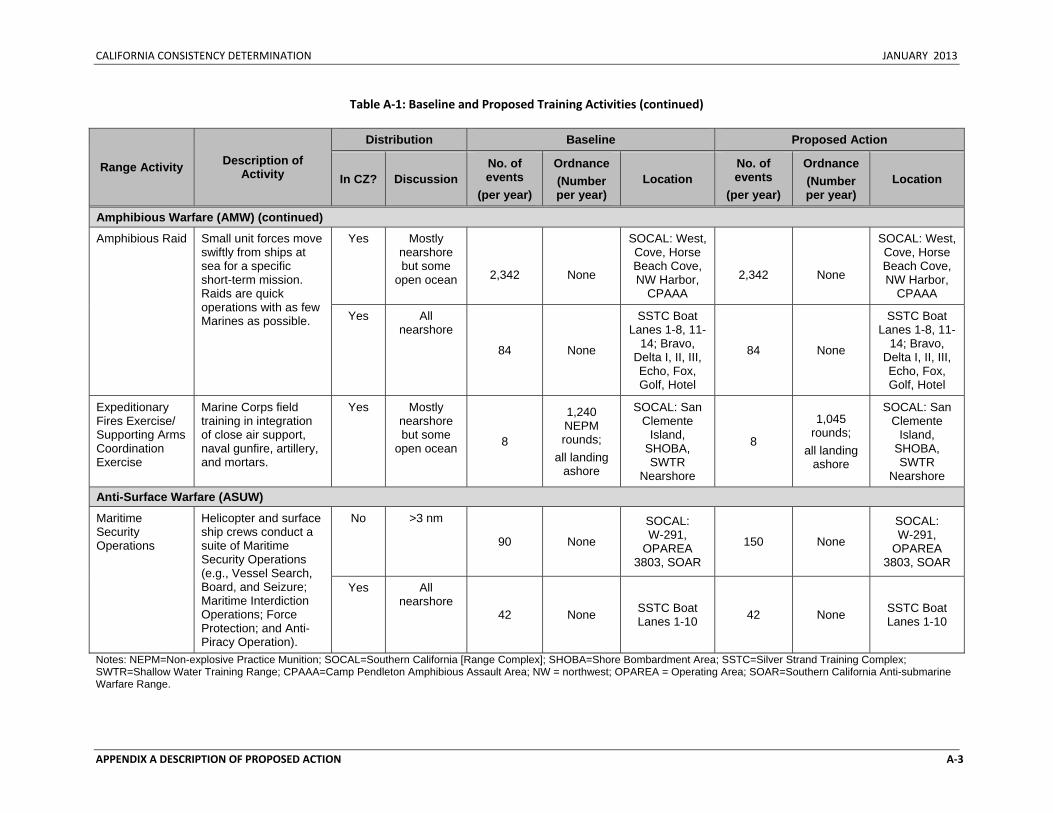
CALIFORNIA CONSISTENCY DETERMINATION JANUARY 2013
APPENDIX A DESCRIPTION OF PROPOSED ACTION A‐3
Table A‐1: Baseline and Proposed Training Activities (continued)
Range Activity Description of Activity
Distribution Baseline Proposed Action
In CZ? Discussion No. of events
(per year)
Ordnance (Number per year)
Location No. of events
(per year)
Ordnance (Number per year)
Location
Amphibious Warfare (AMW) (continued)
Amphibious Raid Small unit forces move swiftly from ships at sea for a specific short-term mission. Raids are quick operations with as few Marines as possible.
Yes Mostly nearshore but some
open ocean
2,342
None
SOCAL: West, Cove, Horse Beach Cove, NW Harbor,
CPAAA
2,342
None
SOCAL: West, Cove, Horse Beach Cove, NW Harbor,
CPAAA
Yes All nearshore
84 None
SSTC Boat Lanes 1-8, 11-
14; Bravo, Delta I, II, III, Echo, Fox, Golf, Hotel
84 None
SSTC Boat Lanes 1-8, 11-
14; Bravo, Delta I, II, III, Echo, Fox, Golf, Hotel
Expeditionary Fires Exercise/ Supporting Arms Coordination Exercise
Marine Corps field training in integration of close air support, naval gunfire, artillery, and mortars.
Yes Mostly nearshore but some
open ocean 8
1,240 NEPM rounds;
all landing ashore
SOCAL: San Clemente
Island, SHOBA, SWTR
Nearshore
8
1,045 rounds;
all landing ashore
SOCAL: San Clemente
Island, SHOBA, SWTR
Nearshore
Anti-Surface Warfare (ASUW)
Maritime Security Operations
Helicopter and surface ship crews conduct a suite of Maritime Security Operations (e.g., Vessel Search, Board, and Seizure; Maritime Interdiction Operations; Force Protection; and Anti-Piracy Operation).
No >3 nm
90 None
SOCAL: W-291,
OPAREA 3803, SOAR
150 None
SOCAL: W-291,
OPAREA 3803, SOAR
Yes All nearshore
42 None SSTC Boat Lanes 1-10 42 None SSTC Boat
Lanes 1-10
Notes: NEPM=Non-explosive Practice Munition; SOCAL=Southern California [Range Complex]; SHOBA=Shore Bombardment Area; SSTC=Silver Strand Training Complex; SWTR=Shallow Water Training Range; CPAAA=Camp Pendleton Amphibious Assault Area; NW = northwest; OPAREA = Operating Area; SOAR=Southern California Anti-submarine Warfare Range.
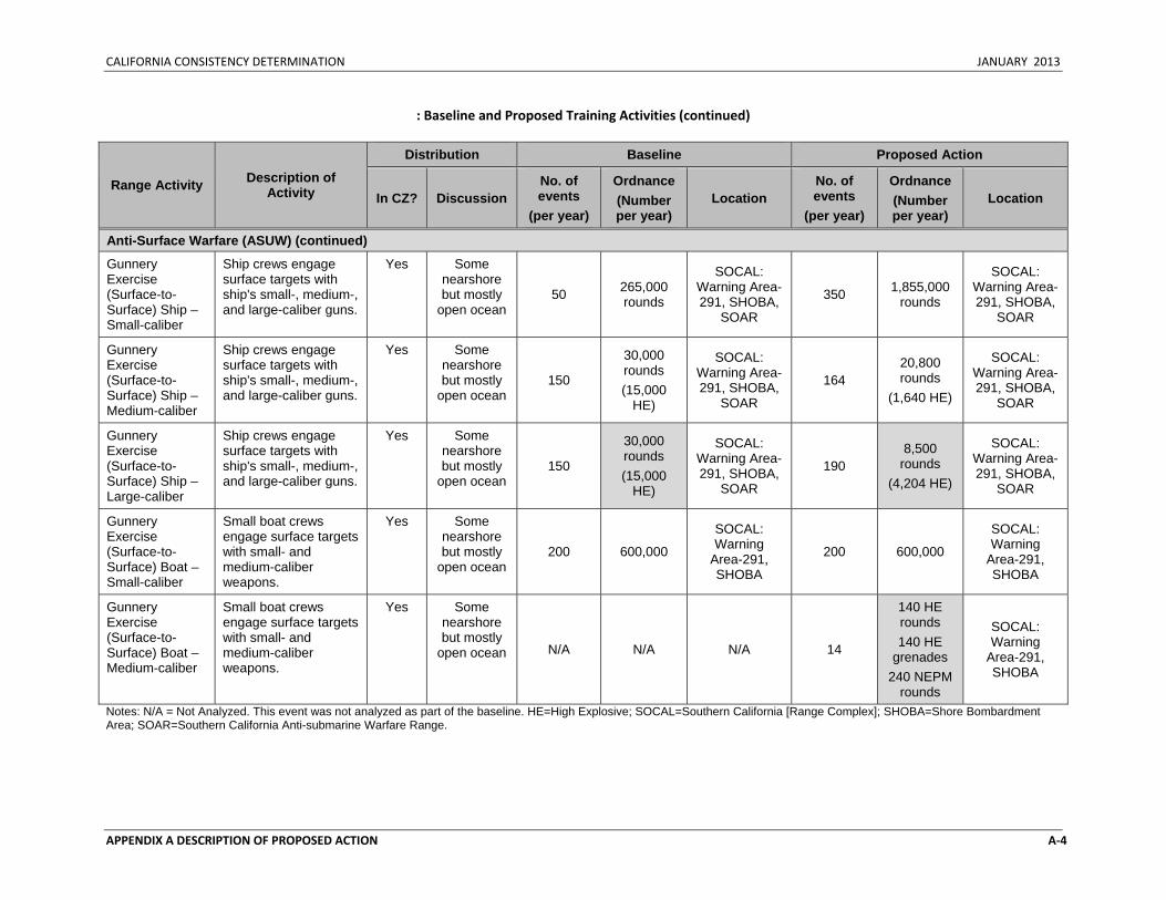
CALIFORNIA CONSISTENCY DETERMINATION JANUARY 2013
APPENDIX A DESCRIPTION OF PROPOSED ACTION A‐4
: Baseline and Proposed Training Activities (continued)
Range Activity Description of Activity
Distribution Baseline Proposed Action
In CZ? Discussion No. of events
(per year)
Ordnance (Number per year)
Location No. of events
(per year)
Ordnance (Number per year)
Location
Anti-Surface Warfare (ASUW) (continued)
Gunnery Exercise (Surface-to-Surface) Ship – Small-caliber
Ship crews engage surface targets with ship's small-, medium-, and large-caliber guns.
Yes Some nearshore but mostly
open ocean 50 265,000
rounds
SOCAL: Warning Area-291, SHOBA,
SOAR
350 1,855,000 rounds
SOCAL: Warning Area-291, SHOBA,
SOAR
Gunnery Exercise (Surface-to-Surface) Ship – Medium-caliber
Ship crews engage surface targets with ship's small-, medium-, and large-caliber guns.
Yes Some nearshore but mostly
open ocean 150
30,000 rounds (15,000
HE)
SOCAL: Warning Area-291, SHOBA,
SOAR
164 20,800 rounds
(1,640 HE)
SOCAL: Warning Area-291, SHOBA,
SOAR
Gunnery Exercise (Surface-to-Surface) Ship – Large-caliber
Ship crews engage surface targets with ship's small-, medium-, and large-caliber guns.
Yes Some nearshore but mostly
open ocean 150
30,000 rounds (15,000
HE)
SOCAL: Warning Area-291, SHOBA,
SOAR
190 8,500
rounds (4,204 HE)
SOCAL: Warning Area-291, SHOBA,
SOAR
Gunnery Exercise (Surface-to-Surface) Boat – Small-caliber
Small boat crews engage surface targets with small- and medium-caliber weapons.
Yes Some nearshore but mostly
open ocean 200 600,000
SOCAL: Warning
Area-291, SHOBA
200 600,000
SOCAL: Warning
Area-291, SHOBA
Gunnery Exercise (Surface-to-Surface) Boat – Medium-caliber
Small boat crews engage surface targets with small- and medium-caliber weapons.
Yes Some nearshore but mostly
open ocean N/A N/A N/A 14
140 HE rounds 140 HE
grenades 240 NEPM
rounds
SOCAL: Warning
Area-291, SHOBA
Notes: N/A = Not Analyzed. This event was not analyzed as part of the baseline. HE=High Explosive; SOCAL=Southern California [Range Complex]; SHOBA=Shore Bombardment Area; SOAR=Southern California Anti-submarine Warfare Range.
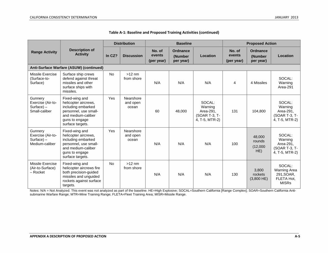
CALIFORNIA CONSISTENCY DETERMINATION JANUARY 2013
APPENDIX A DESCRIPTION OF PROPOSED ACTION A‐5
Table A‐1: Baseline and Proposed Training Activities (continued)
Range Activity Description of Activity
Distribution Baseline Proposed Action
In CZ? Discussion No. of events
(per year)
Ordnance (Number per year)
Location No. of events
(per year)
Ordnance (Number per year)
Location
Anti-Surface Warfare (ASUW) (continued)
Missile Exercise (Surface-to-Surface)
Surface ship crews defend against threat missiles and other surface ships with missiles.
No >12 nm from shore
N/A N/A N/A 4 4 Missiles SOCAL: Warning Area-291
Gunnery Exercise (Air-to-Surface) – Small-caliber
Fixed-wing and helicopter aircrews, including embarked personnel, use small- and medium-caliber guns to engage surface targets.
Yes Nearshore and open
ocean 60 48,000
SOCAL: Warning
Area-291, (SOAR T-3, T-4, T-5, MTR-2)
131 104,800
SOCAL: Warning
Area-291, (SOAR T-3, T-4, T-5, MTR-2)
Gunnery Exercise (Air-to-Surface) – Medium-caliber
Fixed-wing and helicopter aircrews, including embarked personnel, use small- and medium-caliber guns to engage surface targets.
Yes Nearshore and open
ocean N/A N/A N/A 100
48,000 rounds (12,000
HE)
SOCAL: Warning
Area-291, (SOAR T-3, T-4, T-5, MTR-2)
Missile Exercise (Air-to-Surface) – Rocket
Fixed-wing and helicopter aircrews fire both precision-guided missiles and unguided rockets against surface targets.
No >12 nm from shore
N/A N/A N/A 130 3,800
rockets (3,800 HE)
SOCAL: Warning Area 291,SOAR, FLETA Hot,
MISRs
Notes: N/A = Not Analyzed. This event was not analyzed as part of the baseline. HE=High Explosive; SOCAL=Southern California [Range Complex]; SOAR=Southern California Anti-submarine Warfare Range; MTR=Mine Training Range; FLETA=Fleet Training Area; MISR=Missile Range.
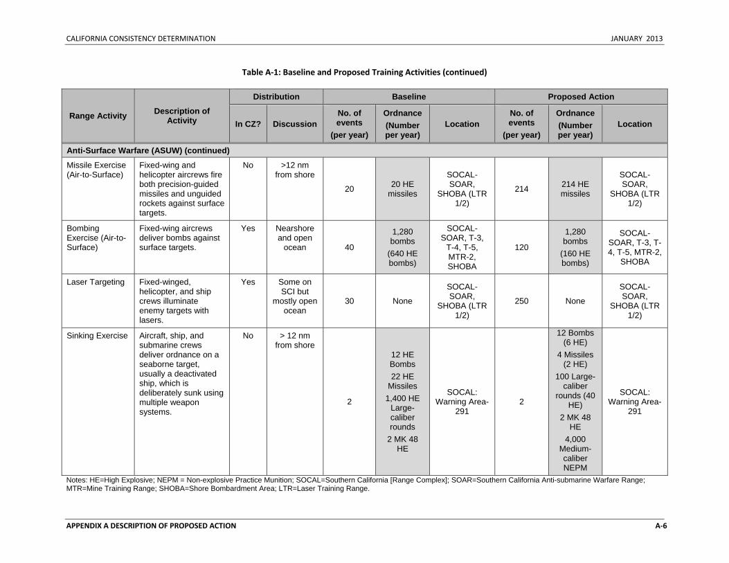
CALIFORNIA CONSISTENCY DETERMINATION JANUARY 2013
APPENDIX A DESCRIPTION OF PROPOSED ACTION A‐6
Table A‐1: Baseline and Proposed Training Activities (continued)
Range Activity Description of Activity
Distribution Baseline Proposed Action
In CZ? Discussion No. of events
(per year)
Ordnance (Number per year)
Location No. of events
(per year)
Ordnance (Number per year)
Location
Anti-Surface Warfare (ASUW) (continued)
Missile Exercise (Air-to-Surface)
Fixed-wing and helicopter aircrews fire both precision-guided missiles and unguided rockets against surface targets.
No >12 nm from shore
20 20 HE missiles
SOCAL-SOAR,
SHOBA (LTR 1/2)
214 214 HE missiles
SOCAL-SOAR,
SHOBA (LTR 1/2)
Bombing Exercise (Air-to-Surface)
Fixed-wing aircrews deliver bombs against surface targets.
Yes Nearshore and open
ocean 40
1,280 bombs
(640 HE bombs)
SOCAL-SOAR, T-3,
T-4, T-5, MTR-2, SHOBA
120
1,280 bombs
(160 HE bombs)
SOCAL-SOAR, T-3, T-4, T-5, MTR-2,
SHOBA
Laser Targeting Fixed-winged, helicopter, and ship crews illuminate enemy targets with lasers.
Yes Some on SCI but
mostly open ocean
30 None
SOCAL-SOAR,
SHOBA (LTR 1/2)
250 None
SOCAL-SOAR,
SHOBA (LTR 1/2)
Sinking Exercise Aircraft, ship, and submarine crews deliver ordnance on a seaborne target, usually a deactivated ship, which is deliberately sunk using multiple weapon systems.
No > 12 nm from shore
2
12 HE Bombs 22 HE
Missiles 1,400 HE
Large-caliber rounds
2 MK 48 HE
SOCAL: Warning Area-
291 2
12 Bombs (6 HE)
4 Missiles (2 HE)
100 Large-caliber
rounds (40 HE)
2 MK 48 HE
4,000 Medium-caliber NEPM
SOCAL: Warning Area-
291
Notes: HE=High Explosive; NEPM = Non-explosive Practice Munition; SOCAL=Southern California [Range Complex]; SOAR=Southern California Anti-submarine Warfare Range; MTR=Mine Training Range; SHOBA=Shore Bombardment Area; LTR=Laser Training Range.
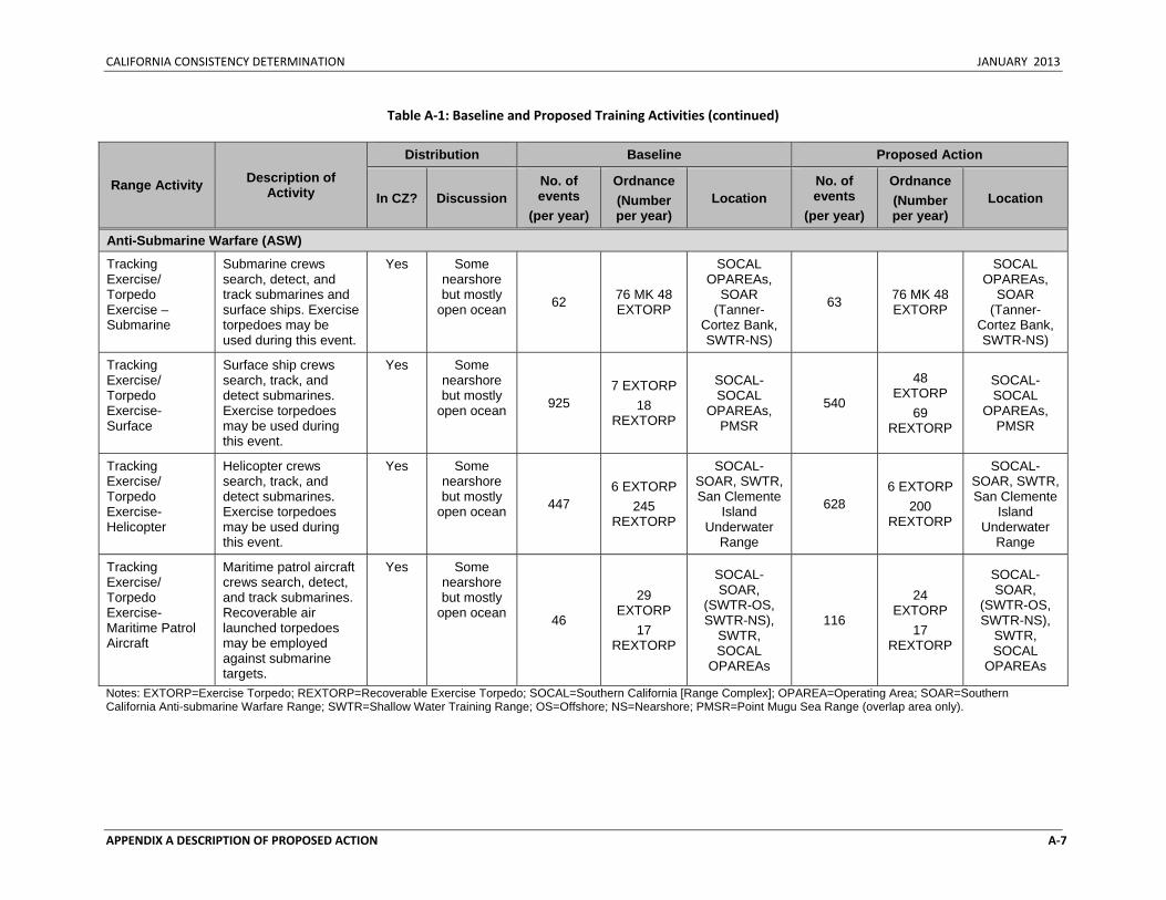
CALIFORNIA CONSISTENCY DETERMINATION JANUARY 2013
APPENDIX A DESCRIPTION OF PROPOSED ACTION A‐7
Table A‐1: Baseline and Proposed Training Activities (continued)
Range Activity Description of Activity
Distribution Baseline Proposed Action
In CZ? Discussion No. of events
(per year)
Ordnance (Number per year)
Location No. of events
(per year)
Ordnance (Number per year)
Location
Anti-Submarine Warfare (ASW)
Tracking Exercise/ Torpedo Exercise – Submarine
Submarine crews search, detect, and track submarines and surface ships. Exercise torpedoes may be used during this event.
Yes Some nearshore but mostly
open ocean 62 76 MK 48 EXTORP
SOCAL OPAREAs,
SOAR (Tanner-
Cortez Bank, SWTR-NS)
63 76 MK 48 EXTORP
SOCAL OPAREAs,
SOAR (Tanner-
Cortez Bank, SWTR-NS)
Tracking Exercise/ Torpedo Exercise-Surface
Surface ship crews search, track, and detect submarines. Exercise torpedoes may be used during this event.
Yes Some nearshore but mostly
open ocean 925 7 EXTORP
18 REXTORP
SOCAL-SOCAL
OPAREAs, PMSR
540
48 EXTORP
69 REXTORP
SOCAL-SOCAL
OPAREAs, PMSR
Tracking Exercise/ Torpedo Exercise-Helicopter
Helicopter crews search, track, and detect submarines. Exercise torpedoes may be used during this event.
Yes Some nearshore but mostly
open ocean 447 6 EXTORP
245 REXTORP
SOCAL-SOAR, SWTR, San Clemente
Island Underwater
Range
628 6 EXTORP
200 REXTORP
SOCAL-SOAR, SWTR, San Clemente
Island Underwater
Range
Tracking Exercise/ Torpedo Exercise-Maritime Patrol Aircraft
Maritime patrol aircraft crews search, detect, and track submarines. Recoverable air launched torpedoes may be employed against submarine targets.
Yes Some nearshore but mostly
open ocean 46
29 EXTORP
17 REXTORP
SOCAL-SOAR,
(SWTR-OS, SWTR-NS),
SWTR, SOCAL
OPAREAs
116
24 EXTORP
17 REXTORP
SOCAL-SOAR,
(SWTR-OS, SWTR-NS),
SWTR, SOCAL
OPAREAs
Notes: EXTORP=Exercise Torpedo; REXTORP=Recoverable Exercise Torpedo; SOCAL=Southern California [Range Complex]; OPAREA=Operating Area; SOAR=Southern California Anti-submarine Warfare Range; SWTR=Shallow Water Training Range; OS=Offshore; NS=Nearshore; PMSR=Point Mugu Sea Range (overlap area only).
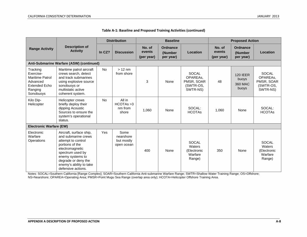
CALIFORNIA CONSISTENCY DETERMINATION JANUARY 2013
APPENDIX A DESCRIPTION OF PROPOSED ACTION A‐8
Table A‐1: Baseline and Proposed Training Activities (continued)
Range Activity Description of Activity
Distribution Baseline Proposed Action
In CZ? Discussion No. of events
(per year)
Ordnance (Number per year)
Location No. of events
(per year)
Ordnance (Number per year)
Location
Anti-Submarine Warfare (ASW) (continued)
Tracking Exercise-Maritime Patrol Advanced Extended Echo Ranging Sonobuoys
Maritime patrol aircraft crews search, detect and track submarines using explosive source sonobuoys or multistatic active coherent system.
No > 12 nm from shore
3 None
SOCAL OPAREAs,
PMSR, SOAR (SWTR-OS, SWTR-NS)
48
120 IEER buoys
360 MAC buoys
SOCAL OPAREAs,
PMSR, SOAR (SWTR-OS, SWTR-NS)
Kilo Dip-Helicopter
Helicopter crews briefly deploy their dipping Acoustic Sources to ensure the system’s operational status.
No All in HCOTAs >3
nm from shore 1,060 None SOCAL:
HCOTAs 1,060 None SOCAL: HCOTAs
Electronic Warfare (EW)
Electronic Warfare Operations
Aircraft, surface ship, and submarine crews attempt to control portions of the electromagnetic spectrum used by enemy systems to degrade or deny the enemy’s ability to take defensive actions.
Yes Some nearshore but mostly
open ocean
400 None
SOCAL Waters
(Electronic Warfare Range)
350 None
SOCAL Waters
(Electronic Warfare Range)
Notes: SOCAL=Southern California [Range Complex]; SOAR=Southern California Anti-submarine Warfare Range; SWTR=Shallow Water Training Range; OS=Offshore; NS=Nearshore; OPAREA=Operating Area; PMSR=Point Mugu Sea Range (overlap area only); HCOTA=Helicopter Offshore Training Area.
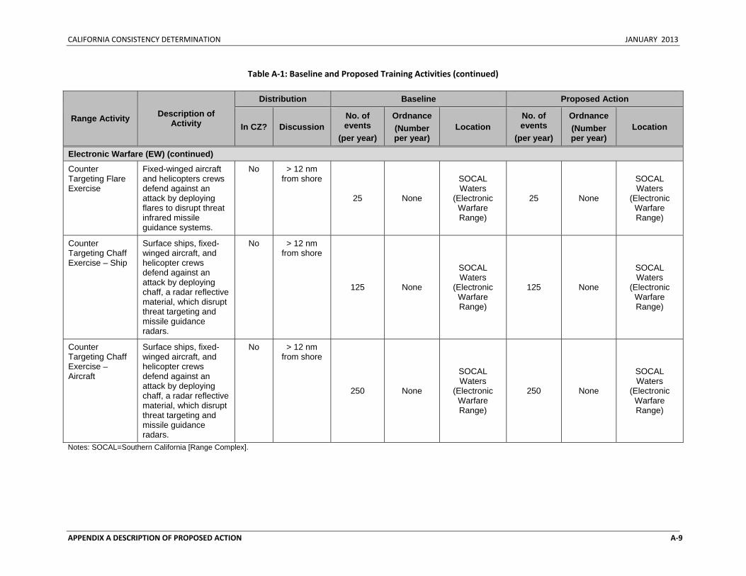
CALIFORNIA CONSISTENCY DETERMINATION JANUARY 2013
APPENDIX A DESCRIPTION OF PROPOSED ACTION A‐9
Table A‐1: Baseline and Proposed Training Activities (continued)
Range Activity Description of Activity
Distribution Baseline Proposed Action
In CZ? Discussion No. of events
(per year)
Ordnance (Number per year)
Location No. of events
(per year)
Ordnance (Number per year)
Location
Electronic Warfare (EW) (continued)
Counter Targeting Flare Exercise
Fixed-winged aircraft and helicopters crews defend against an attack by deploying flares to disrupt threat infrared missile guidance systems.
No > 12 nm from shore
25 None
SOCAL Waters
(Electronic Warfare Range)
25 None
SOCAL Waters
(Electronic Warfare Range)
Counter Targeting Chaff Exercise – Ship
Surface ships, fixed-winged aircraft, and helicopter crews defend against an attack by deploying chaff, a radar reflective material, which disrupt threat targeting and missile guidance radars.
No > 12 nm from shore
125 None
SOCAL Waters
(Electronic Warfare Range)
125 None
SOCAL Waters
(Electronic Warfare Range)
Counter Targeting Chaff Exercise – Aircraft
Surface ships, fixed-winged aircraft, and helicopter crews defend against an attack by deploying chaff, a radar reflective material, which disrupt threat targeting and missile guidance radars.
No > 12 nm from shore
250 None
SOCAL Waters
(Electronic Warfare Range)
250 None
SOCAL Waters
(Electronic Warfare Range)
Notes: SOCAL=Southern California [Range Complex].
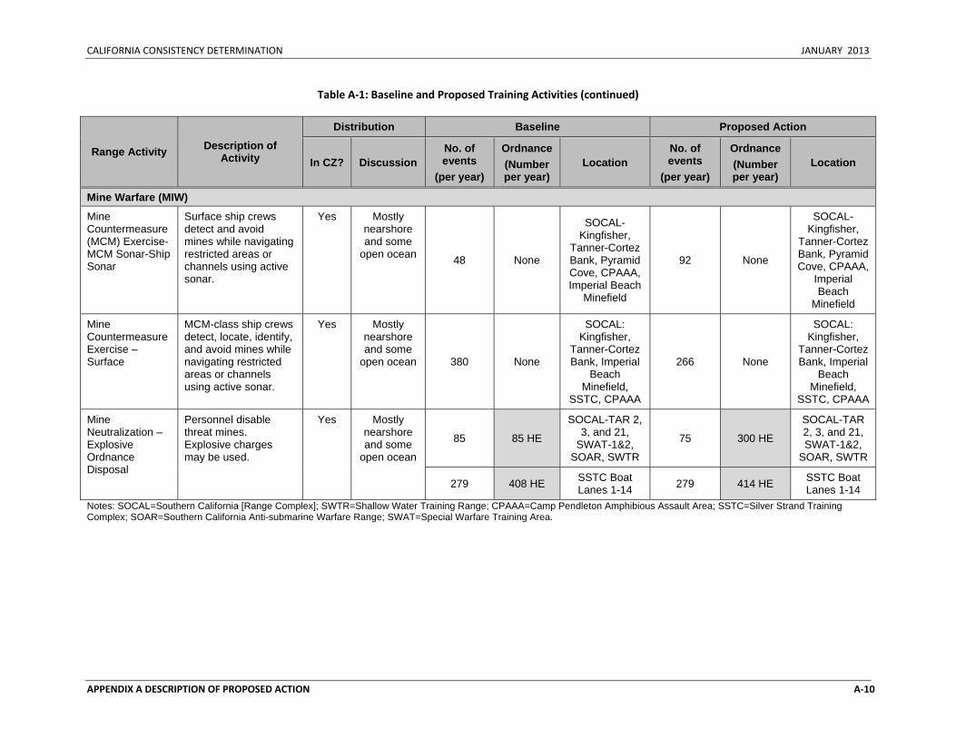
CALIFORNIA CONSISTENCY DETERMINATION JANUARY 2013
APPENDIX A DESCRIPTION OF PROPOSED ACTION A‐10
Table A‐1: Baseline and Proposed Training Activities (continued)
Range Activity Description of Activity
Distribution Baseline Proposed Action
In CZ? Discussion No. of events
(per year)
Ordnance (Number per year)
Location No. of events
(per year)
Ordnance (Number per year)
Location
Mine Warfare (MIW)
Mine Countermeasure(MCM) Exercise-MCM Sonar-Ship Sonar
Surface ship crews detect and avoid mines while navigating restricted areas or channels using active sonar.
Yes Mostly nearshore and some
open ocean 48 None
SOCAL-Kingfisher,
Tanner-Cortez Bank, Pyramid Cove, CPAAA, Imperial Beach
Minefield
92 None
SOCAL-Kingfisher,
Tanner-Cortez Bank, Pyramid Cove, CPAAA,
Imperial Beach
Minefield
Mine Countermeasure Exercise – Surface
MCM-class ship crews detect, locate, identify, and avoid mines while navigating restricted areas or channels using active sonar.
Yes Mostly nearshore and some
open ocean 380 None
SOCAL: Kingfisher,
Tanner-Cortez Bank, Imperial
Beach Minefield,
SSTC, CPAAA
266 None
SOCAL: Kingfisher,
Tanner-Cortez Bank, Imperial
Beach Minefield,
SSTC, CPAAA
Mine Neutralization – Explosive Ordnance Disposal
Personnel disable threat mines. Explosive charges may be used.
Yes Mostly nearshore and some
open ocean
85 85 HE
SOCAL-TAR 2, 3, and 21,
SWAT-1&2, SOAR, SWTR
75 300 HE
SOCAL-TAR 2, 3, and 21, SWAT-1&2,
SOAR, SWTR
279 408 HE SSTC Boat Lanes 1-14 279 414 HE SSTC Boat
Lanes 1-14 Notes: SOCAL=Southern California [Range Complex]; SWTR=Shallow Water Training Range; CPAAA=Camp Pendleton Amphibious Assault Area; SSTC=Silver Strand Training Complex; SOAR=Southern California Anti-submarine Warfare Range; SWAT=Special Warfare Training Area.
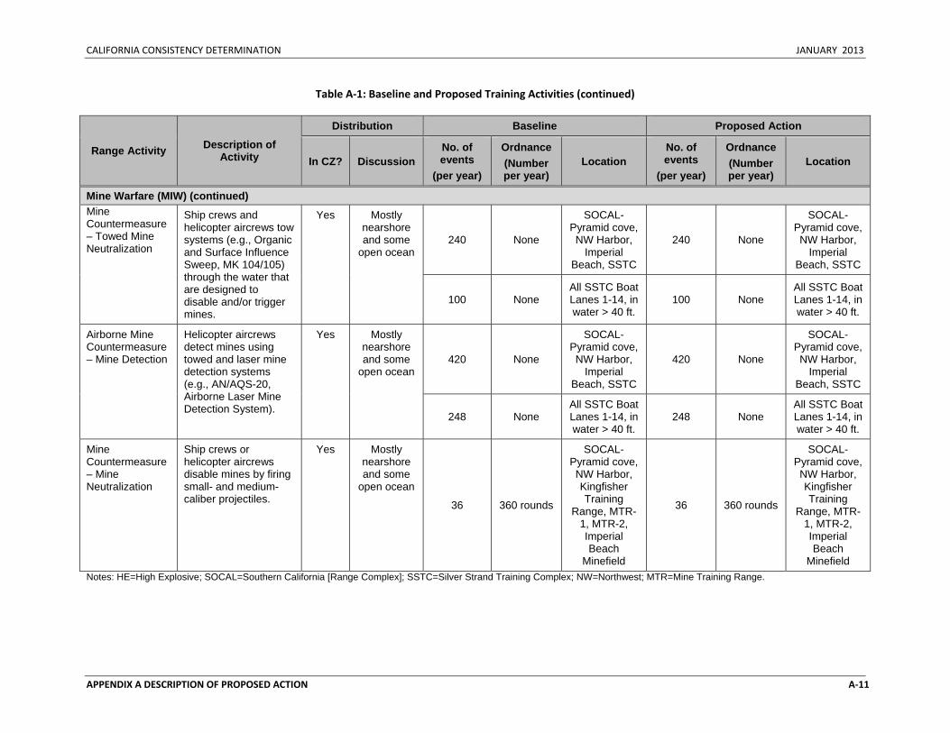
CALIFORNIA CONSISTENCY DETERMINATION JANUARY 2013
APPENDIX A DESCRIPTION OF PROPOSED ACTION A‐11
Table A‐1: Baseline and Proposed Training Activities (continued)
Range Activity Description of Activity
Distribution Baseline Proposed Action
In CZ? Discussion No. of events
(per year)
Ordnance (Number per year)
Location No. of events
(per year)
Ordnance (Number per year)
Location
Mine Warfare (MIW) (continued) Mine Countermeasure – Towed Mine Neutralization
Ship crews and helicopter aircrews tow systems (e.g., Organic and Surface Influence Sweep, MK 104/105) through the water that are designed to disable and/or trigger mines.
Yes Mostly nearshore and some
open ocean 240 None
SOCAL-Pyramid cove, NW Harbor,
Imperial Beach, SSTC
240 None
SOCAL-Pyramid cove, NW Harbor,
Imperial Beach, SSTC
100 None All SSTC Boat Lanes 1-14, in water > 40 ft.
100 None All SSTC Boat Lanes 1-14, in water > 40 ft.
Airborne Mine Countermeasure– Mine Detection
Helicopter aircrews detect mines using towed and laser mine detection systems (e.g., AN/AQS-20, Airborne Laser Mine Detection System).
Yes Mostly nearshore and some
open ocean 420 None
SOCAL-Pyramid cove, NW Harbor,
Imperial Beach, SSTC
420 None
SOCAL-Pyramid cove, NW Harbor,
Imperial Beach, SSTC
248 None All SSTC Boat Lanes 1-14, in water > 40 ft.
248 None All SSTC Boat Lanes 1-14, in water > 40 ft.
Mine Countermeasure – Mine Neutralization
Ship crews or helicopter aircrews disable mines by firing small- and medium-caliber projectiles.
Yes Mostly nearshore and some
open ocean
36 360 rounds
SOCAL-Pyramid cove, NW Harbor, Kingfisher Training
Range, MTR-1, MTR-2, Imperial Beach
Minefield
36 360 rounds
SOCAL-Pyramid cove, NW Harbor, Kingfisher Training
Range, MTR-1, MTR-2, Imperial Beach
Minefield Notes: HE=High Explosive; SOCAL=Southern California [Range Complex]; SSTC=Silver Strand Training Complex; NW=Northwest; MTR=Mine Training Range.
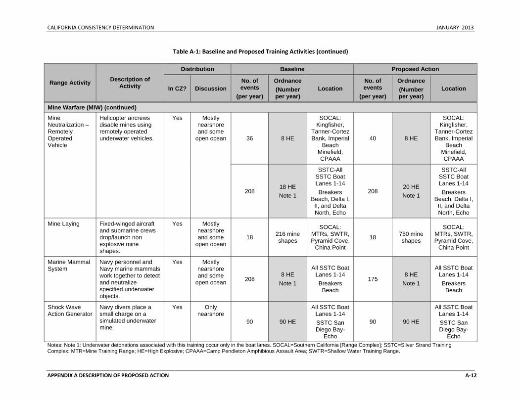
CALIFORNIA CONSISTENCY DETERMINATION JANUARY 2013
APPENDIX A DESCRIPTION OF PROPOSED ACTION A‐12
Table A‐1: Baseline and Proposed Training Activities (continued)
Range Activity Description of Activity
Distribution Baseline Proposed Action
In CZ? Discussion No. of events
(per year)
Ordnance (Number per year)
Location No. of events
(per year)
Ordnance (Number per year)
Location
Mine Warfare (MIW) (continued)
Mine Neutralization – Remotely Operated Vehicle
Helicopter aircrews disable mines using remotely operated underwater vehicles.
Yes Mostly nearshore and some
open ocean 36 8 HE
SOCAL: Kingfisher,
Tanner-Cortez Bank, Imperial
Beach Minefield, CPAAA
40 8 HE
SOCAL: Kingfisher,
Tanner-Cortez Bank, Imperial
Beach Minefield, CPAAA
208 18 HE Note 1
SSTC-All SSTC Boat Lanes 1-14 Breakers
Beach, Delta I, II, and Delta North, Echo
208 20 HE Note 1
SSTC-All SSTC Boat Lanes 1-14 Breakers
Beach, Delta I, II, and Delta North, Echo
Mine Laying Fixed-winged aircraft and submarine crews drop/launch non explosive mine shapes.
Yes Mostly nearshore and some
open ocean 18 216 mine
shapes
SOCAL: MTRs, SWTR, Pyramid Cove,
China Point
18 750 mine shapes
SOCAL: MTRs, SWTR, Pyramid Cove,
China Point
Marine Mammal System
Navy personnel and Navy marine mammals work together to detect and neutralize specified underwater objects.
Yes Mostly nearshore and some
open ocean 208 8 HE
Note 1
All SSTC Boat Lanes 1-14 Breakers
Beach
175 8 HE
Note 1
All SSTC Boat Lanes 1-14 Breakers
Beach
Shock Wave Action Generator
Navy divers place a small charge on a simulated underwater mine.
Yes Only nearshore
90 90 HE
All SSTC Boat Lanes 1-14 SSTC San Diego Bay-
Echo
90 90 HE
All SSTC Boat Lanes 1-14 SSTC San Diego Bay-
Echo Notes: Note 1: Underwater detonations associated with this training occur only in the boat lanes. SOCAL=Southern California [Range Complex]; SSTC=Silver Strand Training Complex; MTR=Mine Training Range; HE=High Explosive; CPAAA=Camp Pendleton Amphibious Assault Area; SWTR=Shallow Water Training Range.
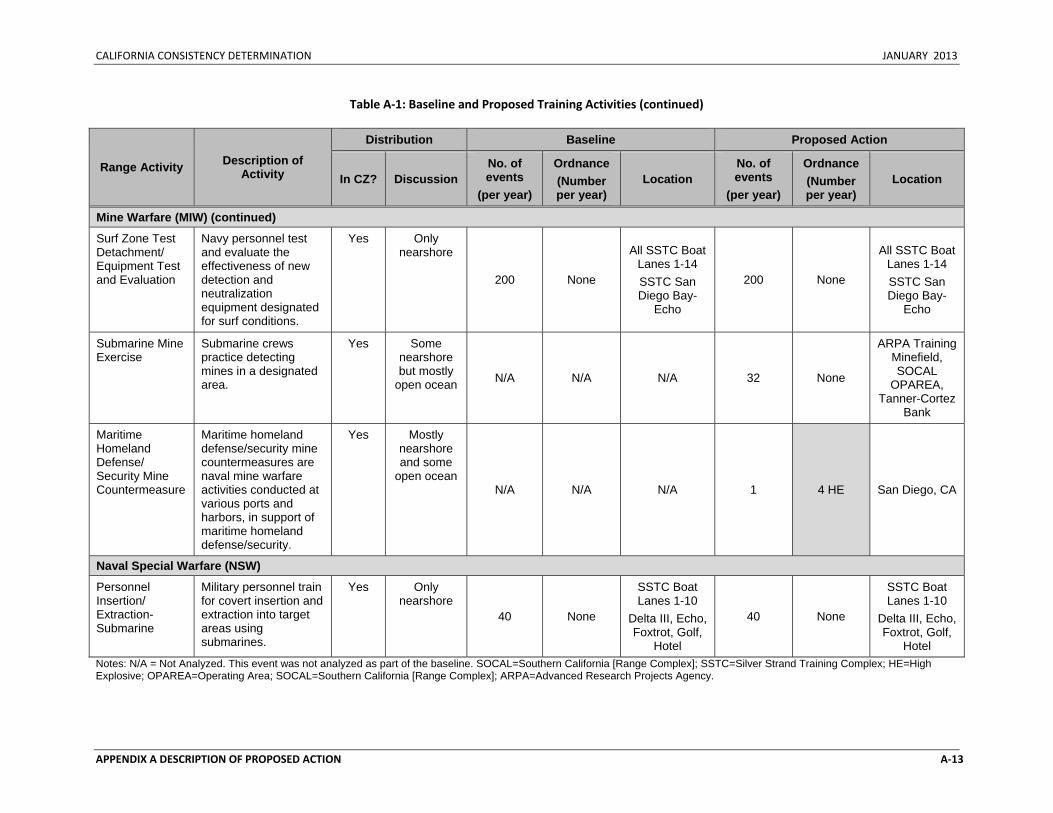
CALIFORNIA CONSISTENCY DETERMINATION JANUARY 2013
APPENDIX A DESCRIPTION OF PROPOSED ACTION A‐13
Table A‐1: Baseline and Proposed Training Activities (continued)
Range Activity Description of Activity
Distribution Baseline Proposed Action
In CZ? Discussion No. of events
(per year)
Ordnance (Number per year)
Location No. of events
(per year)
Ordnance (Number per year)
Location
Mine Warfare (MIW) (continued)
Surf Zone Test Detachment/ Equipment Test and Evaluation
Navy personnel test and evaluate the effectiveness of new detection and neutralization equipment designated for surf conditions.
Yes Only nearshore
200 None
All SSTC Boat Lanes 1-14 SSTC San Diego Bay-
Echo
200 None
All SSTC Boat Lanes 1-14 SSTC San Diego Bay-
Echo
Submarine Mine Exercise
Submarine crews practice detecting mines in a designated area.
Yes Some nearshore but mostly
open ocean N/A N/A N/A 32 None
ARPA Training Minefield, SOCAL
OPAREA, Tanner-Cortez
Bank
Maritime Homeland Defense/ Security Mine Countermeasure
Maritime homeland defense/security mine countermeasures are naval mine warfare activities conducted at various ports and harbors, in support of maritime homeland defense/security.
Yes Mostly nearshore and some
open ocean N/A N/A N/A 1 4 HE San Diego, CA
Naval Special Warfare (NSW)
Personnel Insertion/ Extraction-Submarine
Military personnel train for covert insertion and extraction into target areas using submarines.
Yes Only nearshore
40 None
SSTC Boat Lanes 1-10
Delta III, Echo, Foxtrot, Golf,
Hotel
40 None
SSTC Boat Lanes 1-10
Delta III, Echo, Foxtrot, Golf,
Hotel Notes: N/A = Not Analyzed. This event was not analyzed as part of the baseline. SOCAL=Southern California [Range Complex]; SSTC=Silver Strand Training Complex; HE=High Explosive; OPAREA=Operating Area; SOCAL=Southern California [Range Complex]; ARPA=Advanced Research Projects Agency.
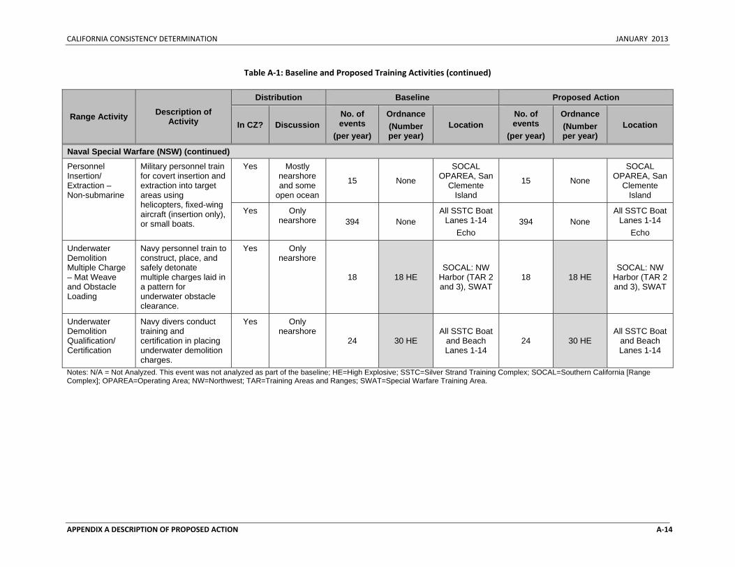
CALIFORNIA CONSISTENCY DETERMINATION JANUARY 2013
APPENDIX A DESCRIPTION OF PROPOSED ACTION A‐14
Table A‐1: Baseline and Proposed Training Activities (continued)
Range Activity Description of Activity
Distribution Baseline Proposed Action
In CZ? Discussion No. of events
(per year)
Ordnance (Number per year)
Location No. of events
(per year)
Ordnance (Number per year)
Location
Naval Special Warfare (NSW) (continued)
Personnel Insertion/ Extraction – Non-submarine
Military personnel train for covert insertion and extraction into target areas using helicopters, fixed-wing aircraft (insertion only), or small boats.
Yes Mostly nearshore and some
open ocean
15 None
SOCAL OPAREA, San
Clemente Island
15 None
SOCAL OPAREA, San
Clemente Island
Yes Only nearshore 394 None
All SSTC Boat Lanes 1-14
Echo 394 None
All SSTC Boat Lanes 1-14
Echo
Underwater Demolition Multiple Charge – Mat Weave and Obstacle Loading
Navy personnel train to construct, place, and safely detonate multiple charges laid in a pattern for underwater obstacle clearance.
Yes Only nearshore
18 18 HE SOCAL: NW
Harbor (TAR 2 and 3), SWAT
18 18 HE SOCAL: NW
Harbor (TAR 2 and 3), SWAT
Underwater Demolition Qualification/ Certification
Navy divers conduct training and certification in placing underwater demolition charges.
Yes Only nearshore
24 30 HE All SSTC Boat
and Beach Lanes 1-14
24 30 HE All SSTC Boat
and Beach Lanes 1-14
Notes: N/A = Not Analyzed. This event was not analyzed as part of the baseline; HE=High Explosive; SSTC=Silver Strand Training Complex; SOCAL=Southern California [Range Complex]; OPAREA=Operating Area; NW=Northwest; TAR=Training Areas and Ranges; SWAT=Special Warfare Training Area.
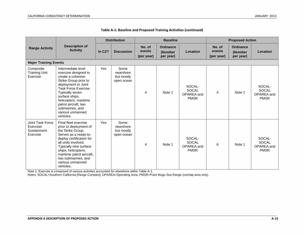
CALIFORNIA CONSISTENCY DETERMINATION JANUARY 2013
APPENDIX A DESCRIPTION OF PROPOSED ACTION A‐15
Table A‐1: Baseline and Proposed Training Activities (continued)
Range Activity Description of Activity
Distribution Baseline Proposed Action
In CZ? Discussion No. of events
(per year)
Ordnance (Number per year)
Location No. of events
(per year)
Ordnance (Number per year)
Location
Major Training Events
Composite Training Unit Exercise
Intermediate level exercise designed to create a cohesive Strike Group prior to deployment or Joint Task Force Exercise. Typically seven surface ships, helicopters, maritime patrol aircraft, two submarines, and various unmanned vehicles.
Yes Some nearshore but mostly
open ocean
4 Note 1
SOCAL-SOCAL
OPAREA and PMSR
4 Note 1
SOCAL-SOCAL
OPAREA and PMSR
Joint Task Force Exercise/ Sustainment Exercise
Final fleet exercise prior to deployment of the Strike Group. Serves as a ready-to-deploy certification for all units involved. Typically nine surface ships, helicopters, maritime patrol aircraft, two submarines, and various unmanned vehicles.
Yes Some nearshore but mostly
open ocean
4 Note 1
SOCAL-SOCAL
OPAREA and PMSR
6 Note 1
SOCAL-SOCAL
OPAREA and PMSR
Note 1: Exercise is comprised of various activities accounted for elsewhere within Table A-1. Notes: SOCAL=Southern California [Range Complex]; OPAREA=Operating Area; PMSR=Point Mugu Sea Range (overlap area only).
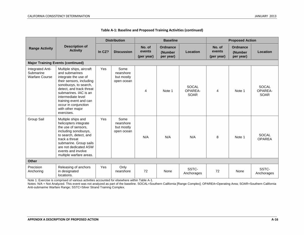
CALIFORNIA CONSISTENCY DETERMINATION JANUARY 2013
APPENDIX A DESCRIPTION OF PROPOSED ACTION A‐16
Table A‐1: Baseline and Proposed Training Activities (continued)
Range Activity Description of Activity
Distribution Baseline Proposed Action
In CZ? Discussion No. of events
(per year)
Ordnance (Number per year)
Location No. of events
(per year)
Ordnance (Number per year)
Location
Major Training Events (continued)
Integrated Anti-Submarine Warfare Course
Multiple ships, aircraft and submarines integrate the use of their sensors, including sonobuoys, to search, detect, and track threat submarines. IAC is an intermediate level training event and can occur in conjunction with other major exercises.
Yes Some nearshore but mostly
open ocean
4 Note 1 SOCAL
OPAREA-SOAR
4 Note 1 SOCAL
OPAREA-SOAR
Group Sail Multiple ships and helicopters integrate the use of sensors, including sonobuoys, to search, detect, and track a threat submarine. Group sails are not dedicated ASW events and involve multiple warfare areas.
Yes Some nearshore but mostly
open ocean
N/A N/A N/A 8 Note 1 SOCAL OPAREA
Other
Precision Anchoring
Releasing of anchors in designated locations.
Yes Only nearshore 72 None SSTC-
Anchorages 72 None SSTC-Anchorages
Note 1: Exercise is comprised of various activities accounted for elsewhere within Table A-1. Notes: N/A = Not Analyzed. This event was not analyzed as part of the baseline. SOCAL=Southern California [Range Complex]; OPAREA=Operating Area; SOAR=Southern California Anti-submarine Warfare Range; SSTC=Silver Strand Training Complex.
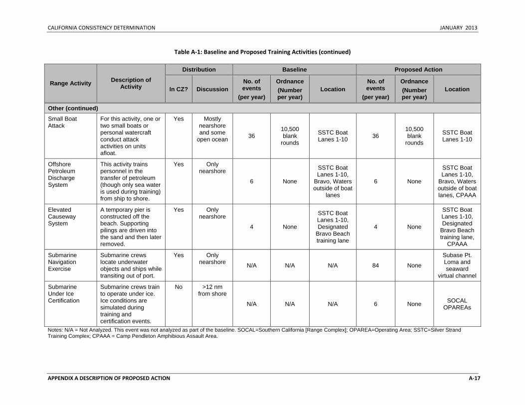
CALIFORNIA CONSISTENCY DETERMINATION JANUARY 2013
APPENDIX A DESCRIPTION OF PROPOSED ACTION A‐17
Table A‐1: Baseline and Proposed Training Activities (continued)
Range Activity Description of Activity
Distribution Baseline Proposed Action
In CZ? Discussion No. of events
(per year)
Ordnance (Number per year)
Location No. of events
(per year)
Ordnance (Number per year)
Location
Other (continued)
Small Boat Attack
For this activity, one or two small boats or personal watercraft conduct attack activities on units afloat.
Yes Mostly nearshore and some
open ocean 36 10,500 blank
rounds
SSTC Boat Lanes 1-10 36
10,500 blank
rounds
SSTC Boat Lanes 1-10
Offshore Petroleum Discharge System
This activity trains personnel in the transfer of petroleum (though only sea water is used during training) from ship to shore.
Yes Only nearshore
6 None
SSTC Boat Lanes 1-10,
Bravo, Waters outside of boat
lanes
6 None
SSTC Boat Lanes 1-10,
Bravo, Waters outside of boat lanes, CPAAA
Elevated Causeway System
A temporary pier is constructed off the beach. Supporting pilings are driven into the sand and then later removed.
Yes Only nearshore
4 None
SSTC Boat Lanes 1-10, Designated
Bravo Beach training lane
4 None
SSTC Boat Lanes 1-10, Designated
Bravo Beach training lane,
CPAAA
Submarine Navigation Exercise
Submarine crews locate underwater objects and ships while transiting out of port.
Yes Only nearshore N/A N/A N/A 84 None
Subase Pt. Loma and seaward
virtual channel
Submarine Under Ice Certification
Submarine crews train to operate under ice. Ice conditions are simulated during training and certification events.
No >12 nm from shore
N/A N/A N/A 6 None SOCAL OPAREAs
Notes: N/A = Not Analyzed. This event was not analyzed as part of the baseline. SOCAL=Southern California [Range Complex]; OPAREA=Operating Area; SSTC=Silver Strand Training Complex; CPAAA = Camp Pendleton Amphibious Assault Area.
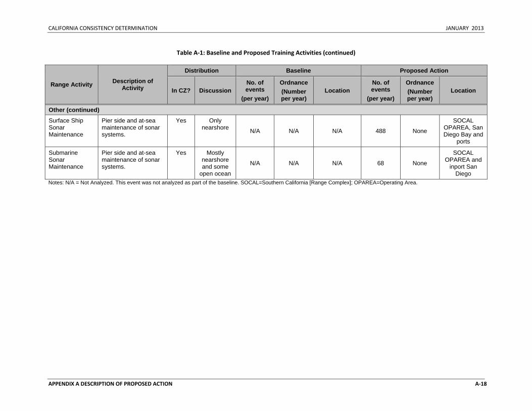
CALIFORNIA CONSISTENCY DETERMINATION JANUARY 2013
APPENDIX A DESCRIPTION OF PROPOSED ACTION A‐18
Table A‐1: Baseline and Proposed Training Activities (continued)
Range Activity Description of Activity
Distribution Baseline Proposed Action
In CZ? Discussion No. of events
(per year)
Ordnance (Number per year)
Location No. of events
(per year)
Ordnance (Number per year)
Location
Other (continued)
Surface Ship Sonar Maintenance
Pier side and at-sea maintenance of sonar systems.
Yes Only nearshore N/A N/A N/A 488 None
SOCAL OPAREA, San Diego Bay and
ports
Submarine Sonar Maintenance
Pier side and at-sea maintenance of sonar systems.
Yes Mostly nearshore and some
open ocean
N/A N/A N/A 68 None
SOCAL OPAREA and
inport San Diego
Notes: N/A = Not Analyzed. This event was not analyzed as part of the baseline. SOCAL=Southern California [Range Complex]; OPAREA=Operating Area.
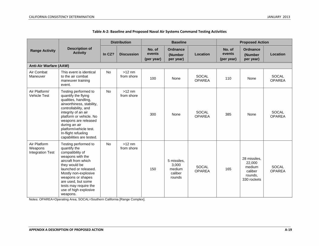
CALIFORNIA CONSISTENCY DETERMINATION JANUARY 2013
APPENDIX A DESCRIPTION OF PROPOSED ACTION A‐19
Table A‐2: Baseline and Proposed Naval Air Systems Command Testing Activities
Range Activity Description of Activity
Distribution Baseline Proposed Action
In CZ? Discussion No. of events
(per year)
Ordnance (Number per year)
Location No. of events
(per year)
Ordnance (Number per year)
Location
Anti-Air Warfare (AAW)
Air Combat Maneuver
This event is identical to the air combat maneuver training event.
No >12 nm from shore 100 None SOCAL
OPAREA 110 None SOCAL OPAREA
Air Platform/ Vehicle Test
Testing performed to quantify the flying qualities, handling, airworthiness, stability, controllability, and integrity of an air platform or vehicle. No weapons are released during an air platform/vehicle test. In-flight refueling capabilities are tested.
No >12 nm from shore
300 None SOCAL OPAREA 385 None SOCAL
OPAREA
Air Platform Weapons Integration Test
Testing performed to quantify the compatibility of weapons with the aircraft from which they would be launched or released. Mostly non-explosive weapons or shapes are used, but some tests may require the use of high explosive weapons.
No >12 nm from shore
150
5 missiles, 3,000
medium caliber rounds
SOCAL OPAREA 165
28 missiles, 22,000 medium caliber rounds,
330 rockets
SOCAL OPAREA
Notes: OPAREA=Operating Area; SOCAL=Southern California [Range Complex].
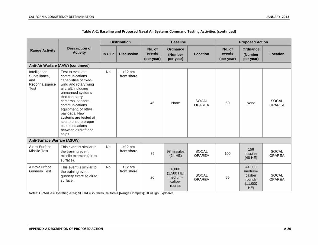
CALIFORNIA CONSISTENCY DETERMINATION JANUARY 2013
APPENDIX A DESCRIPTION OF PROPOSED ACTION A‐20
Table A‐2: Baseline and Proposed Naval Air Systems Command Testing Activities (continued)
Range Activity Description of Activity
Distribution Baseline Proposed Action
In CZ? Discussion No. of events
(per year)
Ordnance (Number per year)
Location No. of events
(per year)
Ordnance (Number per year)
Location
Anti-Air Warfare (AAW) (continued)
Intelligence, Surveillance, and Reconnaissance Test
Test to evaluate communications capabilities of fixed-wing and rotary wing aircraft, including unmanned systems that can carry cameras, sensors, communications equipment, or other payloads. New systems are tested at sea to ensure proper communications between aircraft and ships.
No >12 nm from shore
45 None SOCAL OPAREA 50 None SOCAL
OPAREA
Anti-Surface Warfare (ASUW)
Air-to-Surface Missile Test
This event is similar to the training event missile exercise (air-to-surface).
No >12 nm from shore
89 98 missiles (24 HE)
SOCAL OPAREA 100
156 missiles (48 HE)
SOCAL OPAREA
Air-to-Surface Gunnery Test
This event is similar to the training event gunnery exercise air to surface.
No >12 nm from shore
20
6,000 (1,500 HE) medium- caliber rounds
SOCAL OPAREA 55
44,000 medium- caliber rounds (11,000
HE)
SOCAL OPAREA
Notes: OPAREA=Operating Area; SOCAL=Southern California [Range Complex]; HE=High Explosive.
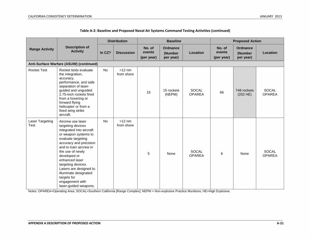
CALIFORNIA CONSISTENCY DETERMINATION JANUARY 2013
APPENDIX A DESCRIPTION OF PROPOSED ACTION A‐21
Table A‐2: Baseline and Proposed Naval Air Systems Command Testing Activities (continued)
Range Activity Description of Activity
Distribution Baseline Proposed Action
In CZ? Discussion No. of events
(per year)
Ordnance (Number per year)
Location No. of events
(per year)
Ordnance (Number per year)
Location
Anti-Surface Warfare (ASUW) (continued)
Rocket Test Rocket tests evaluate the integration, accuracy, performance, and safe separation of laser-guided and unguided 2.75-inch rockets fired from a hovering or forward flying helicopter or from a fixed wing strike aircraft.
No >12 nm from shore
15 15 rockets (NEPM)
SOCAL OPAREA 66 748 rockets
(202 HE) SOCAL
OPAREA
Laser Targeting Test
Aircrew use laser targeting devices integrated into aircraft or weapon systems to evaluate targeting accuracy and precision and to train aircrew in the use of newly developed or enhanced laser targeting devices. Lasers are designed to illuminate designated targets for engagement with laser-guided weapons.
No >12 nm from shore
5 None SOCAL OPAREA 6 None SOCAL
OPAREA
Notes: OPAREA=Operating Area; SOCAL=Southern California [Range Complex]; NEPM = Non-explosive Practice Munitions; HE=High Explosive.
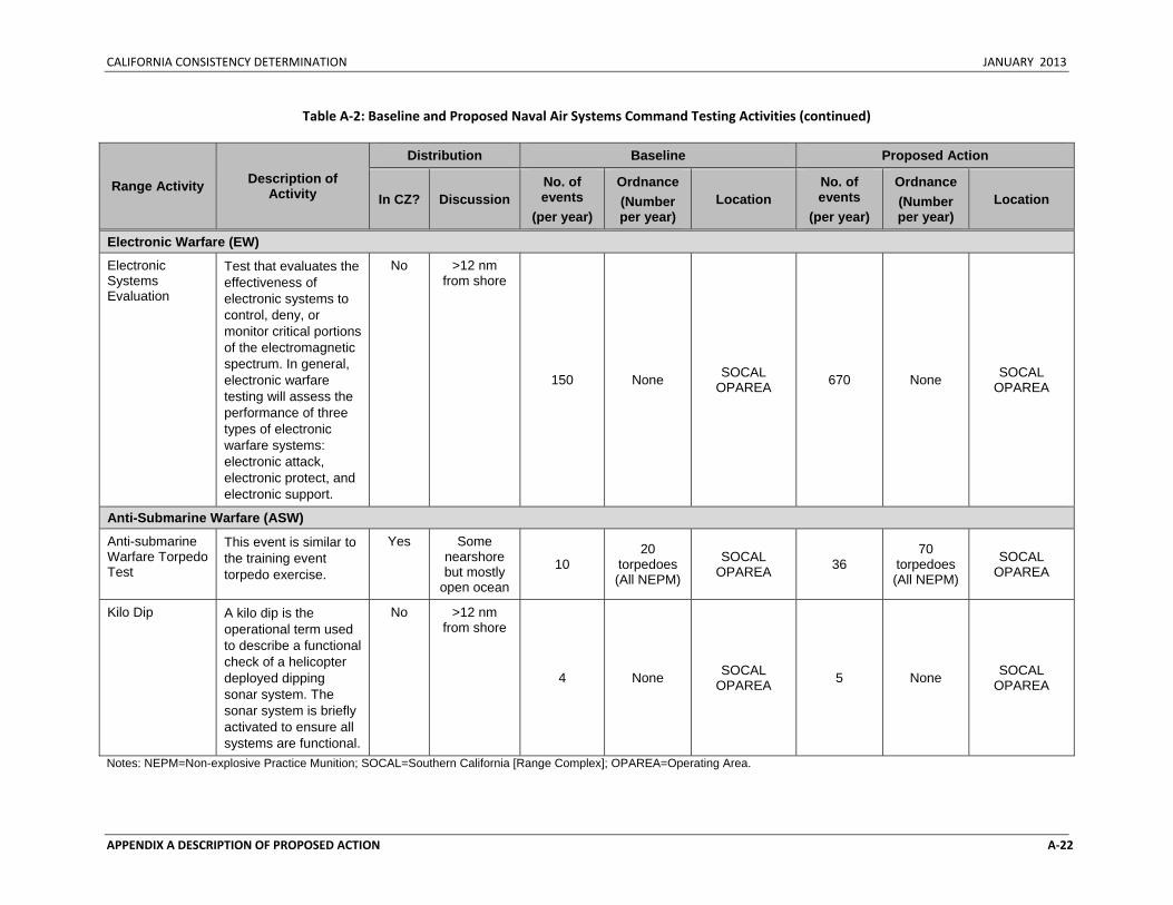
CALIFORNIA CONSISTENCY DETERMINATION JANUARY 2013
APPENDIX A DESCRIPTION OF PROPOSED ACTION A‐22
Table A‐2: Baseline and Proposed Naval Air Systems Command Testing Activities (continued)
Range Activity Description of Activity
Distribution Baseline Proposed Action
In CZ? Discussion No. of events
(per year)
Ordnance (Number per year)
Location No. of events
(per year)
Ordnance (Number per year)
Location
Electronic Warfare (EW)
Electronic Systems Evaluation
Test that evaluates the effectiveness of electronic systems to control, deny, or monitor critical portions of the electromagnetic spectrum. In general, electronic warfare testing will assess the performance of three types of electronic warfare systems: electronic attack, electronic protect, and electronic support.
No >12 nm from shore
150 None SOCAL OPAREA 670 None SOCAL
OPAREA
Anti-Submarine Warfare (ASW)
Anti-submarine Warfare Torpedo Test
This event is similar to the training event torpedo exercise.
Yes Some nearshore but mostly
open ocean
10 20
torpedoes (All NEPM)
SOCAL OPAREA 36
70 torpedoes (All NEPM)
SOCAL OPAREA
Kilo Dip A kilo dip is the operational term used to describe a functional check of a helicopter deployed dipping sonar system. The sonar system is briefly activated to ensure all systems are functional.
No >12 nm from shore
4 None SOCAL OPAREA 5 None SOCAL
OPAREA
Notes: NEPM=Non-explosive Practice Munition; SOCAL=Southern California [Range Complex]; OPAREA=Operating Area.
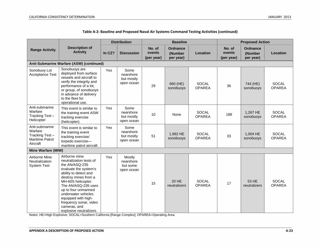
CALIFORNIA CONSISTENCY DETERMINATION JANUARY 2013
APPENDIX A DESCRIPTION OF PROPOSED ACTION A‐23
Table A‐2: Baseline and Proposed Naval Air Systems Command Testing Activities (continued)
Range Activity Description of Activity
Distribution Baseline Proposed Action
In CZ? Discussion No. of events
(per year)
Ordnance (Number per year)
Location No. of events
(per year)
Ordnance (Number per year)
Location
Anti-Submarine Warfare (ASW) (continued)
Sonobuoy Lot Acceptance Test
Sonobuoys are deployed from surface vessels and aircraft to verify the integrity and performance of a lot, or group, of sonobuoys in advance of delivery to the fleet for operational use.
Yes Some nearshore but mostly
open ocean 29 660 (HE)
sonobuoys SOCAL
OPAREA 36 744 (HE) sonobuoys
SOCAL OPAREA
Anti-submarine Warfare Tracking Test – Helicopter
This event is similar to the training event ASW tracking exercise (helicopter).
Yes Some nearshore but mostly
open ocean
10 None SOCAL OPAREA 188 1,267 HE
sonobuoys SOCAL
OPAREA
Anti-submarine Warfare Tracking Test – Maritime Patrol Aircraft
This event is similar to the training event tracking exercise/ torpedo exercise—maritime patrol aircraft.
Yes Some nearshore but mostly
open ocean 51 1,992 HE
sonobuoys SOCAL
OPAREA 33 1,004 HE sonobuoys
SOCAL OPAREA
Mine Warfare (MIW)
Airborne Mine Neutralization System Test
Airborne mine neutralization tests of the AN/ASQ-235 evaluate the system’s ability to detect and destroy mines from a MH-60S helicopter. The AN/ASQ-235 uses up to four unmanned underwater vehicles equipped with high-frequency sonar, video cameras, and explosive neutralizers.
Yes Mostly nearshore but some
open ocean
15 20 HE neutralizers
SOCAL OPAREA 17 53 HE
neutralizers SOCAL
OPAREA
Notes: HE=High Explosive; SOCAL=Southern California [Range Complex]; OPAREA=Operating Area.
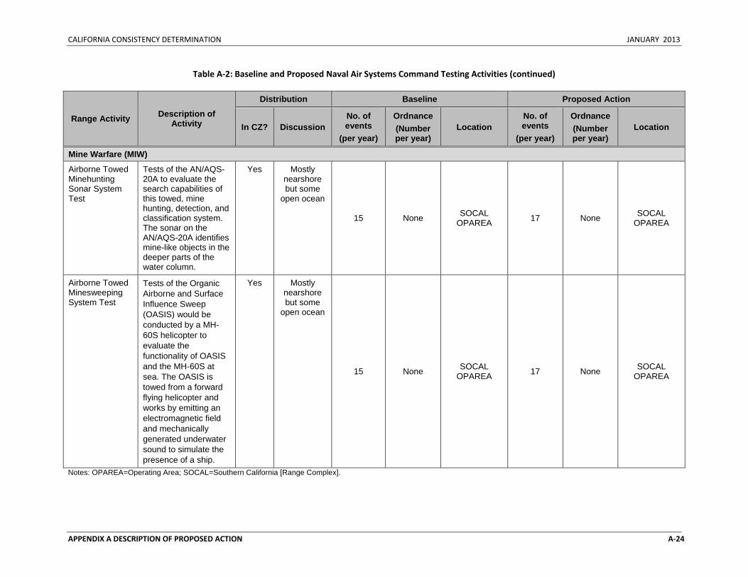
CALIFORNIA CONSISTENCY DETERMINATION JANUARY 2013
APPENDIX A DESCRIPTION OF PROPOSED ACTION A‐24
Table A‐2: Baseline and Proposed Naval Air Systems Command Testing Activities (continued)
Range Activity Description of Activity
Distribution Baseline Proposed Action
In CZ? Discussion No. of events
(per year)
Ordnance (Number per year)
Location No. of events
(per year)
Ordnance (Number per year)
Location
Mine Warfare (MIW)
Airborne Towed Minehunting Sonar System Test
Tests of the AN/AQS-20A to evaluate the search capabilities of this towed, mine hunting, detection, and classification system. The sonar on the AN/AQS-20A identifies mine-like objects in the deeper parts of the water column.
Yes Mostly nearshore but some
open ocean
15 None SOCAL OPAREA 17 None SOCAL
OPAREA
Airborne Towed Minesweeping System Test
Tests of the Organic Airborne and Surface Influence Sweep (OASIS) would be conducted by a MH-60S helicopter to evaluate the functionality of OASIS and the MH-60S at sea. The OASIS is towed from a forward flying helicopter and works by emitting an electromagnetic field and mechanically generated underwater sound to simulate the presence of a ship.
Yes Mostly nearshore but some
open ocean
15 None SOCAL OPAREA 17 None SOCAL
OPAREA
Notes: OPAREA=Operating Area; SOCAL=Southern California [Range Complex].
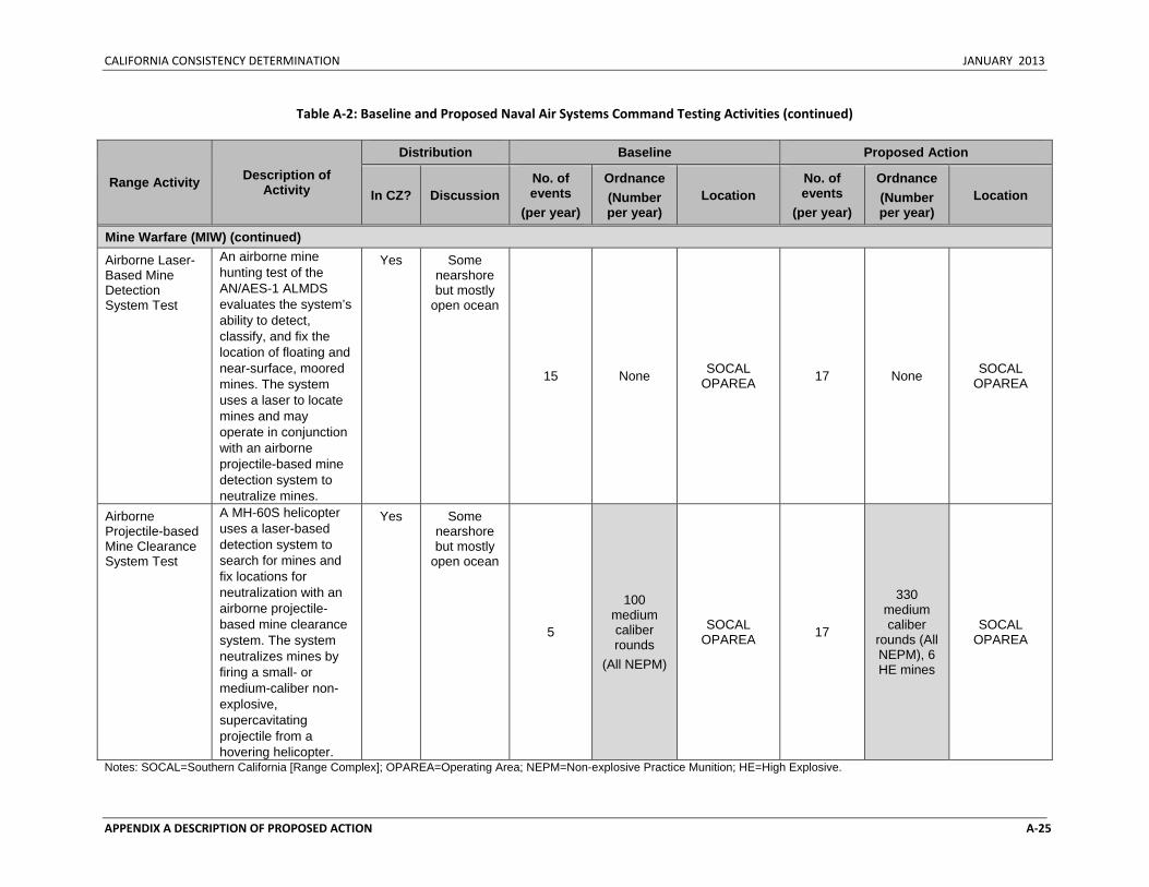
CALIFORNIA CONSISTENCY DETERMINATION JANUARY 2013
APPENDIX A DESCRIPTION OF PROPOSED ACTION A‐25
Table A‐2: Baseline and Proposed Naval Air Systems Command Testing Activities (continued)
Range Activity Description of Activity
Distribution Baseline Proposed Action
In CZ? Discussion No. of events
(per year)
Ordnance (Number per year)
Location No. of events
(per year)
Ordnance (Number per year)
Location
Mine Warfare (MIW) (continued)
Airborne Laser-Based Mine Detection System Test
An airborne mine hunting test of the AN/AES-1 ALMDS evaluates the system’s ability to detect, classify, and fix the location of floating and near-surface, moored mines. The system uses a laser to locate mines and may operate in conjunction with an airborne projectile-based mine detection system to neutralize mines.
Yes Some nearshore but mostly
open ocean
15 None SOCAL OPAREA 17 None SOCAL
OPAREA
Airborne Projectile-based Mine Clearance System Test
A MH-60S helicopter uses a laser-based detection system to search for mines and fix locations for neutralization with an airborne projectile-based mine clearance system. The system neutralizes mines by firing a small- or medium-caliber non-explosive, supercavitating projectile from a hovering helicopter.
Yes Some nearshore but mostly
open ocean
5
100 medium caliber rounds
(All NEPM)
SOCAL OPAREA 17
330 medium caliber
rounds (All NEPM), 6 HE mines
SOCAL OPAREA
Notes: SOCAL=Southern California [Range Complex]; OPAREA=Operating Area; NEPM=Non-explosive Practice Munition; HE=High Explosive.
CALIFORNIA CONSISTENCY DETERMINATION JANUARY 2013
APPENDIX A DESCRIPTION OF PROPOSED ACTION A‐26
Table A‐2: Baseline and Proposed Naval Air Systems Command Testing Activities (continued)
Range Activity Description of Activity
Distribution Baseline Proposed Action
In CZ? Discussion No. of events
(per year)
Ordnance (Number per year)
Location No. of events
(per year)
Ordnance (Number per year)
Location
Other Testing
Test and Evaluation – Catapult Launch
Tests evaluate the function of aircraft carrier catapults at sea following enhancements, modifications, or repairs to catapult launch systems. This includes aircraft catapult launch tests. No weapons or other expendable materials would be released.
No >12 nm from shore
8,700 None HSTT Study Area 9,570 None HSTT Study
Area
Air Platform Shipboard Integrate Test
Tests evaluate the compatibility of aircraft and aircraft systems with ships and shipboard systems. Tests involve physical operations and verify and evaluate communications and tactical data links. This test function also includes an assessment of carrier-shipboard suitability, and hazards of electromagnetic radiation to personnel, ordnance, and fuels.
No >12 nm from shore
124 None HSTT Study Area 136 None HSTT Study
Area
Notes: HSTT=Hawaii-Southern California Training and Testing
CALIFORNIA CONSISTENCY DETERMINATION JANUARY 2013
APPENDIX A DESCRIPTION OF PROPOSED ACTION A‐27
Table A‐2: Baseline and Proposed Naval Air Systems Command Testing Activities (continued)
Range Activity Description of Activity
Distribution Baseline Proposed Action
In CZ? Discussion No. of events
(per year)
Ordnance (Number per year)
Location No. of events
(per year)
Ordnance (Number per year)
Location
Other Testing (continued)
Shipboard Electronic Systems Evaluation
Tests measure ship antenna radiation patterns and test communication systems with a variety of aircraft.
No >12 nm from shore
124 None HSTT Study Area 136 None HSTT Study
Area
Notes: HSTT=Hawaii-Southern California Training and Testing

CALIFORNIA CONSISTENCY DETERMINATION JANUARY 2013
APPENDIX A DESCRIPTION OF PROPOSED ACTION A‐28
Table A‐3: Baseline and Proposed Naval Sea Systems Command Testing Activities
Range Activity Description of Activity
Distribution Baseline Proposed Action
In CZ? Discussion No. of events
(per year)
Ordnance (Number per year)
Location No. of events
(per year)
Ordnance (Number per year)
Location
New Ship Construction Surface Combatant Sea Trials
Pierside Sonar Testing
Tests ship’s sonar systems pierside to ensure proper operation.
Yes Conducted pierside N/A N/A N/A 2 None Pierside: San
Diego, CA
Propulsion Testing
Ship is run at high speeds in various formations (e.g., straight-line and reciprocal paths).
No >12 nm from shore
N/A N/A N/A 2 None SOCAL
Gun Testing – Large-caliber
Gun systems are tested using non-explosive rounds.
Yes Nearshore and open
ocean N/A N/A N/A 2
52 rounds 1,400
medium-caliber rounds
SOCAL
Missile Testing Explosive and non-explosive missiles are fired at target drones to test the launching system.
No >12 nm from shore
N/A N/A N/A 2 4 HE missiles SOCAL
Decoy Testing Includes testing of the MK 36 Decoy Launching system
No >12 nm from shore N/A N/A N/A 2 None SOCAL
Surface Warfare Testing
Ships defend against surface targets with large- and medium-caliber guns.
No >12 nm from shore N/A N/A N/A 2
96 large-caliber rounds
SOCAL
Notes: N/A = Not Analyzed. This event was not analyzed as part of the baseline. CA=California; SOCAL=Southern California [Range Complex] ; HE=High Explosive.
CALIFORNIA CONSISTENCY DETERMINATION JANUARY 2013
APPENDIX A DESCRIPTION OF PROPOSED ACTION A‐29
Table A‐3: Baseline and Proposed Naval Sea Systems Command Testing Activities (continued)
Range Activity Description of Activity
Distribution Baseline Proposed Action
In CZ? Discussion No. of events
(per year)
Ordnance (Number per year)
Location No. of events
(per year)
Ordnance (Number per year)
Location
New Ship Construction (continued) Surface Combatant Sea Trials (continued)
Anti-Submarine Warfare Testing
Ships demonstrate capability of countermeasure systems and underwater surveillance and communications systems.
No >12 nm from shore
N/A N/A N/A 2 None SOCAL
Other Ship ClassNote1 Sea Trials
Propulsion Testing
Ship is run at high speeds in various formations (e.g., straight-line and reciprocal paths).
No >12 nm from shore
N/A N/A N/A 21 None SOCAL
Gun Testing – Small Caliber
Gun systems are tested using non-explosive rounds.
Yes Nearshore and open
ocean N/A N/A N/A 6 6,000
rounds SOCAL
ASW Mission Package Testing
ASW Mission Package Testing
Ships and their supporting platforms (e.g., helicopters, unmanned aerial vehicles) detect, localize, and prosecute submarines.
Yes Nearshore and open
ocean None None None 40 40
torpedoes SOCAL
Note 1: "Other Ships" indicates classes of vessels without hull-mounted sonar. Example ship classes include LCS, MLP, and T-AKE. Notes: N/A = Not Analyzed. This event was not analyzed as part of the baseline. SOCAL=Southern California [Range Complex]
CALIFORNIA CONSISTENCY DETERMINATION JANUARY 2013
APPENDIX A DESCRIPTION OF PROPOSED ACTION A‐30
Table A‐3: Baseline and Proposed Naval Sea Systems Command Testing Activities (continued)
Range Activity Description of Activity
Distribution Baseline Proposed Action
In CZ? Discussion No. of events
(per year)
Ordnance (Number per year)
Location No. of events
(per year)
Ordnance (Number per year)
Location
New Ship Construction (continued) Surface Warfare Mission Package Testing
Gun Testing – Small-caliber
Ships defense against surface targets with small, medium, and large caliber guns and medium range missiles.
Yes Nearshore and open
ocean None None None 5
(either location)
2,500 rounds
HRC
SOCAL
Gun Testing – Medium-caliber
Ships defense against surface targets with small, medium, and large caliber guns and medium range missiles.
Yes Nearshore and open
ocean None None None 5
(either location)
7,000 rounds
(3,500 HE)
HRC
SOCAL
Gun Testing –Large-caliber
Ships defense against surface targets with small, medium, and large caliber guns and medium range missiles.
Yes Nearshore and open
ocean None None None 5 (either location)
7,000 rounds
(4,900 HE)
HRC
SOCAL
Missile/ Rocket Testing
Non-explosive missiles are fired at target drones to test the launching system.
No >12 nm from shore None None None 15 (either
location)
30 missiles/ rockets (15 HE)
HRC
SOCAL
Notes: SOCAL=Southern California [Range Complex]; HRC=Hawaii Range Complex; ASW=Anti-submarine Warfare; HE=High Explosive.
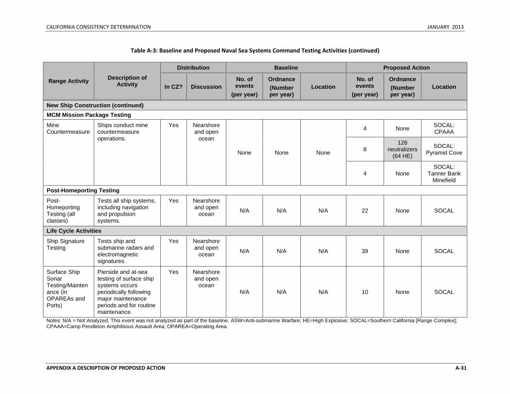
CALIFORNIA CONSISTENCY DETERMINATION JANUARY 2013
APPENDIX A DESCRIPTION OF PROPOSED ACTION A‐31
Table A‐3: Baseline and Proposed Naval Sea Systems Command Testing Activities (continued)
Range Activity Description of Activity
Distribution Baseline Proposed Action
In CZ? Discussion No. of events
(per year)
Ordnance (Number per year)
Location No. of events
(per year)
Ordnance (Number per year)
Location
New Ship Construction (continued) MCM Mission Package Testing
Mine Countermeasure
Ships conduct mine countermeasure operations.
Yes Nearshore and open
ocean
None None None
4 None SOCAL: CPAAA
8 128
neutralizers (64 HE)
SOCAL: Pyramid Cove
4 None SOCAL:
Tanner Bank Minefield
Post-Homeporting Testing
Post-Homeporting Testing (all classes)
Tests all ship systems, including navigation and propulsion systems.
Yes Nearshore and open
ocean N/A N/A N/A 22 None SOCAL
Life Cycle Activities
Ship Signature Testing
Tests ship and submarine radars and electromagnetic signatures.
Yes Nearshore and open
ocean N/A N/A N/A 39 None SOCAL
Surface Ship Sonar Testing/Maintenance (in OPAREAs and Ports)
Pierside and at-sea testing of surface ship systems occurs periodically following major maintenance periods and for routine maintenance.
Yes Nearshore and open
ocean N/A N/A N/A 10 None SOCAL
Notes: N/A = Not Analyzed. This event was not analyzed as part of the baseline. ASW=Anti-submarine Warfare; HE=High Explosive; SOCAL=Southern California [Range Complex]; CPAAA=Camp Pendleton Amphibious Assault Area; OPAREA=Operating Area.
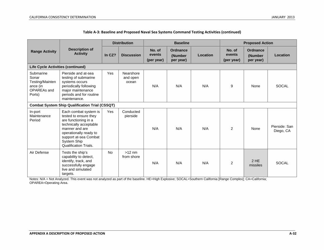
CALIFORNIA CONSISTENCY DETERMINATION JANUARY 2013
APPENDIX A DESCRIPTION OF PROPOSED ACTION A‐32
Table A‐3: Baseline and Proposed Naval Sea Systems Command Testing Activities (continued)
Range Activity Description of Activity
Distribution Baseline Proposed Action
In CZ? Discussion No. of events
(per year)
Ordnance (Number per year)
Location No. of events
(per year)
Ordnance (Number per year)
Location
Life Cycle Activities (continued)
Submarine Sonar Testing/Maintenance (in OPAREAs and Ports)
Pierside and at-sea testing of submarine systems occurs periodically following major maintenance periods and for routine maintenance.
Yes Nearshore and open
ocean N/A N/A N/A 9 None SOCAL
Combat System Ship Qualification Trial (CSSQT)
In-port Maintenance Period
Each combat system is tested to ensure they are functioning in a technically acceptable manner and are operationally ready to support at-sea Combat System Ship Qualification Trials.
Yes Conducted pierside
N/A N/A N/A 2 None Pierside: San Diego, CA
Air Defense Tests the ship’s capability to detect, identify, track, and successfully engage live and simulated targets.
No >12 nm from shore
N/A N/A N/A 2 2 HE missiles SOCAL
Notes: N/A = Not Analyzed. This event was not analyzed as part of the baseline. HE=High Explosive; SOCAL=Southern California [Range Complex]; CA=California; OPAREA=Operating Area.
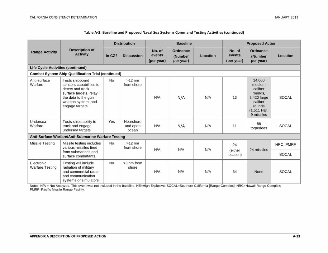
CALIFORNIA CONSISTENCY DETERMINATION JANUARY 2013
APPENDIX A DESCRIPTION OF PROPOSED ACTION A‐33
Table A‐3: Baseline and Proposed Naval Sea Systems Command Testing Activities (continued)
Range Activity Description of Activity
Distribution Baseline Proposed Action
In CZ? Discussion No. of events
(per year)
Ordnance (Number per year)
Location No. of events
(per year)
Ordnance (Number per year)
Location
Life Cycle Activities (continued) Combat System Ship Qualification Trial (continued)
Anti-surface Warfare
Tests shipboard sensors capabilities to detect and track surface targets, relay the data to the gun weapon system, and engage targets.
No >12 nm from shore
N/A N/A N/A 13
14,000 medium caliber rounds,
3,420 large caliber rounds
(1,511 HE), 9 missiles
SOCAL
Undersea Warfare
Tests ships ability to track and engage undersea targets.
Yes Nearshore and open
ocean N/A N/A N/A 11 88
torpedoes SOCAL
Anti-Surface Warfare/Anti-Submarine Warfare Testing
Missile Testing Missile testing includes various missiles fired from submarines and surface combatants.
No >12 nm from shore N/A N/A N/A
24 (either
location) 24 missiles
HRC: PMRF
SOCAL
Electronic Warfare Testing
Testing will include radiation of military and commercial radar and communication systems or simulators.
No >3 nm from shore
N/A N/A N/A 54 None SOCAL
Notes: N/A = Not Analyzed. This event was not included in the baseline. HE=High Explosive; SOCAL=Southern California [Range Complex]; HRC=Hawaii Range Complex; PMRF=Pacific Missile Range Facility.
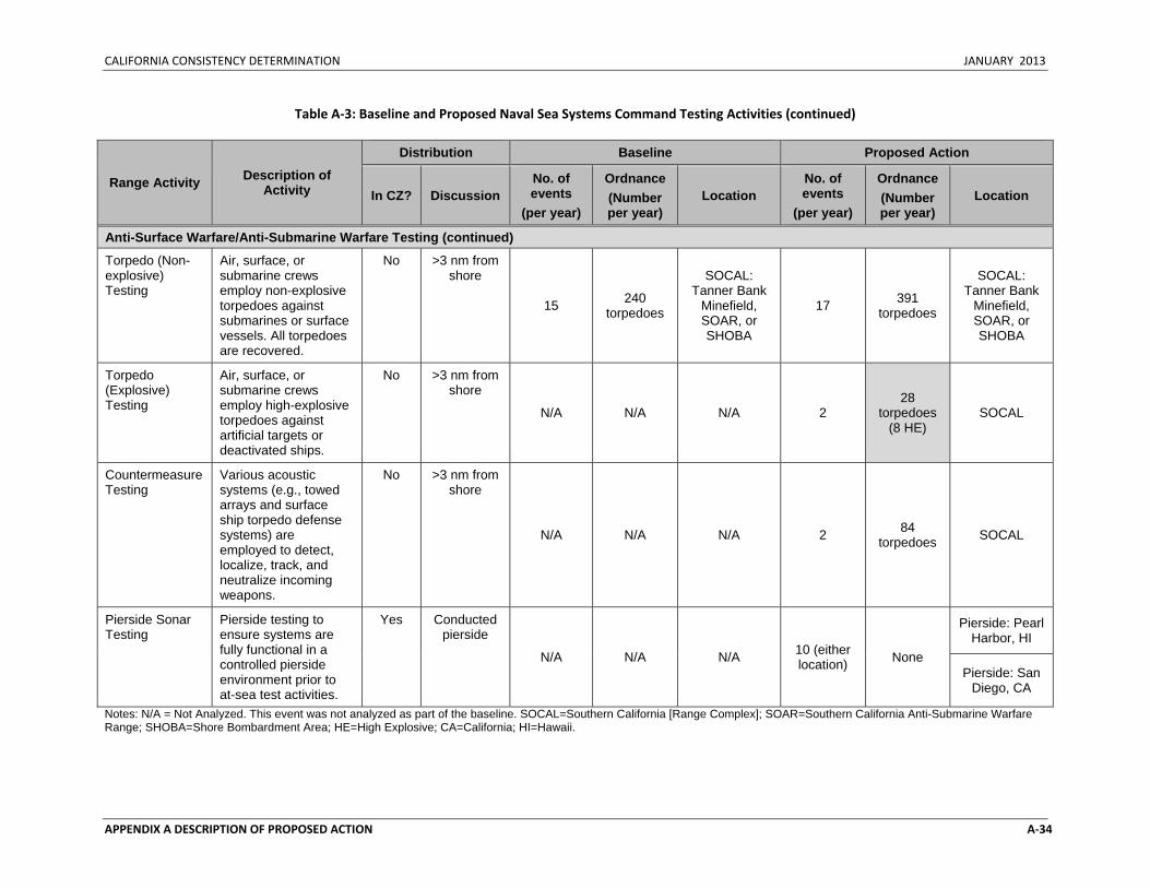
CALIFORNIA CONSISTENCY DETERMINATION JANUARY 2013
APPENDIX A DESCRIPTION OF PROPOSED ACTION A‐34
Table A‐3: Baseline and Proposed Naval Sea Systems Command Testing Activities (continued)
Range Activity Description of Activity
Distribution Baseline Proposed Action
In CZ? Discussion No. of events
(per year)
Ordnance (Number per year)
Location No. of events
(per year)
Ordnance (Number per year)
Location
Anti-Surface Warfare/Anti-Submarine Warfare Testing (continued)
Torpedo (Non-explosive) Testing
Air, surface, or submarine crews employ non-explosive torpedoes against submarines or surface vessels. All torpedoes are recovered.
No >3 nm from shore
15 240 torpedoes
SOCAL: Tanner Bank
Minefield, SOAR, or SHOBA
17 391 torpedoes
SOCAL: Tanner Bank
Minefield, SOAR, or SHOBA
Torpedo (Explosive) Testing
Air, surface, or submarine crews employ high-explosive torpedoes against artificial targets or deactivated ships.
No >3 nm from shore
N/A N/A N/A 2 28
torpedoes (8 HE)
SOCAL
Countermeasure Testing
Various acoustic systems (e.g., towed arrays and surface ship torpedo defense systems) are employed to detect, localize, track, and neutralize incoming weapons.
No >3 nm from shore
N/A N/A N/A 2 84 torpedoes SOCAL
Pierside Sonar Testing
Pierside testing to ensure systems are fully functional in a controlled pierside environment prior to at-sea test activities.
Yes Conducted pierside
N/A N/A N/A 10 (either location) None
Pierside: Pearl Harbor, HI
Pierside: San Diego, CA
Notes: N/A = Not Analyzed. This event was not analyzed as part of the baseline. SOCAL=Southern California [Range Complex]; SOAR=Southern California Anti-Submarine Warfare Range; SHOBA=Shore Bombardment Area; HE=High Explosive; CA=California; HI=Hawaii.
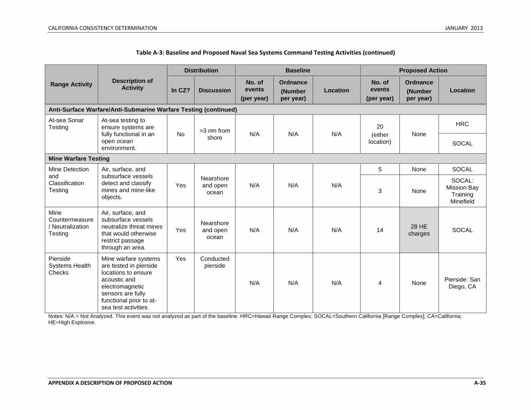
CALIFORNIA CONSISTENCY DETERMINATION JANUARY 2013
APPENDIX A DESCRIPTION OF PROPOSED ACTION A‐35
Table A‐3: Baseline and Proposed Naval Sea Systems Command Testing Activities (continued)
Range Activity Description of Activity
Distribution Baseline Proposed Action
In CZ? Discussion No. of events
(per year)
Ordnance (Number per year)
Location No. of events
(per year)
Ordnance (Number per year)
Location
Anti-Surface Warfare/Anti-Submarine Warfare Testing (continued)
At-sea Sonar Testing
At-sea testing to ensure systems are fully functional in an open ocean environment.
No >3 nm from shore N/A N/A N/A
20 (either
location) None
HRC
SOCAL
Mine Warfare Testing
Mine Detection and Classification Testing
Air, surface, and subsurface vessels detect and classify mines and mine-like objects.
Yes Nearshore and open
ocean N/A N/A N/A
5 None SOCAL
3 None
SOCAL: Mission Bay
Training Minefield
Mine Countermeasure/ Neutralization Testing
Air, surface, and subsurface vessels neutralize threat mines that would otherwise restrict passage through an area.
Yes Nearshore and open
ocean N/A N/A N/A 14 28 HE
charges SOCAL
Pierside Systems Health Checks
Mine warfare systems are tested in pierside locations to ensure acoustic and electromagnetic sensors are fully functional prior to at-sea test activities.
Yes Conducted pierside
N/A N/A N/A 4 None Pierside: San Diego, CA
Notes: N/A = Not Analyzed. This event was not analyzed as part of the baseline. HRC=Hawaii Range Complex; SOCAL=Southern California [Range Complex]; CA=California; HE=High Explosive.
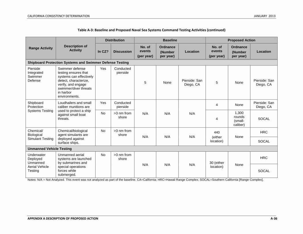
CALIFORNIA CONSISTENCY DETERMINATION JANUARY 2013
APPENDIX A DESCRIPTION OF PROPOSED ACTION A‐36
Table A‐3: Baseline and Proposed Naval Sea Systems Command Testing Activities (continued)
Range Activity Description of Activity
Distribution Baseline Proposed Action
In CZ? Discussion No. of events
(per year)
Ordnance (Number per year)
Location No. of events
(per year)
Ordnance (Number per year)
Location
Shipboard Protection Systems and Swimmer Defense Testing
Pierside Integrated Swimmer Defense
Swimmer defense testing ensures that systems can effectively detect, characterize, verify, and engage swimmer/diver threats in harbor environments.
Yes Conducted pierside
5 None Pierside: San Diego, CA 5 None Pierside: San
Diego, CA
Shipboard Protection Systems Testing
Loudhailers and small caliber munitions are used to protect a ship against small boat threats.
Yes Conducted pierside
N/A N/A N/A
4 None Pierside: San Diego, CA
No >3 nm from shore 4
1,300 rounds (small-caliber)
SOCAL
Chemical/ Biological Simulant Testing
Chemical/biological agent simulants are deployed against surface ships.
No >3 nm from shore N/A N/A N/A
440 (either
location) None
HRC
SOCAL
Unmanned Vehicle Testing
Underwater Deployed Unmanned Aerial Vehicle Testing
Unmanned aerial systems are launched by submarines and special operations forces while submerged.
No >3 nm from shore
N/A N/A N/A 30 (either location) None
HRC
SOCAL
Notes: N/A = Not Analyzed. This event was not analyzed as part of the baseline. CA=California; HRC=Hawaii Range Complex; SOCAL=Southern California [Range Complex].
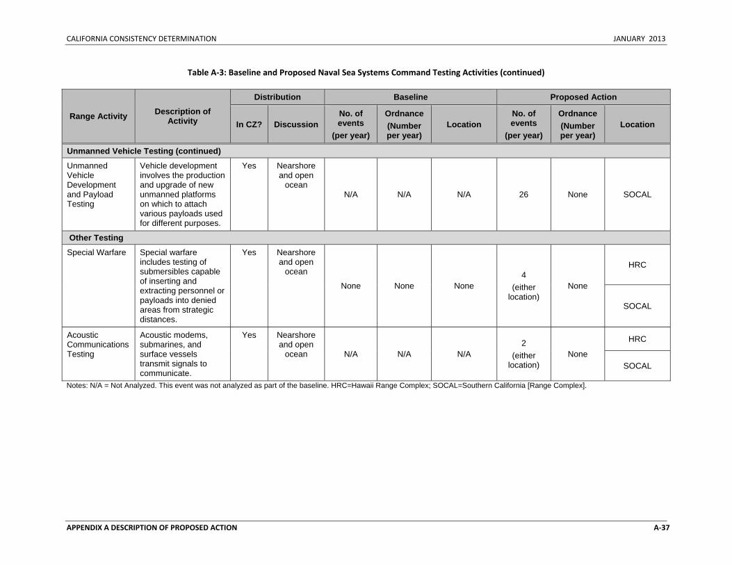
CALIFORNIA CONSISTENCY DETERMINATION JANUARY 2013
APPENDIX A DESCRIPTION OF PROPOSED ACTION A‐37
Table A‐3: Baseline and Proposed Naval Sea Systems Command Testing Activities (continued)
Range Activity Description of Activity
Distribution Baseline Proposed Action
In CZ? Discussion No. of events
(per year)
Ordnance (Number per year)
Location No. of events
(per year)
Ordnance (Number per year)
Location
Unmanned Vehicle Testing (continued)
Unmanned Vehicle Development and Payload Testing
Vehicle development involves the production and upgrade of new unmanned platforms on which to attach various payloads used for different purposes.
Yes Nearshore and open
ocean N/A N/A N/A 26 None SOCAL
Other Testing
Special Warfare Special warfare includes testing of submersibles capable of inserting and extracting personnel or payloads into denied areas from strategic distances.
Yes Nearshore and open
ocean
None None None 4
(either location)
None
HRC
SOCAL
Acoustic Communications Testing
Acoustic modems, submarines, and surface vessels transmit signals to communicate.
Yes Nearshore and open
ocean N/A N/A N/A 2
(either location)
None
HRC
SOCAL
Notes: N/A = Not Analyzed. This event was not analyzed as part of the baseline. HRC=Hawaii Range Complex; SOCAL=Southern California [Range Complex].
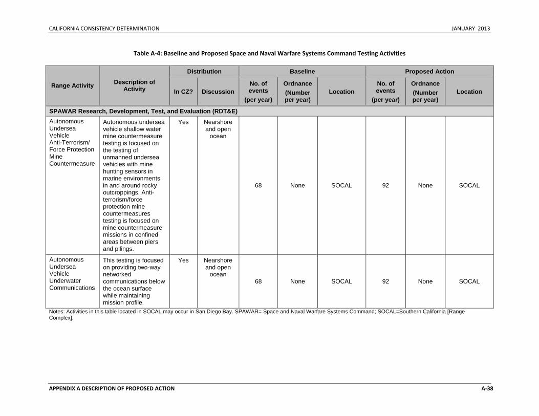
CALIFORNIA CONSISTENCY DETERMINATION JANUARY 2013
APPENDIX A DESCRIPTION OF PROPOSED ACTION A‐38
Table A‐4: Baseline and Proposed Space and Naval Warfare Systems Command Testing Activities
Range Activity Description of Activity
Distribution Baseline Proposed Action
In CZ? Discussion No. of events
(per year)
Ordnance (Number per year)
Location No. of events
(per year)
Ordnance (Number per year)
Location
SPAWAR Research, Development, Test, and Evaluation (RDT&E) Autonomous Undersea Vehicle Anti-Terrorism/ Force Protection Mine Countermeasure
Autonomous undersea vehicle shallow water mine countermeasure testing is focused on the testing of unmanned undersea vehicles with mine hunting sensors in marine environments in and around rocky outcroppings. Anti-terrorism/force protection mine countermeasures testing is focused on mine countermeasure missions in confined areas between piers and pilings.
Yes Nearshore and open
ocean
68 None SOCAL 92 None SOCAL
Autonomous Undersea Vehicle Underwater Communications
This testing is focused on providing two-way networked communications below the ocean surface while maintaining mission profile.
Yes Nearshore and open
ocean 68 None SOCAL 92 None SOCAL
Notes: Activities in this table located in SOCAL may occur in San Diego Bay. SPAWAR= Space and Naval Warfare Systems Command; SOCAL=Southern California [Range Complex].
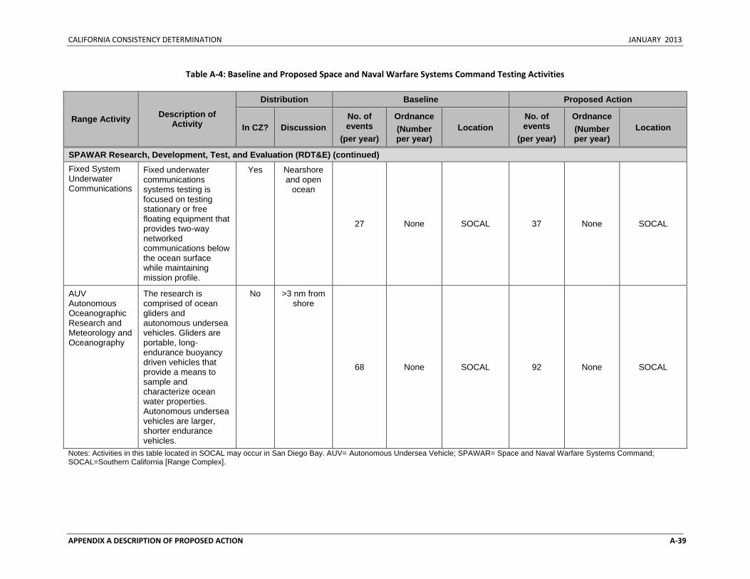
CALIFORNIA CONSISTENCY DETERMINATION JANUARY 2013
APPENDIX A DESCRIPTION OF PROPOSED ACTION A‐39
Table A‐4: Baseline and Proposed Space and Naval Warfare Systems Command Testing Activities
Range Activity Description of Activity
Distribution Baseline Proposed Action
In CZ? Discussion No. of events
(per year)
Ordnance (Number per year)
Location No. of events
(per year)
Ordnance (Number per year)
Location
SPAWAR Research, Development, Test, and Evaluation (RDT&E) (continued) Fixed System Underwater Communications
Fixed underwater communications systems testing is focused on testing stationary or free floating equipment that provides two-way networked communications below the ocean surface while maintaining mission profile.
Yes Nearshore and open
ocean
27 None SOCAL 37 None SOCAL
AUV Autonomous Oceanographic Research and Meteorology and Oceanography
The research is comprised of ocean gliders and autonomous undersea vehicles. Gliders are portable, long-endurance buoyancy driven vehicles that provide a means to sample and characterize ocean water properties. Autonomous undersea vehicles are larger, shorter endurance vehicles.
No >3 nm from shore
68 None SOCAL 92 None SOCAL
Notes: Activities in this table located in SOCAL may occur in San Diego Bay. AUV= Autonomous Undersea Vehicle; SPAWAR= Space and Naval Warfare Systems Command; SOCAL=Southern California [Range Complex].
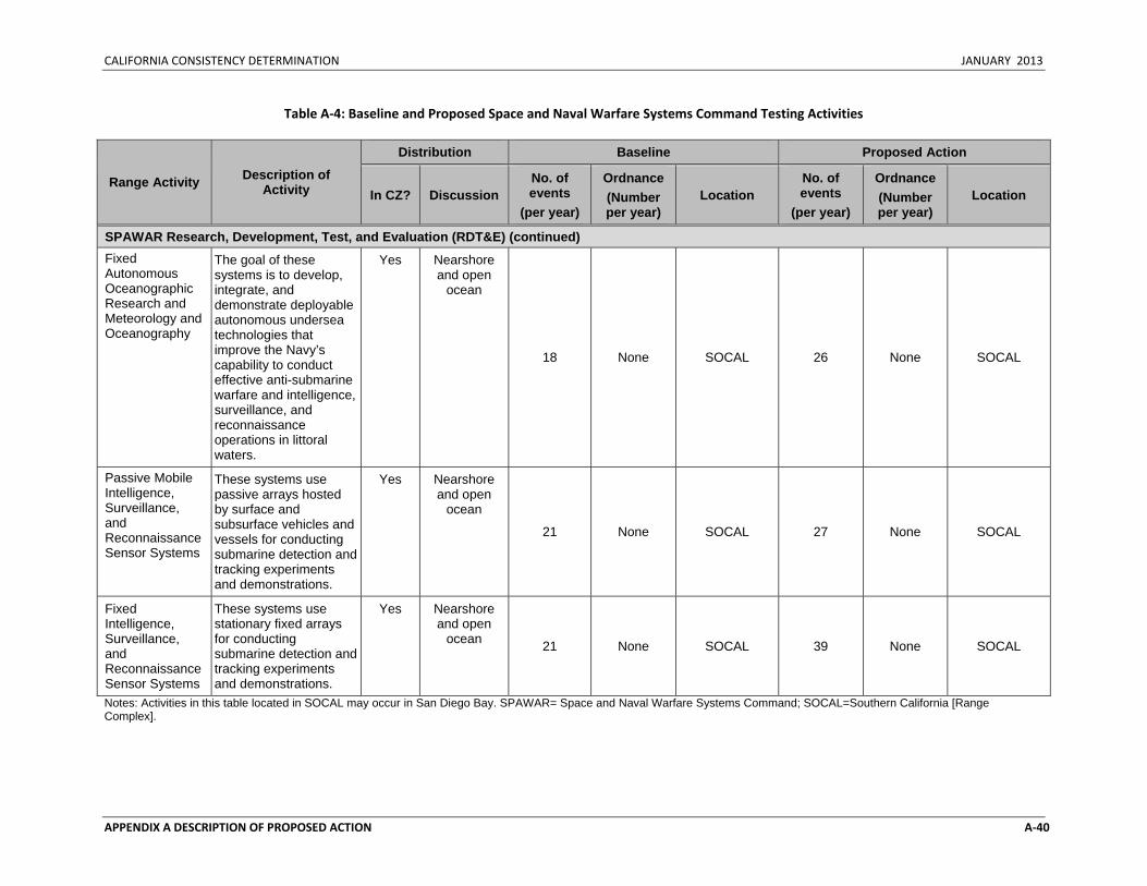
CALIFORNIA CONSISTENCY DETERMINATION JANUARY 2013
APPENDIX A DESCRIPTION OF PROPOSED ACTION A‐40
Table A‐4: Baseline and Proposed Space and Naval Warfare Systems Command Testing Activities
Range Activity Description of Activity
Distribution Baseline Proposed Action
In CZ? Discussion No. of events
(per year)
Ordnance (Number per year)
Location No. of events
(per year)
Ordnance (Number per year)
Location
SPAWAR Research, Development, Test, and Evaluation (RDT&E) (continued) Fixed Autonomous Oceanographic Research and Meteorology and Oceanography
The goal of these systems is to develop, integrate, and demonstrate deployable autonomous undersea technologies that improve the Navy’s capability to conduct effective anti-submarine warfare and intelligence, surveillance, and reconnaissance operations in littoral waters.
Yes Nearshore and open
ocean
18 None SOCAL 26 None SOCAL
Passive Mobile Intelligence, Surveillance, and Reconnaissance Sensor Systems
These systems use passive arrays hosted by surface and subsurface vehicles and vessels for conducting submarine detection and tracking experiments and demonstrations.
Yes Nearshore and open
ocean
21 None SOCAL 27 None SOCAL
Fixed Intelligence, Surveillance, and Reconnaissance Sensor Systems
These systems use stationary fixed arrays for conducting submarine detection and tracking experiments and demonstrations.
Yes Nearshore and open
ocean 21 None SOCAL 39 None SOCAL
Notes: Activities in this table located in SOCAL may occur in San Diego Bay. SPAWAR= Space and Naval Warfare Systems Command; SOCAL=Southern California [Range Complex].
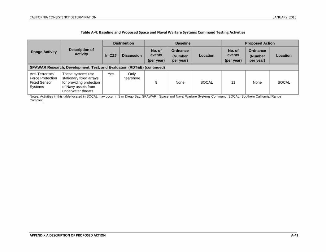
CALIFORNIA CONSISTENCY DETERMINATION JANUARY 2013
APPENDIX A DESCRIPTION OF PROPOSED ACTION A‐41
Table A‐4: Baseline and Proposed Space and Naval Warfare Systems Command Testing Activities
Range Activity Description of Activity
Distribution Baseline Proposed Action
In CZ? Discussion No. of events
(per year)
Ordnance (Number per year)
Location No. of events
(per year)
Ordnance (Number per year)
Location
SPAWAR Research, Development, Test, and Evaluation (RDT&E) (continued)
Anti-Terrorism/ Force Protection Fixed Sensor Systems
These systems use stationary fixed arrays for providing protection of Navy assets from underwater threats.
Yes Only nearshore
9 None SOCAL 11 None SOCAL
Notes: Activities in this table located in SOCAL may occur in San Diego Bay. SPAWAR= Space and Naval Warfare Systems Command; SOCAL=Southern California [Range Complex].

CALIFORNIA CONSISTENCY DETERMINATION JANUARY 2013
APPENDIX A DESCRIPTION OF PROPOSED ACTION A‐42
This Page Intentionally Left Blank

CALIFORNIA CONSISTENCY DETERMINATION JANUARY 2013
Appendix B
Training and Testing Activities Matrices

CALIFORNIA CONSISTENCY DETERMINATION JANUARY 2013
This Page Intentionally Left Blank
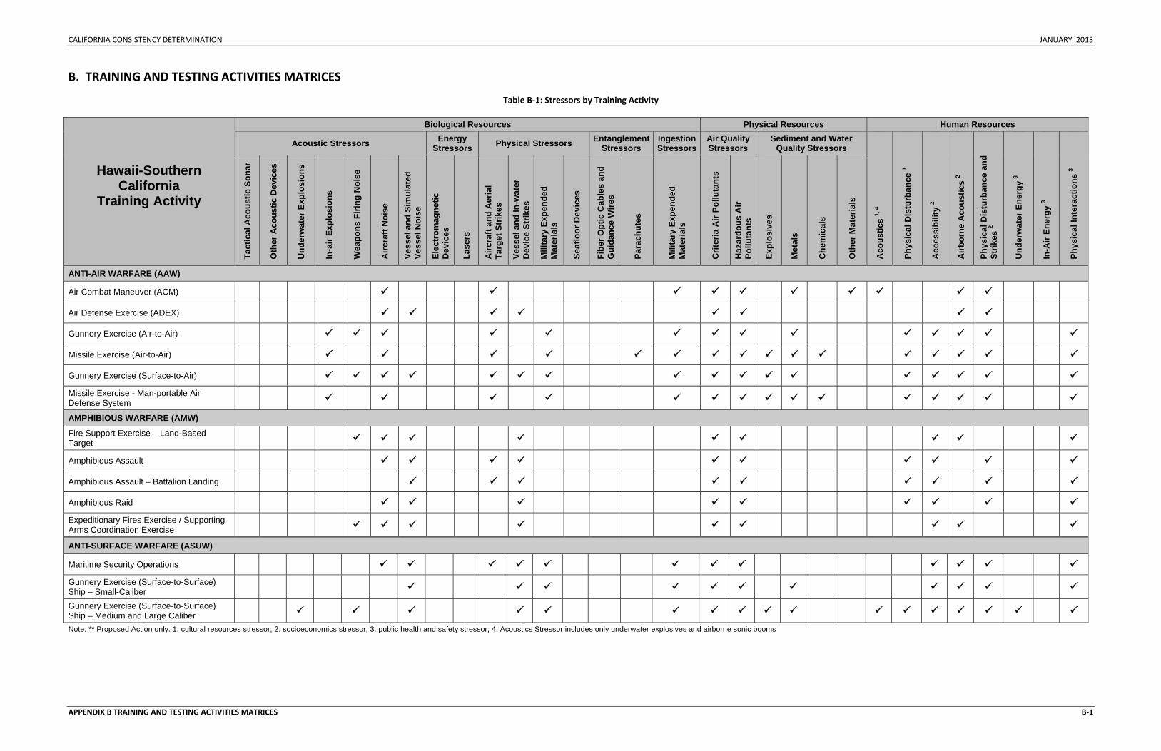
CALIFORNIA CONSISTENCY DETERMINATION JANUARY 2013
APPENDIX B TRAINING AND TESTING ACTIVITIES MATRICES B‐1
B. TRAINING AND TESTING ACTIVITIES MATRICES
Table B‐1: Stressors by Training Activity
Hawaii-Southern California
Training Activity
Biological Resources Physical Resources Human Resources
Acoustic Stressors Energy Stressors Physical Stressors Entanglement
Stressors Ingestion Stressors
Air Quality Stressors
Sediment and Water Quality Stressors
Aco
ustic
s 1,
4
Phys
ical
Dis
turb
ance
1
Acc
essi
bilit
y 2
Airb
orne
Aco
ustic
s 2
Phys
ical
Dis
turb
ance
and
St
rikes
2
Und
erw
ater
Ene
rgy
3
In-A
ir En
ergy
3
Phys
ical
Inte
ract
ions
3
Tact
ical
Aco
ustic
Son
ar
Oth
er A
cous
tic D
evic
es
Und
erw
ater
Exp
losi
ons
In-a
ir Ex
plos
ions
Wea
pons
Firi
ng N
oise
Airc
raft
Noi
se
Vess
el a
nd S
imul
ated
Ve
ssel
Noi
se
Elec
trom
agne
tic
Dev
ices
Lase
rs
Airc
raft
and
Aer
ial
Targ
et S
trik
es
Vess
el a
nd In
-wat
er
Dev
ice
Strik
es
Mili
tary
Exp
ende
d M
ater
ials
Seaf
loor
Dev
ices
Fibe
r Opt
ic C
able
s an
d G
uida
nce
Wire
s
Para
chut
es
Mili
tary
Exp
ende
d M
ater
ials
Crit
eria
Air
Pollu
tant
s
Haz
ardo
us A
ir Po
lluta
nts
Expl
osiv
es
Met
als
Che
mic
als
Oth
er M
ater
ials
ANTI-AIR WARFARE (AAW)
Air Combat Maneuver (ACM)
Air Defense Exercise (ADEX)
Gunnery Exercise (Air-to-Air)
Missile Exercise (Air-to-Air)
Gunnery Exercise (Surface-to-Air) Missile Exercise - Man-portable Air Defense System
AMPHIBIOUS WARFARE (AMW)
Fire Support Exercise – Land-Based Target
Amphibious Assault
Amphibious Assault – Battalion Landing
Amphibious Raid Expeditionary Fires Exercise / Supporting Arms Coordination Exercise
ANTI-SURFACE WARFARE (ASUW)
Maritime Security Operations Gunnery Exercise (Surface-to-Surface) Ship – Small-Caliber
Gunnery Exercise (Surface-to-Surface) Ship – Medium and Large Caliber Note: ** Proposed Action only. 1: cultural resources stressor; 2: socioeconomics stressor; 3: public health and safety stressor; 4: Acoustics Stressor includes only underwater explosives and airborne sonic booms

CALIFORNIA CONSISTENCY DETERMINATION JANUARY 2013
APPENDIX B TRAINING AND TESTING ACTIVITIES MATRICES B‐2
Table B‐1: Stressors by Training Activity (continued)
Hawaii-Southern California
Training Activity
Biological Resources Physical Resources Human Resources
Acoustic Stressors Energy Stressors Physical Stressors Entanglement
Stressors Ingestion Stressors
Air Quality Stressors
Sediment and Water Quality Stressors
Aco
ustic
s 1,
4
Phys
ical
Dis
turb
ance
1
Acc
essi
bilit
y 2
Airb
orne
Aco
ustic
s 2
Phys
ical
Dis
turb
ance
and
St
rikes
2
Und
erw
ater
Ene
rgy
3
In-A
ir En
ergy
3
Phys
ical
Inte
ract
ions
3
Tact
ical
Aco
ustic
Son
ar
Oth
er A
cous
tic D
evic
es
Und
erw
ater
Exp
losi
ons
In-a
ir Ex
plos
ions
Wea
pons
Firi
ng N
oise
Airc
raft
Noi
se
Vess
el a
nd S
imul
ated
Ve
ssel
Noi
se
Elec
trom
agne
tic
Dev
ices
Lase
rs
Airc
raft
and
Aer
ial
Targ
et S
trik
es
Vess
el a
nd In
-wat
er
Dev
ice
Strik
es
Mili
tary
Exp
ende
d M
ater
ials
Seaf
loor
Dev
ices
Fibe
r Opt
ic C
able
s an
d G
uida
nce
Wire
s
Para
chut
es
Mili
tary
Exp
ende
d M
ater
ials
Crit
eria
Air
Pollu
tant
s
Haz
ardo
us A
ir Po
lluta
nts
Expl
osiv
es
Met
als
Che
mic
als
Oth
er M
ater
ials
ANTI-SURFACE WARFARE (ASUW)
Gunnery Exercise (Surface-to-Surface) Boat – Small-Caliber
Gunnery Exercise (Surface-to-Surface) Boat – Medium-Caliber
Missile Exercise (Surface-to-Surface) Gunnery Exercise (Air-to-Surface) – Small-Caliber
Gunnery Exercise (Air-to-Surface) – Medium-Caliber
Missile Exercise (Air-to-Surface) Rocket
Missile Exercise (Air-to-Surface)
Bombing Exercise (Air-to-Surface)
Laser Targeting
Sinking Exercise (SINKEX)
ANTI-SUBMARINE WARFARE (ASW)
Tracking Exercise/Torpedo Exercise – Submarine
Tracking Exercise/Torpedo Exercise – Surface
Tracking Exercise/Torpedo Exercise – Helicopter
Tracking Exercise/Torpedo Exercise – Maritime Patrol Aircraft
Tracking Exercise/Torpedo Exercise – Maritime Patrol Aircraft Extended Echo Ranging Sonobuoys
KILO Dip - Helicopter Notes: 1: cultural resources stressor; 2: socioeconomics stressor; 3: public health and safety stressor; 4: Acoustics Stressor includes only underwater explosives and airborne sonic booms
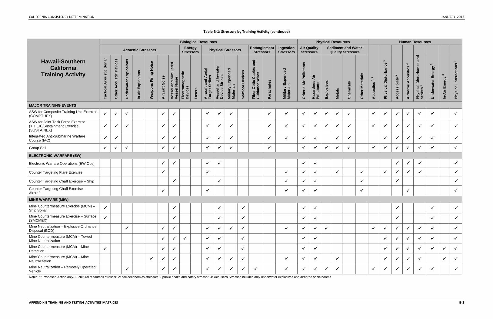
CALIFORNIA CONSISTENCY DETERMINATION JANUARY 2013
APPENDIX B TRAINING AND TESTING ACTIVITIES MATRICES B‐3
Table B‐1: Stressors by Training Activity (continued)
Hawaii-Southern California
Training Activity
Biological Resources Physical Resources Human Resources
Acoustic Stressors Energy Stressors Physical Stressors Entanglement
Stressors Ingestion Stressors
Air Quality Stressors
Sediment and Water Quality Stressors
Aco
ustic
s 1,
4
Phys
ical
Dis
turb
ance
1
Acc
essi
bilit
y 2
Airb
orne
Aco
ustic
s 2
Phys
ical
Dis
turb
ance
and
St
rikes
2
Und
erw
ater
Ene
rgy
3
In-A
ir En
ergy
3
Phys
ical
Inte
ract
ions
3
Tact
ical
Aco
ustic
Son
ar
Oth
er A
cous
tic D
evic
es
Und
erw
ater
Exp
losi
ons
In-a
ir Ex
plos
ions
Wea
pons
Firi
ng N
oise
Airc
raft
Noi
se
Vess
el a
nd S
imul
ated
Ve
ssel
Noi
se
Elec
trom
agne
tic
Dev
ices
Lase
rs
Airc
raft
and
Aer
ial
Targ
et S
trik
es
Vess
el a
nd In
-wat
er
Dev
ice
Strik
es
Mili
tary
Exp
ende
d M
ater
ials
Seaf
loor
Dev
ices
Fibe
r Opt
ic C
able
s an
d G
uida
nce
Wire
s
Para
chut
es
Mili
tary
Exp
ende
d M
ater
ials
Crit
eria
Air
Pollu
tant
s
Haz
ardo
us A
ir Po
lluta
nts
Expl
osiv
es
Met
als
Che
mic
als
Oth
er M
ater
ials
MAJOR TRAINING EVENTS
ASW for Composite Training Unit Exercise (COMPTUEX)
ASW for Joint Task Force Exercise (JTFEX)/Sustainment Exercise (SUSTAINEX)
Integrated Anti-Submarine Warfare Course (IAC)
Group Sail ELECTRONIC WARFARE (EW)
Electronic Warfare Operations (EW Ops)
Counter Targeting Flare Exercise
Counter Targeting Chaff Exercise – Ship Counter Targeting Chaff Exercise – Aircraft
MINE WARFARE (MIW)
Mine Countermeasure Exercise (MCM) – Ship Sonar
Mine Countermeasure Exercise – Surface (SMCMEX)
Mine Neutralization – Explosive Ordnance Disposal (EOD)
Mine Countermeasure (MCM) – Towed Mine Neutralization
Mine Countermeasure (MCM) – Mine Detection
Mine Countermeasure (MCM) – Mine Neutralization
Mine Neutralization – Remotely Operated Vehicle Notes: ** Proposed Action only. 1: cultural resources stressor; 2: socioeconomics stressor; 3: public health and safety stressor; 4: Acoustics Stressor includes only underwater explosives and airborne sonic booms
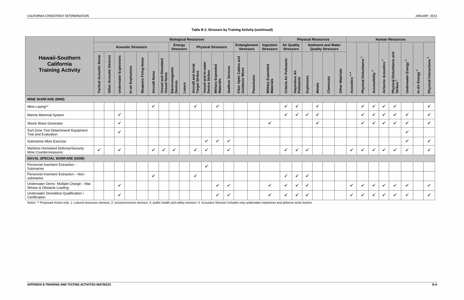
CALIFORNIA CONSISTENCY DETERMINATION JANUARY 2013
APPENDIX B TRAINING AND TESTING ACTIVITIES MATRICES B‐4
Table B‐1: Stressors by Training Activity (continued)
Hawaii-Southern California
Training Activity
Biological Resources Physical Resources Human Resources
Acoustic Stressors Energy Stressors Physical Stressors Entanglement
Stressors Ingestion Stressors
Air Quality Stressors
Sediment and Water Quality Stressors
Aco
ustic
s 1,
4
Phys
ical
Dis
turb
ance
1
Acc
essi
bilit
y 2
Airb
orne
Aco
ustic
s 2
Phys
ical
Dis
turb
ance
and
St
rikes
2
Und
erw
ater
Ene
rgy
3
In-A
ir En
ergy
3
Phys
ical
Inte
ract
ions
3
Tact
ical
Aco
ustic
Son
ar
Oth
er A
cous
tic D
evic
es
Und
erw
ater
Exp
losi
ons
In-a
ir Ex
plos
ions
Wea
pons
Firi
ng N
oise
Airc
raft
Noi
se
Vess
el a
nd S
imul
ated
Ve
ssel
Noi
se
Elec
trom
agne
tic
Dev
ices
Lase
rs
Airc
raft
and
Aer
ial
Targ
et S
trik
es
Vess
el a
nd In
-wat
er
Dev
ice
Strik
es
Mili
tary
Exp
ende
d M
ater
ials
Seaf
loor
Dev
ices
Fibe
r Opt
ic C
able
s an
d G
uida
nce
Wire
s
Para
chut
es
Mili
tary
Exp
ende
d M
ater
ials
Crit
eria
Air
Pollu
tant
s
Haz
ardo
us A
ir Po
lluta
nts
Expl
osiv
es
Met
als
Che
mic
als
Oth
er M
ater
ials
MINE WARFARE (MIW)
Mine Laying**
Marine Mammal System
Shock Wave Generator Surf Zone Test Detachment/ Equipment Test and Evaluation
Submarine Mine Exercise Maritime Homeland Defense/Security Mine Countermeasures
NAVAL SPECIAL WARFARE (NSW)
Personnel Insertion/ Extraction - Submarine
Personnel Insertion/ Extraction – Non-submarine
Underwater Demo Multiple Charge – Mat Weave & Obstacle Loading
Underwater Demolition Qualification / Certification Notes: ** Proposed Action only. 1: cultural resources stressor; 2: socioeconomics stressor; 3: public health and safety stressor; 4: Acoustics Stressor includes only underwater explosives and airborne sonic booms
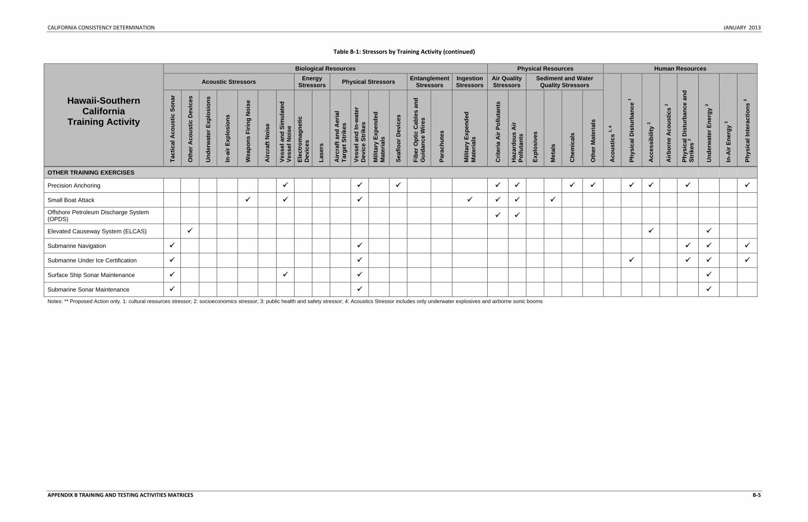
CALIFORNIA CONSISTENCY DETERMINATION JANUARY 2013
APPENDIX B TRAINING AND TESTING ACTIVITIES MATRICES B‐5
Table B‐1: Stressors by Training Activity (continued)
Hawaii-Southern California
Training Activity
Biological Resources Physical Resources Human Resources
Acoustic Stressors Energy Stressors Physical Stressors Entanglement
Stressors Ingestion Stressors
Air Quality Stressors
Sediment and Water Quality Stressors
Aco
ustic
s 1,
4
Phys
ical
Dis
turb
ance
1
Acc
essi
bilit
y 2
Airb
orne
Aco
ustic
s 2
Phys
ical
Dis
turb
ance
and
St
rikes
2
Und
erw
ater
Ene
rgy
3
In-A
ir En
ergy
3
Phys
ical
Inte
ract
ions
3
Tact
ical
Aco
ustic
Son
ar
Oth
er A
cous
tic D
evic
es
Und
erw
ater
Exp
losi
ons
In-a
ir Ex
plos
ions
Wea
pons
Firi
ng N
oise
Airc
raft
Noi
se
Vess
el a
nd S
imul
ated
Ve
ssel
Noi
se
Elec
trom
agne
tic
Dev
ices
Lase
rs
Airc
raft
and
Aer
ial
Targ
et S
trik
es
Vess
el a
nd In
-wat
er
Dev
ice
Strik
es
Mili
tary
Exp
ende
d M
ater
ials
Seaf
loor
Dev
ices
Fibe
r Opt
ic C
able
s an
d G
uida
nce
Wire
s
Para
chut
es
Mili
tary
Exp
ende
d M
ater
ials
Crit
eria
Air
Pollu
tant
s
Haz
ardo
us A
ir Po
lluta
nts
Expl
osiv
es
Met
als
Che
mic
als
Oth
er M
ater
ials
OTHER TRAINING EXERCISES
Precision Anchoring
Small Boat Attack Offshore Petroleum Discharge System (OPDS)
Elevated Causeway System (ELCAS)
Submarine Navigation
Submarine Under Ice Certification
Surface Ship Sonar Maintenance
Submarine Sonar Maintenance Notes: ** Proposed Action only. 1: cultural resources stressor; 2: socioeconomics stressor; 3: public health and safety stressor; 4: Acoustics Stressor includes only underwater explosives and airborne sonic booms
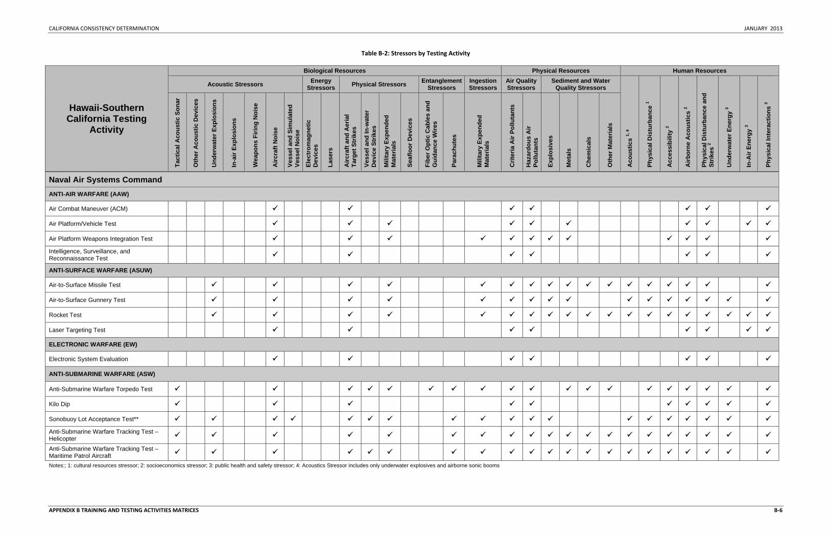
CALIFORNIA CONSISTENCY DETERMINATION JANUARY 2013
APPENDIX B TRAINING AND TESTING ACTIVITIES MATRICES B‐6
Table B‐2: Stressors by Testing Activity
Hawaii-Southern California Testing
Activity
Biological Resources Physical Resources Human Resources
Acoustic Stressors Energy Stressors Physical Stressors Entanglement
Stressors Ingestion Stressors
Air Quality Stressors
Sediment and Water Quality Stressors
Aco
ustic
s 1,
4
Phys
ical
Dis
turb
ance
1
Acc
essi
bilit
y 2
Airb
orne
Aco
ustic
s 2
Phys
ical
Dis
turb
ance
and
St
rikes
2
Und
erw
ater
Ene
rgy
3
In-A
ir En
ergy
3
Phys
ical
Inte
ract
ions
3
Tact
ical
Aco
ustic
Son
ar
Oth
er A
cous
tic D
evic
es
Und
erw
ater
Exp
losi
ons
In-a
ir Ex
plos
ions
Wea
pons
Firi
ng N
oise
Airc
raft
Noi
se
Vess
el a
nd S
imul
ated
Ve
ssel
Noi
se
Elec
trom
agne
tic
Dev
ices
Lase
rs
Airc
raft
and
Aer
ial
Targ
et S
trik
es
Vess
el a
nd In
-wat
er
Dev
ice
Strik
es
Mili
tary
Exp
ende
d M
ater
ials
Seaf
loor
Dev
ices
Fibe
r Opt
ic C
able
s an
d G
uida
nce
Wire
s
Para
chut
es
Mili
tary
Exp
ende
d M
ater
ials
Crit
eria
Air
Pollu
tant
s
Haz
ardo
us A
ir Po
lluta
nts
Expl
osiv
es
Met
als
Che
mic
als
Oth
er M
ater
ials
Naval Air Systems Command
ANTI-AIR WARFARE (AAW)
Air Combat Maneuver (ACM)
Air Platform/Vehicle Test
Air Platform Weapons Integration Test Intelligence, Surveillance, and Reconnaissance Test
ANTI-SURFACE WARFARE (ASUW)
Air-to-Surface Missile Test
Air-to-Surface Gunnery Test
Rocket Test
Laser Targeting Test
ELECTRONIC WARFARE (EW)
Electronic System Evaluation
ANTI-SUBMARINE WARFARE (ASW)
Anti-Submarine Warfare Torpedo Test
Kilo Dip
Sonobuoy Lot Acceptance Test** Anti-Submarine Warfare Tracking Test – Helicopter
Anti-Submarine Warfare Tracking Test – Maritime Patrol Aircraft Notes:; 1: cultural resources stressor; 2: socioeconomics stressor; 3: public health and safety stressor; 4: Acoustics Stressor includes only underwater explosives and airborne sonic booms
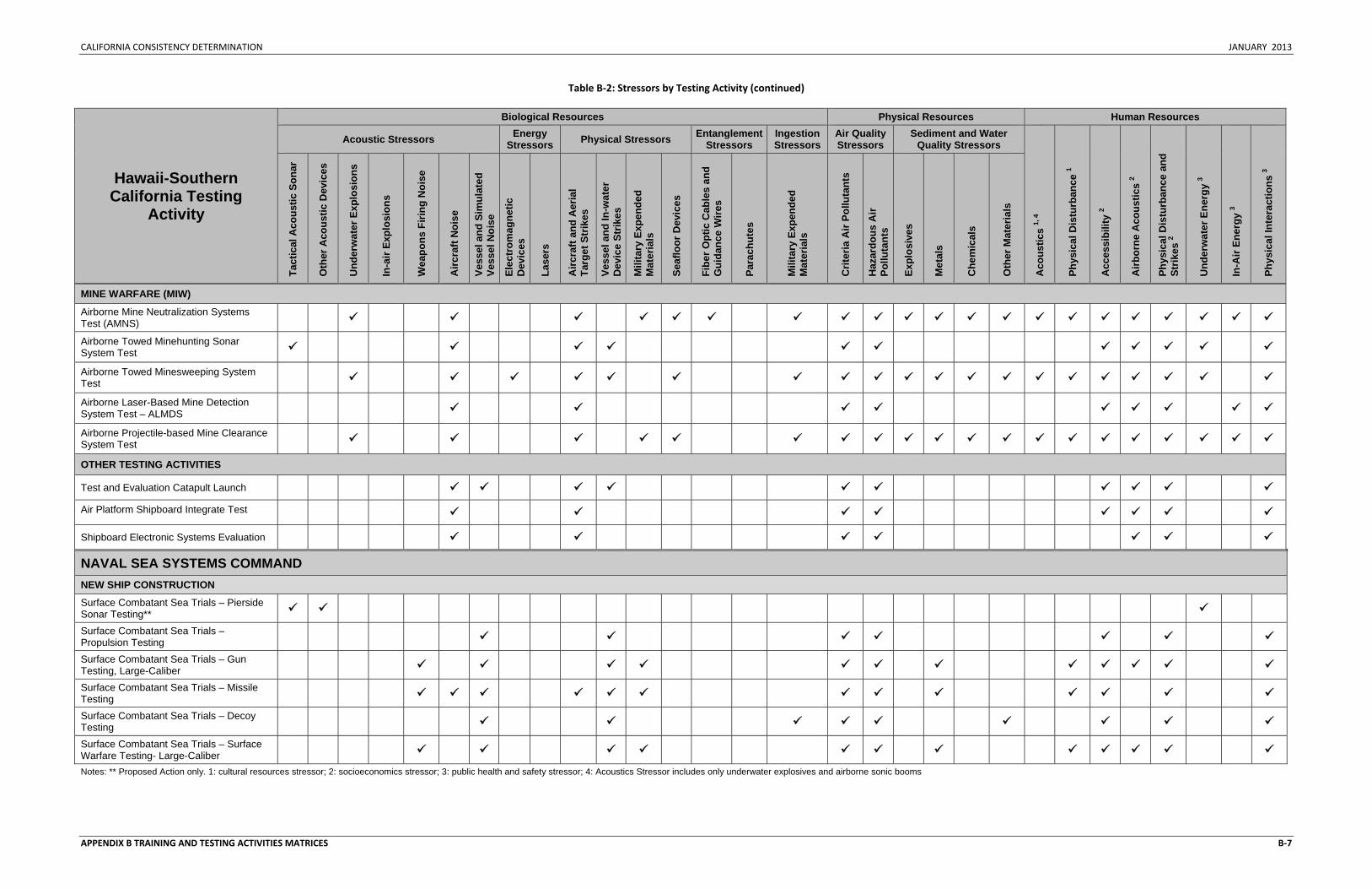
CALIFORNIA CONSISTENCY DETERMINATION JANUARY 2013
APPENDIX B TRAINING AND TESTING ACTIVITIES MATRICES B‐7
Table B‐2: Stressors by Testing Activity (continued)
Hawaii-Southern California Testing
Activity
Biological Resources Physical Resources Human Resources
Acoustic Stressors Energy Stressors Physical Stressors Entanglement
Stressors Ingestion Stressors
Air Quality Stressors
Sediment and Water Quality Stressors
Aco
ustic
s 1,
4
Phys
ical
Dis
turb
ance
1
Acc
essi
bilit
y 2
Airb
orne
Aco
ustic
s 2
Phys
ical
Dis
turb
ance
and
St
rikes
2
Und
erw
ater
Ene
rgy
3
In-A
ir En
ergy
3
Phys
ical
Inte
ract
ions
3
Tact
ical
Aco
ustic
Son
ar
Oth
er A
cous
tic D
evic
es
Und
erw
ater
Exp
losi
ons
In-a
ir Ex
plos
ions
Wea
pons
Firi
ng N
oise
Airc
raft
Noi
se
Vess
el a
nd S
imul
ated
Ve
ssel
Noi
se
Elec
trom
agne
tic
Dev
ices
Lase
rs
Airc
raft
and
Aer
ial
Targ
et S
trik
es
Vess
el a
nd In
-wat
er
Dev
ice
Strik
es
Mili
tary
Exp
ende
d M
ater
ials
Seaf
loor
Dev
ices
Fibe
r Opt
ic C
able
s an
d G
uida
nce
Wire
s
Para
chut
es
Mili
tary
Exp
ende
d M
ater
ials
Crit
eria
Air
Pollu
tant
s
Haz
ardo
us A
ir Po
lluta
nts
Expl
osiv
es
Met
als
Che
mic
als
Oth
er M
ater
ials
MINE WARFARE (MIW) Airborne Mine Neutralization Systems Test (AMNS)
Airborne Towed Minehunting Sonar System Test
Airborne Towed Minesweeping System Test
Airborne Laser-Based Mine Detection System Test – ALMDS
Airborne Projectile-based Mine Clearance System Test
OTHER TESTING ACTIVITIES
Test and Evaluation Catapult Launch Air Platform Shipboard Integrate Test
Shipboard Electronic Systems Evaluation
NAVAL SEA SYSTEMS COMMAND NEW SHIP CONSTRUCTION
Surface Combatant Sea Trials – Pierside Sonar Testing**
Surface Combatant Sea Trials – Propulsion Testing
Surface Combatant Sea Trials – Gun Testing, Large-Caliber
Surface Combatant Sea Trials – Missile Testing
Surface Combatant Sea Trials – Decoy Testing
Surface Combatant Sea Trials – Surface Warfare Testing- Large-Caliber Notes: ** Proposed Action only. 1: cultural resources stressor; 2: socioeconomics stressor; 3: public health and safety stressor; 4: Acoustics Stressor includes only underwater explosives and airborne sonic booms
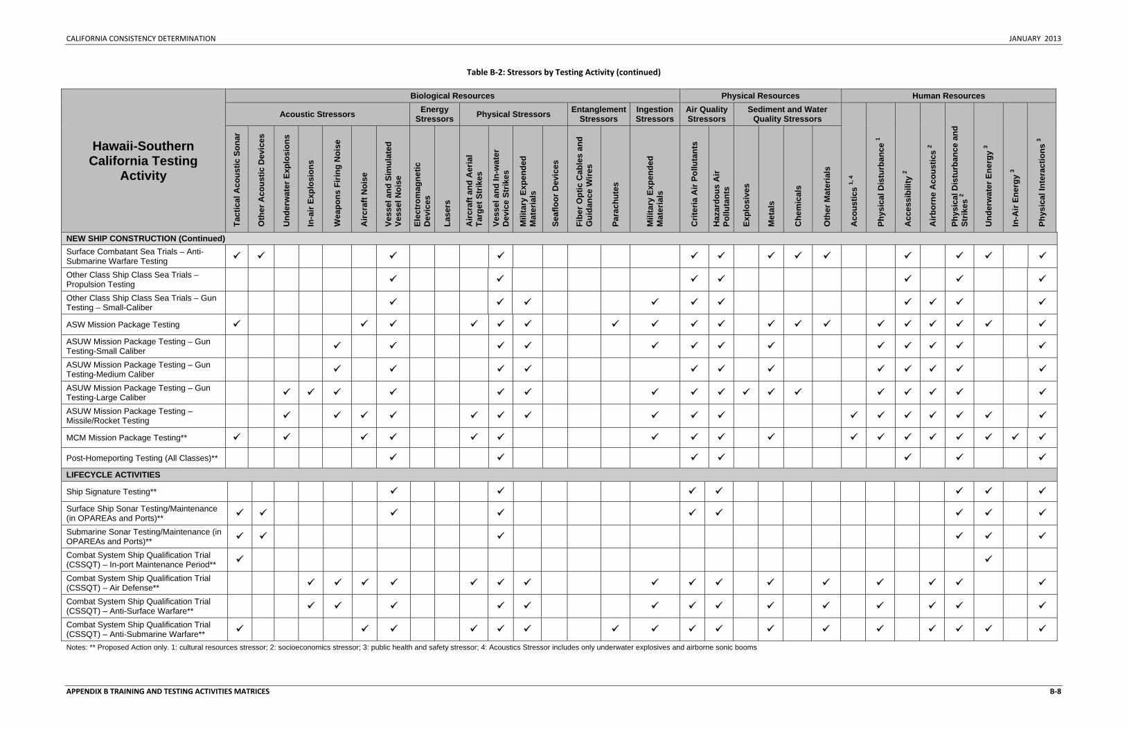
CALIFORNIA CONSISTENCY DETERMINATION JANUARY 2013
APPENDIX B TRAINING AND TESTING ACTIVITIES MATRICES B‐8
Table B‐2: Stressors by Testing Activity (continued)
Hawaii-Southern California Testing
Activity
Biological Resources Physical Resources Human Resources
Acoustic Stressors Energy Stressors Physical Stressors Entanglement
Stressors Ingestion Stressors
Air Quality Stressors
Sediment and Water Quality Stressors
Aco
ustic
s 1,
4
Phys
ical
Dis
turb
ance
1
Acc
essi
bilit
y 2
Airb
orne
Aco
ustic
s 2
Phys
ical
Dis
turb
ance
and
St
rikes
2
Und
erw
ater
Ene
rgy
3
In-A
ir En
ergy
3
Phys
ical
Inte
ract
ions
3
Tact
ical
Aco
ustic
Son
ar
Oth
er A
cous
tic D
evic
es
Und
erw
ater
Exp
losi
ons
In-a
ir Ex
plos
ions
Wea
pons
Firi
ng N
oise
Airc
raft
Noi
se
Vess
el a
nd S
imul
ated
Ve
ssel
Noi
se
Elec
trom
agne
tic
Dev
ices
Lase
rs
Airc
raft
and
Aer
ial
Targ
et S
trik
es
Vess
el a
nd In
-wat
er
Dev
ice
Strik
es
Mili
tary
Exp
ende
d M
ater
ials
Seaf
loor
Dev
ices
Fibe
r Opt
ic C
able
s an
d G
uida
nce
Wire
s
Para
chut
es
Mili
tary
Exp
ende
d M
ater
ials
Crit
eria
Air
Pollu
tant
s
Haz
ardo
us A
ir Po
lluta
nts
Expl
osiv
es
Met
als
Che
mic
als
Oth
er M
ater
ials
NEW SHIP CONSTRUCTION (Continued) Surface Combatant Sea Trials – Anti-Submarine Warfare Testing
Other Class Ship Class Sea Trials – Propulsion Testing
Other Class Ship Class Sea Trials – Gun Testing – Small-Caliber
ASW Mission Package Testing ASUW Mission Package Testing – Gun Testing-Small Caliber
ASUW Mission Package Testing – Gun Testing-Medium Caliber
ASUW Mission Package Testing – Gun Testing-Large Caliber
ASUW Mission Package Testing – Missile/Rocket Testing
MCM Mission Package Testing**
Post-Homeporting Testing (All Classes)** LIFECYCLE ACTIVITIES
Ship Signature Testing** Surface Ship Sonar Testing/Maintenance (in OPAREAs and Ports)**
Submarine Sonar Testing/Maintenance (in OPAREAs and Ports)**
Combat System Ship Qualification Trial (CSSQT) – In-port Maintenance Period**
Combat System Ship Qualification Trial (CSSQT) – Air Defense**
Combat System Ship Qualification Trial (CSSQT) – Anti-Surface Warfare**
Combat System Ship Qualification Trial (CSSQT) – Anti-Submarine Warfare** Notes: ** Proposed Action only. 1: cultural resources stressor; 2: socioeconomics stressor; 3: public health and safety stressor; 4: Acoustics Stressor includes only underwater explosives and airborne sonic booms
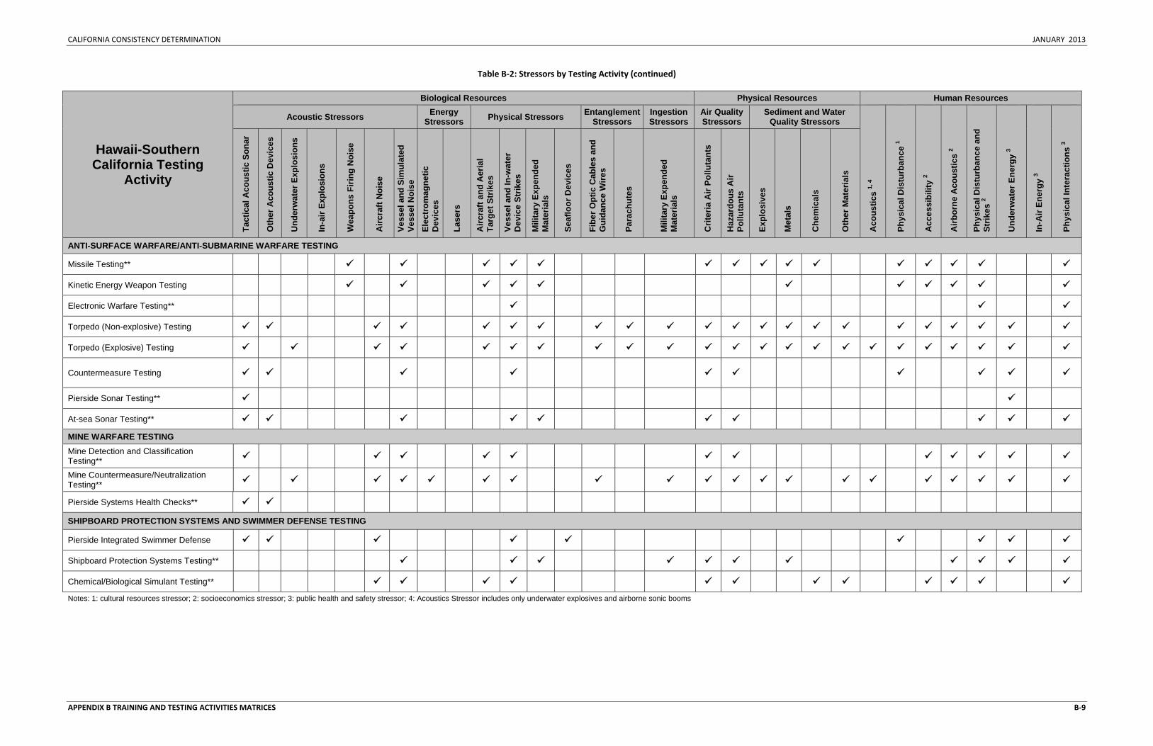
CALIFORNIA CONSISTENCY DETERMINATION JANUARY 2013
APPENDIX B TRAINING AND TESTING ACTIVITIES MATRICES B‐9
Table B‐2: Stressors by Testing Activity (continued)
Hawaii-Southern California Testing
Activity
Biological Resources Physical Resources Human Resources
Acoustic Stressors Energy Stressors Physical Stressors Entanglement
Stressors Ingestion Stressors
Air Quality Stressors
Sediment and Water Quality Stressors
Aco
ustic
s 1,
4
Phys
ical
Dis
turb
ance
1
Acc
essi
bilit
y 2
Airb
orne
Aco
ustic
s 2
Phys
ical
Dis
turb
ance
and
St
rikes
2
Und
erw
ater
Ene
rgy
3
In-A
ir En
ergy
3
Phys
ical
Inte
ract
ions
3
Tact
ical
Aco
ustic
Son
ar
Oth
er A
cous
tic D
evic
es
Und
erw
ater
Exp
losi
ons
In-a
ir Ex
plos
ions
Wea
pons
Firi
ng N
oise
Airc
raft
Noi
se
Vess
el a
nd S
imul
ated
Ve
ssel
Noi
se
Elec
trom
agne
tic
Dev
ices
Lase
rs
Airc
raft
and
Aer
ial
Targ
et S
trik
es
Vess
el a
nd In
-wat
er
Dev
ice
Strik
es
Mili
tary
Exp
ende
d M
ater
ials
Seaf
loor
Dev
ices
Fibe
r Opt
ic C
able
s an
d G
uida
nce
Wire
s
Para
chut
es
Mili
tary
Exp
ende
d M
ater
ials
Crit
eria
Air
Pollu
tant
s
Haz
ardo
us A
ir Po
lluta
nts
Expl
osiv
es
Met
als
Che
mic
als
Oth
er M
ater
ials
ANTI-SURFACE WARFARE/ANTI-SUBMARINE WARFARE TESTING
Missile Testing**
Kinetic Energy Weapon Testing
Electronic Warfare Testing**
Torpedo (Non-explosive) Testing
Torpedo (Explosive) Testing
Countermeasure Testing
Pierside Sonar Testing**
At-sea Sonar Testing** MINE WARFARE TESTING Mine Detection and Classification Testing**
Mine Countermeasure/Neutralization Testing**
Pierside Systems Health Checks**
SHIPBOARD PROTECTION SYSTEMS AND SWIMMER DEFENSE TESTING
Pierside Integrated Swimmer Defense
Shipboard Protection Systems Testing**
Chemical/Biological Simulant Testing** Notes: 1: cultural resources stressor; 2: socioeconomics stressor; 3: public health and safety stressor; 4: Acoustics Stressor includes only underwater explosives and airborne sonic booms
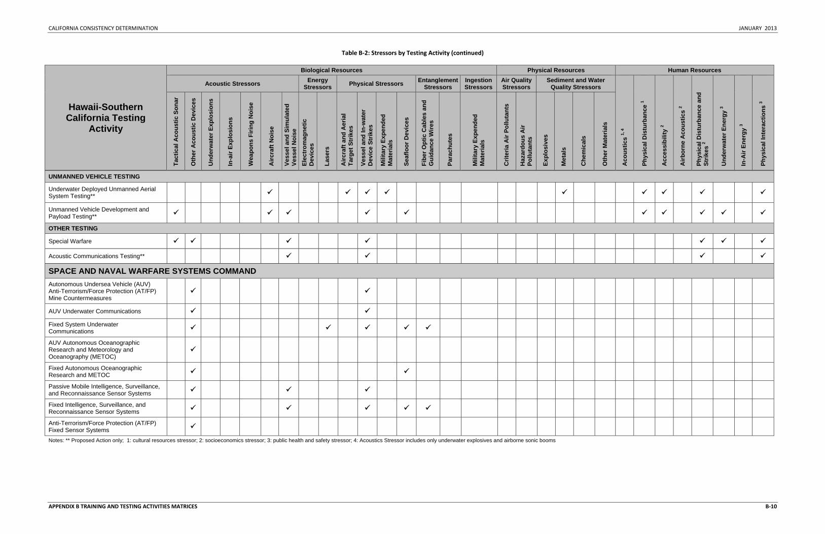
CALIFORNIA CONSISTENCY DETERMINATION JANUARY 2013
APPENDIX B TRAINING AND TESTING ACTIVITIES MATRICES B‐10
Table B‐2: Stressors by Testing Activity (continued)
Hawaii-Southern California Testing
Activity
Biological Resources Physical Resources Human Resources
Acoustic Stressors Energy Stressors Physical Stressors Entanglement
Stressors Ingestion Stressors
Air Quality Stressors
Sediment and Water Quality Stressors
Aco
ustic
s 1,
4
Phys
ical
Dis
turb
ance
1
Acc
essi
bilit
y 2
Airb
orne
Aco
ustic
s 2
Phys
ical
Dis
turb
ance
and
St
rikes
2
Und
erw
ater
Ene
rgy
3
In-A
ir En
ergy
3
Phys
ical
Inte
ract
ions
3
Tact
ical
Aco
ustic
Son
ar
Oth
er A
cous
tic D
evic
es
Und
erw
ater
Exp
losi
ons
In-a
ir Ex
plos
ions
Wea
pons
Firi
ng N
oise
Airc
raft
Noi
se
Vess
el a
nd S
imul
ated
Ve
ssel
Noi
se
Elec
trom
agne
tic
Dev
ices
Lase
rs
Airc
raft
and
Aer
ial
Targ
et S
trik
es
Vess
el a
nd In
-wat
er
Dev
ice
Strik
es
Mili
tary
Exp
ende
d M
ater
ials
Seaf
loor
Dev
ices
Fibe
r Opt
ic C
able
s an
d G
uida
nce
Wire
s
Para
chut
es
Mili
tary
Exp
ende
d M
ater
ials
Crit
eria
Air
Pollu
tant
s
Haz
ardo
us A
ir Po
lluta
nts
Expl
osiv
es
Met
als
Che
mic
als
Oth
er M
ater
ials
UNMANNED VEHICLE TESTING
Underwater Deployed Unmanned Aerial System Testing**
Unmanned Vehicle Development and Payload Testing**
OTHER TESTING
Special Warfare
Acoustic Communications Testing**
SPACE AND NAVAL WARFARE SYSTEMS COMMAND Autonomous Undersea Vehicle (AUV) Anti-Terrorism/Force Protection (AT/FP) Mine Countermeasures
AUV Underwater Communications Fixed System Underwater Communications
AUV Autonomous Oceanographic Research and Meteorology and Oceanography (METOC)
Fixed Autonomous Oceanographic Research and METOC
Passive Mobile Intelligence, Surveillance, and Reconnaissance Sensor Systems
Fixed Intelligence, Surveillance, and Reconnaissance Sensor Systems
Anti-Terrorism/Force Protection (AT/FP) Fixed Sensor Systems
Notes: ** Proposed Action only; 1: cultural resources stressor; 2: socioeconomics stressor; 3: public health and safety stressor; 4: Acoustics Stressor includes only underwater explosives and airborne sonic booms
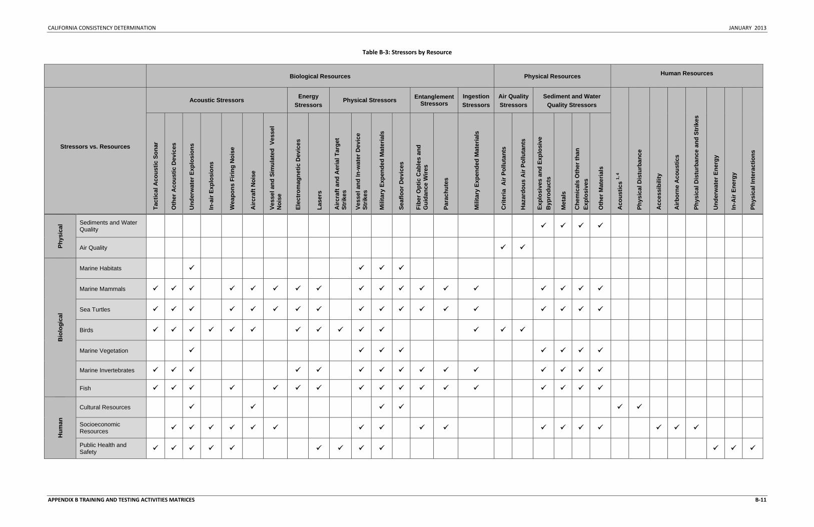
CALIFORNIA CONSISTENCY DETERMINATION JANUARY 2013
APPENDIX B TRAINING AND TESTING ACTIVITIES MATRICES B‐11
Table B‐3: Stressors by Resource
Biological Resources Physical Resources Human Resources
Stressors vs. Resources
Acoustic Stressors Energy Stressors
Physical Stressors Entanglement Stressors
Ingestion Stressors
Air Quality Stressors
Sediment and Water Quality Stressors
Aco
ustic
s 1,
4
Phys
ical
Dis
turb
ance
Acc
essi
bilit
y
Airb
orne
Aco
ustic
s
Phys
ical
Dis
turb
ance
and
Str
ikes
Und
erw
ater
Ene
rgy
In-A
ir En
ergy
Phys
ical
Inte
ract
ions
Tact
ical
Aco
ustic
Son
ar
Oth
er A
cous
tic D
evic
es
Und
erw
ater
Exp
losi
ons
In-a
ir Ex
plos
ions
Wea
pons
Firi
ng N
oise
Airc
raft
Noi
se
Vess
el a
nd S
imul
ated
Ves
sel
Noi
se
Elec
trom
agne
tic D
evic
es
Lase
rs
Airc
raft
and
Aer
ial T
arge
t St
rikes
Vess
el a
nd In
-wat
er D
evic
e St
rikes
Mili
tary
Exp
ende
d M
ater
ials
Seaf
loor
Dev
ices
Fibe
r Opt
ic C
able
s an
d G
uida
nce
Wire
s
Para
chut
es
Mili
tary
Exp
ende
d M
ater
ials
Crit
eria
Air
Pollu
tant
s
Haz
ardo
us A
ir Po
lluta
nts
Expl
osiv
es a
nd E
xplo
sive
B
ypro
duct
s
Met
als
Che
mic
als
Oth
er th
an
Expl
osiv
es
Oth
er M
ater
ials
Phys
ical
Sediments and Water Quality
Air Quality
Bio
logi
cal
Marine Habitats
Marine Mammals
Sea Turtles
Birds
Marine Vegetation
Marine Invertebrates
Fish
Hum
an
Cultural Resources
Socioeconomic Resources
Public Health and Safety

CALIFORNIA CONSISTENCY DETERMINATION JANUARY 2013
APPENDIX B TRAINING AND TESTING ACTIVITIES MATRICES B‐12
This Page Intentionally Left Blank

CALIFORNIA CONSISTENCY DETERMINATION JANUARY 2013
Appendix C
Standard Operating Procedures, Mitigation, and Monitoring

CALIFORNIA CONSISTENCY DETERMINATION JANUARY 2013
This Page Intentionally Left Blank

CALIFORNIA CONSISTENCY DETERMINATION JANUARY 2013
APPENDIX C: STANDARD OPERATING PROCEDURES, MITIGATION, AND MONITORING i
TABLE OF CONTENTS
C STANDARD OPERATING PROCEDURES, MITIGATION, AND MONITORING . C‐1
C.1 STANDARD OPERATING PROCEDURES ............................................................................................... C‐1 C.1.1 VESSEL SAFETY ................................................................................................................................... C‐2 C.1.2 AIRCRAFT SAFETY ............................................................................................................................... C‐2 C.1.3 LASER PROCEDURES ............................................................................................................................ C‐2 C.1.3.1 Laser Operators .......................................................................................................................... C‐3 C.1.3.2 Laser Activity Clearance .............................................................................................................. C‐3 C.1.4 WEAPONS FIRING PROCEDURES ............................................................................................................ C‐3 C.1.4.1 Notice to Mariners ...................................................................................................................... C‐3 C.1.4.2 Weapons Firing Range Clearance ............................................................................................... C‐3 C.1.4.3 Target Deployment Safety .......................................................................................................... C‐3 C.1.5 SWIMMER DEFENSE TESTING PROCEDURES ............................................................................................ C‐4 C.1.5.1 Notice to Mariners ...................................................................................................................... C‐4 C.1.5.2 Swimmer Defense Testing Clearance ......................................................................................... C‐4 C.1.6 UNMANNED AERIAL AND UNDERWATER VEHICLE PROCEDURES ................................................................. C‐4 C.1.7 TOWED IN‐WATER DEVICE PROCEDURES ............................................................................................... C‐4 C.2 INTRODUCTION TO MITIGATION ....................................................................................................... C‐4 C.2.1 REGULATORY REQUIREMENTS FOR MITIGATION ...................................................................................... C‐5 C.2.2 OVERVIEW OF MITIGATION APPROACH .................................................................................................. C‐6 C.2.2.1 Lessons Learned from Previous Environmental Impact Statements/Overseas Environmental Impact Statements ..................................................................................................................................... C‐6 C.2.2.2 Protective Measures Assessment Protocol ................................................................................ C‐6 C.2.3 ASSESSMENT METHOD ........................................................................................................................ C‐7 C.2.3.1 Step 1: Effectiveness Assessment ............................................................................................... C‐7 C.2.3.2 Step 2: Operational Assessment ................................................................................................. C‐9 C.3 MITIGATION ASSESSMENT ............................................................................................................ C‐10 C.3.1 LOOKOUT PROCEDURAL MEASURES .................................................................................................... C‐10 C.3.1.1 Specialized Training .................................................................................................................. C‐10 C.3.1.2 Lookouts.................................................................................................................................... C‐11 C.3.2 MITIGATION ZONE PROCEDURAL MEASURES ........................................................................................ C‐21 C.3.2.1 Acoustic Stressors ..................................................................................................................... C‐22 C.3.2.2 Physical Strike and Disturbance ................................................................................................ C‐49 C.3.3 MITIGATION AREAS .......................................................................................................................... C‐51 C.3.3.1 Sea Turtles ................................................................................................................................ C‐52 C.3.3.2 Seafloor Habitats and Shipwrecks ............................................................................................ C‐52 C.4 MITIGATION SUMMARY ............................................................................................................... C‐53 C.5 MITIGATION MEASURES CONSIDERED BUT ELIMINATED ...................................................................... C‐59 C.5.1 PREVIOUSLY CONSIDERED BUT ELIMINATED .......................................................................................... C‐59 C.5.1.1 Amount and Level of Activities ................................................................................................. C‐59 C.5.1.2 Replacing Training and Testing with Simulated Activities ........................................................ C‐59 C.5.1.3 Location and Timing of Activities .............................................................................................. C‐61 C.5.1.4 Visual and Passive Acoustic Observations ................................................................................ C‐63 C.5.1.5 Increasing the Size of Observed Mitigation Zones ................................................................... C‐64 C.5.1.6 Adopting Mitigation Measures of Foreign Navies .................................................................... C‐65 C.5. 1.7 Reporting .................................................................................................................................. C‐65
CALIFORNIA CONSISTENCY DETERMINATION JANUARY 2013
APPENDIX C: STANDARD OPERATING PROCEDURES, MITIGATION, AND MONITORING ii
C.5.2 PREVIOUSLY ACCEPTED BUT NOW ELIMINATED ..................................................................................... C‐66 C.5.2.1 Implementing a Mitigation Zone for Missile Exercises with Airborne Targets ......................... C‐66 C.5.2.2 Implementing a Mitigation Zone for Medium and Large Caliber Gunnery Exercises with Airborne Targets ...................................................................................................................................... C‐66 C.5.2.3 Implementing Measures for Laser Test Operations ................................................................. C‐66 C.6 MONITORING ............................................................................................................................ C‐67 C.6.1 APPROACH TO MONITORING .............................................................................................................. C‐67 C.6.1.1 Integrated Comprehensive Monitoring Plan Top‐Level Goals .................................................. C‐67 C.6.1.2 Scientific Advisory Group Recommendations .......................................................................... C‐68 C.7 REPORTING ............................................................................................................................... C‐69 C.7.1 EXERCISE AND MONITORING REPORTING ............................................................................................. C‐69 C.7.2 STRANDING RESPONSE PLAN .............................................................................................................. C‐69 C.7.3 BIRD STRIKES ................................................................................................................................... C‐69
LIST OF TABLES
Table C.3‐1: Detection Probability g(0)1 Values for Marine Mammal Species ........................................ C‐16 Table C.3‐2: Predicted Range to Effects and Recommended Mitigation Zones ...................................... C‐21 Table C.3‐3: Predicted Range to Effects and Mitigation Zone Radius for Mine Countermeasure .......... C‐29 Table C.4‐1: Comparison of Current and Recommended Mitigation Measures ..................................... C‐52 Table C.4‐2: Mitigation Identification and Implementation .................................................................... C‐57
LIST OF FIGURES
Figure C.2‐1: Flowchart of Process for Determining Proposed Mitigation Measures ............................... C‐8
CALIFORNIA CONSISTENCY DETERMINATION JANUARY 2013
APPENDIX C: STANDARD OPERATING PROCEDURES, MITIGATION, AND MONITORING C‐1
C STANDARD OPERATING PROCEDURES, MITIGATION, AND MONITORING
This chapter describes the United States (U.S.) Department of the Navy (Navy) standard operating procedures, mitigation measures, and marine species monitoring efforts. Standard operating procedures are essential to maintaining safety and mission success, and in many cases have the added benefit of reducing potential environmental impacts. Mitigation measures are designed to help reduce or avoid potential impacts on marine resources. Marine species monitoring efforts are designed to track compliance with take authorizations, evaluate the effectiveness of mitigation measures, and improve our understanding of the effects training and testing activities have on marine resources within the Hawaii‐Southern California Training and Testing (HSTT) Study Area (Study Area).
C.1 STANDARD OPERATING PROCEDURES Effective training, maintenance, research, development, testing, and evaluation (hereafter referred to collectively as the Proposed Action) require that participants utilize their sensors and weapon systems to their optimum capabilities as required by the activity objectives. The Navy currently employs standard practices to provide for the safety of personnel and equipment, including ships and aircraft, as well as the success of the training and testing activities. For the purpose of this document, the Navy will refer to standard practices as standard operating procedures. Because of their importance for maintaining safety and mission success, standard operating procedures have been considered as part of the Proposed Action under each alternative, and therefore are included in the Chapter 3 (Affected Environment and Environmental Consequences) environmental analyses for each resource.
Navy standard operating procedures have been developed and refined over years of experience, and are broadcast via numerous naval instructions and manuals, including the following sources:
• Ship, Submarine and Aircraft Safety Manuals • Ship, Submarine and Aircraft Standard Operating Manuals • Fleet Area Control and Surveillance Facility Range Operating Instructions • Fleet Exercise Publications and Instructions • Naval Sea Systems Command Test Range Safety and Standard Operating Instructions • Navy Instrumented Range Operating Procedures • Naval Shipyard Sea Trial Agendas • Research, Development, Test and Evaluation Plans • Naval Gunfire Safety Instructions • Navy Planned Maintenance System Instructions and Requirements • Federal Aviation Administration Regulations
In many cases there are incidental environmental, socioeconomic, and cultural benefits resulting from standard operating procedures. Standard operating procedures serve the primary purpose of providing for safety and mission success, and are implemented regardless of their secondary benefits. This is what distinguishes standard operating procedures, which are a component of the Proposed Action, from mitigation measures, which are designed entirely for the purpose of reducing environmental impacts resulting from the Proposed Action. Because standard operating procedures are crucial to safety and mission success, the Navy will not modify them as a way to further reduce effects on environmental resources. Rather, mitigation measures will be used as the tool for avoiding and reducing potential
CALIFORNIA CONSISTENCY DETERMINATION JANUARY 2013
APPENDIX C: STANDARD OPERATING PROCEDURES, MITIGATION, AND MONITORING C‐2
environmental impacts. Standard operating procedures that are recognized as providing a potential secondary benefit are provided below.
C.1.1 VESSEL SAFETY
Surface vessels, which for the purposes of this chapter also include surfaced submarines operated by or for the Navy, have personnel assigned to stand watch at all times, day and night, when the vessel is moving through the water (underway). Bridge watch personnel undertake extensive training in accordance with the Lookout Training Handbook or civilian equivalent, including on‐the‐job instruction and a formal Personal Qualification Standard Program (or equivalent program for supporting contractors or civilians), to certify that they have demonstrated all necessary skills (such as detection and reporting of floating or partially submerged objects). Bridge watch personnel are composed of officers and enlisted men and women. Their duties may be performed in conjunction with other job responsibilities, such as navigating the vessel or supervising other personnel. While on watch, personnel employ visual search techniques, including the use of binoculars, using a scanning method in accordance with the United States Navy Lookout Training Handbook. After sunset and prior to sunrise, personnel standing watch employ night lookout techniques, which include the use of night vision devices.
A primary duty of personnel standing watch on surface vessels is to detect and report all objects and disturbances sighted in the water that may be indicative of a threat to the vessel and its crew, such as debris, a periscope, surfaced submarine, or surface disturbance. Per vessel safety requirements, personnel standing watch also report any marine mammals sighted that have the potential to be in the direct path of the vessel as a standard collision avoidance procedure. Because personnel standing watch are primarily posted for safety of navigation, range clearance, and man‐overboard precautions, they are not normally posted while vessels are moored to a pier. When anchored or moored to a buoy, a bridge team is still maintained but with fewer personnel than when a vessel is underway. When vessels are moored or at anchor, watch personnel may maintain security and safety of the ship by scanning the water for any indications of a threat (as described above).
While underway, Navy surface ships greater than 65 feet (ft.) (20 meters [m]) in length have at least two personnel standing watch with binoculars; Navy surface ships less than 65 ft. (20 m) in length, surfaced submarines, and contractor vessels, have at least one personnel standing watch with binoculars. While underway, personnel standing watch are alert at all times. Due to limited manning and space limitations, smaller vessels and watercraft (e.g., rigid hull inflatable boats) do not have dedicated personnel standing watch, and the boat crew is responsible for maintaining the safety of the boat and surrounding environment.
All vessels use extreme caution and proceed at a “safe speed” so they can take proper and effective action to avoid a collision with any sighted object or disturbance, and can be stopped within a distance appropriate to the prevailing circumstances and conditions.
C.1.2 AIRCRAFT SAFETY
Pilots of Navy aircraft make every attempt to avoid large flocks of birds in order to reduce the safety risk involved with a potential bird strike.
C.1.3 LASER PROCEDURES
The following procedures are applicable to lasers of sufficient intensity to cause human eye damage.
CALIFORNIA CONSISTENCY DETERMINATION JANUARY 2013
APPENDIX C: STANDARD OPERATING PROCEDURES, MITIGATION, AND MONITORING C‐3
C.1.3.1 Laser Operators
Only properly trained and authorized personnel operate lasers.
C.1.3.2 Laser Activity Clearance
Prior to commencing activities involving lasers, the operator ensures that the area is clear of unprotected or unauthorized personnel in the laser impact area by performing a personnel inspection or a flyover. The operator also ensures that any personnel within the area are aware of laser activities and are properly protected.
C.1.4 WEAPONS FIRING PROCEDURES
C.1.4.1 Notice to Mariners
A Notice to Mariners is routinely issued in advance of missile firing activities. A notice is also issued in advance of explosive bombing activities when they are conducted in an area that does not already have a standing Notice to Mariners. For activities involving large caliber gunnery, the Navy evaluates the need to publish a Notice to Mariners based on the scale, location, and timing of the activity. More information on the Notice to Mariners is found in Chapter 3, Section 3.12, of the HSTT Environmental Impact Statement/Overseas Environmental Impact Statement (EIS/OEIS) (Public Health and Safety).
C.1.4.2 Weapons Firing Range Clearance
The weapons firing hazard range must be clear of non‐participating vessels and aircraft before firing activities will commence. The size of the firing hazard range is based on the farthest firing range capability of the weapon being used. All missile and rocket firing activities are carefully planned in advance and conducted under strict procedures which place the ultimate responsibility for range safety on the Officer Conducting the Exercise or civilian equivalent. All weapons firing ceases when cease fire orders are received from the Range Safety Officer or when the line of fire is endangering any object other than the designated target.
Pilots of Navy aircraft are not authorized to expend ordnance, fire missiles, or drop other airborne devices through extensive cloud cover where visual clearance of the air and surface area is not possible. The two exceptions to this requirement are: (1) when operating in the open ocean, air and surface clearance through visual means or radar surveillance is acceptable; and (2) when the operational commander conducting the exercise accepts responsibility for the safeguarding of airborne and surface traffic.
During activities that involve recoverable targets, such as aerial drones, the Navy recovers the target and any associated parachutes to the maximum extent practicable consistent with operational requirements and personnel safety.
C.1.4.3 Target Deployment Safety
Firing exercises involving the Integrated Maritime Portable Acoustic Scoring System are conducted in daylight hours in calm conditions. When small boats are used to deploy or recover buoys the conditions must measure less than three on the Beaufort Scale. When buoys are deployed and recovered from ships, firing exercises are conducted at less than four on the Beaufort Scale. These standards are in place to ensure safe operating conditions during buoy deployment and recovery.
The Beaufort Scale is a standardized measurement of the weather conditions, based primarily on wind speed. The scale is divided into levels from 0 to 12, with 12 indicating the most severe weather
CALIFORNIA CONSISTENCY DETERMINATION JANUARY 2013
APPENDIX C: STANDARD OPERATING PROCEDURES, MITIGATION, AND MONITORING C‐4
conditions (e.g., hurricane force winds). At Beaufort number 3, the wind speed in 7 to 10 knots, and the wave height is 2 to 3.5 ft. (0.5 to 1.1 m). At Beaufort number 4, the wind speed in 11 to 15 knots, and the wave height is 3.5 to 6 ft. (1.1 to 1.8 m).
C.1.5 SWIMMER DEFENSE TESTING PROCEDURES
C.1.5.1 Notice to Mariners
A Notice to Mariners is issued in advance of all swimmer defense testing.
C.1.5.2 Swimmer Defense Testing Clearance
A daily in situ calibration of the source levels is used to establish a clearance area to the 145 decibels (dB) referenced to (re) 1 micro (µ) Pascal (Pa) sound pressure level threshold for non‐participant personnel safety. A hydrophone is stationed during the calibration sequences in order to confirm the area. Boats patrol the 145 dB re 1 µPa sound pressure level area during all test activities. Boat crews are equipped with binoculars and remain vigilant for non‐participant divers and boats, swimmers, snorkelers, and dive flags. If a non‐participating swimmer, snorkeler, or diver is observed entering into the area, of the swimmer defense system, the power levels of the defense system are reduced. An additional 100 yard (yd.) (91.4 m) buffer is applied to the entry point of the non‐participant as an additional precaution. If the area cannot be maintained free of non‐participating swimmers, snorkelers, and divers, testing will cease until the non‐participant has moved outside the area.
C.1.6 UNMANNED AERIAL AND UNDERWATER VEHICLE PROCEDURES
For activities involving unmanned aerial and underwater vehicles, the Navy evaluates the need to publish a Notice to Airmen or Mariners based on the scale, location, and timing of the activity. Unmanned Aerial Vehicles and Unmanned Aircraft Systems are operated in accordance with Federal Aviation Administration air traffic organization policy as issued in Office of the Chief of Naval Operations Instruction 3710, 3750 and 4790.
C.1.7 TOWED IN-WATER DEVICE PROCEDURES
Prior to deploying a towed device from a manned platform, there is a standard operating procedure to search the intended path of the device for any floating debris (e.g., driftwood) or other potential obstructions (e.g., concentrations of floating vegetation [Sargassum or kelp paddies] and animals), since they have the potential to cause damage to the device.
C.2 INTRODUCTION TO MITIGATION The Navy recognizes that the Proposed Action has the potential to impact the environment. Unlike standard operating procedures, which are established for reasons other than environmental benefit, mitigation measures are modifications to the Proposed Action that are implemented for the sole purpose of reducing a specific potential environmental impact on a particular resource. The procedures discussed in this chapter, most of which are currently or were previously implemented as a result of past environmental compliance documents, Endangered Species Act (ESA) biological opinions, Marine Mammal Protection Act (MMPA) letters of authorization, or other formal or informal consultations with regulatory agencies have been coordinated with the National Marine Fisheries Service (NMFS) through the consultation and permitting processes.
Additionally, the Navy has engaged in consultation processes under the ESA with regard to listed species that may be affected by the Proposed Action described in the HSTT EIS/OEIS. For the purposes of the
CALIFORNIA CONSISTENCY DETERMINATION JANUARY 2013
APPENDIX C: STANDARD OPERATING PROCEDURES, MITIGATION, AND MONITORING C‐5
ESA section 7 consultation, the mitigation measures proposed here were considered by NMFS as beneficial actions taken by the Federal agency or applicant (50 Code of Federal Regulations 402.14(g)(8)). As required to satisfy requirements of the ESA, NMFS developed measures contained in reasonable and prudent alternatives, reasonable and prudent measures, or conservation recommendations in the biological opinions issued for this Proposed Action.
C.2.1 REGULATORY REQUIREMENTS FOR MITIGATION
An EIS must analyze the affected environment, discuss the environmental impacts of the Proposed Action and each alternative, and assess the significance of the impacts on the environment. Mitigation measures help reduce the severity or intensity of impacts of the Proposed Action and can occur early in the planning process by choosing not to take the action or by moving the location of the action. Mitigation measure development also occurs throughout the analysis process whenever an impact is minimized by limiting the degree or magnitude of the action or its implementation. Mitigation measures can also include actions that repair, rehabilitate, or restore the affected environment or reduce impacts over time through constant monitoring and corrective adjustments.
In accordance with the National Environmental Policy Act (NEPA) requirement, the environmental benefit of all proposed mitigation measures will apply to all alternatives analyzed in the HSTT EIS, and according to Navy policy, will also apply to the OEIS where applicable and appropriate. Additionally, the White House Council on Environmental Quality issued guidance for mitigation and monitoring on 14 January 2011. This guidance affirms that federal agencies, including the Navy, should:
• commit to mitigation in decision documents when they have based environmental analysis upon such mitigation (by including appropriate conditions on grants, permits, or other agency approvals, and making funding or approvals for implementing the Proposed Action contingent on implementing the mitigation commitments);
• monitor the implementation and effectiveness of mitigation commitments; • make information on mitigation and monitoring available to the public, preferably through
agency web sites; and • remedy ineffective mitigation when the federal action is not yet complete.
The Council on Environmental Quality guidance encourages federal agencies to develop internal processes for post‐decision monitoring to ensure the implementation and effectiveness of the mitigation. It also states that federal agencies may use adaptive management as part of an agency’s action. Adaptive management, when included in the NEPA analysis, allows for the agency to take alternate mitigation actions if mitigation commitments originally made in the planning and decision documents fail to achieve projected environmental outcomes. Adaptive management generally involves four phases: plan, act, monitor, and evaluate. This process allows the use of the results to update knowledge and adjust future management actions accordingly. Through implementing mitigation measures from the Navy’s previous planning, consultations, permits, and monitoring of those efforts, the Navy can use collected data to further refine proposed mitigation measures.
Through the planning, consultation, and permitting processes, federal regulatory agencies may also suggest that the Navy analyze additional mitigation measures for inclusion in Final EIS/OEISs and associated consultation and permitting documents. Any proposals for additional mitigation measures should be based on the federal agency’s assessment of the likelihood that such measures will contribute to a notable reduction of the environmental impact. If additional measures are identified, the Navy will
CALIFORNIA CONSISTENCY DETERMINATION JANUARY 2013
APPENDIX C: STANDARD OPERATING PROCEDURES, MITIGATION, AND MONITORING C‐6
apply the effectiveness and operational assessment protocol discussed in Section C.3 (Mitigation Assessment) to determine whether the additional measure will be proposed for implementation.
C.2.2 OVERVIEW OF MITIGATION APPROACH
This section describes the approach to the Navy’s process of developing its recommended mitigation measures. The Navy's overall approach to assessing potential mitigation measures is based on two principles: (1) mitigations will be effective at reducing potential impacts on the resource, and (2) from a military perspective, the mitigations are practicable, executable, and safety and readiness will not be impacted. The assessment process involves using information directly from the initial Chapter 3 (Affected Environment and Environmental Consequences), and assessing all existing mitigation and proposals for new or modified mitigation in order to determine if establishing and committing to a mitigation measure would be appropriate.
This document is organized to present, and where appropriate, analyze training and testing activities separately. Separate organization and analysis was needed because the training and testing communities perform activities for differing purposes, and in some cases, with different personnel and in different locations. An example would be the difference in testing a new mine warfare system at an established testing range, with civilian scientists and engineers, versus the eventual training of sailors and aviators with that same system. As such, suggested mitigations that are appropriate for both training and testing events will be presented once. Those specific mitigations that are designed for and executable only by the testing community will be presented separately.
C.2.2.1 Lessons Learned from Previous Environmental Impact Statements/Overseas Environmental Impact Statements
In an effort to improve upon past processes, the Navy has considered all mitigations previously implemented and adapted its mitigation assessment approach based on lessons learned from previous EISs, ESA biological opinions, MMPA letters of authorization, and other formal or informal consultations with regulatory agencies. For example, dirt and seeds are removed from tracked vehicles prior to embarking to San Clemente Island and the Silver Strand Training Complex as a means of reducing the introduction of non‐native plant species to these areas. This measure is the result of an iterative consultation process over many years with the U.S. Fish and Wildlife Service on operational impacts on resources on San Clemente Island and the Silver Strand. As a result, this practice has become a Standard Operating Procedure on military land ranges.
The Navy will assess the effectiveness of a full suite of recommended mitigation measures (a portion of which will include specific mitigation areas) on a case‐by‐case basis. The recommended measures are a combination of currently implemented measures, modifications of currently implemented measures, and newly proposed measures. The list of recommended measures is a result of the Navy’s internal adaptive management process, and the assessment of planners, scientists, and the operational community. This chapter contains an explanation, with operational and environmental assessments, of discontinued or modified mitigation measures.
C.2.2.2 Protective Measures Assessment Protocol
The Navy has developed an information technology‐based program, known as the Protective Measures Assessment Protocol, to promulgate environmental protection requirements during training and testing. The Protective Measures Assessment Protocol is a computer‐based application that is available to all Navy personnel involved in training and testing activities. The Protective Measures Assessment Protocol program is a decision support and situational awareness tool designed to help reduce potential impacts
CALIFORNIA CONSISTENCY DETERMINATION JANUARY 2013
APPENDIX C: STANDARD OPERATING PROCEDURES, MITIGATION, AND MONITORING C‐7
on marine species and the ocean environment by informing Navy personnel involved in training and testing activities of all required event‐specific mitigation measures. The program provides a visual display of the exercise area, unit’s position in relation to the target area, and any relevant environmental data. The Navy requires that the Protective Measures Assessment Protocol be used before applicable training or testing activities analyzed in this document are conducted. The final suite of mitigations resulting from the ongoing planning for the HSTT EIS/OEIS, as well as the regulatory consultation and permitting processes will be integrated into the Protective Measures Assessment Protocol.
C.2.3 ASSESSMENT METHOD
As shown in the flow diagram in Figure C.2‐1 and described below, the Navy’s mitigation measures are organized into two categories: (1) procedural measures and (2) proposed mitigation areas. Category 1 (Procedural Measures) involves employing techniques or technology to modify an activity, or decrease the number of activities that occur per year in order to avoid or reduce a potential impact on a particular resource. For the purposes of organization based on the suite of mitigation measures analyzed below, the procedural measures are discussed within two subcategories: lookouts and mitigation zones.
For category 2 (Mitigation Areas), in order to avoid or reduce a potential impact on a particular resource the Navy would either: (1) limit the time of day or duration in which a particular activity could take place, or (2) move or relocate a particular activity outside of a specific geographic area. Within mitigation areas, the measures would only apply to the specific activity that resulted in the requirement for mitigation, and would not prevent or restrict other activities from occurring during that time or in that area.
The Navy undertook two assessment steps for each recommended mitigation measure to ensure its compatibility with Section C.2.2 (Overview of Mitigation Approach). Step 1 is an effectiveness assessment to ensure that mitigations are effective at reducing potential impacts on the resource. Step 2 is an operational assessment of the impacts to safety, practicality, and readiness from the proposed mitigation measure. Steps 1 and 2 are organized according to stressor category throughout Section C.3 (Mitigation Assessment). In determining effectiveness at avoiding or reducing the impact, information was collected from published and readily available sources, as well as Navy after‐action and monitoring reports. When available, these data were used when they represented the best available science and if they were generally accepted by the scientific community to ensure that they were applicable and contributed to the analysis. The result of the assessments is a summary of recommended measures and changes from currently implemented measures, organized by stressor category (Table C.4‐1). In addition, Section C.5 (Mitigation Measures Considered but Eliminated) includes a complete list of mitigation measures that the Navy has considered but eliminated due to either being ineffective at reducing environmental impacts or having an unacceptable operational impact.
C.2.3.1 Step 1: Effectiveness Assessment
Category 1: Procedural Measures. A procedural measure was deemed effective if implementing the measure was likely to result in avoidance or reduction of an impact on a resource.
The level of avoidance or reduction of the impact gained from implementing a procedural measure will be weighed against the potential for a shift in impacts resulting from the activity modification. For example, if predictive modeling results indicate that the use of underwater explosives could cause unacceptable impacts on a particular resource; those impacts could possibly be reduced by substituting non‐explosive activities for explosive activities. However, if the increased use of non‐explosive activities
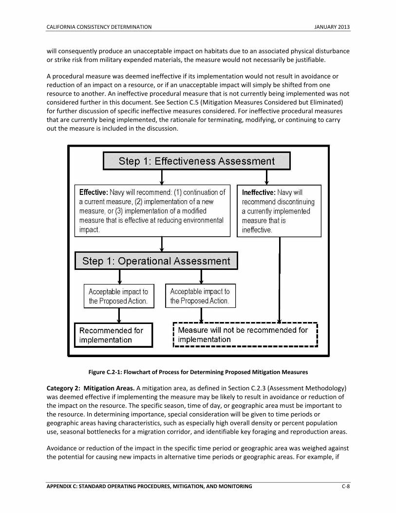
CALIFORNIA CONSISTENCY DETERMINATION JANUARY 2013
APPENDIX C: STANDARD OPERATING PROCEDURES, MITIGATION, AND MONITORING C‐8
will consequently produce an unacceptable impact on habitats due to an associated physical disturbance or strike risk from military expended materials, the measure would not necessarily be justifiable.
A procedural measure was deemed ineffective if its implementation would not result in avoidance or reduction of an impact on a resource, or if an unacceptable impact will simply be shifted from one resource to another. An ineffective procedural measure that is not currently being implemented was not considered further in this document. See Section C.5 (Mitigation Measures Considered but Eliminated) for further discussion of specific ineffective measures considered. For ineffective procedural measures that are currently being implemented, the rationale for terminating, modifying, or continuing to carry out the measure is included in the discussion.
Figure C.2‐1: Flowchart of Process for Determining Proposed Mitigation Measures
Category 2: Mitigation Areas. A mitigation area, as defined in Section C.2.3 (Assessment Methodology) was deemed effective if implementing the measure may be likely to result in avoidance or reduction of the impact on the resource. The specific season, time of day, or geographic area must be important to the resource. In determining importance, special consideration will be given to time periods or geographic areas having characteristics, such as especially high overall density or percent population use, seasonal bottlenecks for a migration corridor, and identifiable key foraging and reproduction areas.
Avoidance or reduction of the impact in the specific time period or geographic area was weighed against the potential for causing new impacts in alternative time periods or geographic areas. For example, if
CALIFORNIA CONSISTENCY DETERMINATION JANUARY 2013
APPENDIX C: STANDARD OPERATING PROCEDURES, MITIGATION, AND MONITORING C‐9
the use of underwater explosives was predicted to cause unacceptable impacts on a particular resource in a known foraging location, those impacts could possibly be reduced by relocating those activities to a new location. However, if the use of explosives at the new location would consequently produce an unacceptable impact on the same or a different resource at the new location, the measure would not necessarily be justifiable.
A mitigation area was deemed ineffective if implementing the measure would not result in avoidance or reduction of an impact on a resource, or if an unacceptable impact will simply be shifted from one time period or location to another. An ineffective mitigation area that the Navy does not currently implement was not considered further in this document. For ineffective mitigation areas that are currently being implemented, the rationale for terminating, modifying, or continuing to carry out the measure is included in the discussion.
C.2.3.2 Step 2: Operational Assessment
The Navy conducted the operational assessment for category 1, procedural measures, and category 2, mitigation areas, using the criteria described below. The Navy deemed procedural and mitigation areas measures to have acceptable operational impacts on a particular proposed activity if the following conclusions were reached:
1. Implementation of the measure will not increase safety risks to Navy personnel and equipment.
2. Implementation of the measure is practicable. Practicability was defined by the following factors:
• The measure does not result in an unacceptable increase in resource requirements (e.g., wear and tear on equipment, additional fuel, additional personnel, increased training or testing requirements, or additional reporting requirements).
• The measure does not result in an unacceptable increase in time away from homeport for Navy personnel.
• The measure does not result in national security concerns. Should national security require conducting more than the designated number of activities, or a change in how the Navy conducts those activities, the Navy reserves the right to provide the regulatory federal agency with prior notification and include the information in any associated exercise or monitoring reports.
• The measure is consistent with Navy policy.
3. Implementation of the measure will not result in an unacceptable impact on readiness. A primary factor that will be considered for all mitigation measures is that the measure must not modify the activity in a way that no longer allows the activity to meet the intended objectives, and ultimately must not interfere with the Navy meeting all of its military readiness requirements. Specifically, for mitigation area measures, the following additional factors were considered:
• The activity is not dependent on a specific range or range support structure within the mitigation area and there are alternate areas with the necessary environmental conditions (e.g., oceanographic conditions).
CALIFORNIA CONSISTENCY DETERMINATION JANUARY 2013
APPENDIX C: STANDARD OPERATING PROCEDURES, MITIGATION, AND MONITORING C‐10
• The mitigation area does not hold any current or foreseeable future readiness value. This assessment will be revisited if Navy operations, or national security interests, conclude that training or testing needs to occur within the mitigation area.
• Implementation of the measure will not prohibit conducting shipboard maintenance, repair, and testing pierside prior to at‐sea operations.
4. The Navy has legal authority to implement the measure.
If all four of the above conclusions were not able to be reached, then the Navy deemed the procedural or mitigation area measure to have unacceptable impacts on the Proposed Action, and did not recommend those unacceptable measures for implementation.
C.3 MITIGATION ASSESSMENT C.3.1 LOOKOUT PROCEDURAL MEASURES
As described in the Section C.1 (Standard Operating Procedures), surface vessels, which for the purposes of this chapter also includes surfaced submarines, have personnel assigned to stand watch at all times when the vessel is underway. Standard watch personnel may perform watch duties in conjunction with job responsibilities that extend beyond looking at the water or air (such as supervision of other personnel). This section will introduce lookouts, which perform similar duties to standard personnel standing watch, and whose duties satisfy both operational and mitigation requirements.
The Navy will have two types of lookouts for the purposes of conducting visual observations: (1) those positioned on surface ships, and (2) those positioned in aircraft or on boats. Lookouts positioned on surface ships will be dedicated solely to diligent observation of the air and surface of the water. They will have multiple observation objectives, which include but are not limited to detecting the presence of biological resources and recreational or fishing boats, observing the mitigation zones described in Section C.3.1.2 (Lookouts), and monitoring for vessel and personnel safety concerns.
Due to aircraft and boat manning and space restrictions, lookouts positioned in aircraft or on boats will consist of the aircraft crew, pilot, or boat crew. Lookouts positioned in aircraft and boats may be responsible for tasks in addition to observing the air or surface of the water (for example, navigation of a helicopter or rigid‐hull inflatable boat). However, aircraft and boat lookouts will, to the maximum extent practicable and consistent with aircraft and boat safety and training and testing requirements, comply with the observation objectives described above for lookouts positioned on surface ships.
The procedural measures described below primarily consist of having lookouts during specific training and testing activities.
C.3.1.1 Specialized Training
C.3.1.1.1 Training for Personnel Standing Watch and Lookouts
C.3.1.1.1.1 United States Navy Marine Species Awareness Training Recommended Mitigation and Comparison to Current Mitigation The Navy is proposing to continue implementing the Marine Species Awareness Training program. All personnel standing watch on the bridge, Commanding Officers, Executive Officers, maritime patrol aircraft aircrews, anti‐submarine warfare helicopter crews, civilian equivalents, and lookouts will successfully complete the United States Navy Marine Species Awareness Training prior to standing watch or serving as a lookout.
CALIFORNIA CONSISTENCY DETERMINATION JANUARY 2013
APPENDIX C: STANDARD OPERATING PROCEDURES, MITIGATION, AND MONITORING C‐11
Effectiveness and Operational Assessment Navy personnel undergo extensive training in order to stand watch on the bridge. Standard training includes on‐the‐job instruction under the supervision of experienced personnel, followed by completion of the Personal Qualification Standard program. The Personal Qualification Standard program certifies that personnel have demonstrated the skills needed to stand watch, such as detecting and reporting floating or partially submerged objects.
The United States Navy Marine Species Awareness Training is a specialized multimedia training program designed to help Navy operational and test communities best avoid potentially harmful interactions with marine species. The program provides specific training on how to visually detect marine species, focusing on marine mammals. The training also includes instruction for visually identifying sea turtles, concentrations of floating vegetation (Sargassum or kelp paddies), jellyfish aggregations, and flocks of seabirds, which are often indicators of marine mammal or sea turtle presence. Marine Species Awareness Training also addresses the role that watchstanders and lookouts play in ensuring Navy’s environmental protection and compliance requirements in governing the protection of marine species, Navy stewardship commitments, and general observation information to aid in avoiding interactions with marine species.
In summary, the Navy believes that the Marine Species Awareness Training is the best and most practicable forum for teaching personnel standing watch and lookouts about their responsibilities for helping reduce impacts on the marine environment while underway. Marine Species Awareness Training also provides the Navy with invaluable training for a relatively large number of personnel assigned to the command. This is important because of constantly shifting assignments of personnel within the command and accommodates training personnel during periods of high turnover. Training onboard the command and based on the command’s schedule also reduces costs during fiscally constrained periods. Overall, the Marine Species Awareness Training is an effective tool for improving the potential for lookouts to detect marine species while on duty.
Implementing the Marine Species Awareness Training program has acceptable operational impacts on the Proposed Action with regard to safety, practicability, impact on readiness, and Navy policy.
C.3.1.2 Lookouts
The Navy proposes to use one or more lookouts during the training and testing activities described below, which are organized by stressor category. The effectiveness and operational assessments are discussed for all lookout measures collectively in Section C.3.1.2.5 (Effectiveness Assessment for Lookouts) and Section C.3.1.2.6 (Operational Assessment for Lookouts).
C.3.1.2.1 Acoustic Stressors – Non-Impulsive Sound
C.3.1.2.1.1 Low-Frequency and Hull-Mounted Mid-Frequency Active Sonar Mitigation measures do not currently exist for low‐frequency active sonar sources analyzed in the HSTT EIS/OEIS, or new platforms or systems, such as the Littoral Combat Ship. The Navy is proposing to add mitigation measures for low‐frequency active sonar and the Littoral Combat Ship, as well as maintain the number of lookouts currently implemented for ships using hull mounted mid‐frequency active sonar.
With the exception of ships less than 65 ft. (20 m) in length, the Littoral Combat Ship, and similar vessels which are minimally manned, vessels using low‐frequency or hull–mounted mid‐frequency active sonar sources associated with anti‐submarine warfare and mine warfare activities at sea will have two
CALIFORNIA CONSISTENCY DETERMINATION JANUARY 2013
APPENDIX C: STANDARD OPERATING PROCEDURES, MITIGATION, AND MONITORING C‐12
lookouts at the forward position of the vessel. For the purposes of this document, low‐frequency active sonar does not include surface towed array surveillance system low frequency active sonar.
While using low‐frequency or hull mounted mid‐frequency active sonar sources associated with anti‐submarine warfare and mine warfare activities at sea, the Littoral Combat Ship (and similar vessels which are minimally manned) and ships less than 65 ft. in length will have one lookout at the forward position of the vessel due to space and manning restrictions.
Ships conducting active sonar activities while moored or at anchor (including pierside testing or maintenance) will maintain one lookout.
C.3.1.2.1.2 High-Frequency and Non-Hull Mounted Mid-frequency Active Sonar Mitigation measures do not currently exist for high‐frequency active sonar activities associated with anti‐submarine warfare and mine warfare, or for new platforms, such as the Littoral Combat Ship; therefore, the Navy is proposing to add a new measure for these activities or platforms. The Navy is proposing to continue using the number of lookouts currently implemented for ships or aircraft conducting non‐hull mounted mid‐frequency active sonar, such as helicopter dipping sonar systems. Surface ships or aircraft conducting high‐frequency or non‐hull mounted mid‐frequency active sonar activities associated with anti‐submarine warfare and mine warfare activities at sea will have one lookout.
C.3.1.2.2 Acoustic Stressors - Explosives and Impulsive Sound
C.3.1.2.2.1 Improved Extended Echo Ranging Sonobuoys The Navy is proposing to continue using the number of lookouts currently implemented for this activity. Aircraft conducting improved extended echo ranging sonobuoy activities will have one lookout.
C.3.1.2.2.2 Anti-Swimmer Grenades The Navy is proposing to continue using the number of lookouts currently implemented for this activity. Surface vessels conducting anti‐swimmer grenade activities will have one lookout.
C.3.1.2.2.3 Mine Countermeasure and Neutralization Activities Using Positive Control Firing Devices
Mine countermeasure and neutralization activities can be divided into two main categories: (1) general activities that can be conducted from a variety of platforms and locations, and (2) activities involving the use of diver placed charges that typically occur close to shore. When either of these activities are conducted using a positive control firing device, the detonation is controlled by the personnel conducting the activity and is not authorized until the area is clear at the time of detonation.
The Navy is proposing to modify the number of lookouts currently implemented for general mine countermeasure and neutralization activities using positive control firing devices to account for additional categories of net explosive weights. The Navy is proposing the following number of lookouts:
• During activities using up to a 500 lb. net explosive weight detonation (bin E10 and below), vessels greater than 200 ft. (61 m) will have two lookouts, while vessels less than 200 ft. (61 m) will have one lookout.
• During activities using a 501–‐650 lb. net explosive weight (bin E11) detonation, the Navy will use two lookouts (one positioned in an aircraft and one in a support vessel).
CALIFORNIA CONSISTENCY DETERMINATION JANUARY 2013
APPENDIX C: STANDARD OPERATING PROCEDURES, MITIGATION, AND MONITORING C‐13
The Navy is proposing to continue using the number of lookouts currently implemented for mine neutralization activities involving diver placed charges using up to a 20 lb. net explosive weight detonation. Mitigation measures for activities involving diver‐placed charges do not currently exist for the 21–100 lb. net explosive weight detonations. The Navy is proposing that activities using up to a 100 lb. net explosive weight (bin E8) detonation will have a total of two lookouts (one lookout positioned in each of the two support vessels). In addition, when aircraft are used, the pilot or member of the aircrew will serve as an additional lookout. All divers placing the charges on mines will support the lookouts while performing their regular duties. The divers will report all marine mammal and sea turtle sightings to their dive support vessel or range safety officer.
C.3.1.2.2.4 Mine Neutralization Activities Using Diver–Placed Time–Delay Firing Devices When mine neutralization activities using diver‐placed charges (up to a 20 lb. net explosive weight) are conducted with a time‐delay firing device, the detonation is fused with a specified time delay by the personnel conducting the activity and is not authorized until the area is clear at the time the fuse is initiated. During these activities, the detonation cannot be terminated once the fuse is initiated due to human safety concerns.
The Navy is proposing to modify the number of lookouts currently used for mine neutralization activities using diver‐placed time‐delay firing devices. As a reference, the current mitigation involves the use of six lookouts and three small rigid‐hull inflatable boats (two lookouts positioned in each of the three boats) for mitigation zones equal to or larger than 1,400 yd. (1,280 m), or four lookouts and two boats for mitigation zones smaller than 1,400 yd. (1,280 m). Using six lookouts and three boats in the long‐term is impracticable to implement from an operational standpoint due to the unacceptable impact that it is causing on resource requirements (i.e., limited personnel resources and boat availability).
During activities using up to a 70 lb. net explosive weight (bin E7) detonation, the Navy will have four lookouts and two small rigid‐hull inflatable boats (two lookouts positioned in each of the two boats). In addition, when aircraft are used, the pilot or member of the aircrew will serve as an additional lookout. Additionally, all divers placing the charges on mines will support the lookouts while performing their regular duties. The divers will report all marine mammal and sea turtle sightings to their dive support vessel.
C.3.1.2.2.5 Ordnance Testing (Line Charge Testing) The Navy is proposing to continue using the number of lookouts currently implemented for this activity. Surface vessels conducting line charge testing will have one lookout.
C.3.1.2.2.6 Gunnery Exercises- Small- and Medium-Caliber (Surface Target) The Navy is proposing to continue using the number of lookouts currently implemented for this activity. Surface vessels or aircraft conducting small‐ and medium‐caliber gunnery exercises using a surface target will have one lookout.
C.3.1.2.2.7 Gunnery Exercises-Large Caliber (Surface Target) The Navy is proposing to continue using the number of lookouts currently implemented for this activity. Surface vessels or aircraft conducting large–caliber gunnery exercises using a surface target will have one lookout.
CALIFORNIA CONSISTENCY DETERMINATION JANUARY 2013
APPENDIX C: STANDARD OPERATING PROCEDURES, MITIGATION, AND MONITORING C‐14
C.3.1.2.2.8 Missile Exercises (Surface Target) The Navy is proposing to continue using the number of lookouts currently implemented for this activity. Surface vessels or aircraft conducting missile exercises against surface targets will have one lookout.
C.3.1.2.2.9 Bombing Exercises The Navy is proposing to continue using the number of lookouts currently implemented for this activity. Aircraft conducting bombing exercises will have one lookout.
C.3.1.2.2.10 Torpedo (Explosive) Testing The Navy is proposing to continue using the number of lookouts currently implemented for this activity. During explosive torpedo testing, the Navy will have one lookout positioned in an aircraft.
C.3.1.2.2.11 Sinking Exercises The Navy is proposing to continue using the number of lookouts currently implemented for this activity. During sinking exercises, the Navy will have two lookouts (one positioned in an aircraft and one on a surface vessel).
C.3.1.2.2.12 At-Sea Explosives Testing Lookout measures do not currently exist for at‐sea explosives testing. The Navy is proposing to add this measure. Each surface vessel supporting at‐sea explosive testing will have a minimum of one lookout.
C.3.1.2.2.13 Elevated Causeway System – Pile Driving Lookout measures do not currently exist for elevated causeway system – pile driving activities. The Navy is proposing to add this measure. During pile driving, the Navy will have one lookout positioned on the platform (which could include the shore, an elevated causeway, or on a ship) that will maximize the potential for sightings.
C.3.1.2.2.14 Weapons Firing Noise Gunnery Exercises – Large-Caliber The Navy is proposing to continue using the number of lookouts currently implemented for this activity. Surface vessels conducting large‐caliber gunnery exercises will have one lookout. This may be the same lookout described in Section C.3.1.2.2.7 (Gunnery Exercises – Large‐Caliber [Surface Target]) when that activity is conducted from a surface vessel against a surface target.
C.3.1.2.3 Physical Strike and Disturbance
C.3.1.2.3.1 Vessels The Navy is proposing to continue using the mitigation measures currently implemented for this activity (including full power propulsion testing). While underway, surface vessels will have a minimum of one lookout.
C.3.1.2.3.2 Towed In-Water Devices The Navy is proposing to continue using the number of lookouts currently implemented for activities using towed in‐water devices (e.g., towed mine neutralization). The Navy will have one lookout during activities using towed in‐water devices when towed from manned platforms.
CALIFORNIA CONSISTENCY DETERMINATION JANUARY 2013
APPENDIX C: STANDARD OPERATING PROCEDURES, MITIGATION, AND MONITORING C‐15
C.3.1.2.4 Physical Strike and Disturbance – Non-Explosive Practice Munitions
C.3.1.2.4.1 Non-Explosive Practice Munitions – Small-, Medium-, and Large-Caliber Gunnery Exercises Using a Surface Target
The Navy is proposing to continue using the number of lookouts currently implemented for these activities. Activities involving non‐explosive practice munitions (e.g., small‐, medium‐, and large‐caliber gunnery exercises) using a surface target will have one lookout.
C.3.1.2.4.2 Non-Explosive Practice Munitions – Bombing Exercises The Navy is proposing to continue using the number of lookouts currently implemented for these activities. The Navy will have one lookout during activities involving non‐explosive bombing exercises.
C.3.1.2.5 Effectiveness Assessment for Lookouts
Personnel standing watch in accordance with Navy standard operating procedures have multiple job responsibilities. While on duty, these standard personnel standing watch often conduct marine species observation in addition to their primary job duties (e.g., aiding in the navigation of the vessel). By having one or more lookouts dedicated solely to observing the air and surface of the water during certain training and testing activities, the Navy increases the likelihood that marine species will be detected.
Although using lookouts is expected to increase the likelihood that marine species will be detected at the surface of the water, it is unlikely that using lookouts will be able to help avoid impacts on all species entirely due to the inherent limitations of sighting marine mammals. In line‐transect analyses, which are typically used to estimate cetacean abundance, the factors affecting the detection of an animal or group of animals directly on the transect line may be probabilistically quantified as g(0). There are two separate components of g(0), perception bias and availability bias (Marsh and Sinclair 1989). Perception bias accounts for animals that are on the transect line and detectable, but are simply missed by the observer. Availability bias accounts for animals that are missed because they are not at the surface at the time the survey platform passes by. Availability bias generally results in a lower g(0) for aerial surveys than shipboard surveys, given that the faster aircraft results in a shorter time the area along the trackline is in view. While correction factors for perception bias are available for many species, estimates of availability bias, particularly from aerial surveys, are available for fewer species. Availability bias is specific to a systematic sampling survey and reflects the chance to detect an animal directly along the trackline. Navy training and testing events are different in this regard since they often involve more than one vessel or aircraft operating in or covering the same area more than once, therefore observers may have multiple opportunities to detect an animal in the area. As a reference, a g(0) value of 1 indicates that animals on the transect line are always detected.
Various factors are involved in estimating g(0), including sightability and detectability of the animal (species‐specific behavior and appearance, school size, blow characteristics, dive characteristics, and dive interval), viewing conditions (sea state, wind speed, wind direction, sea swell, and glare), observer (experience, fatigue, and concentration), and platform characteristics (pitch, roll, yaw, speed, and height above the water). Table C.3‐1 provides detection probabilities for cetacean species based largely on g(0) values derived from ship and aerial surveys in the Study Area. The values in Table C.3‐1 were either determined by the sources noted or applied by the source for abundance or density estimation analyses in the particular geographic location. The purpose of providing Table C.3‐1 is to demonstrate the range of detection probabilities, which vary widely between species and sighting platforms, and are highly dependent on group size and sea state conditions.
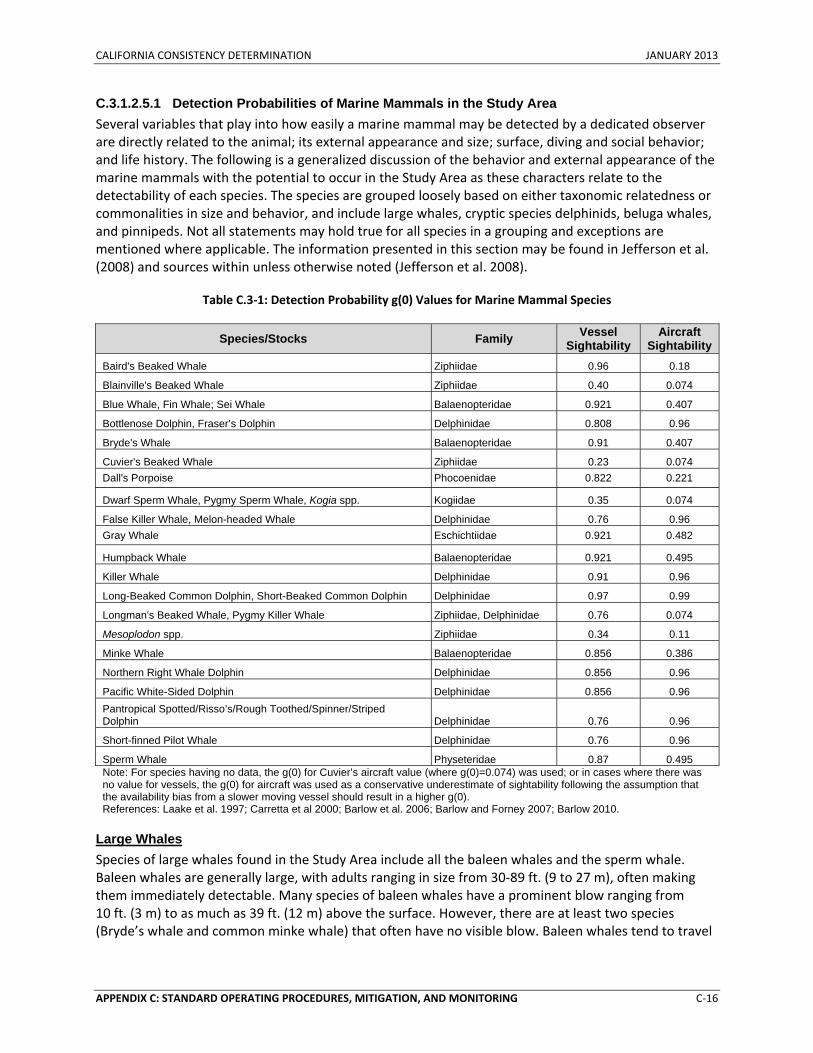
CALIFORNIA CONSISTENCY DETERMINATION JANUARY 2013
APPENDIX C: STANDARD OPERATING PROCEDURES, MITIGATION, AND MONITORING C‐16
C.3.1.2.5.1 Detection Probabilities of Marine Mammals in the Study Area Several variables that play into how easily a marine mammal may be detected by a dedicated observer are directly related to the animal; its external appearance and size; surface, diving and social behavior; and life history. The following is a generalized discussion of the behavior and external appearance of the marine mammals with the potential to occur in the Study Area as these characters relate to the detectability of each species. The species are grouped loosely based on either taxonomic relatedness or commonalities in size and behavior, and include large whales, cryptic species delphinids, beluga whales, and pinnipeds. Not all statements may hold true for all species in a grouping and exceptions are mentioned where applicable. The information presented in this section may be found in Jefferson et al. (2008) and sources within unless otherwise noted (Jefferson et al. 2008).
Table C.3‐1: Detection Probability g(0) Values for Marine Mammal Species
Species/Stocks Family Vessel Sightability
Aircraft Sightability
Baird's Beaked Whale Ziphiidae 0.96 0.18
Blainville's Beaked Whale Ziphiidae 0.40 0.074
Blue Whale, Fin Whale; Sei Whale Balaenopteridae 0.921 0.407
Bottlenose Dolphin, Fraser’s Dolphin Delphinidae 0.808 0.96
Bryde's Whale Balaenopteridae 0.91 0.407
Cuvier's Beaked Whale Ziphiidae 0.23 0.074 Dall's Porpoise Phocoenidae 0.822 0.221
Dwarf Sperm Whale, Pygmy Sperm Whale, Kogia spp. Kogiidae 0.35 0.074
False Killer Whale, Melon-headed Whale Delphinidae 0.76 0.96 Gray Whale Eschichtiidae 0.921 0.482
Humpback Whale Balaenopteridae 0.921 0.495
Killer Whale Delphinidae 0.91 0.96
Long-Beaked Common Dolphin, Short-Beaked Common Dolphin Delphinidae 0.97 0.99
Longman's Beaked Whale, Pygmy Killer Whale Ziphiidae, Delphinidae 0.76 0.074
Mesoplodon spp. Ziphiidae 0.34 0.11
Minke Whale Balaenopteridae 0.856 0.386
Northern Right Whale Dolphin Delphinidae 0.856 0.96
Pacific White-Sided Dolphin Delphinidae 0.856 0.96 Pantropical Spotted/Risso’s/Rough Toothed/Spinner/Striped Dolphin Delphinidae 0.76 0.96
Short-finned Pilot Whale Delphinidae 0.76 0.96
Sperm Whale Physeteridae 0.87 0.495 Note: For species having no data, the g(0) for Cuvier’s aircraft value (where g(0)=0.074) was used; or in cases where there was no value for vessels, the g(0) for aircraft was used as a conservative underestimate of sightability following the assumption that the availability bias from a slower moving vessel should result in a higher g(0). References: Laake et al. 1997; Carretta et al 2000; Barlow et al. 2006; Barlow and Forney 2007; Barlow 2010.
Large Whales Species of large whales found in the Study Area include all the baleen whales and the sperm whale. Baleen whales are generally large, with adults ranging in size from 30‐89 ft. (9 to 27 m), often making them immediately detectable. Many species of baleen whales have a prominent blow ranging from 10 ft. (3 m) to as much as 39 ft. (12 m) above the surface. However, there are at least two species (Bryde’s whale and common minke whale) that often have no visible blow. Baleen whales tend to travel
CALIFORNIA CONSISTENCY DETERMINATION JANUARY 2013
APPENDIX C: STANDARD OPERATING PROCEDURES, MITIGATION, AND MONITORING C‐17
singly or in small groups ranging from pairs to groups of five. The exception to this is the fin whale, which is known to travel in pods of seven or more individuals. All species of baleen whales are known to form larger‐scale aggregations in areas of high localized productivity or on breeding grounds. Baleen whales may or may not fluke at the surface before they dive; some species fluke regularly (humpback whale), some fluke variably (blue whale, fin whale) and some rarely fluke (sei whale, common minke whale, and Bryde’s whale). Baleen whales may remain at the surface for extended periods of time as they forage or socialize. North Atlantic right whales are known to form surface‐active groups and humpback whales to corral prey at the surface. Dive behavior varies amongst species, as well. Many species will dive and remain at depth for as long as 30 minutes. Some will adjust their diving behavior according to the presence of vessels (humpback whale, fin whale). Sei whales are known to sink just below the surface and remain there between breaths. Baleen whales have g(0) values ranging from 0.11 to 1.00 (Table C.3‐1).
Sperm whales are also considered large whales, with adult males reaching as much as 50 ft. (18 m) in total length. Sperm whales at the surface would likely be easy to detect. They are large, have a prominent, 16 ft. (5 m) blow, and may remain at the surface for long periods of time. They are known to raft (i.e., loll at the surface) and to form surface‐active groups when socializing. Sperm whales may travel or congregate in large groups of as many as 50 individuals. Although sperm whales engage in conspicuous surface behavior such as fluking, breaching and tail‐slapping, they are long, deep divers and may remain submerged for over one hour. Sperm whales have g(0) values ranging from 0.19 to 1.00 (see Table C.3‐1).
Cryptic Species Cryptic and deep‐diving species are those that do not surface for long periods of time and are often difficult to see when they surface, which ultimately limits the ability of lookouts to detect them even in good sighting conditions (Barlow et al. 2006). Cryptic species include beaked whales (family Ziphiidae), dwarf and pygmy sperm whales (Kogia species), and harbor porpoises. Beaked whales are notoriously difficult to detect at sea. In the Study Area, beaked whales may occur in a variety of group sizes, ranging from single individuals to groups of as many 22 individuals (MacLeod and D'Amico 2006). Beaked whale diving behavior in general consists of long, deep dives that may last for nearly 90 minutes followed by a series of shallower dives and intermittent surfacings (Tyack et al. 2006, Baird et al. 2008). Some individuals remain at the surface for an extended period of time (perhaps 1 hr. or more) or make shorter dives (MacLeod and D’Amico, 2006). Detection of beaked whales is further complicated because beaked whales often dive and surface in a synchronous pattern and they travel below the surface of the water (MacLeod and D'Amico 2006). Beaked whales have g(0) values ranging from 0.13 to 1.00 (Table C.3‐1).
Dwarf and pygmy sperm whales (referred to broadly as Kogia species) are small cetaceans (10‐13 ft. [3‐4 m] adult length) that are not commonly seen. Kogia species have g(0) values ranging from 0.19 to 0.79 (Table C.3‐1). Kogia species are some of the most commonly stranded species in some areas, which suggests that sightings are not indicative of their overall abundance. This supports the idea that they are cryptic, perhaps engaging in inconspicuous surface behavior or actively avoiding vessels. When Kogia species are sighted, they are typically seen in groups of no more than five to six individuals. They have no visible blow, do not fluke when they dive, and are known to log (i.e., lie motionless) at the surface. When they do dive, they often will sink out of sight with no prominent behavioral display.
Harbor porpoises are difficult to detect in all but the best of conditions (i.e., no swell, no whitecaps). Harbor porpoises have g(0) values ranging from 0.08 to 0.85 (Table C.3‐1). Harbor porpoises travel singly or in small groups of less than six individuals, but may aggregate into groups of several hundred. They
CALIFORNIA CONSISTENCY DETERMINATION JANUARY 2013
APPENDIX C: STANDARD OPERATING PROCEDURES, MITIGATION, AND MONITORING C‐18
are inconspicuous at the surface, rarely lifting their heads above the surface and often lying motionless. They are small and may actively avoid vessels.
Delphinids Delphinids are some of the most likely species to be detected at sea by observers. Delphinids have g(0) values ranging from 0.19 to 1.00 (Table C.3‐1). Many species of delphinids engage in very conspicuous surface behavior, including leaping, spinning, bow riding, and traveling along the surface in large groups. Delphinid group sizes may range from 10 to 10,000 individuals, depending upon the species and the geographic region. Species such as pilot whales, rough‐toothed dolphins, white‐beaked dolphins, white‐sided dolphins, bottlenose dolphins, stenellid dolphins, common dolphins, and Fraser’s dolphins are known to either actively approach and investigate vessels, or bow ride along moving vessels. Fraser’s dolphins and common dolphins form huge groups that travel quickly along the surface, churning up the water and making them visible from a great distance. Delphinids may dive for as little as 1 minute to more than 30 minutes, depending upon the species.
Beluga Whales Beluga whales have an extremely conspicuous coloration (all white) and reach up to 16 ft. (5 m) in total length. They travel in groups ranging from 15 individuals to thousands. They dive for lengths of up to 25 minutes There are no g(0) values available for beluga whales.
Pinnipeds Pinnipeds (seals and sea lions) are more difficult to detect at sea than cetaceans. Pinnipeds are much smaller, often solitary and generally do not engage in conspicuous surface behavior. There is not a lot of information regarding pinniped behavior at sea. Pinnipeds have a low profile, no dorsal appendage and small body size in comparison with most cetaceans, limiting accurate visual detection to sea states of less than 2 on the Beaufort Scale (Carretta et al. 2000). Some species, such as harbor seals, are known to approach and observe human activities on land or on stationary vessels. The only g(0) values available for pinnipeds occurring in the Study Area are for the harbor seal. Harbor seals have a g(0) value of 0.28 (see Table C.3‐1). Harbor seals and gray seals are solitary at sea. Harp seals appear to be an exception, traveling in large groups at the surface and churning up whitewater like dolphins. Gray seals are known to rest vertically at the surface with only the head exposed. Gray seals may dive for as long as 30 minutes and hooded seals for up to 60 minutes.
C.3.1.2.5.2 Detection Probabilities of Sea Turtles in the Study Area Sea turtles spend a majority of their time below the surface and are difficult to sight from a vessel until the animal is at close range (Hazel et al. 2007). Sea turtles often spend over 90 percent of their time underwater and are not visible more than 6.5 ft. (2 m) below the surface (Mansfield 2006). Sea turtles are generally much smaller than cetaceans, so while shipboard surveys designed for sighting marine mammals are adequate for detecting large sea turtles (e.g., adult leatherbacks), they are usually not adequate for detecting the smaller‐sized turtles (e.g., juveniles, Kemp’s ridley). Juvenile sea turtles may be especially difficult to detect. Aerial detection may be more effective in spotting sea turtles on the surface, particularly in calm seas and clear water, but it is possible that the smallest age classes are not detected even in good conditions (Marsh and Saalfeld 1989). Visual detection of sea turtles, especially small turtles, is further complicated by their startle behavior in the presence of ships. Turtles on the surface may dive below the surface of the water in the presence of a vessel before it is detected by shipboard or aerial observers (Kenney 2005). The detection probability of sea turtles is generally lower than that of cetaceans; however, there is no information available on specific g(0) values for turtles. The
CALIFORNIA CONSISTENCY DETERMINATION JANUARY 2013
APPENDIX C: STANDARD OPERATING PROCEDURES, MITIGATION, AND MONITORING C‐19
use of lookouts for visual detection of sea turtles is likely effective only at close range, and is thought to be less effective for small individuals than large individuals.
C.3.1.2.5.3 Summary of Lookout Effectiveness Due to the various detection probabilities, levels of experience, and dependence on sighting conditions, lookouts will not always be effective at avoiding impacts on all species. However, lookouts are expected to increase the overall likelihood that certain marine mammal species will be detected at the surface of the water, when compared to the likelihood that these same species would be detected if lookouts are not used. The Navy believes the continued use of lookouts contributes to helping reduce potential impacts on these marine mammal species from training and testing activities.
C.3.1.2.6 Operational Assessment for Lookouts
As written, the preceding recommended mitigation measures for lookouts have acceptable operational impacts on the proposed activity with regard to safety, practicability, impact on readiness, and Navy policy. The number of lookouts recommended for each measure often represents the maximum lookout capacity based on limited resources (e.g., space and manning restrictions). These operational factors are specifically noted in the sections below where applicable.
C.3.2 MITIGATION ZONE PROCEDURAL MEASURES
Safety zones described in Section C.1 (Standard Operating Procedures) are zones designed for human safety, whereas this section will introduce mitigation zones. A mitigation zone is designed solely for the purpose of reducing potential impacts on marine mammals and sea turtles from training and testing activities. Mitigation zones are measured as the radius from a source. Unique to each activity category, each radius represents a distance that the Navy will visually observe to help reduce injury to marine species. Visual detections of applicable marine species will be communicated immediately to the appropriate watch station for information dissemination and appropriate action. If the presence of marine mammals is detected acoustically, lookouts posted in aircraft and on surface vessels will increase the vigilance of their visual surveillance. As a reference, aerial surveys are typically made by flying at 1,500 ft. (457 m) altitude or lower at the slowest safe speed when practicable.
Many of the proposed activities have mitigation measures that are currently being implemented, as required by previous environmental documents or consultations. Most of the current mitigation zones for activities that involve the use of impulsive and non‐impulsive sources were originally designed to reduce the potential for onset of temporary threshold shift (TTS). For the HSTT EIS/OEIS, the Navy updated the acoustic propagation modeling to incorporate updated hearing threshold metrics (i.e., upper and lower frequency limits), updated density data for marine mammals, and factors such as an animal’s likely presence at various depths. An explanation of the acoustic propagation modeling process can be found in the Determination of Acoustic Effects on Marine Mammals and Sea Turtles (Marine Species Modeling Team, 2013).
As a result of the updates to the acoustic propagation modeling, in some cases the ranges to effects are much larger than those output by previous models. Due to the ineffectiveness and unacceptable operational impacts associated with mitigating such large areas, the Navy is unable to mitigate for onset of TTS for every activity. However, in some cases the ranges to effects are smaller than previous models estimated, and the mitigation zones were adjusted accordingly to provide consistency across the measures. Navy developed each proposed mitigation zone to avoid or reduce the potential for onset of the lowest level of injury, permanent threshold shift (PTS), out to the predicted maximum range. Mitigating to the predicted maximum range to PTS consequently also mitigates to the predicted
CALIFORNIA CONSISTENCY DETERMINATION JANUARY 2013
APPENDIX C: STANDARD OPERATING PROCEDURES, MITIGATION, AND MONITORING C‐20
maximum range to onset mortality (1 percent mortality), onset slight lung injury, and onset slight gastrointestinal tract injury, since the maximum range to effects for these criteria are shorter than for PTS. Furthermore, in most cases, the predicted maximum range to PTS also consequently covers the predicted average range to TTS. Table C.3‐2 summarizes the predicted average range to TTS, average range to PTS, maximum range to PTS, and recommended mitigation zone for each activity category, based on the Navy’s acoustic propagation modeling results.
The activity‐specific mitigation zones are based on the longest range for all the functional hearing groups (based on the hearing threshold metrics described in Section 3.4 [Marine Mammals], and Section 3.5 [Sea Turtles] of the HSTT EIS). The mitigation zone for a majority of activities is driven by either the high‐frequency cetacean or the sea turtle functional hearing groups. Therefore, the mitigation zones are even more protective for the remaining functional hearing groups (low‐frequency cetaceans, mid‐frequency cetaceans, and pinnipeds), and likely cover a larger portion of the potential range to onset of TTS.
In some instances, the Navy recommends mitigation zones that are larger or smaller than the predicted maximum range to PTS based on the effectiveness and operational assessments. The recommended mitigation zones and their associated assessments are provided throughout the remainder of this section. The recommended measures are either currently implemented measures, modifications of current measures, or new measures.
C.3.2.1 Acoustic Stressors
C.3.2.1.1 Non-Impulsive Sound
C.3.2.1.1.1 Low-Frequency and Hull Mounted Mid-Frequency Active Sonar Recommended Mitigation and Comparison to Current Mitigation The Navy is proposing to continue implementing the current mitigation measure for low‐frequency and hull‐mounted mid‐frequency active sonar. The recommended measure includes clarification of post‐sighting activity recommencement conditions.
Training and testing activities that involve the use of low‐frequency and hull‐mounted mid‐frequency active sonar will use lookouts for visual observation from a surface vessel immediately before and during the exercise. Mitigation zones for these activities involve powering down the sonar by 6 dB when a marine mammal is sighted within 1,000 yd. (914 m), and by an additional 4 dB when sighted within 500 yd. (457 m) from the source, for a total reduction of 10 dB. If the source can be turned off during the activity, active transmissions will cease if a marine mammal is sighted within 200 yd. (183 m). Active transmission will recommence if any one of the following conditions are met: (1) the animal is observed exiting the mitigation zone, (2) the animal is thought to have exited the mitigation zone based on its course and speed, (3) the mitigation zone has been clear from any additional sightings for a maximum period of 30 minutes, (4) the vessel has transited more than 2,000 yd. (1.8 km) beyond the location of the last sighting, or (5) the ship concludes that dolphins are deliberately closing in on the ship to ride the vessel’s bow wave (and there are no other marine mammal sightings within the mitigation zone). Active transmission may resume when dolphins are bow riding because they are out of the main transmission axis of the active sonar while in the shallow‐wave area of the vessel bow.
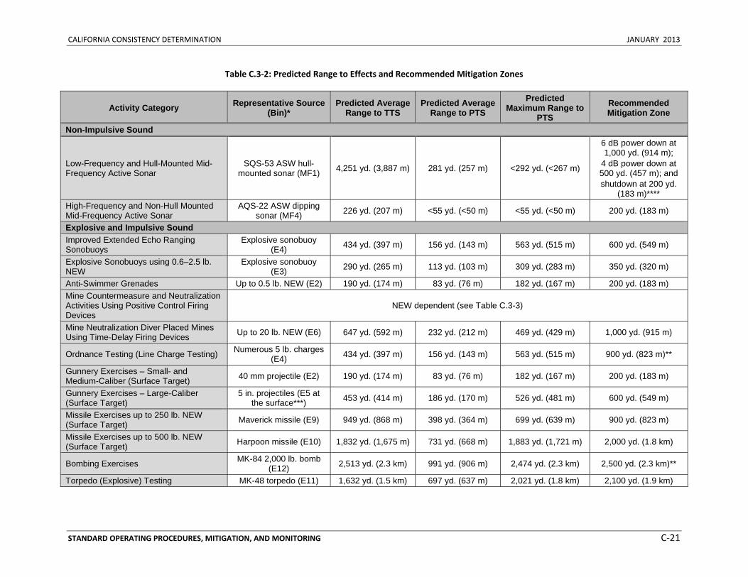
CALIFORNIA CONSISTENCY DETERMINATION JANUARY 2013
STANDARD OPERATING PROCEDURES, MITIGATION, AND MONITORING C‐21
Table C.3‐2: Predicted Range to Effects and Recommended Mitigation Zones
Activity Category Representative Source (Bin)*
Predicted Average Range to TTS
Predicted Average Range to PTS
Predicted Maximum Range to
PTS Recommended Mitigation Zone
Non-Impulsive Sound
Low-Frequency and Hull-Mounted Mid-Frequency Active Sonar
SQS-53 ASW hull-mounted sonar (MF1) 4,251 yd. (3,887 m) 281 yd. (257 m) <292 yd. (<267 m)
6 dB power down at 1,000 yd. (914 m);
4 dB power down at 500 yd. (457 m); and shutdown at 200 yd.
(183 m)**** High-Frequency and Non-Hull Mounted Mid-Frequency Active Sonar
AQS-22 ASW dipping sonar (MF4) 226 yd. (207 m) <55 yd. (<50 m) <55 yd. (<50 m) 200 yd. (183 m)
Explosive and Impulsive Sound Improved Extended Echo Ranging Sonobuoys
Explosive sonobuoy (E4) 434 yd. (397 m) 156 yd. (143 m) 563 yd. (515 m) 600 yd. (549 m)
Explosive Sonobuoys using 0.6–2.5 lb. NEW
Explosive sonobuoy (E3) 290 yd. (265 m) 113 yd. (103 m) 309 yd. (283 m) 350 yd. (320 m)
Anti-Swimmer Grenades Up to 0.5 lb. NEW (E2) 190 yd. (174 m) 83 yd. (76 m) 182 yd. (167 m) 200 yd. (183 m) Mine Countermeasure and Neutralization Activities Using Positive Control Firing Devices
NEW dependent (see Table C.3-3)
Mine Neutralization Diver Placed Mines Using Time-Delay Firing Devices Up to 20 lb. NEW (E6) 647 yd. (592 m) 232 yd. (212 m) 469 yd. (429 m) 1,000 yd. (915 m)
Ordnance Testing (Line Charge Testing) Numerous 5 lb. charges (E4) 434 yd. (397 m) 156 yd. (143 m) 563 yd. (515 m) 900 yd. (823 m)**
Gunnery Exercises – Small- and Medium-Caliber (Surface Target) 40 mm projectile (E2) 190 yd. (174 m) 83 yd. (76 m) 182 yd. (167 m) 200 yd. (183 m)
Gunnery Exercises – Large-Caliber (Surface Target)
5 in. projectiles (E5 at the surface***) 453 yd. (414 m) 186 yd. (170 m) 526 yd. (481 m) 600 yd. (549 m)
Missile Exercises up to 250 lb. NEW (Surface Target) Maverick missile (E9) 949 yd. (868 m) 398 yd. (364 m) 699 yd. (639 m) 900 yd. (823 m)
Missile Exercises up to 500 lb. NEW (Surface Target) Harpoon missile (E10) 1,832 yd. (1,675 m) 731 yd. (668 m) 1,883 yd. (1,721 m) 2,000 yd. (1.8 km)
Bombing Exercises MK-84 2,000 lb. bomb (E12) 2,513 yd. (2.3 km) 991 yd. (906 m) 2,474 yd. (2.3 km) 2,500 yd. (2.3 km)**
Torpedo (Explosive) Testing MK-48 torpedo (E11) 1,632 yd. (1.5 km) 697 yd. (637 m) 2,021 yd. (1.8 km) 2,100 yd. (1.9 km)
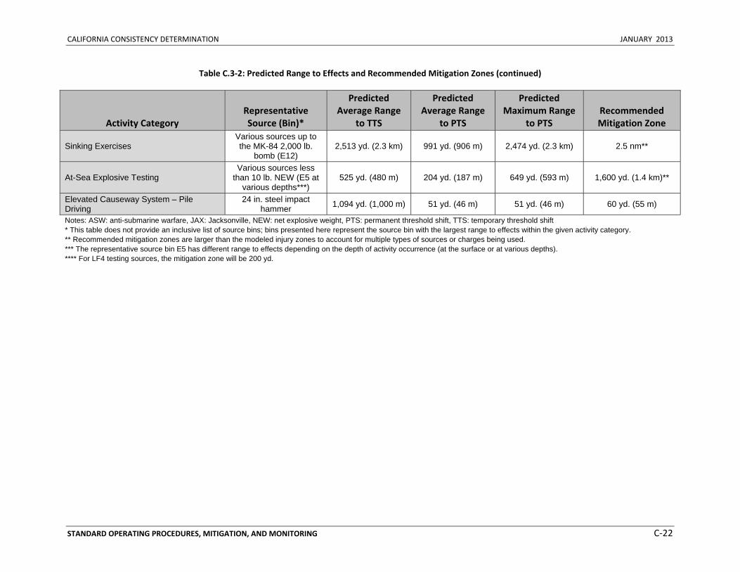
CALIFORNIA CONSISTENCY DETERMINATION JANUARY 2013
STANDARD OPERATING PROCEDURES, MITIGATION, AND MONITORING C‐22
Table C.3‐2: Predicted Range to Effects and Recommended Mitigation Zones (continued)
Activity Category Representative Source (Bin)*
Predicted Average Range
to TTS
Predicted Average Range
to PTS
Predicted Maximum Range
to PTS Recommended Mitigation Zone
Sinking Exercises Various sources up to the MK-84 2,000 lb.
bomb (E12) 2,513 yd. (2.3 km) 991 yd. (906 m) 2,474 yd. (2.3 km) 2.5 nm**
At-Sea Explosive Testing Various sources less
than 10 lb. NEW (E5 at various depths***)
525 yd. (480 m) 204 yd. (187 m) 649 yd. (593 m) 1,600 yd. (1.4 km)**
Elevated Causeway System – Pile Driving
24 in. steel impact hammer 1,094 yd. (1,000 m) 51 yd. (46 m) 51 yd. (46 m) 60 yd. (55 m)
Notes: ASW: anti-submarine warfare, JAX: Jacksonville, NEW: net explosive weight, PTS: permanent threshold shift, TTS: temporary threshold shift * This table does not provide an inclusive list of source bins; bins presented here represent the source bin with the largest range to effects within the given activity category. ** Recommended mitigation zones are larger than the modeled injury zones to account for multiple types of sources or charges being used. *** The representative source bin E5 has different range to effects depending on the depth of activity occurrence (at the surface or at various depths). **** For LF4 testing sources, the mitigation zone will be 200 yd.
CALIFORNIA CONSISTENCY DETERMINATION JANUARY 2013
STANDARD OPERATING PROCEDURES, MITIGATION, AND MONITORING C‐23
Effectiveness and Operational Assessments See the introduction of Section C.3.2 (Mitigation Zone Procedural Measures) for a general discussion of mitigation zones, how they are implemented, and the potential effects they are designed to reduce. As shown in Table C.3‐2, the predicted maximum range to onset of PTS for low‐frequency and hull‐mounted mid‐frequency active sonar sources is approximately 292 yd. (267 m) for one ping. This range was determined by the high‐frequency cetacean functional hearing group. The distance for all other marine mammal functional hearing groups is less than 104 yd. (95 m) for one ping, so the mitigation zone will provide further protection from injury (PTS) for these species. Therefore, implementation of the 200 yd. (183 m) shutdown zone will reduce the potential for exposure to higher levels of energy that would result in injury (PTS) and large threshold shifts that are recoverable (i.e., TTS) when individuals are sighted. Implementation of the 500 yd. (457 m) and 1,000 yd. (914 m) sonar power reductions will further reduce the potential for injury (PTS) and larger threshold shifts that would result in recovery (i.e., TTS) to occur when individual marine mammals are sighted within these zones, especially in cases where the vessel and animal are approaching each other.
The mitigation zones the Navy has developed are within a range for which lookouts can reasonably be expected to maintain situational awareness and visually observe during most conditions. Since the average range to onset of TTS is 4,251 yd. (3,887 m), the entire range to TTS is not reasonably observable. By establishing mitigation zones that can be realistically maintained from surface vessels, lookouts will be more effective at sighting individual animals. The probability of detection decreases dramatically with distance from the ship. By keeping lookouts focused within the ranges where exposure to higher levels of energy is possible, the effectiveness at reducing potential impacts will increase.
The post‐sighting wait period is designed to give any animals that are sighted an opportunity to leave the area before the exercise recommences but will only be employed if one of the other conditions has not already been met. A 30‐minute wait period more than covers the average dive times of most marine mammal species but may not be sufficient for some deep‐diving marine mammal species or for sea turtles. However, the analysis in Section 3.4.3.1.2.1 of the HSTT EIS/OEIS (Direct Injury) shows that injury to deep‐diving marine mammals (e.g., sperm whales and beaked whales) is not expected to occur. Furthermore, any wait period greater than 30 minutes would result in an unacceptable operational impact on readiness.
The Navy proposes implementing the recommended measure described above because (1) it is likely to result in avoidance or reduction of exposure to high levels of energy to marine mammals, and (2) it has acceptable operational impacts on the proposed activity with regard to safety, practicability, impact on readiness, and Navy policy.
C.3.2.1.1.2 High-Frequency and Non-Hull Mounted Mid-Frequency Active Sonar Recommended Mitigation and Comparison to Current Mitigation Mitigation measures do not currently exist for all high‐frequency and non‐hull mounted mid‐frequency active sonar activities (i.e., new sources or sources not previously analyzed). The Navy is proposing to (1) continue implementing the current mitigation measures for activities currently being executed, such as dipping sonar activities; and (2) extend the implementation of its current mitigation to all other activities in this category. The recommended measure includes clarification of a post‐sighting activity recommencement conditions.
Mitigation will include visual observation from a surface vessel or aircraft (with the exception of platforms operating at high altitudes) immediately before and during active transmission within a
CALIFORNIA CONSISTENCY DETERMINATION JANUARY 2013
STANDARD OPERATING PROCEDURES, MITIGATION, AND MONITORING C‐24
mitigation zone of 200 yd. (183 m) from the active sonar source. For activities involving helicopter deployed dipping sonar, visual observation will commence 10 minutes before the first deployment of active dipping sonar. Helicopter dipping and sonobuoy deployment are not conducted in areas of large concentrations of floating vegetation (Sargassum or kelp paddies). If the source can be turned off during the activity, active transmission will cease if a marine mammal or sea turtle is sighted within the mitigation zone. Active transmission will recommence if any one of the following conditions is met: (1) the animal is observed exiting the mitigation zone, (2) the animal is thought to have exited the mitigation zone based on its course and speed, (3) the mitigation zone has been clear from any additional sightings for a maximum period of 10 minutes for an aircraft‐deployed source, (4) the mitigation zone has been clear from any additional sightings for a maximum period of 30 minutes for a vessel‐deployed source, (5) the vessel or aircraft has repositioned itself more than 400 yd. (366 m) away from the location of the last sighting, or (6) the ship concludes that dolphins are deliberately closing in on the ship to ride the vessel’s bow wave(and there are no other marine mammal sightings within the mitigation zone).
Effectiveness and Operational Assessments See the introduction of Section C.3.2 (Mitigation Zone Procedural Measures) for a general discussion of mitigation zones, how they are implemented, and the potential effects they are designed to reduce. As shown in Table C.3‐2, the predicted maximum range to onset of PTS for high‐frequency and non‐hull mounted mid‐frequency active sonar sources is less than 55 yd. (50 m) for one ping. This range was the same for all functional hearing groups. The average range to onset of TTS across all functional hearing groups is 226 yd. (207 m) for one ping. Implementation of the 200 yd. (183 m) mitigation zone will reduce the potential for exposure to higher levels of energy that would result in injury (PTS) and larger threshold shifts that would result in recovery (i.e., TTS) when individuals are sighted. With the exception of activities involving sonobuoys, the lookout is visually observing either close aboard a vessel or from directly above the source by aircraft. Therefore, this measure should be effective at reducing risks to all marine mammals that are available to be observed within this zone for these sources. When sonobuoys are used, the sonobuoy field may be dispersed over a large distance. As discussed in Section C.3.1.2.5 (Effectiveness Assessment for Lookouts), the likelihood of sighting individual animals, particularly sea turtles and some species of small or cryptic marine mammals, decreases at long distances.
The post‐sighting wait periods are designed to give any animals that are sighted an opportunity to leave the area before the exercise recommences but will only be employed if one of the other conditions has not already been met. The 30‐minute wait period for vessel‐deployed sources more than covers the average dive times of most marine mammal species but may not be sufficient for some deep‐diving marine mammal species or for sea turtles. However, the analysis in Section 3.4.3.1.2.1 of the HSTT EIS/OEIS (Direct Injury) shows that injury to deep‐diving marine mammals (e.g., sperm whales and beaked whales) is not expected to occur, with the exception of Kogia species. Furthermore, any wait period greater than 30 minutes for vessel‐deployed sources would result in an unacceptable operational impact on readiness. The 10‐minute wait period for aircraft‐deployed sources is based on fuel restrictions. Any wait period greater than 10 minutes for an aircraft‐deployed source would result in an unacceptable operational impact on readiness and safety of personnel. The 10‐minute wait period covers a portion of the average marine mammal and sea turtle dive times but may not be sufficient to cover the average dive times of all species.
The Navy proposes implementing the recommended measure described above because (1) it is likely to result in avoidance or reduction of exposure to high levels of energy to marine mammals, and (2) it has
CALIFORNIA CONSISTENCY DETERMINATION JANUARY 2013
STANDARD OPERATING PROCEDURES, MITIGATION, AND MONITORING C‐25
acceptable operational impacts to the proposed activity with regard to safety, practicability, impact on readiness, and Navy policy.
C.3.2.1.2 Explosives and Impulsive Sound
C.3.2.1.2.1 Improved Extended Echo Ranging Sonobuoys Recommended Mitigation and Comparison to Current Mitigation The Navy is proposing to modify the mitigation measures currently implemented for this activity by reducing the mitigation zone from 1,000 yd. (914 m) to 600 yd. (549 m). The recommended measure includes clarification of a post‐sighting activity recommencement conditions and a modification of the floating vegetation observation requirements to achieve consistency with regard to mitigation zone size.
Mitigation will include pre‐exercise aerial observation and passive acoustic monitoring, which will begin 30 minutes before the first source/receiver pair detonation and continue throughout the duration of the exercise within a mitigation zone of 600 yd. (549 m) around an Improved Extended Echo Ranging sonobuoy. The pre‐exercise aerial observation will include the time it takes to deploy the sonobuoy pattern (deployment is conducted by aircraft dropping sonobuoys in the water). Improved Extended Echo Ranging sonobuoys will not be deployed if concentrations of floating vegetation (Sargassum or kelp paddies) are observed in the mitigation zone around the intended deployment location. Explosive detonations will cease if a marine mammal or sea turtle is sighted within the mitigation zone. Detonations will recommence if any one of the following conditions is met: (1) the animal is observed exiting the mitigation zone, (2) the animal is thought to have exited the mitigation zone based on its course and speed, or (3) the mitigation zone has been clear from any additional sightings for a period of 30 minutes.
Passive acoustic monitoring would be conducted with Navy assets, such as sonobuoys, already participating in the activity. These assets would only detect vocalizing marine mammals within the frequency bands monitored by Navy personnel. Passive acoustic detections would not provide range or bearing to detected animals, and therefore cannot provide locations of these animals. Passive acoustic detections would be reported to lookouts posted in aircraft and on surface vessels in order to increase vigilance of their visual surveillance.
Effectiveness and Operational Assessments See the introduction of Section C.3.2 (Mitigation Zone Procedural Measures) for a general discussion of mitigation zones, how they are implemented, and the potential effects they are designed to reduce. As shown in Table C.3‐2, the predicted maximum range to onset of PTS for Improved Extended Echo Ranging sonobuoys is approximately 563 yd. (515 m). This range was determined by the high‐frequency cetacean functional hearing group. The remaining functional hearing groups had a shorter range to onset of PTS, so the mitigation zone will provide further protection for these species. The average range to onset of TTS across all functional hearing groups is 434 yd. (397 m). Implementation of the 600 yd. (549 m) mitigation zone will reduce the potential for exposure to higher levels of energy that would result in injury and larger threshold shifts that would result in recovery (i.e., TTS) when individuals are sighted. The sonobuoy field may be dispersed over a large distance. As discussed in Section C.3.1.2.5 (Effectiveness Assessment for Lookouts), the likelihood of sighting individual animals, particularly sea turtles and some species of small or cryptic marine mammals, decreases at long distances.
The decrease in mitigation zone size will result in no mitigation for exposure to lower levels of potential onset of TTS; however, it will allow for a more focused survey effort over a smaller survey distance, and
CALIFORNIA CONSISTENCY DETERMINATION JANUARY 2013
STANDARD OPERATING PROCEDURES, MITIGATION, AND MONITORING C‐26
will consequently increase the likelihood of avoidance of injury and larger threshold shifts that would result in recovery (i.e., TTS) to marine mammals and sea turtles.
The post‐sighting wait period is designed to give any animals that are sighted an opportunity to leave the area before the exercise recommences but will only be employed if one of the other conditions has not already been met. A 30‐minute wait period more than covers the average dive times of most marine mammal species but may not be sufficient for some deep‐diving marine mammal species or for sea turtles. However, the analysis in Section 3.4.3.1.2.1 of the HSTT EIS/OEIS (Direct Injury) shows that injury to deep‐diving marine mammals (e.g., sperm whales and beaked whales) is not expected to occur. Furthermore, any wait period greater than 30 minutes would result in an unacceptable operational impact on readiness.
The Navy proposes implementing the recommended measure described above because (1) it is likely to result in avoidance or reduction of exposure to high levels of energy to marine mammals and sea turtles, and (2) it has acceptable operational impacts on the proposed activity with regard to safety, practicability, impact on readiness, and Navy policy.
C.3.2.1.2.2 Explosive Sonobuoys Using 0.6–2.5 Pound Net Explosive Weight Recommended Mitigation and Comparison to Current Mitigation Mitigation measures do not currently exist for this activity.
Mitigation will include pre‐exercise aerial monitoring during deployment of the field of sonobuoy pairs (typically up to 20 minutes) and continuing throughout the duration of the exercise within a mitigation zone of 350 yd. (320 m) around an explosive sonobuoy. Explosive sonobuoys will not be deployed if concentrations of floating vegetation (Sargassum or kelp paddies) are observed in the mitigation zone (around the intended deployment location). Explosive detonations will cease if a marine mammal or sea turtle is sighted within the mitigation zone. Detonations will recommence if any one of the following conditions is met: (1) the animal is observed exiting the mitigation zone, (2) the animal is thought to have exited the mitigation zone based on its course and speed, or (3) the mitigation zone has been clear from any additional sightings for a period of 10 minutes.
Passive acoustic monitoring will also be conducted with Navy assets, such as sonobuoys, already participating in the activity. These assets would only detect vocalizing marine mammals within the frequency bands monitored by Navy personnel. Passive acoustic detections would not provide range or bearing to detected animals, and therefore cannot provide locations of these animals. Passive acoustic detections would be reported to lookouts posted in aircraft in order to increase vigilance of their visual surveillance.
Effectiveness and Operational Assessments See the introduction of Section C.3.2 (Mitigation Zone Procedural Measures) for a general discussion of mitigation zones, how they are implemented, and the potential effects they are designed to reduce. As shown in Table C.3‐2, the predicted maximum range to onset of PTS for explosive sonobuoys using 0.6–2.5 lb. net explosive weight is approximately 309 yd. (283 m). This range was determined by the high‐frequency cetacean functional hearing group. The remaining functional hearing groups had a shorter range to onset of PTS, so the mitigation zone will provide further protection for these species. The average range to onset of TTS across all functional hearing groups is 290 yd. (265 m). Implementation of the 350 yd. (320 m) mitigation zone will reduce the potential for exposure to higher levels of energy that would result in injury and large threshold shifts that are recoverable (i.e., TTS) when individuals are
CALIFORNIA CONSISTENCY DETERMINATION JANUARY 2013
STANDARD OPERATING PROCEDURES, MITIGATION, AND MONITORING C‐27
sighted. The sonobuoy field may be dispersed over a large distance. As discussed in Section C.3.1.2.5 (Effectiveness Assessment for Lookouts), the likelihood of sighting individual animals, particularly sea turtles and some species of small or cryptic marine mammals, decreases at long distances.
The post‐sighting wait period is designed to give any animals that are sighted an opportunity to leave the area before the exercise recommences but will only be employed if one of the other conditions has not already been met. The 10‐minute wait period for this activity, which involves aircraft‐deployed sources, is based on fuel restrictions. Any wait period greater than 10 minutes for an aircraft‐deployed source would result in an unacceptable operational impact on readiness and safety of personnel. The 10‐minute wait period covers a portion of the average marine mammal and sea turtle dive times but may not be sufficient to cover the average dive times of all species.
The Navy proposes implementing the recommended measure described above because (1) it is likely to result in avoidance or reduction of exposure to high levels of energy to marine mammals and sea turtles, and (2) it has acceptable operational impacts on the proposed activity with regard to safety, practicability, impact on readiness, and Navy policy.
C.3.2.1.2.3 Anti-Swimmer Grenades Recommended Mitigation and Comparison to Current Mitigation The Navy is proposing to continue implementing the current mitigation measures for this activity. The recommended measure includes clarification of a post‐sighting activity recommencement conditions.
Mitigation will include visual observation from a small boat immediately before and during the exercise within a mitigation zone of 200 yd. (183 m) around an anti‐swimmer grenade. The exercise will not commence if concentrations of floating vegetation (Sargassum or kelp paddies) are observed in the mitigation zone. Explosive detonations will cease if a marine mammal or sea turtle is sighted within the mitigation zone. Detonations will recommence if any one of the following conditions is met: (1) the animal is observed exiting the mitigation zone, (2) the animal is thought to have exited the mitigation zone based on its course and speed, or (3) the mitigation zone has been clear from any additional sightings for a period of 30 min, or (4) the activity has been repositioned more than 400 yd. (366 m) away from the location of the last sighting.
Effectiveness and Operational Assessments See the introduction of Section C.3.2 (Mitigation Zone Procedural Measures) for a general discussion of mitigation zones, how they are implemented, and the potential effects they are designed to reduce. As shown in Table C.3‐2, the predicted maximum range to onset of PTS for anti‐swimmer grenades is approximately 182 yd. (167 m). This range was determined by the high‐frequency cetacean functional hearing group. The remaining functional hearing groups had a shorter range to onset of PTS, so the mitigation zone will provide further protection for these species. The average range to onset of TTS across all functional hearing groups is 190 yd. (174 m). Implementation of the 200 yd. (183 m) mitigation zone will reduce the potential for exposure to higher levels of energy that would result in injury and larger threshold shifts that would result in recovery (i.e., TTS) when individuals are sighted. Since the lookout is visually observing close aboard the boat, this measure should be effective at reducing the risk to all marine mammals and sea turtles that are available to be observed.
The post‐sighting wait period is designed to give any animals that are sighted an opportunity to leave the area before the exercise recommences but will only be employed if one of the other conditions has not already been met. A 30‐minute wait period more than covers the average dive times of most marine

CALIFORNIA CONSISTENCY DETERMINATION JANUARY 2013
STANDARD OPERATING PROCEDURES, MITIGATION, AND MONITORING C‐28
mammal species but may not be sufficient for some deep‐diving marine mammal species or for sea turtles. However, the analysis in Section 3.4.3.1.2.1 of the HSTT EIS/OEIS (Direct Injury) shows that injury to deep‐diving marine mammals (e.g., sperm whales and beaked whales) is not expected to occur. Furthermore, any wait period greater than 30 minutes would result in an unacceptable operational impact on readiness.
The Navy proposes implementing the recommended measure described above because (1) it is likely to result in avoidance or reduction of exposure to high levels of energy to marine mammals and sea turtles, and (2) it has acceptable operational impacts on the proposed activity with regard to safety, practicability, impact on readiness, and Navy policy.
C.3.2.1.2.4 Mine Countermeasure and Neutralization Activities Using Positive Control Firing Devices
Recommended Mitigation and Comparison to Current Mitigation Mine countermeasure and neutralization activities can be divided into two main categories: (1) general activities that can be conducted from a variety of platforms and locations, and (2) activities involving the use of diver‐placed charges that typically occur close to shore. When either of these activities are conducted using a positive control firing device, the detonation is controlled by the personnel conducting the activity and is not authorized until the area is clear at the time of detonation. Refer to Section C.3.3.2 (Seafloor Habitats and Shipwrecks) for information on mitigation designed to avoid or reduce potential impacts from military expended materials within shallow coral reef, live hardbottom, artificial reef, and shipwreck mitigation areas.
The Navy is proposing to modify the currently implemented mitigation measures for general mine countermeasure and neutralization activities to account for additional categories of net explosive weights, in order to align with the explosive bins that were modeled. The Navy is proposing the mitigation zones to be used during general mine countermeasure and neutralization activities as outlined in Table C.3‐3. For comparison, the currently implemented mitigation zones for general mine countermeasure and neutralization are:
• 378 yd. (346 m) when using less than 11 lb. net explosive weight • 1,091 yd. (998 m) when using 11–75 lb. net explosive weight • 3,130 yd. (2,862 m) when using 76–600 lb. net explosive weight
The recommended measure includes clarification of post‐sighting activity recommencement conditions, the addition of a requirement to observe for floating vegetation, and clarification of the pertinent location of the distance from shore requirement.
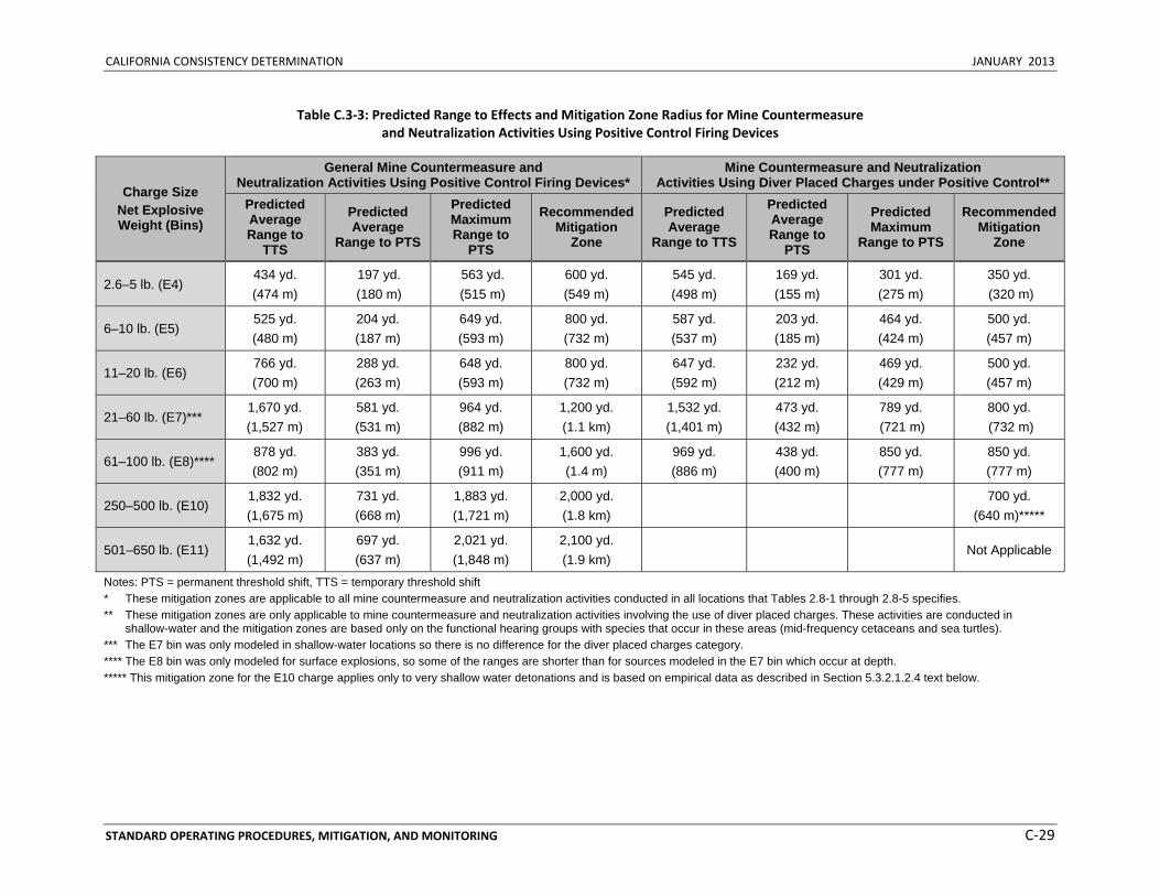
CALIFORNIA CONSISTENCY DETERMINATION JANUARY 2013
STANDARD OPERATING PROCEDURES, MITIGATION, AND MONITORING C‐29
Table C.3‐3: Predicted Range to Effects and Mitigation Zone Radius for Mine Countermeasure and Neutralization Activities Using Positive Control Firing Devices
Charge Size Net Explosive Weight (Bins)
General Mine Countermeasure and Neutralization Activities Using Positive Control Firing Devices*
Mine Countermeasure and Neutralization Activities Using Diver Placed Charges under Positive Control**
Predicted Average Range to
TTS
Predicted Average
Range to PTS
Predicted Maximum Range to
PTS
Recommended Mitigation
Zone
Predicted Average
Range to TTS
Predicted Average Range to
PTS
Predicted Maximum
Range to PTS
Recommended Mitigation
Zone
2.6–5 lb. (E4) 434 yd. (474 m)
197 yd. (180 m)
563 yd. (515 m)
600 yd. (549 m)
545 yd. (498 m)
169 yd. (155 m)
301 yd. (275 m)
350 yd. (320 m)
6–10 lb. (E5) 525 yd. (480 m)
204 yd. (187 m)
649 yd. (593 m)
800 yd. (732 m)
587 yd. (537 m)
203 yd. (185 m)
464 yd. (424 m)
500 yd. (457 m)
11–20 lb. (E6) 766 yd. (700 m)
288 yd. (263 m)
648 yd. (593 m)
800 yd. (732 m)
647 yd. (592 m)
232 yd. (212 m)
469 yd. (429 m)
500 yd. (457 m)
21–60 lb. (E7)*** 1,670 yd. (1,527 m)
581 yd. (531 m)
964 yd. (882 m)
1,200 yd. (1.1 km)
1,532 yd. (1,401 m)
473 yd. (432 m)
789 yd. (721 m)
800 yd. (732 m)
61–100 lb. (E8)**** 878 yd. (802 m)
383 yd. (351 m)
996 yd. (911 m)
1,600 yd. (1.4 m)
969 yd. (886 m)
438 yd. (400 m)
850 yd. (777 m)
850 yd. (777 m)
250–500 lb. (E10) 1,832 yd. (1,675 m)
731 yd. (668 m)
1,883 yd. (1,721 m)
2,000 yd. (1.8 km)
700 yd.
(640 m)*****
501–650 lb. (E11) 1,632 yd. (1,492 m)
697 yd. (637 m)
2,021 yd. (1,848 m)
2,100 yd. (1.9 km)
Not Applicable
Notes: PTS = permanent threshold shift, TTS = temporary threshold shift * These mitigation zones are applicable to all mine countermeasure and neutralization activities conducted in all locations that Tables 2.8-1 through 2.8-5 specifies. ** These mitigation zones are only applicable to mine countermeasure and neutralization activities involving the use of diver placed charges. These activities are conducted in
shallow-water and the mitigation zones are based only on the functional hearing groups with species that occur in these areas (mid-frequency cetaceans and sea turtles). *** The E7 bin was only modeled in shallow-water locations so there is no difference for the diver placed charges category. **** The E8 bin was only modeled for surface explosions, so some of the ranges are shorter than for sources modeled in the E7 bin which occur at depth. ***** This mitigation zone for the E10 charge applies only to very shallow water detonations and is based on empirical data as described in Section 5.3.2.1.2.4 text below.
CALIFORNIA CONSISTENCY DETERMINATION JANUARY 2013
STANDARD OPERATING PROCEDURES, MITIGATION, AND MONITORING C‐30
General mine countermeasure and neutralization activity mitigation will include visual surveillance from surface vessels or aircraft beginning 30 minutes before, during, and 30 minutes after the completion of the exercise within the mitigation zones around the detonation site as identified in Table C.3.3. For activities involving explosives in bin E11 (501–650 lb. net explosive weight), aerial observation of the mitigation zone will be conducted. The exercise will not commence if concentrations of floating vegetation (Sargassum or kelp paddies) are observed in the mitigation zone. Explosive detonations will cease if a marine mammal or sea turtles is sighted within the mitigation zone. Detonations will recommence if any one of the following conditions is met: (1) the animal is observed exiting the mitigation zone, (2) the animal is thought to have exited the mitigation zone based on its course and speed, or (3) the mitigation zone has been clear from any additional sightings for a period of 30 minutes.
In addition to the above, for mine neutralization activities involving diver‐placed charges, visual observation will be conducted by either two boats (rigid‐hull inflatable boats), or one boat and one helicopter. Survey boats will position themselves near the mid‐point of the mitigation zone radius (but always outside the detonation plume radius and human safety zone) and travel in a circular pattern around the detonation location. When using two boats, each boat will be positioned on opposite sides of the detonation location, separated by 180 degrees. Helicopters will travel in a circular pattern around the detonation location when used.
For training exercises that include the use of multiple detonations, the second (or third, etc.) detonation will occur either immediately after the preceding detonation (i.e., within 10 seconds of the preceding detonation), or after 30 minutes have passed.
If flocks of seabirds or individual foraging seabirds are sighted within the water mitigation zone (Table C.3‐3) or moving towards it, activities will be suspended until the birds voluntarily leave the area. Immediately following the detonation, visual monitoring for birds within the mitigation zone will take place for 30 minutes. Observations will be made for animals that have been injured or killed. If animals are detected that have been injured or killed, report will be made to the appropriate Navy Region Environmental Director and the Navy Pacific Fleet Environmental Office. The local base Wildlife Biologist will also be notified.
The Navy is establishing different mitigation zones depending on the depth of the water in which the detonation takes place. The Navy used the Reflection and Refraction in a Multilayered Ocean/Ocean Bottoms with Shear Wave Effects model to predict the pressure‐wave propagation for underwater detonations in deep and shallow water. Due to the complicated nature of propagation in very shallow water (less than 24 ft. [7.3 m]), as well as substantial differences between very shallow water sites, this model cannot accurately predict pressure propagation from underwater detonations occurring in very shallow water environments. In very shallow water, surface‐ and bottom‐boundary effects, thermal layering and mixing of layers, bottom substrate composition, vegetation in the water column, and surface blowout, along with charge size, configuration, and distance from the bottom, provide significant contributions to propagation characteristics. The Navy’s model assumes a uniform, flat bottom throughout the energy field, does not take into account variations in bathymetry, and assumes all charges are elevated off the bottom. Because of this, the deepest point within a scenario modeling box was used to preclude diving animals from being “hidden” beneath the modeled bottom depth and, therefore, not exposed to any energy or sound. Due to modeling limitations for very shallow water, discontinuities in the modeling output over estimated propagated pressure and energies at specific distances from the charge. Models of pressure propagation from underwater detonations predict the distances at which marine mammals may be harmed and thus, are important in anticipating and
CALIFORNIA CONSISTENCY DETERMINATION JANUARY 2013
STANDARD OPERATING PROCEDURES, MITIGATION, AND MONITORING C‐31
mitigating potential harmful effects of underwater explosion training and testing. However, in order to establish accurate mitigation zones for determining physiological effects on marine mammals, measured waveform propagation data was collected at the actual very shallow water locations at San Clemente Island and the Silver Strand Training Complex, and were used to determine the zone of influence and mitigation zone for very shallow water detonations training and testing at these sites.
General mine countermeasure and neutralization activities will include visual surveillance from surface vessels or aircraft beginning 30 minutes before, during, and 30 minutes after the completion of the exercise. During activities using positively controlled firing devices, visual observation for marine mammals, sea turtles, and seabirds will take place within the mitigation zones around the detonation site as identified in Table C.3‐3. If a marine mammal, sea turtle, or seabird is visually detected within the mitigation zone, then the exercise will cease until the mitigation zone has been clear from any additional sightings for 30 minutes. For activities involving explosives in bin E11 (501‐650 lb. net explosive weight), aerial observation of the mitigation zone will be conducted.
Mitigation measures currently do not exist for mine neutralization activities involving diver placed charges using 30‐100 lb. net explosive weight charges. The Navy is proposing to modify the currently implemented mitigation measures for activities involving diver placed charges using less than or equal to 20 lb. net explosive weight charges to account for additional categories of net explosive weights, in order to align with the explosive bins that were modeled. The Navy is proposing the mitigation zones to be used during activities involving diver placed charges as outlined in Table C.3‐3. For comparison, the currently implemented mitigation zone for less than or equal to 20 lb. net explosive weight charges is 700 yd. (640 m).
Effectiveness and Operational Assessments See the introduction of Section C.3.2 (Mitigation Zone Procedural Measures) for a general discussion of mitigation zones, how they are implemented, and the potential effects they are designed to reduce. The range to effects shown in Table C.3‐3 for general mine countermeasure and neutralization activities using positive control firing devices were determined by the high‐frequency cetacean functional hearing group. The remaining functional hearing groups had shorter ranges to onset of PTS, so the mitigation zones will provide further protection for these species. Implementation of the mitigation zones outlined in Table C.3‐3 will reduce the potential for exposure to higher levels of energy that would result in injury and larger threshold shifts that would result in recovery (i.e., TTS) when individuals are sighted.
As described in Section C.3.1 (Lookout Procedural Measures), lookouts positioned in aircraft or small boats may be responsible for tasks in addition to observing the air or surface of the water. For example, a lookout for this activity may also be responsible for navigation of the vessel or assistance with mine countermeasure and neutralization deployment. The decrease in mitigation zone size for activities using diver‐placed charges will result in no mitigation for exposure to lower levels of potential onset of TTS; however, it will allow for a more focused survey effort over a smaller area, and will consequently increase the likelihood of avoidance of injury and larger threshold shifts that would result in recovery (i.e., TTS) to marine mammals. Having a lookout observe a mitigation zone that is too large could potentially increase the safety risk due to an increased level of distraction from normal job duties. Observation of an area beyond what the Navy is proposing to implement would not be likely to result in avoidance or reduction of injury to marine mammals or sea turtles because the effort spent observing those more distant areas would inevitably be minimal.
CALIFORNIA CONSISTENCY DETERMINATION JANUARY 2013
STANDARD OPERATING PROCEDURES, MITIGATION, AND MONITORING C‐32
As described in Section C.3.1.2.5 (Effectiveness Assessment for Lookouts), the ability of a lookout to detect an animal can vary greatly based on what observing platform is being used. For large ranges, aerial observation is more effective. In addition, when observing from a surface vessel, sea turtle and cryptic marine mammal species can be very difficult to detect further that a few meters away from the vessel. However, this measure should be effective at reducing potential impacts for individuals that are sighted.
Mine neutralization activities involving diver‐placed charges occur primarily close to shore and in shallow water (concentrated in the SSTC and San Clemente Island). The range to effects shown in Table C.3‐3 for mine neutralization activities involving diver‐placed charges under positive control were determined by the sea turtle functional hearing group. The mid‐frequency hearing group had shorter ranges to onset of PTS, so the mitigation zones will provide further protection for these species. However, mitigation would be implemented for any species observed within the mitigation zone. Implementation of the mitigation zones outlined in Table C.3‐3 will reduce the potential for exposure to higher levels of energy that would result in injury and larger threshold shifts that would result in recovery (i.e., TTS) when individuals are sighted. The decrease in mitigation zone size for activities using diver‐placed charges (up to 29 lb. net explosive weight) will result in no mitigation for exposure to lower levels of potential onset of TTS; however, it will allow for a more focused survey effort over a smaller area, and will consequently increase the likelihood of avoidance of injury and larger threshold shifts that would result in recovery (i.e., TTS) to marine mammals.
During activities using diver‐placed charges, lookouts are visually observing from small boats (rigid‐hull inflatable boats) or helicopters. As discussed above, aerial observation is more effective than observation from a small boat. Since small boats do not have a very elevated observing platform, the distance over which animals can be observed is much shorter. Sea turtles and cryptic marine mammal species would be very difficult to detect further than a few meters away from the boat.
The post‐sighting wait period is designed to give any animals that are sighted an opportunity to leave the area before the exercise recommences but will only be employed if one of the other conditions has not already been met. A 30‐minute wait period more than covers the average dive times of most marine mammal species but may not be sufficient for some deep‐diving marine mammal species or for sea turtles. However, the analysis in Section 3.4.3.1.2.1 of the HSTT EIS/OEIS (Direct Injury) shows that injury to deep‐diving marine mammals (e.g., sperm whales and beaked whales) is not expected to occur. Furthermore, any wait period greater than 30 minutes would result in an unacceptable operational impact on readiness.
The Navy proposes implementing the recommended measure described above because (1) it is likely to result in avoidance or reduction of injury to most marine mammal species or piping plovers, and (2) it has acceptable operational impacts on the proposed activity with regard to safety, practicability, impact on readiness, and Navy policy.
C.3.2.1.2.5 Mine Neutralization Using Diver-Placed Time-Delay Firing Devices Recommended Mitigation and Comparison to Current Mitigation When mine neutralization activities using diver‐placed charges (up to a 20 lb. net explosive weight) are conducted with a time‐delay firing device, the detonation is fused with a specified time delay by the personnel conducting the activity and is not authorized until the area is clear at the time the fuse is initiated. During these activities, the detonation cannot be terminated once the fuse is initiated due to human safety concerns. Refer to Section C.3.2.1.2.4 (Mine Countermeasure and Neutralization Activities
CALIFORNIA CONSISTENCY DETERMINATION JANUARY 2013
STANDARD OPERATING PROCEDURES, MITIGATION, AND MONITORING C‐33
Using Positive Control Firing Devices) for a general discussion of mitigation measures applicable to mine neutralization activities using diver‐placed mines. This section will specify unique mitigation zones and observation methods for diver‐placed mine activities that use time‐delay firing devices. Refer to Section C.3.3.3 (Seafloor Habitats and Shipwrecks) for information on mitigation designed to avoid or reduce potential impacts from military expended materials within shallow coral reef, live hardbottom, artificial reef, and shipwreck mitigation areas.
The Navy is proposing to modify the mitigation zones and observation requirements currently implemented for mine countermeasure and neutralization activities using diver‐placed time‐delay firing devices. For comparison, the current mitigation zones are based on size of charge and length of time delay, ranging from a 1,000 yd. (914 m) mitigation zone for a 5 lb. net explosive weight charge using a 5‐minute time delay to a 1,450 yd. (1,326 m) mitigation zone for a 20 lb. net explosive weight charge using a 10‐minute time delay. The current requirement is for two boats to be used for observation in mitigation zones that are less than 1,400 yd. (1,280 m). The recommended measure includes clarification of a post‐sighting activity recommencement conditions and the addition of a requirement to observe for floating vegetation.
The Navy recommends one mitigation zone for all net explosive weights and lengths of time delay. Mine neutralization activities involving diver‐placed charges will not include time delay longer than 10 minutes. Mitigation will include visual surveillance from small boats (rigid‐hull inflatable boats) or aircraft commencing 30 minutes before, during, and until 30 minutes after the completion of the exercise within a mitigation zone of 1,000 yd. (915 m) around the detonation site. During activities using time‐delay firing devices involving up to a 20 lb. net explosive weight charge, visual observation will take place using two boats. The exercise will not commence if concentrations of floating vegetation (Sargassum or kelp paddies) are observed in the mitigation zone. The fuse initiation will cease if a marine mammal or sea turtle is sighted within the mitigation zone. Fuse initiation will recommence if any one of the following conditions is met: (1) the animal is observed exiting the mitigation zone, (2) the animal is thought to have exited the mitigation zone based on its course and speed, or (3) the mitigation zone has been clear from any additional sightings for a period of 30 minutes.
Survey boats will position themselves near the mid‐point of the mitigation zone radius (but always outside the detonation plume radius/human safety zone) and travel in a circular pattern around the detonation location. One lookout from each boat will look inward toward the detonation site and the other lookout will look outward away from the detonation site. When using two boats, each boat will be positioned on opposite sides of the detonation location, separated by 180 degrees. If available for use, helicopters will travel in a circular pattern around the detonation location.
For training exercises that include the use of multiple detonations, the second (or third, etc.) detonation will occur either immediately after the preceding detonation (i.e., within 10 seconds of the preceding detonation), or after 30 minutes have passed.
If flocks of birds or individual foraging birds are sighted within the water mitigation zone (Table C.3‐2) or moving towards it, activities will be suspended until the birds voluntarily leave the area. Immediately following the detonation, visual monitoring for birds within the mitigation zone will take place for 30 minutes. Observations will be made for animals that have been injured or killed. If animals are detected that have been injured or killed, report will be made to the appropriate Navy Region Environmental Director and the Navy Pacific Fleet Environmental Office. The local base Wildlife Biologist will also be notified.
CALIFORNIA CONSISTENCY DETERMINATION JANUARY 2013
STANDARD OPERATING PROCEDURES, MITIGATION, AND MONITORING C‐34
Effectiveness and Operational Assessments See the introduction of Section C.3.2 (Mitigation Zone Procedural Measures) for a general discussion of mitigation zones, how they are implemented, and the potential effects they are designed to reduce. As shown in Table C.3‐3, the predicted maximum range to onset of PTS for mine neutralization diver‐placed mines using time‐delay firing devices is approximately 469 yd. (439 m). This range was determined by the high‐frequency cetacean functional hearing group. The remaining functional hearing groups had a shorter range to onset of PTS, so the mitigation zone will provide further protection for these species. The average range to onset of TTS across all functional hearing groups is 647 yd. (592 m). This time‐delay firing device mitigation zone was determined by including additional distance on top of the predicted maximum range to onset of PTS to account for a portion of the time that a marine mammal or sea turtle could enter the mitigation zone during the time delay. Implementation of the 1,000 yd. (915 m) mitigation zone will reduce the potential for exposure to higher levels of energy that would result in injury and larger threshold shifts that would result in recovery (i.e., TTS) when individuals are sighted.
Due to operational impacts with regard to practicability, a 1,000 yd. (915 m) mitigation zone represents the maximum distance that the lookouts on small boats can adequately observe given the number of personnel that will be involved. The use of more than two boats for observation during this activity presents an unacceptable impact on readiness due to limited personnel resources. Since small boats do not have an elevated observing platform, the distance over which animals can be observed is much shorter. Sea turtles and cryptic marine mammal species would be very difficult to detect further that a few meters away from the boat. Sighting a sea turtle is only likely if a helicopter is used. In addition, even with the extended mitigation zone to account for as much of the time delay as possible, there is still a remote chance that animals may swim into the area after the charge is already set.
The post‐sighting wait period is designed to give any animals that are sighted an opportunity to leave the area before the exercise recommences but will only be employed if one of the other conditions has not already been met. A 30‐minute wait period more than covers the average dive times of most marine mammal species but may not be sufficient for some deep‐diving marine mammal species or for sea turtles. However, the analysis in Section 3.4.3.1.2.1 of the HSTT EIS/OEIS (Direct Injury) shows that injury to deep‐diving marine mammals (e.g., sperm whales and beaked whales) is not expected to occur. Furthermore, any wait period greater than 30 minutes would result in an unacceptable operational impact on readiness.
The Navy proposes implementing the recommended measures described above because (1) they are likely to result in avoidance or reduction of injury to most marine mammal species, and (2) they have acceptable operational impacts on the proposed activity with regard to safety, practicability, impact on readiness, and Navy policy.
C.3.2.1.2.6 Gunnery Exercises-Small and Medium Caliber – Surface Target Recommended Mitigation and Comparison to Current Mitigation The Navy is proposing to continue implementing the current mitigation measures for this activity. The recommended measure includes clarification of a post‐sighting activity recommencement conditions and the addition of a requirement to visually observe for kelp. Refer to Section C.3.3.3 (Seafloor Habitats and Shipwrecks) for information on mitigation designed to avoid or reduce potential impacts from military expended materials within shallow coral reef mitigation areas.
Mitigation will include visual observation from a surface vessel or aircraft immediately before and during the exercise within a mitigation zone of 200 yd. (183 m) around the intended impact location. Surface
CALIFORNIA CONSISTENCY DETERMINATION JANUARY 2013
STANDARD OPERATING PROCEDURES, MITIGATION, AND MONITORING C‐35
vessels will observe the mitigation zone from the firing position. When aircraft are firing, the aircrew will maintain visual watch of the mitigation zone during the activity. The exercise will not commence if concentrations of floating vegetation (Sargassum kelp paddies) are observed in the mitigation zone. Firing will cease if a marine mammal or sea turtle is sighted within the mitigation zone. Firing will recommence if any one of the following conditions is met: (1) the animal is observed exiting the mitigation zone, (2) the animal is thought to have exited the mitigation zone based on its course and speed, (3) the mitigation zone has been clear from any additional sightings for a maximum period of 10 minutes for air‐to‐surface gunnery or 30 minutes for surface‐to‐surface gunnery, or (4) the intended target location has been repositioned more than 400 yd. (366 m) away from the location of the last sighting.
Effectiveness and Operational Assessments See the introduction of Section C.3.2 (Mitigation Zone Procedural Measures) for a general discussion of mitigation zones, how they are implemented, and the potential effects they are designed to reduce. As shown in Table C.3‐3, the predicted maximum range to onset of PTS for small‐ and medium‐caliber gunnery is approximately 182 yd. (167 m). This range was determined by the high‐frequency cetacean functional hearing group. The remaining functional hearing groups had a shorter range to onset of PTS, so the mitigation zone will provide further protection for these species. The average range to onset of TTS across all functional hearing groups is 190 yd. (174 m). Implementation of the 200 yd. (183 m) mitigation zone will reduce the potential for exposure to higher levels of energy that would result in injury and larger threshold shifts that would result in recovery (i.e., TTS) when individuals are sighted.
Small‐ and medium‐caliber gunnery exercises involve the participating vessel or aircraft firing munitions at a target location that may be up to 4,000 yd. (3.7 km) away, although typically much closer than this. Therefore, it is necessary for the lookout to be able to visually observe the mitigation zone from varying distances. Large vessel or aircraft platforms would provide a more effective observation platform for lookouts than small boats. However, as discussed in Section C.3.1.2.5 (Effectiveness Assessment for Lookouts), it is highly unlikely that anything but a whale blow or large pod of dolphins will be seen at distances closer to 4,000 yd. (3.7 km). However, this measure is likely effective at reducing the risk of injury to marine mammals that may be observed from the typical target distances. This measure may be ineffective at reducing the risk of injury to sea turtles at large target distances; however, it does reduce the risk for those individuals that may be observed at closer distances. In addition, it is more likely that sea turtles will be observed when exercises involve aircraft versus vessels.
The post‐sighting wait period is designed to give any animals that are sighted an opportunity to leave the area before the exercise recommences but will only be employed if one of the other conditions has not already been met. A 30‐minute wait period more than covers the average dive times of most marine mammal species but may not be sufficient for some deep‐diving marine mammal species or for sea turtles. However, the analysis in Section 3.4.3.1.2.1 of the HSTT EIS/OEIS (Direct Injury) shows that injury to deep‐diving marine mammals (e.g., sperm whales and beaked whales) is not expected to occur. Furthermore, any wait period greater than 30 minutes for ships or 10 minutes for aircraft would result in an unacceptable operational impact on readiness.
The Navy proposes implementing the recommended measure described above because (1) it is likely to result in avoidance or reduction of exposure to high levels of energy to some marine mammal species, and (2) it has acceptable operational impacts on the proposed activity with regard to safety, practicability, impact on readiness, and Navy policy.
CALIFORNIA CONSISTENCY DETERMINATION JANUARY 2013
STANDARD OPERATING PROCEDURES, MITIGATION, AND MONITORING C‐36
C.3.2.1.2.7 Gunnery Exercises-Large Caliber – Surface Target Recommended Mitigation and Comparison to Current Mitigation The Navy is proposing to continue using the currently implemented mitigation zone for this activity. The recommended measure includes clarification of post‐sighting activity recommencement wait periods and conditions, the addition of a requirement to visually observe for kelp paddies, and a modification of the seafloor habitat mitigation area. Specifically for activities involving the integrated maritime portable acoustic scoring system, to maintain consistency for activities within this category and improve the practicability of implementing the measure, the Navy is proposing to decrease the post‐sighting activity recommencement wait period from 45 minutes to 30 minutes. Refer to Section C.3.3.3 (Seafloor Habitats and Shipwrecks) for information on mitigation designed to avoid or reduce potential impacts from military expended materials within shallow coral reef mitigation areas.
Mitigation will include visual observation from a surface vessel or aircraft immediately before and during the exercise within a mitigation zone of 600 yd. (549 m) around the intended impact location. Surface vessels will observe the mitigation zone from the firing position. When aircraft are firing, the aircrew will maintain visual watch of the mitigation zone during the activity. The exercise will not commence if concentrations of floating vegetation (Sargassum or kelp paddies) are observed in the mitigation zone. Firing will cease if a marine mammal or sea turtle is sighted within the mitigation zone. Firing will recommence if any one of the following conditions is met: (1) the animal is observed exiting the mitigation zone, (2) the animal is thought to have exited the mitigation zone based on its course and speed, or (3) the mitigation zone has been clear from any additional sightings for a period of 30 minutes.
Effectiveness and Operational Assessments See the introduction of Section C.3.2 (Mitigation Zone Procedural Measures) for a general discussion of mitigation zones, how they are implemented, and the potential effects they are designed to reduce. As shown in Table C.3‐3, the predicted maximum range to onset of PTS for large‐caliber gunnery is approximately 526 yd. (481 m). This range was determined by the high‐frequency cetacean functional hearing group. The remaining functional hearing groups had a shorter range to onset of PTS, so the mitigation zone will provide further protection for these species. The average range to onset of TTS across all functional hearing groups is 453 yd. (414 m). Implementation of the 600 yd. (549 m) mitigation zone will reduce the potential for exposure to higher levels of energy that would result in injury and larger threshold shifts that would result in recovery (i.e., TTS) when individuals are sighted.
Large‐caliber gunnery exercises involve the participating vessel or aircraft firing munitions at a target location from ranges up to 6 nm away. Therefore it is necessary for the lookout to be able to visually observe the mitigation zone from this distance. Although the lookout will observe for all marine mammals or sea turtles in the area, as discussed in Section C.3.1.2.5 (Effectiveness Assessment for Lookouts), it is highly unlikely that anything but a whale blow or large pod of dolphins will be seen. Although this measure is likely ineffective at reducing the risk of injury to sea turtles and some species of marine mammals, it does reduce the risk for those individuals that may be observed.
The post‐sighting wait period is designed to give any animals that are sighted an opportunity to leave the area before the exercise recommences but will only be employed if one of the other conditions has not already been met. A 30‐minute wait period more than covers the average dive times of most marine mammal species but may not be sufficient for some deep‐diving marine mammal species or for sea turtles. However, the analysis in Section 3.4.3.1.2.1 of the HSTT EIS/OEIS (Direct Injury) shows that injury to deep‐diving marine mammals (e.g., sperm whales and beaked whales) is not expected to occur. Furthermore, any wait period greater than 30 minutes would result in an unacceptable operational
CALIFORNIA CONSISTENCY DETERMINATION JANUARY 2013
STANDARD OPERATING PROCEDURES, MITIGATION, AND MONITORING C‐37
impact on readiness. Due to the extreme difficulty of sighting animals at the far range typical of large‐caliber exercises, the Navy feels that a 30‐minute wait period will be more practicable to implement and will not result in an increased potential impact on any species.
The Navy proposes implementing the recommended measure described above because (1) it is likely to result in avoidance or reduction of exposure to high levels of energy to some marine mammal species, and (2) it has acceptable operational impacts on the proposed activity with regard to safety, practicability, impact on readiness, and Navy policy.
C.3.2.1.2.8 Weapons Firing Noise – Gunnery Exercises – Large-Caliber Recommended Mitigation and Comparison to Current Mitigation The Navy recommends modifying the currently implemented mitigation measure to clarify that the mitigation zone is only on the firing side of the ship. The recommended measure includes clarification of a post‐sighting activity recommencement criterion and the addition of a requirement to visually observe for floating vegetation.
For all explosive and non‐explosive large‐caliber gunnery exercises conducted from a surface vessel, mitigation will include visual observation immediately before and during the exercise within a mitigation zone of 70 yd. (46 m) within 30 degrees on either side of the gun target line on the firing side of the vessel. The exercise will not commence if concentrations of floating vegetation (Sargassum or kelp paddies) are observed in the mitigation zone. Firing will cease if a marine mammal or sea turtle is sighted within the mitigation zone. Firing will recommence if any one of the following conditions is met: (1) the animal is observed exiting the mitigation zone, (2) the animal is thought to have exited the mitigation zone based on its course and speed, or (3) the mitigation zone has been clear from any additional sightings for a period of 30 minutes, or (4) the vessel has repositioned itself more than 140 yd. (128 m) away from the location of the last sighting.
Effectiveness Assessment The mitigation zone is designed to reduce the potential for injury from weapons firing noise during large‐caliber gunnery exercises conducted from a surface vessel. Since the lookout is visually observing nearby aboard the vessel (70 yd. [64 m]), this measure should be effective at reducing the risk to all marine mammals and sea turtles that are observable on the firing side of the ship. The majority of the energy that an animal would be exposed to would occur on the firing side of the vessel and would follow in the direction of fire. In addition, it is not operationally feasible to have lookouts stationed on all sides of the vessel to visually observe for marine mammals and sea turtles due to limited resources (e.g., manning restrictions).
The post‐sighting wait period is designed to give any animals that are sighted an opportunity to leave the area before the exercise recommences but will only be employed if one of the other conditions has not already been met. A 30‐minute wait period more than covers the average dive times of most marine mammal species but may not be sufficient for some deep‐diving marine mammal species or for sea turtles. However, the analysis in Section 3.4.3.1.2.1 of the HSTT EIS/OEIS (Direct Injury) shows that injury to deep‐diving marine mammals (e.g., sperm whales and beaked whales) is not expected to occur. Furthermore, any wait period greater than 30 minutes would result in an unacceptable operational impact on readiness.
The Navy proposes implementing the recommended measure described above because (1) it is likely to result in avoidance or reduction of exposure to high levels of energy to marine mammals and sea turtles,
CALIFORNIA CONSISTENCY DETERMINATION JANUARY 2013
STANDARD OPERATING PROCEDURES, MITIGATION, AND MONITORING C‐38
and (2) it has acceptable operational impacts on the proposed activity with regard to safety, practicability, impact on readiness, and Navy policy.
C.3.2.1.2.9 Missile Exercises up to 250 Pound Net Explosive Weight (Surface Target) Recommended Mitigation and Comparison to Current Mitigation The Navy is proposing to modify the mitigation measures currently implemented for this activity by reducing the mitigation zone from 1,800 yd. (1.6 km) to 900 yd. (823 m). The recommended measure includes clarification of a post‐sighting activity recommencement conditions and a modification of the floating vegetation observation requirements to achieve consistency with regard to mitigation zone size. In addition, the Navy recommends modifying the currently implemented mitigation measure to only include visual observation from an aircraft (when aircraft are firing) prior to commencement of the activity. Previously, the mitigation measure also included visual observation from a surface vessel when the surface vessel fired the missile. Refer to Section C.3.3.3 (Seafloor Habitats and Shipwrecks) for information on mitigation designed to avoid or reduce potential impacts from military expended materials within shallow coral reefs.
When aircraft are firing, mitigation will include visual observation by the aircrew prior to commencement of the activity within a mitigation zone of 900 yd. (823 m) around the deployed target. The exercise will not commence if concentrations of floating vegetation (Sargassum or kelp paddies) are observed in the mitigation zone. Firing will cease if a marine mammal or sea turtle is sighted within the mitigation zone. Firing will recommence if any one of the following conditions is met: (1) the animal is observed exiting the mitigation zone, (2) the animal is thought to have exited the mitigation zone based on its course and speed, or (3) the mitigation zone has been clear from any additional sightings for a period of 30 minutes.
Effectiveness and Operational Assessments See the introduction of Section C.3.2 (Mitigation Zone Procedural Measures) for a general discussion of mitigation zones, how they are implemented, and the potential effects they are designed to reduce. As shown in Table C.3‐2, the predicted maximum range to onset of PTS for a missile exercise (up to 250 lb. net explosive weight [bin E9]) is approximately 699 yd. (639 m). This range was determined by the sea turtle functional hearing group. The marine mammal functional hearing groups had a shorter range to onset of PTS, so the mitigation zone will provide further protection for these species. The average range to onset of TTS across all functional hearing groups is 949 yd. (868 m). Implementation of the 900 yd. (823 m) mitigation zone will reduce the potential for exposure to higher levels of energy that would result in injury and larger threshold shifts that would result in recovery (i.e., TTS) when individuals are sighted. The decrease in mitigation zone size will result in no mitigation for exposure to lower levels of potential onset of TTS; however, it will allow for a more focused survey effort over a smaller survey distance, and will consequently increase the likelihood of avoidance of injury and larger threshold shifts that would result in recovery (i.e., TTS) to marine mammals and sea turtles.
Missile exercises involve the participating vessel or aircraft firing munitions at a target location typically up to 15 nm away and infrequently include ranges up to 75 nm away. When an aircraft is firing, the aircraft can travel close to the intended impact area (when practicable) so that it can be visually observed. However, this is not practicable for a surface vessel. When visual observation of the intended impact area is possible prior to commencement of the activity, animals within the mitigation zone may be observed. However, animals may enter the impact area after the surface vessel or aircraft has completed their visual observation. This measure is not effective at reducing the risk of injury to animals
CALIFORNIA CONSISTENCY DETERMINATION JANUARY 2013
STANDARD OPERATING PROCEDURES, MITIGATION, AND MONITORING C‐39
once the activity has begun, but it does reduce the risk for those individuals that may be observed prior to commencement of the activity.
The post‐sighting wait period is designed to give any animals that are sighted an opportunity to leave the area before the exercise recommences but will only be employed if one of the other conditions has not already been met. A 30‐minute wait period more than covers the average dive times of most marine mammal species but may not be sufficient for some deep‐diving marine mammal species or for sea turtles. However, the analysis in Section 3.4.3.1.2.1 of the HSTT EIS/OEIS (Direct Injury) shows that injury to deep‐diving marine mammals (e.g., sperm whales and beaked whales) is not expected to occur. Furthermore, any wait period greater than 30 minutes would result in an unacceptable operational impact on readiness.
The Navy proposes implementing the recommended measure described above because (1) it is likely to result in avoidance or reduction of exposure to high levels of energy to marine mammals and sea turtles, and (2) it has acceptable operational impacts on the proposed activity with regard to safety, practicability, impact on readiness, and Navy policy.
C.3.2.1.2.10 Missile Exercises up to 500 Pound Net Explosive Weight (Surface Target) Recommended Mitigation and Comparison to Current Mitigation Mitigation measures do not currently exist for this activity. Refer to Section C.3.3.3 (Seafloor Habitats and Shipwrecks) for information on mitigation designed to avoid or reduce potential impacts from military expended materials within shallow coral reefs.
When aircraft are firing, mitigation will include visual observation by the crew or pilot prior to commencement of the activity within a mitigation zone of 2,000 yd. (1.8 km) around the intended impact location (when practicable). The exercise will not commence if concentrations of floating vegetation (Sargassum or kelp paddies) are observed in the mitigation zone. Firing will cease if a marine mammal or sea turtle is sighted within the mitigation zone. Firing will recommence if any one of the following conditions is met: (1) the animal is observed exiting the mitigation zone, (2) the animal is thought to have exited the mitigation zone based on its course and speed, or (3) the mitigation zone has been clear from any additional sightings for a period of 30 minutes.
Effectiveness and Operational Assessments See the introduction of Section C.3.2 (Mitigation Zone Procedural Measures) for a general discussion of mitigation zones, how they are implemented, and the potential effects they are designed to reduce. As shown in Table C.3‐3, the predicted maximum range to onset of PTS for a missile exercise (up to 500 lb. net explosive weight [bin E10]) is approximately 1,883 yd. (1,722 m). This range was determined by the sea turtle functional hearing group. The marine mammal functional hearing groups had a shorter range to onset of PTS, so the mitigation zone will provide further protection for these species. The average range to onset of TTS across all functional hearing groups is 1,832 yd. (1,675 m). Implementation of the 2,000 yd. (1.8 km) mitigation zone will reduce the potential for exposure to higher levels of energy that would result in injury and larger threshold shifts that would result in recovery (i.e., TTS) when individuals are sighted.
Missile exercises involve the participating vessel or aircraft firing munitions at a target location typically up to 15 nm away and infrequently include ranges up to 75 nm away. When an aircraft is firing, the aircraft can travel close to the intended impact area (when practicable) so that it can be visually observed. However, this is not practicable for a surface vessel. When visual observation of the intended
CALIFORNIA CONSISTENCY DETERMINATION JANUARY 2013
STANDARD OPERATING PROCEDURES, MITIGATION, AND MONITORING C‐40
impact area is possible prior to commencement of the activity, animals within the mitigation zone may be observed. However, animals may enter the impact area after the surface vessel or aircraft has completed its visual observation. This measure is not effective at reducing the risk of injury to animals once the activity has begun, but it does reduce the risk for those individuals that may be observed prior to commencement of the activity.
The post‐sighting wait period is designed to give any animals that are sighted an opportunity to leave the area before the exercise recommences but will only be employed if one of the other conditions has not already been met. A 30‐minute wait period more than covers the average dive times of most marine mammal species but may not be sufficient for some deep‐diving marine mammal species or for sea turtles. However, the analysis in Section 3.4.3.1.2.1 of the HSTT EIS/OEIS (Direct Injury) shows that injury to deep‐diving marine mammals (e.g., sperm whales and beaked whales) is not expected to occur. Furthermore, any wait period greater than 30 minutes would result in an unacceptable operational impact on readiness.
The Navy proposes implementing the recommended measure described above because (1) it is likely to result in avoidance or reduction of exposure to high levels of energy to marine mammals and sea turtles, and (2) it has acceptable operational impacts on the proposed activity with regard to safety, practicability, impact on readiness, and Navy policy.
C.3.2.1.2.11 Bombing Exercises Recommended Mitigation and Comparison to Current Mitigation The Navy is proposing to modify the mitigation measures currently implemented for this activity by reducing the mitigation zone from 5,100 yd. (4.7 km) to 2,500 yd. (2.3 km). The recommended measure includes clarification of post‐sighting activity recommencement conditions, the addition of a requirement to visually observe for kelp paddies, and a modification of the floating vegetation observation requirements to achieve consistency with regard to mitigation zone size. Refer to Section C.3.3.3 (Seafloor Habitats and Shipwrecks) for information on mitigation designed to avoid or reduce potential impacts from military expended materials within shallow coral reefs.
Mitigation will include visual observation from the aircraft immediately before the exercise and during target approach within a mitigation zone of 2,500 yd. (2.3 km) around the intended impact location. The exercise will not commence if concentrations of floating vegetation (Sargassum or kelp paddies) are observed in the mitigation zone. Bombing will cease if a marine mammal or sea turtle is sighted within the mitigation zone. Bombing will recommence if any one of the following conditions is met: (1) the animal is observed exiting the mitigation zone, (2) the animal is thought to have exited the mitigation zone based on its course and speed, or (3) the mitigation zone has been clear from any additional sightings for a period of 10 minutes.
Effectiveness and Operational Assessments See the introduction of Section C.3.2 (Mitigation Zone Procedural Measures) for a general discussion of mitigation zones, how they are implemented, and the potential effects they are designed to reduce. As shown in Table C.3‐2, the predicted maximum range to onset of PTS for bombing exercises is approximately 2,474 yd. (2.3 km). This range was determined by the sea turtle functional hearing group. The marine mammal functional hearing groups had a shorter range to onset of PTS, so the mitigation zone will provide further protection for these species. For example, the maximum range to onset of PTS to mid‐frequency of cetaceans is less than 500 yd. (457 m). The average range to onset of TTS across all functional hearing groups is 2,513 yd. (2.3 km). Implementation of the 2,500 yd. (2.3 km) mitigation
CALIFORNIA CONSISTENCY DETERMINATION JANUARY 2013
STANDARD OPERATING PROCEDURES, MITIGATION, AND MONITORING C‐41
zone will reduce the potential for exposure to higher levels of energy that would result in injury and larger threshold shifts that would result in recovery (i.e., TTS) when individuals are sighted.
The maximum range to effects on mortality across all functional hearing groups is less than 250 yd. (229 m). Therefore, this measure will be effective at reducing potential mortality to all marine mammals and sea turtles when individuals are sighted. As discussed in Section C.3.1.2.5 (Effectiveness Assessment for Lookouts), it is highly unlikely that anything but a whale blow or large pod of dolphins will be seen at distances closer to 2,500 yd. (2.3 km) near the perimeter of the mitigation zone. However, this measure is likely effective at reducing the risk of injury to marine mammals and sea turtles that may be observed from the smaller distances within the mitigation zone.
As described in Section C.3.1 (Lookout Procedural Measures), lookouts positioned in aircraft may be responsible for tasks in addition to observing the air or surface of the water. For example, a lookout for this activity may also be responsible for navigation of the aircraft. Having a lookout observe a mitigation zone that is too large could potentially increase the safety risk due to an increased level of distraction from normal job duties. Similarly, lookouts posted in aircraft during bombing activities will, by necessity, focus their attention on the water surface below and surrounding the location of bomb deployment. Due to the nature of this activity (e.g., aircraft maintaining a relatively steady altitude of approximately 1,500 ft. [457 m] and approaching the intended impact location), lookouts will be able to observe a larger area during bombing activities than other proposed activities that involve the use of lookouts positioned in aircraft (e.g., Improved Extended Echo Ranging sonobuoy activities). However, observation of an area beyond what the Navy is proposing to implement for bombing activities is not practicable and would not likely result in avoidance or reduction of injury to marine mammals or sea turtles because the effort spent observing those more distant areas would inevitably be minimal. The decrease in mitigation zone size will result in no mitigation for exposure to lower levels of potential onset of TTS; however, it will allow for a more focused survey effort over a smaller survey distance, and will consequently increase the likelihood of avoidance of injury and larger threshold shifts that would result in recovery (i.e., TTS) to marine mammals and sea turtles.
The post‐sighting wait period is designed to give any animals that are sighted an opportunity to leave the area before the exercise recommences but will only be employed if one of the other conditions has not already been met. The analysis in Section 3.4.3.1.2.1 of the HSTT EIS/OEIS (Direct Injury) shows that injury to deep‐diving marine mammals (e.g., sperm whales and beaked whales) is not expected to occur, with the exception of Kogia species. Furthermore, any wait period greater than 10 minutes would result in an unacceptable operational impact on readiness.
The Navy proposes implementing the recommended measure described above because (1) it is likely to result in avoidance or reduction of exposure to high levels of energy to marine mammals and sea turtles, and (2) it has acceptable operational impacts on the proposed activity with regard to safety, practicability, impact on readiness, and Navy policy.
C.3.2.1.2.12 Explosive Torpedo Testing Recommended Mitigation and Comparison to Current Mitigation The Navy is proposing to modify the mitigation measures currently implemented for this activity by reducing the mitigation zone from 5,063 yd. (4.6 km) to 2,100 yd. (1.9 km). The recommended measure includes clarification of post‐sighting activity recommencement conditions, the addition of a requirement to visually observe for kelp paddies, and a modification of the floating vegetation observation requirements to achieve consistency with regard to mitigation zone size. In addition, the
CALIFORNIA CONSISTENCY DETERMINATION JANUARY 2013
STANDARD OPERATING PROCEDURES, MITIGATION, AND MONITORING C‐42
Navy is proposing to remove the requirement to review remotely sensed sea surface temperature maps prior to conducting the activity. Mitigation will include visual observation by aircraft (with the exception of platforms operating at high altitudes) immediately before, during, and after the exercise within a mitigation zone of 2,100 yd. (1.9 km) around the intended impact location. The exercise will not commence if concentrations of floating vegetation (Sargassum or kelp paddies), or jellyfish aggregations are observed in the mitigation zone. Firing will cease if a marine mammal or sea turtle is sighted within the mitigation zone. Firing will recommence if any one of the following conditions is met: (1) the animal is observed exiting the mitigation zone, (2) the animal is thought to have exited the mitigation zone based on its course and speed, or (3) the mitigation zone has been clear from any additional sightings for a period of 30 minutes.
In addition to visual observation, passive acoustic monitoring would be conducted with Navy assets, such as passive ships sonar systems or sonobuoys, already participating in the activity. Passive acoustic observation would be accomplished through the use of remote acoustic sensors or expendable sonobuoys, or via passive acoustic sensors on submarines when they participate in the Proposed Action. These assets would only detect vocalizing marine mammals within the frequency bands monitored by Navy personnel. Passive acoustic detections would not provide range or bearing to detected animals, and therefore cannot provide locations of these animals. Passive acoustic detections would be reported to the lookout posted in the aircraft in order to increase vigilance of the visual surveillance; and to the person in control of the activity for their consideration in determining when the mitigation zone is determined free of visible marine mammals.
Effectiveness and Operational Assessments See the introduction of Section C.3.2 (Mitigation Zone Procedural Measures) for a general discussion of mitigation zones, how they are implemented, and the potential effects they are designed to reduce. As shown in Table C.3‐2, the predicted maximum range to onset of PTS for explosive torpedoes is approximately 2,021 yd. (1.8 km). This range was determined by the sea turtle functional hearing group. The marine mammal functional hearing groups had a shorter range to onset of PTS, so the mitigation zone will provide further protection for these species. The average range to onset of TTS across all functional hearing groups is 1,632 yd. (1.5 km). Implementation of the 2,100 yd. (1.9 km) mitigation zone will reduce the potential for exposure to higher levels of energy that would result in injury and larger threshold shifts that would result in recovery (i.e., TTS) when individuals are sighted.
The maximum range to effects on mortality across all functional hearing groups is less than 600 yd. (549 m). Therefore, this measure will be effective at reducing potential mortality to all marine mammals and sea turtles when individuals are sighted. As discussed in Section C.3.1.2.5 (Effectiveness Assessment for Lookouts), it is highly unlikely that anything but a whale blow or large pod of dolphins will be seen at distances closer to 2,100 yd. (1.9 km) near the perimeter of the mitigation zone. However, this measure is likely effective at reducing the risk of injury to marine mammals and sea turtles that may be observed from the smaller distances within the mitigation zone.
As described in Section C.3.1 (Lookout Procedural Measures), lookouts positioned in aircraft may be responsible for tasks in addition to observing the air or surface of the water. For example, a lookout for this activity may also be responsible for navigation of the aircraft. Having a lookout observe a mitigation zone that is too large could potentially increase the safety risk due to an increased level of distraction from normal job duties. Observation of an area beyond what the Navy is proposing to implement for torpedo testing activities is not practicable and would not likely result in avoidance or reduction of injury to marine mammals or sea turtles because the effort spent observing those more distant areas would
CALIFORNIA CONSISTENCY DETERMINATION JANUARY 2013
STANDARD OPERATING PROCEDURES, MITIGATION, AND MONITORING C‐43
inevitably be minimal. The decrease in mitigation zone size will result in no mitigation for exposure to lower levels of potential onset of TTS; however, it will allow for a more focused survey effort over a smaller survey distance, and will consequently increase the likelihood of avoidance of injury and larger threshold shifts that would result in recovery (i.e., TTS) to marine mammals and sea turtles.
The post‐sighting wait period is designed to give any animals that are sighted an opportunity to leave the area before the exercise recommences but will only be employed if one of the other conditions has not already been met. A 30‐minute wait period more than covers the average dive times of most marine mammal species but may not be sufficient for some deep‐diving marine mammal species or for sea turtles. However, the analysis in Section 3.4.3.1.2.1 of the HSTT EIS/OEIS (Direct Injury) shows that injury to deep‐diving marine mammals (e.g., sperm whales and beaked whales) is not expected to occur. Furthermore, any wait period greater than 30 minutes would result in an unacceptable operational impact on readiness.
The original intent of the measure requiring the review of remotely sensed sea surface temperature maps was to help predict areas in which protected species could occur. However, while the presence of sea surface temperature fronts may indicate suitable habitat for marine species and may sometimes lead observers to pay more attention to an area of the ocean likely to be associated with a marine species, sea surface temperature fronts alone are insufficient to locate and prevent avoidance of marine species during this type of exercise.
The Navy proposes implementing the recommended measure described above because (1) it is likely to result in avoidance or reduction of exposure to high levels of energy to marine mammals and sea turtles, and (2) it has acceptable operational impacts on the proposed activity with regard to safety, practicability, impact on readiness, and Navy policy.
C.3.2.1.2.13 Sinking Exercises Recommended Mitigation and Comparison to Current Mitigation The Navy is proposing to modify the mitigation measures currently implemented for this activity by reducing the mitigation zone from 4.5 nm to 2.5 nm. The recommended measure includes clarification of a post‐sighting activity recommencement criterion, the addition of a requirement to visually observe for kelp paddies, and a modification of the floating vegetation observation requirements to achieve consistency with regard to mitigation zone size.
Mitigation will include visual observation within a mitigation zone of 2.5 nm around the target ship hulk. Sinking exercises will include aerial observation beginning 90 minutes before the first firing, visual observations from surface vessels throughout the duration of the exercise, and both aerial and surface vessel observation immediately after any planned or unplanned breaks in weapons firing of longer than 2 hours. Prior to conducting the exercise, the Navy will review remotely sensed sea surface temperature and sea surface height maps to aid in deciding where to release the target ship hulk.
The Navy will also monitor using passive acoustics during the exercise. Passive acoustic monitoring would be conducted with Navy assets, such as passive ships sonar systems or sonobuoys, already participating in the activity. These assets would only detect vocalizing marine mammals within the frequency bands monitored by Navy personnel. Passive acoustic detections would not provide range or bearing to detected animals, and therefore cannot provide locations of these animals. Passive acoustic detections would be reported to lookouts posted in aircraft and on surface vessels in order to increase vigilance of their visual surveillance. Lookouts will also increase observation vigilance before the use of
CALIFORNIA CONSISTENCY DETERMINATION JANUARY 2013
STANDARD OPERATING PROCEDURES, MITIGATION, AND MONITORING C‐44
torpedoes or unguided ordnance with a net explosive weight of 500 lb. or greater, or if the Beaufort sea state is a 4 or above.
The exercise will not commence if concentrations of floating vegetation (Sargassum or kelp paddies), or jellyfish aggregations are observed in the mitigation zone. The exercise will cease if a marine mammal or sea turtle is sighted within the mitigation zone. The exercise will recommence if any one of the following conditions is met: (1) the animal is observed exiting the mitigation zone, (2) the animal is thought to have exited the mitigation zone based on its course and speed, or (3) the mitigation zone has been clear from any additional sightings for a period of 30 minutes. Upon sinking the vessel, the Navy will conduct post‐exercise visual surveillance of the mitigation zone for 2 hours (or until sunset, whichever comes first).
Effectiveness and Operational Assessments See the introduction of Section C.3.2 (Mitigation Zone Procedural Measures) for a general discussion of mitigation zones, how they are implemented, and the potential effects they are designed to reduce. During a sinking exercise, multiple weapons sources may be used (projectiles, missiles, bombs, torpedoes), the largest of which is the 2,000 lb. bomb. The recommended mitigation zone is approximately double the predicted maximum range to onset of PTS of the largest weapon source and is designed to account for multiple detonations during the activity. As shown in Table C.3‐2, the predicted maximum range to onset of PTS for a bombing exercise is approximately 2,474 yd. (2.3 km). This range was determined by the sea turtle functional hearing group. The marine mammal functional hearing groups had a shorter range to onset of PTS, so the mitigation zone will provide further protection for these species. For example, the maximum range to onset of PTS to mid‐frequency of cetaceans is less than 500 yd. (457 m). The average range to onset of TTS across all functional hearing groups is 2,513 yd. (2.3 km). Implementation of the 2.5 nm mitigation zone will reduce the potential for exposure to higher levels of energy that would result in injury and larger threshold shifts that would result in recovery (i.e., TTS) when individuals are sighted.
The maximum range to effects on mortality across all functional hearing groups is less than 250 yd. (229 m). Therefore, this measure will be effective at reducing potential mortality to all marine mammals and sea turtles when individuals are sighted. As discussed in Section C.3.1.2.5 (Effectiveness Assessment for Lookouts), it is highly unlikely that anything but a whale blow or large pod of dolphins will be seen at distances closer to 2,100 yd. (1.9 km) near the perimeter of the mitigation zone. However, this measure is likely effective at reducing the risk of injury to marine mammals and sea turtles that may be observed from the smaller distances within the mitigation zone.
As described in Section C.3.1 (Lookout Procedural Measures), lookouts positioned in aircraft or surface vessels may be responsible for tasks in addition to observing the air or surface of the water. For example, a lookout for this activity may also be responsible for navigation of the aircraft. Having a lookout observe a mitigation zone that is too large could potentially increase the safety risk due to an increased level of distraction from normal job duties. Observation of an area beyond what the Navy is proposing to implement for sinking exercises is not practicable and would not likely result in avoidance or reduction of injury to marine mammals or sea turtles because the effort spent observing those more distant areas would inevitably be minimal. The decrease in mitigation zone size will result in no mitigation for exposure to lower levels of potential onset of TTS; however, it will allow for a more focused survey effort over a smaller survey distance, and will consequently increase the likelihood of avoidance of injury and larger threshold shifts that would result in recovery (i.e., TTS) to marine mammals and sea turtles. The amount of time it takes for an aircraft to conduct line transects around a
CALIFORNIA CONSISTENCY DETERMINATION JANUARY 2013
STANDARD OPERATING PROCEDURES, MITIGATION, AND MONITORING C‐45
detonation point within the currently implemented 4.5 nm mitigation zone could result in animals entering the mitigation zone at one end while the aircraft completes the survey at the other end of the mitigation zone.
The post‐sighting wait period is designed to give any animals that are sighted an opportunity to leave the area before the exercise recommences but will only be employed if one of the other conditions has not already been met. A 30‐minute wait period more than covers the average dive times of most marine mammal species but may not be sufficient for some deep‐diving marine mammal species or for sea turtles. However, the analysis in Section 3.4.3.1.2.1 of the HSTT EIS/OEIS (Direct Injury) shows that injury to deep‐diving marine mammals (e.g., sperm whales and beaked whales) is not expected to occur. Furthermore, any wait period greater than 30 minutes would result in an unacceptable operational impact on readiness.
The Navy proposes implementing the recommended measure described above because (1) it is likely to result in avoidance or reduction of exposure to high levels of energy to marine mammals and sea turtles, and (2) it has acceptable operational impacts on the proposed activity with regard to safety, practicability, impact on readiness, and Navy policy.
C.3.2.1.2.14 At-Sea Explosives Testing Recommended Mitigation and Comparison to Current Mitigation Mitigation measures do not currently exist for at‐sea explosive testing activities. Refer to Section C.3.3.3 (Seafloor Habitats and Shipwrecks) for information on mitigation designed to avoid or reduce potential impacts from military expended materials within shallow coral reefs.
Mitigation during at‐sea explosive testing, such as the sinking of a vessel by a sequential firing of multiple small charges (e.g., explosives in bin E5) for use as an artificial reef, will include visual observation from supporting surface vessels immediately before and during the activity within a mitigation zone of 1,600 yd. (1.4 km) around the intended impact location. The exercise will not commence if concentrations of floating vegetation (Sargassum or kelp paddies) are observed in the mitigation zone. Detonations will cease if a marine mammal or sea turtle is sighted within the mitigation zone. Detonations will recommence if any one of the following conditions is met: (1) the animal is observed exiting the mitigation zone, (2) the animal is thought to have exited the mitigation zone based on its course and speed, or (3) the mitigation zone has been clear from any additional sightings for a period of 30 minutes.
Effectiveness and Operational Assessments See the introduction of Section C.3.2 (Mitigation Zone Procedural Measures) for a general discussion of mitigation zones, how they are implemented, and the potential effects they are designed to reduce. During at‐sea explosive testing, multiple weapons sources or charges may be used (projectiles and charges), the largest of which is a 10 lb. net explosive weight charge. The recommended mitigation zone is approximately double the predicted maximum range to onset of PTS of the largest source, and is designed to account for multiple detonations during the activity. As shown in Table C.3‐2, the predicted maximum range to onset of PTS for at‐sea explosive testing is approximately 649 yd. (593 m). This range was determined by the high‐frequency cetacean functional hearing group. The remaining functional hearing groups had a shorter range to onset of PTS, so the mitigation zone will provide further protection for these species. The average range to onset of TTS across all functional hearing groups is 525 yd. (480 m). Implementation of the 1,600 yd. (1.5 km) mitigation zone will reduce the potential for
CALIFORNIA CONSISTENCY DETERMINATION JANUARY 2013
STANDARD OPERATING PROCEDURES, MITIGATION, AND MONITORING C‐46
exposure to higher levels of energy that would result in injury and larger threshold shifts that would result in recovery (i.e., TTS) when individuals are sighted.
The maximum range to effects on mortality across all functional hearing groups is less than 60 yd. (55 m). Therefore, this measure will be effective at reducing potential mortality to all marine mammals and sea turtles when individuals are sighted. This measure is likely also effective at reducing the risk of injury to marine mammals and sea turtles within the maximum range to onset of PTS (649 yd. [593 m]). As discussed in Section C.3.1.2.5 (Effectiveness Assessment for Lookouts), the likelihood of sighting individual animals, particularly sea turtles and some species of small or cryptic marine mammals, from a surface vessel decreases at long distances; therefore, this measure is likely ineffective at reducing impacts on sea turtles and some species of marine mammals at distances closer to 1,600 yd. (1.5 km) near the perimeter of the mitigation zone.
The post‐sighting wait period is designed to give any animals that are sighted an opportunity to leave the area before the exercise recommences but will only be employed if one of the other conditions has not already been met. A 30‐minute wait period more than covers the average dive times of most marine mammal species but may not be sufficient for some deep‐diving marine mammal species or for sea turtles. However, the analysis in Section 3.4.3.1.2.1 of the HSTT EIS/OEIS (Direct Injury) shows that injury to deep‐diving marine mammals (e.g., sperm whales and beaked whales) is not expected to occur. Furthermore, any wait period greater than 30 minutes would result in an unacceptable operational impact on readiness.
The Navy proposes implementing the recommended measure described above because (1) it is likely to result in avoidance or reduction of injury to some species of marine mammals, and (2) it has acceptable operational impacts on the proposed activity with regard to safety, practicability, impact on readiness, and Navy policy.
C.3.2.1.2.15 Elevated Causeway System - Pile Driving Recommended Mitigation and Comparison to Current Mitigation Mitigation measures do not currently exist for this activity.
Mitigation will include visual observation from a support vessel or from shore starting 30 minutes prior to and during the exercise within a mitigation zone of 60 yd. (55 m) around the pile driver. The exercise will not commence if concentrations of floating vegetation (Sargassum or kelp paddies) are observed in the mitigation zone. Pile driving will cease if a marine mammal or sea turtle is visually detected within the mitigation zone. Pile driving will recommence if any one of the following conditions is met: (1) the animal is observed exiting the mitigation zone, (2) the animal is thought to have exited the mitigation zone based on its course and speed, or (3) the mitigation zone has been clear from any additional sightings for a period of 30 minutes.
Effectiveness and Operational Assessments See the introduction of Section C.3.2 (Mitigation Zone Procedural Measures) for a general discussion of mitigation zones, how they are implemented, and the potential effects they are designed to reduce. As shown in Table C.3‐2, the predicted maximum range to onset of PTS for pile‐driving exercises is approximately 51 yd. (46 m). This range was determined by the injury threshold of 180 dB root mean square for cetaceans. The average range to onset of TTS is 1,094 yd. (1,000 m). Implementation of the 60 yd. (55 m) mitigation zone will reduce the potential for exposure to higher levels of energy that would result in injury and larger threshold shifts that would result in recovery (i.e., TTS) when individuals
CALIFORNIA CONSISTENCY DETERMINATION JANUARY 2013
STANDARD OPERATING PROCEDURES, MITIGATION, AND MONITORING C‐47
are sighted. Since the mitigation zone is so small, this measure should be effective at reducing the risk to all marine mammals and sea turtles that are available to be observed within the mitigation zone.
The post‐sighting wait period is designed to give any animals that are sighted an opportunity to leave the area before the exercise recommences but will only be employed if one of the other conditions has not already been met. A 30‐minute wait period more than covers the average dive times of most marine mammal species but may not be sufficient for some deep‐diving marine mammal species or for sea turtles. However, the analysis in Section 3.4.3.1.2.1 of the HSTT EIS/OEIS (Direct Injury) shows that injury to deep‐diving marine mammals (e.g., sperm whales and beaked whales) is not expected to occur. Furthermore, any wait period greater than 30 minutes would result in an unacceptable operational impact to readiness.
The Navy proposes implementing the recommended measure described above because (1) it is likely to result in avoidance or reduction of injury to marine mammals and sea turtles, and (2) it has acceptable operational impacts on the proposed activity with regard to safety, practicability, impact on readiness, and Navy policy.
C.3.2.2 Physical Strike and Disturbance
C.3.2.2.1 Vessels and In-Water Devices
C.3.2.2.1.1 Vessels Recommended Mitigation and Comparison to Current Mitigation The Navy is proposing to continue using the mitigation measures currently implemented.
Ships will avoid approaching marine mammals head on and will maneuver to maintain a mitigation zone of 500 yd. (457 m) around observed whales, and 200 yd. (183 m) around all other marine mammals (except bow‐riding dolphins), providing it is safe to do so.
Effectiveness and Operational Assessments Since the lookout is visually observing within a reasonable distance of the vessel (within 500 yd. [457 m]), this measure should be effective at reducing the risk to marine mammals that are available to be observed. However, as discussed above in Section C.3.1.2.5 (Effectiveness Assessment for Lookouts), large whales and pods of dolphins are more likely to be seen than other more cryptic species, such as beaked whales.
The Navy proposes implementing the recommended measure described above because (1) it is likely to result in avoidance or reduction of injury to marine mammals, and (2) it has acceptable operational impacts on the proposed activity with regard to safety, practicability, impact on readiness, and Navy policy.
C.3.2.2.1.2 Towed In-Water Devices Recommended Mitigation and Comparison to Current Mitigation The Navy is proposing to continue using the mitigation measures currently implemented.
The Navy will ensure that towed in‐water devices, when towed from manned platforms, avoid coming within a mitigation zone of 250 yd. (229 m) around any observed marine mammal, providing it is safe to do so.
CALIFORNIA CONSISTENCY DETERMINATION JANUARY 2013
STANDARD OPERATING PROCEDURES, MITIGATION, AND MONITORING C‐48
Effectiveness and Operational Assessments Since the lookout is visually observing within a reasonable distance of the vessel (250 yd. [229 m]), this measure should be effective at reducing the risk to marine mammals that are observable. However, as discussed above in Section C.3.1.2.5 (Effectiveness Assessment for Lookouts), large whales and pods of dolphins are more likely to be seen than other more cryptic species such as beaked whales.
The Navy proposes implementing the recommended measure described above because (1) it is likely to result in avoidance or reduction of injury to marine mammals, and (2) it has acceptable operational impacts on the proposed activity with regard to safety, practicability, impact on readiness, and Navy policy.
C.3.2.2.2 Non-Explosive Practice Munitions
C.3.2.2.2.1 Gunnery Exercises – Small-, Medium-, and Large-Caliber Using a Surface Target Recommended Mitigation and Comparison to Current Mitigation The Navy is proposing to continue using the mitigation measures currently implemented for this activity. The recommended measure includes clarification of a post‐sighting activity recommencement criterion.
Mitigation will include visual observation immediately before and during the exercise within a mitigation zone of 200 yd. (183 m) around the intended impact location. The exercise will not commence if concentrations of floating vegetation (Sargassum or kelp paddies) are observed in the mitigation zone. Firing will cease if a marine mammal or sea turtle is sighted within the mitigation zone. Firing will recommence if any one of the following conditions is met: (1) the animal is observed exiting the mitigation zone, (2) the animal is thought to have exited the mitigation zone based on its course and speed, or (3) the mitigation zone has been clear from any additional sightings for a period of 30 minutes, or (4) the intended target location has been repositioned more than 400 yd. (366 m) away from the location of the last sighting.
Effectiveness and Operational Assessments The mitigation zone is designed to reduce the potential for direct strike from a non‐explosive projectile. Large‐caliber gunnery exercises involve the participating vessel or aircraft firing munitions at a target location from ranges up to 6 nm away. Small‐ and medium‐caliber gunnery exercises involve the participating vessel or aircraft firing munitions at a target location from up to 2 nm away, although typically closer. Therefore it is necessary for the lookout to be able to visually observe the mitigation zone from these distances. Although the lookout will observe for all marine mammals or sea turtles in the area, as discussed in Section C.3.1.2.5 (Effectiveness Assessment for Lookouts), it is highly unlikely that anything but a whale blow or large pod of dolphins will be seen. Although this measure is likely ineffective at reducing the risk of injury to sea turtles and some species of marine mammals, it does reduce the risk for those individuals that may be observed.
The post‐sighting wait period is designed to give any animals that are sighted an opportunity to leave the area before the exercise recommences but will only be employed if one of the other conditions has not already been met. A 30‐minute wait period more than covers the average dive times of most marine mammal species but may not be sufficient for some deep‐diving marine mammal species or for sea turtles. However, the analysis in Section 3.4.3.1.2.1 of the HSTT EIS/OEIS (Direct Injury) shows that injury to deep‐diving marine mammals (e.g., sperm whales and beaked whales) is not expected to occur. Furthermore, any wait period greater than 30 minutes would result in an unacceptable operational impact on readiness.
CALIFORNIA CONSISTENCY DETERMINATION JANUARY 2013
STANDARD OPERATING PROCEDURES, MITIGATION, AND MONITORING C‐49
The Navy proposes implementing the recommended measure described above because (1) it is likely to result in avoidance or reduction of injury to some species of marine mammals, and (2) it has acceptable operational impacts on the proposed activity with regard to safety, practicability, impact on readiness, and Navy policy.
C.3.2.2.2.2 Bombing Exercises Recommended Mitigation and Comparison to Current Mitigation The Navy is proposing to continue using the mitigation measures currently implemented for this activity. The recommended measure includes clarification of a post‐sighting activity recommencement criterion.
Mitigation will include visual observation from the aircraft immediately before the exercise and during target approach within a mitigation zone of 1,000 yd. (914 m) around the intended impact location. The exercise will not commence if concentrations of floating vegetation (Sargassum or kelp paddies) are observed in the mitigation zone. Bombing will cease if a marine mammal or sea turtle is visually detected within the mitigation zone. Bombing will recommence if any one of the following conditions is met: (1) the animal is observed exiting the mitigation zone, (2) the animal is thought to have exited the mitigation zone based on its course and speed, or (3) the mitigation zone has been clear from any additional sightings for a period of 30 minutes.
Effectiveness and Operational Assessments The post‐sighting wait period is designed to give any animals that are sighted an opportunity to leave the area before the exercise recommences but will only be employed if one of the other conditions has not already been met. A 30‐minute wait period more than covers the average dive times of most marine mammal species but may not be sufficient for some deep‐diving marine mammal species or for sea turtles. However, the analysis in Section 3.4.3.1.1 of the HSTT EIS/OEIS (Direct Injury) shows that injury to deep‐diving marine mammals (e.g., sperm whales and beaked whales) is not expected to occur. Furthermore, any wait period greater than 30 minutes would result in an unacceptable operational impact on readiness.
The mitigation zone is designed to reduce the potential for direct strike from a non‐explosive bomb. The Navy proposes implementing the recommended measure described above because (1) it is likely to result in avoidance or reduction of injury to marine mammals or sea turtles, and (2) it has acceptable operational impacts on the proposed activity with regard to safety, practicability, impact on readiness, and Navy policy.
C.3.3 MITIGATION AREAS
The Navy is proposing to implement several mitigation measures within pre‐defined habitat areas in the Study Area. For the purposes of this document, the Navy will refer to these areas as “mitigation areas.” As described throughout this section, these proposed mitigation areas may be based off endangered species critical habitats, endangered species reproductive areas, or certain bottom features. The size and location of certain habitat areas, such as the critical habitats, is subject to change over time; however, the Navy’s effectiveness and operational assessments, and resulting mitigation recommendations, are entirely dependent on the current definition of each area. Therefore, it is important to note that the Navy is recommending implementing the mitigation measures only within each area’s currently defined or described area. Applying these mitigations to additional or expanded areas could potentially result in an unacceptable impact on readiness.
CALIFORNIA CONSISTENCY DETERMINATION JANUARY 2013
STANDARD OPERATING PROCEDURES, MITIGATION, AND MONITORING C‐50
C.3.3.1 Sea Turtles
Although the Navy has no mitigation measures specific to sea turtles, the Navy’s current measures used to mitigate harm to marine mammals are also effective in mitigating harm to sea turtles. In all cases where lookouts are posted or monitoring is conducted, the presence of sea turtles would have the same effect with regards to halting or modifying an activity, as would the presence of marine mammals.
The Navy will not conduct precision anchoring within the anchor watch circle diameter, or explosive mine countermeasure and neutralization activities near known mapped shallow coral reefs, live hardbottom, artificial reefs, and shipwrecks.
The Navy will not conduct explosive or non‐explosive small, medium, and large caliber gunnery exercises using a surface target, explosive missile exercises using a surface target, explosive and non‐explosive bombing exercises, or at‐sea explosives testing within 350 yd. (320 m) of known mapped shallow coral reefs.
C.3.3.2 Seafloor Habitats and Shipwrecks
The Navy’s currently implemented seafloor habitats and shipwreck mitigation zones are based off the range to effects for marine mammals or sea turtles, which are driven by hearing thresholds. Instead, the recommended measures are modified to focus on reducing potential physical impacts to seafloor habitats and shipwrecks from explosives, and physical strike from military expended materials. The recommended 350 yd. (320 m) mitigation zone is based off the estimated maximum seafloor impact zone for explosions discussed in Section 3.3 of the HSTT EIS/OEIS (Marine Habitats). However, this measure would not apply to diver placed underwater detonations. This training is conducted only over sandy, unobstructed ocean bottoms. The use of non‐explosive military expended materials would result in a smaller footprint of potential impact; however, the Navy recommends applying the explosive mitigation zone to all other explosive and non‐explosive activities as listed above for ease of implementation. This standard mitigation zone will consequently result in an additional protection buffer during the non‐explosive activities listed above.
It is impracticable to predict or to effectively monitor where the military expended materials from airborne gunnery and missile exercises using aerials targets would be likely to strike seafloor habitats and shipwrecks. The potential debris fall zone can only be predicted within tens of miles for long range events, which can be in excess of 80 nm from the firing location during some missile exercises, and thousands of yards for shorter events, which can occur within several thousand yards of the firing location.
Live hard bottom, shallow water coral reefs, artificial reefs, and shipwrecks fulfill important ecosystem functions. Avoiding or minimizing physical disturbance and strike of these resources will likely reduce the impact on these resources. This measure is only effective with regard to known mapped resources since the Navy needs specific locations to restrict the specified activities. It is impracticable for the Navy to avoid these seafloor features when their exact locations are unknown.
The Navy proposes implementing the recommended measures described above because: (1) they are likely to result in avoidance or reduction of physical disturbance and strike to seafloor habitats and shipwrecks, and (2) they have acceptable operational impacts to the proposed activity with regard to safety, practicability, impact to readiness, and Navy policy.
CALIFORNIA CONSISTENCY DETERMINATION JANUARY 2013
STANDARD OPERATING PROCEDURES, MITIGATION, AND MONITORING C‐51
C.4 MITIGATION SUMMARY Table C.4‐1 compares the current and recommended (proposed) mitigations measures for acoustic (non‐impulsive and impulsive) stressors and for physical disturbance and strike stressors.
Table C.4‐2 provides a summary of the Navy’s recommended mitigation measures. For a reference, currently implemented mitigation measures for each activity category are also summarized in the table. The process for developing each of these measures is detailed in Section C.2.3 (Assessment Method) and involved: (1) an effectiveness assessment to determine if implementation of the measure will likely result in avoidance or reduction of an impact on a resource, and (2) an operational assessment to determine if implementation of the measures will have acceptable operational impacts on the Proposed Action with regard to safety, practicability, readiness, and Navy policy. Measures are intended to meet applicable regulatory compliance requirements for NEPA, Executive Order 12114, Council on Environmental Quality guidance, and Navy policy. The proposed mitigation measures were also developed consistent with resource‐specific environmental requirements, as follows:
• Measures specifying marine mammals, floating vegetation, birds, or kelp paddies as the protection focus are intended to meet MMPA requirements.
• Measures specifying sea turtles, birds, floating vegetation, jellyfish aggregations, kelp paddies, or shallow coral reefs as the protection focus are intended to meet ESA requirements.
• Measures specifying shallow coral reefs, live hardbottom, or artificial reefs as the protection focus are intended to meet Essential Fish Habitat requirements of the Magnuson‐Stevens Fishery Conservation and Management Act.
• Measures specifying shipwrecks as the protection focus are intended to meet Abandoned Shipwreck Act and National Historic Preservation Act requirements.
The measures presented in Table C.4‐2 are discussed in greater detail in Section 5.3.1 (Lookout Procedural Measures), Section 5.3.2 (Mitigation Zone Procedural Measures), and Section 5.3.3 (Mitigation Areas). As discussed in Section 5.2.2.2 (Protective Measures Assessment Protocol), the final suite of mitigations resulting from the ongoing planning for this EIS/OEIS, as well as the regulatory consultation and permitting processes will be integrated into the Protective Measures Assessment Protocol for implementation purposes. Section 5.6 (Monitoring) describes the monitoring efforts the Navy will undertake to investigate the effectiveness of implemented mitigation measures and to better understand the impacts of the Proposed Action on marine resources.
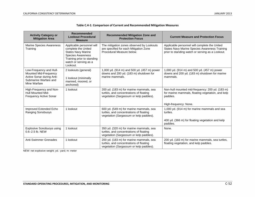
CALIFORNIA CONSISTENCY DETERMINATION JANUARY 2013
STANDARD OPERATING PROCEDURES, MITIGATION, AND MONITORING C‐52
Table C.4‐1: Comparison of Current and Recommended Mitigation Measures
Activity Category or Mitigation Area
Recommended Lookout Procedural
Measure Recommended Mitigation Zone and
Protection Focus Current Measure and Protection Focus
Marine Species Awareness Training
Applicable personnel will complete the United States Navy Marine Species Awareness Training prior to standing watch or serving as a Lookout.
The mitigation zones observed by Lookouts are specified for each Mitigation Zone Procedural Measure below.
Applicable personnel will complete the United States Navy Marine Species Awareness Training prior to standing watch or serving as a Lookout.
Low-Frequency and Hull-Mounted Mid-Frequency Active Sonar during Anti-Submarine Warfare and Mine Warfare
2 lookouts (general) 1 lookout (minimally manned, moored, or anchored)
1,000 yd. (914 m) and 500 yd. (457 m) power downs and 200 yd. (183 m) shutdown for marine mammals.
1,000 yd. (914 m) and 500 yd. (457 m) power downs and 200 yd. (183 m) shutdown for marine mammals.
High-Frequency and Non-Hull Mounted Mid-Frequency Active Sonar
1 lookout 200 yd. (183 m) for marine mammals, sea turtles, and concentrations of floating vegetation (Sargassum or kelp paddies).
Non-hull mounted mid-frequency: 200 yd. (183 m) for marine mammals, floating vegetation, and kelp paddies. High-frequency: None.
Improved Extended Echo Ranging Sonobuoys
1 lookout 600 yd. (549 m) for marine mammals, sea turtles, and concentrations of floating vegetation (Sargassum or kelp paddies).
1,000 yd. (914 m) for marine mammals and sea turtles. 400 yd. (366 m) for floating vegetation and kelp paddies.
Explosive Sonobuoys using 0.6–2.5 lb. NEW
1 lookout 350 yd. (320 m) for marine mammals, sea turtles, and concentrations of floating vegetation (Sargassum or kelp paddies).
None.
Anti-Swimmer Grenades 1 lookout 200 yd. (183 m) for marine mammals, sea turtles, and concentrations of floating vegetation (Sargassum or kelp paddies).
200 yd. (183 m) for marine mammals, sea turtles, floating vegetation, and kelp paddies.
NEW: net explosive weight; yd.: yard; m: meter
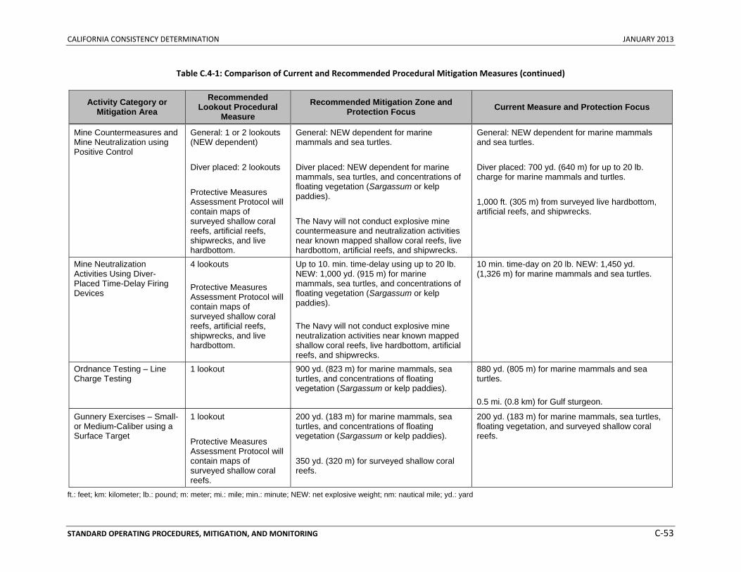
CALIFORNIA CONSISTENCY DETERMINATION JANUARY 2013
STANDARD OPERATING PROCEDURES, MITIGATION, AND MONITORING C‐53
Table C.4‐1: Comparison of Current and Recommended Procedural Mitigation Measures (continued)
Activity Category or Mitigation Area
Recommended Lookout Procedural
Measure Recommended Mitigation Zone and
Protection Focus Current Measure and Protection Focus
Mine Countermeasures and Mine Neutralization using Positive Control
General: 1 or 2 lookouts (NEW dependent) Diver placed: 2 lookouts Protective Measures Assessment Protocol will contain maps of surveyed shallow coral reefs, artificial reefs, shipwrecks, and live hardbottom.
General: NEW dependent for marine mammals and sea turtles. Diver placed: NEW dependent for marine mammals, sea turtles, and concentrations of floating vegetation (Sargassum or kelp paddies). The Navy will not conduct explosive mine countermeasure and neutralization activities near known mapped shallow coral reefs, live hardbottom, artificial reefs, and shipwrecks.
General: NEW dependent for marine mammals and sea turtles. Diver placed: 700 yd. (640 m) for up to 20 lb. charge for marine mammals and turtles. 1,000 ft. (305 m) from surveyed live hardbottom, artificial reefs, and shipwrecks.
Mine Neutralization Activities Using Diver-Placed Time-Delay Firing Devices
4 lookouts Protective Measures Assessment Protocol will contain maps of surveyed shallow coral reefs, artificial reefs, shipwrecks, and live hardbottom.
Up to 10. min. time-delay using up to 20 lb. NEW: 1,000 yd. (915 m) for marine mammals, sea turtles, and concentrations of floating vegetation (Sargassum or kelp paddies). The Navy will not conduct explosive mine neutralization activities near known mapped shallow coral reefs, live hardbottom, artificial reefs, and shipwrecks.
10 min. time-day on 20 lb. NEW: 1,450 yd. (1,326 m) for marine mammals and sea turtles.
Ordnance Testing – Line Charge Testing
1 lookout
900 yd. (823 m) for marine mammals, sea turtles, and concentrations of floating vegetation (Sargassum or kelp paddies).
880 yd. (805 m) for marine mammals and sea turtles. 0.5 mi. (0.8 km) for Gulf sturgeon.
Gunnery Exercises – Small- or Medium-Caliber using a Surface Target
1 lookout Protective Measures Assessment Protocol will contain maps of surveyed shallow coral reefs.
200 yd. (183 m) for marine mammals, sea turtles, and concentrations of floating vegetation (Sargassum or kelp paddies). 350 yd. (320 m) for surveyed shallow coral reefs.
200 yd. (183 m) for marine mammals, sea turtles, floating vegetation, and surveyed shallow coral reefs.
ft.: feet; km: kilometer; lb.: pound; m: meter; mi.: mile; min.: minute; NEW: net explosive weight; nm: nautical mile; yd.: yard
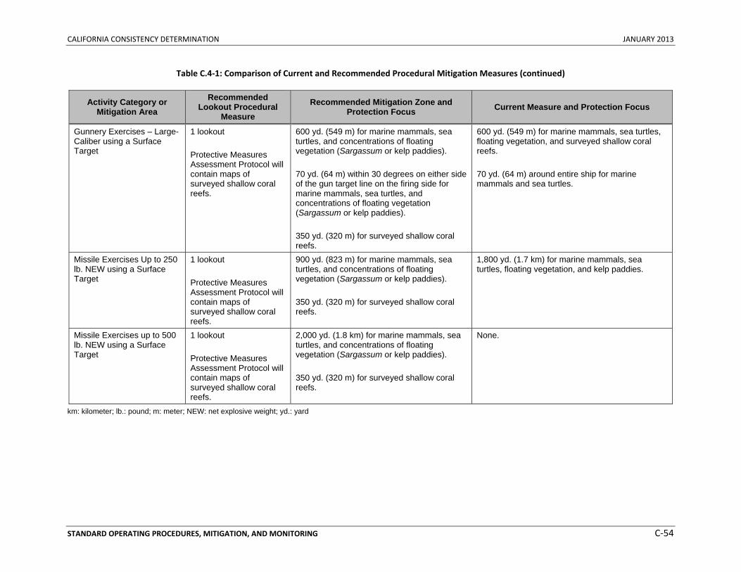
CALIFORNIA CONSISTENCY DETERMINATION JANUARY 2013
STANDARD OPERATING PROCEDURES, MITIGATION, AND MONITORING C‐54
Table C.4‐1: Comparison of Current and Recommended Procedural Mitigation Measures (continued)
Activity Category or Mitigation Area
Recommended Lookout Procedural
Measure Recommended Mitigation Zone and
Protection Focus Current Measure and Protection Focus
Gunnery Exercises – Large-Caliber using a Surface Target
1 lookout Protective Measures Assessment Protocol will contain maps of surveyed shallow coral reefs.
600 yd. (549 m) for marine mammals, sea turtles, and concentrations of floating vegetation (Sargassum or kelp paddies). 70 yd. (64 m) within 30 degrees on either side of the gun target line on the firing side for marine mammals, sea turtles, and concentrations of floating vegetation (Sargassum or kelp paddies). 350 yd. (320 m) for surveyed shallow coral reefs.
600 yd. (549 m) for marine mammals, sea turtles, floating vegetation, and surveyed shallow coral reefs. 70 yd. (64 m) around entire ship for marine mammals and sea turtles.
Missile Exercises Up to 250 lb. NEW using a Surface Target
1 lookout Protective Measures Assessment Protocol will contain maps of surveyed shallow coral reefs.
900 yd. (823 m) for marine mammals, sea turtles, and concentrations of floating vegetation (Sargassum or kelp paddies). 350 yd. (320 m) for surveyed shallow coral reefs.
1,800 yd. (1.7 km) for marine mammals, sea turtles, floating vegetation, and kelp paddies.
Missile Exercises up to 500 lb. NEW using a Surface Target
1 lookout Protective Measures Assessment Protocol will contain maps of surveyed shallow coral reefs.
2,000 yd. (1.8 km) for marine mammals, sea turtles, and concentrations of floating vegetation (Sargassum or kelp paddies). 350 yd. (320 m) for surveyed shallow coral reefs.
None.
km: kilometer; lb.: pound; m: meter; NEW: net explosive weight; yd.: yard
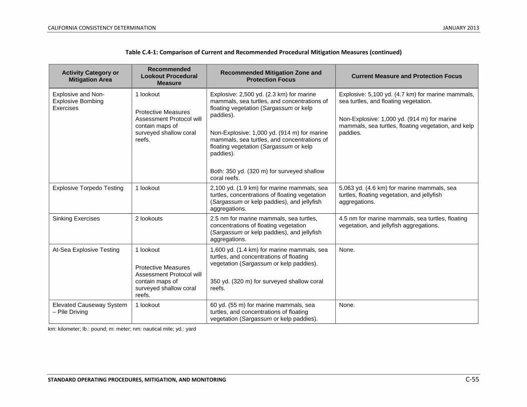
CALIFORNIA CONSISTENCY DETERMINATION JANUARY 2013
STANDARD OPERATING PROCEDURES, MITIGATION, AND MONITORING C‐55
Table C.4‐1: Comparison of Current and Recommended Procedural Mitigation Measures (continued)
Activity Category or Mitigation Area
Recommended Lookout Procedural
Measure Recommended Mitigation Zone and
Protection Focus Current Measure and Protection Focus
Explosive and Non-Explosive Bombing Exercises
1 lookout Protective Measures Assessment Protocol will contain maps of surveyed shallow coral reefs.
Explosive: 2,500 yd. (2.3 km) for marine mammals, sea turtles, and concentrations of floating vegetation (Sargassum or kelp paddies). Non-Explosive: 1,000 yd. (914 m) for marine mammals, sea turtles, and concentrations of floating vegetation (Sargassum or kelp paddies). Both: 350 yd. (320 m) for surveyed shallow coral reefs.
Explosive: 5,100 yd. (4.7 km) for marine mammals, sea turtles, and floating vegetation. Non-Explosive: 1,000 yd. (914 m) for marine mammals, sea turtles, floating vegetation, and kelp paddies.
Explosive Torpedo Testing 1 lookout 2,100 yd. (1.9 km) for marine mammals, sea turtles, concentrations of floating vegetation (Sargassum or kelp paddies), and jellyfish aggregations.
5,063 yd. (4.6 km) for marine mammals, sea turtles, floating vegetation, and jellyfish aggregations.
Sinking Exercises 2 lookouts 2.5 nm for marine mammals, sea turtles, concentrations of floating vegetation (Sargassum or kelp paddies), and jellyfish aggregations.
4.5 nm for marine mammals, sea turtles, floating vegetation, and jellyfish aggregations.
At-Sea Explosive Testing 1 lookout Protective Measures Assessment Protocol will contain maps of surveyed shallow coral reefs.
1,600 yd. (1.4 km) for marine mammals, sea turtles, and concentrations of floating vegetation (Sargassum or kelp paddies). 350 yd. (320 m) for surveyed shallow coral reefs.
None.
Elevated Causeway System – Pile Driving
1 lookout 60 yd. (55 m) for marine mammals, sea turtles, and concentrations of floating vegetation (Sargassum or kelp paddies).
None.
km: kilometer; lb.: pound; m: meter; nm: nautical mile; yd.: yard
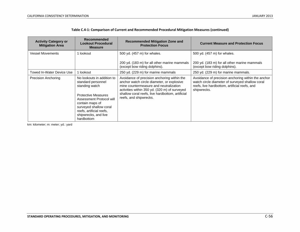
CALIFORNIA CONSISTENCY DETERMINATION JANUARY 2013
STANDARD OPERATING PROCEDURES, MITIGATION, AND MONITORING C‐56
Table C.4‐1: Comparison of Current and Recommended Procedural Mitigation Measures (continued)
Activity Category or Mitigation Area
Recommended Lookout Procedural
Measure Recommended Mitigation Zone and
Protection Focus Current Measure and Protection Focus
Vessel Movements 1 lookout 500 yd. (457 m) for whales. 200 yd. (183 m) for all other marine mammals (except bow riding dolphins).
500 yd. (457 m) for whales. 200 yd. (183 m) for all other marine mammals (except bow riding dolphins).
Towed In-Water Device Use 1 lookout 250 yd. (229 m) for marine mammals 250 yd. (229 m) for marine mammals. Precision Anchoring No lookouts in addition to
standard personnel standing watch Protective Measures Assessment Protocol will contain maps of surveyed shallow coral reefs, artificial reefs, shipwrecks, and live hardbottom
Avoidance of precision anchoring within the anchor watch circle diameter, or explosive mine countermeasure and neutralization activities within 350 yd. (320 m) of surveyed shallow coral reefs, live hardbottom, artificial reefs, and shipwrecks.
Avoidance of precision anchoring within the anchor watch circle diameter of surveyed shallow coral reefs, live hardbottom, artificial reefs, and shipwrecks.
km: kilometer; m: meter; yd.: yard
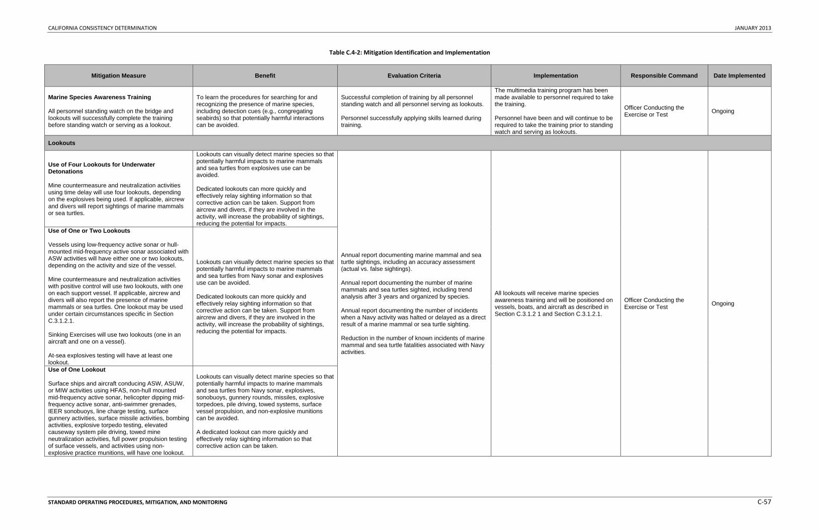
CALIFORNIA CONSISTENCY DETERMINATION JANUARY 2013
STANDARD OPERATING PROCEDURES, MITIGATION, AND MONITORING C‐57
Table C.4‐2: Mitigation Identification and Implementation
Mitigation Measure Benefit Evaluation Criteria Implementation Responsible Command Date Implemented
Marine Species Awareness Training All personnel standing watch on the bridge and lookouts will successfully complete the training before standing watch or serving as a lookout.
To learn the procedures for searching for and recognizing the presence of marine species, including detection cues (e.g., congregating seabirds) so that potentially harmful interactions can be avoided.
Successful completion of training by all personnel standing watch and all personnel serving as lookouts. Personnel successfully applying skills learned during training.
The multimedia training program has been made available to personnel required to take the training. Personnel have been and will continue to be required to take the training prior to standing watch and serving as lookouts.
Officer Conducting the Exercise or Test Ongoing
Lookouts
Use of Four Lookouts for Underwater Detonations Mine countermeasure and neutralization activities using time delay will use four lookouts, depending on the explosives being used. If applicable, aircrew and divers will report sightings of marine mammals or sea turtles.
Lookouts can visually detect marine species so that potentially harmful impacts to marine mammals and sea turtles from explosives use can be avoided. Dedicated lookouts can more quickly and effectively relay sighting information so that corrective action can be taken. Support from aircrew and divers, if they are involved in the activity, will increase the probability of sightings, reducing the potential for impacts.
Annual report documenting marine mammal and sea turtle sightings, including an accuracy assessment (actual vs. false sightings). Annual report documenting the number of marine mammals and sea turtles sighted, including trend analysis after 3 years and organized by species. Annual report documenting the number of incidents when a Navy activity was halted or delayed as a direct result of a marine mammal or sea turtle sighting. Reduction in the number of known incidents of marine mammal and sea turtle fatalities associated with Navy activities.
All lookouts will receive marine species awareness training and will be positioned on vessels, boats, and aircraft as described in Section C.3.1.2 1 and Section C.3.1.2.1.
Officer Conducting the Exercise or Test Ongoing
Use of One or Two Lookouts Vessels using low-frequency active sonar or hull-mounted mid-frequency active sonar associated with ASW activities will have either one or two lookouts, depending on the activity and size of the vessel. Mine countermeasure and neutralization activities with positive control will use two lookouts, with one on each support vessel. If applicable, aircrew and divers will also report the presence of marine mammals or sea turtles. One lookout may be used under certain circumstances specific in Section C.3.1.2.1. Sinking Exercises will use two lookouts (one in an aircraft and one on a vessel). At-sea explosives testing will have at least one lookout.
Lookouts can visually detect marine species so that potentially harmful impacts to marine mammals and sea turtles from Navy sonar and explosives use can be avoided. Dedicated lookouts can more quickly and effectively relay sighting information so that corrective action can be taken. Support from aircrew and divers, if they are involved in the activity, will increase the probability of sightings, reducing the potential for impacts.
Use of One Lookout Surface ships and aircraft conducing ASW, ASUW, or MIW activities using HFAS, non-hull mounted mid-frequency active sonar, helicopter dipping mid-frequency active sonar, anti-swimmer grenades, IEER sonobuoys, line charge testing, surface gunnery activities, surface missile activities, bombing activities, explosive torpedo testing, elevated causeway system pile driving, towed mine neutralization activities, full power propulsion testing of surface vessels, and activities using non-explosive practice munitions, will have one lookout.
Lookouts can visually detect marine species so that potentially harmful impacts to marine mammals and sea turtles from Navy sonar, explosives, sonobuoys, gunnery rounds, missiles, explosive torpedoes, pile driving, towed systems, surface vessel propulsion, and non-explosive munitions can be avoided. A dedicated lookout can more quickly and effectively relay sighting information so that corrective action can be taken.
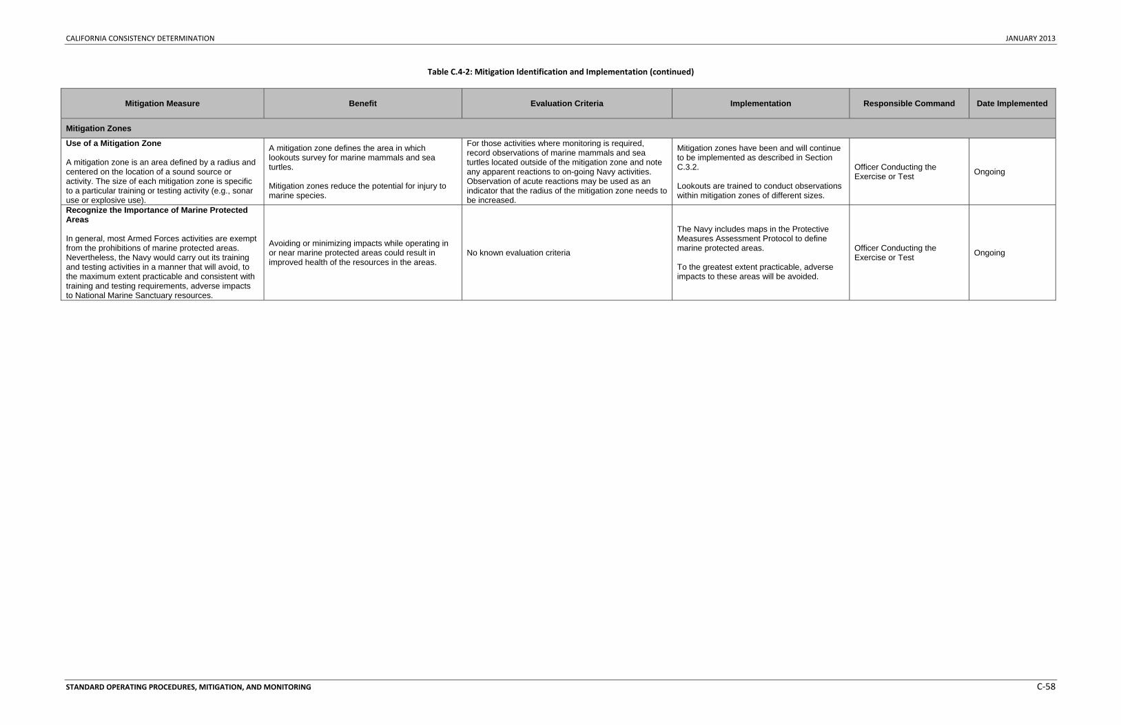
CALIFORNIA CONSISTENCY DETERMINATION JANUARY 2013
STANDARD OPERATING PROCEDURES, MITIGATION, AND MONITORING C‐58
Table C.4‐2: Mitigation Identification and Implementation (continued)
Mitigation Measure Benefit Evaluation Criteria Implementation Responsible Command Date Implemented
Mitigation Zones
Use of a Mitigation Zone A mitigation zone is an area defined by a radius and centered on the location of a sound source or activity. The size of each mitigation zone is specific to a particular training or testing activity (e.g., sonar use or explosive use).
A mitigation zone defines the area in which lookouts survey for marine mammals and sea turtles. Mitigation zones reduce the potential for injury to marine species.
For those activities where monitoring is required, record observations of marine mammals and sea turtles located outside of the mitigation zone and note any apparent reactions to on-going Navy activities. Observation of acute reactions may be used as an indicator that the radius of the mitigation zone needs to be increased.
Mitigation zones have been and will continue to be implemented as described in Section C.3.2. Lookouts are trained to conduct observations within mitigation zones of different sizes.
Officer Conducting the Exercise or Test Ongoing
Recognize the Importance of Marine Protected Areas In general, most Armed Forces activities are exempt from the prohibitions of marine protected areas. Nevertheless, the Navy would carry out its training and testing activities in a manner that will avoid, to the maximum extent practicable and consistent with training and testing requirements, adverse impacts to National Marine Sanctuary resources.
Avoiding or minimizing impacts while operating in or near marine protected areas could result in improved health of the resources in the areas.
No known evaluation criteria
The Navy includes maps in the Protective Measures Assessment Protocol to define marine protected areas. To the greatest extent practicable, adverse impacts to these areas will be avoided.
Officer Conducting the Exercise or Test Ongoing
CALIFORNIA CONSISTENCY DETERMINATION JANUARY 2013
STANDARD OPERATING PROCEDURES, MITIGATION, AND MONITORING C‐59
C.5 MITIGATION MEASURES CONSIDERED BUT ELIMINATED A number of possible alternative or additional mitigation measures have been suggested during the public comment periods of previous Navy environmental documents. In addition, through the evaluation process identified in Section C.2 (Introduction to Mitigation), some measures were deemed to either be ineffective, have an unacceptable impact on the proposed training and testing activities, or both, and will not be carried forward for further consideration. This section presents the measures initially considered and gives an evaluation of the likely effectiveness at reducing impacts on the resource and the impact on the proposed training and testing activities (safety risks to personnel and equipment, practicability of implementation, impact on readiness, and legal authority to implement). Mitigation measures considered but eliminated are discussed in Section C.5.1 (Previously Considered but Eliminated) and Section C.5.3 (Previously Accepted but Now Eliminated). There is a distinction between effective and feasible observation procedures for data collection and measures employed to prevent impacts or otherwise serve as mitigation. The discussion below is in reference to those procedures meant to serve as mitigation measures.
C.5.1 PREVIOUSLY CONSIDERED BUT ELIMINATED
C.5.1.1 Amount and Level of Activities
C.5.1.1.1 Reducing Amount of Training and Testing Activities
Reducing training and testing for the purpose of mitigation would result in an unacceptable impact on readiness for the following reasons:
The requirements to train are designed to provide the experience needed to ensure Sailors are properly prepared for operational success. Training requirements have been developed through many years of iteration and are designed to ensure Sailors achieve the levels of readiness needed to properly respond to the many contingencies that may occur during an actual mission. The Proposed Action does not include training beyond levels required for maintaining satisfactory levels of readiness due to the need to efficiently use limited resources (e.g. fuel, personnel, and time). Therefore, any reduction of training would not allow Sailors to achieve satisfactory levels of readiness needed to accomplish their mission.
The requirements to test systems prior to their implementation in military activities are identified in DoD Directive 5000.1. This directive states that test and evaluation support is to be integrated throughout the defense acquisition process. The Navy rigorously collected data during the developmental stages of the HSTT EIS/OEIS to accurately quantify test activities necessary to meet requirements of DoD Directive 5000.1. These testing requirements are designed to determine whether systems perform as expected and are operationally effective, suitable, survivable, and safe for their intended use. Any reduction of testing activities would not allow the Navy to meet its purpose and need to achieve requirements set forth in DoD Directive 5000.1.
C.5.1.2 Replacing Training and Testing with Simulated Activities
Replacing training and testing activities with simulated activities for the purpose of mitigation would result in an unacceptable impact on readiness for the following reasons:
As described in Section 2.5.1.3 of the HSTT EIS/OEIS (Simulated Training and Testing), the Navy currently uses computer simulation for training and testing whenever possible. Computer simulation can provide familiarity and complement live training; however, it cannot provide the fidelity and level of training necessary to prepare naval forces for deployment.
CALIFORNIA CONSISTENCY DETERMINATION JANUARY 2013
STANDARD OPERATING PROCEDURES, MITIGATION, AND MONITORING C‐60
The Navy is required by law to operationally test major platforms, systems, and components of these platforms and systems in realistic combat conditions before full‐scale production can occur. Substituting simulation for live training and testing fails to meet the purpose of and need for the Proposed Action and therefore was eliminated from consideration as a mitigation measure.
C.5.1.2.1 Reducing Sonar Source Levels and Total Number of Hours
Reducing the sonar source levels and the total number of sonar hours used during training and testing activities for the purpose of mitigation would result in an unacceptable impact on readiness for the following reasons:
Operators of sonar equipment are always cognizant of the environmental variables affecting sound propagation. In this regard, the sonar equipment power levels are always set consistent with mission requirements. Reducing the source level would not allow the Navy to achieve satisfactory levels of readiness needed to accomplish its mission.
Active sonar is only used when required by the mission since it has the potential to alert opposing forces to the sonar platform’s presence. Passive sonar and all other sensors are used in concert with active sonar to the maximum extent practicable when available and when required by the mission.
C.5.1.2.2 Implementing Active Sonar Ramp-Up Procedures during Training or Testing
Implementing active sonar ramp‐up procedures (slowly increasing the sound in the water to necessary levels) in an attempt to clear the range prior to conduct of activities for the purpose of mitigation during training activities would result in an unacceptable impact on readiness for the following reason:
Ramp‐up procedures would alert opponents to the participants’ presence. This would consequently negatively affect the realism of training because the target submarine could detect the searching unit before the searching unit could detect the target submarine, enabling the target submarine to take evasive measures. This is not representative of a real‐world situation and thereby would impact training realism and effectiveness.
Some testing activities currently implement active sonar ramp‐up procedures (slowly increasing the sound in the water to necessary levels) in an attempt to clear the range prior to conduct of activities for the purpose of mitigation. Although ramp‐up procedures are currently used for some testing activities, the effectiveness at avoiding or reducing impacts on marine mammals is unknown. Until evidence suggests that ramp‐procedures are an effective means of avoiding or reducing potential impacts on marine mammals, the Navy will not recommend continuing the implementation of this measure for testing activities as part of the Proposed Action.
C.5.1.2.3 Reducing Vessel Speed
Navy personnel are required to use extreme caution and operate at a slow, safe speed consistent with mission and safety. Reducing vessel speed for the purpose of mitigation would be impracticable to implement and would result in an unacceptable impact on readiness for the following reasons:
Ships and submarines need to be able to react to changing tactical situations and evaluate system capabilities in training and testing as they would in actual combat. Placing arbitrary speed restrictions would not allow them to properly test ship and vessel capabilities or train to react to these situations. Training and testing differently from what would be needed in an actual combat scenario would
CALIFORNIA CONSISTENCY DETERMINATION JANUARY 2013
STANDARD OPERATING PROCEDURES, MITIGATION, AND MONITORING C‐61
decrease training and testing effectiveness, present possible safety issues, and reduce the crew’s abilities.
C.5.1.3 Location and Timing of Activities
C.5.1.3.1 Limiting Activities to a Few Specific Locations
Limiting training and testing activities to a few specific locations for the purpose of mitigation would be impracticable to implement and would result in an unacceptable impact on readiness for the following reasons:
• Areas where training and testing activities are scheduled to occur are carefully chosen to provide safety and allow realism of events. The proximity to facilities, range complexes, and testing ranges is essential to the training and testing realism and effectiveness required to train and certify naval forces ready for combat operations.
• Limiting vessel movements to certain areas would restrict access to training and testing locations and therefore would adversely impact the effectiveness of the Proposed Action.
• As described in Section 2.5.1.1 of the HSTT EIS/OEIS (Alternative Training and Testing Locations), the ability to use the diverse and multidimensional capabilities of each range complex and testing range results in the Navy’s ability to develop and maintain high levels of readiness.
• Major exercises using integrated warfare components require large areas of the littorals and open ocean for realistic and safe training. Otherwise limiting training and testing (including the use of sonar and other active acoustic sources or explosives) to a few specific locations (e.g., abyssal waters and surveyed offshore waters) and avoiding large areas (e.g., large areas of the littorals and open ocean) would adversely impact the effectiveness of the training and testing.
C.5.1.3.2 Avoiding Locations Based on Bathymetry and Environmental Conditions
Avoiding locations for training and testing activities based on bathymetry and environmental conditions for the purpose of mitigation would be impracticable to implement and would result in an unacceptable impact on readiness for the following reasons:
• Areas where training and testing activities are scheduled to occur are carefully chosen to provide safety and allow realism of events.
• As described in Section 2.5.1.1 of the HSTT EIS/OEIS (Alternative Training and Testing Locations), the varying environmental conditions of the Study Area maximize the training realism and testing effectiveness. Otherwise limiting training and testing (including the use of sonar and other active acoustic sources or explosives) to avoid steep or complex bathymetric features (e.g., submarine canyons and large seamounts) and oceanographic features (e.g., surface fronts and variations in sea surface temperatures) would adversely impact the effectiveness of the training and testing.
C.5.1.3.2.1 Avoiding or Reducing Active Sonar at Night and During Periods of Low Visibility Avoiding or reducing active sonar at night and during periods of low visibility for the purpose of mitigation would result in an unacceptable impact on readiness for the following reasons:
• The Navy must train in the same manner as it will fight. Anti‐submarine warfare can require a significant amount of time to develop the “tactical picture,” or an understanding of the battle space such as area searched or unsearched, identifying false contacts, understanding the water conditions, etc. Reducing or securing power in low‐visibility conditions would affect a
CALIFORNIA CONSISTENCY DETERMINATION JANUARY 2013
STANDARD OPERATING PROCEDURES, MITIGATION, AND MONITORING C‐62
commander’s ability to develop this tactical picture and would not provide the needed training realism. Training differently from what would be needed in an actual combat scenario would decrease training effectiveness and reduce the crew’s abilities.
• Mid‐frequency active sonar training is required year‐round in all environments, including night and low‐visibility conditions. Training occurs over many hours or days, which requires large teams of personnel working together in shifts around the clock to work through a scenario. Training at night is vital because environmental differences between day and night affect the detection capabilities of sonar. Temperature layers, which affect sound propagation, move up and down in the water column from day to night and vice versa. Consequently, personnel must train during all hours of the day to ensure they identify and respond to changing environmental conditions, and not doing so would unacceptably decrease training effectiveness and reduce the crews’ abilities. Therefore, the Navy cannot operate only in daylight hours or wait for the weather to clear before training.
• The Navy must test its systems in the same way they would be used for military readiness activities. Reducing or securing power in adverse weather conditions or at night would impact the ability to determine whether systems are operationally effective, suitable, survivable, and safe. Additionally, some systems have a nighttime testing requirement. Therefore, Navy personnel cannot operate only in daylight hours or wait for the weather to clear before or during all test events.
C.5.1.3.2.2 Avoiding or Reducing Active Sonar during Strong Surface Ducts Avoiding or reducing active sonar during strong surface ducts for the purpose of mitigation would be impracticable to implement and would result in an unacceptable impact on readiness for the following reasons:
• The Navy must train in the same manner as it will fight. As described in Section C.5.1.3.2.1 (Avoiding or Reducing Active Sonar at Night and During Periods of Low Visibility), the complexity of anti‐submarine warfare requires the most realistic training possible for the effectiveness and safety of the Sailors.
• Ocean conditions contributing to surface ducting change frequently, and surface ducts can be of varying duration. Surface ducting can also lack uniformity and may not extend over a large geographic area, making it difficult to determine where to reduce power and for what periods.
C.5.1.3.3 Avoiding Locations Based on Distances from Isobaths or Shorelines
A measure requiring avoidance of mid‐frequency active sonar within 13 nm of the 656 ft. (200 m) isobaths was part of the Rim of the Pacific (RIMPAC) 2006 authorization by NMFS. This measure, as well as similar measures of like distances, lacks any scientific basis when applied to the context of the HSTT Study Area (e.g., the bathymetry, sound propagation, width of channels). There is no scientific analysis indicating this measure is protective and no known basis for these specific metrics. The RIMPAC 2006 mitigation measure precluded active anti‐submarine training in the littoral region, which significantly impacted realism and training effectiveness (such as for amphibious landings). This procedure had no observable effect on the protection of marine mammals during RIMPAC 2006, and its value is unclear. However, its effect on realistic training, as with all arbitrary distance from land restrictions, is significant.
Avoiding locations for training and testing activities within the HSTT Study Area based on wide‐scale distances from isobaths or the shoreline for the purpose of mitigation would be impracticable to implement and would result in an unacceptable impact on readiness for the following reasons:
CALIFORNIA CONSISTENCY DETERMINATION JANUARY 2013
STANDARD OPERATING PROCEDURES, MITIGATION, AND MONITORING C‐63
• Areas where training and testing activities are scheduled to occur are carefully chosen to provide safety and allow realism of events. The proximity to facilities, range complexes, and testing ranges is essential to the training and testing realism and effectiveness required to train and certify naval forces ready for combat operations.
• As described in Section 2.5.1.1 of the HSTT EIS/OEIS (Alternative Training and Testing Locations), the ability to use the diverse and multi‐dimensional capabilities of each range complex and testing range results in the Navy’s ability to develop and maintain high levels of readiness. Otherwise limiting training and testing (including the use of sonar and other active acoustic sources or explosives) to avoid arbitrary distances from isobaths or the shoreline would adversely impact the effectiveness of the training and testing. This includes avoiding conducting activities within 12 nm from shore, 25 nm from shore, between shore and the 20‐m isobath, and 13 nm out from the 656 ft. (200 m) isobath.
C.5.1.3.4 Avoiding Marine Species Habitats
Avoiding marine species habitats (e.g., foraging locations, reproductive locations, migration corridors, locations of modeled takes) for the purpose of mitigation would be impracticable to implement and would result in an unacceptable impact on readiness for the following reasons:
• As described in Section C.5.1.3.1 (Limiting Activities to a Few Specific Locations) and Section C.5.1.3.2 (Avoiding Locations Based on Bathymetry and Environmental Conditions), areas where training and testing activities are scheduled to occur are carefully chosen to provide safety and allow realism of events, and the varying environmental conditions of these areas maximize the training realism and testing effectiveness. Activity locations inevitably overlap a wide array of marine species habitats, including foraging habitats, reproductive areas, and migration corridors. Otherwise limiting activities to avoid these habitats would adversely impact the effectiveness of the Proposed Activity.
• Proposed mitigation includes protective measures within several areas (Section C.3.3, Mitigation Areas) that have been well documented as important habitats for particular species. The measures outlined in Section C.3.1 (Lookout Procedural Measures) and Section C.3.2 (Mitigation Zone Procedural Measures) have been developed to reduce potential impacts on marine species regardless of activity location.
• As described in the Determination of Acoustic Effects on Marine Mammals and Sea Turtles for the Hawaii‐Southern California Training and Testing Environmental Impact Statement/Overseas Environmental Impact Statement technical report (Marine Species Modeling Team 2012), modeling locations were developed based on historical data and anticipated future needs. The model does not provide information detailed enough to analyze or compare locations based on potential take levels for each activity; therefore, applying the modeling results to inform development of mitigation areas would not be appropriate.
C.5.1.4 Visual and Passive Acoustic Observations
C.5.1.4.1 Increasing Visual and Passive Acoustic Observations
Increasing visual and passive acoustic observations for the purpose of mitigation would be impracticable to implement for the following reasons:
• The proposed mitigation measures represent the maximum level of effort (e.g., numbers of lookouts and passive sonobuoys) that the Navy can commit to observing mitigation zones given
CALIFORNIA CONSISTENCY DETERMINATION JANUARY 2013
STANDARD OPERATING PROCEDURES, MITIGATION, AND MONITORING C‐64
the number of personnel that will be involved and the number and type of assets and resources available.
C.5.1.5 Increasing the Size of Observed Mitigation Zones
Increasing the size of observed mitigation zones for the purpose of mitigation would be impracticable to implement for the following reasons:
• The Navy developed mitigation zones according to activity type. The proposed mitigation zones represent the maximum area the Navy can effectively observe based on the platform of observation, number of personnel that will be involved, and the number and type of assets and resources available. As mitigation zone sizes increase, the potential for reducing impacts decreases. For instance, if a mitigation zone increases from 1,000 to 4,000 yd. (914 to 3,658 m), the area that must be observed increases sixteen‐fold.
• The proposed mitigation measures balance the need to reduce potential impacts with the ability to provide effective observations throughout a given mitigation zone. Implementation of mitigation zones is most effective when the zone is small enough to be realistically observed.
C.5.1.5.1 Conducting Visual Observations Using Third-Party Observers
With limited exceptions, utilization of third‐party observers in air or on surface platforms in addition to existing Navy lookouts for the purposes of mitigation would be impracticable to implement for the following reasons:
• Use of third‐party observers is not necessary because Navy personnel are extensively trained in spotting items on or near the water surface. Navy spotters receive more hours of training, and use their spotting skills more frequently, than many third‐party trained personnel.
• Use of Navy lookouts is the most effective means to ensure quick and effective implementation of mitigation measures if marine species are spotted. A critical skill set of effective Navy training is communication. Navy lookouts are trained to act swiftly and decisively to ensure that appropriate actions are taken.
• The use of third‐party observers would compromise security for some activities involving active sonar due to the requirement to provide advance notification of specific times and locations of Navy platforms. Reliance on the availability of third‐party personnel would impact training and testing flexibility. The presence of other aircraft in the vicinity of naval activities would raise safety concerns for both the commercial observers and naval aircraft.
• Surface ships have limited passenger capacity. Training and testing event planning includes careful consideration of this limited capacity in the placement of personnel on ships involved in the event. Inclusion of non‐Navy observers onboard these ships would require that in some cases there would be no additional space for essential Navy personnel required to meet the exercise objectives.
• The areas where training events will most likely occur in the Study Area cover approximately 1 million nm2. Contiguous anti‐submarine warfare events may cover many hundreds or even thousands of square miles. The number of civilian ships or aircraft required to monitor the area of these events would be considerable. It is, thus, not feasible to survey or monitor the large exercise areas in the time required. In addition, marine mammals may move into or out of an area, if surveyed before an event, or an animal could move into an area after an event took place. Given that there are no adequate controls to account for these or other possibilities,
CALIFORNIA CONSISTENCY DETERMINATION JANUARY 2013
STANDARD OPERATING PROCEDURES, MITIGATION, AND MONITORING C‐65
there is little utility to performing extensive before or after event surveys of large exercise areas as a mitigation measure.
• Surveying during an event raises safety issues with multiple, slow civilian aircraft operating in the same airspace as military aircraft engaged in combat training activities. In addition, many of the training and testing events take place far from land, limiting both the time available for civilian aircraft to be in the event area and presenting a concern should aircraft mechanical problems arise.
• Scheduling civilian vessels or aircraft to coincide with training events would impact training effectiveness, since exercise event timetables cannot be precisely fixed and are instead based on the free‐flow development of tactical situations. Waiting for civilian aircraft or vessels to complete surveys, refuel, or be on station would slow the progress of the exercise and impact the effectiveness of the military readiness activity.
• Multiple training and testing events can occur simultaneously and in various regions throughout the Study Area, and can last for days or weeks at a time. It is not feasible to have enough qualified third‐party personnel to accomplish the task for every event.
C.5.1.6 ADOPTING MITIGATION MEASURES OF FOREIGN NAVIES
Adopting mitigation measures of foreign navies for the purpose of mitigation would be impracticable to implement and would result in an unacceptable impact on readiness for the following reasons:
• Mitigation measures are carefully customized for and agreed upon by each individual navy based on potential impacts of the activities on marine species and the impacts of the mitigation measures on military readiness. Therefore, the mitigation measures developed for one navy would not necessarily be effective at reducing potential impacts on marine species by all navies. Similarly, mitigation measures that do not cause an unacceptable impact to one navy may cause an unacceptable impact on another. For example, most other navies do not possess an integrated strike group and do not have integrated training requirements. The Navy’s training is built around the integrated warfare concept and is based on the Navy’s capabilities, the threats faced, the operating environment, and the overall mission. Implementing other navies’ mitigation would be incompatible with U.S. Navy requirements.
• The U.S. Navy’s proposed mitigation measures have been carefully designed to reduce potential impacts on marine species while not causing an unacceptable impact on readiness.
C.5.1.7 Reporting
C.5.1.7.1 Increasing Reporting Requirements
Navy reporting requirements, including exercise and monitoring reporting are described in Section C.7 (Reporting). Increasing the requirement to report marine species sightings to augment scientific data collection and verify the implementation of mitigation measures would be impracticable to implement for the following reasons:
• Ships, submarines, aircraft, and personnel engaged in training events are intensively employed throughout the duration of training and testing activities. Any additional workload assigned that is unrelated to their primary duty would adversely impact the effectiveness of the military readiness activity they are undertaking.
• Lookouts cannot identify animals to the species level and would not be able to provide the detailed information that the scientific community would use. Alternatively, the Navy has an integrated comprehensive monitoring program (Section C.6, Monitoring) that does provide
CALIFORNIA CONSISTENCY DETERMINATION JANUARY 2013
STANDARD OPERATING PROCEDURES, MITIGATION, AND MONITORING C‐66
information that is available and useful to the scientific community in annual monitoring reports.
C.5.2 PREVIOUSLY ACCEPTED BUT NOW ELIMINATED
C.5.2.1 Implementing a Mitigation Zone for Missile Exercises with Airborne Targets
Per current mitigation, a mitigation zone of 1,000 yd. (915 m) is observed around the expected expended material field. The Navy is proposing to eliminate the need for a lookout to maintain a mitigation zone for missile exercises involving airborne targets. Most airborne targets are recoverable aerial drones, and missile impact with the target does not typically occur. Most anti‐air missiles used in training are telemetry configured, which means they don’t have an actual warhead. Impact of a target is unlikely because missiles are designed to detonate (simulated detonation for telemetry missiles) in the vicinity of the target and not as a result of a direct strike on the target. Given the speed of the missile and the target, the high altitudes involved, and the long ranges of missile travel possible, it is impracticable to predict or to effectively observe where the missile fragments will fall. The potential expended material fall zone can only be predicted within tens of miles for long range events, which can be in excess of 80 nm from the firing location, and thousands of yards for shorter events, which can occur within several thousand yards from the firing location.
The potential risk to any marine mammal or sea turtle from a missile exercise with an airborne target is a direct strike from falling expended material. Based on the extremely low potential for a target strike and associated expended material field to co‐occur in space and time with a marine species at or near the surface of the water, the potential for a direct strike is negligible. Establishment of a mitigation zone for activities involving airborne targets is ineffective at reducing potential impacts.
C.5.2.2 Implementing a Mitigation Zone for Medium and Large Caliber Gunnery Exercises with Airborne Targets
Per current mitigation, a mitigation zone is observed in the vicinity of the expected expended material field. The Navy is proposing to eliminate the need for a lookout to observe in the vicinity of the expected expended for medium and large caliber gunnery exercises involving airborne targets. The potential expended material fall zone can only be predicted thousands of yards, which can be up to 7 nm from the firing location.
The potential risk to any marine mammal or sea turtle from a gunnery exercise with an airborne target is a direct strike from falling expended material. Based on the extremely low potential for an expended material field to co‐occur in space and time with a marine species at or near the surface of the water, the potential for a direct strike is negligible. Establishment of a mitigation zone for activities involving airborne targets is ineffective at reducing potential impacts.
C.5.2.3 Implementing Measures for Laser Test Operations
Visual surveys would be conducted for all testing activities involving laser line scan, light imaging detection, and ranging lasers. Per current standard operating procedures, only trained personnel operate lasers and visual observation of the area is conducted to ensure human safety. The Navy is proposing to discontinue this procedure as a mitigation measure for two reasons: (1) it is currently a standard operating procedure conducted for human safety, and (2) the environmental consequences analysis suggests that impacts on resources from laser activities are not expected.
CALIFORNIA CONSISTENCY DETERMINATION JANUARY 2013
STANDARD OPERATING PROCEDURES, MITIGATION, AND MONITORING C‐67
C.6 MONITORING C.6.1 APPROACH TO MONITORING
The Navy is committed to demonstrating environmental stewardship while executing its National Defense Mission and complying with the suite of Federal environmental laws and regulations. As a complement to the Navy’s commitment to avoiding and reducing impacts of the Proposed Action through mitigation (Section C.4), the Navy will undertake monitoring efforts to track compliance with take authorizations, to help evaluate the effectiveness of implemented mitigation measures, and to better understand the effects of the Proposed Action on marine resources. Taken together, mitigation and monitoring comprise the Navy’s integrated approach for reducing environmental impacts from the Proposed Action. The Navy’s overall monitoring approach will seek to leverage and build on existing research efforts whenever possible.
Consistent with the cooperating agency agreement with NMFS, mitigation and monitoring measures presented in the HSTT EIS/OEIS focus on the requirements for protection and management of marine resources. A well‐designed monitoring program can provide important feedback for validating assumptions made in analyses and allow for adaptive management of marine resources. Since monitoring will be required for compliance with the final rule issued for the Proposed Action under the MMPA, details of the monitoring program will be developed in coordination with NMFS through the regulatory process. Discussions with resource agencies during the consultation and permitting processes may result in changes to the mitigation as described in this document. Such changes will be reflected in the final HSTT EIS/OEIS, Record of Decision, and consultation documents such as the ESA Biological Opinion.
C.6.1.1 Integrated Comprehensive Monitoring Plan Top-Level Goals
The Integrated Comprehensive Monitoring Program is intended to coordinate monitoring efforts across all regions where the Navy trains and tests and to allocate the most appropriate level and type of effort for each range complex (U.S. Department of the Navy 2010). The current Navy monitoring program is composed of a collection of “range‐specific” monitoring plans, each developed individually as part of MMPA and ESA compliance processes as environmental documentation was completed. These individual plans establish specific monitoring requirements for each range complex and are collectively intended to address the Integrated Comprehensive Monitoring Program top‐level goals.
A 2010 Navy‐sponsored monitoring meeting in Arlington, Virginia, initiated a process to critically evaluate the current Navy monitoring plans and begin development of revisions and updates to both existing region‐specific plans as well as the Integrated Comprehensive Monitoring Program. Discussions at that meeting as well as the following Navy and NMFS annual adaptive management meeting established a way ahead for continued refinement of the Navy's monitoring program. This process included establishing a Scientific Advisory Group of leading marine mammal scientists with the initial task of developing recommendations that would serve as the basis for a Strategic Plan for Navy monitoring. The Strategic Plan is intended to be a primary component of the Integrated Comprehensive Monitoring Program and provide a “vision” for Navy monitoring across geographic regions ‐ serving as guidance for determining how to most efficiently and effectively invest the marine species monitoring resources to address Integrated Comprehensive Monitoring Program top‐level goals and satisfy MMPA Letter of Authorization regulatory requirements.
The objective of the Strategic Plan is to continue the evolution of Navy marine species monitoring towards a single integrated program, incorporating Scientific Advisory Group recommendations, and
CALIFORNIA CONSISTENCY DETERMINATION JANUARY 2013
STANDARD OPERATING PROCEDURES, MITIGATION, AND MONITORING C‐68
establishing a more transparent framework for soliciting, evaluation, and implementing monitoring work across the range complexes. The Strategic Plan must consider a range of factors in addition to the scientific recommendations including logistic, operational, and funding considerations and will be revised regularly as part of the annual adaptive management process.
The Integrated Comprehensive Monitoring Program establishes top‐level goals that have been developed in coordination with NMFS (U.S. Department of the Navy 2010). The following top‐level goals will become more specific with regard to identifying potential projects and monitoring field work through the Strategic Plan process as projects are evaluated and initiated in the HSTT Study Area.
• An increase in our understanding of the likely occurrence of marine mammals or ESA‐listed marine species in the vicinity of the action (i.e., presence, abundance, distribution, and density of species);
• An increase in our understanding of the nature, scope, or context of the likely exposure of marine mammals and ESA‐listed species to any of the potential stressor(s) associated with the action (e.g., tonal and impulsive sound), through better understanding of one or more of the following: (1) the action and the environment in which it occurs (e.g., sound source characterization, propagation, and ambient noise levels); (2) the affected species (e.g., life history or dive patterns); (3) the likely co‐occurrence of marine mammals and ESA‐listed marine species with the action (in whole or part) associated with specific adverse effects, or; (4) the likely biological or behavioral context of exposure to the stressor for the marine mammal and ESA‐listed marine species (e.g., age class of exposed animals or known pupping, calving or feeding areas);
• An increase in our understanding of how individual marine mammals or ESA‐listed marine species respond (behaviorally or physiologically) to the specific stressors associated with the action (in specific contexts, where possible, e.g., at what distance or received level);
• An increase in our understanding of how anticipated individual responses, to individual stressors or anticipated combinations of stressors, may impact either: (1) the long‐term fitness and survival of an individual; or (2) the population, species, or stock (e.g., through effects on annual rates of recruitment or survival);
• An increase in our understanding of the effectiveness of mitigation and monitoring measures; • A better understanding and record of the manner in which the authorized entity complies with
the Incidental Take Authorization and Incidental Take Statement; • An increase in the probability of detecting marine mammals (through improved technology or
methods), both specifically within the mitigation zone (thus allowing for more effective implementation of the mitigation) and in general, to better achieve the above goals; and
• A reduction in the adverse impact of activities to the least practicable level, as defined in the MMPA.
C.6.1.2 Scientific Advisory Group Recommendations
Navy established the Scientific Advisory Group in 2011 with the initial task of evaluating current Navy monitoring approaches under the Integrated Comprehensive Monitoring Program and existing MMPA Letters of Authorization and developing objective scientific recommendations that would form the basis for this Strategic Plan. While recommendations were fairly broad and not prescriptive from a range complex perspective, the Scientific Advisory Group did provide specific programmatic recommendations that serve as guiding principles for the continued evolution of the Navy Marine Species Monitoring
CALIFORNIA CONSISTENCY DETERMINATION JANUARY 2013
STANDARD OPERATING PROCEDURES, MITIGATION, AND MONITORING C‐69
Program and provide a direction for the Strategic Plan to move this development. Key recommendations include:
• Working within a conceptual framework of knowledge, from basic information on the occurrence of species within each range complex, to more specific matters of exposure, response, and consequences.
• Facilitating collaboration among researchers in each region, with the intent to develop a coherent and synergistic regional monitoring and research effort.
• Striving to move away from a “box‐checking” mentality. Monitoring studies should be designed and conducted according to scientific objectives, rather than on merely cataloging effort expended.
• Approach the monitoring program holistically and select projects that offer the best opportunity to advance understanding of the issues, as opposed to establishing range‐specific requirements.
C.7 REPORTING The Navy is committed to documenting and reporting relevant aspects of training and testing activities in order to document species sightings, reduce environmental impact, and improve future environmental assessments, including the reporting initiatives described below.
C.7.1 EXERCISE AND MONITORING REPORTING
The Navy will submit annual exercise and monitoring reports to the Office of Protected Resources at NMFS. The exercise report will describe the level of training and testing conducted during the reporting period, and the monitoring report will describe both the nature of the monitoring that has been conducted and the actual results of the monitoring. All of the details regarding the content of the annual reports will be coordinated with NMFS through the permitting process. All reports submitted to date can be found on the NMFS Office of Protected Resources webpage.
C.7.2 STRANDING RESPONSE PLAN
In coordination with NMFS, the Navy will have a stranding response plan. All of the details regarding the content of the stranding response plan will be coordinated with NMFS through the permitting process.
C.7.3 BIRD STRIKES
The Navy will report all damaging and non‐damaging bird strikes to the Naval Safety Center.

CALIFORNIA CONSISTENCY DETERMINATION JANUARY 2013
STANDARD OPERATING PROCEDURES, MITIGATION, AND MONITORING C‐70
This Page Intentionally Left Blank
CALIFORNIA CONSISTENCY DETERMINATION JANUARY 2013
STANDARD OPERATING PROCEDURES, MITIGATION, AND MONITORING C‐71
REFERENCES
Baird, A.H., V.R. Cumbo, W. Leggat, and M. Rodriguez‐Lanetty (2007). Fidelity and flexibility in coral symbioses. Marine Ecology Progress Series. Vol. 347:307‐309
Barlow, J. (1995). The abundance of cetaceans in California waters. Part I: Ship surveys in summer and fall of 1991. Fishery Bulletin, 93, 1‐14.
Barlow, J. (1999). Trackline detection probability for long‐diving whales. In. Marine mammal survey and assessment methods. G. W. Garner, S. C. Amstrup, J. L. Laakeet al. Rotterdam, Netherlands, A.A. Balkema: 209‐221.
Barlow, J. (2003a). Preliminary Estemates of the Abundance of Cetaceans Along the U.S. West Coast: 1991‐2001. National Marine Fisheries Service, Southwest Fisheries Science Center. Administartive Report LJ‐03‐03, 1‐33.
Barlow, J. (2003). Cetacean Abundance in Hawaiian watersduring summer/fall of 2002. Southwest Fisheries Science Center. LaJolla, CA Laboratory. Administrative Report LJ‐03‐13.
Barlow, J. and K. A. Forney. (2007). "Abundance and population density of cetaceans in the California Current ecosystem." Fishery Bulletin 105: 509‐526.
Barlow, J. and Gerrodette, T. (1996). Abundance of Cetaceans in California Waters Based on 1991 and 1993 Ship Surveys. NOAA Technical Memorandum National Marine Fisheries Service, NOAA‐TM‐NMFS‐SWFSC, 1‐15.
Barlow, J. & S. Sexton. (1996). The effect of diving and searching behavior on the probability of detecting track‐line groups, g, of long‐diving whales during line‐transect surveys. Southwest Fisheries Center Administrative Report. IJ‐96‐14.
Barlow, J. and B. L. Taylor. (2001). Estimates of Large Whale Abundance off California, Oregon, Washington, and Baja California based on 1993 and 1996 Ship Surveys. La Jolla, CA, Southwest Fisheries Science Center, National Marine Fisheries Service and NOAA: 15.
Barlow, J. and B. L. Taylor. (2005). "Estimates of sperm whale abundance in the northeastern temperate Pacific from a combined acoustic and visual survey." Marine Mammal Science 21(3): 429‐445.
Barlow J, Oliver CW, Jackson TD, Taylor BL. (1988) Harbor porpoise, Phocoena phocoena, abundance estimation for California, Oregon,and Washington. II. Aerial surveys. Fish. Bull. 86: 433‐444
Barlow, J. Karin, A. Forney, P. Scott Hill, R. L. Brownell, Jr., J. V. Carretta, D. P. DeMaster, F. Julian, M. S. Lowry, Ragen, T., and Reeves, R. R. (1997). U.S. Pacific Marine Mammal Stock Assessment: 1996. NOAA Technical Memorandum NMFS, NOAA‐TM‐NMFS‐SWFSC‐248, 1‐229.
Barlow, J., Ferguson, M. C., Perrin, W. F., Ballance, L., Gerrodette, T., Joyce, G. (2006). Abundance and densities of beaked and bottlenose whales (family Ziphiidae). Journal of Cetacean Research and Management, 7(3), 263‐270.
Blaylock, R. A., J. W. Hain, L. J. Hansen, D. L. Palka, and G. T. Waring. (1995). U.S. Atlantic and Gulf of Mexico marine mammal stock assessments. NOAA Tech. Mem. NMFS‐SEFSC‐363, 211 pp.
Butterworth, D.S. & D.L. Borchers. (1988). Estimates of g(0) for minke schools from the results of the independent observer experiment on the 1985/86 and IWC/IDCR Antarctic assessment cruises. Rep. Int. Whal. Commn. 38:301‐313.
CALIFORNIA CONSISTENCY DETERMINATION JANUARY 2013
STANDARD OPERATING PROCEDURES, MITIGATION, AND MONITORING C‐72
Calambokidis, J. and J. Barlow. (2004). "Abundance of blue and humpback whales in the eastern North Pacific estimated by capture‐recapture and line‐transect methods." Marine Mammal Science 20(1): 63‐85.
Calambokidis, J., J. R. Evenson, J. C. Cubbage, S. D. Osmek, D. Rugh, and J. L. Laake. (1993a). Calibration of sighting rates of harbor porpoise from aerial surveys. Contract report available from NMFS AFSC, National Marine Mammal Lab, Seattle, WA. 41 p.
Calambokidis, J., J. R. Evenson, J. C. Cubbage, S. D. Osmek, D. Rugh, J. L. Laake, P. J. Gearin, B. J. Turnock, S. J. Jeffries, and R. F. Brown. (1993b). Abundanc estimates of harbor porpoise in Washington and Oregon waters. Contract report available from NMFS AFSC, National Marine Mammal Lab, Seattle, WA. 55 p.
Canadas, A., G. Desportes, & D. Borchers. (2004). The estimation of the detection function and g(0) for shortbeaked common dolphins (Delphinus delphis), using doubleplatform data collected during the NASS‐95 Faroese survey. Journal of Cetacean Research Management. 6(2):191–198
Carretta, J. V., Lowry, M. S., Stinchcomb, C. E., Lynne, M. S. & Cosgrove, R. E. (2000). Distribution and abundance of marine mammals at San Clemente Island and surrounding offshore waters: Results from aerial and ground surveys in 1998 and 1999 [Administrative Report]. (LJ‐00‐02, pp. 43 ). La Jolla, CA: NOAA: Southwest Fisheries Science Center.
Carretta, J.V., J.Barlow, K. Forney, M.M. Muto, J.D. Baker, with contributions from Grant Cameron, Charles Stinchcomb, and Robert Read. (2001). U.S.Pacific Marine Mammal Stock Assessments: 2001. U.S. Department of Commerce, NOAA Technical Memorandum NMFS, NOAA‐TM‐NMFS‐SWFSC‐317, 280 p.
Carretta, J.V., K.A. Forney, M.S. Lowry, J. Barlow, J. Baker, B. Hanson, and M.M. Muto. (2007). U.S. Pacific marine mammal stock assessments: 2007. U.S. Department of Commerce, NOAA Technical Memorandum NMFS, NOAA‐TM‐NMFS‐SWFSC‐414, 316 p.
U.S. Department of the Navy. (2010). Navy Integrated Comprehensive Monitoring Plan. [Final Report 2010]. 73.
Doi, T., F. Kasamatsu & T. Nakano. (1982). A simulation study on sighting survey of minke whales in the Antarctic. Rep. Int. Whal. Comm. 32:919‐928.
Forney, K. A. (2007). Preliminary Estimates of Cetacean Abundance Along the U.S. West Coast and Within Four National Marine Sanctuaries During 2005, U.S. Department of Commerce, National Oceanic and Atmospheric Administration, National Marine Fisheries Service, and Southwest Fisheries Science Center: 36.
Forney, K. A. and J. Barlow. (1993). "Preliminary winter abundance estimates for cetaceans along the California coast based on a 1991 aerial survey." Reports of the International Whaling Commission 43: 407‐415.
Forney, K. A., Barlow, J. & Carretta, J. V. (1995). The abundance of cetaceans in California waters. Part II: Aerial surveys in winter and spring of 1991 and 1992. Fishery Bulletin, 93, 15‐26.
Grünkorn, T., Diederichs, A., and Nehls, G. (2005). Aerial surveys in the German Bight –estimating g(0) for harbour porpoises (Phocoena phocoena). By employing independent double counts. Pp. 25‐34. In: Estimation of g(0) in line transect surveys of cetaceans (Editors F.Thomsen, F. Ugarte and P.G.H. Evans). European Cetacean Society Special Issue No. 44.
CALIFORNIA CONSISTENCY DETERMINATION JANUARY 2013
STANDARD OPERATING PROCEDURES, MITIGATION, AND MONITORING C‐73
Hain, J. H. W., S. L. Ellis, R. D. Kenney and C. K. Slay. (1999). Sightability of right whales in coastal waters of the southeastern United States with implications for the aerial monitoring program. In: Garner and et al., eds. Marine Mammal Survey Assessment Methods. A.A. Balkema, Rotterdam. pp. 191‐207.
Hazel, J., Lawler, I. R., Marsh, H. & Robson, S. (2007). Vessel speed increases collision risk for the green turtle Chelonia mydas. Endangered Species Research, 3, 105‐113.
Jefferson, T. A., Webber, M. A. & Pitman, R. L. (2008). Marine Mammals of the World: A Comprehensive Guide to their Identification (pp. 573). London, UK: Elsevier.
Kasamatsu, F. and Joyce, G. (1995). Current Status of Odontocetes in the Antarctic. Antarctic Science 7, (4): 365‐379.
Laake, J.L., Calambokidis, J., Osmek, S.D., and Rugh, D.J. (1997). Probability of detecting harbor porpoise from aerial surveys: estimating g(0). J. Wildl. Manage. 61:63‐75.
MacLeod, C. D. & D'Amico, A. (2006). A review of beaked whale behaviour and ecology in relation to assessing and mitigating impacts of anthropogenic noise. Journal of Cetacean Research and Management, 7(3), 211‐222.
Mansfield, K. L. (2006). Sources of Mortality, Movements and Behavior of Sea Turtles in Virginia. The College of William and Mary.
Marine Species Modeling Team. (2012). Determination of Acoustic Effects on Marine Mammals and Sea Turtles for the Hawaii‐Southern California Training and Testing Environmental Impact Statement/Overseas Environmental Impact Statement. Naval Undersea Warfare Command Division, Newport.
Marsh, H. and Saalfeld, W. K. (1989). Aerial Surveys of Sea Turtles in the Northern Great Barrier Reef Marine Park. Australia Wildlife Research 16, 239‐249.
Mobley, J. Jr., Spitz, S. and Grotefendt, R. (2001). Abundance of Humpback Whales in Hawaiian Waters: Results of 1993‐2000 Aerial Surveys. Hawaiina Islands Humpback Whale National Marine Sanctuary Office of National Marine Sanctuaries National Oceanic and Atmospheric Administration U.S. Department of Commerce and the Department of Land and Natural Resources State of Hawaii, 1‐17.
Mobley, J. R. (2004). Results of Marine Mammal Surveys on U.S. Navy Underwater Ranges in Hawaii and Bahamas: 27.
Oien, N. (1990). Estimates of g(0) for minke whales based on an independent observer experiment during the Norwegian sightings surveys in July 1988. Rep. Int. Whale. Commn. 40:331‐335
Palka, D. (1995). Influences on spatial patterns of Gulf of Maine harbor porpoises A. S. Blix, L. Walloe and O. Ulltang (Eds.), Whales, Seals, Fish and Man (pp. 69‐75). Elsevier Science.
Palka, D. (1996). Abundance estimate of the Gulf of Maine harbor porpoise. Rep. Int. Whale Commn. 44:27‐50
Palka, D. (2005a). Shipboard surveys in the northwest Atlantic: estimation of g(0). In: Thomsen, F; Ugarte, F; Evans, PGH, eds. Proceedings of the workshop on Estimation of g(0) in line‐transect surveys of cetaceans.ECS Newletter No. 44 – Special Issue. April 2005; p. 32‐37.
Palka, D. (2005b). Aerial surveys in the northwest Atlantic: estimation of g(0). In: Thomsen, F; Ugarte, F; Evans, PGH, eds. Proceedings of the workshop on Estimation of g(0) in line‐transect surveys of cetaceans. ECS Newletter No. 44 – Special Issue. April 2005; p. 12‐17.
CALIFORNIA CONSISTENCY DETERMINATION JANUARY 2013
STANDARD OPERATING PROCEDURES, MITIGATION, AND MONITORING C‐74
Palka, D. L. (2006). Summer Abundance Estimates of Cetaceans in US North Atlantic Navy Operating Areas. (Northeast Fisheries Science Center Reference Document 06‐03, pp. 41). Woods Hole, MA: U.S. Department of Commerce, National Oceanic and Atmospheric Administration, National Marine Fisheries Service, Northeast Fisheries Science Center.
Schweder, T., and Host, G. (1992). Integrating experimental data and survey data to estimate g(0): A first approach. Report of the International Whaling Commision 42, 575‐582.
Schweder,T., Oien, N., Host, G. (1991). Estimates of the detection probability for shipboard surveys of northeastern Atlantic minke whales, based on a parallel ship experiment. Rep. Int. Whale Commn. 41:417‐432
Schweder,T., Oien, N., Host, G. (1992). Estimates of g(0) for nrotheastern Altantic minke whales based on independent observer experimetns in 1989 and 1990, found by the hazard probability method. Rep. Int. Whale Commn. 42:399‐405
Schweder,T., Skaug, H.J., Dimakos, X.K., Langaas, M., & Oien, N., (1997). Abundance of northeastern Atlantic minke whales, estimates for 1989 and 1995. Rep. Int. Whale Commn. 47:452‐483.
Skaug, H.J. & T. Schweder (1999). Hazard models for line transect surveys with independent observers. Biometrics. 55.
Skaug, H. J., Oien, N., Schweder, T. & Bothun, G. (2004). Abundance of minke whales (Balaenoptera acutorostrata) in the Northeast Atlantic: variability in time and space. Canadian Journal of Fisheries and Aquatic Sciences, 61, 870‐886. doi:10.1139/f04‐020
Tyack, P. L. Johnson, M. Aguilar Soto, N. Sturlese, A. Madsen, P. T. (2006). Extreme Diving of Beaked Whales. The Journal of Experimental Biology 209, 4238‐4253. USFWS (2001a). Green sea turtle (Chelonia mydas) fact sheet.
U.S. Fish and Wildlife Service. (2001b). Kemp's ridley sea turtle (Lepidochelys kempii) fact sheet.
U.S. Fish and Wildlife Service. (2001c). Leatherback sea turtle (Dermochelys coriacea) fact sheet.
U.S. Fish and Wildlife Service. (2001d). Loggerhead sea turtle (Caretta caretta) fact sheet.


![Influence Of Metakaolin On Mechanical Properties …A. Consistency test ASTM C-187 were used for the determination of consistency of cement paste by using vicat apparatus [11]. The](https://img.pdfslide.us/doc/110x75/5e86c8b73a22e511fb1565b8/influence-of-metakaolin-on-mechanical-properties-a-consistency-test-astm-c-187.jpg)