Embed Size (px)
Citation preview
New Era, System Capacity,
Global Contribution, the Vision
and Future of China Space
China National Space Administration
Wang Cheng, Jun 9 2016
44th CGMS, Biot France

Three Milestones of China’s Space
60 years of China's Space activity is symbolized historic
missions such as DFH-1 satellite,Shenzhou manned space
program and Cheng-e lunar exploration program.

Space Industry System

12 versions 9500kg (LEO) 5500kg (GTO)
Space Transportation System
228 Launch

Space Transportation System
New Generation CZ-5 and CZ-7, LEO TO 25, GTO TO 14 by CZ-5 ,2016

Current EOS of China
CNSA devotes to construct an EOS for continuous and stable Earth
observations, including:
meteorology series satellites
ocean series satellites
resource series satellites
environment and disaster small satellite constellation (HJ) series.
CNSA make great efforts to enhance the ground receiving and processing
system of EOS, to improve the EOS serving capability so as to push
operational services forward.
CNSA increases inter-connection with other countries and boosts the
serving capability of its satellite dataset.
RS images and dataset have been used in different application fileds
mineral and resource
land use, environment protection
ecosystem control
flood and drought monitoring
city management, et al.

Current EOS of China
Satellit
es
Space
Agency
Equator
Crossing Time
+ Altitude
Launch Date Instrument Status, applications and
other information
HY-1B CNSA 10:30 (D)
798 km
Apr11, 2007 4-band CCD Camera
Ocean Colour and
Temperature Scanner (OCTS)
Ocean monitoring
HJ-1A CNSA 10:30 (D)
650 km
Sep 6, 2008 Two 4-band CCD camera,
Hyperspectral camera
Land, resource and
environment monitoring
HJ-1B CNSA 10:30 (D)
650 km
Sep 6, 2008 Two 4-band CCD camera, IR camera Land, resource and
environment monitoring
HY-2A CNSA/
NSOAS
06:00 (D)
964 km
Aug 16, 2011 Microwave Altimeter, radiometer,
and Scatterometer
Ocean monitoring
ZY-3 CNSA Jan 9, 2012
May,30,2016
3dimention camera mapping and resources
survey
HJ-1C CNSA Nov, 19, 2012 S-band SAR
CBERS-
4
CNSA
+AEB
10:30 (A)
778 km
Dec, 7, 2014 Land monitoring CCD camera, IRMSS,
WFI
GF-1 CNSA 10:30(D)
640 km
Apr 26, 2013 2m panchromatic and 8m
multispectral sensor
16m multispectral sensor
GF-2 CNSA 10:30 (A)
631 km
Aug 19, 2014 1m panchromatic and 4m
multispectral sensor
GF-4 CNSA 36000km Dec, 29, 2015 50m optical sensor
400 m medium wave infrared
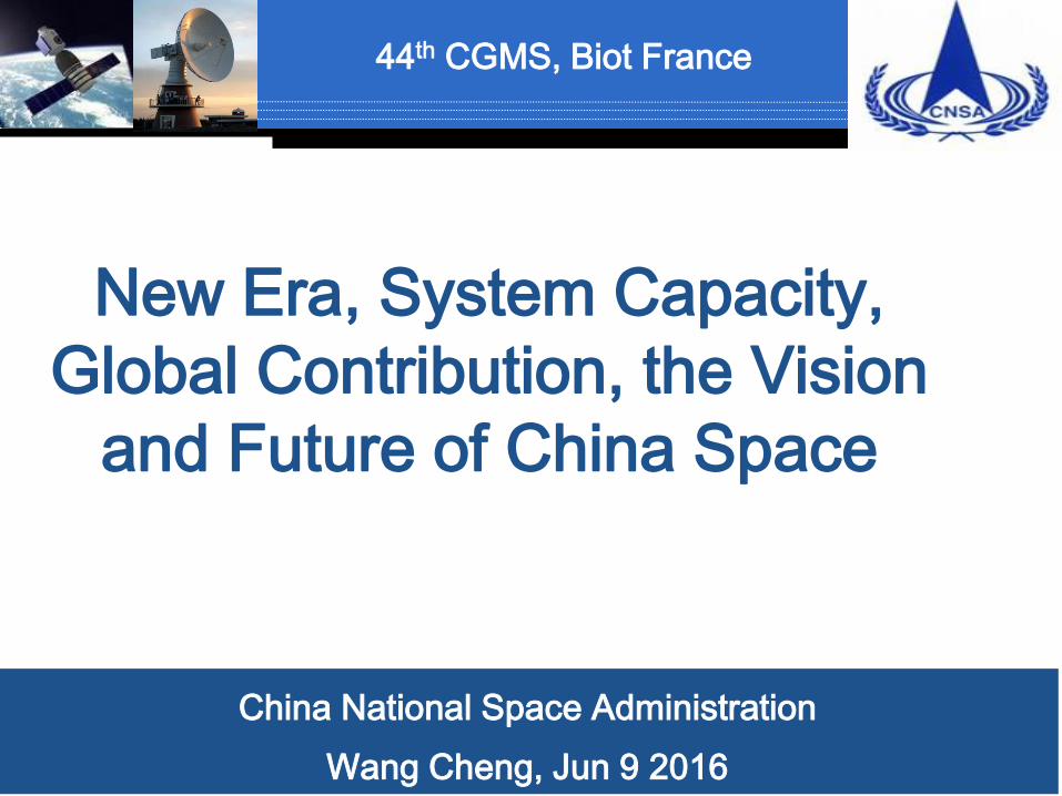
Currently, 11 satellites are on-orbit, including HY-1B, HY-2A, HJ-1A/B,
HJ-1C, ZY-3A,B ,CBERS04,GF-1 ,GF-2 and GF-4( and with FY series)
88
FY -1/2
HY-1A/B
HY-2A
HJ-1A/B/C
HY1/C/D
HY 2/B/C
CBERS 03/04,BJ-2
Land resource
satellitesFY-4
Seismo-Electromagnetic
Satellite
Gravitational Satellite
CEBERS-
01/02/02B/
02C,
High resolution earth
observation System
GF-1 Metro and
Ocean satellites
ZY-3 BJ-1
FY-3
GF-2
Satellites Schedule
FY-2
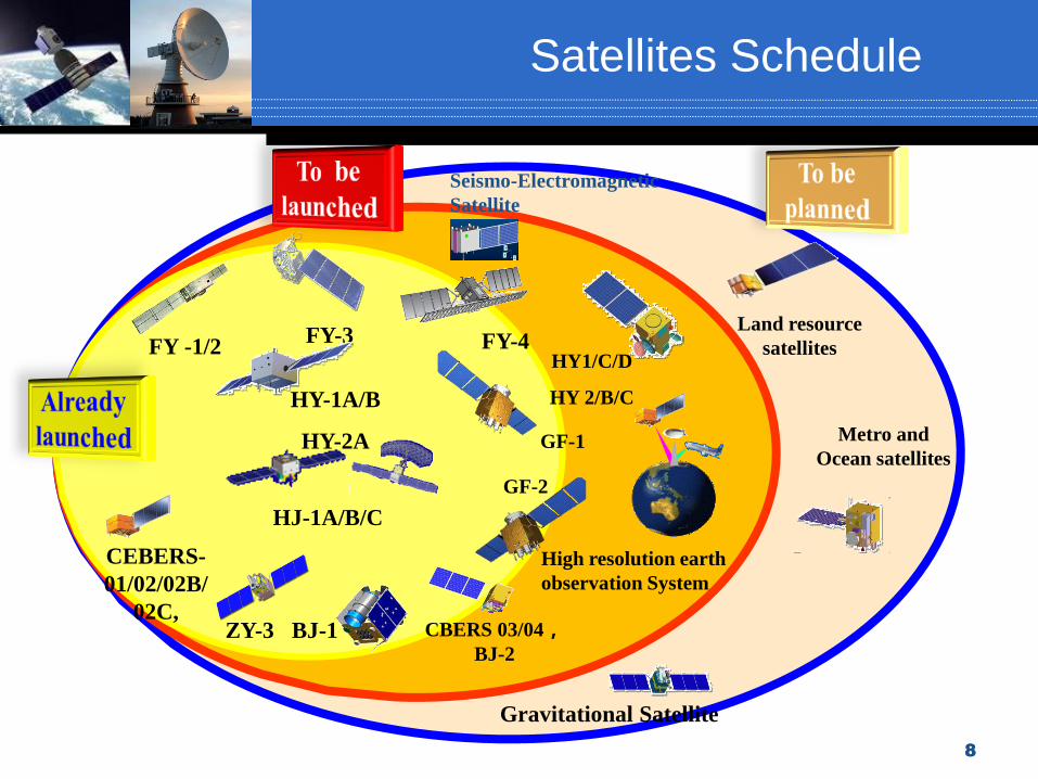
Meteorological Satellites
FY-4
15 min
6 min
60 min
30 min

Ocean Satellites
HY-1
CFOSAT
HY-2

Land Satellites
Medium resolution satellites: HJ-1A/1B/1C, CBERS-04, etc.
HJ-1A/1B CBERS 04HJ-1C
Dongting Lake chlorophyll a concentration distribution map by using HJ-1A data

GF Series
High resolution satellites: GF-1/2/3/4, etc.
GF-1GF-2
Xinhua Hunan landslide
three-dimensionalmonitoring
by using GF-2 data

www.cheos.org.cn
China High-Resolution Earth Observation
System(CHEOS)

China EOS plays an important role in the national development,
environmental protection, disaster detection and so on.
CNSA currently works at the transition stage of changing R&D
satellite to operating satellite. A set of R&D satellites are gradually
converting into operational mode after on-orbit tests.
CGMS provides an excellent opportunity for CNSA to communicate
and share our experiences with other members.
CNSA is devoted to explore new EOS technology and sensors, and
make more contributions for the optimization of global EOS.
Current EOS of China

Communications & Broadcasting Satellites
DFH-5
DFH-4
DFH-3B

Communication Satellite Application

Navigation Satellites

Lunar Exploration Program
China will also conduct the lunar base construction in the future.
First step:
Orbiting
Second step:
Landing
Third step:
Returning

Manned Space Program
Three-Step strategy
First step:
Launch manned spaceships
Third step:
build a Space Station
Second step:
build a Spacelab
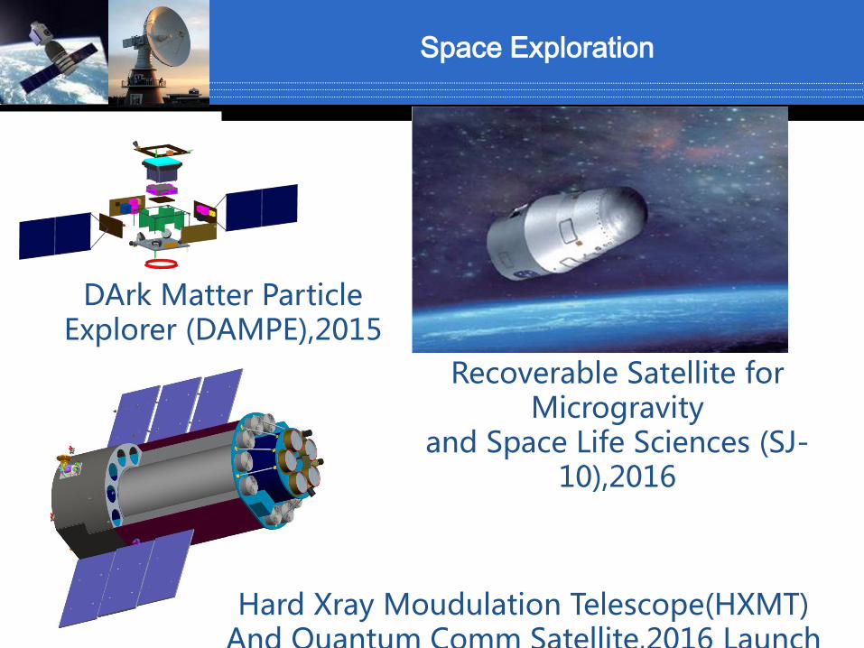
DArk Matter Particle Explorer (DAMPE),2015
Recoverable Satellite for Microgravity
and Space Life Sciences (SJ-10),2016
Hard Xray Moudulation Telescope(HXMT)And Quantum Comm Satellite,2016 Launch
Space Exploration
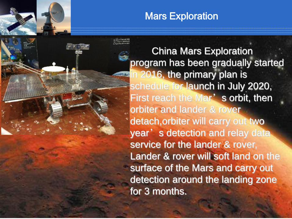
Mars Exploration
China Mars Exploration
program has been gradually started
in 2016, the primary plan is
schedule for launch in July 2020,
First reach the Mar’s orbit, then
orbiter and lander & rover
detach,orbiter will carry out two
year’s detection and relay data
service for the lander & rover,
Lander & rover will soft land on the
surface of the Mars and carry out
detection around the landing zone
for 3 months.

Jiuquan
Xichang
Taiyuan
Hainan JiuquanXichangTaiyuan
Hainan
Space Launch Site

Providing TT&C support for missions such as satellite, manned spaceflight and
deep space exploration.
Yuanwang instrumentation ship
Command &control center
Ground station
Space TT&C

1.National Space Infrastructure
Medium and Long Term Development Plan for National
Space Infrastructure(2015-2025)which plans to build a
world integration space facility that serving users in remote
sensing, communication and broadcasting, navigation and
other services in the next 10 years, Providing strong
information support for national modernization and
sustainable development of economy and society.

中国空间技术研究院通信卫星事业部
25
Development Objectives
2015 or Beyond 2016-2020 2021-2025
To establish major
framework of national
civil space infrastructure,
operational satellite
development pattern,
service mechanism and
national data policy
To establish an advanced,
global and effective national
civil space infrastructure
system; To achieve
internationally advanced level
for business, marketing,
industrial development; To
gradually improve mechanism
of innovation driving,
requirement guiding, market
configuration; To strongly
support economy and society
development, effectively
participate in
internationalization
development
To establish three systems
including satellite remote sensing,
satellite communication, satellite
navigation and positioning; To
establish national civil space
infrastructure system providing
continuous and stable operation
services; To complete data share
service mechanism, provide
standard regulation system,
establish commercialization
development pattern with the
ability of international services
2 Overall Framework and Development Objectives
中国空间技术研究院通信卫星事业部 26
3 Construction of Remote Sensing, Communication, Navigation and
Positioning Satellite System
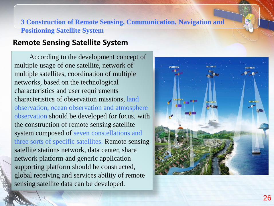
Remote Sensing Satellite System
According to the development concept of
multiple usage of one satellite, network of
multiple satellites, coordination of multiple
networks, based on the technological
characteristics and user requirements
characteristics of observation missions, land
observation, ocean observation and atmosphere
observation should be developed for focus, with
the construction of remote sensing satellite
system composed of seven constellations and
three sorts of specific satellites. Remote sensing
satellite stations network, data center, share
network platform and generic application
supporting platform should be constructed,
global receiving and services ability of remote
sensing satellite data can be developed.

中国空间技术研究院通信卫星事业部 27
Remote Sensing Satellite System -Space System
Land, ocean and atmosphere series satellites should be manufactured, gradually
developing the comprehensive and effective global observation capability with a
reasonable configuration of high, medium and low resolution, as well as an optimal
portfolio of multiple observation methods.
3 Construction of Remote Sensing, Communication, Navigation and
Positioning Satellite System
1 Land Observation: construction of three observation constellations of high
resolution optical, medium resolution optical and SAR, as well as development of
earth physical field satellite.
2 Ocean Observation: construction of ocean color and ocean dynamic
satellite constellation, as well as ocean monitoring satellite.
3 Atmosphere Observation: construction of weather observation and
climate observation satellite constellation, and atmosphere composition
investigation satellite

中国空间技术研究院通信卫星事业部 28
Remote Sensing Satellite System-Ground System
According to the requirements of
effective networking, cooperative
operation, integrated services, using the
existing resources of ground resources,
to construct ground facilities such as
remote sensing satellite receiving
stations network, data center, generic
application supporting platform, share
network platform and so on.
3 Construction of Remote Sensing, Communication, Navigation and
Positioning Satellite System

中国空间技术研究院通信卫星事业部 29
To coordinate all sorts of requirements, establish domestic and polar low earth
orbit, polar orbit antenna, as well as receiving facility at sea, to realize
coordination among multiple stations and integrative receiving for global data
Receiving Stations Network
To upgrade existing land, ocean, weather satellite data center, support with each
other, promote effective usage and share of satellite, data, calculating resourceData Center
Including public supporting platform for calibration and verification field
network, generic technology development
Share Network PlatformTo connect three data centers and all levels of application systems, distribute
satellite operation status and user observation requirements in time, effectively
use all sorts of calculating and data resource, providing business services for
users
Generic Application Supporting Platform
Remote Sensing Satellite System-Ground System
3 Construction of Remote Sensing, Communication, Navigation and
Positioning Satellite System

中国空间技术研究院通信卫星事业部 30
Communication Satellite System
Aiming at industrial and market application, focusing
on commercialization, guaranteeing commonweal
requirements, to develop fixed communication
satellites and mobile communication satellites,
synchronously construct ground facilities such as
TT&C station, gateway station, uplink station,
calibration field and so on, achieve services abilities of
broadband communication, fixed communication,
DTH, mobile communication, mobile multimedia
broadcasting. To gradually construct global satellite
communication and broadcasting system combining
communication network covering worldwide main
regions, provide services for Broadband China and
Globalization strategy, promote international
propagate ability.
3 Construction of Remote Sensing, Communication, Navigation and
Positioning Satellite System

中国空间技术研究院通信卫星事业部 31
Communication Satellite System-Space System
To construct three sorts of satellites including fixed communication, DTH and
broadband communication, provide fixed communication and broadcasting
services for the country, neighborhood and other regions.
Fixed Communication Satellite
• Focusing on the industrial requirements of telecommunication, broadcasting and TV, ocean, petroleum, based on the current satellites in-orbit, to rapidly develop fixed communication satellite system and maintain continuous improvement of fixed communication capability
DTH Satellite
• To develop DTH satellite system on the current basis for the purpose of DTH realization
Broadband Communication Satellite
• To develop broadband communication satellite system with broadcasting and digital distribution capability for two-way communication business such as remote education, telemedicine, rural and agriculture informatization, internationalization development and so on
3 Construction of Remote Sensing, Communication, Navigation and
Positioning Satellite System

中国空间技术研究院通信卫星事业部 32
Navigation and Positioning System
Satellite navigation space system
and ground system construction
belongs to nation’s science and
technology major project of China’s
second generation satellite
navigation system.
By 2020, Beidou global satellite
navigation system of 35 satellites
will be completed, with positioning
accuracy of 10m, timing accuracy
of 20ns.
3 Construction of Remote Sensing, Communication, Navigation and
Positioning Satellite System

中国空间技术研究院通信卫星事业部 33
Climate Change, Global Warming, Ecological Balance,
Atmosphere Environment Monitoring, Grain Yield assessment,
C&CO2 discharge, Ocean Salinity Observation etc.
Government R&D
Meteorological, Ocean, Land Observation, Surveying and
Mapping
Government Operational
High Resolution Earth Observation, Multimedia Satellite
Broadcasting
Commercial Earth observation, Global Communication
PPP
3 Construction of Remote Sensing, Communication, Navigation and
Positioning Satellite System

中国空间技术研究院通信卫星事业部 34
4 Active Promotion on Major Applications
According to business requirements and specific application objectives, to use
diverse constellations, different series of satellite and data resources, construct
satellite comprehensive application system and realize continuous acquirement and
application multiple resource information .
Resource, Environment
and Ecological Protection
Disaster Mitigation and
Emergency Response
Society Management, Public Service
and Safe Production
New Urbanization and Regional Sustainable
Development, Integration
Across Areas
Mass Information
Consumption and
Industrialization
Global Observation and
Earth System Science
Internationalization Service
and Application

中国空间技术研究院通信卫星事业部 35
Encourage
of
Internation
alization
Developme
nt
To study the specific measures of internationalization
development, promote the utilization of domestic and foreign
resources, domestic and foreign markets;
To carry out international coordination, actively participate in
related international organizations and the establishment
important international regulations and standards. To extend
international cooperation, carry out international cooperation
on technology development, satellite development, system
construction and data application;
To encourage and support the construction of international
cooperation comprehensive services, promote the export of
satellite, data and services, improve internationalization
capability and application benefits.
5 Policies and Measures on International Cooperation

36
Product
Observation index
Payload observation
Multi Satellites and
Multi Systems
Public benefit
Commercial service
Overall information flow from requirement extract to satisfy
From the requirement of
standard Product and to its final
service to customer, a Nature flow
Standard Scale Industry
6.Concerns

37
Product
Observation index
Payload observation
Multi Satellites and
Multi Systems
Public benefit
Commercial service
Overall information flow from requirement extract to satisfy
From the requirement of
standard Product and to its final
service to customer, a Nature flow
Standard Scale Industry

38
Airship,HAP
Airplane
Ground observat
ion
Experiment SatelliteGovernment
R&D
Government Operational
Commercial
Maturity level of Application Technology
1 2 3 4 5 6 7 8 9 10 11
Research、modelling and algorithm
Research on technology
method
Pre Study of system
R&D of system
Operational Industrialized
Maturity level of products and its influence to system
Support to Requirement and Mission analysis
Support to Pre study Phase R&D to Operational

39
level name
0-2 Data grade product
3 Image grade product
4Target remote sensing
properties
5Target physical
properties
6Target feature level
product
Identification
recognition
confirmation
Understanding
evaluation
prediction
cogn
itiv
e
pro
cess
product level

7.Global Contribution
China has signed more than 100 space cooperation agreements with 30
countries, space agencies and international organizations.Signed agreements
with APSCO and UN on earth observation data sharing.
The Chinese government has always attached great significance to global contribution of its space system. CNSA is willing to share our experiences and achievements from space technology, science and application with other nations and organizations.
7.Global Contribution


![Technical Review No.87 [Contribution] Perspective …...2 NTN TECHNICAL REVIEW No.87 Contribution Perspective for Advanced Vehicle Technology into CASE Era 1. Introduction Automobiles](https://img.pdfslide.us/doc/110x75/5fa627ccb69ffa5d771c8077/technical-review-no87-contribution-perspective-2-ntn-technical-review-no87.jpg)