Embed Size (px)
Citation preview
Station Area PlanningProject
The Capitol RegionCouncil of Governments,working with citizens andthe City of Hartford, hasdeveloped plans for theareas near stations for theNew Britain - Hartfordbusway.
Please examine thedevelopment plan shownhere to learn how theParkville station area couldchange. The ideas pre-sented here are designedto make the most out ofthe proposed transporta-tion investment and areintended to stimulatediscussion.
Planning around transit (busor rail) stations is known asTransit Oriented Develop-ment and it has beensuccessful throughout thecountry. The Pittsburghbusway and the WashingtonD.C. Metro are exampleswhere districts surroundingthe rapid transit systemsthrive, adding to the qualityof life in these communities.
The New Britain-HartfordBusway Project is a newrapid transit facility beingbuilt by the ConnecticutDepartment of Transporta-tion. It is an exclusive 9.4-milelong busway, linking down-town New Britain withdowntown Hartford’s Union
Why Parkville?
Parkville was one ofsix station areaschosen for detailedstudy. The stationlocation at the edge adense neighborhood,and within walkingdistance of existingemployment andcommercial districts,creates opportunitiesto leverage existingand proposeddevelopment toenhance a wide area.
Executive Summary: Parkville Station AreaImplementation
The initial implementation steps at Parkville will be todevelop a cooperative plan to build the new garages;without additional parking additional development will bedifficult. Later phases of development would likely requiresignificant public/private cooperation. Necessary stationarea improvements must be undertaken, including therenovation of Pope Park West and creation of a pedestrianwalkway and plaza network.
Short-Term: 2004-2009
· Neighborhood Revitalization Zone Committee shouldamend the Parkville Strategic Plan to incorporate theStation Area Plan
· Consider incorporating the station area plan in theHartford Plan of Conservation and Development
· Consider adoption of TOD zoning district.
· Development of the Barridon Building for mixed-use
· Plan and design the Parkville Station pedestrian bridge
· Continue work on Municipal Development Plan (MDP)application
· Design and construct pedestrian improvements alongPark Street
· Plan and implement Special Services District and TaxIncrement Financing (TIF) District to fund new parking
· Design and rebuild Pope Park West
Medium Term: 2010-2019
· Design and build pedestrian bridge, plazas, and mid-block walkways
· Construct parking garages
· Develop Bartholomew Street commercial uses and PopePark townhouses
Long Term: 2020-2025
· Develop mid-rise housing on north side of Park Streetand former Bradlees site
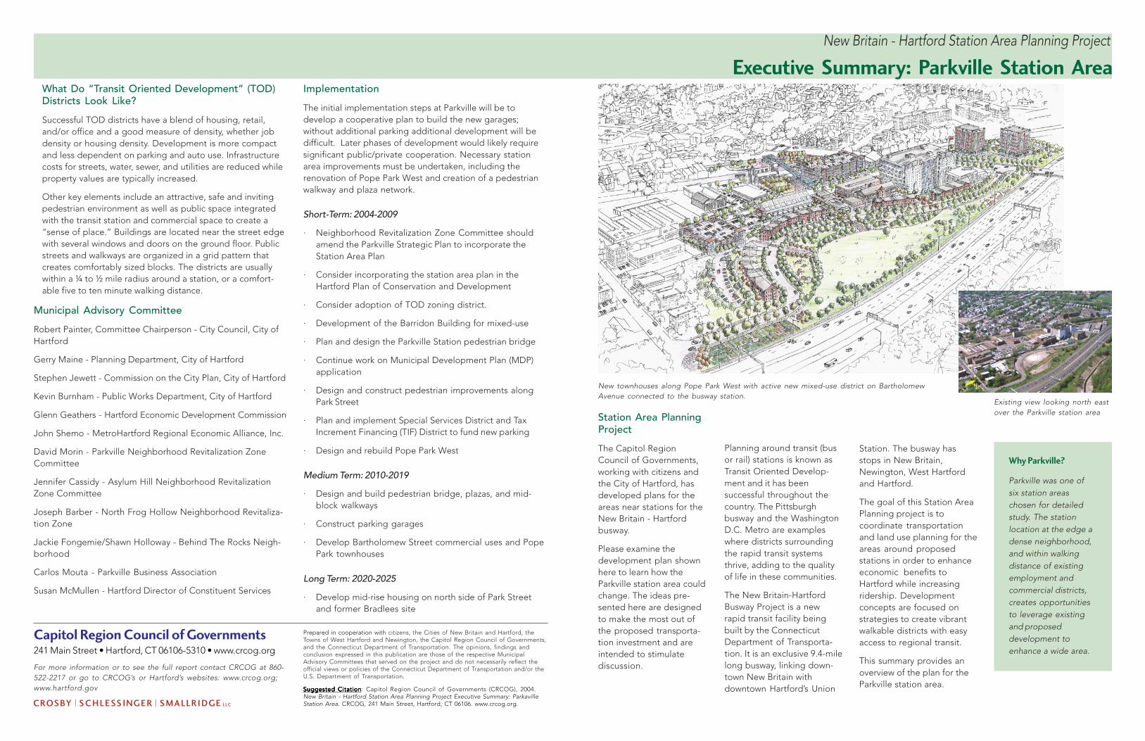
New townhouses along Pope Park West with active new mixed-use district on BartholomewAvenue connected to the busway station.
Existing view looking north eastover the Parkville station area
New Britain - Hartford Station Area Planning Project
Station. The busway hasstops in New Britain,Newington, West Hartfordand Hartford.
The goal of this Station AreaPlanning project is tocoordinate transportationand land use planning for theareas around proposedstations in order to enhanceeconomic benefits toHartford while increasingridership. Developmentconcepts are focused onstrategies to create vibrantwalkable districts with easyaccess to regional transit.
This summary provides anoverview of the plan for theParkville station area.
What Do “Transit Oriented Development” (TOD)Districts Look Like?
Successful TOD districts have a blend of housing, retail,and/or office and a good measure of density, whether jobdensity or housing density. Development is more compactand less dependent on parking and auto use. Infrastructurecosts for streets, water, sewer, and utilities are reduced whileproperty values are typically increased.
Other key elements include an attractive, safe and invitingpedestrian environment as well as public space integratedwith the transit station and commercial space to create a“sense of place.” Buildings are located near the street edgewith several windows and doors on the ground floor. Publicstreets and walkways are organized in a grid pattern thatcreates comfortably sized blocks. The districts are usuallywithin a ¼ to ½ mile radius around a station, or a comfort-able five to ten minute walking distance.
Municipal Advisory Committee
Robert Painter, Committee Chairperson - City Council, City ofHartford
Gerry Maine - Planning Department, City of Hartford
Stephen Jewett - Commission on the City Plan, City of Hartford
Kevin Burnham - Public Works Department, City of Hartford
Glenn Geathers - Hartford Economic Development Commission
John Shemo - MetroHartford Regional Economic Alliance, Inc.
David Morin - Parkville Neighborhood Revitalization ZoneCommittee
Jennifer Cassidy - Asylum Hill Neighborhood RevitalizationZone Committee
Joseph Barber - North Frog Hollow Neighborhood Revitaliza-tion Zone
Jackie Fongemie/Shawn Holloway - Behind The Rocks Neigh-borhood
Carlos Mouta - Parkville Business Association
Susan McMullen - Hartford Director of Constituent Services
Prepared in cooperation with citizens, the Cities of New Britain and Hartford, theTowns of West Hartford and Newington, the Capitol Region Council of Governments,and the Connecticut Department of Transportation. The opinions, findings andconclusion expressed in this publication are those of the respective MunicipalAdvisory Committees that served on the project and do not necessarily reflect theofficial views or policies of the Connecticut Department of Transportation and/or theU.S. Department of Transportation.
Suggested CitationSuggested CitationSuggested CitationSuggested CitationSuggested Citation: Capitol Region Council of Governments (CRCOG), 2004.New Britain - Hartford Station Area Planning Project Executive Summary: ParkavilleStation Area. CRCOG, 241 Main Street, Hartford, CT 06106. www.crcog.org.
Capitol Region Council of Governments241 Main Street • Hartford, CT 06106-5310 • www.crcog.org
For more information or to see the full report contact CRCOG at 860-522-2217 or go to CRCOG’s or Hartford’s websites: www.crcog.org;www.hartford.gov
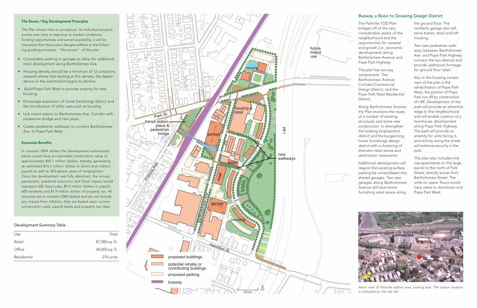
The Parkville TOD Planbridges off of the veryconsiderable assets of theneighborhood and theopportunities for renewaland growth (i.e., economicdevelopment) alongBartholomew Avenue andPope Park Highway.
The plan has two keycomponents: TheBartholomew AvenueCorridor/CommercialDesign District, and thePope Park West ResidentialDistrict.
Along Bartholomew Avenue.the Plan envisions the reuseof a number of existingstructures and some newconstruction to strengthenthe existing employmentdistrict and the burgeoninghome furnishings designdistrict with a clustering ofthematic retail stores anddestination restaurants.
Additional development willrequire that existing surfaceparking be consolidated intoshared garages. Two newgarages along BartholomewAvenue will have homefurnishing retail space along
Aerial view of Parkville station area, looking east. The station locationis indicated by the red dot.
Development Summary Table
Use Total
Retail 87,000 sq. ft.
Office 40,000 sq. ft.
Residential 274 units
The Bones / Key Development Principles
The Plan shown here is conceptual. As individual projectsevolve over time in response to market conditions,funding opportunities and parcel availability, it will beimportant that the project designs adhere to the follow-ing guiding principles - “the bones” - of the plan:
• Consolidate parking in garages to allow for additionalretail development along Bartholomew Ave.
• Housing density should be a minimum of 12 units/acre;research shows that starting at this density, the depen-dence on the automobile begins to decline.
• Build Pope Park West to provide amenity for newhousing.
• Encourage expansion of home furnishings district andthe introduction of other uses such as housing.
• Link transit station to Bartholomew Ave. Corridor withpedestrian bridge and new plaza.
• Create pedestrian walkways to connect BartholomewAve. to Pope Park West
Economic Benefits
In constant 2004 dollars the development summarizedbelow would have an estimated construction value ofapproximately $45.1 million dollars, thereby generatingan estimated $16.2 million dollars in direct and indirectpayroll as well as 343 person years of employment.Once the development was fully absorbed, the annual,permanent, sustained economic and fiscal impact wouldrepresent 430 direct jobs, $9.5 million dollars in payroll,600 residents and $1.9 million dollars of property tax. Allamounts are in constant 2004 dollars and do not includeany impact from inflation; they are based upon currentconstruction costs, payroll levels and property tax rates.
��������
�����
����������� ��������
�������������
�����
� ����
� ����
� �����������
�����
�������������
����������
�����
� � ������������
� � ���������
������
� ������������� � ����������������
������ ����
�����!"��
#������
$��� � �
���!"���
%&'(
the ground floor. Thenortherly garage also willserve transit, retail and lofthousing.
Two new pedestrian walk-ways between BartholomewAve. and Pope Park Highwayconnect the two districts andprovide additional frontagefor ground floor retail.
Key to the housing compo-nent of the plan is therehabilitation of Pope ParkWest, the portion of PopePark cut off by constructionof I-84. Development of thepark will provide an attractiveedge to the neighborhoodand will enable creation of atownhouse developmentalong Pope Park Highway.The park will provide anamenity for units facing it,and activity along the streetwill enhance security in thepark.
The plan also includes mid-rise apartments on the largeparcel to the north of ParkStreet, directly across fromBartholomew Street. Theunits on upper floors wouldhave views to downtown andPope Park West.
Busway a Boon to Growing Design District