Embed Size (px)
Citation preview

A127 – Corridor for Growth
An Economic Plan
March 2014

i
The A127 in Numbers
Built Previously known as the Southend Arterial Road - Opened July 9, 1924
Fully dualled (except for 650m between Fairfax Drive & East St) 1930s
De-trunked' 1997
Distance M25 to Victoria Gateway 20 Miles
All dual carriageway (32 Kms)
Traffic Flows (AADF) Highest - Fairglen to Rayleigh Weir 73,134
-2012 Lowest - Cuckoo Corner to Victoria Gateway 19,462
Collisions Oct 1, 2010 to Sep 30, 2013 380
2 Fatal, 63 Serious, 490 Slight
Junctions (major) M25, Warley Street, Halfway House, Dunton, Fortune of War, 17
Upper Mayne, East Mayne, Fairglen, Rayleigh Weir,
Progress Road, Kent Elms, Tescos, The Bell, Cuckoo Corner,
Priory Crescent, West Road, Victoria Gateway
Junctions (minor) / Side Roads 43
Structures 15 Bridges, 10 Embankments, 5 Footbridges, 1 Underpass 31
Laybys Full Size 15
Mini' 7
Roundabouts Fortune of War (restricted), Tescos, Cuckoo Corner 3
Population Basildon 99,876
Billericay 36,338
Brentwood 73,600
Rayleigh 30,196
Rochford 7,610
Southend 173,600
Wickford 32,500
Basildon District 174,497
Castle Point District 86,600
Rochford District 78,489
Speed Limits M25 to Cranfield Park Road, Nevendon 70mph
(except 40mph at Fortune of War)
Cranfield Park Road, Nevendon to Southend Boundary 50mph
Southend Boundary to Priory Crescent / Fairfax Drive 40mph
Priory Crescent / Fairfax Drive to East Street West Street 30mph
East Street / West Street to Museum 40mph
Museum to Victoria Gateway 30mph
Safety Cameras (Sets) Average Speed 7
Rear Facing 8
Traffic Signal Cameras 3
Signals - Ped Xing (Sets) 11 Junctions with pedestrian facilities, 1 Toucan and 1 Puffin 13
Signals - Traffic (Sets) Progress Road, Kent Elms, The Bell, Cuckoo Corner, 10
Priory Crescent, West Road, Victoria Gateway
VMS Signs 3 in Essex - E/B to Halfway House, W/B & E/B to Fairglen,
4 in Southend - E/B at Progress Road, E/B to Kent Elms,
W/B at Prince Road, W/B to West Road
Bus Stops All within Southend boundary
10 - Eastbound, 10 - Westbound
Vehicle Restraints Central barriers - M25 to The Bell 18.75 Miles
Edge Barriers - selected locations (30 kms)
Elevation (above sea level) M25 - 27m, Victoria Gateway - 37m,
Highest Point - Rayleigh Weir - 76m
Lighting Lit for the entire length of road
Lighting Columns - M25 to Southend Boundary 994
567 Doubles, 427 Singles
PROW Crossing Points - M25 to Southend Boundary 12
7
20
ii
A127 - Corridor for Growth
An Economic Plan
Foreword by Cllr Bass & Cllr Cox
The A127 corridor is an absolutely vital artery to economic competitiveness of the
Thames Gateway South Essex sub-region and indeed to the economy of the County of
Essex and beyond. However, the route is not without its issues. It is the intention of this
document to make a case for the corridor, demonstrating its essential economic
importance and the measures which have to be implemented to ensure that South Essex
remains a thriving economic engine of growth.
It is strongly recommended that this joint strategy between Essex County Council and
Southend-on-Sea Borough Council is adopted to provide greater journey time reliability
along the length of the corridor to sustain the economic advantage of the A127, as well
as to facilitate future growth and prosperity in the region.
Signed
_____________________________ ______________________________
Councillor Rodney L Bass Councillor A Cox Cabinet Member for Cabinet Member for Highways & Transportation Public Protection, Waste & Transport Essex County Council Southend Borough Council

iii
Summary
The purpose of this paper is to make a joint case from Essex County Council (ECC) and Southend Borough Council (SBC) to demonstrate the importance of the A127 corridor to the economic growth and financial well-being of the Thames Gateway South East (TGSE) region.
The TGSE region makes a substantial contribution to Gateway-wide ambitions to deliver an additional £21bn GVA to the UK economy by 2021. The TGSE area is home to over two thirds of a million people, 54,300 businesses and a workforce of over 400,000. It is a vibrant part of the UK which benefits from immediate proximity to London and Europe and good access to the UK’s largest consumer markets. This area is also home to a substantial workforce for London and other key areas. Strategically located immediately to the east of London, TGSE benefits from direct road and rail links to the capital and, via the M25, to the rest of the South East and UK markets. It also benefits from excellent port and airport connectivity to markets in Europe and beyond. With a mature and growing business environment, it contains one of the largest port clusters in the UK and London Southend Airport. TGSE has an ambitious growth agenda to build on existing strengths and make the most of a unique combination of opportunities, including the £1.5bn London Gateway Port and London Southend Airport. It has the potential to further develop strong, established economic sectors (advanced manufacturing, ports and logistics, construction and financial & business services) and support smaller, emerging sectors (energy, digital, creative, cultural and environmental technologies) to generate an additional £2.4bn per annum towards the national economy.
The A127 is an ageing corridor (originally opened in 1924), but one that is a vitally important primary route for the Thames Gateway South Essex (TGSE) area which connects the M25, Basildon and Southend (including London Southend Airport). It also provides access to the wider area such as Brentwood, Billericay, Canvey Island and Wickford. ECC is the responsible highway authority for the road from the M25 to the Southend boundary and SBC is responsible for the remaining length of road to Southend Victoria Station.
The A127 carries a significant amount of traffic, with volumes in excess of 70,000 vehicles per day, (comparable to a motorway in other parts of the country and equal to some of the busiest sections of the A14). However, the A127 has significant capacity issues and flows which need to be addressed if it is to maintain current jobs and aid the delivery of new jobs and housing growth along the corridor and, in particular, to areas such as Basildon Enterprise Corridor (BEC), at the new Saxon Business Park adjacent to London Southend Airport and Southend Central Area.
The A127 suffers from congestion during peak hours, often extending outside of these hours and throughout the day. Due to its location, running adjacent to the A12 and A13, and in the vicinity of the M25, any incidents on these roads naturally lead to traffic using the A127 as an alternative. It is the single corridor and primary route for traffic travelling between Basildon and Southend.
The estimated cost of current proposed improvements for the A127 is in the region of £76m, excluding any widening. Essex and Southend have considered the short, medium and long term requirements to improve the corridor and prioritised the investment need. Fairglen Interchange, Kent Elms Corner Junction and the Bell junction have been identified as priorities within the next six years. A bid has been submitted to the South East Local Enterprise Partnership (SE LEP) for funding support for these priorities, together with funding for other

iv
works. This is currently set at £44.24m, but will be confirmed once further information is received from the LEP. Further funding opportunities will be investigated as one of the future Workstreams.
There are also maintenance issues that urgently need to be addressed if the road is to support and facilitate the planned growth for TGSE. The existing route is of substandard quality, with numerous side roads and direct accesses. As a result, it is extremely sensitive to incidents such as collisions and broken-down vehicles.
This strategy focuses on a coordinated approach to improve conditions along the whole length of the A127 including a catalogue of measures for junction upgrades and improvements, maintenance, signing, lighting and safety camera installation.
The strategy is in four chapters:-
Chapter 1 – Economic Importance of the A127 Corridor
Chapter 2 – Future Requirements for the Route - Improvements
Chapter 3 – Future Requirements for the Route - Maintaining the Asset Chapter 4 – Next Steps and Workstreams

v
SWOT Analysis
Key strategic route from London to Southend Bad public perception
Provides connections to other strategic routes
eg M25, A13, Dartford Crossing etc Old road – originally built 90 years ago
– not fit for 21st century – design life exceeded
Connects existing development sites Too many junctions / side roads / entrances - safety
improvements required
Provides major links to ports and airports 70,000 + vehicles a day – over capacity in most places
Links to major international businesses,
across a range of sectors Knock-on effects of incidents to other routes
– A13 etc & local roads
Serves 600,000 + population and over 240,000 jobs No hard shoulders / SOS phones
75% of route is not in close proximity to residential / housing Lack of maintenance investment – asset has deteriorated
Well known across South Essex Location of utilities – affects future planning
Key route for weekend travel and tourism Many short trips taken (on / off)
Majority of junctions are grade separated Poor links to public transport
Dual carriageway for the entire length Safety concerns - especially lay-bys
Lit for the entire length Lack of business confidence
Central crash barriers for 95% of the length Lack of technology in the past
Strategically important to growth areas of
BEC, London Southend Airport and town centres Infeasible / impractical / too expensive
to add additional carriageways
Links to other major development schemes eg London
Gateway Lack of investment to date – deterrent to development by
new businesses
Additional housing and employment Climate change / weather – increased risk of flooding etc
Provide leverage for business investment / support Deterioration of network
Improve confidence with businesses, communities and
developers to invest Impact of incidents
Promote corridor at LEP and national level Impact of pollution
Potential to widen route Impact on ecology
Provide sustainable transport measures eg P&R for
Basildon, Southend etc Visual appearance could be perceived as a deterrent to
investment
Provide better incident management Use of the corridor by utility companies
Develop a robust asset management plan
Use more advanced methods for recording asset information
– provide better case for investment
Introduce better technology to manage route
Improve visual appearance – aesthetic appeal
Strengths Weaknesses
Opportunities Threats
vi
A127 - Sphere of Influence

vii
Contents
CHAPTER 1 - ECONOMIC IMPORTANCE OF THE A127 CORRIDOR ............................................ 1 1. The National and Regional Picture................................................................................................................ 1
a. SE LEP............................................................................................................................................................... 1 b. Key Economic Areas ........................................................................................................................................ 1 c. Basildon Enterprise Corridor ........................................................................................................................... 2 d. Southend and Rochford ................................................................................................................................... 2 e. Thurrock and Castle Point ............................................................................................................................... 3 f. Future Growth ................................................................................................................................................. 3 g. Development areas ......................................................................................................................................... 4 h. Tourist Destination .......................................................................................................................................... 5
2. Stimulating Growth ...................................................................................................................................... 6 a. Economic Growth ............................................................................................................................................ 6 b. GVA .................................................................................................................................................................. 6 c. Sphere of Influence ......................................................................................................................................... 7
3. Capability and capacity of the route ............................................................................................................. 8 a. Strategic Route ................................................................................................................................................ 8 b. Freight ............................................................................................................................................................. 8 c. Traffic Operations ............................................................................................................................................ 8 d. Congestion ..................................................................................................................................................... 10 e. Collision History ............................................................................................................................................. 10 f. Cost of Vehicle Collisions ............................................................................................................................... 11 g. Journey Time Benefits of Collision Reduction ............................................................................................... 12 h. Other Incidents .............................................................................................................................................. 12 i. Non-Motorised Use ....................................................................................................................................... 12 j. Air Quality ...................................................................................................................................................... 13 k. Noise .............................................................................................................................................................. 13 l. Community Severance ................................................................................................................................... 13 m. Public Perception ........................................................................................................................................... 13
CHAPTER 2 - FUTURE REQUIREMENTS FOR THE ROUTE – IMPROVEMENTS ........................... 14 1. Constraints .................................................................................................................................................. 14 2. Funding ....................................................................................................................................................... 14 3. Traffic Management .................................................................................................................................... 14 4. Speed Limits ................................................................................................................................................ 14 5. Safety Barriers ............................................................................................................................................. 15 6. Signing ......................................................................................................................................................... 16
a. Telematic signs .............................................................................................................................................. 16 b. Diversion Routes ............................................................................................................................................ 16 c. Local Signs ..................................................................................................................................................... 16
7. Traffic Signals .............................................................................................................................................. 17 8. Lay-bys ........................................................................................................................................................ 17 9. Public Rights of Way (PROW) ...................................................................................................................... 18 10. Lighting ....................................................................................................................................................... 18 11. Side Roads ................................................................................................................................................... 19
a. Direct Access.................................................................................................................................................. 19 12. Safety Cameras ............................................................................................................................................ 20 13. Basildon By-Pass .......................................................................................................................................... 20 14. Proposed Junction Improvements ............................................................................................................... 21
a. B186 Warley Junction .................................................................................................................................... 21 b. A128 Halfway House...................................................................................................................................... 21 c. B148 Dunton .................................................................................................................................................. 22 d. Fortune of War .............................................................................................................................................. 22 e. A176 Upper Mayne........................................................................................................................................ 22

viii
f. A132 Nevendon ............................................................................................................................................. 23 g. A127 / A130 Fairglen Interchange ................................................................................................................. 23 h. A129 Rayleigh Weir ....................................................................................................................................... 24 i. Progress Road ................................................................................................................................................ 25 j. Kent Elms ....................................................................................................................................................... 25 k. B1013 Nestuda Way Junction ........................................................................................................................ 26 l. Rochford Road / The Bell ............................................................................................................................... 26 m. A1159 Cuckoo Corner .................................................................................................................................... 27 n. Victoria Gateway ........................................................................................................................................... 27
15. Summary Table ........................................................................................................................................... 28
CHAPTER 3 - FUTURE REQUIREMENTS FOR THE ROUTE – MAINTAINING THE ASSET ............. 29 1. Overview ..................................................................................................................................................... 29 2. Asset Inventory Register .............................................................................................................................. 29 3. Carriageways ............................................................................................................................................... 29 4. Footways ..................................................................................................................................................... 30 5. Cycleways .................................................................................................................................................... 30 6. Structures .................................................................................................................................................... 30 7. Vehicle Restraints ........................................................................................................................................ 30 8. Safety Cameras ............................................................................................................................................ 31 9. Drainage ...................................................................................................................................................... 31 10. Environmental Maintenance and Trees ....................................................................................................... 31
a. Environmental Maintenance ......................................................................................................................... 31 b. Trees .............................................................................................................................................................. 31
11. Winter Management ................................................................................................................................... 32 12. Summary Table ........................................................................................................................................... 32
CHAPTER 4 - NEXT STEPS AND WORKSTREAMS .................................................................... 33 1. Approval of the plan by ECC and SBC ........................................................................................................... 33 2. Inclusion of the A127 – Corridor for Growth Economic Plan as a supporting document to the business plan
as part of the LEP submission to Government March 31, 2014. ........................................................................... 33 3. Workstreams to take forward following LEP submission ............................................................................. 33
a. Engagement with businesses, the public and other statutory bodies .......................................................... 33 b. Data Collection and Modelling ...................................................................................................................... 33 c. Asset Management ........................................................................................................................................ 33 d. Detailed Scheme Options and Initial Design.................................................................................................. 33 e. Corridor Management ................................................................................................................................... 34 f. Community Severance – interruption of north south movements, accessibility issues. .............................. 34
APPENDICES ........................................................................................................................ 35

ix
Tables
Table 1: Planned growth in houses and jobs ................................................................................................4
Table 2: Assumed jobs by industry ...............................................................................................................7
Table 3: Congestion Reference Flows ...........................................................................................................9
Appendices
Appendix 1 Housing & Jobs Development Forecasts
Appendix 2 Average Annual Daily Flows 2000 – 2012
Appendix 3 Eastbound / Westbound Average Speeds
Appendix 4 Headline impact of collisions on traffic operations

A127 - Corridor for Growth
1
Chapter 1 - Economic Importance of the A127 Corridor
1. The National and Regional Picture
a. SE LEP
The South East Local Enterprise Partnership (SE LEP) considers the whole of the Thames Gateway as a key location for growth and this is stated as such in the recently published Strategic Economic Plan (SEP). The A127 is a key artery along the length of the Gateway that is fundamental in the support of this growth.
The SE LEP’s SEP states that securing the maximum possible growth from the Thames Gateway is conditional on:
securing the necessary investment in key infrastructure (including road, rail and broadband) to remove existing capacity constraints and ensure sufficient capacity to support specific growth locations;
unblocking the delivery of appropriate sites for residential and commercial development.
Thames Gateway will see growth in Basildon and Southend town centres and at the new Saxon Business Park adjacent to London Southend Airport. The area will also include a new Anglia Ruskin’s MedTech campus.
Significant growth is planned at London Southend Airport, including the new Business Park and additional sites covered by the Joint Area Action Plan (JAAP) developed by Southend and Rochford Councils, creating approximately 7,380 jobs. Works are also planned to provide good access to the new Business Park, with further junction improvements to key roads and roundabouts from the A127 and in Rochford to facilitate access to the Airport and the Business Park.
b. Key Economic Areas
The A127 provides the main route between Southend and London. It also links the main towns of Southend and Basildon, joining them to London and the motorway network, via the M25.
Basildon is one of the largest towns in Essex with a population of approximately 100,000. The Basildon Enterprise Corridor, to the north of the town, is directly accessed from the A127 and provides employment for over 30,000.
Brentwood, Wickford, Billericay and Rayleigh are all market towns located to the north of, and accessed from, the A127. Combined, these towns have a population of over 170,000.
Southend, at the eastern end of the A127, is a Unitary Authority with a population of approximately 176,000. Following new ownership by the Stobart Group, London Southend Airport has recently expanded to cater for up to 2m ppa with both the Airport and associated Business Park directly accessed from the A127.
The A13 provides an alternative link to the M25 for South Essex, but only effectively from Sadlers Farm. This is a high-capacity road which runs parallel to the A127 and is also near capacity. Should either road be obstructed or closed, then the alternative route fills up very quickly.

A127 - Corridor for Growth
2
c. Basildon Enterprise Corridor
The Basildon Enterprise Corridor encompasses the main business hub in Essex and plays host to major international businesses such as Ford, SELEX Galileo and New Holland Agriculture, along with a growing concentration of advanced engineering small and medium employers (SMEs). It is well located to provide a base for global companies seeking to build links with the established concentration of advanced manufacturing and engineering businesses. Basildon has ambitious plans to redevelop the town centre and railway station, including the relocation of South Essex College’s Basildon Campus from Nether Mayne to Basildon town centre. This is expected to bring a range of significant economic impacts, with student numbers expected to double from 1,000 to 2,000. The range of vocational programmes strongly linked to the skills businesses need will be extended and will help to raise educational and skills aspirations in the town. This growth of the town centre and the development at Nether Mayne of 725 homes will be supported by improvements to the corridor and Basildon town centre road configuration.
d. Southend and Rochford
The economic growth potential of Southend has been recognised by government by the signing of a City Deal on March 10, 2014. This seeks to address the challenge to economic growth posed by the poor quality, long term vacant space along the A127 at Victoria Avenue which disincentivises potential investors and offers a poor welcome to the town centre for businesses and visitors alike. A new hub for cultural and creative businesses is also proposed, as well as incubation space for new entrepreneurs. Through the City Deal opportunity, Southend has also secured £1.8m of Regional Growth Fund funding to deliver business support and a growth hub. The Southend and Rochford growth area extends from Southend town centre along the A127 from Victoria Avenue and out to London Southend Airport with its surrounding commercial and housing sites in Rochford. These provide the potential for up to 20,000 new jobs and 11,000 new homes. London Southend Airport and business parks are key economic drivers and are expected to generate approximately 7,380 new jobs across Southend and Rochford. The growth area has seen significant public and private investment in recent years, with Stobart Group’s £130m+ investment at the Airport at one end, and the £3m SBC development of the Royal Pavilion on the pier, overlooked by the £25m Park Inn Palace, at the other. This demonstrates the overall growth potential of the area. The cluster of business parks to the west of London Southend Airport will deliver almost 100,000m² of employment floorspace and approximately 6,000 new jobs in Saxon Business Park and around Nestuda Way and Aviation Way Industrial Sites. Additionally, the airport itself is planned to deliver up to 1,400 new jobs. Saxon Business Park will be home to the Anglia Ruskin MedTech Campus. High-end business space will be provided for a range of aviation businesses and commercial headquarters. The A127 Victoria Avenue area is the subject of the agreed City Deal, reflecting the desire to use this as a lever to drive regeneration. The wider benefits of this will act as a catalyst for the wholesale mixed-use transformation of the Southend Central Area into a fully competitive regional centre which will provide accommodation for 6,500 new jobs. The development of at least 2,000 homes in the Central Area is also proposed. This will be supported by the A127 corridor improvements.

A127 - Corridor for Growth
3
e. Thurrock and Castle Point
Thurrock The London Gateway Port development, which opened last year, is expected to generate 12,000 direct and 20,000 indirect jobs. This development will provide the UK’s newest deep sea container port, capable of handling 3.5 million containers per year, alongside the largest logistics park in Europe. The expansion of Tilbury port to create up to 4,000 new local jobs will contribute to the wider regeneration of Thurrock. Lakeside is to be transformed into a regional town centre, with up to 3,000 new homes, and new employment, retail and leisure facilities with up to 9,000 jobs. A new town centre is planned for Purfleet, with up to 3,000 new homes, and associated mixed use development opportunities, to improve and expand the existing town centre. Grays town centre will be regenerated as a learning, business and public administration hub to complement nearby Lakeside. Castle Point Transformation of both Hadleigh Town Centre and Canvey Town Centre is planned. The Legacy from the Hadleigh Olympic Event will result in a new mountain biking facility and hub with improved access and is due to be open early 2015. London Commuter Town
The A127 provides the main road commuter link from the Southend and Basildon areas to London.
f. Future Growth
Within South Essex, the A127 is the key corridor to sustain existing jobs and business and for unlocking future growth in the region.
With London Gateway and the recent expansion to London Southend Airport, as well as the recommended Lower Thames Crossing, the Thames Gateway area will see a large amount of growth in the near future.
London Gateway is the UK’s first deep sea container port and Europe’s largest logistics park. It is accessed from the A13 at Stanford-le-Hope in Thurrock. When fully open, it is anticipated that this will bring over 12,000 new direct jobs to the Thames Gateway.
London Southend Airport has recently undergone a series of improvements that are likely to lead to a long term increase in jobs and passenger numbers. London Southend Airport is accessed directly from the A127 and from the new railway station at the airport.
A consultation for a Lower Thames Crossing as an alternative to the Dartford Crossing was completed in July 2013. Three options were proposed and have now been narrowed down to two, both of which will link directly to the A13 and the Thames Gateway. The proposal is for the new crossing point to be open in the early 2020s.

A127 - Corridor for Growth
4
On top of these three major transport improvements, there are plans to expand existing industrial areas in Southend and Basildon. Given the strategic nature of the A127, any improvements to the route will serve to make the Thames Gateway a more attractive location for investors.
g. Development areas
A map showing all the prospective homes and jobs in the TGSE area can be seen in
Appendix 1.
Table 1 shows the 2011 base number of households and jobs compared to growth by 2036 using the best currently available estimates from emerging local plans.
Table 1: Planned growth in houses and jobs
2011* 2036
Households Jobs Households Jobs
Basildon 73,424 91,183 88,484 101,422
Brentwood 31,483 39,611 36,913 47,725
Castle Point 36,887 22,896 40,887 24,996
Rochford 34,200 22,977 36,985 29,400
Southend-on-Sea 76,080 65,457 82,580 82,147
Total 252,074 242,124 285,849 285,690
* 2011 figures based on Tempro data from National Transport Model
Key Investments to promote growth include:- The Nether Mayne development, Basildon - 725 new family homes, new and improved infrastructure, community facilities and school; improved connectivity and apprenticeship and training opportunities.
Gardiners Lane South, Basildon - development of 3.94 hectares of land for residential and commercial development to help support both the housing offer and sustain the business economy.
Rochford Housing – delivering Rochford Core Strategy’s dwelling provision of 250 homes per annum, and including housing sites in West Rochford (600) in proximity to London Southend Airport, South Hawkwell (175), South East Ashingdon (500), Hullbridge (500), and West Rayleigh (550). Southend Central Area: delivering planned growth to stimulate regeneration, including 6,500 new jobs and at least 2,000 additional homes in conjunction with improvements to the transport network.
The A127 is a key link between Southend, Basildon and the M25 and London, and also serves many industrial facilities in the area. The area around the A127 has been identified for several local development schemes, both residential and commercial.
These will include:

A127 - Corridor for Growth
5
A development of 700 residential units in the vicinity of the Ford plant at Dunton, west of
Basildon. It is anticipated that this will increase A127 traffic flow by approximately 450
vehicles during peak hours.
A waste facility, approximately 1 mile to the east of the A127 / A132 Nevendon junction
which will have a significant impact on HGV levels on the roads in the area.
An animal rescue facility is currently being constructed at the A127 / A132 Nevendon
junction. Impact on the local road network is expected to be minimal.
A development of up to 400 houses on and around Pound Lane and the local vicinity is
underway. Again, impact on the local road network during peak periods is not expected
to be significant.
The Essex Highways SMO3 (Strategic Management Office) has recently been relocated
to Childerditch Lane, Brentwood, and is accessed from the A127. This will bring
approximately 100 additional vehicle movements per day, mainly during peak hours,
although the SMO will be a 24 hour facility. There will be a higher-than-average
movement of HGV’s around the SMO, due to the nature of the facility. Movements will
most likely be greater during winter months, due to the winter maintenance procedures
(gritting etc).
Brentwood DC are investigating the possibility of expanding West Horndon with a
development of 1,500 homes which would have a significant impact on the A127.
The increased traffic resulting from these developments will add more pressure on an already congested route, emphasising the need for improvements. Congestion, delays and reliability problems affect the key strategic route of the A127, which is already operating above its operational capacities, with the congestion effects spreading to local networks.
h. Tourist Destination
Historically, Southend has always been a very popular tourist destination, and remains so, particularly through the summer season. About six million tourists visit Southend every year, generating estimated revenues of £360 million a year and employing nearly 8,000 people. Although some will use the railway, many will drive, with the A127 being the major corridor to gain access to the town centre and sea front. Use of the A127 at weekends in the summer is considerable – on several occasions in 2013, delays and incidents caused tailbacks from Southend to Basildon, seriously affecting the visitor economy of Southend.
It is worth noting that Southend Businesses have consistently raised concerns over journey time reliability on the A127, particularly during busy peak times. At other times, at weekends and bank / school holidays, the issue of reliability and tailbacks from incidents is often raised by the tourism industry as affecting visitor choice and the value of spend. Improving the “pinch-points” and the implementation of VMS, better travel information and incident management would contribute greatly to the visitor experience and business confidence.

A127 - Corridor for Growth
6
2. Stimulating Growth
a. Economic Growth
Growth is fundamental to the prosperity of the region and there are two major growth areas along the A127 corridor.
The Basildon Enterprise Corridor is the largest employment area in Essex. As an employment centre, Basildon is a key area for regeneration and attracts much traffic from the surrounding areas. Reducing congestion and improving reliability would have a direct economic benefit to the whole area. Reductions in incidents and congestion will assist in meeting Local Transport Plan (LTP) objectives to improve reliability of journey time and resilience. The Dunton, A176 Noak Bridge, and A132 Nevendon Interchanges provide the main accesses to this busy industrial and residential area.
London Southend Airport (LSA) and the adjacent business park developments is a key employment area with a major focus for growth in the TGSE area and heavily reliant on the A127. Plans for LSA involve releasing further land for business development (Saxon Business Park), providing improved access to employment, supporting development in and around the airport, and within Southend itself. The Joint Area Action Plan for the LSA and environs area has identified the need to improve key junctions on the A127 and surrounding junctions in Rochford as a result of the increase in jobs and homes. This has been developed through the use of a SATURN transport model and VISSIM micro simulation. (The evidence provided from these models was used to justify the recent award of Pinch Point funding from the DfT for the Tesco Roundabout improvement.) Improving the reliability, the resilience and appearance of the key corridor link to London will
improve the desirability of this area for businesses and will improve prospects for growth.
b. GVA
Gross Value Added (GVA) benefits for the envisaged jobs have been estimated and
adjusted for the impact of transport schemes using ‘English Partnerships’ Additionality Guide
– A standard approach to assessing the additionality impacts of interventions, October 2008’.
10 Industry GVA values on NUTS Level 3 up to 2010 from the ONS was used to expand
GVA per person values for the East of England. It should be noted that these values differ
slightly for Essex and Southend.
As local development plans of the various districts are in varied stages of development, have
different planning horizons and report future employment with varying detail, a significant
number of assumptions have had to be made. This results in the job forecasts shown in
Table 2 below, and is based on the assumption that realisation commences in 2015 and
grows linearly to 2036, after which it is assumed to remain constant.
Based on these assumptions, the estimates of job numbers (in Table 2) were made for a 60
year period. Using 2010 values and discount from the Treasury’s Green Book rates, these
are consistent with DfT approaches for the quantification of other transport induced benefits
such as travel times and safety benefits. The discount rate is taken from the Green Book
table 6.1 which suggests a discount rate of 3.5% for years 0 to 30 and a rate of 3.0% for
years 31 to 60. The effect of this is to reduce the value of the additional GVA over time, and
in a consistent manner with all other transport benefits.

A127 - Corridor for Growth
7
Table 2: Assumed jobs by industry
Basildon Brentwood Castle Point Rochford Essex Total Southend
Production (incl manufacturing) 2,492 3,197 700 5,000 11.389 788
Distribution; transport; accommodation and food 1,400 159 700 690 2,950 11,429
Financial and insurance activities 3,173 2,379 350 367 6,269 183
Public administration; education; health 3,173 2,379 350 367 6,269 183
Other services and household activities
4,108
Total 10,239 8,114 2,100 6,423 26,877 16,690
Temporary jobs involved in the construction of houses and other buildings have been
ignored in this case, as they are expected to be small compared to the numbers shown in
Table 2. Local GVA assessments typically include the total GVA calculations without any
allowance for jobs that have simply relocated from other areas. It should be noted that, in
this case, allowance has been made for a number of factors to attach jobs to the specific
transport scheme.
Typically 24% of the total level of job creation is “deadweight” that would be likely to have
happened anyway and is not associated with the scheme. 6% is assumed to be leakage
(benefits outside of the target area) and 21% are jobs displaced from adjoining areas (and so
are not additional jobs). In total, therefore, 49% is considered directly attributable to the
transport scheme (i.e. 51% of the calculated GVA needs to be removed from economic
appraisal purposes).
Allowance does however need to be made for the potential beneficial impact of combined
development of related activities on sites in close proximity that higher mobility on the A127
would permit. This is estimated to be equivalent to around a 10% increase in GVA.
Based on the above, there is a forecast increase in GVA to the local economy of £15.11bn
(£10.60bn in Essex and £4.51bn in Southend) over the 60 year period, which could be
dependent on transport schemes, such as the A127, that feeds the development areas. This
equates to a benefit of around £252m per year in a DfT price base of 2010.
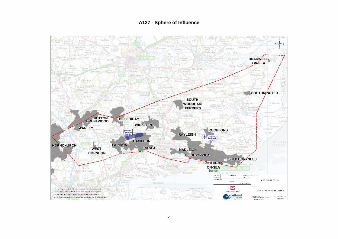
c. Sphere of Influence
A pictorial indication of the sphere of influence of the A127 was shown earlier in the Overview. It can be seen that for many business and residents in the south east of Essex, the only way to access London and the motorway system to the rest of the country is by using the A127.

A127 - Corridor for Growth
8
3. Capability and capacity of the route
a. Strategic Route
The A127 is an ageing corridor (originally opened in 1924), but one that is a vitally important primary route for the Thames Gateway South Essex (TGSE) area which connects the M25, Basildon and Southend (including London Southend Airport).
From the Fairglen junction to the east of Basildon, the A127 is the main corridor for traffic travelling west / east and from / to Southend. The Fairglen junction is the key link to the A130 and the North and the A13 and Westwards to London. This junction is over capacity and suffers from significant congestion at peak times, and at various intervals throughout the day. It is very sensitive to incidents, not only on the A127, but also the A13, A12 and M25.
The A127 is designated a PR1 Strategic Route, meaning any asset failure on the A127 is likely to have a significant impact on the local economy. Both ECC and Southend have stated that one of their major aims is to improve journey time reliability along this route.
b. Freight
There is an unusually large number of Large Goods Vehicles (LGVs) on Essex roads (over 22% of all LGVs in the East of England are registered in Essex).
Although the A13 may be the prime routing for freight deliveries accessing the new London Gateway and Tilbury container ports, with the important commercial destinations along the A127 corridor, freight traffic forms a significant percentage of the movements to destinations such as the Basildon Enterprise Parks and London Southend Airport.
c. Traffic Operations
The following is a short summary of vehicle flows and speed along the study section using
the latest available information.
Appendix 2 shows Annual Average Daily Flows (AADFs) available from the DfT for the
period 2000 to 2012 along various sections of the route.
The Essex sections west of the Southend boundary carry very similar flows, between
approximately 55,000 and 73,000 vehicle per day, with flows declining towards the end of
the route in Southend. There is not a strong trend in the data, but, on average, there is a
growth in AADF of 0.39% per year, compared to almost no growth on other A-Roads in
Essex.
Not intended as a detailed capacity analysis, but, as an indication, the reference capacity of
the dual carriage way section in AADF is estimated as 67,500, yielding the flow/CRF as
shown in Table 3 below, indicating the road section is operating at or near capacity during
most peak hours. The table also show the effect of traffic flow increases with the planned
houses and jobs inserted to the DfT Tempro Model. These increases represent potential
demand flows and would not take account of transport capacity restraining developments,
variable demand, mode or time shift.
Within Southend where capacity is ruled by junctions, the results are from an assignment
model that will constrain and reassign demand flows.

A127 - Corridor for Growth
9
Table 3: Congestion Reference Flows
LOCATION 2011 Two Way
AADT FLOW/CRF
2036 Two Way Forecast
FLOW/CRF
LA Boundary to A128 65,214 0.97 90,419 1.34
A128 to A176 62,623 0.93 86,476 1.29
A176 to A132 72,888 1.08 100,651 1.50
A132 to A130 67,551 1.00 93,281 1.39
A130 to Progress Road 70,171 1.04 90,598 1.35
Progress Road to Kent Elms* 40,700 0.97 45,200 1.06
Kent Elms to Tesco Rndbt* 40,100 0.51 49,600 0.58
Tesco Rndbt to The Bell* 40,200 1.00 55,700 1.01
The Bell to Cuckoo Corner* 32,700 1.03 49,700 0.96
* Sections in urban areas of Southend based on model results and show the worst of AM, PM peaks and
either directions. AADTs estimated from base and forecast peak hour flows.
Figures 1 and 2 show the data in diagrams. The change in Flow / CRF at Kent Elms indicates the constraints of the signals at Kent Elms which hold back the flow of traffic.
Figure 1: Current Congestion Reference
Figure 2: Forecast Congestion Reference

A127 - Corridor for Growth
10
Appendix 3 shows average travel speeds along the A127 east of the M25. These data are
the average speeds by section from TrafficMaster for normal weekdays in neutral months
(September and October 2011 plus April to June 2012). Shown are data from three hours
over the AM and PM peak periods, and for the hour 20:00 to 21:00. The latter is shown as a
surrogate for free flow speeds, and it is taken that, any speeds lower than that are due to the
presence of, and interaction with other vehicles, and thus indicative of congestion.
Specifically of note:
There is a significant reduction in speed over peak periods along almost all of the route.
It is more marked in the PM period in the eastbound direction compared to the
westbound direction;
The slowing of traffic on the approaches to on and off slips and at the at-grade junction
in Southend-on-Sea;
The morning peak being concentrated in the 07:00 to 09:00 period and the afternoon
peak more spread;
Geometric delay at the Fortune of War junction and at the junctions in Southend-on-Sea.
d. Congestion
The A127 is operating substantially over-capacity and the collision types and rates are
indicative of this problem. Peak traffic volumes are likely to contribute toward the most
prevalent collision types; namely shunt and lane-change collisions because, at such
congestion levels, mean headways (the distance between vehicles) are substantially
reduced.
The A127 is generally free flowing in the morning peak flow period on the non-built up sections, but with delays at certain junctions due to the volume of merging traffic. In Southend, there are eastbound delays at Kent Elms in the morning peak.
In the afternoon peak flow period, the A127 appears more congested, especially Southend-bound from the A176 to Rayleigh Weir. The coefficient of variation is relatively low, indicating that the A127, whilst it may be congested, is relatively reliably congested on a regular basis.
As previously mentioned, the A127 is operating over optimum capacity, and with low
resilience. This is most noticeable during the peak periods, when congestion is present at
most junctions. In addition, the route is experiencing congestion for a greater proportion of
the day than just the conventional peak times. This results in flow breakdown, which in turn
causes delays and an increased risk of collisions. There is also no means of effectively
managing traffic along the route, should the need arise.
Managing demand and traffic between the A127 and A13 is required, as well as directing
traffic to the most appropriate route in times of congestions and incidents.
e. Collision History
A detailed collision analysis of the A127 was carried out in 2010 by TMS Consultancy. This analysis identified that the A127 has a series of collision and incident cluster sites along its length, both at junctions and along the links. The analysis separated the road into six link sections, seven junctions and specified one link area and three junction areas of concern, and then identified possible solutions to the concerns. The report also identified the overall capacity of the A127 as an issue.

A127 - Corridor for Growth
11
The collisions caused by being an over-capacity road are not simple to address. The number of side-roads and accesses along the A127 tend to restrict any benefit from traditional capacity improvement measures, such as additional lanes. The TMS Report suggested that the introduction of a reduced speed limit, to match the existing 50mph restriction at the eastern end of the A127, would be a realistic measure to address the collision rate.
The junctions identified as being problematic are the A128 Halfway House, B148 Dunton, A132 Nevendon and the A176 Upper Mayne junctions.
The link area identified as having a specific collision problem was in the vicinity of the A176 Upper Mayne interchange at Basildon. This has suffered from a series of shunt-type collisions, which suggests junction-type conflicts rather than link-based conflicts. In addition, the vertical alignment of the A127 restricts forward visibility to less than 100m in either direction at this point. The reduced forward visibility means that drivers are unable to easily see other vehicles slowing for the junction, or as a result of congestion on the mainline. A potential solution to this would be to reduce the speed limit to 40mph, in order to match the forward visibility available, along with enforcement cameras. Alternatively, install a speed-reactive variable-message sign to highlight potential congestion at the scene to make drivers aware of slowing traffic.
The A128 Halfway House Interchange has a sub-standard horizontal alignment which is thought to be contributing to the high proportion of shunt-type collisions at the junction. Realigning these entries would address the issue and would also offer better visibility of the junction to the right, at the give way line.
The B148 Dunton / West Mayne Junction suffers from the eastbound exit slip having a substandard alignment, leading to clusters of collisions. Although the slip roads here could be realigned, the entire junction has been earmarked for a Section 106 housing development scheme in the near future, and any realignment would ideally be included within this scope of works.
The A132 Nevendon Road Interchange suffers from a high collision rate due to its very high traffic volume. There are three major issues in evidence. First, many of the single vehicle loss of control collisions occurring in off-peak hours, are at weekends, and 75% of the single vehicle incidents have occurred in the wet. There are a high number of lane-change type collisions, which may be caused by driver confusion as to which lane to use. This would be addressed by improved surfacing, with refreshed and improved signs and road markings.
Any incident affecting these junctions has a ‘knock-on’ effect back to the Fairglen junction, which is the key junction for the corridor for traffic east of Basildon to Southend.
The introduction of speed limits to reduce collisions can also have a beneficial effect in managing traffic flow. The use of variable speed limits, to both reduce collisions and improve reliability, would need to be studied carefully to avoid concerns that a reduction in speed is detrimental to businesses, in the form of longer journey times. Wide consultation on this would be required and could form part of the next steps in terms of this Plan, together with the modelling of costs and benefits.
f. Cost of Vehicle Collisions
In the period 1 October 2010 to 30 September 2013, there were 380 reported vehicle
collisions that resulted in injury or death along the A127. These collisions caused 2 fatalities,
63 people to be seriously injured and 490 slightly injured.

A127 - Corridor for Growth
12
The TMS study recommended a series of interventions. They concluded that the proposed
intervention measures would reduce collisions in which people are killed or seriously injured
(KSIs) by 45%, and all collisions causing injury by 70%. Applying these reductions to the
data from the last three years results in expected reductions, averaged per year, of 0.3 fatal
collisions, 8.4 serious injury collisions and 75.1 injury collisions. This would translate into a
monetary benefit of collision reduction of £4,026,000 per year1. Assuming no growth and a
10 year scheme life, this would yield a benefit of £32 million. A relatively short scheme life
was applied here as many of the measures are technology driven and not permanent
infrastructure. The cost of collisions and other incidents to other road users in terms of
increased journey times are addressed in a separate section.
g. Journey Time Benefits of Collision Reduction
To estimate the impact of collisions on journey time, available historic traffic flow and journey
time data was analysed. Reliable sets of both hourly flow and journey time data were
available for the section between the Warley Junction and the Southend boundary for 2012.
During 2012, there were 64 reported injury collisions on this section, and it was possible to
detect the impact on journey time and flows when the collision occurred, and during
subsequent hours before flow returned to normal. There were occasions where it appears
that slow traffic could have been the cause of shunt type collisions, rather than the collision
being the initial reason for slow progress. Appendix 4 summarises this analysis.
On average, each collision resulted in 275 vehicle hours of delay, ranging from no
discernable impact to more than 1,000 vehicle hours of delay.
Applying the average delay to the average number of accidents per year (126.7) and the
estimated saving of accidents of 70% as above, this results in an estimated saving of 24,380
vehicle-hours per year. Very simplified economic assessment of these show a benefit over
10 years at 2010 prices of £2.8 million.
h. Other Incidents
Study of ANPR data for 2012 on the section between the Warley junction and Progress
Road, showed that there were 639 occasions, excluding times where injury accidents were
reported, where speeds dropped lower than 20% of the average expected during the
particular period. These were likely due to an incident of some nature, including minor
accidents, broken-down vehicles or other disturbances in the traffic stream. It needs to be
considered that in very congested flow conditions, even small disruptions can cause delays
over long distances and times. The average duration of the impact of the identified
occurrences of slow journey times was 1.9 hours.
i. Non-Motorised Use
Detailed surveys of non-motorised usage have not been collected for some time, but general
observations would say that little or no cyclists / pedestrians use the cycleways or footways
along the A127, until one approaches the environs of Southend where usage escalates
dramatically.
1 Using default WebTAG and COBA principles and data unless updated scheme specific data is available. All cost at 2010 prices
and discounted to 2010 per WebTAG guidance

A127 - Corridor for Growth
13
j. Air Quality
Currently, there are no identified air quality management areas along the A127 corridor. However, with the high volumes of traffic using this route, there are concerns when congestion builds up at key areas. It will be necessary to continue to improve the air quality by encouraging greater use of sustainable transport modes including public transport, cycling and walking, wherever practically possible.
Utilising developments in traffic signal technology and air quality monitoring equipment, there is a need to improve collectively the information and knowledge on air quality, and particularly links with health and wellbeing. This report recommends that a separate piece of work be commissioned to inform this, particularly as the responsibility for Public Health now rests with Local Authorities.
k. Noise
Before and after noise studies are required to evidence claims for compensation subsequent to schemes being constructed. As set out above, knowledge on the effects of noise and the ability to quantify this are limited. Again, it is the case that noise can have a detrimental effect on health.
l. Community Severance
In Southend particularly, community severance is an issue, with access to schools, health centres and libraries affected by a lack of crossing points. A further study should be commissioned to consider this further and input into the Business Case development.
m. Public Perception
The public perception of the A127 is that it is an old, sub-standard road which has been
overlooked for improvement over many years. Although the A127 was ‘de-trunked’ in the
1990’s, there has been little visible difference to the travelling public – the same types of
traffic still use the A127 for the same destinations. The existing infrastructure along the
A127 is old, and much of it would benefit from refurbishment / renewal, as would updating
statutory undertakers plant and equipment. This is reflected in the development of the asset
management plans currently underway.
The A127 is a strategic route which it has not been possible to maintain to the level desired
and expected of it by the travelling public and particularly businesses. This has contributed
to traffic incidents which, in turn, have led to delays. Consequently, the route is seen to be
unreliable, which reduces the area’s appeal to potential investors. It is vital that funding be
made available to maintain the A127, otherwise the economic potential of the area will be
seriously jeopardised. Stimulating and encouraging business investment and site viability
will require an economic stimulus in terms of a programme of real improvements, which is at
the core of this Plan. Maintenance issues on the A127 are often reported in the local press.
There are locations where the road is prone to flooding - the A127 / A129 Rayleigh Weir, the
A127 / A1245 Fairglen, and the Fortune of War interchanges all suffer from flooding at times
of heavy rain. In particular, the Fairglen interchange has been completely flooded in recent
years. Also, there have been a number of reported embankment failures between Rayleigh
Weir and Fairglen.

A127 - Corridor for Growth
14
Chapter 2 - Future Requirements for the Route – Improvements
1. Constraints
Increasing the number of lanes is the most obvious way to increase capacity along the A127.
There are a number of both over - and under - bridges that would need widening or
replacement to accommodate 3 lanes in each direction, but widening these would involve a
significant financial commitment. There are also numerous fronting properties directly (and
solely) accessed from the A127. Widening would involve a significant financial commitment,
but would enable future business investment and growth. The widening of the A127 in both
directions in Essex requires further detailed investigation.
2. Funding
Historically, the A127 received its own funding stream, but, in recent years, this has not been
the case. The road is perceived to be in a poor state of repair, and any works are likely to be
prohibitively expensive due to the complicated traffic management required. If
improvements to the A127 were to be funded from available capital allocations, it is likely to
have a significant impact on available budget elsewhere in the County and the Borough.
The estimated cost of current proposed improvements for the A127 is in the region of £76m, excluding any widening. Essex and Southend have considered the short, medium and long term requirements to improve the corridor and prioritised the investment need. Fairglen Interchange, Kent Elms Corner Junction and the Bell junction have been identified as priorities within the next six years. A bid has been submitted to the SE LEP for funding support for these priorities, together with funding for other works. This is currently set at £44.24m, but will be confirmed once further information is received from the LEP. Further funding opportunities will be investigated as one of the future Workstreams.
In addition to the LSGF bid, Essex and Southend are investing funding of £1.64m, along with
developer S106 contributions of £1m for Nevendon interchange capacity improvements.
3. Traffic Management
Carrying out any substantial works to the A127 would risk increasing the congestion on and
around the A127. Whilst the A13 runs parallel to the A127 to the south, there are no real
local alternatives to the north. Any significant accident or traffic incident quickly causes
congestion and delays on less strategic routes. A challenge for any works on the A127
would be to manage this migration on to other routes, and limiting this relocation would be
seen positively by local residents.
Maintaining a flow of traffic, through the use of speed limits and improved infrastructure, will
increase both the capacity and reliability of the road (with regard to journey time), which will
increase journey confidence for the road user. This, in turn, will make the Thames Gateway
a more attractive location for investors, which will help to promote growth across the area.
4. Speed Limits
The speed limit on the A127 is currently 70mph from the M25 to 500m beyond Cranfield
Park Road, Nevendon (excluding the short length of 40mph restriction at the Fortune of War
roundabout) with a 50mph limit between Cranfield Park Road and the ECC / SBC border. At
the Southend boundary (100m beyond Rayleigh Downs Road) the speed limit becomes
40mph and remains so until 200m before the junction with Fairfax Drive and Priory Crescent

A127 - Corridor for Growth
15
when it becomes 30 mph. After the junction with East Street / West Street, it becomes
40mph for the stretch along Victoria Avenue, reverting to 30mph at Southend Victoria
Station.
As a general rule, a 1mph reduction in mean speed will result in a 5% reduction in injury
collisions, and a 10% reduction in ‘Killed or Seriously Injured’ (KSI) collisions. Therefore,
considering this guidance, the option of reducing the speed limit along the whole length of
the A127 should be considered.
A 24/7 50mph speed limit along the entire length of the A127 has been considered
previously. Whilst this would regulate flow and increase throughput during peak hours,
during off-peak hours it would generate frustration and annoyance for drivers being held to
an unnecessarily slow restriction.
Consideration has been given to introducing a variable speed limit along the A127 between
the M25 and the A127 / A130 Fairglen roundabout. Speed limits could then be adjusted to
suit traffic flows and for any incidents that may occur. This also has the added benefit of
releasing traffic speeds to 70mph during periods of low flow.
It is estimated that installing the variable limit would cost in the region of £4.7m (2012 prices)
with SPECS enforcement. Initially, no insurmountable problems with the technology have
been foreseen, and ECC Highways legal section have confirmed that, provided there are the
relevant speed limit orders in place, a variable speed limit on the A127 is possible. There
would be some signing difficulties, as every side road or residential access would need a
VMS sign / mechanism for telling the road user what speed limit is currently in force.
A Business Case for this would need to be developed alongside widespread consultation,
particularly with businesses, to ensure support, and that real benefits, in terms of safety,
congestion reduction and improvements to journey time reliability, can be realised.
5. Safety Barriers
The vehicle restraints on the A127 were subject to a detailed condition assessment in
2010/11 and 2011/12. The inspections highlighted a series of concerns, and whilst a
number of refurbishment programmes were carried out in 2012/13 (in the order of £250k),
the condition of vehicle restraints on the A127 remains a priority concern.
It is believed that the cost to remedy defects and replace units which are no longer
serviceable is in the order of £3m. However, most of the vehicle restraints stock is ‘out of
specification’ owing to its age. Revisions to containment performance standards and other
specifications are not generally retrospective. To bring the existing vehicle restraints up to
standard would cost in the order of £10m. This is largely an improvement issue, although it
could be argued that as most of the stock is older than its service life, it should be renewed
with modern assets under capital maintenance.
A Road Restraint Risk Assessment Process (RRRAP) was carried out on the A127 in
2010/11. The RRRAP recommended that vehicle restraints should be installed on the verge
at various locations where vehicle restraints are not currently installed (vehicle restraints are
currently present at selected locations). The cost to install the required vehicle restraints
would be in the order of £5m.

A127 - Corridor for Growth
16
6. Signing
a. Telematic signs
Seven potential sites for new telematic variable message signs (VMS) need to be identified
in addition to the four existing sites. These locations are to be at strategic points on the
carriageway to allow for effective management of diversion routes.
The three existing variable message signs on the A127 in Essex are in the following
locations:
on the eastbound approach to Halfway House
on the westbound approach to Fairglen Junction
on the eastbound approach to Fairglen Junction.
There are a total of four VMS locations in Southend, which are installed preceding the
junctions of Progress Road and Cuckoo Corner.
Each VMS typically requires 40m of vehicle restraint system, and approximately 20m² of
grasscrete (maintenance purposes) in addition to a dedicated power supply (mini feeder
pillar). It is not believed that land purchase will be required for installation of additional VMS
units. It is assumed that there would be up to 20m of statutory undertakers’ plant to be
diverted at each location.
In conjunction with the ANPR cameras (see below), these VMS can display journey time
information into town. Both the ANPR cameras and the VMS are operated from the Essex
Traffic Control Centre (ETCC) in Chelmsford.
There is an MS3 variable message matrix gantry-sign on the westbound A127, between
Childerditch Lane and Little Warley Hall Lane. However, this sign is assumed to be part of
the M25 system network and not available for use as part of the A127 diversion route
signing.
b. Diversion Routes
Diversion routes are pre-selected agreed strategic routes on to which traffic can be diverted
at pre-determined points, should the A127 be closed. Diversion routes would be required to
be signed by means of black-on-yellow stick-on symbols on existing signs along the
diversion route. There are existing symbol-led diversion routes in the vicinity, for use when
the A13 / M25 is closed. Careful consideration needs to be given to the signing strategy to
prevent confusion to road users.
Liaison will be required with the Highways Agency and London Boroughs in order to suitably
sign the M25 and approaches in preparation for diversion routes. However, the M25 would
not be used as a diversion route for A127. Consideration should be given to examine the
existing direction signs for uniformity.
The estimated cost for all signage work detailed above is £1.7 million.
c. Local Signs
There have been irregularities identified in signing traffic to London / M25 on the A127 and in
the vicinity of Rayleigh Spur. Approximately five signs will require amendment or
replacement, in order to show the correct destination on the relevant signs.

A127 - Corridor for Growth
17
7. Traffic Signals
There are 18 sets of traffic signals along the A127 – all of them within the Southend
boundary. Of these, 13 are at junctions and 5 are for pedestrian crossings.
These signals are linked and programmed through SCOOT etc to maximize performance.
As part of the A127 major works that was recently completed at Progress Road and Cuckoo Corner, five ANPR cameras were installed between the A127 / A130 Fairglen Interchange and Victoria Avenue, monitoring traffic heading into Southend (eastbound). There are currently no plans to monitor westbound traffic at this time. A review of traffic signal lighting equipment is planned to investigate the potential use of extra low voltage (ELV) lamps. Typically, ELV equipment will provide annual revenue savings in the order of 40 – 60% over mains voltage installations.
8. Lay-bys
The A127 is a key HGV route, accessing south Essex ports and major businesses. There
are fifteen existing ‘full size’ lay-bys on the A127 between the M25 junction and the boundary
with SBC.
There are no ‘formal’ lay-bys within the Southend boundary, only bus stop lay-bys and 7
‘mini’ lay-bys.
Each existing lay-by site has been examined to determine the compliance with current
standards. A standard layout has been assumed, and an assessment has been made
concerning the practicality of accommodating this within the highway boundary at each
location.
No existing lay-bys on the A127 between M25 J29 and Rayleigh Weir comply with current
standards. Due to the speed and traffic flows on the A127, lay-bys are required to be to
“Type A with merge taper” standard, at approximate 2.5km intervals. The lay-bys should be
375m total length, with a stopping sight distance of 295m at 120kph (75mph) design speed,
according to TD9/93.
TD69/07 (The Location and Layout of Lay-bys and Rest Areas) states that a Type A with
merge taper lay-by needs 11.8m available verge outside of the existing edge-of-carriageway
line.
Lay-by locations have been laid out according to guidance. However, sufficient verge
availability is limited in all but two locations. In the remaining nine locations, an amount of
land would require purchasing. It is estimated that the amount of land required would not
exceed 500 square metres per location, and would be considerably less in most
circumstances.
Statutory undertakers’ apparatus details have not been requested for the lay-by locations.
However, it is assumed that apparatus will require local diversion or protection for
approximately 100m at each location.
Upgrading lay-bys to current standards reduces the risk of collisions for drivers accessing
and leaving the facility, again helping to improve route reliability. To upgrade all existing lay-
bys to comply with current standards would cost approximately £11 million. To increase the
frequency of the lay-bys, especially on the westbound carriageway, would cost
approximately £1 million per additional layby required.

A127 - Corridor for Growth
18
9. Public Rights of Way (PROW)
There are twelve locations where Public Rights of Way cross the A127 from the M25 up to
the Southend boundary. There are no controlled crossing points. Pedestrians wishing to
cross the A127 have to either use signalised crossing points at junctions (crossing over or
under the A127) or cross the live carriageway at specified at-grade locations (for example,
where there are gaps in the central reserve safety fence). It is suggested that each crossing
point is examined and improvements considered, or, preferably, the crossing point removed
completely.
There is also an existing footbridge over the A127 adjacent to the Fortune of War junction.
Any realignment works through this section will affect the stanchions and foundations.
Additionally, there are three footbridges within Southend, but none comply with current DDA
requirements.
10. Lighting
The A127 is lit for the entire length of carriageway from the M25 to Southend Victoria
Gateway.
The 2010 TMS Site Safety Assessment of the A127 identified a high proportion of collisions
during the hours of darkness, with a high number of collisions occurring in the dark, during
peak periods. Whilst improvements to lighting may assist road safety, the benefits cannot be
accurately determined due to the effect congestion has on collision numbers. The existing
lighting and suggested improvements and / or alterations, especially at junctions, have been
examined and considered.
From the M25 to the Southend boundary, there are 994 existing lighting columns, 567
doubles and 427 singles (1561 lamps). At an average cost of £1700 per column to replace,
they all could be replaced for approximately £1.7m (material costs – not including traffic
management or other preliminaries). However, most of the existing columns are located in
the central reserve which causes a number of problems, such as increased risks to
workforce during maintenance periods, or provision of power to the central reservation.
Following a conservation and economic cost saving proposal by EEC, the lights between the
M25 and the Southend boundary are switched off between the hours of 00.00 and 05.00 am,
although the junctions remain lit 24/7. The A127 within Southend remains fully lit at night,
given the urban nature and high incidence of side roads and junctions.
If modern LED lighting were used, apart from many other advantages, there would be
substantial energy savings. It is predicted that these savings could be up to £1 million per
year.
Added to this, there are substantial potential maintenance savings. Conventional sodium HP
or metal halide lamps have a life span of around one year requiring at least annual
replacement and maintenance. High power LED lights require no regular maintenance,
further increasing savings on replacement bulbs, access equipment and labour costs, and an
associated health and safety benefit from reduced maintenance requirements. New
installations benefit from a substantial reduction in the cost of expensive heavy duty cable
required for sodium lighting.
One proposal that could save energy and improve lighting would be to not only replace the
existing lighting with energy efficient LED lamps, but also to use new technology to dim or
reduce lighting, at and between junctions, in a programmed manner.

A127 - Corridor for Growth
19
Southend has committed to a conversion programme of street lighting to LEDs (£0.5m in
2014/15) and will be considering the use of these at the Tesco (B1013) junction as part of
the DfT “pinch point” funding allocation. This will allow the use and demonstration of new
technology in this area. The new traffic signal junctions at Progress Road and Cuckoo
Corner use LEDs with significant improvements in reliability and reduction in energy usage.
11. Side Roads
The A127 has 60 junctions with major roads and side roads. Seventeen junctions would be
classed as major.
Also, the A127 is served by numerous direct-access side roads, with at-grade junctions
which do not conform to current standards. Whilst there is a minimal accident history, with
one collision in three years being directly attributable to vehicles exiting a side road, the
potential for incidents remains.
Some of the busier side roads include:
Childerditch Hall Drive, Warley
Childerditch Lane, Warley
Thorndon Avenue, West Horndon
Pipps Hill Road, Basildon
Gardiners Lane, Basildon
Hovefields Avenue, Basildon
Cranfield Park Road / Dick Turpin / Pound Lane
Daws Heath Road / St Michael’s Road, Rayleigh
Plus many side road junctions in Southend
One proposal would be to see if the ECC roads can be either closed or amalgamated into
single access points with a parallel service road. This has already been carried out for St
Michaels Road and Daws Heath Road in January 2008. It is anticipated that there would be
substantial local objection to the closure of these roads.
a. Direct Access
The A127 has a large amount of direct accesses, both residential and commercial. Closure,
or removal, of direct accesses will reduce the risk of collisions on the A127. It should also
reduce congestion and delay, because fast moving A127 traffic will no longer be attempting
to avoid other slow-moving vehicles that are trying to access or egress these sub-standard
junctions.
However, these premises are often only accessed from the A127. Preventing direct access
is therefore likely to require compulsory purchase of premises which is a process that is very
costly and time consuming. This would be particularly true for any in the environs of
Southend.

A127 - Corridor for Growth
20
12. Safety Cameras
Currently, there are 7 sets of average speed cameras from Nevendon up to the Southend
boundary. Within the Southend boundary there are 8 rear facing cameras and 3 traffic signal
cameras.
There is an opportunity to improve the safety camera coverage along the A127 as there are
some gaps. Scheme costs have been calculated to provide additional safety cameras to
ensure comprehensive coverage along the entire length.
13. Basildon By-Pass
Previous studies have identified options to construct a new dual two lane carriageway
‘Basildon By-pass’ from various points between Dunton to Fairglen by-passing to the north of
the existing road alignment.
Travel time from Fairglen to Dunton is at the moment approximately 13mins, whereas, at
70mph, the bypass could reduce that time by a half.
Previous studies on delay cost, show that a full cost / benefit ratio analysis would give a
significant positive return on a 7min saving for up to 70,000 vehicles per day. It should be
noted that historic proposals for this route attracted significant opposition.

A127 - Corridor for Growth
21
14. Proposed Junction Improvements
a. B186 Warley Junction
The B186 Warley junction suffers from congestion, and is also prone to collisions at the top
of the slip roads. Due to the layout of the junction, extending the slip roads is not viable.
This would require the demolition and reconstruction of a bridge to the west, together with
some relatively major amendments required to the entry slip from the M25 junction.
The installation of signals at the junction will help regulate the flow of traffic. Queue
detectors would be installed along the slip roads, and would be linked to the signals. Should
queues be detected, the signals will be triggered and the traffic released. This will reduce
the risk of traffic backing up along the A127 mainline and, in turn, reduce the risk of shunt-
type collisions.
The junction exit slips can be widened on approach to the signals to provide a left - and right-
turn lane. This would bring greater efficiency to the junction, and increase traffic flow.
The junction area (away from the A127 mainline) will be re-classified to a 40mph limit, to
reduce speeds along Warley Street and to assist in the safe operation of the signalised
junction.
Pedestrian footways will require either constructing or improving, with crossing points and an
appropriate on-demand pedestrian phasing at the signals. The parapets adjacent to the
footway over the Warley Street Bridge will need assessing for suitability and will require
replacement. This has not been costed, but it is anticipated that this will be included under
Maintenance.
Signing and road marking in the vicinity of the junction will be improved to increase
forewarning of the new junction arrangement.
A ‘grasscrete’ maintenance area will be required to be installed for any future maintenance
access to the signals.
The estimated cost of the scheme, including statutory undertakers’ diversions, is £2,280,000
(2012 prices).
There are areas of environmental concern in the vicinity of this junction, one of which
concerns great crested newts and the other concerns bats. Any new alignment design
would require hedgerow and watercourse surveys.
There is no identified flood risk here, however any offline improvements to increase capacity
are not recommended due to the dense network of footpaths and public rights of way. In
order to preserve land character, any capacity improvements would be best served by
widening along the existing corridor.
b. A128 Halfway House
The A128 Halfway House junction suffers from a lack of visibility due to slip road alignment
which has led to a number of reported collisions. The realignment of both exit slip roads at
the roundabout have been reviewed and costed at £360,000.
The junction also suffers from subsidence of the slip roads and is should be noted that the
above cost does not include measures to address this. Investigations and in-depth risk
assessments to identify stabilising works required for the slipping embankments have been
costed at £100,000.

A127 - Corridor for Growth
22
c. B148 Dunton
The TMS safety report indicates that a realignment of the eastbound off-slip may solve
accident issues at the Dunton Interchange. However, this junction will be the access point
for a new large residential development. This work will completely alter the flows across this
junction and alterations to this junction will form part of the new development.
d. Fortune of War
This junction remains the only constriction to free flow along the A127 within the Essex
boundary and is a true ‘pinch point’. As such, it is a limiting factor for capacity between
Southend and M25. It would appear from accident data that the historical problem of trucks
overturning has been solved by the introduction of a 40mph speed restriction enforced by
safety cameras. The remaining problem therefore is one of delays which are a cost to
drivers and discourage businesses and people locating to the area.
The “roundabout” also only permits left-in and left-out movements along the A127. The
approach arms of the junction do not facilitate comfortable left turn manoeuvres, and are
constrained by the proximity to properties and limited highway land.
Provisional costs are as follows:
Highway engineering work £1.5m
Stats diversion costs (20/3/2012) £1.5m
Demolish and replace the footbridge £400k.
Whilst it is anticipated that the realignment of the circulatory carriageway would not require
any additional land, it would affect the McDonalds restaurant and the electricity sub-station to
the northwest. Additionally, there are a number of services running through the existing
roundabout. Development on one quadrant has limited the alternatives easily available.
Realignment would mean the existing 40mph safety camera could then be removed,
negating an ongoing maintenance need.
Additional lanes could be accommodated past the Fortune of War without affecting adjacent
buildings, but requiring land outside the highway boundary. The junctions with Pound Lane,
Compton Avenue and other local streets will need to be relocated southwards on the
westbound carriageway, and the layby opposite Pound Lane would need relocating or
removing.
e. A176 Upper Mayne
This short length of road under the A127 is already the cause of a major bottleneck in the
AM and PM peaks. The widths have been examined to see if it is possible to gain enough
room for four lanes by removing one of the footways. Four 3m lanes could be achieved
under the existing bridge, if the footways were reduced and rationalised to a single 1.6m
footway, with only the west side being used.
As the road has a 40mph limit, vehicle restraints are not mandatory. However, an
assessment should be undertaken to identify if protection is required at the abutments and
the cost of the type required.
In order to better cater for pedestrians, a subway is envisaged through the wing walls and
behind the west abutment. Whilst this may be problematic, it does appear that it could be
achieved. The wing walls are constructed in reinforced concrete and are stepped, each
A127 - Corridor for Growth
23
provided with piled foundations. The support of these would be complicated in such
proximity to the opening and permanent modification and support is likely to be required.
It is estimated that there would be 2.8m cover to the structure. This would seem to be
sufficiently large to limit the impact / settlement within the carriageway above to within
acceptable allowances. Monitoring of carriageway levels would be required throughout the
process, and the process would carry a high element of risk.
It is estimated that the subway would cost approximately £2 million.
In addition, segregated left turn lanes at the A176 Interchange would assist with reducing the
queues that back-up on the main carriageway of the A127.
There are five areas in the immediate vicinity of the Noak Bridge junction in which great
crested newts are present, with an additional area where bats have been identified. These
areas would be subject to further survey and possible relocation of protected species prior to
any works going ahead. This would require funding prior to the main scheme works.
f. A132 Nevendon
Section 106 funding from the Courtauld Road Waste Transfer Station has been made
available to fund improvements to the A132 Nevendon Junction. The current proposal is to
introduce an extra circulatory lane on the roundabout. The A132 Nevendon junction suffers
from congestion, leaving the A127 eastbound. Suggested solutions include widening the
carriageway to three lanes on the roundabout under A127 – especially Wickford (north)
bound.
An estimate was produced for additional lanes on the roundabout in 2012, both northbound
to Wickford and southbound to Basildon. The costs were estimated as £898,000 (in 2012
prices), including a 44% optimism bias. This does not include any unforeseen issues with
Statutory Undertakers or their plant.
The addition of a similar lane southbound to Basildon is simply a case of doubling the
cost. A review of this has been carried out and confirms that the signals costs and
construction costs are similar.
No structural works have been included. No amendment to the A132 Southbound
approach has been costed.
The existing A127 underbridges here would be wide enough to accommodate carriageway
widening to 3 lanes in each direction, between parapets, subject to structural approval.
There is an available Section 106 budget of approximately £1M for widening the roundabout.
g. A127 / A130 Fairglen Interchange
Vehicles travelling eastbound on the A127 wishing to head to Chelmsford (north on the
A130) currently have to leave the A127, join the A1245 and A130, including traversing two
roundabouts, passing two sets of signals, and travelling approximately 1.5miles, equivalent
to 3 minutes journey time, not including any time spent stationary at signals.
It would be possible to provide a slip road between the eastbound A127 and the northbound
A130, providing an improved link to Chelmsford, Colchester and the North. As the site is
heavily constrained by Morbec Farm, if the scheme were to go ahead, then two structures
would require alteration, one of which is a Network Rail bridge.

A127 - Corridor for Growth
24
Average Annual Daily Traffic (AADT) figures are estimated to be within the ranges necessary
for the slip to be cost effective, if no land purchase is required. A scheme which can be
constructed on the available land would be heavily constrained. It would be necessary to
have an estimated 10% elevation gradient (the maximum gradient permitted in the design
regulations). This would necessitate a mandatory design speed limit of 30kph / 20mph, but
this is not appropriate for a link between two 70mph routes. It would slow cars leaving the
A127 sufficiently to create a hazard to mainline traffic. The addition of very short taper
lengths and slips would exacerbate the situation.
Investigations have been undertaken regarding scheme feasibility, should land be
purchased. If land currently used by Morbec Farm was purchased, then link speeds could
be maintained. However, the cost of the land and modification to the structures would count
heavily against the cost / benefit ratio for the scheme. If land is not purchased, then the link
becomes unsafe, and the earthworks required to join the two roads would be considerable,
which would bring further expense. (Land costs have not been obtained, however they are
likely to exceed £1m)
h. A129 Rayleigh Weir
The A127 / A129 Rayleigh Weir junction suffers from vehicles on the east-bound exit slip
backing up on to the mainline A127. The feasibility of extending the eastbound off-slip into
the existing lay-by has been examined and is deemed possible; the introduction of a queue
detector on the signals at the top of the slip road which would assist in reducing queuing
traffic has been considered; lane discipline carriageway markings have been included; and
discussions over the current signal arrangements both here and at Stadium Way, the
junction to the south, have been undertaken with Essex Intelligent Transport Systems
(EITS).
EITS have proposals to install Split Cycle Offset Optimisation Technique (SCOOT) signals at
the A129 Stadium Way signals to try to clear queuing traffic that blocks the Weir roundabout.
However the problem appears to be not the signals at Stadium Way junction, but the double
mini roundabouts at the Woodmans Arms, Thundersley, which is the next junction on the
A129, south of Stadium Way. When the green signals at Stadium Way southbound are
shown, there is nowhere for traffic to go due to the queuing traffic from the Woodmans Arms.
It is possible that signalising the Woodmans Arms junction would work better than the current
arrangement of double mini roundabouts and zebra crossings. These could control the
crossing pedestrians and could clear the main road, as south of the Woodman Arms the
road is normally clear. However, this would be necessary at the expense of the side roads.
This has not been costed.
The estimated cost of installing replacement signals, including a proposed queue detector, is
£236,000.
In addition, the A127 / A129 Rayleigh Weir junction would not be suitable for increasing
capacity to 3 lanes in each direction, as the distance between the parapets is insufficient,
and would produce lanes with a substandard width. Also, as the A127 in this location is in a
cutting, widening would prove very expensive.
The A127 mainline immediately west of the A129 Rayleigh Weir junction has two sub-
standard horizontal curves, one of 875m and the other 350m radius, both are below the
desirable minimum radius of 1020m for a design speed of 120kph (approx. 75mph). Any
improvement to the alignment through here, to comply with the minimum standards, will
involve the reconstruction of 700m of new dual carriageway, and would require land take and

A127 - Corridor for Growth
25
disruption to existing properties and services, such as the existing westbound petrol station
which would require demolition. The cost of these works would be substantial, and the
disruption to the network could prove the scheme unbuildable. At this stage, it is not
recommended to realign the A127 in this location.
i. Progress Road
The Progress Road junction scheme was completed in 2011 and provides an additional lane for A127 eastbound traffic and dedicated lanes for turning movements into The Fairway and Progress Road. The primary aim of this scheme was to address the significant delays on the A127 eastbound approach in both the AM and PM peak periods and therefore improve access to Southend and the Progress Road Business Park. Overall, the scheme has proven to be very successful with delays reduced by up to 15 minutes. The traffic signals were working under local plan control (CLF), but SCOOT validation works were undertaken at the end of January 2011 to link to the eastbound downstream signals. The downstream junction at Kent Elms Corner now requires improvement, particularly in the AM peak due to this junction being over capacity.
j. Kent Elms
Existing Layout and Performance Both the eastbound and westbound A127 approaches to the Kent Elms junctions are two lanes. There is a dedicated right turn facility of 50m from the A127 eastbound into Bridgewater Drive and a dedicated right turn facility of 80m from the A127 westbound into Rayleigh Road (A1015). Bridgewater Drive to the south has a two lane approach with Rayleigh Road having a three lane approach. The eastbound A127 currently experiences significant delays in the AM peak for vehicles turning left and also travelling towards the town centre, the seafront, LSA, Shoeburyness and for those turning right into Bridgwater Drive. The westbound A127 currently experiences delays in the PM peak for vehicles turning left into Bridgwater Drive and towards the Borough boundary, and for those turning right into Rayleigh Road. The delays at both Rayleigh Road and Bridgwater Drive are consistent in both the AM and PM peaks for all associated manoeuvres. At grade, pedestrian movements at the junction are currently uncontrolled. There is the provision of a footbridge across the A127 on the western side of the junction, but observations suggest that not all pedestrians use the footbridge to cross the A127. There is a significant issue of community severance at this junction. The footbridge is non-DDA compliant, with a library, a health centre and local schools all effectively cut-off from the community on the south side of the A127. Potential Options for Improvement Options for at grade improvements are possible. The introduction of an additional lane on the approaches would allow for a higher number of vehicles to pass through the junction, reducing the queuing currently experienced on the A127 both eastbound and westbound. It has been shown that vehicles queuing on the A127 to turn right, both eastbound and westbound, come into conflict with those heading to and from the town centre when the queue of right turning vehicles extends beyond the dedicated lane length. To reduce this

A127 - Corridor for Growth
26
impact, the lengths of the dedicated facilities could be extended to accommodate greater queue lengths. Any widening of the A127 would result in the need to remove the pedestrian over-bridge to accommodate the additional width of the carriageway. To ensure pedestrian / cyclist safety in crossing at this junction, Toucan crossings would be installed. This would also enable the existing cycling facilities to be better connected and would allow for any future cycle improvements to be accommodated to create a continuous route linking with the JAAP developments. The construction cost associated with at grade improvements, including the provision of Toucan crossings, are estimated to be around £2m, excluding statutory undertakers diversion costs. An overall package of £5m has been identified for funding within this strategy.
k. B1013 Nestuda Way Junction
In relation to the proposed increase in employment within the JAAP area and housing in Rochford and Southend, the roundabout at the B1013 Nestuda Way is forecast to be over capacity in all modelled scenarios. A successful application to the DfT Pinch Point programme was made, with the scheme completion planned for March 2015.
l. Rochford Road / The Bell
Existing Layout and Performance Currently, both the eastbound and westbound A127 approaches to The Bell junction are two lanes. There is a dedicated right turn facility of 50m from the A127 eastbound into Hobleythick Lane and a dedicated right turn facility of 30m from the A127 westbound into Rochford Road. Hobleythick Lane to the south of the junction and Rochford Road to the north both have two lane approaches to the junction. The A127 westbound approach to the junction currently experiences delays in both the AM and PM peaks for vehicles undertaking a left turn into Hobleythick Lane and towards the Borough boundary. Similarly, there are delays to those turning right into Rochford Road. In both the AM and PM peaks, there are severe delays on the A127 eastbound approach for vehicles undertaking left turns and travelling towards the town centre and airport, and also for those making a right turn into Hobleythick Lane. The delays on the Rochford Road and Hobleythick Lane approaches to the junction are consistent in both the AM and PM peaks for all associated manoeuvres. There are at grade signalised crossings on the A127 arms of the junction only, along with the provision of a footbridge across the A127 on the western side of the junction. Potential Options for Improvement The introduction of an additional lane on both sides of the approaches would increase capacity of the junction, and reduce the level of queuing currently experienced on both the A127 eastbound and westbound approaches. In order to reduce the impact of vehicles queuing eastbound and westbound on the A127 to
turn right, restricting those heading to and from the town centre, the lengths of the dedicated
lanes could be extended to accommodate the level of queuing that has been observed there.
However, any widening of the A127 to improve the performance of The Bell junction would

A127 - Corridor for Growth
27
result in the need to remove the pedestrian over-bridge to accommodate the additional
carriageway width. In this case, the existing pedestrian crossings could be upgraded to
Toucan crossings, which would also enable the existing cycling facilities to be better
connected and would allow for any future cycle improvements to be accommodated,
particularly linking with the town centre and airport developments.
The addition of a third lane on Rochford Road would reduce the queue length currently
experienced, as the higher volume of vehicles making right turn manoeuvres could be
accommodated in dedicated lanes.
m. A1159 Cuckoo Corner
The Cuckoo Corner major scheme, which has now been completed, introduced traffic signal control on three arms of the roundabout. The aim of the Cuckoo Corner work was to relieve AM and PM peak queues on Priory Crescent in particular, whilst maintaining the capacity for the rest of the approaches as much as possible. The final design was a signalised solution, but with an alternative staging sequence to minimise queuing on the circulatory carriageway (i.e. each arm runs in a separate stage which can then freely circulate the roundabout). Results from modelling the new junction indicate that Priory Crescent and Prince Avenue benefit in the AM peak, with Prince Avenue being the main beneficiary in the PM peak in terms of average queue length. The northern arm of the roundabout (Manners Way) is not under traffic signal control initially
and contains a modified, staggered zebra crossing for pedestrians. As a contingency
measure and to facilitate future expansion around LSA and the implementation of the Joint
Area Action Plan, the requisite civil works infrastructure has been installed on this approach
to ease the introduction of signal control if so required in the future.
The importance of signal coordination with the adjacent traffic signals at Hobleythick Lane has been recognised in order to minimise the possibility of exit blocking for A127 westbound traffic and has resulted in the need to coordinate both these sets of signals under SCOOT control. This enables a common cycle time to be maintained to guarantee linking for eastbound and westbound traffic on the A127 into the wider ITS infrastructure to maximise performance of the network.
n. Victoria Gateway
This scheme delivered both a modified junction layout and a significant contribution to public
realm improvements. Linking the railway station and Victoria Avenue with the High Street
was an important component and also creating a multi modal transport interchange has
allowed improved connectivity between bus, rail and taxi.
The three schemes at Progress Road, Cuckoo Corner and Victoria Gateway were awarded
(along with City Beach) the RTPI Public Realm Award in 2012.

A127 - Corridor for Growth
28
15. Summary Table
Scheme Estimated Cost
B186 Warley Junction £2,280,000 A128 Halfway House Junction £360,000 Fortune of War RAB £3,450,000 A176 Noak Bridge £2,000,000 A132 Nevendon Junction £898,000 Fairglen Interchange £15,000,000 A129 Rayleigh Weir £690,000 Kent Elms £5,000,000 The Bell £5,000,000 BEC2 Bus Lane £2,700,000 Layby Upgrades £11,000,000 Lighting Upgrades £1,700,000 Safety Barriers £18,000,000 Safety Camera Upgrades £1,275,000 Signing Upgrades £1,700,000 Speed Limits £4,880,000 Traffic Signals – Convert to ELV £200,000
Total £76,133,000
A127 - Corridor for Growth
29
Chapter 3 - Future Requirements for the Route – Maintaining the Asset
1. Overview
The A127 dual carriageway, once a trunk road and maintained by the Highways Agency,
was re-classified and transferred back to the responsibility of the County in the mid-nineties.
It was accompanied by an additional maintenance allocation, provided annually for a short
period, but this has now ceased.
The A127 is 32km (20 miles) in length from the M25 to Southend Victoria Gateway
(carriageway length 64 km), and is one of the busiest ‘non-trunk’ roads in the country. Over
73,000 vehicles per day are recorded on sections of the A127, and the average daily traffic
flow is around 71,400 vehicles. It remains an important Priority 1, inter-urban route linking
Southend and Basildon to Thurrock, Castle Point and the M25.
In recognition of its importance, the A127 is viewed as ‘critical infrastructure’, such that asset
failure on the A127 would have a significant impact on the local and even the national
economy.
2. Asset Inventory Register
Much of the inventory information within the carriageway environment was collected during 2002/03 and 2005/06, and is therefore somewhat out of date.
A new inventory survey is required, together with a process for insuring that inventory data is updated on a regular basis.
In Southend, work is underway to compile an asset register and develop the appropriate tools to price a comprehensive maintenance package using whole life costings and identifying the appropriate time for interventions.
3. Carriageways
The A127 is in reasonable condition overall, but, there are a number of condition-based concerns at key locations. The ‘do minimum’ maintenance approach in recent years has been effective at minimising traffic disruption, but the need for more expansive structural works is escalating year on year.
Inconsistent construction has resulted in a degree of unpredictability in terms of performance. There are a range of geotechnical concerns, such as the embankments on the A128 on- and off- slips, the embankment at the Rayleigh Weir Cutting, and thirteen other sites along the carriageway.
The requirement for carriageway maintenance was identified as a key issue in a recent enhancement proposal to develop a medium to long term prioritised programme of work which will support economic growth within the Thames Gateway.
Embankments show signs of movement over the years. A programme is required to implement works to stabilise embankments, and establish contingencies for dealing with the possibility of significant embankment movement in the future.

A127 - Corridor for Growth
30
4. Footways
Funding on the A127 has tended to target the maintenance demands of the carriageway, with the result that the footways are in decline. There are significant areas suffering from oxidization, structural movement and general wear. Whilst these areas have been made ‘safe’, the trend of neglect may be building up a maintenance challenge for the future. Restricted working and traffic management add significant costs to works. No formal footway condition surveys have been carried out in the county since 2010/11 and no formal levels of service for footways have been agreed.
5. Cycleways
Funding on the A127 has tended to target the maintenance demands of the carriageway, with the result that the cycleways are in decline. There are significant areas suffering from oxidization, structural movement and general wear. Whilst these areas have been made ‘safe’, the trend of neglect may be building up a maintenance challenge for the future. Restricted working and traffic management add significant costs to works. No formal cycleway condition surveys have been carried out in the county since 2007/08 (other than those ‘in carriageway’ or shared use). There is also some doubt as to whether the remote cycleways (not included within carriageway or shared use with footways) are inspected properly or regularly and accordingly whether reactive works are being carried out. There are also no formal levels of service identified for cycleways.
The cycleways in Southend, from the Borough boundary, have been resurfaced in the last five years and the condition is generally good. However, there is a lack of linking infrastructure to form a continuous route. This should be rectified and, at the same time, improvements made overall to the condition of the footways as part of the asset maintenance programme.
6. Structures
There are over 34 structures (bridges, fly-overs, footbridges, retaining walls, culverts) on the A127. These were mainly constructed between 1960 and 1991. The majority of these structures have been subject to principal inspections, although some inspections date from March 1995. The majority of the structures were reported to be in very good, good or fair condition at the time of the inspections, although the Fortune of War footbridge was reported as having poor load bearing elements. The Warley Street bridge (B186) has issues with its edge beam and bearings which will require remedial works in the order of £840k. Currently temporary concrete barriers prevent highway users from striking the edge beam, but this is not sustainable over the long term.
7. Vehicle Restraints
The vehicle restraints on the A127 were subject to a detailed condition assessment in 2010/11 and 2011/12. The inspections highlighted a series of concerns, and whilst a number of refurbishment programmes was carried out in 2012/13 (in the order of £250k), the condition of vehicle restraints on the A127 remains a priority concern. It is believed that the cost to remedy defects and replace units which are no longer serviceable is in the order of £3m. The risk of a vehicle colliding with a sub-standard vehicle restraint remains significant, and represents a health and safety risk to the travelling public, as well as a risk of potential litigation and a resultant negative impact on the Councils.
The Road Restraint Risk Assessment Process (RRRAP) on the A127 recommended that vehicle restraints should be installed on the verge at various locations where vehicle

A127 - Corridor for Growth
31
restraints are not currently installed (vehicle restraints are currently present at certain locations along the verge). The cost to install the Vehicle Restraints will be in the order of £5m. This is not a capital maintenance commitment, it is an improvement cost, and therefore has been excluded from the assessment of maintenance needs.
A re-tensioning programme is required. The code of practice recommends that this is carried out once every two years.
8. Safety Cameras
The A127 Average Speed Camera System was commissioned in 2009, based on SPECS1
technology and requires weekly visits by the police to download offence data from a WORM
drive. It cost about £1.2m to provide at the outset and investment will be required by ECC in
the medium term (probably 3/5 years) to enable offence data to be transmitted digitally to the
offence processing centre at Billericay police station. A cost is currently being sought from
Vysionics ITS Limited for this upgrade.
There has been a proposal to provide another average speed camera system on the A127
between the county boundary near to the M25 and the Fortune of War junction. The
estimated cost is in the region of £1m. If funding should become available, it is likely that
this would be high on the list of priority routes within the county.
9. Drainage
There are surface water problems on the A127 and, in particular, there is a known flooding problem at Fairglen and there have been recent instances at Rayleigh Weir.
Work is required to coordinate and record all prior drainage data and then bring this up-to-date. Service inspections will be required and a forward drainage maintenance programme should be developed to avoid blockages and incidence of lane or road closures due to flooding. Ensuring that pumping equipment is regularly inspected, maintained and upgraded is a very important requirement.
Tackling the increased incidence of heavy rainfall and changing weather patterns means that the drainage systems will need to be tested and evaluated. The principal of SUDS (sustainable urban drainage systems) could be considered, and modern methods of highway drainage utilising wide channels will show benefits.
10. Environmental Maintenance and Trees
a. Environmental Maintenance
The current gully cleansing, weed spraying and sign cleansing programme should be reviewed and improvements developed and implemented.
b. Trees
There is currently no recorded information on trees alongside the A127 and therefore no record exists of the level of potential risk to highway users. A formal ‘on-site’ tree survey would be required.

A127 - Corridor for Growth
32
11. Winter Management
There is currently no winter management infrastructure on the A127. However, installing a weather station would enhance the accuracy of weather prediction for the area, and would be of relatively small cost. Note that diversion routes should be fit for the purpose, and therefore should also be subject to precautionary salting.
12. Summary Table
The following table shows the likely funding requirements over the next five years to maintain the A127 to the desired standard:-
Asset Sub Group
Estimated Cost
Carriageway £42,500,000 Footways / Cycleways £650,000 Structures / Culverts £2,200,000 Vehicle restraints / Terminals £3,050,000 Street lighting £600,000 Embankments £1,000,000 Drainage £550,000 Southend – various (Under development)
£3m to £10m
Misc
£27,000
Total £53,577,000 to £60,577,000
A127 - Corridor for Growth
33
Chapter 4 - Next Steps and Workstreams
1. Approval of the plan by ECC and SBC
This draft plan will be submitted to both the ECC and SBC Cabinet Meetings for approval.
SBC on 18 March 2014 and ECC on 25 March 2014.
2. Inclusion of the A127 – Corridor for Growth Economic Plan as a supporting document
to the business plan as part of the LEP submission to Government March 31, 2014.
The A127 - Corridor for Growth, Economic Plan, will support the business case for funding
from the SE LEP for the priority schemes (Fairglen and JAAP) which are currently
programmed for 2015/16 onwards.
3. Workstreams to take forward following LEP submission
a. Engagement with businesses, the public and other statutory bodies
The A127 is a key corridor to economic growth across south Essex and the Thames
Gateway. Support from businesses, the public and other statutory bodies along the corridor
will strengthen the case for investment into this strategic link. Contact will be made with
large businesses such as London Southend Airport, Ford Motor Company, New Holland
Agriculture, SELEX Galileo and the SELEP Business Group to gain endorsement of this
resilience strategy.
b. Data Collection and Modelling
Data collection, modelling and origin and destination data analysis will be required to inform
further development of this document and to aid initial design and testing of the individual
schemes. Funding has been made available from the ECC Capital Budget for 2014/15 to
initiate this work.
c. Asset Management
1. Development of a robust asset management plan for the route (eg GAIST)
2. Further survey work, data collection and analysis
3. Conduct specific pieces of work around noise and air quality
a. To enable the development of the strategy in more detail and to inform design of
individual schemes, geological surveys of the road structure and traffic data
collection will be required. It is known that there are issues with embankments,
drainage and road condition, so robust information is required
b. Air Quality and Noise.
d. Detailed Scheme Options and Initial Design
Widening
Further investigation and options for widening the corridor to three lanes in
Essex in both directions is required along with cost estimates.
A127 - Corridor for Growth
34
Junctions
Essex County Council has set aside £200,000 from the 2014/15 Highways
advanced design budget to kick start the design of the improvement schemes for
the top priority junctions on the A127, Fairglen and Morbec Corner. These two
junctions make up one interchange to the east of Basildon which is a key link to
the A130, A13 and M25 for traffic traveling from / to Southend, Basildon, Castle
Point and Rochford. Southend Borough Council has funding in the Capital
Programme to continue work and take the preliminary design of the A127
schemes to Business Case submission.
Maintenance schemes
A robust detailed asset management plan needs to be developed. Southend
Borough Council (SBC) has engaged GAIST to develop a plan for the Southend
part of the corridor. To ensure consistency of approach and to strengthen the
case for funding through partnership working, it is proposed that the ECC asset
management plan is developed as a joint document and procured through the
partnership with SBC.
e. Corridor Management
Develop an Incident Management Plan – alliance with emergency services, eg dedicated
incident response for speedy recovery.
f. Community Severance – interruption of north south movements, accessibility issues.
Review all issues resulting from severance, especially within Southend.

A127 - Corridor for Growth
35
Appendices
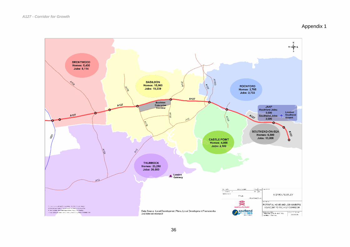
A127 - Corridor for Growth
36
Appendix 1

A127 - Corridor for Growth
37
Appendix 2
Average Annual Daily Flows 2000 - 2012
Figure 3: Average Annual Daily Flows 2000 - 2012

A127 - Corridor for Growth
38
Appendix 3
Figure 4: Eastbound Average Speeds
Figure 5: Westbound Average Speeds

A127 - Corridor for Growth
39
Appendix 4
Accident Date and Time Time of impact on operations (hours)
Vehicle-Hours of delay
16/01/2012 17:00 2 297
18/01/2012 18:00 3 432
18/01/2012 09:00 3 689
24/01/2012 08:00 3 236
26/01/2012 07:00 6 481
03/02/2012 18:00 2 184
09/02/2012 17:00 4 1142
12/02/2012 08:00 3 11
15/02/2012 09:00 2 270
19/02/2012 12:00 <0.5 -
01/03/2012 06:00 4 679
05/03/2012 16:00 8 1000
11/03/2012 16:00 6 313
11/03/2012 18:00 <0.5 -
13/03/2012 13:00 <0.5 -
16/03/2012 12:00 <0.5 -
20/03/2012 08:00 3 325
27/03/2012 07:00 3 368
28/03/2012 08:00 3 539
03/04/2012 22:00 <0.5 -
15/04/2012 12:00 2 228
22/04/2012 13:00 <0.5 -
28/04/2012 21:00 2 4
11/05/2012 12:00 2 312
14/05/2012 07:00 3 538
27/05/2012 07:00 1 33
27/05/2012 13:00 4 658
11/06/2012 17:00 2 509
12/06/2012 18:00 1 197
13/06/2012 10:00 2 275
13/06/2012 07:00 3 68
18/06/2012 18:00 <0.5 -
01/07/2012 07:00 <0.5 -
10/07/2012 20:00 2 2
20/07/2012 16:00 3 160
21/07/2012 10:00 3 678
25/07/2012 12:00 <0.5 -
06/08/2012 14:00 3 223
08/08/2012 16:00 <0.5 -
12/08/2012 07:00 1 3
13/08/2012 14:00 2 11
18/08/2012 12:00 1 41
18/08/2012 08:00 3 616
19/08/2012 02:00 <0.5 -
21/08/2012 11:00 <0.5 -
22/08/2012 12:00 <0.5 -
22/08/2012 08:00 2 207
25/08/2012 11:00 <0.5 -
31/08/2012 09:00 2 286
04/09/2012 07:00 4 607
08/09/2012 14:00 <0.5 -
10/09/2012 20:00 3 23
16/09/2012 20:00 3 10
16/09/2012 00:00 4 251
22/09/2012 14:00 3 771
24/09/2012 16:00 2 461
28/09/2012 07:00 2 207
02/10/2012 17:00 7 879
18/10/2012 15:00 4 413
20/11/2012 08:00 2 193
21/11/2012 16:00 4 353
27/11/2012 06:00 5 1066
04/12/2012 06:00 3 197
26/12/2012 15:00 1 147
Headline impact of collisions on traffic operations.