Embed Size (px)
Citation preview
NETWORK THROUGH CENTURIES: FROM THE BYZANTINE ERA TO PRESENT DAYS
E. Fioretto 1
1 Politecnico di Milano, Dept. ABC, Via Ponzio 31, 20133 Milano – [email protected]
KEY WORDS: Archaeological sites, Network, Cultural Heritage, Preservation, Valorisation, Byzantine Empire
ABSTRACT:
Over the centuries, the Roman Empire enlarge and restrict its borders, as a consequence of many factors, like different emperor’s
policies, wars and conquests.
In a general view, we can identify them and we can consider the Danubian Limes as one of the most important one.
This Limes was mostly characterized by the fact that it was corresponded with the path of the Danube river, from Germany till the
Black Sea.
Those lands, through centuries, were always threaten by the risk of barbarians’ incursions and this is the reason why the Danubian
Limes had always been considered as a fragile border.
During the sixth century, in the midst Byzantine Era, Justinian the I was the first emperor able to consider the problem of the military
protection not even “site by site”. He felt the need of an (absolutely modern) idea of considering the limes as a network of sites, who
need each other to guarantee a strong and efficient result.
Speaking about the architectonical choices, the system of military camps and fortress starts to change its identity, becoming cities
with specific relations.
Focusing on the case study of Serbia, the aim of the work is to map the specific location of each archaeological site, trying to use this
network as an index of places. The research would like to highlight the important value of those sites as Cultural Heritage,
considering the necessity of their preservation and valorization as historical evidence in a new European and common scenario.
1. INTRODUCTION
The work that is going to be presented is part of an ongoing
research, that starts from the idea to investigate the potentialities
of an Intercultural Dialogue1 between researchers in the field of
architectural preservation, through the study for the
conservation and valorization of Cultural Heritage2.
The case study that this research would like to investigate is the
Balkan region, with a special attention to Serbia.
1 the definition of Intercultural Dialogue, as declared in 2001 by the
Universal Declaration on Cultural Diversity of UNESCO:
“In our increasingly diverse societies, it is essential to ensure harmonious interaction among people and
groups with plural, varied and dynamic cultural
identities as well as their willingness to live together. Policies for the inclusion and participation of all
citizens are guarantees of social cohesion, the vitality
of civil society and peace. Thus defined, cultural pluralism gives policy expression to the reality of
cultural diversity. Indissociable from a democratic
framework, cultural pluralism is conducive to cultural exchange and to the flourishing of creative capacities
that sustain public life” (Article 2, “From cultural
diversity to cultural pluralism”). 2 Cultural Heritage is an essential instrument for the Intercultural Dialogue, as defined, in 2015, by the Namur Declaration:
(point 2 of the Declaration) “Cultural Heritage is a
key component of the European identity; it is of general public interest and its transmission to future
generations is a shared responsibility; it is a unique
resource, fragile, non-renewable and non-relocatable, contributing to the attractiveness and the development
of Europe and, crucially, to the creation of a more
peaceful, just and cohesive society”.
It’s almost impossible to summarize the long, huge and
complex process of historical events that let the Balkan region,
through centuries, became a land of migration’s activity, as
outcomes of a spontaneous or forced transfers of people.
The result is an ethnic mix, especially in the border areas of this
region.
Groups of people with different origins, during the years paved
the way for who’s Hösch3 consider as a “Balcanic mix”
(“Miscuglio balcanico”, in the source red by the author).
Taking into consideration the recent history of these countries,
we have to note that with the Russian Revolution, so starting
from 1917, and especially with the Cold War, a wall has been
created between the Eastern and the Western part of Europe.
This kind of censorship lasts for many decades, still recent
times, and those countries were projected, in a really brief
period, in a word that was grown with different habits and rules.
Nowadays, a lot of countries are fully involved in a European
strategy to enlarge the boundaries of Europe, including the
Balkan region.
It is a strategical and really interesting moment of the history,
that can become an important occasion to implement our
knowledge.
The relation between Italy and Serbia, that is the most important
case study of this research, is rooted on the common ancient
background, represented by the common belonging to the
Roman Empire.
And, especially, we are speaking about that Roman Empire that
nowadays we used to call “Byzantine Empire”, that,
chronologically, can be identified between the 395 a.C., after
the death of the roman emperor Teodosio I, and the 1453, with
the Fall of Constantinople to the Ottoman Empire.
From the geographical point of view, subjects of our interest are
the boundaries of the Byzantine empire, that, over the centuries,
3 HÖSCH 2006
The International Archives of the Photogrammetry, Remote Sensing and Spatial Information Sciences, Volume XLII-2/W11, 2019 GEORES 2019 – 2nd International Conference of Geomatics and Restoration, 8–10 May 2019, Milan, Italy
This contribution has been peer-reviewed. https://doi.org/10.5194/isprs-archives-XLII-2-W11-519-2019 | © Authors 2019. CC BY 4.0 License.
519
had been enlarged and restricted as a consequence of many
factors, like different emperor’s policies, wars and conquests.
Generally speaking, they could be differenced by two main
characteristics: natural and artificial boundaries.
Under the artificial category we could identify, for instance, the
Vallo di Adriano, or Vallo di Antonino, built from new thanks to
the work of man and soldiers.
Under the natural category it is possible to identify each
situation where the limes (boundary, in his latin and original
name) corresponds to a natural geographical element. It is
possible to generally count them in three main situations, it
means where the boundary is represented by:
- Mountains, as the case of Carpazi in the roman
Province of Dacia;
- Desert, as in Egypt
- Rivers, as in the cases of the rivers Rhine, Euphrates
and Danube.
In any case, if from one side the idea itself of boundary entails
the meaning of the last part of something, in our case the lands
of an Empire, from another side it entails the complex system of
relations between what belong to one and the other side of this
line.
The considered case study of the Danubian Limes seems to be
interesting also for this aspect: it is that boundary of the Empire
that divide the roman land from the “barbarian” one: those
lands, through centuries, were always threaten by the risk of
barbarians’ incursions and this is the reason why the Danubian
Limes had always been considered as a fragile border.
Nowadays the Danube river flows through ten countries,
becoming the boundary between some of them, connecting
Germany to the Black Sea.
During the roman era the difficulties to defend a so huge portion
of land implied the constant modifications of the boundary of
the Empire on this side, as a consequence of so many wars and
conquest by barbarians’ populations.
The peak has been reached during the fifth century, with the big
phenomenon of the Barbarian Invasions, represented mostly,
along the Danube river, by the Huns. This historical phase
implied a big loss of architectural manufacts along the Limes,
destroyed during the wars for the conquest of new lands by
Huns.
But in the sixth century, and we are reaching the core of the
research, thanks to the policy of the emperor Justinian I, the
Danubian Limes starts to take on a new role.
Justinian the I was able to understand the need of a (modern)
necessity to create a network of sites, to reach a situation of
balance on the limes defense policy.
Balance in terms of a new safety for the boundary and balance
in terms of a broad-minded approach about the strategic set-up
of the defense system.
As well as we can understand from the words of Procopio di
Cesarea4, through the studies of Enrico Zanini, “in the new
project for the Danubian Limes, Justinian I didn’t limit himself
to restore what was already built, but he carried out a real plan
of restorations, re-buildings and new constructions, sometimes
including also some removals. It’s seemed that, according also
the words of Procopio, he forced himself to homogenize the
dimensions of the defense system: enlarging little fortresses,
4 The research will adopt the 560 a.C. as a “terminus post-quem”,
because some historians make it coincide with the first publication of
the “De Aedificiis” opera by Procopio da Cesarea. This document is mostly important for this research, because it can be considered as the
first systematic census of architectonical proprieties of the Eastern
Roman Empire.
reducing too big ones and building from new fortress wherever
he felt the need of them”.5
2. A NETWORK OF SITES: THE DANUBIAN LIMES
In the Giulio-Claudia Era (27-68 a.C.) the defense system of the
Danubian Limes was represented by simple tent’s camps,
defended by palisades.
Approximately on the first half of the second century the design
of castrum starts to reach its characteristic pattern, divided in
four parts, by two orthogonal main paths. The Limes, at that
time, is an offensive structure. Fortresses played the role of
logistical support for troops, engaged in wars of conquest of the
Dacia.
During the third century we can note a new change of
perspective about the internal organization of the castrum plan.
New buildings appear in the plan of the settlement, probably
with the function of warehouses. The result is a modification of
the original quadripartite military facility. It is possible to
assume this change also with a theoretical interpretation: the
limes starts to play a new role, now defensive rather than
offensive.
The defensive line is moving towards a dual process of
evolution. On one hand, the limes is enhanced to build a barrier
against the incursions of barbarians6.
On the other hand, the limes begins to get involved in a new
way, starting new relationships with the territory that it must
defend and administer. In that period the new and urgent
problem of the Illyricum, considered as a border’s region, arose.
The traditional Roman concept of the defense system, which
considered the Limes as a militarized band that can defend and
isolate the empire, began to enter into crisis; but, at the same
time it was also considered as the finis, the political,
administrative, economic and, especially, cultural and religious
frontier, between the Roman and not Roman.
We can consider this period as the beginning of a limit
differentiation process; it can be introduced a new distinction
between political and administrative limit and cultural limit,
between the frontier and the border, but it will take on full
significance only in the Justinian I era7.
In the Justinian I program of Renovatio Imperii we notice an
extraordinary relevance regarding the recapture of the Danube
banks.
The re-definition of the defensive and administrative boundaries
is indeed the last attempt to stave off the pressure of Slavs. It
felt the need to maintain a political and administrative control
over a complex region: the complexity of its layout did not
relieve it from play a central role in the general economy of the
Empire.
From an architectural point of view, it should be noted that the
internal organization of castra detects a gradual shift: from a
purely military organization, articulated on quadripartite
scheme, we can see a growing rise of foreign organism’s
encampment. Justinian adopts a standardization policy in his
immense construction effort along the Danubio river, expanding
5 This part has been translated by the author. Here the original version,
in Italian: “Nell’intervenire sul limes danubiano, Giustiniano non si limita a restaurare l’esistente, ma attua un piano preciso ed
articolato di restauri, di riedificazioni, di nuove costruzioni e, in
diversi casi, di eliminazioni. Sembra di cogliere, anche sulla base delle indicazioni di Procopio di Cesarea, uno sforzo di
omogeneizzazione delle dimensioni delle fortezze: si ampliano i forti
più piccoli, si riducono le strutture troppo grandi ed onerose per la difesa e si costruiscono ex novo alcuni forti laddove se ne avverte la
necessità”. [ZANINI, 1987] 6 TREADGOLD 2009 7 ZANINI 1986
The International Archives of the Photogrammetry, Remote Sensing and Spatial Information Sciences, Volume XLII-2/W11, 2019 GEORES 2019 – 2nd International Conference of Geomatics and Restoration, 8–10 May 2019, Milan, Italy
This contribution has been peer-reviewed. https://doi.org/10.5194/isprs-archives-XLII-2-W11-519-2019 | © Authors 2019. CC BY 4.0 License.
520
the smallest castra, resizing the widest ones, funding new ones.
Procopio told about the characteristics of these castra, referring
to a description of something like cities.
“As one goes on from Viminacium there chance to be three
strongholds on the bank of the Ister, Pinci and Cupi and Novae.
These were formerly both single in construction and when
named were single towers. But now the Emperor Justinian has
greatly increased the number of the houses and enlarged the
defences at these places, and thereby has properly given them
the rank of cities”8.
So, these are new fortified centers, but, now, surrounded by
villages inhabited by civilians9.
What we must notice, therefore, is that the limes lost, gradually,
its purely strategic-military role; the area is still under the
jurisdiction of one dux, but, in fact, it becomes an area
populated by citizens, who start to have business relationship,
cultivate and breed animals.
If we would like to give a brief chronological view, we can
divide the limes’ role in these three parts:
1_ the limes was born as offensive structure,
2_ the limes becomes a defensive structure
3_the limes plays the role of "dam", as a protection band in a
context where it was clear that this area became, mostly, a
contact and exchange zone, between different people and
cultures.
This research is trying to explore and collect archaeological data
to let us have a new and clear idea of the arrangement of the
Danubian Limes under the reign of Justinian I.
It should be noticed that, during the 1960s and 1980s two dams
were built along the Danube Limes. Unfortunately, these
decisions implied that so many archaeological sites were sunk
by the waters of the river.
The results of the excavations carried out due to the
construction of the dams were published mostly in periodicals.
Probably the most important publication about these
archaeological areas is “Starinar”, the official periodical of the
Institute of Archaeology in Belgrade, especially the volumes
XXXIII-XXXIV.
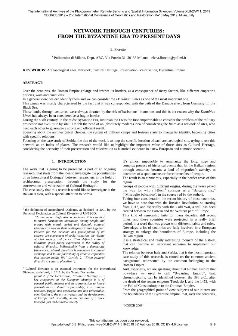
Figure 1. General view of the analyzed area
1 - Singidunum - Belgrade
2 - Viminacium
3 - Lederata - Ram
4 - Castrum Novae - Cezava
5 - Saldum
6 - Ad Scrofulos - Bosman
7 - Smorna - Boljetin
8 - Campsa - Ravna
9 - Taliata - Donji Milanovac
10 - Hajducka Vodenica
11 - Transdierna - Tekija
12 - Sip
13 - Diana - Kladovo
14 - Donja Butorka
15 - Pontes - Kostol
8 PROCOPIO DI CESAREA 1971 9 PROCOPIO DI CESAREA 1544
16 - Rtkovo - Glamija
17 - Milutinovac
18 - Ljubicevac
19 - Egeta
20 – Slatinska
The International Archives of the Photogrammetry, Remote Sensing and Spatial Information Sciences, Volume XLII-2/W11, 2019 GEORES 2019 – 2nd International Conference of Geomatics and Restoration, 8–10 May 2019, Milan, Italy
This contribution has been peer-reviewed. https://doi.org/10.5194/isprs-archives-XLII-2-W11-519-2019 | © Authors 2019. CC BY 4.0 License.
521
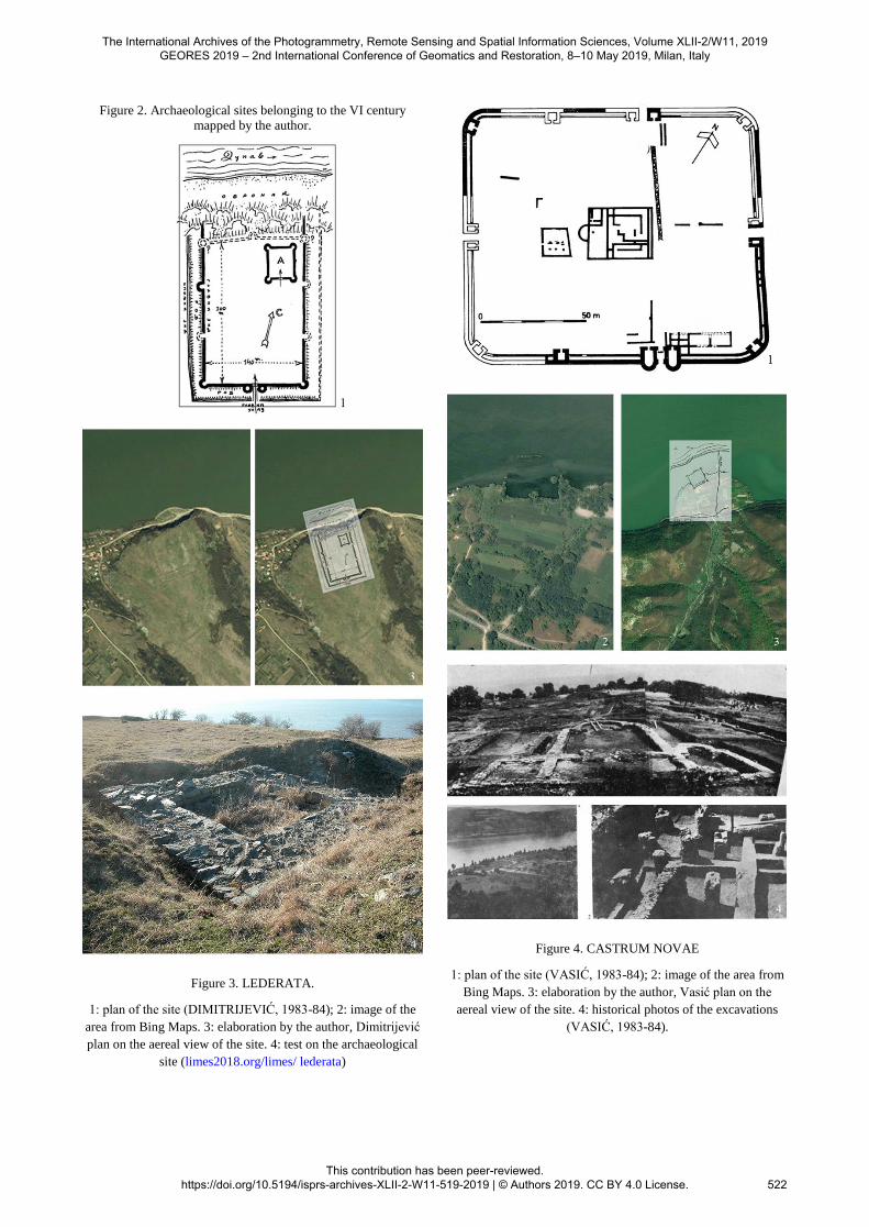
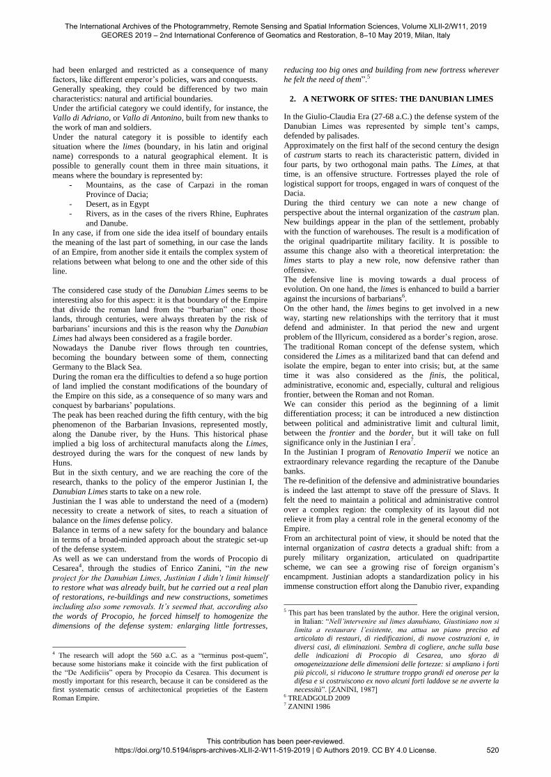
Figure 2. Archaeological sites belonging to the VI century
mapped by the author.
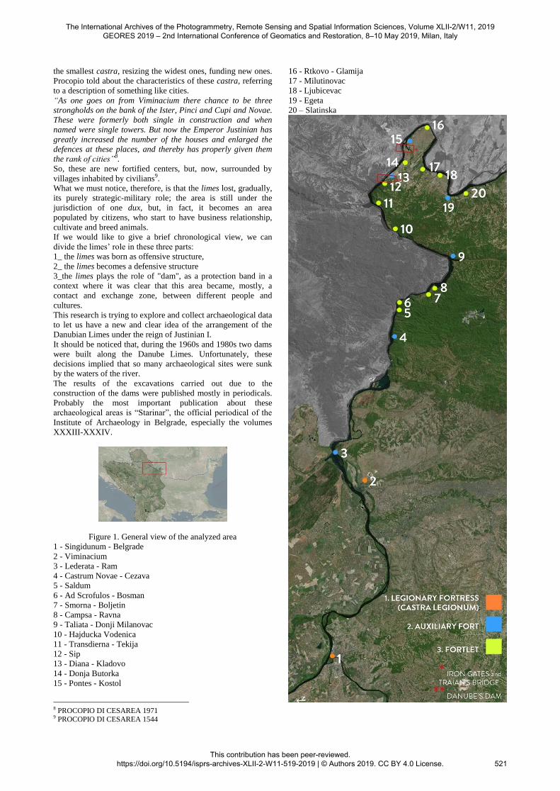
Figure 3. LEDERATA.
1: plan of the site (DIMITRIJEVIĆ, 1983-84); 2: image of the
area from Bing Maps. 3: elaboration by the author, Dimitrijević
plan on the aereal view of the site. 4: test on the archaeological
site (limes2018.org/limes/ lederata)
Figure 4. CASTRUM NOVAE
1: plan of the site (VASIĆ, 1983-84); 2: image of the area from
Bing Maps. 3: elaboration by the author, Vasić plan on the
aereal view of the site. 4: historical photos of the excavations
(VASIĆ, 1983-84).
The International Archives of the Photogrammetry, Remote Sensing and Spatial Information Sciences, Volume XLII-2/W11, 2019 GEORES 2019 – 2nd International Conference of Geomatics and Restoration, 8–10 May 2019, Milan, Italy
This contribution has been peer-reviewed. https://doi.org/10.5194/isprs-archives-XLII-2-W11-519-2019 | © Authors 2019. CC BY 4.0 License.
522
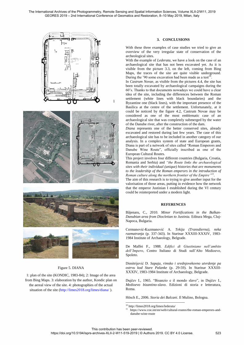
Figure 5. DIANA
1: plan of the site (KONDIC, 1983-84); 2: Image of the area
from Bing Maps. 3: elaboration by the author, Kondic plan on
the aereal view of the site. 4: photographies of the actual
situation of the site (http://limes2018.org/limes/diana/ ).
3. CONCLUSIONS
With these three examples of case studies we tried to give an
overview of the very irregular state of conservation of the
archeological sites.
With the example of Lederata, we have a look on the case of an
archaeological site that has not been excavated yet. As it is
visible from the picture 3.3, on the left, coming from Bing
Maps, the traces of the site are quite visible underground.
During the ’90 some excavation had been made as a test10.
In Castrum Novae, as visible from the pictures 4.4, the site has
been totally excavated by archaeological campaigns during the
60’s. Thanks to that documents nowadays we could have a clear
idea of the site, including the differences between the Roman
settlement (white lines with black boundaries) and the
Byzantine one (black lines), with the important presence of the
Basilica at the centre of the settlement. Unfortunately, at it
could be noticed by the figure 4.2, Castrum Novae may be
considered as one of the most emblematic case of an
archaeological site that was completely submerged by the water
of the Danube river, after the construction of the dam.
Diana represents one of the better conserved sites, already
excavated and restored during last few years. The case of this
archaeological site has to be included in another category of our
analysis. In a complex system of state and European grants,
Diana is part of a network of sites called “Roman Emperors and
Danube Wine Route”, officially inscribed as one of the
European Cultural Routes.
This project involves four different countries (Bulgaria, Croatia,
Romania and Serbia) and “the Route links the archaeological
sites with their individual (unique) histories that are monuments
to the leadership of the Roman emperors in the introduction of
Roman culture along the northern frontier of the Empire”11.
The aim of this research is to trying to give another input for the
valorisation of those areas, putting in evidence how the network
that the emperor Justinian I established during the VI century
could be reinterpreted under a modern light.
REFERENCES
Bâjenaru, C., 2010. Minor Fortifications in the Balkan-
Danubian area from Diocletian to Justinia. Editura Mega, Cluj-
Napoca, Bulgaria.
Cermanović-Kuzmanović A. Tekija (Transdierna), neka
razmatranja (p. 337-343). In Starinar XXXIII-XXXIV, 1983-
1984 Institute of Archaeology, Belgrade.
De Maffei F., 1988. Edifici di Giustiniano nell’ambito
dell’Impero, Centro Italiano di Studi sull’Alto Medioevo,
Spoleto.
Dimitrijević D. Sapaja, rimsko i srednjovekovno utvrdenje pa
ostrvu kod Stare Palanke (p. 29-59). In Starinar XXXIII-
XXXIV, 1983-1984 Institute of Archaeology, Belgrade.
Dujčev I., 1965. “Bisanzio e il mondo slavo”, in Dujčev I.,
Medioevo bizantino-slavo. Edizioni di storia e letteratura,
Roma.
Hösch E., 2006. Storia dei Balcani. Il Mulino, Bologna.
10 http://limes2018.org/limes/lederata/ 11 https://www.coe.int/en/web/cultural-routes/the-roman-emperors-and-
danube-wine-route
The International Archives of the Photogrammetry, Remote Sensing and Spatial Information Sciences, Volume XLII-2/W11, 2019 GEORES 2019 – 2nd International Conference of Geomatics and Restoration, 8–10 May 2019, Milan, Italy
This contribution has been peer-reviewed. https://doi.org/10.5194/isprs-archives-XLII-2-W11-519-2019 | © Authors 2019. CC BY 4.0 License.
523
Jęczmienowski E., 2012. The Fortifications of the Upper
Moesian Limes. Topography, Forms, Garrison Sizes, in
Światowit. In Annual of the Institute of Archaeology
of the University of Warsaw), vol X (LI), fascicle A,
Mediterranean and non-european archaeology. Institute of
Archaeology, Warsaw.
Jovanović A. Hajdučka Vodenica kasnoantičko i
ranovizantijsko utvrdenje (p. 319-331). In Starinar XXXIII-
XXXIV, 1983-1984 Institute of Archaeology, Belgrade.
Kondic V. Bosman, ranovizantijsko utvrdenje (p. 137-146). In
Starinar XXXIII-XXXIV, 1983-1984 Institute of Archaeology,
Belgrade.
Kondic V. Dijana – utvrdjenje 1 veka (p. 261-272). In Starinar
XL-XLI, 1989-1990, Institute of Archaeology, Belgrade.
Kondic V. Ravna (Campsa) rimsko i ranovizantijsko utvrdenje
(p. 233-253). In Starinar XXXIII-XXXIV, 1983-1984 Institute
of Archaeology, Belgrade.
Korać M., Golubović S., Mrđić N., Jeremić G., Pop-Lazić S.,
2014. Roman Limes in Serbia - Frontiers of the Roman Empire.
Institute of Archeology, Belgrade.
Milosevic P. Sip, kasnoantičko utvrdenje (p. 357-362). In
Starinar XXXIII-XXXIV, 1983-1984 Institute of Archaeology,
Belgrade.
Obolensky D., 1971. The Byzantine Commonwealth. Praeger
Publishers, Washington, New York.
Ostrogorsky G., 2014. Storia dell’Impero Bizantino. Einaudi
Editore, Torino.
Popovic M. Svetinja, novi podaci o ranovizantijskom
Viminacijumu (p. 1-37). In Starinar XXXVIII-1988. Institute of
Archaeology, Belgrade.
Procopio di Cesarea, 1547. De Aedificiis. Michel Tramezino,
Venezia. (translated in Italian, from the original version, in
Greek, VI Cent., by Benedetto Egio da Spoleto).
Procopio di Cesarea, 1971. Procopius VII Buildings (De
Aedificiis), translated in English from the original version in
Greek by H. B. Dewing with the collaboration of Glanville
Downey. Harvard University Press, Cambridge, Massachusetts.
Ronkey, S., 2002. Lo Stato bizantino. Einaudi, Torino.
Treadgold W., 2009. Storia di Bisanzio. Il Mulino, Bologna.
Vasić M. Čezava – castrum Novae (p.91-122). In Starinar
XXXIII-XXXIV, 1983-1984 Institute of Archaeology,
Belgrade.
Vasić M., 1990. Čezava – Castrum Novae. La stratigraphie, la
chronologie et les phases architectoniques, in Limes 14
Carnuntum, (p. 897–911)
Zanini E., 1986. “Confine e frontiera: il limes danubiano nel VI
secolo”. In MILION studi e ricerche di arte.
Zotović LJ. Boljetin (Smorna), rimski i ranovizantijski logor
(p.211-225). In Starinar XXXIII-XXXIV, 1983-1984 Institute
of Archaeology, Belgrade.
The International Archives of the Photogrammetry, Remote Sensing and Spatial Information Sciences, Volume XLII-2/W11, 2019 GEORES 2019 – 2nd International Conference of Geomatics and Restoration, 8–10 May 2019, Milan, Italy
This contribution has been peer-reviewed. https://doi.org/10.5194/isprs-archives-XLII-2-W11-519-2019 | © Authors 2019. CC BY 4.0 License.
524


![[E-Book - Storia] David, Nicolle - Angus McBride - Romano-Byzantine Armies 4th-9th Centuries (Osprey Military - Men at Ar](https://img.pdfslide.us/doc/110x75/577cc10c1a28aba711921461/e-book-storia-david-nicolle-angus-mcbride-romano-byzantine-armies.jpg)


![[Osprey] MAA 247 Romano Byzantine Armies 4th-9th Centuries [Osprey Men at Arms Series]](https://img.pdfslide.us/doc/110x75/54529f7daf795919308b4d6c/osprey-maa-247-romano-byzantine-armies-4th-9th-centuries-osprey-men-at-arms-series.jpg)