Embed Size (px)
Citation preview
MountainBikingin DCR'sBlue Hills Reservation
It's you r natu re!
6101
61046105
6106
6005
6800
6850
6700
6830
6009
1046
1033
6600
6650
6670
6877
6896
68916880
6900
1030
6102
6103
1023
1002
1050
1010
1001 1003
Cosmos Path
K Path Accord Path
Eliot C
ircle
Summ
it Road
Wolcott Path
Burm
a Road
Pipe L
ine
§̈¦93§̈¦95UV128
!j
DEDHAM
EXIT 1EXIT 13
CANTON
BOSTON MILTON
Neponset
Brush Hill Rd
Greenlodge St
Valley Pky
Nepon
set Riv
er
Nepo
nset R
iver
!j Parking AreaClosed Trail (No bikes)Narrow TrailWide TrailPaved RoadStreamElevation Contour(20 ft interval)Town BoundaryWetlandOpen Water
0 0.125 0.25Mile
OTO GREATBLUE HILL
<
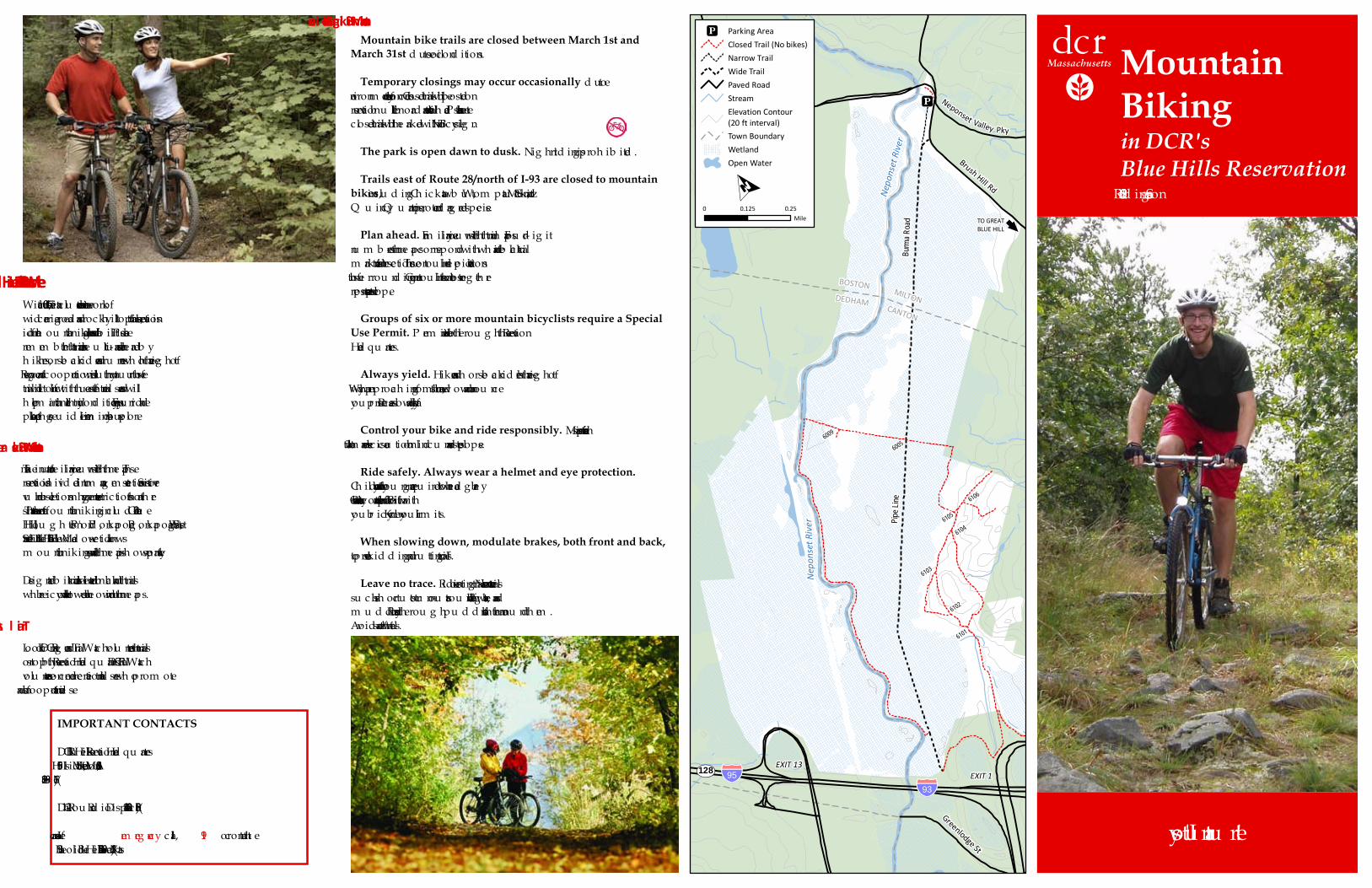
•Mountain bike trails are closed between March 1st andMarch 31st d u e to soil cond itions.•Temporary closings may occur occasionally d u e toenvironm ental or safety concerns. Closed trails will b e posted onreservation b u lletin b oard s and at trailh ead s. P lease take note:closed trails will b e m arked with a No Bicycle sig n.•The park is open dawn to dusk. Nig h t rid ing is proh ib ited .•Trails east of Route 28/north of I-93 are closed to mountainbikes, inclu d ing Ch ickatawb u t, Wom patu ck, St. Moritz andQ u incy Q u arries, to protect end ang ered species.•Plan ahead.Fam iliarize you rself with th e trail m aps. Fou r-d ig itnu m b ers on th e m aps correspond with wh ite and b lack trailm arkers at trail intersections. Th e contou r lines d epict elevationsof th e su rrou nd ing area. Contou r lines th at are closer tog eth errepresent a steeper slope.•Groups of six or more mountain bicyclists require a SpecialUse Permit. P erm its are availab le th rou g h th e ReservationHead qu arters.•Always yield.Hikers and h orseb ack rid ers h ave th e rig h t ofway. Wh en approach ing from th e rear, slow d own and annou nceyou r presence. P ass slowly and safely.•Control your bike and ride responsibly. Maintain a safe speedat all tim es and exerc ise cau tion on b lind cu rves and steep slopes.•Ride safely. Always wear a helmet and eye protection.Ch ild ren 16 years and you ng er are requ ired to wear h ead g ear b ystate law. Carry a water b ottle and a repair kit. Be fam iliar withyou r b icycle. Know you r lim its.•When slowing down, modulate brakes, both front and back,to prevent skid d ing and ru tting of trails.•Leave no trace.Rid e on existing trails. Never create new trailssu c h as sh ort cu ts or tu rn-ou ts arou nd fallen log s, water b ars andm u d d y areas. Rid e th rou g h pu d d les rath er th an arou nd th em .Avoid soft and wet trails.
Mountain Biking Guidelines
With over 7,000 acres th at inclu d e an extensive network ofwid e carriag e road s and rocky h illtop trails, th e reservation isid eal for m ou ntain b ikers of all ag es and ab ilities. P leaserem em b er th at th e trails are m u lti-u se and are sh ared b yh ikers, h orseb ack rid ers and ru nners wh o h ave th e rig h t ofway. Respect and cooperation will ensu re th at you r u se of th etrail will not conflict with th e u se of oth er trail u sers and willh elp m aintain h ealth y trail cond itions. Enjoy you r rid e andplease keep th ese g u id elines in m ind as you explore.
Welcome to DCR’s Blue Hills Reservation
Take a m inu te to fam iliarize you rself with th e m aps. Th ereservation is d ivid ed into m anag em ent sections. Sensitive orvu lnerab le sections m ay h ave g reater restrictions th an oth ersites. Th e areas th at offer m ou ntain b iking inclu d e Great Blu eHill, Hou g h ton's P ond , P onkapoag , P onkapoag East, WestStreet and Little Blu e Hill. Th e Fowl Mead ow section allowsm ou ntain b iking as well and th e m ap is sh own separately.Desig nated b ike trails are d elineated in b lack and th e trailswh ere b icycles are not allowed are sh own in red on th e m aps.
Where Mountain Bikes are Allowed
Trail AssistanceLook for DCR rang ers and TrailWatc h volu nteers on th e trailsor stop b y th e Reservation Head qu arters. DCR TrailWatchvolu nteers are concerned recreational trail u sers wh o prom otesafe and cooperative trail u se.
IMPORTANT CONTACTS
DCR Blu e Hills Reservation Head qu arters695 Hillsid e Street, Milton, MA 02186(617) 698-1802DCR 24-h ou r Rad io Dispatch (508) 820-1428In case of anem erg ency, call911or contact th eState P olice Blu e Hills Barracks at (617) 698-5840.
2018 Rid ing Season
!j
!j
!j
!j
!j
!j
!j
!j
!j
!j
!j
!j
!j
!j1055
10831120
1123
108610811062
1093
1110
1143
1151
1105
1082
1092
11171103
1115
10726104
6105 6106
6005
6800
68506700
6830
5343
53655364
5361
5332
5321
5174
51765330
53845362
5401
5374
5371
5344
5241
5311
5425
5395
53855382
5381
2182
2183
2155
219021722154
2140
2149
2162
2165
2164
21502146
2163
2176
2189
2210
2194
2175
5423
5414
5421
1191
1085 1100
1114
1135
1175
1183
1203
1063
1066
1140
1156
1141
1147 1160
1162
11781180
1185
1204
1201
2053
2075
2054
2070
20812112
2094
2129
5175
5422
5424
5218
2096
1210
1046
1033
2085 2100
2092
2111
1215
1224
2117
2130
2151
2153
2132
2123
5320
5322
53555216
6600
6650
6670 6877
68966891
6880 6900 1030
11221150
1154
1182
1166
1165
1121
1214
1217
1170
1172
1208
1209
1206
2071
2135
2141
2181
5360
5370
2072
1023
1051
1002
1050
1010
10011003
1057
1077
1079
5380
5383
3024
Cosmos Path
K Path
Maple Avenue
Redm
an Far
m Path
Acton Path
Ponkapoag Trail
Accord Path
Eliot Ci
rcleSum
mit Ro
ad
Wolcott Path
Puddle Path
Coon
Hollow Path
Wildcat Notch Path
Half Way Path
Coon Hollow Path
Wildca
t Notc
hPa
th
Five C
orners
Path Wolcott Path
Hough
ton Pa
th
Border Path
Rotch Path HemenwayHill Path
Eustis T
rail
Chestnut Run Path
Base Path
Breakn
eckLed
ge Path
Hancock
HillPa
th
Border PathValley Path
Headqu
arters P
ath Bugbee
Angle Path Burnt H
ill Path
Tucker Hill Path
Dark Hollow Path
Doe Hollow Path
Bugbee
Path
Hollow Path
ObliquePath Pipe L
ine
Monatiquot Path
Fells Path
Pig Rock Path
Buck Hill PathForest Path
Beech
South
Skyline
Skyline
North
Skyline
North Skyline
Path
!j
§̈¦93§̈¦93
!(28
!(24
UV138
UV138
Greenlodge St
EXIT 2
Washi
ngton
St
Randolph StCanton St
EXIT 3EXIT 4
EXIT 5
High S
t
Green St
Royall StBlue Hill River Rd
Blue Hill River Rd
Hillside
St
Brush Hill Rd Canton
Ave
Unquity Rd
Chickatawbut Rd
Forest St
Harland St
QUINCY
RANDOLPH
CANTONMILTON
See reverse for acomplete map ofFowl Meadow.
PONKAPOAGGOLF COURSE
YMCACAMP
AMCCABINSPonkapoag Pond
FISHERMANSBEACH
BROOKWOODFARM
Houghton's Pond
BLUE HILLSKI AREA
TRAILSIDEMUSEUM Hillside
Pond
DuckPool
!_
!_
!@
!̂
µ́
Blue Hill River
CANTONMILTON
RANDOLPH
MILTON
QUINCYMILTON
PONKAPOAGGOLF COURSE
BALL FIELDS
Old Route 128
!j
Hillside St
!j
Blue H
ill Ave
Rando
lph Av
e
ELIOTTOWER
2P
µ́
µ́
µ́
µ́
µ́
µ́
µ́
µ́
µ́
µ́
µ́
µ́
µ́
µ́
µ́
µ́
µ́µ́
µ́ µ́
µ́
µ́
µ́
µ́
µ́
µ́
µ́
µ́
µ́
µ́
µ́
µ́
µ́
µ́
µ́µ́
µ́
µ́µ́
µ́
µ́
0 0.25 0.5Mile
Geographic data supplied by the Office of Geographic Information (MassGIS) and DCR GIS.
OPrinted 4/2018.
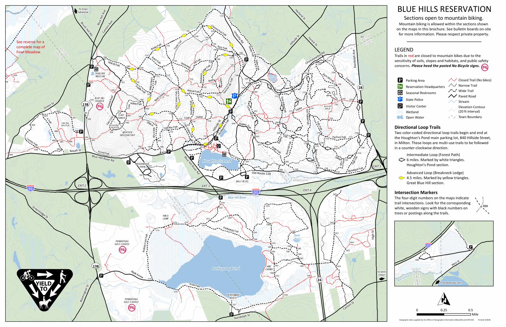
BLUE HILLS RESERVATIONSections open to mountain biking.
Mountain biking is allowed within the sections shownon the maps in this brochure. See bulletin boards on-site
for more information. Please respect private property.
LEGENDTrails in red are closed to mountain bikes due to thesensitivity of soils, slopes and habitats, and public safetyconcerns. Please heed the posted No Bicycle signs.
Directional Loop TrailsTwo color-coded directional loop trails begin and end atthe Houghton's Pond main parking lot, 840 Hillside Street,in Milton. These loops are multi-use trails to be followedin a counter-clockwise direction.
Intersection MarkersThe four-digit numbers on the maps indicatetrail intersections. Look for the correspondingwhite, wooden signs with black numbers ontrees or postings along the trails.
Intermediate Loop (Forest Path)6 miles. Marked by white triangles.Houghton's Pond section.Advanced Loop (Breakneck Ledge)4.5 miles. Marked by yellow triangles.Great Blue Hill section.
µ́µ́
4084
Buck Hill(496 ft)
Great BlueHill (635 ft)
Little BlueHill (270 ft)
TO FOWLMEADOW<
WEATHEROBSERVATORY
5620
56115600
5610
West St
§̈¦93
QUINCYRANDOLPHBRAINTREEBlue Hill River
TO WESTSTREET<
<TO PONKAPOAG EAST
!j
!j Parking Area!@ Reservation Headquarters!_ Seasonal Restrooms2P State Police!̂ Visitor Center
WetlandOpen Water
Closed Trail (No bikes)Narrow TrailWide TrailPaved RoadStreamElevation Contour(20 ft interval)Town Boundary