Embed Size (px)
Citation preview

NERC Floods and Droughts Resilience (FDR) workshop
Summary Report
November 14, 2019
Mary Ward House, Bloomsbury, London Final version: 04/06/2020

Executive Summary Flood and drought events can have devastating human consequences, including disruption to economy, food security, damage to infrastructure, and threat to human health and life. To address this emerging risk, NERC is developing a case for a large capital investment to fund the establishment of a UK network of digitally connected data hubs and sensors in river catchments to give near-real-time data that would be transformative for researchers, end users, and policymakers. A workshop was held on 14 November 2019 to discuss the major knowledge gaps in catchment hydrology and to determine how significant capital investments could be best utilised to provide data required to improve understanding of floods and droughts. Fifteen delegates from organisations across the UK were selected to attend from an open call. In summary, the key recommendations from the FDR workshop are:
• a scoping exercise of approximately 12 months should be undertaken to recognise and analyse gaps in knowledge prior to any large spending commitment;
• any large-scale FDR project should include the development of near-real-time monitoring systems across several nested catchments with a view to allow for scalable interrogation of hydrological changes across different catchment types;
• selected catchment sites should utilise and leverage existing infrastructure where possible, with findings being easily and freely accessible for all.
The detailed recommendations obtained from this community workshop are highlighted in this summary report.
NERC Capital Team: [email protected].

Contents
Background ........................................................................................................................................................................ 1 Session 1 – Science questions .......................................................................................................................................... 2 Session 2 – Key catchment properties............................................................................................................................... 4 Session 3 – Target variables and suggested technologies ................................................................................................ 6 Session 4 – Steps to implementation ................................................................................................................................. 9 Plenary ............................................................................................................................................................................. 10
Further Steps ............................................................................................................................................................... 11 Annex A – Delegate List .................................................................................................................................................. 12 Annex B – Workshop agenda .......................................................................................................................................... 13 Annex C – Questionnaire sent to EOI submitters ............................................................................................................ 14 Annex D - EoI Responses ................................................................................................................................................ 16
Acronym Details FDR Floods and Droughts Resilience COS Catchment Observing Systems EOI Expression of Interest

1
Background NERC held a Floods and Droughts Resilience (FDR) workshop on Thursday 14 November 2019 at Mary Ward House in London. NERC’s FDR programme is a proposed large capital investment to increase the UK’s resilience to floods and droughts by constructing a digitally connected and network of sensors, observatories and research facilities to provide vital research data and allow near-real-time decision making. This capital investment could include also: a test-bed platform, a dedicated data hub, and rapidly-deployable mobile monitoring capability. In 2017, NERC began scoping after a recommendation from NERC’s Joint Capital Advisory Group. NERC carried out two workshops (then named “Catchment Observing Systems”; COS) in November 2018 and 2019 and is currently developing a case for investment. FDR was highlighted in the UKRI Infrastructure Report (The UK’s research and innovation infrastructure: opportunities to grow our capacity) as a priority for capital investment. NERC is actively scoping this priority area to ensure that the project delivers transformative and innovative national infrastructure. As such, this workshop specifically aimed to bring together the flood and/or drought resilience community to advise NERC on the prioritisation and implementation of the investment. The workshop was one day long and involved 15 delegates from organisations across the UK. Delegates were selected based on information supplied in Expression of Interest (EOI) forms they submitted to NERC prior to the workshop. A full list of delegates can be found in Annex A. The workshop was divided into four sessions (Annex B). The workshop built on i) data gathered from previous COS workshops in 2017 and 2018 and ii) the results of a questionnaire (Annex C) sent to all those who submitted an EOI to attend the 2019 FDR workshop. This report outlines the key findings from the workshop.

2
Session 1 – Science questions Headline findings:
1. The focus of research questions should be: firstly to advance scientific understanding of catchment hydrology and secondly to use this transformative knowledge to increase UK resilience to flood and drought events
2. Catchments are independent systems and, as such, extrapolating data findings across
multiple catchments remains challenging
3. The term catchment processes should be prioritised ahead of catchment properties
4. Research questions should not rely solely on improving models but also fundamental understanding that underpins these representations
Background A set of three science questions were developed from previous workshop findings. These were considered and discussed by delegates in Session 1 (Figure 1; Annex C) with an aim to gain consensus on a well-defined set of scientific questions for the FDR programme.
Figure 1: Science questions from Session 1 (developed from previous workshop findings). 1. The focus of questions should be: firstly to advance scientific understanding of catchment
hydrology and secondly to use this transformative knowledge to increase UK resilience to flood and drought events
The addition of the word ‘resilience’ to the previous workshop title (COS) raised a lot of discussion, including whether it would be more beneficial to develop a programme of monitoring / measuring to improve researchers’ ability to simulate flood / drought events and therefore better understand the effect of interventions on flood and drought resilience, or whether the focus should be for researchers to develop
Q1: Which catchment properties and interactions control the extent,
magnitude and duration of floods and droughts and how can this knowledge
be used to better understand and predict the impacts of climate change
in both the short and long term?
Q2: How can measurements / observations be used more effectively
to improve catchment process understanding and reduce uncertainty
under extreme hydrological conditions?
Q3: Can a UK-wide flood, drought and related hazard ‘models of
everywhere’ be developed from multiple catchment observations combined with analytical tools to
support future decision making, i.e. forecasting, targeted interventions
and incident response and recovery?
3
greater understanding of hydrological processes, which could allow approaches to be developed and implemented that increase UK resilience to flood and drought events. The consensus was that the latter was preferable. Based on this, it was suggested that there is a need to rephrase question one in order to emphasise the desired scientific outcome from the outset. It was considered that question one focusses on the processes of flood and drought events rather than the impacts despite that fact that the analysis of impacts is crucially important with respect to developing resilience to flood and drought events. Question three was also suggested to be reframed because it is closed and needs to be open and explorative. 2. Catchments are independent systems and, as such, extrapolating data findings across multiple
catchments remains challenging It was argued that having detailed knowledge of a single catchment may allow for some level of transferability to other, less understood, catchments by aiding the identification of similarities and differences. However, characterising any such transferability is considered challenging. It was also highlighted that single catchment analysis can provide guidance on the minimum level of monitoring required at other locations, and it is a useful starting point for research in understudied catchments. Identifying where knowledge gaps exist was flagged as a priority for any scoping exercise. It was suggested that existing data and/or infrastructure should be utilised to better identify what knowledge gaps exist. To move forward and resolve these gaps, measurements and observations should be undertaken in a nested (telescopic) approach that can be undertaken across a wide range of spatial scales. There was consensus that such an approach should focus on a network-based analysis. Question two should be reframed to indicate: i) what is known, and ii) how the existing knowledge base can be improved. 3. The term catchment processes should be prioritised ahead of catchment properties
There was consensus that catchment properties are 2D, while catchment processes refer to interactive, 3 / 4D systems and better represents fluxes; the latter is more challenging to capture but would be more novel. Moreover, moving from understanding properties to understanding processes is required for transformational advances in catchment hydrological functioning and response (including flood and drought). 4. Research questions should not rely solely on models improving models but also fundamental
understanding that underpins these representations
The phrase: ‘models of everywhere’ (question three) was debated; some thought that there needs to be better understanding of the places between the areas measured before developing models of everywhere. There was consensus that development of a framework is preferred and that this should be a priority. It was highlighted that models are considered by many to be a toolbox rather than a solution in themselves and that elements of modelling are frequently applied to data to develop understanding (e.g. data averaging, interpretation).

4
Session 2 – Key catchment properties Headline findings:
1. Use a small number (possibly 3-4) carefully chosen nested catchments to offer better opportunities for covering the range of catchment properties across the UK
2. Chosen catchments should build on existing hard (e.g. man-made structures) and soft (e.g. using the natural environment) infrastructure where possible
3. The potential benefits of developing rapidly deployable mobile units for use outside of the
proposed nested catchments should be explored
4. There should be a thorough scoping exercise carried out to establish what is already in existence and where the gaps in knowledge and infrastructure exist
5. Any scoping exercise should deliver fully costed investment plans Background This session built on work carried out in previous scoping activities. Several catchment types and properties had been identified previously and in preparation for the workshop, delegates were asked to consider the list and submit their opinions on their relevant priority for inclusion. The results of the ranking exercise (presented in Table 1) were available for discussion during Session 2.
Rank Rank (median)
1 Urban dominated - culverted, small tributaries, water quality problems, pluvial flooding, storm water flooding
2 Groundwater dominated - agricultural, lowland, irrigated, peri-urban areas
3 Intensively managed landscapes, for example water quality impacts of agriculture
4 Upland, peat dominated - steep sloped, forestry, flood-prone, urban areas =5 Estuarine - storm surge, waves, fluvial flood, urban =5 Chalk, groundwater dominated - flooding, drought processes 7 Hard rock island - drought prone
Table 1: Results of ranking exercise carried out by delegates in the pre-workshop questionnaire. 1. Use a small number (possibly 3-4) carefully chosen nested catchments to offer better
opportunities for covering the range of catchment properties across the UK
There was a consensus among the delegates that, instead of trying to instrument individual examples of catchment properties, there should be an attempt to close the water balance over large and multi-variable catchments - these were referred to during the discussion as ‘super-catchments’. It was recommended that super-catchments should be chosen to be as representative of the UK geology and geography as possible, including relevant estuarine areas. The group felt that there should be a nested approach to instrumenting these super-catchments, so as to simultaneously provide information on sub-catchments. In addition, the delegates felt this approach would allow for novel and innovative opportunities to fill the knowledge gaps in hydrological process and the water balance, something that all the delegates thought should be a priority. Taking this approach would provide data capture opportunities on hydrological stores and fluxes through a range of connected catchment properties, in a wide variety of land uses, and during varying catchment states. The group highlighted the need for these super-catchments to include a range of gradients, geology, urban/semi-urban and rural spaces, highly regulated landscapes, climate and land uses. It was recognised that instrumentation of these connected super-catchments would need to allow for real-time data capture that supported spatio-temporal analysis. 2. Chosen catchments should build on existing hard (e.g. man-made structures) and soft (e.g. using
the natural environment) infrastructure where possible

5
Delegates agreed that it was important to build on the existing infrastructure (hard and soft) using a nested approach, but to take care to avoid overlaps and focus on synergy with pre-existing infrastructure and datasets. As well as there already being instrumented catchments in existence, it was noted that there are several data service providers and that thorough exploration of these capabilities could fulfil the requirements of any proposed data hub. Identifying where the gaps are in the current infrastructure provision would allow any proposed development to target those gaps specifically, thus optimising the investment. One particular benefit of such an approach is that it would support the ability to provide a testbed where calibration of prototype approaches could be undertaken. 3. The potential benefits of developing rapidly deployable mobile units for use outside of the proposed nested catchments should be explored Delegates discussed the relative merits of developing rapidly deployable mobile units that would complement the super-catchment sites by being able to capture real-time data in areas of interest that fell outside of the range of the infrastructure. One of the benefits identified was the ability to test new technologies (discussed further in Session 3), but it was also recognised that rapidly deployable units could be used to complement the super-catchment sites by facilitating data capture during particular scenarios / conditions of specific interest. Delegates did not take their discussions in this area further than to agree it warranted further investigation as to the relative benefits during a scoping activity. 4. There should be a thorough scoping exercise carried out to establish what is already in existence and where the gaps in knowledge and infrastructure exist Throughout the discussion, the delegates felt that significant investigation was required into catchment measurement, observation and data processing, and that this would need to be sought in order to establish what information and infrastructures are currently available before any investment in new infrastructure could take place. It was felt that there should be extensive scoping activities undertaken to establish which catchments are instrumented, what exactly is being measured at each of these catchments (or not), and where the gaps are. The group also recognised that a scoping activity should include the aspects of data handling, management and processing, and look to incorporate complimentary research activities, such as those within the ‘Constructing a Digital Environment’, for areas of mutual benefit. The outcomes of this scoping activity would then be used to inform the priorities of any super-catchment infrastructure investment. 5. Any scoping exercise should deliver fully costed investment plans Discussion was held around the topic of using different levels of investment based on the assessment of existing capabilities (e.g. bronze, silver and gold) where bronze represented the use of existing technology in new and novel ways, through to Gold which represented innovative prototype approaches being tested. The number of catchments studied could also be reflected in the different investment options.

6
Session 3 – Target variables and suggested technologies Headline findings:
1. A scoping exercise should be undertaken to establish exactly which variables are currently being captured, how and where, and therefore identify any subsequent knowledge gaps
2. The ‘core’ priority variables should be those that enable the water balance to be fully accounted for and key hydrological stores and fluxes dynamics to be quantified
3. Water quantity and water quality variables are both important
4. Selected catchments should provide test bed opportunities and the ability to ground-truth
novel approaches Background This session built on feedback from applicants to the FDR workshop who were asked to provide their top three priorities for variables that should be measured at the catchment sites. These priorities were then refined by the delegates during the pre-workshop questionnaire (Figure 2) and potential technological solutions were proposed (Figure 3).
Figure 2: Variables considered to be of priority in any proposed research infrastructure.
Figure 3: Potential technological solutions for data capture.

7
1. A scoping exercise should be undertaken to establish exactly which variables are currently being captured, how and where, and therefore identify any subsequent gaps As identified in Session 2, the delegates felt that there was a lack of an overview with respect to what is currently being measured, how and where. Therefore before any decision on investment can be undertaken, a comprehensive knowledge gap analysis should be completed. It was also noted that this knowledge gap analysis should include within its remit the extensive historical data sets available as these may inform the priorities for variable identification in any proposed infrastructure. 2. The ‘core’ priority variables should be those that enable the water balance to be closed and key hydrological stores and fluxes dynamics to be quantified
There was significant discussion on the specific variables that could be important, and in some cases technologies that could be used to capture the measurements. These are summarised in Table 2. There was general consensus among the delegates that there should be a group of ‘core’ measurements taken across each of the super-catchments; these should be chosen for their specific role in closing the gaps in knowledge of the water balance and understanding hydrological fluxes’ and stores’ dynamics, and that these measurements should be integrated across space and time. The exact details surrounding the standardisation of the protocols for capturing this data should form part of the scoping exercise. 3. Water quantity and water quality variables are both important During the discussion of the variables of importance, it was highlighted by several delegates that there should be strong emphasis placed on capturing data relating to both water quantity and water quality. The delegates discussed the transferability of knowledge gained at one catchment and applied to another and highlighted the need for this to be reflected adequately in the science questions (see Session 1). It was recognised that not all the variables discussed during the workshop would be relevant at all the catchment sites. Again, it was recommended that the scoping exercise would be able to inform exactly where investment is required in order to plug gaps in knowledge or research capability. 4. Selected catchments should provide test bed opportunities and the ability to ground-truth novel approaches Although no firm agreement was reached on the mechanism, the delegates agreed that ground truthing opportunities, in addition to the ability to test new technological approaches, would be a welcome feature at one or more of the super-catchments. The delegates also agreed that the provision of a rapidly deployable mobile unit pool could be useful to both test new equipment and / or protocols, and to capture data at catchments outside of the range of the super-catchments’ infrastructure during specific hydrological events. There was group consensus that whilst development of new technologies should definitely be a feature of the infrastructure, developing protocols that made better and more accurate usage of existing technologies is equally as important.

8
Key variable Key technology Notes Anion/ cation concentration
Chlorophyll concentration eDNA and omics sampling
Incidence of microbial pathogens / rare species / invasive species; measurement of functional aspects of organisms
Drivers of change Mathematicians and statisticians Identify what specific factor is driving variability in/across catchment/s
Evaporation Sontimeter Fish abundance Hydroacoustic surveys and fish
counters Locate these in feeder streams and lakes
Flow/storage Land use information (real time) Nutrient concentration Pathogen/ microbiological load Precipitation (in all forms, range of altitudes)
Rainfall radar High-resolution, spatially variable extreme rainfall
Sediment bedload transport Mobile in-situ sensors Sediment variables (flux, sources, particle size)
Accretion profiles
Snow pack/melt rates Soil moisture COSMOS, Satellite (thermal and
optical) Groundwater (50 cm)
Soil water movement Horizontal and vertical measurements
Stream/water flow Aerodynamic gauges; doples Substrate variables/substrate disturbance
Passive acoustics E.g. fish spawning habitat
Surface area/shoreline/banks EO, drones Surface particle tracking Cameras Temperature Turbidity Water extent / level Radar (SAR and SENTINEL,
SENTINEL2) / Earth Observation (EO); altimetry (SENTINEL); SWOT (NASA)
Water quality Chemical/biological analysis; total suspended sediment; Chla – algal concentrations; sensors
Riparian/upstream vegetation diversity; essential for community buy-in and interacting with/investment from industry
Water temperature and oxygen concentration
Consistent and accurate measurements required
Water quantity Table 2: List of key variables and associated technology discussed at the workshop. It is important to note that technology was not described for all variables and that this is not an exhaustive, nor prioritised, list of discussed variables / technologies.

9
Session 4 – Steps to implementation Headline recommendations:
1. Develop a scalable scoping exercise to identify knowledge gaps and deliver pathways to implementation for a large-scale investment;
2. Initiate a large-scale infrastructural project which uses a nested approach to better understand flood and drought processes and resilience.
Background
This session aimed to discuss and identify potential ways forward towards implementation. It was not possible to develop a fully prioritised and comprehensive implementation plan, but it was clear that in order to complete a large-scale investment into floods and droughts resilience infrastructure, a scalable scoping exercise is required. 1. Develop a scalable scoping exercise to identify knowledge gaps and deliver pathways to
implementation for a large-scale investment
There was consensus that a scoping exercise needs to be undertaken before a large-scale infrastructure can be developed. Delegates recommended several key objectives that the scoping exercise would ideally address but did not prioritise them; these are shown in Figure 4. It was recommended that the scoping exercise should span approximately 12 months.
Figure 4: Possible objectives of the scoping exercise, suggested by delegates during Session 4.
Identify what technology / infrastructure exists, knowledge / gaps, requirements for advancement in science
Identify practical considerations (i.e. access to land and sites; technology at UK or EU/existing data standard),
feasibility studies, links to other environmental schemes (e.g. Defra)
Identify where a large
infrastructure for floods and
droughts should exist
Identify mechanisms
for project implementation
Identify who should be involved
Engage with existing data systems / hubs /
platforms / technologies /
organisations (e.g. DAFNE, JASMIN;
leverage 5G technology
companies to test their technology on project; EA 25-year
flood hydrology roadmap; Data Labs
approach being pioneered for the
Environmental Data Service for the
Natural Environment Programme; UK
Water Partnership’s Digital Water Group;
Turing Institute)
Allow for data collected by
technology to be of different
entities
De-risk investment
Capture flood and drought
event impact, not just
response or process
Discuss project with
stakeholders (end-users, industrial / financial
partners, water authorities,
wildlife trusts, rivers trusts,
charities, national
parks, forestrycommission,
NFU; governmental organisations such as Defra)

10
2. Initiate a large-scale infrastructural project which uses a nested approach to better understand flood and drought process and resilience
There was consensus that after the scoping exercise is complete, a large-scale infrastructure should be developed and that this would be hugely beneficial to the UK research and wider water community. Delegates highlighted several key objectives of such a large-scale infrastructure but did not prioritise them; these are shown in Figure 5. Ultimate end-goals recommended for a large-scale infrastructure included: early-warning capabilities, pre-empting and improved warning of extreme events, and technology generation that is fit for purpose.
Figure 5: Possible objectives of a project with a large-scale FDR infrastructure, suggested by delegates during Session 4.
Plenary The plenary was chaired by Professor David Hannah and the following points were discussed:
• A scoping exercise is essential and this needs to engage extensively with the existing scientific community (including NERC’s constructing a digital network). Outcomes of this scoping project need to be joined up to determine research priorities and maximise potential for transformative research;
• It needs to be clear whether the infrastructure should be challenge led, or underpinning all hydrological research (i.e. a national capability);
• The scoping programme design needs to be considered carefully (e.g. what / where / frequency of measurements).
• This infrastructure should be innovative, original, and collaborative; transformative science will come from novel combinations of observations and models, which utilise pre-existing or new technologies over short-to-long timescales. In so doing, outcomes will be more generalisable and this research will underpin increased UK resilience to floods and droughts;
• Pre-existing data hub / platforms (NERC, UKCEH) should be leveraged to maximise existing investments.
Data supplied from any project should
be in useable format, and data
sharing should be mandated
Consider legal negotiations which
could slow down the project (e.g. cross-country monitoring and pre-existing infrastructures)
Allow networking and training opportunities (e.g. annual conference / meet up for those involved in the project,
opportunities for people to bid for time / training on equipment)
Focus on two or three large catchments (suggestions in
Session 2) to allow verification monitoring on similar catchments
(super-catchments)
Develop the project using
lateral knowledge
transfer structure
Propagate research
findings (e.g. AGU Fall Meeting;
publications)
Fully support and engage with end-
users, stakeholders and flood and
drought communities
Generate new technology which
can be used to test something (e.g. live
flood/drought events)

11
Further Steps
NERC will use the information in this report to develop a case for capital investment into improving the UK’s resilience to flood and drought events.
12
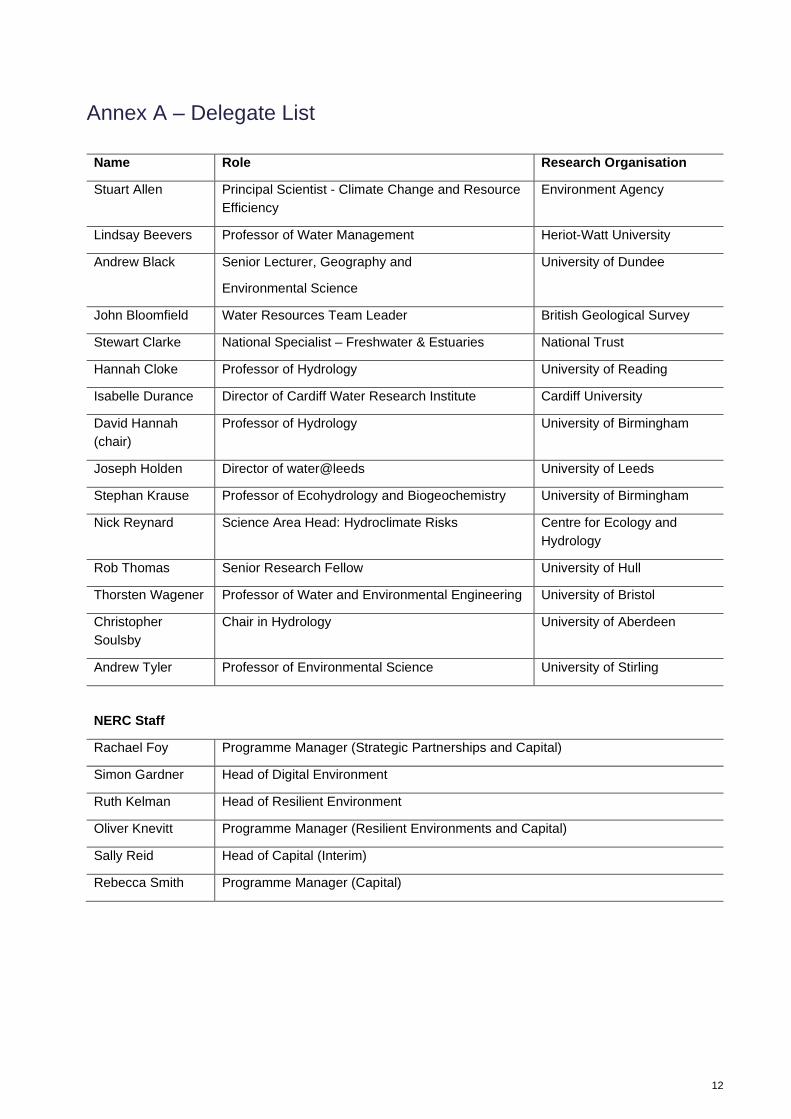
Annex A – Delegate List
Name Role Research Organisation
Stuart Allen Principal Scientist - Climate Change and Resource Efficiency
Environment Agency
Lindsay Beevers Professor of Water Management Heriot-Watt University
Andrew Black Senior Lecturer, Geography and
Environmental Science
University of Dundee
John Bloomfield Water Resources Team Leader British Geological Survey
Stewart Clarke National Specialist – Freshwater & Estuaries National Trust
Hannah Cloke Professor of Hydrology University of Reading
Isabelle Durance Director of Cardiff Water Research Institute Cardiff University
David Hannah (chair)
Professor of Hydrology University of Birmingham
Joseph Holden Director of water@leeds University of Leeds
Stephan Krause Professor of Ecohydrology and Biogeochemistry University of Birmingham
Nick Reynard Science Area Head: Hydroclimate Risks Centre for Ecology and Hydrology
Rob Thomas Senior Research Fellow University of Hull
Thorsten Wagener Professor of Water and Environmental Engineering University of Bristol
Christopher Soulsby
Chair in Hydrology University of Aberdeen
Andrew Tyler Professor of Environmental Science University of Stirling
NERC Staff
Rachael Foy Programme Manager (Strategic Partnerships and Capital)
Simon Gardner Head of Digital Environment
Ruth Kelman Head of Resilient Environment
Oliver Knevitt Programme Manager (Resilient Environments and Capital)
Sally Reid Head of Capital (Interim)
Rebecca Smith Programme Manager (Capital)

13
Annex B – Workshop agenda
9.30 - 10.00 Arrival (refreshments available)
10.00 - 10.15 Welcome, introductions and aims for the day David Hannah, Sally
Reid, Simon Gardner
10.15 - 11.15 Session 1 – Science questions All
11.15 - 11.30 Refreshment break
11.30 - 12.45 Session 2 – Key catchment properties All
12.45 - 1.30 Lunch
1.30 – 2.45 Session 3 – Target variables, and suggested technologies All
2.45 – 3.00 Refreshment break
3.00 – 3.55 Session 4 – Steps to implementation All
3.55 - 4.00 Next steps from NERC Sally Reid
4.00 Workshop close

14
Annex C – Questionnaire sent to EOI submitters
Floods and Droughts Pre-workshop Questionnaire
Please consider all the questions below. All responses are due by 4pm Monday 11 November 2019. Please submit by email to [email protected]
1. Science questions
The high-level research challenges which were developed in the earlier scoping of the business case are listed below, and we would like to review these to ensure that they are suitably ambitious, i.e. represent a step-change in our understanding, and that there aren’t any key gaps.
Previously developed questions:
Q1 Which catchment properties and interactions control the extent, magnitude and duration of floods and droughts and how can this knowledge be used to better understand and predict the impacts of climate change in both the short and long term?
Q2 How can measurements / observations be used more effectively to improve catchment process understanding and reduce uncertainty under extreme hydrological conditions?
Q3 Can a UK-wide flood, drought and related hazard ‘models of everywhere’ be developed from multiple catchment observations combined with analytical tools to support future decision making, i.e. forecasting, targeted interventions and incident response and recovery?
We would like to capture your thoughts on these science questions and would ask you to fill in your responses to the prompts below:
In your opinion, do these science questions adequately represent the major uncertainties in current understanding of catchment hydrology? Please comment on the level of ambition and any knowledge gaps that you consider may not have been covered.
2. Catchment properties
a. The following catchment properties have identified as being key to representing the range of possible hydrological responses. In terms of bringing the catchment infrastructure online, please rank them in order with 1 being the catchment you would bring online first and 6 being the one you would bring online last:
Catchment type/property Rank
Groundwater dominated - agricultural, lowland, irrigated, peri-urban areas
Upland, peat dominated - steep sloped, forestry, flood-prone, urban areas
Hard rock island - drought prone
Estuarine - storm surge, waves, fluvial flood, urban
Chalk, groundwater dominated - flooding, drought processes
Urban dominated - culverted, small tributaries, water quality problems, pluvial flooding, storm water flooding
Intensively managed landscapes, for example water quality impacts of agriculture

15
b. Are there catchment types/properties typical of the UK that are missing from the list? Please give details below and indicate its relative importance:
3. Key variables
Candidates wishing to be considered for a place at this event were asked to submit their top priorities for variables, measurements and observations to be recorded at the catchments. A word cloud and summary of these responses is provided in Annex D.
Looking at the collated responses, are the expected range of variables represented? Should these be measured at each catchment site? Are there variables you would like to be able to measure but are as yet unable to do so because of a lack of appropriate technology/sensors, and is there scope for development here? Please provide your thoughts below:
4. Next steps discussion
In previous scoping activities, the following objectives were drawn up. During the workshop, we will use this as a starting point for discussions on how best to deliver on this infrastructure. Please provide some general thoughts on how you would suggest this is achieved; whether these objectives are appropriate; and key considerations for any implementation plan. Some discussion questions are provided below to act as a prompt but are for guidance only.
Previously developed project objectives:
1. To deploy up to five new long term SMART integrated research infrastructures across representative flood and drought prone catchments in the UK, instrumented with existing state of the art technologies.
2. To develop a catchment-scale test-bed platform for innovation of next generation monitoring and measurement technologies.
3. To establish a fully functional hydrological data hub for quality assurance, streaming and management of real-time, integrated hydrological data to support new research and multiple other user needs.
4. To deliver rapidly-deployable mobile monitoring facilities for capturing full duration of specific extreme events within and outside the catchment observatories
Discussion questions:
• Is a phased approach appropriate for this infrastructure? • If yes, which of the activities would you suggest doing up front? • What would these success stories look like and how would they be best achieved? What is
transformative about these successes? • What budget should be allocated to each of these? • What implications/considerations do they have for the bigger picture?
Please provide your thoughts in the box below. These comments will be collated and be available during the discussion at the workshop:
5. Finally, are there any other comments on the scoping of this infrastructure that you would like to add that you feel is not covered by the previous questions?
Thank you for completing the questionnaire. Please submit your responses to this questionnaire by email to [email protected] by 4pm Monday 11 November 2019.

16
Annex D - EoI Responses
Individuals who applied to the NERC capital workshop on floods and droughts resilience were asked to identify their top observation/measurement priorities. Commonly identified themes from these responses include, but are not limited to:
• Increasing the spatio-temporal resolution of measurements (notably to catchment scale); • Monitoring flow and understanding the variables which may impact/influence this; • Improving understanding and observation of soil moisture content; • Implementing real-time, autonomous sensors at high spatial resolution; • Increasing the resolution of data (e.g., via equipment, historical data and/or data sharing); • Decreasing the uncertainty of measurements and predictions; • Understanding and monitoring how land-use changes/management can affect catchments; • Water quality parameters.
Keywords from the responses are also displayed as a word cloud (beneath). These keywords and themes may form part of a broader discussion.