Embed Size (px)
Citation preview

City of Surrey PLANNING & DEVELOPMENT REPORT
File: 7914-0323-00
Planning Report Date: September 14, 2015
PROPOSAL:
• NCP Amendment from Half-Acre Residential to Single Family Front Accessed 6-10 upa
• Rezoning from RA to RF and RF-12
to allow subdivision into six (6) single family lots
LOCATION: 7071 - 193 Street
OWNERS: Navjot Sikham Pavitter Singh Sikham
ZONING: RA
OCP DESIGNATION: Urban
NCP DESIGNATION: Half-Acre Residential
INFILL PLAN DESIGNATION:
Single Family Front Accessed (6-10 upa)
Staff Report to Council File: 7914-0323-00
Planning & Development Report
Page 2 RECOMMENDATION SUMMARY • By-law Introduction and set date for Public Hearing for Rezoning. DEVIATION FROM PLANS, POLICIES OR REGULATIONS • Although the application complies with the Aloha Estates Infill Area Concept Plan, an
amendment to the East Clayton Neighbourhood Concept Plan (NCP) is required. RATIONALE OF RECOMMENDATION • Complies with the Aloha Estates Infill Area Concept Plan, which was approved by Council on
October 28, 2013 (Corporate Report No. R219; 2013).
• The proposed development is compatible with RF-12-zoned single family lots proposed to the immediate north of the subject site under Application No. 7914-0107-00 (rezoning at Third Reading).
• The proposed lots will provide variety in the neighbourhood.
Staff Report to Council File: 7914-0323-00
Planning & Development Report
Page 3 RECOMMENDATION The Planning & Development Department recommends that: 1. a By-law be introduced to rezone Block A shown on the Survey Plan from "One-Acre
Residential Zone (RA )" (By-law No. 12000) to "Single Family Residential (12) Zone (RF-12)" (By-law No. 12000) and Block B on the Survey Plan from "One-Acre Residential Zone (RA)" (By-law No. 12000) to "Single Family Residential Zone (RF)" (By-law No. 12000) and a date be set for Public Hearing.
2. Council instruct staff to resolve the following issues prior to final adoption:
(a) ensure that all engineering requirements and issues including restrictive covenants, dedications, and rights-of-way where necessary, are addressed to the satisfaction of the General Manager, Engineering;
(b) submission of a subdivision layout to the satisfaction of the Approving Officer;
(c) submission of a finalized tree survey and a statement regarding tree preservation
to the satisfaction of the City Landscape Architect; (d) the applicant satisfy the deficiency in tree replacement on the site, to the
satisfaction of the Planning and Development Department; and
(e) demolition of existing buildings and structures to the satisfaction of the Planning and Development Department.
3. Council pass a resolution to amend the East Clayton Neighbourhood Concept Plan (NCP)
to redesignate the land from "Half-Acre Residential" to "Single Family Front Accessed 6-10 upa" when the project is considered for final adoption.
REFERRALS Engineering: The Engineering Department has no objection to the project
subject to the completion of Engineering servicing requirements as outlined in Appendix III.
School District: Projected number of students from this development: 3 Elementary students at Katzie Elementary School 2 Secondary students at Clayton Heights Secondary School (Appendix IV) The applicant has advised that the dwelling units in this project are expected to be constructed and ready for occupancy by Fall 2016.

Staff Report to Council File: 7914-0323-00
Planning & Development Report
Page 4 Parks, Recreation & Culture:
The Parks, Recreation and Culture Department has no objection to the development proposal.
Fortis BC:
Fortis BC has no requirements relative to the proposed subdivision and rezoning.
SITE CHARACTERISTICS Existing Land Use: Acreage parcel with single family dwelling to be removed and a gas right-
of-way along most of the south lot line. Adjacent Area:
Direction Existing Use Aloha Estates Infill Area Concept Plan Designation
Existing Zone
North:
Single family dwelling on acreage parcel under Application No. 7914-0177-00 for 22 single family small lots (proposed RF-10 and RF-12 at Third Reading).
Single Family Front Accessed 6-10 upa
RA
East (Across 193 Street):
Single family dwelling on acreage parcel and new park site.
Single Family Front Accessed 6-10 upa and Park
RA
South (Across Fortis BC ROW):
Single family dwelling on acreage parcel.
Townhouse 20-25 upa RA
West:
Single family dwelling on acreage parcel.
Single Family Front Accessed 6-10 upa and Townhouse 20-25 upa
RA
DEVELOPMENT CONSIDERATIONS Background • The original Aloha Estates subdivision was approved in 1978 and consisted of thirty-six (36),
minimum one-acre residential lots. • The East Clayton Neighbourhood Concept Plan (NCP) (Appendix VII) was approved by
Council on March 3, 2003 (Corporate Report No. C-006) to guide the development of the eastern portion of a larger area covered by the Clayton General Land Use Plan.

Staff Report to Council File: 7914-0323-00
Planning & Development Report
Page 5 • At the time the East Clayton NCP was developed through the public consultation process, the
residents and property owners within the Aloha Estates neighbourhood of East Clayton indicated that they were not in favour of redeveloping their properties but were willing to support a Half-Acre Residential designation for their neighbourhood.
• In recent years, there has been interest in amending the current Half-Acre Residential
designation in order to permit redevelopment of the area.
• On May 27, 2013, the owners of three properties in Aloha Estates (7091 – 193 Street, 19289 - 71 Avenue, and 7138 - 192 Street), submitted Application No. 7913-0111-00 to rezone and subdivide these properties into a mix of small single family lots and a remnant parcel for future multi-family development.
• As the above-noted application did not comply with the Half-Acre Residential designation
within the East Clayton NCP, the Planning Department consequently sought Council authorization to proceed with the preparation of an infill development plan to guide redevelopment for the entire Aloha Estates neighbourhood.
• Following a public consultation process, staff prepared the Aloha Estates Infill Area Concept
Plan ("Aloha Estates Plan") (Appendix VIII), which was approved by Council on October 28, 2013 (Corporate Report No. R219). As noted in Corporate Report No. R219, the intent of the Aloha Estates Plan is to guide future amendments to the East Clayton Neighbourhood Concept Plan ("NCP") through individual land development applications.
Site Context • The approximately 4,000-square metre (1 ac.) subject site is located within the Aloha Estates
neighbourhood of East Clayton.
• The subject site is designated "Urban" in the Official Community Plan (OCP), "Half-Acre Residential" in the East Clayton NCP, and "Single Family Front Accessed (6-10 upa)" in the Aloha Estates Plan, and is zoned "One-Acre Residential Zone (RA)".
Justification for NCP Amendment • The applicant is seeking an amendment to the East Clayton NCP to redesignate the subject
site from Half-Acre Residential to Single Family Front Accessed (6-10 upa).
• The intent of the Aloha Estates Plan is to guide future amendments to the East Clayton Neighbourhood Concept Plan (NCP) through individual land development applications in the plan area.
• The proposed amended East Clayton NCP designation is consistent with the land use
designation proposed in the Aloha Estates Plan. For this reason, the proposed NCP amendment has merit.
Staff Report to Council File: 7914-0323-00
Planning & Development Report
Page 6 Current Application • In addition to the proposed amendment to the East Clayton NCP the applicant proposes to
rezone the subject site from "One-Acre Residential Zone (RA)" to the following:
o "Single Family Residential (12) Zone (RF-12)" to allow subdivision into two (2) single family lots in the northwest portion, called Block A; and
o "Single Family Residential Zone (RF)" to allow subdivision into four (4) single family lots for the east and southern portions, called Block B.
• Proposed Lots 1-3 will front 193 Street and proposed Lots 4-6 will front a proposed cul-de-sac (192A Street) off of 71 Avenue. 192A Street will be built to a Neo-traditional half-road standard, and constructed to its ultimate width when the adjacent western property located at 7086 – 192 Street develops.
• The northern half-road portion of 192A Street, south of 71 Avenue is to be constructed under Application No. 7914-0107-00 (Third Reading), and will provide road access to the western side of the subject site from 71 Avenue.
• Proposed Lots 1 through 4 will comply with the RF Zone, ranging in size from 560 square
metres (6,000 sq. ft.) to 901 square metres (9,700 sq. ft.), in depth from 29 metres (95 ft.) to 45 metres (147 ft.), and in width from 16.7 metres (55 ft.) to 23 metres (75 ft.). Proposed Lots 1 through 3 will be oriented towards 193 Street, and proposed Lot 4 will be oriented towards the proposed cul-de-sac.
• Proposed Lots 5 and 6 will comply with the dimensional requirements of the RF-12 Zone, ranging in size from 379 square metres (4,000 sq. ft.) to 400 square metres (4,300 sq. ft.), in depth from 28.5 metres (94 ft.) to 30 metres (98 ft.), and are 15.5 metres (51 ft.) wide. Proposed Lots 5 and 6 will be oriented towards the proposed cul-de-sac.
• Proposed Lots 5 and 6 are irregular shaped. The applicant retained Mike Tynan of Tynan
Consulting Ltd. to provide a building footprint analysis, and confirmed that both lots can achieve the maximum house size without a Development Variance Permit for reduced setbacks.
• The applicant will provide a north/south 6-metre (20 ft.) wide walkway in the southwest
corner of the site. The walkway will provide a connection from the proposed cul-de-sac to a future east/west multi-use pathway, which will run along a portion of the Fortis BC gas right-of-way, adjacent proposed Lots 3 and 4.
Multi-Use Pathway • A portion of the southern boundary of the subject lot is encumbered by a Fortis BC gas right-
of-way (ROW) and is adjacent a future multi-use pathway to the south, as shown in the Aloha Estates Plan (Appendix VIII).
Staff Report to Council File: 7914-0323-00
Planning & Development Report
Page 7 • Although the future multi-use pathway is not shown on the subject site in the Aloha Estates
Plan, staff requested the applicant to convey the portion of the subject site encumbered by the ROW to the City as a lot. This would achieve a pathway width that is consistent with the existing multi-use pathway to the west of 192 Street and the future multi-use pathway to the east of 193 Street, which spans the entire width of the Fortis BC right-of-way. The conveyance would improve the continuity of the multi-use pathway that traverses East Clayton and address the lack of City funding to acquire this portion.
• In exchange for the applicant conveying the area encumbered by the right-of-way to the City
(which would not affect the applicant’s lot yield), staff suggested a Comprehensive Development (CD) Zone on all six proposed lots that would permit comparable house sizes. However, the applicant was not agreeable to conveying the encumbered portion of the subject lot to the City.
• The multi-use pathway shown in the Aloha Estates Plan, between 192 and 193 Streets, is intended to be secured through the multi-family development to the south and west of the subject site. A portion of the multi-use pathway to the southwest of the subject lot, is intended to be secured under current development Application No. 7914-0278-00 (scheduled to be considered by Council on September 14, 2015), which proposes 23 townhouse units.
• Without conveying the encumbered area of the subject site to the City, a portion of the
future multi-use pathway to the south of the subject site will have a smaller width than the future multi-use pathway on the east side of 193 Street, as well as the existing multi-use pathway on the west side of 192 Street.
Building Scheme and Lot Grading • The applicant retained Mike Tynan of Tynan Consulting Ltd. as the Design Consultant. The
Design Consultant conducted a character study of the surrounding older homes and based on the findings of the study, proposed a set of building design guidelines for all proposed lots (Appendix V). The older homes in the area do not provide a suitable architectural context for a post 2010 RF-zone development. The building design guidelines use updated standards that result in reasonable compatibility with the older homes in the area.
• For Crime Prevention Through Environmental Design (CPTED) purposes, the Building Scheme contains a provision that limits the height of the landscaping to 1.2 metres (4 ft.) along the southern property line, adjacent the future multi-use pathway.
• A preliminary lot grading plan was submitted by CitiWest Consulting Ltd. Up to 1.1 metres (3.6 ft.) of fill is proposed in order to meet the road grade for the proposed cul-de-sac and 193 Street.
• A 1-metre (3.3 ft.) high retaining wall is proposed adjacent the Fortis BC ROW on a portion of
proposed Lots 3 and 4.
• The applicant proposes basements on all six (6) lots. The feasibility of in-ground basements will be confirmed once the City’s Engineering Department has reviewed and accepted the applicant’s final engineering drawings.
Staff Report to Council File: 7914-0323-00
Planning & Development Report
Page 8 PRE-NOTIFICATION Pre-notification letters were mailed on December 22, 2014 and staff received one response as summarized below: • The Cloverdale Community Association (CCA) submitted a letter (Appendix IX) and has no
objections to the proposed RF and RF-12 lots. However, the letter outlined several requests, described below (with staff comments in italics):
o 193 Street should be widened to accommodate parking on both sides of the street.
(On-street parking will be permitted on both sides of 193 Street, once it is constructed to its ultimate width.)
o A parking pad should be constructed adjacent the garage to accommodate parking for
a secondary suite and garage sizes should be 6.4 metres (21 ft.) deep and 6.1 metres (20 ft.) wide. A restrictive covenant should be required in this regard.
(The driveways will be a minimum of 6.7 metres (22 ft.) deep for proposed Lots 1-4 and 6.0 metres (20 ft.) deep for proposed Lots 4 and 5 and can accommodate two spaces. Including the garage, the proposed lots can accommodate a total of four off-street vehicles, which complies with the Zoning By-law requirement for single family dwellings with a secondary suite. The width of proposed Lots 1-3 is wide enough to accommodate a parking pad adjacent the garage, and therefore, proposed Lots 1-3 could accommodate 5 off-street vehicles. Proposed Lot 4 is partially encumbered by the Fortis BC right-of-way and requires an approved permit from Fortis BC for the parking of vehicles within the right-of-way. Proposed Lots 5 and 6 are RF-12 lots and are not wide enough to accommodate a parking pad adjacent the garage. The minimum double wide (side-by-side parking) garage size in the Zoning By-law is 5.7 metres (18.8 ft.) wide by 6.1 metres (20 ft.) deep, which is slightly less than the 6.1-metre (20 ft.) width and 6.4-metre (21 ft.) depth requested by the CCA. Due to the impact on livable space and permeable area, staff are not recommending parking pads (proposed Lots 4-6 only) or that larger garages be imposed, although specifically requested by the CCA.)
o Driveways should be located such that maximum street parking on 193 Street can be
achieved.
(Driveways will be paired, which allows for more on-street parking.)
Staff Report to Council File: 7914-0323-00
Planning & Development Report
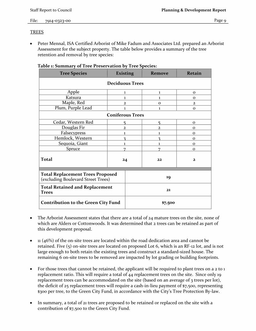
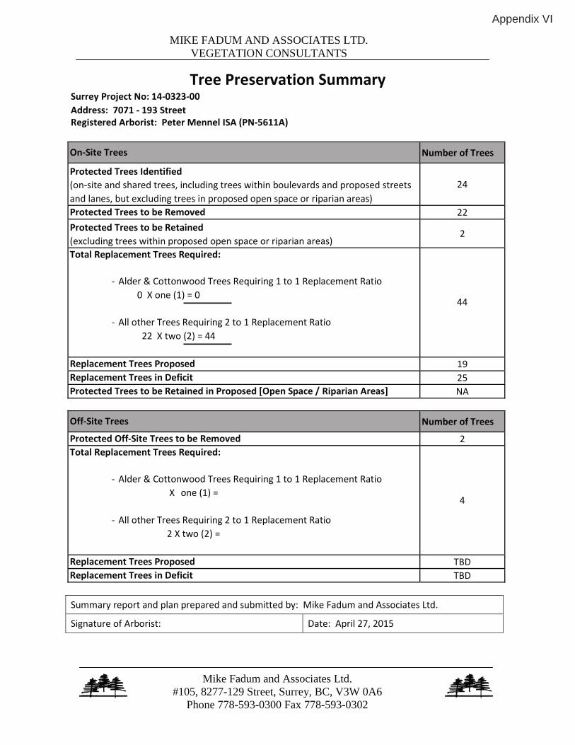
Page 9 TREES • Peter Mennal, ISA Certified Arborist of Mike Fadum and Associates Ltd. prepared an Arborist
Assessment for the subject property. The table below provides a summary of the tree retention and removal by tree species: Table 1: Summary of Tree Preservation by Tree Species:
Tree Species Existing Remove Retain
Deciduous Trees
Apple 1 1 0 Katsura 1 1 0
Maple, Red 2 0 2 Plum, Purple Lead 1 1 0
Coniferous Trees Cedar, Western Red 5 5 0
Douglas Fir 2 2 0 Falsecypress 1 1 0
Hemlock, Western 3 3 0 Sequoia, Giant 1 1 0
Spruce 7 7 0
Total 24 22 2
Total Replacement Trees Proposed (excluding Boulevard Street Trees) 19
Total Retained and Replacement Trees 21
Contribution to the Green City Fund $7,500
• The Arborist Assessment states that there are a total of 24 mature trees on the site, none of
which are Alders or Cottonwoods. It was determined that 2 trees can be retained as part of this development proposal.
• 11 (46%) of the on-site trees are located within the road dedication area and cannot be retained. Five (5) on-site trees are located on proposed Lot 6, which is an RF-12 lot, and is not large enough to both retain the existing trees and construct a standard-sized house. The remaining 6 on-site trees to be removed are impacted by lot grading or building footprints.
• For those trees that cannot be retained, the applicant will be required to plant trees on a 2 to 1
replacement ratio. This will require a total of 44 replacement trees on the site. Since only 19 replacement trees can be accommodated on the site (based on an average of 3 trees per lot), the deficit of 25 replacement trees will require a cash-in-lieu payment of $7,500, representing $300 per tree, to the Green City Fund, in accordance with the City’s Tree Protection By-law.
• In summary, a total of 21 trees are proposed to be retained or replaced on the site with a
contribution of $7,500 to the Green City Fund.

Staff Report to Council File: 7914-0323-00
Planning & Development Report
Page 10 SUSTAINABLE DEVELOPMENT CHECKLIST The applicant prepared and submitted a sustainable development checklist for the subject site on November 7, 2014. The table below summarizes the applicable development features of the proposal based on the seven (7) criteria listed in the Surrey Sustainable Development Checklist.
Sustainability Criteria
Sustainable Development Features Summary
1. Site Context & Location
(A1-A2)
• Complies with the Aloha Estates Infill Area Concept Plan.
2. Density & Diversity (B1-B7)
• Two different residential zones are proposed, to create a mix of lot sizes. Secondary suites will be permitted.
3. Ecology & Stewardship
(C1-C4)
• Replacement trees and cash-in-lieu for the tree deficiency will be provided.
4. Sustainable Transport & Mobility
(D1-D2)
• A connection to the future Clayton Greenway will be provided.
5. Accessibility & Safety
(E1-E3)
• CPTED principles will be applied along the southern property line, which will border the future Clayton Greenway.
6. Green Certification (F1)
• N/A
7. Education & Awareness
(G1-G4)
• Pre-notification letters were mailed to residents and a development proposal sign was installed on site.

Staff Report to Council File: 7914-0323-00
Planning & Development Report
Page 11 INFORMATION ATTACHED TO THIS REPORT The following information is attached to this Report: Appendix I. Lot Owners, Action Summary, Project Data Sheets and Survey Plan Appendix II. Proposed Subdivision Layout Appendix III. Engineering Summary Appendix IV. School District Comments Appendix V. Building Design Guidelines Summary Appendix VI. Summary of Tree Survey and Tree Preservation Appendix VII. NCP Amendment Map Appendix VIII. Aloha Estates Plan Appendix IX. Comments from the Cloverdale Community Association
original signed by Judith Robertson Jean Lamontagne General Manager Planning and Development JD/da \\file-server1\net-data\csdc\generate\areaprod\save\15335344038.doc KD 9/9/15 1:23 PM

\\file-server1\net-data\csdc\generate\areaprod\save\15335344038.doc KD 9/9/15 1:23 PM
APPENDIX I
Information for City Clerk Legal Description and Owners of all lots that form part of the application: 1. (a) Agent: Name: Roger Jawanda
Citiwest Consulting Ltd. Address: 9030 - King George Blvd, Unit 101 Surrey, BC V3V 7Y3 Tel: 604-591-2213
2. Properties involved in the Application
(a) Civic Address: 7071 - 193 Street
(b) Civic Address: 7071 - 193 Street Owner: Navjot Sikham Pavitter S Sikham PID: 005-240-671 Lot 31 Section 15 Township 8 New Westminster District Plan 54452
3. Summary of Actions for City Clerk's Office
(a) Introduce a By-law to rezone the property.

\\file-server1\net-data\csdc\generate\areaprod\save\15335344038.doc KD 9/9/15 1:23 PM
SUBDIVISION DATA SHEET
Proposed Zoning: RF and RF-12
Requires Project Data Proposed GROSS SITE AREA Acres 1.0 Hectares 0.4 NUMBER OF LOTS Existing 1 Proposed 6 SIZE OF LOTS Range of lot widths (metres) RF: 16.7 metres to 23 metres
RF-12: 15.5 metres Range of lot areas (square metres) RF: 560 sq. m. to 901 sq. m.
RF-12: 379 sq. m. to 400 sq. m. DENSITY Lots/Hectare & Lots/Acre (Gross) 14.75 upha / 6 upa Lots/Hectare & Lots/Acre (Net) 17.2 upha / 7 upa SITE COVERAGE (in % of gross site area) Maximum Coverage of Principal &
Accessory Building RF: 60%
RF-12: 70% Estimated Road, Lane & Driveway Coverage RF and RF-12: 21.6& Total Site Coverage RF: 81.6% RF-12: 91.6% PARKLAND Area (square metres) N/A % of Gross Site Required PARKLAND 5% money in lieu YES TREE SURVEY/ASSESSMENT YES MODEL BUILDING SCHEME YES HERITAGE SITE Retention NO FRASER HEALTH Approval NO DEV. VARIANCE PERMIT required Road Length/Standards NO Works and Services NO Building Retention NO Others NO

SURVEY PLAN TO ACCOMPANY CITY OF SURREY REZONING BYLAW NO. OF LOT 31, SECTION 15, TOWNSHIP 8, NWD, PLAN 54452 City of Surrey B.C.G.S. 92G.017
0 10 20 JO 40 50 m ,.,._. ~~-~--~
SCALE - 1 : 750 All distances are in metres
11 Plan 54452 BLOCK A
0.117 ho.
30 Plan 54452
'm S !'IN 0>· ~m oN
31
90'15'50" 28.126
Plan 54452
10 Plan 54452
Cameron Land Surveying Ltd. B.C. Land Surveyors Unit 206 - 16055 Fraser Highway Surrey, B.C. V4N OG2 Phon~ 604-597-3777 Fax: 604-597-3783
BLOCK B
90'15'51"
32 Plan 5#52

²
²
²
²
²
²
²
²
²
²
²
H:\P
roje
cts\
3165
\Dw
g\31
65La
yout
.dw
g
Appendix
II

Appendix III
ktsU'RREY • the future lives here.
INTER-OFFICE MEMO
TO . Manager, Area Planning & Development - North Surrey Division Planning and Development Department
FROM: Development Services Manager, Engineering Department
DATE: Revision #1, June 10, 2015 PROJECT FILE:
RE: Engineering Requirements Location: 7071 193 Street
NCP AMENDMENT
All engineering requirements relative to the OCP Amendment will be addressed through the rezone/subdivision requirements listed below.
REZONE/SUBDIVISION
Property and Right-of-Way Requirements • Dedicate 11.5 m for 192A Street to the Half Road Standard and necessary lands required for the
14.0 m radius cul-de-sac. • Dedicate 6.o m at the end of the 192A Street cul-de-sac to connect to the Clayton Greenway. • Provide a o.s m SRW along 192A Street and 193 Street frontages. • Provide offsite SRW's required to access and service the development if not provided by Surrey
Project 7814-0107-oo.
Works and Services • Construct 193 Street to the Neo-Traditional Local Road Standard. • Construct east side of192A Street to the Half Road Standard. • Provide cash-in-lieu for the construction of the 3.0 m concrete walkway. • Construct 6.o m driveway letdowns to each lot. • Construct 71 Avenue and 192 A Avenue to the Half Road Standard if not constructed under
Surrey Project 7814-0107-oo • Complete a comprehensive stormwater servicing plan for Aloha Estates and resolve drainage
issues. • Construct sanitary sewer upgrades to resolve downstream capacity constraints. • Construct storm, water and sanitary mains and service connections to service the
development.
~mentis required prior to Rezone/Subdivision.
Remi Dube, P.Eng. Development Services Manager
CE
NOTE: Detailed Land Development Engineering Review available on file

School Enrolment Projections and Planning Update:The following tables illustrate the enrolment projections (with current/approved ministrycapacity) for the elementary and secondary schools serving the proposed development.
THE IMPACT ON SCHOOLS
APPLICATION #: 14 0323 00
SUMMARY
The proposed 6 Single family with suites Katzie Elementaryare estimated to have the following impacton the following schools:
Projected # of students for this development:
Elementary Students: 3Secondary Students: 2
September 2014 Enrolment/School Capacity
Katzie ElementaryEnrolment (K/1-7): 135 K + 510 Capacity (K/1-7): 80 K + 525
Clayton Heights SecondaryEnrolment (8-12): 1270 Clayton Heights SecondaryNominal Capacity (8-12): 1000 Functional Capacity*(8-12); 1080
Projected cumulative impact of development Nominal Capacity (8-12):subject project) in the subject catchment areas:
Elementary Students: 35Secondary Students: 288Total New Students: 323
Katzie is a new elementary school in the East Clayton NCP Area which opened during 2013-2014 School Year. The new school has relieved overcrowding in neighbouring schools but is now full and Katize, Hazelgrove and Clayton Elementary have a combined capacity of 111% (and projected to increase to 130% within two years). Between existing housing, and planned growth, Clayton area schools will have increased portable requirements and boundary adjustments for September 2015. The construction of additional elementary school capacity in the area is a high priority within the district's 5-Year Capital Plan. The school district has received capital project approval for a new North Clayton Area Secondary (site #215) that will relieve overcrowding at Clayton Heights Secondary, Lord Tweedsmuir Secondary and North Surrey Secondary.
PlanningDecember-02-14
*Functional Capacity at secondary schools is based on space utilization estimate of 27 students per instructional space. The number of instructional spaces is estimated by dividing nominal facility capacity (Ministry capacity) by 25.
0
200
400
600
800
1000
1200
2010 2011 2012 2013 2014 2015 2016 2017 2018 2019
Enrolment
Capacity
0
200
400
600
800
1000
1200
1400
1600
1800
2000
2010 2011 2012 2013 2014 2015 2016 2017 2018 2019
Enrolment
Capacity
Functional Capacity
Appendix IV

BUILDING GUIDELINES SUMMARY
Surrey Project no: 7914-0323-00 Project Location: 7071 - 193 Street, Surrey, B.C. Design Consultant: Tynan Consulting Ltd., (Michael E. Tynan)
The draft Building Scheme proposed for this Project has been filed with the City Clerk. The following is a summary of the Residential Character Study and the Design Guidelines which highlight the important features and form the basis of the draft Building Scheme.
1. Residential Character
1.1 General Description of the Existing and/or Emerging Residential Character of the Subject Site:
This area was built out over a time period spanning from the 1960's to the 1990's. The age distribution from oldest to newest is: 1960's (25%), 1970's (63%), and 1990's (13%). A majority of homes in this area have a floor area over 3500 sq.ft.. Home size distribution is: 2001 - 2500 sq.ft. (13%), 2501 - 3000 sq.ft. (25%), 3001 - 3550 sq.ft. (25%), over 3500 sq.ft. (38%). Styles found in this area include: "Old Urban" (25%), "West Coast Traditional (English Tudor emulation)" (25%), "West Coast Traditional" (13%), "Modern California Stucco" (13%), "Traditional English" (13%), and "Traditional French Provincial" (13%). Home types include: Bungalow (13%), Basement Entry (13%), and Two-Storey (75%).
Massing scale (front wall exposure) characteristics include: Low mass structure (13%), Mid-scale massing (25%), Mid-scale massing with proportionally consistent, well balanced massing design (25%), Mid to high scale massing (25%), High scale, box-like massing (upper floor directly above the floor below, thereby exposing the entire upper floor wall mass to street views) (13%). All homes have a one storey high front entrance.
The range of roof slopes found in this area is: 5:12 (40%), 7:12 (10%), 9:12 (20%), 12:12 (30%). Main roof forms (largest upper floor truss spans) include: Main common hip roof (25%), Main common gable roof (63%), and Main Mansard roof (13%). Feature roof projection types include: Common Hip (33%), Common Gable (44%), Boston Hip (11%), and Shed roof (11%). Roof surfaces include: Rectangular profile type asphalt shingles (13%), Concrete tile (26%), and Cedar shingles (63%).
Main wall cladding materials include: Horizontal cedar siding (13%), and Stucco cladding (87%). Feature wall trim materials used on the front facade include: No feature veneer (38%), Brick feature veneer (25%), Wood wall shingles accent (13%), and Tudor style battens over stucco accent (25%). Wall cladding and trim colours include: Neutral (54%), and Natural (46%).
Covered parking configurations include: Double garage (38%), Triple garage (50%), Rear garage (13%). Driveway surfaces include: Asphalt driveway (87%), and Exposed aggregate driveway (13%).
Appendix V

A variety of landscaping standards are evident, including: Old suburban landscape standard with sod and modest plantings (25%), Old suburban landscape standard - with average plantings for this area (38%), old suburban landscape standard - high quality with numerous plantings (25%), and modern suburban landscape standard with modest plantings (13%).
1.2 Features of Surrounding Dwellings Significant to the Proposed Building Scheme:
1) Context Homes: The housing stock in the area surrounding the subject site does not provide suitable architectural context for a post year 2010 RF zone development. Massing scale, massing designs, roof designs, construction materials, and trim and detailing elements have improved significantly since most homes in this area were constructed. It is more sensible therefore, to use updated standards that result in reasonable compatibility with the older homes and also result in standards that improve over time, than it is to specifically emulate the older homes by building to the older standards.
2) Style Character : Neighbouring homes are either estate sized Traditional or Modern California Stucco homes, or are old urban homes that have massing designs and exterior trim and detailing standards that do not meet modern standards. Rather than emulating the existing homes, the recommendation is to utilize compatible styles including “Neo-Traditional”, “Neo-Heritage”, "Craftsman-Heritage" and "Rural Heritage". Note that style range is not specifically restricted in the building scheme. However, the consultant refers to the character study when reviewing plans for meeting style-character intent.
3) Home Types : There are a wide range of home types evident, and so some flexibility is justified. Home type (Two-Storey, Bungalow, Basement Entry, Split Level, etc.) will not be regulated in the building scheme.
4) Massing Designs : Massing designs should meet new standards for RF zoned subdivisions. New homes should exhibit "mid-scale" massing. Various elements and projections on the front of the home should be interesting architecturally, and should be in pleasing natural proportions to one another. These elements and projections should be located so as to create balance across the façade.
5) Front Entrance Design : Front entrance porticos range from one to 1 ½ storeys in height. The recommendation is to limit the range of entrance portico heights to between one storey and 1 ½ storeys to ensure there is not proportional overstatement of this one element.
6) Exterior Wall Cladding : The range of cladding materials used in this area, include cedar, stucco, brick, and stone. Reasonable flexibility should therefore be permitted, including the use of vinyl siding, provided the overall quality of wall cladding materials meets or exceeds common standards for post 2010 developments.
7) Roof surface : A wide range of roof surfacing materials have been used in this area including cedar shingles, concrete roof tiles, and asphalt shingles. The roof surface is not a uniquely recognizable characteristic of this area and so flexibility in roof surface materials is warranted. The recommendation is to permit cedar shingles, shake profile concrete roof tiles, shake profile asphalt shingles with a raised ridge cap, and new environmentally sustainable roof products that have a strong shake profile.
8) Roof Slope : Roof slopes of 7:12 or higher have been used on context homes. This is a suitable minimum roof slope given the objectives of ensuring continuity with context homes and to ensure that homes appear style-authentic within the proposed style range.

Streetscape: The area surrounding the subject site is comprised of a wide variety of homes situated on large RA zoned lots. There are two main categories of homes; estate-sized (3000+ sq.ft.) Two-Storey and Bungalow homes, and moderately sized (2000-2600 sq.ft.) "Old urban" or "West Coast Traditional" style box-like Basement Entry and Cathedral Entry forms. There is no obvious cohesive character. Massing scale ranges from "low" to "high-scale box-like". Roof slopes range from 4:12 to 12:12. Roof surfaces include cedar shingles, asphalt shingles and concrete roof tiles. Homes are clad in vinyl or stucco in neutral or natural colours. Landscapes range from "near natural" to above-average.
2. Proposed Design Guidelines
2.1 Specific Residential Character and Design Elements these Guidelines Attempt to Preserve and/or Create:
the new homes are readily identifiable as one of the following styles: “Neo-Traditional”, “Neo-Heritage”, “Craftsman-Heritage”, or “Rural Heritage”. Note that the proposed style range is not contained within the building scheme, but is contained within the residential character study which forms the basis for interpreting building scheme regulations.
a new single family dwelling constructed on any lot meets year 2000's design standards, which include the proportionally correct allotment of mass between various street facing elements, the overall balanced distribution of mass within the front facade, readily recognizable style-authentic design, and a high trim and detailing standard used specifically to reinforce the style objectives stated above.
trim elements will include several of the following: furred out wood posts, articulated wood post bases, wood braces and brackets, louvered wood vents, bold wood window and door trim, highly detailed gable ends, wood dentil details, stone or brick feature accents, covered entrance verandas and other style-specific elements, all used to reinforce the style (i.e. not just decorative).
the development is internally consistent in theme, representation, and character. the entrance element will be limited in height (relative dominance) to 1 to 1 ½ storeys.
2.2 Proposed Design Solutions:
Interfacing Treatment Existing neighbouring homes do not provide suitable contextwith existing dwellings) for the proposed RF type homes at the subject site. Interfacing
treatments are therefore not contemplated. Rather, massing design, construction materials, and trim element treatments will meet or exceed standards commonly found in RF developments constructed in Surrey subsequent to the year 2010.
Exterior Materials/Colours: Stucco, Cedar, Vinyl, Hardiplank, Brick, and Stone.
“Natural” colours such as browns, greens, clays, and other earth-tones, and “Neutral” colours such as grey, white, and cream are permitted. Primary colours are not recommended for this development, except on trim elements. “Warm” colours such as pink, rose, peach, salmon are not permitted. Trim colours: Shade variation of main colour, complementary, neutral, or subdued contrast only.

Roof Pitch: Minimum 7:12.
Roof Materials/Colours: Cedar shingles, shake profile concrete roof tiles, shake profile asphalt shingles with a raised ridge cap, and new environmentally sustainable roofing products should be permitted, providing that the aesthetic properties of the new materials are equal to or better than that of the traditional roofing products. Greys, black, or browns only.
In-ground basements: Permitted, subject to determination that service invert locations are sufficiently below grade. Basements will appear underground from the front.
Treatment of Corner Lots: Not applicable - there are no corner lots
Landscaping: Moderate modern urban standard: Tree planting as specified on Tree Replacement Plan plus minimum 20 shrubs of a minimum 3 gallon pot size. Sod from street to face of home. Driveways: exposed aggregate, interlocking masonry pavers, or stamped concrete.
any fencing installed along the south lot line on lots 3 and 4:
(i) shall be permeable, consisting of a horizontally aligned three rail boards type, with optional paige wire installed on the inside of the fence (between the fence and the dwelling);
(ii) shall be not less than 0.9m high, nor more than 1.2m high, and
(iii) shall be located parallel to and within 0.15m of said lotlines, and
(iv) landscaping installed along said lot lines shall consist solely of species with a maturity height of 1.2m or less,
(v) not less than 12 shrubs with maturity heights less than 1.2 metres shall be planted along the fence specified in clause 2.5(g), in addition to any other planting requirements.
Compliance Deposit: $5,000.00
Summary prepared and submitted by: Tynan Consulting Ltd. Date: January 4, 2015
Reviewed and Approved by: Date: January 4, 2015
MIKE FADUM AND ASSOCIATES LTD.VEGETATION CONSULTANTS
Mike Fadum and Associates Ltd.#105, 8277-129 Street, Surrey, BC, V3W 0A6
Phone 778-593-0300 Fax 778-593-0302
Tree Preservation Summary Surrey Project No: 14-0323-00 Address: 7071 - 193 StreetRegistered Arborist: Peter Mennel ISA (PN-5611A)
On-Site Trees Number of Trees
Protected Trees Identified (on-site and shared trees, including trees within boulevards and proposed streets and lanes, but excluding trees in proposed open space or riparian areas)
24
Protected Trees to be Removed 22 Protected Trees to be Retained (excluding trees within proposed open space or riparian areas)
2
Total Replacement Trees Required:
- Alder & Cottonwood Trees Requiring 1 to 1 Replacement Ratio 0 X one (1) = 0
- All other Trees Requiring 2 to 1 Replacement Ratio 22 X two (2) = 44
44
Replacement Trees Proposed 19 Replacement Trees in Deficit 25 Protected Trees to be Retained in Proposed [Open Space / Riparian Areas] NA
Off-Site Trees Number of Trees
Protected Off-Site Trees to be Removed 2 Total Replacement Trees Required:
- Alder & Cottonwood Trees Requiring 1 to 1 Replacement Ratio X one (1) =
- All other Trees Requiring 2 to 1 Replacement Ratio 2 X two (2) =
4
Replacement Trees Proposed TBD Replacement Trees in Deficit TBD
Summary report and plan prepared and submitted by: Mike Fadum and Associates Ltd.
Signature of Arborist: Date: April 27, 2015
Appendix VI
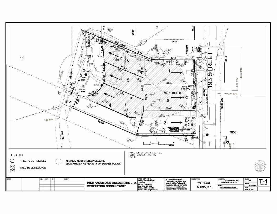
11
LEGEND
TREE TO BE RETAINED
TREE TO BE REMOVED
MINIMUM NO DISTURBANCE ZONE (6X DIAMETER AS PER CITY OF SURREY POLICY)
NOTE: NON BY-LAW TREES HAVE BEEN REMOVED FROM THE PLANS
MIKE FADUM AND ASSOCIATES LTD. VEGETATION CONSULTANTS
.-!05, B7T7129 8l 8Jnwy, Brttllh Coklmbll V3WOA8
"'" (7711)!113<!:!t00 F""{7711)~ Mm>loto («14) 2«HllOOI Emllll: nftdy
.. I ......
0 Copjlllght-. Till& d-"0 ond doolgn lo tho property of MU FU!m and Allodltel Ltd. ar.:l may not'NIP'Oduced or ulld for oltn•r prDfecl-wtlha•lh· .. ~·
! I I ! I i I 1 i i ;=; i fii I
! I
I ~
I I::E I~
_____ jc I~ 1-i I j (.._.
I ! I i f 7058
~ ~
~ ?1~ ..•••. ::;. '<JLY
1-
11
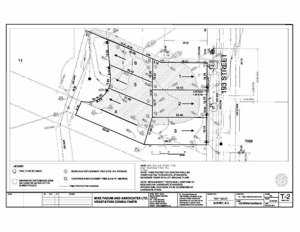
LEGEND
0 TREE TO BE RETAINED
( - - -,, MINIMUM NO DISTIJRBANCE ZONE \. _~/ (8X DIAMETER NJ PER CITY OF
SURREY POLICY)
I
lc .. ,.
& DECIDUOUS REPLACEMENT TREE (5 CM. DIA. MINIMUM)
Q CONIFE:ROUS REPLACE:MENT TREE (3.0 M HT. MINIMUM)
~~- TREE PROTECTION FENCING
.......
NOTE: NON BY-LAW TREES HAVE BEEN REMOVED FROM THE PLANS NOTE: TREE PROTECTION FENCING SHALl. BE CONSTRUCTED TO MUNICIPAL STANDARDS. REASSESS TRE:ES WITH L.0T GRADING PLANS.
NOTE: REPLACEMENT TREES SHALl. CONFORM TO BCSLAIBCLNA LANDSCAPE STANDARDS. SPECIES AND LOCATIONS TO BE DETERMINED AT LANDSCAPE STAGE.
.-!05, B7T7129 8l 0 Copjlllght-. 8Jnwy, Brttllh Coklmbll Till& d-"0 ond doolgn lolho
MIKE FADUM AND ASSOCIATES LTD. V3WOA8 property of MU FU!m and "'" (7711)!113<1:!100 Allodltel Ltd. ar.:l may not'-VEGETATION CONSULTANTS F""(7711)~ NIP'Oduced or ulld for oltn•r Mm>loo («14) 2«HllOOI prDfecl-wtlha•lh· .. ~· Emllll: nftdy
7058
~ ?1~ ..•••. ::;. '<JLY
. ..._ ..... IMiiiE'IliiUi
T-2 T2 - lREE PROTECTlON PIAN 7071193 ST.
II&T2Cifl ·- .. _ SURREY. B.C. C£0adW ... O...- Lid.

!(
!.
!.
!.
!.
!.
!.
B
POTENTIALTRANSIT
TRANSFER POINT D
A
BC GAS R.O.W.
5.69 ha(14.06 ac)
THES
E C
UL-
DE-
SAC
MIG
HT
NO
T B
E R
EQU
IRED
IFC
ON
SU
LID
ATIO
N O
FPA
RC
ELS
TAK
ES P
LAC
E
C
4.22 ha(10.42 ac)(Excludes
100 year floodpond areas)
For more detail on future land uses,see Aloha Estates Infill Area Land Use Concept,approved by Council on October 28, 2013
For more detail on future land uses, seeEast Clayton Transit Oriented Area Land Use Concept,approved by Council on April 28, 2014
McLellan Crk
North Crk
McLellan Crk
McLellan C
rk
188
St
196
St
72 Ave
68 Ave
70 Ave
192
St
193
St
Fraser Hwy
69 Ave
73 Ave
65 Ave
64 Ave
194A
St
194
St
68A Ave
69A Ave
74 Ave
195
St
63A Ave
67A Ave
68B Ave
189
St
193B
St
190
St
193A
St
63B Ave
195A
St71 Ave
72A Ave
194B
St
192A
St
70A Ave
191
St
187
St
63 Ave
187A
St
67 Ave
71A Ave
191A
St
66 Ave
192
St D
iv
62A Ave
195B
St
73B Ave
189A
St
70B Ave
66A Ave
191B
St
Watkins Dr
62 Ave
Greenside
Dr W
62B Ave
194 S
t
191
St
70A Ave
195A
St
195
St
194
St
187
St
191
St
63 Ave
70A Ave
192
St
70 Ave
195
St
72A Ave
63 Ave
191A
St
189
St
62A Ave
66 Ave
70 Ave
66A Ave
187A
St
191A
St
62A Ave
70A Ave
192 St
71A Ave
66 Ave
62A Ave
190
St
62A Ave
195A
St
192
St
193B
St
189 St
193 St
192A
St
71 Ave
191A
St
68A Ave
195
St
70 Ave
194B
St
67 Ave
63A Ave
67A Ave
EAST CLAYTON LAND USE PLANThis map is provided as general reference only. The City of Surrey makes no warrantees, express or implied,
as to the fitness of the information for any purpose, or to the results obtained by individuals using the information and is not responsible for any action taken in reliance on the information contained herein. (APPROVED BY COUNCIL AT ITS REGULAR MEETING OF MARCH 10, 2003. RESOLUTION R03-661) Amended May
·CITY OF SURREY - PLANNING & DEVELOPMENT DEPARTMENT
Open Space / Park on Private Property
Special Setback and Landscaping,Buffers (landscaped area on private property)
Natural Area
Public Open Space / Park
! ! ! ! ! !Multi Use Pathway on Public Landor on Private Property with PublicUse R.O.W.
Urban Landmark / Reference Point
Neighbourhood Gateway Feature
!H
Utility - Open Space
Specialty Community - Oriented Commercial
Institutional (church, schools,civic buildings, seniors housing, etc.)
Storm Water Ponds(100 year flood event)
Storm Water Pond onPrivate Property
School & Park
Riparian Protection Area
Commercial / Residential
Neighbourhood Commercial
15-25 u.p.a. (Medium-High Density)
10-15 u.p.a. Special Residential
10-15 u.p.a. (Medium Density)
6-10 u.p.a. (Low Density)
Half Acre Residential
Business Park
30-70 u.p.a. (High Density)
0 130 260 390 52065Meters
22-45 u.p.a. (High Density)
Proposed East Clayton NCPamendment from Half-AcreResidential to Single FamilyFront Accessed 6-10 upa
Appendix VIINCP Amendment Map
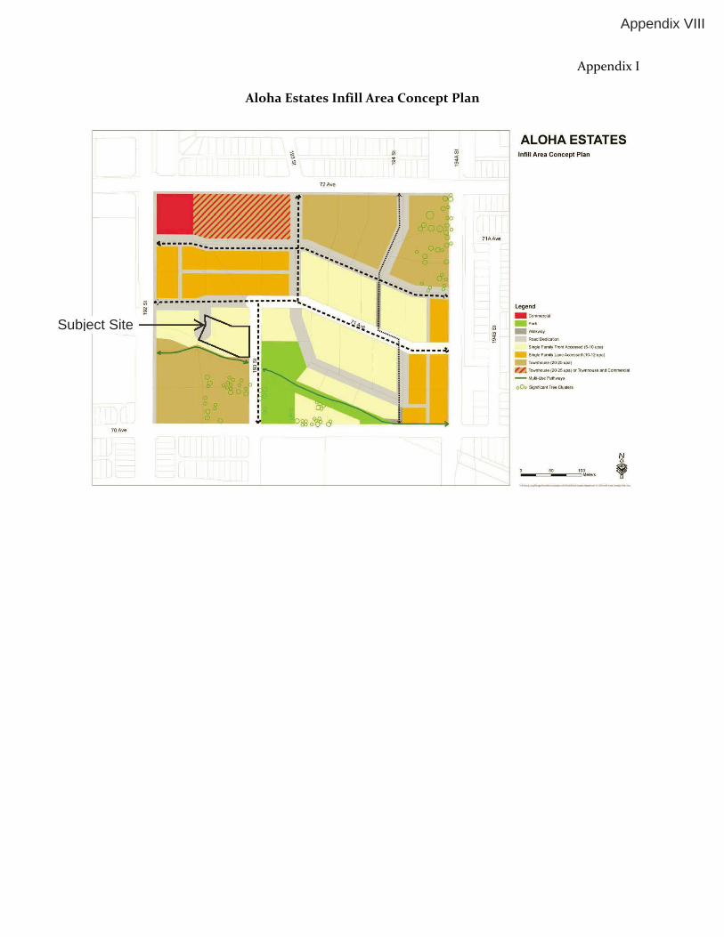
Appendix I
Aloha Estates Infill Area Concept Plan
Subject Site
Appendix VIII
72Ave
! l I • I :" I :" I f
·-----····----------------~-~ :" I •...... ..// ·-. .. ...
··~r--~ i ··-•• .:t ......
I ciS .;. ----------------- ""i- ----- ~ ..... I •. .. ..
--~~1'.
70Ave
71AAve
ALOHA ESTATES lnfill Area Concept Plan
Legend ----WIIkway ·-s.lgleF.mlyfrontAcoHM<I(6-10upe)
Sa'lglef~~AoceSMd(1 ().12upll)
TO¥ro'nhouM(20-2~upa)
~ TOIIII'fJhov..,(:Z0.2~upa)ortowrot.ouseao>(f~
- Mu .. Use P•lhways
o0o SogrullaniT,..Ciusten

Cloverdale Community Association Website: www.cloverdalecommunity.org
February 8, 2015
Jeff Denney City of Surrey Planning and Development Department 13450-104 Avenue Surrey BC V3T 1V8
Re: 7071-193 Street / File: 7914-0323-00
Dear Mr. Denney:
The Cloverdale Community Association (CCA) has received the preliminary notice for the proposed development noted above.
While we are pleased to hear that the developer has not proposed RF10 lots in such a busy neighbourhood, we would like to make sure that we all create a balanced neighbourhood moving forward and therefore we would like the following items addressed in order for the CCA to fully support this project:
1. As other future development occur in the same area including this one, 193 Street should be widened to accommodate sidewalks on both sides, Green Boulevard with trees and grass and double-sided parking. The new standard for the road width is now 20 meters.
2. To be proactive as we all should be, if the developer is planning on building secondary suites then we would like to see gravel, asphalt, paver or concrete parking pads installed on the each lot which will accommodate a secondary suite. If the developer is not planning on building secondary suites at this time but the new homeowners decide to do so after the houses are built, then a parking pad for each lot should be installed to deal with future parking problems which may occur. If the new homeowners aren’t planning on putting in a secondary suite then the pad can be easily removed if they don’t want to keep it. Please note that although at this time 3 cars cannot be parked in a row as per the current bylaw, a DVP can be requested to increase the side yard setback to place the parking pad along the side of the house which has been allowed and done by engineering in the past. The association will support the DVP application for this type of request.
3. Driveways should be placed so maximum on-street parking can be achieved on 193 Street.
4. All garage sizes regardless of the zoning should be 6.4m deep x 6.10m wide.
Appendix IX

Cloverdale Community Association Website: www.cloverdalecommunity.org
5. We would also require a restrictive covenant to be placed on all the lots to ensure that the garage sizes, driveway locations, parking pads and their locations do not change or get skipped after the project receives final approval.
Please keep us updated with any changes which may occur after this letter has been received by you.
We trust the above information is satisfactory and as always, we expect our comments to be added in the planning report and project file for council to review.
Thank you.
Sincerely,
Mike Bola President Cloverdale Community Association 604-318-0381
Cc: Board of Directors