Embed Size (px)
Citation preview
NCHRP Web Document 37 (Project B25-20): Contractor’s Final Report
Management of Runoff from Surface Transportation
Facilities—Synthesis and Research Plan
Prepared for: National Cooperative Highway Research Program
Transportation Research Board National Research Council
Submitted by: GKY and Associates, Inc.
Springfield, Virginia
And
Louis Berger and Associates, Inc. East Orange, New Jersey
March 2001
ACKNOWLEDGMENT This work was sponsored by the American Association of State Highway and Transportation Officials (AASHTO), in cooperation with the Federal Highway Administration, and was conducted in the National Cooperative Highway Research Program (NCHRP), which is administered by the Transportation Research Board (TRB) of the National Research Council.
DISCLAIMER The opinion and conclusions expressed or implied in the report are those of the research agency. They are not necessarily those of the TRB, the National Research Council, AASHTO, or the U.S. Government. This report has not been edited by TRB.
i
Table of Contents Page No.
CHAPTER 1. INTRODUCTION...............................................................................................................................1
CHAPTER 2. HIGH LIKELIHOOD RESEARCH NEED TOPIC AREAS..........................................................2
CHAPTER 3. INFORMATION TECHNOLOGY ...................................................................................................4
INTRODUCTION.....................................................................................................................................................4 WATER QUALITY KNOWLEDGE BASE (WQKB) .............................................................................................4 INTERNET RESOURCES........................................................................................................................................8
Federal Agency Sites .............................................................................................................................................8 Representative State and Local Sites .....................................................................................................................8 Representative Professional Society Sites .............................................................................................................8
EVALUATION OF INFORMATION IN THE WQKB ...........................................................................................9 Loadings ................................................................................................................................................................9 Intervention..........................................................................................................................................................12 Impacts ................................................................................................................................................................14 References ...........................................................................................................................................................21
GAPS.......................................................................................................................................................................21 CHAPTER 4. PRACTITIONER SURVEY ............................................................................................................23
INTRODUCTION...................................................................................................................................................23 FINDINGS ..............................................................................................................................................................23
Common Issues....................................................................................................................................................23 Project Statement Topic Areas ............................................................................................................................24 Research Needs Evaluation .................................................................................................................................25 Information Transfer............................................................................................................................................26
SUMMARY ............................................................................................................................................................26 CHAPTER 5. ANALYSIS OF INFORMATION ...................................................................................................27
CHAPTER 6. RESEARCH PROGRAM.................................................................................................................29
RANKED PROJECTS LIST (25-20) ......................................................................................................................29 PROBLEM STATEMENTS ...................................................................................................................................31
CHAPTER 7. POTENTIAL SOURCES OF RESEARCH FUNDING ................................................................53
FHWA SURFACE TRANSPORTATION RESEARCH FUNDING (~$100 MILLION PER YEAR)..................53 STATEWIDE PLANNING AND RESEARCH (SPR) FUNDING (~$481.5 MILLION)......................................53 DEPARTMENT OF TRANSPORTATION SMALL BUSINESS INNOVATIVE RESEARCH (SBIR) PROGRAM .............................................................................................................................................................54 OTHER FEDERAL FUNDING SOURCES ...........................................................................................................55
APPENDIX A. SURVEY – MANAGEMENT OF RUNOFF FROM SURFACE TRANSPORTATION FACILITIES ..........................................................................................................................................................A-1
1
CHAPTER 1. INTRODUCTION
A number of research problem statements on management of runoff have recently appeared, and collectively they have perplexed and confounded rational choice of which problem merits attention first, and of what should be done next – in short, how do you prioritize the diverse interests of states and TRB committee recommendations? The interests and recommendations overlap with regional differences coming to play to generate slightly different versions of the same need. What sets this research project apart from previous information syntheses on the subject is the objective of identifying and prioritizing research needs with an anticipation of future needs.
The objectives of this present effort, 25-20, are to:
1. Generate a useful, synthesized product for immediate usage.
2. Provide a strategic research plan to fill gaps in knowledge. Set up a medium for information exchange.
To quote one of the panel members, Edwin E. Herricks, from a book he assembled in 1995,
“. . . It is necessary to connect storm events with stormwater runoff and recognize that the complex interaction of physics and chemistry on the lands, as well as in the channel, will have an equally complex effect on receiving system organisms and their interactions.”
The project objectives and the quote of Herricks focused the project team’s mission. It appears that
the principal aim of this project is to define an NCHRP research program that will provide operational methods to address the significant effects of transportation facility runoff on receiving systems, biology, and ecology. Extensive research and information exists that needs to be systematized, evaluated, possibly supplemented, and integrated into a focused transportation context. A main theme of the program, therefore, is to proceed from diverse research results to practice.
The information used in the process of defining a program is presented in this report:
��Chapter II gives the a priori suggestions of the 25-20 panel that initiated the process.
��Chapter III describes and utilizes the Water Quality Knowledge Base (WQKB) that was assembled and explored to support the program recommendations. The WQKB is resident on a CD and is available to support information needs of transportation practitioners. Internet resources are discussed.
��Chapter IV describes and summarizes the results of a practitioner survey on the topic of water quality issues associated with surface runoff.
��Chapter V summarizes how the contractor team analyzed the material collected and assembled in Chapters II through IV.
��Chapter VI presents a suggested 5-year, 12-project, three-million-dollar program.
��Chapter VII discusses potential sources of funds to implement the program.
This sets the stage for a panel meeting. The next step in the process is to review and refine the projects described in the program. The contractor team will then conform the projects to second-stage NCHRP problem statements, an outline of which is in Appendix A.
2
CHAPTER 2. HIGH LIKELIHOOD RESEARCH NEED TOPIC AREAS
The following potential problem statement topic areas were identified a priori by the NCHRP panel as components of the management of water runoff from surface transportation facilities. These topics were organized under category headings and grouped by importance based on the panel identification and contractor feedback. The Water Quality Knowledge Base (WQKB) discussed in the next chapter uses the prioritized topics as main headers in the associated index. Key word selections (in Italics) highlight areas of emphasis. The key words are used as tools to group the index subheadings within the WQKB.
I. Topics of high likelihood for identification of research needs.
A. Receiving Waters Assessment: There is no clear assessment methodology. Important area for compilation of either ongoing or completed work.
1. Water Quality Assessment
degradation, dissolved oxygen, fate, kinetics, mathematical model, monitoring, nitrogen, nutrients, phosphorus, river model, stream model, transport, water-quality criteria, water-quality model
2. Habitat Assessment
beneficial use, biological impacts, eutrophication, fish passage, geomorphology, habitat, habitat characterization, impact, impairment, sedimentation, turbidity, submerged aquatic vegetation (SAV), wetlands, benthic community, impact analysis, impact assessment
3. Biological/Ecological Assessment
algae, bioassessment, biocriteria, biotoxicity, diversity, ecological model, food chain, microinvertebrates, production, taxonomy, amphibians, aquatic ecology, aquatic invertebrates, bioindicators, biological monitoring, indicator species, fish, macroinvertebrates
B. Best Management Practices: Identify existing synthesis reports and gaps and relate or collate new data. These data include design, selection, and performance elements. There is a substantial amount of information; emphasis should be on effectiveness of pollutant removal and practicality.
1. BMP Selection
aesthetics, costs, design criteria, E&S control, effectiveness, efficiency, innovation, level of service, nutrient management, pollutant removal, remediation, requirements, site constraints
2. BMP Design
a. Conventional BMPs
buffers, constructed wetlands, created wetlands, extended detention ponds, filter strips, grassed swales, infiltration basins, infiltration trenches, oil/grease separators, ponds, water quality inlets, wet ponds
b. Space limited BMPs
adsorptive filters, bioswales, ion exchangers, porous pavements, sand filters, storage tanks, swirl concentrators, ultra-urban BMP
c. Nonstructural BMPs
bridge cleaning, debris control, deck drainage, fertilizer management, landscaping, landuse, litter, mowing, pesticide management, source control, street sweeping, vegetation practices
3
3. BMP Maintenance
agreements, chemical storage, cost benefit, dredging, hazardous waste disposal, inspection, life cycle, maintenance, maintenance economics, maintenance guidance, operations sediment disposal, sediment removal
C. Information Systems and Technology Exchange: The opportunity for rapid dissemination of information to facilitate development and implementation of stormwater and runoff programs should be explored.
adult education, bulletin board, distance learning, HTML, internet, knowledge management, NHI, public education, public relations, training, training courses, web page, workshops, world wide web
II. Topics of medium interest for identification of research needs but which may become important.
A. Systems Planning: Planning must move beyond project-by-project analysis to collaborative planning to integrate stormwater investments into a watershed and landuse management context. Stormwater issues must get factored in statewide and regional systems planning and financing issues.
CIP, comprehensive planning, GIS, GPS, land use, local plans, regional BMPs, source water protection, stakeholders, state plans, stormwater banking, TMDL, water supply, watershed modeling, watershed models, zoning
B. Constraints and Regulations. Comprehensive planning is strongly governed by regulations and efficient processes to consider regulations are needed.
Clean Water Act, compacts, Endangered Species Act, environmental justice, Historic Preservation Act, NEPA, NPDES, permits, treaties
C. Stormwater Hydrology and Hydraulics as they pertain to water quality: There are substantial existing data on hydraulics. However, it is typically quantity as opposed to quality oriented. Retrofit of hydraulic facilities to dual use that considers water quality is of interest.
channels, cross drainage, design event, detention, drainage, first flush, highway drainage, hydraulic models, hydrodynamic, hydrograph, mixing zone, outfalls, pavement drainage, rain, rain models, rainfall, return period, scour, velocity
III. Topics of lesser interest for identification of research needs.
A. Constituents and Loadings: Physical, chemical, and biological constituents in runoff are well identified and can be included by reference. Databases on toxicological properties are evolving.
acute toxicity, ADT, analytical chemistry, aromatic hydrocarbons, case studies, chemical analyses, chronic toxicity, data sets, delivery ratios, emission, erosion, heavy metals, inorganic salts, ionic species, loading, measurements, nutrients, soil loss, suspended solids, toxicity, water-quality criteria, water quality data, water-quality standards
B. Groundwater: There is information that may need to be synthesized.
aquifers, borings, contaminated groundwater, deicing, drinking water supply, geohydrology, geology, groundwater, groundwater model, groundwater quality, plumes, subsurface drainage, test wells, text pits, wellhead protection, monitoring wells, monitoring well data

4
CHAPTER 3. INFORMATION TECHNOLOGY
INTRODUCTION This chapter presents the Water Quality Knowledge Base (WQKB), which is utilized to describe the highway runoff water quality issue. This issue is presented in the context of highway practitioners. Also this issue is presented in the natural order - loading or pollution emissions are discussed first, then intervention in the form of BMPs and last the impacts of the runoff on receiving waters. Gaps in that knowledge useful for sustaining the highway function are identified.
WATER QUALITY KNOWLEDGE BASE (WQKB) The Water Quality Knowledge Base (WQKB) included the first 10 items listed below as electronic documents. Items 1 and 4 through 10 were obtained as electronic files in several formats and processed with software. Items 2 and 3 were manually retyped and included. This retyping included about 1000 page equivalents of text, equations, and graphics that are the foundation relationships of water quality response modeling as supported by EPA. Subsequent technologies have evolved models and predictive procedures that rest on this foundation.
One EPA electronic manuscript (Item 10) was retrieved from New Zealand from the contractor who prepared the document. This international delivery and the retyping of the basic technology delayed the preparation of the WQKB.
The WQKB also includes bibliographic lists of relevant document citations as items 11 and 12. Item 11 is an annotated bibliography of recent references and item 12 is an unannotated list of older references.
Once in final electronic format, the items 1 to 12 were each electronically scanned and encoded with electronic bookmarks at locations where information relating to the prioritized research needs topic areas developed by the NCHRP 20-25 panel and refined by project staff effort could be found. They were then converted into a compiled HTML help library just like help systems that are used to support application software such as Microsoft Office. This was done with the software tool DocToHelp (WexTech) which can use the electronic bookmarks in each document to build the index described below. This results in a search engine that is intuitive to use to begin with and is very intuitive for those familiar with applications help systems.
Information in the WQKB can be found in three ways:
��An Index that follows the prioritized research needs topic areas developed by the NCHRP 20-25 panel and refined by project staff effort. Key words were used to generate synonym groupings to gather HTML files that associate with index categories.
��A Contents outline that references the documents themselves ant their chapters and headings.
��A Search feature that will search the entire WQKB using Boolean logic – this searching method is very focused and can be narrowed with the Boolean definition of desired sets and subsets.
The WQKB was explored and probed to find areas of research need. This exploration itself led to a conclusion that the WQKB itself had gaps that could be filled:
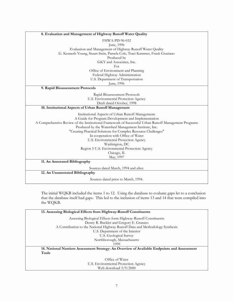
��The information about biological effects of drainage upon receiving waters was sparse. A recent FHWA/USGS project addressed the current information about this topic. Item 13 in the list below fills the information void quite well.
5
��The WQKB provided the basic science about calculating cause and effect through Items 2 and 3. However, events have unfolded using the basic science to provide modeling tools that synthesize the basic science. Item 14 was identified and it provides a comprehensive overview of current modeling methods particularly as they relate to nutrient-ecological interactions.
Consequently, items 13 and 14 were acquired and compiled into the WQKB. This inclusion demonstrates one of the project recommendations: mainly that the WQKB can be updated with new information as it becomes available and that a systematic method be put in place to do just that.
1. Nonstructural BMP Handbook
Nonstructural BMP Handbook A Guide to Nonpoint Source Pollution Prevention and Control through Nonstructural Measures
Prepared by the Northern Virginia Planning District Commission Prepared for the Department of Conservation and Recreation
Division of Soil and Water Conservation December, 1996
2. Water Quality Assessment, Part 1
EPA-600/6-82-004a September, 1982
WATER QUALITY ASSESSMENT: A Screening Procedure for Toxic and Conventional Pollutants
Part 1 by W.B. Mills, J.D. Dean, D.B. Porcella, S.A. Gherini, R.J.M. Hudson, W.E. Frick, G.L. Rupp, G.L. Bowie,
Tetra Tech, Incorporated Lafayette, California 94549 Contract No. 68-03-2673
Prepared in Cooperation with U.S. EPA's Center for Water Quality Modeling Environmental Research Laboratory
Athens, GA Monitoring and Data Support Division
Office of Water Regulations and Standards Office of Water
Washington, D.C. Technology Transfer Center for Environmental Research Information
Cincinnati, OH
3. Water Quality Assessment, Part 2
EPA-600/6-82-004b September, 1982
WATER QUALITY ASSESSMENT: A Screening Procedure for Toxic and Conventional Pollutants
Part 2 by
W.B. Mills, J.D. Dean, D.B. Porcella, S.A. Gherini, R.J.M. Hudson, W.E. Frick, G.L. Rupp, G.L. Bowie Tetra Tech, Incorporated
Lafayette, California 94549 Contract No. 68-03-2673
Prepared in Cooperation with U.S. EPA's Center for Water Quality Modeling Environmental Research Laboratory Athens, GA
Monitoring and Data Support Division Office of Water Regulations and Standards
Office of Water Washington, D.C.
Technology Transfer Center for Environmental Research Information Cincinnati, OH
6
4. Riparian Road Guide
Riparian Road Guide Managing Roads to Enhance Riparian Areas
Produced by Terrene Institute Washington, D.C.
In cooperation with U.S. Environmental Protection Agency Region 6 Water Management Division
Water Quality Branch Dallas, Texas
and USDA Forest Service Southwestern Region
Albuquerque, NM ©1994 Terrene Institute
Included here by permission
5. Fundamentals of Urban Runoff Management
Fundamentals of Urban Runoff Management Technical and Institutional Issues
by Richard R. Horner, Joseph J. Skupien, and
Eric H. Livingston, H. Earl Shaver of the Watershed Management Institute Produced by
Terrene Institute Washington, D.C.
In cooperation with U.S. Environmental Protection Agency
August 1994 Includes Chapters 3 and 6
6. Ultra-Urban Best Management Practices
Ultra-Urban Best Management Practices Office of Environment and Planning
Federal Highway Administration U.S. Department of Transportation
Washington, DC October, 1999
7. Guidance Specifying Management Measures for Sources of Nonpoint Pollution in Coastal Waters
840-B-92-002 January, 1993
Guidance Specifying Management Measures for Sources of Nonpoint Pollution in Coastal Waters Issued under the authority of Section 6217(g) of the Coastal Zone Act
Reauthorization Amendments of 1990 Includes only: Chapter 4, Section VII
7
8. Evaluation and Management of Highway Runoff Water Quality
FHWA-PD-96-032 June, 1996
Evaluation and Management of Highway Runoff Water Quality G. Kenneth Young, Stuart Stein, Pamela Cole, Traci Kammer, Frank Graziano
Produced by GKY and Associates, Inc.
For Office of Environment and Planning
Federal Highway Administration U.S. Department of Transportation
June, 1996 9. Rapid Bioassessment Protocols
Rapid Bioassessment Protocols U.S. Environmental Protection Agency
Draft dated October, 1998 10. Institutional Aspects of Urban Runoff Management
Institutional Aspects of Urban Runoff Management: A Guide for Program Development and Implementation
A Comprehensive Review of the Institutional Framework of Successful Urban Runoff Management Programs Produced by the Watershed Management Institute, Inc.
"Creating Practical Solutions for Complex Resource Challenges" In cooperation with Office of Water
U.S. Environmental Protection Agency Washington, DC
Region 5 U.S. Environmental Protection Agency Chicago, IL May, 1997
11. An Annotated Bibliography
Sources dated March, 1994 and after. 12. An Unannotated Bibliography
Sources dated prior to March, 1994.
The initial WQKB included the items 1 to 12. Using the database to evaluate gaps let to a conclusion that the database itself had gaps. This led to the inclusion of items 13 and 14 that were compiled into the WQKB.
13. Assessing Biological Effects from Highway-Runoff Constituents
Assessing Biological Effects form Highway-Runoff Constituents Denny R. Buckler and Gregory E. Granato
A Contribution to the National Highway Runoff Data and Methodology Synthesis U.S. Department of the Interior
U.S. Geological Survey Northborough, Massachusetts
1999 14. National Nutrient Assessment Strategy: An Overview of Available Endpoints and Assessment Tools
Office of Water U.S. Environmental Protection Agency
Web download 3/9/2000
8
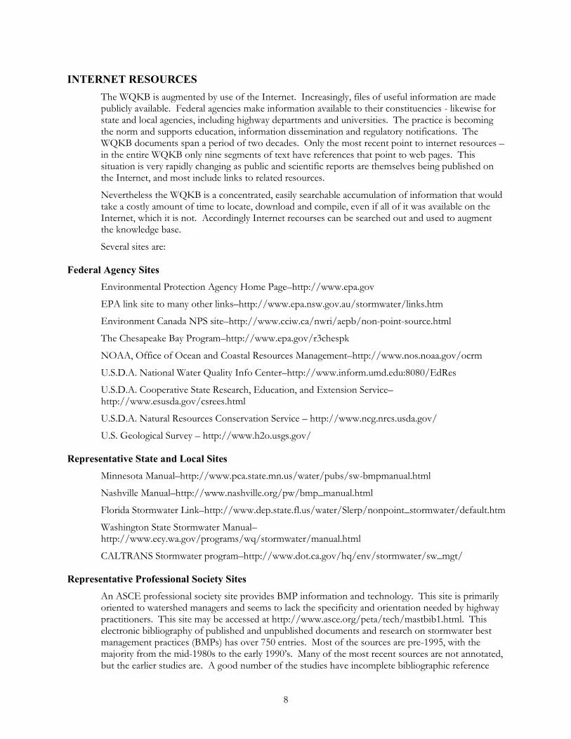
INTERNET RESOURCES The WQKB is augmented by use of the Internet. Increasingly, files of useful information are made publicly available. Federal agencies make information available to their constituencies - likewise for state and local agencies, including highway departments and universities. The practice is becoming the norm and supports education, information dissemination and regulatory notifications. The WQKB documents span a period of two decades. Only the most recent point to internet resources – in the entire WQKB only nine segments of text have references that point to web pages. This situation is very rapidly changing as public and scientific reports are themselves being published on the Internet, and most include links to related resources.
Nevertheless the WQKB is a concentrated, easily searchable accumulation of information that would take a costly amount of time to locate, download and compile, even if all of it was available on the Internet, which it is not. Accordingly Internet recourses can be searched out and used to augment the knowledge base.
Several sites are:
Federal Agency Sites Environmental Protection Agency Home Page–http://www.epa.gov
EPA link site to many other links–http://www.epa.nsw.gov.au/stormwater/links.htm
Environment Canada NPS site–http://www.cciw.ca/nwri/aepb/non-point-source.html
The Chesapeake Bay Program–http://www.epa.gov/r3chespk
NOAA, Office of Ocean and Coastal Resources Management–http://www.nos.noaa.gov/ocrm
U.S.D.A. National Water Quality Info Center–http://www.inform.umd.edu:8080/EdRes
U.S.D.A. Cooperative State Research, Education, and Extension Service–http://www.esusda.gov/csrees.html
U.S.D.A. Natural Resources Conservation Service – http://www.ncg.nrcs.usda.gov/
U.S. Geological Survey – http://www.h2o.usgs.gov/
Representative State and Local Sites Minnesota Manual–http://www.pca.state.mn.us/water/pubs/sw-bmpmanual.html
Nashville Manual–http://www.nashville.org/pw/bmp_manual.html
Florida Stormwater Link–http://www.dep.state.fl.us/water/Slerp/nonpoint_stormwater/default.htm
Washington State Stormwater Manual–http://www.ecy.wa.gov/programs/wq/stormwater/manual.html
CALTRANS Stormwater program–http://www.dot.ca.gov/hq/env/stormwater/sw_mgt/
Representative Professional Society Sites An ASCE professional society site provides BMP information and technology. This site is primarily oriented to watershed managers and seems to lack the specificity and orientation needed by highway practitioners. This site may be accessed at http://www.asce.org/peta/tech/mastbib1.html. This electronic bibliography of published and unpublished documents and research on stormwater best management practices (BMPs) has over 750 entries. Most of the sources are pre-1995, with the majority from the mid-1980s to the early 1990’s. Many of the most recent sources are not annotated, but the earlier studies are. A good number of the studies have incomplete bibliographic reference
9
information, or are from unpublished symposium presentations. However, it is a very comprehensive and useful resource on the subject. The database is divided into six “chapters,” which focus on structural BMPs (infiltration, filtration, detention, and other), nonstructural BMPs, and other studies related to stormwater and water quality.
The Transportation Research Board site, under the committee A2A03, Hydrology, Hydraulics and Water Quality, has water quality problem statements that are the result of committee work of members from highway agencies, government and private practice. These may be accessed at http://www.nationalacademies.org/trb/publications/problems/a2a03ps3.pdf.
The A2A03 Water Quality research problem topics appear in order of priority. The Committee focuses on the engineering aspects of water quality with less emphasis on ecology than the thrust of this study; however, there is notable overlap.
Topics Problem Statements
1. Hydraulic Retrofits to Enhance Water Quality
2. Water Quality Management Techniques for Narrow Right-of-Way Areas
3. Research on Modern Information Exchange to Accelerate Nationwide Water Quality Mitigation
4. Impacts of Highway Runoff on Receiving Waters
5. Identifying and Assessing Potential Water-Quality Problem Areas Within the Set of Highway Facilities and Activities
6. Comprehensive Integrated Water Quality Management
7. Water Quality Benefits Associated with Pavement Design
8. Best Management Practices for Mitigating Impacts of Urban Highway Ice and Snowmelt
EVALUATION OF INFORMATION IN THE WQKB
Loadings Vehicles are both a direct and indirect source of pollutants on highways. Directly, vehicles contribute pollutants through normal operation and wear. Indirectly, vehicles can also acquire solid materials on the surface to be deposited on the roadway later through rain or wind actions (Barret, et al., 1993). Increased traffic volume, therefore, would appear to increase the amount of pollutants accumulating on the road surface. However, vehicle turbulence also can remove solids and other pollutants from highway lanes and shoulders (Kerri, et al., 1985) and the impact of traffic volume on pollutant accumulation is therefore somewhat concealed in field observations.
Data developed in Amy, et al. (1974) include nationwide means of solids loading rates and pollutant composition of street solids, as well as a more detailed breakdown of data into major source categories. Data from the URS report are divided into 13 subsets among three major source categories including climate, land use, and average daily traffic.
Loads to the Lower San Francisco Bay of three metals--copper, cadmium, and zinc (Woodward Clyde, 1992). Reportedly, tire wear could account for at least half of the total cadmium and zinc deposited in the bay each year, with the copper being linked to brake pad wear. Metals that are strongly linked to cars, such as cadmium and copper, are found to have higher concentrations in runoff from streets and parking lots and minimal concentrations in roof and lawn runoff.
The characteristics of highway runoff have been the focus of recent reporting (Barrett et al., 1995). Storm water runoff from roadways and impervious surfaces in heavily developed areas has been
10
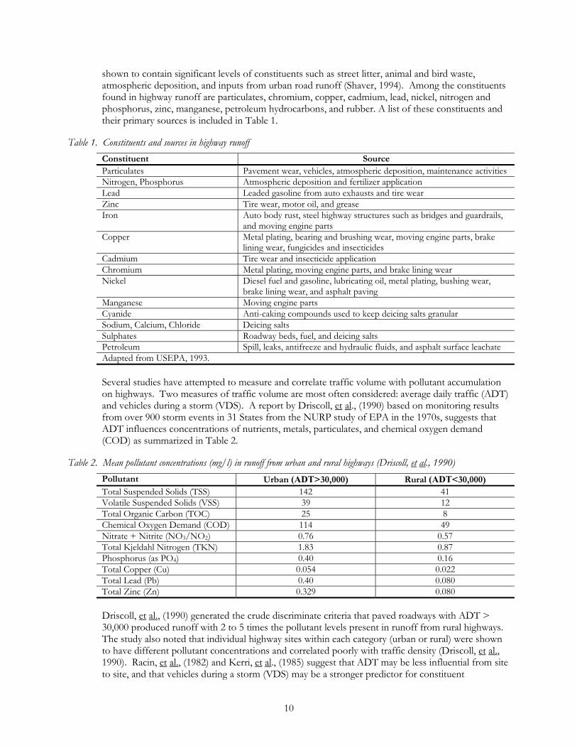
shown to contain significant levels of constituents such as street litter, animal and bird waste, atmospheric deposition, and inputs from urban road runoff (Shaver, 1994). Among the constituents found in highway runoff are particulates, chromium, copper, cadmium, lead, nickel, nitrogen and phosphorus, zinc, manganese, petroleum hydrocarbons, and rubber. A list of these constituents and their primary sources is included in Table 1.
Table 1. Constituents and sources in highway runoff Constituent Source Particulates Pavement wear, vehicles, atmospheric deposition, maintenance activities Nitrogen, Phosphorus Atmospheric deposition and fertilizer application Lead Leaded gasoline from auto exhausts and tire wear Zinc Tire wear, motor oil, and grease Iron Auto body rust, steel highway structures such as bridges and guardrails,
and moving engine parts Copper Metal plating, bearing and brushing wear, moving engine parts, brake
lining wear, fungicides and insecticides Cadmium Tire wear and insecticide application Chromium Metal plating, moving engine parts, and brake lining wear Nickel Diesel fuel and gasoline, lubricating oil, metal plating, bushing wear,
brake lining wear, and asphalt paving Manganese Moving engine parts Cyanide Anti-caking compounds used to keep deicing salts granular Sodium, Calcium, Chloride Deicing salts Sulphates Roadway beds, fuel, and deicing salts Petroleum Spill, leaks, antifreeze and hydraulic fluids, and asphalt surface leachate Adapted from USEPA, 1993.
Several studies have attempted to measure and correlate traffic volume with pollutant accumulation on highways. Two measures of traffic volume are most often considered: average daily traffic (ADT) and vehicles during a storm (VDS). A report by Driscoll, et al., (1990) based on monitoring results from over 900 storm events in 31 States from the NURP study of EPA in the 1970s, suggests that ADT influences concentrations of nutrients, metals, particulates, and chemical oxygen demand (COD) as summarized in Table 2.
Table 2. Mean pollutant concentrations (mg/l) in runoff from urban and rural highways (Driscoll, et al., 1990) Pollutant Urban (ADT>30,000) Rural (ADT<30,000) Total Suspended Solids (TSS) 142 41 Volatile Suspended Solids (VSS) 39 12 Total Organic Carbon (TOC) 25 8 Chemical Oxygen Demand (COD) 114 49 Nitrate + Nitrite (NO3/NO2) 0.76 0.57 Total Kjeldahl Nitrogen (TKN) 1.83 0.87 Phosphorus (as PO4) 0.40 0.16 Total Copper (Cu) 0.054 0.022 Total Lead (Pb) 0.40 0.080 Total Zinc (Zn) 0.329 0.080
Driscoll, et al., (1990) generated the crude discriminate criteria that paved roadways with ADT > 30,000 produced runoff with 2 to 5 times the pollutant levels present in runoff from rural highways. The study also noted that individual highway sites within each category (urban or rural) were shown to have different pollutant concentrations and correlated poorly with traffic density (Driscoll, et al., 1990). Racin, et al., (1982) and Kerri, et al., (1985) suggest that ADT may be less influential from site to site, and that vehicles during a storm (VDS) may be a stronger predictor for constituent
11
concentrations. Also, there have been mixed results in correlating ADT with pollutant concentrations (Barret, et al., 1993).
Despite uncertainty, ADT continues to be the focus for predicting pollutant concentrations, and is used in Driscoll’s modeling technique to distinguish between urban and rural settings and to estimate pollutant loadings. Results from Driscoll, et al., (1990) and other studies have lead the highway community to formulate pollutant load estimates based on the differing ADT discriminate values for urban and rural land use.
Pure land use emissions are an issue affecting highway runoff characterization. Land uses or activities can generate different characteristic concentrations of hydrocarbons, trace metals, or toxicants. Pinpointing the constituent emissions from these right of way areas may resolve concerns about who is responsible when highway and off site drainage are mixed and sediment toxicity, groundwater contamination, or toxicity is impacting receiving surface waters. A preliminary list of potential pure land use types is included below (Claytor and Schueler, 1996):
�� Pavement that is conditioned by the level of traffic(ADT)
��Median and right of way edge, landscaping treatments
��Airport deicing facilities.
��Auto recycler facilities.
��Commercial nurseries.
��Commercial parking lots.
�� Fueling stations.
�� Fleet storage areas (bus, truck).
�� Industrial rooftops (depending on the roof surface).
��Marinas.
��Outdoor container storage of liquids.
��Outdoor loading/unloading facilities.
�� Public works storage areas.
��Vehicle service and maintenance areas.
��Vehicle and equipment washing/steam cleaning facilities.
Identifying emissions by pure land use will aid in determining who is responsible for downstream receiving water impacts and will aid in selecting the most effective BMP, in terms of constituent removal capability, in addition to determining the most appropriate location for the BMP. Lack of information in this area contributes to confusion as to which stakeholders cause impacts–highway facilities or other off site watershed activities.
Studies have found the concentrations of some of the metals and nutrients significantly correlated with that of total suspended solids (TSS). These results suggest that controlling TSS may result in reducing other constituents with the same particle sizes. The City of Austin (1990) found the event mean concentration (EMC) values of total phosphorus (TP), total Kjeldahl nitrogen (TKN), total organic carbon (TOC), lead (Pb), and zinc (Zn) are related to the values of TSS EMC. This correlation indicates that these constituents may be removed along with the particulates by filtration technologies such as sand filters or those proposed and tested by Sansalone (1994,1998).
Sansalone(1994) found that heavy metal concentrations are significantly correlated to suspended solids in highway runoff.. Runoff data from eight U.S. and European highways were analyzed.
12
Results indicated a strong positive correlation between heavy metals and suspended solids for snow washoff events, and a weaker positive correlation for rainfall events.
Intervention Information on BMPs is widely reported in the literature (City of Portland, 1995; Claytor and Schueler, 1996; Driscoll and Mangarella, 1990; NVPDC, 1992; Schueler, 1987; Young et al., 1996). The typical BMP selection process includes the following steps, to narrow the list of options and select the best alternative:
Step 1: Specify or revisit the management and performance objectives
Step 2: Analyze existing or potential source control options.
Step 3: Analyze purpose of the BMP (i.e., single or dual purpose).
Step 4: Evaluate site considerations/constraints.
Step 5: Evaluate pollutant removal capabilities.
Step 6: Evaluate aesthetic value/amenities.
Step 7: Evaluate cost and maintenance constraints.
Step 8: Select a BMP from the alternatives.
Alternative BMPs from the literature include:
��Conventional Structural BMPs
- Extended Detention Ponds - Wet Ponds (Ponds with a Permanent Pool) - Infiltration Trenches - Infiltration Basins - Sand Filters - Water Quality Inlets - Grassed Swales - Filter Strips - Constructed Wetlands - Porous Pavement
�� Space-Limited BMPS
- Sand Filter Alternatives - WQV Storage Tanks - Bioretention Areas - Manhole Filter Systems - Stream Channel Retrofits
��Non-Structural BMPs And Related Considerations
- Land Use and Comprehensive Site Planning - Landscaping and Vegetative Practices - Pesticide and Fertilizer Management - Litter and Debris Controls
13
- Illicit Discharge Controls - Bridge Cleaning, Maintenance and Deck Drainage - Bridge Painting - Chemical Storage - BMP Maintenance
Design criteria are available for each management practice. Generally, this guidance is provided in a design manual or handbook at the state or local level of government.
Design manuals, handbooks and design criteria provide detail for specific management practices. Many city and county programs use their state's manual, with four programs in Washington relying on the Puget Sound Manual. Some have published their own guidance and manuals. For specific example, three Florida water management districts use the Florida DEP manual while both the Northeastern Illinois Planning Commission and the Denver Flood Control District use their own guidance manuals.
The widespread information about BMPs is oriented to watershed storm water management. Highway agencies want to manage their own runoff and are less willing to address the problems of offsite drainage that traverses their right of way. Thus, it would appear that the adaptation of BMP technology to micro highway environments requires attention - particularly the consideration of the highway specific highly restricted space constraints. The issue is the retrofit of devices to existing systems that have little or no extra space. NCHRP 25-13 pertains to bridge deck drainage that involves an extreme but widespread case of the highway space constraint – project documents discuss the question as to “whether existing bridges should be retrofit”. The present EPA thinking is to restrict use of scupper drains to waterways and wetlands and to route deck runoff to bridge ends for treatment.
Highway systems designed and constructed prior to the current concerns about water quality generate significant erosion and pollution loads containing heavy metals, hydrocarbons, sediment, and debris that run off into and threaten the quality of surface waters and their tributaries. In areas where such adverse impacts to surface waters can be attributed to adjacent roads or bridges, retrofit management projects to protect these waters may be needed (e.g., installation of structural or nonstructural pollution controls). Retrofit projects can be located in existing rights-of-way, within interchange loops, or on adjacent land area.
Numerous existing detention basins, perhaps both onsite and regional, that can be hydraulically modified to provide water quality treatment. This can be fairly easy and inexpensive to implement. However, these modifications must not reduce existing flood protection or the basin's required “live” storage volume so as to adversely impact downstream water levels or velocities.
Retrofitting is a process that involves the modification of existing control structures or conveyance systems, initially designed to safely convey or temporarily store storm water runoff to minimize flooding. Retrofitting existing conveyance systems and installing a new BMP designed for water quantity control and/or water quality treatment is an option used in the ultra-urban environment. These BMPs must fit into the existing storm drain system, and match the existing hydraulic gradient. Ultra-urban BMPS are frequently configured off-line and designed to treat a certain portion (usually the "first flush") of a storm. The remainder of the runoff bypasses the water quality BMP. Where existing development or financial constraints limit the feasibility of locating different BMP options, it might be necessary to evaluate and prioritize various factors to determine the most appropriate retrofit for a particular site.
Sansalone(1998) describes the design and performance of a bench-scale and prototype in-situ highway BMP called a partial exfiltration trench (PET). The PET is a passive treatment technique that synthesizes the best attributes of porous pavement and infiltration trenches, and may serve as a retrofit of the current practice of pavement under drainage along highways. PETs provide a water
14
quality function, in addition to water quantity control. The PET uses an oxide-coated sand (OCS) that immobilizes infiltrated metal elements within the PET, providing the water quality function. A highway BMP-PET and sampling system was constructed at an experimental site along the Millcreek Expressway of I-75, a major north-south interstate in Cincinnati, Ohio. The prototype was constructed at the experimental site after bench-scale testing had been completed. Based on characteristic metal loadings from urban Cincinnati pavement drainage, performance indicates that the design life of a BMP-PET may exceed 15 years in a humid climate. Performance of the prototype PET along the highway indicated metal element mass removal efficiency of greater than 80 percent after nearly one year of pavement drainage loadings
Impacts Highway runoff contains a complex mixture of potentially adverse constituents, which may have been reduced by BMP intervention. These constituents include deicers, nutrients, metals, organic chemicals, sediment, and potentially, herbicides and pesticides. Assessing the deleterious effects of these different contaminants depend upon location, environmental setting, and the characteristics of the receiving waters.
The first step in performing a water quality assessment is gathering field data for analysis. This involves review of existing site maps and reports, site visits, and field monitoring (including ground and surface waters) designated as potentially impacted resources. The second step in the assessment is analyzing this information to determine conditions before, during, and after the proposed activity. Current methods tend to include expensive mathematical modeling techniques. Once potential adverse affects are identified through the modeling or other methods, appropriate mitigation alternatives can be incorporated into project plans
The least costly (although not always most cost-efficient) means of assessing receiving water quality is through the use of an existing water quality-monitoring network. Many county and city health maintain extensive water quality monitoring networks. Colleges and universities are also excellent sources of water quality monitoring data. The following are some readily available sources of water quality data:
County/city health departments.
United States Geological Survey's annual Water Resources Data Reports.
305(b) report to EPA and Congress.
Special watershed protection districts/programs Local civic and environmental organizations.
Thus, existing data are essentially free, except for the search to find the data, and often readily available. In many instances, base conditions are already set and trend data is available. The primary drawback to such an approach is that the watershed planner may have little or no control over the placement of testing stations or the determination of testing parameters. Carrying this idea further, monitoring networks can be set up for specific projects to support or possibly supplant modeling.
Monitoring and modeling needs to consider that potentially toxic compounds may affect aquatic organisms via two pathways. The first pathway involves adsorption or the bonding of the compound by the organic matter of the organism. This essentially affects the cell tissues inside the body of the organism. For higher organisms the adsorption and bonding differ between the various organs and are higher for lipids (fats) and the liver of fish and other aquatic organisms. Only dissolved and dissociated (ionized) toxic compounds are available for such bonding to cell tissues. The second route is by ingestion of contaminated food or sediments. Contaminated sediments may pass through
15
the digestive system of the organism and become available due to changed chemistry inside the digestive tract.. It has been observed that in the presence of solids, aquatic organisms and plants respond differently to toxic exposure expressed as total concentration. The ingestion route is applicable only for higher trophic level organisms (Novotny and Olem, 1994).
Most of the methods for prediction of water quality apply to continuous, stead-state discharges of pollutants. The discharges can be located anywhere within the receiving water estuary, from head to mouth. Multiple sources of pollutants can be analyzed by applying the method of superposition.
Dilution or first order decay models may be appropriate for modeling toxics where partitioning is not an issue. Where it is necessary to differentiate toxic pollutants in the dissolved phase from those that are adsorbed to solids, partitioning must be accounted for in the model. Metals are the toxicants of particular concern with highway runoff.
Several widely available simulation models can be used to link the assess aspects of the nutrient over enrichment process in rivers and streams with other parameters. Plankton-dominated systems can be well described by currently available models that incorporate the dynamics of algal growth. Modeling of periphyton-dominant systems is limited by our understanding of the growth processes. Because the underlying chemical, physical, and biological processes are so complex, the accuracy that can be attained from using these models varies and is proportional to applied resources Prediction of nutrient and dissolved oxygen concentrations, as well as algae and macrophyte levels, are factors in indirectly assessing the sensitivity of chemical water quality parameters and possibly the toxicity of multiple compounds. is essential to the water quality management process. The state of the science regarding the available models is given in information provided in The Compendium of Tools for Watershed Assessment and TMDL Development (USEPA). Modeling tools that link water quality parameters and estimates of primary production in receiving waters include: QUAL2E, WASPS, CE-QUAL-RIV1 or W2 or ICM.
The FHWA has sponsored studies by Dupuis, et al., that address effects of highway runoff: “Effects of Highway Runoff on Receiving Waters, Volumes I, II, III, IV, V,” 1985, and “Assessment of Bridge Deck Runoff Contaminants on Receiving Waters,” NCHRP 25-13, 1999.
The objective of The National Cooperative Highway Project 25-13 is to develop a process for identifying, assessing, and managing bridge deck runoff that could adversely affect receiving waters. Although drainage systems from most new bridges are designed with EPA 1990 Coastal Zone Act Reauthorization Amendment (CZARA) recommendations in mind (divert runoff waters to land for treatment, restrict use of scupper drains on bridges crossing sensitive ecosystems, etc.), the question remains as to whether existing bridges should be retrofit. Retrofit and design measures for bridges are constrained by the unique physical features of the receiving water crossing, thus retrofit or on-site mitigation schemes are not practicable for every bridge. Literature review revealed that although a considerable body of information is available on the chemical quality and loadings that can be expected from bridge runoff, a more accessible database needs to be developed to assist bridge planners and designers in implementation of the final process. The literature review also revealed that although several studies have directly assessed bridge runoff impacts, only one included a comprehensive field evaluation of aquatic biota. This study is involved with toxicity evaluations but apparently is not funded to address the mathematical modeling of receiving waters.
The rapid bioassessment protocols (RBPs)—also known as community bioassessment protocols—advocate an integrated assessment, comparing habitat (physical structure and flow regime) and biological measures with empirically defined reference conditions. Reference conditions are established through systematic monitoring of actual sites (ecoregion reference sites) that represent the natural range of variation in “least disturbed” water chemistry, habitat, and biological condition.
Habitat assessment is defined as the evaluation of the structure of the surrounding physical habitat that influences the quality of the water resource and the condition of the resident aquatic community

16
(Barbour, et al. 1996a). For streams, an encompassing approach to assessing structure of the habitat includes an evaluation of the variety and quality of the substrate, channel morphology, bank structure, and riparian vegetation. Habitat parameters pertinent to the assessment of habitat quality include those that characterize the stream “micro scale” habitat (e.g., estimation of embeddedness), the “macro scale” features (e.g., channel morphology), and the riparian and bank structure features that are most often influential in affecting the other parameters.
An overall assessment of ecological condition first evaluates habitat quality, then analyzes the biological components in light of these data. If adverse effects are likely, then sediment and water chemistry sampling and evaluating potential pollution sources within the watershed should be undertaken. As the principal determinant of biological potential, habitat sets the context for interpreting biosurvey results. Along with sediment quality, habitat can be used as a general predictor of biological condition.
An evaluation of habitat quality is integral to any assessment of ecological integrity and should be documented at each site at the time of any biological sampling. In the truest sense, “habitat” incorporates all aspects of physical and chemical constituents along with the biotic interactions. In these protocols, the definition of "habitat" is narrowed to the quality of the in stream and riparian habitat that influences the structure and function of the aquatic community in a stream. The presence of a degraded habitat can sometimes obscure investigations on the effects of toxicity and/or pollution. The assessments performed by many water resource agencies include a general description of the site, a physical characterization, and a visual assessment of in stream and riparian habitat quality. Some states (e.g., Idaho DEQ and Illinois EPA) include quantitative measurements of physical parameters in their habitat assessment.
The biological well being of a stream system is the ultimate goal of any water quality program. A multitude of factors affect biological well being, many of which are, of course, influenced by human activities. Performing a “biological community assessment,” or “biological monitoring,” on a watershed is recognized as an indicator of water quality and the general health of a stream. Biological monitoring is also a particularly good screening tool when deciding where to target resources. If the biological community assessment indicates good stream health, or the presence of endangered or threatened species, the watershed planner may wish to implement more prevention style nonstructural BMPs. Likewise, evidence that the watershed is highly impaired may warrant further investigation to the root cause or that resources be diverted to a different watershed altogether.
U.S. Environmental Protection Agency (EPA) has produced substantial guidance and documentation on both bioassessment strategies and implementation policy on biological surveys and criteria for water resource programs. Much of this effort has led to the national trend of adapting biological assessment and monitoring approaches for detecting problems, evaluating Best Management Practices (BMPs) for mitigation, and monitoring ecological health over time. The chronology of the crucial EPA guidance relevant to bioassessment in streams and rivers is presented in Table 3.
Table 3. Chronology of U.S. EPA bioassessment guidance (relevant to streams and rivers). Year Document Title Relationship to Bioassessment Citation 1987 Surface Water Monitoring: A
Framework for Change EPA calls for efficacious methods to assess and determine the ecological health of the nation's surface waters.
U.S. EPA 1987
1988 Proceedings of the First National Workshop on Biological Criteria (Lincolnwood, Illinois)
EPA brings together agency biologists and “basic” researchers to establish a framework for the initial development of biological criteria and associated biosurvey methods.
U.S. EPA 1988
1989 Rapid Bioassessment Protocols for Use in Streams and Rivers: Benthic
The initial development of cost-effective methods in response to the mandate by EPA (1987), which are to provide biological data on a national scale to
Plafkin, et al. 1989

17
Macroinvertebrates and Fish address the goals of the Clean Water Act. 1989 Regionalization as a Tool for
Managing Environmental Resources
EPA develops the concept of ecoregions and partitions the contiguous U.S. into homogeneous regions of ecological similarity, providing a basis for establishment of regional reference conditions.
Gallant, et al. 1989
1990 Second National Symposium on Water Quality Assessment: Meeting Summary
EPA holds a series of National Water Quality Symposia. In this second symposium, biological monitoring is introduced as an effective means to evaluating the quality of water resources.
U.S. EPA 1990a
1990 Biological Criteria: National Program Guidance for Surface Waters
The concept of biological criteria is described for implementation into state water quality programs. The use of biocriteria for evaluating attainment of "aquatic life use" is discussed.
U.S. EPA 1990b
1990 Macroinvertebrate Field and Laboratory Methods for Evaluating the Biological Integrity of Surface Waters
This EPA document is a compilation of the current "state-of-the-art" field and laboratory methods used for surveying benthic macroinvertebrates in all surface waters (i.e., streams, rivers, lakes, and estuaries).
Klemm, et al. 1990
1991 Biological Criteria: State Development and Implementation Efforts
The status of biocriteria and bioassessment programs as of 1990 is summarized here.
U.S. EPA 1991a
1991 Biological Criteria Guide to Technical Literature
A limited literature survey of relevant research papers and studies is compiled for use by state water resource agencies.
U.S. EPA 1991b
1991 Technical Support Document for Water Quality Based Toxics Control
EPA describes the approach for implementing water quality-based toxics control of the nation's surface waters, and discusses the value of integrating three monitoring tools, i.e., chemical analyses, toxicity testing, and biological surveys.
U.S. EPA 1991c
1991 Biological Criteria: Research and Regulation, Proceedings of the Symposium
This national symposium focuses on the efficacy of implementing biocriteria in all surface waters, and the proceedings document the varied applicable approaches to bioassessments.
U.S. EPA 1991d
1991 Report of the Ecoregions Subcommittee of the Ecological Processes and Effects Committee
The SAB (Science Advisory Board) reports favorably that the use of ecoregions is a useful framework for assessing regional fauna and flora. Ecoregions become more widely viewed as a basis for establishing regional reference conditions.
U.S. EPA 1991e
1991 Guidance for the Implementation of Water Quality Based Decisions: The TMDL Process
The establishment of the TMDL (total maximum daily loads) process for cumulative impacts (nonpoint and point sources) supports the need for more effective monitoring tools, including biological and habitat assessments.
U.S. EPA 1991f
1991 Design Report for EMAP, the Environmental Monitoring and Assessment Program
EPA's Environmental Monitoring and Assessment Program (EMAP) is designed as a rigorous national program for assessing the ecological status of the nation's surface waters.
Overton, et al. 1991
1992 Procedures for Initiating Narrative Biological Criteria
A discussion of the concept and rationale for establishing narrative expressions of biocriteria is presented in this EPA document.
Gibson 1992
1992 Ambient Water-Quality Monitoring in the U.S. First Year Review, Evaluation, and Recommendations
Provide first-year summary of task force efforts to develop and recommend framework and approach for improving water resource quality monitoring.
ITFM 1992
1993 Fish Field and Laboratory Methods for Evaluating the
A compilation of the current "state-of-the-art" field and laboratory methods used for surveying the fish
Klemm, et al. 1993
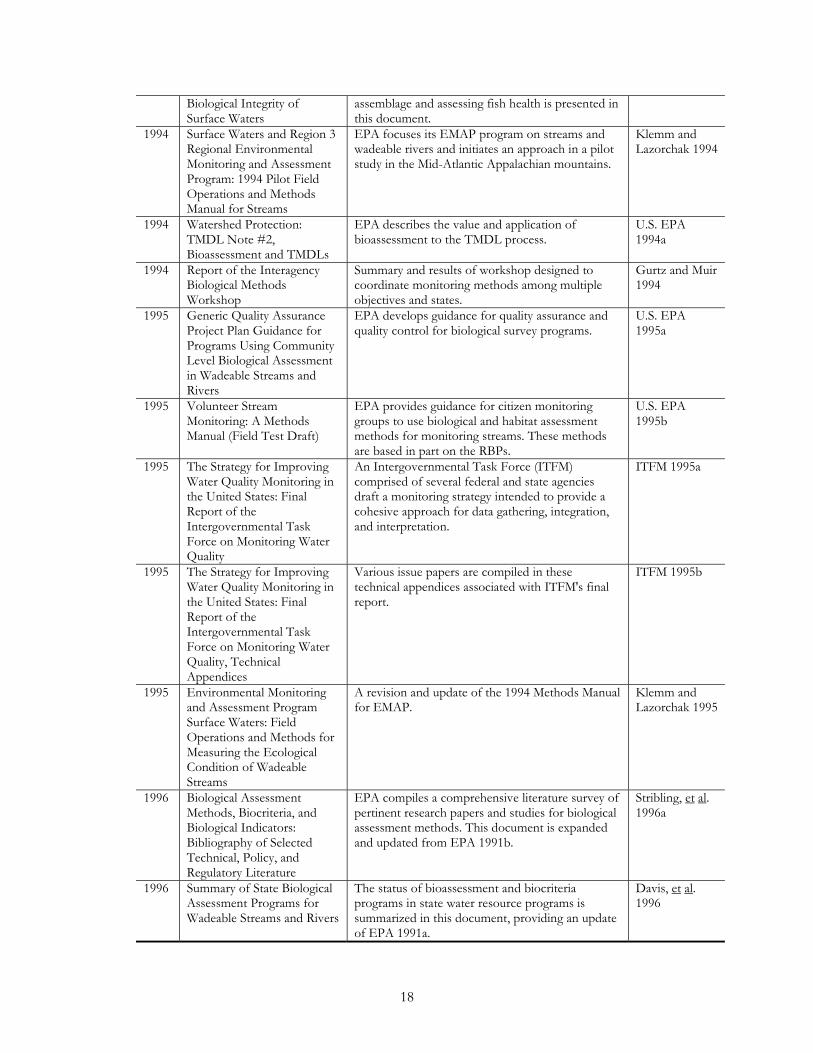
18
Biological Integrity of Surface Waters
assemblage and assessing fish health is presented in this document.
1994 Surface Waters and Region 3 Regional Environmental Monitoring and Assessment Program: 1994 Pilot Field Operations and Methods Manual for Streams
EPA focuses its EMAP program on streams and wadeable rivers and initiates an approach in a pilot study in the Mid-Atlantic Appalachian mountains.
Klemm and Lazorchak 1994
1994 Watershed Protection: TMDL Note #2, Bioassessment and TMDLs
EPA describes the value and application of bioassessment to the TMDL process.
U.S. EPA 1994a
1994 Report of the Interagency Biological Methods Workshop
Summary and results of workshop designed to coordinate monitoring methods among multiple objectives and states.
Gurtz and Muir 1994
1995 Generic Quality Assurance Project Plan Guidance for Programs Using Community Level Biological Assessment in Wadeable Streams and Rivers
EPA develops guidance for quality assurance and quality control for biological survey programs.
U.S. EPA 1995a
1995 Volunteer Stream Monitoring: A Methods Manual (Field Test Draft)
EPA provides guidance for citizen monitoring groups to use biological and habitat assessment methods for monitoring streams. These methods are based in part on the RBPs.
U.S. EPA 1995b
1995 The Strategy for Improving Water Quality Monitoring in the United States: Final Report of the Intergovernmental Task Force on Monitoring Water Quality
An Intergovernmental Task Force (ITFM) comprised of several federal and state agencies draft a monitoring strategy intended to provide a cohesive approach for data gathering, integration, and interpretation.
ITFM 1995a
1995 The Strategy for Improving Water Quality Monitoring in the United States: Final Report of the Intergovernmental Task Force on Monitoring Water Quality, Technical Appendices
Various issue papers are compiled in these technical appendices associated with ITFM's final report.
ITFM 1995b
1995 Environmental Monitoring and Assessment Program Surface Waters: Field Operations and Methods for Measuring the Ecological Condition of Wadeable Streams
A revision and update of the 1994 Methods Manual for EMAP.
Klemm and Lazorchak 1995
1996 Biological Assessment Methods, Biocriteria, and Biological Indicators: Bibliography of Selected Technical, Policy, and Regulatory Literature
EPA compiles a comprehensive literature survey of pertinent research papers and studies for biological assessment methods. This document is expanded and updated from EPA 1991b.
Stribling, et al. 1996a
1996 Summary of State Biological Assessment Programs for Wadeable Streams and Rivers
The status of bioassessment and biocriteria programs in state water resource programs is summarized in this document, providing an update of EPA 1991a.
Davis, et al. 1996
19
1996 Biological Criteria: Technical Guidance for Streams and Small Rivers
Technical guidance for development of biocriteria for streams and wadeable rivers is provided as a follow-up to the Program Guidance (EPA 1990b). This technical guidance serves as a framework for developing guidance for other surface water types.
Gibson, et al. 1996
1996 The Volunteer Monitor's Guide to Quality Assurance Project Plans
EPA develops guidance for quality assurance for citizen monitoring programs, which becomes a companion document to EPA 1995a.
U.S. EPA 1996a
1996 Nonpoint Source Monitoring and Evaluation Guide
EPA describes how biological survey methods are used in nonpoint-source investigations, and explains the value of biological and habitat assessment to evaluating BMP implementation and identifying impairment.
U.S. EPA 1996b
1996 Biological Criteria: Technical Guidance for Survey Design and Statistical Evaluation of Biosurvey Data
EPA describes and define different statistical approaches for biological data analysis and development of biocriteria.
Reckhow and Warren-Hicks 1996
Literally hundreds, if not thousands, of biological endpoints may be either directly, or associatively, affected by contaminant exposure. Many biological tools have been shown to be useful in evaluating environmental contaminants. Each technique has advantages and drawbacks that must be carefully considered in terms of its suitability to meet information needs for local, regional, and national studies. A number of the techniques are applicable to onsite use in receiving waters, whereas others are applied in the laboratory to samples collected in the field. In most situations, habitat assessments and analytical chemistry determinations should be made and documented in concert with biological measures to maximize opportunities for establishing cause and effect.
A regional index approach has been developed by Ohio. Ohio EPA used three biological indices—IBI, Iwb, and ICI—to establish its biocriteria. Criteria for each index are defined by organism group, biological index, site type (fish),ecoregion, and aquatic life use designation. Modified Iwb and IBI criteria were defined for each of the five Ohio ecoregions for three site types: headwaters (drainage areas – 20 mi2 [51.8 km2], wading sites (streams sampled with wading methods, usually 20-300 mi2 [51.8-777 km2] and boat sites (streams sampled with boat methods, usually 200-6,000 mi2 [518-15,540 km2]. The calibration of the indices and the resultant biocriteria consider the effect of stream size and sampling gear selectivity.
Ohio established ecoregional biocriteria for the warmwater habitat class at the 25th percentile value of the reference site data for each ecoregion index. It set criteria for the exceptional warmwater habitat class at the 75th percentile, based on a statewide—not ecoregion—assessment of data from reference streams. In addition, Ohio established modified warmwater habitat criteria for some streams with physical habitat so altered that the expected warmwater habitat use could not be realistically attained but could support some semblance of a warmwater habitat community. The two biocriteria (25th percentile values) established for this class were for sites in the Huron/Erie Plain and for sites in the rest of the habitat.
Ohio EPA also established a process to determine the use attainment of Ohio’s lotic surface waters. Attainment is assessed primarily based on biological monitoring and the ability to achieve the use class biocriteria. Nonattainment depends on the magnitude of departure from the ecoregional biocriteria (e.g., within four IBI units of the ecoregion criteria) and the distance downstream over which the departure is sustained. Generally, attainment is achieved by meeting all three numeric indices. Attainment is considered partial if at least one organism group index does not meet expectations but is no lower than a fair narrative rating, and the other organism group exhibits attainment. Nonattainment occurs if none of the indices meet ecoregional biocriteria or if one organism group gets a poor or very poor narrative rating, even if the other group exhibits attainment.
20
An appealing approach to biological assessment is to evaluate toxicity. The toxicity, of course, could derive from any, or a synergistic combination of, high runoff loading factors. One way to look at toxicity is that it is a whole effluent attribute just as any other loading factor; this puts toxicity in the category of “constituents and loadings.” Herein, however, toxicity is considered to be a biological impact associated with the discharge of highway runoff to receiving waters (perhaps after dilution). As such, toxicity is a bioassessment tool.
Whole-organism, or single-species, toxicity tests have been widely used to evaluate the effects of environmental contaminants. Mortality, growth, and reproduction are the typical responses measured by toxicity tests. Additionally, whole-organism exposures are often used to obtain the biological samples required for the biochemical, physiological, and histological assessments described above. A summary of historical application of toxicity testing to highway runoff is provided by Smith and Lord (1990). Toxicity-testing procedures have been developed for a wide range of species, including microbes, algae, aquatic invertebrates, fish and others. Additionally, tests have been designed that can be conducted on-site or in the laboratory with field-collected samples. The choice of species and life stage to be tested and appropriate routes of exposure are important considerations in whole-organism testing and in putting it into the context of receiving waters. Species considerations include sensitivity to the contaminants being evaluated, availability of healthy specimens for testing, ease of culture and maintenance, and local importance and relevance to the receiving waters being evaluated.
Microtox ® and Mutatox ® are microbial assays that use marine bioluminescent bacteria (Photobacterium phosphoreum) to detect the presence of cytotoxic and genotoxic environmental contaminants. The assays can be used with unprocessed water samples or with extracts of various environmental media, including water, sediment, and tissue. They can also be used in conjunction with SPMD extracts. Microtox ® is used to evaluate cytotoxicity by quantifying reduction in light output as a result of death of the bacteria. The assay has been shown to be sensitive to a wide range of toxicants (Kaiser and Palabrica, 1991; Jacobs and others, 1993). Mutatox ® is similar in concept and procedure, but uses a dark mutant strain of Photobacterium phosphoreum to detect the presence of DNA-damaging chemicals. Genotoxicity of a sample is quantified by restoration of light production of bacterial cells upon reverting back to wild-type bacteria. It can be used with a similar suite of environmental media or SPMD extracts. The assay has been shown to detect genotoxicity with over 100 chemicals (Johnson, 1992a,b; Ho and Quinn, 1993). The relative ease and efficiency of the Microtox ® and Mutatox ® procedures make them ideally suited for screening large numbers of environmental samples but the fact that the bacteria are of marine origin raises issues about the suitability for freshwater environments.
Algal growth studies have been used to evaluate the effects of environmental contaminants and nutrient enrichment on aquatic algal communities. The most commonly used species is the green alga Selenastrum capricornutum. A variety of responses can be measured, including optical density of exposed cultures, oxygen production and(or) carbon dioxide uptake, cell counts, gravimetric cell mass determinations, and measurement of chlorophyll (American Society for Testing and Materials, 1997e). Increases or decreases in these parameters, compared to control responses, are used to determine effects on algal growth.
Aquatic invertebrates have been widely used to evaluate environmental contaminants that are in receiving waters and aquatic sediments. For evaluation of waterborne contaminants, tests with Daphnia magna and Ceriodaphnia dubia are most commonly used (American Society for Testing and Materials, 1997b,d). With both species of aquatic invertebrates, assessments of contaminant effects on survival, growth, and reproductive success can be made. Aquatic sediments are often chosen as a medium for toxicity testing because they are recognized as contaminant sinks. Methods for evaluating contaminants that are in sediments have been developed for use with several aquatic invertebrate species, including the amphipod Hyalella azteca and the midge Chironomus tentans
21
(American Society for Testing and Materials, 1997f). As with the waterborne testing procedures, effects on survival, growth, and reproduction can be measured.
Toxicity studies can be conducted in which fish are exposed to environmental contaminants in water and(or) food, or by injection of environmental-contaminant extracts. Toxicity studies can be conducted with a wide range of fish species and can provide information on the short-term (acute) and long-term (chronic) toxicity of contaminants (American Society for Testing and Materials, 1997a,c). Egg injection studies are particularly useful for evaluating the effects of contaminants on early developmental stages. The procedure involves injection of contaminants into freshly fertilized eggs and subsequent evaluation of mortality, hatchability, and developmental effects (Walker and others, 1994).
In-situ exposures provide a method for assessing the survival and health of organisms for baseline and highway diluted runoff waters from the geographic area under evaluation. Duration of these tests can extend from 96 hours to 30 days. Early life stages of fish and (or) other organisms are exposed directly to water from the site of interest, using environmental chambers at the site (Finger and Bulak, 1988; Hall and others, 1993). Measurements are made to evaluate effects on survival, growth, and behavior. This type of exposure study is particularly useful for evaluating pollution effects on species that are indigenous to the site of interest
References The evaluation used the WQKB supplemented with Internet resources and the professional experiences of the authors. References included in the evaluation can be determined for the complete citation using the WQKB search tools–in other words the full citations are included in the WQKB.
GAPS The consideration of the evaluation afforded by the WQKB from the standpoint of a highway professional puts the research needs in focus. The issue of water quality is really the issue of the possible or potential impacts of water quality that is modified by the highway facility or the traffic or the maintenance that it receives. The question is what to do about water quality changes if anything. A desired answer is “nothing” if that can be justified. Beyond “nothing”, what one does is to make the impacts acceptable with a reasonable expenditure of planning, design and construction or maintenance resources. Therefore the gaps are associated with finding directions that reduce uncertainty for practitioners in their application of acceptable, reasonable methods to first define if runoff is potentially damaging and, if so, what acceptable and reasonable intervention is called for.
1. A key question for biological characterization of runoff is “is it toxic.” Answers can lead to whether impacts are even an issue. Standardized toxicity tests for highway runoff would guide resources and make the decision of conducting additional impact work more supportable.
2. The highway practitioner is given a large set of options for evaluation of receiving water impacts. This leads to no uniformity and wide differences across agencies on how to proceed and what is necessary. The literature supports this situation with many available techniques having uncertain accuracy and a wide choice space for impact techniques. The Ohio professionals have worked through this with the development of regional indices. A uniform index method would cut down the choice space and reduce the inclination of making every project a research project unto itself.
3. Loading discriminate functions are confounded by lack of pure land use emissions information. Emissions data on national basis are one decade or more old. Pure land use emissions data are a gap in knowledge with respect to the highway environment.
22
4. Retrofit BMPs and limited land use BMPs need to be derived from the wide set of BMP information. There are gaps in standardization of hydraulic modification retrofits, in viable demonstrations and in innovative approaches to stop metal migration. CALTRANS has a program of demonstrating BMP retrofits and has found them difficult to tuck into their existing infrastructure and relatively expensive.
5. The wide choice space facing practical highway design teams causes unnecessary expenditure of initial planning resources. Expert systems that focus resources and narrow BMP choices in the space constrained highway setting are needed to shorten the project time lines.

23
CHAPTER 4. PRACTITIONER SURVEY
INTRODUCTION Transportation practitioners were surveyed to directly find out what their needs are regarding runoff and water quality, where they feel future research efforts should be focused, and how best to disseminate information. Written questionnaires were mailed to 276 individuals soliciting their unique perspectives of the inadequacies (and adequacies) of the existing knowledge base and how to improve data transfer. Representatives of each state, the District of Columbia, Puerto Rico, and Canada were contacted. Questionnaires were mailed to state, federal, and municipal personnel concerned with highway, rail, and airport facilities. Each discipline was represented at least once in each state. The questionnaire was also made accessible on the Internet for electronic responses.
The questionnaire consisted of three sections: I. Background Information, II. Management Needs, and III. Data Availability and Utilization. Section I requested data on the education and experience of the respondent and the facility type (highway, rail, airport) being represented by the respondent. Section II was designed to elicit from the respondent what they considered to be the most common runoff/water quality management issues and then to have them tell us if they felt they have enough information at hand to adequately address those issues. We then asked about the research they felt was needed to fill any information gaps they may have just identified. Section III was designed to find out how practitioners in the field learn of the information they need and how they feel data transfer can be improved.
The form sent to the practitioners is presented in Appendix A.
FINDINGS Fifty-one responses to the questionnaire were received by return mail and electronically. This represents an 18 percent return. The returns came from 39 states. Thirty-nine returns (76 percent) were from people representing highway facilities only, one (two percent) representing rail only, six (12 percent) representing airports only, and five (ten percent) from those concerned with highways and airports (1) or all three facility types (4). The National Climate Data Center divides the United States into six regions. The returns were spread over each region: western (11), high plains (4), southern (5), midwestern (10), southeast (7) and northeast (14).
Common Issues The runoff/water quality management issues that were identified by practitioners as most common fell into nine general categories: best management practices (BMPs); receiving water impacts; permitting/regulation and compliance; stormwater hydrology/hydraulics and drainage; habitat assessment/ecologic issues; data collection and information transfer; cleaning and washing; spills; and deicing as indicated in Table 4.
Table 4. Runoff/Water Quality Management Issues Data Data Not Sufficient Sufficient BMPs Installation and Maintenance 6 7 * Bridges 1 4 Cost 2 1 Site Constraints 2 3
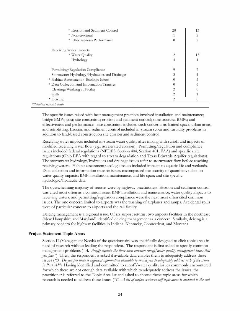
24
* Erosion and Sediment Control 20 13 * Nonstructural 1 2 * Effectiveness/Performance 0 2 Receiving Water Impacts * Water Quality 2 13 Hydrology 4 4 Permitting/Regulation Compliance 9 7 Stormwater Hydrology/Hydraulics and Drainage 3 4
* Habitat Assessment / Ecologic Issues 0 5 * Data Collection and Information Transfer 0 6 Cleaning/Washing at Facility 2 0 Spills 2 1
* Deicing 2 6 *Potential research needs
The specific issues raised with best management practices involved installation and maintenance; bridge BMPs; cost; site constraints; erosion and sediment control; nonstructural BMPs; and effectiveness and performance. Site constraints included such concerns as limited space, urban areas, and retrofitting. Erosion and sediment control included in-stream scour and turbidity problems in addition to land-based construction site erosion and sediment control.
Receiving water impacts included in-stream water quality after mixing with runoff and impacts of modified receiving water flow (e.g., accelerated erosion). Permitting/regulation and compliance issues included federal regulations (NPDES, Section 404, Section 401, FAA) and specific state regulations (Ohio EPA with regard to stream degradation and Texas Edwards Aquifer regulations). The stormwater hydrology/hydraulics and drainage issues refer to stormwater flow before reaching receiving waters. Habitat assessment/ecologic issues included impacts to aquatic life and wetlands. Data collection and information transfer issues encompassed the scarcity of quantitative data on water quality impacts; BMP installation, maintenance, and life span; and site specific hydrologic/hydraulic data.
The overwhelming majority of returns were by highway practitioners. Erosion and sediment control was cited most often as a common issue. BMP installation and maintenance, water quality impacts to receiving waters, and permitting/regulation compliance were the next most often cited common issues. The one concern limited to airports was the washing of airplanes and ramps. Accidental spills were of particular concern to airports and the rail facility.
Deicing management is a regional issue. Of six airport returns, two airports facilities in the northeast (New Hampshire and Maryland) identified deicing management as a concern. Similarly, deicing is a primary concern for highway facilities in Indiana, Kentucky, Connecticut, and Montana.
Project Statement Topic Areas Section II (Management Needs) of the questionnaire was specifically designed to elicit topic areas in need of research without leading the respondent. The respondent is first asked to specify common management problems (“A. Briefly explain the three most common runoff/water quality management issues that you face.”) Then, the respondent is asked if available data enables them to adequately address these issues (“B. Do you feel there is sufficient information available to enable you to adequately address each of the issues in Part A?”) Having identified and committed to runoff/water quality issues commonly encountered for which there are not enough data available with which to adequately address the issues, the practitioner is referred to the Topic Area list and asked to choose those topic areas for which research is needed to address these issues (“C. A list of surface water runoff topic areas is attached to the end

25
of this survey. For each answer of “no” in Part B, please indicate below areas from this list where you feel research is most needed to address the issues specified.”) This list consisted of the potential problem statement topic areas developed for this project. In this way, the responding transportation practitioner independently identified topic area research needs that, if satisfied, would be most useful in managing the problems they commonly faced. In other words, the survey respondents identified data gaps tied to the project topic areas from their individual perspectives.
While it was initially felt that survey responses for Section II would focus in on research needs as expressed by the project topic areas, when data were found to be insufficient, practitioners recognized the broad overlap of the topic areas and management issues by selecting multiple topic areas to meet a specific need. This diminished the ability of the survey alone to clearly identify research need. This diminished the ability of the survey alone to clearly identify research needs. For example, deicing was identified as an issue with insufficient data. The Pennsylvania Department of Transportation chose research in the BMP Selection, BMP Design (conventional, space-limited, nonstructural), BMP Maintenance, and Constituents and Loadings topic areas to address road salt contamination while the Montana Department of Transportation identified all the topic areas as relevant to address chemical deicers and impacts to fisheries and water quality. On the other hand, Indiana Department of Transportation selected only BMP Design (nonstructural), BMP Maintenance, and Groundwater as the research topic areas to address salt runoff and Kentucky Transportation Cabinet selected only Storm Water Hydrology/Hydraulics to address deicing agent contamination.
The research areas that were repeatedly identified are related to water quality impacts to receiving waters; BMP installation and maintenance; BMP site constraints; permitting/regulation compliance; stormwater hydrology/hydraulics; habitat assessment/ecologic issues; and data collection and information transfer. A common theme expressed was an overall need for information to assist in the selection and design of appropriate BMPs. One respondent specifically called for a field handbook.
Research Needs Evaluation This survey revealed that among transportation practitioners, there is little agreement on whether sufficient data are available to address some of the common issues they identified. On the very same issue, some respondents said there were sufficient data available while others said the data were not sufficient. There are a number of possible explanations for this. Some respondents may repeatedly deal with an aspect of the issue that has been satisfactorily resolved, does not present a problem, and is under control. However, others may repeatedly face an aspect for which nothing seems to work. For the former, there is no need for additional research. For the latter, there is a research need.
An important consideration is information access and transfer. Those with access to a great deal of literature may be able to find answers to specific questions and will not identify a research need. In contrast, others may not have a similar level of data access and do not realize that the research they need already has been conducted and made available. In cases like these, the problem is not to fill an information gap with research. Rather, it is to better disseminate existing information.
Some areas were identified by most of the respondents as common issues that were also perceived to be lacking in documented data. These subjects, then, are tagged as areas potentially having a true research need. These ranked topic areas are:
1. Water quality receiving water impacts; 2. Deicing; 3. Data collection and information transfer; 4. Habitat assessment and ecologic issues; 5. Bridge BMPs; 6. BMP site constraints;
26
7. Nonstructural BMPs; and 8. BMP effectiveness and performance.
Of the areas which were almost evenly split, the subject of erosion and sediment control BMPs was most often cited as lacking sufficient data. These topics may represent true information gaps in need of research or they may represent a failure to make the existing information database available to those in need of access to it.
Information Transfer Overall, practitioners rely on published material (e.g., state and federal studies, manuals, and regulations and professional and trade journals and newsletters) as a source of information that is used to address runoff/water quality management issues. However, to learn of new information practitioners also depend upon Internet websites, organizations, conferences, workshops, and personal contacts (vendors, colleagues).
Half of the respondents felt they learned of new information in a timely manner. However, it was also felt that timeliness is a function of data availability. It was noted that, at times, there is not enough time to digest new information. The survey reveals a frustration with the difficulty of finding out about information needed to do the job. One respondent commented that there is “no formal system to be kept aware of new information.”
Seventy-five percent of the respondents provided suggestions for improving information transfer. Sixty-six percent of these suggestions pertained to using the Internet and electronic exchange through list servers, electronic subscriptions and newsletters as the means of improving information transfer and access. Nearly half felt a central depository is needed. This concept was expressed in a variety of ways, for example: “Internet site containing bibliographies and studies;” “master list of documents with short description of what is contained within, located on a web page;” “create a web page as the depository of new development, data and publications;” “establish a web site that cross references key terms and lists document information;” “an electronic database or library on the Internet for transportation professionals . . . would be a useful tool to increase everyone's awareness of available documents;” “clearinghouse over the Internet which includes historical and current research.”
SUMMARY This survey underscores the importance of creating a widely accessible interactive knowledge base of existing information to which new data can be added. Information access and transfer influences a practitioner's perception of the need for research. There is a genuine need for a central depository for this knowledge base of references to sources of data. A search of this knowledge base will reveal whether the areas tagged in the survey analysis as potential research needs are true data gaps or whether they represent erroneous perceptions on the part of practitioners because they are not fully aware of the existing knowledge base.
27
CHAPTER 5. ANALYSIS OF INFORMATION
An analysis of the panel inputs, the survey results and Water Quality Knowledge Base (WQKB), which is on a CD, led the team to suggest a responsive research program.
The WQKB appears to be a good tool to identify research and truly seems to be a practitioner “knowledge base.” However, the WQKB has limited value in identifying “practical” gaps. DOT websites were checked for available and relevant documents, including practical manuals. A few were found (e.g., the Washington State DOT Highway Runoff Manual). There may be more. The WQKB fills a need to find empirical studies to back up environmental investigations or to apply to studies. The WQKB suggests a gap in operational manuals for the transportation practitioner, but this may be an inherent bias in the compilation method. Overall, a search of the WQKB essentially confirms the need for "operational methods" for a DOT to follow and apply.
A search of the WQKB certainly confirms a view gleaned from the survey summary that there is only a perception of a lack of information. Not only does the WQKB show that certain subjects have numerous studies and reports, but, as mentioned above, some application compilations do exist. People just do not know about them. The WQKB should help in synthesizing the information and integrating the data into a form (method) that meets their specific needs. In other words, practitioners should value the wealth of information that has been compiled and shown to exist. The survey points us to the subjects where this is needed.
The generalized process used by the study team followed several steps. The WQKB was used to find gaps by investigating the water quality issue in a natural order (loadings, intervention, impacts) using key words. The WQKB served the useful function of supporting needs identified by the panel, the practitioners or by the study team. The study team:
�� Looked at panel inputs and survey results to see perception of gaps
��Added to that list with what the team perceived to be the gaps
�� Looked at other NCHRP and TRB committee studies and the regulatory environment to see where they are heading (NCHRP - biocriteria, EPA - TMDLs) to include what the highway practitioners may face in the near future. In other words, there has to be value to the practitioner associated with filling a gap.
��Went through WQKB to establish needs based on key word searches.
- The WQKB search confirmed the survey evaluation conclusion that current information exchange is not adequate. The WQKB shows that a large knowledge base exists for some of the subjects practitioners identified as needing more research. And, in some cases, operational application compilations also exist. From this it may be concluded that there is an immediate need for a water management information system problem statement.
- The survey gave a clear indication that practitioners feel existing data relating runoff, receiving water quality, and ecology are not sufficient for them to meet their needs. The WQKB search confirmed this. While some data were found, there are no operational tools for practitioners to turn to when they find themselves contending with runoff and ecological issues. From this it may be concluded there is a need for problem statements regarding ecological assessment methods. Our professional expertise led us to focus in on the environmental indicator approach (biological indicators) and the toxicity. Furthermore additional sources (items 13 and 14) were added to the WQKB
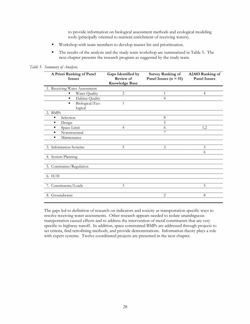
28
to provide information on biological assessment methods and ecological modeling tools (principally oriented to nutrient enrichment of receiving waters).
��Workshop with team members to develop master list and prioritization.
��The results of the analysis and the study team workshop are summarized in Table 5. The next chapter presents the research program as suggested by the study team.
Table 5. Summary of Analysis. A Priori Ranking of Panel
Issues Gaps Identified by
Review of Knowledge Base
Survey Ranking of Panel Issues (n = 51)
A2A03 Ranking of Panel Issues
1. Receiving Water Assessment �� Water Quality 2 1 4 �� Habitat Quality 4 �� Biological/Eco
logical 1
2. BMPs �� Selection 8 �� Design 5 �� Space Limit 4 6 1,2 �� Nonstructural 7 �� Maintenance
3. Information Systems 5 3 3
6 4. System Planning
5. Constraints/Regulation
6. H/H
7. Constituents/Loads 3 5
8. Groundwater 2 8
The gaps led to definition of research on indicators and toxicity as transportation specific ways to resolve receiving water assessments. Other research appears needed to isolate unambiguous transportation caused effects and to address the intervention of metal constituents that are very specific to highway runoff. In addition, space constrained BMPs are addressed through projects to set criteria, find retrofitting methods, and provide demonstrations. Information theory plays a role with expert systems. Twelve coordinated projects are presented in the next chapter.
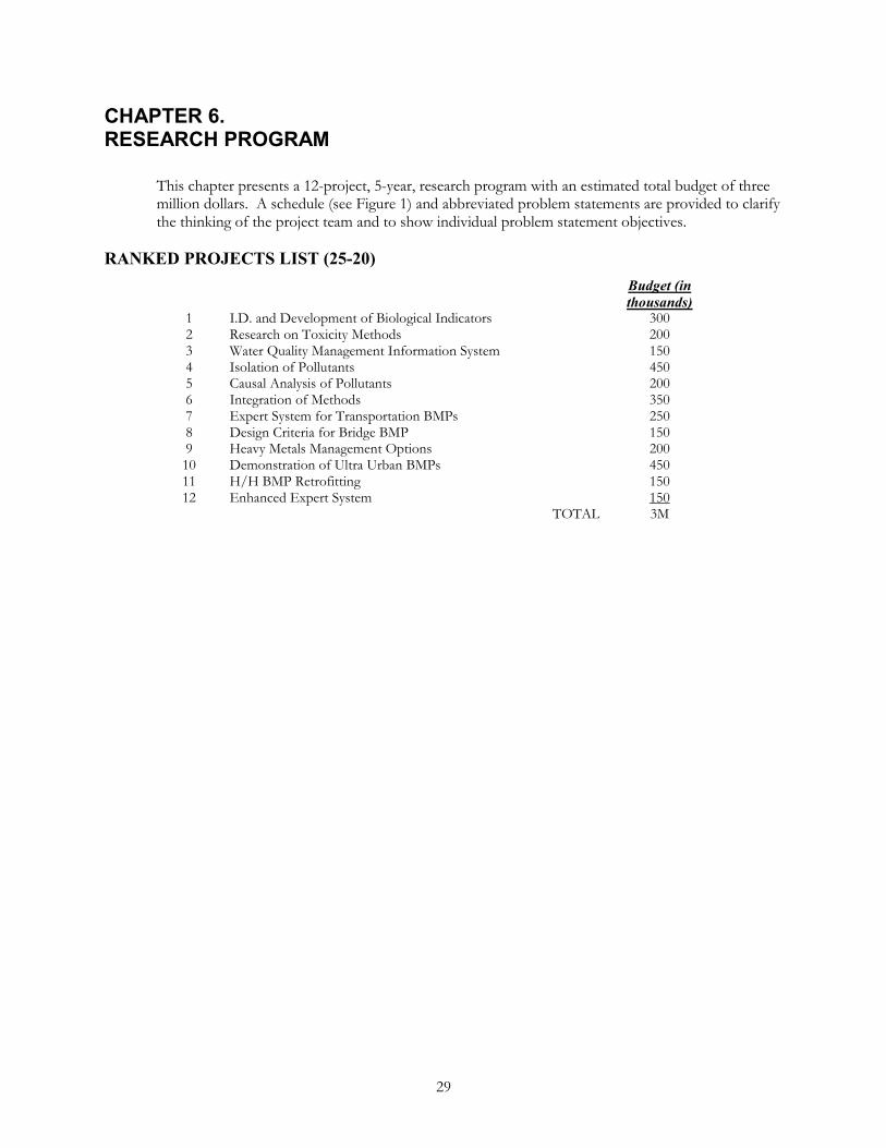
29
CHAPTER 6. RESEARCH PROGRAM
This chapter presents a 12-project, 5-year, research program with an estimated total budget of three million dollars. A schedule (see Figure 1) and abbreviated problem statements are provided to clarify the thinking of the project team and to show individual problem statement objectives.
RANKED PROJECTS LIST (25-20) Budget (in
thousands) 1 I.D. and Development of Biological Indicators 300 2 Research on Toxicity Methods 200 3 Water Quality Management Information System 150 4 Isolation of Pollutants 450 5 Causal Analysis of Pollutants 200 6 Integration of Methods 350 7 Expert System for Transportation BMPs 250 8 Design Criteria for Bridge BMP 150 9 Heavy Metals Management Options 200 10 Demonstration of Ultra Urban BMPs 450 11 H/H BMP Retrofitting 150 12 Enhanced Expert System 150 TOTAL 3M

Figure 1. 25-20 Schedule (5 Year)
Rank
1
2
3
4
5
6
7
8
9
10
11
12
Biological Indicators 300K
Toxicity Methods 200K
Management Info 150K
Isolation of Pollutants 450K
Causal Analysis 200K
Integration 350K
Expert BMPs 250K
Bridge BMPs 150K(25-13)
Heavy Metals 200K
Demo of Ultra Urban BMPs 450K
H/H Retrofit 150K
Enhanced Expert BMPs 150K
31
PROBLEM STATEMENTS I. Problem Statement 25-20-1 II. PROBLEM TITLE
Identification and Development of Regional Aquatic Biological Indicators to Assess Impacts of Highway Runoff
III. RESEARCH PROBLEM STATEMENT
Pollutant loadings from storm water runoff impact the chemical composition of receiving waters and their sediments. Regulatory decisions regarding impacts to aquatic ecosystems often rely upon chemical (non-biological) aquatic life based water quality standards that do not clearly relate pollutant loadings to ecological impacts on aquatic species, populations, or communities. To assess impacts to aquatic ecosystems, practitioners need cost-effective operational methods that can measure ecosystem impacts specifically attributable to highway runoff and measure the effectiveness of runoff management practices.
The environmental indicators concept, developed by the USEPA to measure progress towards meeting national water quality goals and objectives, is a tool that can be adapted and applied to aquatic ecosystems, highway runoff impacts, and the evaluation of the effectiveness of highway storm water management. Biological indicators can assess existing ecological conditions and the success or failure of highway storm water management practices. A process in needed to guide transportation practitioners in the appropriate use and interpretation of regional biological indicators.
IV. RESEARCH OBJECTIVES
The objective of this project is to provide highway practitioners with regional tools for assessing the biological impacts of highway runoff, including:
�� Assessment of existing biological conditions
�� Assessment of the effects of specific constituents of concern
�� Effectiveness of storm water management
�� Case studies
This will be done through the following tasks:
1. Literature Search – A literature search should be conducted to compile information on the use of biological indicators as a tool for aquatic habitat assessment (freshwater and saline) and for measuring the effectiveness of storm water runoff management. The focus of the search should be in establishing the relationships between specific highway constituents of concern and impacts to aquatic ecosystems; regional differences; and case studies (such as how Ohio and other states uses biological indicators to identify the causes and extent of water quality impairments and to evaluate the effectiveness of water quality management programs, including storm water runoff).
2. Identify Relationships Between Highway Runoff and Impacts to Aquatic Ecosystems – Review the information collected in the literature search to identify the relationships between highway runoff constituents of concern and impacts to aquatic ecosystems on a regional basis.
3. Develop Regional Biological Indicators – Assess the relationships of highway runoff and aquatic impacts to develop a prioritized candidate list of biological indicators. Selection
32
criteria utilized for prioritization should include availability of data, ease of interpretation, sensitivity to runoff, and cost-effectiveness.
4. Guidance Manual – Organize data in a format that will enable practitioners to choose, compute, and utilize biological indicators. Develop a methodology that will guide practitioners in the selection of cost-effective project-appropriate biological indicators.
V. ESTIMATE OF PROBLEM FUNDING AND RESEARCH PERIOD
The estimated funding for this project is $300,000 for the tasks noted above. The research will require approximately 18 months to complete.
VI. URGENCY, PAYOFF POTENTIAL, AND IMPLEMENTATION
Transportation practitioners need to reliably translate ecosystem conditions and runoff management objectives into performance measures. Biological indicators are cost-effective tools to both assess aquatic conditions and measure the success of management choices. The environmental indicator approach has been embraced by federal, state, and local regulatory agencies nationwide as a results-based environmental management tool to evaluate environmental quality and management progress. Transportation practitioners would greatly benefit by similarly adapting this approach which is rapidly spreading in acceptance throughout the regulatory community.
VII. PERSON(S) DEVELOPING THE PROBLEM
VIII. PROBLEM MONITOR
IX. DATE AND SUBMITTED BY
33
I. Problem Statement 25-20- 2 II. PROBLEM TITLE
Research on Methods for Assessing the Toxicity of Highway Runoff
III. RESEARCH PROBLEM STATEMENT
The prevalent thinking is that highway runoff is toxic and can degrade off-site ecosystems. However, studies on the toxicity of highway runoff are inconclusive. Numerous methods are available to assess acute and chronic toxicity. These include laboratory and field testing methodologies that cover microorganisms, algae, benthic invertebrates, and fish. Variables influencing toxicity results include species, life stage, and routes of exposure. In light of the variety of available toxicity testing methods and target species, the variability of toxicity testing results with respect to highway runoff, and the unique limitations of individual methodologies, there is a need to develop toxicity testing protocols to specifically address highway runoff delivered to different ecosystems.
IV. RESEARCH OBJECTIVES
The objective of this project is to provide highway practitioners with standardized and cost-effective methods for assessing the toxicity of highway runoff which are acceptable to environmental professionals.
This will be done through the following tasks:
1. Literature Search – A literature search should be conducted to compile data on toxicity methodologies applicable to the assessment of highway runoff. The focus of the search should be method limitations and reliability; quality assurance and quality control; interpretation of analytical results; method applicability to different ecosystems and objectives; and cost.
2. Standard Protocols – Review the information collected in the literature search and establish standard protocols for conducting toxicity testing for highway runoff.
3. Develop Guidance Manual – Develop a methodology to guide transportation practitioners in the selection of the most cost-effective toxicity testing techniques that meet project-specific objectives.
V. ESTIMATE OF PROBLEM FUNDING AND RESEARCH PERIOD
The estimated funding for this project is $200,000 for the tasks noted above. The research will require approximately 18 months to complete.
VI. URGENCY, PAYOFF POTENTIAL, AND IMPLEMENTATION
The uncertainty of the toxic properties of constituents of highway runoff is utmost in the public’s mind and often leads DOTs to spend money on toxicity testing that is unnecessary, inappropriate and inconclusive. There is an immediate need to establish guidance on the applicability of toxicity testing, the selection of cost-effective project-appropriate tests, testing protocols, and the interpretation of results.
VII. PERSON(S) DEVELOPING THE PROBLEM
VIII. PROBLEM MONITOR
IX. DATE AND SUBMITTED BY
34
I. Problem Statement 25-20-3 II. PROBLEM TITLE
Water Quality Management Information System
III. RESEARCH PROBLEM STATEMENT
This project, NCHRP 25-20, generated a CD knowledge base with 11 documents, a complete annotated bibliography, and an unannotated bibliography. The practitioner survey associated with this study identified a need for readily accessible, up to date knowledge and information. Practitioners also identified a problem with being made aware of new research and having access to that information.
IV. RESEARCH OBJECTIVES
The objective of this project is to facilitate information transfer among transportation practitioners. This will be accomplished by (1) enhancement of the CD-ROM-based knowledge base generated by NCHRP Project 25-20 and (2) development of an Internet site for the purpose of information storage, exchange and access. Either or both of these tasks are opportunities for privatization as a means of sustaining them after the project is completed.
CD Enhancement and Privatization
Enhance the NCHRP Project 25-20 electronic knowledge base by incorporating 10 to 20 of the references from it’s annotated bibliography and by adding additional resources to the existing bibliography. Update and expand the electronic indexing system of the knowledge base to incorporate the new material and new cross references. Once produced, a strategy for publicizing the CD’s existence making it available to those who need it must be established.
Web Site Development
Design, develop and deploy an Internet site to speed and expand availability of transportation runoff water quality information. The site should contain the following elements:
�� The community’s best bibliography of titles and authors with as many as possible annotated and cross-referenced.
�� As extensive an online library of complete sources as possible to shorten the acquisition time for information on subjects covered.
�� An area for posting research updates and progress reports on work of interest to the community.
�� A “round table” discussion where professionals may exchange information publicly and make contact with each other for private, off-line communication.
Once established, a strategy for publicizing the site’s existence and incorporating access to it into appropriate on-line resources needs be established.
V. ESTIMATE OF PROBLEM FUNDING AND RESEARCH PERIOD
The estimated funding for this project is $150,000 for the tasks noted above. The research will require approximately 18 months to complete.

35
VI. URGENCY, PAYOFF POTENTIAL, AND IMPLEMENTATION
This project could save state DOTs significant effort in searching for highway runoff water quality information. The practitioner survey done by NCHRP Project 25-20 indicates that:
�� Practitioners must manually review many paper products and develop their own information networks.
�� There is no formal system to keep practitioners aware of new information.
�� Timeliness of getting new information is a function of data availability.
�� There is frustration with the difficulty of finding out about relevant information.
�� 75% of the respondents suggested improving information transfer—60% of which suggestions pertained to the Internet
�� Nearly 50% felt a central depository is needed.
That the Internet could go a long way toward solving the centralization (real or virtual), timeliness and accessibility frustrations expressed by practitioners is apparent. Why it has yet to be done is equally apparent—no one as yet has assumed leadership by dedicating the resources required to design and implement an appropriate Internet site.
Until the Internet site is available and heavily populated with content, the CD-ROM knowledge base will package and make available 20 to 30 of the best “core” references on desktop computers.
VII. PERSON(S) DEVELOPING THE PROBLEM
VIII. PROBLEM MONITOR
IX. DATE AND SUBMITTED BY
36
I. Problem Statement 25-20-4 II. PROBLEM TITLE
Isolation of Pollutants in Transportation Runoff
III. RESEARCH PROBLEM STATEMENT
Nonpoint sources of pollution are recognized as potential contributors to chemical and/or biological impairment of water resources. Highway runoff often carries elevated concentrations of heavy metals and other pollutants, which impact receiving waters. In order to determine the magnitude of highway runoff impacts on water resources, it is first necessary to determine the chemical characteristics of highway runoff.
Research is needed to measure the chemical composition of highway runoff and to determine the extent to which various factors (e.g., ADT, climate, etc.) influence highway runoff water quality.
Previous research has evaluated runoff from specific land uses on a local, regional and national level. Unfortunately, none of the research focused on isolated highway runoff from a statistically significant sample in order to determine how various highway characteristics influence the quality of runoff. The following references may be of interest in responding to this solicitation:
U.S. Environmental Protection Agency, 1983. Results of the Nationwide Urban Runoff Program, Volume I. Final Report. Water Planning Division. Washington, D.C.
Driscoll, E.D., P.E. Shelley, and E.W. Strecker, 1990. Pollutant Loadings and Impacts from Highway Stormwater Runoff, Volumes I – IV. FHWA-RD-88-009. FHWA, U.S. Department of Transportation. Washington, D.C.
Sansalone, J.J., S.G. Buchberger, and M.T. Koechling, 1995. Correlation Between Heavy Metals and Suspended Solids in Highway Runoff: Implications fro Control Strategies. Transportation Research Record No. 1483. Transportation Research Board. Washington, D.C.
IV. RESEARCH OBJECTIVES
The objective of this project is to generate a statistically significant sample of pavement runoff and its chemical characteristics. This will be done through the following tasks:
1. Literature Search – A literature search should be conducted to focus identification of highway characteristics which influence runoff water quality as well as appropriate water quality parameters to consider.
2. Monitoring Program Design – Design a national highway runoff water quality monitoring program that considers influential highway characteristics and appropriate water quality parameters.
3. Monitoring – Implement the monitoring program, including collecting the samples and analytical chemistry.
4. Reporting – Prepare a report that documents the tasks and presents the monitoring results. Additionally, develop a database of monitoring site characteristics and all analytical chemistry results.

37
V. ESTIMATE OF PROBLEM FUNDING AND RESEARCH PERIOD
The estimated funding for this project is $450,000. The research will require approximately 24 months to complete.
VI. URGENCY, PAYOFF POTENTIAL, AND IMPLEMENTATION
This project could save state DOTs significant effort in monitoring highway runoff water quality for regulatory compliance. Total Maximum Daily Loads (TMDLs) will force nonpoint source and/or point source pollutant load reductions in order to meet water body designated uses. Without a clear understanding of highway runoff water quality characteristics, state DOTs will be at a distinct disadvantage as a stakeholder in the TMDL process. This process may result in highway BMPs to reduce highway loadings – the need for such management measures should be based on a sound understanding of highway runoff characteristics.
Similarly, the EPA’s National Pollutant Discharge Elimination System (NPDES) storm water permitting program will require permittees (which can include State departments of transportation) to choose appropriate best management practices for stormwater management. As is the case with the TMDL process, such management measures selected in response to NPDES permit requirements should be based on a sound understanding of highway runoff characteristics.
The anticipated product from this research, water quality characteristics from a statistically significant sample of pavement runoff, will feed into another NCHRP project to analyze this data to develop predictive models of highway runoff water quality.
VII. PERSONS DEVELOPING THE PROBLEM
VIII. PROBLEM MONITOR
IX. DATE AND SUBMITTED BY
38
I. Problem Statement 25-20-5 II. PROBLEM TITLE
Causal Analysis of Pollutants in Transportation Runoff III. RESEARCH PROBLEM STATEMENT
Nonpoint sources of pollution are recognized as potential contributors to chemical and/or biological impairment of water resources. Highway runoff often carries elevated concentrations of heavy metals and other pollutants that impact receiving waters. In order to determine the magnitude of highway runoff impacts on water resources, it is first necessary to determine the chemical characteristics of highway runoff. Research project 25-20-4, “Isolation of Pollutants in Transportation Runoff,” will generate a statistically significant sample of pavement runoff and its chemical characteristics. This project will analyze the monitoring data to develop causal relationships between transportation facility attributes and runoff water quality.
Research is needed to determine the extent to which various factors (e.g., ADT, climate, etc.) influence highway runoff water quality. Previous research has evaluated runoff from specific land uses on a local, regional and national level. Unfortunately, none of the research focused on isolated highway runoff from a statistically significant sample in order to determine how various highway characteristics influence the quality of runoff. The following references may be of interest in responding to this solicitation:
U.S. Environmental Protection Agency, 1983. Results of the Nationwide Urban Runoff Program, Volume I. Final Report. Water Planning Division. Washington, D.C.
Driscoll, E.D., P.E. Shelley, and E.W. Strecker, 1990. Pollutant Loadings and Impacts from Highway Stormwater Runoff, Volumes I – IV. FHWA-RD-88-009. FHWA, U.S. Department of Transportation. Washington, D.C.
Sansalone, J.J., S.G. Buchberger, and M.T. Koechling, 1995. Correlation Between Heavy Metals and Suspended Solids in Highway Runoff: Implications from Control Strategies. Transportation Research Record No. 1483. Transportation Research Board. Washington, D.C.
IV. RESEARCH OBJECTIVES
The objective of this project is to develop causal relationships between transportation facility attributes and runoff water quality. This will be done through the following tasks:
1. Literature Search – A literature search should be conducted to review highway characteristics which influence runoff water quality as well as appropriate water quality parameters to consider. This would build on similar work done on Project 25-20-4.
2. Monitoring Data Review – Review the monitoring data collected in Project 25-20-4 and assess its completeness for accomplishing the project objectives.
3. Statistical Modeling – Perform statistical analyses of the monitoring data to develop models which predict highway runoff water quality characteristics as a function of site attributes. This should also describe limitations in the analysis and recommendations for applying these models for highway practitioner use.
39
4. Reporting – Prepare a report that documents the tasks and presents a modeling procedure for highway practitioners to use in estimating pollutant loadings of various constituents as a function of highway attributes .
V. ESTIMATE OF PROBLEM FUNDING AND RESEARCH PERIOD
The estimated funding for this project is $200,000. The research will require approximately 24 months to complete.
VI. URGENCY, PAYOFF POTENTIAL, AND IMPLEMENTATION
This project could save state DOTs significant effort in monitoring highway runoff water quality for regulatory compliance. Total Maximum Daily Loads (TMDLs) will force nonpoint source and/or point source pollutant load reductions in order to meet water body designated uses. Without a clear understanding of highway runoff water quality characteristics, state DOTs will be at a distinct disadvantage as a stakeholder in the TMDL process. This process may result in highway BMPs to reduce highway loadings – the need for such management measures should be based on a sound understanding of highway runoff characteristics.
Similarly, the EPA’s National Pollutant Discharge Elimination System (NPDES) storm water permitting program will require permittees (which can include State departments of transportation) to choose appropriate best management practices for stormwater management. As is the case with the TMDL process, such management measures selected in response to NPDES permit requirements should be based on a sound understanding of highway runoff characteristics.
The anticipated product from this research, predictive models of highway runoff water quality, will enable highway practitioners to evaluate highway runoff contributions to receiving water quality impacts.
VII. PERSONS DEVELOPING THE PROBLEM
VIII. PROBLEM MONITOR
IX. DATE AND SUBMITTED BY
40
I. Problem Statement 25-20-6 II. Problem Title
Integration of Multidisciplinary Methods for Evaluation of Transportation Runoff Impacts to Aquatic Ecosystems.
III. Research Problem Statement
Current techniques for assessing highway runoff impacts on aquatic ecosystems are not multidisciplinary. According to Herricks (1995) “…It is necessary to connect storm events with stormwater runoff and recognize that the complex interaction of physics and chemistry on the land, as well as the channel, will have an equally complex effect on receiving system organisms and their interactions.” It is important to integrate this process to avoid an inconsistent labyrinth of alternatives in runoff management.
Highway practitioners who deal with water quantity are often at odds with those who deal with water quality. Hydrologic and hydraulic calculations used to design runoff handling systems are generally insensitive to toxicity and biological issues in downstream areas. Similarly, those employed to effect improvements in water quality in downstream areas are often insensitive to hydraulic considerations in land development (including highway) design.
The following reference may be of interest in responding to this solicitation:
Herricks, E.E. (ed.), Stormwater Runoff and Receiving Systems- Impact, Monitoring, and Assessment. CRC Press, Inc. Boca Raton, Florida (1995)
U.S. Environmental Protection Agency, 1983. Results of the Nationwide Urban Runoff Program, Volume I. Final Report. Water Planning Division. Washington, D.C.
Driscoll, E.D., P.E. Shelley, and E.W. Strecker, 1990. Pollutant Loadings and Impacts from Highway Stormwater Runoff, Volumes I – IV. FHWA-RD-88-009. FHWA, U.S. Department of Transportation. Washington, D.C.
United States Environmental Protection Agency, “National Nutrient Assessment Strategy: An Overview of Available Endpoints and Assessment Tools,” August 1998.
IV. RESEARCH OBJECTIVES
The objective of this project is build upon the research of described in Problems 25-20-1, 25-20-2, and 25-20-5 to provide transportation practitioners with a consistent integrated process that links runoff characterization, known physics and engineering calculations with toxicity and biological indicators.
This will be done through the following tasks:
1. Research Review and Literature Search – Review the findings of Problems 25-20-1, 25-20-2, and 25-20-5. A literature search should also be conducted to compile additional information on integrated methods for assessing the impacts of transportation facility runoff on aquatic ecosystems.
2. Identify Runoff Impact Relationship Factors – Evaluate the findings of 25-20-1 (biological impact indicators), 25-20-2 (highway runoff toxicity) and 25-20-5 (highway runoff water quality predictive tool) to identify the factors associated with the physical and chemical characteristics of runoff as well as the vulnerability of aquatic ecosystems. These factors will form the foundation for developing an integrated method for evaluating transportation runoff impacts on aquatic ecosystems.
3. Develop Multidisciplinary Method for Evaluating Transportation Runoff Impacts to Aquatic Ecosystems – Develop a quantitative process for integrating runoff characteristics

41
with ecosystem impacts as a function of relationship factors identified in Task 2. This process may be a set of predictive models or may be a ranking methodology that assesses impacts.
4. Develop Guidance Manual—Develop a manual to guide transportation practitioners in the application of the integrated process.
V. ESTIMATE OF PROBLEM FUNDING AND RESEARCH PERIOD
The estimated funding for this project is $350,000. The research will require approximately 24 months to complete.
VI. URGENCY, PAYOFF POTENTIAL, AND IMPLEMENTATION
This project could save state DOTs significant effort in highway runoff water handling design costs for regulatory compliance. Total Maximum Daily Loads (TMDLs) will force nonpoint source and point source pollutant load reductions in order to meet water body designated uses. Stormwater NPDES permits will also affect highway stormwater management. This research will result in a better understanding of how engineering design decisions affect water quality in downstream areas through the development of a quantitative process This will allow state DOTs to respond and react to regulatory requirements which will influence design decisions.
The anticipated design guidance product from this research will enable highway practitioners to engineer highway runoff with compliant effects upon receiving water quality impacts.
VII. PERSON(S) DEVELOPING THE PROBLEM
VIII. PROBLEM MONITOR
IX. DATE AND SUBMITTED BY

42
I. Problem Statement 25-20-7 II. PROBLEM TITLE
Expert System for Transportation BMPs
III. RESEARCH PROBLEM STATEMENT
Two FHWA reports address conventional and ultra-urban BMPs. Each is a kind of synthesis of available information and are both comprehensive and extensive. For the information to be useful to practitioners, they must be extremely familiar with all the information available and must determine which portions are applicable to a specific site under consideration and how that information applies to the site.
Practitioners need quick and ready access to BMP information and a means of quickly applying applicable portions of it to site-specific situations—an expert system. With today’s automation and communication technologies, such a system could be developed as an automated interface and database which users could access on desktop systems or via the Internet.
The information in these reports and in the BMP literature is available for expert system research.
The following references may be of interest in responding to this solicitation:
Young, G. K., Stein, S., Cole, P., Kammer T., Graziano, Bank F. “Evaluation and management of highway runoff water quality.” Federal Highway Administration Final Report FHWA-PD-96-032, FHWA (1996) 480 pp.
“Ultra-Urban Best Management Practices,” Office of Environment and Planning, Federal Highway Administration, Washington, DC, October, 1999
IV. RESEARCH OBJECTIVES
The objective of this project is to provide highway practitioners with an expert system. The expert system will use site information such as area, percent imperviousness, soil type, use (ADT), and desired runoff quality, and rank by effectiveness and cost alternative BMP choices.
This research will be done through the following tasks:
1. Literature Search and Practitioner Survey – A literature search should be conducted to identify design and monitoring information elements available to highway practitioners. This search for information should include a survey of highway practitioners as to sources and methods used and/or required for BMP design.
2. Conceptual Design – Conceptually design an expert system which:
��Contains a database of appropriate BMP design data and methods.
�� Implements an interface which accepts site-specific design information
��Returns, if possible, one or more BMP designs which meets the criteria specified and complies with applicable regulatory requirements
�� If no design is possible, returns site-specific information on what factors prevent appropriate design.
43
3. Implementation Design – Determine the most appropriate medium or media in which to implement the resulting expert system. A stand-alone will be faster while Internet-based application would be easier to maintain and enable instant distribution of updates. A combination is also possible, e.g. a stand-alone interface with Internet-based database.
4. Implementation – Code the interface and design and populate the database. Prepare a report that documents the expert system and includes a practitioner user guide.
V. ESTIMATE OF PROBLEM FUNDING AND RESEARCH PERIOD
The estimated funding for this project is $250,000. The research will require approximately 18 months to complete.
VI. URGENCY, PAYOFF POTENTIAL, AND IMPLEMENTATION
This project could save state DOTs significant effort in designing effective and compliant highway BMPs. The anticipated expert system product from this research will enable highway practitioners to more quickly identify the characteristics of an effective and compliant BMP for a specific situation. Depending on the scope and adequacy of the resulting database, it can greatly reduce the need for redesign as the result of oversights, miscalculations or omissions. The speed with which it is anticipated site-specific BMP design characteristics may be developed using an automated expert system may enable development of alternative designs from which practitioners may choose in any given situation.
VII. PERSON(S) DEVELOPING THE PROBLEM
VIII. PROBLEM MONITOR
IX. DATE AND SUBMITTED BY

44
I. Problem Statement 25-20-8 II. PROBLEM TITLE
Design Criteria for Bridge BMPs III. RESEARCH PROBLEM STATEMENT
Bridges are normally graded to direct runoff to the ends of the bridge. Runoff is most often piped through a scupper drain system to one or both ends of the bridge where it joins surface drainage. Bridge runoff requires evaluation as a potential pollutant to receiving waters that are typical of bridge sites. An existing NCHRP (25-13) study is evaluating the effects of bridge deck runoff. The next step is to devise operational methods to incorporate acceptable bridge BMP designs.
IV. RESEARCH OBJECTIVES
The objective of this project is to further the results of NCHRP 25-13 by subjecting potential design criteria for containment and disposal of bridge deck runoff to cost and feasibility analyses. It is anticipated that 25-13 will result in recommendations for additional research
This research will be done through the following tasks:
1. Formulate Feasibility Objectives—Using the 25-13 practitioner guidance as a basis, formulate critical feasibility objectives for bridge site water quality BMPs. Potential objectives are implementation costs, maintenance cost, cost of operation, integrated versus retrofit designs, and pollutant removal effectiveness. Incorporate both regional and functional diversity among the objectives.
2. Describe Operational Methods—It is anticipated that the results of 25-13 will necessarily be mainly “site specific” to the sites studied. This task will apply the feasibility objectives formulated in the previous task and apply them “generally” to bridge designs in order to make generalize the relevance of 25-13 results. Regional and functional diversity is again important in development of methods for incorporation.
3. Manual Updates—Update existing BMP information and guidance documents to incorporate the information resulting from this study. Where possible, integrate the information into scheduled re-writes or updates of manuals. Where not, publish stand-alone appendices to them. If complete in time, incorporate this information into any expert system being developed.
The following references may be of interest in responding to this solicitation:
Young, G.K., Stein, S., Cole, P., Kammer T., Graziano, Bank F. "Evaluation and management of highway runoff water quality." Federal Highway Administration Final Report FHWA-PD-96-032, FHWA (1996) 480 pp.
“Ultra-Urban Best Management Practices,” Office of Environment and Planning, Federal Highway Administration, Washington, DC, October, 1999.
V. ESTIMATE OF PROBLEM FUNDING AND RESEARCH PERIOD
The estimated funding for this project is $150,000. The research will require approximately 18 months to complete.
45
VI. URGENCY, PAYOFF POTENTIAL, AND IMPLEMENTATION
This project could save state DOTs significant effort in bridge deck runoff water handling design costs for regulatory compliance. Total Maximum Daily Loads (TMDLs) will force nonpoint source and point source pollutant load reductions in order to meet water body designated uses. Stormwater NPDES permits will also affect highway stormwater management. This research will result in a better understanding of the operational factors affecting design, retrofit, implementation, maintenance, and effectiveness of bridge deck BMPs. This will allow state DOTs to produce better designs for less.
The anticipated design guidance products from this research will enable highway practitioners to engineer bridge deck runoff with compliant effects upon receiving water quality impacts.
VII. PERSON(S) DEVELOPING THE PROBLEM
VIII. PROBLEM MONITOR
IX. DATE AND SUBMITTED BY
46
I. Problem Statement 25-20-9 II. PROBLEM TITLE
Heavy metals management options
III. RESEARCH PROBLEM STATEMENT
The Ohio Department of Transportation and the University of Cincinnati have monitored an interstate for particulates in runoff. Detailed particle analysis of the particulates indicated that the very fine faction and its relative abundance drives heavy metal emissions. Since these tend to remain suspended, they are subject to transport over extended distances from the roadway where they are generated. Practitioners need effective ways to confine the heavy metal toxins to the right of way. This research correlates and continues the research described in 25-20-4.
The following references may be of interest in responding to this solicitation:
U.S. Environmental Protection Agency, 1983. Results of the Nationwide Urban Runoff Program, Volume I. Final Report. Water Planning Division. Washington, D.C.
Driscoll, E.D., P.E. Shelley, and E.W. Strecker, 1990. Pollutant Loadings and Impacts from Highway Stormwater Runoff, Volumes I – IV. FHWA-RD-88-009. FHWA, U.S. Department of Transportation. Washington, D.C.
Sansalone, J.J., S.G. Buchberger, and M.T. Koechling, 1995. Correlation Between Heavy Metals and Suspended Solids in Highway Runoff: Implications fro Control Strategies. Transportation Research Record No. 1483. Transportation Research Board. Washington, D.C.
IV. RESEARCH OBJECTIVES
The objective of this project is to devise methods to interrupt heavy metal transport beyond the highway right of way. Potential methods include particulate exfiltration trenches (PETs), vacuum collection, and grassy swales, coagulation and sedimentation. A secondary objective is to determine disposal options for collected residues.
This research will be conducted through the following tasks:
1. Literature Search—Critically review existing literature to determine the state of existing knowledge concerning the measurement, generation, transport and removal of heavy metal components from highway runoff (or other emissions). Identify the most promising technologies available to measure, to prevent generation and transport, and to effectively collect and dispose of heavy metal components from highway runoff.
2. Method Demonstration—Demonstrate the actual effectiveness of the methods identified in the previous task in both urban and major rural arterial settings where heavy metal emissions are likely to be significant. Sites selected should represent regional diversity and should allow effective water quality monitoring. A standardized water quality measurement technique should be selected and used at all sites to remove the effects of differing techniques upon the data collected.
3. Guidance Manual—Develop a manual to guide transportation practitioners in the application of the technologies most likely to be implemented into highway design to address heavy metal aspects of water quality.
47
V. ESTIMATE OF PROBLEM FUNDING AND RESEARCH PERIOD
The estimated funding for this project is $200,000. The research will require approximately 18 months to complete.
VI. URGENCY, PAYOFF POTENTIAL, AND IMPLEMENTATION
This research will result in a better understanding of the mechanisms responsible for the generation and transport of heavy metal pollutant components of highway runoff. It will demonstrate the relative—if not absolute—effectiveness of the demonstrated technologies in removing those toxins from the runoff leaving the highway right of way. This will allow state DOTs to produce better designs for less.
Total Maximum Daily Loads (TMDLs) will force nonpoint source and point source pollutant load reductions in order to meet water body designated uses. Stormwater NPDES permits will also affect highway stormwater management. The anticipated guidance manual will enable highway practitioners to engineer bridge deck runoff with compliant effects upon receiving water quality impacts.
VII. PERSON(S) DEVELOPING THE PROBLEM
VIII. PROBLEM MONITOR
IX. DATE AND SUBMITTED BY
48
I. Problem Statement 25-20-10 II. PROBLEM TITLE
Demonstration of Ultra-Urban BMPs
III. RESEARCH PROBLEM STATEMENT
A number of ultra-urban BMPs have been identified in a national study—“Ultra-Urban Best Management Practices,” Office of Environment and Planning, Federal Highway Administration, U.S. Department of Transportation, Washington, DC, October, 1999. The purpose that study was to provide a planning-level review of the applicability and use of new and more traditional BMPs in ultra-urban settings. That study was not intended to result in a design manual.
A number of case studies need to be demonstrated and evaluated for practicality so that initial comprehensive design guidance may be undertaken.
IV. RESEARCH OBJECTIVES
The term "ultra-urban" has been used to describe areas of the country where space for stormwater BMP implementation is limited. The goal of ultra-urban technology is to provide cost-effective, low-maintenance solutions to stormwater management problems in the ultra-urban environment. The objective of this project is to construct and evaluate likely ultra-urban BMP designs in ultra-urban settings and evaluate them for operational effectiveness as a function of maintenance requirements.
To make the results of this research broadly applicable, sensitivity to regional and site-specific issues will be important. For example, bioswales are prevalent in the northwest where there is more space to implement them, but are not widely used in the northeast. Cartridge filters and other such mechanical systems are used in commercial site plans. Chemical treatment is a potential “retrofit” to increase the water quality effectiveness in wet ponds.
This research will be completed through the following tasks:
1. Site and matching BMP selection BMP—Select a series of sites suitable for installation (or retrofit) of an ultra-urban BMP. Find (or collect) and analyze the existing water quality issues associated with the sites to assist in BMP selection and to establish water quality data baseline. Select an appropriate BMP for installation or retrofit at the each site. Develop a site-specific monitoring plan to collect the necessary water quality data for analysis.
2. BMP Installation, Operation and Monitoring—At each site, install or retrofit the selected BMP and the necessary instrumentation to collect the water quality data identified in task 1. Operate each BMP for a minimum of one year while collecting water quality and maintenance operations costs. Analyze the resulting data for significant trends and draw conclusions about effectiveness relative to maintenance costs.
3. Manual Guidance—Develop guidance elements that may be published as ultra-urban addenda to existing BMP guidance manuals.
V. ESTIMATE OF PROBLEM FUNDING AND RESEARCH PERIOD
The estimated budget for this project is $450,000. The research will require approximately 30 months to complete.
49
VI. URGENCY, PAYOFF POTENTIAL, AND IMPLEMENTATION
This research will result in a better understanding of the factors affecting the design, operation, effectiveness and maintenance of those ultra-urban BMPs demonstrated. This will permit state DOTs to produce better designs for less. Total Maximum Daily Loads (TMDLs) will force nonpoint source and point source pollutant load reductions in order to meet water body designated uses. Stormwater NPDES permits will also affect highway stormwater management. The anticipated guidance addenda will enable highway practitioners to implement cost-effective BMPs in the ultra-urban environment with compliant effects upon receiving water quality impacts.
VII. PERSON(S) DEVELOPING THE PROBLEM
VIII. PROBLEM MONITOR
IX. DATE AND SUBMITTED BY
50
I. Problem Statement 25-20-11 II. PROBLEM TITLE
Hydraulics and Hydrology BMP Retrofitting III. RESEARCH PROBLEM STATEMENT
Existing transportation infrastructure utilizes a number of types of drainage management facilities such as detention ponds and storm sewers. Facing ever-increasing water quality requirements, practitioners need practical guidance for capturing water quality benefit from BMP infrastructure already in place. Such hydraulic facilities can be retrofitted to provide water quality benefits.
Often, measures are installed during construction for erosion and sediment control and then removed when construction is complete resulting in loss of benefit. Such hydraulic facilities may provide significant water quality benefit if simply left in place after construction. Benefit may be augmented if retrofitted to provide water quality benefits.
Highway practitioners need guidance material how these existing facilities may be retrofitted to provide water quality benefit.
IV. RESEARCH OBJECTIVES
The objective of this project is to identify methods and techniques to retrofit existing drainage infrastructure, with an emphasis on maintenance. A sub-objective (constraint) is to implement retrofits within existing rights-of-way.
This research will be accomplished through the following tasks:
1. Design Standards Review—State highway department water quality and BMP construction standards need to be reviewed to establish overall water quality benefit goals for retrofit types to be explored.
2. Development of Water Quality Retrofit Conceptual Designs—Develop a series of conceptual design standards which quantify the water quality benefits of retrofitting drainage elements with water quality elements. Focus on those likely to result in water quality benefits that meet the design standards detailed in task 1. Every effort should be made to accommodate as many drainage element types as possible with a retrofit concept, i.e., storm sewers, roadside channels, trenches, swales, ponds, et cetera. The overall potential of retrofit depends on the incidence of existing drainage systems available and receptive to retrofits. This needs to be determined.
3. Develop Guidance Manual—Develop a practical guidance manual for transportation practitioners in selecting, designing and implementing water quality retrofits to existing highway drainage systems. Include modification to maintenance considerations introduced as a result of the retrofits.
V. ESTIMATE OF PROBLEM FUNDING AND RESEARCH PERIOD
The estimated funding for this project is $150,000. The research will require approximately 18 months to complete.
VI. URGENCY, PAYOFF POTENTIAL, AND IMPLEMENTATION
This project could save state DOTs significant expense in meeting ever-increasing water quality requirements. Total Maximum Daily Loads (TMDLs) will force nonpoint source and point source pollutant load reductions in order to meet water body designated uses.

51
Stormwater NPDES permits will also affect highway stormwater management. This research will allow state DOTs to retrofit existing facilities to meet more stringent standards and construction requirements needed to meet standards.
VII. PERSON(S) DEVELOPING THE PROBLEM
VIII. PROBLEM MONITOR
IX. DATE AND SUBMITTED BY
52
I. Problem Statement 25-20-12 II. PROBLEM TITLE
Enhanced expert system for transportation BMPs
III. RESEARCH PROBLEM STATEMENT
Practitioners need quick and ready access to BMP information that would be afforded by an expert system. Ongoing research into BMPs including NCHRP research projects will yield new information on BMP selection, performance, and design that will be available for enhanced expert system research. This research builds upon that begun in 25-20-7.
IV. RESEARCH OBJECTIVES
The objective of this project is to enhance the highway practitioners’ enhanced expert system with information and research results made available since its initial deployment. The expert system will use site information such as area, percent imperviousness, soil type, use (ADT), and desired runoff quality, and rank by effectiveness and cost alternative BMP choices.
This research will be done through the following tasks:
1. Literature Search and Practitioner Survey – A literature search should be conducted to identify design and monitoring information elements which have become available to highway practitioners or have substantially changed since initial deployment of the expert system. This search for information should include a survey of highway practitioners as to sources and methods used and/or required for BMP design.
2. Update Expert System – Code the interface and design and populate the database with the addition data. Update the report that documents the expert system.
V. ESTIMATE OF PROBLEM FUNDING AND RESEARCH PERIOD
The estimated funding for this project is $150,000. The research will require approximately 18 months to complete.
VI. URGENCY, PAYOFF POTENTIAL, AND IMPLEMENTATION
This project could save state DOTs significant effort in designing effective and compliant highway BMPs. The anticipated expert system product from this research will enable highway practitioners to more quickly identify the characteristics of an effective and compliant BMP for a specific situation. Depending on the scope and adequacy of the resulting database, it can greatly reduce the need for redesign as the result of oversights, miscalculations or omissions. The speed with which it is anticipated site-specific BMP design characteristics may be developed using an automated expert system may enable development of alternative designs from which practitioners may choose in any given situation.
VII. PERSON(S) DEVELOPING THE PROBLEM
VIII. PROBLEM MONITOR
IX. DATE AND SUBMITTED BY
53
CHAPTER 7. POTENTIAL SOURCES OF RESEARCH FUNDING
This section provides an overview of funding sources for this quality of runoff project.
FHWA SURFACE TRANSPORTATION RESEARCH FUNDING (~$100 MILLION PER YEAR)
The Transportation Equity Act for the 21st Century (TEA-21) provides for funding surface transportation research projects through the Federal Highway Administration (FHWA). The budgeted funding level is approximately $100 million per year for the six years covered under the act. A portion of the funds is earmarked for specific projects/programs (~ $80 million) and the remainder goes into administrative research funds ($ 20 million). From the administrative research funds, the FHWA Environmental Research Program currently receives approximately $4 million per year for supporting directly sponsored research within FHWA, providing research grants and match funds to states, and participating in federal cooperative research work with other agencies.
The administrative research funds are also used to support the Transportation Environmental Research Program (TERP). This program funds research in transportation and environmental issues at universities and colleges. Research topics include environmental impact assessment in transportation, storm water constituents, and water quality. Awards are made based on responses to TERP research announcements and typically range from $20,000 to $50,000 each.
STATEWIDE PLANNING AND RESEARCH (SPR) FUNDING (~$481.5 MILLION)
The States receive planning and research funding from a 2% takedown of State apportionments for the Interstate Maintenance, National Highway System, Surface Transportation, Congestion Mitigation & Air Quality, and Bridge Rehabilitation and Replacement Programs. The SPR funding averages approximately $481.5 million per year for the six years of TEA-21. Of that amount, approximately 25% or roughly $120 million must be used for research, development, and technology transfer activities. Figure 2 presents an overview of how SPR funds are used for conducting research projects.

54
Figure 2. Statewide Planning and Research Fund Usage
As shown in Figure 2, approximately 5.5 percent of the SPR funds are allocated by each state for the National Cooperative Highway Research Program (NCHRP). The program is administered by the Transportation Research Board and the funds are spent on research topics approved on ballot by at least two-thirds of the states. Project ranking is done by the AASHTO Standing Committee on Research.
The States can also use the funds to conduct “Pooled Fund” projects, perform in-house research projects, or support university research efforts. Pooled Fund projects are often embarked upon by states with a common research need. Several states may choose to “pool” their resources to jointly fund a project that otherwise would be too costly to fund through a single state. The FHWA may also participate in these projects by using a portion of their research dollars to contribute to the effort.
DEPARTMENT OF TRANSPORTATION SMALL BUSINESS INNOVATIVE RESEARCH (SBIR) PROGRAM
The Small Business Innovative Research program was developed to utilize small businesses in conducting Federal research & development projects. The Department of Transportation’s SBIR program is directed by the Volpe Center in Cambridge, Massachusetts. Each year, the DOT solicits innovative research proposals from small businesses that address high priority transportation-related research areas in the Department. Phase I proposals that deal with feasibility-related experimental or theoretical research efforts can be funded up to $100,000. Small businesses that perform successful Phase I projects may submit Phase II proposals to continue the research at funding levels up to
Federal-Aid Highway Apportionments
Statewide Planning and Research Funds(25% required for research, development, and
technology transfer)
2% Takedown
5.5%
NCHRP Research Projects
Internal State
Research Projects
University Research Projects
Pooled Fund Projects

55
$750,000. Commercialization of research applications under Phase III must be completed using non-Federal funding sources.
OTHER FEDERAL FUNDING SOURCES In December of 1999, the EPA office of Water updated their Catalog of Federal Funding Sources for Watershed Protection (Second Edition, EPA 841-B-99-003). The catalog lists a wide variety of Federal sources for funding watershed protection projects. After reviewing this document, it appears that several of the funding sources cited may be available for conducting research projects related to management of runoff from surface transportation facilities. The following are brief paragraph summaries of some of the relevant information contained in EPA’s catalog:
Water Quality Cooperative Agreements (FY00 ~$19 million). The EPA provides funding through these grants for supporting the creation of unique and new approaches to dealing with storm water, sanitary sewer, and combined sewer overflows issues. These projects may include research, investigations, experiments, training, demonstrations, surveys, and studies related to the causes, effects, extent, and prevention of pollution. Eligible applicants may include state water pollution control agencies, interstate agencies, local public agencies, Indian tribes, non-profit institutions, organizations, and individuals.
Science to Achieve Results Program (FY00 ~$100 million). This EPA program provides funding for conducting research in the following six areas: Safe Drinking Water, High Priority Air Pollutants, Research to Improve Human Health Risk Assessment, Research to Improve Ecological Risk Assessment, Emerging Issues, and Pollution Prevention & New Technologies. Research grants typically range from $5,000 to $2 million and are aimed at facilitating cooperation between EPA and the scientific community to jointly solve environmental problems. Eligible applicants include U.S. States, territories, and possessions, universities and colleges, state & local governments, and nonprofit institutions that have demonstrated unusually high scientific ability.
CWA Section 319 Non-Point Source Implementation Grants (FY00 ~$200 million). Under this EPA program, grants are provided to states and tribes for implementation of non-point source projects and programs that are in accordance with Section 319 of the Clean Water Act. Many of the projects include design, implementation, and monitoring of best management practices for controlling storm water runoff. There is normally a 40% match funding requirement for states/tribes/local organizations that apply. Eligible applicants include lead state & territorial NPS agencies and eligible tribes.
Pollution Prevention Incentives for States (FY00 ~$5 million). This EPA grant program provides grants to states for projects that address multimedia pollution prevention as an environmental management priority, establishing prevention goals, providing direct technical assistance to businesses, conducting outreach, and collecting and analyzing data. Project grants typically range from $25,000 to $100,000 and require states to provide at least 50% of the total project costs. Both states and Indian tribes may apply for the grants.
National Sea Grant College Program (FY00 ~$59 million). Sea Grant is a partnership between the nation’s universities and the National Oceanic and Atmospheric Administration that encourages wise use of our marine resources and coastal environment through research, education, outreach, and technology transfer. National- and state- level competitions are held annually to select grant awardees. There is a 50 % match requirement (1/3 of the total project) for all grant projects. Eligible applicants include state and local governments, nonprofit and for-profit organizations, academic institutions, federally recognized Indian tribes, and individuals.
56
Chesapeake Bay Program Grants (FY00 ~$15 million). EPA’s Chesapeake Bay Program provides for grants to reduce and prevent pollution and to improve the living resources in the Chesapeake Bay. Eligible grant activities include research, monitoring, and implementation projects. Grants in the past have ranged from $5,000 to $2.7 million with a median of $300,000. There are certain match requirements depending upon the specific project and program funding source. Eligible applicants include state water pollution control agencies, interstate agencies, other public or nonprofit organizations, and private agencies.

A-1
APPENDIX A. SURVEY - MANAGEMENT OF RUNOFF FROM SURFACE TRANSPORTATION FACILITIES Visit the website of GKY & Associates to respond electronically: www.gky.com/nchrp25-20 I. BACKGROUND INFORMATION
Name/Title: ________________________________ Agency: ________________________________
Division: _________________________________ Address: _________________________________
________________________________
Phone number: __________________________
Fax number: __________________________
Email address: __________________________ Transportation Facility Type:
� highway � rail � airport
Education & Experience: Highest degree obtained ________________________ Years experience in current discipline __________ II. MANAGEMENT NEEDS
A. Briefly explain the three most common runoff/water quality management issues that you face? 1. 2. 3.
B. Do you feel there is sufficient information available to enable you to adequately
address each of the issues in Part A?
1. � yes � no
2. � yes

A-2
� no
3. � yes � no
C. A list of surface water runoff topic areas is attached to the end of this survey. For
each answer of “no” in Part B, please indicate below areas from this list where you feel research is most needed to address the issues specified.
1. 2. 3. III. DATA AVAILABILITY AND UTILIZATION
A. What sources of data (e.g. reports, databases) do you rely on to address runoff/water quality management issues? Please be specific (i.e., provide title of document, website address, name of organization, etc.)
B. How do you typically learn of new information about runoff/water quality management?
C. How do you typically gain access to sources of new information in this field? D. Do you feel you learn of and gain access to new information in a timely manner? E. Imagine you are doing a database search for information related to your management needs. From the list below, please indicate which keyword/phrases you would be most likely to use to search the database. Water Quality Assessment
degradation dissolved oxygen fate & transport kinetics mathematical model monitoring nitrogen nutrients phosphorus river model stream model turbidity water-quality criteria water-quality model Habitat Assessment
benthic community biological impacts beneficial use eutrophication fish passage geomorphology habitat(s) habitat assessment habitat characterization impact impact analysis impact assessment sedimentation submerged aquatic vegetation wetlands
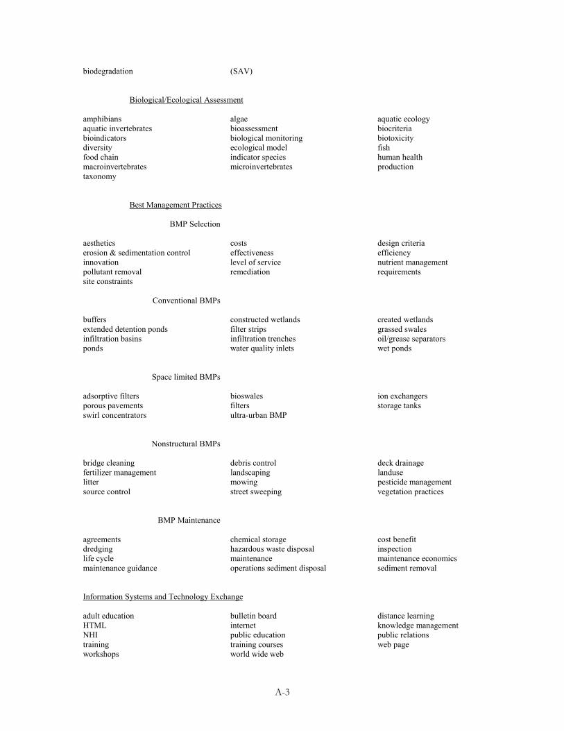
A-3
biodegradation (SAV) Biological/Ecological Assessment amphibians algae aquatic ecology aquatic invertebrates bioassessment biocriteria bioindicators biological monitoring biotoxicity diversity ecological model fish food chain indicator species human health macroinvertebrates microinvertebrates production taxonomy Best Management Practices
BMP Selection
aesthetics costs design criteria erosion & sedimentation control effectiveness efficiency innovation level of service nutrient management pollutant removal remediation requirements site constraints
Conventional BMPs buffers constructed wetlands created wetlands extended detention ponds filter strips grassed swales infiltration basins infiltration trenches oil/grease separators ponds water quality inlets wet ponds
Space limited BMPs adsorptive filters bioswales ion exchangers porous pavements filters storage tanks swirl concentrators ultra-urban BMP
Nonstructural BMPs bridge cleaning debris control deck drainage fertilizer management landscaping landuse litter mowing pesticide management source control street sweeping vegetation practices
BMP Maintenance agreements chemical storage cost benefit dredging hazardous waste disposal inspection life cycle maintenance maintenance economics maintenance guidance operations sediment disposal sediment removal Information Systems and Technology Exchange adult education bulletin board distance learning HTML internet knowledge management NHI public education public relations training training courses web page workshops world wide web
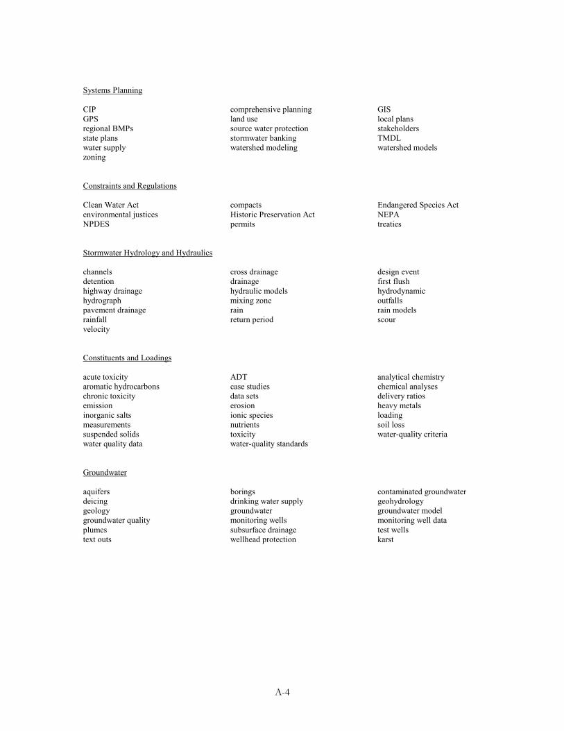
A-4
Systems Planning CIP comprehensive planning GIS GPS land use local plans regional BMPs source water protection stakeholders state plans stormwater banking TMDL water supply watershed modeling watershed models zoning Constraints and Regulations Clean Water Act compacts Endangered Species Act environmental justices Historic Preservation Act NEPA NPDES permits treaties Stormwater Hydrology and Hydraulics channels cross drainage design event detention drainage first flush highway drainage hydraulic models hydrodynamic hydrograph mixing zone outfalls pavement drainage rain rain models rainfall return period scour velocity Constituents and Loadings acute toxicity ADT analytical chemistry aromatic hydrocarbons case studies chemical analyses chronic toxicity data sets delivery ratios emission erosion heavy metals inorganic salts ionic species loading measurements nutrients soil loss suspended solids toxicity water-quality criteria water quality data water-quality standards Groundwater aquifers borings contaminated groundwater deicing drinking water supply geohydrology geology groundwater groundwater model groundwater quality monitoring wells monitoring well data plumes subsurface drainage test wells text outs wellhead protection karst
A-5
F. Please comment briefly on what you think could be done to help: 1) make important new documents more accessible for your use; and 2) increase your awareness of new research, data, publications and other documents in this field. Thank you for taking the time to complete this questionnaire. Please return to: Dr. Marjorie Zeff Louis Berger & Associates, Inc. 100 Halsted Street East Orange, New Jersey 07019
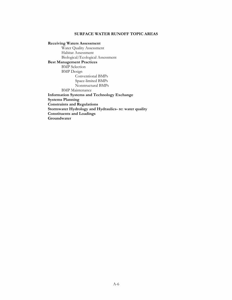
A-6
SURFACE WATER RUNOFF TOPIC AREAS
Receiving Waters Assessment Water Quality Assessment Habitat Assessment Biological/Ecological Assessment Best Management Practices BMP Selection BMP Design Conventional BMPs Space-limited BMPs Nonstructural BMPs BMP Maintenance Information Systems and Technology Exchange Systems Planning Constraints and Regulations Stormwater Hydrology and Hydraulics- re: water quality Constituents and Loadings
Groundwater


![1] (: 311 - Transportation Research Boardonlinepubs.trb.org/Onlinepubs/nchrp/nchrp_syn_141.pdf · JOHN GRAY, President, National Asphalt Pavement Association (cx officio) THOMAS H](https://img.pdfslide.us/doc/110x75/5ed016b4160afc65d9458562/1-311-transportation-research-john-gray-president-national-asphalt-pavement.jpg)