Embed Size (px)
Citation preview

ACKNOWLEDGMENT OF SPONSORSHIP This work was sponsored by one or more of the following as noted g American Association of State Highway and Transportation Officials in cooperation with the Federal Highway Administration and was conducted in the National Cooperative Highway Research Program
c Federal Transit Administration and was conducted in the Transit Cooperative Research Program
c Federal Aviation Administration and was conducted in the Airport Cooperative Research Program
c Research and Innovative Technology Administration and was conducted in the National Cooperative Freight Research Program
c Pipeline and Hazardous Materials Safety Administration and was conducted in the Hazardous Materials Cooperative Research Program
which is administered by the Transportation Research Board of the National Academies
DISCLAIMER This is an uncorrected draft as submitted by the research agency The opinions and conclusions expressed or implied in the report are those of the research agency They are not necessarily those of the Transportation Research Board the National Academies or the program sponsors
Final Report
NCHRP 8-55A Developing a Logical Model for a Geo-Spatial Right-of-Way Land Management System Prepared for Transportation Research Board of The National Academies Prepared by Kathleen Hancock PE PhD Virginia Polytechnic Institute and State University The Center for Geospatial Information Technology Alexandria VA February 2011
NCHRP 8-55A Developing a Logical Model for a Geospatial Right-of-Way Land Management System
Center for Geospatial Information Technology Virginia Polytechnic Institute and State University i
CONTENTS LIST OF FIGURES ii LIST OF TABLES ii LIST OF ACRONYMS iii ACKNOWLEDGEMENTS iv ABSTRACT v SUMMARY 1 CHAPTER 1 Introduction and Research Approach 4 11 Problem Statement 4 12 Objectives and Scope 5 13 Research Overview 6 14 Report Organization 7 CHAPTER 2 Research Overview 8 21 Right-of-way Information Management Systems 11 22 Geographical Information Management Systems in Right-of-Way 17 23 Vendor Systems 21 24 Summary 22 CHAPTER 3 Logical Model 23 CHAPTER 4 Testing 34 CHAPTER 5 Conclusions and Suggested Research 39 51 Conclusions 39 52 Suggested Research 41 REFERENCES 42 APPENDIX A Executive Summaries A-1
Executive Summary 1 Improving Resource management and Operations in Right-of-Way Offices with Right-of-Way Information Management Systems A-2
Executive Summary 2 Implementing an Information Management System in Right-of-Way Offices An Overview for Executives A-4
APPENDIX B Information Surveys B-1
Survey B-2 Survey Responses B-4
NCHRP 8-55A Developing a Logical Model for a Geospatial Right-of-Way Land Management System
Center for Geospatial Information Technology Virginia Polytechnic Institute and State University ii
LIST OF FIGURES
Figure 1 Overall right-of-way business process flow 27 Figure 2 Process flow diagram for Appraisal 28 Figure 3 Process flow diagram for Acquisition 29 Figure 4 Process flow diagram for Relocation Part 1 30 Figure 5 Process flow diagram for Relocation Part 2 31 Figure 6 Process flow diagram for Property Management 32 Figure 7 UML diagrams included in the model and their classification 33 Figure B-1 NCHRP 8-55A survey B-2 Figure B-2 States responding to survey B-4
LIST OF TABLES Table 1 Examples of right-of-way systems currently in use by transportation agencies 9 Table 2 States participating in case study evaluation 35 Table 3 Summary of changes to the geospatial model based on PennDOT visit 36 Table 4 Summary of changes resulting from WSDOT evaluation 38 Table B-1 States responding to survey B-4 Table B-2 Survey response B-5 Table B-3 Survey response details B-7 Table B-4 Review of State ROW Web pages B-9
NCHRP 8-55A Developing a Logical Model for a Geospatial Right-of-Way Land Management System
Center for Geospatial Information Technology Virginia Polytechnic Institute and State University iii
LIST OF ACRONYMS
AASHTO American Association of State Highway and Transportation Officials
CADD Computer-Aided Design and Drafting
Caltrans California Department of Transportation
CASE Computer Aided Software Engineering
CD Compact Disk
DOT Department of Transportation
EA Enterprise Architecture
FHWA Federal Highway Administration
GIS Geographic Information System
GPS Global Positioning System
IT Information Technology
MPO Metropolitan Planning Organization
NCHRP National Cooperative Highway Research Program
PennDOT Pennsylvania Department of Transportation
ROW Right-of-way
TRB Transportation Research Board
UML Uniform Modeling Language
WSDOT Washington Department of Transportation
XML Extensible Markup Language
NCHRP 8-55A Developing a Logical Model for a Geospatial Right-of-Way Land Management System
Center for Geospatial Information Technology Virginia Polytechnic Institute and State University iv
ACKNOWLEDGMENTS
The authors wish to thank the following organizations who provided valuable input and
perspectives on developing the logical model and other deliverables during this project
Our sincere thanks go to all the members of the NCHRP Project Panel and the state
transportation real estate offices that helped during the evaluation process specifically the staff
from the Division of Right of Way amp Land Surveys at Caltrans the staff from the Utilities and
Right-of-Way Section at PennDOT and the staff from Real Estate Services at WSDOT We
would also like to thank the members of the AASHTO subcommittee on Right-of-Way and
Utilities for their participation in the survey and for time at their annual meetings
NCHRP 8-55A Developing a Logical Model for a Geospatial Right-of-Way Land Management System
Center for Geospatial Information Technology Virginia Polytechnic Institute and State University v
ABSTRACT
Effectively managing information in a state transportation agency is critical to its ability
to perform its mission of delivering safe accessible and sustainable transportation for people
and goods while meeting performance goals under increasing resource constraints Delivering
projects on time and in budget is a high priority performance goal that is both readily measured
and highly visible Fundamental to delivering projects is the ability to acquire real property
within the required timeframe Acquiring property and relocating the affected people and
businesses relies on knowing precisely and quickly the status of the different aspects of the
acquisition and relocation process Effectively managing the information required to perform
these functions is at the heart of an enterprise-wide information management system for right-of-
way offices Geospatially enabling the system provides a visual component to managing this
information and substantially enhances an agencyrsquos ability to carry out its business effectively
This project developed a logical model for an enterprise-level geospatially-enabled information
management system providing the building blocks for states to develop a system that best meets
their individual needs An implementation guide and two executive summaries that provide (1)
an overview of the usefulness and benefits of incorporating an information management system
and (2) the necessary requirements to implement such a model are also included The logical
model was developed in Enterprise Architect by Sparx Systems and is provided on an
accompanying CD
NCHRP 8-55A Developing a Logical Model for a Geospatial Right-of-Way Land Management System
Center for Geospatial Information Technology Virginia Polytechnic Institute and State University 1
SUMMARY
The National Cooperative Highway Research Program (NCHRP) 8-55 and 8-55A
research projects were designed to identify how geographic information systems could be used to
support the acquisition of real property and relocation of those affected and to provide the basis
for an enterprise-wide geospatially-enabled information management system for the offices that
are responsible for these issues in state transportation agencies This report details the work
performed for 8-55A The objectives of this project were to develop a logical model for a
prototypical enterprise-wide geospatially-enabled right-of-way management system and deliver
two presentation-ready executive summaries that demonstrate the benefits and usefulness of such
a system Linkage between the logical model and other state transportation agency enterprise
systems was included in the model to assist with implementation within an enterprise
environment
The logical model developed for this project using uniform modeling language (UML)
and computer aided software engineering (CASE) tools provides a backbone for transportation
agencies to modify as necessary for building an information management system to meet their
specific needs in acquiring and managing real property
The initial step to developing the model was to update the literature review from the first
project (Hancock 2006) and perform a survey of information system and geographic information
system (GIS) usage in real estate or right-of-way (ROW) offices in state transportation agencies
Results indicated that many states employ stand-alone applications while a much smaller number
have larger enterprise systems covering the major right-of-way business processes In addition
NCHRP 8-55A Developing a Logical Model for a Geospatial Right-of-Way Land Management System
Center for Geospatial Information Technology Virginia Polytechnic Institute and State University 2
GIS emerged as an important tool for achieving standardization and coordination for data
analysis and sharing across transportation agencies However this geospatial capability is only
available in individual applications and small systems covering one or two areas of right-of-way
With one exception Minnesota large information management systems which cover multiple
right-of-way areas are not currently integrated with an enterprise GIS
To assist states with designing and implementing a right-of-way information management
system this project developed the logical model based on requirements from Public Law 91-646
as amended (The Uniform Act) and the recommended processes defined in the Federal Highway
Administration (FHWA) Project Development Guide (PDG) (FHWA 2000) The model
encompasses the business areas of appraisal and acquisition of real property and the relocation of
individuals and businesses that are affected by that acquisition as well as the management of
property owned by the agency
Because the logical model provides a framework and not an operable system it could not
be tested in the traditional sense Instead it was evaluated through interviews with personnel in
right-of-way offices at three transportation agencies California (Caltrans) Pennsylvania
(PennDOT) and Washington (WSDOT) Three scenarios were considered including
bull An office that does not have an information management system or wants to replace an existing system and wants to include geospatial capabilities
bull An office that wants to geospatially enable an existing information management system bull An office that does not have an information management system but has access to an agency
enterprise GIS The evaluation consisted of detailed discussions with members from each functional area and
recommendations and modifications were integrated into the final model
An implementation guide ldquoA Guide to Wherersquos my Stuffrdquo was developed to provide
guidance to state agencies in implementing an information management system including
directions on how to customize and use the logical model to support that implementation
NCHRP 8-55A Developing a Logical Model for a Geospatial Right-of-Way Land Management System
Center for Geospatial Information Technology Virginia Polytechnic Institute and State University 3
Because information management systems require substantial resources and time to
implement two executive summaries were also created for use by right-of-way offices in
pursuing the necessary commitment to support the development of a system The first summary
focuses on the current state of the practice in ROW enterprise-level geospatially-enabled
information management systems with a discussion of the benefits associated with those
systems The second summary focuses on what information is important for an executive to
evaluate as part of a request to fund an information management system
NCHRP 8-55A Developing a Logical Model for a Geospatial Right-of-Way Land Management System
Center for Geospatial Information Technology Virginia Polytechnic Institute and State University 4
CHAPTER 1 INTRODUCTION
11 PROBLEM STATEMENT
Right-of-way (ROW) requirements are significant components of project scheduling and
cost ROW information that has traditionally been manually recorded includes agency
ownership appraisal information acquisition status and propertyndashmanagement functions that are
important for addressing real estate issues utilities environmental permitting and mitigation
access management outdoor advertising control and programming Electronic management of
this information improves coordination and consistency of data leading to reduced project
delivery delays caused by ROW acquisition In addition the ability to retrieve these data
electronically provides fast convenient and consistent access to all users reducing the time and
expense needed to ship documents eliminating repetitive entries minimizing data-entry errors
caused by multiple formats and ultimately saving money for state transportation agencies
Electronic management of real estate information could improve coordination with local
jurisdictions and provide appropriate data to the public on agency ownership of property
While many state transportation agencies use technologies such as Computer-Aided
Drafting and Design (CADD) to generate ROW plans final approved plans are often manually
recorded and filed on paper or Mylar Posting and storing such data by hand is obsolete
inefficient and unresponsive to the demands of modern project management hindering multiple
users from conveniently accessing real-time ROW information and resulting in undue delay and
costs Moreover paper and Mylar records are vulnerable to damage or destruction in the event
of fire flooding or other catastrophic event
NCHRP 8-55A Developing a Logical Model for a Geospatial Right-of-Way Land Management System
Center for Geospatial Information Technology Virginia Polytechnic Institute and State University 5
The automation of ROW functions and development of data-integration models using
currently available technology including geospatial applications are needed to enable multiple
users to access ROW information quickly and easily and to improve the ability of agencies to
deliver projects on time and in budget
Project 8-55 identified the data elements needed to support the automation of ROW
functions as the first step in the development of fully operational systems that integrate geo-
spatial technologies into the ROW process (Hancock 2006) Project 8-55A used this
information to develop and evaluate a logical model for a geospatially-enabled ROW
information management system which can be used as the basis for developing a fully functional
information management system that meets the individual needs of each state transportation
agency
12 OBJECTIVES AND SCOPE
The objectives of this research were to develop an enterprise-level logical model for a
prototypical geospatially-enabled right-of-way management system and deliver two
presentation-ready executive summaries in print and electronic formats that demonstrate the
benefits and usefulness of a geospatially-enabled information management system and what
would be required to implement such as system Linkage between the logical model and other
state transportation agency enterprise systems is included in the design to ensure interoperability
between a right-of-way system and other existing systems in an enterprise environment
An implementation guide ldquoA Guide to Wherersquos my Stuffrdquo was developed as part of the
logical model and is published as a separate document (Hancock 2011) The logical model
developed using Sparx Systems Enterprise Architect is included with the guide on a compact
NCHRP 8-55A Developing a Logical Model for a Geospatial Right-of-Way Land Management System
Center for Geospatial Information Technology Virginia Polytechnic Institute and State University 6
disk (CD) The executive summaries are included in Appendix A of this document as well as the
guide
13 RESEARCH OVERVIEW
This research consisted of six tasks The first task was an extension and update of the
literature review performed for 8-55 and included a search of key features and attributes that
could be associated with a logical model for a prototypical geospatially-enabled ROW
management system for state transportation agencies This task also included a survey of state
ROW offices for current use of information systems and GIS
The second and third tasks were to develop the outline for the logical model and then to
develop the model itself The objective was to prepare an outline of the logical model for the
right-of-way business areas of appraisal acquisition relocation and property management
The resulting overall model consists primarily of process flow diagrams business process
models and use case models as mapped to the business process models
The fourth and fifth tasks were to establish an evaluation plan and then to evaluate the
logical model to determine (1) how features of the models integrate with existing geospatial
systems and (2) how such a system might be implemented in states that do not presently use
either geospatially enabled or ROW information management systems
Once the model was completed and evaluated the sixth task was to develop an
implementation plan that would assist state agencies with implementing an enterprise-wide
geospatially-enabled information management system specifically for three scenarios in a state
with (1) no enterprise-level geospatially-enabled ROW information management system (2) an
NCHRP 8-55A Developing a Logical Model for a Geospatial Right-of-Way Land Management System
Center for Geospatial Information Technology Virginia Polytechnic Institute and State University 7
enterprise-level ROW information management system that is not geospatially enabled and (3) a
geospatially enabled system that has no or limited ROW components
The final task was to prepare two executive summaries The first summary focused on
the current state of the practice in ROW enterprise-level geospatially-enabled information
management systems and includes a discussion of the benefits and costs associated with those
systems in the context of designing and implementing such a system for state transportation
agency ROW offices The second summary presented what is necessary for an executive to
understand to implement an enterprise-level geospatially-enabled information management
system
14 REPORT ORGANIZATION
This report is organized into five chapters The first chapter provides an overview of the
problem statement objectives and a brief overview of the research performed in this project
The second chapter describes the results of the literature review and survey Chapter 3 discusses
the logical model and implementation guide while Chapter 4 summarizes the evaluation of the
model and Chapter 5 presents conclusions and recommendations for suggested future research
Appendix A consists of the two executive summaries while Appendix B includes the
survey and survey results Additional deliverables for this project are available under separate
cover and include the implementation guide ldquoA Guide to Wherersquos My Stuffrdquo and on the
accompanying CD the supporting appendices to the Guide the logical model and
documentation a slideshow presentation to support the executive summaries and the Visio files
for the process diagrams shown in Figures 1 through 6
NCHRP 8-55A Developing a Logical Model for a Geospatial Right-of-Way Land Management System
Center for Geospatial Information Technology Virginia Polytechnic Institute and State University 8
CHAPTER 2 LITERATURE REVIEW
A review was performed updating the results from Project 8-55 (Hancock 2006) and
provided an understanding of the state of the practice in geospatially-enabled enterprise
information management systems for both right-of-way activities and for more comprehensive
transportation agency systems that include the acquisition of real property as one of the
components The resulting literature review built on the annotated bibliography compiled in
Project 8-55 and included literature that covered
bull all types of enterprise level information systems bull technologies used for information systems bull geospatial systems and layers bull linkages between systems
The updated bibliography is available in the appendices to the implementation guide
Through the AASHTO Subcommittee on Right-of-Way and Utilities an updated survey
of states was performed to determine the state of the practice of state transportation agency ROW
offices in their use of information management systems interaction with broader systems in
other areas of the agency and in use of GIS The survey and results are included in Appendix B
Based on the literature review and survey several states have implemented information
management systems at different levels in their right-of-way or real estate offices These systems
vary from individual applications for a specific activity to more comprehensive systems that
operate across several activities A brief overview of some existing right-of-way systems is
summarized in Table 1 while a detailed discussion is provided in the following sections
NCHRP 8-55A Developing a Logical Model for a Geospatial Right-of-Way Land Management System
Center for Geospatial Information Technology Virginia Polytechnic Institute and State University 9
Table 1 Examples of right-of-way systems currently in use by transportation agencies
System Agency
State Primary Functional Areas of
Application
Indi
vidu
al
Syst
ems
ODAIMS Outdoor Advertising Inventory Management System [a] Florida Outdoor advertising signs regulation
OREMS Office of Real Estate Management System [b c] Maryland Acquisition
TUMS Transportation Utility and Management System [d] Wisconsin Correspondences between offices
Smal
l Ent
erpr
ise
Syst
ems
ROWMIS Right of Way Management Information System [d] California Highway projects Parcel acquisitions
IRMS Image Records Management System [b] Connecticut Document Management for right-of-way
documents and maps RAI Realty Asset Inventory Management System [d] Missouri Realty assets sales leases and excess
properties IRWIN Integrated Right-of-Way Information Network [e f] Nevada Property acquisition and property
management ARMS Automated Right-of-Way Management System [g] Nebraska Appraisal Negotiation (partial)
ROWIS Right-of-Way Information System [g] Texas Project setup mapping funding
appraisal negotiations eminent domain HAMS Highway Access Management System [d] Wisconsin Driveway permits and land division
reviews
Larg
e En
terp
rise
Syst
ems
CPMS Comprehensive Project Management System [h] Alabama
Project status right-of-way mapping appraisal status acquisition relocation leased property
RWMS Right-of-Way Management System [i] Florida Most functional areas of right-of-way
LRS Land Record System [j] Indiana Land records Status of each parcel
AARS Appraisal Acquisition and Relocation System [k] Louisiana Appraisal Acquisition and Relocation
REMIS Real Estate Management Information System [l] Michigan Most functional areas of right-of-way
REALMS Right-of-Way Electronic Acquisition Land Management System [d] Minnesota Right-of-way acquisition land
management PTS Right-of-Way Parcel Tracking System [m] Mississippi Full range of right-of-way activities
RWDMS Right-of-Way Data Management System [n o] Oregon Enterprise content management for right-
of-way processes ROWIS Right-of-Way Office Information System [p q] Pennsylvania Appraisal Acquisition Relocation
Property Management RUMS Right-of-Way Utilities Management System [p r] Virginia Most functional areas of right-of-way
READS Real Estate Automated Data System [s] Wisconsin Most functional areas of right-of-way
a Office of Real Estate Services (2004a) ldquoOutdoor Advertising-State Study State of Florida Outdoor
Advertising ndash Automated Data Gathering System A Case Studyrdquo United States Federal Highway Administration Florida lthttpwwwfhwadotgovREALESTATEoacasescaseflhtmgt
NCHRP 8-55A Developing a Logical Model for a Geospatial Right-of-Way Land Management System
Center for Geospatial Information Technology Virginia Polytechnic Institute and State University 10
b Oregon Department of Transportation (ODOT) (2008) ldquoEnterprise Content Management Systems (Right of Way)rdquo United States Subcommittee on Right-of-Way and Utilities (AASTHO) Washington DC lthttpcmstransportationorgsitesrightofwaydocsRWorEnterpriseContentMgmtSys3408dogt
c Federal Highway Administration (2004) ldquoCongratulations to the Winners of the 2004 Excellence in Right-of-Way Awardsrdquo FHWA-HEP-04-010 Washington DC
d Ordway D Whaley J (2008) ldquoGeographical Information Systems Applications For Transportation Right-of-Wayrdquo Summary Report on a Follow-Up Peer Exchange Leersquos Summit Missouri July 22-24 2008 lthttpwwwgisfhwadotgovdocumentsrightOfWayaspmissourigt [Retrieved on 032709]
e ldquoOffice of Real Estate Services ndash Newsletterrdquo Federal Highway Administration Issue 2009 lthttpwwwfhwadotgovrealestatenewslettersecond2009pdfgt [Retrieved on 080609]
f ldquoNDOT Integrated Right of Way Information Network (IRWIN) Phases 1 and 2rdquo ITIS Inc lthttpitis-corp1comindexphppage=irwin-phase-2gt [Retrieved on 080609]
g New Jersey Department of Transportation (2004) ldquoSurvey - Right-of-Way information systemrdquo United States Subcommittee on Right-of-Way and Utilities (AASTHO) Washington DC lthttpcmstransportationorgsitesrightofwaydocsSurvey_Right_of_Way_Information_Systempdfgt
h Gravley R ldquoALDOTs Comprehensive Project Management System (CPMS)rdquo Southern States and Federal Transportation Finance Conference Alabama 2008
i Federal Highway Administration ldquoGIS in Right of Way Scan Tallahassee Floridardquo (2004) Washington DC lthttpwwwfhwadotgovrealestatescanstalafreporthtmgt
j Indiana Department of Transportation Office of Real Estate (2006) ldquoProperty Management Manualrdquo Indianapolis lthttpwwwingovindotfiles05PropertyManagementManual12-05pdfgt
k Xriver Technologies LLC (2008) ldquoAppraisal Acquisition amp Relocation System (AARS)rdquo United States lthttpwwwxrivertechcomCommonCaseStudiesCaseStudy_AARSPDFgt
l Michigan Department of Transportation (2003) ldquoReal Estate Management Information Systemrdquo Subcommittee on Right-of-Way and Utilities (AASTHO) Exhibit F Michigan
m Peyton L Mississippi Department of Transportation (2002) ldquoROW Parcel Tracking System Detailed requirementsFunctional design documentrdquo United States Subcommittee on Right-of-Way and Utilities (AASTHO) Exhibit H Mississippi
n Oregon Department of Transportation (2006) ldquoRight of Way Data Management System (RWDMS)rdquo ODOT Surveyors Conference lthttporegonwatertrailsorgODOTHWYGEOMETRONICSdocsRWDMSpdfgt
o Federal Highway Administration (2009) ldquoCongratulations to the Winners of the 2008 Excellence in Right-of-Way Awardsrdquo Washington DC lthttpwwwfhwadotgovREALESTATEroweahtmgt
p Hancock K (2006) ldquoIntegrating Geo-Spatial Technologies into Right-of-Way Data Management Processrdquo Contractorrsquos Final Report National Cooperative Highway Research Program Project 8-55 Transportation Research Board Washington DC lthttponlinepubstrborgonlinepubsnchrpnchrp_rrd_310pdfgt
q Bentley Systems Inc ldquoBentley Right Of Way Office For The Webrdquo ltftpftp2bentleycomdistcollateralBentley_20Right_20of_20Way_20for_20the_20Web_20Spec_20Sheet_2C_20Low_20Respdflopdfgt [Retrieved on 080609]
r Virginia Department of Transportation (2008) ldquoRight of Way Utilities Management System (RUMS)rdquo Virginia lthttpvirginiadotorgbusinessrow-rumsaspgt [Retrieved on 080609]
s MSI Data Systems Inc (2008) ldquoREADS - Automated Software for State Government HighwaysReal Estate Operationrdquo Mequon WI lthttpwwwmsidatacomproductsreadsgt [Retrieved on 07162009]
Individual systems typically support a single activity They include applications developed to
manage limited data using personal scale computer databases or assist in specific computations
with the help of excel spreadsheets or in generating pay packages or specific documents using
pre-defined templates Some systems manage information for more than one principal area in a
right-of-way office or focus on a single activity such as document management across all areas
in a right-of-way office These systems are classified as small enterprise systems More
comprehensive systems that include the majority of right-of-way functional areas are classified
NCHRP 8-55A Developing a Logical Model for a Geospatial Right-of-Way Land Management System
Center for Geospatial Information Technology Virginia Polytechnic Institute and State University 11
as large enterprise systems and range from customized enterprise database management systems
to complex information management systems such as Alabamarsquos Comprehensive Project
Management System (CPMS) CPMS is a broad system that integrates its right-of-way system
with a larger project management system and several other systems like Disadvantaged Business
Enterprises program (DBE) Right-of-Way Storm Water Consultant Management State-wide
Transportation Improvement Program (STIP) and Transportation Economic Land Use System
(TELUS) (Gravley 2008) The right-of-way management system that forms a sub-system to the
CPMS includes six major processes Project Status right-of-way mapping appraisal status
acquisition relocation and leased property management
From the literature information systems with varying levels of complexity and breadth
are currently in use Only a small percentage are as comprehensive as CPMS and even fewer are
geospatially enabled and integrated into the overall business of a state transportation agency
The following sections present more detailed information from the literature review
21 RIGHT-OF-WAY INFORMATION MANAGEMENT SYSTEMS
Several states have implemented different types of information management systems at
different levels in their right-of-way or real estate offices These systems vary from those that
perform a specific activity to comprehensive systems that operate at an enterprise-wide level
This section provides an overview of existing systems for right-of-way in use at the time of this
research
NCHRP 8-55A Developing a Logical Model for a Geospatial Right-of-Way Land Management System
Center for Geospatial Information Technology Virginia Polytechnic Institute and State University 12
211 Stand-alone Systems
Several standalone systems are currently in use by state transportation agencies
Typically these systems were developed for a specific activity within the right-of-way project
process like asset management acquisition outdoor advertising etc
Examples of these standalone systems include the Indiana DOT and Maryland DOT
Indiana has a Land Record System (LRS) that maintains a database of land records (IDOT
2006) It is used to track project and parcel activities for the Property Management function
Maryland has a standalone application for acquisition activities called the Office of Real Estate
Management System (OREMS) which uses a database to store and manage acquisition
information (ODOT 2008) (FHWA 2004) South Carolina also has a system for their
acquisition activities using a centralized computer database It further has an integrated
document repository to manage right-of-way acquisition activities (ODOT 2008) (NJDOT
2004) New York has an in-house application used to track payments and generate pay packages
(ODOT 2008) This system is considered a stand-alone system but may have the capability to
link to other processes in design planning and right-of-way mapping
A different type of stand-alone system is Wisconsinrsquos Transportation Utility and
Management System (TUMS) which is used for highway projects to identify track and manage
correspondence between offices in accordance with the WisDOT guide to utility
coordination(Ordway 2008)
An information system under development for determining relocation assistance benefits
for displaced residents and businesses is AASHTOrsquos Turbo Relocation This system is being
developed by Balanced Environmental Management Systems (BEM) in cooperation with
NCHRP 8-55A Developing a Logical Model for a Geospatial Right-of-Way Land Management System
Center for Geospatial Information Technology Virginia Polytechnic Institute and State University 13
AASHTO and the Turbo Relocation Task Force to provide an interactive software product to
assist states in consistently calculating relocation benefits (AASHTO)
212 Small Enterprise Systems
Small enterprise systems either manage information for more than one principal area of
the right-of-way management processes or focus on a single activity such as document
management across the right-of-way office or agency
Right of Way Management Information System (ROWMIS) developed by Caltrans is an
example of one such small enterprise system (Ordway 2008) This system helps to facilitate the
planning and management of highway projects and parcel acquisition across the state of
California It is a web-based application with a secure centralized database containing project
parcel and acquisition information The system currently does not include appraisal and
relocation assistance apart from the capability to generate forms Right-of-way Information
System (ROWIS) of Texas built on SQL Server is another such system that captures data
related to project setup mapping funding appraisal negotiations and eminent domain (NJDOT
2004) This system also does not include relocation and property management of the right-of-
way project process
Missourirsquos inventory management system called the Realty Asset Inventory (RAI) is a
small enterprise system that is used statewide to manage Missourirsquos realty assets and to identify
properties that are no longer needed for highway purposes (Ordway 2008) (FHWA 2007) RAI
is a computerized relational database system that documents all sales leases and excess
properties with additional reference to other realty of interest such as environmental cultural
historical and wetland mitigation sites However the system does not consider other aspects of
NCHRP 8-55A Developing a Logical Model for a Geospatial Right-of-Way Land Management System
Center for Geospatial Information Technology Virginia Polytechnic Institute and State University 14
right-of-way like appraisal and relocation It does include an embedded right-of-way parcel
acquisition database that documents acquisition information Similarly Nebraska has an
application that uses a Lotus based system that interacts with DB2 and MicroStation called the
Automated Right-of-way Management System (ARMS) (NJDOT 2004) This includes project
tracking data and a document generation capability This system focuses on appraisal with some
of the negotiation modules but does not include relocation and property management aspects of
the right-of-way management
Image Records Management System (IRMS) is another example of a small enterprise
system for Connecticut which creates and tracks the right-of-way documents using an Oracle
database (John 2009) Although this system only manages documents it is categorized as a
small enterprise system for its enterprise-wide usage North Dakota uses a small-scale enterprise-
level application called the Records Information Management System (RIM) consisting of
multiple databases which are integrated with File-Net to manage right-of-way records and files
(ODOT 2008)
213 Large Enterprise Systems
Several states have more comprehensive enterprise systems that include most major right
of way activities Virginiarsquos Right-of-Way Utilities Management System (RUMS) is a web-
based system that runs on an Oracle database to track the real estate acquisition process on a
project-by-project basis and includes a powerful document management feature (Hancock
2006) It supports right of way and utilities business from the estimate stage through
condemnation by tracking evaluations negotiations legal functions relocation of families and
businesses disposition of improvements and the relocation of utility facilities Real Estate
NCHRP 8-55A Developing a Logical Model for a Geospatial Right-of-Way Land Management System
Center for Geospatial Information Technology Virginia Polytechnic Institute and State University 15
Management Information System (REMIS) of Michigan is also a fully integrated enterprise level
information management system for right-of-way activities featuring immediate updating of
reports and schedules (MichDOT 2003) REMIS provides easy access to data through organized
folders within the system such as job folder parcel folder relocation folder condemnation folder
etc Both RUMS and REMIS capture most of the functional areas in right-of-way
Real Estate Automated Data System (READS) of Wisconsin (WisDOT) and Appraisal
Acquisition and Relocation System (AARS) of the Louisiana Department of Transportation and
Development (LA DOTD) also have large enterprise systems READS allows users to obtain
status updates on any parcel through streamlining and simplifying the daily highwayreal estate
operations (MSI 2008) This automated system includes extensive data tracking report
generation and analysis for acquisition land inventory cost estimation litigation accounting
property management appraisals and relocation AARS is a web based intranetinternet
application using Oracle database and includes detailed appraisal acquisition and relocation
workflow processing needs as defined by the LA DOTD Real Estate Section (ODOT 2008)
(Xriver 2008)
Other states that have automated Right of Way processes at an enterprise-wide level
include Oregon and Pennsylvania Oregonrsquos Right of Way Data Management System (RWDMS)
is an enterprise content management initiative for right of way project processes (ODOT 2006)
(FHWA 2009) The system assists in the effective management of the statersquos database of assets
through ODOTs Intranet and FileNet programs Pennsylvania Department of Transportationrsquos
(PennDOT) system called the Right of Way Office Information System is a state-wide system
that standardized the property information into a single electronic case folder for each land
parcel PennDOTs comprehensive management tool incorporates innovative data-integration
NCHRP 8-55A Developing a Logical Model for a Geospatial Right-of-Way Land Management System
Center for Geospatial Information Technology Virginia Polytechnic Institute and State University 16
capabilities and supports Right-of-Way appraisal negotiation relocation and property
management (Hancock 2006) (Bentley) It also includes administration of the project appraisers
and district activities and tracking of legal information along with the management of contracts
task orders and subcontractors
Nevada DOTs Right of Way Information Network (IRWIN) is another example of an
integrated system for the management of their right of way information to facilitate streamlined
workflow and common interface solutions (FHWA 2009) (NDOT) The system supports
inventory access retrieval management and reporting of all DOT right-of-way properties and
allows users to track work processes and access stored documents from a centralized information
center The system integrates with NDOTs GIS Public Lands Survey System data and video
logging system electronic document management system and NDOTs Integrated Financial
System
Washington State Department of Transportation is another example for an integrated
system Its web-based Right-of-Way Management System known as the Integrated Realty
Information System (IRIS) has helped in structuring their land acquisition processes (Ordway
2008) The system provides advanced reporting and management workflow that helps WSDOT
with the efficient management of the property acquisitions financial data and projectproperty
costs WSDOT plans to expand the system to integrate with GIS to further advance its
capabilities by locating the properties affected by an acquisition and displaying them
geospatially
In general these larger enterprise systems enable data sharing across divisions of right-
of-way but do not necessarily communicate with other major information systems transportation
agencies Alabama is one exception that integrates its right of way system with its
NCHRP 8-55A Developing a Logical Model for a Geospatial Right-of-Way Land Management System
Center for Geospatial Information Technology Virginia Polytechnic Institute and State University 17
Comprehensive Project Management System (CPMS) along with several other systems
including Disadvantaged Business Enterprises program (DBE) Right-of-Way Storm Water
Consultant Management State-wide Transportation Improvement Program (STIP) and
Transportation Economic Land Use System (TELUS) (Gravley 2008) The right-of-way
management sub system includes six major processes project status right-of-way mapping
appraisal status acquisition relocation and leased property as well as a comprehensive reporting
module
22 GEOGRAPHICAL INFORMATION MANAGEMENT SYSTEMS IN RIGHT-OF-
WAY
The use of GIS as an analysis and decision making tool in state transportation agencies
has been increasing steadily since the early 1990s A number of agencies use GIS to manage
analyze and disseminate geospatial information making data more accessible to the decision
maker and enhancing the data interpretation capability When location is brought to bear on any
fundamentally spatial activity such as transportation managing and analyzing information is
more effective and powerful
Thus geospatial enablement of an information management system adds value to the
system by enabling new methods of integration and ways of visual interpretation of data Several
stand-alone and some enterprise level applications of GIS are currently in use by transportation
right-of-way offices Similar to section 21 this section groups systems according to their
complexity from stand-alone system to geospatially-enabled information management systems
In addition a section on vendor software designed for right-of-way applications is provided
NCHRP 8-55A Developing a Logical Model for a Geospatial Right-of-Way Land Management System
Center for Geospatial Information Technology Virginia Polytechnic Institute and State University 18
221 Stand-alone Systems
Most stand-alone systems use GIS to enhance data viewing and extraction capabilities
and not as an analysis tool Marylandrsquos MdProperty View is an individual system that includes
scanned images of property maps and digitized parcel centroids which link each property to the
State Department of Assessments and Taxationrsquos parcel database (Hancock 2006) The Office of
Real Estate uses this system to obtain parcel information for obtaining property information for
the acquisition of right of way for transportation projects In Texas San Antoniorsquos Right of Way
Application is an Internet-based tool which provides users with access to scanned images of all
past and current right-of-way maps by interactively selecting a location in the district from
pointing and clicking on a GIS interface San Antonio District right of way professionals as well
as other DOT employees use this system to view project information from any computer
connected to the internetintranet (Hancock 2006)
Geographical Information System based Management Information System (GISMIS)
used by New Jersey integrates its digitized document database with geospatial highway database
of digital roadway plans and right-of-way maps (Kaan 2003) This is a standalone system used
for the effective management and retrieval of requested documents from a very large scanned
digital document database
New Mexicorsquos Non-Right of Way (NRW) Parcel amp Improvement Inventory system is a
standalone GIS application that enables automated generation of NRW Parcel and Improvement
Inventory summary sheets which include geospatial view of parcel locations (Hancock 2006)
Florida has integrated GIS into several departments in its right-of-way office (FHWA
2004) As an example Outdoor Advertising Inventory Management System (ODAMIS) is a
NCHRP 8-55A Developing a Logical Model for a Geospatial Right-of-Way Land Management System
Center for Geospatial Information Technology Virginia Polytechnic Institute and State University 19
clientserver application created specifically for the regulation of outdoor advertising signs GIS
enables users to view sign locations on a map
222 Small Enterprise Systems
As discussed in Section 212 small enterprise systems either manage information for
more than one principal area of the right-of-way management processes or focus on a single
activity across right-of-way office or agency Highway Access Management System (HAMS) of
Wisconsin can be categorized as a small enterprise-level information management system that
brings together diverse information for managing driveway permits and land division reviews
(Hancock 2006) (Ordway 2008) HAMS has combined the capabilities of several components
into one geospatially driven web interface enabling straightforward interaction between end-
users and the system
223 Large Enterprise Systems
Large scale enterprise systems using GIS have only been implemented in Minnesota at
the time of this research although several states have plans to add GIS capabilities Right-of-
way Electronic Acquisition Land Management System (REALMS) is a larger enterprise-wide
system that is used by the Minnesota Department of Transportation to support right-of-way
acquisition and land management functions (Ordway 2008) This web-based online system
allows users to quickly access and search right-of-way information visualize and track parcel
geometry and customize and generate reports Users are able to search for a record in REALMS
and view it in the map view as well as search for REALMS data in the map and view
NCHRP 8-55A Developing a Logical Model for a Geospatial Right-of-Way Land Management System
Center for Geospatial Information Technology Virginia Polytechnic Institute and State University 20
information from the REALMS database thus providing an enhanced integrated geospatial
capability to the system
The following systems have specific plans to incorporate GIS but are not currently
enabled Right of Way Management System (RWMS) of Florida is a large web-based enterprise
system used to record and track all right-of-way activities including acquisition eminent domain
relocation property management business damages contracting appraisal cost estimating and
funds management using Hummingbird DM product (ODOT 2008) (FHWA 2004) Although
the system currently has no integrated GIS it has the capability to integrate geospatial
technologies and Florida is working on a building an enterprise GIS Mississippirsquos Right of Way
Parcel Tracking System (PTS) which has the capability to interface with a GIS in the future
currently manages information flow of the full range of right-of-way activities that include title
parcel deed development appraisal negotiationacquisition relocation eminent domain
hazardous material sites and improvements (Petyon 2002)
Oregonrsquos FileNet Enterprise Content Management (ECM) application enables access to
the right-of-way data (township range file number record number deed date history of deed
sales etc) of each parcel to its users (FHWA 2007) The data was captured and indexed by the
placement of centroids Oregon is expecting that the legal description creation process and the
appraisal description process will be automated after which relocation condemnation
acquisition activities are anticipated to be moved into the system Eventually ODOT plans to
expand the application to make mass acquisition cost estimates based on historical data and
prices and to access all documents through a GIS interface that displays the parcel polygon
instead of the current centroids
NCHRP 8-55A Developing a Logical Model for a Geospatial Right-of-Way Land Management System
Center for Geospatial Information Technology Virginia Polytechnic Institute and State University 21
23 VENDOR SYSTEMS
Off-the-shelf systems developed by vendors include Land and Right-of-Way Acquisition
Management amp Record Keeping by the Diversified Energy Software Solutions (DESS)
(Diversified) It is advertised as a secure systematic application that streamlines the entire life-
cycle of the land and right of way acquisition process and rapidly provides acquisition and
property information It covers several right-of-way areas like Agent Daily Report Logs
Documents and Digital Content Agent-Owner Contact Diaries Court Orders Tract Financials
Project Financials On-Demand Reporting GIS Map Integration Special Provisions Owner
Contact Records Condemnation Tie Plats Title Opinions Negotiations On-Demand Searching
and Personnel Task Tracking Similarly Balanced Environmental Management (BEM) Systems
has developed a system called Paecetrak which is a web-based GIS-enabled application
advertised to manage the acquisition of properties for transportation system right-of-way (BEM)
This system is currently being used for NJTransit capital programs
DREAMaps is yet another off-the-shelf application developed by Smart Data Strategies
Inc (SDS) It is a web-based GIS-enabled commercial application for right-of-way Management
that has a modular architecture allowing seamless integration by wrapping around existing
workflows with web and desktop platform compatibility web browser support and product
security Illinoisrsquos Aeronautical Land Acquisition System (ALAS) that has been developed to
analyze and aid in the decision-making process of the property in those areas that are being
considered for the airport and related facilities is built on Dream Maps (Hancock 2006) This
system also has an electronic file cabinet module that allows users to scan and link documents to
related parcels
NCHRP 8-55A Developing a Logical Model for a Geospatial Right-of-Way Land Management System
Center for Geospatial Information Technology Virginia Polytechnic Institute and State University 22
24 SUMMARY
This review shows that GIS has emerged as an important tool for achieving
standardization and coordination for data analysis and sharing across transportation agencies and
can potentially improve management of right-of-way information Individual applications have
limited but measurable benefits for right-of-way Small enterprise systems enhance capabilities
across one or two areas of right-of-way offices Large systems cover multiple right-of-way areas
but are not currently integrated with an enterprise GIS This identifies the need to provide states
with a template for developing an enterprise wide geospatially enabled information management
system to help enhance the overall right-of-way project process
With data centrally accessible and efficiently organized the possibilities for extraction
and analysis are greatly expanded Geospatial integration helps streamline projects from the
initial planning stages through construction and maintenance phases Further some
transportation agencies are migrating to maintaining geospatial data warehouses where layers of
information are maintained and served out to agency stakeholders Integrating information
management systems with these geospatial warehouses is necessary to the effective
implementation of a geospatially enabled system
NCHRP 8-55A Developing a Logical Model for a Geospatial Right-of-Way Land Management System
Center for Geospatial Information Technology Virginia Polytechnic Institute and State University 23
CHAPTER 3 LOGICAL MODEL
The logical model developed for this project was designed to provide the basis and
underlying structure for state transportation agencies to develop an operational enterprise-level
geospatially-enabled information management system for the right-of-way business areas of
appraisal acquisition relocation and property management Geospatial enablement and
interoperability with other information systems are also included in the logical model
framework In addition an implementation guide ldquoA Guide for Managing Stuffrdquo for the model
was developed which includes (1) enterprise-wide standardization guidelines for data elements
that cross multiple activities to ensure interoperability with other agency systems (2) guidelines
for use by state transportation agencies to adapt the model to their specific requirements (3)
guidance on how such a system would integrate and interact with other agency systems (4)
information about how this system integrates into the project delivery process and (5) guidance
on how this system supports state transportation agency performance measures and goals This
guide is available under separate cover
Development of the model consisted of establishing the structure of the logical model
ensuring that the enterprise was correctly defined and capturing the various business processes to
be included Although actual coding was not part of the model input and output data models
were defined and interactions between the business processes inputs outputs and user resources
were included Business process flow diagrams shown in Figures 1 through 6 and the data
elements from Project 8-55 (Hancock 2006) provided the basis for developing the model
NCHRP 8-55A Developing a Logical Model for a Geospatial Right-of-Way Land Management System
Center for Geospatial Information Technology Virginia Polytechnic Institute and State University 24
The logical model was developed using the Computer Aided Software Engineering (CASE)
tool Enterprise Architect by Sparx Systems (Sparx Systems) This is a desktop CASE software
package that fully supports UML 20 a uniform modeling language that is flexible extendable
and comprehensive but generic enough to serve as a foundation for all system modeling It uses
a visual graphic interface which allows the user to map elements and models into graphic
diagrams One of the reasons for selecting this package was that it provides a read-only
executable program that allows anyone to view the model in the CASE environment thus
allowing anyone to view the model This program is included with the model on the CD
provided with the implementation guide
In the terminology of software and information systems the design and implementation
of this information system primarily consisted of Conceptual Logical and Physical Data
Modeling prior to system development (Nicewarner 2004) (Bryce) Conceptual and Logical
Modeling captured the data processes activities and functions of the right-of-way business
while the Physical Modeling described how the system is implemented in terms of computer
hardwaresoftware database files information system screens etc Conceptual and logical model
designs were developed prior to the Physical Model design which in combination are used for
eventual software development
UML is an accepted set of notation techniques for visually defining documenting and
representing software intensive systems This uniform design supports the portability of
framework development for the model and provides an appropriate platform for modeling the
rigorous and traceable information system for complex right-of-way activities The UML model
views are divided into two sets Behavioral Model Views and Structural Model Views as shown
in Figure 7 The Behavioral Model Views capture the dynamic behavior of the system over time
NCHRP 8-55A Developing a Logical Model for a Geospatial Right-of-Way Land Management System
Center for Geospatial Information Technology Virginia Polytechnic Institute and State University 25
This dynamic view for the system is demonstrated by four UML models or diagrams Business
Process Model or Analysis model Use Case Model Communication Diagrams and Sequence
Diagrams The Business Process Model captures the broad outline of procedures and the
sequence of activities that drive the business The Use Case Model defines the features or
requirements expected to be provided by the system and captures the interactions within the
system and with entities that are external to the system Sequence Diagrams and Communication
Diagrams are a form of Interaction Model Views and are encompassed in the individual use
cases illustrating the communication between objects and messages that trigger those
communications
The Structural Modeling View defines the static architecture of a model It models the
elements that constitute the system and the relationships and dependencies between the elements
The Structural Modeling View consists of three models Class Model Diagrams Component
Model Diagrams and Package Model Diagrams Class Model Diagrams reflect the logical
structure of the system by capturing the attributes and behavior of the model in its static view
and illustrating the relationships between the classes and interfaces Component Model Diagrams
depict how a system is decomposed into various components that can illustrate the structure of
arbitrarily complex systems Package Model Diagrams demonstrate the organization of packages
and their elements and thus help in organizing use case diagrams class diagrams or other UML
diagrams
The proposed overall right-of-way model supports the abstraction of right-of-way
information and activities that facilitate the design of a comprehensive right-of-way information
management system with the help of the above described UML Model Views These individual
models depict explicit yet complimentary perspectives of the overall model The complete
NCHRP 8-55A Developing a Logical Model for a Geospatial Right-of-Way Land Management System
Center for Geospatial Information Technology Virginia Polytechnic Institute and State University 26
description and the application of these UML modeling views for designing the right-of-way
system logical model are described in detail in the appendices to the implementation guide
NCHRP 8-55A Developing a Logical Model for a Geospatial Right-of-Way Land Management System
Center for Geospatial Information Technology Virginia Polytechnic Institute and State University 27
Figure 1 Overall right-of-way business process flow
NCHRP 8-55A Developing a Logical Model for a Geospatial Right-of-Way Land Management System
Center for Geospatial Information Technology Virginia Polytechnic Institute and State University 28
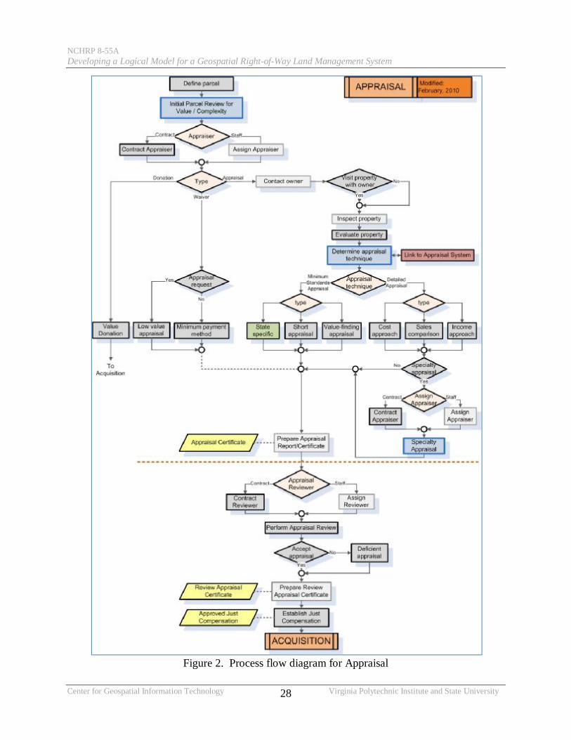
Figure 2 Process flow diagram for Appraisal
NCHRP 8-55A Developing a Logical Model for a Geospatial Right-of-Way Land Management System
Center for Geospatial Information Technology Virginia Polytechnic Institute and State University 29
Figure 3 Process flow diagram for Acquisition
NCHRP 8-55A Developing a Logical Model for a Geospatial Right-of-Way Land Management System
Center for Geospatial Information Technology Virginia Polytechnic Institute and State University 30
Figure 4 Process flow diagram for Relocation Part 1
NCHRP 8-55A Developing a Logical Model for a Geospatial Right-of-Way Land Management System
Center for Geospatial Information Technology Virginia Polytechnic Institute and State University 31
Figure 5 Process flow diagram for Relocation Part 2
NCHRP 8-55A Developing a Logical Model for a Geospatial Right-of-Way Land Management System
Center for Geospatial Information Technology Virginia Polytechnic Institute and State University 32
Figure 6 Process flow diagram for Property Management
NCHRP 8-55A Developing a Logical Model for a Geospatial Right-of-Way Land Management System
Center for Geospatial Information Technology Virginia Polytechnic Institute and State University 33
Figure 7 UML diagrams included in the model and their classification
Model
Behavioral Model Views
Structural Model Views
Business Process Model
Component Model
Use Case Model
Class Model
Interaction Model Views Package Model
Communication Diagrams
Sequence Diagrams
NCHRP 8-55A Developing a Logical Model for a Geospatial Right-of-Way Land Management System
Center for Geospatial Information Technology Virginia Polytechnic Institute and State University 34
CHAPTER 4 TESTING
During development the logical model was evaluated with unit tests used for testing
units that are being built such as classes and components and integration tests used for testing
how units work together Performing other system-based testing was not an option given that no
code was developed for this project
Once the model was complete case study testing was performed through visits with three
states to evaluate the validity and usefulness of the model The intension was to evaluate (1)
implementing a comprehensive geospatially-enabled enterprise-wide information management
system (2) geospatially enabling an existing right-of-way information management system or (3)
integrating an information management system with an existing transportation agency GIS
warehouse With the evolution of enterprise GIS systems and the fact that most transportation
agencies have implemented one or more enterprise database systems the second two cases were
merged together in the logical model and thus in the testing
While the logical model was being developed six states were identified as candidates for
testing the model primarily using information from the survey results The primary criteria
consisted of (1) existence of an information infrastructure including use of information
management systems and interoperability of information both in the right of way office and
across the agency (2) existence and use of GIS and availability of transportation GIS base
layers and (3) the extent of the enterprise within the state right-of-way office Originally states
that were not part of the study were identified but based on the complex UML structure of the
logical model and the fact that a working prototype was not part of this project the states that
NCHRP 8-55A Developing a Logical Model for a Geospatial Right-of-Way Land Management System
Center for Geospatial Information Technology Virginia Polytechnic Institute and State University 35
were involved in the project were better able to evaluate the work that was performed and
provide feedback base on their own experience in developing information management systems
The final three states selected for evaluating the system were Pennsylvania Washington
and California How they relate to the defined case studies and their contribution to the process
are summarized in Table 2
Table 2 States participating in case study evaluation
State Case Study Criteria Status at Time of Visit Comments
Pennsylvania Geospatially enable an existing system Mature system
Well established system with internal development expertise ldquowork environmentrdquo system
Washington Geospatially enable an existing system Newly launched system
New system with staff that had just gone through implementation ldquoelectronic ledgerrdquo system
California Implement new enterprise system In development
New system under development Still in the design phase by internal staff
The models were evaluated through detailed discussions with members of the right-of-
way office both in group settings and one-on-one with members of each of the four primary areas
of appraisal acquisition relocation and property management Interactions with other systems
in the agency were identified both those existing and those planned with specific data elements
being checked against the model where possible The following sections encapsulate the hours
of discussions that were held with right-of-way personnel
Pennsylvania With PennDOT the focus was to determine if the model accurately
represented how a right-of-way office would track and visualize parcel status and whether the
model had identified the appropriate activities that could benefit from geospatial enablement
The Parcel Tracking and Geospatial Enablement components of the model were presented and
evaluated for practicality and accuracy and to ensure that the information captured in the model
is compliant with their business practices The discussion included an overview of the
NCHRP 8-55A Developing a Logical Model for a Geospatial Right-of-Way Land Management System
Center for Geospatial Information Technology Virginia Polytechnic Institute and State University 36
framework the parcel tracking logical flow chart and the list and description of attributes of the
parcel tracking model and the list of identified geospatial enablement activities Discrepancies
or variations with the model were documented and the model updated as summarized in Table 3
Table 3 Summary of changes to the geospatial model based on PennDOT visit
Object Affected Functional Area Description of Change
Parc
el T
rack
ing
State - Parcel type of take Project Development Renamed Parcel Type to Parcel type of take
State - Appraisal Type Appraisal Noted under the state description that it can be otherwise defined as lsquoformat requiredrsquo
State - Appraisal Technique Appraisal Noted under the state description that it can be otherwise defined as lsquovaluation techniquersquo
State - Status Appraiser Assignment Appraisal
Noted under the state description that verifying appraiser certification acts as a checkmark or requirement for determining appraiser assignmt
State - Appraisal Complexity Appraisal Added to capture the complexity of parcel appraisal
State - Utilities Appraisal Added to identify the utilities (if any) present on the right-of-way parcel
State - Secondary Relocation Indicator Relocation
Modified the categories under the state description to address billboards and commercial signs on parcel
State - Notice to Proceed Project Closing Added to identify the type of notice issued for proceeding with roadway construction
State - Status Federal Voucher Letter Project Closing Added to identify the submission of federal
voucher letter
States - Milestones Parcel Tracking Identified milestones from the existing flags and values are added to Appraisal Acquisition Relocation and Property Management
Geo
spat
ial E
nabl
emen
t
Layer -VideoLog Appraisal
Added for identifying the parcels during alignment selection locating properties during initial appraisal review and for determining the complexity of appraisal
Layer Utilities Appraisal Added to facilitate the identification of parcels with utilities and locating the possible areas for adjusting the utilities
External Resource- Historical Parcel Sales Records Appraisal Added to facilitate the geospatial activity
associated with sales comparison Geospatial Activity- Sales Comparison (Data Analysis) Appraisal Added to incorporate paired sales comparison
with historical data Geospatial Activity- Spatial Analysis 3D Analyst Appraisal Added to analyze the effect of elevation
changes on adjoining property Geospatial Activity- Data Query Extraction Overlay Appraisal Added to identify parcels with utilities
Geospatial Activity- Spatial Analysis Overlay Spatial Query
Relocation Added to locate suitable parcels for adjusting or relocating the affected utilities
External Resource Historical Parcel Sales Records Appraisal Added to facilitate the geospatial activity
associated with sales comparison
NCHRP 8-55A Developing a Logical Model for a Geospatial Right-of-Way Land Management System
Center for Geospatial Information Technology Virginia Polytechnic Institute and State University 37
One important aspect of the feedback for the Parcel Tracking model consisted of
specifically identifying milestones separately from general status for parcels as they move
through each of the business functional areas since milestones are typically tracked as part of
performance measures within the office
Washington With WSDOT the goal was to take advantage of their experience in
recently having implemented an enterprise-wide information management system and to identify
activities or functions that were missed or could be improved Although it did not include GIS
they had designed the system to include that capability in a follow-on phase Table 4 provides a
summary of changes to the logical model that resulted from the evaluation discussions
Some critical lessons learned that could be beneficial to transportation agencies as they
pursue implementing an information system include
bull Take the necessary time to plan for the system including possible re-engineering of activities Be careful of the ldquowant it nowrdquo desire
bull Do not underestimate the challenge of legacy data bull Communicate Communicate Communicate This goes in both directions bull Include the necessary time investment of staff in implementation activities
California Caltrans is in the process of designing and implementing a new right-of-way
information management system They desire to geospatially enable it but may have to add that
capability at a later date The majority of discussions centered around differences in terminology
and several state-specific activities that were not added to the logical model because they are
unique to how Caltrans does certain activities The primary change that was incorporated into
the model was a more accurate representation of time-specific requirements associated with
notices and possession Sequence diagrams throughout the model were updated as necessary
Because Caltrans had process diagrams and a data model for the new system they provided the
NCHRP 8-55A Developing a Logical Model for a Geospatial Right-of-Way Land Management System
Center for Geospatial Information Technology Virginia Polytechnic Institute and State University 38
researchers with this information and the team was able to compare these against the project
model Although the changes were not itemized several small adjustments were made
Table 4 Summary of changes resulting from WSDOT evaluation
Functional Area Activity Affected Description of Change
Appraisal Scoping Improve Links to early planning activities Project planning systems
Appraisal Market data sheet Add activity
Acquisition Clearing title Expand activity add associated milestone
Acquisition amp Relocation External information
Add links to external information (beyond other systems)
County assessorrsquos office HUD Codes
Acquisition Easements Define type
Acquisition Encumbrances Expand activity and define type
Appraisal and Acquisition Geospatial enablement Add septic and well relocation for geospatial
enablement
Relocation Flags Add flag for who is entering information (additional attributes beyond just agent)
Relocation Appeals diary Add activity and document
Property Management External link Add link to real-time permittinglicensing system
Property Management Communication Add link to ldquobroadcastrdquo capability to ensure appropriate actors made aware of information
Property Management Geospatial enablement Add attribute to tie lease to parcel and alignment
Overall History of plans Add activity to track changes to ROW plans
Overall Terminology Identify different terminology used by different states
Project Management Certification of completion Expand certification of completion definitions
NCHRP 8-55A Developing a Logical Model for a Geospatial Right-of-Way Land Management System
Center for Geospatial Information Technology Virginia Polytechnic Institute and State University 39
CHAPTER 5 CONCLUSIONS AND SUGGESTED RESEARCH
51 CONCLUSIONS
This project accomplished three objectives The first was an expanded comprehensive
annotated bibliography of literature about use of geospatial and innovative information systems
to include enterprise level systems used in state transportation agencies The second was a
logical model for a geospatially-enabled enterprise-wide information management system for
right-of-way offices and an accompanying implementation guide The third was two executive
summaries the first of which focused on the current state of the practice designed to answer
ldquowhatrsquos in it for me (my agency)rdquo while the second focused on implementing an information
system and answered ldquowhat does the ROW office need to ensure the implementation is
successfulrdquo
The bibliography and survey supported the need for a comprehensive enterprise-level
geospatially-enabled information management system for right-of-way activities and provided
important information for the necessary linkages to existing information systems within
transportation agencies It also provides a valuable resource for states who are interested in
specific literature related to information systems and right-of-way activities
Exploiting the significant role an integrated and interoperable enterprise-wide
information management system can play in supporting the right-of-way business processes can
improve efficiency and on-time project delivery for transportation agencies Development of an
effective right-of-way information management system requires precisely modeling the activities
NCHRP 8-55A Developing a Logical Model for a Geospatial Right-of-Way Land Management System
Center for Geospatial Information Technology Virginia Polytechnic Institute and State University 40
and information that make up the business The UML-based logical model provides the basis for
such a system and is expected to
bull Provide a template for state transportation agencies to support the development of an enterprise-wide right-of-way information management system that has the flexibility to meet the unique needs of the individual agencies
bull Establish a standard structure and vocabulary for effectively processing and sharing right-of-way information to improve enterprise-wide business activities
bull Assist transportation agencies in planning for implementing a system that would integrate and interact with other existing enterprise-level information systems in the agency prior to the investment of funds
bull Enhance the integration of the right-of-way business processes into the state agencyrsquos overall project delivery process
Although the model provides the necessary structure for building a right-of-way system
it does not include software development Business processes identified in the model are
consistent with current federal guidelines for right-of-way offices (FHWA 2006) and are
designed to achieve interoperability in right-of-way activities and to facilitate data integration
across the organization The design is expected to act as a flexible blueprint for state
transportation agencies to implement an enterprise-wide information management system
accommodating the unique needs of individual agencies
The implementation guide is designed to assist transportation agencies in implementing a
system to meet the goals established in this project It includes specific guidelines on building
the system using the logical model as developed or modifying it to meet their unique
requirements Three specific scenarios are included
bull Implement a comprehensive geospatially-enabled enterprise-wide information management system
bull Geospatially enable an existing right-of-way information management system bull Integrate an information management system with an existing transportation agency GIS
warehouse
NCHRP 8-55A Developing a Logical Model for a Geospatial Right-of-Way Land Management System
Center for Geospatial Information Technology Virginia Polytechnic Institute and State University 41
The executive summaries are intended to provide short easily understood documents that
can be used to market the need for and implementation of an information management system to
upper management within the organization
Specifically the results of this research were designed to provide right-of-way offices
with the necessary information to pursue support and funding to implement or expand a right-of-
way information management system The logical model provides a backbone for building the
system reducing the time and effort required by the agency during implementation
52 SUGGESTED RESEARCH
This research developed a logical model for a geospatially-enabled enterprise-wide
information management system for right-of-way activities The next step is to build the system
itself Because of the unique nature of each state transportation agency it is unrealistic to
attempt to build a single system that could be adapted to each agency Therefore the focus
should be on communicating these results and supporting state initiatives to implement systems
One of the challenges identified during the research performed for both this project and
NCHRP 8-55 was keeping pace with rapidly evolving technology while working within a more
restrictive information technology (IT) process for implementing this technology Research into
how transportation agency IT policies can be more flexible and agile while maintaining
necessary standards to meet the larger agency requirements could provide substantial benefits to
the implementation of these types of systems
NCHRP 8-55A Developing a Logical Model for a Geospatial Right-of-Way Land Management System
Center for Geospatial Information Technology Virginia Polytechnic Institute and State University 42
REFERENCES
ldquoAASHTO Turbo Relocation Winrdquo BEM Systems Inc
lthttpwwwbemsyscomindexphpoption=com_contentampview=articleampid=45aashto-
turbo-relocation-winampcatid=20recent-newsampItemid=27gt [Retrieved on 080609]
American Association of State Highway and Transportation Officials (2007) ldquoTurbo
Relocationrdquo Request for Information Preparatory to the Development of a Relocation
Benefits Calculation System April
Bentley Systems Inc ldquoBentley Right Of Way Office For The Webrdquo
ltftpftp2bentleycomdistcollateralBentley_20Right_20of_20Way_20for_20the_20W
eb_20Spec_20Sheet_2C_20Low_20Respdflopdfgt [Retrieved on 080609]
Bryce Tim ldquoLogical vs Physical Design Do You Know the Differencerdquo
lthttpittoolboxcomblogsirm-bloglogical-vs-physical-design-do-you-know-the-
difference-9011gt [Retrieved on 050309]
ldquoDREAMaps for Real Property Intelligencerdquo Smart Data Strategies Inc lthttpwwwsds-
inccomproductshtmgt [Retrieved on 080609]
Federal Highway Administration (2004) ldquoCongratulations to the Winners of the 2004
Excellence in Right-of-Way Awardsrdquo FHWA-HEP-04-010 Washington DC
Federal Highway Administration Office of Real Estate Services (2004) ldquoOutdoor Advertising-
State Study State of Florida Outdoor Advertising ndash Automated Data Gathering System A
Case Studyrdquo United States Florida
lthttpwwwfhwadotgovREALESTATEoacasescaseflhtmgt
NCHRP 8-55A Developing a Logical Model for a Geospatial Right-of-Way Land Management System
Center for Geospatial Information Technology Virginia Polytechnic Institute and State University 43
Federal Highway Administration (2004) ldquoGIS in Right of Way Scan Tallahassee Floridardquo
July 2004 Washington DC lthttpwwwfhwadotgovrealestatescanstalafreporthtmgt
Federal Highway Administration (2006) ldquoProject Development Guide (PDG)rdquo
lthttpwwwfhwadotgovrealestatepdghtmgt [Retrieved on 081507]
Federal Highway Administration (2007) ldquoPeer Exchange on Applications of Geographic
Information Systems in the Right-of-Way Areardquo Lees Summit Missouri August 2007
ltwwwgisfhwadotgovgisrowaspgt
Federal Highway Administration (2009) ldquoCongratulations to the Winners of the 2008
Excellence in Right-of-Way Awardsrdquo Washington DC
lthttpwwwfhwadotgovREALESTATEroweahtmgt
Federal Highway Administration (2009) ldquoOffice of Real Estate Services ndash Newsletterrdquo
lthttpwwwfhwadotgovrealestatenewslettersecond2009pdfgt [Retrieved on
080609]
Ghanta N (2007) ldquoIntegrating Geospatial Technologies into the Property Management Process
Of The Transportation Right-Of-Wayrdquo Masterrsquos Thesis Virginia Polytechnic Institute
and State university Falls Church Virginia
Gravley R (2008) ldquoALDOTs Comprehensive Project Management System (CPMS)rdquo Southern
States and Federal Transportation Finance Conference Alabama
Hancock Kathleen L (2006) Integrating Geospatial Technologies into the Right-of-Way Data-
Management Process National Cooperative Highway Research Program Research
Results Digest 310 Transportation Research Board Washington DC December
lthttponlinepubstrborgonlinepubsnchrpnchrp_rrd_310pdfgt
NCHRP 8-55A Developing a Logical Model for a Geospatial Right-of-Way Land Management System
Center for Geospatial Information Technology Virginia Polytechnic Institute and State University 44
Hancock Kathleen L (2006) Integrating Geospatial Technologies into the Right-of-Way Data-
Management Process Appendixes A through F National Cooperative Highway Research
Program Web-Only Document 95 Transportation Research Board June Alexandria VA
lthttponlinepubstrborgonlinepubsnchrpnchrp_w95pdfgt
Hancock K (2006) ldquoGeospatially Enabling Information Management for Right-of-Way
Activitiesrdquo 86th Transportation Research Record Washington DC
Indiana Department of Transportation (2006) ldquoProperty Management Manualrdquo United States
Office of Real Estate Indiana
httpwwwingovindotfiles05PropertyManagementManual12-05pdf
John Durling O (2009) ldquoImage Records Management Systemrdquo Connecticut Geo-Focus 2009
Vol 2 3 Connecticut Geospatial Newsletter Fallrsquo09-Connecticut Geospatial Information
Systems Council East Hartford Connecticut
lthttpwwwctgovgislibgisCT_Geospatial_Newsletter_Fall09pdfgt
Kaan Ozbay and Nebahat Noyan (2003) ldquoGeographical Information System Based
Management Information System (GISMIS)rdquo 82nd Transportation Research Record
January 2003 Washington DC
ldquoLand amp Right of Way Acquisition Management and Record Keepingrdquo Diversified Energy
Software Solutions (DESS) LLC
lthttpwwwdesoftsolcomsolutionsAMShtmlgt [Retrieved on 080609]
Michigan Department of Transportation (2003) ldquoReal Estate Management Information
Systemrdquo Subcommittee on Right-of-Way and Utilities (AASTHO) Exhibit F Michigan
ldquoMnDOTs Office of Land Management websiterdquo ltwwwolmwebdotstatemnusgt [Retrieved
on 07162009]
NCHRP 8-55A Developing a Logical Model for a Geospatial Right-of-Way Land Management System
Center for Geospatial Information Technology Virginia Polytechnic Institute and State University 45
MSI Data Systems Inc (2008) ldquoREADS - Automated Software for State Government
HighwaysReal Estate Operationrdquo Mequon WI
lthttpwwwmsidatacomproductsreadsgt [Retrieved on 07162009]
ldquoNDOT Integrated Right of Way Information Network (IRWIN) Phases 1 and 2rdquo ITIS Inc
lthttpitis-corp1comindexphppage=irwin-phase-2gt [Retrieved on 080609]
New Jersey Department of Transportation (2004) ldquoSurvey - Right-of-Way information systemrdquo
United States Subcommittee on Right-of-Way and Utilities (AASTHO) Washington
DC
lthttpcmstransportationorgsitesrightofwaydocsSurvey_Right_of_Way_Information
_Systempdfgt
Nicewarner N ldquoWhy Have Conceptual Logical and Physical Data Modelingto enforce
standards and reduce confusionrdquo PowerBuilder Developers Journal 2004 SYS-CON
Media Inc lthttppbdjsys-concomnode106944gt
Ordway D Whaley J (2008) ldquoGeographical Information Systems Applications For
Transportation Right-of-Wayrdquo Summary Report on a Follow-Up Peer Exchange Leersquos
Summit Missouri July 22-24
lthttpwwwgisfhwadotgovdocumentsrightOfWayaspmissourigt [Retrieved on
032709]
Oregon Department of Transportation (ODOT) (2008) ldquoEnterprise Content Management
Systems (Right of Way)rdquo United States Subcommittee on Right-of-Way and Utilities
(AASTHO) Washington DC
lthttpcmstransportationorgsitesrightofwaydocsRWorEnterpriseContentMgmtSys34
08dogt
NCHRP 8-55A Developing a Logical Model for a Geospatial Right-of-Way Land Management System
Center for Geospatial Information Technology Virginia Polytechnic Institute and State University 46
Oregon Department of Transportation (2006) ldquoRight of Way Data Management System
(RWDMS)rdquo ODOT Surveyors Conference
lthttporegonwatertrailsorgODOTHWYGEOMETRONICSdocsRWDMSpdfgt
ldquoPaecetrak Right-of-Way Acquisition Support System (Version 40)rdquo BEM Systems Inc
ltwwwbemcorpnetwebcoppaecetrakwebwebBrochurepdfgt [Retrieved on 080609]
Petyon L Mississippi Department of Transportation (2002) ldquoROW Parcel Tracking System
Detailed requirementsFunctional design documentrdquo United States Subcommittee on
Right-of-Way and Utilities (AASTHO) Exhibit H Mississippi
ldquoREADS - Automated Software for State Government HighwaysReal Estate Operationrdquo MSI
Data Systems 2008 lthttpwwwmsidatacomProductsproductsaspPage=readsgt
[Retrieved on 07162009]
ldquoRight of Way Utilities Management System (RUMS)rdquo Virginia Department of Transportation
Virginia 2008 lthttpvirginiadotorgbusinessrow-rumsaspgt [Retrieved on 080609]
Saka Anthony A (2004) Geographic Information System Implementation of State Department
of Transportation Right-of-Way Programs Office of Real Estate Services Washington
DC Federal Highway Administration July 2004 DTFH61-03-H-00121
lthttpwwwfhwadotgovrealestaterowsurvjuly04htmgt
Sparx Systems Pty Ltd (2007) Enterprise Architect - UML CASE Tool - Desktop Professional
and Corporate Editions Version 70 [Software] Available from
lthttpwwwsparxsystemscomauproductseaindexhtmlgt
ldquoUniform Relocation Assistance and Real Property Acquisition Policies Act of 1970 (Uniform
Act) amended by Public Law 91-646 Public Law 100-17 Public Law 102-240 Public
Law 105-117rdquo httpwwwfhwadotgovrealestateacthtm [Retrieved on 090609]
NCHRP 8-55A Developing a Logical Model for a Geospatial Right-of-Way Land Management System
Center for Geospatial Information Technology Virginia Polytechnic Institute and State University 47
Xriver Technologies LLC (2008) ldquoAppraisal Acquisition amp Relocation System (AARS)rdquo
United States
lthttpwwwxrivertechcomCommonCaseStudiesCaseStudy_AARSPDFgt
NCHRP 8-55A Developing a Logical Model for a Geospatial Right-of-Way Land Management System
Center for Geospatial Information Technology A-1 Virginia Polytechnic Institute and State University
APPENDIX A EXECUTIVE SUMMARIES
The executive summaries presented in this appendix were developed for members of upper
management within transportation agencies The first summary focuses on the current state of
the practice in ROW enterprise-level geospatially-enabled information management systems
with a discussion of the benefits and costs associated with those systems in the context of
designing and implementing such a system for right-of-way offices The second summary
focuses on what information is important for an executive to have for evaluation as part of a
request to fund an enterprise-level geospatially-enabled information management system to
improve its successful implementation
Executive Summary 1 Improving Resource management and Operations in Right-of-Way Offices with Right-of-Way Information Management Systems
Executive Summary 2 Implementing an Information Management System in Right-of-Way Offices An Overview for Executives
NCHRP 8-55A Developing a Logical Model for a Geospatial Right-of-Way Land Management System
Center for Geospatial Information Technology A-2 Virginia Polytechnic Institute and State University
30
70
State Use of ROW Information Management Systems
States Using a System
No System Identified
10
18
72
State ROW Office Use of GISCADD
Use GIS
Use CADD
Neither found
Improving Resource Management and Operations in Right of Way Offices
With Right-of-Way Information Management Systems
A well designed and implemented information management system can substantially improve management of resources ndash personnel money information and time ndash which is critically important to successfully meeting state performance goals and budgets Adding geospatial capabilities (GIS) to the system to replace hardcopy maps and tabular information and to give additional management and analysis functions can significantly increase its usefulness
In the Right-of-Way office this is particularly important because of the resources required to deliver real property for transportation improvements and manage state-owned land
BENEFITS
diams Improved on-time delivery of project real property
diams Expedited project award
diams Reduced staffing andor improved staff efficiency
diams Improved scheduling
diams Improved access to information both internally and by the public
diams Improved customer service and public relations
diams Improved documentation and reporting uniformity
diams Reduced time to perform tasks
diams Reduced redundancy primarily in data entry
diams Increased management flexibility
diams Improved oversight capabilities
diams Improved integration use and sharing of information
DOCUMENTED SAVINGS
bull A return on investment of more than 21
Pennsylvania invested $829000 on a ROW information system that reduced annual operating costs by nearly $680000while providing greater convenience to users Because the system integrates with their financial system the time to process payments reduced from several days toseveral minutes
NCHRP 8-55A Developing a Logical Model for a Geospatial Right-of-Way Land Management System
Center for Geospatial Information Technology A-3 Virginia Polytechnic Institute and State University
bull Staffing reductions and improved on-time performance
In Virginia the ROW information system provides over 500 staff and contractors all information on ROW projects providing exceptional customer service Information is entered only once eliminating duplication of effort Clear project tracking provides staff with a comprehensive understanding of the status of each project including resource allocation
In Maryland research staff has been
reduced by half because parcel and other geospatial information is available through the intranet In-person courthouse research and travel time have been eliminated
New Mexico uses GIS to generate
summaries on excess property for sale to the public reducing the time required to provide this information from several hours to several minutes The information includes a map with an aerial photograph image background resulting in dramatically reduced questions from the public
Using GIS the San Antonio district of
Texas provides its staff with electronic access to project drawings thus eliminating the manual locating and reviewing of large drawing sets Drawings are accessed by simply clicking on a desired section of road
bull One-person project oversight and
management of real estate activities
In Illinois a multi-million dollar airport project is managed by a single person who has desktop access to near real-time information about the project
RISKS OF NOT IMPLEMENTING A SYSTEM
A primary purpose of this type of information management system is to facilitate standard business operations and support information and decision making by providing easy access to both internal and external information relevant to meeting the goals and operational needs of the transportation agency and the real estate office
Without such a system decision makers are
limited in their ability to monitor performance and identify opportunities quickly and make strategic adjustments to resource allocation as needed The real estate office will be limited in its ability to respond to the rapidly increasing reliance on digital information exchange to perform its functions
Expectations in the current technological environment are for faster more accurate information with fingertip access to on-line maps Without a geospatially enabled system these expectations cannot be met for staff or the public
FOR MORE INFORMATION
This document is part of the National Cooperative Highway Research Project 8-55A ldquoDeveloping a Logical Model for a Geo-Spatial Right-of-Way Land Management Systemrdquo The project is managed by Ed Harrigan EHARRIGAnasedu and is being performed under Kathleen Hancock hancockkvtedu at Virginia Tech and was completed in 211 Results of the first phase 8-55 Integrating Geo-Spatial Technologies into the ROW Data-Management Process including the documented savings reported here are available at httponlinepubstrborgonlinepubsnchrpnchrp_rrd_310pdf and httpwwwtrborgnewsblurb_detailaspid=7308
NCHRP 8-55A Developing a Logical Model for a Geospatial Right-of-Way Land Management System
Center for Geospatial Information Technology A-4 Virginia Polytechnic Institute and State University
Implementing an Information Management System in Right-of-Way Offices
An Overview for Executives
Increasing responsiveness and maximizing resources are important factors in how transportation agencies improve their business in todayrsquos data-driven performance-based environment The ability to deliver projects on time and within budget is one measure of a transportation agencyrsquos performance The effective delivery of real property by the right-of-way office is fundamental to achieving this agency objective A well designed and implemented information management system can substantially improve this capability Adding geospatial capabilities (GIS) to the system to replace reliance on hardcopy maps and tabular information and to give additional management and analysis functions can significantly increase its usefulness
Understanding the critical factors necessary to successfully implement an information management system can ensure the best value for the necessary outlay in resources and can substantially improve the realization of the systemrsquos full potential Obtaining strategic buy-in from agency executive-level decision makers to pursue implementation will provide the necessary foundation for system
Implementing a System The process to implement an information management system is well documented and follows standard procedures
diams Formalize support diams Assess requirements diams Assess capabilities diams Define the system diams Develop an implementation plan diams Implement the system diams Maintain the system
Implementation is typically considered complete at the point when the system being implemented has transitioned to ldquobusiness as usualrdquo for its users
Implementation Responsibilities bull Project champion This person is typically
known and trusted by agency management and is responsible for marketing and promoting the system both inside and outside the agency
Without an identified champion history has shown that projects flounder at the first major challenge
bull Steering group The steering group is responsible for ensuring that there is active and appropriate input and feedback to the system during the implementation process
Transportation agencies consist of multiple departments and offices responsible for different aspects of doing business Without representation from each group that will be impacted by the system the system will face numerous challenges including a) meeting agency information technology (IT) requirements b) obtaining buy-in from stakeholders and c) coordinating data sharing between data owners and users as well as performing the tasks necessary to support right-of-way activities
bull Project manager The project manager is responsible for the day-to-day management of the process
This person must have the necessary skills authority and resources to coordinate sometimes conflicting input from the groups and individuals involved in the process The project manager must also have the organizational skills to ensure that the process stays on track and within design boundaries and sufficient technical understanding of the right-of-way process and individual functions to reasonably evaluate input during the development process
bull Development team The development team consists of the people who will actually be developing the system
They can be wholly from within the agency or wholly contracted from outside or a combination of both The importance at the proposal stage is that the skills necessary to the project be clearly identified and articulated
NCHRP 8-55A Developing a Logical Model for a Geospatial Right-of-Way Land Management System
Center for Geospatial Information Technology A-5 Virginia Polytechnic Institute and State University
Implementation Factors bull Assessing requirements Any proposal for a
new information system should include a clearly stated understanding of the scope and goals of that system As these requirements are refined consideration should include the business areas to be included (often referred to as the enterprise) the functions that should be performed the data needed to support these functions other systems that should interact with the proposed system security issues and any legal and regulatory requirements
bull Assessing capabilities An understanding of the capabilities in the right-of-way office and across the agency is critical to successfully implementing a system Considerations include available or required hardware and software existing applications including database management systems and GIS datasets along with who is responsible for them and agency policies and procedures related to IT including application development data and data standards and hardware and software acquisition Knowing who will be responsible for maintaining the system and any corresponding data and output is also necessary Availability of funding for development and continued maintenance is critical to the projectrsquos success
bull Defining the system This is the core of the system and will be the basis for the tool that manages the information associated with right-of-way offices The technical considerations will be included in the detailed implementation plan An important aspect of this definition is knowing the starting point for system development Three common starting points include diams The system is being developed from scratch
with no existing information management system or GIS
diams The system is expanding on an existing information management system to include GIS
diams The system is being developed to take advantage of existing GIS capabilities
Knowing this information will ensure that appropriate coordination is considered in the design
Additional Considerations
The current evolution and expansion of technology is extremely rapid and most transportation agency policies and procedures are not designed to operate at the same rate of change Innovative and flexible approaches to supporting improved information management tools could save money and time both in their implementation and use
From concept to operation a comprehensive information management system can take 12 to 24 months or longer and during that timetechnology will become more powerful faster and more flexible at the same time that the general public will become more technologically sophisticated with fingertip access to information through smart phones and other similar devices A flexible design can readily take advantage of this changing technology without requiring major modifications However waiting for the next advancement before initiating the process canand often does result in never starting
Many transportation agencies are in the process of either designing or building an agency-wide infrastructure for sharing data andor integrating computer systems Although the desire to fold individual systems into this larger initiative is compelling the reality may be more problematic given the scale complexity and cost of the larger effort With current technologies consideration should be given to supporting individual systems if they provide the necessary connections to and support for integrating with the larger initiative
For More Information This document is part of the National Cooperative Highway Research Project 8-55A ldquoDeveloping a Logical Model for a Geo-Spatial Right-of-Way Land Management Systemrdquo The project was managed by Ed Harrigan EHARRIGAnasedu and was performed under Kathleen Hancock hancockkvtedu at Virginia Tech and was completed in 211 A detailed implementation guide was developed as part of this project and will be available through TRB
Results of the first phase 8-55 Integrating Geo-Spatial Technologies into the ROW Data-Management Process including the documented savings reported here are available at httponlinepubstrborgonlinepubsnchrpnchrp_rrd_310pdf and httpwwwtrborgnewsblurb_detailaspid=7308
NCHRP 8-55A Developing a Logical Model for a Geospatial Right-of-Way Land Management System
Center for Geospatial Information Technology B-1 Virginia Polytechnic Institute and State University
APPENDIX B SURVEY AND RESULTS
A written survey was completed during this project and was distributed to attendees of the 2006
AASHTOFHWA Right of Way and Utilities Subcommittee Conference in Baltimore Maryland
The purpose of this survey was to update the survey results from NCHRP 8-55 to states that were
actively using geospatial technologies in their day-to-day activities as well as to identify what
other systems were in use by the transportation agency This survey along with the
corresponding cover letter is presented followed by a summary of the results and a scan of
agency web pages to identify other possible states using an information system along with that
system
NCHRP 8-55A Developing a Logical Model for a Geospatial Right-of-Way Land Management System
Center for Geospatial Information Technology Virginia Polytechnic Institute and State University B-2
Figure B-1 NCHRP 8-55A survey
NCHRP 8-55A Developing a Logical Model for a Geospatial Right-of-Way Land Management System
Center for Geospatial Information Technology Virginia Polytechnic Institute and State University B-3
Figure B-1 NCHRP 8-55A survey (cont)
NCHRP 8-55A Developing a Logical Model for a Geospatial Right-of-Way Land Management System
Center for Geospatial Information Technology Virginia Polytechnic Institute and State University B-4
Table B-1 States responding to survey
State Abbr State Abbr
Alabama AL North Dakota ND
Arkansas AR Oklahoma OK
California CA Oregon OR
Kentucky KY Pennsylvania PA
Louisiana LA South Carolina SC
Maine ME South Dakota SD
Maryland MD Tennessee TN
Michigan MI Texas TX
Minnesota MN Vermont VT
Missouri MO Washington WA
New York NY Wisconsin WI
SURVEY RESPONSES
23 responses to the survey that was sent out to the AASHTO ROW subcommittee listserve were received Table B1 lists the states that responded and Figure B1 shows the geospatial representation of the same information
Figure B-2 States that responded to survey
NCHRP 8-55A Developing a Logical Model for a Geospatial Right-of-Way Land Management System
Center for Geospatial Information Technology Virginia Polytechnic Institute and State University B-5
Table B-2 Survey responses
NCHRP 8-55A Developing a Logical Model for a Geospatial Right-of-Way Land Management System
Center for Geospatial Information Technology Virginia Polytechnic Institute and State University B-6
Table B-2 Survey responses (cont)
NCHRP 8-55A Developing a Logical Model for a Geospatial Right-of-Way Land Management System
Center for Geospatial Information Technology Virginia Polytechnic Institute and State University B-7
Table B-3 Survey response details
NCHRP 8-55A Developing a Logical Model for a Geospatial Right-of-Way Land Management System
Center for Geospatial Information Technology Virginia Polytechnic Institute and State University B-8
Table B-3 Survey response details (cont)
NCHRP 8-55A Developing a Logical Model for a Geospatial Right-of-Way Land Management System
Center for Geospatial Information Technology Virginia Polytechnic Institute and State University B-9
Table B-4 Review of State ROW Web Pages
State ROW info
ROW Home Page
ROW Information
System
Information System name (from survey)
GIS [from 8-55A
survey]
GIS from 8-55
survey Information on Web Page
Alabama Yes Yes Yes CPMS CADD Contacts overview flowchart FAQs rights plans procedural manuals and events
Alaska Yes Yes None found None found ROW Plans available applications for leases sign and driveway permits employee directory appraisal forms and guidelines
Arizona + Yes Yes None found CADD Yes Property Sales Acquisitions and CADD
Arkansas Some Yes Yes Land Acquisition None found [GeoMedia] ROW Director with brief ROW
description ROW manual
California + Yes Yes Yes ROWMIS RAP Tracker Yes [ArcGIS]
PDF publications online ROW manual excess land sales appraisal forms sign permits and contact information
Colorado Yes No None found None found ROW manual Purchase of excess land Connecticut Some No None found None found Property Sales coming up Permits DC No No Department of Public Works Delaware + Some No None found None found Yes Site map Basic ROW information
Florida + Yes Yes Yes None found Yes
FAQs on functional areas online database of pre-qualified consultants Outdoor Advertising Inventory Mgmt System - Online Database rules and regs
Georgia + No Yes None found None found Yes Consultant ROW information Hawaii Some Yes None found None found General information
Idaho Yes Yes None found None found Description of functional areas and land sales Public Auction site highlighted
Illinois Some No None found None found Land sales and some forms Advertising Control page Land acquisition manual
Indiana No No Yes None found Contact information Permits
Iowa + Yes Yes None found CADD Sales site some manuals brochures national right of way links page
Kansas + Yes Yes None found None found X Links to good ROW information
Kentucky Yes Yes Yes RWMS None found [ArcGIS] General information ROW Manual
Louisiana Yes Yes None found AARS None found Manuals training newsletters forms and a directory of personnel
Maine Some No Yes RMS CADD [ArcMap] ROW Manual General ROW
information
Maryland + Some Yes None found OREMS None found [ArcGIS] Yes ROW functional areas described Maps
amp Brochures Massachusetts + Yes Yes None found None found Yes General information on ROW process amp
Departments ROW Manual
Michigan Yes Yes Yes R-Tracks CADD [TransCad] Public information on ROW process and
relocation Property sale information
Minnesota + Yes Yes Yes REALMS Yes [ArcGIS] Yes Links to lots of different information including manuals
NCHRP 8-55A Developing a Logical Model for a Geospatial Right-of-Way Land Management System
Center for Geospatial Information Technology Virginia Polytechnic Institute and State University B-10
Mississippi + Some No None found None found Yes Brief description of office LPA Manual
Missouri No No None found None found [ArcGIS] Primarily project related LPA Manual
Montana Some Yes None found CADD ROW manual
Nebraska Yes Yes None found None found Manuals land sales applications and general right of way information
Nevada No No None found IRWIN None found ROW forms State DOT clickable map N Hampshire Some No None found CADD General information CADD information
New Jersey Some Yes Yes None found Some basic ROW information and links Has link to ROW manual under Publications
New Mexico + Some Yes None found Yes Yes Basic information
New York + Some Yes None found Q amp A None found unclear General right of way and outdoor advertising
North Carolina Yes Yes None found None found Information on sections and who to contact
North Dakota Some Yes None found None found Interactive site for Right of Way plats
Ohio + Some Yes None found None found unclear ROW manuals training resources Acquisition and Appraisal pre-qualified individuals and FAQ
Oklahoma + No Yes None found None found Yes Contacts only
Oregon Yes Yes Yes RWDMS None found [TransGIS] Extensive site with information on each
work unit forms manuals etc
Pennsylvania Some Yes Yes ROW Office No General information and contacts ROW section falls within the Design Services Division
Puerto Rico No No Spanish
Rhode Island No Yes None found None found ROW acquired under Real Estate Section Minimal ROW information available
South Carolina + Some No None found Entire
Connection None found Yes ROW Acquisition Appraisal and Relocation manuals
South Dakota Some Yes None found AgWare None found [ArcGIS] General information and contact page
Relocation Brochure
Tennessee Yes Yes None found TRIMS None found [TRIMS] Information on sections who to contact
and some forms
Texas + Some Yes None found ROWIS None found [ArcGIS] Yes Information on acquisition contracts
forms amp other resources ROW manual
Utah Yes Yes Yes CADD ROW information including manuals forms information property sales and much more
Vermont Some Yes None found None found [ArcGIS] Basic information and contacts
Virginia + Some Yes Yes No Contact and general information Land sales site Information on RUMS
Washington + Some Yes Yes IRIS None found Property Sales and ROW Plans West Virginia Some Yes None found None found General information
Wisconsin No No None found READS None found [ArcGIS] Contact page listing
Wyoming No No None found None found Land sales Responded to 8-55A Survey + Responded to original 8-55 Survey

Final Report
NCHRP 8-55A Developing a Logical Model for a Geo-Spatial Right-of-Way Land Management System Prepared for Transportation Research Board of The National Academies Prepared by Kathleen Hancock PE PhD Virginia Polytechnic Institute and State University The Center for Geospatial Information Technology Alexandria VA February 2011
NCHRP 8-55A Developing a Logical Model for a Geospatial Right-of-Way Land Management System
Center for Geospatial Information Technology Virginia Polytechnic Institute and State University i
CONTENTS LIST OF FIGURES ii LIST OF TABLES ii LIST OF ACRONYMS iii ACKNOWLEDGEMENTS iv ABSTRACT v SUMMARY 1 CHAPTER 1 Introduction and Research Approach 4 11 Problem Statement 4 12 Objectives and Scope 5 13 Research Overview 6 14 Report Organization 7 CHAPTER 2 Research Overview 8 21 Right-of-way Information Management Systems 11 22 Geographical Information Management Systems in Right-of-Way 17 23 Vendor Systems 21 24 Summary 22 CHAPTER 3 Logical Model 23 CHAPTER 4 Testing 34 CHAPTER 5 Conclusions and Suggested Research 39 51 Conclusions 39 52 Suggested Research 41 REFERENCES 42 APPENDIX A Executive Summaries A-1
Executive Summary 1 Improving Resource management and Operations in Right-of-Way Offices with Right-of-Way Information Management Systems A-2
Executive Summary 2 Implementing an Information Management System in Right-of-Way Offices An Overview for Executives A-4
APPENDIX B Information Surveys B-1
Survey B-2 Survey Responses B-4
NCHRP 8-55A Developing a Logical Model for a Geospatial Right-of-Way Land Management System
Center for Geospatial Information Technology Virginia Polytechnic Institute and State University ii
LIST OF FIGURES
Figure 1 Overall right-of-way business process flow 27 Figure 2 Process flow diagram for Appraisal 28 Figure 3 Process flow diagram for Acquisition 29 Figure 4 Process flow diagram for Relocation Part 1 30 Figure 5 Process flow diagram for Relocation Part 2 31 Figure 6 Process flow diagram for Property Management 32 Figure 7 UML diagrams included in the model and their classification 33 Figure B-1 NCHRP 8-55A survey B-2 Figure B-2 States responding to survey B-4
LIST OF TABLES Table 1 Examples of right-of-way systems currently in use by transportation agencies 9 Table 2 States participating in case study evaluation 35 Table 3 Summary of changes to the geospatial model based on PennDOT visit 36 Table 4 Summary of changes resulting from WSDOT evaluation 38 Table B-1 States responding to survey B-4 Table B-2 Survey response B-5 Table B-3 Survey response details B-7 Table B-4 Review of State ROW Web pages B-9
NCHRP 8-55A Developing a Logical Model for a Geospatial Right-of-Way Land Management System
Center for Geospatial Information Technology Virginia Polytechnic Institute and State University iii
LIST OF ACRONYMS
AASHTO American Association of State Highway and Transportation Officials
CADD Computer-Aided Design and Drafting
Caltrans California Department of Transportation
CASE Computer Aided Software Engineering
CD Compact Disk
DOT Department of Transportation
EA Enterprise Architecture
FHWA Federal Highway Administration
GIS Geographic Information System
GPS Global Positioning System
IT Information Technology
MPO Metropolitan Planning Organization
NCHRP National Cooperative Highway Research Program
PennDOT Pennsylvania Department of Transportation
ROW Right-of-way
TRB Transportation Research Board
UML Uniform Modeling Language
WSDOT Washington Department of Transportation
XML Extensible Markup Language
NCHRP 8-55A Developing a Logical Model for a Geospatial Right-of-Way Land Management System
Center for Geospatial Information Technology Virginia Polytechnic Institute and State University iv
ACKNOWLEDGMENTS
The authors wish to thank the following organizations who provided valuable input and
perspectives on developing the logical model and other deliverables during this project
Our sincere thanks go to all the members of the NCHRP Project Panel and the state
transportation real estate offices that helped during the evaluation process specifically the staff
from the Division of Right of Way amp Land Surveys at Caltrans the staff from the Utilities and
Right-of-Way Section at PennDOT and the staff from Real Estate Services at WSDOT We
would also like to thank the members of the AASHTO subcommittee on Right-of-Way and
Utilities for their participation in the survey and for time at their annual meetings
NCHRP 8-55A Developing a Logical Model for a Geospatial Right-of-Way Land Management System
Center for Geospatial Information Technology Virginia Polytechnic Institute and State University v
ABSTRACT
Effectively managing information in a state transportation agency is critical to its ability
to perform its mission of delivering safe accessible and sustainable transportation for people
and goods while meeting performance goals under increasing resource constraints Delivering
projects on time and in budget is a high priority performance goal that is both readily measured
and highly visible Fundamental to delivering projects is the ability to acquire real property
within the required timeframe Acquiring property and relocating the affected people and
businesses relies on knowing precisely and quickly the status of the different aspects of the
acquisition and relocation process Effectively managing the information required to perform
these functions is at the heart of an enterprise-wide information management system for right-of-
way offices Geospatially enabling the system provides a visual component to managing this
information and substantially enhances an agencyrsquos ability to carry out its business effectively
This project developed a logical model for an enterprise-level geospatially-enabled information
management system providing the building blocks for states to develop a system that best meets
their individual needs An implementation guide and two executive summaries that provide (1)
an overview of the usefulness and benefits of incorporating an information management system
and (2) the necessary requirements to implement such a model are also included The logical
model was developed in Enterprise Architect by Sparx Systems and is provided on an
accompanying CD
NCHRP 8-55A Developing a Logical Model for a Geospatial Right-of-Way Land Management System
Center for Geospatial Information Technology Virginia Polytechnic Institute and State University 1
SUMMARY
The National Cooperative Highway Research Program (NCHRP) 8-55 and 8-55A
research projects were designed to identify how geographic information systems could be used to
support the acquisition of real property and relocation of those affected and to provide the basis
for an enterprise-wide geospatially-enabled information management system for the offices that
are responsible for these issues in state transportation agencies This report details the work
performed for 8-55A The objectives of this project were to develop a logical model for a
prototypical enterprise-wide geospatially-enabled right-of-way management system and deliver
two presentation-ready executive summaries that demonstrate the benefits and usefulness of such
a system Linkage between the logical model and other state transportation agency enterprise
systems was included in the model to assist with implementation within an enterprise
environment
The logical model developed for this project using uniform modeling language (UML)
and computer aided software engineering (CASE) tools provides a backbone for transportation
agencies to modify as necessary for building an information management system to meet their
specific needs in acquiring and managing real property
The initial step to developing the model was to update the literature review from the first
project (Hancock 2006) and perform a survey of information system and geographic information
system (GIS) usage in real estate or right-of-way (ROW) offices in state transportation agencies
Results indicated that many states employ stand-alone applications while a much smaller number
have larger enterprise systems covering the major right-of-way business processes In addition
NCHRP 8-55A Developing a Logical Model for a Geospatial Right-of-Way Land Management System
Center for Geospatial Information Technology Virginia Polytechnic Institute and State University 2
GIS emerged as an important tool for achieving standardization and coordination for data
analysis and sharing across transportation agencies However this geospatial capability is only
available in individual applications and small systems covering one or two areas of right-of-way
With one exception Minnesota large information management systems which cover multiple
right-of-way areas are not currently integrated with an enterprise GIS
To assist states with designing and implementing a right-of-way information management
system this project developed the logical model based on requirements from Public Law 91-646
as amended (The Uniform Act) and the recommended processes defined in the Federal Highway
Administration (FHWA) Project Development Guide (PDG) (FHWA 2000) The model
encompasses the business areas of appraisal and acquisition of real property and the relocation of
individuals and businesses that are affected by that acquisition as well as the management of
property owned by the agency
Because the logical model provides a framework and not an operable system it could not
be tested in the traditional sense Instead it was evaluated through interviews with personnel in
right-of-way offices at three transportation agencies California (Caltrans) Pennsylvania
(PennDOT) and Washington (WSDOT) Three scenarios were considered including
bull An office that does not have an information management system or wants to replace an existing system and wants to include geospatial capabilities
bull An office that wants to geospatially enable an existing information management system bull An office that does not have an information management system but has access to an agency
enterprise GIS The evaluation consisted of detailed discussions with members from each functional area and
recommendations and modifications were integrated into the final model
An implementation guide ldquoA Guide to Wherersquos my Stuffrdquo was developed to provide
guidance to state agencies in implementing an information management system including
directions on how to customize and use the logical model to support that implementation
NCHRP 8-55A Developing a Logical Model for a Geospatial Right-of-Way Land Management System
Center for Geospatial Information Technology Virginia Polytechnic Institute and State University 3
Because information management systems require substantial resources and time to
implement two executive summaries were also created for use by right-of-way offices in
pursuing the necessary commitment to support the development of a system The first summary
focuses on the current state of the practice in ROW enterprise-level geospatially-enabled
information management systems with a discussion of the benefits associated with those
systems The second summary focuses on what information is important for an executive to
evaluate as part of a request to fund an information management system
NCHRP 8-55A Developing a Logical Model for a Geospatial Right-of-Way Land Management System
Center for Geospatial Information Technology Virginia Polytechnic Institute and State University 4
CHAPTER 1 INTRODUCTION
11 PROBLEM STATEMENT
Right-of-way (ROW) requirements are significant components of project scheduling and
cost ROW information that has traditionally been manually recorded includes agency
ownership appraisal information acquisition status and propertyndashmanagement functions that are
important for addressing real estate issues utilities environmental permitting and mitigation
access management outdoor advertising control and programming Electronic management of
this information improves coordination and consistency of data leading to reduced project
delivery delays caused by ROW acquisition In addition the ability to retrieve these data
electronically provides fast convenient and consistent access to all users reducing the time and
expense needed to ship documents eliminating repetitive entries minimizing data-entry errors
caused by multiple formats and ultimately saving money for state transportation agencies
Electronic management of real estate information could improve coordination with local
jurisdictions and provide appropriate data to the public on agency ownership of property
While many state transportation agencies use technologies such as Computer-Aided
Drafting and Design (CADD) to generate ROW plans final approved plans are often manually
recorded and filed on paper or Mylar Posting and storing such data by hand is obsolete
inefficient and unresponsive to the demands of modern project management hindering multiple
users from conveniently accessing real-time ROW information and resulting in undue delay and
costs Moreover paper and Mylar records are vulnerable to damage or destruction in the event
of fire flooding or other catastrophic event
NCHRP 8-55A Developing a Logical Model for a Geospatial Right-of-Way Land Management System
Center for Geospatial Information Technology Virginia Polytechnic Institute and State University 5
The automation of ROW functions and development of data-integration models using
currently available technology including geospatial applications are needed to enable multiple
users to access ROW information quickly and easily and to improve the ability of agencies to
deliver projects on time and in budget
Project 8-55 identified the data elements needed to support the automation of ROW
functions as the first step in the development of fully operational systems that integrate geo-
spatial technologies into the ROW process (Hancock 2006) Project 8-55A used this
information to develop and evaluate a logical model for a geospatially-enabled ROW
information management system which can be used as the basis for developing a fully functional
information management system that meets the individual needs of each state transportation
agency
12 OBJECTIVES AND SCOPE
The objectives of this research were to develop an enterprise-level logical model for a
prototypical geospatially-enabled right-of-way management system and deliver two
presentation-ready executive summaries in print and electronic formats that demonstrate the
benefits and usefulness of a geospatially-enabled information management system and what
would be required to implement such as system Linkage between the logical model and other
state transportation agency enterprise systems is included in the design to ensure interoperability
between a right-of-way system and other existing systems in an enterprise environment
An implementation guide ldquoA Guide to Wherersquos my Stuffrdquo was developed as part of the
logical model and is published as a separate document (Hancock 2011) The logical model
developed using Sparx Systems Enterprise Architect is included with the guide on a compact
NCHRP 8-55A Developing a Logical Model for a Geospatial Right-of-Way Land Management System
Center for Geospatial Information Technology Virginia Polytechnic Institute and State University 6
disk (CD) The executive summaries are included in Appendix A of this document as well as the
guide
13 RESEARCH OVERVIEW
This research consisted of six tasks The first task was an extension and update of the
literature review performed for 8-55 and included a search of key features and attributes that
could be associated with a logical model for a prototypical geospatially-enabled ROW
management system for state transportation agencies This task also included a survey of state
ROW offices for current use of information systems and GIS
The second and third tasks were to develop the outline for the logical model and then to
develop the model itself The objective was to prepare an outline of the logical model for the
right-of-way business areas of appraisal acquisition relocation and property management
The resulting overall model consists primarily of process flow diagrams business process
models and use case models as mapped to the business process models
The fourth and fifth tasks were to establish an evaluation plan and then to evaluate the
logical model to determine (1) how features of the models integrate with existing geospatial
systems and (2) how such a system might be implemented in states that do not presently use
either geospatially enabled or ROW information management systems
Once the model was completed and evaluated the sixth task was to develop an
implementation plan that would assist state agencies with implementing an enterprise-wide
geospatially-enabled information management system specifically for three scenarios in a state
with (1) no enterprise-level geospatially-enabled ROW information management system (2) an
NCHRP 8-55A Developing a Logical Model for a Geospatial Right-of-Way Land Management System
Center for Geospatial Information Technology Virginia Polytechnic Institute and State University 7
enterprise-level ROW information management system that is not geospatially enabled and (3) a
geospatially enabled system that has no or limited ROW components
The final task was to prepare two executive summaries The first summary focused on
the current state of the practice in ROW enterprise-level geospatially-enabled information
management systems and includes a discussion of the benefits and costs associated with those
systems in the context of designing and implementing such a system for state transportation
agency ROW offices The second summary presented what is necessary for an executive to
understand to implement an enterprise-level geospatially-enabled information management
system
14 REPORT ORGANIZATION
This report is organized into five chapters The first chapter provides an overview of the
problem statement objectives and a brief overview of the research performed in this project
The second chapter describes the results of the literature review and survey Chapter 3 discusses
the logical model and implementation guide while Chapter 4 summarizes the evaluation of the
model and Chapter 5 presents conclusions and recommendations for suggested future research
Appendix A consists of the two executive summaries while Appendix B includes the
survey and survey results Additional deliverables for this project are available under separate
cover and include the implementation guide ldquoA Guide to Wherersquos My Stuffrdquo and on the
accompanying CD the supporting appendices to the Guide the logical model and
documentation a slideshow presentation to support the executive summaries and the Visio files
for the process diagrams shown in Figures 1 through 6
NCHRP 8-55A Developing a Logical Model for a Geospatial Right-of-Way Land Management System
Center for Geospatial Information Technology Virginia Polytechnic Institute and State University 8
CHAPTER 2 LITERATURE REVIEW
A review was performed updating the results from Project 8-55 (Hancock 2006) and
provided an understanding of the state of the practice in geospatially-enabled enterprise
information management systems for both right-of-way activities and for more comprehensive
transportation agency systems that include the acquisition of real property as one of the
components The resulting literature review built on the annotated bibliography compiled in
Project 8-55 and included literature that covered
bull all types of enterprise level information systems bull technologies used for information systems bull geospatial systems and layers bull linkages between systems
The updated bibliography is available in the appendices to the implementation guide
Through the AASHTO Subcommittee on Right-of-Way and Utilities an updated survey
of states was performed to determine the state of the practice of state transportation agency ROW
offices in their use of information management systems interaction with broader systems in
other areas of the agency and in use of GIS The survey and results are included in Appendix B
Based on the literature review and survey several states have implemented information
management systems at different levels in their right-of-way or real estate offices These systems
vary from individual applications for a specific activity to more comprehensive systems that
operate across several activities A brief overview of some existing right-of-way systems is
summarized in Table 1 while a detailed discussion is provided in the following sections
NCHRP 8-55A Developing a Logical Model for a Geospatial Right-of-Way Land Management System
Center for Geospatial Information Technology Virginia Polytechnic Institute and State University 9
Table 1 Examples of right-of-way systems currently in use by transportation agencies
System Agency
State Primary Functional Areas of
Application
Indi
vidu
al
Syst
ems
ODAIMS Outdoor Advertising Inventory Management System [a] Florida Outdoor advertising signs regulation
OREMS Office of Real Estate Management System [b c] Maryland Acquisition
TUMS Transportation Utility and Management System [d] Wisconsin Correspondences between offices
Smal
l Ent
erpr
ise
Syst
ems
ROWMIS Right of Way Management Information System [d] California Highway projects Parcel acquisitions
IRMS Image Records Management System [b] Connecticut Document Management for right-of-way
documents and maps RAI Realty Asset Inventory Management System [d] Missouri Realty assets sales leases and excess
properties IRWIN Integrated Right-of-Way Information Network [e f] Nevada Property acquisition and property
management ARMS Automated Right-of-Way Management System [g] Nebraska Appraisal Negotiation (partial)
ROWIS Right-of-Way Information System [g] Texas Project setup mapping funding
appraisal negotiations eminent domain HAMS Highway Access Management System [d] Wisconsin Driveway permits and land division
reviews
Larg
e En
terp
rise
Syst
ems
CPMS Comprehensive Project Management System [h] Alabama
Project status right-of-way mapping appraisal status acquisition relocation leased property
RWMS Right-of-Way Management System [i] Florida Most functional areas of right-of-way
LRS Land Record System [j] Indiana Land records Status of each parcel
AARS Appraisal Acquisition and Relocation System [k] Louisiana Appraisal Acquisition and Relocation
REMIS Real Estate Management Information System [l] Michigan Most functional areas of right-of-way
REALMS Right-of-Way Electronic Acquisition Land Management System [d] Minnesota Right-of-way acquisition land
management PTS Right-of-Way Parcel Tracking System [m] Mississippi Full range of right-of-way activities
RWDMS Right-of-Way Data Management System [n o] Oregon Enterprise content management for right-
of-way processes ROWIS Right-of-Way Office Information System [p q] Pennsylvania Appraisal Acquisition Relocation
Property Management RUMS Right-of-Way Utilities Management System [p r] Virginia Most functional areas of right-of-way
READS Real Estate Automated Data System [s] Wisconsin Most functional areas of right-of-way
a Office of Real Estate Services (2004a) ldquoOutdoor Advertising-State Study State of Florida Outdoor
Advertising ndash Automated Data Gathering System A Case Studyrdquo United States Federal Highway Administration Florida lthttpwwwfhwadotgovREALESTATEoacasescaseflhtmgt
NCHRP 8-55A Developing a Logical Model for a Geospatial Right-of-Way Land Management System
Center for Geospatial Information Technology Virginia Polytechnic Institute and State University 10
b Oregon Department of Transportation (ODOT) (2008) ldquoEnterprise Content Management Systems (Right of Way)rdquo United States Subcommittee on Right-of-Way and Utilities (AASTHO) Washington DC lthttpcmstransportationorgsitesrightofwaydocsRWorEnterpriseContentMgmtSys3408dogt
c Federal Highway Administration (2004) ldquoCongratulations to the Winners of the 2004 Excellence in Right-of-Way Awardsrdquo FHWA-HEP-04-010 Washington DC
d Ordway D Whaley J (2008) ldquoGeographical Information Systems Applications For Transportation Right-of-Wayrdquo Summary Report on a Follow-Up Peer Exchange Leersquos Summit Missouri July 22-24 2008 lthttpwwwgisfhwadotgovdocumentsrightOfWayaspmissourigt [Retrieved on 032709]
e ldquoOffice of Real Estate Services ndash Newsletterrdquo Federal Highway Administration Issue 2009 lthttpwwwfhwadotgovrealestatenewslettersecond2009pdfgt [Retrieved on 080609]
f ldquoNDOT Integrated Right of Way Information Network (IRWIN) Phases 1 and 2rdquo ITIS Inc lthttpitis-corp1comindexphppage=irwin-phase-2gt [Retrieved on 080609]
g New Jersey Department of Transportation (2004) ldquoSurvey - Right-of-Way information systemrdquo United States Subcommittee on Right-of-Way and Utilities (AASTHO) Washington DC lthttpcmstransportationorgsitesrightofwaydocsSurvey_Right_of_Way_Information_Systempdfgt
h Gravley R ldquoALDOTs Comprehensive Project Management System (CPMS)rdquo Southern States and Federal Transportation Finance Conference Alabama 2008
i Federal Highway Administration ldquoGIS in Right of Way Scan Tallahassee Floridardquo (2004) Washington DC lthttpwwwfhwadotgovrealestatescanstalafreporthtmgt
j Indiana Department of Transportation Office of Real Estate (2006) ldquoProperty Management Manualrdquo Indianapolis lthttpwwwingovindotfiles05PropertyManagementManual12-05pdfgt
k Xriver Technologies LLC (2008) ldquoAppraisal Acquisition amp Relocation System (AARS)rdquo United States lthttpwwwxrivertechcomCommonCaseStudiesCaseStudy_AARSPDFgt
l Michigan Department of Transportation (2003) ldquoReal Estate Management Information Systemrdquo Subcommittee on Right-of-Way and Utilities (AASTHO) Exhibit F Michigan
m Peyton L Mississippi Department of Transportation (2002) ldquoROW Parcel Tracking System Detailed requirementsFunctional design documentrdquo United States Subcommittee on Right-of-Way and Utilities (AASTHO) Exhibit H Mississippi
n Oregon Department of Transportation (2006) ldquoRight of Way Data Management System (RWDMS)rdquo ODOT Surveyors Conference lthttporegonwatertrailsorgODOTHWYGEOMETRONICSdocsRWDMSpdfgt
o Federal Highway Administration (2009) ldquoCongratulations to the Winners of the 2008 Excellence in Right-of-Way Awardsrdquo Washington DC lthttpwwwfhwadotgovREALESTATEroweahtmgt
p Hancock K (2006) ldquoIntegrating Geo-Spatial Technologies into Right-of-Way Data Management Processrdquo Contractorrsquos Final Report National Cooperative Highway Research Program Project 8-55 Transportation Research Board Washington DC lthttponlinepubstrborgonlinepubsnchrpnchrp_rrd_310pdfgt
q Bentley Systems Inc ldquoBentley Right Of Way Office For The Webrdquo ltftpftp2bentleycomdistcollateralBentley_20Right_20of_20Way_20for_20the_20Web_20Spec_20Sheet_2C_20Low_20Respdflopdfgt [Retrieved on 080609]
r Virginia Department of Transportation (2008) ldquoRight of Way Utilities Management System (RUMS)rdquo Virginia lthttpvirginiadotorgbusinessrow-rumsaspgt [Retrieved on 080609]
s MSI Data Systems Inc (2008) ldquoREADS - Automated Software for State Government HighwaysReal Estate Operationrdquo Mequon WI lthttpwwwmsidatacomproductsreadsgt [Retrieved on 07162009]
Individual systems typically support a single activity They include applications developed to
manage limited data using personal scale computer databases or assist in specific computations
with the help of excel spreadsheets or in generating pay packages or specific documents using
pre-defined templates Some systems manage information for more than one principal area in a
right-of-way office or focus on a single activity such as document management across all areas
in a right-of-way office These systems are classified as small enterprise systems More
comprehensive systems that include the majority of right-of-way functional areas are classified
NCHRP 8-55A Developing a Logical Model for a Geospatial Right-of-Way Land Management System
Center for Geospatial Information Technology Virginia Polytechnic Institute and State University 11
as large enterprise systems and range from customized enterprise database management systems
to complex information management systems such as Alabamarsquos Comprehensive Project
Management System (CPMS) CPMS is a broad system that integrates its right-of-way system
with a larger project management system and several other systems like Disadvantaged Business
Enterprises program (DBE) Right-of-Way Storm Water Consultant Management State-wide
Transportation Improvement Program (STIP) and Transportation Economic Land Use System
(TELUS) (Gravley 2008) The right-of-way management system that forms a sub-system to the
CPMS includes six major processes Project Status right-of-way mapping appraisal status
acquisition relocation and leased property management
From the literature information systems with varying levels of complexity and breadth
are currently in use Only a small percentage are as comprehensive as CPMS and even fewer are
geospatially enabled and integrated into the overall business of a state transportation agency
The following sections present more detailed information from the literature review
21 RIGHT-OF-WAY INFORMATION MANAGEMENT SYSTEMS
Several states have implemented different types of information management systems at
different levels in their right-of-way or real estate offices These systems vary from those that
perform a specific activity to comprehensive systems that operate at an enterprise-wide level
This section provides an overview of existing systems for right-of-way in use at the time of this
research
NCHRP 8-55A Developing a Logical Model for a Geospatial Right-of-Way Land Management System
Center for Geospatial Information Technology Virginia Polytechnic Institute and State University 12
211 Stand-alone Systems
Several standalone systems are currently in use by state transportation agencies
Typically these systems were developed for a specific activity within the right-of-way project
process like asset management acquisition outdoor advertising etc
Examples of these standalone systems include the Indiana DOT and Maryland DOT
Indiana has a Land Record System (LRS) that maintains a database of land records (IDOT
2006) It is used to track project and parcel activities for the Property Management function
Maryland has a standalone application for acquisition activities called the Office of Real Estate
Management System (OREMS) which uses a database to store and manage acquisition
information (ODOT 2008) (FHWA 2004) South Carolina also has a system for their
acquisition activities using a centralized computer database It further has an integrated
document repository to manage right-of-way acquisition activities (ODOT 2008) (NJDOT
2004) New York has an in-house application used to track payments and generate pay packages
(ODOT 2008) This system is considered a stand-alone system but may have the capability to
link to other processes in design planning and right-of-way mapping
A different type of stand-alone system is Wisconsinrsquos Transportation Utility and
Management System (TUMS) which is used for highway projects to identify track and manage
correspondence between offices in accordance with the WisDOT guide to utility
coordination(Ordway 2008)
An information system under development for determining relocation assistance benefits
for displaced residents and businesses is AASHTOrsquos Turbo Relocation This system is being
developed by Balanced Environmental Management Systems (BEM) in cooperation with
NCHRP 8-55A Developing a Logical Model for a Geospatial Right-of-Way Land Management System
Center for Geospatial Information Technology Virginia Polytechnic Institute and State University 13
AASHTO and the Turbo Relocation Task Force to provide an interactive software product to
assist states in consistently calculating relocation benefits (AASHTO)
212 Small Enterprise Systems
Small enterprise systems either manage information for more than one principal area of
the right-of-way management processes or focus on a single activity such as document
management across the right-of-way office or agency
Right of Way Management Information System (ROWMIS) developed by Caltrans is an
example of one such small enterprise system (Ordway 2008) This system helps to facilitate the
planning and management of highway projects and parcel acquisition across the state of
California It is a web-based application with a secure centralized database containing project
parcel and acquisition information The system currently does not include appraisal and
relocation assistance apart from the capability to generate forms Right-of-way Information
System (ROWIS) of Texas built on SQL Server is another such system that captures data
related to project setup mapping funding appraisal negotiations and eminent domain (NJDOT
2004) This system also does not include relocation and property management of the right-of-
way project process
Missourirsquos inventory management system called the Realty Asset Inventory (RAI) is a
small enterprise system that is used statewide to manage Missourirsquos realty assets and to identify
properties that are no longer needed for highway purposes (Ordway 2008) (FHWA 2007) RAI
is a computerized relational database system that documents all sales leases and excess
properties with additional reference to other realty of interest such as environmental cultural
historical and wetland mitigation sites However the system does not consider other aspects of
NCHRP 8-55A Developing a Logical Model for a Geospatial Right-of-Way Land Management System
Center for Geospatial Information Technology Virginia Polytechnic Institute and State University 14
right-of-way like appraisal and relocation It does include an embedded right-of-way parcel
acquisition database that documents acquisition information Similarly Nebraska has an
application that uses a Lotus based system that interacts with DB2 and MicroStation called the
Automated Right-of-way Management System (ARMS) (NJDOT 2004) This includes project
tracking data and a document generation capability This system focuses on appraisal with some
of the negotiation modules but does not include relocation and property management aspects of
the right-of-way management
Image Records Management System (IRMS) is another example of a small enterprise
system for Connecticut which creates and tracks the right-of-way documents using an Oracle
database (John 2009) Although this system only manages documents it is categorized as a
small enterprise system for its enterprise-wide usage North Dakota uses a small-scale enterprise-
level application called the Records Information Management System (RIM) consisting of
multiple databases which are integrated with File-Net to manage right-of-way records and files
(ODOT 2008)
213 Large Enterprise Systems
Several states have more comprehensive enterprise systems that include most major right
of way activities Virginiarsquos Right-of-Way Utilities Management System (RUMS) is a web-
based system that runs on an Oracle database to track the real estate acquisition process on a
project-by-project basis and includes a powerful document management feature (Hancock
2006) It supports right of way and utilities business from the estimate stage through
condemnation by tracking evaluations negotiations legal functions relocation of families and
businesses disposition of improvements and the relocation of utility facilities Real Estate
NCHRP 8-55A Developing a Logical Model for a Geospatial Right-of-Way Land Management System
Center for Geospatial Information Technology Virginia Polytechnic Institute and State University 15
Management Information System (REMIS) of Michigan is also a fully integrated enterprise level
information management system for right-of-way activities featuring immediate updating of
reports and schedules (MichDOT 2003) REMIS provides easy access to data through organized
folders within the system such as job folder parcel folder relocation folder condemnation folder
etc Both RUMS and REMIS capture most of the functional areas in right-of-way
Real Estate Automated Data System (READS) of Wisconsin (WisDOT) and Appraisal
Acquisition and Relocation System (AARS) of the Louisiana Department of Transportation and
Development (LA DOTD) also have large enterprise systems READS allows users to obtain
status updates on any parcel through streamlining and simplifying the daily highwayreal estate
operations (MSI 2008) This automated system includes extensive data tracking report
generation and analysis for acquisition land inventory cost estimation litigation accounting
property management appraisals and relocation AARS is a web based intranetinternet
application using Oracle database and includes detailed appraisal acquisition and relocation
workflow processing needs as defined by the LA DOTD Real Estate Section (ODOT 2008)
(Xriver 2008)
Other states that have automated Right of Way processes at an enterprise-wide level
include Oregon and Pennsylvania Oregonrsquos Right of Way Data Management System (RWDMS)
is an enterprise content management initiative for right of way project processes (ODOT 2006)
(FHWA 2009) The system assists in the effective management of the statersquos database of assets
through ODOTs Intranet and FileNet programs Pennsylvania Department of Transportationrsquos
(PennDOT) system called the Right of Way Office Information System is a state-wide system
that standardized the property information into a single electronic case folder for each land
parcel PennDOTs comprehensive management tool incorporates innovative data-integration
NCHRP 8-55A Developing a Logical Model for a Geospatial Right-of-Way Land Management System
Center for Geospatial Information Technology Virginia Polytechnic Institute and State University 16
capabilities and supports Right-of-Way appraisal negotiation relocation and property
management (Hancock 2006) (Bentley) It also includes administration of the project appraisers
and district activities and tracking of legal information along with the management of contracts
task orders and subcontractors
Nevada DOTs Right of Way Information Network (IRWIN) is another example of an
integrated system for the management of their right of way information to facilitate streamlined
workflow and common interface solutions (FHWA 2009) (NDOT) The system supports
inventory access retrieval management and reporting of all DOT right-of-way properties and
allows users to track work processes and access stored documents from a centralized information
center The system integrates with NDOTs GIS Public Lands Survey System data and video
logging system electronic document management system and NDOTs Integrated Financial
System
Washington State Department of Transportation is another example for an integrated
system Its web-based Right-of-Way Management System known as the Integrated Realty
Information System (IRIS) has helped in structuring their land acquisition processes (Ordway
2008) The system provides advanced reporting and management workflow that helps WSDOT
with the efficient management of the property acquisitions financial data and projectproperty
costs WSDOT plans to expand the system to integrate with GIS to further advance its
capabilities by locating the properties affected by an acquisition and displaying them
geospatially
In general these larger enterprise systems enable data sharing across divisions of right-
of-way but do not necessarily communicate with other major information systems transportation
agencies Alabama is one exception that integrates its right of way system with its
NCHRP 8-55A Developing a Logical Model for a Geospatial Right-of-Way Land Management System
Center for Geospatial Information Technology Virginia Polytechnic Institute and State University 17
Comprehensive Project Management System (CPMS) along with several other systems
including Disadvantaged Business Enterprises program (DBE) Right-of-Way Storm Water
Consultant Management State-wide Transportation Improvement Program (STIP) and
Transportation Economic Land Use System (TELUS) (Gravley 2008) The right-of-way
management sub system includes six major processes project status right-of-way mapping
appraisal status acquisition relocation and leased property as well as a comprehensive reporting
module
22 GEOGRAPHICAL INFORMATION MANAGEMENT SYSTEMS IN RIGHT-OF-
WAY
The use of GIS as an analysis and decision making tool in state transportation agencies
has been increasing steadily since the early 1990s A number of agencies use GIS to manage
analyze and disseminate geospatial information making data more accessible to the decision
maker and enhancing the data interpretation capability When location is brought to bear on any
fundamentally spatial activity such as transportation managing and analyzing information is
more effective and powerful
Thus geospatial enablement of an information management system adds value to the
system by enabling new methods of integration and ways of visual interpretation of data Several
stand-alone and some enterprise level applications of GIS are currently in use by transportation
right-of-way offices Similar to section 21 this section groups systems according to their
complexity from stand-alone system to geospatially-enabled information management systems
In addition a section on vendor software designed for right-of-way applications is provided
NCHRP 8-55A Developing a Logical Model for a Geospatial Right-of-Way Land Management System
Center for Geospatial Information Technology Virginia Polytechnic Institute and State University 18
221 Stand-alone Systems
Most stand-alone systems use GIS to enhance data viewing and extraction capabilities
and not as an analysis tool Marylandrsquos MdProperty View is an individual system that includes
scanned images of property maps and digitized parcel centroids which link each property to the
State Department of Assessments and Taxationrsquos parcel database (Hancock 2006) The Office of
Real Estate uses this system to obtain parcel information for obtaining property information for
the acquisition of right of way for transportation projects In Texas San Antoniorsquos Right of Way
Application is an Internet-based tool which provides users with access to scanned images of all
past and current right-of-way maps by interactively selecting a location in the district from
pointing and clicking on a GIS interface San Antonio District right of way professionals as well
as other DOT employees use this system to view project information from any computer
connected to the internetintranet (Hancock 2006)
Geographical Information System based Management Information System (GISMIS)
used by New Jersey integrates its digitized document database with geospatial highway database
of digital roadway plans and right-of-way maps (Kaan 2003) This is a standalone system used
for the effective management and retrieval of requested documents from a very large scanned
digital document database
New Mexicorsquos Non-Right of Way (NRW) Parcel amp Improvement Inventory system is a
standalone GIS application that enables automated generation of NRW Parcel and Improvement
Inventory summary sheets which include geospatial view of parcel locations (Hancock 2006)
Florida has integrated GIS into several departments in its right-of-way office (FHWA
2004) As an example Outdoor Advertising Inventory Management System (ODAMIS) is a
NCHRP 8-55A Developing a Logical Model for a Geospatial Right-of-Way Land Management System
Center for Geospatial Information Technology Virginia Polytechnic Institute and State University 19
clientserver application created specifically for the regulation of outdoor advertising signs GIS
enables users to view sign locations on a map
222 Small Enterprise Systems
As discussed in Section 212 small enterprise systems either manage information for
more than one principal area of the right-of-way management processes or focus on a single
activity across right-of-way office or agency Highway Access Management System (HAMS) of
Wisconsin can be categorized as a small enterprise-level information management system that
brings together diverse information for managing driveway permits and land division reviews
(Hancock 2006) (Ordway 2008) HAMS has combined the capabilities of several components
into one geospatially driven web interface enabling straightforward interaction between end-
users and the system
223 Large Enterprise Systems
Large scale enterprise systems using GIS have only been implemented in Minnesota at
the time of this research although several states have plans to add GIS capabilities Right-of-
way Electronic Acquisition Land Management System (REALMS) is a larger enterprise-wide
system that is used by the Minnesota Department of Transportation to support right-of-way
acquisition and land management functions (Ordway 2008) This web-based online system
allows users to quickly access and search right-of-way information visualize and track parcel
geometry and customize and generate reports Users are able to search for a record in REALMS
and view it in the map view as well as search for REALMS data in the map and view
NCHRP 8-55A Developing a Logical Model for a Geospatial Right-of-Way Land Management System
Center for Geospatial Information Technology Virginia Polytechnic Institute and State University 20
information from the REALMS database thus providing an enhanced integrated geospatial
capability to the system
The following systems have specific plans to incorporate GIS but are not currently
enabled Right of Way Management System (RWMS) of Florida is a large web-based enterprise
system used to record and track all right-of-way activities including acquisition eminent domain
relocation property management business damages contracting appraisal cost estimating and
funds management using Hummingbird DM product (ODOT 2008) (FHWA 2004) Although
the system currently has no integrated GIS it has the capability to integrate geospatial
technologies and Florida is working on a building an enterprise GIS Mississippirsquos Right of Way
Parcel Tracking System (PTS) which has the capability to interface with a GIS in the future
currently manages information flow of the full range of right-of-way activities that include title
parcel deed development appraisal negotiationacquisition relocation eminent domain
hazardous material sites and improvements (Petyon 2002)
Oregonrsquos FileNet Enterprise Content Management (ECM) application enables access to
the right-of-way data (township range file number record number deed date history of deed
sales etc) of each parcel to its users (FHWA 2007) The data was captured and indexed by the
placement of centroids Oregon is expecting that the legal description creation process and the
appraisal description process will be automated after which relocation condemnation
acquisition activities are anticipated to be moved into the system Eventually ODOT plans to
expand the application to make mass acquisition cost estimates based on historical data and
prices and to access all documents through a GIS interface that displays the parcel polygon
instead of the current centroids
NCHRP 8-55A Developing a Logical Model for a Geospatial Right-of-Way Land Management System
Center for Geospatial Information Technology Virginia Polytechnic Institute and State University 21
23 VENDOR SYSTEMS
Off-the-shelf systems developed by vendors include Land and Right-of-Way Acquisition
Management amp Record Keeping by the Diversified Energy Software Solutions (DESS)
(Diversified) It is advertised as a secure systematic application that streamlines the entire life-
cycle of the land and right of way acquisition process and rapidly provides acquisition and
property information It covers several right-of-way areas like Agent Daily Report Logs
Documents and Digital Content Agent-Owner Contact Diaries Court Orders Tract Financials
Project Financials On-Demand Reporting GIS Map Integration Special Provisions Owner
Contact Records Condemnation Tie Plats Title Opinions Negotiations On-Demand Searching
and Personnel Task Tracking Similarly Balanced Environmental Management (BEM) Systems
has developed a system called Paecetrak which is a web-based GIS-enabled application
advertised to manage the acquisition of properties for transportation system right-of-way (BEM)
This system is currently being used for NJTransit capital programs
DREAMaps is yet another off-the-shelf application developed by Smart Data Strategies
Inc (SDS) It is a web-based GIS-enabled commercial application for right-of-way Management
that has a modular architecture allowing seamless integration by wrapping around existing
workflows with web and desktop platform compatibility web browser support and product
security Illinoisrsquos Aeronautical Land Acquisition System (ALAS) that has been developed to
analyze and aid in the decision-making process of the property in those areas that are being
considered for the airport and related facilities is built on Dream Maps (Hancock 2006) This
system also has an electronic file cabinet module that allows users to scan and link documents to
related parcels
NCHRP 8-55A Developing a Logical Model for a Geospatial Right-of-Way Land Management System
Center for Geospatial Information Technology Virginia Polytechnic Institute and State University 22
24 SUMMARY
This review shows that GIS has emerged as an important tool for achieving
standardization and coordination for data analysis and sharing across transportation agencies and
can potentially improve management of right-of-way information Individual applications have
limited but measurable benefits for right-of-way Small enterprise systems enhance capabilities
across one or two areas of right-of-way offices Large systems cover multiple right-of-way areas
but are not currently integrated with an enterprise GIS This identifies the need to provide states
with a template for developing an enterprise wide geospatially enabled information management
system to help enhance the overall right-of-way project process
With data centrally accessible and efficiently organized the possibilities for extraction
and analysis are greatly expanded Geospatial integration helps streamline projects from the
initial planning stages through construction and maintenance phases Further some
transportation agencies are migrating to maintaining geospatial data warehouses where layers of
information are maintained and served out to agency stakeholders Integrating information
management systems with these geospatial warehouses is necessary to the effective
implementation of a geospatially enabled system
NCHRP 8-55A Developing a Logical Model for a Geospatial Right-of-Way Land Management System
Center for Geospatial Information Technology Virginia Polytechnic Institute and State University 23
CHAPTER 3 LOGICAL MODEL
The logical model developed for this project was designed to provide the basis and
underlying structure for state transportation agencies to develop an operational enterprise-level
geospatially-enabled information management system for the right-of-way business areas of
appraisal acquisition relocation and property management Geospatial enablement and
interoperability with other information systems are also included in the logical model
framework In addition an implementation guide ldquoA Guide for Managing Stuffrdquo for the model
was developed which includes (1) enterprise-wide standardization guidelines for data elements
that cross multiple activities to ensure interoperability with other agency systems (2) guidelines
for use by state transportation agencies to adapt the model to their specific requirements (3)
guidance on how such a system would integrate and interact with other agency systems (4)
information about how this system integrates into the project delivery process and (5) guidance
on how this system supports state transportation agency performance measures and goals This
guide is available under separate cover
Development of the model consisted of establishing the structure of the logical model
ensuring that the enterprise was correctly defined and capturing the various business processes to
be included Although actual coding was not part of the model input and output data models
were defined and interactions between the business processes inputs outputs and user resources
were included Business process flow diagrams shown in Figures 1 through 6 and the data
elements from Project 8-55 (Hancock 2006) provided the basis for developing the model
NCHRP 8-55A Developing a Logical Model for a Geospatial Right-of-Way Land Management System
Center for Geospatial Information Technology Virginia Polytechnic Institute and State University 24
The logical model was developed using the Computer Aided Software Engineering (CASE)
tool Enterprise Architect by Sparx Systems (Sparx Systems) This is a desktop CASE software
package that fully supports UML 20 a uniform modeling language that is flexible extendable
and comprehensive but generic enough to serve as a foundation for all system modeling It uses
a visual graphic interface which allows the user to map elements and models into graphic
diagrams One of the reasons for selecting this package was that it provides a read-only
executable program that allows anyone to view the model in the CASE environment thus
allowing anyone to view the model This program is included with the model on the CD
provided with the implementation guide
In the terminology of software and information systems the design and implementation
of this information system primarily consisted of Conceptual Logical and Physical Data
Modeling prior to system development (Nicewarner 2004) (Bryce) Conceptual and Logical
Modeling captured the data processes activities and functions of the right-of-way business
while the Physical Modeling described how the system is implemented in terms of computer
hardwaresoftware database files information system screens etc Conceptual and logical model
designs were developed prior to the Physical Model design which in combination are used for
eventual software development
UML is an accepted set of notation techniques for visually defining documenting and
representing software intensive systems This uniform design supports the portability of
framework development for the model and provides an appropriate platform for modeling the
rigorous and traceable information system for complex right-of-way activities The UML model
views are divided into two sets Behavioral Model Views and Structural Model Views as shown
in Figure 7 The Behavioral Model Views capture the dynamic behavior of the system over time
NCHRP 8-55A Developing a Logical Model for a Geospatial Right-of-Way Land Management System
Center for Geospatial Information Technology Virginia Polytechnic Institute and State University 25
This dynamic view for the system is demonstrated by four UML models or diagrams Business
Process Model or Analysis model Use Case Model Communication Diagrams and Sequence
Diagrams The Business Process Model captures the broad outline of procedures and the
sequence of activities that drive the business The Use Case Model defines the features or
requirements expected to be provided by the system and captures the interactions within the
system and with entities that are external to the system Sequence Diagrams and Communication
Diagrams are a form of Interaction Model Views and are encompassed in the individual use
cases illustrating the communication between objects and messages that trigger those
communications
The Structural Modeling View defines the static architecture of a model It models the
elements that constitute the system and the relationships and dependencies between the elements
The Structural Modeling View consists of three models Class Model Diagrams Component
Model Diagrams and Package Model Diagrams Class Model Diagrams reflect the logical
structure of the system by capturing the attributes and behavior of the model in its static view
and illustrating the relationships between the classes and interfaces Component Model Diagrams
depict how a system is decomposed into various components that can illustrate the structure of
arbitrarily complex systems Package Model Diagrams demonstrate the organization of packages
and their elements and thus help in organizing use case diagrams class diagrams or other UML
diagrams
The proposed overall right-of-way model supports the abstraction of right-of-way
information and activities that facilitate the design of a comprehensive right-of-way information
management system with the help of the above described UML Model Views These individual
models depict explicit yet complimentary perspectives of the overall model The complete
NCHRP 8-55A Developing a Logical Model for a Geospatial Right-of-Way Land Management System
Center for Geospatial Information Technology Virginia Polytechnic Institute and State University 26
description and the application of these UML modeling views for designing the right-of-way
system logical model are described in detail in the appendices to the implementation guide
NCHRP 8-55A Developing a Logical Model for a Geospatial Right-of-Way Land Management System
Center for Geospatial Information Technology Virginia Polytechnic Institute and State University 27
Figure 1 Overall right-of-way business process flow
NCHRP 8-55A Developing a Logical Model for a Geospatial Right-of-Way Land Management System
Center for Geospatial Information Technology Virginia Polytechnic Institute and State University 28
Figure 2 Process flow diagram for Appraisal
NCHRP 8-55A Developing a Logical Model for a Geospatial Right-of-Way Land Management System
Center for Geospatial Information Technology Virginia Polytechnic Institute and State University 29
Figure 3 Process flow diagram for Acquisition
NCHRP 8-55A Developing a Logical Model for a Geospatial Right-of-Way Land Management System
Center for Geospatial Information Technology Virginia Polytechnic Institute and State University 30
Figure 4 Process flow diagram for Relocation Part 1
NCHRP 8-55A Developing a Logical Model for a Geospatial Right-of-Way Land Management System
Center for Geospatial Information Technology Virginia Polytechnic Institute and State University 31
Figure 5 Process flow diagram for Relocation Part 2
NCHRP 8-55A Developing a Logical Model for a Geospatial Right-of-Way Land Management System
Center for Geospatial Information Technology Virginia Polytechnic Institute and State University 32
Figure 6 Process flow diagram for Property Management
NCHRP 8-55A Developing a Logical Model for a Geospatial Right-of-Way Land Management System
Center for Geospatial Information Technology Virginia Polytechnic Institute and State University 33
Figure 7 UML diagrams included in the model and their classification
Model
Behavioral Model Views
Structural Model Views
Business Process Model
Component Model
Use Case Model
Class Model
Interaction Model Views Package Model
Communication Diagrams
Sequence Diagrams
NCHRP 8-55A Developing a Logical Model for a Geospatial Right-of-Way Land Management System
Center for Geospatial Information Technology Virginia Polytechnic Institute and State University 34
CHAPTER 4 TESTING
During development the logical model was evaluated with unit tests used for testing
units that are being built such as classes and components and integration tests used for testing
how units work together Performing other system-based testing was not an option given that no
code was developed for this project
Once the model was complete case study testing was performed through visits with three
states to evaluate the validity and usefulness of the model The intension was to evaluate (1)
implementing a comprehensive geospatially-enabled enterprise-wide information management
system (2) geospatially enabling an existing right-of-way information management system or (3)
integrating an information management system with an existing transportation agency GIS
warehouse With the evolution of enterprise GIS systems and the fact that most transportation
agencies have implemented one or more enterprise database systems the second two cases were
merged together in the logical model and thus in the testing
While the logical model was being developed six states were identified as candidates for
testing the model primarily using information from the survey results The primary criteria
consisted of (1) existence of an information infrastructure including use of information
management systems and interoperability of information both in the right of way office and
across the agency (2) existence and use of GIS and availability of transportation GIS base
layers and (3) the extent of the enterprise within the state right-of-way office Originally states
that were not part of the study were identified but based on the complex UML structure of the
logical model and the fact that a working prototype was not part of this project the states that
NCHRP 8-55A Developing a Logical Model for a Geospatial Right-of-Way Land Management System
Center for Geospatial Information Technology Virginia Polytechnic Institute and State University 35
were involved in the project were better able to evaluate the work that was performed and
provide feedback base on their own experience in developing information management systems
The final three states selected for evaluating the system were Pennsylvania Washington
and California How they relate to the defined case studies and their contribution to the process
are summarized in Table 2
Table 2 States participating in case study evaluation
State Case Study Criteria Status at Time of Visit Comments
Pennsylvania Geospatially enable an existing system Mature system
Well established system with internal development expertise ldquowork environmentrdquo system
Washington Geospatially enable an existing system Newly launched system
New system with staff that had just gone through implementation ldquoelectronic ledgerrdquo system
California Implement new enterprise system In development
New system under development Still in the design phase by internal staff
The models were evaluated through detailed discussions with members of the right-of-
way office both in group settings and one-on-one with members of each of the four primary areas
of appraisal acquisition relocation and property management Interactions with other systems
in the agency were identified both those existing and those planned with specific data elements
being checked against the model where possible The following sections encapsulate the hours
of discussions that were held with right-of-way personnel
Pennsylvania With PennDOT the focus was to determine if the model accurately
represented how a right-of-way office would track and visualize parcel status and whether the
model had identified the appropriate activities that could benefit from geospatial enablement
The Parcel Tracking and Geospatial Enablement components of the model were presented and
evaluated for practicality and accuracy and to ensure that the information captured in the model
is compliant with their business practices The discussion included an overview of the
NCHRP 8-55A Developing a Logical Model for a Geospatial Right-of-Way Land Management System
Center for Geospatial Information Technology Virginia Polytechnic Institute and State University 36
framework the parcel tracking logical flow chart and the list and description of attributes of the
parcel tracking model and the list of identified geospatial enablement activities Discrepancies
or variations with the model were documented and the model updated as summarized in Table 3
Table 3 Summary of changes to the geospatial model based on PennDOT visit
Object Affected Functional Area Description of Change
Parc
el T
rack
ing
State - Parcel type of take Project Development Renamed Parcel Type to Parcel type of take
State - Appraisal Type Appraisal Noted under the state description that it can be otherwise defined as lsquoformat requiredrsquo
State - Appraisal Technique Appraisal Noted under the state description that it can be otherwise defined as lsquovaluation techniquersquo
State - Status Appraiser Assignment Appraisal
Noted under the state description that verifying appraiser certification acts as a checkmark or requirement for determining appraiser assignmt
State - Appraisal Complexity Appraisal Added to capture the complexity of parcel appraisal
State - Utilities Appraisal Added to identify the utilities (if any) present on the right-of-way parcel
State - Secondary Relocation Indicator Relocation
Modified the categories under the state description to address billboards and commercial signs on parcel
State - Notice to Proceed Project Closing Added to identify the type of notice issued for proceeding with roadway construction
State - Status Federal Voucher Letter Project Closing Added to identify the submission of federal
voucher letter
States - Milestones Parcel Tracking Identified milestones from the existing flags and values are added to Appraisal Acquisition Relocation and Property Management
Geo
spat
ial E
nabl
emen
t
Layer -VideoLog Appraisal
Added for identifying the parcels during alignment selection locating properties during initial appraisal review and for determining the complexity of appraisal
Layer Utilities Appraisal Added to facilitate the identification of parcels with utilities and locating the possible areas for adjusting the utilities
External Resource- Historical Parcel Sales Records Appraisal Added to facilitate the geospatial activity
associated with sales comparison Geospatial Activity- Sales Comparison (Data Analysis) Appraisal Added to incorporate paired sales comparison
with historical data Geospatial Activity- Spatial Analysis 3D Analyst Appraisal Added to analyze the effect of elevation
changes on adjoining property Geospatial Activity- Data Query Extraction Overlay Appraisal Added to identify parcels with utilities
Geospatial Activity- Spatial Analysis Overlay Spatial Query
Relocation Added to locate suitable parcels for adjusting or relocating the affected utilities
External Resource Historical Parcel Sales Records Appraisal Added to facilitate the geospatial activity
associated with sales comparison
NCHRP 8-55A Developing a Logical Model for a Geospatial Right-of-Way Land Management System
Center for Geospatial Information Technology Virginia Polytechnic Institute and State University 37
One important aspect of the feedback for the Parcel Tracking model consisted of
specifically identifying milestones separately from general status for parcels as they move
through each of the business functional areas since milestones are typically tracked as part of
performance measures within the office
Washington With WSDOT the goal was to take advantage of their experience in
recently having implemented an enterprise-wide information management system and to identify
activities or functions that were missed or could be improved Although it did not include GIS
they had designed the system to include that capability in a follow-on phase Table 4 provides a
summary of changes to the logical model that resulted from the evaluation discussions
Some critical lessons learned that could be beneficial to transportation agencies as they
pursue implementing an information system include
bull Take the necessary time to plan for the system including possible re-engineering of activities Be careful of the ldquowant it nowrdquo desire
bull Do not underestimate the challenge of legacy data bull Communicate Communicate Communicate This goes in both directions bull Include the necessary time investment of staff in implementation activities
California Caltrans is in the process of designing and implementing a new right-of-way
information management system They desire to geospatially enable it but may have to add that
capability at a later date The majority of discussions centered around differences in terminology
and several state-specific activities that were not added to the logical model because they are
unique to how Caltrans does certain activities The primary change that was incorporated into
the model was a more accurate representation of time-specific requirements associated with
notices and possession Sequence diagrams throughout the model were updated as necessary
Because Caltrans had process diagrams and a data model for the new system they provided the
NCHRP 8-55A Developing a Logical Model for a Geospatial Right-of-Way Land Management System
Center for Geospatial Information Technology Virginia Polytechnic Institute and State University 38
researchers with this information and the team was able to compare these against the project
model Although the changes were not itemized several small adjustments were made
Table 4 Summary of changes resulting from WSDOT evaluation
Functional Area Activity Affected Description of Change
Appraisal Scoping Improve Links to early planning activities Project planning systems
Appraisal Market data sheet Add activity
Acquisition Clearing title Expand activity add associated milestone
Acquisition amp Relocation External information
Add links to external information (beyond other systems)
County assessorrsquos office HUD Codes
Acquisition Easements Define type
Acquisition Encumbrances Expand activity and define type
Appraisal and Acquisition Geospatial enablement Add septic and well relocation for geospatial
enablement
Relocation Flags Add flag for who is entering information (additional attributes beyond just agent)
Relocation Appeals diary Add activity and document
Property Management External link Add link to real-time permittinglicensing system
Property Management Communication Add link to ldquobroadcastrdquo capability to ensure appropriate actors made aware of information
Property Management Geospatial enablement Add attribute to tie lease to parcel and alignment
Overall History of plans Add activity to track changes to ROW plans
Overall Terminology Identify different terminology used by different states
Project Management Certification of completion Expand certification of completion definitions
NCHRP 8-55A Developing a Logical Model for a Geospatial Right-of-Way Land Management System
Center for Geospatial Information Technology Virginia Polytechnic Institute and State University 39
CHAPTER 5 CONCLUSIONS AND SUGGESTED RESEARCH
51 CONCLUSIONS
This project accomplished three objectives The first was an expanded comprehensive
annotated bibliography of literature about use of geospatial and innovative information systems
to include enterprise level systems used in state transportation agencies The second was a
logical model for a geospatially-enabled enterprise-wide information management system for
right-of-way offices and an accompanying implementation guide The third was two executive
summaries the first of which focused on the current state of the practice designed to answer
ldquowhatrsquos in it for me (my agency)rdquo while the second focused on implementing an information
system and answered ldquowhat does the ROW office need to ensure the implementation is
successfulrdquo
The bibliography and survey supported the need for a comprehensive enterprise-level
geospatially-enabled information management system for right-of-way activities and provided
important information for the necessary linkages to existing information systems within
transportation agencies It also provides a valuable resource for states who are interested in
specific literature related to information systems and right-of-way activities
Exploiting the significant role an integrated and interoperable enterprise-wide
information management system can play in supporting the right-of-way business processes can
improve efficiency and on-time project delivery for transportation agencies Development of an
effective right-of-way information management system requires precisely modeling the activities
NCHRP 8-55A Developing a Logical Model for a Geospatial Right-of-Way Land Management System
Center for Geospatial Information Technology Virginia Polytechnic Institute and State University 40
and information that make up the business The UML-based logical model provides the basis for
such a system and is expected to
bull Provide a template for state transportation agencies to support the development of an enterprise-wide right-of-way information management system that has the flexibility to meet the unique needs of the individual agencies
bull Establish a standard structure and vocabulary for effectively processing and sharing right-of-way information to improve enterprise-wide business activities
bull Assist transportation agencies in planning for implementing a system that would integrate and interact with other existing enterprise-level information systems in the agency prior to the investment of funds
bull Enhance the integration of the right-of-way business processes into the state agencyrsquos overall project delivery process
Although the model provides the necessary structure for building a right-of-way system
it does not include software development Business processes identified in the model are
consistent with current federal guidelines for right-of-way offices (FHWA 2006) and are
designed to achieve interoperability in right-of-way activities and to facilitate data integration
across the organization The design is expected to act as a flexible blueprint for state
transportation agencies to implement an enterprise-wide information management system
accommodating the unique needs of individual agencies
The implementation guide is designed to assist transportation agencies in implementing a
system to meet the goals established in this project It includes specific guidelines on building
the system using the logical model as developed or modifying it to meet their unique
requirements Three specific scenarios are included
bull Implement a comprehensive geospatially-enabled enterprise-wide information management system
bull Geospatially enable an existing right-of-way information management system bull Integrate an information management system with an existing transportation agency GIS
warehouse
NCHRP 8-55A Developing a Logical Model for a Geospatial Right-of-Way Land Management System
Center for Geospatial Information Technology Virginia Polytechnic Institute and State University 41
The executive summaries are intended to provide short easily understood documents that
can be used to market the need for and implementation of an information management system to
upper management within the organization
Specifically the results of this research were designed to provide right-of-way offices
with the necessary information to pursue support and funding to implement or expand a right-of-
way information management system The logical model provides a backbone for building the
system reducing the time and effort required by the agency during implementation
52 SUGGESTED RESEARCH
This research developed a logical model for a geospatially-enabled enterprise-wide
information management system for right-of-way activities The next step is to build the system
itself Because of the unique nature of each state transportation agency it is unrealistic to
attempt to build a single system that could be adapted to each agency Therefore the focus
should be on communicating these results and supporting state initiatives to implement systems
One of the challenges identified during the research performed for both this project and
NCHRP 8-55 was keeping pace with rapidly evolving technology while working within a more
restrictive information technology (IT) process for implementing this technology Research into
how transportation agency IT policies can be more flexible and agile while maintaining
necessary standards to meet the larger agency requirements could provide substantial benefits to
the implementation of these types of systems
NCHRP 8-55A Developing a Logical Model for a Geospatial Right-of-Way Land Management System
Center for Geospatial Information Technology Virginia Polytechnic Institute and State University 42
REFERENCES
ldquoAASHTO Turbo Relocation Winrdquo BEM Systems Inc
lthttpwwwbemsyscomindexphpoption=com_contentampview=articleampid=45aashto-
turbo-relocation-winampcatid=20recent-newsampItemid=27gt [Retrieved on 080609]
American Association of State Highway and Transportation Officials (2007) ldquoTurbo
Relocationrdquo Request for Information Preparatory to the Development of a Relocation
Benefits Calculation System April
Bentley Systems Inc ldquoBentley Right Of Way Office For The Webrdquo
ltftpftp2bentleycomdistcollateralBentley_20Right_20of_20Way_20for_20the_20W
eb_20Spec_20Sheet_2C_20Low_20Respdflopdfgt [Retrieved on 080609]
Bryce Tim ldquoLogical vs Physical Design Do You Know the Differencerdquo
lthttpittoolboxcomblogsirm-bloglogical-vs-physical-design-do-you-know-the-
difference-9011gt [Retrieved on 050309]
ldquoDREAMaps for Real Property Intelligencerdquo Smart Data Strategies Inc lthttpwwwsds-
inccomproductshtmgt [Retrieved on 080609]
Federal Highway Administration (2004) ldquoCongratulations to the Winners of the 2004
Excellence in Right-of-Way Awardsrdquo FHWA-HEP-04-010 Washington DC
Federal Highway Administration Office of Real Estate Services (2004) ldquoOutdoor Advertising-
State Study State of Florida Outdoor Advertising ndash Automated Data Gathering System A
Case Studyrdquo United States Florida
lthttpwwwfhwadotgovREALESTATEoacasescaseflhtmgt
NCHRP 8-55A Developing a Logical Model for a Geospatial Right-of-Way Land Management System
Center for Geospatial Information Technology Virginia Polytechnic Institute and State University 43
Federal Highway Administration (2004) ldquoGIS in Right of Way Scan Tallahassee Floridardquo
July 2004 Washington DC lthttpwwwfhwadotgovrealestatescanstalafreporthtmgt
Federal Highway Administration (2006) ldquoProject Development Guide (PDG)rdquo
lthttpwwwfhwadotgovrealestatepdghtmgt [Retrieved on 081507]
Federal Highway Administration (2007) ldquoPeer Exchange on Applications of Geographic
Information Systems in the Right-of-Way Areardquo Lees Summit Missouri August 2007
ltwwwgisfhwadotgovgisrowaspgt
Federal Highway Administration (2009) ldquoCongratulations to the Winners of the 2008
Excellence in Right-of-Way Awardsrdquo Washington DC
lthttpwwwfhwadotgovREALESTATEroweahtmgt
Federal Highway Administration (2009) ldquoOffice of Real Estate Services ndash Newsletterrdquo
lthttpwwwfhwadotgovrealestatenewslettersecond2009pdfgt [Retrieved on
080609]
Ghanta N (2007) ldquoIntegrating Geospatial Technologies into the Property Management Process
Of The Transportation Right-Of-Wayrdquo Masterrsquos Thesis Virginia Polytechnic Institute
and State university Falls Church Virginia
Gravley R (2008) ldquoALDOTs Comprehensive Project Management System (CPMS)rdquo Southern
States and Federal Transportation Finance Conference Alabama
Hancock Kathleen L (2006) Integrating Geospatial Technologies into the Right-of-Way Data-
Management Process National Cooperative Highway Research Program Research
Results Digest 310 Transportation Research Board Washington DC December
lthttponlinepubstrborgonlinepubsnchrpnchrp_rrd_310pdfgt
NCHRP 8-55A Developing a Logical Model for a Geospatial Right-of-Way Land Management System
Center for Geospatial Information Technology Virginia Polytechnic Institute and State University 44
Hancock Kathleen L (2006) Integrating Geospatial Technologies into the Right-of-Way Data-
Management Process Appendixes A through F National Cooperative Highway Research
Program Web-Only Document 95 Transportation Research Board June Alexandria VA
lthttponlinepubstrborgonlinepubsnchrpnchrp_w95pdfgt
Hancock K (2006) ldquoGeospatially Enabling Information Management for Right-of-Way
Activitiesrdquo 86th Transportation Research Record Washington DC
Indiana Department of Transportation (2006) ldquoProperty Management Manualrdquo United States
Office of Real Estate Indiana
httpwwwingovindotfiles05PropertyManagementManual12-05pdf
John Durling O (2009) ldquoImage Records Management Systemrdquo Connecticut Geo-Focus 2009
Vol 2 3 Connecticut Geospatial Newsletter Fallrsquo09-Connecticut Geospatial Information
Systems Council East Hartford Connecticut
lthttpwwwctgovgislibgisCT_Geospatial_Newsletter_Fall09pdfgt
Kaan Ozbay and Nebahat Noyan (2003) ldquoGeographical Information System Based
Management Information System (GISMIS)rdquo 82nd Transportation Research Record
January 2003 Washington DC
ldquoLand amp Right of Way Acquisition Management and Record Keepingrdquo Diversified Energy
Software Solutions (DESS) LLC
lthttpwwwdesoftsolcomsolutionsAMShtmlgt [Retrieved on 080609]
Michigan Department of Transportation (2003) ldquoReal Estate Management Information
Systemrdquo Subcommittee on Right-of-Way and Utilities (AASTHO) Exhibit F Michigan
ldquoMnDOTs Office of Land Management websiterdquo ltwwwolmwebdotstatemnusgt [Retrieved
on 07162009]
NCHRP 8-55A Developing a Logical Model for a Geospatial Right-of-Way Land Management System
Center for Geospatial Information Technology Virginia Polytechnic Institute and State University 45
MSI Data Systems Inc (2008) ldquoREADS - Automated Software for State Government
HighwaysReal Estate Operationrdquo Mequon WI
lthttpwwwmsidatacomproductsreadsgt [Retrieved on 07162009]
ldquoNDOT Integrated Right of Way Information Network (IRWIN) Phases 1 and 2rdquo ITIS Inc
lthttpitis-corp1comindexphppage=irwin-phase-2gt [Retrieved on 080609]
New Jersey Department of Transportation (2004) ldquoSurvey - Right-of-Way information systemrdquo
United States Subcommittee on Right-of-Way and Utilities (AASTHO) Washington
DC
lthttpcmstransportationorgsitesrightofwaydocsSurvey_Right_of_Way_Information
_Systempdfgt
Nicewarner N ldquoWhy Have Conceptual Logical and Physical Data Modelingto enforce
standards and reduce confusionrdquo PowerBuilder Developers Journal 2004 SYS-CON
Media Inc lthttppbdjsys-concomnode106944gt
Ordway D Whaley J (2008) ldquoGeographical Information Systems Applications For
Transportation Right-of-Wayrdquo Summary Report on a Follow-Up Peer Exchange Leersquos
Summit Missouri July 22-24
lthttpwwwgisfhwadotgovdocumentsrightOfWayaspmissourigt [Retrieved on
032709]
Oregon Department of Transportation (ODOT) (2008) ldquoEnterprise Content Management
Systems (Right of Way)rdquo United States Subcommittee on Right-of-Way and Utilities
(AASTHO) Washington DC
lthttpcmstransportationorgsitesrightofwaydocsRWorEnterpriseContentMgmtSys34
08dogt
NCHRP 8-55A Developing a Logical Model for a Geospatial Right-of-Way Land Management System
Center for Geospatial Information Technology Virginia Polytechnic Institute and State University 46
Oregon Department of Transportation (2006) ldquoRight of Way Data Management System
(RWDMS)rdquo ODOT Surveyors Conference
lthttporegonwatertrailsorgODOTHWYGEOMETRONICSdocsRWDMSpdfgt
ldquoPaecetrak Right-of-Way Acquisition Support System (Version 40)rdquo BEM Systems Inc
ltwwwbemcorpnetwebcoppaecetrakwebwebBrochurepdfgt [Retrieved on 080609]
Petyon L Mississippi Department of Transportation (2002) ldquoROW Parcel Tracking System
Detailed requirementsFunctional design documentrdquo United States Subcommittee on
Right-of-Way and Utilities (AASTHO) Exhibit H Mississippi
ldquoREADS - Automated Software for State Government HighwaysReal Estate Operationrdquo MSI
Data Systems 2008 lthttpwwwmsidatacomProductsproductsaspPage=readsgt
[Retrieved on 07162009]
ldquoRight of Way Utilities Management System (RUMS)rdquo Virginia Department of Transportation
Virginia 2008 lthttpvirginiadotorgbusinessrow-rumsaspgt [Retrieved on 080609]
Saka Anthony A (2004) Geographic Information System Implementation of State Department
of Transportation Right-of-Way Programs Office of Real Estate Services Washington
DC Federal Highway Administration July 2004 DTFH61-03-H-00121
lthttpwwwfhwadotgovrealestaterowsurvjuly04htmgt
Sparx Systems Pty Ltd (2007) Enterprise Architect - UML CASE Tool - Desktop Professional
and Corporate Editions Version 70 [Software] Available from
lthttpwwwsparxsystemscomauproductseaindexhtmlgt
ldquoUniform Relocation Assistance and Real Property Acquisition Policies Act of 1970 (Uniform
Act) amended by Public Law 91-646 Public Law 100-17 Public Law 102-240 Public
Law 105-117rdquo httpwwwfhwadotgovrealestateacthtm [Retrieved on 090609]
NCHRP 8-55A Developing a Logical Model for a Geospatial Right-of-Way Land Management System
Center for Geospatial Information Technology Virginia Polytechnic Institute and State University 47
Xriver Technologies LLC (2008) ldquoAppraisal Acquisition amp Relocation System (AARS)rdquo
United States
lthttpwwwxrivertechcomCommonCaseStudiesCaseStudy_AARSPDFgt
NCHRP 8-55A Developing a Logical Model for a Geospatial Right-of-Way Land Management System
Center for Geospatial Information Technology A-1 Virginia Polytechnic Institute and State University
APPENDIX A EXECUTIVE SUMMARIES
The executive summaries presented in this appendix were developed for members of upper
management within transportation agencies The first summary focuses on the current state of
the practice in ROW enterprise-level geospatially-enabled information management systems
with a discussion of the benefits and costs associated with those systems in the context of
designing and implementing such a system for right-of-way offices The second summary
focuses on what information is important for an executive to have for evaluation as part of a
request to fund an enterprise-level geospatially-enabled information management system to
improve its successful implementation
Executive Summary 1 Improving Resource management and Operations in Right-of-Way Offices with Right-of-Way Information Management Systems
Executive Summary 2 Implementing an Information Management System in Right-of-Way Offices An Overview for Executives
NCHRP 8-55A Developing a Logical Model for a Geospatial Right-of-Way Land Management System
Center for Geospatial Information Technology A-2 Virginia Polytechnic Institute and State University
30
70
State Use of ROW Information Management Systems
States Using a System
No System Identified
10
18
72
State ROW Office Use of GISCADD
Use GIS
Use CADD
Neither found
Improving Resource Management and Operations in Right of Way Offices
With Right-of-Way Information Management Systems
A well designed and implemented information management system can substantially improve management of resources ndash personnel money information and time ndash which is critically important to successfully meeting state performance goals and budgets Adding geospatial capabilities (GIS) to the system to replace hardcopy maps and tabular information and to give additional management and analysis functions can significantly increase its usefulness
In the Right-of-Way office this is particularly important because of the resources required to deliver real property for transportation improvements and manage state-owned land
BENEFITS
diams Improved on-time delivery of project real property
diams Expedited project award
diams Reduced staffing andor improved staff efficiency
diams Improved scheduling
diams Improved access to information both internally and by the public
diams Improved customer service and public relations
diams Improved documentation and reporting uniformity
diams Reduced time to perform tasks
diams Reduced redundancy primarily in data entry
diams Increased management flexibility
diams Improved oversight capabilities
diams Improved integration use and sharing of information
DOCUMENTED SAVINGS
bull A return on investment of more than 21
Pennsylvania invested $829000 on a ROW information system that reduced annual operating costs by nearly $680000while providing greater convenience to users Because the system integrates with their financial system the time to process payments reduced from several days toseveral minutes
NCHRP 8-55A Developing a Logical Model for a Geospatial Right-of-Way Land Management System
Center for Geospatial Information Technology A-3 Virginia Polytechnic Institute and State University
bull Staffing reductions and improved on-time performance
In Virginia the ROW information system provides over 500 staff and contractors all information on ROW projects providing exceptional customer service Information is entered only once eliminating duplication of effort Clear project tracking provides staff with a comprehensive understanding of the status of each project including resource allocation
In Maryland research staff has been
reduced by half because parcel and other geospatial information is available through the intranet In-person courthouse research and travel time have been eliminated
New Mexico uses GIS to generate
summaries on excess property for sale to the public reducing the time required to provide this information from several hours to several minutes The information includes a map with an aerial photograph image background resulting in dramatically reduced questions from the public
Using GIS the San Antonio district of
Texas provides its staff with electronic access to project drawings thus eliminating the manual locating and reviewing of large drawing sets Drawings are accessed by simply clicking on a desired section of road
bull One-person project oversight and
management of real estate activities
In Illinois a multi-million dollar airport project is managed by a single person who has desktop access to near real-time information about the project
RISKS OF NOT IMPLEMENTING A SYSTEM
A primary purpose of this type of information management system is to facilitate standard business operations and support information and decision making by providing easy access to both internal and external information relevant to meeting the goals and operational needs of the transportation agency and the real estate office
Without such a system decision makers are
limited in their ability to monitor performance and identify opportunities quickly and make strategic adjustments to resource allocation as needed The real estate office will be limited in its ability to respond to the rapidly increasing reliance on digital information exchange to perform its functions
Expectations in the current technological environment are for faster more accurate information with fingertip access to on-line maps Without a geospatially enabled system these expectations cannot be met for staff or the public
FOR MORE INFORMATION
This document is part of the National Cooperative Highway Research Project 8-55A ldquoDeveloping a Logical Model for a Geo-Spatial Right-of-Way Land Management Systemrdquo The project is managed by Ed Harrigan EHARRIGAnasedu and is being performed under Kathleen Hancock hancockkvtedu at Virginia Tech and was completed in 211 Results of the first phase 8-55 Integrating Geo-Spatial Technologies into the ROW Data-Management Process including the documented savings reported here are available at httponlinepubstrborgonlinepubsnchrpnchrp_rrd_310pdf and httpwwwtrborgnewsblurb_detailaspid=7308
NCHRP 8-55A Developing a Logical Model for a Geospatial Right-of-Way Land Management System
Center for Geospatial Information Technology A-4 Virginia Polytechnic Institute and State University
Implementing an Information Management System in Right-of-Way Offices
An Overview for Executives
Increasing responsiveness and maximizing resources are important factors in how transportation agencies improve their business in todayrsquos data-driven performance-based environment The ability to deliver projects on time and within budget is one measure of a transportation agencyrsquos performance The effective delivery of real property by the right-of-way office is fundamental to achieving this agency objective A well designed and implemented information management system can substantially improve this capability Adding geospatial capabilities (GIS) to the system to replace reliance on hardcopy maps and tabular information and to give additional management and analysis functions can significantly increase its usefulness
Understanding the critical factors necessary to successfully implement an information management system can ensure the best value for the necessary outlay in resources and can substantially improve the realization of the systemrsquos full potential Obtaining strategic buy-in from agency executive-level decision makers to pursue implementation will provide the necessary foundation for system
Implementing a System The process to implement an information management system is well documented and follows standard procedures
diams Formalize support diams Assess requirements diams Assess capabilities diams Define the system diams Develop an implementation plan diams Implement the system diams Maintain the system
Implementation is typically considered complete at the point when the system being implemented has transitioned to ldquobusiness as usualrdquo for its users
Implementation Responsibilities bull Project champion This person is typically
known and trusted by agency management and is responsible for marketing and promoting the system both inside and outside the agency
Without an identified champion history has shown that projects flounder at the first major challenge
bull Steering group The steering group is responsible for ensuring that there is active and appropriate input and feedback to the system during the implementation process
Transportation agencies consist of multiple departments and offices responsible for different aspects of doing business Without representation from each group that will be impacted by the system the system will face numerous challenges including a) meeting agency information technology (IT) requirements b) obtaining buy-in from stakeholders and c) coordinating data sharing between data owners and users as well as performing the tasks necessary to support right-of-way activities
bull Project manager The project manager is responsible for the day-to-day management of the process
This person must have the necessary skills authority and resources to coordinate sometimes conflicting input from the groups and individuals involved in the process The project manager must also have the organizational skills to ensure that the process stays on track and within design boundaries and sufficient technical understanding of the right-of-way process and individual functions to reasonably evaluate input during the development process
bull Development team The development team consists of the people who will actually be developing the system
They can be wholly from within the agency or wholly contracted from outside or a combination of both The importance at the proposal stage is that the skills necessary to the project be clearly identified and articulated
NCHRP 8-55A Developing a Logical Model for a Geospatial Right-of-Way Land Management System
Center for Geospatial Information Technology A-5 Virginia Polytechnic Institute and State University
Implementation Factors bull Assessing requirements Any proposal for a
new information system should include a clearly stated understanding of the scope and goals of that system As these requirements are refined consideration should include the business areas to be included (often referred to as the enterprise) the functions that should be performed the data needed to support these functions other systems that should interact with the proposed system security issues and any legal and regulatory requirements
bull Assessing capabilities An understanding of the capabilities in the right-of-way office and across the agency is critical to successfully implementing a system Considerations include available or required hardware and software existing applications including database management systems and GIS datasets along with who is responsible for them and agency policies and procedures related to IT including application development data and data standards and hardware and software acquisition Knowing who will be responsible for maintaining the system and any corresponding data and output is also necessary Availability of funding for development and continued maintenance is critical to the projectrsquos success
bull Defining the system This is the core of the system and will be the basis for the tool that manages the information associated with right-of-way offices The technical considerations will be included in the detailed implementation plan An important aspect of this definition is knowing the starting point for system development Three common starting points include diams The system is being developed from scratch
with no existing information management system or GIS
diams The system is expanding on an existing information management system to include GIS
diams The system is being developed to take advantage of existing GIS capabilities
Knowing this information will ensure that appropriate coordination is considered in the design
Additional Considerations
The current evolution and expansion of technology is extremely rapid and most transportation agency policies and procedures are not designed to operate at the same rate of change Innovative and flexible approaches to supporting improved information management tools could save money and time both in their implementation and use
From concept to operation a comprehensive information management system can take 12 to 24 months or longer and during that timetechnology will become more powerful faster and more flexible at the same time that the general public will become more technologically sophisticated with fingertip access to information through smart phones and other similar devices A flexible design can readily take advantage of this changing technology without requiring major modifications However waiting for the next advancement before initiating the process canand often does result in never starting
Many transportation agencies are in the process of either designing or building an agency-wide infrastructure for sharing data andor integrating computer systems Although the desire to fold individual systems into this larger initiative is compelling the reality may be more problematic given the scale complexity and cost of the larger effort With current technologies consideration should be given to supporting individual systems if they provide the necessary connections to and support for integrating with the larger initiative
For More Information This document is part of the National Cooperative Highway Research Project 8-55A ldquoDeveloping a Logical Model for a Geo-Spatial Right-of-Way Land Management Systemrdquo The project was managed by Ed Harrigan EHARRIGAnasedu and was performed under Kathleen Hancock hancockkvtedu at Virginia Tech and was completed in 211 A detailed implementation guide was developed as part of this project and will be available through TRB
Results of the first phase 8-55 Integrating Geo-Spatial Technologies into the ROW Data-Management Process including the documented savings reported here are available at httponlinepubstrborgonlinepubsnchrpnchrp_rrd_310pdf and httpwwwtrborgnewsblurb_detailaspid=7308
NCHRP 8-55A Developing a Logical Model for a Geospatial Right-of-Way Land Management System
Center for Geospatial Information Technology B-1 Virginia Polytechnic Institute and State University
APPENDIX B SURVEY AND RESULTS
A written survey was completed during this project and was distributed to attendees of the 2006
AASHTOFHWA Right of Way and Utilities Subcommittee Conference in Baltimore Maryland
The purpose of this survey was to update the survey results from NCHRP 8-55 to states that were
actively using geospatial technologies in their day-to-day activities as well as to identify what
other systems were in use by the transportation agency This survey along with the
corresponding cover letter is presented followed by a summary of the results and a scan of
agency web pages to identify other possible states using an information system along with that
system
NCHRP 8-55A Developing a Logical Model for a Geospatial Right-of-Way Land Management System
Center for Geospatial Information Technology Virginia Polytechnic Institute and State University B-2
Figure B-1 NCHRP 8-55A survey
NCHRP 8-55A Developing a Logical Model for a Geospatial Right-of-Way Land Management System
Center for Geospatial Information Technology Virginia Polytechnic Institute and State University B-3
Figure B-1 NCHRP 8-55A survey (cont)
NCHRP 8-55A Developing a Logical Model for a Geospatial Right-of-Way Land Management System
Center for Geospatial Information Technology Virginia Polytechnic Institute and State University B-4
Table B-1 States responding to survey
State Abbr State Abbr
Alabama AL North Dakota ND
Arkansas AR Oklahoma OK
California CA Oregon OR
Kentucky KY Pennsylvania PA
Louisiana LA South Carolina SC
Maine ME South Dakota SD
Maryland MD Tennessee TN
Michigan MI Texas TX
Minnesota MN Vermont VT
Missouri MO Washington WA
New York NY Wisconsin WI
SURVEY RESPONSES
23 responses to the survey that was sent out to the AASHTO ROW subcommittee listserve were received Table B1 lists the states that responded and Figure B1 shows the geospatial representation of the same information
Figure B-2 States that responded to survey
NCHRP 8-55A Developing a Logical Model for a Geospatial Right-of-Way Land Management System
Center for Geospatial Information Technology Virginia Polytechnic Institute and State University B-5
Table B-2 Survey responses
NCHRP 8-55A Developing a Logical Model for a Geospatial Right-of-Way Land Management System
Center for Geospatial Information Technology Virginia Polytechnic Institute and State University B-6
Table B-2 Survey responses (cont)
NCHRP 8-55A Developing a Logical Model for a Geospatial Right-of-Way Land Management System
Center for Geospatial Information Technology Virginia Polytechnic Institute and State University B-7
Table B-3 Survey response details
NCHRP 8-55A Developing a Logical Model for a Geospatial Right-of-Way Land Management System
Center for Geospatial Information Technology Virginia Polytechnic Institute and State University B-8
Table B-3 Survey response details (cont)
NCHRP 8-55A Developing a Logical Model for a Geospatial Right-of-Way Land Management System
Center for Geospatial Information Technology Virginia Polytechnic Institute and State University B-9
Table B-4 Review of State ROW Web Pages
State ROW info
ROW Home Page
ROW Information
System
Information System name (from survey)
GIS [from 8-55A
survey]
GIS from 8-55
survey Information on Web Page
Alabama Yes Yes Yes CPMS CADD Contacts overview flowchart FAQs rights plans procedural manuals and events
Alaska Yes Yes None found None found ROW Plans available applications for leases sign and driveway permits employee directory appraisal forms and guidelines
Arizona + Yes Yes None found CADD Yes Property Sales Acquisitions and CADD
Arkansas Some Yes Yes Land Acquisition None found [GeoMedia] ROW Director with brief ROW
description ROW manual
California + Yes Yes Yes ROWMIS RAP Tracker Yes [ArcGIS]
PDF publications online ROW manual excess land sales appraisal forms sign permits and contact information
Colorado Yes No None found None found ROW manual Purchase of excess land Connecticut Some No None found None found Property Sales coming up Permits DC No No Department of Public Works Delaware + Some No None found None found Yes Site map Basic ROW information
Florida + Yes Yes Yes None found Yes
FAQs on functional areas online database of pre-qualified consultants Outdoor Advertising Inventory Mgmt System - Online Database rules and regs
Georgia + No Yes None found None found Yes Consultant ROW information Hawaii Some Yes None found None found General information
Idaho Yes Yes None found None found Description of functional areas and land sales Public Auction site highlighted
Illinois Some No None found None found Land sales and some forms Advertising Control page Land acquisition manual
Indiana No No Yes None found Contact information Permits
Iowa + Yes Yes None found CADD Sales site some manuals brochures national right of way links page
Kansas + Yes Yes None found None found X Links to good ROW information
Kentucky Yes Yes Yes RWMS None found [ArcGIS] General information ROW Manual
Louisiana Yes Yes None found AARS None found Manuals training newsletters forms and a directory of personnel
Maine Some No Yes RMS CADD [ArcMap] ROW Manual General ROW
information
Maryland + Some Yes None found OREMS None found [ArcGIS] Yes ROW functional areas described Maps
amp Brochures Massachusetts + Yes Yes None found None found Yes General information on ROW process amp
Departments ROW Manual
Michigan Yes Yes Yes R-Tracks CADD [TransCad] Public information on ROW process and
relocation Property sale information
Minnesota + Yes Yes Yes REALMS Yes [ArcGIS] Yes Links to lots of different information including manuals
NCHRP 8-55A Developing a Logical Model for a Geospatial Right-of-Way Land Management System
Center for Geospatial Information Technology Virginia Polytechnic Institute and State University B-10
Mississippi + Some No None found None found Yes Brief description of office LPA Manual
Missouri No No None found None found [ArcGIS] Primarily project related LPA Manual
Montana Some Yes None found CADD ROW manual
Nebraska Yes Yes None found None found Manuals land sales applications and general right of way information
Nevada No No None found IRWIN None found ROW forms State DOT clickable map N Hampshire Some No None found CADD General information CADD information
New Jersey Some Yes Yes None found Some basic ROW information and links Has link to ROW manual under Publications
New Mexico + Some Yes None found Yes Yes Basic information
New York + Some Yes None found Q amp A None found unclear General right of way and outdoor advertising
North Carolina Yes Yes None found None found Information on sections and who to contact
North Dakota Some Yes None found None found Interactive site for Right of Way plats
Ohio + Some Yes None found None found unclear ROW manuals training resources Acquisition and Appraisal pre-qualified individuals and FAQ
Oklahoma + No Yes None found None found Yes Contacts only
Oregon Yes Yes Yes RWDMS None found [TransGIS] Extensive site with information on each
work unit forms manuals etc
Pennsylvania Some Yes Yes ROW Office No General information and contacts ROW section falls within the Design Services Division
Puerto Rico No No Spanish
Rhode Island No Yes None found None found ROW acquired under Real Estate Section Minimal ROW information available
South Carolina + Some No None found Entire
Connection None found Yes ROW Acquisition Appraisal and Relocation manuals
South Dakota Some Yes None found AgWare None found [ArcGIS] General information and contact page
Relocation Brochure
Tennessee Yes Yes None found TRIMS None found [TRIMS] Information on sections who to contact
and some forms
Texas + Some Yes None found ROWIS None found [ArcGIS] Yes Information on acquisition contracts
forms amp other resources ROW manual
Utah Yes Yes Yes CADD ROW information including manuals forms information property sales and much more
Vermont Some Yes None found None found [ArcGIS] Basic information and contacts
Virginia + Some Yes Yes No Contact and general information Land sales site Information on RUMS
Washington + Some Yes Yes IRIS None found Property Sales and ROW Plans West Virginia Some Yes None found None found General information
Wisconsin No No None found READS None found [ArcGIS] Contact page listing
Wyoming No No None found None found Land sales Responded to 8-55A Survey + Responded to original 8-55 Survey

NCHRP 8-55A Developing a Logical Model for a Geospatial Right-of-Way Land Management System
Center for Geospatial Information Technology Virginia Polytechnic Institute and State University 1
SUMMARY
The National Cooperative Highway Research Program (NCHRP) 8-55 and 8-55A
research projects were designed to identify how geographic information systems could be used to
support the acquisition of real property and relocation of those affected and to provide the basis
for an enterprise-wide geospatially-enabled information management system for the offices that
are responsible for these issues in state transportation agencies This report details the work
performed for 8-55A The objectives of this project were to develop a logical model for a
prototypical enterprise-wide geospatially-enabled right-of-way management system and deliver
two presentation-ready executive summaries that demonstrate the benefits and usefulness of such
a system Linkage between the logical model and other state transportation agency enterprise
systems was included in the model to assist with implementation within an enterprise
environment
The logical model developed for this project using uniform modeling language (UML)
and computer aided software engineering (CASE) tools provides a backbone for transportation
agencies to modify as necessary for building an information management system to meet their
specific needs in acquiring and managing real property
The initial step to developing the model was to update the literature review from the first
project (Hancock 2006) and perform a survey of information system and geographic information
system (GIS) usage in real estate or right-of-way (ROW) offices in state transportation agencies
Results indicated that many states employ stand-alone applications while a much smaller number
have larger enterprise systems covering the major right-of-way business processes In addition
NCHRP 8-55A Developing a Logical Model for a Geospatial Right-of-Way Land Management System
Center for Geospatial Information Technology Virginia Polytechnic Institute and State University 2
GIS emerged as an important tool for achieving standardization and coordination for data
analysis and sharing across transportation agencies However this geospatial capability is only
available in individual applications and small systems covering one or two areas of right-of-way
With one exception Minnesota large information management systems which cover multiple
right-of-way areas are not currently integrated with an enterprise GIS
To assist states with designing and implementing a right-of-way information management
system this project developed the logical model based on requirements from Public Law 91-646
as amended (The Uniform Act) and the recommended processes defined in the Federal Highway
Administration (FHWA) Project Development Guide (PDG) (FHWA 2000) The model
encompasses the business areas of appraisal and acquisition of real property and the relocation of
individuals and businesses that are affected by that acquisition as well as the management of
property owned by the agency
Because the logical model provides a framework and not an operable system it could not
be tested in the traditional sense Instead it was evaluated through interviews with personnel in
right-of-way offices at three transportation agencies California (Caltrans) Pennsylvania
(PennDOT) and Washington (WSDOT) Three scenarios were considered including
bull An office that does not have an information management system or wants to replace an existing system and wants to include geospatial capabilities
bull An office that wants to geospatially enable an existing information management system bull An office that does not have an information management system but has access to an agency
enterprise GIS The evaluation consisted of detailed discussions with members from each functional area and
recommendations and modifications were integrated into the final model
An implementation guide ldquoA Guide to Wherersquos my Stuffrdquo was developed to provide
guidance to state agencies in implementing an information management system including
directions on how to customize and use the logical model to support that implementation
NCHRP 8-55A Developing a Logical Model for a Geospatial Right-of-Way Land Management System
Center for Geospatial Information Technology Virginia Polytechnic Institute and State University 3
Because information management systems require substantial resources and time to
implement two executive summaries were also created for use by right-of-way offices in
pursuing the necessary commitment to support the development of a system The first summary
focuses on the current state of the practice in ROW enterprise-level geospatially-enabled
information management systems with a discussion of the benefits associated with those
systems The second summary focuses on what information is important for an executive to
evaluate as part of a request to fund an information management system
NCHRP 8-55A Developing a Logical Model for a Geospatial Right-of-Way Land Management System
Center for Geospatial Information Technology Virginia Polytechnic Institute and State University 4
CHAPTER 1 INTRODUCTION
11 PROBLEM STATEMENT
Right-of-way (ROW) requirements are significant components of project scheduling and
cost ROW information that has traditionally been manually recorded includes agency
ownership appraisal information acquisition status and propertyndashmanagement functions that are
important for addressing real estate issues utilities environmental permitting and mitigation
access management outdoor advertising control and programming Electronic management of
this information improves coordination and consistency of data leading to reduced project
delivery delays caused by ROW acquisition In addition the ability to retrieve these data
electronically provides fast convenient and consistent access to all users reducing the time and
expense needed to ship documents eliminating repetitive entries minimizing data-entry errors
caused by multiple formats and ultimately saving money for state transportation agencies
Electronic management of real estate information could improve coordination with local
jurisdictions and provide appropriate data to the public on agency ownership of property
While many state transportation agencies use technologies such as Computer-Aided
Drafting and Design (CADD) to generate ROW plans final approved plans are often manually
recorded and filed on paper or Mylar Posting and storing such data by hand is obsolete
inefficient and unresponsive to the demands of modern project management hindering multiple
users from conveniently accessing real-time ROW information and resulting in undue delay and
costs Moreover paper and Mylar records are vulnerable to damage or destruction in the event
of fire flooding or other catastrophic event
NCHRP 8-55A Developing a Logical Model for a Geospatial Right-of-Way Land Management System
Center for Geospatial Information Technology Virginia Polytechnic Institute and State University 5
The automation of ROW functions and development of data-integration models using
currently available technology including geospatial applications are needed to enable multiple
users to access ROW information quickly and easily and to improve the ability of agencies to
deliver projects on time and in budget
Project 8-55 identified the data elements needed to support the automation of ROW
functions as the first step in the development of fully operational systems that integrate geo-
spatial technologies into the ROW process (Hancock 2006) Project 8-55A used this
information to develop and evaluate a logical model for a geospatially-enabled ROW
information management system which can be used as the basis for developing a fully functional
information management system that meets the individual needs of each state transportation
agency
12 OBJECTIVES AND SCOPE
The objectives of this research were to develop an enterprise-level logical model for a
prototypical geospatially-enabled right-of-way management system and deliver two
presentation-ready executive summaries in print and electronic formats that demonstrate the
benefits and usefulness of a geospatially-enabled information management system and what
would be required to implement such as system Linkage between the logical model and other
state transportation agency enterprise systems is included in the design to ensure interoperability
between a right-of-way system and other existing systems in an enterprise environment
An implementation guide ldquoA Guide to Wherersquos my Stuffrdquo was developed as part of the
logical model and is published as a separate document (Hancock 2011) The logical model
developed using Sparx Systems Enterprise Architect is included with the guide on a compact
NCHRP 8-55A Developing a Logical Model for a Geospatial Right-of-Way Land Management System
Center for Geospatial Information Technology Virginia Polytechnic Institute and State University 6
disk (CD) The executive summaries are included in Appendix A of this document as well as the
guide
13 RESEARCH OVERVIEW
This research consisted of six tasks The first task was an extension and update of the
literature review performed for 8-55 and included a search of key features and attributes that
could be associated with a logical model for a prototypical geospatially-enabled ROW
management system for state transportation agencies This task also included a survey of state
ROW offices for current use of information systems and GIS
The second and third tasks were to develop the outline for the logical model and then to
develop the model itself The objective was to prepare an outline of the logical model for the
right-of-way business areas of appraisal acquisition relocation and property management
The resulting overall model consists primarily of process flow diagrams business process
models and use case models as mapped to the business process models
The fourth and fifth tasks were to establish an evaluation plan and then to evaluate the
logical model to determine (1) how features of the models integrate with existing geospatial
systems and (2) how such a system might be implemented in states that do not presently use
either geospatially enabled or ROW information management systems
Once the model was completed and evaluated the sixth task was to develop an
implementation plan that would assist state agencies with implementing an enterprise-wide
geospatially-enabled information management system specifically for three scenarios in a state
with (1) no enterprise-level geospatially-enabled ROW information management system (2) an
NCHRP 8-55A Developing a Logical Model for a Geospatial Right-of-Way Land Management System
Center for Geospatial Information Technology Virginia Polytechnic Institute and State University 7
enterprise-level ROW information management system that is not geospatially enabled and (3) a
geospatially enabled system that has no or limited ROW components
The final task was to prepare two executive summaries The first summary focused on
the current state of the practice in ROW enterprise-level geospatially-enabled information
management systems and includes a discussion of the benefits and costs associated with those
systems in the context of designing and implementing such a system for state transportation
agency ROW offices The second summary presented what is necessary for an executive to
understand to implement an enterprise-level geospatially-enabled information management
system
14 REPORT ORGANIZATION
This report is organized into five chapters The first chapter provides an overview of the
problem statement objectives and a brief overview of the research performed in this project
The second chapter describes the results of the literature review and survey Chapter 3 discusses
the logical model and implementation guide while Chapter 4 summarizes the evaluation of the
model and Chapter 5 presents conclusions and recommendations for suggested future research
Appendix A consists of the two executive summaries while Appendix B includes the
survey and survey results Additional deliverables for this project are available under separate
cover and include the implementation guide ldquoA Guide to Wherersquos My Stuffrdquo and on the
accompanying CD the supporting appendices to the Guide the logical model and
documentation a slideshow presentation to support the executive summaries and the Visio files
for the process diagrams shown in Figures 1 through 6
NCHRP 8-55A Developing a Logical Model for a Geospatial Right-of-Way Land Management System
Center for Geospatial Information Technology Virginia Polytechnic Institute and State University 8
CHAPTER 2 LITERATURE REVIEW
A review was performed updating the results from Project 8-55 (Hancock 2006) and
provided an understanding of the state of the practice in geospatially-enabled enterprise
information management systems for both right-of-way activities and for more comprehensive
transportation agency systems that include the acquisition of real property as one of the
components The resulting literature review built on the annotated bibliography compiled in
Project 8-55 and included literature that covered
bull all types of enterprise level information systems bull technologies used for information systems bull geospatial systems and layers bull linkages between systems
The updated bibliography is available in the appendices to the implementation guide
Through the AASHTO Subcommittee on Right-of-Way and Utilities an updated survey
of states was performed to determine the state of the practice of state transportation agency ROW
offices in their use of information management systems interaction with broader systems in
other areas of the agency and in use of GIS The survey and results are included in Appendix B
Based on the literature review and survey several states have implemented information
management systems at different levels in their right-of-way or real estate offices These systems
vary from individual applications for a specific activity to more comprehensive systems that
operate across several activities A brief overview of some existing right-of-way systems is
summarized in Table 1 while a detailed discussion is provided in the following sections
NCHRP 8-55A Developing a Logical Model for a Geospatial Right-of-Way Land Management System
Center for Geospatial Information Technology Virginia Polytechnic Institute and State University 9
Table 1 Examples of right-of-way systems currently in use by transportation agencies
System Agency
State Primary Functional Areas of
Application
Indi
vidu
al
Syst
ems
ODAIMS Outdoor Advertising Inventory Management System [a] Florida Outdoor advertising signs regulation
OREMS Office of Real Estate Management System [b c] Maryland Acquisition
TUMS Transportation Utility and Management System [d] Wisconsin Correspondences between offices
Smal
l Ent
erpr
ise
Syst
ems
ROWMIS Right of Way Management Information System [d] California Highway projects Parcel acquisitions
IRMS Image Records Management System [b] Connecticut Document Management for right-of-way
documents and maps RAI Realty Asset Inventory Management System [d] Missouri Realty assets sales leases and excess
properties IRWIN Integrated Right-of-Way Information Network [e f] Nevada Property acquisition and property
management ARMS Automated Right-of-Way Management System [g] Nebraska Appraisal Negotiation (partial)
ROWIS Right-of-Way Information System [g] Texas Project setup mapping funding
appraisal negotiations eminent domain HAMS Highway Access Management System [d] Wisconsin Driveway permits and land division
reviews
Larg
e En
terp
rise
Syst
ems
CPMS Comprehensive Project Management System [h] Alabama
Project status right-of-way mapping appraisal status acquisition relocation leased property
RWMS Right-of-Way Management System [i] Florida Most functional areas of right-of-way
LRS Land Record System [j] Indiana Land records Status of each parcel
AARS Appraisal Acquisition and Relocation System [k] Louisiana Appraisal Acquisition and Relocation
REMIS Real Estate Management Information System [l] Michigan Most functional areas of right-of-way
REALMS Right-of-Way Electronic Acquisition Land Management System [d] Minnesota Right-of-way acquisition land
management PTS Right-of-Way Parcel Tracking System [m] Mississippi Full range of right-of-way activities
RWDMS Right-of-Way Data Management System [n o] Oregon Enterprise content management for right-
of-way processes ROWIS Right-of-Way Office Information System [p q] Pennsylvania Appraisal Acquisition Relocation
Property Management RUMS Right-of-Way Utilities Management System [p r] Virginia Most functional areas of right-of-way
READS Real Estate Automated Data System [s] Wisconsin Most functional areas of right-of-way
a Office of Real Estate Services (2004a) ldquoOutdoor Advertising-State Study State of Florida Outdoor
Advertising ndash Automated Data Gathering System A Case Studyrdquo United States Federal Highway Administration Florida lthttpwwwfhwadotgovREALESTATEoacasescaseflhtmgt
NCHRP 8-55A Developing a Logical Model for a Geospatial Right-of-Way Land Management System
Center for Geospatial Information Technology Virginia Polytechnic Institute and State University 10
b Oregon Department of Transportation (ODOT) (2008) ldquoEnterprise Content Management Systems (Right of Way)rdquo United States Subcommittee on Right-of-Way and Utilities (AASTHO) Washington DC lthttpcmstransportationorgsitesrightofwaydocsRWorEnterpriseContentMgmtSys3408dogt
c Federal Highway Administration (2004) ldquoCongratulations to the Winners of the 2004 Excellence in Right-of-Way Awardsrdquo FHWA-HEP-04-010 Washington DC
d Ordway D Whaley J (2008) ldquoGeographical Information Systems Applications For Transportation Right-of-Wayrdquo Summary Report on a Follow-Up Peer Exchange Leersquos Summit Missouri July 22-24 2008 lthttpwwwgisfhwadotgovdocumentsrightOfWayaspmissourigt [Retrieved on 032709]
e ldquoOffice of Real Estate Services ndash Newsletterrdquo Federal Highway Administration Issue 2009 lthttpwwwfhwadotgovrealestatenewslettersecond2009pdfgt [Retrieved on 080609]
f ldquoNDOT Integrated Right of Way Information Network (IRWIN) Phases 1 and 2rdquo ITIS Inc lthttpitis-corp1comindexphppage=irwin-phase-2gt [Retrieved on 080609]
g New Jersey Department of Transportation (2004) ldquoSurvey - Right-of-Way information systemrdquo United States Subcommittee on Right-of-Way and Utilities (AASTHO) Washington DC lthttpcmstransportationorgsitesrightofwaydocsSurvey_Right_of_Way_Information_Systempdfgt
h Gravley R ldquoALDOTs Comprehensive Project Management System (CPMS)rdquo Southern States and Federal Transportation Finance Conference Alabama 2008
i Federal Highway Administration ldquoGIS in Right of Way Scan Tallahassee Floridardquo (2004) Washington DC lthttpwwwfhwadotgovrealestatescanstalafreporthtmgt
j Indiana Department of Transportation Office of Real Estate (2006) ldquoProperty Management Manualrdquo Indianapolis lthttpwwwingovindotfiles05PropertyManagementManual12-05pdfgt
k Xriver Technologies LLC (2008) ldquoAppraisal Acquisition amp Relocation System (AARS)rdquo United States lthttpwwwxrivertechcomCommonCaseStudiesCaseStudy_AARSPDFgt
l Michigan Department of Transportation (2003) ldquoReal Estate Management Information Systemrdquo Subcommittee on Right-of-Way and Utilities (AASTHO) Exhibit F Michigan
m Peyton L Mississippi Department of Transportation (2002) ldquoROW Parcel Tracking System Detailed requirementsFunctional design documentrdquo United States Subcommittee on Right-of-Way and Utilities (AASTHO) Exhibit H Mississippi
n Oregon Department of Transportation (2006) ldquoRight of Way Data Management System (RWDMS)rdquo ODOT Surveyors Conference lthttporegonwatertrailsorgODOTHWYGEOMETRONICSdocsRWDMSpdfgt
o Federal Highway Administration (2009) ldquoCongratulations to the Winners of the 2008 Excellence in Right-of-Way Awardsrdquo Washington DC lthttpwwwfhwadotgovREALESTATEroweahtmgt
p Hancock K (2006) ldquoIntegrating Geo-Spatial Technologies into Right-of-Way Data Management Processrdquo Contractorrsquos Final Report National Cooperative Highway Research Program Project 8-55 Transportation Research Board Washington DC lthttponlinepubstrborgonlinepubsnchrpnchrp_rrd_310pdfgt
q Bentley Systems Inc ldquoBentley Right Of Way Office For The Webrdquo ltftpftp2bentleycomdistcollateralBentley_20Right_20of_20Way_20for_20the_20Web_20Spec_20Sheet_2C_20Low_20Respdflopdfgt [Retrieved on 080609]
r Virginia Department of Transportation (2008) ldquoRight of Way Utilities Management System (RUMS)rdquo Virginia lthttpvirginiadotorgbusinessrow-rumsaspgt [Retrieved on 080609]
s MSI Data Systems Inc (2008) ldquoREADS - Automated Software for State Government HighwaysReal Estate Operationrdquo Mequon WI lthttpwwwmsidatacomproductsreadsgt [Retrieved on 07162009]
Individual systems typically support a single activity They include applications developed to
manage limited data using personal scale computer databases or assist in specific computations
with the help of excel spreadsheets or in generating pay packages or specific documents using
pre-defined templates Some systems manage information for more than one principal area in a
right-of-way office or focus on a single activity such as document management across all areas
in a right-of-way office These systems are classified as small enterprise systems More
comprehensive systems that include the majority of right-of-way functional areas are classified
NCHRP 8-55A Developing a Logical Model for a Geospatial Right-of-Way Land Management System
Center for Geospatial Information Technology Virginia Polytechnic Institute and State University 11
as large enterprise systems and range from customized enterprise database management systems
to complex information management systems such as Alabamarsquos Comprehensive Project
Management System (CPMS) CPMS is a broad system that integrates its right-of-way system
with a larger project management system and several other systems like Disadvantaged Business
Enterprises program (DBE) Right-of-Way Storm Water Consultant Management State-wide
Transportation Improvement Program (STIP) and Transportation Economic Land Use System
(TELUS) (Gravley 2008) The right-of-way management system that forms a sub-system to the
CPMS includes six major processes Project Status right-of-way mapping appraisal status
acquisition relocation and leased property management
From the literature information systems with varying levels of complexity and breadth
are currently in use Only a small percentage are as comprehensive as CPMS and even fewer are
geospatially enabled and integrated into the overall business of a state transportation agency
The following sections present more detailed information from the literature review
21 RIGHT-OF-WAY INFORMATION MANAGEMENT SYSTEMS
Several states have implemented different types of information management systems at
different levels in their right-of-way or real estate offices These systems vary from those that
perform a specific activity to comprehensive systems that operate at an enterprise-wide level
This section provides an overview of existing systems for right-of-way in use at the time of this
research
NCHRP 8-55A Developing a Logical Model for a Geospatial Right-of-Way Land Management System
Center for Geospatial Information Technology Virginia Polytechnic Institute and State University 12
211 Stand-alone Systems
Several standalone systems are currently in use by state transportation agencies
Typically these systems were developed for a specific activity within the right-of-way project
process like asset management acquisition outdoor advertising etc
Examples of these standalone systems include the Indiana DOT and Maryland DOT
Indiana has a Land Record System (LRS) that maintains a database of land records (IDOT
2006) It is used to track project and parcel activities for the Property Management function
Maryland has a standalone application for acquisition activities called the Office of Real Estate
Management System (OREMS) which uses a database to store and manage acquisition
information (ODOT 2008) (FHWA 2004) South Carolina also has a system for their
acquisition activities using a centralized computer database It further has an integrated
document repository to manage right-of-way acquisition activities (ODOT 2008) (NJDOT
2004) New York has an in-house application used to track payments and generate pay packages
(ODOT 2008) This system is considered a stand-alone system but may have the capability to
link to other processes in design planning and right-of-way mapping
A different type of stand-alone system is Wisconsinrsquos Transportation Utility and
Management System (TUMS) which is used for highway projects to identify track and manage
correspondence between offices in accordance with the WisDOT guide to utility
coordination(Ordway 2008)
An information system under development for determining relocation assistance benefits
for displaced residents and businesses is AASHTOrsquos Turbo Relocation This system is being
developed by Balanced Environmental Management Systems (BEM) in cooperation with
NCHRP 8-55A Developing a Logical Model for a Geospatial Right-of-Way Land Management System
Center for Geospatial Information Technology Virginia Polytechnic Institute and State University 13
AASHTO and the Turbo Relocation Task Force to provide an interactive software product to
assist states in consistently calculating relocation benefits (AASHTO)
212 Small Enterprise Systems
Small enterprise systems either manage information for more than one principal area of
the right-of-way management processes or focus on a single activity such as document
management across the right-of-way office or agency
Right of Way Management Information System (ROWMIS) developed by Caltrans is an
example of one such small enterprise system (Ordway 2008) This system helps to facilitate the
planning and management of highway projects and parcel acquisition across the state of
California It is a web-based application with a secure centralized database containing project
parcel and acquisition information The system currently does not include appraisal and
relocation assistance apart from the capability to generate forms Right-of-way Information
System (ROWIS) of Texas built on SQL Server is another such system that captures data
related to project setup mapping funding appraisal negotiations and eminent domain (NJDOT
2004) This system also does not include relocation and property management of the right-of-
way project process
Missourirsquos inventory management system called the Realty Asset Inventory (RAI) is a
small enterprise system that is used statewide to manage Missourirsquos realty assets and to identify
properties that are no longer needed for highway purposes (Ordway 2008) (FHWA 2007) RAI
is a computerized relational database system that documents all sales leases and excess
properties with additional reference to other realty of interest such as environmental cultural
historical and wetland mitigation sites However the system does not consider other aspects of
NCHRP 8-55A Developing a Logical Model for a Geospatial Right-of-Way Land Management System
Center for Geospatial Information Technology Virginia Polytechnic Institute and State University 14
right-of-way like appraisal and relocation It does include an embedded right-of-way parcel
acquisition database that documents acquisition information Similarly Nebraska has an
application that uses a Lotus based system that interacts with DB2 and MicroStation called the
Automated Right-of-way Management System (ARMS) (NJDOT 2004) This includes project
tracking data and a document generation capability This system focuses on appraisal with some
of the negotiation modules but does not include relocation and property management aspects of
the right-of-way management
Image Records Management System (IRMS) is another example of a small enterprise
system for Connecticut which creates and tracks the right-of-way documents using an Oracle
database (John 2009) Although this system only manages documents it is categorized as a
small enterprise system for its enterprise-wide usage North Dakota uses a small-scale enterprise-
level application called the Records Information Management System (RIM) consisting of
multiple databases which are integrated with File-Net to manage right-of-way records and files
(ODOT 2008)
213 Large Enterprise Systems
Several states have more comprehensive enterprise systems that include most major right
of way activities Virginiarsquos Right-of-Way Utilities Management System (RUMS) is a web-
based system that runs on an Oracle database to track the real estate acquisition process on a
project-by-project basis and includes a powerful document management feature (Hancock
2006) It supports right of way and utilities business from the estimate stage through
condemnation by tracking evaluations negotiations legal functions relocation of families and
businesses disposition of improvements and the relocation of utility facilities Real Estate
NCHRP 8-55A Developing a Logical Model for a Geospatial Right-of-Way Land Management System
Center for Geospatial Information Technology Virginia Polytechnic Institute and State University 15
Management Information System (REMIS) of Michigan is also a fully integrated enterprise level
information management system for right-of-way activities featuring immediate updating of
reports and schedules (MichDOT 2003) REMIS provides easy access to data through organized
folders within the system such as job folder parcel folder relocation folder condemnation folder
etc Both RUMS and REMIS capture most of the functional areas in right-of-way
Real Estate Automated Data System (READS) of Wisconsin (WisDOT) and Appraisal
Acquisition and Relocation System (AARS) of the Louisiana Department of Transportation and
Development (LA DOTD) also have large enterprise systems READS allows users to obtain
status updates on any parcel through streamlining and simplifying the daily highwayreal estate
operations (MSI 2008) This automated system includes extensive data tracking report
generation and analysis for acquisition land inventory cost estimation litigation accounting
property management appraisals and relocation AARS is a web based intranetinternet
application using Oracle database and includes detailed appraisal acquisition and relocation
workflow processing needs as defined by the LA DOTD Real Estate Section (ODOT 2008)
(Xriver 2008)
Other states that have automated Right of Way processes at an enterprise-wide level
include Oregon and Pennsylvania Oregonrsquos Right of Way Data Management System (RWDMS)
is an enterprise content management initiative for right of way project processes (ODOT 2006)
(FHWA 2009) The system assists in the effective management of the statersquos database of assets
through ODOTs Intranet and FileNet programs Pennsylvania Department of Transportationrsquos
(PennDOT) system called the Right of Way Office Information System is a state-wide system
that standardized the property information into a single electronic case folder for each land
parcel PennDOTs comprehensive management tool incorporates innovative data-integration
NCHRP 8-55A Developing a Logical Model for a Geospatial Right-of-Way Land Management System
Center for Geospatial Information Technology Virginia Polytechnic Institute and State University 16
capabilities and supports Right-of-Way appraisal negotiation relocation and property
management (Hancock 2006) (Bentley) It also includes administration of the project appraisers
and district activities and tracking of legal information along with the management of contracts
task orders and subcontractors
Nevada DOTs Right of Way Information Network (IRWIN) is another example of an
integrated system for the management of their right of way information to facilitate streamlined
workflow and common interface solutions (FHWA 2009) (NDOT) The system supports
inventory access retrieval management and reporting of all DOT right-of-way properties and
allows users to track work processes and access stored documents from a centralized information
center The system integrates with NDOTs GIS Public Lands Survey System data and video
logging system electronic document management system and NDOTs Integrated Financial
System
Washington State Department of Transportation is another example for an integrated
system Its web-based Right-of-Way Management System known as the Integrated Realty
Information System (IRIS) has helped in structuring their land acquisition processes (Ordway
2008) The system provides advanced reporting and management workflow that helps WSDOT
with the efficient management of the property acquisitions financial data and projectproperty
costs WSDOT plans to expand the system to integrate with GIS to further advance its
capabilities by locating the properties affected by an acquisition and displaying them
geospatially
In general these larger enterprise systems enable data sharing across divisions of right-
of-way but do not necessarily communicate with other major information systems transportation
agencies Alabama is one exception that integrates its right of way system with its
NCHRP 8-55A Developing a Logical Model for a Geospatial Right-of-Way Land Management System
Center for Geospatial Information Technology Virginia Polytechnic Institute and State University 17
Comprehensive Project Management System (CPMS) along with several other systems
including Disadvantaged Business Enterprises program (DBE) Right-of-Way Storm Water
Consultant Management State-wide Transportation Improvement Program (STIP) and
Transportation Economic Land Use System (TELUS) (Gravley 2008) The right-of-way
management sub system includes six major processes project status right-of-way mapping
appraisal status acquisition relocation and leased property as well as a comprehensive reporting
module
22 GEOGRAPHICAL INFORMATION MANAGEMENT SYSTEMS IN RIGHT-OF-
WAY
The use of GIS as an analysis and decision making tool in state transportation agencies
has been increasing steadily since the early 1990s A number of agencies use GIS to manage
analyze and disseminate geospatial information making data more accessible to the decision
maker and enhancing the data interpretation capability When location is brought to bear on any
fundamentally spatial activity such as transportation managing and analyzing information is
more effective and powerful
Thus geospatial enablement of an information management system adds value to the
system by enabling new methods of integration and ways of visual interpretation of data Several
stand-alone and some enterprise level applications of GIS are currently in use by transportation
right-of-way offices Similar to section 21 this section groups systems according to their
complexity from stand-alone system to geospatially-enabled information management systems
In addition a section on vendor software designed for right-of-way applications is provided
NCHRP 8-55A Developing a Logical Model for a Geospatial Right-of-Way Land Management System
Center for Geospatial Information Technology Virginia Polytechnic Institute and State University 18
221 Stand-alone Systems
Most stand-alone systems use GIS to enhance data viewing and extraction capabilities
and not as an analysis tool Marylandrsquos MdProperty View is an individual system that includes
scanned images of property maps and digitized parcel centroids which link each property to the
State Department of Assessments and Taxationrsquos parcel database (Hancock 2006) The Office of
Real Estate uses this system to obtain parcel information for obtaining property information for
the acquisition of right of way for transportation projects In Texas San Antoniorsquos Right of Way
Application is an Internet-based tool which provides users with access to scanned images of all
past and current right-of-way maps by interactively selecting a location in the district from
pointing and clicking on a GIS interface San Antonio District right of way professionals as well
as other DOT employees use this system to view project information from any computer
connected to the internetintranet (Hancock 2006)
Geographical Information System based Management Information System (GISMIS)
used by New Jersey integrates its digitized document database with geospatial highway database
of digital roadway plans and right-of-way maps (Kaan 2003) This is a standalone system used
for the effective management and retrieval of requested documents from a very large scanned
digital document database
New Mexicorsquos Non-Right of Way (NRW) Parcel amp Improvement Inventory system is a
standalone GIS application that enables automated generation of NRW Parcel and Improvement
Inventory summary sheets which include geospatial view of parcel locations (Hancock 2006)
Florida has integrated GIS into several departments in its right-of-way office (FHWA
2004) As an example Outdoor Advertising Inventory Management System (ODAMIS) is a
NCHRP 8-55A Developing a Logical Model for a Geospatial Right-of-Way Land Management System
Center for Geospatial Information Technology Virginia Polytechnic Institute and State University 19
clientserver application created specifically for the regulation of outdoor advertising signs GIS
enables users to view sign locations on a map
222 Small Enterprise Systems
As discussed in Section 212 small enterprise systems either manage information for
more than one principal area of the right-of-way management processes or focus on a single
activity across right-of-way office or agency Highway Access Management System (HAMS) of
Wisconsin can be categorized as a small enterprise-level information management system that
brings together diverse information for managing driveway permits and land division reviews
(Hancock 2006) (Ordway 2008) HAMS has combined the capabilities of several components
into one geospatially driven web interface enabling straightforward interaction between end-
users and the system
223 Large Enterprise Systems
Large scale enterprise systems using GIS have only been implemented in Minnesota at
the time of this research although several states have plans to add GIS capabilities Right-of-
way Electronic Acquisition Land Management System (REALMS) is a larger enterprise-wide
system that is used by the Minnesota Department of Transportation to support right-of-way
acquisition and land management functions (Ordway 2008) This web-based online system
allows users to quickly access and search right-of-way information visualize and track parcel
geometry and customize and generate reports Users are able to search for a record in REALMS
and view it in the map view as well as search for REALMS data in the map and view
NCHRP 8-55A Developing a Logical Model for a Geospatial Right-of-Way Land Management System
Center for Geospatial Information Technology Virginia Polytechnic Institute and State University 20
information from the REALMS database thus providing an enhanced integrated geospatial
capability to the system
The following systems have specific plans to incorporate GIS but are not currently
enabled Right of Way Management System (RWMS) of Florida is a large web-based enterprise
system used to record and track all right-of-way activities including acquisition eminent domain
relocation property management business damages contracting appraisal cost estimating and
funds management using Hummingbird DM product (ODOT 2008) (FHWA 2004) Although
the system currently has no integrated GIS it has the capability to integrate geospatial
technologies and Florida is working on a building an enterprise GIS Mississippirsquos Right of Way
Parcel Tracking System (PTS) which has the capability to interface with a GIS in the future
currently manages information flow of the full range of right-of-way activities that include title
parcel deed development appraisal negotiationacquisition relocation eminent domain
hazardous material sites and improvements (Petyon 2002)
Oregonrsquos FileNet Enterprise Content Management (ECM) application enables access to
the right-of-way data (township range file number record number deed date history of deed
sales etc) of each parcel to its users (FHWA 2007) The data was captured and indexed by the
placement of centroids Oregon is expecting that the legal description creation process and the
appraisal description process will be automated after which relocation condemnation
acquisition activities are anticipated to be moved into the system Eventually ODOT plans to
expand the application to make mass acquisition cost estimates based on historical data and
prices and to access all documents through a GIS interface that displays the parcel polygon
instead of the current centroids
NCHRP 8-55A Developing a Logical Model for a Geospatial Right-of-Way Land Management System
Center for Geospatial Information Technology Virginia Polytechnic Institute and State University 21
23 VENDOR SYSTEMS
Off-the-shelf systems developed by vendors include Land and Right-of-Way Acquisition
Management amp Record Keeping by the Diversified Energy Software Solutions (DESS)
(Diversified) It is advertised as a secure systematic application that streamlines the entire life-
cycle of the land and right of way acquisition process and rapidly provides acquisition and
property information It covers several right-of-way areas like Agent Daily Report Logs
Documents and Digital Content Agent-Owner Contact Diaries Court Orders Tract Financials
Project Financials On-Demand Reporting GIS Map Integration Special Provisions Owner
Contact Records Condemnation Tie Plats Title Opinions Negotiations On-Demand Searching
and Personnel Task Tracking Similarly Balanced Environmental Management (BEM) Systems
has developed a system called Paecetrak which is a web-based GIS-enabled application
advertised to manage the acquisition of properties for transportation system right-of-way (BEM)
This system is currently being used for NJTransit capital programs
DREAMaps is yet another off-the-shelf application developed by Smart Data Strategies
Inc (SDS) It is a web-based GIS-enabled commercial application for right-of-way Management
that has a modular architecture allowing seamless integration by wrapping around existing
workflows with web and desktop platform compatibility web browser support and product
security Illinoisrsquos Aeronautical Land Acquisition System (ALAS) that has been developed to
analyze and aid in the decision-making process of the property in those areas that are being
considered for the airport and related facilities is built on Dream Maps (Hancock 2006) This
system also has an electronic file cabinet module that allows users to scan and link documents to
related parcels
NCHRP 8-55A Developing a Logical Model for a Geospatial Right-of-Way Land Management System
Center for Geospatial Information Technology Virginia Polytechnic Institute and State University 22
24 SUMMARY
This review shows that GIS has emerged as an important tool for achieving
standardization and coordination for data analysis and sharing across transportation agencies and
can potentially improve management of right-of-way information Individual applications have
limited but measurable benefits for right-of-way Small enterprise systems enhance capabilities
across one or two areas of right-of-way offices Large systems cover multiple right-of-way areas
but are not currently integrated with an enterprise GIS This identifies the need to provide states
with a template for developing an enterprise wide geospatially enabled information management
system to help enhance the overall right-of-way project process
With data centrally accessible and efficiently organized the possibilities for extraction
and analysis are greatly expanded Geospatial integration helps streamline projects from the
initial planning stages through construction and maintenance phases Further some
transportation agencies are migrating to maintaining geospatial data warehouses where layers of
information are maintained and served out to agency stakeholders Integrating information
management systems with these geospatial warehouses is necessary to the effective
implementation of a geospatially enabled system
NCHRP 8-55A Developing a Logical Model for a Geospatial Right-of-Way Land Management System
Center for Geospatial Information Technology Virginia Polytechnic Institute and State University 23
CHAPTER 3 LOGICAL MODEL
The logical model developed for this project was designed to provide the basis and
underlying structure for state transportation agencies to develop an operational enterprise-level
geospatially-enabled information management system for the right-of-way business areas of
appraisal acquisition relocation and property management Geospatial enablement and
interoperability with other information systems are also included in the logical model
framework In addition an implementation guide ldquoA Guide for Managing Stuffrdquo for the model
was developed which includes (1) enterprise-wide standardization guidelines for data elements
that cross multiple activities to ensure interoperability with other agency systems (2) guidelines
for use by state transportation agencies to adapt the model to their specific requirements (3)
guidance on how such a system would integrate and interact with other agency systems (4)
information about how this system integrates into the project delivery process and (5) guidance
on how this system supports state transportation agency performance measures and goals This
guide is available under separate cover
Development of the model consisted of establishing the structure of the logical model
ensuring that the enterprise was correctly defined and capturing the various business processes to
be included Although actual coding was not part of the model input and output data models
were defined and interactions between the business processes inputs outputs and user resources
were included Business process flow diagrams shown in Figures 1 through 6 and the data
elements from Project 8-55 (Hancock 2006) provided the basis for developing the model
NCHRP 8-55A Developing a Logical Model for a Geospatial Right-of-Way Land Management System
Center for Geospatial Information Technology Virginia Polytechnic Institute and State University 24
The logical model was developed using the Computer Aided Software Engineering (CASE)
tool Enterprise Architect by Sparx Systems (Sparx Systems) This is a desktop CASE software
package that fully supports UML 20 a uniform modeling language that is flexible extendable
and comprehensive but generic enough to serve as a foundation for all system modeling It uses
a visual graphic interface which allows the user to map elements and models into graphic
diagrams One of the reasons for selecting this package was that it provides a read-only
executable program that allows anyone to view the model in the CASE environment thus
allowing anyone to view the model This program is included with the model on the CD
provided with the implementation guide
In the terminology of software and information systems the design and implementation
of this information system primarily consisted of Conceptual Logical and Physical Data
Modeling prior to system development (Nicewarner 2004) (Bryce) Conceptual and Logical
Modeling captured the data processes activities and functions of the right-of-way business
while the Physical Modeling described how the system is implemented in terms of computer
hardwaresoftware database files information system screens etc Conceptual and logical model
designs were developed prior to the Physical Model design which in combination are used for
eventual software development
UML is an accepted set of notation techniques for visually defining documenting and
representing software intensive systems This uniform design supports the portability of
framework development for the model and provides an appropriate platform for modeling the
rigorous and traceable information system for complex right-of-way activities The UML model
views are divided into two sets Behavioral Model Views and Structural Model Views as shown
in Figure 7 The Behavioral Model Views capture the dynamic behavior of the system over time
NCHRP 8-55A Developing a Logical Model for a Geospatial Right-of-Way Land Management System
Center for Geospatial Information Technology Virginia Polytechnic Institute and State University 25
This dynamic view for the system is demonstrated by four UML models or diagrams Business
Process Model or Analysis model Use Case Model Communication Diagrams and Sequence
Diagrams The Business Process Model captures the broad outline of procedures and the
sequence of activities that drive the business The Use Case Model defines the features or
requirements expected to be provided by the system and captures the interactions within the
system and with entities that are external to the system Sequence Diagrams and Communication
Diagrams are a form of Interaction Model Views and are encompassed in the individual use
cases illustrating the communication between objects and messages that trigger those
communications
The Structural Modeling View defines the static architecture of a model It models the
elements that constitute the system and the relationships and dependencies between the elements
The Structural Modeling View consists of three models Class Model Diagrams Component
Model Diagrams and Package Model Diagrams Class Model Diagrams reflect the logical
structure of the system by capturing the attributes and behavior of the model in its static view
and illustrating the relationships between the classes and interfaces Component Model Diagrams
depict how a system is decomposed into various components that can illustrate the structure of
arbitrarily complex systems Package Model Diagrams demonstrate the organization of packages
and their elements and thus help in organizing use case diagrams class diagrams or other UML
diagrams
The proposed overall right-of-way model supports the abstraction of right-of-way
information and activities that facilitate the design of a comprehensive right-of-way information
management system with the help of the above described UML Model Views These individual
models depict explicit yet complimentary perspectives of the overall model The complete
NCHRP 8-55A Developing a Logical Model for a Geospatial Right-of-Way Land Management System
Center for Geospatial Information Technology Virginia Polytechnic Institute and State University 26
description and the application of these UML modeling views for designing the right-of-way
system logical model are described in detail in the appendices to the implementation guide
NCHRP 8-55A Developing a Logical Model for a Geospatial Right-of-Way Land Management System
Center for Geospatial Information Technology Virginia Polytechnic Institute and State University 27
Figure 1 Overall right-of-way business process flow
NCHRP 8-55A Developing a Logical Model for a Geospatial Right-of-Way Land Management System
Center for Geospatial Information Technology Virginia Polytechnic Institute and State University 28
Figure 2 Process flow diagram for Appraisal
NCHRP 8-55A Developing a Logical Model for a Geospatial Right-of-Way Land Management System
Center for Geospatial Information Technology Virginia Polytechnic Institute and State University 29
Figure 3 Process flow diagram for Acquisition
NCHRP 8-55A Developing a Logical Model for a Geospatial Right-of-Way Land Management System
Center for Geospatial Information Technology Virginia Polytechnic Institute and State University 30
Figure 4 Process flow diagram for Relocation Part 1
NCHRP 8-55A Developing a Logical Model for a Geospatial Right-of-Way Land Management System
Center for Geospatial Information Technology Virginia Polytechnic Institute and State University 31
Figure 5 Process flow diagram for Relocation Part 2
NCHRP 8-55A Developing a Logical Model for a Geospatial Right-of-Way Land Management System
Center for Geospatial Information Technology Virginia Polytechnic Institute and State University 32
Figure 6 Process flow diagram for Property Management
NCHRP 8-55A Developing a Logical Model for a Geospatial Right-of-Way Land Management System
Center for Geospatial Information Technology Virginia Polytechnic Institute and State University 33
Figure 7 UML diagrams included in the model and their classification
Model
Behavioral Model Views
Structural Model Views
Business Process Model
Component Model
Use Case Model
Class Model
Interaction Model Views Package Model
Communication Diagrams
Sequence Diagrams
NCHRP 8-55A Developing a Logical Model for a Geospatial Right-of-Way Land Management System
Center for Geospatial Information Technology Virginia Polytechnic Institute and State University 34
CHAPTER 4 TESTING
During development the logical model was evaluated with unit tests used for testing
units that are being built such as classes and components and integration tests used for testing
how units work together Performing other system-based testing was not an option given that no
code was developed for this project
Once the model was complete case study testing was performed through visits with three
states to evaluate the validity and usefulness of the model The intension was to evaluate (1)
implementing a comprehensive geospatially-enabled enterprise-wide information management
system (2) geospatially enabling an existing right-of-way information management system or (3)
integrating an information management system with an existing transportation agency GIS
warehouse With the evolution of enterprise GIS systems and the fact that most transportation
agencies have implemented one or more enterprise database systems the second two cases were
merged together in the logical model and thus in the testing
While the logical model was being developed six states were identified as candidates for
testing the model primarily using information from the survey results The primary criteria
consisted of (1) existence of an information infrastructure including use of information
management systems and interoperability of information both in the right of way office and
across the agency (2) existence and use of GIS and availability of transportation GIS base
layers and (3) the extent of the enterprise within the state right-of-way office Originally states
that were not part of the study were identified but based on the complex UML structure of the
logical model and the fact that a working prototype was not part of this project the states that
NCHRP 8-55A Developing a Logical Model for a Geospatial Right-of-Way Land Management System
Center for Geospatial Information Technology Virginia Polytechnic Institute and State University 35
were involved in the project were better able to evaluate the work that was performed and
provide feedback base on their own experience in developing information management systems
The final three states selected for evaluating the system were Pennsylvania Washington
and California How they relate to the defined case studies and their contribution to the process
are summarized in Table 2
Table 2 States participating in case study evaluation
State Case Study Criteria Status at Time of Visit Comments
Pennsylvania Geospatially enable an existing system Mature system
Well established system with internal development expertise ldquowork environmentrdquo system
Washington Geospatially enable an existing system Newly launched system
New system with staff that had just gone through implementation ldquoelectronic ledgerrdquo system
California Implement new enterprise system In development
New system under development Still in the design phase by internal staff
The models were evaluated through detailed discussions with members of the right-of-
way office both in group settings and one-on-one with members of each of the four primary areas
of appraisal acquisition relocation and property management Interactions with other systems
in the agency were identified both those existing and those planned with specific data elements
being checked against the model where possible The following sections encapsulate the hours
of discussions that were held with right-of-way personnel
Pennsylvania With PennDOT the focus was to determine if the model accurately
represented how a right-of-way office would track and visualize parcel status and whether the
model had identified the appropriate activities that could benefit from geospatial enablement
The Parcel Tracking and Geospatial Enablement components of the model were presented and
evaluated for practicality and accuracy and to ensure that the information captured in the model
is compliant with their business practices The discussion included an overview of the
NCHRP 8-55A Developing a Logical Model for a Geospatial Right-of-Way Land Management System
Center for Geospatial Information Technology Virginia Polytechnic Institute and State University 36
framework the parcel tracking logical flow chart and the list and description of attributes of the
parcel tracking model and the list of identified geospatial enablement activities Discrepancies
or variations with the model were documented and the model updated as summarized in Table 3
Table 3 Summary of changes to the geospatial model based on PennDOT visit
Object Affected Functional Area Description of Change
Parc
el T
rack
ing
State - Parcel type of take Project Development Renamed Parcel Type to Parcel type of take
State - Appraisal Type Appraisal Noted under the state description that it can be otherwise defined as lsquoformat requiredrsquo
State - Appraisal Technique Appraisal Noted under the state description that it can be otherwise defined as lsquovaluation techniquersquo
State - Status Appraiser Assignment Appraisal
Noted under the state description that verifying appraiser certification acts as a checkmark or requirement for determining appraiser assignmt
State - Appraisal Complexity Appraisal Added to capture the complexity of parcel appraisal
State - Utilities Appraisal Added to identify the utilities (if any) present on the right-of-way parcel
State - Secondary Relocation Indicator Relocation
Modified the categories under the state description to address billboards and commercial signs on parcel
State - Notice to Proceed Project Closing Added to identify the type of notice issued for proceeding with roadway construction
State - Status Federal Voucher Letter Project Closing Added to identify the submission of federal
voucher letter
States - Milestones Parcel Tracking Identified milestones from the existing flags and values are added to Appraisal Acquisition Relocation and Property Management
Geo
spat
ial E
nabl
emen
t
Layer -VideoLog Appraisal
Added for identifying the parcels during alignment selection locating properties during initial appraisal review and for determining the complexity of appraisal
Layer Utilities Appraisal Added to facilitate the identification of parcels with utilities and locating the possible areas for adjusting the utilities
External Resource- Historical Parcel Sales Records Appraisal Added to facilitate the geospatial activity
associated with sales comparison Geospatial Activity- Sales Comparison (Data Analysis) Appraisal Added to incorporate paired sales comparison
with historical data Geospatial Activity- Spatial Analysis 3D Analyst Appraisal Added to analyze the effect of elevation
changes on adjoining property Geospatial Activity- Data Query Extraction Overlay Appraisal Added to identify parcels with utilities
Geospatial Activity- Spatial Analysis Overlay Spatial Query
Relocation Added to locate suitable parcels for adjusting or relocating the affected utilities
External Resource Historical Parcel Sales Records Appraisal Added to facilitate the geospatial activity
associated with sales comparison
NCHRP 8-55A Developing a Logical Model for a Geospatial Right-of-Way Land Management System
Center for Geospatial Information Technology Virginia Polytechnic Institute and State University 37
One important aspect of the feedback for the Parcel Tracking model consisted of
specifically identifying milestones separately from general status for parcels as they move
through each of the business functional areas since milestones are typically tracked as part of
performance measures within the office
Washington With WSDOT the goal was to take advantage of their experience in
recently having implemented an enterprise-wide information management system and to identify
activities or functions that were missed or could be improved Although it did not include GIS
they had designed the system to include that capability in a follow-on phase Table 4 provides a
summary of changes to the logical model that resulted from the evaluation discussions
Some critical lessons learned that could be beneficial to transportation agencies as they
pursue implementing an information system include
bull Take the necessary time to plan for the system including possible re-engineering of activities Be careful of the ldquowant it nowrdquo desire
bull Do not underestimate the challenge of legacy data bull Communicate Communicate Communicate This goes in both directions bull Include the necessary time investment of staff in implementation activities
California Caltrans is in the process of designing and implementing a new right-of-way
information management system They desire to geospatially enable it but may have to add that
capability at a later date The majority of discussions centered around differences in terminology
and several state-specific activities that were not added to the logical model because they are
unique to how Caltrans does certain activities The primary change that was incorporated into
the model was a more accurate representation of time-specific requirements associated with
notices and possession Sequence diagrams throughout the model were updated as necessary
Because Caltrans had process diagrams and a data model for the new system they provided the
NCHRP 8-55A Developing a Logical Model for a Geospatial Right-of-Way Land Management System
Center for Geospatial Information Technology Virginia Polytechnic Institute and State University 38
researchers with this information and the team was able to compare these against the project
model Although the changes were not itemized several small adjustments were made
Table 4 Summary of changes resulting from WSDOT evaluation
Functional Area Activity Affected Description of Change
Appraisal Scoping Improve Links to early planning activities Project planning systems
Appraisal Market data sheet Add activity
Acquisition Clearing title Expand activity add associated milestone
Acquisition amp Relocation External information
Add links to external information (beyond other systems)
County assessorrsquos office HUD Codes
Acquisition Easements Define type
Acquisition Encumbrances Expand activity and define type
Appraisal and Acquisition Geospatial enablement Add septic and well relocation for geospatial
enablement
Relocation Flags Add flag for who is entering information (additional attributes beyond just agent)
Relocation Appeals diary Add activity and document
Property Management External link Add link to real-time permittinglicensing system
Property Management Communication Add link to ldquobroadcastrdquo capability to ensure appropriate actors made aware of information
Property Management Geospatial enablement Add attribute to tie lease to parcel and alignment
Overall History of plans Add activity to track changes to ROW plans
Overall Terminology Identify different terminology used by different states
Project Management Certification of completion Expand certification of completion definitions
NCHRP 8-55A Developing a Logical Model for a Geospatial Right-of-Way Land Management System
Center for Geospatial Information Technology Virginia Polytechnic Institute and State University 39
CHAPTER 5 CONCLUSIONS AND SUGGESTED RESEARCH
51 CONCLUSIONS
This project accomplished three objectives The first was an expanded comprehensive
annotated bibliography of literature about use of geospatial and innovative information systems
to include enterprise level systems used in state transportation agencies The second was a
logical model for a geospatially-enabled enterprise-wide information management system for
right-of-way offices and an accompanying implementation guide The third was two executive
summaries the first of which focused on the current state of the practice designed to answer
ldquowhatrsquos in it for me (my agency)rdquo while the second focused on implementing an information
system and answered ldquowhat does the ROW office need to ensure the implementation is
successfulrdquo
The bibliography and survey supported the need for a comprehensive enterprise-level
geospatially-enabled information management system for right-of-way activities and provided
important information for the necessary linkages to existing information systems within
transportation agencies It also provides a valuable resource for states who are interested in
specific literature related to information systems and right-of-way activities
Exploiting the significant role an integrated and interoperable enterprise-wide
information management system can play in supporting the right-of-way business processes can
improve efficiency and on-time project delivery for transportation agencies Development of an
effective right-of-way information management system requires precisely modeling the activities
NCHRP 8-55A Developing a Logical Model for a Geospatial Right-of-Way Land Management System
Center for Geospatial Information Technology Virginia Polytechnic Institute and State University 40
and information that make up the business The UML-based logical model provides the basis for
such a system and is expected to
bull Provide a template for state transportation agencies to support the development of an enterprise-wide right-of-way information management system that has the flexibility to meet the unique needs of the individual agencies
bull Establish a standard structure and vocabulary for effectively processing and sharing right-of-way information to improve enterprise-wide business activities
bull Assist transportation agencies in planning for implementing a system that would integrate and interact with other existing enterprise-level information systems in the agency prior to the investment of funds
bull Enhance the integration of the right-of-way business processes into the state agencyrsquos overall project delivery process
Although the model provides the necessary structure for building a right-of-way system
it does not include software development Business processes identified in the model are
consistent with current federal guidelines for right-of-way offices (FHWA 2006) and are
designed to achieve interoperability in right-of-way activities and to facilitate data integration
across the organization The design is expected to act as a flexible blueprint for state
transportation agencies to implement an enterprise-wide information management system
accommodating the unique needs of individual agencies
The implementation guide is designed to assist transportation agencies in implementing a
system to meet the goals established in this project It includes specific guidelines on building
the system using the logical model as developed or modifying it to meet their unique
requirements Three specific scenarios are included
bull Implement a comprehensive geospatially-enabled enterprise-wide information management system
bull Geospatially enable an existing right-of-way information management system bull Integrate an information management system with an existing transportation agency GIS
warehouse
NCHRP 8-55A Developing a Logical Model for a Geospatial Right-of-Way Land Management System
Center for Geospatial Information Technology Virginia Polytechnic Institute and State University 41
The executive summaries are intended to provide short easily understood documents that
can be used to market the need for and implementation of an information management system to
upper management within the organization
Specifically the results of this research were designed to provide right-of-way offices
with the necessary information to pursue support and funding to implement or expand a right-of-
way information management system The logical model provides a backbone for building the
system reducing the time and effort required by the agency during implementation
52 SUGGESTED RESEARCH
This research developed a logical model for a geospatially-enabled enterprise-wide
information management system for right-of-way activities The next step is to build the system
itself Because of the unique nature of each state transportation agency it is unrealistic to
attempt to build a single system that could be adapted to each agency Therefore the focus
should be on communicating these results and supporting state initiatives to implement systems
One of the challenges identified during the research performed for both this project and
NCHRP 8-55 was keeping pace with rapidly evolving technology while working within a more
restrictive information technology (IT) process for implementing this technology Research into
how transportation agency IT policies can be more flexible and agile while maintaining
necessary standards to meet the larger agency requirements could provide substantial benefits to
the implementation of these types of systems
NCHRP 8-55A Developing a Logical Model for a Geospatial Right-of-Way Land Management System
Center for Geospatial Information Technology Virginia Polytechnic Institute and State University 42
REFERENCES
ldquoAASHTO Turbo Relocation Winrdquo BEM Systems Inc
lthttpwwwbemsyscomindexphpoption=com_contentampview=articleampid=45aashto-
turbo-relocation-winampcatid=20recent-newsampItemid=27gt [Retrieved on 080609]
American Association of State Highway and Transportation Officials (2007) ldquoTurbo
Relocationrdquo Request for Information Preparatory to the Development of a Relocation
Benefits Calculation System April
Bentley Systems Inc ldquoBentley Right Of Way Office For The Webrdquo
ltftpftp2bentleycomdistcollateralBentley_20Right_20of_20Way_20for_20the_20W
eb_20Spec_20Sheet_2C_20Low_20Respdflopdfgt [Retrieved on 080609]
Bryce Tim ldquoLogical vs Physical Design Do You Know the Differencerdquo
lthttpittoolboxcomblogsirm-bloglogical-vs-physical-design-do-you-know-the-
difference-9011gt [Retrieved on 050309]
ldquoDREAMaps for Real Property Intelligencerdquo Smart Data Strategies Inc lthttpwwwsds-
inccomproductshtmgt [Retrieved on 080609]
Federal Highway Administration (2004) ldquoCongratulations to the Winners of the 2004
Excellence in Right-of-Way Awardsrdquo FHWA-HEP-04-010 Washington DC
Federal Highway Administration Office of Real Estate Services (2004) ldquoOutdoor Advertising-
State Study State of Florida Outdoor Advertising ndash Automated Data Gathering System A
Case Studyrdquo United States Florida
lthttpwwwfhwadotgovREALESTATEoacasescaseflhtmgt
NCHRP 8-55A Developing a Logical Model for a Geospatial Right-of-Way Land Management System
Center for Geospatial Information Technology Virginia Polytechnic Institute and State University 43
Federal Highway Administration (2004) ldquoGIS in Right of Way Scan Tallahassee Floridardquo
July 2004 Washington DC lthttpwwwfhwadotgovrealestatescanstalafreporthtmgt
Federal Highway Administration (2006) ldquoProject Development Guide (PDG)rdquo
lthttpwwwfhwadotgovrealestatepdghtmgt [Retrieved on 081507]
Federal Highway Administration (2007) ldquoPeer Exchange on Applications of Geographic
Information Systems in the Right-of-Way Areardquo Lees Summit Missouri August 2007
ltwwwgisfhwadotgovgisrowaspgt
Federal Highway Administration (2009) ldquoCongratulations to the Winners of the 2008
Excellence in Right-of-Way Awardsrdquo Washington DC
lthttpwwwfhwadotgovREALESTATEroweahtmgt
Federal Highway Administration (2009) ldquoOffice of Real Estate Services ndash Newsletterrdquo
lthttpwwwfhwadotgovrealestatenewslettersecond2009pdfgt [Retrieved on
080609]
Ghanta N (2007) ldquoIntegrating Geospatial Technologies into the Property Management Process
Of The Transportation Right-Of-Wayrdquo Masterrsquos Thesis Virginia Polytechnic Institute
and State university Falls Church Virginia
Gravley R (2008) ldquoALDOTs Comprehensive Project Management System (CPMS)rdquo Southern
States and Federal Transportation Finance Conference Alabama
Hancock Kathleen L (2006) Integrating Geospatial Technologies into the Right-of-Way Data-
Management Process National Cooperative Highway Research Program Research
Results Digest 310 Transportation Research Board Washington DC December
lthttponlinepubstrborgonlinepubsnchrpnchrp_rrd_310pdfgt
NCHRP 8-55A Developing a Logical Model for a Geospatial Right-of-Way Land Management System
Center for Geospatial Information Technology Virginia Polytechnic Institute and State University 44
Hancock Kathleen L (2006) Integrating Geospatial Technologies into the Right-of-Way Data-
Management Process Appendixes A through F National Cooperative Highway Research
Program Web-Only Document 95 Transportation Research Board June Alexandria VA
lthttponlinepubstrborgonlinepubsnchrpnchrp_w95pdfgt
Hancock K (2006) ldquoGeospatially Enabling Information Management for Right-of-Way
Activitiesrdquo 86th Transportation Research Record Washington DC
Indiana Department of Transportation (2006) ldquoProperty Management Manualrdquo United States
Office of Real Estate Indiana
httpwwwingovindotfiles05PropertyManagementManual12-05pdf
John Durling O (2009) ldquoImage Records Management Systemrdquo Connecticut Geo-Focus 2009
Vol 2 3 Connecticut Geospatial Newsletter Fallrsquo09-Connecticut Geospatial Information
Systems Council East Hartford Connecticut
lthttpwwwctgovgislibgisCT_Geospatial_Newsletter_Fall09pdfgt
Kaan Ozbay and Nebahat Noyan (2003) ldquoGeographical Information System Based
Management Information System (GISMIS)rdquo 82nd Transportation Research Record
January 2003 Washington DC
ldquoLand amp Right of Way Acquisition Management and Record Keepingrdquo Diversified Energy
Software Solutions (DESS) LLC
lthttpwwwdesoftsolcomsolutionsAMShtmlgt [Retrieved on 080609]
Michigan Department of Transportation (2003) ldquoReal Estate Management Information
Systemrdquo Subcommittee on Right-of-Way and Utilities (AASTHO) Exhibit F Michigan
ldquoMnDOTs Office of Land Management websiterdquo ltwwwolmwebdotstatemnusgt [Retrieved
on 07162009]
NCHRP 8-55A Developing a Logical Model for a Geospatial Right-of-Way Land Management System
Center for Geospatial Information Technology Virginia Polytechnic Institute and State University 45
MSI Data Systems Inc (2008) ldquoREADS - Automated Software for State Government
HighwaysReal Estate Operationrdquo Mequon WI
lthttpwwwmsidatacomproductsreadsgt [Retrieved on 07162009]
ldquoNDOT Integrated Right of Way Information Network (IRWIN) Phases 1 and 2rdquo ITIS Inc
lthttpitis-corp1comindexphppage=irwin-phase-2gt [Retrieved on 080609]
New Jersey Department of Transportation (2004) ldquoSurvey - Right-of-Way information systemrdquo
United States Subcommittee on Right-of-Way and Utilities (AASTHO) Washington
DC
lthttpcmstransportationorgsitesrightofwaydocsSurvey_Right_of_Way_Information
_Systempdfgt
Nicewarner N ldquoWhy Have Conceptual Logical and Physical Data Modelingto enforce
standards and reduce confusionrdquo PowerBuilder Developers Journal 2004 SYS-CON
Media Inc lthttppbdjsys-concomnode106944gt
Ordway D Whaley J (2008) ldquoGeographical Information Systems Applications For
Transportation Right-of-Wayrdquo Summary Report on a Follow-Up Peer Exchange Leersquos
Summit Missouri July 22-24
lthttpwwwgisfhwadotgovdocumentsrightOfWayaspmissourigt [Retrieved on
032709]
Oregon Department of Transportation (ODOT) (2008) ldquoEnterprise Content Management
Systems (Right of Way)rdquo United States Subcommittee on Right-of-Way and Utilities
(AASTHO) Washington DC
lthttpcmstransportationorgsitesrightofwaydocsRWorEnterpriseContentMgmtSys34
08dogt
NCHRP 8-55A Developing a Logical Model for a Geospatial Right-of-Way Land Management System
Center for Geospatial Information Technology Virginia Polytechnic Institute and State University 46
Oregon Department of Transportation (2006) ldquoRight of Way Data Management System
(RWDMS)rdquo ODOT Surveyors Conference
lthttporegonwatertrailsorgODOTHWYGEOMETRONICSdocsRWDMSpdfgt
ldquoPaecetrak Right-of-Way Acquisition Support System (Version 40)rdquo BEM Systems Inc
ltwwwbemcorpnetwebcoppaecetrakwebwebBrochurepdfgt [Retrieved on 080609]
Petyon L Mississippi Department of Transportation (2002) ldquoROW Parcel Tracking System
Detailed requirementsFunctional design documentrdquo United States Subcommittee on
Right-of-Way and Utilities (AASTHO) Exhibit H Mississippi
ldquoREADS - Automated Software for State Government HighwaysReal Estate Operationrdquo MSI
Data Systems 2008 lthttpwwwmsidatacomProductsproductsaspPage=readsgt
[Retrieved on 07162009]
ldquoRight of Way Utilities Management System (RUMS)rdquo Virginia Department of Transportation
Virginia 2008 lthttpvirginiadotorgbusinessrow-rumsaspgt [Retrieved on 080609]
Saka Anthony A (2004) Geographic Information System Implementation of State Department
of Transportation Right-of-Way Programs Office of Real Estate Services Washington
DC Federal Highway Administration July 2004 DTFH61-03-H-00121
lthttpwwwfhwadotgovrealestaterowsurvjuly04htmgt
Sparx Systems Pty Ltd (2007) Enterprise Architect - UML CASE Tool - Desktop Professional
and Corporate Editions Version 70 [Software] Available from
lthttpwwwsparxsystemscomauproductseaindexhtmlgt
ldquoUniform Relocation Assistance and Real Property Acquisition Policies Act of 1970 (Uniform
Act) amended by Public Law 91-646 Public Law 100-17 Public Law 102-240 Public
Law 105-117rdquo httpwwwfhwadotgovrealestateacthtm [Retrieved on 090609]
NCHRP 8-55A Developing a Logical Model for a Geospatial Right-of-Way Land Management System
Center for Geospatial Information Technology Virginia Polytechnic Institute and State University 47
Xriver Technologies LLC (2008) ldquoAppraisal Acquisition amp Relocation System (AARS)rdquo
United States
lthttpwwwxrivertechcomCommonCaseStudiesCaseStudy_AARSPDFgt
NCHRP 8-55A Developing a Logical Model for a Geospatial Right-of-Way Land Management System
Center for Geospatial Information Technology A-1 Virginia Polytechnic Institute and State University
APPENDIX A EXECUTIVE SUMMARIES
The executive summaries presented in this appendix were developed for members of upper
management within transportation agencies The first summary focuses on the current state of
the practice in ROW enterprise-level geospatially-enabled information management systems
with a discussion of the benefits and costs associated with those systems in the context of
designing and implementing such a system for right-of-way offices The second summary
focuses on what information is important for an executive to have for evaluation as part of a
request to fund an enterprise-level geospatially-enabled information management system to
improve its successful implementation
Executive Summary 1 Improving Resource management and Operations in Right-of-Way Offices with Right-of-Way Information Management Systems
Executive Summary 2 Implementing an Information Management System in Right-of-Way Offices An Overview for Executives
NCHRP 8-55A Developing a Logical Model for a Geospatial Right-of-Way Land Management System
Center for Geospatial Information Technology A-2 Virginia Polytechnic Institute and State University
30
70
State Use of ROW Information Management Systems
States Using a System
No System Identified
10
18
72
State ROW Office Use of GISCADD
Use GIS
Use CADD
Neither found
Improving Resource Management and Operations in Right of Way Offices
With Right-of-Way Information Management Systems
A well designed and implemented information management system can substantially improve management of resources ndash personnel money information and time ndash which is critically important to successfully meeting state performance goals and budgets Adding geospatial capabilities (GIS) to the system to replace hardcopy maps and tabular information and to give additional management and analysis functions can significantly increase its usefulness
In the Right-of-Way office this is particularly important because of the resources required to deliver real property for transportation improvements and manage state-owned land
BENEFITS
diams Improved on-time delivery of project real property
diams Expedited project award
diams Reduced staffing andor improved staff efficiency
diams Improved scheduling
diams Improved access to information both internally and by the public
diams Improved customer service and public relations
diams Improved documentation and reporting uniformity
diams Reduced time to perform tasks
diams Reduced redundancy primarily in data entry
diams Increased management flexibility
diams Improved oversight capabilities
diams Improved integration use and sharing of information
DOCUMENTED SAVINGS
bull A return on investment of more than 21
Pennsylvania invested $829000 on a ROW information system that reduced annual operating costs by nearly $680000while providing greater convenience to users Because the system integrates with their financial system the time to process payments reduced from several days toseveral minutes
NCHRP 8-55A Developing a Logical Model for a Geospatial Right-of-Way Land Management System
Center for Geospatial Information Technology A-3 Virginia Polytechnic Institute and State University
bull Staffing reductions and improved on-time performance
In Virginia the ROW information system provides over 500 staff and contractors all information on ROW projects providing exceptional customer service Information is entered only once eliminating duplication of effort Clear project tracking provides staff with a comprehensive understanding of the status of each project including resource allocation
In Maryland research staff has been
reduced by half because parcel and other geospatial information is available through the intranet In-person courthouse research and travel time have been eliminated
New Mexico uses GIS to generate
summaries on excess property for sale to the public reducing the time required to provide this information from several hours to several minutes The information includes a map with an aerial photograph image background resulting in dramatically reduced questions from the public
Using GIS the San Antonio district of
Texas provides its staff with electronic access to project drawings thus eliminating the manual locating and reviewing of large drawing sets Drawings are accessed by simply clicking on a desired section of road
bull One-person project oversight and
management of real estate activities
In Illinois a multi-million dollar airport project is managed by a single person who has desktop access to near real-time information about the project
RISKS OF NOT IMPLEMENTING A SYSTEM
A primary purpose of this type of information management system is to facilitate standard business operations and support information and decision making by providing easy access to both internal and external information relevant to meeting the goals and operational needs of the transportation agency and the real estate office
Without such a system decision makers are
limited in their ability to monitor performance and identify opportunities quickly and make strategic adjustments to resource allocation as needed The real estate office will be limited in its ability to respond to the rapidly increasing reliance on digital information exchange to perform its functions
Expectations in the current technological environment are for faster more accurate information with fingertip access to on-line maps Without a geospatially enabled system these expectations cannot be met for staff or the public
FOR MORE INFORMATION
This document is part of the National Cooperative Highway Research Project 8-55A ldquoDeveloping a Logical Model for a Geo-Spatial Right-of-Way Land Management Systemrdquo The project is managed by Ed Harrigan EHARRIGAnasedu and is being performed under Kathleen Hancock hancockkvtedu at Virginia Tech and was completed in 211 Results of the first phase 8-55 Integrating Geo-Spatial Technologies into the ROW Data-Management Process including the documented savings reported here are available at httponlinepubstrborgonlinepubsnchrpnchrp_rrd_310pdf and httpwwwtrborgnewsblurb_detailaspid=7308
NCHRP 8-55A Developing a Logical Model for a Geospatial Right-of-Way Land Management System
Center for Geospatial Information Technology A-4 Virginia Polytechnic Institute and State University
Implementing an Information Management System in Right-of-Way Offices
An Overview for Executives
Increasing responsiveness and maximizing resources are important factors in how transportation agencies improve their business in todayrsquos data-driven performance-based environment The ability to deliver projects on time and within budget is one measure of a transportation agencyrsquos performance The effective delivery of real property by the right-of-way office is fundamental to achieving this agency objective A well designed and implemented information management system can substantially improve this capability Adding geospatial capabilities (GIS) to the system to replace reliance on hardcopy maps and tabular information and to give additional management and analysis functions can significantly increase its usefulness
Understanding the critical factors necessary to successfully implement an information management system can ensure the best value for the necessary outlay in resources and can substantially improve the realization of the systemrsquos full potential Obtaining strategic buy-in from agency executive-level decision makers to pursue implementation will provide the necessary foundation for system
Implementing a System The process to implement an information management system is well documented and follows standard procedures
diams Formalize support diams Assess requirements diams Assess capabilities diams Define the system diams Develop an implementation plan diams Implement the system diams Maintain the system
Implementation is typically considered complete at the point when the system being implemented has transitioned to ldquobusiness as usualrdquo for its users
Implementation Responsibilities bull Project champion This person is typically
known and trusted by agency management and is responsible for marketing and promoting the system both inside and outside the agency
Without an identified champion history has shown that projects flounder at the first major challenge
bull Steering group The steering group is responsible for ensuring that there is active and appropriate input and feedback to the system during the implementation process
Transportation agencies consist of multiple departments and offices responsible for different aspects of doing business Without representation from each group that will be impacted by the system the system will face numerous challenges including a) meeting agency information technology (IT) requirements b) obtaining buy-in from stakeholders and c) coordinating data sharing between data owners and users as well as performing the tasks necessary to support right-of-way activities
bull Project manager The project manager is responsible for the day-to-day management of the process
This person must have the necessary skills authority and resources to coordinate sometimes conflicting input from the groups and individuals involved in the process The project manager must also have the organizational skills to ensure that the process stays on track and within design boundaries and sufficient technical understanding of the right-of-way process and individual functions to reasonably evaluate input during the development process
bull Development team The development team consists of the people who will actually be developing the system
They can be wholly from within the agency or wholly contracted from outside or a combination of both The importance at the proposal stage is that the skills necessary to the project be clearly identified and articulated
NCHRP 8-55A Developing a Logical Model for a Geospatial Right-of-Way Land Management System
Center for Geospatial Information Technology A-5 Virginia Polytechnic Institute and State University
Implementation Factors bull Assessing requirements Any proposal for a
new information system should include a clearly stated understanding of the scope and goals of that system As these requirements are refined consideration should include the business areas to be included (often referred to as the enterprise) the functions that should be performed the data needed to support these functions other systems that should interact with the proposed system security issues and any legal and regulatory requirements
bull Assessing capabilities An understanding of the capabilities in the right-of-way office and across the agency is critical to successfully implementing a system Considerations include available or required hardware and software existing applications including database management systems and GIS datasets along with who is responsible for them and agency policies and procedures related to IT including application development data and data standards and hardware and software acquisition Knowing who will be responsible for maintaining the system and any corresponding data and output is also necessary Availability of funding for development and continued maintenance is critical to the projectrsquos success
bull Defining the system This is the core of the system and will be the basis for the tool that manages the information associated with right-of-way offices The technical considerations will be included in the detailed implementation plan An important aspect of this definition is knowing the starting point for system development Three common starting points include diams The system is being developed from scratch
with no existing information management system or GIS
diams The system is expanding on an existing information management system to include GIS
diams The system is being developed to take advantage of existing GIS capabilities
Knowing this information will ensure that appropriate coordination is considered in the design
Additional Considerations
The current evolution and expansion of technology is extremely rapid and most transportation agency policies and procedures are not designed to operate at the same rate of change Innovative and flexible approaches to supporting improved information management tools could save money and time both in their implementation and use
From concept to operation a comprehensive information management system can take 12 to 24 months or longer and during that timetechnology will become more powerful faster and more flexible at the same time that the general public will become more technologically sophisticated with fingertip access to information through smart phones and other similar devices A flexible design can readily take advantage of this changing technology without requiring major modifications However waiting for the next advancement before initiating the process canand often does result in never starting
Many transportation agencies are in the process of either designing or building an agency-wide infrastructure for sharing data andor integrating computer systems Although the desire to fold individual systems into this larger initiative is compelling the reality may be more problematic given the scale complexity and cost of the larger effort With current technologies consideration should be given to supporting individual systems if they provide the necessary connections to and support for integrating with the larger initiative
For More Information This document is part of the National Cooperative Highway Research Project 8-55A ldquoDeveloping a Logical Model for a Geo-Spatial Right-of-Way Land Management Systemrdquo The project was managed by Ed Harrigan EHARRIGAnasedu and was performed under Kathleen Hancock hancockkvtedu at Virginia Tech and was completed in 211 A detailed implementation guide was developed as part of this project and will be available through TRB
Results of the first phase 8-55 Integrating Geo-Spatial Technologies into the ROW Data-Management Process including the documented savings reported here are available at httponlinepubstrborgonlinepubsnchrpnchrp_rrd_310pdf and httpwwwtrborgnewsblurb_detailaspid=7308
NCHRP 8-55A Developing a Logical Model for a Geospatial Right-of-Way Land Management System
Center for Geospatial Information Technology B-1 Virginia Polytechnic Institute and State University
APPENDIX B SURVEY AND RESULTS
A written survey was completed during this project and was distributed to attendees of the 2006
AASHTOFHWA Right of Way and Utilities Subcommittee Conference in Baltimore Maryland
The purpose of this survey was to update the survey results from NCHRP 8-55 to states that were
actively using geospatial technologies in their day-to-day activities as well as to identify what
other systems were in use by the transportation agency This survey along with the
corresponding cover letter is presented followed by a summary of the results and a scan of
agency web pages to identify other possible states using an information system along with that
system
NCHRP 8-55A Developing a Logical Model for a Geospatial Right-of-Way Land Management System
Center for Geospatial Information Technology Virginia Polytechnic Institute and State University B-2
Figure B-1 NCHRP 8-55A survey
NCHRP 8-55A Developing a Logical Model for a Geospatial Right-of-Way Land Management System
Center for Geospatial Information Technology Virginia Polytechnic Institute and State University B-3
Figure B-1 NCHRP 8-55A survey (cont)
NCHRP 8-55A Developing a Logical Model for a Geospatial Right-of-Way Land Management System
Center for Geospatial Information Technology Virginia Polytechnic Institute and State University B-4
Table B-1 States responding to survey
State Abbr State Abbr
Alabama AL North Dakota ND
Arkansas AR Oklahoma OK
California CA Oregon OR
Kentucky KY Pennsylvania PA
Louisiana LA South Carolina SC
Maine ME South Dakota SD
Maryland MD Tennessee TN
Michigan MI Texas TX
Minnesota MN Vermont VT
Missouri MO Washington WA
New York NY Wisconsin WI
SURVEY RESPONSES
23 responses to the survey that was sent out to the AASHTO ROW subcommittee listserve were received Table B1 lists the states that responded and Figure B1 shows the geospatial representation of the same information
Figure B-2 States that responded to survey
NCHRP 8-55A Developing a Logical Model for a Geospatial Right-of-Way Land Management System
Center for Geospatial Information Technology Virginia Polytechnic Institute and State University B-5
Table B-2 Survey responses
NCHRP 8-55A Developing a Logical Model for a Geospatial Right-of-Way Land Management System
Center for Geospatial Information Technology Virginia Polytechnic Institute and State University B-6
Table B-2 Survey responses (cont)
NCHRP 8-55A Developing a Logical Model for a Geospatial Right-of-Way Land Management System
Center for Geospatial Information Technology Virginia Polytechnic Institute and State University B-7
Table B-3 Survey response details
NCHRP 8-55A Developing a Logical Model for a Geospatial Right-of-Way Land Management System
Center for Geospatial Information Technology Virginia Polytechnic Institute and State University B-8
Table B-3 Survey response details (cont)
NCHRP 8-55A Developing a Logical Model for a Geospatial Right-of-Way Land Management System
Center for Geospatial Information Technology Virginia Polytechnic Institute and State University B-9
Table B-4 Review of State ROW Web Pages
State ROW info
ROW Home Page
ROW Information
System
Information System name (from survey)
GIS [from 8-55A
survey]
GIS from 8-55
survey Information on Web Page
Alabama Yes Yes Yes CPMS CADD Contacts overview flowchart FAQs rights plans procedural manuals and events
Alaska Yes Yes None found None found ROW Plans available applications for leases sign and driveway permits employee directory appraisal forms and guidelines
Arizona + Yes Yes None found CADD Yes Property Sales Acquisitions and CADD
Arkansas Some Yes Yes Land Acquisition None found [GeoMedia] ROW Director with brief ROW
description ROW manual
California + Yes Yes Yes ROWMIS RAP Tracker Yes [ArcGIS]
PDF publications online ROW manual excess land sales appraisal forms sign permits and contact information
Colorado Yes No None found None found ROW manual Purchase of excess land Connecticut Some No None found None found Property Sales coming up Permits DC No No Department of Public Works Delaware + Some No None found None found Yes Site map Basic ROW information
Florida + Yes Yes Yes None found Yes
FAQs on functional areas online database of pre-qualified consultants Outdoor Advertising Inventory Mgmt System - Online Database rules and regs
Georgia + No Yes None found None found Yes Consultant ROW information Hawaii Some Yes None found None found General information
Idaho Yes Yes None found None found Description of functional areas and land sales Public Auction site highlighted
Illinois Some No None found None found Land sales and some forms Advertising Control page Land acquisition manual
Indiana No No Yes None found Contact information Permits
Iowa + Yes Yes None found CADD Sales site some manuals brochures national right of way links page
Kansas + Yes Yes None found None found X Links to good ROW information
Kentucky Yes Yes Yes RWMS None found [ArcGIS] General information ROW Manual
Louisiana Yes Yes None found AARS None found Manuals training newsletters forms and a directory of personnel
Maine Some No Yes RMS CADD [ArcMap] ROW Manual General ROW
information
Maryland + Some Yes None found OREMS None found [ArcGIS] Yes ROW functional areas described Maps
amp Brochures Massachusetts + Yes Yes None found None found Yes General information on ROW process amp
Departments ROW Manual
Michigan Yes Yes Yes R-Tracks CADD [TransCad] Public information on ROW process and
relocation Property sale information
Minnesota + Yes Yes Yes REALMS Yes [ArcGIS] Yes Links to lots of different information including manuals
NCHRP 8-55A Developing a Logical Model for a Geospatial Right-of-Way Land Management System
Center for Geospatial Information Technology Virginia Polytechnic Institute and State University B-10
Mississippi + Some No None found None found Yes Brief description of office LPA Manual
Missouri No No None found None found [ArcGIS] Primarily project related LPA Manual
Montana Some Yes None found CADD ROW manual
Nebraska Yes Yes None found None found Manuals land sales applications and general right of way information
Nevada No No None found IRWIN None found ROW forms State DOT clickable map N Hampshire Some No None found CADD General information CADD information
New Jersey Some Yes Yes None found Some basic ROW information and links Has link to ROW manual under Publications
New Mexico + Some Yes None found Yes Yes Basic information
New York + Some Yes None found Q amp A None found unclear General right of way and outdoor advertising
North Carolina Yes Yes None found None found Information on sections and who to contact
North Dakota Some Yes None found None found Interactive site for Right of Way plats
Ohio + Some Yes None found None found unclear ROW manuals training resources Acquisition and Appraisal pre-qualified individuals and FAQ
Oklahoma + No Yes None found None found Yes Contacts only
Oregon Yes Yes Yes RWDMS None found [TransGIS] Extensive site with information on each
work unit forms manuals etc
Pennsylvania Some Yes Yes ROW Office No General information and contacts ROW section falls within the Design Services Division
Puerto Rico No No Spanish
Rhode Island No Yes None found None found ROW acquired under Real Estate Section Minimal ROW information available
South Carolina + Some No None found Entire
Connection None found Yes ROW Acquisition Appraisal and Relocation manuals
South Dakota Some Yes None found AgWare None found [ArcGIS] General information and contact page
Relocation Brochure
Tennessee Yes Yes None found TRIMS None found [TRIMS] Information on sections who to contact
and some forms
Texas + Some Yes None found ROWIS None found [ArcGIS] Yes Information on acquisition contracts
forms amp other resources ROW manual
Utah Yes Yes Yes CADD ROW information including manuals forms information property sales and much more
Vermont Some Yes None found None found [ArcGIS] Basic information and contacts
Virginia + Some Yes Yes No Contact and general information Land sales site Information on RUMS
Washington + Some Yes Yes IRIS None found Property Sales and ROW Plans West Virginia Some Yes None found None found General information
Wisconsin No No None found READS None found [ArcGIS] Contact page listing
Wyoming No No None found None found Land sales Responded to 8-55A Survey + Responded to original 8-55 Survey
NCHRP 8-55A Developing a Logical Model for a Geospatial Right-of-Way Land Management System
Center for Geospatial Information Technology Virginia Polytechnic Institute and State University 3
Because information management systems require substantial resources and time to
implement two executive summaries were also created for use by right-of-way offices in
pursuing the necessary commitment to support the development of a system The first summary
focuses on the current state of the practice in ROW enterprise-level geospatially-enabled
information management systems with a discussion of the benefits associated with those
systems The second summary focuses on what information is important for an executive to
evaluate as part of a request to fund an information management system
NCHRP 8-55A Developing a Logical Model for a Geospatial Right-of-Way Land Management System
Center for Geospatial Information Technology Virginia Polytechnic Institute and State University 4
CHAPTER 1 INTRODUCTION
11 PROBLEM STATEMENT
Right-of-way (ROW) requirements are significant components of project scheduling and
cost ROW information that has traditionally been manually recorded includes agency
ownership appraisal information acquisition status and propertyndashmanagement functions that are
important for addressing real estate issues utilities environmental permitting and mitigation
access management outdoor advertising control and programming Electronic management of
this information improves coordination and consistency of data leading to reduced project
delivery delays caused by ROW acquisition In addition the ability to retrieve these data
electronically provides fast convenient and consistent access to all users reducing the time and
expense needed to ship documents eliminating repetitive entries minimizing data-entry errors
caused by multiple formats and ultimately saving money for state transportation agencies
Electronic management of real estate information could improve coordination with local
jurisdictions and provide appropriate data to the public on agency ownership of property
While many state transportation agencies use technologies such as Computer-Aided
Drafting and Design (CADD) to generate ROW plans final approved plans are often manually
recorded and filed on paper or Mylar Posting and storing such data by hand is obsolete
inefficient and unresponsive to the demands of modern project management hindering multiple
users from conveniently accessing real-time ROW information and resulting in undue delay and
costs Moreover paper and Mylar records are vulnerable to damage or destruction in the event
of fire flooding or other catastrophic event
NCHRP 8-55A Developing a Logical Model for a Geospatial Right-of-Way Land Management System
Center for Geospatial Information Technology Virginia Polytechnic Institute and State University 5
The automation of ROW functions and development of data-integration models using
currently available technology including geospatial applications are needed to enable multiple
users to access ROW information quickly and easily and to improve the ability of agencies to
deliver projects on time and in budget
Project 8-55 identified the data elements needed to support the automation of ROW
functions as the first step in the development of fully operational systems that integrate geo-
spatial technologies into the ROW process (Hancock 2006) Project 8-55A used this
information to develop and evaluate a logical model for a geospatially-enabled ROW
information management system which can be used as the basis for developing a fully functional
information management system that meets the individual needs of each state transportation
agency
12 OBJECTIVES AND SCOPE
The objectives of this research were to develop an enterprise-level logical model for a
prototypical geospatially-enabled right-of-way management system and deliver two
presentation-ready executive summaries in print and electronic formats that demonstrate the
benefits and usefulness of a geospatially-enabled information management system and what
would be required to implement such as system Linkage between the logical model and other
state transportation agency enterprise systems is included in the design to ensure interoperability
between a right-of-way system and other existing systems in an enterprise environment
An implementation guide ldquoA Guide to Wherersquos my Stuffrdquo was developed as part of the
logical model and is published as a separate document (Hancock 2011) The logical model
developed using Sparx Systems Enterprise Architect is included with the guide on a compact
NCHRP 8-55A Developing a Logical Model for a Geospatial Right-of-Way Land Management System
Center for Geospatial Information Technology Virginia Polytechnic Institute and State University 6
disk (CD) The executive summaries are included in Appendix A of this document as well as the
guide
13 RESEARCH OVERVIEW
This research consisted of six tasks The first task was an extension and update of the
literature review performed for 8-55 and included a search of key features and attributes that
could be associated with a logical model for a prototypical geospatially-enabled ROW
management system for state transportation agencies This task also included a survey of state
ROW offices for current use of information systems and GIS
The second and third tasks were to develop the outline for the logical model and then to
develop the model itself The objective was to prepare an outline of the logical model for the
right-of-way business areas of appraisal acquisition relocation and property management
The resulting overall model consists primarily of process flow diagrams business process
models and use case models as mapped to the business process models
The fourth and fifth tasks were to establish an evaluation plan and then to evaluate the
logical model to determine (1) how features of the models integrate with existing geospatial
systems and (2) how such a system might be implemented in states that do not presently use
either geospatially enabled or ROW information management systems
Once the model was completed and evaluated the sixth task was to develop an
implementation plan that would assist state agencies with implementing an enterprise-wide
geospatially-enabled information management system specifically for three scenarios in a state
with (1) no enterprise-level geospatially-enabled ROW information management system (2) an
NCHRP 8-55A Developing a Logical Model for a Geospatial Right-of-Way Land Management System
Center for Geospatial Information Technology Virginia Polytechnic Institute and State University 7
enterprise-level ROW information management system that is not geospatially enabled and (3) a
geospatially enabled system that has no or limited ROW components
The final task was to prepare two executive summaries The first summary focused on
the current state of the practice in ROW enterprise-level geospatially-enabled information
management systems and includes a discussion of the benefits and costs associated with those
systems in the context of designing and implementing such a system for state transportation
agency ROW offices The second summary presented what is necessary for an executive to
understand to implement an enterprise-level geospatially-enabled information management
system
14 REPORT ORGANIZATION
This report is organized into five chapters The first chapter provides an overview of the
problem statement objectives and a brief overview of the research performed in this project
The second chapter describes the results of the literature review and survey Chapter 3 discusses
the logical model and implementation guide while Chapter 4 summarizes the evaluation of the
model and Chapter 5 presents conclusions and recommendations for suggested future research
Appendix A consists of the two executive summaries while Appendix B includes the
survey and survey results Additional deliverables for this project are available under separate
cover and include the implementation guide ldquoA Guide to Wherersquos My Stuffrdquo and on the
accompanying CD the supporting appendices to the Guide the logical model and
documentation a slideshow presentation to support the executive summaries and the Visio files
for the process diagrams shown in Figures 1 through 6
NCHRP 8-55A Developing a Logical Model for a Geospatial Right-of-Way Land Management System
Center for Geospatial Information Technology Virginia Polytechnic Institute and State University 8
CHAPTER 2 LITERATURE REVIEW
A review was performed updating the results from Project 8-55 (Hancock 2006) and
provided an understanding of the state of the practice in geospatially-enabled enterprise
information management systems for both right-of-way activities and for more comprehensive
transportation agency systems that include the acquisition of real property as one of the
components The resulting literature review built on the annotated bibliography compiled in
Project 8-55 and included literature that covered
bull all types of enterprise level information systems bull technologies used for information systems bull geospatial systems and layers bull linkages between systems
The updated bibliography is available in the appendices to the implementation guide
Through the AASHTO Subcommittee on Right-of-Way and Utilities an updated survey
of states was performed to determine the state of the practice of state transportation agency ROW
offices in their use of information management systems interaction with broader systems in
other areas of the agency and in use of GIS The survey and results are included in Appendix B
Based on the literature review and survey several states have implemented information
management systems at different levels in their right-of-way or real estate offices These systems
vary from individual applications for a specific activity to more comprehensive systems that
operate across several activities A brief overview of some existing right-of-way systems is
summarized in Table 1 while a detailed discussion is provided in the following sections
NCHRP 8-55A Developing a Logical Model for a Geospatial Right-of-Way Land Management System
Center for Geospatial Information Technology Virginia Polytechnic Institute and State University 9
Table 1 Examples of right-of-way systems currently in use by transportation agencies
System Agency
State Primary Functional Areas of
Application
Indi
vidu
al
Syst
ems
ODAIMS Outdoor Advertising Inventory Management System [a] Florida Outdoor advertising signs regulation
OREMS Office of Real Estate Management System [b c] Maryland Acquisition
TUMS Transportation Utility and Management System [d] Wisconsin Correspondences between offices
Smal
l Ent
erpr
ise
Syst
ems
ROWMIS Right of Way Management Information System [d] California Highway projects Parcel acquisitions
IRMS Image Records Management System [b] Connecticut Document Management for right-of-way
documents and maps RAI Realty Asset Inventory Management System [d] Missouri Realty assets sales leases and excess
properties IRWIN Integrated Right-of-Way Information Network [e f] Nevada Property acquisition and property
management ARMS Automated Right-of-Way Management System [g] Nebraska Appraisal Negotiation (partial)
ROWIS Right-of-Way Information System [g] Texas Project setup mapping funding
appraisal negotiations eminent domain HAMS Highway Access Management System [d] Wisconsin Driveway permits and land division
reviews
Larg
e En
terp
rise
Syst
ems
CPMS Comprehensive Project Management System [h] Alabama
Project status right-of-way mapping appraisal status acquisition relocation leased property
RWMS Right-of-Way Management System [i] Florida Most functional areas of right-of-way
LRS Land Record System [j] Indiana Land records Status of each parcel
AARS Appraisal Acquisition and Relocation System [k] Louisiana Appraisal Acquisition and Relocation
REMIS Real Estate Management Information System [l] Michigan Most functional areas of right-of-way
REALMS Right-of-Way Electronic Acquisition Land Management System [d] Minnesota Right-of-way acquisition land
management PTS Right-of-Way Parcel Tracking System [m] Mississippi Full range of right-of-way activities
RWDMS Right-of-Way Data Management System [n o] Oregon Enterprise content management for right-
of-way processes ROWIS Right-of-Way Office Information System [p q] Pennsylvania Appraisal Acquisition Relocation
Property Management RUMS Right-of-Way Utilities Management System [p r] Virginia Most functional areas of right-of-way
READS Real Estate Automated Data System [s] Wisconsin Most functional areas of right-of-way
a Office of Real Estate Services (2004a) ldquoOutdoor Advertising-State Study State of Florida Outdoor
Advertising ndash Automated Data Gathering System A Case Studyrdquo United States Federal Highway Administration Florida lthttpwwwfhwadotgovREALESTATEoacasescaseflhtmgt
NCHRP 8-55A Developing a Logical Model for a Geospatial Right-of-Way Land Management System
Center for Geospatial Information Technology Virginia Polytechnic Institute and State University 10
b Oregon Department of Transportation (ODOT) (2008) ldquoEnterprise Content Management Systems (Right of Way)rdquo United States Subcommittee on Right-of-Way and Utilities (AASTHO) Washington DC lthttpcmstransportationorgsitesrightofwaydocsRWorEnterpriseContentMgmtSys3408dogt
c Federal Highway Administration (2004) ldquoCongratulations to the Winners of the 2004 Excellence in Right-of-Way Awardsrdquo FHWA-HEP-04-010 Washington DC
d Ordway D Whaley J (2008) ldquoGeographical Information Systems Applications For Transportation Right-of-Wayrdquo Summary Report on a Follow-Up Peer Exchange Leersquos Summit Missouri July 22-24 2008 lthttpwwwgisfhwadotgovdocumentsrightOfWayaspmissourigt [Retrieved on 032709]
e ldquoOffice of Real Estate Services ndash Newsletterrdquo Federal Highway Administration Issue 2009 lthttpwwwfhwadotgovrealestatenewslettersecond2009pdfgt [Retrieved on 080609]
f ldquoNDOT Integrated Right of Way Information Network (IRWIN) Phases 1 and 2rdquo ITIS Inc lthttpitis-corp1comindexphppage=irwin-phase-2gt [Retrieved on 080609]
g New Jersey Department of Transportation (2004) ldquoSurvey - Right-of-Way information systemrdquo United States Subcommittee on Right-of-Way and Utilities (AASTHO) Washington DC lthttpcmstransportationorgsitesrightofwaydocsSurvey_Right_of_Way_Information_Systempdfgt
h Gravley R ldquoALDOTs Comprehensive Project Management System (CPMS)rdquo Southern States and Federal Transportation Finance Conference Alabama 2008
i Federal Highway Administration ldquoGIS in Right of Way Scan Tallahassee Floridardquo (2004) Washington DC lthttpwwwfhwadotgovrealestatescanstalafreporthtmgt
j Indiana Department of Transportation Office of Real Estate (2006) ldquoProperty Management Manualrdquo Indianapolis lthttpwwwingovindotfiles05PropertyManagementManual12-05pdfgt
k Xriver Technologies LLC (2008) ldquoAppraisal Acquisition amp Relocation System (AARS)rdquo United States lthttpwwwxrivertechcomCommonCaseStudiesCaseStudy_AARSPDFgt
l Michigan Department of Transportation (2003) ldquoReal Estate Management Information Systemrdquo Subcommittee on Right-of-Way and Utilities (AASTHO) Exhibit F Michigan
m Peyton L Mississippi Department of Transportation (2002) ldquoROW Parcel Tracking System Detailed requirementsFunctional design documentrdquo United States Subcommittee on Right-of-Way and Utilities (AASTHO) Exhibit H Mississippi
n Oregon Department of Transportation (2006) ldquoRight of Way Data Management System (RWDMS)rdquo ODOT Surveyors Conference lthttporegonwatertrailsorgODOTHWYGEOMETRONICSdocsRWDMSpdfgt
o Federal Highway Administration (2009) ldquoCongratulations to the Winners of the 2008 Excellence in Right-of-Way Awardsrdquo Washington DC lthttpwwwfhwadotgovREALESTATEroweahtmgt
p Hancock K (2006) ldquoIntegrating Geo-Spatial Technologies into Right-of-Way Data Management Processrdquo Contractorrsquos Final Report National Cooperative Highway Research Program Project 8-55 Transportation Research Board Washington DC lthttponlinepubstrborgonlinepubsnchrpnchrp_rrd_310pdfgt
q Bentley Systems Inc ldquoBentley Right Of Way Office For The Webrdquo ltftpftp2bentleycomdistcollateralBentley_20Right_20of_20Way_20for_20the_20Web_20Spec_20Sheet_2C_20Low_20Respdflopdfgt [Retrieved on 080609]
r Virginia Department of Transportation (2008) ldquoRight of Way Utilities Management System (RUMS)rdquo Virginia lthttpvirginiadotorgbusinessrow-rumsaspgt [Retrieved on 080609]
s MSI Data Systems Inc (2008) ldquoREADS - Automated Software for State Government HighwaysReal Estate Operationrdquo Mequon WI lthttpwwwmsidatacomproductsreadsgt [Retrieved on 07162009]
Individual systems typically support a single activity They include applications developed to
manage limited data using personal scale computer databases or assist in specific computations
with the help of excel spreadsheets or in generating pay packages or specific documents using
pre-defined templates Some systems manage information for more than one principal area in a
right-of-way office or focus on a single activity such as document management across all areas
in a right-of-way office These systems are classified as small enterprise systems More
comprehensive systems that include the majority of right-of-way functional areas are classified
NCHRP 8-55A Developing a Logical Model for a Geospatial Right-of-Way Land Management System
Center for Geospatial Information Technology Virginia Polytechnic Institute and State University 11
as large enterprise systems and range from customized enterprise database management systems
to complex information management systems such as Alabamarsquos Comprehensive Project
Management System (CPMS) CPMS is a broad system that integrates its right-of-way system
with a larger project management system and several other systems like Disadvantaged Business
Enterprises program (DBE) Right-of-Way Storm Water Consultant Management State-wide
Transportation Improvement Program (STIP) and Transportation Economic Land Use System
(TELUS) (Gravley 2008) The right-of-way management system that forms a sub-system to the
CPMS includes six major processes Project Status right-of-way mapping appraisal status
acquisition relocation and leased property management
From the literature information systems with varying levels of complexity and breadth
are currently in use Only a small percentage are as comprehensive as CPMS and even fewer are
geospatially enabled and integrated into the overall business of a state transportation agency
The following sections present more detailed information from the literature review
21 RIGHT-OF-WAY INFORMATION MANAGEMENT SYSTEMS
Several states have implemented different types of information management systems at
different levels in their right-of-way or real estate offices These systems vary from those that
perform a specific activity to comprehensive systems that operate at an enterprise-wide level
This section provides an overview of existing systems for right-of-way in use at the time of this
research
NCHRP 8-55A Developing a Logical Model for a Geospatial Right-of-Way Land Management System
Center for Geospatial Information Technology Virginia Polytechnic Institute and State University 12
211 Stand-alone Systems
Several standalone systems are currently in use by state transportation agencies
Typically these systems were developed for a specific activity within the right-of-way project
process like asset management acquisition outdoor advertising etc
Examples of these standalone systems include the Indiana DOT and Maryland DOT
Indiana has a Land Record System (LRS) that maintains a database of land records (IDOT
2006) It is used to track project and parcel activities for the Property Management function
Maryland has a standalone application for acquisition activities called the Office of Real Estate
Management System (OREMS) which uses a database to store and manage acquisition
information (ODOT 2008) (FHWA 2004) South Carolina also has a system for their
acquisition activities using a centralized computer database It further has an integrated
document repository to manage right-of-way acquisition activities (ODOT 2008) (NJDOT
2004) New York has an in-house application used to track payments and generate pay packages
(ODOT 2008) This system is considered a stand-alone system but may have the capability to
link to other processes in design planning and right-of-way mapping
A different type of stand-alone system is Wisconsinrsquos Transportation Utility and
Management System (TUMS) which is used for highway projects to identify track and manage
correspondence between offices in accordance with the WisDOT guide to utility
coordination(Ordway 2008)
An information system under development for determining relocation assistance benefits
for displaced residents and businesses is AASHTOrsquos Turbo Relocation This system is being
developed by Balanced Environmental Management Systems (BEM) in cooperation with
NCHRP 8-55A Developing a Logical Model for a Geospatial Right-of-Way Land Management System
Center for Geospatial Information Technology Virginia Polytechnic Institute and State University 13
AASHTO and the Turbo Relocation Task Force to provide an interactive software product to
assist states in consistently calculating relocation benefits (AASHTO)
212 Small Enterprise Systems
Small enterprise systems either manage information for more than one principal area of
the right-of-way management processes or focus on a single activity such as document
management across the right-of-way office or agency
Right of Way Management Information System (ROWMIS) developed by Caltrans is an
example of one such small enterprise system (Ordway 2008) This system helps to facilitate the
planning and management of highway projects and parcel acquisition across the state of
California It is a web-based application with a secure centralized database containing project
parcel and acquisition information The system currently does not include appraisal and
relocation assistance apart from the capability to generate forms Right-of-way Information
System (ROWIS) of Texas built on SQL Server is another such system that captures data
related to project setup mapping funding appraisal negotiations and eminent domain (NJDOT
2004) This system also does not include relocation and property management of the right-of-
way project process
Missourirsquos inventory management system called the Realty Asset Inventory (RAI) is a
small enterprise system that is used statewide to manage Missourirsquos realty assets and to identify
properties that are no longer needed for highway purposes (Ordway 2008) (FHWA 2007) RAI
is a computerized relational database system that documents all sales leases and excess
properties with additional reference to other realty of interest such as environmental cultural
historical and wetland mitigation sites However the system does not consider other aspects of
NCHRP 8-55A Developing a Logical Model for a Geospatial Right-of-Way Land Management System
Center for Geospatial Information Technology Virginia Polytechnic Institute and State University 14
right-of-way like appraisal and relocation It does include an embedded right-of-way parcel
acquisition database that documents acquisition information Similarly Nebraska has an
application that uses a Lotus based system that interacts with DB2 and MicroStation called the
Automated Right-of-way Management System (ARMS) (NJDOT 2004) This includes project
tracking data and a document generation capability This system focuses on appraisal with some
of the negotiation modules but does not include relocation and property management aspects of
the right-of-way management
Image Records Management System (IRMS) is another example of a small enterprise
system for Connecticut which creates and tracks the right-of-way documents using an Oracle
database (John 2009) Although this system only manages documents it is categorized as a
small enterprise system for its enterprise-wide usage North Dakota uses a small-scale enterprise-
level application called the Records Information Management System (RIM) consisting of
multiple databases which are integrated with File-Net to manage right-of-way records and files
(ODOT 2008)
213 Large Enterprise Systems
Several states have more comprehensive enterprise systems that include most major right
of way activities Virginiarsquos Right-of-Way Utilities Management System (RUMS) is a web-
based system that runs on an Oracle database to track the real estate acquisition process on a
project-by-project basis and includes a powerful document management feature (Hancock
2006) It supports right of way and utilities business from the estimate stage through
condemnation by tracking evaluations negotiations legal functions relocation of families and
businesses disposition of improvements and the relocation of utility facilities Real Estate
NCHRP 8-55A Developing a Logical Model for a Geospatial Right-of-Way Land Management System
Center for Geospatial Information Technology Virginia Polytechnic Institute and State University 15
Management Information System (REMIS) of Michigan is also a fully integrated enterprise level
information management system for right-of-way activities featuring immediate updating of
reports and schedules (MichDOT 2003) REMIS provides easy access to data through organized
folders within the system such as job folder parcel folder relocation folder condemnation folder
etc Both RUMS and REMIS capture most of the functional areas in right-of-way
Real Estate Automated Data System (READS) of Wisconsin (WisDOT) and Appraisal
Acquisition and Relocation System (AARS) of the Louisiana Department of Transportation and
Development (LA DOTD) also have large enterprise systems READS allows users to obtain
status updates on any parcel through streamlining and simplifying the daily highwayreal estate
operations (MSI 2008) This automated system includes extensive data tracking report
generation and analysis for acquisition land inventory cost estimation litigation accounting
property management appraisals and relocation AARS is a web based intranetinternet
application using Oracle database and includes detailed appraisal acquisition and relocation
workflow processing needs as defined by the LA DOTD Real Estate Section (ODOT 2008)
(Xriver 2008)
Other states that have automated Right of Way processes at an enterprise-wide level
include Oregon and Pennsylvania Oregonrsquos Right of Way Data Management System (RWDMS)
is an enterprise content management initiative for right of way project processes (ODOT 2006)
(FHWA 2009) The system assists in the effective management of the statersquos database of assets
through ODOTs Intranet and FileNet programs Pennsylvania Department of Transportationrsquos
(PennDOT) system called the Right of Way Office Information System is a state-wide system
that standardized the property information into a single electronic case folder for each land
parcel PennDOTs comprehensive management tool incorporates innovative data-integration
NCHRP 8-55A Developing a Logical Model for a Geospatial Right-of-Way Land Management System
Center for Geospatial Information Technology Virginia Polytechnic Institute and State University 16
capabilities and supports Right-of-Way appraisal negotiation relocation and property
management (Hancock 2006) (Bentley) It also includes administration of the project appraisers
and district activities and tracking of legal information along with the management of contracts
task orders and subcontractors
Nevada DOTs Right of Way Information Network (IRWIN) is another example of an
integrated system for the management of their right of way information to facilitate streamlined
workflow and common interface solutions (FHWA 2009) (NDOT) The system supports
inventory access retrieval management and reporting of all DOT right-of-way properties and
allows users to track work processes and access stored documents from a centralized information
center The system integrates with NDOTs GIS Public Lands Survey System data and video
logging system electronic document management system and NDOTs Integrated Financial
System
Washington State Department of Transportation is another example for an integrated
system Its web-based Right-of-Way Management System known as the Integrated Realty
Information System (IRIS) has helped in structuring their land acquisition processes (Ordway
2008) The system provides advanced reporting and management workflow that helps WSDOT
with the efficient management of the property acquisitions financial data and projectproperty
costs WSDOT plans to expand the system to integrate with GIS to further advance its
capabilities by locating the properties affected by an acquisition and displaying them
geospatially
In general these larger enterprise systems enable data sharing across divisions of right-
of-way but do not necessarily communicate with other major information systems transportation
agencies Alabama is one exception that integrates its right of way system with its
NCHRP 8-55A Developing a Logical Model for a Geospatial Right-of-Way Land Management System
Center for Geospatial Information Technology Virginia Polytechnic Institute and State University 17
Comprehensive Project Management System (CPMS) along with several other systems
including Disadvantaged Business Enterprises program (DBE) Right-of-Way Storm Water
Consultant Management State-wide Transportation Improvement Program (STIP) and
Transportation Economic Land Use System (TELUS) (Gravley 2008) The right-of-way
management sub system includes six major processes project status right-of-way mapping
appraisal status acquisition relocation and leased property as well as a comprehensive reporting
module
22 GEOGRAPHICAL INFORMATION MANAGEMENT SYSTEMS IN RIGHT-OF-
WAY
The use of GIS as an analysis and decision making tool in state transportation agencies
has been increasing steadily since the early 1990s A number of agencies use GIS to manage
analyze and disseminate geospatial information making data more accessible to the decision
maker and enhancing the data interpretation capability When location is brought to bear on any
fundamentally spatial activity such as transportation managing and analyzing information is
more effective and powerful
Thus geospatial enablement of an information management system adds value to the
system by enabling new methods of integration and ways of visual interpretation of data Several
stand-alone and some enterprise level applications of GIS are currently in use by transportation
right-of-way offices Similar to section 21 this section groups systems according to their
complexity from stand-alone system to geospatially-enabled information management systems
In addition a section on vendor software designed for right-of-way applications is provided
NCHRP 8-55A Developing a Logical Model for a Geospatial Right-of-Way Land Management System
Center for Geospatial Information Technology Virginia Polytechnic Institute and State University 18
221 Stand-alone Systems
Most stand-alone systems use GIS to enhance data viewing and extraction capabilities
and not as an analysis tool Marylandrsquos MdProperty View is an individual system that includes
scanned images of property maps and digitized parcel centroids which link each property to the
State Department of Assessments and Taxationrsquos parcel database (Hancock 2006) The Office of
Real Estate uses this system to obtain parcel information for obtaining property information for
the acquisition of right of way for transportation projects In Texas San Antoniorsquos Right of Way
Application is an Internet-based tool which provides users with access to scanned images of all
past and current right-of-way maps by interactively selecting a location in the district from
pointing and clicking on a GIS interface San Antonio District right of way professionals as well
as other DOT employees use this system to view project information from any computer
connected to the internetintranet (Hancock 2006)
Geographical Information System based Management Information System (GISMIS)
used by New Jersey integrates its digitized document database with geospatial highway database
of digital roadway plans and right-of-way maps (Kaan 2003) This is a standalone system used
for the effective management and retrieval of requested documents from a very large scanned
digital document database
New Mexicorsquos Non-Right of Way (NRW) Parcel amp Improvement Inventory system is a
standalone GIS application that enables automated generation of NRW Parcel and Improvement
Inventory summary sheets which include geospatial view of parcel locations (Hancock 2006)
Florida has integrated GIS into several departments in its right-of-way office (FHWA
2004) As an example Outdoor Advertising Inventory Management System (ODAMIS) is a
NCHRP 8-55A Developing a Logical Model for a Geospatial Right-of-Way Land Management System
Center for Geospatial Information Technology Virginia Polytechnic Institute and State University 19
clientserver application created specifically for the regulation of outdoor advertising signs GIS
enables users to view sign locations on a map
222 Small Enterprise Systems
As discussed in Section 212 small enterprise systems either manage information for
more than one principal area of the right-of-way management processes or focus on a single
activity across right-of-way office or agency Highway Access Management System (HAMS) of
Wisconsin can be categorized as a small enterprise-level information management system that
brings together diverse information for managing driveway permits and land division reviews
(Hancock 2006) (Ordway 2008) HAMS has combined the capabilities of several components
into one geospatially driven web interface enabling straightforward interaction between end-
users and the system
223 Large Enterprise Systems
Large scale enterprise systems using GIS have only been implemented in Minnesota at
the time of this research although several states have plans to add GIS capabilities Right-of-
way Electronic Acquisition Land Management System (REALMS) is a larger enterprise-wide
system that is used by the Minnesota Department of Transportation to support right-of-way
acquisition and land management functions (Ordway 2008) This web-based online system
allows users to quickly access and search right-of-way information visualize and track parcel
geometry and customize and generate reports Users are able to search for a record in REALMS
and view it in the map view as well as search for REALMS data in the map and view
NCHRP 8-55A Developing a Logical Model for a Geospatial Right-of-Way Land Management System
Center for Geospatial Information Technology Virginia Polytechnic Institute and State University 20
information from the REALMS database thus providing an enhanced integrated geospatial
capability to the system
The following systems have specific plans to incorporate GIS but are not currently
enabled Right of Way Management System (RWMS) of Florida is a large web-based enterprise
system used to record and track all right-of-way activities including acquisition eminent domain
relocation property management business damages contracting appraisal cost estimating and
funds management using Hummingbird DM product (ODOT 2008) (FHWA 2004) Although
the system currently has no integrated GIS it has the capability to integrate geospatial
technologies and Florida is working on a building an enterprise GIS Mississippirsquos Right of Way
Parcel Tracking System (PTS) which has the capability to interface with a GIS in the future
currently manages information flow of the full range of right-of-way activities that include title
parcel deed development appraisal negotiationacquisition relocation eminent domain
hazardous material sites and improvements (Petyon 2002)
Oregonrsquos FileNet Enterprise Content Management (ECM) application enables access to
the right-of-way data (township range file number record number deed date history of deed
sales etc) of each parcel to its users (FHWA 2007) The data was captured and indexed by the
placement of centroids Oregon is expecting that the legal description creation process and the
appraisal description process will be automated after which relocation condemnation
acquisition activities are anticipated to be moved into the system Eventually ODOT plans to
expand the application to make mass acquisition cost estimates based on historical data and
prices and to access all documents through a GIS interface that displays the parcel polygon
instead of the current centroids
NCHRP 8-55A Developing a Logical Model for a Geospatial Right-of-Way Land Management System
Center for Geospatial Information Technology Virginia Polytechnic Institute and State University 21
23 VENDOR SYSTEMS
Off-the-shelf systems developed by vendors include Land and Right-of-Way Acquisition
Management amp Record Keeping by the Diversified Energy Software Solutions (DESS)
(Diversified) It is advertised as a secure systematic application that streamlines the entire life-
cycle of the land and right of way acquisition process and rapidly provides acquisition and
property information It covers several right-of-way areas like Agent Daily Report Logs
Documents and Digital Content Agent-Owner Contact Diaries Court Orders Tract Financials
Project Financials On-Demand Reporting GIS Map Integration Special Provisions Owner
Contact Records Condemnation Tie Plats Title Opinions Negotiations On-Demand Searching
and Personnel Task Tracking Similarly Balanced Environmental Management (BEM) Systems
has developed a system called Paecetrak which is a web-based GIS-enabled application
advertised to manage the acquisition of properties for transportation system right-of-way (BEM)
This system is currently being used for NJTransit capital programs
DREAMaps is yet another off-the-shelf application developed by Smart Data Strategies
Inc (SDS) It is a web-based GIS-enabled commercial application for right-of-way Management
that has a modular architecture allowing seamless integration by wrapping around existing
workflows with web and desktop platform compatibility web browser support and product
security Illinoisrsquos Aeronautical Land Acquisition System (ALAS) that has been developed to
analyze and aid in the decision-making process of the property in those areas that are being
considered for the airport and related facilities is built on Dream Maps (Hancock 2006) This
system also has an electronic file cabinet module that allows users to scan and link documents to
related parcels
NCHRP 8-55A Developing a Logical Model for a Geospatial Right-of-Way Land Management System
Center for Geospatial Information Technology Virginia Polytechnic Institute and State University 22
24 SUMMARY
This review shows that GIS has emerged as an important tool for achieving
standardization and coordination for data analysis and sharing across transportation agencies and
can potentially improve management of right-of-way information Individual applications have
limited but measurable benefits for right-of-way Small enterprise systems enhance capabilities
across one or two areas of right-of-way offices Large systems cover multiple right-of-way areas
but are not currently integrated with an enterprise GIS This identifies the need to provide states
with a template for developing an enterprise wide geospatially enabled information management
system to help enhance the overall right-of-way project process
With data centrally accessible and efficiently organized the possibilities for extraction
and analysis are greatly expanded Geospatial integration helps streamline projects from the
initial planning stages through construction and maintenance phases Further some
transportation agencies are migrating to maintaining geospatial data warehouses where layers of
information are maintained and served out to agency stakeholders Integrating information
management systems with these geospatial warehouses is necessary to the effective
implementation of a geospatially enabled system
NCHRP 8-55A Developing a Logical Model for a Geospatial Right-of-Way Land Management System
Center for Geospatial Information Technology Virginia Polytechnic Institute and State University 23
CHAPTER 3 LOGICAL MODEL
The logical model developed for this project was designed to provide the basis and
underlying structure for state transportation agencies to develop an operational enterprise-level
geospatially-enabled information management system for the right-of-way business areas of
appraisal acquisition relocation and property management Geospatial enablement and
interoperability with other information systems are also included in the logical model
framework In addition an implementation guide ldquoA Guide for Managing Stuffrdquo for the model
was developed which includes (1) enterprise-wide standardization guidelines for data elements
that cross multiple activities to ensure interoperability with other agency systems (2) guidelines
for use by state transportation agencies to adapt the model to their specific requirements (3)
guidance on how such a system would integrate and interact with other agency systems (4)
information about how this system integrates into the project delivery process and (5) guidance
on how this system supports state transportation agency performance measures and goals This
guide is available under separate cover
Development of the model consisted of establishing the structure of the logical model
ensuring that the enterprise was correctly defined and capturing the various business processes to
be included Although actual coding was not part of the model input and output data models
were defined and interactions between the business processes inputs outputs and user resources
were included Business process flow diagrams shown in Figures 1 through 6 and the data
elements from Project 8-55 (Hancock 2006) provided the basis for developing the model
NCHRP 8-55A Developing a Logical Model for a Geospatial Right-of-Way Land Management System
Center for Geospatial Information Technology Virginia Polytechnic Institute and State University 24
The logical model was developed using the Computer Aided Software Engineering (CASE)
tool Enterprise Architect by Sparx Systems (Sparx Systems) This is a desktop CASE software
package that fully supports UML 20 a uniform modeling language that is flexible extendable
and comprehensive but generic enough to serve as a foundation for all system modeling It uses
a visual graphic interface which allows the user to map elements and models into graphic
diagrams One of the reasons for selecting this package was that it provides a read-only
executable program that allows anyone to view the model in the CASE environment thus
allowing anyone to view the model This program is included with the model on the CD
provided with the implementation guide
In the terminology of software and information systems the design and implementation
of this information system primarily consisted of Conceptual Logical and Physical Data
Modeling prior to system development (Nicewarner 2004) (Bryce) Conceptual and Logical
Modeling captured the data processes activities and functions of the right-of-way business
while the Physical Modeling described how the system is implemented in terms of computer
hardwaresoftware database files information system screens etc Conceptual and logical model
designs were developed prior to the Physical Model design which in combination are used for
eventual software development
UML is an accepted set of notation techniques for visually defining documenting and
representing software intensive systems This uniform design supports the portability of
framework development for the model and provides an appropriate platform for modeling the
rigorous and traceable information system for complex right-of-way activities The UML model
views are divided into two sets Behavioral Model Views and Structural Model Views as shown
in Figure 7 The Behavioral Model Views capture the dynamic behavior of the system over time
NCHRP 8-55A Developing a Logical Model for a Geospatial Right-of-Way Land Management System
Center for Geospatial Information Technology Virginia Polytechnic Institute and State University 25
This dynamic view for the system is demonstrated by four UML models or diagrams Business
Process Model or Analysis model Use Case Model Communication Diagrams and Sequence
Diagrams The Business Process Model captures the broad outline of procedures and the
sequence of activities that drive the business The Use Case Model defines the features or
requirements expected to be provided by the system and captures the interactions within the
system and with entities that are external to the system Sequence Diagrams and Communication
Diagrams are a form of Interaction Model Views and are encompassed in the individual use
cases illustrating the communication between objects and messages that trigger those
communications
The Structural Modeling View defines the static architecture of a model It models the
elements that constitute the system and the relationships and dependencies between the elements
The Structural Modeling View consists of three models Class Model Diagrams Component
Model Diagrams and Package Model Diagrams Class Model Diagrams reflect the logical
structure of the system by capturing the attributes and behavior of the model in its static view
and illustrating the relationships between the classes and interfaces Component Model Diagrams
depict how a system is decomposed into various components that can illustrate the structure of
arbitrarily complex systems Package Model Diagrams demonstrate the organization of packages
and their elements and thus help in organizing use case diagrams class diagrams or other UML
diagrams
The proposed overall right-of-way model supports the abstraction of right-of-way
information and activities that facilitate the design of a comprehensive right-of-way information
management system with the help of the above described UML Model Views These individual
models depict explicit yet complimentary perspectives of the overall model The complete
NCHRP 8-55A Developing a Logical Model for a Geospatial Right-of-Way Land Management System
Center for Geospatial Information Technology Virginia Polytechnic Institute and State University 26
description and the application of these UML modeling views for designing the right-of-way
system logical model are described in detail in the appendices to the implementation guide
NCHRP 8-55A Developing a Logical Model for a Geospatial Right-of-Way Land Management System
Center for Geospatial Information Technology Virginia Polytechnic Institute and State University 27
Figure 1 Overall right-of-way business process flow
NCHRP 8-55A Developing a Logical Model for a Geospatial Right-of-Way Land Management System
Center for Geospatial Information Technology Virginia Polytechnic Institute and State University 28
Figure 2 Process flow diagram for Appraisal
NCHRP 8-55A Developing a Logical Model for a Geospatial Right-of-Way Land Management System
Center for Geospatial Information Technology Virginia Polytechnic Institute and State University 29
Figure 3 Process flow diagram for Acquisition
NCHRP 8-55A Developing a Logical Model for a Geospatial Right-of-Way Land Management System
Center for Geospatial Information Technology Virginia Polytechnic Institute and State University 30
Figure 4 Process flow diagram for Relocation Part 1
NCHRP 8-55A Developing a Logical Model for a Geospatial Right-of-Way Land Management System
Center for Geospatial Information Technology Virginia Polytechnic Institute and State University 31
Figure 5 Process flow diagram for Relocation Part 2
NCHRP 8-55A Developing a Logical Model for a Geospatial Right-of-Way Land Management System
Center for Geospatial Information Technology Virginia Polytechnic Institute and State University 32
Figure 6 Process flow diagram for Property Management
NCHRP 8-55A Developing a Logical Model for a Geospatial Right-of-Way Land Management System
Center for Geospatial Information Technology Virginia Polytechnic Institute and State University 33
Figure 7 UML diagrams included in the model and their classification
Model
Behavioral Model Views
Structural Model Views
Business Process Model
Component Model
Use Case Model
Class Model
Interaction Model Views Package Model
Communication Diagrams
Sequence Diagrams
NCHRP 8-55A Developing a Logical Model for a Geospatial Right-of-Way Land Management System
Center for Geospatial Information Technology Virginia Polytechnic Institute and State University 34
CHAPTER 4 TESTING
During development the logical model was evaluated with unit tests used for testing
units that are being built such as classes and components and integration tests used for testing
how units work together Performing other system-based testing was not an option given that no
code was developed for this project
Once the model was complete case study testing was performed through visits with three
states to evaluate the validity and usefulness of the model The intension was to evaluate (1)
implementing a comprehensive geospatially-enabled enterprise-wide information management
system (2) geospatially enabling an existing right-of-way information management system or (3)
integrating an information management system with an existing transportation agency GIS
warehouse With the evolution of enterprise GIS systems and the fact that most transportation
agencies have implemented one or more enterprise database systems the second two cases were
merged together in the logical model and thus in the testing
While the logical model was being developed six states were identified as candidates for
testing the model primarily using information from the survey results The primary criteria
consisted of (1) existence of an information infrastructure including use of information
management systems and interoperability of information both in the right of way office and
across the agency (2) existence and use of GIS and availability of transportation GIS base
layers and (3) the extent of the enterprise within the state right-of-way office Originally states
that were not part of the study were identified but based on the complex UML structure of the
logical model and the fact that a working prototype was not part of this project the states that
NCHRP 8-55A Developing a Logical Model for a Geospatial Right-of-Way Land Management System
Center for Geospatial Information Technology Virginia Polytechnic Institute and State University 35
were involved in the project were better able to evaluate the work that was performed and
provide feedback base on their own experience in developing information management systems
The final three states selected for evaluating the system were Pennsylvania Washington
and California How they relate to the defined case studies and their contribution to the process
are summarized in Table 2
Table 2 States participating in case study evaluation
State Case Study Criteria Status at Time of Visit Comments
Pennsylvania Geospatially enable an existing system Mature system
Well established system with internal development expertise ldquowork environmentrdquo system
Washington Geospatially enable an existing system Newly launched system
New system with staff that had just gone through implementation ldquoelectronic ledgerrdquo system
California Implement new enterprise system In development
New system under development Still in the design phase by internal staff
The models were evaluated through detailed discussions with members of the right-of-
way office both in group settings and one-on-one with members of each of the four primary areas
of appraisal acquisition relocation and property management Interactions with other systems
in the agency were identified both those existing and those planned with specific data elements
being checked against the model where possible The following sections encapsulate the hours
of discussions that were held with right-of-way personnel
Pennsylvania With PennDOT the focus was to determine if the model accurately
represented how a right-of-way office would track and visualize parcel status and whether the
model had identified the appropriate activities that could benefit from geospatial enablement
The Parcel Tracking and Geospatial Enablement components of the model were presented and
evaluated for practicality and accuracy and to ensure that the information captured in the model
is compliant with their business practices The discussion included an overview of the
NCHRP 8-55A Developing a Logical Model for a Geospatial Right-of-Way Land Management System
Center for Geospatial Information Technology Virginia Polytechnic Institute and State University 36
framework the parcel tracking logical flow chart and the list and description of attributes of the
parcel tracking model and the list of identified geospatial enablement activities Discrepancies
or variations with the model were documented and the model updated as summarized in Table 3
Table 3 Summary of changes to the geospatial model based on PennDOT visit
Object Affected Functional Area Description of Change
Parc
el T
rack
ing
State - Parcel type of take Project Development Renamed Parcel Type to Parcel type of take
State - Appraisal Type Appraisal Noted under the state description that it can be otherwise defined as lsquoformat requiredrsquo
State - Appraisal Technique Appraisal Noted under the state description that it can be otherwise defined as lsquovaluation techniquersquo
State - Status Appraiser Assignment Appraisal
Noted under the state description that verifying appraiser certification acts as a checkmark or requirement for determining appraiser assignmt
State - Appraisal Complexity Appraisal Added to capture the complexity of parcel appraisal
State - Utilities Appraisal Added to identify the utilities (if any) present on the right-of-way parcel
State - Secondary Relocation Indicator Relocation
Modified the categories under the state description to address billboards and commercial signs on parcel
State - Notice to Proceed Project Closing Added to identify the type of notice issued for proceeding with roadway construction
State - Status Federal Voucher Letter Project Closing Added to identify the submission of federal
voucher letter
States - Milestones Parcel Tracking Identified milestones from the existing flags and values are added to Appraisal Acquisition Relocation and Property Management
Geo
spat
ial E
nabl
emen
t
Layer -VideoLog Appraisal
Added for identifying the parcels during alignment selection locating properties during initial appraisal review and for determining the complexity of appraisal
Layer Utilities Appraisal Added to facilitate the identification of parcels with utilities and locating the possible areas for adjusting the utilities
External Resource- Historical Parcel Sales Records Appraisal Added to facilitate the geospatial activity
associated with sales comparison Geospatial Activity- Sales Comparison (Data Analysis) Appraisal Added to incorporate paired sales comparison
with historical data Geospatial Activity- Spatial Analysis 3D Analyst Appraisal Added to analyze the effect of elevation
changes on adjoining property Geospatial Activity- Data Query Extraction Overlay Appraisal Added to identify parcels with utilities
Geospatial Activity- Spatial Analysis Overlay Spatial Query
Relocation Added to locate suitable parcels for adjusting or relocating the affected utilities
External Resource Historical Parcel Sales Records Appraisal Added to facilitate the geospatial activity
associated with sales comparison
NCHRP 8-55A Developing a Logical Model for a Geospatial Right-of-Way Land Management System
Center for Geospatial Information Technology Virginia Polytechnic Institute and State University 37
One important aspect of the feedback for the Parcel Tracking model consisted of
specifically identifying milestones separately from general status for parcels as they move
through each of the business functional areas since milestones are typically tracked as part of
performance measures within the office
Washington With WSDOT the goal was to take advantage of their experience in
recently having implemented an enterprise-wide information management system and to identify
activities or functions that were missed or could be improved Although it did not include GIS
they had designed the system to include that capability in a follow-on phase Table 4 provides a
summary of changes to the logical model that resulted from the evaluation discussions
Some critical lessons learned that could be beneficial to transportation agencies as they
pursue implementing an information system include
bull Take the necessary time to plan for the system including possible re-engineering of activities Be careful of the ldquowant it nowrdquo desire
bull Do not underestimate the challenge of legacy data bull Communicate Communicate Communicate This goes in both directions bull Include the necessary time investment of staff in implementation activities
California Caltrans is in the process of designing and implementing a new right-of-way
information management system They desire to geospatially enable it but may have to add that
capability at a later date The majority of discussions centered around differences in terminology
and several state-specific activities that were not added to the logical model because they are
unique to how Caltrans does certain activities The primary change that was incorporated into
the model was a more accurate representation of time-specific requirements associated with
notices and possession Sequence diagrams throughout the model were updated as necessary
Because Caltrans had process diagrams and a data model for the new system they provided the
NCHRP 8-55A Developing a Logical Model for a Geospatial Right-of-Way Land Management System
Center for Geospatial Information Technology Virginia Polytechnic Institute and State University 38
researchers with this information and the team was able to compare these against the project
model Although the changes were not itemized several small adjustments were made
Table 4 Summary of changes resulting from WSDOT evaluation
Functional Area Activity Affected Description of Change
Appraisal Scoping Improve Links to early planning activities Project planning systems
Appraisal Market data sheet Add activity
Acquisition Clearing title Expand activity add associated milestone
Acquisition amp Relocation External information
Add links to external information (beyond other systems)
County assessorrsquos office HUD Codes
Acquisition Easements Define type
Acquisition Encumbrances Expand activity and define type
Appraisal and Acquisition Geospatial enablement Add septic and well relocation for geospatial
enablement
Relocation Flags Add flag for who is entering information (additional attributes beyond just agent)
Relocation Appeals diary Add activity and document
Property Management External link Add link to real-time permittinglicensing system
Property Management Communication Add link to ldquobroadcastrdquo capability to ensure appropriate actors made aware of information
Property Management Geospatial enablement Add attribute to tie lease to parcel and alignment
Overall History of plans Add activity to track changes to ROW plans
Overall Terminology Identify different terminology used by different states
Project Management Certification of completion Expand certification of completion definitions
NCHRP 8-55A Developing a Logical Model for a Geospatial Right-of-Way Land Management System
Center for Geospatial Information Technology Virginia Polytechnic Institute and State University 39
CHAPTER 5 CONCLUSIONS AND SUGGESTED RESEARCH
51 CONCLUSIONS
This project accomplished three objectives The first was an expanded comprehensive
annotated bibliography of literature about use of geospatial and innovative information systems
to include enterprise level systems used in state transportation agencies The second was a
logical model for a geospatially-enabled enterprise-wide information management system for
right-of-way offices and an accompanying implementation guide The third was two executive
summaries the first of which focused on the current state of the practice designed to answer
ldquowhatrsquos in it for me (my agency)rdquo while the second focused on implementing an information
system and answered ldquowhat does the ROW office need to ensure the implementation is
successfulrdquo
The bibliography and survey supported the need for a comprehensive enterprise-level
geospatially-enabled information management system for right-of-way activities and provided
important information for the necessary linkages to existing information systems within
transportation agencies It also provides a valuable resource for states who are interested in
specific literature related to information systems and right-of-way activities
Exploiting the significant role an integrated and interoperable enterprise-wide
information management system can play in supporting the right-of-way business processes can
improve efficiency and on-time project delivery for transportation agencies Development of an
effective right-of-way information management system requires precisely modeling the activities
NCHRP 8-55A Developing a Logical Model for a Geospatial Right-of-Way Land Management System
Center for Geospatial Information Technology Virginia Polytechnic Institute and State University 40
and information that make up the business The UML-based logical model provides the basis for
such a system and is expected to
bull Provide a template for state transportation agencies to support the development of an enterprise-wide right-of-way information management system that has the flexibility to meet the unique needs of the individual agencies
bull Establish a standard structure and vocabulary for effectively processing and sharing right-of-way information to improve enterprise-wide business activities
bull Assist transportation agencies in planning for implementing a system that would integrate and interact with other existing enterprise-level information systems in the agency prior to the investment of funds
bull Enhance the integration of the right-of-way business processes into the state agencyrsquos overall project delivery process
Although the model provides the necessary structure for building a right-of-way system
it does not include software development Business processes identified in the model are
consistent with current federal guidelines for right-of-way offices (FHWA 2006) and are
designed to achieve interoperability in right-of-way activities and to facilitate data integration
across the organization The design is expected to act as a flexible blueprint for state
transportation agencies to implement an enterprise-wide information management system
accommodating the unique needs of individual agencies
The implementation guide is designed to assist transportation agencies in implementing a
system to meet the goals established in this project It includes specific guidelines on building
the system using the logical model as developed or modifying it to meet their unique
requirements Three specific scenarios are included
bull Implement a comprehensive geospatially-enabled enterprise-wide information management system
bull Geospatially enable an existing right-of-way information management system bull Integrate an information management system with an existing transportation agency GIS
warehouse
NCHRP 8-55A Developing a Logical Model for a Geospatial Right-of-Way Land Management System
Center for Geospatial Information Technology Virginia Polytechnic Institute and State University 41
The executive summaries are intended to provide short easily understood documents that
can be used to market the need for and implementation of an information management system to
upper management within the organization
Specifically the results of this research were designed to provide right-of-way offices
with the necessary information to pursue support and funding to implement or expand a right-of-
way information management system The logical model provides a backbone for building the
system reducing the time and effort required by the agency during implementation
52 SUGGESTED RESEARCH
This research developed a logical model for a geospatially-enabled enterprise-wide
information management system for right-of-way activities The next step is to build the system
itself Because of the unique nature of each state transportation agency it is unrealistic to
attempt to build a single system that could be adapted to each agency Therefore the focus
should be on communicating these results and supporting state initiatives to implement systems
One of the challenges identified during the research performed for both this project and
NCHRP 8-55 was keeping pace with rapidly evolving technology while working within a more
restrictive information technology (IT) process for implementing this technology Research into
how transportation agency IT policies can be more flexible and agile while maintaining
necessary standards to meet the larger agency requirements could provide substantial benefits to
the implementation of these types of systems
NCHRP 8-55A Developing a Logical Model for a Geospatial Right-of-Way Land Management System
Center for Geospatial Information Technology Virginia Polytechnic Institute and State University 42
REFERENCES
ldquoAASHTO Turbo Relocation Winrdquo BEM Systems Inc
lthttpwwwbemsyscomindexphpoption=com_contentampview=articleampid=45aashto-
turbo-relocation-winampcatid=20recent-newsampItemid=27gt [Retrieved on 080609]
American Association of State Highway and Transportation Officials (2007) ldquoTurbo
Relocationrdquo Request for Information Preparatory to the Development of a Relocation
Benefits Calculation System April
Bentley Systems Inc ldquoBentley Right Of Way Office For The Webrdquo
ltftpftp2bentleycomdistcollateralBentley_20Right_20of_20Way_20for_20the_20W
eb_20Spec_20Sheet_2C_20Low_20Respdflopdfgt [Retrieved on 080609]
Bryce Tim ldquoLogical vs Physical Design Do You Know the Differencerdquo
lthttpittoolboxcomblogsirm-bloglogical-vs-physical-design-do-you-know-the-
difference-9011gt [Retrieved on 050309]
ldquoDREAMaps for Real Property Intelligencerdquo Smart Data Strategies Inc lthttpwwwsds-
inccomproductshtmgt [Retrieved on 080609]
Federal Highway Administration (2004) ldquoCongratulations to the Winners of the 2004
Excellence in Right-of-Way Awardsrdquo FHWA-HEP-04-010 Washington DC
Federal Highway Administration Office of Real Estate Services (2004) ldquoOutdoor Advertising-
State Study State of Florida Outdoor Advertising ndash Automated Data Gathering System A
Case Studyrdquo United States Florida
lthttpwwwfhwadotgovREALESTATEoacasescaseflhtmgt
NCHRP 8-55A Developing a Logical Model for a Geospatial Right-of-Way Land Management System
Center for Geospatial Information Technology Virginia Polytechnic Institute and State University 43
Federal Highway Administration (2004) ldquoGIS in Right of Way Scan Tallahassee Floridardquo
July 2004 Washington DC lthttpwwwfhwadotgovrealestatescanstalafreporthtmgt
Federal Highway Administration (2006) ldquoProject Development Guide (PDG)rdquo
lthttpwwwfhwadotgovrealestatepdghtmgt [Retrieved on 081507]
Federal Highway Administration (2007) ldquoPeer Exchange on Applications of Geographic
Information Systems in the Right-of-Way Areardquo Lees Summit Missouri August 2007
ltwwwgisfhwadotgovgisrowaspgt
Federal Highway Administration (2009) ldquoCongratulations to the Winners of the 2008
Excellence in Right-of-Way Awardsrdquo Washington DC
lthttpwwwfhwadotgovREALESTATEroweahtmgt
Federal Highway Administration (2009) ldquoOffice of Real Estate Services ndash Newsletterrdquo
lthttpwwwfhwadotgovrealestatenewslettersecond2009pdfgt [Retrieved on
080609]
Ghanta N (2007) ldquoIntegrating Geospatial Technologies into the Property Management Process
Of The Transportation Right-Of-Wayrdquo Masterrsquos Thesis Virginia Polytechnic Institute
and State university Falls Church Virginia
Gravley R (2008) ldquoALDOTs Comprehensive Project Management System (CPMS)rdquo Southern
States and Federal Transportation Finance Conference Alabama
Hancock Kathleen L (2006) Integrating Geospatial Technologies into the Right-of-Way Data-
Management Process National Cooperative Highway Research Program Research
Results Digest 310 Transportation Research Board Washington DC December
lthttponlinepubstrborgonlinepubsnchrpnchrp_rrd_310pdfgt
NCHRP 8-55A Developing a Logical Model for a Geospatial Right-of-Way Land Management System
Center for Geospatial Information Technology Virginia Polytechnic Institute and State University 44
Hancock Kathleen L (2006) Integrating Geospatial Technologies into the Right-of-Way Data-
Management Process Appendixes A through F National Cooperative Highway Research
Program Web-Only Document 95 Transportation Research Board June Alexandria VA
lthttponlinepubstrborgonlinepubsnchrpnchrp_w95pdfgt
Hancock K (2006) ldquoGeospatially Enabling Information Management for Right-of-Way
Activitiesrdquo 86th Transportation Research Record Washington DC
Indiana Department of Transportation (2006) ldquoProperty Management Manualrdquo United States
Office of Real Estate Indiana
httpwwwingovindotfiles05PropertyManagementManual12-05pdf
John Durling O (2009) ldquoImage Records Management Systemrdquo Connecticut Geo-Focus 2009
Vol 2 3 Connecticut Geospatial Newsletter Fallrsquo09-Connecticut Geospatial Information
Systems Council East Hartford Connecticut
lthttpwwwctgovgislibgisCT_Geospatial_Newsletter_Fall09pdfgt
Kaan Ozbay and Nebahat Noyan (2003) ldquoGeographical Information System Based
Management Information System (GISMIS)rdquo 82nd Transportation Research Record
January 2003 Washington DC
ldquoLand amp Right of Way Acquisition Management and Record Keepingrdquo Diversified Energy
Software Solutions (DESS) LLC
lthttpwwwdesoftsolcomsolutionsAMShtmlgt [Retrieved on 080609]
Michigan Department of Transportation (2003) ldquoReal Estate Management Information
Systemrdquo Subcommittee on Right-of-Way and Utilities (AASTHO) Exhibit F Michigan
ldquoMnDOTs Office of Land Management websiterdquo ltwwwolmwebdotstatemnusgt [Retrieved
on 07162009]
NCHRP 8-55A Developing a Logical Model for a Geospatial Right-of-Way Land Management System
Center for Geospatial Information Technology Virginia Polytechnic Institute and State University 45
MSI Data Systems Inc (2008) ldquoREADS - Automated Software for State Government
HighwaysReal Estate Operationrdquo Mequon WI
lthttpwwwmsidatacomproductsreadsgt [Retrieved on 07162009]
ldquoNDOT Integrated Right of Way Information Network (IRWIN) Phases 1 and 2rdquo ITIS Inc
lthttpitis-corp1comindexphppage=irwin-phase-2gt [Retrieved on 080609]
New Jersey Department of Transportation (2004) ldquoSurvey - Right-of-Way information systemrdquo
United States Subcommittee on Right-of-Way and Utilities (AASTHO) Washington
DC
lthttpcmstransportationorgsitesrightofwaydocsSurvey_Right_of_Way_Information
_Systempdfgt
Nicewarner N ldquoWhy Have Conceptual Logical and Physical Data Modelingto enforce
standards and reduce confusionrdquo PowerBuilder Developers Journal 2004 SYS-CON
Media Inc lthttppbdjsys-concomnode106944gt
Ordway D Whaley J (2008) ldquoGeographical Information Systems Applications For
Transportation Right-of-Wayrdquo Summary Report on a Follow-Up Peer Exchange Leersquos
Summit Missouri July 22-24
lthttpwwwgisfhwadotgovdocumentsrightOfWayaspmissourigt [Retrieved on
032709]
Oregon Department of Transportation (ODOT) (2008) ldquoEnterprise Content Management
Systems (Right of Way)rdquo United States Subcommittee on Right-of-Way and Utilities
(AASTHO) Washington DC
lthttpcmstransportationorgsitesrightofwaydocsRWorEnterpriseContentMgmtSys34
08dogt
NCHRP 8-55A Developing a Logical Model for a Geospatial Right-of-Way Land Management System
Center for Geospatial Information Technology Virginia Polytechnic Institute and State University 46
Oregon Department of Transportation (2006) ldquoRight of Way Data Management System
(RWDMS)rdquo ODOT Surveyors Conference
lthttporegonwatertrailsorgODOTHWYGEOMETRONICSdocsRWDMSpdfgt
ldquoPaecetrak Right-of-Way Acquisition Support System (Version 40)rdquo BEM Systems Inc
ltwwwbemcorpnetwebcoppaecetrakwebwebBrochurepdfgt [Retrieved on 080609]
Petyon L Mississippi Department of Transportation (2002) ldquoROW Parcel Tracking System
Detailed requirementsFunctional design documentrdquo United States Subcommittee on
Right-of-Way and Utilities (AASTHO) Exhibit H Mississippi
ldquoREADS - Automated Software for State Government HighwaysReal Estate Operationrdquo MSI
Data Systems 2008 lthttpwwwmsidatacomProductsproductsaspPage=readsgt
[Retrieved on 07162009]
ldquoRight of Way Utilities Management System (RUMS)rdquo Virginia Department of Transportation
Virginia 2008 lthttpvirginiadotorgbusinessrow-rumsaspgt [Retrieved on 080609]
Saka Anthony A (2004) Geographic Information System Implementation of State Department
of Transportation Right-of-Way Programs Office of Real Estate Services Washington
DC Federal Highway Administration July 2004 DTFH61-03-H-00121
lthttpwwwfhwadotgovrealestaterowsurvjuly04htmgt
Sparx Systems Pty Ltd (2007) Enterprise Architect - UML CASE Tool - Desktop Professional
and Corporate Editions Version 70 [Software] Available from
lthttpwwwsparxsystemscomauproductseaindexhtmlgt
ldquoUniform Relocation Assistance and Real Property Acquisition Policies Act of 1970 (Uniform
Act) amended by Public Law 91-646 Public Law 100-17 Public Law 102-240 Public
Law 105-117rdquo httpwwwfhwadotgovrealestateacthtm [Retrieved on 090609]
NCHRP 8-55A Developing a Logical Model for a Geospatial Right-of-Way Land Management System
Center for Geospatial Information Technology Virginia Polytechnic Institute and State University 47
Xriver Technologies LLC (2008) ldquoAppraisal Acquisition amp Relocation System (AARS)rdquo
United States
lthttpwwwxrivertechcomCommonCaseStudiesCaseStudy_AARSPDFgt
NCHRP 8-55A Developing a Logical Model for a Geospatial Right-of-Way Land Management System
Center for Geospatial Information Technology A-1 Virginia Polytechnic Institute and State University
APPENDIX A EXECUTIVE SUMMARIES
The executive summaries presented in this appendix were developed for members of upper
management within transportation agencies The first summary focuses on the current state of
the practice in ROW enterprise-level geospatially-enabled information management systems
with a discussion of the benefits and costs associated with those systems in the context of
designing and implementing such a system for right-of-way offices The second summary
focuses on what information is important for an executive to have for evaluation as part of a
request to fund an enterprise-level geospatially-enabled information management system to
improve its successful implementation
Executive Summary 1 Improving Resource management and Operations in Right-of-Way Offices with Right-of-Way Information Management Systems
Executive Summary 2 Implementing an Information Management System in Right-of-Way Offices An Overview for Executives
NCHRP 8-55A Developing a Logical Model for a Geospatial Right-of-Way Land Management System
Center for Geospatial Information Technology A-2 Virginia Polytechnic Institute and State University
30
70
State Use of ROW Information Management Systems
States Using a System
No System Identified
10
18
72
State ROW Office Use of GISCADD
Use GIS
Use CADD
Neither found
Improving Resource Management and Operations in Right of Way Offices
With Right-of-Way Information Management Systems
A well designed and implemented information management system can substantially improve management of resources ndash personnel money information and time ndash which is critically important to successfully meeting state performance goals and budgets Adding geospatial capabilities (GIS) to the system to replace hardcopy maps and tabular information and to give additional management and analysis functions can significantly increase its usefulness
In the Right-of-Way office this is particularly important because of the resources required to deliver real property for transportation improvements and manage state-owned land
BENEFITS
diams Improved on-time delivery of project real property
diams Expedited project award
diams Reduced staffing andor improved staff efficiency
diams Improved scheduling
diams Improved access to information both internally and by the public
diams Improved customer service and public relations
diams Improved documentation and reporting uniformity
diams Reduced time to perform tasks
diams Reduced redundancy primarily in data entry
diams Increased management flexibility
diams Improved oversight capabilities
diams Improved integration use and sharing of information
DOCUMENTED SAVINGS
bull A return on investment of more than 21
Pennsylvania invested $829000 on a ROW information system that reduced annual operating costs by nearly $680000while providing greater convenience to users Because the system integrates with their financial system the time to process payments reduced from several days toseveral minutes
NCHRP 8-55A Developing a Logical Model for a Geospatial Right-of-Way Land Management System
Center for Geospatial Information Technology A-3 Virginia Polytechnic Institute and State University
bull Staffing reductions and improved on-time performance
In Virginia the ROW information system provides over 500 staff and contractors all information on ROW projects providing exceptional customer service Information is entered only once eliminating duplication of effort Clear project tracking provides staff with a comprehensive understanding of the status of each project including resource allocation
In Maryland research staff has been
reduced by half because parcel and other geospatial information is available through the intranet In-person courthouse research and travel time have been eliminated
New Mexico uses GIS to generate
summaries on excess property for sale to the public reducing the time required to provide this information from several hours to several minutes The information includes a map with an aerial photograph image background resulting in dramatically reduced questions from the public
Using GIS the San Antonio district of
Texas provides its staff with electronic access to project drawings thus eliminating the manual locating and reviewing of large drawing sets Drawings are accessed by simply clicking on a desired section of road
bull One-person project oversight and
management of real estate activities
In Illinois a multi-million dollar airport project is managed by a single person who has desktop access to near real-time information about the project
RISKS OF NOT IMPLEMENTING A SYSTEM
A primary purpose of this type of information management system is to facilitate standard business operations and support information and decision making by providing easy access to both internal and external information relevant to meeting the goals and operational needs of the transportation agency and the real estate office
Without such a system decision makers are
limited in their ability to monitor performance and identify opportunities quickly and make strategic adjustments to resource allocation as needed The real estate office will be limited in its ability to respond to the rapidly increasing reliance on digital information exchange to perform its functions
Expectations in the current technological environment are for faster more accurate information with fingertip access to on-line maps Without a geospatially enabled system these expectations cannot be met for staff or the public
FOR MORE INFORMATION
This document is part of the National Cooperative Highway Research Project 8-55A ldquoDeveloping a Logical Model for a Geo-Spatial Right-of-Way Land Management Systemrdquo The project is managed by Ed Harrigan EHARRIGAnasedu and is being performed under Kathleen Hancock hancockkvtedu at Virginia Tech and was completed in 211 Results of the first phase 8-55 Integrating Geo-Spatial Technologies into the ROW Data-Management Process including the documented savings reported here are available at httponlinepubstrborgonlinepubsnchrpnchrp_rrd_310pdf and httpwwwtrborgnewsblurb_detailaspid=7308
NCHRP 8-55A Developing a Logical Model for a Geospatial Right-of-Way Land Management System
Center for Geospatial Information Technology A-4 Virginia Polytechnic Institute and State University
Implementing an Information Management System in Right-of-Way Offices
An Overview for Executives
Increasing responsiveness and maximizing resources are important factors in how transportation agencies improve their business in todayrsquos data-driven performance-based environment The ability to deliver projects on time and within budget is one measure of a transportation agencyrsquos performance The effective delivery of real property by the right-of-way office is fundamental to achieving this agency objective A well designed and implemented information management system can substantially improve this capability Adding geospatial capabilities (GIS) to the system to replace reliance on hardcopy maps and tabular information and to give additional management and analysis functions can significantly increase its usefulness
Understanding the critical factors necessary to successfully implement an information management system can ensure the best value for the necessary outlay in resources and can substantially improve the realization of the systemrsquos full potential Obtaining strategic buy-in from agency executive-level decision makers to pursue implementation will provide the necessary foundation for system
Implementing a System The process to implement an information management system is well documented and follows standard procedures
diams Formalize support diams Assess requirements diams Assess capabilities diams Define the system diams Develop an implementation plan diams Implement the system diams Maintain the system
Implementation is typically considered complete at the point when the system being implemented has transitioned to ldquobusiness as usualrdquo for its users
Implementation Responsibilities bull Project champion This person is typically
known and trusted by agency management and is responsible for marketing and promoting the system both inside and outside the agency
Without an identified champion history has shown that projects flounder at the first major challenge
bull Steering group The steering group is responsible for ensuring that there is active and appropriate input and feedback to the system during the implementation process
Transportation agencies consist of multiple departments and offices responsible for different aspects of doing business Without representation from each group that will be impacted by the system the system will face numerous challenges including a) meeting agency information technology (IT) requirements b) obtaining buy-in from stakeholders and c) coordinating data sharing between data owners and users as well as performing the tasks necessary to support right-of-way activities
bull Project manager The project manager is responsible for the day-to-day management of the process
This person must have the necessary skills authority and resources to coordinate sometimes conflicting input from the groups and individuals involved in the process The project manager must also have the organizational skills to ensure that the process stays on track and within design boundaries and sufficient technical understanding of the right-of-way process and individual functions to reasonably evaluate input during the development process
bull Development team The development team consists of the people who will actually be developing the system
They can be wholly from within the agency or wholly contracted from outside or a combination of both The importance at the proposal stage is that the skills necessary to the project be clearly identified and articulated
NCHRP 8-55A Developing a Logical Model for a Geospatial Right-of-Way Land Management System
Center for Geospatial Information Technology A-5 Virginia Polytechnic Institute and State University
Implementation Factors bull Assessing requirements Any proposal for a
new information system should include a clearly stated understanding of the scope and goals of that system As these requirements are refined consideration should include the business areas to be included (often referred to as the enterprise) the functions that should be performed the data needed to support these functions other systems that should interact with the proposed system security issues and any legal and regulatory requirements
bull Assessing capabilities An understanding of the capabilities in the right-of-way office and across the agency is critical to successfully implementing a system Considerations include available or required hardware and software existing applications including database management systems and GIS datasets along with who is responsible for them and agency policies and procedures related to IT including application development data and data standards and hardware and software acquisition Knowing who will be responsible for maintaining the system and any corresponding data and output is also necessary Availability of funding for development and continued maintenance is critical to the projectrsquos success
bull Defining the system This is the core of the system and will be the basis for the tool that manages the information associated with right-of-way offices The technical considerations will be included in the detailed implementation plan An important aspect of this definition is knowing the starting point for system development Three common starting points include diams The system is being developed from scratch
with no existing information management system or GIS
diams The system is expanding on an existing information management system to include GIS
diams The system is being developed to take advantage of existing GIS capabilities
Knowing this information will ensure that appropriate coordination is considered in the design
Additional Considerations
The current evolution and expansion of technology is extremely rapid and most transportation agency policies and procedures are not designed to operate at the same rate of change Innovative and flexible approaches to supporting improved information management tools could save money and time both in their implementation and use
From concept to operation a comprehensive information management system can take 12 to 24 months or longer and during that timetechnology will become more powerful faster and more flexible at the same time that the general public will become more technologically sophisticated with fingertip access to information through smart phones and other similar devices A flexible design can readily take advantage of this changing technology without requiring major modifications However waiting for the next advancement before initiating the process canand often does result in never starting
Many transportation agencies are in the process of either designing or building an agency-wide infrastructure for sharing data andor integrating computer systems Although the desire to fold individual systems into this larger initiative is compelling the reality may be more problematic given the scale complexity and cost of the larger effort With current technologies consideration should be given to supporting individual systems if they provide the necessary connections to and support for integrating with the larger initiative
For More Information This document is part of the National Cooperative Highway Research Project 8-55A ldquoDeveloping a Logical Model for a Geo-Spatial Right-of-Way Land Management Systemrdquo The project was managed by Ed Harrigan EHARRIGAnasedu and was performed under Kathleen Hancock hancockkvtedu at Virginia Tech and was completed in 211 A detailed implementation guide was developed as part of this project and will be available through TRB
Results of the first phase 8-55 Integrating Geo-Spatial Technologies into the ROW Data-Management Process including the documented savings reported here are available at httponlinepubstrborgonlinepubsnchrpnchrp_rrd_310pdf and httpwwwtrborgnewsblurb_detailaspid=7308
NCHRP 8-55A Developing a Logical Model for a Geospatial Right-of-Way Land Management System
Center for Geospatial Information Technology B-1 Virginia Polytechnic Institute and State University
APPENDIX B SURVEY AND RESULTS
A written survey was completed during this project and was distributed to attendees of the 2006
AASHTOFHWA Right of Way and Utilities Subcommittee Conference in Baltimore Maryland
The purpose of this survey was to update the survey results from NCHRP 8-55 to states that were
actively using geospatial technologies in their day-to-day activities as well as to identify what
other systems were in use by the transportation agency This survey along with the
corresponding cover letter is presented followed by a summary of the results and a scan of
agency web pages to identify other possible states using an information system along with that
system
NCHRP 8-55A Developing a Logical Model for a Geospatial Right-of-Way Land Management System
Center for Geospatial Information Technology Virginia Polytechnic Institute and State University B-2
Figure B-1 NCHRP 8-55A survey
NCHRP 8-55A Developing a Logical Model for a Geospatial Right-of-Way Land Management System
Center for Geospatial Information Technology Virginia Polytechnic Institute and State University B-3
Figure B-1 NCHRP 8-55A survey (cont)
NCHRP 8-55A Developing a Logical Model for a Geospatial Right-of-Way Land Management System
Center for Geospatial Information Technology Virginia Polytechnic Institute and State University B-4
Table B-1 States responding to survey
State Abbr State Abbr
Alabama AL North Dakota ND
Arkansas AR Oklahoma OK
California CA Oregon OR
Kentucky KY Pennsylvania PA
Louisiana LA South Carolina SC
Maine ME South Dakota SD
Maryland MD Tennessee TN
Michigan MI Texas TX
Minnesota MN Vermont VT
Missouri MO Washington WA
New York NY Wisconsin WI
SURVEY RESPONSES
23 responses to the survey that was sent out to the AASHTO ROW subcommittee listserve were received Table B1 lists the states that responded and Figure B1 shows the geospatial representation of the same information
Figure B-2 States that responded to survey
NCHRP 8-55A Developing a Logical Model for a Geospatial Right-of-Way Land Management System
Center for Geospatial Information Technology Virginia Polytechnic Institute and State University B-5
Table B-2 Survey responses
NCHRP 8-55A Developing a Logical Model for a Geospatial Right-of-Way Land Management System
Center for Geospatial Information Technology Virginia Polytechnic Institute and State University B-6
Table B-2 Survey responses (cont)
NCHRP 8-55A Developing a Logical Model for a Geospatial Right-of-Way Land Management System
Center for Geospatial Information Technology Virginia Polytechnic Institute and State University B-7
Table B-3 Survey response details
NCHRP 8-55A Developing a Logical Model for a Geospatial Right-of-Way Land Management System
Center for Geospatial Information Technology Virginia Polytechnic Institute and State University B-8
Table B-3 Survey response details (cont)
NCHRP 8-55A Developing a Logical Model for a Geospatial Right-of-Way Land Management System
Center for Geospatial Information Technology Virginia Polytechnic Institute and State University B-9
Table B-4 Review of State ROW Web Pages
State ROW info
ROW Home Page
ROW Information
System
Information System name (from survey)
GIS [from 8-55A
survey]
GIS from 8-55
survey Information on Web Page
Alabama Yes Yes Yes CPMS CADD Contacts overview flowchart FAQs rights plans procedural manuals and events
Alaska Yes Yes None found None found ROW Plans available applications for leases sign and driveway permits employee directory appraisal forms and guidelines
Arizona + Yes Yes None found CADD Yes Property Sales Acquisitions and CADD
Arkansas Some Yes Yes Land Acquisition None found [GeoMedia] ROW Director with brief ROW
description ROW manual
California + Yes Yes Yes ROWMIS RAP Tracker Yes [ArcGIS]
PDF publications online ROW manual excess land sales appraisal forms sign permits and contact information
Colorado Yes No None found None found ROW manual Purchase of excess land Connecticut Some No None found None found Property Sales coming up Permits DC No No Department of Public Works Delaware + Some No None found None found Yes Site map Basic ROW information
Florida + Yes Yes Yes None found Yes
FAQs on functional areas online database of pre-qualified consultants Outdoor Advertising Inventory Mgmt System - Online Database rules and regs
Georgia + No Yes None found None found Yes Consultant ROW information Hawaii Some Yes None found None found General information
Idaho Yes Yes None found None found Description of functional areas and land sales Public Auction site highlighted
Illinois Some No None found None found Land sales and some forms Advertising Control page Land acquisition manual
Indiana No No Yes None found Contact information Permits
Iowa + Yes Yes None found CADD Sales site some manuals brochures national right of way links page
Kansas + Yes Yes None found None found X Links to good ROW information
Kentucky Yes Yes Yes RWMS None found [ArcGIS] General information ROW Manual
Louisiana Yes Yes None found AARS None found Manuals training newsletters forms and a directory of personnel
Maine Some No Yes RMS CADD [ArcMap] ROW Manual General ROW
information
Maryland + Some Yes None found OREMS None found [ArcGIS] Yes ROW functional areas described Maps
amp Brochures Massachusetts + Yes Yes None found None found Yes General information on ROW process amp
Departments ROW Manual
Michigan Yes Yes Yes R-Tracks CADD [TransCad] Public information on ROW process and
relocation Property sale information
Minnesota + Yes Yes Yes REALMS Yes [ArcGIS] Yes Links to lots of different information including manuals
NCHRP 8-55A Developing a Logical Model for a Geospatial Right-of-Way Land Management System
Center for Geospatial Information Technology Virginia Polytechnic Institute and State University B-10
Mississippi + Some No None found None found Yes Brief description of office LPA Manual
Missouri No No None found None found [ArcGIS] Primarily project related LPA Manual
Montana Some Yes None found CADD ROW manual
Nebraska Yes Yes None found None found Manuals land sales applications and general right of way information
Nevada No No None found IRWIN None found ROW forms State DOT clickable map N Hampshire Some No None found CADD General information CADD information
New Jersey Some Yes Yes None found Some basic ROW information and links Has link to ROW manual under Publications
New Mexico + Some Yes None found Yes Yes Basic information
New York + Some Yes None found Q amp A None found unclear General right of way and outdoor advertising
North Carolina Yes Yes None found None found Information on sections and who to contact
North Dakota Some Yes None found None found Interactive site for Right of Way plats
Ohio + Some Yes None found None found unclear ROW manuals training resources Acquisition and Appraisal pre-qualified individuals and FAQ
Oklahoma + No Yes None found None found Yes Contacts only
Oregon Yes Yes Yes RWDMS None found [TransGIS] Extensive site with information on each
work unit forms manuals etc
Pennsylvania Some Yes Yes ROW Office No General information and contacts ROW section falls within the Design Services Division
Puerto Rico No No Spanish
Rhode Island No Yes None found None found ROW acquired under Real Estate Section Minimal ROW information available
South Carolina + Some No None found Entire
Connection None found Yes ROW Acquisition Appraisal and Relocation manuals
South Dakota Some Yes None found AgWare None found [ArcGIS] General information and contact page
Relocation Brochure
Tennessee Yes Yes None found TRIMS None found [TRIMS] Information on sections who to contact
and some forms
Texas + Some Yes None found ROWIS None found [ArcGIS] Yes Information on acquisition contracts
forms amp other resources ROW manual
Utah Yes Yes Yes CADD ROW information including manuals forms information property sales and much more
Vermont Some Yes None found None found [ArcGIS] Basic information and contacts
Virginia + Some Yes Yes No Contact and general information Land sales site Information on RUMS
Washington + Some Yes Yes IRIS None found Property Sales and ROW Plans West Virginia Some Yes None found None found General information
Wisconsin No No None found READS None found [ArcGIS] Contact page listing
Wyoming No No None found None found Land sales Responded to 8-55A Survey + Responded to original 8-55 Survey

NCHRP 8-55A Developing a Logical Model for a Geospatial Right-of-Way Land Management System
Center for Geospatial Information Technology Virginia Polytechnic Institute and State University 10
b Oregon Department of Transportation (ODOT) (2008) ldquoEnterprise Content Management Systems (Right of Way)rdquo United States Subcommittee on Right-of-Way and Utilities (AASTHO) Washington DC lthttpcmstransportationorgsitesrightofwaydocsRWorEnterpriseContentMgmtSys3408dogt
c Federal Highway Administration (2004) ldquoCongratulations to the Winners of the 2004 Excellence in Right-of-Way Awardsrdquo FHWA-HEP-04-010 Washington DC
d Ordway D Whaley J (2008) ldquoGeographical Information Systems Applications For Transportation Right-of-Wayrdquo Summary Report on a Follow-Up Peer Exchange Leersquos Summit Missouri July 22-24 2008 lthttpwwwgisfhwadotgovdocumentsrightOfWayaspmissourigt [Retrieved on 032709]
e ldquoOffice of Real Estate Services ndash Newsletterrdquo Federal Highway Administration Issue 2009 lthttpwwwfhwadotgovrealestatenewslettersecond2009pdfgt [Retrieved on 080609]
f ldquoNDOT Integrated Right of Way Information Network (IRWIN) Phases 1 and 2rdquo ITIS Inc lthttpitis-corp1comindexphppage=irwin-phase-2gt [Retrieved on 080609]
g New Jersey Department of Transportation (2004) ldquoSurvey - Right-of-Way information systemrdquo United States Subcommittee on Right-of-Way and Utilities (AASTHO) Washington DC lthttpcmstransportationorgsitesrightofwaydocsSurvey_Right_of_Way_Information_Systempdfgt
h Gravley R ldquoALDOTs Comprehensive Project Management System (CPMS)rdquo Southern States and Federal Transportation Finance Conference Alabama 2008
i Federal Highway Administration ldquoGIS in Right of Way Scan Tallahassee Floridardquo (2004) Washington DC lthttpwwwfhwadotgovrealestatescanstalafreporthtmgt
j Indiana Department of Transportation Office of Real Estate (2006) ldquoProperty Management Manualrdquo Indianapolis lthttpwwwingovindotfiles05PropertyManagementManual12-05pdfgt
k Xriver Technologies LLC (2008) ldquoAppraisal Acquisition amp Relocation System (AARS)rdquo United States lthttpwwwxrivertechcomCommonCaseStudiesCaseStudy_AARSPDFgt
l Michigan Department of Transportation (2003) ldquoReal Estate Management Information Systemrdquo Subcommittee on Right-of-Way and Utilities (AASTHO) Exhibit F Michigan
m Peyton L Mississippi Department of Transportation (2002) ldquoROW Parcel Tracking System Detailed requirementsFunctional design documentrdquo United States Subcommittee on Right-of-Way and Utilities (AASTHO) Exhibit H Mississippi
n Oregon Department of Transportation (2006) ldquoRight of Way Data Management System (RWDMS)rdquo ODOT Surveyors Conference lthttporegonwatertrailsorgODOTHWYGEOMETRONICSdocsRWDMSpdfgt
o Federal Highway Administration (2009) ldquoCongratulations to the Winners of the 2008 Excellence in Right-of-Way Awardsrdquo Washington DC lthttpwwwfhwadotgovREALESTATEroweahtmgt
p Hancock K (2006) ldquoIntegrating Geo-Spatial Technologies into Right-of-Way Data Management Processrdquo Contractorrsquos Final Report National Cooperative Highway Research Program Project 8-55 Transportation Research Board Washington DC lthttponlinepubstrborgonlinepubsnchrpnchrp_rrd_310pdfgt
q Bentley Systems Inc ldquoBentley Right Of Way Office For The Webrdquo ltftpftp2bentleycomdistcollateralBentley_20Right_20of_20Way_20for_20the_20Web_20Spec_20Sheet_2C_20Low_20Respdflopdfgt [Retrieved on 080609]
r Virginia Department of Transportation (2008) ldquoRight of Way Utilities Management System (RUMS)rdquo Virginia lthttpvirginiadotorgbusinessrow-rumsaspgt [Retrieved on 080609]
s MSI Data Systems Inc (2008) ldquoREADS - Automated Software for State Government HighwaysReal Estate Operationrdquo Mequon WI lthttpwwwmsidatacomproductsreadsgt [Retrieved on 07162009]
Individual systems typically support a single activity They include applications developed to
manage limited data using personal scale computer databases or assist in specific computations
with the help of excel spreadsheets or in generating pay packages or specific documents using
pre-defined templates Some systems manage information for more than one principal area in a
right-of-way office or focus on a single activity such as document management across all areas
in a right-of-way office These systems are classified as small enterprise systems More
comprehensive systems that include the majority of right-of-way functional areas are classified
NCHRP 8-55A Developing a Logical Model for a Geospatial Right-of-Way Land Management System
Center for Geospatial Information Technology Virginia Polytechnic Institute and State University 11
as large enterprise systems and range from customized enterprise database management systems
to complex information management systems such as Alabamarsquos Comprehensive Project
Management System (CPMS) CPMS is a broad system that integrates its right-of-way system
with a larger project management system and several other systems like Disadvantaged Business
Enterprises program (DBE) Right-of-Way Storm Water Consultant Management State-wide
Transportation Improvement Program (STIP) and Transportation Economic Land Use System
(TELUS) (Gravley 2008) The right-of-way management system that forms a sub-system to the
CPMS includes six major processes Project Status right-of-way mapping appraisal status
acquisition relocation and leased property management
From the literature information systems with varying levels of complexity and breadth
are currently in use Only a small percentage are as comprehensive as CPMS and even fewer are
geospatially enabled and integrated into the overall business of a state transportation agency
The following sections present more detailed information from the literature review
21 RIGHT-OF-WAY INFORMATION MANAGEMENT SYSTEMS
Several states have implemented different types of information management systems at
different levels in their right-of-way or real estate offices These systems vary from those that
perform a specific activity to comprehensive systems that operate at an enterprise-wide level
This section provides an overview of existing systems for right-of-way in use at the time of this
research
NCHRP 8-55A Developing a Logical Model for a Geospatial Right-of-Way Land Management System
Center for Geospatial Information Technology Virginia Polytechnic Institute and State University 12
211 Stand-alone Systems
Several standalone systems are currently in use by state transportation agencies
Typically these systems were developed for a specific activity within the right-of-way project
process like asset management acquisition outdoor advertising etc
Examples of these standalone systems include the Indiana DOT and Maryland DOT
Indiana has a Land Record System (LRS) that maintains a database of land records (IDOT
2006) It is used to track project and parcel activities for the Property Management function
Maryland has a standalone application for acquisition activities called the Office of Real Estate
Management System (OREMS) which uses a database to store and manage acquisition
information (ODOT 2008) (FHWA 2004) South Carolina also has a system for their
acquisition activities using a centralized computer database It further has an integrated
document repository to manage right-of-way acquisition activities (ODOT 2008) (NJDOT
2004) New York has an in-house application used to track payments and generate pay packages
(ODOT 2008) This system is considered a stand-alone system but may have the capability to
link to other processes in design planning and right-of-way mapping
A different type of stand-alone system is Wisconsinrsquos Transportation Utility and
Management System (TUMS) which is used for highway projects to identify track and manage
correspondence between offices in accordance with the WisDOT guide to utility
coordination(Ordway 2008)
An information system under development for determining relocation assistance benefits
for displaced residents and businesses is AASHTOrsquos Turbo Relocation This system is being
developed by Balanced Environmental Management Systems (BEM) in cooperation with
NCHRP 8-55A Developing a Logical Model for a Geospatial Right-of-Way Land Management System
Center for Geospatial Information Technology Virginia Polytechnic Institute and State University 13
AASHTO and the Turbo Relocation Task Force to provide an interactive software product to
assist states in consistently calculating relocation benefits (AASHTO)
212 Small Enterprise Systems
Small enterprise systems either manage information for more than one principal area of
the right-of-way management processes or focus on a single activity such as document
management across the right-of-way office or agency
Right of Way Management Information System (ROWMIS) developed by Caltrans is an
example of one such small enterprise system (Ordway 2008) This system helps to facilitate the
planning and management of highway projects and parcel acquisition across the state of
California It is a web-based application with a secure centralized database containing project
parcel and acquisition information The system currently does not include appraisal and
relocation assistance apart from the capability to generate forms Right-of-way Information
System (ROWIS) of Texas built on SQL Server is another such system that captures data
related to project setup mapping funding appraisal negotiations and eminent domain (NJDOT
2004) This system also does not include relocation and property management of the right-of-
way project process
Missourirsquos inventory management system called the Realty Asset Inventory (RAI) is a
small enterprise system that is used statewide to manage Missourirsquos realty assets and to identify
properties that are no longer needed for highway purposes (Ordway 2008) (FHWA 2007) RAI
is a computerized relational database system that documents all sales leases and excess
properties with additional reference to other realty of interest such as environmental cultural
historical and wetland mitigation sites However the system does not consider other aspects of
NCHRP 8-55A Developing a Logical Model for a Geospatial Right-of-Way Land Management System
Center for Geospatial Information Technology Virginia Polytechnic Institute and State University 14
right-of-way like appraisal and relocation It does include an embedded right-of-way parcel
acquisition database that documents acquisition information Similarly Nebraska has an
application that uses a Lotus based system that interacts with DB2 and MicroStation called the
Automated Right-of-way Management System (ARMS) (NJDOT 2004) This includes project
tracking data and a document generation capability This system focuses on appraisal with some
of the negotiation modules but does not include relocation and property management aspects of
the right-of-way management
Image Records Management System (IRMS) is another example of a small enterprise
system for Connecticut which creates and tracks the right-of-way documents using an Oracle
database (John 2009) Although this system only manages documents it is categorized as a
small enterprise system for its enterprise-wide usage North Dakota uses a small-scale enterprise-
level application called the Records Information Management System (RIM) consisting of
multiple databases which are integrated with File-Net to manage right-of-way records and files
(ODOT 2008)
213 Large Enterprise Systems
Several states have more comprehensive enterprise systems that include most major right
of way activities Virginiarsquos Right-of-Way Utilities Management System (RUMS) is a web-
based system that runs on an Oracle database to track the real estate acquisition process on a
project-by-project basis and includes a powerful document management feature (Hancock
2006) It supports right of way and utilities business from the estimate stage through
condemnation by tracking evaluations negotiations legal functions relocation of families and
businesses disposition of improvements and the relocation of utility facilities Real Estate
NCHRP 8-55A Developing a Logical Model for a Geospatial Right-of-Way Land Management System
Center for Geospatial Information Technology Virginia Polytechnic Institute and State University 15
Management Information System (REMIS) of Michigan is also a fully integrated enterprise level
information management system for right-of-way activities featuring immediate updating of
reports and schedules (MichDOT 2003) REMIS provides easy access to data through organized
folders within the system such as job folder parcel folder relocation folder condemnation folder
etc Both RUMS and REMIS capture most of the functional areas in right-of-way
Real Estate Automated Data System (READS) of Wisconsin (WisDOT) and Appraisal
Acquisition and Relocation System (AARS) of the Louisiana Department of Transportation and
Development (LA DOTD) also have large enterprise systems READS allows users to obtain
status updates on any parcel through streamlining and simplifying the daily highwayreal estate
operations (MSI 2008) This automated system includes extensive data tracking report
generation and analysis for acquisition land inventory cost estimation litigation accounting
property management appraisals and relocation AARS is a web based intranetinternet
application using Oracle database and includes detailed appraisal acquisition and relocation
workflow processing needs as defined by the LA DOTD Real Estate Section (ODOT 2008)
(Xriver 2008)
Other states that have automated Right of Way processes at an enterprise-wide level
include Oregon and Pennsylvania Oregonrsquos Right of Way Data Management System (RWDMS)
is an enterprise content management initiative for right of way project processes (ODOT 2006)
(FHWA 2009) The system assists in the effective management of the statersquos database of assets
through ODOTs Intranet and FileNet programs Pennsylvania Department of Transportationrsquos
(PennDOT) system called the Right of Way Office Information System is a state-wide system
that standardized the property information into a single electronic case folder for each land
parcel PennDOTs comprehensive management tool incorporates innovative data-integration
NCHRP 8-55A Developing a Logical Model for a Geospatial Right-of-Way Land Management System
Center for Geospatial Information Technology Virginia Polytechnic Institute and State University 16
capabilities and supports Right-of-Way appraisal negotiation relocation and property
management (Hancock 2006) (Bentley) It also includes administration of the project appraisers
and district activities and tracking of legal information along with the management of contracts
task orders and subcontractors
Nevada DOTs Right of Way Information Network (IRWIN) is another example of an
integrated system for the management of their right of way information to facilitate streamlined
workflow and common interface solutions (FHWA 2009) (NDOT) The system supports
inventory access retrieval management and reporting of all DOT right-of-way properties and
allows users to track work processes and access stored documents from a centralized information
center The system integrates with NDOTs GIS Public Lands Survey System data and video
logging system electronic document management system and NDOTs Integrated Financial
System
Washington State Department of Transportation is another example for an integrated
system Its web-based Right-of-Way Management System known as the Integrated Realty
Information System (IRIS) has helped in structuring their land acquisition processes (Ordway
2008) The system provides advanced reporting and management workflow that helps WSDOT
with the efficient management of the property acquisitions financial data and projectproperty
costs WSDOT plans to expand the system to integrate with GIS to further advance its
capabilities by locating the properties affected by an acquisition and displaying them
geospatially
In general these larger enterprise systems enable data sharing across divisions of right-
of-way but do not necessarily communicate with other major information systems transportation
agencies Alabama is one exception that integrates its right of way system with its
NCHRP 8-55A Developing a Logical Model for a Geospatial Right-of-Way Land Management System
Center for Geospatial Information Technology Virginia Polytechnic Institute and State University 17
Comprehensive Project Management System (CPMS) along with several other systems
including Disadvantaged Business Enterprises program (DBE) Right-of-Way Storm Water
Consultant Management State-wide Transportation Improvement Program (STIP) and
Transportation Economic Land Use System (TELUS) (Gravley 2008) The right-of-way
management sub system includes six major processes project status right-of-way mapping
appraisal status acquisition relocation and leased property as well as a comprehensive reporting
module
22 GEOGRAPHICAL INFORMATION MANAGEMENT SYSTEMS IN RIGHT-OF-
WAY
The use of GIS as an analysis and decision making tool in state transportation agencies
has been increasing steadily since the early 1990s A number of agencies use GIS to manage
analyze and disseminate geospatial information making data more accessible to the decision
maker and enhancing the data interpretation capability When location is brought to bear on any
fundamentally spatial activity such as transportation managing and analyzing information is
more effective and powerful
Thus geospatial enablement of an information management system adds value to the
system by enabling new methods of integration and ways of visual interpretation of data Several
stand-alone and some enterprise level applications of GIS are currently in use by transportation
right-of-way offices Similar to section 21 this section groups systems according to their
complexity from stand-alone system to geospatially-enabled information management systems
In addition a section on vendor software designed for right-of-way applications is provided
NCHRP 8-55A Developing a Logical Model for a Geospatial Right-of-Way Land Management System
Center for Geospatial Information Technology Virginia Polytechnic Institute and State University 18
221 Stand-alone Systems
Most stand-alone systems use GIS to enhance data viewing and extraction capabilities
and not as an analysis tool Marylandrsquos MdProperty View is an individual system that includes
scanned images of property maps and digitized parcel centroids which link each property to the
State Department of Assessments and Taxationrsquos parcel database (Hancock 2006) The Office of
Real Estate uses this system to obtain parcel information for obtaining property information for
the acquisition of right of way for transportation projects In Texas San Antoniorsquos Right of Way
Application is an Internet-based tool which provides users with access to scanned images of all
past and current right-of-way maps by interactively selecting a location in the district from
pointing and clicking on a GIS interface San Antonio District right of way professionals as well
as other DOT employees use this system to view project information from any computer
connected to the internetintranet (Hancock 2006)
Geographical Information System based Management Information System (GISMIS)
used by New Jersey integrates its digitized document database with geospatial highway database
of digital roadway plans and right-of-way maps (Kaan 2003) This is a standalone system used
for the effective management and retrieval of requested documents from a very large scanned
digital document database
New Mexicorsquos Non-Right of Way (NRW) Parcel amp Improvement Inventory system is a
standalone GIS application that enables automated generation of NRW Parcel and Improvement
Inventory summary sheets which include geospatial view of parcel locations (Hancock 2006)
Florida has integrated GIS into several departments in its right-of-way office (FHWA
2004) As an example Outdoor Advertising Inventory Management System (ODAMIS) is a
NCHRP 8-55A Developing a Logical Model for a Geospatial Right-of-Way Land Management System
Center for Geospatial Information Technology Virginia Polytechnic Institute and State University 19
clientserver application created specifically for the regulation of outdoor advertising signs GIS
enables users to view sign locations on a map
222 Small Enterprise Systems
As discussed in Section 212 small enterprise systems either manage information for
more than one principal area of the right-of-way management processes or focus on a single
activity across right-of-way office or agency Highway Access Management System (HAMS) of
Wisconsin can be categorized as a small enterprise-level information management system that
brings together diverse information for managing driveway permits and land division reviews
(Hancock 2006) (Ordway 2008) HAMS has combined the capabilities of several components
into one geospatially driven web interface enabling straightforward interaction between end-
users and the system
223 Large Enterprise Systems
Large scale enterprise systems using GIS have only been implemented in Minnesota at
the time of this research although several states have plans to add GIS capabilities Right-of-
way Electronic Acquisition Land Management System (REALMS) is a larger enterprise-wide
system that is used by the Minnesota Department of Transportation to support right-of-way
acquisition and land management functions (Ordway 2008) This web-based online system
allows users to quickly access and search right-of-way information visualize and track parcel
geometry and customize and generate reports Users are able to search for a record in REALMS
and view it in the map view as well as search for REALMS data in the map and view
NCHRP 8-55A Developing a Logical Model for a Geospatial Right-of-Way Land Management System
Center for Geospatial Information Technology Virginia Polytechnic Institute and State University 20
information from the REALMS database thus providing an enhanced integrated geospatial
capability to the system
The following systems have specific plans to incorporate GIS but are not currently
enabled Right of Way Management System (RWMS) of Florida is a large web-based enterprise
system used to record and track all right-of-way activities including acquisition eminent domain
relocation property management business damages contracting appraisal cost estimating and
funds management using Hummingbird DM product (ODOT 2008) (FHWA 2004) Although
the system currently has no integrated GIS it has the capability to integrate geospatial
technologies and Florida is working on a building an enterprise GIS Mississippirsquos Right of Way
Parcel Tracking System (PTS) which has the capability to interface with a GIS in the future
currently manages information flow of the full range of right-of-way activities that include title
parcel deed development appraisal negotiationacquisition relocation eminent domain
hazardous material sites and improvements (Petyon 2002)
Oregonrsquos FileNet Enterprise Content Management (ECM) application enables access to
the right-of-way data (township range file number record number deed date history of deed
sales etc) of each parcel to its users (FHWA 2007) The data was captured and indexed by the
placement of centroids Oregon is expecting that the legal description creation process and the
appraisal description process will be automated after which relocation condemnation
acquisition activities are anticipated to be moved into the system Eventually ODOT plans to
expand the application to make mass acquisition cost estimates based on historical data and
prices and to access all documents through a GIS interface that displays the parcel polygon
instead of the current centroids
NCHRP 8-55A Developing a Logical Model for a Geospatial Right-of-Way Land Management System
Center for Geospatial Information Technology Virginia Polytechnic Institute and State University 21
23 VENDOR SYSTEMS
Off-the-shelf systems developed by vendors include Land and Right-of-Way Acquisition
Management amp Record Keeping by the Diversified Energy Software Solutions (DESS)
(Diversified) It is advertised as a secure systematic application that streamlines the entire life-
cycle of the land and right of way acquisition process and rapidly provides acquisition and
property information It covers several right-of-way areas like Agent Daily Report Logs
Documents and Digital Content Agent-Owner Contact Diaries Court Orders Tract Financials
Project Financials On-Demand Reporting GIS Map Integration Special Provisions Owner
Contact Records Condemnation Tie Plats Title Opinions Negotiations On-Demand Searching
and Personnel Task Tracking Similarly Balanced Environmental Management (BEM) Systems
has developed a system called Paecetrak which is a web-based GIS-enabled application
advertised to manage the acquisition of properties for transportation system right-of-way (BEM)
This system is currently being used for NJTransit capital programs
DREAMaps is yet another off-the-shelf application developed by Smart Data Strategies
Inc (SDS) It is a web-based GIS-enabled commercial application for right-of-way Management
that has a modular architecture allowing seamless integration by wrapping around existing
workflows with web and desktop platform compatibility web browser support and product
security Illinoisrsquos Aeronautical Land Acquisition System (ALAS) that has been developed to
analyze and aid in the decision-making process of the property in those areas that are being
considered for the airport and related facilities is built on Dream Maps (Hancock 2006) This
system also has an electronic file cabinet module that allows users to scan and link documents to
related parcels
NCHRP 8-55A Developing a Logical Model for a Geospatial Right-of-Way Land Management System
Center for Geospatial Information Technology Virginia Polytechnic Institute and State University 22
24 SUMMARY
This review shows that GIS has emerged as an important tool for achieving
standardization and coordination for data analysis and sharing across transportation agencies and
can potentially improve management of right-of-way information Individual applications have
limited but measurable benefits for right-of-way Small enterprise systems enhance capabilities
across one or two areas of right-of-way offices Large systems cover multiple right-of-way areas
but are not currently integrated with an enterprise GIS This identifies the need to provide states
with a template for developing an enterprise wide geospatially enabled information management
system to help enhance the overall right-of-way project process
With data centrally accessible and efficiently organized the possibilities for extraction
and analysis are greatly expanded Geospatial integration helps streamline projects from the
initial planning stages through construction and maintenance phases Further some
transportation agencies are migrating to maintaining geospatial data warehouses where layers of
information are maintained and served out to agency stakeholders Integrating information
management systems with these geospatial warehouses is necessary to the effective
implementation of a geospatially enabled system
NCHRP 8-55A Developing a Logical Model for a Geospatial Right-of-Way Land Management System
Center for Geospatial Information Technology Virginia Polytechnic Institute and State University 23
CHAPTER 3 LOGICAL MODEL
The logical model developed for this project was designed to provide the basis and
underlying structure for state transportation agencies to develop an operational enterprise-level
geospatially-enabled information management system for the right-of-way business areas of
appraisal acquisition relocation and property management Geospatial enablement and
interoperability with other information systems are also included in the logical model
framework In addition an implementation guide ldquoA Guide for Managing Stuffrdquo for the model
was developed which includes (1) enterprise-wide standardization guidelines for data elements
that cross multiple activities to ensure interoperability with other agency systems (2) guidelines
for use by state transportation agencies to adapt the model to their specific requirements (3)
guidance on how such a system would integrate and interact with other agency systems (4)
information about how this system integrates into the project delivery process and (5) guidance
on how this system supports state transportation agency performance measures and goals This
guide is available under separate cover
Development of the model consisted of establishing the structure of the logical model
ensuring that the enterprise was correctly defined and capturing the various business processes to
be included Although actual coding was not part of the model input and output data models
were defined and interactions between the business processes inputs outputs and user resources
were included Business process flow diagrams shown in Figures 1 through 6 and the data
elements from Project 8-55 (Hancock 2006) provided the basis for developing the model
NCHRP 8-55A Developing a Logical Model for a Geospatial Right-of-Way Land Management System
Center for Geospatial Information Technology Virginia Polytechnic Institute and State University 24
The logical model was developed using the Computer Aided Software Engineering (CASE)
tool Enterprise Architect by Sparx Systems (Sparx Systems) This is a desktop CASE software
package that fully supports UML 20 a uniform modeling language that is flexible extendable
and comprehensive but generic enough to serve as a foundation for all system modeling It uses
a visual graphic interface which allows the user to map elements and models into graphic
diagrams One of the reasons for selecting this package was that it provides a read-only
executable program that allows anyone to view the model in the CASE environment thus
allowing anyone to view the model This program is included with the model on the CD
provided with the implementation guide
In the terminology of software and information systems the design and implementation
of this information system primarily consisted of Conceptual Logical and Physical Data
Modeling prior to system development (Nicewarner 2004) (Bryce) Conceptual and Logical
Modeling captured the data processes activities and functions of the right-of-way business
while the Physical Modeling described how the system is implemented in terms of computer
hardwaresoftware database files information system screens etc Conceptual and logical model
designs were developed prior to the Physical Model design which in combination are used for
eventual software development
UML is an accepted set of notation techniques for visually defining documenting and
representing software intensive systems This uniform design supports the portability of
framework development for the model and provides an appropriate platform for modeling the
rigorous and traceable information system for complex right-of-way activities The UML model
views are divided into two sets Behavioral Model Views and Structural Model Views as shown
in Figure 7 The Behavioral Model Views capture the dynamic behavior of the system over time
NCHRP 8-55A Developing a Logical Model for a Geospatial Right-of-Way Land Management System
Center for Geospatial Information Technology Virginia Polytechnic Institute and State University 25
This dynamic view for the system is demonstrated by four UML models or diagrams Business
Process Model or Analysis model Use Case Model Communication Diagrams and Sequence
Diagrams The Business Process Model captures the broad outline of procedures and the
sequence of activities that drive the business The Use Case Model defines the features or
requirements expected to be provided by the system and captures the interactions within the
system and with entities that are external to the system Sequence Diagrams and Communication
Diagrams are a form of Interaction Model Views and are encompassed in the individual use
cases illustrating the communication between objects and messages that trigger those
communications
The Structural Modeling View defines the static architecture of a model It models the
elements that constitute the system and the relationships and dependencies between the elements
The Structural Modeling View consists of three models Class Model Diagrams Component
Model Diagrams and Package Model Diagrams Class Model Diagrams reflect the logical
structure of the system by capturing the attributes and behavior of the model in its static view
and illustrating the relationships between the classes and interfaces Component Model Diagrams
depict how a system is decomposed into various components that can illustrate the structure of
arbitrarily complex systems Package Model Diagrams demonstrate the organization of packages
and their elements and thus help in organizing use case diagrams class diagrams or other UML
diagrams
The proposed overall right-of-way model supports the abstraction of right-of-way
information and activities that facilitate the design of a comprehensive right-of-way information
management system with the help of the above described UML Model Views These individual
models depict explicit yet complimentary perspectives of the overall model The complete
NCHRP 8-55A Developing a Logical Model for a Geospatial Right-of-Way Land Management System
Center for Geospatial Information Technology Virginia Polytechnic Institute and State University 26
description and the application of these UML modeling views for designing the right-of-way
system logical model are described in detail in the appendices to the implementation guide
NCHRP 8-55A Developing a Logical Model for a Geospatial Right-of-Way Land Management System
Center for Geospatial Information Technology Virginia Polytechnic Institute and State University 27
Figure 1 Overall right-of-way business process flow
NCHRP 8-55A Developing a Logical Model for a Geospatial Right-of-Way Land Management System
Center for Geospatial Information Technology Virginia Polytechnic Institute and State University 28
Figure 2 Process flow diagram for Appraisal
NCHRP 8-55A Developing a Logical Model for a Geospatial Right-of-Way Land Management System
Center for Geospatial Information Technology Virginia Polytechnic Institute and State University 29
Figure 3 Process flow diagram for Acquisition
NCHRP 8-55A Developing a Logical Model for a Geospatial Right-of-Way Land Management System
Center for Geospatial Information Technology Virginia Polytechnic Institute and State University 30
Figure 4 Process flow diagram for Relocation Part 1
NCHRP 8-55A Developing a Logical Model for a Geospatial Right-of-Way Land Management System
Center for Geospatial Information Technology Virginia Polytechnic Institute and State University 31
Figure 5 Process flow diagram for Relocation Part 2
NCHRP 8-55A Developing a Logical Model for a Geospatial Right-of-Way Land Management System
Center for Geospatial Information Technology Virginia Polytechnic Institute and State University 32
Figure 6 Process flow diagram for Property Management
NCHRP 8-55A Developing a Logical Model for a Geospatial Right-of-Way Land Management System
Center for Geospatial Information Technology Virginia Polytechnic Institute and State University 33
Figure 7 UML diagrams included in the model and their classification
Model
Behavioral Model Views
Structural Model Views
Business Process Model
Component Model
Use Case Model
Class Model
Interaction Model Views Package Model
Communication Diagrams
Sequence Diagrams
NCHRP 8-55A Developing a Logical Model for a Geospatial Right-of-Way Land Management System
Center for Geospatial Information Technology Virginia Polytechnic Institute and State University 34
CHAPTER 4 TESTING
During development the logical model was evaluated with unit tests used for testing
units that are being built such as classes and components and integration tests used for testing
how units work together Performing other system-based testing was not an option given that no
code was developed for this project
Once the model was complete case study testing was performed through visits with three
states to evaluate the validity and usefulness of the model The intension was to evaluate (1)
implementing a comprehensive geospatially-enabled enterprise-wide information management
system (2) geospatially enabling an existing right-of-way information management system or (3)
integrating an information management system with an existing transportation agency GIS
warehouse With the evolution of enterprise GIS systems and the fact that most transportation
agencies have implemented one or more enterprise database systems the second two cases were
merged together in the logical model and thus in the testing
While the logical model was being developed six states were identified as candidates for
testing the model primarily using information from the survey results The primary criteria
consisted of (1) existence of an information infrastructure including use of information
management systems and interoperability of information both in the right of way office and
across the agency (2) existence and use of GIS and availability of transportation GIS base
layers and (3) the extent of the enterprise within the state right-of-way office Originally states
that were not part of the study were identified but based on the complex UML structure of the
logical model and the fact that a working prototype was not part of this project the states that
NCHRP 8-55A Developing a Logical Model for a Geospatial Right-of-Way Land Management System
Center for Geospatial Information Technology Virginia Polytechnic Institute and State University 35
were involved in the project were better able to evaluate the work that was performed and
provide feedback base on their own experience in developing information management systems
The final three states selected for evaluating the system were Pennsylvania Washington
and California How they relate to the defined case studies and their contribution to the process
are summarized in Table 2
Table 2 States participating in case study evaluation
State Case Study Criteria Status at Time of Visit Comments
Pennsylvania Geospatially enable an existing system Mature system
Well established system with internal development expertise ldquowork environmentrdquo system
Washington Geospatially enable an existing system Newly launched system
New system with staff that had just gone through implementation ldquoelectronic ledgerrdquo system
California Implement new enterprise system In development
New system under development Still in the design phase by internal staff
The models were evaluated through detailed discussions with members of the right-of-
way office both in group settings and one-on-one with members of each of the four primary areas
of appraisal acquisition relocation and property management Interactions with other systems
in the agency were identified both those existing and those planned with specific data elements
being checked against the model where possible The following sections encapsulate the hours
of discussions that were held with right-of-way personnel
Pennsylvania With PennDOT the focus was to determine if the model accurately
represented how a right-of-way office would track and visualize parcel status and whether the
model had identified the appropriate activities that could benefit from geospatial enablement
The Parcel Tracking and Geospatial Enablement components of the model were presented and
evaluated for practicality and accuracy and to ensure that the information captured in the model
is compliant with their business practices The discussion included an overview of the
NCHRP 8-55A Developing a Logical Model for a Geospatial Right-of-Way Land Management System
Center for Geospatial Information Technology Virginia Polytechnic Institute and State University 36
framework the parcel tracking logical flow chart and the list and description of attributes of the
parcel tracking model and the list of identified geospatial enablement activities Discrepancies
or variations with the model were documented and the model updated as summarized in Table 3
Table 3 Summary of changes to the geospatial model based on PennDOT visit
Object Affected Functional Area Description of Change
Parc
el T
rack
ing
State - Parcel type of take Project Development Renamed Parcel Type to Parcel type of take
State - Appraisal Type Appraisal Noted under the state description that it can be otherwise defined as lsquoformat requiredrsquo
State - Appraisal Technique Appraisal Noted under the state description that it can be otherwise defined as lsquovaluation techniquersquo
State - Status Appraiser Assignment Appraisal
Noted under the state description that verifying appraiser certification acts as a checkmark or requirement for determining appraiser assignmt
State - Appraisal Complexity Appraisal Added to capture the complexity of parcel appraisal
State - Utilities Appraisal Added to identify the utilities (if any) present on the right-of-way parcel
State - Secondary Relocation Indicator Relocation
Modified the categories under the state description to address billboards and commercial signs on parcel
State - Notice to Proceed Project Closing Added to identify the type of notice issued for proceeding with roadway construction
State - Status Federal Voucher Letter Project Closing Added to identify the submission of federal
voucher letter
States - Milestones Parcel Tracking Identified milestones from the existing flags and values are added to Appraisal Acquisition Relocation and Property Management
Geo
spat
ial E
nabl
emen
t
Layer -VideoLog Appraisal
Added for identifying the parcels during alignment selection locating properties during initial appraisal review and for determining the complexity of appraisal
Layer Utilities Appraisal Added to facilitate the identification of parcels with utilities and locating the possible areas for adjusting the utilities
External Resource- Historical Parcel Sales Records Appraisal Added to facilitate the geospatial activity
associated with sales comparison Geospatial Activity- Sales Comparison (Data Analysis) Appraisal Added to incorporate paired sales comparison
with historical data Geospatial Activity- Spatial Analysis 3D Analyst Appraisal Added to analyze the effect of elevation
changes on adjoining property Geospatial Activity- Data Query Extraction Overlay Appraisal Added to identify parcels with utilities
Geospatial Activity- Spatial Analysis Overlay Spatial Query
Relocation Added to locate suitable parcels for adjusting or relocating the affected utilities
External Resource Historical Parcel Sales Records Appraisal Added to facilitate the geospatial activity
associated with sales comparison
NCHRP 8-55A Developing a Logical Model for a Geospatial Right-of-Way Land Management System
Center for Geospatial Information Technology Virginia Polytechnic Institute and State University 37
One important aspect of the feedback for the Parcel Tracking model consisted of
specifically identifying milestones separately from general status for parcels as they move
through each of the business functional areas since milestones are typically tracked as part of
performance measures within the office
Washington With WSDOT the goal was to take advantage of their experience in
recently having implemented an enterprise-wide information management system and to identify
activities or functions that were missed or could be improved Although it did not include GIS
they had designed the system to include that capability in a follow-on phase Table 4 provides a
summary of changes to the logical model that resulted from the evaluation discussions
Some critical lessons learned that could be beneficial to transportation agencies as they
pursue implementing an information system include
bull Take the necessary time to plan for the system including possible re-engineering of activities Be careful of the ldquowant it nowrdquo desire
bull Do not underestimate the challenge of legacy data bull Communicate Communicate Communicate This goes in both directions bull Include the necessary time investment of staff in implementation activities
California Caltrans is in the process of designing and implementing a new right-of-way
information management system They desire to geospatially enable it but may have to add that
capability at a later date The majority of discussions centered around differences in terminology
and several state-specific activities that were not added to the logical model because they are
unique to how Caltrans does certain activities The primary change that was incorporated into
the model was a more accurate representation of time-specific requirements associated with
notices and possession Sequence diagrams throughout the model were updated as necessary
Because Caltrans had process diagrams and a data model for the new system they provided the
NCHRP 8-55A Developing a Logical Model for a Geospatial Right-of-Way Land Management System
Center for Geospatial Information Technology Virginia Polytechnic Institute and State University 38
researchers with this information and the team was able to compare these against the project
model Although the changes were not itemized several small adjustments were made
Table 4 Summary of changes resulting from WSDOT evaluation
Functional Area Activity Affected Description of Change
Appraisal Scoping Improve Links to early planning activities Project planning systems
Appraisal Market data sheet Add activity
Acquisition Clearing title Expand activity add associated milestone
Acquisition amp Relocation External information
Add links to external information (beyond other systems)
County assessorrsquos office HUD Codes
Acquisition Easements Define type
Acquisition Encumbrances Expand activity and define type
Appraisal and Acquisition Geospatial enablement Add septic and well relocation for geospatial
enablement
Relocation Flags Add flag for who is entering information (additional attributes beyond just agent)
Relocation Appeals diary Add activity and document
Property Management External link Add link to real-time permittinglicensing system
Property Management Communication Add link to ldquobroadcastrdquo capability to ensure appropriate actors made aware of information
Property Management Geospatial enablement Add attribute to tie lease to parcel and alignment
Overall History of plans Add activity to track changes to ROW plans
Overall Terminology Identify different terminology used by different states
Project Management Certification of completion Expand certification of completion definitions
NCHRP 8-55A Developing a Logical Model for a Geospatial Right-of-Way Land Management System
Center for Geospatial Information Technology Virginia Polytechnic Institute and State University 39
CHAPTER 5 CONCLUSIONS AND SUGGESTED RESEARCH
51 CONCLUSIONS
This project accomplished three objectives The first was an expanded comprehensive
annotated bibliography of literature about use of geospatial and innovative information systems
to include enterprise level systems used in state transportation agencies The second was a
logical model for a geospatially-enabled enterprise-wide information management system for
right-of-way offices and an accompanying implementation guide The third was two executive
summaries the first of which focused on the current state of the practice designed to answer
ldquowhatrsquos in it for me (my agency)rdquo while the second focused on implementing an information
system and answered ldquowhat does the ROW office need to ensure the implementation is
successfulrdquo
The bibliography and survey supported the need for a comprehensive enterprise-level
geospatially-enabled information management system for right-of-way activities and provided
important information for the necessary linkages to existing information systems within
transportation agencies It also provides a valuable resource for states who are interested in
specific literature related to information systems and right-of-way activities
Exploiting the significant role an integrated and interoperable enterprise-wide
information management system can play in supporting the right-of-way business processes can
improve efficiency and on-time project delivery for transportation agencies Development of an
effective right-of-way information management system requires precisely modeling the activities
NCHRP 8-55A Developing a Logical Model for a Geospatial Right-of-Way Land Management System
Center for Geospatial Information Technology Virginia Polytechnic Institute and State University 40
and information that make up the business The UML-based logical model provides the basis for
such a system and is expected to
bull Provide a template for state transportation agencies to support the development of an enterprise-wide right-of-way information management system that has the flexibility to meet the unique needs of the individual agencies
bull Establish a standard structure and vocabulary for effectively processing and sharing right-of-way information to improve enterprise-wide business activities
bull Assist transportation agencies in planning for implementing a system that would integrate and interact with other existing enterprise-level information systems in the agency prior to the investment of funds
bull Enhance the integration of the right-of-way business processes into the state agencyrsquos overall project delivery process
Although the model provides the necessary structure for building a right-of-way system
it does not include software development Business processes identified in the model are
consistent with current federal guidelines for right-of-way offices (FHWA 2006) and are
designed to achieve interoperability in right-of-way activities and to facilitate data integration
across the organization The design is expected to act as a flexible blueprint for state
transportation agencies to implement an enterprise-wide information management system
accommodating the unique needs of individual agencies
The implementation guide is designed to assist transportation agencies in implementing a
system to meet the goals established in this project It includes specific guidelines on building
the system using the logical model as developed or modifying it to meet their unique
requirements Three specific scenarios are included
bull Implement a comprehensive geospatially-enabled enterprise-wide information management system
bull Geospatially enable an existing right-of-way information management system bull Integrate an information management system with an existing transportation agency GIS
warehouse
NCHRP 8-55A Developing a Logical Model for a Geospatial Right-of-Way Land Management System
Center for Geospatial Information Technology Virginia Polytechnic Institute and State University 41
The executive summaries are intended to provide short easily understood documents that
can be used to market the need for and implementation of an information management system to
upper management within the organization
Specifically the results of this research were designed to provide right-of-way offices
with the necessary information to pursue support and funding to implement or expand a right-of-
way information management system The logical model provides a backbone for building the
system reducing the time and effort required by the agency during implementation
52 SUGGESTED RESEARCH
This research developed a logical model for a geospatially-enabled enterprise-wide
information management system for right-of-way activities The next step is to build the system
itself Because of the unique nature of each state transportation agency it is unrealistic to
attempt to build a single system that could be adapted to each agency Therefore the focus
should be on communicating these results and supporting state initiatives to implement systems
One of the challenges identified during the research performed for both this project and
NCHRP 8-55 was keeping pace with rapidly evolving technology while working within a more
restrictive information technology (IT) process for implementing this technology Research into
how transportation agency IT policies can be more flexible and agile while maintaining
necessary standards to meet the larger agency requirements could provide substantial benefits to
the implementation of these types of systems
NCHRP 8-55A Developing a Logical Model for a Geospatial Right-of-Way Land Management System
Center for Geospatial Information Technology Virginia Polytechnic Institute and State University 42
REFERENCES
ldquoAASHTO Turbo Relocation Winrdquo BEM Systems Inc
lthttpwwwbemsyscomindexphpoption=com_contentampview=articleampid=45aashto-
turbo-relocation-winampcatid=20recent-newsampItemid=27gt [Retrieved on 080609]
American Association of State Highway and Transportation Officials (2007) ldquoTurbo
Relocationrdquo Request for Information Preparatory to the Development of a Relocation
Benefits Calculation System April
Bentley Systems Inc ldquoBentley Right Of Way Office For The Webrdquo
ltftpftp2bentleycomdistcollateralBentley_20Right_20of_20Way_20for_20the_20W
eb_20Spec_20Sheet_2C_20Low_20Respdflopdfgt [Retrieved on 080609]
Bryce Tim ldquoLogical vs Physical Design Do You Know the Differencerdquo
lthttpittoolboxcomblogsirm-bloglogical-vs-physical-design-do-you-know-the-
difference-9011gt [Retrieved on 050309]
ldquoDREAMaps for Real Property Intelligencerdquo Smart Data Strategies Inc lthttpwwwsds-
inccomproductshtmgt [Retrieved on 080609]
Federal Highway Administration (2004) ldquoCongratulations to the Winners of the 2004
Excellence in Right-of-Way Awardsrdquo FHWA-HEP-04-010 Washington DC
Federal Highway Administration Office of Real Estate Services (2004) ldquoOutdoor Advertising-
State Study State of Florida Outdoor Advertising ndash Automated Data Gathering System A
Case Studyrdquo United States Florida
lthttpwwwfhwadotgovREALESTATEoacasescaseflhtmgt
NCHRP 8-55A Developing a Logical Model for a Geospatial Right-of-Way Land Management System
Center for Geospatial Information Technology Virginia Polytechnic Institute and State University 43
Federal Highway Administration (2004) ldquoGIS in Right of Way Scan Tallahassee Floridardquo
July 2004 Washington DC lthttpwwwfhwadotgovrealestatescanstalafreporthtmgt
Federal Highway Administration (2006) ldquoProject Development Guide (PDG)rdquo
lthttpwwwfhwadotgovrealestatepdghtmgt [Retrieved on 081507]
Federal Highway Administration (2007) ldquoPeer Exchange on Applications of Geographic
Information Systems in the Right-of-Way Areardquo Lees Summit Missouri August 2007
ltwwwgisfhwadotgovgisrowaspgt
Federal Highway Administration (2009) ldquoCongratulations to the Winners of the 2008
Excellence in Right-of-Way Awardsrdquo Washington DC
lthttpwwwfhwadotgovREALESTATEroweahtmgt
Federal Highway Administration (2009) ldquoOffice of Real Estate Services ndash Newsletterrdquo
lthttpwwwfhwadotgovrealestatenewslettersecond2009pdfgt [Retrieved on
080609]
Ghanta N (2007) ldquoIntegrating Geospatial Technologies into the Property Management Process
Of The Transportation Right-Of-Wayrdquo Masterrsquos Thesis Virginia Polytechnic Institute
and State university Falls Church Virginia
Gravley R (2008) ldquoALDOTs Comprehensive Project Management System (CPMS)rdquo Southern
States and Federal Transportation Finance Conference Alabama
Hancock Kathleen L (2006) Integrating Geospatial Technologies into the Right-of-Way Data-
Management Process National Cooperative Highway Research Program Research
Results Digest 310 Transportation Research Board Washington DC December
lthttponlinepubstrborgonlinepubsnchrpnchrp_rrd_310pdfgt
NCHRP 8-55A Developing a Logical Model for a Geospatial Right-of-Way Land Management System
Center for Geospatial Information Technology Virginia Polytechnic Institute and State University 44
Hancock Kathleen L (2006) Integrating Geospatial Technologies into the Right-of-Way Data-
Management Process Appendixes A through F National Cooperative Highway Research
Program Web-Only Document 95 Transportation Research Board June Alexandria VA
lthttponlinepubstrborgonlinepubsnchrpnchrp_w95pdfgt
Hancock K (2006) ldquoGeospatially Enabling Information Management for Right-of-Way
Activitiesrdquo 86th Transportation Research Record Washington DC
Indiana Department of Transportation (2006) ldquoProperty Management Manualrdquo United States
Office of Real Estate Indiana
httpwwwingovindotfiles05PropertyManagementManual12-05pdf
John Durling O (2009) ldquoImage Records Management Systemrdquo Connecticut Geo-Focus 2009
Vol 2 3 Connecticut Geospatial Newsletter Fallrsquo09-Connecticut Geospatial Information
Systems Council East Hartford Connecticut
lthttpwwwctgovgislibgisCT_Geospatial_Newsletter_Fall09pdfgt
Kaan Ozbay and Nebahat Noyan (2003) ldquoGeographical Information System Based
Management Information System (GISMIS)rdquo 82nd Transportation Research Record
January 2003 Washington DC
ldquoLand amp Right of Way Acquisition Management and Record Keepingrdquo Diversified Energy
Software Solutions (DESS) LLC
lthttpwwwdesoftsolcomsolutionsAMShtmlgt [Retrieved on 080609]
Michigan Department of Transportation (2003) ldquoReal Estate Management Information
Systemrdquo Subcommittee on Right-of-Way and Utilities (AASTHO) Exhibit F Michigan
ldquoMnDOTs Office of Land Management websiterdquo ltwwwolmwebdotstatemnusgt [Retrieved
on 07162009]
NCHRP 8-55A Developing a Logical Model for a Geospatial Right-of-Way Land Management System
Center for Geospatial Information Technology Virginia Polytechnic Institute and State University 45
MSI Data Systems Inc (2008) ldquoREADS - Automated Software for State Government
HighwaysReal Estate Operationrdquo Mequon WI
lthttpwwwmsidatacomproductsreadsgt [Retrieved on 07162009]
ldquoNDOT Integrated Right of Way Information Network (IRWIN) Phases 1 and 2rdquo ITIS Inc
lthttpitis-corp1comindexphppage=irwin-phase-2gt [Retrieved on 080609]
New Jersey Department of Transportation (2004) ldquoSurvey - Right-of-Way information systemrdquo
United States Subcommittee on Right-of-Way and Utilities (AASTHO) Washington
DC
lthttpcmstransportationorgsitesrightofwaydocsSurvey_Right_of_Way_Information
_Systempdfgt
Nicewarner N ldquoWhy Have Conceptual Logical and Physical Data Modelingto enforce
standards and reduce confusionrdquo PowerBuilder Developers Journal 2004 SYS-CON
Media Inc lthttppbdjsys-concomnode106944gt
Ordway D Whaley J (2008) ldquoGeographical Information Systems Applications For
Transportation Right-of-Wayrdquo Summary Report on a Follow-Up Peer Exchange Leersquos
Summit Missouri July 22-24
lthttpwwwgisfhwadotgovdocumentsrightOfWayaspmissourigt [Retrieved on
032709]
Oregon Department of Transportation (ODOT) (2008) ldquoEnterprise Content Management
Systems (Right of Way)rdquo United States Subcommittee on Right-of-Way and Utilities
(AASTHO) Washington DC
lthttpcmstransportationorgsitesrightofwaydocsRWorEnterpriseContentMgmtSys34
08dogt
NCHRP 8-55A Developing a Logical Model for a Geospatial Right-of-Way Land Management System
Center for Geospatial Information Technology Virginia Polytechnic Institute and State University 46
Oregon Department of Transportation (2006) ldquoRight of Way Data Management System
(RWDMS)rdquo ODOT Surveyors Conference
lthttporegonwatertrailsorgODOTHWYGEOMETRONICSdocsRWDMSpdfgt
ldquoPaecetrak Right-of-Way Acquisition Support System (Version 40)rdquo BEM Systems Inc
ltwwwbemcorpnetwebcoppaecetrakwebwebBrochurepdfgt [Retrieved on 080609]
Petyon L Mississippi Department of Transportation (2002) ldquoROW Parcel Tracking System
Detailed requirementsFunctional design documentrdquo United States Subcommittee on
Right-of-Way and Utilities (AASTHO) Exhibit H Mississippi
ldquoREADS - Automated Software for State Government HighwaysReal Estate Operationrdquo MSI
Data Systems 2008 lthttpwwwmsidatacomProductsproductsaspPage=readsgt
[Retrieved on 07162009]
ldquoRight of Way Utilities Management System (RUMS)rdquo Virginia Department of Transportation
Virginia 2008 lthttpvirginiadotorgbusinessrow-rumsaspgt [Retrieved on 080609]
Saka Anthony A (2004) Geographic Information System Implementation of State Department
of Transportation Right-of-Way Programs Office of Real Estate Services Washington
DC Federal Highway Administration July 2004 DTFH61-03-H-00121
lthttpwwwfhwadotgovrealestaterowsurvjuly04htmgt
Sparx Systems Pty Ltd (2007) Enterprise Architect - UML CASE Tool - Desktop Professional
and Corporate Editions Version 70 [Software] Available from
lthttpwwwsparxsystemscomauproductseaindexhtmlgt
ldquoUniform Relocation Assistance and Real Property Acquisition Policies Act of 1970 (Uniform
Act) amended by Public Law 91-646 Public Law 100-17 Public Law 102-240 Public
Law 105-117rdquo httpwwwfhwadotgovrealestateacthtm [Retrieved on 090609]
NCHRP 8-55A Developing a Logical Model for a Geospatial Right-of-Way Land Management System
Center for Geospatial Information Technology Virginia Polytechnic Institute and State University 47
Xriver Technologies LLC (2008) ldquoAppraisal Acquisition amp Relocation System (AARS)rdquo
United States
lthttpwwwxrivertechcomCommonCaseStudiesCaseStudy_AARSPDFgt
NCHRP 8-55A Developing a Logical Model for a Geospatial Right-of-Way Land Management System
Center for Geospatial Information Technology A-1 Virginia Polytechnic Institute and State University
APPENDIX A EXECUTIVE SUMMARIES
The executive summaries presented in this appendix were developed for members of upper
management within transportation agencies The first summary focuses on the current state of
the practice in ROW enterprise-level geospatially-enabled information management systems
with a discussion of the benefits and costs associated with those systems in the context of
designing and implementing such a system for right-of-way offices The second summary
focuses on what information is important for an executive to have for evaluation as part of a
request to fund an enterprise-level geospatially-enabled information management system to
improve its successful implementation
Executive Summary 1 Improving Resource management and Operations in Right-of-Way Offices with Right-of-Way Information Management Systems
Executive Summary 2 Implementing an Information Management System in Right-of-Way Offices An Overview for Executives
NCHRP 8-55A Developing a Logical Model for a Geospatial Right-of-Way Land Management System
Center for Geospatial Information Technology A-2 Virginia Polytechnic Institute and State University
30
70
State Use of ROW Information Management Systems
States Using a System
No System Identified
10
18
72
State ROW Office Use of GISCADD
Use GIS
Use CADD
Neither found
Improving Resource Management and Operations in Right of Way Offices
With Right-of-Way Information Management Systems
A well designed and implemented information management system can substantially improve management of resources ndash personnel money information and time ndash which is critically important to successfully meeting state performance goals and budgets Adding geospatial capabilities (GIS) to the system to replace hardcopy maps and tabular information and to give additional management and analysis functions can significantly increase its usefulness
In the Right-of-Way office this is particularly important because of the resources required to deliver real property for transportation improvements and manage state-owned land
BENEFITS
diams Improved on-time delivery of project real property
diams Expedited project award
diams Reduced staffing andor improved staff efficiency
diams Improved scheduling
diams Improved access to information both internally and by the public
diams Improved customer service and public relations
diams Improved documentation and reporting uniformity
diams Reduced time to perform tasks
diams Reduced redundancy primarily in data entry
diams Increased management flexibility
diams Improved oversight capabilities
diams Improved integration use and sharing of information
DOCUMENTED SAVINGS
bull A return on investment of more than 21
Pennsylvania invested $829000 on a ROW information system that reduced annual operating costs by nearly $680000while providing greater convenience to users Because the system integrates with their financial system the time to process payments reduced from several days toseveral minutes
NCHRP 8-55A Developing a Logical Model for a Geospatial Right-of-Way Land Management System
Center for Geospatial Information Technology A-3 Virginia Polytechnic Institute and State University
bull Staffing reductions and improved on-time performance
In Virginia the ROW information system provides over 500 staff and contractors all information on ROW projects providing exceptional customer service Information is entered only once eliminating duplication of effort Clear project tracking provides staff with a comprehensive understanding of the status of each project including resource allocation
In Maryland research staff has been
reduced by half because parcel and other geospatial information is available through the intranet In-person courthouse research and travel time have been eliminated
New Mexico uses GIS to generate
summaries on excess property for sale to the public reducing the time required to provide this information from several hours to several minutes The information includes a map with an aerial photograph image background resulting in dramatically reduced questions from the public
Using GIS the San Antonio district of
Texas provides its staff with electronic access to project drawings thus eliminating the manual locating and reviewing of large drawing sets Drawings are accessed by simply clicking on a desired section of road
bull One-person project oversight and
management of real estate activities
In Illinois a multi-million dollar airport project is managed by a single person who has desktop access to near real-time information about the project
RISKS OF NOT IMPLEMENTING A SYSTEM
A primary purpose of this type of information management system is to facilitate standard business operations and support information and decision making by providing easy access to both internal and external information relevant to meeting the goals and operational needs of the transportation agency and the real estate office
Without such a system decision makers are
limited in their ability to monitor performance and identify opportunities quickly and make strategic adjustments to resource allocation as needed The real estate office will be limited in its ability to respond to the rapidly increasing reliance on digital information exchange to perform its functions
Expectations in the current technological environment are for faster more accurate information with fingertip access to on-line maps Without a geospatially enabled system these expectations cannot be met for staff or the public
FOR MORE INFORMATION
This document is part of the National Cooperative Highway Research Project 8-55A ldquoDeveloping a Logical Model for a Geo-Spatial Right-of-Way Land Management Systemrdquo The project is managed by Ed Harrigan EHARRIGAnasedu and is being performed under Kathleen Hancock hancockkvtedu at Virginia Tech and was completed in 211 Results of the first phase 8-55 Integrating Geo-Spatial Technologies into the ROW Data-Management Process including the documented savings reported here are available at httponlinepubstrborgonlinepubsnchrpnchrp_rrd_310pdf and httpwwwtrborgnewsblurb_detailaspid=7308
NCHRP 8-55A Developing a Logical Model for a Geospatial Right-of-Way Land Management System
Center for Geospatial Information Technology A-4 Virginia Polytechnic Institute and State University
Implementing an Information Management System in Right-of-Way Offices
An Overview for Executives
Increasing responsiveness and maximizing resources are important factors in how transportation agencies improve their business in todayrsquos data-driven performance-based environment The ability to deliver projects on time and within budget is one measure of a transportation agencyrsquos performance The effective delivery of real property by the right-of-way office is fundamental to achieving this agency objective A well designed and implemented information management system can substantially improve this capability Adding geospatial capabilities (GIS) to the system to replace reliance on hardcopy maps and tabular information and to give additional management and analysis functions can significantly increase its usefulness
Understanding the critical factors necessary to successfully implement an information management system can ensure the best value for the necessary outlay in resources and can substantially improve the realization of the systemrsquos full potential Obtaining strategic buy-in from agency executive-level decision makers to pursue implementation will provide the necessary foundation for system
Implementing a System The process to implement an information management system is well documented and follows standard procedures
diams Formalize support diams Assess requirements diams Assess capabilities diams Define the system diams Develop an implementation plan diams Implement the system diams Maintain the system
Implementation is typically considered complete at the point when the system being implemented has transitioned to ldquobusiness as usualrdquo for its users
Implementation Responsibilities bull Project champion This person is typically
known and trusted by agency management and is responsible for marketing and promoting the system both inside and outside the agency
Without an identified champion history has shown that projects flounder at the first major challenge
bull Steering group The steering group is responsible for ensuring that there is active and appropriate input and feedback to the system during the implementation process
Transportation agencies consist of multiple departments and offices responsible for different aspects of doing business Without representation from each group that will be impacted by the system the system will face numerous challenges including a) meeting agency information technology (IT) requirements b) obtaining buy-in from stakeholders and c) coordinating data sharing between data owners and users as well as performing the tasks necessary to support right-of-way activities
bull Project manager The project manager is responsible for the day-to-day management of the process
This person must have the necessary skills authority and resources to coordinate sometimes conflicting input from the groups and individuals involved in the process The project manager must also have the organizational skills to ensure that the process stays on track and within design boundaries and sufficient technical understanding of the right-of-way process and individual functions to reasonably evaluate input during the development process
bull Development team The development team consists of the people who will actually be developing the system
They can be wholly from within the agency or wholly contracted from outside or a combination of both The importance at the proposal stage is that the skills necessary to the project be clearly identified and articulated
NCHRP 8-55A Developing a Logical Model for a Geospatial Right-of-Way Land Management System
Center for Geospatial Information Technology A-5 Virginia Polytechnic Institute and State University
Implementation Factors bull Assessing requirements Any proposal for a
new information system should include a clearly stated understanding of the scope and goals of that system As these requirements are refined consideration should include the business areas to be included (often referred to as the enterprise) the functions that should be performed the data needed to support these functions other systems that should interact with the proposed system security issues and any legal and regulatory requirements
bull Assessing capabilities An understanding of the capabilities in the right-of-way office and across the agency is critical to successfully implementing a system Considerations include available or required hardware and software existing applications including database management systems and GIS datasets along with who is responsible for them and agency policies and procedures related to IT including application development data and data standards and hardware and software acquisition Knowing who will be responsible for maintaining the system and any corresponding data and output is also necessary Availability of funding for development and continued maintenance is critical to the projectrsquos success
bull Defining the system This is the core of the system and will be the basis for the tool that manages the information associated with right-of-way offices The technical considerations will be included in the detailed implementation plan An important aspect of this definition is knowing the starting point for system development Three common starting points include diams The system is being developed from scratch
with no existing information management system or GIS
diams The system is expanding on an existing information management system to include GIS
diams The system is being developed to take advantage of existing GIS capabilities
Knowing this information will ensure that appropriate coordination is considered in the design
Additional Considerations
The current evolution and expansion of technology is extremely rapid and most transportation agency policies and procedures are not designed to operate at the same rate of change Innovative and flexible approaches to supporting improved information management tools could save money and time both in their implementation and use
From concept to operation a comprehensive information management system can take 12 to 24 months or longer and during that timetechnology will become more powerful faster and more flexible at the same time that the general public will become more technologically sophisticated with fingertip access to information through smart phones and other similar devices A flexible design can readily take advantage of this changing technology without requiring major modifications However waiting for the next advancement before initiating the process canand often does result in never starting
Many transportation agencies are in the process of either designing or building an agency-wide infrastructure for sharing data andor integrating computer systems Although the desire to fold individual systems into this larger initiative is compelling the reality may be more problematic given the scale complexity and cost of the larger effort With current technologies consideration should be given to supporting individual systems if they provide the necessary connections to and support for integrating with the larger initiative
For More Information This document is part of the National Cooperative Highway Research Project 8-55A ldquoDeveloping a Logical Model for a Geo-Spatial Right-of-Way Land Management Systemrdquo The project was managed by Ed Harrigan EHARRIGAnasedu and was performed under Kathleen Hancock hancockkvtedu at Virginia Tech and was completed in 211 A detailed implementation guide was developed as part of this project and will be available through TRB
Results of the first phase 8-55 Integrating Geo-Spatial Technologies into the ROW Data-Management Process including the documented savings reported here are available at httponlinepubstrborgonlinepubsnchrpnchrp_rrd_310pdf and httpwwwtrborgnewsblurb_detailaspid=7308
NCHRP 8-55A Developing a Logical Model for a Geospatial Right-of-Way Land Management System
Center for Geospatial Information Technology B-1 Virginia Polytechnic Institute and State University
APPENDIX B SURVEY AND RESULTS
A written survey was completed during this project and was distributed to attendees of the 2006
AASHTOFHWA Right of Way and Utilities Subcommittee Conference in Baltimore Maryland
The purpose of this survey was to update the survey results from NCHRP 8-55 to states that were
actively using geospatial technologies in their day-to-day activities as well as to identify what
other systems were in use by the transportation agency This survey along with the
corresponding cover letter is presented followed by a summary of the results and a scan of
agency web pages to identify other possible states using an information system along with that
system
NCHRP 8-55A Developing a Logical Model for a Geospatial Right-of-Way Land Management System
Center for Geospatial Information Technology Virginia Polytechnic Institute and State University B-2
Figure B-1 NCHRP 8-55A survey
NCHRP 8-55A Developing a Logical Model for a Geospatial Right-of-Way Land Management System
Center for Geospatial Information Technology Virginia Polytechnic Institute and State University B-3
Figure B-1 NCHRP 8-55A survey (cont)
NCHRP 8-55A Developing a Logical Model for a Geospatial Right-of-Way Land Management System
Center for Geospatial Information Technology Virginia Polytechnic Institute and State University B-4
Table B-1 States responding to survey
State Abbr State Abbr
Alabama AL North Dakota ND
Arkansas AR Oklahoma OK
California CA Oregon OR
Kentucky KY Pennsylvania PA
Louisiana LA South Carolina SC
Maine ME South Dakota SD
Maryland MD Tennessee TN
Michigan MI Texas TX
Minnesota MN Vermont VT
Missouri MO Washington WA
New York NY Wisconsin WI
SURVEY RESPONSES
23 responses to the survey that was sent out to the AASHTO ROW subcommittee listserve were received Table B1 lists the states that responded and Figure B1 shows the geospatial representation of the same information
Figure B-2 States that responded to survey
NCHRP 8-55A Developing a Logical Model for a Geospatial Right-of-Way Land Management System
Center for Geospatial Information Technology Virginia Polytechnic Institute and State University B-5
Table B-2 Survey responses
NCHRP 8-55A Developing a Logical Model for a Geospatial Right-of-Way Land Management System
Center for Geospatial Information Technology Virginia Polytechnic Institute and State University B-6
Table B-2 Survey responses (cont)
NCHRP 8-55A Developing a Logical Model for a Geospatial Right-of-Way Land Management System
Center for Geospatial Information Technology Virginia Polytechnic Institute and State University B-7
Table B-3 Survey response details
NCHRP 8-55A Developing a Logical Model for a Geospatial Right-of-Way Land Management System
Center for Geospatial Information Technology Virginia Polytechnic Institute and State University B-8
Table B-3 Survey response details (cont)
NCHRP 8-55A Developing a Logical Model for a Geospatial Right-of-Way Land Management System
Center for Geospatial Information Technology Virginia Polytechnic Institute and State University B-9
Table B-4 Review of State ROW Web Pages
State ROW info
ROW Home Page
ROW Information
System
Information System name (from survey)
GIS [from 8-55A
survey]
GIS from 8-55
survey Information on Web Page
Alabama Yes Yes Yes CPMS CADD Contacts overview flowchart FAQs rights plans procedural manuals and events
Alaska Yes Yes None found None found ROW Plans available applications for leases sign and driveway permits employee directory appraisal forms and guidelines
Arizona + Yes Yes None found CADD Yes Property Sales Acquisitions and CADD
Arkansas Some Yes Yes Land Acquisition None found [GeoMedia] ROW Director with brief ROW
description ROW manual
California + Yes Yes Yes ROWMIS RAP Tracker Yes [ArcGIS]
PDF publications online ROW manual excess land sales appraisal forms sign permits and contact information
Colorado Yes No None found None found ROW manual Purchase of excess land Connecticut Some No None found None found Property Sales coming up Permits DC No No Department of Public Works Delaware + Some No None found None found Yes Site map Basic ROW information
Florida + Yes Yes Yes None found Yes
FAQs on functional areas online database of pre-qualified consultants Outdoor Advertising Inventory Mgmt System - Online Database rules and regs
Georgia + No Yes None found None found Yes Consultant ROW information Hawaii Some Yes None found None found General information
Idaho Yes Yes None found None found Description of functional areas and land sales Public Auction site highlighted
Illinois Some No None found None found Land sales and some forms Advertising Control page Land acquisition manual
Indiana No No Yes None found Contact information Permits
Iowa + Yes Yes None found CADD Sales site some manuals brochures national right of way links page
Kansas + Yes Yes None found None found X Links to good ROW information
Kentucky Yes Yes Yes RWMS None found [ArcGIS] General information ROW Manual
Louisiana Yes Yes None found AARS None found Manuals training newsletters forms and a directory of personnel
Maine Some No Yes RMS CADD [ArcMap] ROW Manual General ROW
information
Maryland + Some Yes None found OREMS None found [ArcGIS] Yes ROW functional areas described Maps
amp Brochures Massachusetts + Yes Yes None found None found Yes General information on ROW process amp
Departments ROW Manual
Michigan Yes Yes Yes R-Tracks CADD [TransCad] Public information on ROW process and
relocation Property sale information
Minnesota + Yes Yes Yes REALMS Yes [ArcGIS] Yes Links to lots of different information including manuals
NCHRP 8-55A Developing a Logical Model for a Geospatial Right-of-Way Land Management System
Center for Geospatial Information Technology Virginia Polytechnic Institute and State University B-10
Mississippi + Some No None found None found Yes Brief description of office LPA Manual
Missouri No No None found None found [ArcGIS] Primarily project related LPA Manual
Montana Some Yes None found CADD ROW manual
Nebraska Yes Yes None found None found Manuals land sales applications and general right of way information
Nevada No No None found IRWIN None found ROW forms State DOT clickable map N Hampshire Some No None found CADD General information CADD information
New Jersey Some Yes Yes None found Some basic ROW information and links Has link to ROW manual under Publications
New Mexico + Some Yes None found Yes Yes Basic information
New York + Some Yes None found Q amp A None found unclear General right of way and outdoor advertising
North Carolina Yes Yes None found None found Information on sections and who to contact
North Dakota Some Yes None found None found Interactive site for Right of Way plats
Ohio + Some Yes None found None found unclear ROW manuals training resources Acquisition and Appraisal pre-qualified individuals and FAQ
Oklahoma + No Yes None found None found Yes Contacts only
Oregon Yes Yes Yes RWDMS None found [TransGIS] Extensive site with information on each
work unit forms manuals etc
Pennsylvania Some Yes Yes ROW Office No General information and contacts ROW section falls within the Design Services Division
Puerto Rico No No Spanish
Rhode Island No Yes None found None found ROW acquired under Real Estate Section Minimal ROW information available
South Carolina + Some No None found Entire
Connection None found Yes ROW Acquisition Appraisal and Relocation manuals
South Dakota Some Yes None found AgWare None found [ArcGIS] General information and contact page
Relocation Brochure
Tennessee Yes Yes None found TRIMS None found [TRIMS] Information on sections who to contact
and some forms
Texas + Some Yes None found ROWIS None found [ArcGIS] Yes Information on acquisition contracts
forms amp other resources ROW manual
Utah Yes Yes Yes CADD ROW information including manuals forms information property sales and much more
Vermont Some Yes None found None found [ArcGIS] Basic information and contacts
Virginia + Some Yes Yes No Contact and general information Land sales site Information on RUMS
Washington + Some Yes Yes IRIS None found Property Sales and ROW Plans West Virginia Some Yes None found None found General information
Wisconsin No No None found READS None found [ArcGIS] Contact page listing
Wyoming No No None found None found Land sales Responded to 8-55A Survey + Responded to original 8-55 Survey
NCHRP 8-55A Developing a Logical Model for a Geospatial Right-of-Way Land Management System
Center for Geospatial Information Technology Virginia Polytechnic Institute and State University 11
as large enterprise systems and range from customized enterprise database management systems
to complex information management systems such as Alabamarsquos Comprehensive Project
Management System (CPMS) CPMS is a broad system that integrates its right-of-way system
with a larger project management system and several other systems like Disadvantaged Business
Enterprises program (DBE) Right-of-Way Storm Water Consultant Management State-wide
Transportation Improvement Program (STIP) and Transportation Economic Land Use System
(TELUS) (Gravley 2008) The right-of-way management system that forms a sub-system to the
CPMS includes six major processes Project Status right-of-way mapping appraisal status
acquisition relocation and leased property management
From the literature information systems with varying levels of complexity and breadth
are currently in use Only a small percentage are as comprehensive as CPMS and even fewer are
geospatially enabled and integrated into the overall business of a state transportation agency
The following sections present more detailed information from the literature review
21 RIGHT-OF-WAY INFORMATION MANAGEMENT SYSTEMS
Several states have implemented different types of information management systems at
different levels in their right-of-way or real estate offices These systems vary from those that
perform a specific activity to comprehensive systems that operate at an enterprise-wide level
This section provides an overview of existing systems for right-of-way in use at the time of this
research
NCHRP 8-55A Developing a Logical Model for a Geospatial Right-of-Way Land Management System
Center for Geospatial Information Technology Virginia Polytechnic Institute and State University 12
211 Stand-alone Systems
Several standalone systems are currently in use by state transportation agencies
Typically these systems were developed for a specific activity within the right-of-way project
process like asset management acquisition outdoor advertising etc
Examples of these standalone systems include the Indiana DOT and Maryland DOT
Indiana has a Land Record System (LRS) that maintains a database of land records (IDOT
2006) It is used to track project and parcel activities for the Property Management function
Maryland has a standalone application for acquisition activities called the Office of Real Estate
Management System (OREMS) which uses a database to store and manage acquisition
information (ODOT 2008) (FHWA 2004) South Carolina also has a system for their
acquisition activities using a centralized computer database It further has an integrated
document repository to manage right-of-way acquisition activities (ODOT 2008) (NJDOT
2004) New York has an in-house application used to track payments and generate pay packages
(ODOT 2008) This system is considered a stand-alone system but may have the capability to
link to other processes in design planning and right-of-way mapping
A different type of stand-alone system is Wisconsinrsquos Transportation Utility and
Management System (TUMS) which is used for highway projects to identify track and manage
correspondence between offices in accordance with the WisDOT guide to utility
coordination(Ordway 2008)
An information system under development for determining relocation assistance benefits
for displaced residents and businesses is AASHTOrsquos Turbo Relocation This system is being
developed by Balanced Environmental Management Systems (BEM) in cooperation with
NCHRP 8-55A Developing a Logical Model for a Geospatial Right-of-Way Land Management System
Center for Geospatial Information Technology Virginia Polytechnic Institute and State University 13
AASHTO and the Turbo Relocation Task Force to provide an interactive software product to
assist states in consistently calculating relocation benefits (AASHTO)
212 Small Enterprise Systems
Small enterprise systems either manage information for more than one principal area of
the right-of-way management processes or focus on a single activity such as document
management across the right-of-way office or agency
Right of Way Management Information System (ROWMIS) developed by Caltrans is an
example of one such small enterprise system (Ordway 2008) This system helps to facilitate the
planning and management of highway projects and parcel acquisition across the state of
California It is a web-based application with a secure centralized database containing project
parcel and acquisition information The system currently does not include appraisal and
relocation assistance apart from the capability to generate forms Right-of-way Information
System (ROWIS) of Texas built on SQL Server is another such system that captures data
related to project setup mapping funding appraisal negotiations and eminent domain (NJDOT
2004) This system also does not include relocation and property management of the right-of-
way project process
Missourirsquos inventory management system called the Realty Asset Inventory (RAI) is a
small enterprise system that is used statewide to manage Missourirsquos realty assets and to identify
properties that are no longer needed for highway purposes (Ordway 2008) (FHWA 2007) RAI
is a computerized relational database system that documents all sales leases and excess
properties with additional reference to other realty of interest such as environmental cultural
historical and wetland mitigation sites However the system does not consider other aspects of
NCHRP 8-55A Developing a Logical Model for a Geospatial Right-of-Way Land Management System
Center for Geospatial Information Technology Virginia Polytechnic Institute and State University 14
right-of-way like appraisal and relocation It does include an embedded right-of-way parcel
acquisition database that documents acquisition information Similarly Nebraska has an
application that uses a Lotus based system that interacts with DB2 and MicroStation called the
Automated Right-of-way Management System (ARMS) (NJDOT 2004) This includes project
tracking data and a document generation capability This system focuses on appraisal with some
of the negotiation modules but does not include relocation and property management aspects of
the right-of-way management
Image Records Management System (IRMS) is another example of a small enterprise
system for Connecticut which creates and tracks the right-of-way documents using an Oracle
database (John 2009) Although this system only manages documents it is categorized as a
small enterprise system for its enterprise-wide usage North Dakota uses a small-scale enterprise-
level application called the Records Information Management System (RIM) consisting of
multiple databases which are integrated with File-Net to manage right-of-way records and files
(ODOT 2008)
213 Large Enterprise Systems
Several states have more comprehensive enterprise systems that include most major right
of way activities Virginiarsquos Right-of-Way Utilities Management System (RUMS) is a web-
based system that runs on an Oracle database to track the real estate acquisition process on a
project-by-project basis and includes a powerful document management feature (Hancock
2006) It supports right of way and utilities business from the estimate stage through
condemnation by tracking evaluations negotiations legal functions relocation of families and
businesses disposition of improvements and the relocation of utility facilities Real Estate
NCHRP 8-55A Developing a Logical Model for a Geospatial Right-of-Way Land Management System
Center for Geospatial Information Technology Virginia Polytechnic Institute and State University 15
Management Information System (REMIS) of Michigan is also a fully integrated enterprise level
information management system for right-of-way activities featuring immediate updating of
reports and schedules (MichDOT 2003) REMIS provides easy access to data through organized
folders within the system such as job folder parcel folder relocation folder condemnation folder
etc Both RUMS and REMIS capture most of the functional areas in right-of-way
Real Estate Automated Data System (READS) of Wisconsin (WisDOT) and Appraisal
Acquisition and Relocation System (AARS) of the Louisiana Department of Transportation and
Development (LA DOTD) also have large enterprise systems READS allows users to obtain
status updates on any parcel through streamlining and simplifying the daily highwayreal estate
operations (MSI 2008) This automated system includes extensive data tracking report
generation and analysis for acquisition land inventory cost estimation litigation accounting
property management appraisals and relocation AARS is a web based intranetinternet
application using Oracle database and includes detailed appraisal acquisition and relocation
workflow processing needs as defined by the LA DOTD Real Estate Section (ODOT 2008)
(Xriver 2008)
Other states that have automated Right of Way processes at an enterprise-wide level
include Oregon and Pennsylvania Oregonrsquos Right of Way Data Management System (RWDMS)
is an enterprise content management initiative for right of way project processes (ODOT 2006)
(FHWA 2009) The system assists in the effective management of the statersquos database of assets
through ODOTs Intranet and FileNet programs Pennsylvania Department of Transportationrsquos
(PennDOT) system called the Right of Way Office Information System is a state-wide system
that standardized the property information into a single electronic case folder for each land
parcel PennDOTs comprehensive management tool incorporates innovative data-integration
NCHRP 8-55A Developing a Logical Model for a Geospatial Right-of-Way Land Management System
Center for Geospatial Information Technology Virginia Polytechnic Institute and State University 16
capabilities and supports Right-of-Way appraisal negotiation relocation and property
management (Hancock 2006) (Bentley) It also includes administration of the project appraisers
and district activities and tracking of legal information along with the management of contracts
task orders and subcontractors
Nevada DOTs Right of Way Information Network (IRWIN) is another example of an
integrated system for the management of their right of way information to facilitate streamlined
workflow and common interface solutions (FHWA 2009) (NDOT) The system supports
inventory access retrieval management and reporting of all DOT right-of-way properties and
allows users to track work processes and access stored documents from a centralized information
center The system integrates with NDOTs GIS Public Lands Survey System data and video
logging system electronic document management system and NDOTs Integrated Financial
System
Washington State Department of Transportation is another example for an integrated
system Its web-based Right-of-Way Management System known as the Integrated Realty
Information System (IRIS) has helped in structuring their land acquisition processes (Ordway
2008) The system provides advanced reporting and management workflow that helps WSDOT
with the efficient management of the property acquisitions financial data and projectproperty
costs WSDOT plans to expand the system to integrate with GIS to further advance its
capabilities by locating the properties affected by an acquisition and displaying them
geospatially
In general these larger enterprise systems enable data sharing across divisions of right-
of-way but do not necessarily communicate with other major information systems transportation
agencies Alabama is one exception that integrates its right of way system with its
NCHRP 8-55A Developing a Logical Model for a Geospatial Right-of-Way Land Management System
Center for Geospatial Information Technology Virginia Polytechnic Institute and State University 17
Comprehensive Project Management System (CPMS) along with several other systems
including Disadvantaged Business Enterprises program (DBE) Right-of-Way Storm Water
Consultant Management State-wide Transportation Improvement Program (STIP) and
Transportation Economic Land Use System (TELUS) (Gravley 2008) The right-of-way
management sub system includes six major processes project status right-of-way mapping
appraisal status acquisition relocation and leased property as well as a comprehensive reporting
module
22 GEOGRAPHICAL INFORMATION MANAGEMENT SYSTEMS IN RIGHT-OF-
WAY
The use of GIS as an analysis and decision making tool in state transportation agencies
has been increasing steadily since the early 1990s A number of agencies use GIS to manage
analyze and disseminate geospatial information making data more accessible to the decision
maker and enhancing the data interpretation capability When location is brought to bear on any
fundamentally spatial activity such as transportation managing and analyzing information is
more effective and powerful
Thus geospatial enablement of an information management system adds value to the
system by enabling new methods of integration and ways of visual interpretation of data Several
stand-alone and some enterprise level applications of GIS are currently in use by transportation
right-of-way offices Similar to section 21 this section groups systems according to their
complexity from stand-alone system to geospatially-enabled information management systems
In addition a section on vendor software designed for right-of-way applications is provided
NCHRP 8-55A Developing a Logical Model for a Geospatial Right-of-Way Land Management System
Center for Geospatial Information Technology Virginia Polytechnic Institute and State University 18
221 Stand-alone Systems
Most stand-alone systems use GIS to enhance data viewing and extraction capabilities
and not as an analysis tool Marylandrsquos MdProperty View is an individual system that includes
scanned images of property maps and digitized parcel centroids which link each property to the
State Department of Assessments and Taxationrsquos parcel database (Hancock 2006) The Office of
Real Estate uses this system to obtain parcel information for obtaining property information for
the acquisition of right of way for transportation projects In Texas San Antoniorsquos Right of Way
Application is an Internet-based tool which provides users with access to scanned images of all
past and current right-of-way maps by interactively selecting a location in the district from
pointing and clicking on a GIS interface San Antonio District right of way professionals as well
as other DOT employees use this system to view project information from any computer
connected to the internetintranet (Hancock 2006)
Geographical Information System based Management Information System (GISMIS)
used by New Jersey integrates its digitized document database with geospatial highway database
of digital roadway plans and right-of-way maps (Kaan 2003) This is a standalone system used
for the effective management and retrieval of requested documents from a very large scanned
digital document database
New Mexicorsquos Non-Right of Way (NRW) Parcel amp Improvement Inventory system is a
standalone GIS application that enables automated generation of NRW Parcel and Improvement
Inventory summary sheets which include geospatial view of parcel locations (Hancock 2006)
Florida has integrated GIS into several departments in its right-of-way office (FHWA
2004) As an example Outdoor Advertising Inventory Management System (ODAMIS) is a
NCHRP 8-55A Developing a Logical Model for a Geospatial Right-of-Way Land Management System
Center for Geospatial Information Technology Virginia Polytechnic Institute and State University 19
clientserver application created specifically for the regulation of outdoor advertising signs GIS
enables users to view sign locations on a map
222 Small Enterprise Systems
As discussed in Section 212 small enterprise systems either manage information for
more than one principal area of the right-of-way management processes or focus on a single
activity across right-of-way office or agency Highway Access Management System (HAMS) of
Wisconsin can be categorized as a small enterprise-level information management system that
brings together diverse information for managing driveway permits and land division reviews
(Hancock 2006) (Ordway 2008) HAMS has combined the capabilities of several components
into one geospatially driven web interface enabling straightforward interaction between end-
users and the system
223 Large Enterprise Systems
Large scale enterprise systems using GIS have only been implemented in Minnesota at
the time of this research although several states have plans to add GIS capabilities Right-of-
way Electronic Acquisition Land Management System (REALMS) is a larger enterprise-wide
system that is used by the Minnesota Department of Transportation to support right-of-way
acquisition and land management functions (Ordway 2008) This web-based online system
allows users to quickly access and search right-of-way information visualize and track parcel
geometry and customize and generate reports Users are able to search for a record in REALMS
and view it in the map view as well as search for REALMS data in the map and view
NCHRP 8-55A Developing a Logical Model for a Geospatial Right-of-Way Land Management System
Center for Geospatial Information Technology Virginia Polytechnic Institute and State University 20
information from the REALMS database thus providing an enhanced integrated geospatial
capability to the system
The following systems have specific plans to incorporate GIS but are not currently
enabled Right of Way Management System (RWMS) of Florida is a large web-based enterprise
system used to record and track all right-of-way activities including acquisition eminent domain
relocation property management business damages contracting appraisal cost estimating and
funds management using Hummingbird DM product (ODOT 2008) (FHWA 2004) Although
the system currently has no integrated GIS it has the capability to integrate geospatial
technologies and Florida is working on a building an enterprise GIS Mississippirsquos Right of Way
Parcel Tracking System (PTS) which has the capability to interface with a GIS in the future
currently manages information flow of the full range of right-of-way activities that include title
parcel deed development appraisal negotiationacquisition relocation eminent domain
hazardous material sites and improvements (Petyon 2002)
Oregonrsquos FileNet Enterprise Content Management (ECM) application enables access to
the right-of-way data (township range file number record number deed date history of deed
sales etc) of each parcel to its users (FHWA 2007) The data was captured and indexed by the
placement of centroids Oregon is expecting that the legal description creation process and the
appraisal description process will be automated after which relocation condemnation
acquisition activities are anticipated to be moved into the system Eventually ODOT plans to
expand the application to make mass acquisition cost estimates based on historical data and
prices and to access all documents through a GIS interface that displays the parcel polygon
instead of the current centroids
NCHRP 8-55A Developing a Logical Model for a Geospatial Right-of-Way Land Management System
Center for Geospatial Information Technology Virginia Polytechnic Institute and State University 21
23 VENDOR SYSTEMS
Off-the-shelf systems developed by vendors include Land and Right-of-Way Acquisition
Management amp Record Keeping by the Diversified Energy Software Solutions (DESS)
(Diversified) It is advertised as a secure systematic application that streamlines the entire life-
cycle of the land and right of way acquisition process and rapidly provides acquisition and
property information It covers several right-of-way areas like Agent Daily Report Logs
Documents and Digital Content Agent-Owner Contact Diaries Court Orders Tract Financials
Project Financials On-Demand Reporting GIS Map Integration Special Provisions Owner
Contact Records Condemnation Tie Plats Title Opinions Negotiations On-Demand Searching
and Personnel Task Tracking Similarly Balanced Environmental Management (BEM) Systems
has developed a system called Paecetrak which is a web-based GIS-enabled application
advertised to manage the acquisition of properties for transportation system right-of-way (BEM)
This system is currently being used for NJTransit capital programs
DREAMaps is yet another off-the-shelf application developed by Smart Data Strategies
Inc (SDS) It is a web-based GIS-enabled commercial application for right-of-way Management
that has a modular architecture allowing seamless integration by wrapping around existing
workflows with web and desktop platform compatibility web browser support and product
security Illinoisrsquos Aeronautical Land Acquisition System (ALAS) that has been developed to
analyze and aid in the decision-making process of the property in those areas that are being
considered for the airport and related facilities is built on Dream Maps (Hancock 2006) This
system also has an electronic file cabinet module that allows users to scan and link documents to
related parcels
NCHRP 8-55A Developing a Logical Model for a Geospatial Right-of-Way Land Management System
Center for Geospatial Information Technology Virginia Polytechnic Institute and State University 22
24 SUMMARY
This review shows that GIS has emerged as an important tool for achieving
standardization and coordination for data analysis and sharing across transportation agencies and
can potentially improve management of right-of-way information Individual applications have
limited but measurable benefits for right-of-way Small enterprise systems enhance capabilities
across one or two areas of right-of-way offices Large systems cover multiple right-of-way areas
but are not currently integrated with an enterprise GIS This identifies the need to provide states
with a template for developing an enterprise wide geospatially enabled information management
system to help enhance the overall right-of-way project process
With data centrally accessible and efficiently organized the possibilities for extraction
and analysis are greatly expanded Geospatial integration helps streamline projects from the
initial planning stages through construction and maintenance phases Further some
transportation agencies are migrating to maintaining geospatial data warehouses where layers of
information are maintained and served out to agency stakeholders Integrating information
management systems with these geospatial warehouses is necessary to the effective
implementation of a geospatially enabled system
NCHRP 8-55A Developing a Logical Model for a Geospatial Right-of-Way Land Management System
Center for Geospatial Information Technology Virginia Polytechnic Institute and State University 23
CHAPTER 3 LOGICAL MODEL
The logical model developed for this project was designed to provide the basis and
underlying structure for state transportation agencies to develop an operational enterprise-level
geospatially-enabled information management system for the right-of-way business areas of
appraisal acquisition relocation and property management Geospatial enablement and
interoperability with other information systems are also included in the logical model
framework In addition an implementation guide ldquoA Guide for Managing Stuffrdquo for the model
was developed which includes (1) enterprise-wide standardization guidelines for data elements
that cross multiple activities to ensure interoperability with other agency systems (2) guidelines
for use by state transportation agencies to adapt the model to their specific requirements (3)
guidance on how such a system would integrate and interact with other agency systems (4)
information about how this system integrates into the project delivery process and (5) guidance
on how this system supports state transportation agency performance measures and goals This
guide is available under separate cover
Development of the model consisted of establishing the structure of the logical model
ensuring that the enterprise was correctly defined and capturing the various business processes to
be included Although actual coding was not part of the model input and output data models
were defined and interactions between the business processes inputs outputs and user resources
were included Business process flow diagrams shown in Figures 1 through 6 and the data
elements from Project 8-55 (Hancock 2006) provided the basis for developing the model
NCHRP 8-55A Developing a Logical Model for a Geospatial Right-of-Way Land Management System
Center for Geospatial Information Technology Virginia Polytechnic Institute and State University 24
The logical model was developed using the Computer Aided Software Engineering (CASE)
tool Enterprise Architect by Sparx Systems (Sparx Systems) This is a desktop CASE software
package that fully supports UML 20 a uniform modeling language that is flexible extendable
and comprehensive but generic enough to serve as a foundation for all system modeling It uses
a visual graphic interface which allows the user to map elements and models into graphic
diagrams One of the reasons for selecting this package was that it provides a read-only
executable program that allows anyone to view the model in the CASE environment thus
allowing anyone to view the model This program is included with the model on the CD
provided with the implementation guide
In the terminology of software and information systems the design and implementation
of this information system primarily consisted of Conceptual Logical and Physical Data
Modeling prior to system development (Nicewarner 2004) (Bryce) Conceptual and Logical
Modeling captured the data processes activities and functions of the right-of-way business
while the Physical Modeling described how the system is implemented in terms of computer
hardwaresoftware database files information system screens etc Conceptual and logical model
designs were developed prior to the Physical Model design which in combination are used for
eventual software development
UML is an accepted set of notation techniques for visually defining documenting and
representing software intensive systems This uniform design supports the portability of
framework development for the model and provides an appropriate platform for modeling the
rigorous and traceable information system for complex right-of-way activities The UML model
views are divided into two sets Behavioral Model Views and Structural Model Views as shown
in Figure 7 The Behavioral Model Views capture the dynamic behavior of the system over time
NCHRP 8-55A Developing a Logical Model for a Geospatial Right-of-Way Land Management System
Center for Geospatial Information Technology Virginia Polytechnic Institute and State University 25
This dynamic view for the system is demonstrated by four UML models or diagrams Business
Process Model or Analysis model Use Case Model Communication Diagrams and Sequence
Diagrams The Business Process Model captures the broad outline of procedures and the
sequence of activities that drive the business The Use Case Model defines the features or
requirements expected to be provided by the system and captures the interactions within the
system and with entities that are external to the system Sequence Diagrams and Communication
Diagrams are a form of Interaction Model Views and are encompassed in the individual use
cases illustrating the communication between objects and messages that trigger those
communications
The Structural Modeling View defines the static architecture of a model It models the
elements that constitute the system and the relationships and dependencies between the elements
The Structural Modeling View consists of three models Class Model Diagrams Component
Model Diagrams and Package Model Diagrams Class Model Diagrams reflect the logical
structure of the system by capturing the attributes and behavior of the model in its static view
and illustrating the relationships between the classes and interfaces Component Model Diagrams
depict how a system is decomposed into various components that can illustrate the structure of
arbitrarily complex systems Package Model Diagrams demonstrate the organization of packages
and their elements and thus help in organizing use case diagrams class diagrams or other UML
diagrams
The proposed overall right-of-way model supports the abstraction of right-of-way
information and activities that facilitate the design of a comprehensive right-of-way information
management system with the help of the above described UML Model Views These individual
models depict explicit yet complimentary perspectives of the overall model The complete
NCHRP 8-55A Developing a Logical Model for a Geospatial Right-of-Way Land Management System
Center for Geospatial Information Technology Virginia Polytechnic Institute and State University 26
description and the application of these UML modeling views for designing the right-of-way
system logical model are described in detail in the appendices to the implementation guide
NCHRP 8-55A Developing a Logical Model for a Geospatial Right-of-Way Land Management System
Center for Geospatial Information Technology Virginia Polytechnic Institute and State University 27
Figure 1 Overall right-of-way business process flow
NCHRP 8-55A Developing a Logical Model for a Geospatial Right-of-Way Land Management System
Center for Geospatial Information Technology Virginia Polytechnic Institute and State University 28
Figure 2 Process flow diagram for Appraisal
NCHRP 8-55A Developing a Logical Model for a Geospatial Right-of-Way Land Management System
Center for Geospatial Information Technology Virginia Polytechnic Institute and State University 29
Figure 3 Process flow diagram for Acquisition
NCHRP 8-55A Developing a Logical Model for a Geospatial Right-of-Way Land Management System
Center for Geospatial Information Technology Virginia Polytechnic Institute and State University 30
Figure 4 Process flow diagram for Relocation Part 1
NCHRP 8-55A Developing a Logical Model for a Geospatial Right-of-Way Land Management System
Center for Geospatial Information Technology Virginia Polytechnic Institute and State University 31
Figure 5 Process flow diagram for Relocation Part 2
NCHRP 8-55A Developing a Logical Model for a Geospatial Right-of-Way Land Management System
Center for Geospatial Information Technology Virginia Polytechnic Institute and State University 32
Figure 6 Process flow diagram for Property Management
NCHRP 8-55A Developing a Logical Model for a Geospatial Right-of-Way Land Management System
Center for Geospatial Information Technology Virginia Polytechnic Institute and State University 33
Figure 7 UML diagrams included in the model and their classification
Model
Behavioral Model Views
Structural Model Views
Business Process Model
Component Model
Use Case Model
Class Model
Interaction Model Views Package Model
Communication Diagrams
Sequence Diagrams
NCHRP 8-55A Developing a Logical Model for a Geospatial Right-of-Way Land Management System
Center for Geospatial Information Technology Virginia Polytechnic Institute and State University 34
CHAPTER 4 TESTING
During development the logical model was evaluated with unit tests used for testing
units that are being built such as classes and components and integration tests used for testing
how units work together Performing other system-based testing was not an option given that no
code was developed for this project
Once the model was complete case study testing was performed through visits with three
states to evaluate the validity and usefulness of the model The intension was to evaluate (1)
implementing a comprehensive geospatially-enabled enterprise-wide information management
system (2) geospatially enabling an existing right-of-way information management system or (3)
integrating an information management system with an existing transportation agency GIS
warehouse With the evolution of enterprise GIS systems and the fact that most transportation
agencies have implemented one or more enterprise database systems the second two cases were
merged together in the logical model and thus in the testing
While the logical model was being developed six states were identified as candidates for
testing the model primarily using information from the survey results The primary criteria
consisted of (1) existence of an information infrastructure including use of information
management systems and interoperability of information both in the right of way office and
across the agency (2) existence and use of GIS and availability of transportation GIS base
layers and (3) the extent of the enterprise within the state right-of-way office Originally states
that were not part of the study were identified but based on the complex UML structure of the
logical model and the fact that a working prototype was not part of this project the states that
NCHRP 8-55A Developing a Logical Model for a Geospatial Right-of-Way Land Management System
Center for Geospatial Information Technology Virginia Polytechnic Institute and State University 35
were involved in the project were better able to evaluate the work that was performed and
provide feedback base on their own experience in developing information management systems
The final three states selected for evaluating the system were Pennsylvania Washington
and California How they relate to the defined case studies and their contribution to the process
are summarized in Table 2
Table 2 States participating in case study evaluation
State Case Study Criteria Status at Time of Visit Comments
Pennsylvania Geospatially enable an existing system Mature system
Well established system with internal development expertise ldquowork environmentrdquo system
Washington Geospatially enable an existing system Newly launched system
New system with staff that had just gone through implementation ldquoelectronic ledgerrdquo system
California Implement new enterprise system In development
New system under development Still in the design phase by internal staff
The models were evaluated through detailed discussions with members of the right-of-
way office both in group settings and one-on-one with members of each of the four primary areas
of appraisal acquisition relocation and property management Interactions with other systems
in the agency were identified both those existing and those planned with specific data elements
being checked against the model where possible The following sections encapsulate the hours
of discussions that were held with right-of-way personnel
Pennsylvania With PennDOT the focus was to determine if the model accurately
represented how a right-of-way office would track and visualize parcel status and whether the
model had identified the appropriate activities that could benefit from geospatial enablement
The Parcel Tracking and Geospatial Enablement components of the model were presented and
evaluated for practicality and accuracy and to ensure that the information captured in the model
is compliant with their business practices The discussion included an overview of the
NCHRP 8-55A Developing a Logical Model for a Geospatial Right-of-Way Land Management System
Center for Geospatial Information Technology Virginia Polytechnic Institute and State University 36
framework the parcel tracking logical flow chart and the list and description of attributes of the
parcel tracking model and the list of identified geospatial enablement activities Discrepancies
or variations with the model were documented and the model updated as summarized in Table 3
Table 3 Summary of changes to the geospatial model based on PennDOT visit
Object Affected Functional Area Description of Change
Parc
el T
rack
ing
State - Parcel type of take Project Development Renamed Parcel Type to Parcel type of take
State - Appraisal Type Appraisal Noted under the state description that it can be otherwise defined as lsquoformat requiredrsquo
State - Appraisal Technique Appraisal Noted under the state description that it can be otherwise defined as lsquovaluation techniquersquo
State - Status Appraiser Assignment Appraisal
Noted under the state description that verifying appraiser certification acts as a checkmark or requirement for determining appraiser assignmt
State - Appraisal Complexity Appraisal Added to capture the complexity of parcel appraisal
State - Utilities Appraisal Added to identify the utilities (if any) present on the right-of-way parcel
State - Secondary Relocation Indicator Relocation
Modified the categories under the state description to address billboards and commercial signs on parcel
State - Notice to Proceed Project Closing Added to identify the type of notice issued for proceeding with roadway construction
State - Status Federal Voucher Letter Project Closing Added to identify the submission of federal
voucher letter
States - Milestones Parcel Tracking Identified milestones from the existing flags and values are added to Appraisal Acquisition Relocation and Property Management
Geo
spat
ial E
nabl
emen
t
Layer -VideoLog Appraisal
Added for identifying the parcels during alignment selection locating properties during initial appraisal review and for determining the complexity of appraisal
Layer Utilities Appraisal Added to facilitate the identification of parcels with utilities and locating the possible areas for adjusting the utilities
External Resource- Historical Parcel Sales Records Appraisal Added to facilitate the geospatial activity
associated with sales comparison Geospatial Activity- Sales Comparison (Data Analysis) Appraisal Added to incorporate paired sales comparison
with historical data Geospatial Activity- Spatial Analysis 3D Analyst Appraisal Added to analyze the effect of elevation
changes on adjoining property Geospatial Activity- Data Query Extraction Overlay Appraisal Added to identify parcels with utilities
Geospatial Activity- Spatial Analysis Overlay Spatial Query
Relocation Added to locate suitable parcels for adjusting or relocating the affected utilities
External Resource Historical Parcel Sales Records Appraisal Added to facilitate the geospatial activity
associated with sales comparison
NCHRP 8-55A Developing a Logical Model for a Geospatial Right-of-Way Land Management System
Center for Geospatial Information Technology Virginia Polytechnic Institute and State University 37
One important aspect of the feedback for the Parcel Tracking model consisted of
specifically identifying milestones separately from general status for parcels as they move
through each of the business functional areas since milestones are typically tracked as part of
performance measures within the office
Washington With WSDOT the goal was to take advantage of their experience in
recently having implemented an enterprise-wide information management system and to identify
activities or functions that were missed or could be improved Although it did not include GIS
they had designed the system to include that capability in a follow-on phase Table 4 provides a
summary of changes to the logical model that resulted from the evaluation discussions
Some critical lessons learned that could be beneficial to transportation agencies as they
pursue implementing an information system include
bull Take the necessary time to plan for the system including possible re-engineering of activities Be careful of the ldquowant it nowrdquo desire
bull Do not underestimate the challenge of legacy data bull Communicate Communicate Communicate This goes in both directions bull Include the necessary time investment of staff in implementation activities
California Caltrans is in the process of designing and implementing a new right-of-way
information management system They desire to geospatially enable it but may have to add that
capability at a later date The majority of discussions centered around differences in terminology
and several state-specific activities that were not added to the logical model because they are
unique to how Caltrans does certain activities The primary change that was incorporated into
the model was a more accurate representation of time-specific requirements associated with
notices and possession Sequence diagrams throughout the model were updated as necessary
Because Caltrans had process diagrams and a data model for the new system they provided the
NCHRP 8-55A Developing a Logical Model for a Geospatial Right-of-Way Land Management System
Center for Geospatial Information Technology Virginia Polytechnic Institute and State University 38
researchers with this information and the team was able to compare these against the project
model Although the changes were not itemized several small adjustments were made
Table 4 Summary of changes resulting from WSDOT evaluation
Functional Area Activity Affected Description of Change
Appraisal Scoping Improve Links to early planning activities Project planning systems
Appraisal Market data sheet Add activity
Acquisition Clearing title Expand activity add associated milestone
Acquisition amp Relocation External information
Add links to external information (beyond other systems)
County assessorrsquos office HUD Codes
Acquisition Easements Define type
Acquisition Encumbrances Expand activity and define type
Appraisal and Acquisition Geospatial enablement Add septic and well relocation for geospatial
enablement
Relocation Flags Add flag for who is entering information (additional attributes beyond just agent)
Relocation Appeals diary Add activity and document
Property Management External link Add link to real-time permittinglicensing system
Property Management Communication Add link to ldquobroadcastrdquo capability to ensure appropriate actors made aware of information
Property Management Geospatial enablement Add attribute to tie lease to parcel and alignment
Overall History of plans Add activity to track changes to ROW plans
Overall Terminology Identify different terminology used by different states
Project Management Certification of completion Expand certification of completion definitions
NCHRP 8-55A Developing a Logical Model for a Geospatial Right-of-Way Land Management System
Center for Geospatial Information Technology Virginia Polytechnic Institute and State University 39
CHAPTER 5 CONCLUSIONS AND SUGGESTED RESEARCH
51 CONCLUSIONS
This project accomplished three objectives The first was an expanded comprehensive
annotated bibliography of literature about use of geospatial and innovative information systems
to include enterprise level systems used in state transportation agencies The second was a
logical model for a geospatially-enabled enterprise-wide information management system for
right-of-way offices and an accompanying implementation guide The third was two executive
summaries the first of which focused on the current state of the practice designed to answer
ldquowhatrsquos in it for me (my agency)rdquo while the second focused on implementing an information
system and answered ldquowhat does the ROW office need to ensure the implementation is
successfulrdquo
The bibliography and survey supported the need for a comprehensive enterprise-level
geospatially-enabled information management system for right-of-way activities and provided
important information for the necessary linkages to existing information systems within
transportation agencies It also provides a valuable resource for states who are interested in
specific literature related to information systems and right-of-way activities
Exploiting the significant role an integrated and interoperable enterprise-wide
information management system can play in supporting the right-of-way business processes can
improve efficiency and on-time project delivery for transportation agencies Development of an
effective right-of-way information management system requires precisely modeling the activities
NCHRP 8-55A Developing a Logical Model for a Geospatial Right-of-Way Land Management System
Center for Geospatial Information Technology Virginia Polytechnic Institute and State University 40
and information that make up the business The UML-based logical model provides the basis for
such a system and is expected to
bull Provide a template for state transportation agencies to support the development of an enterprise-wide right-of-way information management system that has the flexibility to meet the unique needs of the individual agencies
bull Establish a standard structure and vocabulary for effectively processing and sharing right-of-way information to improve enterprise-wide business activities
bull Assist transportation agencies in planning for implementing a system that would integrate and interact with other existing enterprise-level information systems in the agency prior to the investment of funds
bull Enhance the integration of the right-of-way business processes into the state agencyrsquos overall project delivery process
Although the model provides the necessary structure for building a right-of-way system
it does not include software development Business processes identified in the model are
consistent with current federal guidelines for right-of-way offices (FHWA 2006) and are
designed to achieve interoperability in right-of-way activities and to facilitate data integration
across the organization The design is expected to act as a flexible blueprint for state
transportation agencies to implement an enterprise-wide information management system
accommodating the unique needs of individual agencies
The implementation guide is designed to assist transportation agencies in implementing a
system to meet the goals established in this project It includes specific guidelines on building
the system using the logical model as developed or modifying it to meet their unique
requirements Three specific scenarios are included
bull Implement a comprehensive geospatially-enabled enterprise-wide information management system
bull Geospatially enable an existing right-of-way information management system bull Integrate an information management system with an existing transportation agency GIS
warehouse
NCHRP 8-55A Developing a Logical Model for a Geospatial Right-of-Way Land Management System
Center for Geospatial Information Technology Virginia Polytechnic Institute and State University 41
The executive summaries are intended to provide short easily understood documents that
can be used to market the need for and implementation of an information management system to
upper management within the organization
Specifically the results of this research were designed to provide right-of-way offices
with the necessary information to pursue support and funding to implement or expand a right-of-
way information management system The logical model provides a backbone for building the
system reducing the time and effort required by the agency during implementation
52 SUGGESTED RESEARCH
This research developed a logical model for a geospatially-enabled enterprise-wide
information management system for right-of-way activities The next step is to build the system
itself Because of the unique nature of each state transportation agency it is unrealistic to
attempt to build a single system that could be adapted to each agency Therefore the focus
should be on communicating these results and supporting state initiatives to implement systems
One of the challenges identified during the research performed for both this project and
NCHRP 8-55 was keeping pace with rapidly evolving technology while working within a more
restrictive information technology (IT) process for implementing this technology Research into
how transportation agency IT policies can be more flexible and agile while maintaining
necessary standards to meet the larger agency requirements could provide substantial benefits to
the implementation of these types of systems
NCHRP 8-55A Developing a Logical Model for a Geospatial Right-of-Way Land Management System
Center for Geospatial Information Technology Virginia Polytechnic Institute and State University 42
REFERENCES
ldquoAASHTO Turbo Relocation Winrdquo BEM Systems Inc
lthttpwwwbemsyscomindexphpoption=com_contentampview=articleampid=45aashto-
turbo-relocation-winampcatid=20recent-newsampItemid=27gt [Retrieved on 080609]
American Association of State Highway and Transportation Officials (2007) ldquoTurbo
Relocationrdquo Request for Information Preparatory to the Development of a Relocation
Benefits Calculation System April
Bentley Systems Inc ldquoBentley Right Of Way Office For The Webrdquo
ltftpftp2bentleycomdistcollateralBentley_20Right_20of_20Way_20for_20the_20W
eb_20Spec_20Sheet_2C_20Low_20Respdflopdfgt [Retrieved on 080609]
Bryce Tim ldquoLogical vs Physical Design Do You Know the Differencerdquo
lthttpittoolboxcomblogsirm-bloglogical-vs-physical-design-do-you-know-the-
difference-9011gt [Retrieved on 050309]
ldquoDREAMaps for Real Property Intelligencerdquo Smart Data Strategies Inc lthttpwwwsds-
inccomproductshtmgt [Retrieved on 080609]
Federal Highway Administration (2004) ldquoCongratulations to the Winners of the 2004
Excellence in Right-of-Way Awardsrdquo FHWA-HEP-04-010 Washington DC
Federal Highway Administration Office of Real Estate Services (2004) ldquoOutdoor Advertising-
State Study State of Florida Outdoor Advertising ndash Automated Data Gathering System A
Case Studyrdquo United States Florida
lthttpwwwfhwadotgovREALESTATEoacasescaseflhtmgt
NCHRP 8-55A Developing a Logical Model for a Geospatial Right-of-Way Land Management System
Center for Geospatial Information Technology Virginia Polytechnic Institute and State University 43
Federal Highway Administration (2004) ldquoGIS in Right of Way Scan Tallahassee Floridardquo
July 2004 Washington DC lthttpwwwfhwadotgovrealestatescanstalafreporthtmgt
Federal Highway Administration (2006) ldquoProject Development Guide (PDG)rdquo
lthttpwwwfhwadotgovrealestatepdghtmgt [Retrieved on 081507]
Federal Highway Administration (2007) ldquoPeer Exchange on Applications of Geographic
Information Systems in the Right-of-Way Areardquo Lees Summit Missouri August 2007
ltwwwgisfhwadotgovgisrowaspgt
Federal Highway Administration (2009) ldquoCongratulations to the Winners of the 2008
Excellence in Right-of-Way Awardsrdquo Washington DC
lthttpwwwfhwadotgovREALESTATEroweahtmgt
Federal Highway Administration (2009) ldquoOffice of Real Estate Services ndash Newsletterrdquo
lthttpwwwfhwadotgovrealestatenewslettersecond2009pdfgt [Retrieved on
080609]
Ghanta N (2007) ldquoIntegrating Geospatial Technologies into the Property Management Process
Of The Transportation Right-Of-Wayrdquo Masterrsquos Thesis Virginia Polytechnic Institute
and State university Falls Church Virginia
Gravley R (2008) ldquoALDOTs Comprehensive Project Management System (CPMS)rdquo Southern
States and Federal Transportation Finance Conference Alabama
Hancock Kathleen L (2006) Integrating Geospatial Technologies into the Right-of-Way Data-
Management Process National Cooperative Highway Research Program Research
Results Digest 310 Transportation Research Board Washington DC December
lthttponlinepubstrborgonlinepubsnchrpnchrp_rrd_310pdfgt
NCHRP 8-55A Developing a Logical Model for a Geospatial Right-of-Way Land Management System
Center for Geospatial Information Technology Virginia Polytechnic Institute and State University 44
Hancock Kathleen L (2006) Integrating Geospatial Technologies into the Right-of-Way Data-
Management Process Appendixes A through F National Cooperative Highway Research
Program Web-Only Document 95 Transportation Research Board June Alexandria VA
lthttponlinepubstrborgonlinepubsnchrpnchrp_w95pdfgt
Hancock K (2006) ldquoGeospatially Enabling Information Management for Right-of-Way
Activitiesrdquo 86th Transportation Research Record Washington DC
Indiana Department of Transportation (2006) ldquoProperty Management Manualrdquo United States
Office of Real Estate Indiana
httpwwwingovindotfiles05PropertyManagementManual12-05pdf
John Durling O (2009) ldquoImage Records Management Systemrdquo Connecticut Geo-Focus 2009
Vol 2 3 Connecticut Geospatial Newsletter Fallrsquo09-Connecticut Geospatial Information
Systems Council East Hartford Connecticut
lthttpwwwctgovgislibgisCT_Geospatial_Newsletter_Fall09pdfgt
Kaan Ozbay and Nebahat Noyan (2003) ldquoGeographical Information System Based
Management Information System (GISMIS)rdquo 82nd Transportation Research Record
January 2003 Washington DC
ldquoLand amp Right of Way Acquisition Management and Record Keepingrdquo Diversified Energy
Software Solutions (DESS) LLC
lthttpwwwdesoftsolcomsolutionsAMShtmlgt [Retrieved on 080609]
Michigan Department of Transportation (2003) ldquoReal Estate Management Information
Systemrdquo Subcommittee on Right-of-Way and Utilities (AASTHO) Exhibit F Michigan
ldquoMnDOTs Office of Land Management websiterdquo ltwwwolmwebdotstatemnusgt [Retrieved
on 07162009]
NCHRP 8-55A Developing a Logical Model for a Geospatial Right-of-Way Land Management System
Center for Geospatial Information Technology Virginia Polytechnic Institute and State University 45
MSI Data Systems Inc (2008) ldquoREADS - Automated Software for State Government
HighwaysReal Estate Operationrdquo Mequon WI
lthttpwwwmsidatacomproductsreadsgt [Retrieved on 07162009]
ldquoNDOT Integrated Right of Way Information Network (IRWIN) Phases 1 and 2rdquo ITIS Inc
lthttpitis-corp1comindexphppage=irwin-phase-2gt [Retrieved on 080609]
New Jersey Department of Transportation (2004) ldquoSurvey - Right-of-Way information systemrdquo
United States Subcommittee on Right-of-Way and Utilities (AASTHO) Washington
DC
lthttpcmstransportationorgsitesrightofwaydocsSurvey_Right_of_Way_Information
_Systempdfgt
Nicewarner N ldquoWhy Have Conceptual Logical and Physical Data Modelingto enforce
standards and reduce confusionrdquo PowerBuilder Developers Journal 2004 SYS-CON
Media Inc lthttppbdjsys-concomnode106944gt
Ordway D Whaley J (2008) ldquoGeographical Information Systems Applications For
Transportation Right-of-Wayrdquo Summary Report on a Follow-Up Peer Exchange Leersquos
Summit Missouri July 22-24
lthttpwwwgisfhwadotgovdocumentsrightOfWayaspmissourigt [Retrieved on
032709]
Oregon Department of Transportation (ODOT) (2008) ldquoEnterprise Content Management
Systems (Right of Way)rdquo United States Subcommittee on Right-of-Way and Utilities
(AASTHO) Washington DC
lthttpcmstransportationorgsitesrightofwaydocsRWorEnterpriseContentMgmtSys34
08dogt
NCHRP 8-55A Developing a Logical Model for a Geospatial Right-of-Way Land Management System
Center for Geospatial Information Technology Virginia Polytechnic Institute and State University 46
Oregon Department of Transportation (2006) ldquoRight of Way Data Management System
(RWDMS)rdquo ODOT Surveyors Conference
lthttporegonwatertrailsorgODOTHWYGEOMETRONICSdocsRWDMSpdfgt
ldquoPaecetrak Right-of-Way Acquisition Support System (Version 40)rdquo BEM Systems Inc
ltwwwbemcorpnetwebcoppaecetrakwebwebBrochurepdfgt [Retrieved on 080609]
Petyon L Mississippi Department of Transportation (2002) ldquoROW Parcel Tracking System
Detailed requirementsFunctional design documentrdquo United States Subcommittee on
Right-of-Way and Utilities (AASTHO) Exhibit H Mississippi
ldquoREADS - Automated Software for State Government HighwaysReal Estate Operationrdquo MSI
Data Systems 2008 lthttpwwwmsidatacomProductsproductsaspPage=readsgt
[Retrieved on 07162009]
ldquoRight of Way Utilities Management System (RUMS)rdquo Virginia Department of Transportation
Virginia 2008 lthttpvirginiadotorgbusinessrow-rumsaspgt [Retrieved on 080609]
Saka Anthony A (2004) Geographic Information System Implementation of State Department
of Transportation Right-of-Way Programs Office of Real Estate Services Washington
DC Federal Highway Administration July 2004 DTFH61-03-H-00121
lthttpwwwfhwadotgovrealestaterowsurvjuly04htmgt
Sparx Systems Pty Ltd (2007) Enterprise Architect - UML CASE Tool - Desktop Professional
and Corporate Editions Version 70 [Software] Available from
lthttpwwwsparxsystemscomauproductseaindexhtmlgt
ldquoUniform Relocation Assistance and Real Property Acquisition Policies Act of 1970 (Uniform
Act) amended by Public Law 91-646 Public Law 100-17 Public Law 102-240 Public
Law 105-117rdquo httpwwwfhwadotgovrealestateacthtm [Retrieved on 090609]
NCHRP 8-55A Developing a Logical Model for a Geospatial Right-of-Way Land Management System
Center for Geospatial Information Technology Virginia Polytechnic Institute and State University 47
Xriver Technologies LLC (2008) ldquoAppraisal Acquisition amp Relocation System (AARS)rdquo
United States
lthttpwwwxrivertechcomCommonCaseStudiesCaseStudy_AARSPDFgt
NCHRP 8-55A Developing a Logical Model for a Geospatial Right-of-Way Land Management System
Center for Geospatial Information Technology A-1 Virginia Polytechnic Institute and State University
APPENDIX A EXECUTIVE SUMMARIES
The executive summaries presented in this appendix were developed for members of upper
management within transportation agencies The first summary focuses on the current state of
the practice in ROW enterprise-level geospatially-enabled information management systems
with a discussion of the benefits and costs associated with those systems in the context of
designing and implementing such a system for right-of-way offices The second summary
focuses on what information is important for an executive to have for evaluation as part of a
request to fund an enterprise-level geospatially-enabled information management system to
improve its successful implementation
Executive Summary 1 Improving Resource management and Operations in Right-of-Way Offices with Right-of-Way Information Management Systems
Executive Summary 2 Implementing an Information Management System in Right-of-Way Offices An Overview for Executives
NCHRP 8-55A Developing a Logical Model for a Geospatial Right-of-Way Land Management System
Center for Geospatial Information Technology A-2 Virginia Polytechnic Institute and State University
30
70
State Use of ROW Information Management Systems
States Using a System
No System Identified
10
18
72
State ROW Office Use of GISCADD
Use GIS
Use CADD
Neither found
Improving Resource Management and Operations in Right of Way Offices
With Right-of-Way Information Management Systems
A well designed and implemented information management system can substantially improve management of resources ndash personnel money information and time ndash which is critically important to successfully meeting state performance goals and budgets Adding geospatial capabilities (GIS) to the system to replace hardcopy maps and tabular information and to give additional management and analysis functions can significantly increase its usefulness
In the Right-of-Way office this is particularly important because of the resources required to deliver real property for transportation improvements and manage state-owned land
BENEFITS
diams Improved on-time delivery of project real property
diams Expedited project award
diams Reduced staffing andor improved staff efficiency
diams Improved scheduling
diams Improved access to information both internally and by the public
diams Improved customer service and public relations
diams Improved documentation and reporting uniformity
diams Reduced time to perform tasks
diams Reduced redundancy primarily in data entry
diams Increased management flexibility
diams Improved oversight capabilities
diams Improved integration use and sharing of information
DOCUMENTED SAVINGS
bull A return on investment of more than 21
Pennsylvania invested $829000 on a ROW information system that reduced annual operating costs by nearly $680000while providing greater convenience to users Because the system integrates with their financial system the time to process payments reduced from several days toseveral minutes
NCHRP 8-55A Developing a Logical Model for a Geospatial Right-of-Way Land Management System
Center for Geospatial Information Technology A-3 Virginia Polytechnic Institute and State University
bull Staffing reductions and improved on-time performance
In Virginia the ROW information system provides over 500 staff and contractors all information on ROW projects providing exceptional customer service Information is entered only once eliminating duplication of effort Clear project tracking provides staff with a comprehensive understanding of the status of each project including resource allocation
In Maryland research staff has been
reduced by half because parcel and other geospatial information is available through the intranet In-person courthouse research and travel time have been eliminated
New Mexico uses GIS to generate
summaries on excess property for sale to the public reducing the time required to provide this information from several hours to several minutes The information includes a map with an aerial photograph image background resulting in dramatically reduced questions from the public
Using GIS the San Antonio district of
Texas provides its staff with electronic access to project drawings thus eliminating the manual locating and reviewing of large drawing sets Drawings are accessed by simply clicking on a desired section of road
bull One-person project oversight and
management of real estate activities
In Illinois a multi-million dollar airport project is managed by a single person who has desktop access to near real-time information about the project
RISKS OF NOT IMPLEMENTING A SYSTEM
A primary purpose of this type of information management system is to facilitate standard business operations and support information and decision making by providing easy access to both internal and external information relevant to meeting the goals and operational needs of the transportation agency and the real estate office
Without such a system decision makers are
limited in their ability to monitor performance and identify opportunities quickly and make strategic adjustments to resource allocation as needed The real estate office will be limited in its ability to respond to the rapidly increasing reliance on digital information exchange to perform its functions
Expectations in the current technological environment are for faster more accurate information with fingertip access to on-line maps Without a geospatially enabled system these expectations cannot be met for staff or the public
FOR MORE INFORMATION
This document is part of the National Cooperative Highway Research Project 8-55A ldquoDeveloping a Logical Model for a Geo-Spatial Right-of-Way Land Management Systemrdquo The project is managed by Ed Harrigan EHARRIGAnasedu and is being performed under Kathleen Hancock hancockkvtedu at Virginia Tech and was completed in 211 Results of the first phase 8-55 Integrating Geo-Spatial Technologies into the ROW Data-Management Process including the documented savings reported here are available at httponlinepubstrborgonlinepubsnchrpnchrp_rrd_310pdf and httpwwwtrborgnewsblurb_detailaspid=7308
NCHRP 8-55A Developing a Logical Model for a Geospatial Right-of-Way Land Management System
Center for Geospatial Information Technology A-4 Virginia Polytechnic Institute and State University
Implementing an Information Management System in Right-of-Way Offices
An Overview for Executives
Increasing responsiveness and maximizing resources are important factors in how transportation agencies improve their business in todayrsquos data-driven performance-based environment The ability to deliver projects on time and within budget is one measure of a transportation agencyrsquos performance The effective delivery of real property by the right-of-way office is fundamental to achieving this agency objective A well designed and implemented information management system can substantially improve this capability Adding geospatial capabilities (GIS) to the system to replace reliance on hardcopy maps and tabular information and to give additional management and analysis functions can significantly increase its usefulness
Understanding the critical factors necessary to successfully implement an information management system can ensure the best value for the necessary outlay in resources and can substantially improve the realization of the systemrsquos full potential Obtaining strategic buy-in from agency executive-level decision makers to pursue implementation will provide the necessary foundation for system
Implementing a System The process to implement an information management system is well documented and follows standard procedures
diams Formalize support diams Assess requirements diams Assess capabilities diams Define the system diams Develop an implementation plan diams Implement the system diams Maintain the system
Implementation is typically considered complete at the point when the system being implemented has transitioned to ldquobusiness as usualrdquo for its users
Implementation Responsibilities bull Project champion This person is typically
known and trusted by agency management and is responsible for marketing and promoting the system both inside and outside the agency
Without an identified champion history has shown that projects flounder at the first major challenge
bull Steering group The steering group is responsible for ensuring that there is active and appropriate input and feedback to the system during the implementation process
Transportation agencies consist of multiple departments and offices responsible for different aspects of doing business Without representation from each group that will be impacted by the system the system will face numerous challenges including a) meeting agency information technology (IT) requirements b) obtaining buy-in from stakeholders and c) coordinating data sharing between data owners and users as well as performing the tasks necessary to support right-of-way activities
bull Project manager The project manager is responsible for the day-to-day management of the process
This person must have the necessary skills authority and resources to coordinate sometimes conflicting input from the groups and individuals involved in the process The project manager must also have the organizational skills to ensure that the process stays on track and within design boundaries and sufficient technical understanding of the right-of-way process and individual functions to reasonably evaluate input during the development process
bull Development team The development team consists of the people who will actually be developing the system
They can be wholly from within the agency or wholly contracted from outside or a combination of both The importance at the proposal stage is that the skills necessary to the project be clearly identified and articulated
NCHRP 8-55A Developing a Logical Model for a Geospatial Right-of-Way Land Management System
Center for Geospatial Information Technology A-5 Virginia Polytechnic Institute and State University
Implementation Factors bull Assessing requirements Any proposal for a
new information system should include a clearly stated understanding of the scope and goals of that system As these requirements are refined consideration should include the business areas to be included (often referred to as the enterprise) the functions that should be performed the data needed to support these functions other systems that should interact with the proposed system security issues and any legal and regulatory requirements
bull Assessing capabilities An understanding of the capabilities in the right-of-way office and across the agency is critical to successfully implementing a system Considerations include available or required hardware and software existing applications including database management systems and GIS datasets along with who is responsible for them and agency policies and procedures related to IT including application development data and data standards and hardware and software acquisition Knowing who will be responsible for maintaining the system and any corresponding data and output is also necessary Availability of funding for development and continued maintenance is critical to the projectrsquos success
bull Defining the system This is the core of the system and will be the basis for the tool that manages the information associated with right-of-way offices The technical considerations will be included in the detailed implementation plan An important aspect of this definition is knowing the starting point for system development Three common starting points include diams The system is being developed from scratch
with no existing information management system or GIS
diams The system is expanding on an existing information management system to include GIS
diams The system is being developed to take advantage of existing GIS capabilities
Knowing this information will ensure that appropriate coordination is considered in the design
Additional Considerations
The current evolution and expansion of technology is extremely rapid and most transportation agency policies and procedures are not designed to operate at the same rate of change Innovative and flexible approaches to supporting improved information management tools could save money and time both in their implementation and use
From concept to operation a comprehensive information management system can take 12 to 24 months or longer and during that timetechnology will become more powerful faster and more flexible at the same time that the general public will become more technologically sophisticated with fingertip access to information through smart phones and other similar devices A flexible design can readily take advantage of this changing technology without requiring major modifications However waiting for the next advancement before initiating the process canand often does result in never starting
Many transportation agencies are in the process of either designing or building an agency-wide infrastructure for sharing data andor integrating computer systems Although the desire to fold individual systems into this larger initiative is compelling the reality may be more problematic given the scale complexity and cost of the larger effort With current technologies consideration should be given to supporting individual systems if they provide the necessary connections to and support for integrating with the larger initiative
For More Information This document is part of the National Cooperative Highway Research Project 8-55A ldquoDeveloping a Logical Model for a Geo-Spatial Right-of-Way Land Management Systemrdquo The project was managed by Ed Harrigan EHARRIGAnasedu and was performed under Kathleen Hancock hancockkvtedu at Virginia Tech and was completed in 211 A detailed implementation guide was developed as part of this project and will be available through TRB
Results of the first phase 8-55 Integrating Geo-Spatial Technologies into the ROW Data-Management Process including the documented savings reported here are available at httponlinepubstrborgonlinepubsnchrpnchrp_rrd_310pdf and httpwwwtrborgnewsblurb_detailaspid=7308
NCHRP 8-55A Developing a Logical Model for a Geospatial Right-of-Way Land Management System
Center for Geospatial Information Technology B-1 Virginia Polytechnic Institute and State University
APPENDIX B SURVEY AND RESULTS
A written survey was completed during this project and was distributed to attendees of the 2006
AASHTOFHWA Right of Way and Utilities Subcommittee Conference in Baltimore Maryland
The purpose of this survey was to update the survey results from NCHRP 8-55 to states that were
actively using geospatial technologies in their day-to-day activities as well as to identify what
other systems were in use by the transportation agency This survey along with the
corresponding cover letter is presented followed by a summary of the results and a scan of
agency web pages to identify other possible states using an information system along with that
system
NCHRP 8-55A Developing a Logical Model for a Geospatial Right-of-Way Land Management System
Center for Geospatial Information Technology Virginia Polytechnic Institute and State University B-2
Figure B-1 NCHRP 8-55A survey
NCHRP 8-55A Developing a Logical Model for a Geospatial Right-of-Way Land Management System
Center for Geospatial Information Technology Virginia Polytechnic Institute and State University B-3
Figure B-1 NCHRP 8-55A survey (cont)
NCHRP 8-55A Developing a Logical Model for a Geospatial Right-of-Way Land Management System
Center for Geospatial Information Technology Virginia Polytechnic Institute and State University B-4
Table B-1 States responding to survey
State Abbr State Abbr
Alabama AL North Dakota ND
Arkansas AR Oklahoma OK
California CA Oregon OR
Kentucky KY Pennsylvania PA
Louisiana LA South Carolina SC
Maine ME South Dakota SD
Maryland MD Tennessee TN
Michigan MI Texas TX
Minnesota MN Vermont VT
Missouri MO Washington WA
New York NY Wisconsin WI
SURVEY RESPONSES
23 responses to the survey that was sent out to the AASHTO ROW subcommittee listserve were received Table B1 lists the states that responded and Figure B1 shows the geospatial representation of the same information
Figure B-2 States that responded to survey
NCHRP 8-55A Developing a Logical Model for a Geospatial Right-of-Way Land Management System
Center for Geospatial Information Technology Virginia Polytechnic Institute and State University B-5
Table B-2 Survey responses
NCHRP 8-55A Developing a Logical Model for a Geospatial Right-of-Way Land Management System
Center for Geospatial Information Technology Virginia Polytechnic Institute and State University B-6
Table B-2 Survey responses (cont)
NCHRP 8-55A Developing a Logical Model for a Geospatial Right-of-Way Land Management System
Center for Geospatial Information Technology Virginia Polytechnic Institute and State University B-7
Table B-3 Survey response details
NCHRP 8-55A Developing a Logical Model for a Geospatial Right-of-Way Land Management System
Center for Geospatial Information Technology Virginia Polytechnic Institute and State University B-8
Table B-3 Survey response details (cont)
NCHRP 8-55A Developing a Logical Model for a Geospatial Right-of-Way Land Management System
Center for Geospatial Information Technology Virginia Polytechnic Institute and State University B-9
Table B-4 Review of State ROW Web Pages
State ROW info
ROW Home Page
ROW Information
System
Information System name (from survey)
GIS [from 8-55A
survey]
GIS from 8-55
survey Information on Web Page
Alabama Yes Yes Yes CPMS CADD Contacts overview flowchart FAQs rights plans procedural manuals and events
Alaska Yes Yes None found None found ROW Plans available applications for leases sign and driveway permits employee directory appraisal forms and guidelines
Arizona + Yes Yes None found CADD Yes Property Sales Acquisitions and CADD
Arkansas Some Yes Yes Land Acquisition None found [GeoMedia] ROW Director with brief ROW
description ROW manual
California + Yes Yes Yes ROWMIS RAP Tracker Yes [ArcGIS]
PDF publications online ROW manual excess land sales appraisal forms sign permits and contact information
Colorado Yes No None found None found ROW manual Purchase of excess land Connecticut Some No None found None found Property Sales coming up Permits DC No No Department of Public Works Delaware + Some No None found None found Yes Site map Basic ROW information
Florida + Yes Yes Yes None found Yes
FAQs on functional areas online database of pre-qualified consultants Outdoor Advertising Inventory Mgmt System - Online Database rules and regs
Georgia + No Yes None found None found Yes Consultant ROW information Hawaii Some Yes None found None found General information
Idaho Yes Yes None found None found Description of functional areas and land sales Public Auction site highlighted
Illinois Some No None found None found Land sales and some forms Advertising Control page Land acquisition manual
Indiana No No Yes None found Contact information Permits
Iowa + Yes Yes None found CADD Sales site some manuals brochures national right of way links page
Kansas + Yes Yes None found None found X Links to good ROW information
Kentucky Yes Yes Yes RWMS None found [ArcGIS] General information ROW Manual
Louisiana Yes Yes None found AARS None found Manuals training newsletters forms and a directory of personnel
Maine Some No Yes RMS CADD [ArcMap] ROW Manual General ROW
information
Maryland + Some Yes None found OREMS None found [ArcGIS] Yes ROW functional areas described Maps
amp Brochures Massachusetts + Yes Yes None found None found Yes General information on ROW process amp
Departments ROW Manual
Michigan Yes Yes Yes R-Tracks CADD [TransCad] Public information on ROW process and
relocation Property sale information
Minnesota + Yes Yes Yes REALMS Yes [ArcGIS] Yes Links to lots of different information including manuals
NCHRP 8-55A Developing a Logical Model for a Geospatial Right-of-Way Land Management System
Center for Geospatial Information Technology Virginia Polytechnic Institute and State University B-10
Mississippi + Some No None found None found Yes Brief description of office LPA Manual
Missouri No No None found None found [ArcGIS] Primarily project related LPA Manual
Montana Some Yes None found CADD ROW manual
Nebraska Yes Yes None found None found Manuals land sales applications and general right of way information
Nevada No No None found IRWIN None found ROW forms State DOT clickable map N Hampshire Some No None found CADD General information CADD information
New Jersey Some Yes Yes None found Some basic ROW information and links Has link to ROW manual under Publications
New Mexico + Some Yes None found Yes Yes Basic information
New York + Some Yes None found Q amp A None found unclear General right of way and outdoor advertising
North Carolina Yes Yes None found None found Information on sections and who to contact
North Dakota Some Yes None found None found Interactive site for Right of Way plats
Ohio + Some Yes None found None found unclear ROW manuals training resources Acquisition and Appraisal pre-qualified individuals and FAQ
Oklahoma + No Yes None found None found Yes Contacts only
Oregon Yes Yes Yes RWDMS None found [TransGIS] Extensive site with information on each
work unit forms manuals etc
Pennsylvania Some Yes Yes ROW Office No General information and contacts ROW section falls within the Design Services Division
Puerto Rico No No Spanish
Rhode Island No Yes None found None found ROW acquired under Real Estate Section Minimal ROW information available
South Carolina + Some No None found Entire
Connection None found Yes ROW Acquisition Appraisal and Relocation manuals
South Dakota Some Yes None found AgWare None found [ArcGIS] General information and contact page
Relocation Brochure
Tennessee Yes Yes None found TRIMS None found [TRIMS] Information on sections who to contact
and some forms
Texas + Some Yes None found ROWIS None found [ArcGIS] Yes Information on acquisition contracts
forms amp other resources ROW manual
Utah Yes Yes Yes CADD ROW information including manuals forms information property sales and much more
Vermont Some Yes None found None found [ArcGIS] Basic information and contacts
Virginia + Some Yes Yes No Contact and general information Land sales site Information on RUMS
Washington + Some Yes Yes IRIS None found Property Sales and ROW Plans West Virginia Some Yes None found None found General information
Wisconsin No No None found READS None found [ArcGIS] Contact page listing
Wyoming No No None found None found Land sales Responded to 8-55A Survey + Responded to original 8-55 Survey

NCHRP 8-55A Developing a Logical Model for a Geospatial Right-of-Way Land Management System
Center for Geospatial Information Technology Virginia Polytechnic Institute and State University 12
211 Stand-alone Systems
Several standalone systems are currently in use by state transportation agencies
Typically these systems were developed for a specific activity within the right-of-way project
process like asset management acquisition outdoor advertising etc
Examples of these standalone systems include the Indiana DOT and Maryland DOT
Indiana has a Land Record System (LRS) that maintains a database of land records (IDOT
2006) It is used to track project and parcel activities for the Property Management function
Maryland has a standalone application for acquisition activities called the Office of Real Estate
Management System (OREMS) which uses a database to store and manage acquisition
information (ODOT 2008) (FHWA 2004) South Carolina also has a system for their
acquisition activities using a centralized computer database It further has an integrated
document repository to manage right-of-way acquisition activities (ODOT 2008) (NJDOT
2004) New York has an in-house application used to track payments and generate pay packages
(ODOT 2008) This system is considered a stand-alone system but may have the capability to
link to other processes in design planning and right-of-way mapping
A different type of stand-alone system is Wisconsinrsquos Transportation Utility and
Management System (TUMS) which is used for highway projects to identify track and manage
correspondence between offices in accordance with the WisDOT guide to utility
coordination(Ordway 2008)
An information system under development for determining relocation assistance benefits
for displaced residents and businesses is AASHTOrsquos Turbo Relocation This system is being
developed by Balanced Environmental Management Systems (BEM) in cooperation with
NCHRP 8-55A Developing a Logical Model for a Geospatial Right-of-Way Land Management System
Center for Geospatial Information Technology Virginia Polytechnic Institute and State University 13
AASHTO and the Turbo Relocation Task Force to provide an interactive software product to
assist states in consistently calculating relocation benefits (AASHTO)
212 Small Enterprise Systems
Small enterprise systems either manage information for more than one principal area of
the right-of-way management processes or focus on a single activity such as document
management across the right-of-way office or agency
Right of Way Management Information System (ROWMIS) developed by Caltrans is an
example of one such small enterprise system (Ordway 2008) This system helps to facilitate the
planning and management of highway projects and parcel acquisition across the state of
California It is a web-based application with a secure centralized database containing project
parcel and acquisition information The system currently does not include appraisal and
relocation assistance apart from the capability to generate forms Right-of-way Information
System (ROWIS) of Texas built on SQL Server is another such system that captures data
related to project setup mapping funding appraisal negotiations and eminent domain (NJDOT
2004) This system also does not include relocation and property management of the right-of-
way project process
Missourirsquos inventory management system called the Realty Asset Inventory (RAI) is a
small enterprise system that is used statewide to manage Missourirsquos realty assets and to identify
properties that are no longer needed for highway purposes (Ordway 2008) (FHWA 2007) RAI
is a computerized relational database system that documents all sales leases and excess
properties with additional reference to other realty of interest such as environmental cultural
historical and wetland mitigation sites However the system does not consider other aspects of
NCHRP 8-55A Developing a Logical Model for a Geospatial Right-of-Way Land Management System
Center for Geospatial Information Technology Virginia Polytechnic Institute and State University 14
right-of-way like appraisal and relocation It does include an embedded right-of-way parcel
acquisition database that documents acquisition information Similarly Nebraska has an
application that uses a Lotus based system that interacts with DB2 and MicroStation called the
Automated Right-of-way Management System (ARMS) (NJDOT 2004) This includes project
tracking data and a document generation capability This system focuses on appraisal with some
of the negotiation modules but does not include relocation and property management aspects of
the right-of-way management
Image Records Management System (IRMS) is another example of a small enterprise
system for Connecticut which creates and tracks the right-of-way documents using an Oracle
database (John 2009) Although this system only manages documents it is categorized as a
small enterprise system for its enterprise-wide usage North Dakota uses a small-scale enterprise-
level application called the Records Information Management System (RIM) consisting of
multiple databases which are integrated with File-Net to manage right-of-way records and files
(ODOT 2008)
213 Large Enterprise Systems
Several states have more comprehensive enterprise systems that include most major right
of way activities Virginiarsquos Right-of-Way Utilities Management System (RUMS) is a web-
based system that runs on an Oracle database to track the real estate acquisition process on a
project-by-project basis and includes a powerful document management feature (Hancock
2006) It supports right of way and utilities business from the estimate stage through
condemnation by tracking evaluations negotiations legal functions relocation of families and
businesses disposition of improvements and the relocation of utility facilities Real Estate
NCHRP 8-55A Developing a Logical Model for a Geospatial Right-of-Way Land Management System
Center for Geospatial Information Technology Virginia Polytechnic Institute and State University 15
Management Information System (REMIS) of Michigan is also a fully integrated enterprise level
information management system for right-of-way activities featuring immediate updating of
reports and schedules (MichDOT 2003) REMIS provides easy access to data through organized
folders within the system such as job folder parcel folder relocation folder condemnation folder
etc Both RUMS and REMIS capture most of the functional areas in right-of-way
Real Estate Automated Data System (READS) of Wisconsin (WisDOT) and Appraisal
Acquisition and Relocation System (AARS) of the Louisiana Department of Transportation and
Development (LA DOTD) also have large enterprise systems READS allows users to obtain
status updates on any parcel through streamlining and simplifying the daily highwayreal estate
operations (MSI 2008) This automated system includes extensive data tracking report
generation and analysis for acquisition land inventory cost estimation litigation accounting
property management appraisals and relocation AARS is a web based intranetinternet
application using Oracle database and includes detailed appraisal acquisition and relocation
workflow processing needs as defined by the LA DOTD Real Estate Section (ODOT 2008)
(Xriver 2008)
Other states that have automated Right of Way processes at an enterprise-wide level
include Oregon and Pennsylvania Oregonrsquos Right of Way Data Management System (RWDMS)
is an enterprise content management initiative for right of way project processes (ODOT 2006)
(FHWA 2009) The system assists in the effective management of the statersquos database of assets
through ODOTs Intranet and FileNet programs Pennsylvania Department of Transportationrsquos
(PennDOT) system called the Right of Way Office Information System is a state-wide system
that standardized the property information into a single electronic case folder for each land
parcel PennDOTs comprehensive management tool incorporates innovative data-integration
NCHRP 8-55A Developing a Logical Model for a Geospatial Right-of-Way Land Management System
Center for Geospatial Information Technology Virginia Polytechnic Institute and State University 16
capabilities and supports Right-of-Way appraisal negotiation relocation and property
management (Hancock 2006) (Bentley) It also includes administration of the project appraisers
and district activities and tracking of legal information along with the management of contracts
task orders and subcontractors
Nevada DOTs Right of Way Information Network (IRWIN) is another example of an
integrated system for the management of their right of way information to facilitate streamlined
workflow and common interface solutions (FHWA 2009) (NDOT) The system supports
inventory access retrieval management and reporting of all DOT right-of-way properties and
allows users to track work processes and access stored documents from a centralized information
center The system integrates with NDOTs GIS Public Lands Survey System data and video
logging system electronic document management system and NDOTs Integrated Financial
System
Washington State Department of Transportation is another example for an integrated
system Its web-based Right-of-Way Management System known as the Integrated Realty
Information System (IRIS) has helped in structuring their land acquisition processes (Ordway
2008) The system provides advanced reporting and management workflow that helps WSDOT
with the efficient management of the property acquisitions financial data and projectproperty
costs WSDOT plans to expand the system to integrate with GIS to further advance its
capabilities by locating the properties affected by an acquisition and displaying them
geospatially
In general these larger enterprise systems enable data sharing across divisions of right-
of-way but do not necessarily communicate with other major information systems transportation
agencies Alabama is one exception that integrates its right of way system with its
NCHRP 8-55A Developing a Logical Model for a Geospatial Right-of-Way Land Management System
Center for Geospatial Information Technology Virginia Polytechnic Institute and State University 17
Comprehensive Project Management System (CPMS) along with several other systems
including Disadvantaged Business Enterprises program (DBE) Right-of-Way Storm Water
Consultant Management State-wide Transportation Improvement Program (STIP) and
Transportation Economic Land Use System (TELUS) (Gravley 2008) The right-of-way
management sub system includes six major processes project status right-of-way mapping
appraisal status acquisition relocation and leased property as well as a comprehensive reporting
module
22 GEOGRAPHICAL INFORMATION MANAGEMENT SYSTEMS IN RIGHT-OF-
WAY
The use of GIS as an analysis and decision making tool in state transportation agencies
has been increasing steadily since the early 1990s A number of agencies use GIS to manage
analyze and disseminate geospatial information making data more accessible to the decision
maker and enhancing the data interpretation capability When location is brought to bear on any
fundamentally spatial activity such as transportation managing and analyzing information is
more effective and powerful
Thus geospatial enablement of an information management system adds value to the
system by enabling new methods of integration and ways of visual interpretation of data Several
stand-alone and some enterprise level applications of GIS are currently in use by transportation
right-of-way offices Similar to section 21 this section groups systems according to their
complexity from stand-alone system to geospatially-enabled information management systems
In addition a section on vendor software designed for right-of-way applications is provided
NCHRP 8-55A Developing a Logical Model for a Geospatial Right-of-Way Land Management System
Center for Geospatial Information Technology Virginia Polytechnic Institute and State University 18
221 Stand-alone Systems
Most stand-alone systems use GIS to enhance data viewing and extraction capabilities
and not as an analysis tool Marylandrsquos MdProperty View is an individual system that includes
scanned images of property maps and digitized parcel centroids which link each property to the
State Department of Assessments and Taxationrsquos parcel database (Hancock 2006) The Office of
Real Estate uses this system to obtain parcel information for obtaining property information for
the acquisition of right of way for transportation projects In Texas San Antoniorsquos Right of Way
Application is an Internet-based tool which provides users with access to scanned images of all
past and current right-of-way maps by interactively selecting a location in the district from
pointing and clicking on a GIS interface San Antonio District right of way professionals as well
as other DOT employees use this system to view project information from any computer
connected to the internetintranet (Hancock 2006)
Geographical Information System based Management Information System (GISMIS)
used by New Jersey integrates its digitized document database with geospatial highway database
of digital roadway plans and right-of-way maps (Kaan 2003) This is a standalone system used
for the effective management and retrieval of requested documents from a very large scanned
digital document database
New Mexicorsquos Non-Right of Way (NRW) Parcel amp Improvement Inventory system is a
standalone GIS application that enables automated generation of NRW Parcel and Improvement
Inventory summary sheets which include geospatial view of parcel locations (Hancock 2006)
Florida has integrated GIS into several departments in its right-of-way office (FHWA
2004) As an example Outdoor Advertising Inventory Management System (ODAMIS) is a
NCHRP 8-55A Developing a Logical Model for a Geospatial Right-of-Way Land Management System
Center for Geospatial Information Technology Virginia Polytechnic Institute and State University 19
clientserver application created specifically for the regulation of outdoor advertising signs GIS
enables users to view sign locations on a map
222 Small Enterprise Systems
As discussed in Section 212 small enterprise systems either manage information for
more than one principal area of the right-of-way management processes or focus on a single
activity across right-of-way office or agency Highway Access Management System (HAMS) of
Wisconsin can be categorized as a small enterprise-level information management system that
brings together diverse information for managing driveway permits and land division reviews
(Hancock 2006) (Ordway 2008) HAMS has combined the capabilities of several components
into one geospatially driven web interface enabling straightforward interaction between end-
users and the system
223 Large Enterprise Systems
Large scale enterprise systems using GIS have only been implemented in Minnesota at
the time of this research although several states have plans to add GIS capabilities Right-of-
way Electronic Acquisition Land Management System (REALMS) is a larger enterprise-wide
system that is used by the Minnesota Department of Transportation to support right-of-way
acquisition and land management functions (Ordway 2008) This web-based online system
allows users to quickly access and search right-of-way information visualize and track parcel
geometry and customize and generate reports Users are able to search for a record in REALMS
and view it in the map view as well as search for REALMS data in the map and view
NCHRP 8-55A Developing a Logical Model for a Geospatial Right-of-Way Land Management System
Center for Geospatial Information Technology Virginia Polytechnic Institute and State University 20
information from the REALMS database thus providing an enhanced integrated geospatial
capability to the system
The following systems have specific plans to incorporate GIS but are not currently
enabled Right of Way Management System (RWMS) of Florida is a large web-based enterprise
system used to record and track all right-of-way activities including acquisition eminent domain
relocation property management business damages contracting appraisal cost estimating and
funds management using Hummingbird DM product (ODOT 2008) (FHWA 2004) Although
the system currently has no integrated GIS it has the capability to integrate geospatial
technologies and Florida is working on a building an enterprise GIS Mississippirsquos Right of Way
Parcel Tracking System (PTS) which has the capability to interface with a GIS in the future
currently manages information flow of the full range of right-of-way activities that include title
parcel deed development appraisal negotiationacquisition relocation eminent domain
hazardous material sites and improvements (Petyon 2002)
Oregonrsquos FileNet Enterprise Content Management (ECM) application enables access to
the right-of-way data (township range file number record number deed date history of deed
sales etc) of each parcel to its users (FHWA 2007) The data was captured and indexed by the
placement of centroids Oregon is expecting that the legal description creation process and the
appraisal description process will be automated after which relocation condemnation
acquisition activities are anticipated to be moved into the system Eventually ODOT plans to
expand the application to make mass acquisition cost estimates based on historical data and
prices and to access all documents through a GIS interface that displays the parcel polygon
instead of the current centroids
NCHRP 8-55A Developing a Logical Model for a Geospatial Right-of-Way Land Management System
Center for Geospatial Information Technology Virginia Polytechnic Institute and State University 21
23 VENDOR SYSTEMS
Off-the-shelf systems developed by vendors include Land and Right-of-Way Acquisition
Management amp Record Keeping by the Diversified Energy Software Solutions (DESS)
(Diversified) It is advertised as a secure systematic application that streamlines the entire life-
cycle of the land and right of way acquisition process and rapidly provides acquisition and
property information It covers several right-of-way areas like Agent Daily Report Logs
Documents and Digital Content Agent-Owner Contact Diaries Court Orders Tract Financials
Project Financials On-Demand Reporting GIS Map Integration Special Provisions Owner
Contact Records Condemnation Tie Plats Title Opinions Negotiations On-Demand Searching
and Personnel Task Tracking Similarly Balanced Environmental Management (BEM) Systems
has developed a system called Paecetrak which is a web-based GIS-enabled application
advertised to manage the acquisition of properties for transportation system right-of-way (BEM)
This system is currently being used for NJTransit capital programs
DREAMaps is yet another off-the-shelf application developed by Smart Data Strategies
Inc (SDS) It is a web-based GIS-enabled commercial application for right-of-way Management
that has a modular architecture allowing seamless integration by wrapping around existing
workflows with web and desktop platform compatibility web browser support and product
security Illinoisrsquos Aeronautical Land Acquisition System (ALAS) that has been developed to
analyze and aid in the decision-making process of the property in those areas that are being
considered for the airport and related facilities is built on Dream Maps (Hancock 2006) This
system also has an electronic file cabinet module that allows users to scan and link documents to
related parcels
NCHRP 8-55A Developing a Logical Model for a Geospatial Right-of-Way Land Management System
Center for Geospatial Information Technology Virginia Polytechnic Institute and State University 22
24 SUMMARY
This review shows that GIS has emerged as an important tool for achieving
standardization and coordination for data analysis and sharing across transportation agencies and
can potentially improve management of right-of-way information Individual applications have
limited but measurable benefits for right-of-way Small enterprise systems enhance capabilities
across one or two areas of right-of-way offices Large systems cover multiple right-of-way areas
but are not currently integrated with an enterprise GIS This identifies the need to provide states
with a template for developing an enterprise wide geospatially enabled information management
system to help enhance the overall right-of-way project process
With data centrally accessible and efficiently organized the possibilities for extraction
and analysis are greatly expanded Geospatial integration helps streamline projects from the
initial planning stages through construction and maintenance phases Further some
transportation agencies are migrating to maintaining geospatial data warehouses where layers of
information are maintained and served out to agency stakeholders Integrating information
management systems with these geospatial warehouses is necessary to the effective
implementation of a geospatially enabled system
NCHRP 8-55A Developing a Logical Model for a Geospatial Right-of-Way Land Management System
Center for Geospatial Information Technology Virginia Polytechnic Institute and State University 23
CHAPTER 3 LOGICAL MODEL
The logical model developed for this project was designed to provide the basis and
underlying structure for state transportation agencies to develop an operational enterprise-level
geospatially-enabled information management system for the right-of-way business areas of
appraisal acquisition relocation and property management Geospatial enablement and
interoperability with other information systems are also included in the logical model
framework In addition an implementation guide ldquoA Guide for Managing Stuffrdquo for the model
was developed which includes (1) enterprise-wide standardization guidelines for data elements
that cross multiple activities to ensure interoperability with other agency systems (2) guidelines
for use by state transportation agencies to adapt the model to their specific requirements (3)
guidance on how such a system would integrate and interact with other agency systems (4)
information about how this system integrates into the project delivery process and (5) guidance
on how this system supports state transportation agency performance measures and goals This
guide is available under separate cover
Development of the model consisted of establishing the structure of the logical model
ensuring that the enterprise was correctly defined and capturing the various business processes to
be included Although actual coding was not part of the model input and output data models
were defined and interactions between the business processes inputs outputs and user resources
were included Business process flow diagrams shown in Figures 1 through 6 and the data
elements from Project 8-55 (Hancock 2006) provided the basis for developing the model
NCHRP 8-55A Developing a Logical Model for a Geospatial Right-of-Way Land Management System
Center for Geospatial Information Technology Virginia Polytechnic Institute and State University 24
The logical model was developed using the Computer Aided Software Engineering (CASE)
tool Enterprise Architect by Sparx Systems (Sparx Systems) This is a desktop CASE software
package that fully supports UML 20 a uniform modeling language that is flexible extendable
and comprehensive but generic enough to serve as a foundation for all system modeling It uses
a visual graphic interface which allows the user to map elements and models into graphic
diagrams One of the reasons for selecting this package was that it provides a read-only
executable program that allows anyone to view the model in the CASE environment thus
allowing anyone to view the model This program is included with the model on the CD
provided with the implementation guide
In the terminology of software and information systems the design and implementation
of this information system primarily consisted of Conceptual Logical and Physical Data
Modeling prior to system development (Nicewarner 2004) (Bryce) Conceptual and Logical
Modeling captured the data processes activities and functions of the right-of-way business
while the Physical Modeling described how the system is implemented in terms of computer
hardwaresoftware database files information system screens etc Conceptual and logical model
designs were developed prior to the Physical Model design which in combination are used for
eventual software development
UML is an accepted set of notation techniques for visually defining documenting and
representing software intensive systems This uniform design supports the portability of
framework development for the model and provides an appropriate platform for modeling the
rigorous and traceable information system for complex right-of-way activities The UML model
views are divided into two sets Behavioral Model Views and Structural Model Views as shown
in Figure 7 The Behavioral Model Views capture the dynamic behavior of the system over time
NCHRP 8-55A Developing a Logical Model for a Geospatial Right-of-Way Land Management System
Center for Geospatial Information Technology Virginia Polytechnic Institute and State University 25
This dynamic view for the system is demonstrated by four UML models or diagrams Business
Process Model or Analysis model Use Case Model Communication Diagrams and Sequence
Diagrams The Business Process Model captures the broad outline of procedures and the
sequence of activities that drive the business The Use Case Model defines the features or
requirements expected to be provided by the system and captures the interactions within the
system and with entities that are external to the system Sequence Diagrams and Communication
Diagrams are a form of Interaction Model Views and are encompassed in the individual use
cases illustrating the communication between objects and messages that trigger those
communications
The Structural Modeling View defines the static architecture of a model It models the
elements that constitute the system and the relationships and dependencies between the elements
The Structural Modeling View consists of three models Class Model Diagrams Component
Model Diagrams and Package Model Diagrams Class Model Diagrams reflect the logical
structure of the system by capturing the attributes and behavior of the model in its static view
and illustrating the relationships between the classes and interfaces Component Model Diagrams
depict how a system is decomposed into various components that can illustrate the structure of
arbitrarily complex systems Package Model Diagrams demonstrate the organization of packages
and their elements and thus help in organizing use case diagrams class diagrams or other UML
diagrams
The proposed overall right-of-way model supports the abstraction of right-of-way
information and activities that facilitate the design of a comprehensive right-of-way information
management system with the help of the above described UML Model Views These individual
models depict explicit yet complimentary perspectives of the overall model The complete
NCHRP 8-55A Developing a Logical Model for a Geospatial Right-of-Way Land Management System
Center for Geospatial Information Technology Virginia Polytechnic Institute and State University 26
description and the application of these UML modeling views for designing the right-of-way
system logical model are described in detail in the appendices to the implementation guide
NCHRP 8-55A Developing a Logical Model for a Geospatial Right-of-Way Land Management System
Center for Geospatial Information Technology Virginia Polytechnic Institute and State University 27
Figure 1 Overall right-of-way business process flow
NCHRP 8-55A Developing a Logical Model for a Geospatial Right-of-Way Land Management System
Center for Geospatial Information Technology Virginia Polytechnic Institute and State University 28
Figure 2 Process flow diagram for Appraisal
NCHRP 8-55A Developing a Logical Model for a Geospatial Right-of-Way Land Management System
Center for Geospatial Information Technology Virginia Polytechnic Institute and State University 29
Figure 3 Process flow diagram for Acquisition
NCHRP 8-55A Developing a Logical Model for a Geospatial Right-of-Way Land Management System
Center for Geospatial Information Technology Virginia Polytechnic Institute and State University 30
Figure 4 Process flow diagram for Relocation Part 1
NCHRP 8-55A Developing a Logical Model for a Geospatial Right-of-Way Land Management System
Center for Geospatial Information Technology Virginia Polytechnic Institute and State University 31
Figure 5 Process flow diagram for Relocation Part 2
NCHRP 8-55A Developing a Logical Model for a Geospatial Right-of-Way Land Management System
Center for Geospatial Information Technology Virginia Polytechnic Institute and State University 32
Figure 6 Process flow diagram for Property Management
NCHRP 8-55A Developing a Logical Model for a Geospatial Right-of-Way Land Management System
Center for Geospatial Information Technology Virginia Polytechnic Institute and State University 33
Figure 7 UML diagrams included in the model and their classification
Model
Behavioral Model Views
Structural Model Views
Business Process Model
Component Model
Use Case Model
Class Model
Interaction Model Views Package Model
Communication Diagrams
Sequence Diagrams
NCHRP 8-55A Developing a Logical Model for a Geospatial Right-of-Way Land Management System
Center for Geospatial Information Technology Virginia Polytechnic Institute and State University 34
CHAPTER 4 TESTING
During development the logical model was evaluated with unit tests used for testing
units that are being built such as classes and components and integration tests used for testing
how units work together Performing other system-based testing was not an option given that no
code was developed for this project
Once the model was complete case study testing was performed through visits with three
states to evaluate the validity and usefulness of the model The intension was to evaluate (1)
implementing a comprehensive geospatially-enabled enterprise-wide information management
system (2) geospatially enabling an existing right-of-way information management system or (3)
integrating an information management system with an existing transportation agency GIS
warehouse With the evolution of enterprise GIS systems and the fact that most transportation
agencies have implemented one or more enterprise database systems the second two cases were
merged together in the logical model and thus in the testing
While the logical model was being developed six states were identified as candidates for
testing the model primarily using information from the survey results The primary criteria
consisted of (1) existence of an information infrastructure including use of information
management systems and interoperability of information both in the right of way office and
across the agency (2) existence and use of GIS and availability of transportation GIS base
layers and (3) the extent of the enterprise within the state right-of-way office Originally states
that were not part of the study were identified but based on the complex UML structure of the
logical model and the fact that a working prototype was not part of this project the states that
NCHRP 8-55A Developing a Logical Model for a Geospatial Right-of-Way Land Management System
Center for Geospatial Information Technology Virginia Polytechnic Institute and State University 35
were involved in the project were better able to evaluate the work that was performed and
provide feedback base on their own experience in developing information management systems
The final three states selected for evaluating the system were Pennsylvania Washington
and California How they relate to the defined case studies and their contribution to the process
are summarized in Table 2
Table 2 States participating in case study evaluation
State Case Study Criteria Status at Time of Visit Comments
Pennsylvania Geospatially enable an existing system Mature system
Well established system with internal development expertise ldquowork environmentrdquo system
Washington Geospatially enable an existing system Newly launched system
New system with staff that had just gone through implementation ldquoelectronic ledgerrdquo system
California Implement new enterprise system In development
New system under development Still in the design phase by internal staff
The models were evaluated through detailed discussions with members of the right-of-
way office both in group settings and one-on-one with members of each of the four primary areas
of appraisal acquisition relocation and property management Interactions with other systems
in the agency were identified both those existing and those planned with specific data elements
being checked against the model where possible The following sections encapsulate the hours
of discussions that were held with right-of-way personnel
Pennsylvania With PennDOT the focus was to determine if the model accurately
represented how a right-of-way office would track and visualize parcel status and whether the
model had identified the appropriate activities that could benefit from geospatial enablement
The Parcel Tracking and Geospatial Enablement components of the model were presented and
evaluated for practicality and accuracy and to ensure that the information captured in the model
is compliant with their business practices The discussion included an overview of the
NCHRP 8-55A Developing a Logical Model for a Geospatial Right-of-Way Land Management System
Center for Geospatial Information Technology Virginia Polytechnic Institute and State University 36
framework the parcel tracking logical flow chart and the list and description of attributes of the
parcel tracking model and the list of identified geospatial enablement activities Discrepancies
or variations with the model were documented and the model updated as summarized in Table 3
Table 3 Summary of changes to the geospatial model based on PennDOT visit
Object Affected Functional Area Description of Change
Parc
el T
rack
ing
State - Parcel type of take Project Development Renamed Parcel Type to Parcel type of take
State - Appraisal Type Appraisal Noted under the state description that it can be otherwise defined as lsquoformat requiredrsquo
State - Appraisal Technique Appraisal Noted under the state description that it can be otherwise defined as lsquovaluation techniquersquo
State - Status Appraiser Assignment Appraisal
Noted under the state description that verifying appraiser certification acts as a checkmark or requirement for determining appraiser assignmt
State - Appraisal Complexity Appraisal Added to capture the complexity of parcel appraisal
State - Utilities Appraisal Added to identify the utilities (if any) present on the right-of-way parcel
State - Secondary Relocation Indicator Relocation
Modified the categories under the state description to address billboards and commercial signs on parcel
State - Notice to Proceed Project Closing Added to identify the type of notice issued for proceeding with roadway construction
State - Status Federal Voucher Letter Project Closing Added to identify the submission of federal
voucher letter
States - Milestones Parcel Tracking Identified milestones from the existing flags and values are added to Appraisal Acquisition Relocation and Property Management
Geo
spat
ial E
nabl
emen
t
Layer -VideoLog Appraisal
Added for identifying the parcels during alignment selection locating properties during initial appraisal review and for determining the complexity of appraisal
Layer Utilities Appraisal Added to facilitate the identification of parcels with utilities and locating the possible areas for adjusting the utilities
External Resource- Historical Parcel Sales Records Appraisal Added to facilitate the geospatial activity
associated with sales comparison Geospatial Activity- Sales Comparison (Data Analysis) Appraisal Added to incorporate paired sales comparison
with historical data Geospatial Activity- Spatial Analysis 3D Analyst Appraisal Added to analyze the effect of elevation
changes on adjoining property Geospatial Activity- Data Query Extraction Overlay Appraisal Added to identify parcels with utilities
Geospatial Activity- Spatial Analysis Overlay Spatial Query
Relocation Added to locate suitable parcels for adjusting or relocating the affected utilities
External Resource Historical Parcel Sales Records Appraisal Added to facilitate the geospatial activity
associated with sales comparison
NCHRP 8-55A Developing a Logical Model for a Geospatial Right-of-Way Land Management System
Center for Geospatial Information Technology Virginia Polytechnic Institute and State University 37
One important aspect of the feedback for the Parcel Tracking model consisted of
specifically identifying milestones separately from general status for parcels as they move
through each of the business functional areas since milestones are typically tracked as part of
performance measures within the office
Washington With WSDOT the goal was to take advantage of their experience in
recently having implemented an enterprise-wide information management system and to identify
activities or functions that were missed or could be improved Although it did not include GIS
they had designed the system to include that capability in a follow-on phase Table 4 provides a
summary of changes to the logical model that resulted from the evaluation discussions
Some critical lessons learned that could be beneficial to transportation agencies as they
pursue implementing an information system include
bull Take the necessary time to plan for the system including possible re-engineering of activities Be careful of the ldquowant it nowrdquo desire
bull Do not underestimate the challenge of legacy data bull Communicate Communicate Communicate This goes in both directions bull Include the necessary time investment of staff in implementation activities
California Caltrans is in the process of designing and implementing a new right-of-way
information management system They desire to geospatially enable it but may have to add that
capability at a later date The majority of discussions centered around differences in terminology
and several state-specific activities that were not added to the logical model because they are
unique to how Caltrans does certain activities The primary change that was incorporated into
the model was a more accurate representation of time-specific requirements associated with
notices and possession Sequence diagrams throughout the model were updated as necessary
Because Caltrans had process diagrams and a data model for the new system they provided the
NCHRP 8-55A Developing a Logical Model for a Geospatial Right-of-Way Land Management System
Center for Geospatial Information Technology Virginia Polytechnic Institute and State University 38
researchers with this information and the team was able to compare these against the project
model Although the changes were not itemized several small adjustments were made
Table 4 Summary of changes resulting from WSDOT evaluation
Functional Area Activity Affected Description of Change
Appraisal Scoping Improve Links to early planning activities Project planning systems
Appraisal Market data sheet Add activity
Acquisition Clearing title Expand activity add associated milestone
Acquisition amp Relocation External information
Add links to external information (beyond other systems)
County assessorrsquos office HUD Codes
Acquisition Easements Define type
Acquisition Encumbrances Expand activity and define type
Appraisal and Acquisition Geospatial enablement Add septic and well relocation for geospatial
enablement
Relocation Flags Add flag for who is entering information (additional attributes beyond just agent)
Relocation Appeals diary Add activity and document
Property Management External link Add link to real-time permittinglicensing system
Property Management Communication Add link to ldquobroadcastrdquo capability to ensure appropriate actors made aware of information
Property Management Geospatial enablement Add attribute to tie lease to parcel and alignment
Overall History of plans Add activity to track changes to ROW plans
Overall Terminology Identify different terminology used by different states
Project Management Certification of completion Expand certification of completion definitions
NCHRP 8-55A Developing a Logical Model for a Geospatial Right-of-Way Land Management System
Center for Geospatial Information Technology Virginia Polytechnic Institute and State University 39
CHAPTER 5 CONCLUSIONS AND SUGGESTED RESEARCH
51 CONCLUSIONS
This project accomplished three objectives The first was an expanded comprehensive
annotated bibliography of literature about use of geospatial and innovative information systems
to include enterprise level systems used in state transportation agencies The second was a
logical model for a geospatially-enabled enterprise-wide information management system for
right-of-way offices and an accompanying implementation guide The third was two executive
summaries the first of which focused on the current state of the practice designed to answer
ldquowhatrsquos in it for me (my agency)rdquo while the second focused on implementing an information
system and answered ldquowhat does the ROW office need to ensure the implementation is
successfulrdquo
The bibliography and survey supported the need for a comprehensive enterprise-level
geospatially-enabled information management system for right-of-way activities and provided
important information for the necessary linkages to existing information systems within
transportation agencies It also provides a valuable resource for states who are interested in
specific literature related to information systems and right-of-way activities
Exploiting the significant role an integrated and interoperable enterprise-wide
information management system can play in supporting the right-of-way business processes can
improve efficiency and on-time project delivery for transportation agencies Development of an
effective right-of-way information management system requires precisely modeling the activities
NCHRP 8-55A Developing a Logical Model for a Geospatial Right-of-Way Land Management System
Center for Geospatial Information Technology Virginia Polytechnic Institute and State University 40
and information that make up the business The UML-based logical model provides the basis for
such a system and is expected to
bull Provide a template for state transportation agencies to support the development of an enterprise-wide right-of-way information management system that has the flexibility to meet the unique needs of the individual agencies
bull Establish a standard structure and vocabulary for effectively processing and sharing right-of-way information to improve enterprise-wide business activities
bull Assist transportation agencies in planning for implementing a system that would integrate and interact with other existing enterprise-level information systems in the agency prior to the investment of funds
bull Enhance the integration of the right-of-way business processes into the state agencyrsquos overall project delivery process
Although the model provides the necessary structure for building a right-of-way system
it does not include software development Business processes identified in the model are
consistent with current federal guidelines for right-of-way offices (FHWA 2006) and are
designed to achieve interoperability in right-of-way activities and to facilitate data integration
across the organization The design is expected to act as a flexible blueprint for state
transportation agencies to implement an enterprise-wide information management system
accommodating the unique needs of individual agencies
The implementation guide is designed to assist transportation agencies in implementing a
system to meet the goals established in this project It includes specific guidelines on building
the system using the logical model as developed or modifying it to meet their unique
requirements Three specific scenarios are included
bull Implement a comprehensive geospatially-enabled enterprise-wide information management system
bull Geospatially enable an existing right-of-way information management system bull Integrate an information management system with an existing transportation agency GIS
warehouse
NCHRP 8-55A Developing a Logical Model for a Geospatial Right-of-Way Land Management System
Center for Geospatial Information Technology Virginia Polytechnic Institute and State University 41
The executive summaries are intended to provide short easily understood documents that
can be used to market the need for and implementation of an information management system to
upper management within the organization
Specifically the results of this research were designed to provide right-of-way offices
with the necessary information to pursue support and funding to implement or expand a right-of-
way information management system The logical model provides a backbone for building the
system reducing the time and effort required by the agency during implementation
52 SUGGESTED RESEARCH
This research developed a logical model for a geospatially-enabled enterprise-wide
information management system for right-of-way activities The next step is to build the system
itself Because of the unique nature of each state transportation agency it is unrealistic to
attempt to build a single system that could be adapted to each agency Therefore the focus
should be on communicating these results and supporting state initiatives to implement systems
One of the challenges identified during the research performed for both this project and
NCHRP 8-55 was keeping pace with rapidly evolving technology while working within a more
restrictive information technology (IT) process for implementing this technology Research into
how transportation agency IT policies can be more flexible and agile while maintaining
necessary standards to meet the larger agency requirements could provide substantial benefits to
the implementation of these types of systems
NCHRP 8-55A Developing a Logical Model for a Geospatial Right-of-Way Land Management System
Center for Geospatial Information Technology Virginia Polytechnic Institute and State University 42
REFERENCES
ldquoAASHTO Turbo Relocation Winrdquo BEM Systems Inc
lthttpwwwbemsyscomindexphpoption=com_contentampview=articleampid=45aashto-
turbo-relocation-winampcatid=20recent-newsampItemid=27gt [Retrieved on 080609]
American Association of State Highway and Transportation Officials (2007) ldquoTurbo
Relocationrdquo Request for Information Preparatory to the Development of a Relocation
Benefits Calculation System April
Bentley Systems Inc ldquoBentley Right Of Way Office For The Webrdquo
ltftpftp2bentleycomdistcollateralBentley_20Right_20of_20Way_20for_20the_20W
eb_20Spec_20Sheet_2C_20Low_20Respdflopdfgt [Retrieved on 080609]
Bryce Tim ldquoLogical vs Physical Design Do You Know the Differencerdquo
lthttpittoolboxcomblogsirm-bloglogical-vs-physical-design-do-you-know-the-
difference-9011gt [Retrieved on 050309]
ldquoDREAMaps for Real Property Intelligencerdquo Smart Data Strategies Inc lthttpwwwsds-
inccomproductshtmgt [Retrieved on 080609]
Federal Highway Administration (2004) ldquoCongratulations to the Winners of the 2004
Excellence in Right-of-Way Awardsrdquo FHWA-HEP-04-010 Washington DC
Federal Highway Administration Office of Real Estate Services (2004) ldquoOutdoor Advertising-
State Study State of Florida Outdoor Advertising ndash Automated Data Gathering System A
Case Studyrdquo United States Florida
lthttpwwwfhwadotgovREALESTATEoacasescaseflhtmgt
NCHRP 8-55A Developing a Logical Model for a Geospatial Right-of-Way Land Management System
Center for Geospatial Information Technology Virginia Polytechnic Institute and State University 43
Federal Highway Administration (2004) ldquoGIS in Right of Way Scan Tallahassee Floridardquo
July 2004 Washington DC lthttpwwwfhwadotgovrealestatescanstalafreporthtmgt
Federal Highway Administration (2006) ldquoProject Development Guide (PDG)rdquo
lthttpwwwfhwadotgovrealestatepdghtmgt [Retrieved on 081507]
Federal Highway Administration (2007) ldquoPeer Exchange on Applications of Geographic
Information Systems in the Right-of-Way Areardquo Lees Summit Missouri August 2007
ltwwwgisfhwadotgovgisrowaspgt
Federal Highway Administration (2009) ldquoCongratulations to the Winners of the 2008
Excellence in Right-of-Way Awardsrdquo Washington DC
lthttpwwwfhwadotgovREALESTATEroweahtmgt
Federal Highway Administration (2009) ldquoOffice of Real Estate Services ndash Newsletterrdquo
lthttpwwwfhwadotgovrealestatenewslettersecond2009pdfgt [Retrieved on
080609]
Ghanta N (2007) ldquoIntegrating Geospatial Technologies into the Property Management Process
Of The Transportation Right-Of-Wayrdquo Masterrsquos Thesis Virginia Polytechnic Institute
and State university Falls Church Virginia
Gravley R (2008) ldquoALDOTs Comprehensive Project Management System (CPMS)rdquo Southern
States and Federal Transportation Finance Conference Alabama
Hancock Kathleen L (2006) Integrating Geospatial Technologies into the Right-of-Way Data-
Management Process National Cooperative Highway Research Program Research
Results Digest 310 Transportation Research Board Washington DC December
lthttponlinepubstrborgonlinepubsnchrpnchrp_rrd_310pdfgt
NCHRP 8-55A Developing a Logical Model for a Geospatial Right-of-Way Land Management System
Center for Geospatial Information Technology Virginia Polytechnic Institute and State University 44
Hancock Kathleen L (2006) Integrating Geospatial Technologies into the Right-of-Way Data-
Management Process Appendixes A through F National Cooperative Highway Research
Program Web-Only Document 95 Transportation Research Board June Alexandria VA
lthttponlinepubstrborgonlinepubsnchrpnchrp_w95pdfgt
Hancock K (2006) ldquoGeospatially Enabling Information Management for Right-of-Way
Activitiesrdquo 86th Transportation Research Record Washington DC
Indiana Department of Transportation (2006) ldquoProperty Management Manualrdquo United States
Office of Real Estate Indiana
httpwwwingovindotfiles05PropertyManagementManual12-05pdf
John Durling O (2009) ldquoImage Records Management Systemrdquo Connecticut Geo-Focus 2009
Vol 2 3 Connecticut Geospatial Newsletter Fallrsquo09-Connecticut Geospatial Information
Systems Council East Hartford Connecticut
lthttpwwwctgovgislibgisCT_Geospatial_Newsletter_Fall09pdfgt
Kaan Ozbay and Nebahat Noyan (2003) ldquoGeographical Information System Based
Management Information System (GISMIS)rdquo 82nd Transportation Research Record
January 2003 Washington DC
ldquoLand amp Right of Way Acquisition Management and Record Keepingrdquo Diversified Energy
Software Solutions (DESS) LLC
lthttpwwwdesoftsolcomsolutionsAMShtmlgt [Retrieved on 080609]
Michigan Department of Transportation (2003) ldquoReal Estate Management Information
Systemrdquo Subcommittee on Right-of-Way and Utilities (AASTHO) Exhibit F Michigan
ldquoMnDOTs Office of Land Management websiterdquo ltwwwolmwebdotstatemnusgt [Retrieved
on 07162009]
NCHRP 8-55A Developing a Logical Model for a Geospatial Right-of-Way Land Management System
Center for Geospatial Information Technology Virginia Polytechnic Institute and State University 45
MSI Data Systems Inc (2008) ldquoREADS - Automated Software for State Government
HighwaysReal Estate Operationrdquo Mequon WI
lthttpwwwmsidatacomproductsreadsgt [Retrieved on 07162009]
ldquoNDOT Integrated Right of Way Information Network (IRWIN) Phases 1 and 2rdquo ITIS Inc
lthttpitis-corp1comindexphppage=irwin-phase-2gt [Retrieved on 080609]
New Jersey Department of Transportation (2004) ldquoSurvey - Right-of-Way information systemrdquo
United States Subcommittee on Right-of-Way and Utilities (AASTHO) Washington
DC
lthttpcmstransportationorgsitesrightofwaydocsSurvey_Right_of_Way_Information
_Systempdfgt
Nicewarner N ldquoWhy Have Conceptual Logical and Physical Data Modelingto enforce
standards and reduce confusionrdquo PowerBuilder Developers Journal 2004 SYS-CON
Media Inc lthttppbdjsys-concomnode106944gt
Ordway D Whaley J (2008) ldquoGeographical Information Systems Applications For
Transportation Right-of-Wayrdquo Summary Report on a Follow-Up Peer Exchange Leersquos
Summit Missouri July 22-24
lthttpwwwgisfhwadotgovdocumentsrightOfWayaspmissourigt [Retrieved on
032709]
Oregon Department of Transportation (ODOT) (2008) ldquoEnterprise Content Management
Systems (Right of Way)rdquo United States Subcommittee on Right-of-Way and Utilities
(AASTHO) Washington DC
lthttpcmstransportationorgsitesrightofwaydocsRWorEnterpriseContentMgmtSys34
08dogt
NCHRP 8-55A Developing a Logical Model for a Geospatial Right-of-Way Land Management System
Center for Geospatial Information Technology Virginia Polytechnic Institute and State University 46
Oregon Department of Transportation (2006) ldquoRight of Way Data Management System
(RWDMS)rdquo ODOT Surveyors Conference
lthttporegonwatertrailsorgODOTHWYGEOMETRONICSdocsRWDMSpdfgt
ldquoPaecetrak Right-of-Way Acquisition Support System (Version 40)rdquo BEM Systems Inc
ltwwwbemcorpnetwebcoppaecetrakwebwebBrochurepdfgt [Retrieved on 080609]
Petyon L Mississippi Department of Transportation (2002) ldquoROW Parcel Tracking System
Detailed requirementsFunctional design documentrdquo United States Subcommittee on
Right-of-Way and Utilities (AASTHO) Exhibit H Mississippi
ldquoREADS - Automated Software for State Government HighwaysReal Estate Operationrdquo MSI
Data Systems 2008 lthttpwwwmsidatacomProductsproductsaspPage=readsgt
[Retrieved on 07162009]
ldquoRight of Way Utilities Management System (RUMS)rdquo Virginia Department of Transportation
Virginia 2008 lthttpvirginiadotorgbusinessrow-rumsaspgt [Retrieved on 080609]
Saka Anthony A (2004) Geographic Information System Implementation of State Department
of Transportation Right-of-Way Programs Office of Real Estate Services Washington
DC Federal Highway Administration July 2004 DTFH61-03-H-00121
lthttpwwwfhwadotgovrealestaterowsurvjuly04htmgt
Sparx Systems Pty Ltd (2007) Enterprise Architect - UML CASE Tool - Desktop Professional
and Corporate Editions Version 70 [Software] Available from
lthttpwwwsparxsystemscomauproductseaindexhtmlgt
ldquoUniform Relocation Assistance and Real Property Acquisition Policies Act of 1970 (Uniform
Act) amended by Public Law 91-646 Public Law 100-17 Public Law 102-240 Public
Law 105-117rdquo httpwwwfhwadotgovrealestateacthtm [Retrieved on 090609]
NCHRP 8-55A Developing a Logical Model for a Geospatial Right-of-Way Land Management System
Center for Geospatial Information Technology Virginia Polytechnic Institute and State University 47
Xriver Technologies LLC (2008) ldquoAppraisal Acquisition amp Relocation System (AARS)rdquo
United States
lthttpwwwxrivertechcomCommonCaseStudiesCaseStudy_AARSPDFgt
NCHRP 8-55A Developing a Logical Model for a Geospatial Right-of-Way Land Management System
Center for Geospatial Information Technology A-1 Virginia Polytechnic Institute and State University
APPENDIX A EXECUTIVE SUMMARIES
The executive summaries presented in this appendix were developed for members of upper
management within transportation agencies The first summary focuses on the current state of
the practice in ROW enterprise-level geospatially-enabled information management systems
with a discussion of the benefits and costs associated with those systems in the context of
designing and implementing such a system for right-of-way offices The second summary
focuses on what information is important for an executive to have for evaluation as part of a
request to fund an enterprise-level geospatially-enabled information management system to
improve its successful implementation
Executive Summary 1 Improving Resource management and Operations in Right-of-Way Offices with Right-of-Way Information Management Systems
Executive Summary 2 Implementing an Information Management System in Right-of-Way Offices An Overview for Executives
NCHRP 8-55A Developing a Logical Model for a Geospatial Right-of-Way Land Management System
Center for Geospatial Information Technology A-2 Virginia Polytechnic Institute and State University
30
70
State Use of ROW Information Management Systems
States Using a System
No System Identified
10
18
72
State ROW Office Use of GISCADD
Use GIS
Use CADD
Neither found
Improving Resource Management and Operations in Right of Way Offices
With Right-of-Way Information Management Systems
A well designed and implemented information management system can substantially improve management of resources ndash personnel money information and time ndash which is critically important to successfully meeting state performance goals and budgets Adding geospatial capabilities (GIS) to the system to replace hardcopy maps and tabular information and to give additional management and analysis functions can significantly increase its usefulness
In the Right-of-Way office this is particularly important because of the resources required to deliver real property for transportation improvements and manage state-owned land
BENEFITS
diams Improved on-time delivery of project real property
diams Expedited project award
diams Reduced staffing andor improved staff efficiency
diams Improved scheduling
diams Improved access to information both internally and by the public
diams Improved customer service and public relations
diams Improved documentation and reporting uniformity
diams Reduced time to perform tasks
diams Reduced redundancy primarily in data entry
diams Increased management flexibility
diams Improved oversight capabilities
diams Improved integration use and sharing of information
DOCUMENTED SAVINGS
bull A return on investment of more than 21
Pennsylvania invested $829000 on a ROW information system that reduced annual operating costs by nearly $680000while providing greater convenience to users Because the system integrates with their financial system the time to process payments reduced from several days toseveral minutes
NCHRP 8-55A Developing a Logical Model for a Geospatial Right-of-Way Land Management System
Center for Geospatial Information Technology A-3 Virginia Polytechnic Institute and State University
bull Staffing reductions and improved on-time performance
In Virginia the ROW information system provides over 500 staff and contractors all information on ROW projects providing exceptional customer service Information is entered only once eliminating duplication of effort Clear project tracking provides staff with a comprehensive understanding of the status of each project including resource allocation
In Maryland research staff has been
reduced by half because parcel and other geospatial information is available through the intranet In-person courthouse research and travel time have been eliminated
New Mexico uses GIS to generate
summaries on excess property for sale to the public reducing the time required to provide this information from several hours to several minutes The information includes a map with an aerial photograph image background resulting in dramatically reduced questions from the public
Using GIS the San Antonio district of
Texas provides its staff with electronic access to project drawings thus eliminating the manual locating and reviewing of large drawing sets Drawings are accessed by simply clicking on a desired section of road
bull One-person project oversight and
management of real estate activities
In Illinois a multi-million dollar airport project is managed by a single person who has desktop access to near real-time information about the project
RISKS OF NOT IMPLEMENTING A SYSTEM
A primary purpose of this type of information management system is to facilitate standard business operations and support information and decision making by providing easy access to both internal and external information relevant to meeting the goals and operational needs of the transportation agency and the real estate office
Without such a system decision makers are
limited in their ability to monitor performance and identify opportunities quickly and make strategic adjustments to resource allocation as needed The real estate office will be limited in its ability to respond to the rapidly increasing reliance on digital information exchange to perform its functions
Expectations in the current technological environment are for faster more accurate information with fingertip access to on-line maps Without a geospatially enabled system these expectations cannot be met for staff or the public
FOR MORE INFORMATION
This document is part of the National Cooperative Highway Research Project 8-55A ldquoDeveloping a Logical Model for a Geo-Spatial Right-of-Way Land Management Systemrdquo The project is managed by Ed Harrigan EHARRIGAnasedu and is being performed under Kathleen Hancock hancockkvtedu at Virginia Tech and was completed in 211 Results of the first phase 8-55 Integrating Geo-Spatial Technologies into the ROW Data-Management Process including the documented savings reported here are available at httponlinepubstrborgonlinepubsnchrpnchrp_rrd_310pdf and httpwwwtrborgnewsblurb_detailaspid=7308
NCHRP 8-55A Developing a Logical Model for a Geospatial Right-of-Way Land Management System
Center for Geospatial Information Technology A-4 Virginia Polytechnic Institute and State University
Implementing an Information Management System in Right-of-Way Offices
An Overview for Executives
Increasing responsiveness and maximizing resources are important factors in how transportation agencies improve their business in todayrsquos data-driven performance-based environment The ability to deliver projects on time and within budget is one measure of a transportation agencyrsquos performance The effective delivery of real property by the right-of-way office is fundamental to achieving this agency objective A well designed and implemented information management system can substantially improve this capability Adding geospatial capabilities (GIS) to the system to replace reliance on hardcopy maps and tabular information and to give additional management and analysis functions can significantly increase its usefulness
Understanding the critical factors necessary to successfully implement an information management system can ensure the best value for the necessary outlay in resources and can substantially improve the realization of the systemrsquos full potential Obtaining strategic buy-in from agency executive-level decision makers to pursue implementation will provide the necessary foundation for system
Implementing a System The process to implement an information management system is well documented and follows standard procedures
diams Formalize support diams Assess requirements diams Assess capabilities diams Define the system diams Develop an implementation plan diams Implement the system diams Maintain the system
Implementation is typically considered complete at the point when the system being implemented has transitioned to ldquobusiness as usualrdquo for its users
Implementation Responsibilities bull Project champion This person is typically
known and trusted by agency management and is responsible for marketing and promoting the system both inside and outside the agency
Without an identified champion history has shown that projects flounder at the first major challenge
bull Steering group The steering group is responsible for ensuring that there is active and appropriate input and feedback to the system during the implementation process
Transportation agencies consist of multiple departments and offices responsible for different aspects of doing business Without representation from each group that will be impacted by the system the system will face numerous challenges including a) meeting agency information technology (IT) requirements b) obtaining buy-in from stakeholders and c) coordinating data sharing between data owners and users as well as performing the tasks necessary to support right-of-way activities
bull Project manager The project manager is responsible for the day-to-day management of the process
This person must have the necessary skills authority and resources to coordinate sometimes conflicting input from the groups and individuals involved in the process The project manager must also have the organizational skills to ensure that the process stays on track and within design boundaries and sufficient technical understanding of the right-of-way process and individual functions to reasonably evaluate input during the development process
bull Development team The development team consists of the people who will actually be developing the system
They can be wholly from within the agency or wholly contracted from outside or a combination of both The importance at the proposal stage is that the skills necessary to the project be clearly identified and articulated
NCHRP 8-55A Developing a Logical Model for a Geospatial Right-of-Way Land Management System
Center for Geospatial Information Technology A-5 Virginia Polytechnic Institute and State University
Implementation Factors bull Assessing requirements Any proposal for a
new information system should include a clearly stated understanding of the scope and goals of that system As these requirements are refined consideration should include the business areas to be included (often referred to as the enterprise) the functions that should be performed the data needed to support these functions other systems that should interact with the proposed system security issues and any legal and regulatory requirements
bull Assessing capabilities An understanding of the capabilities in the right-of-way office and across the agency is critical to successfully implementing a system Considerations include available or required hardware and software existing applications including database management systems and GIS datasets along with who is responsible for them and agency policies and procedures related to IT including application development data and data standards and hardware and software acquisition Knowing who will be responsible for maintaining the system and any corresponding data and output is also necessary Availability of funding for development and continued maintenance is critical to the projectrsquos success
bull Defining the system This is the core of the system and will be the basis for the tool that manages the information associated with right-of-way offices The technical considerations will be included in the detailed implementation plan An important aspect of this definition is knowing the starting point for system development Three common starting points include diams The system is being developed from scratch
with no existing information management system or GIS
diams The system is expanding on an existing information management system to include GIS
diams The system is being developed to take advantage of existing GIS capabilities
Knowing this information will ensure that appropriate coordination is considered in the design
Additional Considerations
The current evolution and expansion of technology is extremely rapid and most transportation agency policies and procedures are not designed to operate at the same rate of change Innovative and flexible approaches to supporting improved information management tools could save money and time both in their implementation and use
From concept to operation a comprehensive information management system can take 12 to 24 months or longer and during that timetechnology will become more powerful faster and more flexible at the same time that the general public will become more technologically sophisticated with fingertip access to information through smart phones and other similar devices A flexible design can readily take advantage of this changing technology without requiring major modifications However waiting for the next advancement before initiating the process canand often does result in never starting
Many transportation agencies are in the process of either designing or building an agency-wide infrastructure for sharing data andor integrating computer systems Although the desire to fold individual systems into this larger initiative is compelling the reality may be more problematic given the scale complexity and cost of the larger effort With current technologies consideration should be given to supporting individual systems if they provide the necessary connections to and support for integrating with the larger initiative
For More Information This document is part of the National Cooperative Highway Research Project 8-55A ldquoDeveloping a Logical Model for a Geo-Spatial Right-of-Way Land Management Systemrdquo The project was managed by Ed Harrigan EHARRIGAnasedu and was performed under Kathleen Hancock hancockkvtedu at Virginia Tech and was completed in 211 A detailed implementation guide was developed as part of this project and will be available through TRB
Results of the first phase 8-55 Integrating Geo-Spatial Technologies into the ROW Data-Management Process including the documented savings reported here are available at httponlinepubstrborgonlinepubsnchrpnchrp_rrd_310pdf and httpwwwtrborgnewsblurb_detailaspid=7308
NCHRP 8-55A Developing a Logical Model for a Geospatial Right-of-Way Land Management System
Center for Geospatial Information Technology B-1 Virginia Polytechnic Institute and State University
APPENDIX B SURVEY AND RESULTS
A written survey was completed during this project and was distributed to attendees of the 2006
AASHTOFHWA Right of Way and Utilities Subcommittee Conference in Baltimore Maryland
The purpose of this survey was to update the survey results from NCHRP 8-55 to states that were
actively using geospatial technologies in their day-to-day activities as well as to identify what
other systems were in use by the transportation agency This survey along with the
corresponding cover letter is presented followed by a summary of the results and a scan of
agency web pages to identify other possible states using an information system along with that
system
NCHRP 8-55A Developing a Logical Model for a Geospatial Right-of-Way Land Management System
Center for Geospatial Information Technology Virginia Polytechnic Institute and State University B-2
Figure B-1 NCHRP 8-55A survey
NCHRP 8-55A Developing a Logical Model for a Geospatial Right-of-Way Land Management System
Center for Geospatial Information Technology Virginia Polytechnic Institute and State University B-3
Figure B-1 NCHRP 8-55A survey (cont)
NCHRP 8-55A Developing a Logical Model for a Geospatial Right-of-Way Land Management System
Center for Geospatial Information Technology Virginia Polytechnic Institute and State University B-4
Table B-1 States responding to survey
State Abbr State Abbr
Alabama AL North Dakota ND
Arkansas AR Oklahoma OK
California CA Oregon OR
Kentucky KY Pennsylvania PA
Louisiana LA South Carolina SC
Maine ME South Dakota SD
Maryland MD Tennessee TN
Michigan MI Texas TX
Minnesota MN Vermont VT
Missouri MO Washington WA
New York NY Wisconsin WI
SURVEY RESPONSES
23 responses to the survey that was sent out to the AASHTO ROW subcommittee listserve were received Table B1 lists the states that responded and Figure B1 shows the geospatial representation of the same information
Figure B-2 States that responded to survey
NCHRP 8-55A Developing a Logical Model for a Geospatial Right-of-Way Land Management System
Center for Geospatial Information Technology Virginia Polytechnic Institute and State University B-5
Table B-2 Survey responses
NCHRP 8-55A Developing a Logical Model for a Geospatial Right-of-Way Land Management System
Center for Geospatial Information Technology Virginia Polytechnic Institute and State University B-6
Table B-2 Survey responses (cont)
NCHRP 8-55A Developing a Logical Model for a Geospatial Right-of-Way Land Management System
Center for Geospatial Information Technology Virginia Polytechnic Institute and State University B-7
Table B-3 Survey response details
NCHRP 8-55A Developing a Logical Model for a Geospatial Right-of-Way Land Management System
Center for Geospatial Information Technology Virginia Polytechnic Institute and State University B-8
Table B-3 Survey response details (cont)
NCHRP 8-55A Developing a Logical Model for a Geospatial Right-of-Way Land Management System
Center for Geospatial Information Technology Virginia Polytechnic Institute and State University B-9
Table B-4 Review of State ROW Web Pages
State ROW info
ROW Home Page
ROW Information
System
Information System name (from survey)
GIS [from 8-55A
survey]
GIS from 8-55
survey Information on Web Page
Alabama Yes Yes Yes CPMS CADD Contacts overview flowchart FAQs rights plans procedural manuals and events
Alaska Yes Yes None found None found ROW Plans available applications for leases sign and driveway permits employee directory appraisal forms and guidelines
Arizona + Yes Yes None found CADD Yes Property Sales Acquisitions and CADD
Arkansas Some Yes Yes Land Acquisition None found [GeoMedia] ROW Director with brief ROW
description ROW manual
California + Yes Yes Yes ROWMIS RAP Tracker Yes [ArcGIS]
PDF publications online ROW manual excess land sales appraisal forms sign permits and contact information
Colorado Yes No None found None found ROW manual Purchase of excess land Connecticut Some No None found None found Property Sales coming up Permits DC No No Department of Public Works Delaware + Some No None found None found Yes Site map Basic ROW information
Florida + Yes Yes Yes None found Yes
FAQs on functional areas online database of pre-qualified consultants Outdoor Advertising Inventory Mgmt System - Online Database rules and regs
Georgia + No Yes None found None found Yes Consultant ROW information Hawaii Some Yes None found None found General information
Idaho Yes Yes None found None found Description of functional areas and land sales Public Auction site highlighted
Illinois Some No None found None found Land sales and some forms Advertising Control page Land acquisition manual
Indiana No No Yes None found Contact information Permits
Iowa + Yes Yes None found CADD Sales site some manuals brochures national right of way links page
Kansas + Yes Yes None found None found X Links to good ROW information
Kentucky Yes Yes Yes RWMS None found [ArcGIS] General information ROW Manual
Louisiana Yes Yes None found AARS None found Manuals training newsletters forms and a directory of personnel
Maine Some No Yes RMS CADD [ArcMap] ROW Manual General ROW
information
Maryland + Some Yes None found OREMS None found [ArcGIS] Yes ROW functional areas described Maps
amp Brochures Massachusetts + Yes Yes None found None found Yes General information on ROW process amp
Departments ROW Manual
Michigan Yes Yes Yes R-Tracks CADD [TransCad] Public information on ROW process and
relocation Property sale information
Minnesota + Yes Yes Yes REALMS Yes [ArcGIS] Yes Links to lots of different information including manuals
NCHRP 8-55A Developing a Logical Model for a Geospatial Right-of-Way Land Management System
Center for Geospatial Information Technology Virginia Polytechnic Institute and State University B-10
Mississippi + Some No None found None found Yes Brief description of office LPA Manual
Missouri No No None found None found [ArcGIS] Primarily project related LPA Manual
Montana Some Yes None found CADD ROW manual
Nebraska Yes Yes None found None found Manuals land sales applications and general right of way information
Nevada No No None found IRWIN None found ROW forms State DOT clickable map N Hampshire Some No None found CADD General information CADD information
New Jersey Some Yes Yes None found Some basic ROW information and links Has link to ROW manual under Publications
New Mexico + Some Yes None found Yes Yes Basic information
New York + Some Yes None found Q amp A None found unclear General right of way and outdoor advertising
North Carolina Yes Yes None found None found Information on sections and who to contact
North Dakota Some Yes None found None found Interactive site for Right of Way plats
Ohio + Some Yes None found None found unclear ROW manuals training resources Acquisition and Appraisal pre-qualified individuals and FAQ
Oklahoma + No Yes None found None found Yes Contacts only
Oregon Yes Yes Yes RWDMS None found [TransGIS] Extensive site with information on each
work unit forms manuals etc
Pennsylvania Some Yes Yes ROW Office No General information and contacts ROW section falls within the Design Services Division
Puerto Rico No No Spanish
Rhode Island No Yes None found None found ROW acquired under Real Estate Section Minimal ROW information available
South Carolina + Some No None found Entire
Connection None found Yes ROW Acquisition Appraisal and Relocation manuals
South Dakota Some Yes None found AgWare None found [ArcGIS] General information and contact page
Relocation Brochure
Tennessee Yes Yes None found TRIMS None found [TRIMS] Information on sections who to contact
and some forms
Texas + Some Yes None found ROWIS None found [ArcGIS] Yes Information on acquisition contracts
forms amp other resources ROW manual
Utah Yes Yes Yes CADD ROW information including manuals forms information property sales and much more
Vermont Some Yes None found None found [ArcGIS] Basic information and contacts
Virginia + Some Yes Yes No Contact and general information Land sales site Information on RUMS
Washington + Some Yes Yes IRIS None found Property Sales and ROW Plans West Virginia Some Yes None found None found General information
Wisconsin No No None found READS None found [ArcGIS] Contact page listing
Wyoming No No None found None found Land sales Responded to 8-55A Survey + Responded to original 8-55 Survey