Embed Size (px)
Citation preview

i
NCDOT MAPPING & SURVEYS FOR
PLANNING AND DESIGN ACTIVITIES
REVISED: September 1, 2017
ii
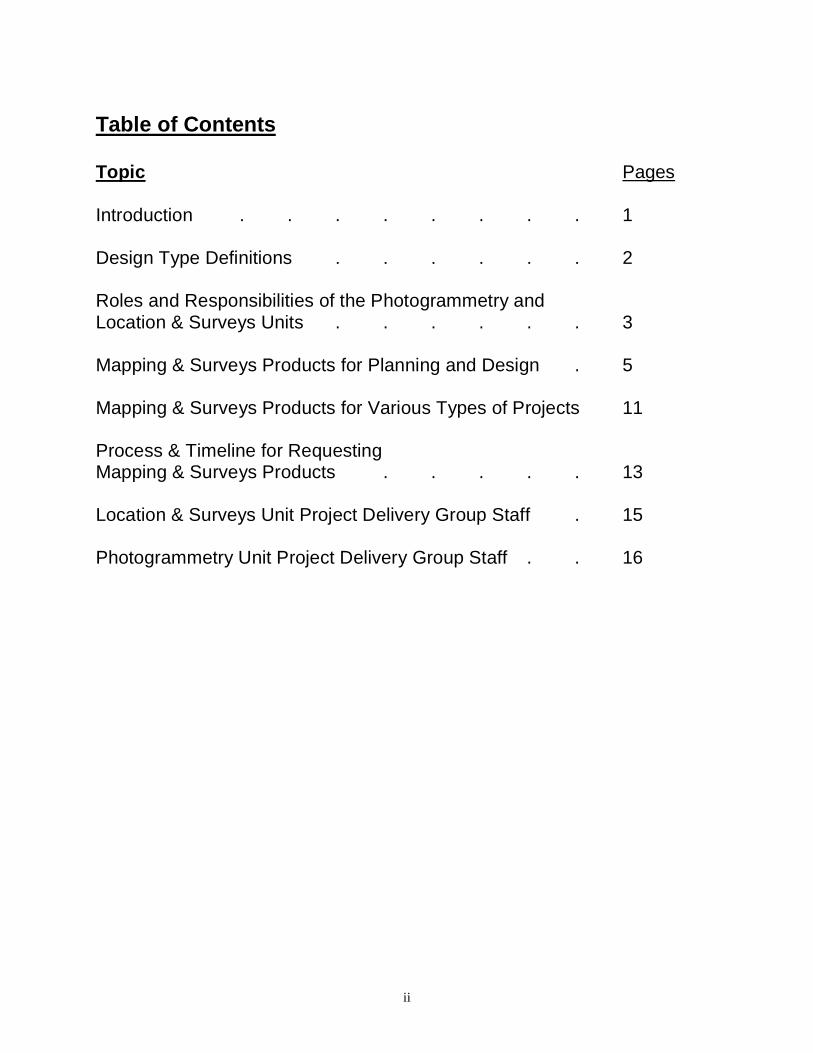
Table of Contents Topic Pages Introduction . . . . . . . . 1 Design Type Definitions . . . . . . 2 Roles and Responsibilities of the Photogrammetry and Location & Surveys Units . . . . . . 3 Mapping & Surveys Products for Planning and Design . 5 Mapping & Surveys Products for Various Types of Projects 11 Process & Timeline for Requesting Mapping & Surveys Products . . . . . 13 Location & Surveys Unit Project Delivery Group Staff . 15 Photogrammetry Unit Project Delivery Group Staff . . 16

1
Introduction These mapping and surveys guidelines can assist planning and design personnel with the determination of the correct mapping or surveys products to request to support their preconstruction work activities. Design type definitions are covered first in this document. Next, an overview of the roles and responsibilities of the Photogrammetry and Location & Surveys Units are presented which is followed by detailed information about specific standard mapping and surveys products for planning and design. A discussion about which mapping and surveys products are usually requested for certain project types (widening versus new location, and project size) is then covered. Finally, the last 2 pages of the document identify the key staff from the Photogrammetry and Location & Surveys Units that will work most closely with planning and design personnel to meet their mapping and surveys requirements. It should be noted the mapping and surveys products referenced in this document are not an exhaustive list of the products and services offered by the Photogrammetry and Location & Surveys Units. Questions concerning mapping and surveys products and services should be directed to Photogrammetry and Location & Surveys Units’ staff identified at the end of this document. The NEPA Merger 01 Process is referenced where pertinent.

2
Design Type Definitions Functional Design is a very general design that includes horizontal and vertical alignments, EP’s, slope stakes and R/W limits for all study alternatives. These designs should also include general layouts for proposed interchanges. Details like turn lanes or superelevation are not usually included. Functional designs are done on Orthophotography between Concurrence Points 1 and 2, within the study area, on new location projects. Functional designs are intended to establish basic line and grade for comparative alternatives. Initial cost estimates are also established based on these fundamental design elements. Preliminary Design is a very specific design that includes horizontal and vertical alignments, EP’s, slope stakes, turn lanes, superelevation and R/W limits. Preliminary designs are done on preliminary mapping (topographic mapping, shell plan sheet mapping, or preliminary plan sheet mapping) between Concurrence Points 2 and 3 on all corridors that are carried forward for detailed study. This type of design is done on new location, widening and bridge projects. Preliminary design is a refinement of the functional design. These refinements generally consist of adjusting the alignment and grade to avoid or minimize impacts to resources, such as delineated streams and wetlands, whose locations were not known at the functional design stage. The scope of work in this phase should not include starting the design over just because of a transition between mapping types. Final Design is a very detailed design done on the most accurate form of mapping - final surveys. Final design work also includes computing and summarizing all contract quantities, incorporating R/W revisions, receiving plans from various Units (Traffic Engineering Branch, Roadside Environmental Unit, Utilities, etc.) and incorporating them into the final plan package. These final plans are used to construct the project. This type of design is usually begun after Concurrence Point 4A. Consistent with the previous design stages, final designs are a further refinement of the preliminary designs and are not intended to be a point to start the design process over again.
3
Final Surveys
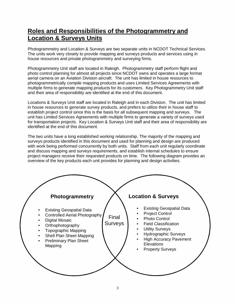
Roles and Responsibilities of the Photogrammetry an d Location & Surveys Units Photogrammetry and Location & Surveys are two separate units in NCDOT Technical Services. The units work very closely to provide mapping and surveys products and services using in house resources and private photogrammetry and surveying firms. Photogrammetry Unit staff are located in Raleigh. Photogrammetry staff perform flight and photo control planning for almost all projects since NCDOT owns and operates a large format aerial camera on an Aviation Division aircraft. The unit has limited in house resources to photogrammetrically compile mapping products and uses Limited Services Agreements with multiple firms to generate mapping products for its customers. Key Photogrammetry Unit staff and their area of responsibility are identified at the end of this document. Locations & Surveys Unit staff are located in Raleigh and in each Division. The unit has limited in house resources to generate survey products, and prefers to utilize their in house staff to establish project control since this is the basis for all subsequent mapping and surveys. The unit has Limited Services Agreements with multiple firms to generate a variety of surveys used for transportation projects. Key Location & Surveys Unit staff and their area of responsibility are identified at the end of this document. The two units have a long established working relationship. The majority of the mapping and surveys products identified in this document and used for planning and design are produced with work being performed concurrently by both units. Staff from each unit regularly coordinate and discuss mapping and surveys requirements, and establish internal schedules to ensure project managers receive their requested products on time. The following diagram provides an overview of the key products each unit provides for planning and design activities.
• Existing Geospatial Data • Controlled Aerial Photography • Digital Mosaic • Orthophotography • Topographic Mapping • Shell Plan Sheet Mapping • Preliminary Plan Sheet
Mapping
• Existing Geospatial Data • Project Control • Photo Control • Field Classification • Utility Surveys • Hydrographic Surveys • High Accuracy Pavement
Elevations • Property Surveys
Photogrammetry Location & Surveys

4
Roles and Responsibilities of the Photogrammetry an d Location & Surveys Units The above diagram shows not only final mapping and surveys products that are delivered to project managers, but also key sub component mapping and surveys products that are concurrently generated, and assembled to produce Final Surveys. The following pages detail several of the products listed in the above diagram that are delivered to project managers for planning and design. Information includes current status maps for existing statewide geospatial data, project coordinate system definition, typical pixel resolution for image based products, typical plot scales for graphic mapping and surveys, and whether Photogrammetry or Location & Surveys will deliver the mapping or surveys to the requesting project manager.
5
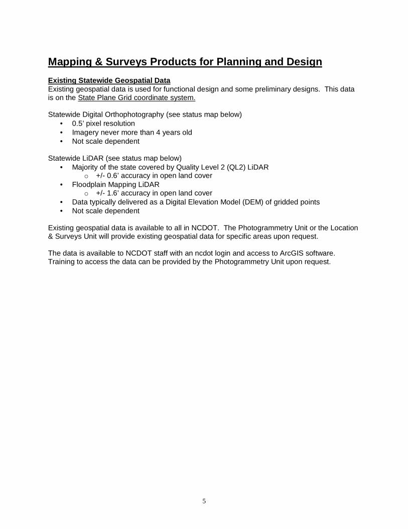
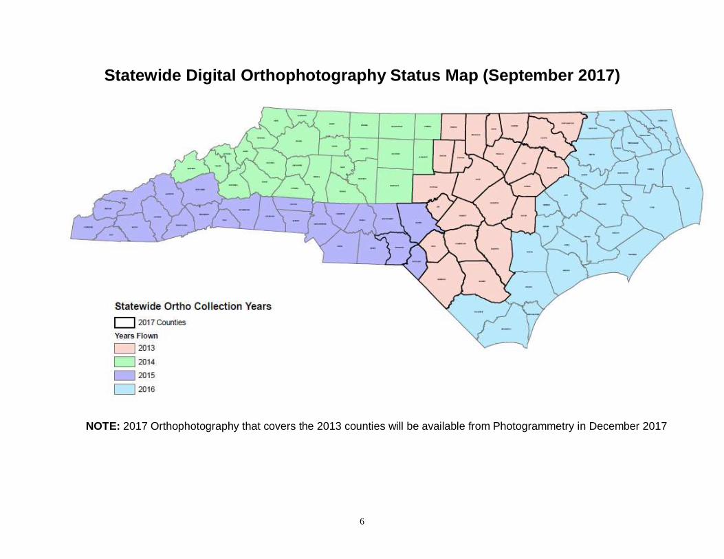
Mapping & Surveys Products for Planning and Design Existing Statewide Geospatial Data Existing geospatial data is used for functional design and some preliminary designs. This data is on the State Plane Grid coordinate system. Statewide Digital Orthophotography (see status map below)
• 0.5’ pixel resolution • Imagery never more than 4 years old • Not scale dependent
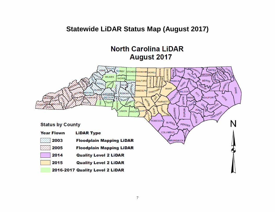
Statewide LiDAR (see status map below)
• Majority of the state covered by Quality Level 2 (QL2) LiDAR o +/- 0.6’ accuracy in open land cover
• Floodplain Mapping LiDAR o +/- 1.6’ accuracy in open land cover
• Data typically delivered as a Digital Elevation Model (DEM) of gridded points • Not scale dependent
Existing geospatial data is available to all in NCDOT. The Photogrammetry Unit or the Location & Surveys Unit will provide existing geospatial data for specific areas upon request. The data is available to NCDOT staff with an ncdot login and access to ArcGIS software. Training to access the data can be provided by the Photogrammetry Unit upon request.
6
Statewide Digital Orthophotography Status Map (Sept ember 2017)
NOTE: 2017 Orthophotography that covers the 2013 counties will be available from Photogrammetry in December 2017
7
Statewide LiDAR Status Map (August 2017)
8
Mapping & Surveys Products for Planning and Design Controlled Aerial Photography (CAP) When requested, Controlled Aerial Photography will be acquired by Photogrammetry. This is done in anticipation that a project will need mapping in the near future and to take advantage of the ‘leaf-off’ flying season. Digital Mosaic (M)
• Its primary use is for functional design and/or display purposes. • This product is rectified digital aerial imagery on the State Plane Grid.
o Digital imagery in MrSID image format with the associated MrSID world file o No elevation data is delivered
• Typically provided at 0.5’ or 1.0’ pixel resolution • Not scale dependent • No surveyed ground control is required. • The Photogrammetry Unit delivers this product to the customer.
Orthophotography (OP)
• Its primary uses are for functional and preliminary design work. o Imagery from this product can be supplemented and transformed into Preliminary
Mapping. • This product is rectified digital aerial imagery and a Digital Elevation Model on the State
Plane Grid. o Digital Orthoimagery in MrSID image format with the associated MrSID world file o Digital Elevation Model (DEM)
� The best available elevation model is used and is enhanced with stereo compiled breaklines on all major transportation features and major bodies of water.
• Typically provided at 0.5’ or 1.0’ pixel resolution • Not scale dependent • Surveyed ground controls are required • The Photogrammetry Unit delivers this product to the customer.
Topographic Mapping (T)
• Its primary use is for preliminary design work on new location and large scale widening projects with multiple alternatives.
• This product is planimetric data to Topographic Specifications and a Digital Terrain Model on the State Plane Grid.
o Vector planimetric file in MicroStation (DGN) format. o Digital Terrain Model (DTM)
� The best available elevation model is used and is enhanced with stereo compiled breaklines on all appropriate terrain features.
o Municipal property data and field classification are incorporated into the mapping. • Typically provided at 1”=200’ for rural projects and 1”=100’ for urban projects • Surveyed ground controls are required • The Photogrammetry Unit delivers this product to the customer.
9
Mapping & Surveys Products for Planning and Design Shell Plan Sheet Mapping (SPS)
• Its primary use is for preliminary design work on widening projects and bridge replacement projects.
o This mapping is frequently converted into Final Surveys. • This product is planimetric data to Plan Sheet Specifications and a Digital Terrain Model
on a Localized Coordinate System. o Vector planimetric file in MicroStation (DGN) format. o Digital Terrain Model (DTM)
� Where available, QL2 LiDAR elevation data is used and is enhanced with stereo compiled breaklines on all appropriate terrain features.
o No additional mapping data is incorporated into this mapping. • Provided at 1”=50’ for vast majority of projects. Some urban projects with dense
development provided at 1”=30’ or 1”=20’ upon customer request. • Surveyed ground controls are required. • The Photogrammetry Unit delivers this product to the customer, which may be a Project
Manager or the Location & Surveys Unit, or both. Preliminary Plan Sheet Mapping (PPS)
• Its primary use is for preliminary design work on widening projects and small new location projects.
o This mapping is frequently converted into Final Surveys. • This product is planimetric data to Plan Sheet Specifications and a Digital Terrain Model
on a Localized Coordinate System. o Vector planimetric file in MicroStation (DGN) format
� Field Classification of planimetric features o Digital Terrain Model (DTM)
� Where available, QL2 LiDAR elevation data is used and is enhanced with stereo compiled breaklines on all appropriate terrain features.
o Additional mapping data incorporated into this mapping, most commonly GIS Municipal Property data and/or field surveyed data
• Provided at 1”=50’ for vast majority of projects. Some urban projects with dense development provided at 1”=30’ or 1”=20’ upon customer request.
• Surveyed ground controls are required. • The Photogrammetry Unit delivers this product to the customer, which may be a Project
Manager or the Location & Surveys Unit, or both.

10
Mapping & Surveys Products for Planning and Design Final Surveys (FS)
• Use is for all Final Design projects. • This product is planimetric data to Plan Sheet Specifications and a Digital Terrain Model
on a Localized Coordinate System. o Vector planimetric file in MicroStation (DGN) format, including:
� Field Classification of planimetric features � Utility Surveys � Hydrographic Surveys � High Accuracy Pavement Elevations � Property Surveys
o Digital Terrain Model (DTM) � Field surveys on all roads and hydrographic features � Where available, QL2 LiDAR elevation data is used and is field verified.
• Provided at 1”=50’ for vast majority of projects. Some urban projects with dense development provided at 1”=30’ or 1”=20’ upon customer request.
• Surveyed ground controls are required. • This product is usually produced jointly by Photogrammetry and Location & Surveys for
larger projects, where Shell or Preliminary Plan Sheet Mapping is converted to Final Surveys.
• This product can be completed solely by Location & Surveys for smaller projects. Examples of smaller projects could be intersection improvement projects or bridge replacement projects.
• If numerous smaller projects are identified during the annual Requesting Mappings/Surveys cycle prior to leaf-off flight season, it is usually most efficient to treat them as part of a statewide program and involve Photogrammetry. This has been done many times for the bridge replacement program.
• The Location & Surveys Unit delivers this product to the customer in the vast majority of cases, but in some rare instances the Photogrammetry Unit delivers this product to the customer.
11
Mapping & Surveys Products for Various Types of Pro jects Existing geospatial data is used at the early stages of all projects to aide in project scope and help determine the course of action a project should follow. Generally speaking, projects fall into 5 basic categories: New Location, Large Widening, Average Widening, Small Widening, and Bridge and Small Safety Improvement. New Location Projects • Orthophotography – Typically requested the fall prior to the initial Scoping Meeting. If
scoping is to occur in early spring, it may be necessary to request mapping two flight seasons prior to the Scoping Meeting. Mapping limits for each project should be attached to the request for this mapping.
• Topographic Mapping or Preliminary Plan Sheet Mapping – If deemed appropriate,
either Topographic Mapping or Preliminary Plan Sheet Mapping is requested the fall prior to the initial Scoping Meeting. If scoping is to occur in early spring, it may be necessary to request mapping two flight seasons prior to the Scoping Meeting. When appropriate, Topographic Mapping can be generated from previously supplied Orthophotos. This is usually requested for the alternates selected for detailed study (Concurrence Point #2). Mapping limits for each alternate should be attached to the request for this mapping.
• Final Surveys - Request for Final Surveys should be submitted during the Annual
Requesting Mapping and Surveys cycle, or after LEDPA is achieved (Concurrence Point #3), or anytime out of cycle as deemed appropriate by the Division and Central Project Managers.
Large Widening Projects • Orthophotography – If deemed appropriate, orthophotography is requested the fall prior to
the initial Scoping Meeting. If scoping is to occur in early spring, it may be necessary to request mapping two flight seasons prior to the Scoping Meeting. Mapping limits for each project should be attached to the request for this mapping.
• Topographic Mapping or Preliminary Plan Sheet Mapping – If deemed appropriate,
either Topographic Mapping or Preliminary Plan Sheet Mapping is requested the fall prior to the initial Scoping Meeting. If scoping is to occur in early spring, it may be necessary to request mapping two flight seasons prior to the Scoping Meeting. When appropriate, Topographic Mapping can be generated from previously supplied Orthophotos. This is usually requested for the alternates selected for detailed study (Concurrence Point #2). Mapping limits for each alternate should be attached to the request for this mapping.
• Final Surveys - Request for Final Surveys should be submitted during the Annual
Requesting Mapping and Surveys cycle, or after LEDPA is achieved (Concurrence Point #3), or anytime out of cycle as deemed appropriate by the Division and Central Project Managers.

12
Mapping & Surveys Products for Various Types of Pro jects Average Widening Projects • Preliminary Plan Sheet Mapping or Shell Plan Sheet Mapping – If deemed appropriate,
either Preliminary Plan Sheet Mapping or Shell Plan Sheet Mapping is requested the fall prior to the initial Scoping Meeting. If scoping is to occur in early spring, it may be necessary to request mapping two flight seasons prior to the Scoping Meeting. Mapping limits for each alternate should be attached to the request for this mapping.
• Final Surveys - Request for Final Surveys should be submitted during the Annual
Requesting Mapping and Surveys cycle, or after LEDPA is achieved (Concurrence Point #3), or anytime out of cycle as deemed appropriate by the Division and Central Project Managers.
Small Widening Projects • Final Surveys – Request for Final Surveys should be submitted during the Annual
Requesting Mapping and Surveys cycle, or anytime out of cycle as deemed appropriate by the Division and Central Project Managers. No survey groundwork should be started until the public involvement (at a minimum public notification) has been initiated/occurred (Letter, Postcard/Newsletter, Public Meeting, and/or Public Hearing).
Bridge and Small Safety Improvement Projects • Final Surveys – Request for Final Surveys should be submitted during the Annual
Requesting Mapping and Surveys cycle, or anytime out of cycle as deemed appropriate by the Division and Central Project Managers. Final Surveys for these projects are often completed solely by Location & Surveys for smaller projects. If numerous bridge and larger safety improvement projects are identified during the Annual Requesting Mapping and Surveys cycle prior to leaf-off flight season, it is usually most efficient to treat them as part of a statewide program and involve Photogrammetry. No survey groundwork should be started until the public involvement (at a minimum public notification) has been initiated/occurred (Letter, Postcard/Newsletter, Public Meeting, and/or Public Hearing).

13
Process & Timeline for Requesting Mapping & Surveys Products Annual Process The following is a generalized framework for the process and timeline to request controlled aerial photography, mapping, and surveys. This timeline takes into account flying aerial photography during leaf off season, which is mid-December to mid-April depending on the project location. Leaf off aerial photography is needed for maximum utilization of photogrammetric map compilation which is significantly faster and less expensive than ground based surveys. Project Managers need to take into account their mapping and surveys needs through two leaf off flight seasons in order to allow sufficient time for mapping and surveys to be completed and delivered in the first half of the second flight season. Looking further ahead also allows time for orthophotography or topographic mapping to be developed for preliminary design activities over larger study areas on large widening or new location projects. The annual process should begin in August each year and should involve Division Project Managers, Central Project Managers, Regional and Division Location & Surveys Unit Managers, and Photogrammetry Group Managers. The process will start with Photogrammetry sending a Mapping & Surveys Request to Divisions, Central Project Teams, and other NCDOT business units as needed. The Division and Central Project Managers should evaluate their mapping and surveys requirements through June of the second flight season, and submit a list of projects along with mapping and surveys limits to the Photogrammetry and Location & Surveys Units. Regional and Division Location & Surveys Team Leads are available for consultation and to assist in the development of mapping and surveys limits. Photogrammetry and Central Location & Surveys staff will research to see if existing mapping or surveys are available or already underway, and also evaluate the requested delivery schedules as they relate to available in house and private firm resources to complete the mapping and surveys. After that is completed, Mapping/Surveys Meetings will be conducted on a Regional basis with Division and Central Project Managers, Location & Surveys staff, and Photogrammetry staff. The purpose of the Regional Mapping/Surveys Meetings is to ensure requirements are clearly understood, and to evaluate mapping and surveys delivery schedules across the enterprise. If after completion of the Regional Mapping/Surveys Meetings, it is determined that in house and private firm mapping and surveys resources cannot meet all the requested delivery schedules, Photogrammetry and Location & Surveys will submit revised delivery schedules to Division Engineers and appropriate Division and Central staff for prioritization. At that time, Division Engineers and appropriate Division and Central staff establish final product delivery dates.
14
Process & Timeline for Requesting Mapping & Surveys Products Generalized Timeline for Annual Requesting Mapping & Surveys Process The following is a generalized timeline starting in August 2018. Actual dates are approximate. August 1, 2018: Photogrammetry sends Mapping/Surveys Request and Guidelines to Divisions and Central Project Delivery Teams. August 15, 2018: Regional Mapping Meetings are scheduled in advance to be accomplished mid-September to mid-October. September 15, 2018: Completed Mapping Request spreadsheet and DGN limits are submitted to Photogrammetry / Location & Surveys. Regional and Division Location & Surveys Team Leads are available for consultation and to assist in the development of mapping and surveys limits. Division and Central Project Managers should request mapping and surveys with delivery schedules through June 30, 2019 to account for leaf off flying season. October 1-15, 2018: Regional Mapping Meetings conducted with Division & Central Project Managers, Photogrammetry, and Location & Surveys November 1, 2018: If necessary, Photogrammetry / Location & Surveys submit revised delivery schedules to Division Engineers and appropriate Division and Central staff for Prioritization. November 15, 2018: Division Engineers and appropriate Division and Central staff establish final product delivery dates. At the conclusion of the Annual Requesting Mapping and Surveys cycle, the Location & Surveys Unit will sent a formal memo on NCDOT letterhead to each Division and Central Project Manager summarizing the scheduled delivery for all mapping and surveys products for each project. Out of Cycle Requests for Mapping & Surveys Out of Cycle requests for mapping and surveys should be requested from the Regional or Division Location & Surveys Team Lead, as appropriate, who will evaluate the scope of the mapping and surveys and coordinate with Photogrammetry.
15
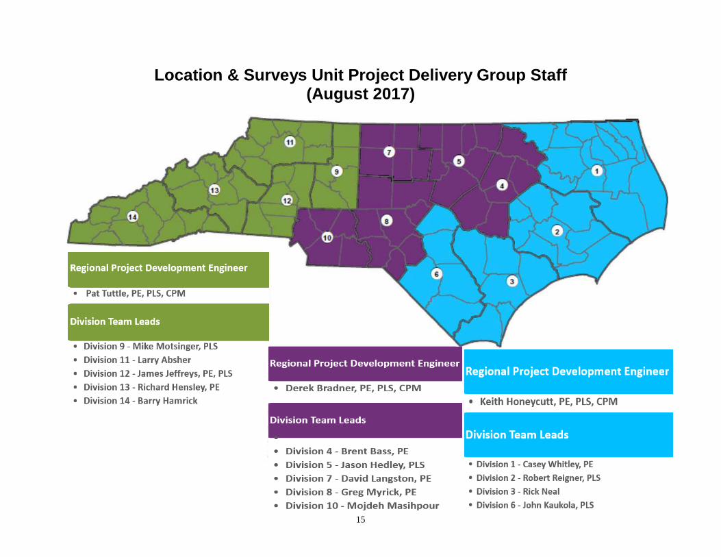
Location & Surveys Unit Project Delivery Group Staf f (August 2017)
16
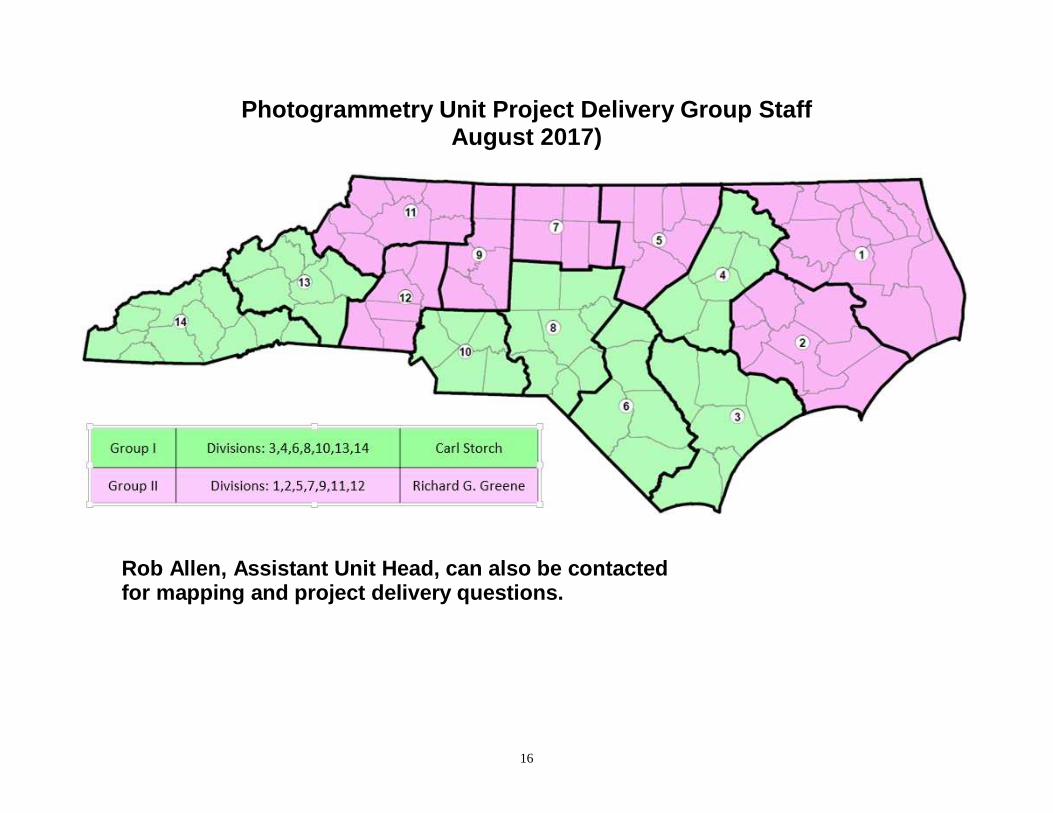
Photogrammetry Unit Project Delivery Group Staff August 2017)
Rob Allen, Assistant Unit Head, can also be contact ed for mapping and project delivery questions.