Embed Size (px)
Citation preview


INTRODUCTION
The NCDOT Facility Types and Control of Access Definitions document was prepared to create a set of easy tounderstand and consistent definitions for all roadways for NCDOT and its partners to use in the planning,design, and operations processes. The definitions are primarily based on the function of the roadway, level ofmobility and access, and whether the facility has traffic signals, driveways, and/or medians. These definitionswere developed from a committee comprised of members from the Federal Highway Administration and thefollowing NCDOT branches: Traffic Engineering, Highway Design, Project Development, and TransportationPlanning. The North Carolina Board of Transportation adopted these definitions on September 2, 2004 as a partof the Statewide Transportation Plan.
The facility type definitions are identical to those used in a Comprehensive Transportation Plan (CTP), withthe exception of Thoroughfares. In a CTP, Thoroughfares are further broken down to Major Thoroughfares andMinor Thoroughfares. In this document, both Major and Minor Thoroughfares fall into the generalThoroughfares description.
The first section this document provides descriptions of the different facility types with examples as they existat the time this document was created. The facility types are listed in order of the level of mobility provided(highest to lowest). This is followed by the definitions of the different types of control of access and acomparison chart. The second section of this document provides illustrative examples that show variouselements of each of the different facility types. These illustrations are not drawn to any particular scale.
This document was revised in August 2005 in order to simplify the facility type definitions. The originalExpressway Type I and Type II definitions were consolidated into one Expressway definition. Similarily, theBoulevard Type I and Type II definitions were consolidated into one Boulevard definition.
An electronic version of this document is available athttp://www.ncdot.org/doh/preconstruct/tpb/shc/pdf/NCDOT_Facility_Types.pdf (Acrobat Reader required).
Document Prepared by:NCDOT-Transportation Planning Branch
Systems Planning UnitAttn: David S. Wasserman, P.E.
1554 Mail Service CenterRaleigh, NC 27699-1554(919) 715-5482 ext. 380
Illustrative Examples Prepared by:NCDOT-Highway Design Branch
Visualization UnitRaleigh, NC 27699-1582
(919) 250-4016

NORTH CAROLINA DEPARTMENT OF TRANSPORTATIONFACILITY TYPES
Listed in Order of Mobility Function
Adopted by the North Carolina Board of TransportationSeptember 2, 2004
Freeways
US 74 in Waynesville
US 264 east of I-95 (Wilson Bypass)
I-40/85 in Orange County
US 64 in Rocky Mount
Functional Purpose: High Mobility, Low Access
AASHTO Design Classification: Interstate orFreeway
Posted Speed Limit: 55 mph or greater
Control of Access: Full
Traffic Signals: Not Allowed
Driveways: Not Allowed
Cross-Section: Minimum 4 Lanes with a Median
Connections: Provided only at Interchanges; AllCross Streets are Grade-Separated
Median Crossovers: Public-use Crossovers NotAllowed; U-turn Median Openings for Use byAuthorized Vehicles Only when Need is Justified
Examples: I-40, I-95, US 64 between Rocky Mountand Williamston, US 52 between Lexington andMount Airy, US 70 between Kinston and New Bern,US 74 near Waynesville, US 264 east of I-95(Wilson Bypass), US 1 between Raleigh andSanford

NORTH CAROLINA DEPARTMENT OF TRANSPORTATIONFACILITY TYPES
Listed in Order of Mobility Function
Adopted by the North Carolina Board of TransportationSeptember 2, 2004
Expressways
US 221 (Marion Bypass)
US 117 north of I-40
US 74 west of Waynesville
US 64 in Apex
Functional Purpose: High Mobility, Low toModerateAccess
AASHTO Design Classification: Arterial
Posted Speed Limit: 45 mph to 60 mph
Control of Access: Limited or Partial
Traffic Signals: Not Allowed
Driveways:Limited Control of Access - Not AllowedPartial Control of Access - One Driveway
Connection per Parcel; Consolidate and/orShare Driveways and Limit Access toConnecting Streets or Service Roads; Restrict toRight-in/Right-out
Cross-Section: Minimum 4 Lanes with a Median
Connections: Provided only at Interchanges forMajor Cross Streets and At-Grade Intersections forMinor Cross Streets; Use of Acceleration andDeceleration Lanes for At-Grade Intersections
Median Crossovers: Allowed; Alternatives to All-Movement Crossovers Encouraged; MinimumSpacing between All-Movement Crossovers is 2000feet (posted speed limit of greater than 45 mph) or1200 feet (posted speed limit of 45 mph or less)
Examples: US 221 (Marion Bypass), US 220 inRockingham County, US 321 south of Lenoir, US117 north of I-40; US 74 (Independence Blvd) justeast of I-277 in Charlotte, US 74 west ofWaynesville, US 29 in Guilford County, US 301north of Wilson, US 64 in Apex
NORTH CAROLINA DEPARTMENT OF TRANSPORTATIONFACILITY TYPES
Listed in Order of Mobility Function
Adopted by the North Carolina Board of TransportationSeptember 2, 2004
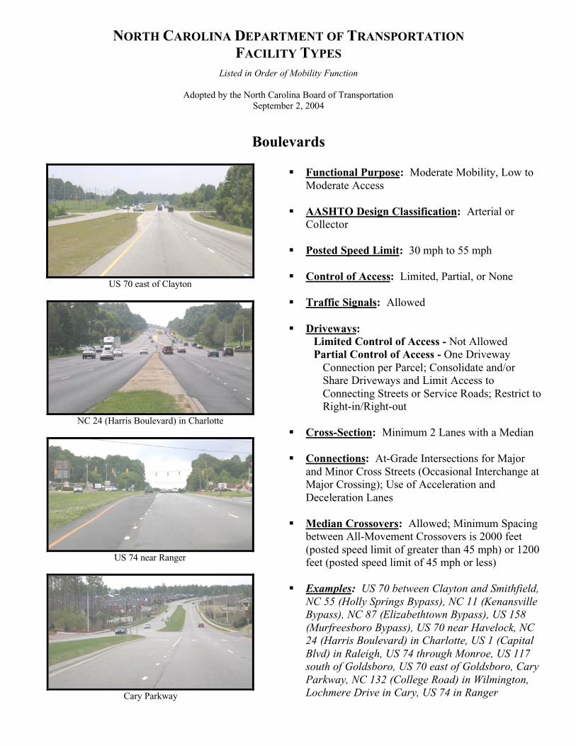
Boulevards
US 70 east of Clayton
NC 24 (Harris Boulevard) in Charlotte
US 74 near Ranger
Cary Parkway
Functional Purpose: Moderate Mobility, Low toModerate Access
AASHTO Design Classification: Arterial orCollector
Posted Speed Limit: 30 mph to 55 mph
Control of Access: Limited, Partial, or None
Traffic Signals: Allowed
Driveways:Limited Control of Access - Not AllowedPartial Control of Access - One Driveway
Connection per Parcel; Consolidate and/orShare Driveways and Limit Access toConnecting Streets or Service Roads; Restrict toRight-in/Right-out
Cross-Section: Minimum 2 Lanes with a Median
Connections: At-Grade Intersections for Majorand Minor Cross Streets (Occasional Interchange atMajor Crossing); Use of Acceleration andDeceleration Lanes
Median Crossovers: Allowed; Minimum Spacingbetween All-Movement Crossovers is 2000 feet(posted speed limit of greater than 45 mph) or 1200feet (posted speed limit of 45 mph or less)
Examples: US 70 between Clayton and Smithfield,NC 55 (Holly Springs Bypass), NC 11 (KenansvilleBypass), NC 87 (Elizabethtown Bypass), US 158(Murfreesboro Bypass), US 70 near Havelock, NC24 (Harris Boulevard) in Charlotte, US 1 (CapitalBlvd) in Raleigh, US 74 through Monroe, US 117south of Goldsboro, US 70 east of Goldsboro, CaryParkway, NC 132 (College Road) in Wilmington,Lochmere Drive in Cary, US 74 in Ranger

NORTH CAROLINA DEPARTMENT OF TRANSPORTATIONFACILITY TYPES
Listed in Order of Mobility Function
Adopted by the North Carolina Board of TransportationSeptember 2, 2004
Thoroughfares
Old Concord Road in Charlotte
Hillsborough Street in Raleigh
Shamrock Road in Charlotte
Trinity Road in Raleigh
Functional Purpose: Moderate to Low Mobility,High Access
AASHTO Design Classification: Collector orLocal
Posted Speed Limit: 25 mph to 55 mph
Control of Access: None
Traffic Signals: Allowed
Driveways: Allowed with Full Movements;Consolidate or Share Connections, if possible
Cross-Section: Minimum 2 Lanes; No Median;Includes All Facilities with a Two Way Left TurnLane
Connections: Primarily At-Grade Intersections
Median Crossovers: Not Applicable
Examples: Old Concord Road in Charlotte,Hillsborough Street in Raleigh, Shamrock Road inCharlotte, Trinity Road in Raleigh

NORTH CAROLINA DEPARTMENT OF TRANSPORTATIONCONTROL OF ACCESS DEFINITIONS
Listed in Order of Mobility Function
Adopted by the North Carolina Board of TransportationSeptember 2, 2004
Full Control of AccessConnections to a facility provided only via ramps at interchanges. All cross-streets are grade-separated. Noprivate driveway connections allowed. A control of access fence is placed along the entire length of the facilityand at a minimum of 1000 feet beyond the ramp intersections on the Y lines (minor facility) at interchanges (ifpossible).
Limited Control of AccessConnections to a facility provided only via ramps at interchanges (major crossings) and at-grade intersections(minor crossings and service roads). No private driveway connections allowed. A control of access fence isplaced along the entire length of the facility, except at intersections, and at a minimum of 1000 feet beyond theramp intersections on the Y lines (minor facility) at interchanges (if possible).
Partial Control of AccessConnections to a facility provided via ramps at interchanges, at-grade intersections, and private driveways.Private driveway connections are normally defined as a maximum of one connection per parcel. Oneconnection is defined as one ingress and one egress point. The use of shared or consolidated connections ishighly encouraged. Connections may be restricted or prohibited if alternate access is available through otheradjacent public facilities. A control of access fence is placed along the entire length of the facility, except atintersections and driveways, and at a minimum of 1000 feet beyond the ramp terminals on the minor facility atinterchanges (if possible).
No Control of AccessConnections to a facility provided via ramps at interchanges, at-grade intersections, and private driveways. Nophysical restrictions, i.e., a control of access fence, exist. Normally, private driveway connections are definedas one connection per parcel. Additional connections may be considered if they are justified and if suchconnections do not negatively impact traffic operations and public safety.

NC
DO
T F
AC
ILIT
YT
YP
ES
CO
MP
AR
ISO
NC
HA
RT
Fre
eway
sE
xpre
ssw
ays
Bou
leva
rds
Tho
roug
hfar
es
Fun
ctio
nal P
urpo
seH
igh
Mob
ility
, Low
Acc
ess
Hig
h M
obili
ty, L
ow to
Mod
erat
eA
cces
sM
oder
ate
Mob
ility
, Low
toM
oder
ate
Acc
ess
Mod
erat
e to
Low
Mob
ility
, Hig
hA
cces
s
AA
SHT
O D
esig
nC
lass
ific
atio
nIn
ters
tate
or
Free
way
Art
eria
lA
rter
ial o
r C
olle
ctor
Col
lect
or o
r L
ocal
Pos
ted
Spee
d L
imit
55 m
ph o
r gr
eate
r45
mph
to 6
0 m
ph30
mph
to 5
5 m
ph25
mph
to 5
5 m
ph
Con
trol
of
Acc
ess
Full
Lim
ited
or P
artia
lL
imite
d or
Par
tial
Non
e
Tra
ffic
Sig
nals
Not
Allo
wed
Not
Allo
wed
Allo
wed
Allo
wed
Dri
vew
ays
Not
Allo
wed
Lim
ited
Con
trol
of
Acc
ess
- N
otA
llow
ed
Part
ial C
ontr
ol o
f A
cces
s -
One
Dri
vew
ay C
onne
ctio
n pe
r Pa
rcel
;C
onso
lidat
e an
d/or
Sha
reD
rive
way
s an
d L
imit
Acc
ess
toC
onne
ctin
g St
reet
s or
Ser
vice
Roa
ds; R
estr
ict t
o R
ight
-in/
Rig
ht-
out
Lim
ited
Con
trol
of
Acc
ess
- N
otA
llow
ed
Part
ial C
ontr
ol o
f A
cces
s -
One
Dri
vew
ay C
onne
ctio
n pe
r Pa
rcel
;C
onso
lidat
e an
d/or
Sha
reD
rive
way
s an
d L
imit
Acc
ess
toC
onne
ctin
g St
reet
s or
Ser
vice
Roa
ds; R
estr
ict t
o R
ight
-in/
Rig
ht-
out
Allo
wed
with
Ful
l Mov
emen
ts;
Con
solid
ate
or S
hare
Con
nect
ions
, if
poss
ible
Cro
ss-S
ecti
onM
inim
um 4
Lan
es w
ith a
Med
ian
Min
imum
4 L
anes
with
a M
edia
nM
inim
um 2
Lan
es w
ith a
Med
ian
Min
imum
2 L
anes
; No
Med
ian;
Incl
udes
Fac
ilitie
s w
ith T
wo
Way
Lef
t Tur
n L
ane
Con
nect
ions
Prov
ided
onl
y at
Int
erch
ange
s;A
ll C
ross
Str
eets
are
Gra
de-
Sepa
rate
d
Prov
ided
onl
y at
Int
erch
ange
s fo
rM
ajor
Cro
ss S
tree
ts a
nd A
t-G
rade
Inte
rsec
tions
for
Min
or C
ross
Stre
ets;
Use
of
Acc
eler
atio
n an
dD
ecel
erat
ion
Lan
es f
or A
t-G
rade
Inte
rsec
tions
At-
Gra
de I
nter
sect
ions
for
mos
tM
ajor
and
Min
or C
ross
Str
eets
(Occ
asio
nal I
nter
chan
ge a
t Maj
orC
ross
ing)
; Use
of
Acc
eler
atio
nan
d D
ecel
erat
ion
Lan
es
Prim
arily
At-
Gra
de I
nter
sect
ions
Med
ian
Cro
ssov
ers
Publ
ic-u
se C
ross
over
s N
otA
llow
ed; U
-tur
n M
edia
nO
peni
ngs
for
Use
by
Aut
hori
zed
Veh
icle
s O
nly
whe
n N
eed
isJu
stif
ied
Allo
wed
; Alte
rnat
ives
to A
ll-M
ovem
ent C
ross
over
sE
ncou
rage
d;M
inim
um S
paci
ngbe
twee
n A
ll-M
ovem
ent
Cro
ssov
ers
is 2
000
feet
(po
sted
spee
d lim
it of
gre
ater
than
45
mph
) or
120
0 fe
et (
post
edsp
eed
limit
of 4
5 m
ph o
r le
ss)
Allo
wed
;Min
imum
Spa
cing
betw
een
All-
Mov
emen
tC
ross
over
s is
200
0 fe
et (
post
edsp
eed
limit
of g
reat
er th
an 4
5m
ph)
or 1
200
feet
(po
sted
spee
d lim
it of
45
mph
or
less
)
Not
App
licab
le


REFERENCES
1. American Association of State Highway and Transportation Officials (AASHTO), A Policy on GeometricDesign of Highways and Streets, 4th Edition, 2001
2. North Carolina Department of Transportation (NCDOT), Design Manual, 2002
3. North Carolina Department of Transportation (NCDOT), Policy on Street and Driveway Access to NorthCarolina Highways, 2003
4. North Carolina Department of Transportation (NCDOT), Median Crossover Guidelines, 2004