Embed Size (px)
Citation preview
Navigating with Smartphones and Tablets
Robin Martel, PresidentFugawi Software

Outline
1. Who are Fugawi?2. The Navigator3. What to look for in an App4. Other things - Accessories5. Q&A

1995Birth of
Fugawi PC software
2001Fugawi
supports Palm, Pocket PC
2003Fugawi first to support ENC
(vector) charts
2007Fugawi
supports 3rd party
Navionics
2008Fugawi
X-Traverse, first online third party chart provider for
Apple, Mac and PC products
2011Canadian
Distributor of Marine electronics
and charts (Actisense, CHS, NV Charts, etc.)
2014New quilted raster charts
for chartplotters
and Web services to
support mobile apps
We’re the Fugawi!
2012Chart software for Chartplotters, Web services for brand
name marine electronics
(Raymarine, Lowrance, Simrad,
B&G)

What is a navigator?
Person who is aware of the ship’s position at all times.
Other responsibilities:• Planning the journey• Avoiding hazards• Advising ETAs• Maintaining charts and equipment
Charts are updated all the time. Always ensure you have the latest charts.

What is Navigation?The ‘Bible’ of Navigation
The American Practical Navigator, first published in 1802, original author, Nathaniel Bowditch. Many revisions.

Why mobile?Pros•Portable•Multi-purpose•Cost-effective•Large displays•Many have built in GPS / Compass
Cons•Not Sunlight readable•Generally not weatherproof•Battery Life•Many options can be confusing

Devices
1. Smartphone or Tablet? (Screen size, what you own, portability)
2. Android, Windows, Apple? (iOS have the most accessories)
3. What model? (GPS included? Compass?)
Most popular choice is the iPad WiFi+Cellular models

Some Navigation Apps…(there are many more)
TransasNavionics Garmin Jeppesen iNavX
Search “Marine Navigation”PathAway

Where to get charts?Outside of USA, charts are NOT free.
Fugawi X-Traverse •First and largest third party chart provider•Raster and vector charts•weather services•Charts updated•Several Apps supported (iNavX, PathAway, Fugawi)
Other apps:•Free USA charts•In app purchase for S-57 charts •Own brand proprietary charts (Navionics, C-MAP, Transas)

iNavX has the most charts, updated!
Including CHS - Canadian Government Charts

Why iNavX?1. Access to thousands of world wide
charts2. The ONLY app to provide many brands
of charts 3. Charts are up-to-date 4. Real-time navigation, advanced options
available5. Share trips with friends via Facebook6. Supports NMEA data from Wifi7. View AIS and instrument data8. Weather forecast (maps) overlayThe MOST and BEST chart selection.

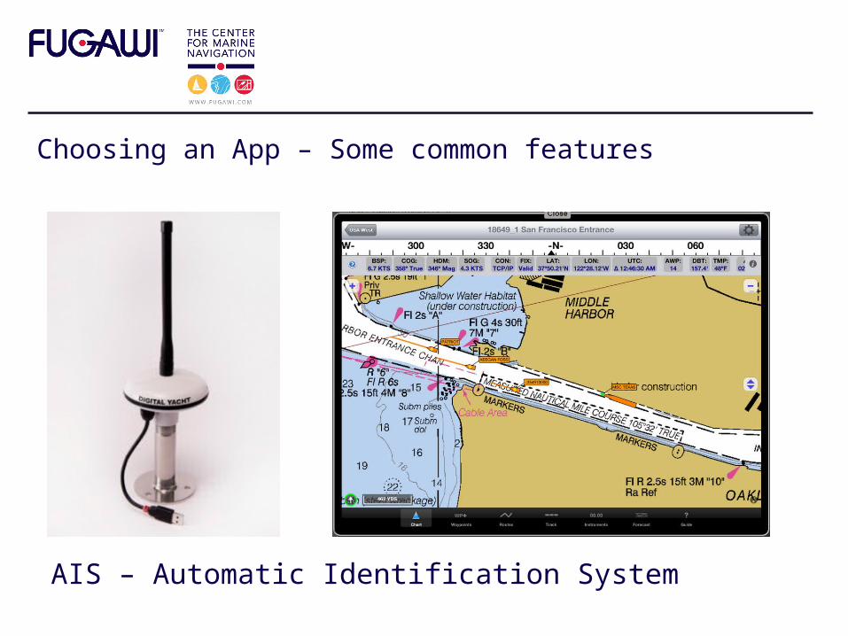
Choosing an App – Some common features
Real Time Navigation – Waypoints, Routes, Course to Steer, ETA, etc.

Choosing an App – Some common features
Instruments – Digital and Analogue Styles
Choosing an App – Some common features
AIS – Automatic Identification System

Choosing an App – Some common features
Weather – Free GRIB files or more detailed

Choosing an App – Some common features
NMEA Data in via WiFi

Choosing an App – Some common features
Anchor Alarm

Choosing an App – Some common features
Auto Routing

Accessories
• Waterproof cases / mounts
• AIS and NMEA WiFi• External GPS
devices• Sonar, …
store.fugawi.com or booth G351
Digital Yacht iAIS receiver
BadElf GPS
Vexilar Fish Finder / Sonar
Lifejacket

Final thoughts
1. Use all tools available
2. Don’t forget to look outside
Questions?Fugawi Booth G351
NMEA 2000 ConnectFest Booth G138
Store.fugawi.com