Embed Size (px)
Citation preview

Volcanic and Earthquake
Hazards: Living Safely with
Nature’s Perils and the Role of
the Real Estate Sector
CREBA 4th Monthly Business Meeting
27 April 2017
Renato U. Solidum, Jr.
Department of Science and Technology
Philippine Institute of Volcanology and Seismology

BEAUTIFUL PHILIPPINES
www.expedia.com.ph
www.synotrip.com
outoftownblog.com
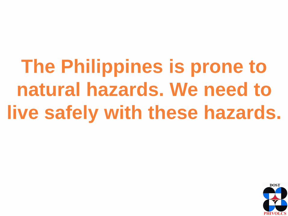
The Philippines is prone to
natural hazards. We need to
live safely with these hazards.
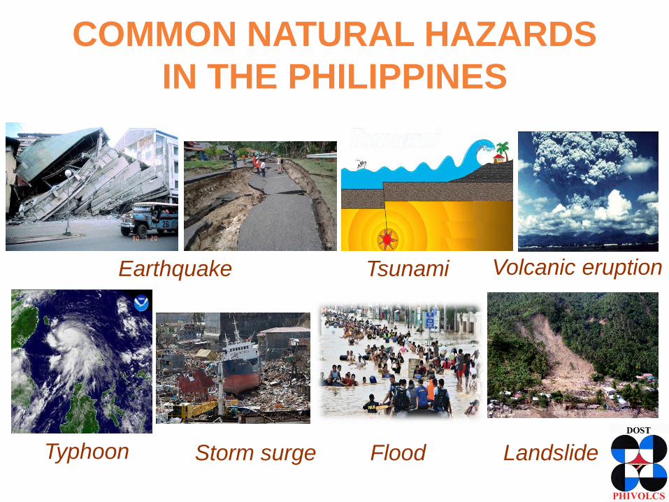
COMMON NATURAL HAZARDS
IN THE PHILIPPINES
Earthquake Tsunami Volcanic eruption
Typhoon Storm surge Flood Landslide
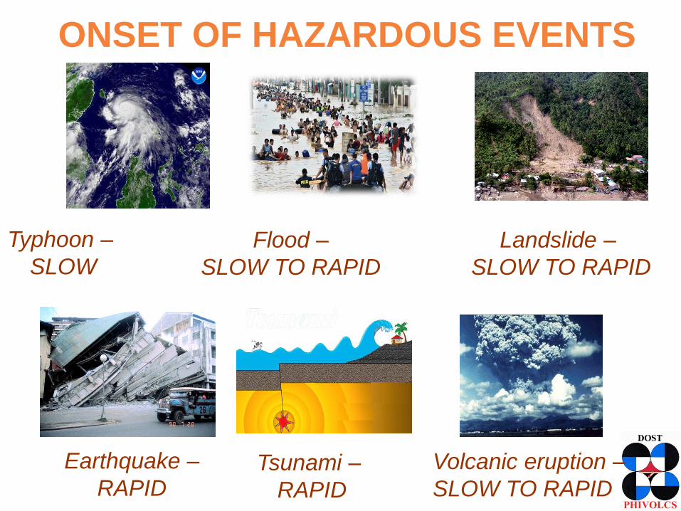
ONSET OF HAZARDOUS EVENTS
Earthquake –
RAPIDTsunami –
RAPID
Volcanic eruption –
SLOW TO RAPID
Typhoon –
SLOW
Flood –
SLOW TO RAPID
Landslide –
SLOW TO RAPID
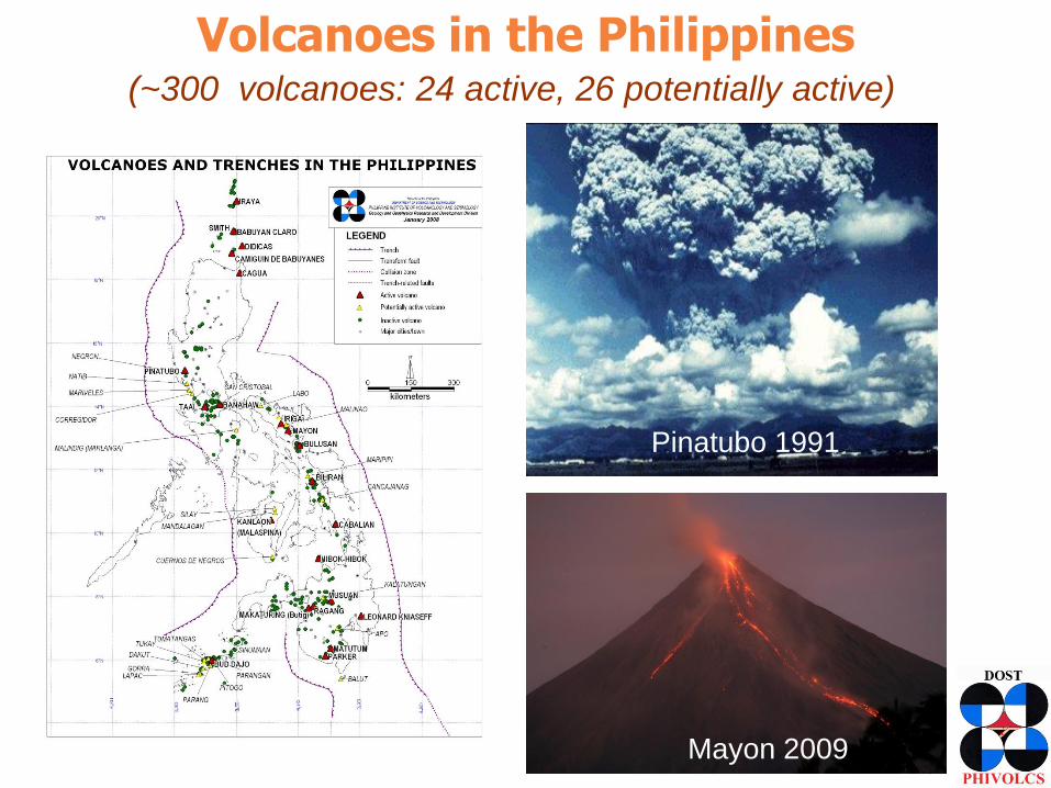
Volcanoes in the Philippines(~300 volcanoes: 24 active, 26 potentially active)
Mayon 2009
Pinatubo 1991

Pinatubo lahar, 1995Pinatubo, 1991
1991 Pinatubo Eruption and Subsequent Lahars
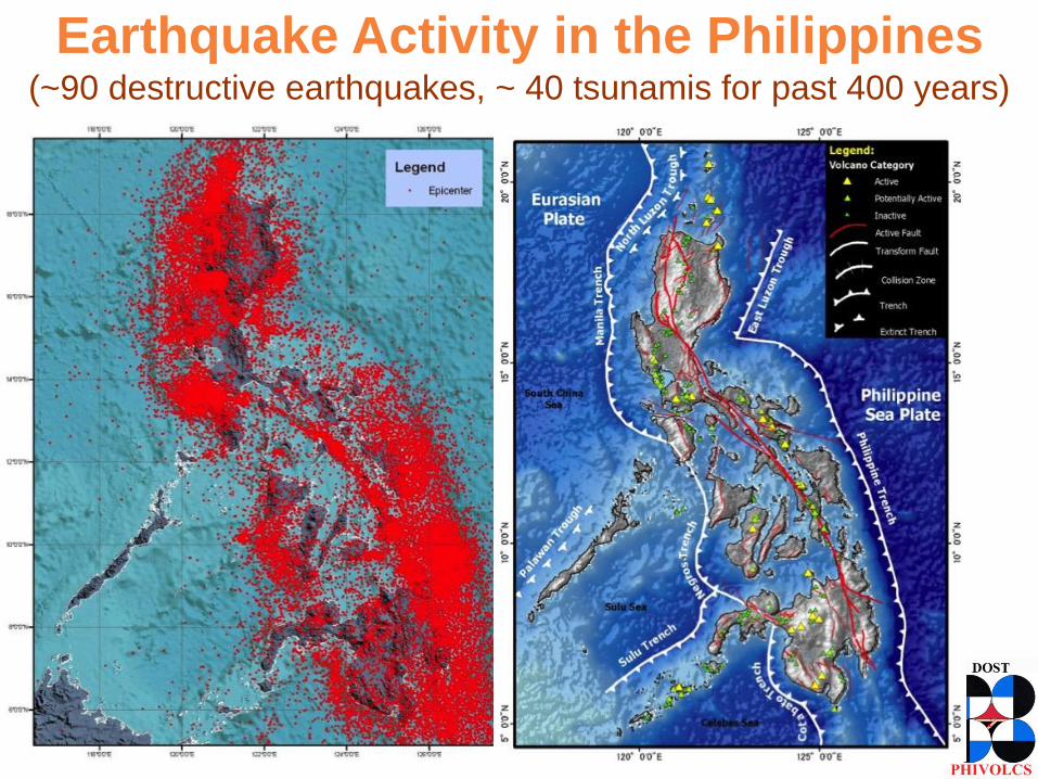
(~90 destructive earthquakes, ~ 40 tsunamis for past 400 years)
Earthquake Activity in the Philippines
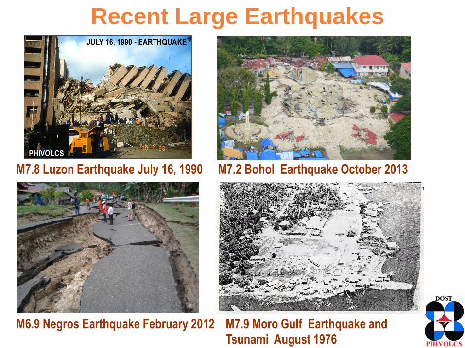
Recent Large Earthquakes
M7.8 Luzon Earthquake July 16, 1990 M7.2 Bohol Earthquake October 2013
M6.9 Negros Earthquake February 2012 M7.9 Moro Gulf Earthquake and
Tsunami August 1976

FEBRUARY 10, 2017 M6.7 SURIGAO DEL
NORTE EARTHQUAKE

Disaster Losses
• Life loss or Injury
• Damage to buildings, infrastructures, properties,
equipment
• Loss of lifelines – water, energy/electricity,
communication, transport systems (roads,
bridges, rail, seaport, airport)
• Damage to or interruption of food supply
• Loss of public and other critical services
• Loss of business or revenues from business
interruption
• Disruption of economic development
The Goal
• Reduce losses and ensure effective and
efficient performance of critical processes
and delivery of core services with minimal
and acceptable disruption

• Know Hazards and Risks
<- Hazard and Risk Assessment
Influenced by natural and built-environment
• Monitor
<- Monitoring
• Warn and Disseminate Information
<- Communication
• Respond Properly and Timely
<- Mitigation, Preparedness, Response, Recovery
KEY ACTIONS FOR DISASTER
RISK REDUCTION

Photo: Richel Umel /
Reuters
Orchid Subdivision, Iligan City affected
by TC Sendong flood in 2011
Cateel, Davao Oriental affected by TC
Pablo strong winds in 2012
LocationDesign and Construction
Poor Land Use and Building Code Implementation
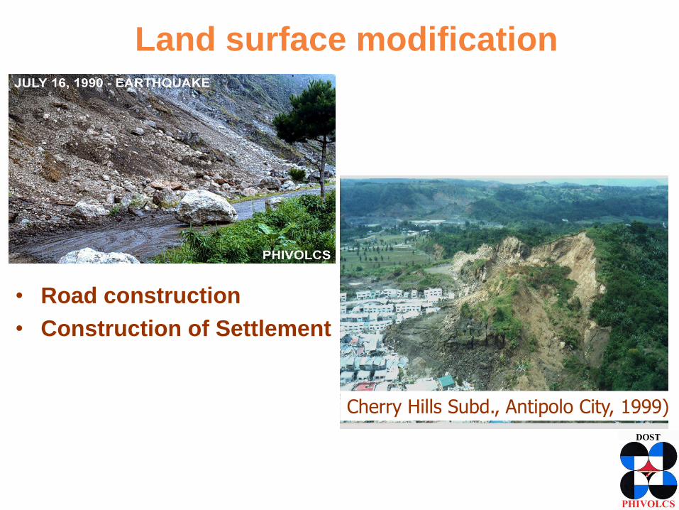
Land surface modification
• Road construction
• Construction of Settlement
Cherry Hills Subd., Antipolo City, 1999)
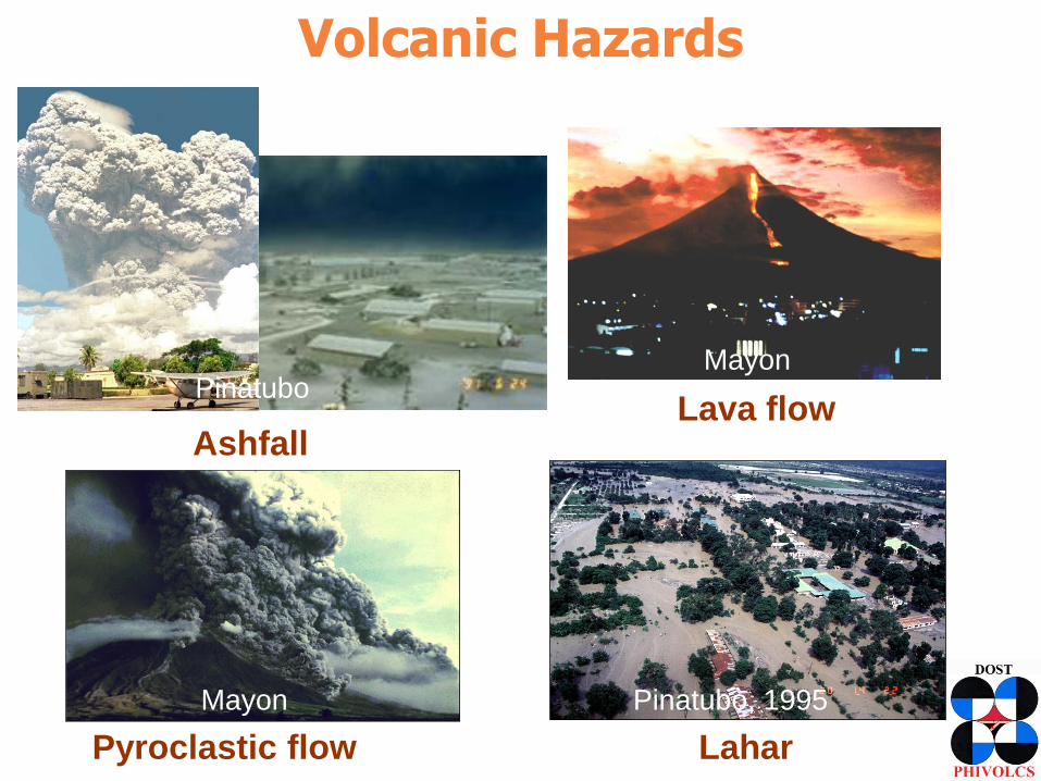
Volcanic Hazards
Pinatubo, 1995
PinatuboMayon
Mayon
•Lahar
Ashfall•Lava flow
•Pyroclastic flow
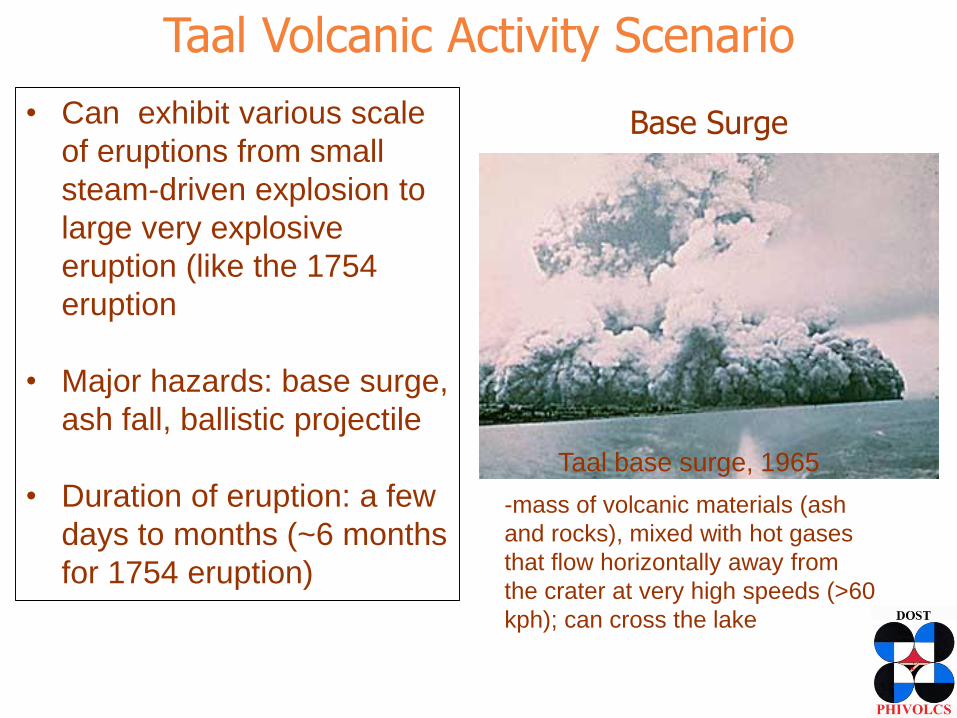
Taal Volcanic Activity Scenario
• Can exhibit various scale
of eruptions from small
steam-driven explosion to
large very explosive
eruption (like the 1754
eruption
• Major hazards: base surge,
ash fall, ballistic projectile
• Duration of eruption: a few
days to months (~6 months
for 1754 eruption)
Taal base surge, 1965
Base Surge
-mass of volcanic materials (ash
and rocks), mixed with hot gases
that flow horizontally away from
the crater at very high speeds (>60
kph); can cross the lake
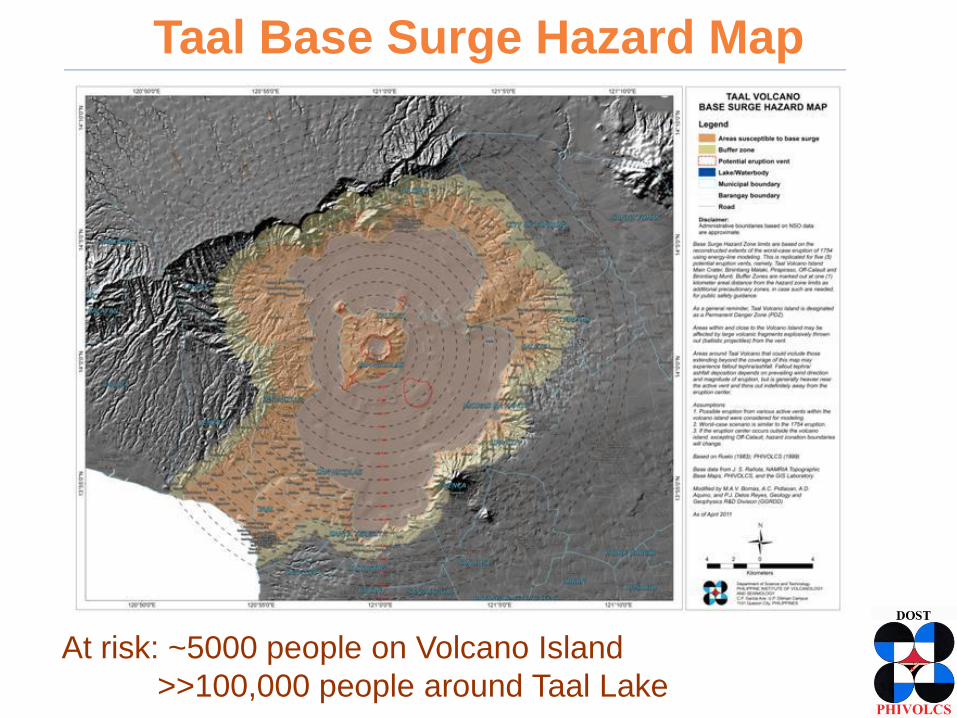
Taal Base Surge Hazard Map
At risk: ~5000 people on Volcano Island
>>100,000 people around Taal Lake

Earthquake Hazards
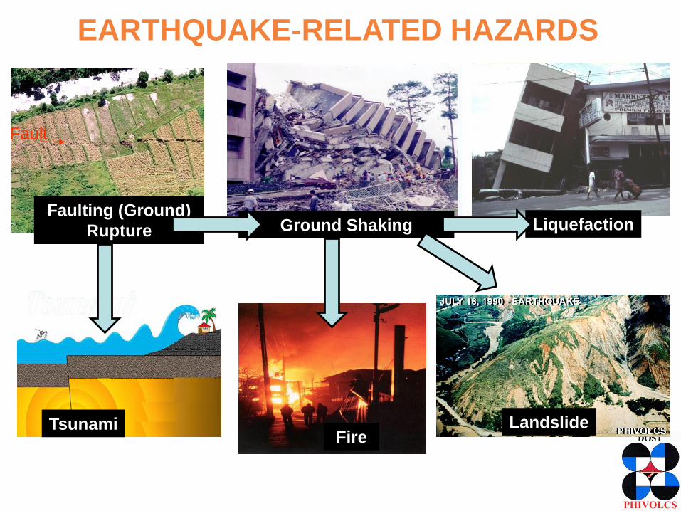
TsunamiFire
Ground Shaking Liquefaction
Landslide
Faulting (Ground)
Rupture
Fault
EARTHQUAKE-RELATED HAZARDS

Strike Slip
Normal
Thrust or Reverse
• fractures where rock
movement has taken
place and
earthquakes have
been produced
• active faults are
those that moved in
the last 10,000 years
FAULTS

GROUND RUPTURE
• No construction on
top of an active fault
• House or building
should be at least 5
meters away from
the trace of the fault
2008 M 7.9 Sichuan, China
1994 M 7.1 Mindoro

PHIVOLCS FaultFinder
Hazard and risk information through web applications
• The PHIVOLCS FaultFinder, is a web-based online application to locate the
nearest active fault from a specified location or the named barangay. This
application facilitates easy access to quality data for disaster preparedness, land
use, risk assessment and in real-estate.
URL: http://faultfinder.phivolcs.dost.gov.ph
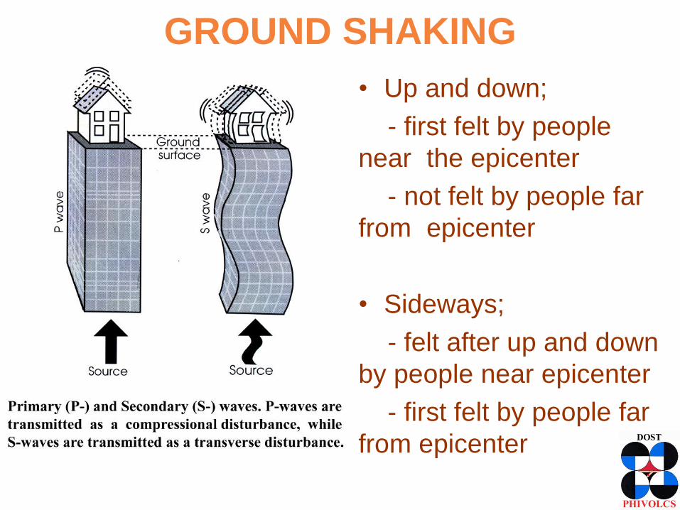
GROUND SHAKING
• Up and down;
- first felt by people
near the epicenter
- not felt by people far
from epicenter
• Sideways;
- felt after up and down
by people near epicenter
- first felt by people far
from epicenter

GROUND SHAKING EFFECTS
Building Collapse Falling Objects

Scenario: Magnitude 7.2 Along West Valley FaultNUEVA ECIJA
ZA
MB
AL
ES
NCR
BULACAN
RIZAL
CAVITE
LAGUNA
BATANGAS
PAMPANGA
TARLAC
BATAAN
Ground Shaking Intensity
1995 Kobe Earthquake

Building Damage & Casualty EstimatesFOR METRO MANILA FROM A M7.2 WEST VALLEY FAULT EARTHQUAKE
Residential Building (1,325,896)
Damage Heavy -168,300 (12.7%) Partly - 339,800 (25.6%)
Public Buildings
Damage Heavy - 8-10% Partly - 20-25%
10-30 Storey Building
Damage Heavy - 11% Partly - 27%
30-60 Storey
Damage Heavy - 2% Partly - 12%
Population (9,932,560)
Casualty Dead 33,500 (0.3%)
Injured 113,600 (1.1%)
Additional Deaths by Fire 18,000
Metro Manila Earthquake Impact Reduction Study, 2004 – JICA, PHIVOLCS, MMDA
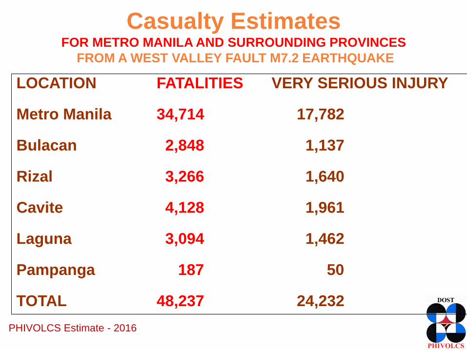
Casualty EstimatesFOR METRO MANILA AND SURROUNDING PROVINCES
FROM A WEST VALLEY FAULT M7.2 EARTHQUAKE
PHIVOLCS Estimate - 2016
LOCATION FATALITIES VERY SERIOUS INJURY
Metro Manila 34,714 17,782
Bulacan 2,848 1,137
Rizal 3,266 1,640
Cavite 4,128 1,961
Laguna 3,094 1,462
Pampanga 187 50
TOTAL 48,237 24,232

CEBU FAULT SYSTEM
(CFS):
Central Cebu Fault
Magnitude 7.0
earthquake
PEIS VIII Cebu City
and Central Cebu

• Loose, water-rich
sediments behave like
liquid during strong
ground shaking.
• Sediments are
rearranged into a
more compact state.
LIQUEFACTION
Subsidence of building, roads
Dagupan 1990
Fissuring of roads
Mindoro 1994

(READY for GMMA
Project, 2013)
Liquefaction PotentialM7.2 West Valley Fault Earthquake
• Areas underlain
by loose and
water-saturated
sediments prone
to liquefaction.
High
Moderate
LEGEND

LANDSLIDE• Down slope movement of rocks, soil and other debris commonly
triggered by heavy rain and strong earthquakes
Effects:
• erosion
• burial
• blockageRoad, Luzon, Philippines1990
Luzon, Philippines1990 Highway, Kumamoto Japan 2016
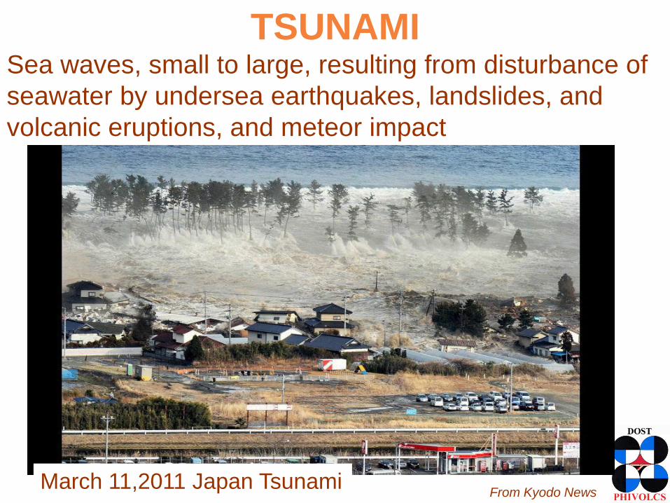
Sea waves, small to large, resulting from disturbance of
seawater by undersea earthquakes, landslides, and
volcanic eruptions, and meteor impact
March 11,2011 Japan TsunamiFrom Kyodo News
TSUNAMI
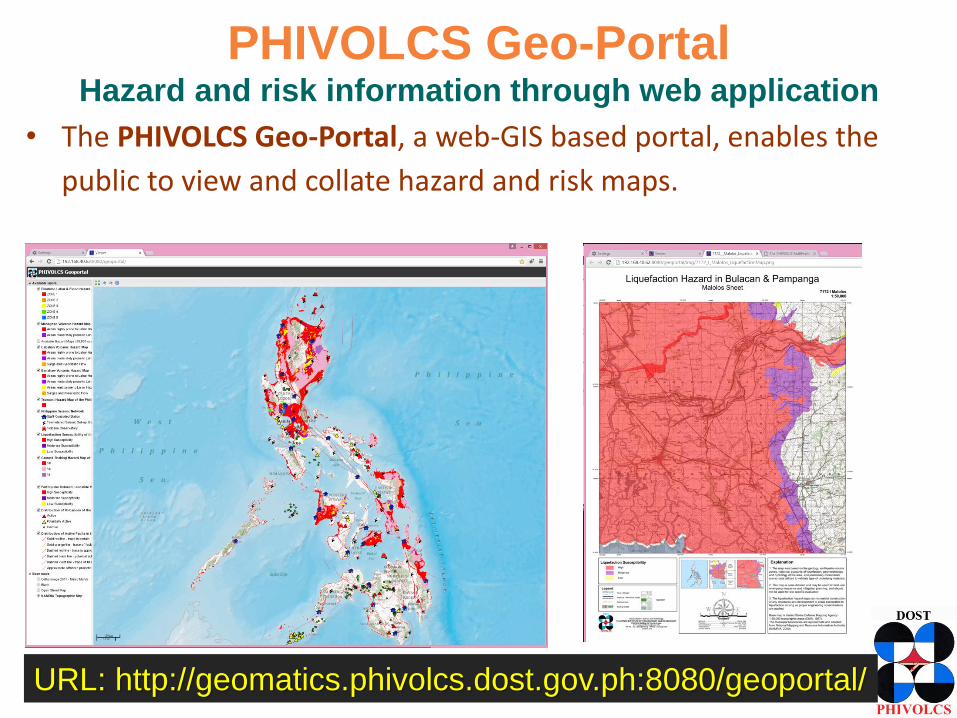
PHIVOLCS Geo-PortalHazard and risk information through web application
• The PHIVOLCS Geo-Portal, a web-GIS based portal, enables the
public to view and collate hazard and risk maps.
URL: http://geomatics.phivolcs.dost.gov.ph:8080/geoportal/

SUMMARY• The Philippines is exposed to various natural hazards
that can cause loss of lives, properties, and severely
impact the economy.
• Real estate sector plays an important role in disaster
risk reduction.
• Critical to the safety of houses and buildings would
be their location (hazards) and construction
(resistance to the effects of hazards).
• The hazards and potential impacts can be
exacerbated by man’s modification of the natural
environment or the design and integrity of man’s built
environment.

/PHIVOLCS
@phivolcs_dost
www.phivolcs.dost.gov.ph
Earthquake & Tsunami (24/7):
Tel. Numbers
+632 929-9254
+632 426-1468 loc 124 / 125
Fax number
+632 927-1087
Volcano (24/7):
Tel. Numbers
+632 426-1468 loc 127
Telefax number
+632 927-1095
IEC materials:
+632 426-1468 loc 128
+632 927-4524
PHIVOLCS CONTACT

![Nature’s blessing or nature’s curse [EBRD - Working papers]€¦ · Nature’s blessing or nature’s curse: the political economy of transition in resource-based economies Akram](https://img.pdfslide.us/doc/110x75/5b14edd87f8b9a467c8ccd5d/natures-blessing-or-natures-curse-ebrd-working-papers-natures-blessing.jpg)