Embed Size (px)
Citation preview
NATIONAL UNIVERSITY OF LIFE AND ENVIRONMENTAL SCIENCES OF UKRAINE
Department of geoinformation system and technologies
«APPROVED»
Dean of faculty
_____________ Т.О. Ievsiukov
«___» _____________ 2015 year.
APPROVED by department of
geoinformation system and technologies
_________________________________
Protocol № 12 «19» may 2015 year.
Head of department of geoinformation
system and technologies
____________________ S.S. Kokhan
SYLLABUS
GEOINFORMATION SYSTEMS AND DATABASES
direction 6.080101 «Geodesy, Cartography and Land Management»
specialty
specialization
faculty of Land management
authors accos. prof. Drozdivskyi O.P.
assistant Moskalenko A.A.
Kyiv – 2015 year
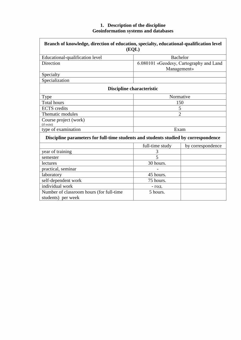
1. Description of the discipline
Geoinformation systems and databases
Branch of knowledge, direction of education, specialty, educational-qualification level
(EQL)
Educational-qualification level Bachelor
Direction 6.080101 «Geodesy, Cartography and Land
Management»
Specialty
Specialization
Discipline characteristic
Type Normative
Total hours 150
ECTS credits 5
Thematic modules 2
Course project (work) (if exist)
type of examination Exam
Discipline parameters for full-time students and students studied by correspondence
full-time study by correspondence
year of training 3
semester 5
lectures 30 hours.
practical, seminar -
laboratory 45 hours.
self-dependent work 75 hours.
individual work - год.
Number of classroom hours (for full-time
students) per week
5 hours.
2. Purpose and tasks of the discipline
Geoinformation systems and databases
Aim of the discipline: The course "GIS and Database" provides the opportunity to use in
program-technical complex for automated recording, storing, displaying, analyzing, modeling of
spatially coordinated information and creating databases.
Tasks of discipline is forming as the specialist and subsequent practical use of
technologies of GIS and databases is the task of study of discipline, in particular, geodatabase
knowledge and practical skills of work on a computer in MS Access environment, and basic
receptions of development and work, with the databases in MS Access.
Students after study of the course should know:
basics of the geoinformation systems;
basic concepts and determination of database theory;
database System Concepts and Architecture;
stages of database design;
relational Algebra and Relational Calculus;
SQL-Schema Definition, Constraints, and Queries;
functional Dependencies and Normalization for Relational Databases.
Students after study of the course should be able:
creating vector topological model;
editing vector topological model;
creating relational databases and work with it;
creating conceptual and logical data models;
realizing physical data model;
development of database structure in MS Access;
development of forms and queries in MS Access and data entering to base;
use GIS and databases for land management;
combining database and vector topological model.
3. Program and structure of the discipline:
Geoinformation systems and databases
full-time study :
SEMANTIC MODULE I.
BASICS OF GEOINFORMATION SYSTEMS AND TECNOLOGIES
Theme 1. Introduction to Geoinformation systems and tecnologies.
The use of information systems in the land management. General concepts of
geoinformatics, geoinformation systems and technologies: geographical objectives, elements and
domains of geographic information. Definitions, components, functions and classification of the
geographic information systems (GIS). Examples of use and current trends of GIS in various
fields. Modern approaches to modeling environment (cartography, remote sensing, GIS). The
aim and purpose of the discipline.
Theme 2. Database technology use in GIS.
Fundamentals of structuring information. General classification data models in GIS and
database (DB). Limitations of classical models of data storage and processing geospatial data.
Theme 3. Sources of GIS data and technology.
The task of collecting and entering data. Sources of spatial data. Sources of atributive
data.
Theme 4. Model of spatial data. Mosaic models.
Principles of modeling surfaces. Structures modeling the earth's surface. Raster model.
Methods of compression grid structures. Hexagonal model. TIN-model. Problems using grid
structures. Hierarchical data model mosaic.
Theme 5. Model of spatial data: vector and object data models.
The basic definition of vector models. Vector non-topological and topological models.
Advantages and disadvantages vector models. Vector data - methods of saving.
Theme 6. Basic principles of control data relevance and accuracy.
Total classification of geospatial data change. Basics requirements for creating and
updating data. Geospatial data update rules.
SEMANTIC MODULE II.
MODERN TECHNOLOGY OF DATABASES
Theme 7. Basic concepts and determination of database theory.
Determination of databases. Classification of databases. Database management systems
(DBMS), their possibilities, description and use. Models of data. Possibilities and application of
geodatabase in land management. Database system architecture. Review maker of DBMS
products.
Theme 8. Storage and processing of large data extend.
Basic determination big database and large-scale data. Factors that define big database.
Centralized and client/server architecture for DBMS. Determination of distributed database and
distributed database management systems. Distributed and parallel data processing. Advantages
and disadvantages distributed DBMS. Multitasked systems.
Theme 9. Relational model: basic concepts and determination.
Main relational database concepts. Domains, relationship, cortege, attribute. Types of
relationship that used in relational databases. Theory of relational model. Relational DB schema.
Structure of relational database. Mathematical relations. Properties of relations. Relation keys.
Theme 10. Modern methodology of database design.
Total review methodology of database design. Software for database design. Basic stages
of planning of database. Conceptual design of base, basic stages and operations. Logical
planning of base, basic stages and operations. Physical planning of database, basic stages and
operations.
Theme 11. Normalization as way to control of database structure.
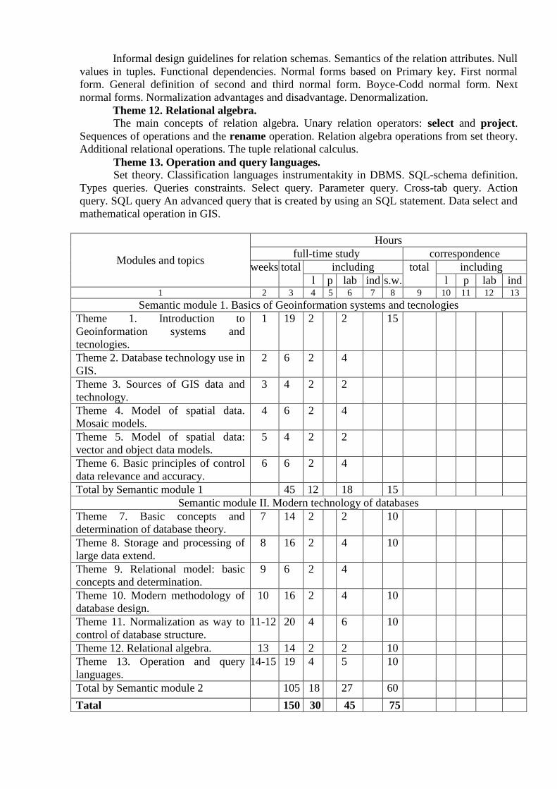
Informal design guidelines for relation schemas. Semantics of the relation attributes. Null
values in tuples. Functional dependencies. Normal forms based on Primary key. First normal
form. General definition of second and third normal form. Boyce-Codd normal form. Next
normal forms. Normalization advantages and disadvantage. Denormalization.
Theme 12. Relational algebra.
The main concepts of relation algebra. Unary relation operators: select and project.
Sequences of operations and the rename operation. Relation algebra operations from set theory.
Additional relational operations. The tuple relational calculus.
Theme 13. Operation and query languages.
Set theory. Classification languages instrumentakity in DBMS. SQL-schema definition.
Types queries. Queries constraints. Select query. Parameter query. Cross-tab query. Action
query. SQL query An advanced query that is created by using an SQL statement. Data select and
mathematical operation in GIS.
Modules and topics
Hours
full-time study correspondence
weeks total including total including
l p lab ind s.w. l p lab ind 1 2 3 4 5 6 7 8 9 10 11 12 13
Semantic module 1. Basics of Geoinformation systems and tecnologies
Theme 1. Introduction to
Geoinformation systems and
tecnologies.
1 19 2 2 15
Theme 2. Database technology use in
GIS.
2 6 2 4
Theme 3. Sources of GIS data and
technology.
3 4 2 2
Theme 4. Model of spatial data.
Mosaic models.
4 6 2 4
Theme 5. Model of spatial data:
vector and object data models.
5 4 2 2
Theme 6. Basic principles of control
data relevance and accuracy.
6 6 2 4
Total by Semantic module 1 45 12 18 15
Semantic module II. Modern technology of databases
Theme 7. Basic concepts and
determination of database theory.
7 14 2 2 10
Theme 8. Storage and processing of
large data extend.
8 16 2 4 10
Theme 9. Relational model: basic
concepts and determination.
9 6 2 4
Theme 10. Modern methodology of
database design.
10 16 2 4 10
Theme 11. Normalization as way to
control of database structure.
11-12 20 4 6 10
Theme 12. Relational algebra. 13 14 2 2 10
Theme 13. Operation and query
languages.
14-15 19 4 5 10
Total by Semantic module 2 105 18 27 60
Tatal 150 30 45 75
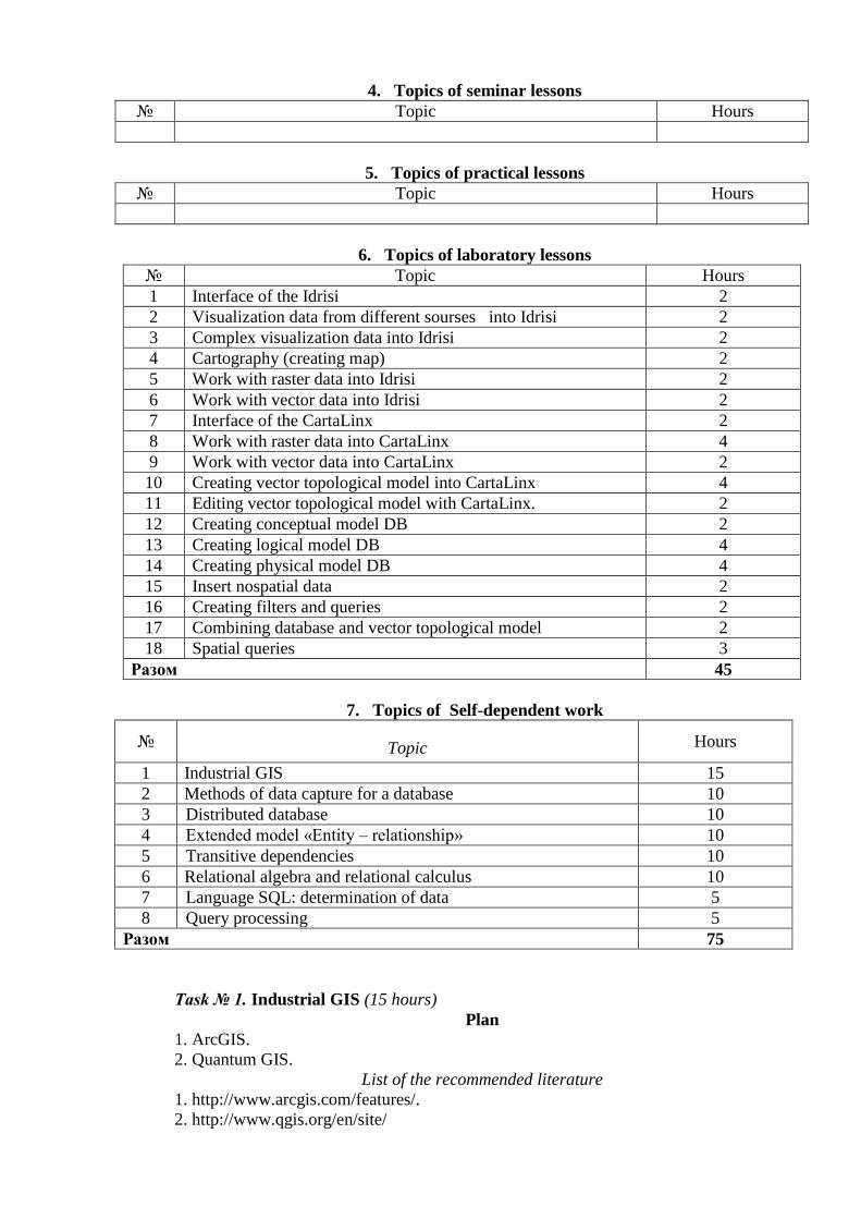
4. Topics of seminar lessons
№ Topic Hours
5. Topics of practical lessons
№ Topic Hours
6. Topics of laboratory lessons
№ Topic Hours
1 Interface of the Idrisi 2
2 Visualization data from different sourses into Idrisi 2
3 Complex visualization data into Idrisi 2
4 Cartography (creating map) 2
5 Work with raster data into Idrisi 2
6 Work with vector data into Idrisi 2
7 Interface of the CartaLinx 2
8 Work with raster data into CartaLinx 4
9 Work with vector data into CartaLinx 2
10 Creating vector topological model into CartaLinx 4
11 Editing vector topological model with CartaLinx. 2
12 Creating conceptual model DB 2
13 Creating logical model DB 4
14 Creating physical model DB 4
15 Insert nospatial data 2
16 Creating filters and queries 2
17 Combining database and vector topological model 2
18 Spatial queries 3
Разом 45
7. Topics of Self-dependent work
№ Topic Hours
1 Industrial GIS 15
2 Methods of data capture for a database 10
3 Distributed database 10
4 Extended model «Entity – relationship» 10
5 Transitive dependencies 10
6 Relational algebra and relational calculus 10
7 Language SQL: determination of data 5
8 Query processing 5
Разом 75
UNDER THE DIRECTION OF TEACHER
Task № 1. Industrial GIS (15 hours)
Plan
1. ArcGIS.
2. Quantum GIS.
List of the recommended literature
1. http://www.arcgis.com/features/.
2. http://www.qgis.org/en/site/
Task № 2. Methods of data capture for a database (10 hours)
Plan
1. Planning of database development.
2. Determination of system requirements.
3. Collection and analysis of user requirements.
4. Document study of customer.
5. Interviews and questionnaire.
6. Supervision at work of customer.
List of the recommended literature
1. Коннолли Т., Брег К. Базы данных. 3-е изд.: Пер. с англ. – М.: Изд. дом
«Вильямс», 2003. – 1440 с.
2. Fundamentals of Database Systems, 4/E Ramez Elmasri, University of Texas at
Arlington Shamkant B. Navathe, Georgia Institute of Technology, 2005
Task № 3. Distributed database (10 hours)
Plan
1. Basic idea distributed data bases and distributed data processing.
2. Functions of distributed DBMS.
3. Technologies and facilities of data scatter – basic concepts.
List of the recommended literature
1. Коннолли Т., Брег К. Базы данных. 3-е изд.: Пер. с англ. – М.: Изд. дом
«Вильямс», 2003. – 1440 с.
2. Глушков С.В., Ломотько Д.В. Базы даннях. – Харьков: Фолио, 2002. – 504 с.
3. Голицина О.Л., Максимов Н.В., Попов И.И. Базы данных. – М.: Форум, 2006. –
352 с.
4. Fundamentals of Database Systems, 4/E Ramez Elmasri, University of Texas at
Arlington Shamkant B. Navathe, Georgia Institute of Technology, 2005
Task № 4. Extended model «Entity – relationship» (10 hours)
Plan
1. Superclasses/subclass and inheritance of attributes.
2. Specification / generalization – basic concepts and processes.
3. Aggregation.
4. Composition.
List of the recommended literature
1. Коннолли Т., Брег К. Базы данных. 3-е изд.: Пер. с англ. – М.: Изд. дом
«Вильямс», 2003. – 1440 с.
Task № 5. Transitive dependencies (10 hours)
Plan
1. Functional dependency.
2. Transitive dependencies.
3. Normalization process.
List of the recommended literature
1. Коннолли Т., Брег К. Базы данных. 3-е изд.: Пер. с англ. – М.: Изд. дом
«Вильямс», 2003. – 1440 с.
2. Голицина О.Л., Максимов Н.В., Попов И.И. Базы данных. – М.: Форум, 2006. –
352 с.
3. Fundamentals of Database Systems, 4/E Ramez Elmasri, University of Texas at
Arlington Shamkant B. Navathe, Georgia Institute of Technology, 2005
Task № 6. Relational algebra and relational calculus (10 hours)
Plan
1. Unary operations – basic concepts and determination.
2. Operations with ensembles.
3. Operations of connection.
4. Operations of division.
5. Relational calculusof tuples.
6. Relational calculusof domains.
List of the recommended literature
1. Коннолли Т., Брег К. Базы данных. 3-е изд.: Пер. с англ. – М.: Изд. дом
«Вильямс», 2003. – 1440 с.
2. Глушков С.В., Ломотько Д.В. Базы даннях. – Харьков: Фолио, 2002. – 504 с.
Task № 7. Language SQL: determination of data (9 hours)
Plan
1. Data types of SQL.
2. Supporter of data integrity.
3. Data-bases design in SQL.
4. Work with tables in SQL.
5. Work with submissions in SQL.
6. Work with indexes in SQL.
7. Access control to data by SQL.
List of the recommended literature
1. Коннолли Т., Брег К. Базы данных. 3-е изд.: Пер. с англ. – М.: Изд. дом
«Вильямс», 2003. – 1440 с.
2. Глушков С.В., Ломотько Д.В. Базы даннях. – Харьков: Фолио, 2002. – 504 с.
3. Голицина О.Л., Максимов Н.В., Попов И.И. Базы данных. – М.: Форум, 2006. –
352 с.
Task № 8. Query processing (10 hours)
Plan
1. Query processing in Spatial models.
2. Spatial Join and refinement steps.
List of the recommended literature
1. Geographic information systems / M. Van Meirvenne, Svitlana Kokhan, roman
Ananchenko, NAUU, 2003
2. Fundamentals of Database Systems, 4/E Ramez Elmasri, University of Texas at
Arlington Shamkant B. Navathe, Georgia Institute of Technology, 2005
8. Control Questions, Tests.
Control Questions:
1. What is GIS?
2. How to relate information using GIS?
3. Define the elements of a GIS.
4. What is Raster Method?
5. Define GIS and other information systems.
6. Define Data Representation and Projection in GIS.
7. What is a Database?
8. What is a Database Management System (DBMS)?
9. Define the classification of databases.
10. What is data models?
11. What is a Database System Concepts?
12. What is a Schema construct?
13. Define the Categories of Data Model.
14. What is Database languages and interfaces?
15. What is a Database design?
16. What is a Conceptual Database Design?
17. Define the Basic stages of planning of database.
18. What is Physical Database Design?
19. Define the Steps in Database Design.
20. What is a Relational model concepts?
21. What is a Constraints?
22. Define the Relational model constraints and relational DB schemas.
23. Discuss each of the following concepts in the context of the relational data model: (a)
relation; (b) attribute; (c) domain; d) tuple; (e) intension and extension; (f) degree and
cardinality.
24. Describe the relationship between mathematical relations and relations in the
relational data model.
25. Describe the differences between a relation and a relation schema. What is a
relational database schema?
26. Discuss the properties of a relation.
27. Discuss the differences between the candidate keys and the primary key of a relation.
Explain what is meant by a foreign key. How do foreign keys of relations relate to candidate
keys? Give examples to illustrate your answer.
28. What is data model? What is attribute?
29. What are structural constraints?
30. What kind of information does the cardinality ratio give us?
31. In how many different ways can two entities be involved in a cardinality
relationship? Give examples.
32. What kind of information does the participation constraint give us?
33. Is it always necessary to have cardinality ratios as well as participation constraints in
the same ER diagram? Why? Explain.
34. Define the five basic relational algebra operations. Define the Join, Intersection, and
Division operations in terms of these five basic operations.
35. Discuss the differences between the five Join operations: Theta join, Equijoin,
Natural join, Outer join, and Semijoin. Give examples to illustrate your answer.
36. Compare and contrast the tuple relational calculus with domain relational calculus. In
particular, discuss the distinction between tuple and domain variables.
37. What is the difference between a procedural and a non-procedural language? How
would you classify the relational algebra and relational calculus?
38. What are the advantages and disadvantages of SQL?
39. Explain the function of each of the clauses in the SELECT statement. What
restrictions are imposed on these clauses?
40. What restrictions apply to the use of the aggregate functions within the SELECT
statement? How do nulls affect the aggregate functions?
41. Explain how the GROUP BY clause works.
42. What is functional dependency?
43. What does the term unnormalized relation refer to?
44. How did the normal forms develop historically from first normal form up to Boyce-
Codd normal form?
45. Define first normal form.
46. Define second normal form.
47. Define third normal form.
48. Define Boyce-Codd normal form.
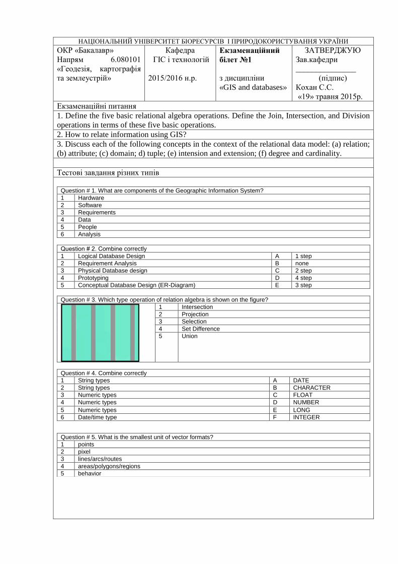
НАЦІОНАЛЬНИЙ УНІВЕРСИТЕТ БІОРЕСУРСІВ І ПРИРОДОКОРИСТУВАННЯ УКРАЇНИ
ОКР «Бакалавр»
Напрям 6.080101
«Геодезія, картографія
та землеустрій»
Кафедра
ГІС і технологій
2015/2016 н.р.
Екзаменаційний
білет №1
з дисципліни
«GIS and databases»
ЗАТВЕРДЖУЮ
Зав.кафедри
_______________
(підпис)
Кохан С.С.
«19» травня 2015р.
Екзаменаційні питання
1. Define the five basic relational algebra operations. Define the Join, Intersection, and Division
operations in terms of these five basic operations.
2. How to relate information using GIS?
3. Discuss each of the following concepts in the context of the relational data model: (a) relation;
(b) attribute; (c) domain; d) tuple; (e) intension and extension; (f) degree and cardinality.
Тестові завдання різних типів
Question # 1. What are components of the Geographic Information System?
1 Hardware
2 Software
3 Requirements
4 Data
5 People
6 Analysis
Question # 2. Сombine correctly
1 Logical Database Design A 1 step
2 Requirement Analysis B none
3 Physical Database design C 2 step
4 Prototyping D 4 step
5 Conceptual Database Design (ER-Diagram) E 3 step
Question # 3. Which type operation of relation algebra is shown on the figure?
1 Intersection
2 Projection
3 Selection
4 Set Difference
5 Union
Question # 4. Combine correctly
1 String types A DATE
2 String types B CHARACTER
3 Numeric types C FLOAT
4 Numeric types D NUMBER
5 Numeric types E LONG
6 Date/time type F INTEGER
Question # 5. What is the smallest unit of vector formats?
1 points
2 pixel
3 lines/arcs/routes
4 areas/polygons/regions
5 behavior
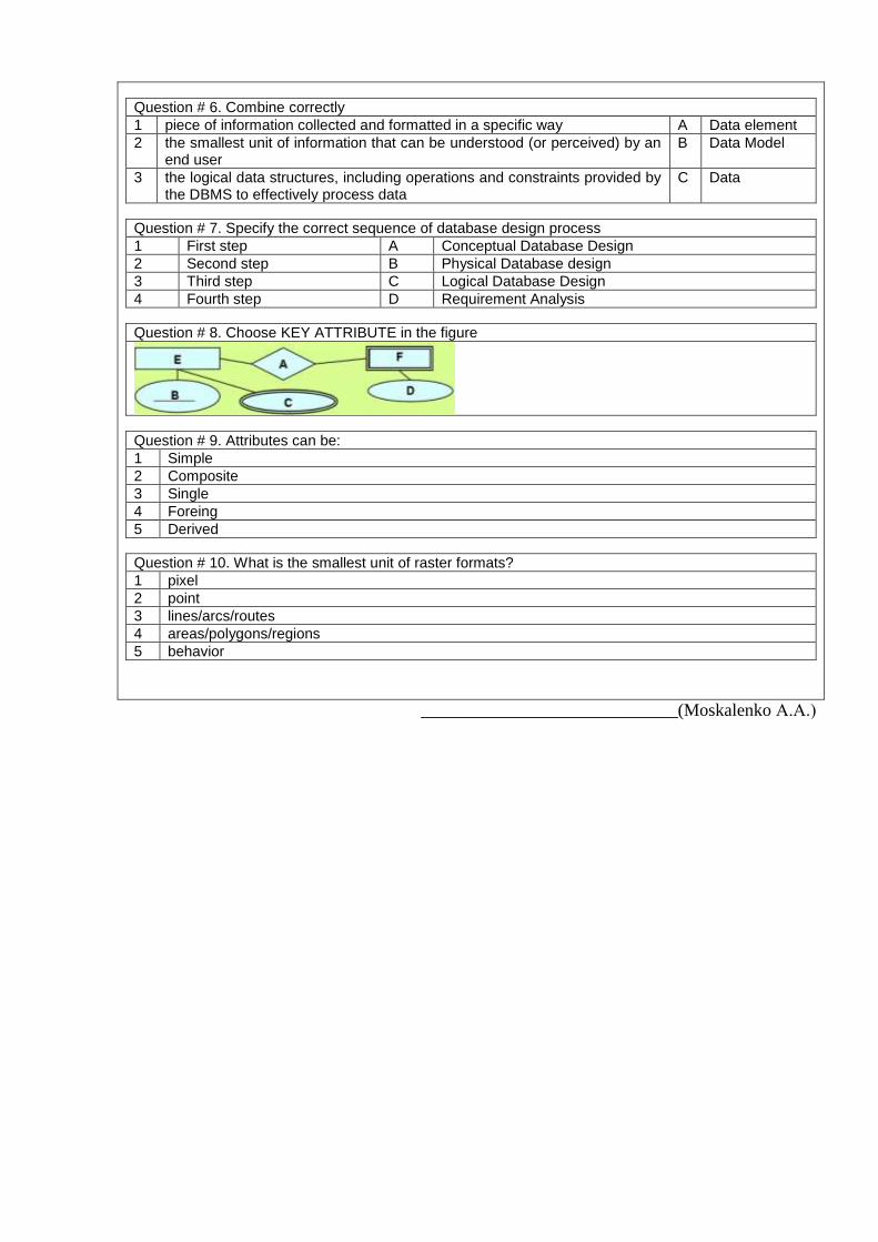
Question # 6. Combine correctly
1 piece of information collected and formatted in a specific way A Data element
2 the smallest unit of information that can be understood (or perceived) by an end user
B Data Model
3 the logical data structures, including operations and constraints provided by the DBMS to effectively process data
C Data
Question # 7. Specify the correct sequence of database design process
1 First step A Conceptual Database Design
2 Second step B Physical Database design
3 Third step C Logical Database Design
4 Fourth step D Requirement Analysis
Question # 8. Choose KEY ATTRIBUTE in the figure
Question # 9. Attributes can be:
1 Simple
2 Composite
3 Single
4 Foreing
5 Derived
Question # 10. What is the smallest unit of raster formats?
1 pixel
2 point
3 lines/arcs/routes
4 areas/polygons/regions
5 behavior
_____________________________(Moskalenko А.А.)

9. Methods of teaching
In conducting lectures appropriate to use verbal teaching methods: explanation, narration,
discussion, educational debate, with a combination of visual learning methods: illustration,
showing.
In carrying out laboratory work should be used such as verbal learning method of
instruction on the combination of visual learning methods of illustration and demonstration, the
aspect of these studies is that they facilitate communication theory and practice, providing
students acquiring skills using standard and specialized software, application of information
technology to cadastral and form students' initial skills of research activities. Laboratory work in
the laboratory are equipped computers.
10. Forms of control
The main methods of control of knowledge and skills students have to study the subject "
Geoinformation systems and databases" are: oral examination, written and practical test,
standardized control in the form of modular test papers, assessment for individual learning task,
the final test.
The total value of these methods is to make the best possible to ensure timely and
comprehensive feedback between students and teachers, by which establishes how students
perceive and learn the material.
The purpose determines the choice of control methods, it should be borne in mind that
these methods can be applied in all kinds of control - only complete applications allows regularly
and objectively identify the dynamics of the formation of knowledge and skills of students. Each
control method has its advantages and disadvantages, scope of application, none of them can not
be the only one able to diagnose all aspects of the learning process. So:
- to control the absorption of lectures: oral questioning, written modular test papers,
current testing score for an individual learning task, the final test.
- for the monitoring and evaluation of laboratory work: practical test and evaluation of
each laboratory work..
11. Distribution of grades received by students during study
Student's evaluation takes place according to "Про екзамени та заліки НУБіП України"
dated 02/20/2015. The protocol №6 of Table 1.
The national grade ECTS
grade Definition of ECTS grade
Total points
for all the
educational
activities
EXCELENT А EXCELLENT – excellent performance
with few errors 90-100
GOOD
B VERY GOOD – above average with some
mistakes 82-89
C GOOD – generaly correct work with a
number of blunders 74-81
SATISFACTORILY
D SATISFACTORY – not bad but many
drawbacks 64-73
E ENOUGH – performance meets the
minimum criteria 60-63
UNSATISFACTORILY FX
UNSATISFACTORY – must work before
get credit (positive evaluation) 35-59
F POOR – thorough and elaborate 1-34
Student’s rating of course mastering Rcourse it is determined in points and made 100
points. Course ratings calculate as: RCOURSE=REDU+ RFinal Test (Course ratings = Education work
rating + Final Test Rating)
70% (70 points) of the RCOURSE is the REDU
30% (30 points) of the RCOURSE is the RFinal Test.
RCOURSE equal 100 points (100 %).
Ratings of education work consist of attending a lecture, mastering of theoretical
material, executing and passing laboratory works, and control theoretical knowledge.
REDU=RLect+RLab+RSelf+RContr.
Evaluation criteria for an attending of a lecture RLect
Student will have a maximal grade for an attending a lecture, if he/she presents on a
lecture, participates actively in the discussion of theme of lecture, answer а lecturer question,
gives examples, assiduously conducts the compendium of lecture.
Student will have a minimum (sufficient) grade (0,6 to maximal) for a lecture, if he/she
is late for the lecture less than 5 minutes, inattentive (but keeps discipline), passive in discussion
of theme, doesn’t give examples, but can formulate basic concepts of a lecture. Student will have
a 0,6 grade, if he/she didn’t appear on a lecture with reasonable excuse, but has conducts the
compendium of lecture and can formulate the basic concepts of lecture.
Student will have grade from 0 to minimum, if he/she is late for the lecture more than 5
minutes, can‘t define the basic concepts of lecture, but has the compendium of lecture,
inattentive (but keeps discipline).
If student skipped lecture with reasonable excuse and doesn’t have the compendium of
lecture, student will have grade equal 0.
If student skipped lecture without reasonable excuse, disturbs discipline, doesn’t have the
compendium of lecture, student will have penalty grade.
Evaluation criteria for the mastering control of theoretical materials RContr.
The written work has a maximal grade, if it has written answer to the
questions contained in the examination card. Answer should be in the compressed
form, logically and consistently, contains a definitions, basic descriptions,
principles and receptions of implementation, charts, examples, the indicated
application domain in speciality area, etc. The written work has a minimal grade (0,6 to maximal), if it has main definition and
descriptions, indicates principles and receptions of implementation, gives some examples, etc
and gives written answer (even inexact) to all questions contained in the examination card.
Rating for laboratory work RLAB
Student will have a maximal grade for fulfillment of a laboratory work, if he/she
presents on a lesson, participates actively in implementation of laboratory work, executes the
task fully and gets the expected result, can explain a logical sequence and phased of actions,
answers a control questions of teacher.
Student will have a minimum (sufficient) grade (0,6 to maximal) for a laboratory work,
if he/she is late for the lesson less than 5 minutes, inattentive (but keeps discipline), executes the
task fully, but with some teacher help, and gets the expected result, gives insufficient answer a
control questions of teacher.
Student will have grade from 0 to minimum, if he/she executes the task partly, (but
executes the task more than 75%), or doesn’t get the expected result, gives inexact answer.
If student skipped laboratory work with reasonable excuse, student has to rework this
lesson in other time. Student should arrange time with a teacher, because task uses license
software.
If student skipped laboratory work without reasonable excuse or didn’t finish task in the
set time, student gets a penalty.
Rating for self-work RSelf

Student will have a maximal grade for defence of a self-work, if he/she clear define a
theoretical grounds of the topic, gives examples, can account for the sequence of actions
implementation, can apply theoretical knowledges in practice.
Student will have a minimum (sufficient) grade (0,5 to maximal) defence of a self-
work, if he/she gives insufficient answer, doesn’t give examples or gives one with complication.
Student will have grade from 0 to minimum for defence of a self-work, if he/she gives
inexact answer, doesn’t give main definitions.
Rating of additional work Radd and rating of penalty Rpenalty has an influence on rating of
educational work.
Maximal rating of additional work makes 10% from rating of course (that is 10 points).
It’s determined by a lecturer. Rating of additional work given to student after department
decision for implementation of work, that don’t foreseen by a working curricula of the course,
but increase student’s level of skill.
5% (4 points) of the rating of education work is rating of penalty. Rating of penalty has
negative quantity and it decreases rating of education work. Rating of penalty was determined by
a lecturer. It’s entered department decision for a student, who was mastering material of the
module too late, wasn’t following the executive schedule and had omitted lesson from time to
time, etc.
Students have to have more than 60 % points from rating of educational work for
admitting to final test. It’s meaning, that student should to do next minimal list of work:
to execute all laboratory works;
to don’t get punitive measure of lecturer.
Rating evaluation of the final test is proposed as a test tasks.
Rating evaluations system of educational work for the substance modules
Type of work
Module Course
point by
work
percent by total
percent by
modules total
work module
Module
# 1
Lecture 100 5 %
70 % 100 21 %
100
Laboratory work #1 100 6 % Laboratory work #2 100 6 % Laboratory work #3 100 6 % Laboratory work #4 100 8 % Laboratory work #5 100 6 % Laboratory work #6 100 6 % Laboratory work #7 100 6 % Laboratory work #8 100 6 % Self-work 100 15 %
Module test / control 100 30 % 30 %
Module
# 2
Lecture 100 5 %
70 % 100 49 %
Laboratory work #9 100 5 %
Laboratory work #10 100 5 % Laboratory work #11 100 5 % Laboratory work #12 100 5 % Laboratory work #13 100 5 % Laboratory work #14 100 5 % Laboratory work #15 100 5 % Laboratory work #16 100 5 % Laboratory work #17 100 5 % Laboratory work #18 100 5 %
Self-work 100 15 %
Module test / control 100 30 % 30 %
Final test 100 30 %
12. Textbooks
1. Кохан С.С., Москаленко А.А., Іванюта О.О. Geoinformation systems and databases
(a series of lectures) для студентів напряму підготовки «Геодезія, картографія та
землеустрій» - К.: ЦК «КОМПРИНТ»,2014. У.д.а = 5,9.
2. Кохан С.С., Москаленко А.А., Іванюта О.О. Geoinformation systems and databases
(methodological guideline for laboratory classes) для студентів напряму підготовки
«Геодезія, картографія та землеустрій» - К.: ЦК «КОМПРИНТ»,2014. У.д.а = 8,9.
13. Recommended literature Basic:
1. Коннолли Т., Брег К. Базы данных. 3-е изд.: Пер. с англ. – М.: Изд. дом
«Вильямс», 2003. – 1440 с.
2. Дейт К. Введение в системы баз данных. Пер. с англ. – М.: Наука, 1980. – 464 с.
3. Глушков С.В., Ломотько Д.В. Базы даннях. – Харьков: Фолио, 2002. – 504 с.
4. Глушаков С.В., Сурядный А.С. Microsoft Office 2000: Учеб. курс. – Харків:
Фолио, 2000. – 502 с.
5. Самойленко В.М. Основи геоінформаційних систем. – К.: Ніка-Центр, 2003. –
276 с.
6. Ekmasri, R. and Navatane, S.B. Fundamentals of Database Systems, 4th ed., Addison-
Wesly, Reading, Boston, MA, 2004
7. Geographic information systems / M. Van Meirvenne, Svitlana Kokhan, roman
Ananchenko, NAUU, 2003
8. Fundamentals of Database Systems, 4/E Ramez Elmasri, University of Texas at
Arlington Shamkant B. Navathe, Georgia Institute of Technology, 2005
Additional:
1. Голицина О.Л., Максимов Н.В., Попов И.И. Базы данных. – М.: Форум, 2006. –
352 с.
2. ДеМерс М. Географические информационные системы.: Пер. с англ. – М.: Дата+,
1999. – 490 с.
3. Інформатика та комп’ютерна техніка: Навч.-метод. посібник / За заг. ред. О.Д.
Шарапова. – К.: КНЕУ, 2002/
4. Sikha Bagui, Richard Earp. Database design using Entity-Relationship Diagrams, CRC
Press, RBoca Raton, Florida, 2000.4. ISO/TS 19104:2008 «Geographic information –
Terminology».
5. ISO 19107:2003 «Geographic information - Spatial schema».
6. ISO 19108:2002 «Geographic information - Temporal schema»
7. ISO 19110:2005 «Geographic information - Methodology for feature cataloguing»
8. ISO 19115 «Geographic information - Metadata»
14. Information resources:
1. http://2k8618.blogspot.com/2011/07/database-management-systems-dbms.html
2. http://www.scribd.com/doc/2166197/Relational-Algebra-and-Relational-Calculus
3. http://www.sybaseteam.com/dbms-concepts-by-navathe-and-elmasri-ppt-files-t-473.html
4. http://www.techopedia.com/definition/24559/relational-model-database