Embed Size (px)
Citation preview

National Protected Area Expansion Strategy Resource Document
2009
Department of Environmental Affairs
South African National Biodiversity Institute

Preface
This Resource Document accompanies South Africa’s National Protected Area Expansion
Strategy (NPAES) 2008, providing additional technical detail to support aspects of the
strategy. The Resource Document is not intended to be a standalone document and should
be read together with the strategy, which is available at www.environment.gov.za or
http://biodiversityadvisor.sanbi.org, or can be ordered from [email protected].
The Resource Document was developed with the assistance of specialist consultants
commissioned by the Department of Environmental Affairs (DEA) (previously the
Department of Environmental Affairs and Tourism (DEAT)), through the South African
National Biodiversity Institute, as part of the process of developing the NPAES. The process
was overseen by a task team of the Ministerial Technical Committee’s (MINTECH) Working
Group 1 (Biodiversity and Heritage), with input from national and provincial conservation
institutions and key national departments. A project team comprising SANBI, South African
National Parks and DEAT provided technical oversight to the consultants.
The NPAES was developed during 2007 and 2008, and approved in March 2009.
Note on department names
In July 2009, following general elections in April 2009, changes were made to the structure
and names of several government departments. Because the content of this document was
developed before those changes, references to national departments in much of the
document use names that applied prior to July 2009.
National Protected Area Expansion Strategy: Resource Document Page i 2009

Contents
List of Tables ............................................................................................................................ v
List of Figures ......................................................................................................................... vi
Acronyms ............................................................................................................................... vii
Key Definitions ........................................................................................................................ ix
1. Introduction ...................................................................................................................... 1
What is the NPAES? ........................................................................................................................... 1
Why a Resource Document? .............................................................................................................. 2
Definitions of protected areas and conservation areas ....................................................................... 3
Summary of protected area targets and focus areas .......................................................................... 4
Overview of the Resource Document ................................................................................................. 5
2. Policy and legal context ................................................................................................... 8
Policy context ...................................................................................................................................... 8
Convention on Biological Diversity ................................................................................................................. 8 White Paper on Biodiversity ........................................................................................................................... 9 Bioregional approach to South Africa’s protected areas ................................................................................. 9 National Spatial Biodiversity Assessment 2004 .............................................................................................. 9 National Biodiversity Strategy and Action Plan ............................................................................................. 10 National Biodiversity Framework .................................................................................................................. 11
Legal context ..................................................................................................................................... 11
National Environmental Management: Protected Areas Act (Act 57 of 2003) .............................................. 11 National Forests Act (Act 84 of 1998) ........................................................................................................... 14 World Heritage Convention Act (Act 49 of 1999) .......................................................................................... 15 Marine Living Resources Act (Act 18 of 1998) ............................................................................................. 15 Mountain Catchment Areas Act (Act 63 of 1970) ......................................................................................... 16 Relationship between Protected Areas Act and provincial legislation .......................................................... 17 Legal procedures for the declaration of protected areas .............................................................................. 17
Types of conservation areas and other forms of statutory protection ............................................... 21
3. Institutional context ........................................................................................................ 23
National protected area agencies ..................................................................................................... 24
Department of Environmental Affairs and Tourism ....................................................................................... 24 South African National Parks ........................................................................................................................ 24 Department of Water Affairs and Forestry .................................................................................................... 25
Provincial protected area agencies ................................................................................................... 25
Eastern Cape ............................................................................................................................................... 25 Free State ..................................................................................................................................................... 26 Gauteng........................................................................................................................................................ 26
National Protected Area Expansion Strategy: Resource Document Page ii 2009

KwaZulu-Natal .............................................................................................................................................. 26 Limpopo........................................................................................................................................................ 27 Mpumalanga ................................................................................................................................................. 27 North West ................................................................................................................................................... 28 Northern Cape .............................................................................................................................................. 28 Western Cape .............................................................................................................................................. 28
Municipal protected area agencies ................................................................................................... 29
Other protected area bodies ............................................................................................................. 30
Key partners in the protected area system ....................................................................................... 30
Cooperative governance structures for the protected area system .................................................. 32
Status of protected area expansion strategies prior to development of the NPAES: National
agencies ............................................................................................................................................ 33
South African National Biodiversity Institute ................................................................................................. 33 South African National Parks ........................................................................................................................ 33 Department of Water Affairs and Forestry .................................................................................................... 34 Marine and Coastal Management ................................................................................................................ 34
Status of protected area expansion strategies prior to development of the NPAES: Provincial
agencies ............................................................................................................................................ 36
Ezemvelo KZN Wildlife ................................................................................................................................. 37 Mpumalanga Tourism and Parks Agency ..................................................................................................... 37 North West Parks and Tourism Board .......................................................................................................... 38 Eastern Cape Parks ..................................................................................................................................... 38 CapeNature .................................................................................................................................................. 38 Northern Cape Department of Tourism, Environment and Conservation ..................................................... 39 Limpopo Economic Development Environment and Tourism, and Limpopo Tourism Board ........................ 39 Free State Department of Tourism, Environmental and Economic Affairs ................................................... 39 Gauteng Department of Agriculture, Conservation and Environment ........................................................... 40
4. Distribution and profile of the protected area network in 2008 ...................................... 42
Limitations of the protected area and conservation area data .......................................................... 42
Distribution of the national protected network and conservation area network ................................ 42
Representation of ecosystems in the protected area network .......................................................... 44
Representation of terrestrial ecosystems ..................................................................................................... 45 Representation of freshwater ecosystems.................................................................................................... 46 Representation of marine ecosystems ......................................................................................................... 47
5. Spatial analysis of focus areas for protected area expansion ....................................... 49
The systematic biodiversity planning approach ................................................................................ 49
Biodiversity targets and protected area targets ................................................................................ 50
Input layers ........................................................................................................................................ 51
Analysis and integration .................................................................................................................... 56
Summary of results of the spatial analysis ........................................................................................ 60
National Protected Area Expansion Strategy: Resource Document Page iii 2009

Focus areas for protected area expansion, and area required to meet protected area targets .................... 60 Terrestrial and freshwater targets met in focus areas for protected area expansion .................................... 64 Urgency of protected area activity in different areas .................................................................................... 66
Marine assessment ........................................................................................................................... 68
6. Mechanisms for protected area expansion: additional information ................................ 70
Acquisition of land ............................................................................................................................. 71
Negotiation of contract agreements with landowners ....................................................................... 73
Declaration of public land available for conservation ........................................................................ 76
Formalising the protected area status of existing conservation areas .............................................. 81
Approach to land reform and protected area expansion ................................................................... 81
Risks associated with the different protected area expansion mechanisms .................................... 84
7. Financial tools for protected area expansion: additional information ............................. 87
Sources of financing for protected area expansion .......................................................................... 87
Government funding ..................................................................................................................................... 87 Commitment of protected area income streams to finance protected area expansion ................................. 88 NGO, private sector and donor funding ........................................................................................................ 88 Securitisation of income streams .................................................................................................................. 89
Fiscal incentives that support protected area expansion .................................................................. 89
Encourage landowners to enter into biodiversity stewardship agreements by making conservation
management activities tax deductible ........................................................................................................... 90 Reduce the transaction costs in land acquisition for the purposes of establishing a protected area ............ 91 Remove perverse incentives in property rates ............................................................................................. 91 Deploy EPWP spending to incentivise private landowners to declare a protected area ............................... 91
Finance mechanisms for protected area expansion ......................................................................... 92
8. Agency-specific implementation plans ........................................................................... 94
Common steps in the planning and execution of protected area expansion .................................... 94
Format and content of agency-specific protected area expansion plans ......................................... 97
References ............................................................................................................................ 98
Selected biobliography ........................................................................................................ 100
National Protected Area Expansion Strategy: Resource Document Page iv 2009

List of Tables
Table 1: Intended users of the NPAES Resource Document ................................................................. 2
Table 2: Summary of land-based and marine protected area targets, and areas still required to meet
targets ..................................................................................................................................................... 4
Table 3: Summary of the legal characteristics of the four protected area types defined in the Protected
Areas Act ............................................................................................................................................... 13
Table 4: Summary of the legal characteristics of a Specially Protected Forest Area as defined in the
National Forests Act .............................................................................................................................. 14
Table 5: Summary of the legal characteristics of a World Heritage Site as defined in the World
Heritage Convention Act ....................................................................................................................... 15
Table 6: Summary of the legal characteristics of a marine protected area as defined in the Marine
Living Resources Act ............................................................................................................................ 16
Table 7: Summary of the legal characteristics of a Mountain Catchment Area as defined in the
Mountain Catchment Areas Act ............................................................................................................ 17
Table 8: Areas under some form of statutory protection other than the Protected Areas Act .............. 22
Table 9: Conservation areas under some form of conservation management/tenure.......................... 22
Table 10: Key partners in the planning, establishment and management of the protected area network
.............................................................................................................................................................. 31
Table 11: The status of national and provincial agency protected area expansion plans in early 2008,
prior to the development of the NPAES ................................................................................................ 41
Table 12: The area and numbers of protected areas and conservation areas compared between key
protected area agencies ........................................................................................................................ 43
Table 13: The area and number of land-based protected areas, marine protected areas, and
conservation areas in each size class .................................................................................................. 44
Table 14: Area protected and percentage of protected area target met by biome ............................... 45
Table 15: Number of vegetation groups and vegetation types for which the protected area target has
been met in the protected area network (shown as a proportion of the total number per biome) ........ 46
Table 16: Categories of marine protected areas .................................................................................. 47
Table 17: Protection of South Africa’s inshore marine bioregions in marine protected areas
(categories 1-3) measured as the length (km) of coastline (Lombard et al. 2004) ............................... 48
Table 18: Protection of South Africa’s EEZ (all offshore bioregions) in marine protected areas
(categories 1-3) (Lombard et al. 2004) ................................................................................................. 48
Table 19: Datasets used in the compilation of a transformation layer for the spatial analysis ............. 52
Table 20: Areas required to meet protected area targets by province ................................................. 63
Table 21: Areas required to meet protected area targets in each biome ............................................. 64
Table 22: Summary of the level of urgency of protected area expansion by vegetation group ............ 67
Table 23: Protected area targets for inshore marine bioregions ........................................................... 69
Table 24: Offshore marine protected area targets ................................................................................ 69
National Protected Area Expansion Strategy: Resource Document Page v 2009

Table 25: Summary of expansion mechanisms for different land ownership and tenure arrangements
.............................................................................................................................................................. 70
Table 26: A summary of the suggested approach to the declaration of public land available for
conservation .......................................................................................................................................... 77
Table 27: A summary of the generic risks associated with protected area expansion mechanisms, and
recommendations for mitigation of these risks...................................................................................... 84
Table 28: Common steps in the planning and execution of protected area expansion within each
protected area agency .......................................................................................................................... 94
Table 29: Suggested format for an agency-specific implementation plan ............................................ 97
List of Figures
Figure 1: The NPAES deals with all of South Africa's territory, including the mainland EEZ and the
Prince Edward Islands EEZ .................................................................................................................... 1
Figure 2: Focus areas for land-based protected area expansion ........................................................... 6
Figure 3: Important biozones for marine protected area expansion as determined in the NSBA 2004
and (inset) a biodiversity planning exercise for the Prince Edward Islands EEZ .................................... 7
Figure 4: South Africa’s marine bioregions (the Sub-Antarctic Bioregion linked to the Prince Edward
Islands is not shown) ............................................................................................................................. 35
Figure 5: The distribution of land-based and marine protected areas in South Africa in 2008 ............. 43
Figure 6: The protection levels of river ecosystems summarised in terms of the % of the protected
area target that has been met in formal protected areas ...................................................................... 47
Figure 7: Areas of high importance for land-based protected area expansion (i.e. areas of high value
for meeting protected area targets for biodiversity features) ................................................................ 61
Figure 8: Large, intact and un-fragmented areas suitable for the creation or expansion of large
protected areas (a subset of the areas shown in Figure 7) .................................................................. 62
Figure 9: Improvement in the protection level of river ecosystems that would result if the focus areas
were conserved ..................................................................................................................................... 66
National Protected Area Expansion Strategy: Resource Document Page vi 2009
Acronyms
C.A.P.E. Cape Action for People and the Environment
CBD Convention on Biological Diversity
COP Conference of Parties (to CBD)
DAEA KwaZulu-Natal Department of Agriculture and Environment Affairs
DALA Mpumalanga Department of Agriculture and Land Administration
DEA Department of Environmental Affairs
DEAT Department of Environmental Affairs and Tourism
DEA&DP Western Cape Department of Environment Affairs and Development Planning
DEDEA Eastern Cape Department of Economic Development and Environment Affairs
DEDET Limpopo Department of Economic Development, Environment and Tourism
DLA Department of Land Affairs
DME Department of Minerals and Energy
DoA Department of Agriculture
DoT Department of Transport
DPLG Department of Provincial and Local Government
DPW Department of Public Works
DTEC Northern Cape Department of Tourism, Environment and Conservation
DTEEA Free State Department of Tourism, Economic and Environment Affairs
DWAF Department of Water Affairs and Forestry
ECP Eastern Cape Parks
EEZ Exclusive Economic Zone
EKZNW Ezemvelo KwaZulu-Natal Wildlife
EPWP Expanded Public Works Programme
EWT Endangered Wildlife Trust
GDACE Gauteng Department of Agriculture, Conservation and Environment
IUCN International Union for Conservation of Nature
KZN KwaZulu-Natal
LTPB/LTB Limpopo Tourism (and Parks) Board
MCM Marine and Coastal Management Branch of DEAT/DEA
MEC Provincial Member of the Executive Council
MDTP Maloti-Drakensberg Transfrontier Project
MINMEC Ministerial Forum
MINTECH Ministerial Technical Committee
MoU Memorandum of Understanding
MTPA Mpumalanga Tourism and Parks Agency
NBF National Biodiversity Framework
NBSAP National Biodiversity Strategy and Action Plan
NCBCS Northern Cape Biodiversity Conservation Strategy
National Protected Area Expansion Strategy: Resource Document Page vii 2009

NEMA National Environmental Management Act
NGO Non-Government Organisation
NPAES National Protected Area Expansion Strategy
NSBA National Spatial Biodiversity Assessment
NSLC National State Land Committee
NWDACE North West Department of Agriculture, Conservation and Environment
NWPTB North West Parks and Tourism Board
RLCC Regional Land Claims Commission
SANBI South African National Biodiversity Institute
SANParks South African National Parks
SKEP Succulent Karoo Ecosystem Programme
UNESCO United Nations Educational, Scientific and Cultural Organisation
WWF-SA World Wide Fund for Nature South Africa
National Protected Area Expansion Strategy: Resource Document Page viii 2009
Key Definitions
Protected area A protected area is an area of land or sea that is formally protected by law and managed
mainly for biodiversity conservation. Protected areas recognised in the National
Environmental Management: Protected Areas Act (Act 57 of 2003) (hereafter referred to as
the Protected Areas Act) are considered formal protected areas in the NPAES. This is a
narrower definition of protected areas than the International Union for Conservation of
Nature (IUCN) definition.1 The NPAES distinguishes between land-based protected areas,
which may protect both terrestrial and freshwater biodiversity features, and marine protected
areas.
Conservation area A conservation area is an area of land not formally protected by law but informally protected
by the current owners and users and managed at least partly for biodiversity conservation.
Because there is no long-term security associated with conservation areas, they are not a
strong form of protection and are not considered part of the protected area network.
Biodiversity targets Biodiversity targets refer to how much of a biodiversity feature (e.g. an ecosystem) should
ideally be protected to ensure it will persist. Biodiversity targets should be based on the
ecological characteristics of the biodiversity feature concerned. Although they may be
refined over time as our scientific knowledge and information improves, they are not “action
targets” or political targets that change every few years. The spatial analysis in the NPAES is
based on the biodiversity targets set in the NSBA 2004.
Protected area targets Protected area targets refer to the area of land that should be included in the protected area
network by a certain date. They are action targets or political targets that should be updated
every few years.
1 The IUCN defines a protected area as an area of land and/or sea especially dedicated to the protection and maintenance of biological diversity and of natural and associated cultural resources, and managed through legal or other effective means. This broad definition includes areas which are not legally protected and which the NPAES defines as conservation areas rather than protected areas.
National Protected Area Expansion Strategy: Resource Document Page ix 2009

National Protected Area Expansion Strategy: Resource Document Page x 2009
Protected area targets are a subset of biodiversity targets. In the very long term, we would
like our protected area targets to equal or even exceed our biodiversity targets. However, it
is not a realistic goal to meet all national biodiversity targets in the protected area network in
the next five or fifteen or even twenty years. Protected area targets are useful to focus
attention in the medium term on meeting a realistic subset of our biodiversity targets.
Systematic biodiversity planning Systematic biodiversity planning, also known as systematic conservation planning, identifies
important areas for biodiversity conservation based on three principles:
• The principle of representation, or the need to conserve a representative sample of
biodiversity pattern, including ecosystems, habitats and species;
• The principle of persistence, or the need to conserve ecological and evolutionary
processes that allows biodiversity to persist over time;
• The principle of setting explicit biodiversity targets, where each biodiversity feature has
quantitative targets set to maintain viable populations and functioning ecosystems,
landscapes and seascapes.
Systematic biodiversity planning encourages efficiency (i.e. achieving biodiversity targets in
the smallest area possible) and allows for conflict avoidance (by avoiding meeting
biodiversity targets in areas where there are many competing land uses) through including
spatial data on a range of socio-economic factors.
Biodiversity stewardship Landowners/users voluntarily participate in biodiversity conservation by agreeing formally
(through a biodiversity stewardship agreement) to conserve their land to (i) protect important
ecosystems; (ii) enable sustainable use of natural resources and (iii) effectively manage
threats to natural systems and biodiversity. Landowners/users who enter into these
agreements are supported by government.
Contract agreements with landowners/users, usually developed through biodiversity
stewardship programmes, are identified in the NPAES as a key mechanism for expanding
the protected area network.
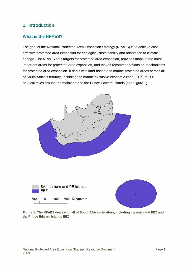
1. Introduction
What is the NPAES?
The goal of the National Protected Area Expansion Strategy (NPAES) is to achieve cost
effective protected area expansion for ecological sustainability and adaptation to climate
change. The NPAES sets targets for protected area expansion, provides maps of the most
important areas for protected area expansion, and makes recommendations on mechanisms
for protected area expansion. It deals with land-based and marine protected areas across all
of South Africa’s territory, including the marine exclusive economic zone (EEZ) of 200
nautical miles around the mainland and the Prince Edward Islands (see Figure 1).
Figure 1: The NPAES deals with all of South Africa's territory, including the mainland EEZ and the Prince Edward Islands EEZ
National Protected Area Expansion Strategy: Resource Document Page 1 2009

Why a Resource Document?
In the course of developing the NPAES, large amounts of information relating to protected
area expansion in South Africa were gathered. Inclusion of all of this information in the
strategy itself would have made for an unwieldy document; however, much of it is valuable
especially for those involved in implementing protected area expansion. This Resource
Document thus provides additional technical information to support aspects of the NPAES. It
does not summarise the NPAES (apart from the protected area targets and focus areas
which are provided for ease of reference later in this section), and is not intended to be a
standalone document but should be read in conjunction with the strategy.
The intended users of the Resource Document are summarised in Table 1. They are
primarily those involved directly in protected area consolidation and expansion, including
through biodiversity stewardship programmes.
Table 1: Intended users of the NPAES Resource Document2
Agency, department or organisation Acronym
1. National protected area agencies
Protected Areas Directorate of DEA DEA
Marine and Coastal Management Branch of DEA MCM
South African National Biodiversity Institute SANBI*
Department of Water Affairs and Forestry (Forestry Branch**) DWAF
South African National Parks SANParks
iSimangaliso Wetland Park
2. Provincial protected area agencies
CapeNature
Eastern Cape Parks ECP
Ezemvelo KwaZulu-Natal Wildlife EKZNW
Mpumalanga Tourism and Parks Agency MTPA
North West Parks and Tourism Board NWPTB
3. Provincial environmental affairs departments
Eastern Cape Department of Economic Development and Environment Affairs DEDEA
Free State Department of Tourism, Economic and Environment Affairs DTEEA
Gauteng Department of Agriculture, Conservation and Environment GDACE
KwaZulu-Natal Department of Agriculture and Environment Affairs DAEA
Limpopo Department of Economic Development, Environment and Tourism DEDET
2 Some names have changed since the development of this document.
National Protected Area Expansion Strategy: Resource Document Page 2 2009

Mpumalanga Department of Agriculture and Land Administration DALA
North West Department of Agriculture, Conservation and Environment NWDACE
Northern Cape Department of Tourism, Environment and Conservation DTEC
Western Cape Department of Environment Affairs and Development Planning DEA&DP 4. Environmental or conservation management departments/branches of local, district and metropolitan municipalities responsible for local nature reserves 5. NGOs involved in protected area establishment processes Table notes: * Including bioregional programmes, such as the Cape Programme for People and the Environment (C.A.P.E.), the Succulent Karoo Ecosystem Programme (SKEP) and the Grasslands Programme ** Now located in the Department of Agriculture, Fisheries and Forestry (DAFF)
Definitions of protected areas and conservation areas
Protected areas are areas of land or sea that are formally protected by law and managed
mainly for biodiversity conservation. Protected areas recognised in the National
Environmental Management: Protected Areas Act (Act 57 of 2003) (hereafter referred to as
the Protected Areas Act) are considered formal protected areas in the NPAES. This is a
narrower definition of protected areas than the International Union for Conservation of
Nature (IUCN) definition.3
The Protected Areas Act distinguishes between several categories of protected area:
• Special nature reserves,
• National Parks,
• Nature reserves,
• Protected environments.
It also recognises World Heritage Sites, marine protected areas, specially protected forest
areas, and mountain catchment areas. See Section 2 for more detail on protected area
categories and types.
The NPAES distinguishes between land-based protected areas, which may protect both
terrestrial and freshwater biodiversity features, and marine protected areas.
It is important to differentiate protected areas from conservation areas. Conservation areas
are areas of land not formally protected by law but informally protected by the current 3 The IUCN defines a protected area as an area of land and/or sea especially dedicated to the protection and maintenance of biological diversity and of natural and associated cultural resources, and managed through legal or other effective means. This broad definition includes areas which are not legally protected and which the NPAES defines as conservation areas rather than protected areas.
National Protected Area Expansion Strategy: Resource Document Page 3 2009

owners and users and managed at least partly for biodiversity conservation. Because there
is no long-term security associated with conservation areas, they are not a strong form of
protection and are not considered part of the protected area network. Conservation areas
are not a major focus of the NPAES.
There are also several forms of statutory protection that are not recognised in terms of the
Protected Areas Act but nevertheless provide a degree of protection for the areas and sites
concerned. These other forms of statutory protection, also not considered part of the
protected area network, are listed at the end of Section 2.
Summary of protected area targets and focus areas
The NPAES sets twenty-year targets for land-based and marine protected areas,
summarised in Table 2. The summarised targets are built up from more detailed ecosystem-
level targets, as discussed further in Section 5. The more detailed targets are crucial for
ensuring that protected area expansion does not just provide more protection for already
well-protected ecosystems, and they help to determine the geographic focus areas for
protected area expansion (see Figure 2).
Table 2: Summary of land-based and marine protected area targets, and areas still required to meet targets
20-year target Current protection level*
Addition needed to meet 20-year target
Addition needed in next 5 years
Land-based 12% 6.5% (7.9m ha) 8.8% (10.8m ha) 2.2% (2.7m ha)
Marine inshore** No-take: 15% No-take: 9.1% (334km) No-take: 6% (234km) No-take: 1.5% (59km)
Total: 25% Total: 21.5% (785km) Total: 9.6% (353km) Total: 2.4% (88km)
Marine offshore: mainland EEZ
No-take: 15% No-take: 0.16% (1 671km2) No-take: 14.8%(159 111km2) No-take: 3.7% (39 887km2)
Total: 20% Total: 0.4% (4 172km2) Total: 19.6% (210 205km2) Total: 4.9% (52 551km2)
Marine offshore: Prince Edward Islands EEZ
No-take: 15% No-take: 0% *** No-take: 15% (70 032km2) No-take: 3.8% (17 508km2)
Total: 20% Total: 0% **** Total: 20% (93 376km2) Total: 5% (23 344km2) Table notes: * An area is considered protected if it falls within a protected area recognised in the Protected Areas Act. ** Inshore marine targets are measured in kilometres of coastline because of the varying distances which inshore MPAs extend from the coastline. Inshore is considered to mean from the high water mark to the 30m depth contour. All inshore MPAs extend at least this far. In future we will move towards using a more accurate area-based measure for inshore MPA targets, but this is not possible with current data. *** Fishing has been excluded from a 12 nautical mile exclusion zone immediately around the islands (3% of the Prince Edward Islands EEZ) but the area has not been promulgated as an MPA. **** The intention to declare a marine protected area in the Prince Edward Islands EEZ was published for comment by the Minister of Environment Affairs in the Government Gazette on 8 May 2009. At the time of finalising this document, the process had not been concluded and the protected area had not yet been established.
National Protected Area Expansion Strategy: Resource Document Page 4 2009

In the next five years, in order to move a quarter of the way to meeting the twenty-year
protected area targets, we need to add 2.7 million hectares to the land-based protected area
network, 88km to the inshore marine protected area network (including 59km in no-take
zones), 52 500 km2 to the offshore marine protected area network in South Africa’s mainland
Exclusive Economic Zone (EEZ), and 23 300 km2 to the offshore marine protected area
network in the Prince Edward Islands EEZ.
In addition to these focus areas, threatened ecosystems identified in the National Spatial
Biodiversity Assessment (NSBA) or listed in terms of the National Environmental
Management: Biodiversity Act (Act 10 of 2004) (hereafter referred to as the Biodiversity Act)
are important for protected area expansion. Threatened ecosystems are often highly
fragmented and thus not suitable for the creation or expansion of large protected areas, but
contractual protected areas through biodiversity stewardship programmes can play a crucial
role in protecting remaining natural habitat in threatened ecosystems.
In the marine environment, priority areas for protected area expansion are based on work
done previously for the NSBA 2004 (Lombard et al. 2004) and a biodiversity plan for the
Prince Edward Islands EEZ (Lombard et al. 2007), shown in Figure 3. The determination of
these priorities is not discussed further in this Resource Document.
Overview of the Resource Document
This Resource Document is structured as follows:
• Section 2 provides information on the policy and legal context for protected area
expansion;
• Section 3 provides an overview of the institutional context;
• Section 4 profiles the protected area network as it was in 2008, providing a baseline for
the NPAES;
• Section 5 explains the spatial analysis that was undertaken to identify focus areas for
land-based protected area expansion;
• Section 6 provides detailed information on mechanisms for protected area expansion;
• Section 7 provides information on sources of finance and financial mechanisms for
protected area expansion;
• Section 8 gives broad guidelines for agency-specific implementation plans based in the
NPAES.
National Protected Area Expansion Strategy: Resource Document Page 5 2009

Figure 2: Focus areas for land-based protected area expansion
National Protected Area Expansion Strategy: Resource Document Page 6 2009

Figure 3: Important biozones for marine protected area expansion as determined in the NSBA 2004 and (inset) a biodiversity planning exercise for the Prince Edward Islands EEZ
National Protected Area Expansion Strategy: Resource Document Page 7 2009

2. Policy and legal context4
This section provides background on the policy and legal context for protected area
expansion, including the various types of protected areas recognised by the Protected Areas
Act.
Policy context
The policy context for protected area expansion in South Africa is provided by the following,
each of which is discussed briefly below:
• Convention on Biological Diversity (CBD),
• White Paper on Biodiversity (1997),
• Bioregional approach to protected areas (2001),
• National Spatial Biodiversity Assessment (2004),
• National Biodiversity Strategy and Action Plan (2005),
• National Biodiversity Framework (2008).
Convention on Biological Diversity
South Africa is a signatory to the CBD, which requests countries to:
• Establish a system of protected areas to conserve biodiversity;
• Develop guidelines for the selection, establishment and management of protected areas;
• Promote the protection of ecosystems, natural habitats and the maintenance of viable
populations of species.
The central role of protected areas in implementing the objectives of the CBD has been
emphasised repeatedly in decisions of the Conference of the Parties (COP).
The target to achieve “a significant reduction in the current rate of loss of biological diversity”
by the year 2010 was agreed by the sixth COP in 2002, and endorsed by the world’s leaders
at the World Summit on Sustainable Development the following year.
The COP, at its seventh meeting in 2004, agreed on a programme of work for protected
areas which included approaches to ensuring the effective ongoing development of a
4 Note that pre-July 2009 department names are used in this section.
National Protected Area Expansion Strategy: Resource Document Page 8 2009

comprehensive, effectively managed and ecologically representative national and regional
protected areas that collectively contribute to achieving the 2010 target.
White Paper on Biodiversity
At a national level, the White Paper on the Conservation and Sustainable Use of South
Africa’s Biological Diversity (1997) established South Africa’s intent to secure under
protection at least 10% of each habitat and ecosystem within the seven biomes.
Bioregional approach to South Africa’s protected areas
In 2001, DEAT published “A bioregional approach to South Africa’s protected areas” (DEAT,
2001). This strategy document proposed an increase of the protected area estate for
terrestrial environments from 6% to 8% and for marine and coastal environments from 5% to
20%. It also envisaged that the protected area network should become fully representative of
South Africa’s biodiversity.
National Spatial Biodiversity Assessment 2004
The NSBA 2004 (Driver et al. 2005) provides a spatial description of the location of South
Africa’s threatened and under-protected ecosystems, and identifies broad priority areas for
conservation action.
The NSBA is based on the systematic approach to biodiversity planning, which is driven by
three principles:
• The principle of representation, or the need to conserve a representative sample of
biodiversity pattern, including ecosystems, habitats and species;
• The principle of persistence, or the need to conserve ecological and evolutionary
processes that allows biodiversity to persist over time;
• The principle of setting explicit biodiversity targets, where each biodiversity feature has
quantitative targets set to maintain viable populations and functioning ecosystems,
landscapes and seascapes.
The NSBA delivered some striking results:
• 34% of the country’s 440 terrestrial ecosystems are threatened, with 5% critically
endangered, 13% endangered and 16% vulnerable;
National Protected Area Expansion Strategy: Resource Document Page 9 2009
• 82% of main river ecosystem types are threatened, with 44% critically endangered, 27%
endangered and 11% vulnerable;
• 77% of 13 estuary groups (comprising 259 estuaries altogether) are threatened, with
23% critically endangered, 39% endangered and 15% vulnerable;
• 65% of 34 marine biozones are threatened, with 12% critically endangered, 15%
endangered and 38% vulnerable.
The NSBA 2004 highlighted that although nearly 6%5 of South Africa’s land surface area is
conserved in formal protected areas, the protected area network is biased towards particular
ecosystems – it does not conserve a representative sample of biodiversity and excludes
some key ecological processes. This helped to provide the basis for the development of the
NPAES.
National Biodiversity Strategy and Action Plan
The National Biodiversity Strategy and Action Plan (NBSAP) (DEAT 2005) is a long-term
strategy that identifies five strategic objectives. For each strategic objective, the NBSAP
identifies outcomes, activities, targets and indicators.
Relevant to the NPAES is Strategic Objective 5: “A network of protected areas and
conservation areas conserves a representative sample of biodiversity and maintains key
ecological processes across the landscape and seascape”.6 The 15-year (i.e. 2020) target
for this strategic objective is: “The protected area network covers 12% of the terrestrial and
20% of the marine environment thereby contributing to representation targets in priority
areas”.
Within Strategic Objective 5, Outcome 5.2 lays the basis for the NPAES: “The protected area
network is secured, expanded and managed to ensure that a representative sample of
biodiversity and key ecological processes are conserved”.
Activity 5.2.1 of Outcome 5.2 specifically requires that the responsible institutions “Expand,
consolidate and/or rationalise the protected area network through a range of implementation
tools, focusing on priority areas for representation and persistence of biodiversity”.
5 This figure has subsequently increased to 6.5%. 6 The NBSAP used the term “conservation areas” to mean both formal protected areas and informal conservation areas as defined in the NPAES. Thus the original wording of Strategic Objective 5 referred just to “conservation areas” and has been modified here to reflect the now agreed definitions of “protected area” and “conservation area” (see Section 1).
National Protected Area Expansion Strategy: Resource Document Page 10 2009
National Biodiversity Framework
The drafting of a National Biodiversity Framework (NBF) is an explicit requirement of the
Biodiversity Act. The NBF (DEAT 2008) is informed by and draws together key elements
from both the NBSAP and the NSBA. The NBF focuses attention on the immediate priorities
for the next five years, both spatial and thematic, within each of the Strategic Objectives of
the NBSAP. The NBF identifies 33 Priority Actions for the period 2008 to 2012, of which the
last five relate to Strategic Objective 5 (see NBSAP above):
29. Finalise the twenty-year National Protected Area Expansion Strategy, underpinned by
the national biodiversity targets in the NSBA, refined for biomes, provinces and marine
biozones;
30. Implement the first phase of the National Protected Area Expansion Strategy (in other
words the first set of five-year targets);
31. Establish and strengthen provincial stewardship programmes;
32. Strengthen programmes that support the informal conservation area system;
33. Develop and implement a national botanical gardens expansion strategy.
The NPAES contributes directly to achieving Priority Action 29, and indirectly to Priority
Actions 30 and 31. The NBF 2012 targets for Priority Action 30 reflect the five-year protected
area targets in the NPAES.
Legal context
Various pieces of national legislation allow areas of land or sea in South Africa to be formally
designated as protected areas. The different types of protected areas, and their enabling
legislation, are briefly discussed below. This brief overview does not deal in detail with the
legal context for protected areas. A list of types of conservation areas and areas under other
forms of statutory protection is provided at the end of the subsection.
National Environmental Management: Protected Areas Act (Act 57 of 2003)7
The Protected Areas Act is the primary statute for the governance, management, regulation
and monitoring of protected areas. It seeks to effect the establishment of a representative
national network of protected areas covering state, private and communal land. It promotes
7 Including the National Environmental Management: Protected Areas Amendment Act (Act 31 of 2004).
National Protected Area Expansion Strategy: Resource Document Page 11 2009

the use of protected areas, and participation in their management. The Protected Areas Act
also provides for the continued existence, governance and functions of South African
National Parks (SANParks), and for inter-governmental co-operation concerning protected
areas.
Section 10 of the Protected Areas Act calls for the maintenance of a register of protected
areas that contains a list of all protected areas, including those declared in terms of other
legislation.
The Protected Areas Act recognises the following kinds of protected areas:
• Special nature reserves,
• National Parks and nature reserves;8
• Protected environments;
• World Heritage Sites declared in terms of the World Heritage Convention Act (Act 49 of
1999);
• Marine protected areas declared in terms of the Marine Living Resources Act (Act 18 of
1998);
• Specially protected forest areas (including Forest Nature Reserves and Forest
Wilderness Areas) declared in terms of the National Forests Act (Act 84 of 1998);
• Mountain Catchment Areas declared in terms of the Mountain Catchment Areas Act (Act
63 of 1970).
Despite recognising all of the above-mentioned protected areas, only the following
categories of protected area may be specifically declared in terms of the Protected Areas
Act, each with a specific objective, management authority, restrictions and withdrawal
conditions, as summarised in Table 3:
• Special nature reserve,
• National Park,
• Nature reserve,
• Protected environment.
8 Parts of National Parks and nature reserves can be declared as “wilderness areas”.
National Protected Area Expansion Strategy: Resource Document Page 12 2009

Table 3: Summary of the legal characteristics of the four protected area types defined in the Protected Areas Act
Spec
ial n
atur
e re
serv
e
Objective: To protect highly sensitive, outstanding ecosystems, species or geological or physical features in the area. To make the area primarily available for scientific research or environmental monitoring. Management authority: Designated by the Minister in terms of an approved Management Plan that may include co-management agreements. Use restrictions: Strict access restrictions that include aircraft restrictions. No mining. No commercial activities specifically provided for. Additional restrictions may be imposed by management authority. Withdrawal: Requires resolution of Parliament.
Nat
iona
l Par
k
Objective: To protect an area that is of national or international biodiversity importance; or which contains a viable, representative sample of South Africa’s natural systems, scenic areas or cultural heritage sites; or that protects the ecological integrity of one or more ecosystems in the area. Management authority: South African National Parks (SANParks) or any other management authority assigned by the Minister. Use restrictions: Access restriction. No mining. Aircraft restrictions. Commercial activities subject to certain requirements being met. Additional management authority imposed restrictions. Withdrawal: Requires resolution of Parliament, unless landowner withdraws from contractual agreement.
Nat
ure
rese
rve
Objective: To protect an area that has significant natural features or biodiversity; that is of scientific, cultural, historical or archaeological interest; that is in need of long-term protection for the maintenance of biodiversity; or for the provision of environmental goods or services. Management authority: Management authority designated by the MEC in terms of approved Management Plan. Co-management agreements may be entered into. Use restrictions: Access restriction. No mining. Commercial activities subject to certain requirements being met. Additional management authority imposed restrictions. Withdrawal: Requires resolution of Parliament or Provincial Legislature, unless landowner withdraws from contractual agreement.
Prot
ecte
d en
viro
nmen
t
Objective: To protect an area or ecosystem that is outside of a special nature reserve, national park, world heritage site or nature reserve and is sensitive to development due to Its biological diversity; natural characteristics; scientific, cultural, historical, archaeological or geological value; scenic and landscape value; or provision of environmental goods and services. Management authority: Management authority may be designated by the MEC or Minister. Use restrictions: No mining without Minister and Minister of Minerals and Energy’s consent. Restrictions may be gazetted. Withdrawal: By notice in relevant government (provincial or national) gazette.
National Protected Area Expansion Strategy: Resource Document Page 13 2009

National Forests Act (Act 84 of 1998)
The National Forests Act provides for the declaration of a State Forest, or land outside a
State Forest (at the request or consent of the registered landowner), as a “Specially
Protected Forest Area” in one of the following categories:
• Forest Nature Reserve,
• Forest Wilderness Reserve,
• Any other type of protected area that is “recognised in international law or practice”.9
Only Chapters 1 and 2 and Section 48 of the Protected Areas Act apply to Specially
Protected Forest Areas (this effectively means that norms and standards can be set by the
Minister for the administration of these areas and that mining may not be conducted). The
other provisions of the Protected Areas Act do not apply to Specially Protected Forest Areas.
Where a Specially Protected Forest Area is declared or included in a special nature reserve,
National Park or nature reserve, such area will then fall under the protection of the Protected
Areas Act, in accordance with an agreement concluded between the Minister and the
Minister of Water Affairs and Forestry.
Table 4 briefly characterises the legal nature of a Specially Protected Forest Area.
Table 4: Summary of the legal characteristics of a Specially Protected Forest Area as defined in the National Forests Act
Spec
ially
Pro
tect
ed
Fore
st A
rea
Objective: To protect forests and trees of national significance. Management authority: The Minister of Water Affairs and Forestry is responsible for the management of protected areas declared in terms of the Act. A management plan and management agreement is not specifically provided for in Act. Management is only with the consent of the landowners. Use restrictions: No person may cut, disturb, damage or destroy any forest produce from a protected forest without a permit issued by the Minister. Additional restrictions may be imposed by the Minister. Withdrawal: The declaration may not be withdrawn unless the same requirements for public participation procedure have been followed and the withdrawal of the declaration is approved by resolution of Parliament.
9 This is open to considerable interpretation. It is conceivable that the demarcated indigenous state forests are also considered Specially Protected Forest Areas in terms of the National Forests Act.
National Protected Area Expansion Strategy: Resource Document Page 14 2009
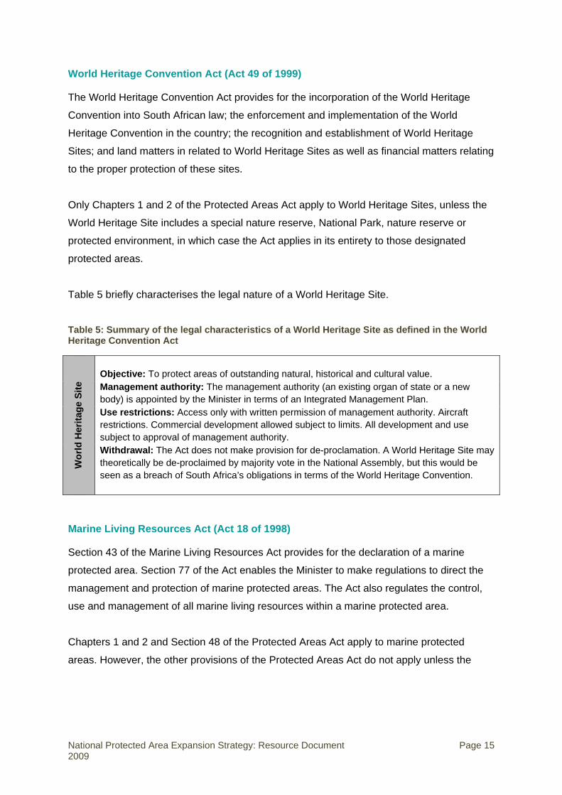
World Heritage Convention Act (Act 49 of 1999)
The World Heritage Convention Act provides for the incorporation of the World Heritage
Convention into South African law; the enforcement and implementation of the World
Heritage Convention in the country; the recognition and establishment of World Heritage
Sites; and land matters in related to World Heritage Sites as well as financial matters relating
to the proper protection of these sites.
Only Chapters 1 and 2 of the Protected Areas Act apply to World Heritage Sites, unless the
World Heritage Site includes a special nature reserve, National Park, nature reserve or
protected environment, in which case the Act applies in its entirety to those designated
protected areas.
Table 5 briefly characterises the legal nature of a World Heritage Site.
Table 5: Summary of the legal characteristics of a World Heritage Site as defined in the World Heritage Convention Act
Wor
ld H
erita
ge S
ite
Objective: To protect areas of outstanding natural, historical and cultural value. Management authority: The management authority (an existing organ of state or a new body) is appointed by the Minister in terms of an Integrated Management Plan. Use restrictions: Access only with written permission of management authority. Aircraft restrictions. Commercial development allowed subject to limits. All development and use subject to approval of management authority. Withdrawal: The Act does not make provision for de-proclamation. A World Heritage Site may theoretically be de-proclaimed by majority vote in the National Assembly, but this would be seen as a breach of South Africa’s obligations in terms of the World Heritage Convention.
Marine Living Resources Act (Act 18 of 1998)
Section 43 of the Marine Living Resources Act provides for the declaration of a marine
protected area. Section 77 of the Act enables the Minister to make regulations to direct the
management and protection of marine protected areas. The Act also regulates the control,
use and management of all marine living resources within a marine protected area.
Chapters 1 and 2 and Section 48 of the Protected Areas Act apply to marine protected
areas. However, the other provisions of the Protected Areas Act do not apply unless the
National Protected Area Expansion Strategy: Resource Document Page 15 2009

area is proclaimed as part of a National Park, in which case the Marine Living Resources Act
and the Protected Areas Act may apply concurrently.10
Table 6 briefly characterises the legal nature of a marine protected area.
Table 6: Summary of the legal characteristics of a marine protected area as defined in the Marine Living Resources Act
Mar
ine
prot
ecte
d ar
ea
Objective: To protect marine fauna and flora and the physical features on which they depend; to facilitate fishery management by protecting spawning stock, allowing stock recovery, enhancing stock abundance in adjacent areas, and providing pristine communities for research; or to diminish any conflict that may arise from competing uses in an area. Management authority: MCM. Delegated management authority to DEA or local government or assignment of provisions of the Act to a provincial administration. Use restrictions: Strict use restrictions in “restricted zones”. Marine resource use restrictions outside restricted zones. No mining. Development controls. Commercial and recreational activities under permit. Additional management authority imposed restrictions. Withdrawal: Requires resolution of Parliament.
Mountain Catchment Areas Act (Act 63 of 1970)
The Mountain Catchment Areas Act aims to provide for the conservation, use, management
and control of land situated in “Mountain Catchment Areas”. Although it is a national statute,
its administration has been assigned to provinces with effect from 7 April 1995.
Chapters 1 and 2 of the Protected Areas Act apply to Mountain Catchment Areas. The other
provisions of the Protected Areas Act do not apply unless the area is proclaimed as part of a
special nature reserve, National Park, nature reserve or protected environment, in which
case the Protected Areas Act applies in its entirety for those proclaimed protected areas.
Table 7 briefly characterises the legal nature of a Mountain Catchment Area.
10 There is considerable uncertainty and differing views on which of these two pieces of legislation prevails in National Parks.
National Protected Area Expansion Strategy: Resource Document Page 16 2009

Table 7: Summary of the legal characteristics of a Mountain Catchment Area as defined in the Mountain Catchment Areas Act
Mou
ntai
n C
atch
men
t A
rea
Objective: To conserve land within a defined “Mountain Catchment Area”. Management authority: Provincial protected area agency. Delegation of management functions to any “department of state”. Mountain Catchment Area advisory committee may be established. Use restrictions: Access control. Regulations (“directions”) may be gazetted by the MEC, including for an area 5km outside the Mountain Catchment Area. Regulation or prohibition of fire. Withdrawal: By notice in provincial government gazette.
Relationship between Protected Areas Act and provincial legislation
The management of protected areas is regulated by a wide variety of statutes, at provincial
and national level. Section 7 of the Protected Areas Act regulates the interaction of these
statutes as follows:
• Where a provision of the Protected Areas Act specifically concerns the management or
development of protected areas and there is a conflict with other national legislation, the
relevant section of the Protected Areas Act prevails.
• If the Protected Areas Act conflicts with provincial legislation, the conflict must be
resolved in terms of Section 146 of the Constitution.
• Where there is a conflict with a municipal by-law, the relevant section of the Protected
Areas Act prevails.
The operation of the Protected Areas Act does not affect the implementation of national and
provincial legislation when it:
• Regulates matters not covered by the Protected Areas Act,
• Is consistent with the Protected Areas Act,
• Prevails in terms of Section 146 of the Constitution.
Legal procedures for the declaration of protected areas
Special nature reserves, National Parks, nature reserves and protected environments
The Protected Areas Act deals with the manner in which an area may be declared a special
nature reserve, National Park, nature reserve or protected environment.
National Protected Area Expansion Strategy: Resource Document Page 17 2009
The Minister of Environmental Affairs is responsible for declaring a special nature reserve,
National Park or national protected environment by notice in the Government Gazette. The
relevant provincial MEC (whose portfolio includes responsibility for provincial protected
areas) is responsible for declaring a provincial or local nature reserve or provincial protected
environment by notice in the Provincial Gazette.
The Protected Areas Act expressly provides for the declaration of private land provided that:
• In the case of a special nature reserve, National Park or nature reserve, the landowner
consents to the declaration in the form of a written agreement entered into with the
Minister (special nature reserve or National Park) or the MEC (nature reserve).
• In the case of a protected environment, the landowner has requested or consented to the
declaration and has been sent a copy of the proposed notice of declaration.
The declaration process may be initiated by the Minister or the MEC, subject to the following:
• If the land in question is privately owned, the declaration may be initiated by the
landowner (e.g. in the form of a request by the landowner to the Minister or the MEC for
the land to be declared a nature reserve or protected environment). A request by the
owner of private land for his or her (or its) land to be declared a protected area must be
considered by the Minister or the MEC.
• If the area consists of, or includes, land owned by the State, the Minister or the MEC
may make the declaration only with the agreement of the Cabinet member or MEC
responsible for the administration of that land.
• If the area consists of, or includes, land which is held in trust by the State or an organ of
state for a community or other beneficiary, the Minister or the MEC may make the
declaration only with the concurrence of the trustee and the community involved.
Before the Minister or MEC may issue a notice in the relevant Gazette declaring a special
nature reserve, National Park, nature reserve or protected environment, the Minister or MEC
must follow:
• The consultative process prescribed in the Act,
• The public participation process prescribed in the Act.
National Protected Area Expansion Strategy: Resource Document Page 18 2009

Specially Protected Forest Areas
The National Forests Act deals with the manner in which an area may be declared as a
category of Specially Protected Forest Area. The Minister of Water Affairs and Forestry is
responsible for declaring any category of Specially Protected Forest Area by notice in the
Government Gazette.
The National Forests Act expressly provides for the declaration of:
• A State Forest or part of it.
• Land that has been purchased, or expropriated under Section 49 of the Act.
• Private land outside a State Forest.
The declaration process may be initiated by the Minister, subject to the following:
• In the case of a “trust forest”, the Minister must consult with the communities residing on
the land adjoining the proposed specially protected forest.
• If the land in question is privately owned, the declaration may only be initiated by the
registered owner of the land or with the consent of the landowner.
Before the Minister may issue a notice in the Government Gazette declaring a Specially
Protected Forest Area, the Minister must follow:
• The consultative process prescribed in the Act,
• The public participation process prescribed in the Act.
World Heritage Sites
The Minister of Environmental Affairs is responsible for the procedure relating to the
nomination of South Africa’s heritage sites with exceptional qualities for consideration of
inscription on the World Heritage List by the World Heritage Committee. This requires that:
• Places of potential cultural or natural heritage be identified, investigated and included on
the national World Heritage Tentative List.
• Once a site is on the Tentative List, a written motivation for consideration as a World
Heritage Site is prepared in accordance with the requirements of the Operational
Guidelines for the implementation of the World Heritage Convention.
National Protected Area Expansion Strategy: Resource Document Page 19 2009
• The nominated place is then independently assessed by the International Council on
Monuments and Sites (ICOMOS) and/or IUCN and then recommended for inscription on
the World Heritage List by the World Heritage Committee.
• The inscription of the place on the World Heritage List will then make it possible for it to
be also proclaimed as a World Heritage Site by notice in the Government Gazette issued
in terms of the World Heritage Convention Act.
The Minister may:
• Purchase any property and reserve it for purposes contemplated in the World Heritage
Convention Act in relation to World Heritage Sites, if that purpose is in the public interest
and with the concurrence of the Minister of Public Works.
• Expropriate land for World Heritage Site purposes, subject to the Expropriation Act (Act
63 of 1975).
• Consolidate land of which the State is the owner and forming part or potentially forming
part of a World Heritage Site, subject to Section 40 of the Deeds Registries Act (Act 47
of 1937).
• Register by a notarial deed entered into between the State and owner or owners, a
condition over land forming part or potentially forming part of a World Heritage Site to the
effect that such land may not be separately alienated, leased or encumbered without the
prior written consent of the Minister, and the notarial deed may be accompanied by a
sketch plan of such land. This is subject to Section 65 of the Deeds Registries Act.
No specific provisions are provided for in the Act for consultation and public participation.
Marine protected areas
The Marine Living Resources Act deals with the manner in which an area may be declared
as a marine protected area. The Minister of Environmental Affairs is responsible for
declaring a marine protected area by notice in the Government Gazette.
Where a marine protected area is included in a special nature reserve, National Park or
nature reserve, the area must be managed and regulated as part of the special nature
reserve, National Park or nature reserve in terms of the Protected Areas Act.
National Protected Area Expansion Strategy: Resource Document Page 20 2009

Although not explicitly provided for in the Marine Living Resources Act, the declaration of a
marine protected area can include the zonation of the marine protected area into "controlled
zones", "restricted zones" and/or "sanctuary zones".
No specific provisions are provided for in the Act for consultation and public participation.
Mountain Catchment Areas
The Mountain Catchment Areas Act deals with the manner in which an area may be
declared as a Mountain Catchment Area. The relevant provincial MEC is responsible for
declaring, or altering the boundaries of, a Mountain Catchment Area by notice in the
Provincial Gazette.
No specific provisions are provided for in the Act for consultation and public participation.
Types of conservation areas and other forms of statutory protection
As explained in Section 1, conservation areas are areas of land not formally protected by lay
but informally protected by the current owners and users and managed at least partly for
biodiversity conservation. Because there is no long-term security associated with
conservation areas, they are not a strong form of protection and are not considered part of
the protected area network. There are also several forms of statutory protection that are not
recognised in terms of the Protected Areas Act but can provide a degree of protection for the
areas and sites concerned. These other forms of statutory protection are also not considered
part of the protected area network.
Nevertheless it is useful to summarise the different types of conservation areas and areas
under other forms of statutory protection. As discussed in Section 6, they can provide a
starting point for expanding the protected area network if they fall within focus areas for
protected area expansion or within threatened ecosystems.
Table 8 describes the existing areas under some form of statutory protection (other than the
Protected Areas Act) while Table 9 describes existing conservation areas under some form
of conservation management or tenure.
National Protected Area Expansion Strategy: Resource Document Page 21 2009

Table 8: Areas under some form of statutory protection other than the Protected Areas Act
Type of conservation area Enabling legislation
National and Provincial Heritage Site National Heritage Resources Act
“Protected Area”
Biodiversity management agreement Biodiversity Act
National Botanical Garden Environmental Management Cooperation Agreement National Environmental Management Act
State Forest (Indigenous State Forest) National Forests Act
Controlled Forest
Closed (marine) areas Marine Living Resources Act
Conservancy (selected areas conservancies only)
Selected provincial legislation Private Nature Reserve (selected PNRs only)
Site of Conservation Significance
Local Authority Nature Reserve Municipal by-laws
Table 9: Conservation areas under some form of conservation management/tenure
Biosphere Reserve (in terms of UNESCO’s Man and the Biosphere Program)
Non-statutory Private Nature Reserve
“Mega-Reserve” initiatives (e.g. Baviaanskloof Mega-Reserve) and biodiversity corridor initiatives (e.g. Greater Cederberg Biodiversity Corridor, Garden Route Initiative)
Natural Heritage Site
Trans-Frontier Conservation Area
Bird Sanctuary
Community Conservation Area
“Headman’s Forest”
Voluntary conservation area
Special Management Area
Sectoral (e.g. wine) “partner”, “member” or “champion” sites (or equivalent)
Non-statutory Wilderness Areas
Estuary Protected/Conservation Area or Estuary Management Area
National Protected Area Expansion Strategy: Resource Document Page 22 2009

3. Institutional context11
This section provides an overview of the institutional context for protected area expansion in
South Africa. Protected area planning, management and expansion are a concurrent
legislative competency of national and provincial government in terms of the Constitution,
and there is considerable institutional diversity in the way South Africa’s protected areas are
managed. Please note that the information in this section was correct at the time the NPAES
was developed in 2008; in some cases in it now outdated as a result of departmental
restructuring and name changes.
Most of the National Parks and some World Heritage Sites are currently managed by
SANParks. The Protected Areas Act also provides for the assignation of the management
authority for a National Park to any “suitable person, organisation or organ of state”.
Several existing marine protected areas are managed by the Marine and Coastal
Management (MCM) branch of DEAT. The Minister typically assigns management authority
for marine protected areas to provincial or national protected area agencies (Lemm &
Attwood 2004).
The Department of Water Affairs and Forestry (DWAF) is responsible for most of the
Specially Protected Forest Areas but is in the process of assigning the management
authority for these to the relevant national or provincial protected area agencies.
Provincial conservation agencies responsible for protected areas vary in institutional
character and structure across the nine provinces. Six provinces have established public
entities (agencies or boards) to plan for and manage nature reserves, protected
environments, World Heritage Sites and/or Mountain Catchment Areas. The other three
provinces include the protected area function as a directorate within a provincial government
department that includes other functions, such as economic affairs, environmental affairs,
tourism and/or agriculture.
At the local level, several local, district and metropolitan municipalities have established a
nature conservation function to administer and manage (local) nature reserves within their
municipal jurisdiction.
11 Note that pre-July 2009 department names are used in this section.
National Protected Area Expansion Strategy: Resource Document Page 23 2009
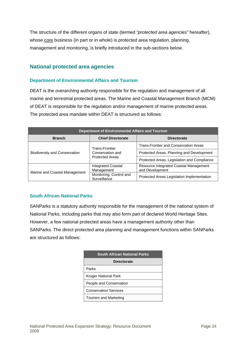
The structure of the different organs of state (termed “protected area agencies” hereafter),
whose core business (in part or in whole) is protected area regulation, planning,
management and monitoring, is briefly introduced in the sub-sections below.
National protected area agencies
Department of Environmental Affairs and Tourism
DEAT is the overarching authority responsible for the regulation and management of all
marine and terrestrial protected areas. The Marine and Coastal Management Branch (MCM)
of DEAT is responsible for the regulation and/or management of marine protected areas.
The protected area mandate within DEAT is structured as follows:
Department of Environmental Affairs and Tourism
Branch Chief Directorate Directorate
Biodiversity and Conservation Trans-Frontier Conservation and Protected Areas
Trans-Frontier and Conservation Areas
Protected Areas, Planning and Development
Protected Areas, Legislation and Compliance
Marine and Coastal Management
Integrated Coastal Management
Resource Integrated Coastal Management and Development
Monitoring, Control and Surveillance Protected Areas Legislation Implementation
South African National Parks
SANParks is a statutory authority responsible for the management of the national system of
National Parks, including parks that may also form part of declared World Heritage Sites.
However, a few national protected areas have a management authority other than
SANParks. The direct protected area planning and management functions within SANParks
are structured as follows:
South African National Parks
Directorate
Parks
Kruger National Park
People and Conservation
Conservation Services
Tourism and Marketing
National Protected Area Expansion Strategy: Resource Document Page 24 2009
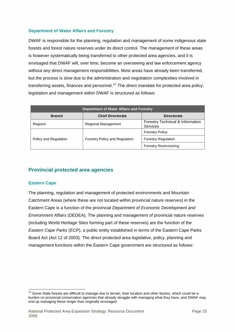
Department of Water Affairs and Forestry
DWAF is responsible for the planning, regulation and management of some indigenous state
forests and forest nature reserves under its direct control. The management of these areas
is however systematically being transferred to other protected area agencies, and it is
envisaged that DWAF will, over time, become an overseeing and law enforcement agency
without any direct management responsibilities. Most areas have already been transferred,
but the process is slow due to the administration and negotiation complexities involved in
transferring assets, finances and personnel.12 The direct mandate for protected area policy,
legislation and management within DWAF is structured as follows:
Department of Water Affairs and Forestry
Branch Chief Directorate Directorate
Regions Regional Management Forestry Technical & Information Services
Policy and Regulation Forestry Policy and Regulation
Forestry Policy
Forestry Regulation
Forestry Restructuring
Provincial protected area agencies
Eastern Cape
The planning, regulation and management of protected environments and Mountain
Catchment Areas (where these are not located within provincial nature reserves) in the
Eastern Cape is a function of the provincial Department of Economic Development and
Environment Affairs (DEDEA). The planning and management of provincial nature reserves
(including World Heritage Sites forming part of these reserves) are the function of the
Eastern Cape Parks (ECP), a public entity established in terms of the Eastern Cape Parks
Board Act (Act 12 of 2003). The direct protected area legislative, policy, planning and
management functions within the Eastern Cape government are structured as follows:
12 Some State forests are difficult to manage due to terrain, their location and other factors, which could be a burden on provincial conservation agencies that already struggle with managing what they have, and DWAF may end up managing these longer than originally envisaged
National Protected Area Expansion Strategy: Resource Document Page 25 2009

Eastern Cape Department of Economic Development and
Environment Affairs Chief Directorate Directorate
Environmental Affairs Biodiversity
Eastern Cape Parks
Directorate
Conservation
Commercialisation
Free State
The regulation, planning and management of provincial nature reserves (including former
Qwaqwa “National Parks”) and World Heritage Sites in the Free State are the function of the
Department of Tourism, Environmental and Economic Affairs (DTEEA). The direct protected
area functions within the Free State government are structured as follows:
Free State Department of Tourism, Environmental and
Economic Affairs Chief Directorate Directorate
Environmental Affairs Conservation
Gauteng
The regulation, planning and management of provincial nature reserves and World Heritage
Sites in Gauteng are the function of the Department of Agriculture, Conservation and
Environment (GDACE). The direct protected area functions within the Gauteng government
are structured as follows:
Gauteng Department of Agriculture, Conservation and
Environment Chief Directorate Directorate
Sustainable Use of the Environment Nature Conservation
Compliance and Enforcement Enforcement
KwaZulu-Natal
The regulation, planning and management of protected areas (including provincial nature
reserves, Marine protected areas and some World Heritage Sites) in KwaZulu-Natal are the
National Protected Area Expansion Strategy: Resource Document Page 26 2009

function of the public entity, Ezemvelo KZN Wildlife (EKZNW). Statutory “Local Conservation
Boards” also provide for the formal integration of local communities into the management of
each of the provincial nature reserves areas in the province. The direct protected area
functions within KwaZulu-Natal are structured as follows:
Ezemvelo KZN Wildlife
Directorate Branch
Biodiversity Conservation Conservation
Conservation Planning
Commercial Operations Ecotourism and Marketing
Partnerships and Ecotourism
Limpopo
The regulation, planning and management of provincial nature reserves, and other
conservation areas in Limpopo, are the function of the Department of Economic
Development, Environment and Tourism (DEDET).13 The direct protected area functions
within Limpopo are structured as follows:
Department of Economic Development, Environment and Tourism
Branch Chief Directorate Directorate
Environment Biodiversity and Natural Resource Management
Protected Areas
State-owned nature reserves
Mpumalanga
The regulation, planning and management of provincial nature reserves in Mpumalanga are
the function of the public entity, Mpumalanga Tourism & Parks Agency (MTPA), established
in terms of the Mpumalanga Tourism & Parks Agency Act, 2005. The direct protected area
functions within Mpumalanga are structured as follows:
13 A Service Level Agreement is being drafted between DEDET and the Limpopo Tourism and Parks Board (LTPB) for the “outsourcing” of the administration and management of tourism operations in the provincial nature reserves.
National Protected Area Expansion Strategy: Resource Document Page 27 2009
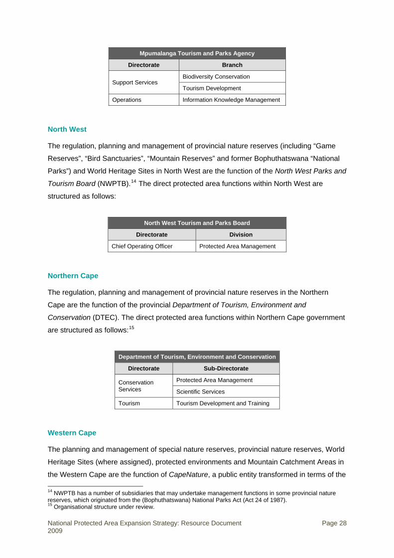
Mpumalanga Tourism and Parks Agency
Directorate Branch
Support Services Biodiversity Conservation
Tourism Development
Operations Information Knowledge Management
North West
The regulation, planning and management of provincial nature reserves (including “Game
Reserves”, “Bird Sanctuaries”, “Mountain Reserves” and former Bophuthatswana “National
Parks”) and World Heritage Sites in North West are the function of the North West Parks and
Tourism Board (NWPTB).14 The direct protected area functions within North West are
structured as follows:
North West Tourism and Parks Board
Directorate Division
Chief Operating Officer Protected Area Management
Northern Cape
The regulation, planning and management of provincial nature reserves in the Northern
Cape are the function of the provincial Department of Tourism, Environment and
Conservation (DTEC). The direct protected area functions within Northern Cape government
are structured as follows:15
Department of Tourism, Environment and Conservation
Directorate Sub-Directorate
Conservation Services
Protected Area Management
Scientific Services
Tourism Tourism Development and Training
Western Cape
The planning and management of special nature reserves, provincial nature reserves, World
Heritage Sites (where assigned), protected environments and Mountain Catchment Areas in
the Western Cape are the function of CapeNature, a public entity transformed in terms of the 14 NWPTB has a number of subsidiaries that may undertake management functions in some provincial nature reserves, which originated from the (Bophuthatswana) National Parks Act (Act 24 of 1987). 15 Organisational structure under review.
National Protected Area Expansion Strategy: Resource Document Page 28 2009

Western Cape Nature Conservation Laws Amendment Act (Act 3 of 2000). The direct
protected area functions within the Western Cape are structured as follows:
CapeNature
Directorate Business Unit / Programme
Operations Business Units (x8)
Monitoring and Evaluation
Biodiversity
Scientific Services
Conservation Stewardship
Fire Management
Invasive Alien Species
Municipal protected area agencies
The planning, regulation and management of local nature reserves is a responsibility of
some district, local and metropolitan municipalities.16 Where one or more local nature
reserves fall within the jurisdiction of a municipality, the structural responsibilities for their
management are structured in a plethora of different ways, which cannot all be shown in this
brief overview of the institutional arrangements for protected areas.
Three examples – Buffalo City, City of Cape Town and eThekwini – are shown in the table
below to demonstrate the structural variability of the direct protected area function in the
municipal organograms:
Buffalo City (local municipality)
Directorate Department Division
Social Services Community Services Integrated Environmental Development
City of Cape Town (metropolitan municipality)
Directorate Department Branch
Strategy and Planning Environmental Resource Management Nature Conservation
eThekwini (metropolitan municipality)
Deputy Manager Unit Division Health, Safety and Security
Parks, Recreation, Cemeteries and Culture Conservation
16 Because conservation is not a competence of the local sphere of government in terms of the Constitution, conservation is seen as an unfunded mandate by many municipalities. Some municipalities, especially smaller ones with fewer resources, have shed or are shedding their nature conservation departments and staff.
National Protected Area Expansion Strategy: Resource Document Page 29 2009

Other protected area bodies
The iSimangaliso Wetland Park Authority is a statutory body, established (in terms of the
World Heritage Convention Act) to manage the iSimangaliso Wetland Park, a World Heritage
Site.
The Prince Edward Islands Management Committee was established by DEAT to oversee
activities in the Prince Edward Island special nature reserve, and to advise DEAT on its
management and conservation.
Robben Island Museum is a declared “Cultural Institution” (in terms of the Cultural
Institutions Act, Act 119 of 1998) and is responsible for the management of the Robben
Island World Heritage Site on behalf of the Department of Arts and Culture.
The Vredefort Dome Conservancy has been assigned the responsibility for the collective
management of privately owned land within the larger Vredefort Dome World Heritage Site
(the other responsible government agencies are NWPTB and DTEEA).
In several instances, private land has been declared as a protected area with the private
landowner (individual, business, joint venture, or community) assigned as the responsible
management authority, with planning, financial and/or technical support from the relevant
protected area agency. As biodiversity stewardship programmes are rolled out across the
provinces (see Section 6), this institutional arrangement may become increasingly common
for the management of different categories of protected areas.
Key partners in the protected area system
The success of the protected area system is dependent on the maintenance of key
partnerships between the various organs of state directly responsible for protected area
management (described above), other relevant organs of state, other relevant government-
led programmes, major NGOs in the conservation sector, relevant commercial production
sectors, and private and communal landowners. These key partners are listed in Table 10
below.
National Protected Area Expansion Strategy: Resource Document Page 30 2009
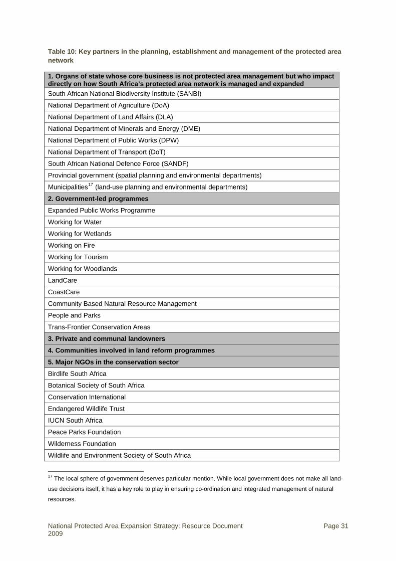
Table 10: Key partners in the planning, establishment and management of the protected area network
1. Organs of state whose core business is not protected area management but who impact directly on how South Africa’s protected area network is managed and expanded South African National Biodiversity Institute (SANBI)
National Department of Agriculture (DoA)
National Department of Land Affairs (DLA)
National Department of Minerals and Energy (DME)
National Department of Public Works (DPW)
National Department of Transport (DoT)
South African National Defence Force (SANDF)
Provincial government (spatial planning and environmental departments)
Municipalities17 (land-use planning and environmental departments)
2. Government-led programmes
Expanded Public Works Programme
Working for Water
Working for Wetlands
Working on Fire
Working for Tourism
Working for Woodlands
LandCare
CoastCare
Community Based Natural Resource Management
People and Parks
Trans-Frontier Conservation Areas
3. Private and communal landowners
4. Communities involved in land reform programmes
5. Major NGOs in the conservation sector
Birdlife South Africa
Botanical Society of South Africa
Conservation International
Endangered Wildlife Trust
IUCN South Africa
Peace Parks Foundation
Wilderness Foundation
Wildlife and Environment Society of South Africa
17 The local sphere of government deserves particular mention. While local government does not make all land-
use decisions itself, it has a key role to play in ensuring co-ordination and integrated management of natural
resources.
National Protected Area Expansion Strategy: Resource Document Page 31 2009

WWF-South Africa
Wildlands Trust 6. Commercial production sectors which have an important contribution to make to managing and expanding the protected area network Forestry (unplanted land)
Mining (un-mined or rehabilitated land)
Game farming
Wildlife tourism and hunting
7. Bioregional programmes
Cape Action for People and the Environment (C.A.P.E.)
Grasslands Programme
Maloti-Drakensberg Transfrontier Project (MDTP)
Subtropical Thicket Ecosystem Programme (STEP)
Succulent Karoo Ecosystem Programme (SKEP)
Wild Coast Programme
Cooperative governance structures for the protected area system
Several inter-governmental structures promote and facilitate co-operation between the
different spheres of government in South Africa. Structures of particular relevance to the
protected area systems include:
• Ministerial Forums,
• Ministerial Technical Working Groups,
The Ministerial Forums (MINMECs) promote co-operative governance between the national
ministers and their respective counterparts at provincial level. The environmental MINMEC
comprises the Minister and Director-General of DEAT and the provincial ministers, or
Members of Executive Councils (MECs), for Environmental Matters. MINMEC meets three
times a year.
The environmental Ministerial Forum is supported by the Ministerial Technical Committee
(MINTECH). MINTECH is a forum that facilitates co-ordination between DEA and the
provincial environmental departments. It comprises the Director General of DEA,
representatives of SANBI and SANParks, and the heads of the provincial departments
responsible for environmental management and biodiversity conservation in the relevant
province. MINTECH meets three times a year.
Four Technical Working Groups have been established under MINTECH. Working Group 1
National Protected Area Expansion Strategy: Resource Document Page 32 2009

focuses on biodiversity and heritage, including protected areas. The Working Groups meet
three times a year.
A Protected Area Expansion Strategy Task Team was established within the institutional
framework of Working Group 1 to guide the development of the NPAES.
A key recommendation of the NPAES was the revitalisation of the Protected Areas Forum.
This is a national forum convened by DEA with representation from protected area agencies,
SANBI, relevant national NGOs, and other organisations as required. It has a key role to
play in co-ordinating and monitoring the implementation of the NPAES, ensuring that there is
alignment of the efforts of the multiple agencies involved, and providing a forum for
discussion on challenges and sharing of lessons.
Status of protected area expansion strategies prior to development of the NPAES: National agencies
This section aims to describe the status of protected area expansion planning at the agency
level in early 2008, prior to the development of the NPAES. A brief description is given for
each national agency’s protected area expansion plan, and the information is summarised in
Table 11.
South African National Biodiversity Institute
SANBI is responsible for expansion of botanical gardens in South Africa and is developing
its strategy to include protected area expansion (Willis 2008). The strategy proposes
significant interaction with the bioregional programmes to identify potential and suitable sites
for new gardens to ensure they include a large area of relatively undisturbed natural
habitat/vegetation representative of at least some of the main vegetation types of each
province. The strategy does not include detail on financing or implementation mechanisms.
South African National Parks
SANParks has a draft expansion plan that strives to achieve national representation of the
biodiversity, landscapes and associated heritage assets of South Africa and to achieve the
previous national protected area targets of 8% of terrestrial areas and 20% of coastline
under protection by 2010 (Magome et al. 2007). The plan includes a brief discussion on the
mechanisms to expand National Parks. SANParks has a broad-scale systematic biodiversity
National Protected Area Expansion Strategy: Resource Document Page 33 2009
planning system to provide the overall national context and the means to properly identify
the relative importance of expansion in different parks and to guide detailed planning for new
parks. In addition to its national expansion plan, SANParks also has park-specific expansion
strategies (some of which are based on fine-scale systematic biodiversity plans) for all parks,
which identify key land parcels that are required to meet the specific goals of that park
(Knight 2004). Decisions around specific cadastral units are made using a property
prioritisation methodology that includes a range of factors such as property conservation
value, management value and social impacts. Implementation of the expansion strategy is to
be funded from internal resources, an annual DEA grant and partnerships with various donor
organisations and other institutions.
Department of Water Affairs and Forestry
DWAF undertook a systematic biodiversity plan for the Forest Biome of South Africa
(Berliner 2006). The purpose of the biodiversity plan was, in part, to identify priority forests
areas that urgently need to be included within a “forest protected area network”. The
systematic biodiversity plan identifies the spatial priority forest areas, but does not describe
implementation or finance mechanisms for their incorporation into the protected area
network.
Marine and Coastal Management
The 3 656 km long coast and the 200 nautical mile mainland EEZ of South Africa comprises
six marine bioregions (Figure 4). The Prince Edward Islands and its EEZ constitute a
seventh marine bioregion, the Sub-Antarctic bioregion. Each of these marine bioregions is at
a different stage of the planning process, with different authorities and role players being
involved in planning for expansion of the marine protected area network. The status of
marine protected area expansion planning for each of the marine bioregions is discussed
briefly below.
National Protected Area Expansion Strategy: Resource Document Page 34 2009

AtlanticOffshoreBioregion Indo-Pacific
OffshoreBioregion
South-westIndian OffshoreBioregion
NamaquaBioregion
West IndianOffshoreBioregion
NatalBioregion
DelagoaBioregion
South-western CapeBioregion
AgulhasBioregion
Figure 4: South Africa’s marine bioregions (the Sub-Antarctic Bioregion linked to the Prince Edward Islands is not shown)
.
Natal and Delagoa Bioregions (extends into Mozambique)
These two bioregions are being considered in a systematic biodiversity planning process
termed SEA-Plan, a collaborative planning initiative led by EKZNW and involving DEA and
various research institutions (NMMU, ORI, NSB, CMG, CSIR, UCT, SAIAB). The initiative
covers the KZN coastline and the KZN component of the EEZ. The results of the plan will
feed into future revisions of the NPAES.
Agulhas Bioregion
A systematic biodiversity plan for the inshore region of the Agulhas Bioregion has been
completed by WWF-SA with 19 priority areas identified (Clarke & Lombard 2007). The
offshore region (30m to EEZ boundary) is being addressed as part of the Offshore Marine
Protected area Project described below.
Namaqua and South-Western Cape Bioregions (extends into Namibia)
There are no systematic biodiversity planning initiatives underway in these bioregions, but
the offshore region is included in the Offshore Marine Protected Area Project. The Benguela
Current Large Marine Ecosystem (BCLME) Programme has collated spatial data to support
planning in the region, including the Namaqua and South-Western Cape bioregions.
National Protected Area Expansion Strategy: Resource Document Page 35 2009

Sub-Antarctic Bioregion
South Africa is the only country in the Sub-Antarctic bioregion that does not yet have a
marine protected area within its EEZ. A systematic biodiversity plan was developed in
consultation with stakeholders for the Prince Edward Islands (Lombard et al. 2007), with a
proposed protected area design for the Prince Edward Islands EEZ. Based on this proposed
design, the Minister of Environmental Affairs published for public comment in May 2009 a
draft notice of his intention to declare the Prince Edward Islands Marine Protected Area. At
the time of finalising this document the process had not been concluded and the protected
area had not yet been established.
Offshore Marine Protected Area Project
Recognising the extremely low levels of protection of offshore areas in South Africa’s EEZ,
SANBI, MCM and WWF-SA initiated a collaborative Offshore Marine Protected Area project,
due to be completed during 2010. Offshore marine protected areas (including the proposed
Prince Edward Island Marine Protected Area), will increase the representative protection of
South Africa’s marine territory to more than just coastal protection, thereby addressing a
priority gap identified in the NSBA 2004.
Estuaries
The estuarine regions of the coastline have not yet been planned for in a single estuarine
biodiversity plan for the country, but have generally been included within the biodiversity
planning initiatives in the coastal provinces: KwaZulu-Natal, Eastern Cape, Western Cape
and Northern Cape. The NPAES did not set explicit protected area targets for estuaries.
However, two existing sub-national conservation plans for estuaries cover over 80% of
South Africa’s 270 estuaries and provide targets and priorities for estuarine protected
areas.18 These should be used as the basis for expanding estuarine protected areas in the
absence of national targets. Estuaries will receive significant attention in the upcoming
NSBA 2010.
Status of protected area expansion strategies prior to development of the NPAES: Provincial agencies
At the time of development of the NPAES, none of the provincial protected area agencies
had a complete protected area expansion plan that included both systematic spatial 18 These are Turpie & Clark’s (2007) conservation plan for temperate South African estuaries, done as part of the C.A.P.E. Regional Estuarine Management Programme, and Ezemvelo KZN Wildlife’s conservation plan for KZN estuaries (plan completed, report forthcoming)
National Protected Area Expansion Strategy: Resource Document Page 36 2009
prioritisation and non-spatial elements such as methods of expansion, financing and
institutional arrangements. However, several provinces have an understanding of spatial
biodiversity priorities that forms the basis for the expansion of their protected areas. There is
considerable work to be done by the provinces to complete their provincial protected area
expansion plans based on the NPAES. The following describes the status of each provincial
protected area expansion plan at the time the NPAES was being developed. The information
is summarised in Table 11.
Ezemvelo KZN Wildlife
EKZNW has a mature systematic biodiversity plan for KwaZulu-Natal and has a protected
area expansion plan (Wakelin et al. 2007) based on:
• The provincial conservation plan (KZN C-Plan_v3, 2006),
• The Maputaland Conservation Planning System and Conservation Assessment Plan
(Smith & Leader-Williams 2006),
• EKZNW’s management structures.
A prioritised list of properties is the core of the expansion plan. However, the current strategy
does not include any discussion on the tools or methods that could be used to secure the
priority land, or how to finance the expansion plan. There is no dedicated fund for land
acquisition, although R2 million has been set aside for negotiating and servicing biodiversity
stewardship agreements as part of the KZN Stewardship Programme.
Mpumalanga Tourism and Parks Agency
MTPA does not have a protected area expansion plan.19 They have a systematic provincial
biodiversity plan, the Mpumalanga Biodiversity Conservation Plan, which includes an
analysis of the protection levels of habitat types. The provincial biodiversity plan will
comprise the spatial foundation of protected area expansion in the province. Although there
is a draft biodiversity stewardship policy under review, there is no other formal consideration
of the tools, methods and finances for protected area expansion. There is no dedicated fund
for land acquisition.
19 Subsequent to the development of the NPAES, MTPA has developed the Mpumalanga Protected Area Expansion Strategy, based on the spatial analysis in the NPAES and the Mpumalanga Biodiversity Conservation Plan.
National Protected Area Expansion Strategy: Resource Document Page 37 2009
North West Parks and Tourism Board
NWPTB has a protected area expansion plan that is based entirely on tourism development
and not biodiversity. Although a new protected area expansion plan is being drafted to
incorporate biodiversity priorities, these will not be based on a provincial systematic
biodiversity plan. Included in the new protected area expansion plan is an assessment of
known biodiversity priorities in the province such as the corridor between Pilanesberg,
Vaalkop and Borakalalo reserves (Desmet et al. 2006a, 2006b). There is no documented
policy on tools and financing of the planned expansions in the existing strategy or the new
draft strategy. There is no dedicated fund for land acquisition.
Eastern Cape Parks
ECP does not have a documented protected area expansion plan. One of the spatial
products of the recent systematic provincial biodiversity plan, the Eastern Cape Biodiversity
Conservation Plan, will be a protected area consolidation and expansion plan. There is an
active and financed programme to expand the protected area network in the province,
aiming at filling gaps and improving the boundary shape of the network, but this is not
informed by the spatial plan or any other systematic methodology. Expansion priorities are
largely determined by the specific land cadastres identified for expansion in each protected
area’s Strategic Management Plan. How these cadastres were identified has not been
documented. There is no documented policy on tools and financing of the planned
expansions in the existing strategy or the new draft strategy. There is no dedicated fund for
land acquisition.
CapeNature
CapeNature’s protected area expansion strategy focuses on establishing in-perpetuity or
long-term contract protected areas equivalent to provincial nature reserves or National Parks
in security and legal status, in top priority areas identified in fine-scale systematic biodiversity
plans. This is co-ordinated by a well-developed Biodiversity Stewardship Programme.
Implementation is done by a Biodiversity Stewardship Unit and the Conservation Services
staff in each of the nine Business Units as one of their key deliverables and by biodiversity
corridor initiatives, such as the Greater Cederberg Biodiversity Corridor. Site selection is
guided by fine-scale biodiversity plans undertaken through the C.A.P.E. programme, and the
NSBA. Other than potential transfer of state-owned forestry land to CapeNature, no land
acquisition is planned.
National Protected Area Expansion Strategy: Resource Document Page 38 2009

Northern Cape Department of Tourism, Environment and Conservation
DTEC did not have a provincial protected area expansion plan at the time of development of
the NPAES, although they had a draft Biodiversity Conservation Strategy that includes a
section on protected area expansion. This Northern Cape Biodiversity Conservation Strategy
(NCBCS) is based on a spatially explicit biodiversity priorities map derived from the national-
scale NSBA. The NCBCS provides some detail on the expansion tools, expansion models,
incentives for landowners, funding and key activities required to expand the protected area
network, and it prioritises areas listed as “not protected, poorly protected and hardly
protected”. Biodiversity stewardship, biodiversity offsets and contractual agreements are
seen as the most cost-effective means to a protected area target of 6.5% by 2014, although
land purchases will also be investigated using funds from internal and donor sources. The
NCBCS does not include specific discussion on finance options or any details on how this
plan will be implemented.
Limpopo Economic Development Environment and Tourism, and Limpopo Tourism Board
Limpopo has two related organs of state that are responsible for protected area expansion:
DEDET and LTB. Although both have a mandate to expand protected areas, the motive and
criteria for doing so differs significantly. DEDET has the mandate for biodiversity protection
in the province, including protected area expansion for biodiversity representation, but does
not yet have a provincial systematic biodiversity plan to provide the spatial assessment. LTB
has the mandate to expand and develop tourism operations in the province and aims to do
so by increasing the protected area footprint. LTB has a draft protected area expansion plan
and associated development framework (Malan 2007). This plan is not linked to a systematic
provincial biodiversity plan, but does identify key properties for priority action. The
methodology for this prioritisation is not described, but seems to focus primarily on the
economic development aspects of tourism potential. There is no discussion on financing or
implementation tools.
Free State Department of Tourism, Environmental and Economic Affairs
DTEEA has a high-level non-spatial protected area expansion plan (DTEEA 2007). DTEEA
does not have a systematic provincial biodiversity plan although the protected area
expansion plan includes a Strategic Outcome with supporting interventions to address this
deficit. There is no discussion on financing or implementation tools.
National Protected Area Expansion Strategy: Resource Document Page 39 2009
National Protected Area Expansion Strategy: Resource Document Page 40 2009
Gauteng Department of Agriculture, Conservation and Environment
The Directorate of Nature Conservation within GDACE has the mature Gauteng C-Plan (v2),
a systematic provincial biodiversity plan that identifies biodiversity priority sites as the basis
for protected area expansion (Pfab 2006). Forty priority sites have been identified; however,
the small size and highly urban nature of the province does not lend itself to significant
expansion of protected areas. GDACE has thus focused on protection outside of the
protected area network through a series of strategic partnerships with major landholders.
Each priority site has been described in terms of its biodiversity features and importance,
with recommendations for specific expansion (Pfab 2006). This strategy does not give any
indication of finance options or human resource requirements, and remains largely a spatial
prioritisation plan.

Table 11: The status of national and provincial agency protected area expansion plans in early 2008, prior to the development of the NPAES
Protected area agency
Biodiversity-based protected area expansion plan
Protected area gap analysis & systematic biodiversity plan (SBP)
Protected area expansion
mechanisms
Implementation plan
Financial plan Institutional plan
Monitoring & evaluation plan
CapeNature No No provincial plan, but several fine-scale SBPs
Not explicit; focused on stewardship
No No No No
DEDET / LPT No No No No No No No
DTEC Yes No provincial SBP. Based on NSBA. Brief description No No No No DTEEA Yes No No No No No No DWAF No SBP completed for the forest biome,
but not used in an expansion plan. No No No No No
EC Parks No Recently released provincial SBP and protected area gap analysis
No Park-specific expansion
plans
No No No
EKZNW Yes Mature provincial SBP Brief description Prioritised list of projects for protected area
Expansion
No No No
GDACE Yes Mature provincial SBP No No No No No MCM No Currently based on NSBA. SBP
complete for only one bioregion. No No, but will be
bioregion-specific.
No No No
MPTB No A provincial SBP was completed in 2006.
Not explicit; focused on stewardship
No No No No
NWPTB No No SBP in place although some biodiversity priorities have been
identified
No No No No No
SANParks Yes National SBP. Several fine-scale SBPs for specific protected areas
Brief description Park-specific expansion plans with overall 3-yr
plan.
Brief description of national and
partner funding mechanisms.
No No
National Protected Area Expansion Strategy: Resource Document Page 41 2009

4. Distribution and profile of the protected area network in 2008
This assessment of the distribution and profile of the protected area network in 2008
provides the baseline against which to assess the implementation of the NPAES.
Limitations of the protected area and conservation area data
There are several limitations in South Africa’s protected area and conservation area
datasets. Although significant errors in the national protected area spatial data layer used in
the NSBA 2004 were corrected as part of the development of the NPAES, this dataset still
requires significant improvement.
The current national protected area spatial data layer is estimated to range in accuracy
between 75% and 95%, while the accuracy of the conservation area spatial data layer is less
than 70% (Holness, pers. comm. 2007).
The NPAES identifies updating and improving spatial information on the distribution of
protected areas, linked to the Protected Area Register, as an urgent priority. This includes
verifying protected area boundaries, ensuring that all protected areas are mapped, and
ensuring that all mapped protected areas have been declared. It is a complex task that
involves searching through deeds records. Insufficient resources are currently allocated to
this task given the fundamental importance of an accurate spatial layer of protected areas.
Improving spatial information on the distribution of conservation areas is also identified as a
priority in the NPAES.
Distribution of the national protected network and conservation area network
In 2008 South Africa had approximately 55820 land-based protected areas, 19 marine
protected areas and 232 conservation areas. The land-based protected areas collectively
exceeded 7.9 million hectares or 6.5 % of the country and the marine protected areas
comprised over 426 000 ha (see Table 12 and Figure 5). These figures are approximations
because the protected area spatial layer is recognised to be inaccurate.
20 This figure differs from the DEAT Protected Area Register due to differences in protected area definitions and inclusion of local nature reserves that are not included on the Register for various reasons.
National Protected Area Expansion Strategy: Resource Document Page 42 2009

Table 12: The area and numbers of protected areas and conservation areas compared between key protected area agencies
Province Protected areas Conservation areas % of province in protected
areas Area (ha) Number Area (ha) Number Eastern Cape 415 352 86 242 982 64 2.5%
Free State 141 777 12 1.1%
Gauteng 63 334 30 11 817 6 3.8%
KwaZulu-Natal 808 857 95 9 279 6 8.6%
Limpopo 455 433 70 389 689 11 3.6%
Mpumalanga 209 818 40 93 489 7 2.7%
North West 264 677 22 76 806 5 2.5%
Northern Cape 173 647 10 0.5%
Western Cape 1 422 206 169 117 154 133 11.0%
SANParks 3 951 030 16 3.2% (of SA)
Total land-based 7 906 133 598 941 215 232 6.5 (of SA) Marine 426 000 19
Forma l protected areas
Figure 5: The distribution of land-based and marine protected areas in South Africa in 2008
(Note that many of the marine protected areas and some land-based protected areas are too small to be easily visible at this scale)
National Protected Area Expansion Strategy: Resource Document Page 43 2009

The protected areas and conservation areas in South Africa are not equally distributed within
size classes, with the majority being between 1 000 and 100 000 ha (see Table 13), only
eight larger than 100 000 ha and one larger than 1 000 000 ha (Kruger National Park).
Although the representation of biodiversity features such as species and habitats can be
achieved in many smaller and isolated areas, the larger scale ecological and evolutionary
processes generally require larger areas. Providing for adaptation to climate change will also
likely require larger protected areas. Thus it is important to build and maintain a protected
area network comprising some very large areas interspersed with many smaller areas. The
NPAES thus focuses both on the consolidation and expansion of existing protected areas to
increase the number with a large extent, and on the establishment of new protected areas to
protect under-represented ecosystems and species.
Table 13: The area and number of land-based protected areas, marine protected areas, and conservation areas in each size class
Size class (ha)
Land-based protected areas Conservation areas Marine
protected areas Total
Area Number Area Number Area Number Area Number
0 – 10 131 23 29 4 4 1 164 28
10 – 102 3 679 78 2 207 49 420 7 6 306 134
102 – 103 68 812 154 34 271 79 3 913 13 106 996 246
103 – 104 683 360 183 286 737 84 45 064 14 1 015 161 281
104 – 105 3 092 654 106 432 785 17 376 600 13 3 902 039 136
105 - 106 2 191 330 7 201 857 1 0 2 393 187 8
> 106 1 901 885 1 0 0 0 1 901 885 1
Representation of ecosystems in the protected area network
A key measure of success of the protected area network is how well it represents the
nation’s biodiversity and provides for the persistence of this biodiversity. The systematic
biodiversity planning approach strives to build representation and persistence into the design
of the protected area network in a proactive, efficient and explicit manner. The explicit goal
of systematic biodiversity planning is to identify areas that are required to meet biodiversity
targets. A rapid assessment of broad surrogates of biodiversity (such as biomes, vegetation
groups and marine bioregions) can demonstrate how well the existing protected area
network represents biodiversity in general, and where the spatial gaps are. Importantly, only
the protected area network, not the conservation area network, is considered to contribute
towards meeting protected area targets. (See Section 5 for an explanation of the difference
between biodiversity targets and protected area targets.)
National Protected Area Expansion Strategy: Resource Document Page 44 2009
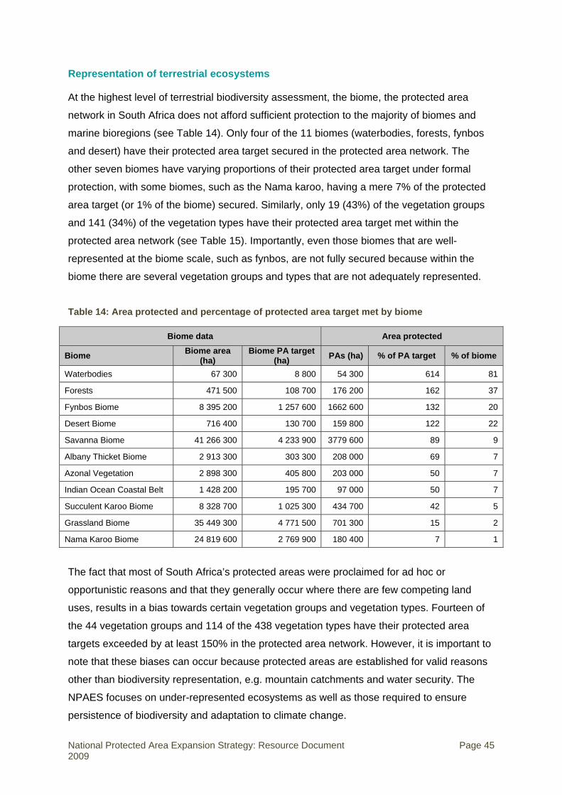
Representation of terrestrial ecosystems
At the highest level of terrestrial biodiversity assessment, the biome, the protected area
network in South Africa does not afford sufficient protection to the majority of biomes and
marine bioregions (see Table 14). Only four of the 11 biomes (waterbodies, forests, fynbos
and desert) have their protected area target secured in the protected area network. The
other seven biomes have varying proportions of their protected area target under formal
protection, with some biomes, such as the Nama karoo, having a mere 7% of the protected
area target (or 1% of the biome) secured. Similarly, only 19 (43%) of the vegetation groups
and 141 (34%) of the vegetation types have their protected area target met within the
protected area network (see Table 15). Importantly, even those biomes that are well-
represented at the biome scale, such as fynbos, are not fully secured because within the
biome there are several vegetation groups and types that are not adequately represented.
Table 14: Area protected and percentage of protected area target met by biome
Biome data Area protected
Biome Biome area (ha)
Biome PA target(ha) PAs (ha) % of PA target % of biome
Waterbodies 67 300 8 800 54 300 614 81
Forests 471 500 108 700 176 200 162 37
Fynbos Biome 8 395 200 1 257 600 1662 600 132 20
Desert Biome 716 400 130 700 159 800 122 22
Savanna Biome 41 266 300 4 233 900 3779 600 89 9
Albany Thicket Biome 2 913 300 303 300 208 000 69 7
Azonal Vegetation 2 898 300 405 800 203 000 50 7
Indian Ocean Coastal Belt 1 428 200 195 700 97 000 50 7
Succulent Karoo Biome 8 328 700 1 025 300 434 700 42 5
Grassland Biome 35 449 300 4 771 500 701 300 15 2
Nama Karoo Biome 24 819 600 2 769 900 180 400 7 1
The fact that most of South Africa’s protected areas were proclaimed for ad hoc or
opportunistic reasons and that they generally occur where there are few competing land
uses, results in a bias towards certain vegetation groups and vegetation types. Fourteen of
the 44 vegetation groups and 114 of the 438 vegetation types have their protected area
targets exceeded by at least 150% in the protected area network. However, it is important to
note that these biases can occur because protected areas are established for valid reasons
other than biodiversity representation, e.g. mountain catchments and water security. The
NPAES focuses on under-represented ecosystems as well as those required to ensure
persistence of biodiversity and adaptation to climate change.
National Protected Area Expansion Strategy: Resource Document Page 45 2009

Table 15: Number of vegetation groups and vegetation types for which the protected area target has been met in the protected area network (shown as a proportion of the total number per biome)
Biome Vegetation groups for which protected area target has been met
Vegetation types for which protected area target has been met
Number / total % Number / total %
Albany Thicket Biome 0 / 1 0 3 / 14 21
Azonal Vegetation 2 / 6 33 15 / 34 44
Desert Biome 1 / 2 50 6 / 15 40
Forests 2 / 2 100 8 / 12 67
Fynbos Biome 5 / 12 42 50 / 119 42
Grassland Biome 0 / 4 0 10 / 72 14
Indian Ocean Coastal Belt 0 / 1 0 2 / 3 67
Nama-Karoo Biome 0 / 3 0 1 / 14 7
Savanna Biome 3 / 6 50 29 / 87 33
Succulent Karoo Biome 5 / 6 83 15 / 63 24
Waterbodies 1/1 100 2 / 3 67
Total 19 / 44 43 141 / 438 32
Representation of freshwater ecosystems
The following profile of freshwater ecosystem protection levels is derived from a desktop
spatial assessment done for the NPAES by the CSIR (Nel et al. 2007). The focus is on river
ecosystems only.
Freshwater ecosystems are poorly protected across South Africa, with only 26 of the 222
rivers types having their protected area target met (see Figure 6). River types are defined
based on a combination of Level 1 ecoregions, flow variability, and longitudinal zonation (Nel
et al. 2007). Seventy-seven river types are not represented at all in protected areas, while a
further 87 rivers have less than 30% of their protected area target met.
National Protected Area Expansion Strategy: Resource Document Page 46 2009
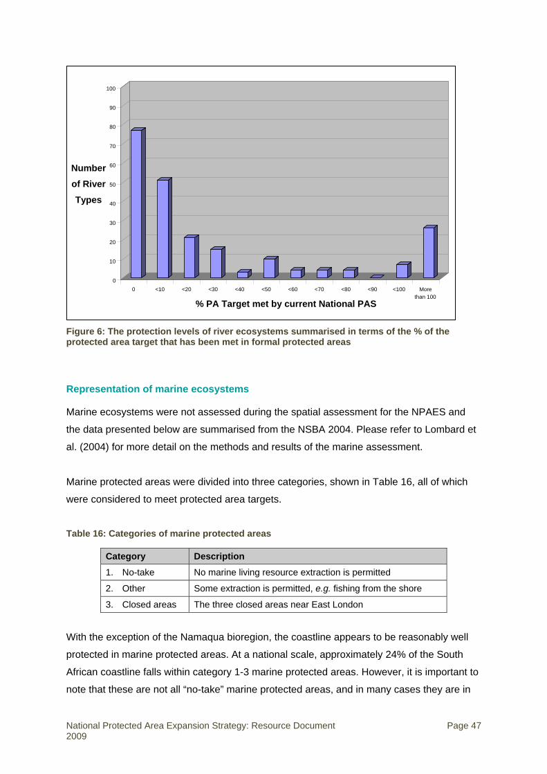
% PA Target met by current National PAS
Morethan 100
<100<90<80<70<60<500 <10 <20 <30 <40
Number of River Types
100
90
80
70
60
50
40
30
20
10
0
Figure 6: The protection levels of river ecosystems summarised in terms of the % of the protected area target that has been met in formal protected areas
Representation of marine ecosystems
Marine ecosystems were not assessed during the spatial assessment for the NPAES and
the data presented below are summarised from the NSBA 2004. Please refer to Lombard et
al. (2004) for more detail on the methods and results of the marine assessment.
Marine protected areas were divided into three categories, shown in Table 16, all of which
were considered to meet protected area targets.
Table 16: Categories of marine protected areas
Category Description
1. No-take No marine living resource extraction is permitted
2. Other Some extraction is permitted, e.g. fishing from the shore
3. Closed areas The three closed areas near East London
With the exception of the Namaqua bioregion, the coastline appears to be reasonably well
protected in marine protected areas. At a national scale, approximately 24% of the South
African coastline falls within category 1-3 marine protected areas. However, it is important to
note that these are not all “no-take” marine protected areas, and in many cases they are in
National Protected Area Expansion Strategy: Resource Document Page 47 2009

fact nodes of exploitation. The marine protected areas are also unevenly distributed among
inshore marine bioregions (see Table 17), with Delagoa having 100% protected and
Namaqua having zero protection status. There has not yet been an assessment of protection
of marine ecosystems at a spatial scale finer than marine bioregions, so even bioregions that
appear to be relatively well protected are likely to include under-protected ecosystems.
In contrast to the coastline, South Africa’s EEZ is very poorly protected with only 0.41% in
marine protected areas and only 0.16% as no-take (see Table 18). Although the addition of
the proposed Namaqua marine protected area to the marine protected area estate would
almost triple the area of the EEZ under protection, this would still fall far short of the
protected area target for the EEZ.
Table 17: Protection of South Africa’s inshore marine bioregions in marine protected areas (categories 1-3) measured as the length (km) of coastline (Lombard et al. 2004)
Bioregion Cat. 1 Cat. 2 Cat. 3 % in MPAs Total length
Namaqua 0 0 0 0 684
SW Cape 51 163 0 51.0 420
Agulhas 197 78 52 19.2 1 706
Natal 43 100 0 20.6 693
Delagoa 43 110 0 100 153
Total 334 451 52 24.4 3 656
Table 18: Protection of South Africa’s EEZ (all offshore bioregions) in marine protected areas (categories 1-3) (Lombard et al. 2004)
Category 1 Category 2 Category 3 Total
Area (ha) 176 100 250 100 26 100 107 188 300
Percentage 0.16 0.23 0.02 1.4
National Protected Area Expansion Strategy: Resource Document Page 48 2009
5. Spatial analysis of focus areas for protected area expansion
This section provides an overview of the systematic biodiversity planning approach and
methods used to conduct the spatial assessment of priorities for protected area expansion.
For more detail please refer to Holness et al (in prep).
The purpose of the spatial analysis of priorities for protected area expansion was to identify
gaps in the protected area network, to identify where protected area expansion would
contribute to meeting national biodiversity targets, and then to prioritise spatially within these
areas in order to identify protected area expansion priorities that would result in a more
representative and efficient protected area network that also provides for persistence and
climate change adaptation. The result of the spatial analysis was the focus areas for
protected area expansion shown in Figure 2. The spatial analysis included terrestrial and
freshwater components. The marine component is least developed, based only on the
analysis done for the NSBA 2004 and a previous biodiversity plan for the Prince Edward
Islands EEZ. Estuaries have been incorporated to some extent through the selection of
priorities in the freshwater analysis, but there is no explicit estuarine component. The
freshwater component is being developed further through the National Freshwater
Ecosystem Priority Areas (NFEPA) Project, which will identify a national network of
freshwater conservation areas and will be completed in 2011. The marine component is
being developed further through the Offshore Marine Protected Area Project, which will
design options for an offshore marine protected area network and will be completed in 2010.
The estuarine component is being taken further through the NSBA 2010, which will identify
an agreed set of national estuarine protected area priorities.
The systematic biodiversity planning approach
Although several approaches can be used to plan for biodiversity conservation, South Africa
has adopted the principles and practice of systematic biodiversity planning (often referred to
as systematic conservation planning), and indeed is a leader in the development and
application of this science. In addition to the principles of representation and persistence and
the setting of quantitative biodiversity targets (see Section 2, sub-section on NSBA),
systematic biodiversity planning encourages efficiency (i.e. achieving biodiversity targets in
the smallest area possible) and allows for conflict avoidance (by avoiding meeting
biodiversity targets in areas where there are many competing land uses) through including
spatial data on a range of socio-economic factors.
National Protected Area Expansion Strategy: Resource Document Page 49 2009

South Africa is one of the first countries to apply systematic biodiversity planning principles
across the terrestrial, freshwater and marine environments, as was done in the NSBA 2004.
Further, each province is encouraged to produce and maintain a systematic provincial
biodiversity plan, with assistance from SANBI. NBF Priority Action 16 states that every
province should have a spatial biodiversity plan, based on a systematic biodiversity
assessment incorporating both aquatic and terrestrial features, which identifies geographic
biodiversity priority areas.
Biodiversity targets and protected area targets
The term “target” is used in two ways in the NPAES: biodiversity target, and protected area
target. Each of these terms is explained below. It is important not to confuse the two.
Biodiversity targets refer to how much (defined as an area) of each biodiversity feature
should ideally be protected to ensure it will persist. Biodiversity targets should be based on
the ecological characteristics of the biodiversity feature concerned. Although they may be
refined over time as our scientific knowledge and information improves, they are not “action
targets” or political targets that change every few years. The spatial analysis in the NPAES is
based on the biodiversity targets set in the NSBA 2004.
The international norm of a flat 10% target was felt to be insufficient in a country as
biodiversity-rich as South Africa. The NSBA 2004 set national biodiversity targets for a range
of biodiversity features. For example, each national vegetation type has a biodiversity target
based on its species-richness. The biodiversity target for the least species-rich vegetation
types is 16% of the original area of the vegetation type, and for the most species-rich
vegetation types the target is 36% of the original areas of the vegetation type.21 In the
absence of a clear ecological basis for setting biodiversity targets, such as for marine and
freshwater aquatic systems, the NSBA 2004 set a generic biodiversity target of 20% of the
original extent of the biodiversity feature concerned.
Protected area targets refer to the area of land that should be included in the protected
area network by a certain date. They are action targets or political targets that should be
updated every few years.
21 The methodology for setting these biodiversity targets is based on an assessment of species-area curves (Desmet & Cowling, 2004).
National Protected Area Expansion Strategy: Resource Document Page 50 2009

What is the relationship between biodiversity targets and protected area targets? Protected area targets should be a subset of biodiversity targets. In the very long term, we would
like our protected area targets to equal or even exceed our biodiversity targets. However, it
is not a realistic goal to meet all national biodiversity targets in the protected area network in
the next five or fifteen or even twenty years. Protected area targets are useful to focus
attention in the medium term on meeting a realistic subset of our biodiversity targets.
The spatial analysis of priorities for land-based protected area expansion uses the NBSAP
15-year overall protected area target of 12% of total terrestrial surface area as a starting
point for developing ecosystem-specific protected area targets. This area is equivalent to
approximately 54% of the overall area required to achieve all the biodiversity targets.
Therefore in order to efficiently allocate the anticipated protected area expansion across the
biodiversity features, a protected area target was established for each vegetation type that
equates to 54% of its biodiversity target. In addition, protected area targets were established
at the vegetation group and biome level, based on the aggregated targets of their
component vegetation types. A 20% target was set for ecological process areas.
Input layers
The systematic biodiversity planning approach used in the spatial analysis of priorities for
protected area expansion relied heavily on several key data layers, outlined briefly below:
• Updated protected area data layer;
• Updated transformation and fragmentation layers;
• Biodiversity pattern and ecological process layers:
o Terrestrial,
o Freshwater;
• Priorities from other systematic biodiversity plans.
Protected area layer
The protected area spatial layer forms a critical part of the spatial assessment of priorities for
protected area expansion. Although time and resources limited the opportunity to fully
update the protected area layer compiled for the NSBA 2004, two key deficiencies were
addressed:
National Protected Area Expansion Strategy: Resource Document Page 51 2009

• The NSBA 2004 protected area spatial layer was updated with the latest data from all the
protected area agencies. Changes reflected both new and expanded protected areas, as
well as corrections to significant errors in presence/absence and spatial extent of
protected areas already in the dataset.
• The classification of protected areas was aligned with the Protected Areas Act. The
NSBA classified protected areas as Type 1, 2 or 3 based primarily on their legal security.
The spatial analysis for the NPAES includes all formal protected areas declared in terms
of the Protected Areas Act, and does away with the division into Types.
Although the layer is an improvement on the NSBA 2004 layer, a more accurate protected
area layer is a key priority for provincial protected area expansion programmes, for the
NSBA 2010 and for future revisions of the NPAES.
Transformation and fragmentation layer
An important step in the spatial analysis is to be able to restrict the selection of priority areas
for protected area expansion to land that has not been irreversibly transformed by human
activity such as urban development, cultivation, mining or severe degradation. Furthermore,
there are practical management reasons to avoid selecting priority areas where the
remaining intact land is so fragmented that it would be impractical or inefficient to manage it
as a protected area. These fragmented areas are also likely to have lost elements of
biodiversity pattern and are likely to be missing key ecological processes. This requires the
development of a transformation layer and a landscape fragmentation layer.
The transformation layer was compiled from several existing national and provincial datasets
of various spatial resolutions (see Table 19). Finer scale provincial or other layers took
precedence over the broad-scale National Land Cover 2000. The final transformation layer
had a resolution of approximately 1 ha pixel size, but should be used with great caution at
any scale finer than 1:50 000.
Table 19: Datasets used in the compilation of a transformation layer for the spatial analysis
Database Fields or data used
National Land Cover 2000 • Natural • Arable farming • Plantation • Urban, including industrial and mined areas • Degraded Areas
National Protected Area Expansion Strategy: Resource Document Page 52 2009

Database Fields or data used
Supplementary data from the 1:50 000 topographic map series
• Dams • Major roads (national, secondary, main etc) with 50m buffer • Railway lines
Provincial and other transformation datasets
• KwaZulu-Natal land cover • Mpumalanga land cover • Garden Route Initiative transformation
Note: some provincial layers, such as Gauteng’s, were excluded as they were too fine-scale and technically unmanageable at the national scale.
The transformation layer was used as the basis for calculating habitat fragmentation by
assessing the level of intactness of the area around a particular point. Areas were
considered to be fragmented if they were not at least 75% intact at a variety of scales (c. 9,
25, 49, 121 & 529 ha). A second separate filter of fragment size was applied so that only
natural areas larger than 50 ha were available for selection in the spatial analysis.
Terrestrial biodiversity pattern
The biodiversity pattern data used in the terrestrial component of the spatial analysis were
the 438 national vegetation types from the Vegetation Map of South Africa, Lesotho and
Swaziland (Mucina & Rutherford 2006). In addition, these basic units were analysed as
aggregated vegetation groups and biomes grouped according to the classification of Mucina
& Rutherford (2006). Vegetation types are generally considered useful surrogates for other
unmapped biodiversity in the landscape.
Ecological processes
A new ecological processes layer was derived for this assessment. This layer included the
following elements, each of which is described briefly below:
• Climate and landscape heterogeneity,
• Coastal processes,
• Habitat heterogeneity,
• Centres of floral endemism,
• River associated movement corridors.
Those areas of the country that have high levels of climate and landscape heterogeneity
are believed to provide opportunity for species and systems to adapt to climate change.
These areas represent important upland-lowland and climatic gradients along which species
National Protected Area Expansion Strategy: Resource Document Page 53 2009

will have to move and may include refugia for those species that otherwise may not be able
to adapt to rapid environmental change. A series of topographic and climatic indices were
combined in the preparation of this layer:
• Topographic heterogeneity (altitude),
• Temperature gradients,
• Precipitation gradients.
The coastal process layer was compiled using an inclusive definition of “coastal process
areas”, including:
• A minimum coastal buffer of 1km,
• Areas that comply with the legal definitions in the National Environmental Management:
Integrated Coastal Management Act (Act 24 of 2008),
• Land types associated with coastal geomorphological processes, especially sand dunes,
• Coastal vegetation units as defined in the South African Vegetation Map (Mucina &
Rutherford 2006), selected based on their ecological classification and description,
• Additional wetland vegetation types that are adjacent to or intersect the above coastal
layers, where these have been mapped.
Areas with high levels of habitat heterogeneity were identified using the South African
Vegetation Map at three scales: biome, vegetation group and vegetation type. These areas
have high levels of floristic diversity and are likely to represent areas of high levels of
speciation. The number of biomes, groups or types was calculated for each 49km2 area.
Areas were considered to have high habitat heterogeneity if they contained:
• Three or more biomes,
• Three or more vegetation groups, or
• Four or more vegetation types.
Southern Africa has extremely high levels of floristic diversity and endemism. Most of these
endemic species are concentrated in a few relatively small and clearly defined centres of floral endemism. At a national scale these centres represent:
• A unique species composition,
• The ecological processes that have caused such high levels of biodiversity,
• The characteristics which allow these high levels of diversity to persist.
National Protected Area Expansion Strategy: Resource Document Page 54 2009

The remaining intact areas of the floristic centres of endemism summarised in Regions of
Floristic Endemism in Southern Africa were used.
Corridors provide critical ecological linkages between large core patches of intact habitat
through hostile matrix areas of transformed habitat. Corridors are seen to be critical for the
movement of a variety of animal species in the short term (pollinators, predators), to provide
for genetic interchange between spatially separate populations of animals in the medium
term, and in the long term are hoped to be important for the migration of plant and other
species under conditions of global climate change. One of the most clearly defined corridors,
especially in heavily transformed arable agriculture and urbanised landscapes, are those
associated with rivers. Importantly, these river associated movement corridors also
provide upland-lowland linkages on the macro-scale. A corridor layer was created based on
second order and larger rivers and a cost surface derived from the transformation and
fragmentation layer. A total corridor width of approximately 1km was aimed for in completely
transformed landscapes, and 10km in completely natural areas, with the corridors varying in
width in response to the level and pattern of transformation.
Freshwater representativeness and persistence
A freshwater representativeness and persistence layer was derived based on the following
considerations:
• Representation of freshwater pattern in intact rivers (biodiversity targets were set for
representation of river type and endemic fish species),
• Connectivity between representative river sections,
• Free-flowing rivers (rivers with no impoundments or with low levels of impoundments
were identified to protect important riverine and estuarine processes),
• Areas where minor expansion of a protected area would capture whole river systems
• River systems supporting priority estuaries.
Priorities from other systematic plans
An updated ecosystem status layer based on the approach used in the NSBA 2004
analysis was incorporated. The ecosystem status of each vegetation type was calculated
using the proportion of remaining natural habitat per vegetation type:
• Critically Endangered (CR) = at or below the biodiversity target,
National Protected Area Expansion Strategy: Resource Document Page 55 2009
• Endangered (EN) = at or below biodiversity target + 15% of original area,
• Vulnerable (VU) = at or below 60% of original area.
Taking cognisance of the considerable systematic biodiversity planning already done in
South Africa at a variety of scales, the spatial analysis included the top priority areas
identified in existing systematic biodiversity plans. This was important because
systematic biodiversity plans done at provincial or finer scale are able to draw on much
richer data sources than is possible in a national spatial assessment (for example species
data or more detailed transformation maps). In addition, this allows better alignment of the
national and provincial plans. This layer was used as part of a cost surface to bias the areas
selected within the national assessment towards areas favoured by the provincial plans,
while still using biodiversity targets that are consistent with national biodiversity targets and
applying the principles of systematic biodiversity planning.
Top priorities from the following provincial and other fine-scale plans were used:
• Mpumalanga Biodiversity Conservation Plan (top 20% by area)
• Gauteng C-Plan (top 20% by area)
• KwaZulu-Natal Biodiversity Conservation Plan (top 20% by area)
• Eastern Cape Biodiversity Conservation Plan (top 20% by area)
• Western Cape Interim Assessment (remaining intact areas of threatened ecosystems
supplemented by Criterion D ecosystems, approximately 26% by area)
• Leslie Hill Succulent Karoo Systematic Assessment (top 20% by area)
• Grasslands Systematic Assessment (only used in provinces with no systematic
assessment, priority biodiversity areas with all non-intact areas removed)
• DWAF Forest Conservation Plan (only used in provinces with no systematic assessment,
top two priority categories)
Analysis and integration
A dual systematic biodiversity planning approach was used in the analysis for the NPAES:
• A fine-scale summed irreplaceability approach,
• A coarser scale MARXAN-based analysis.
National Protected Area Expansion Strategy: Resource Document Page 56 2009

The reason for the dual approach was to allow the analysis to provide a very fine resolution,
while still producing a spatially efficient result taking into account the issues of adjacency
and clumping.
Summed irreplaceability approach
A summed irreplaceability approach was undertaken to provide a very fine resolution picture
of the importance of different areas for protected area consolidation. The analysis was
undertaken in a raster environment, with a resolution of approximately 1ha. This approach
examines how necessary each planning unit is in terms of meeting the protected area target
for each feature, and then sums these for each planning unit.22
The protected area target for each biodiversity feature was compared to the intact area of
that feature that was already protected within a formal protected area. Major transformed
areas in protected areas, such as dams, were not considered to contribute to meeting
biodiversity targets for each feature. Where a protected area target had not yet been met
within the current protected area network, the remaining portion of the target was evaluated
against the intact natural areas outside the protected area network that are still available for
meeting the biodiversity target. The analysis examines the degree to which each available
portion of the habitat outside the current protected area network is required in terms of
meeting the biodiversity target for that feature. A planning unit would have an irreplaceability
of 0 for that feature if it did not contain any of that feature or if the target for that feature has
already been met in the existing protected area network. Conversely, if a planning unit is
always required in order to meet the biodiversity target for that feature then it will have an
irreplaceability of 1.
The irreplaceability values for each planning unit were calculated for:
• Vegetation types,
• Vegetation groups,
• Biomes,
• Terrestrial processes,
• Freshwater.
22 The analysis was undertaken using the CPlan irreplaceability algorithm for equal sized planning units, although as the analysis was undertaken in a raster planning environment, the actual analysis took place using IDRISI.
National Protected Area Expansion Strategy: Resource Document Page 57 2009

The summed irreplaceability of a planning unit was calculated based on its requirement to
meet all of the above targets simultaneously.
In order to align the analysis more closely with other national planning processes, the
following two layers were processed into a format compatible with the summed
irreplaceability values:
• Ecosystem status,
• Priorities from other plans.
These were added to the summed irreplaceability values to provide a composite
irreplaceability value for each planning unit.
MARXAN- based analysis
The summed irreplaceability approach provides a useful fine-scale analysis of what an
individual area contributes in terms of meeting national protected area targets. However, it
does not identify specific priority areas, provide an efficient reserve network or take issues
such as adjacency to existing protected areas into account. In order to design an efficient
reserve network the widely used MARXAN systematic planning software program was used.
Hexagon planning units of 2000 ha were used.
Similar to the summed irreplaceability approach, the program evaluates the targets for each
biodiversity feature against the current protected area network and the remaining natural
areas available to meet the targets. The analysis was run using the targets for vegetation
types, vegetation groups, biomes and terrestrial processes.
MARXAN attempts to produce a least-cost solution that meets the biodiversity targets.
These costs are calculated based on three elements:
• Boundary costs,
• Planning unit costs,
• Costs of not meeting targets.
Boundary costs: MARXAN addresses the issues of adjacency and producing clumped
priority areas around existing protected areas and rare biodiversity features (rather than a
shotgun scatter of individual planning units) by attempting to reduce the boundary cost of the
National Protected Area Expansion Strategy: Resource Document Page 58 2009

selected solutions. Conceptually, a group of adjacent planning units will have a shorter
external boundary than the same number of spatially separated units. This is important both
from a management perspective (in that it identifies consolidated protected areas and priority
areas) and an ecological perspective (in that it reduces edge effects and tends to identify
larger, connected priority areas that are more likely to persist).
Planning unit costs: A cost surface was prepared to identify the cost of each planning unit:
• The transformation and fragmentation layer was used as the primary input in the cost
surface. Planning units with high proportions of transformed areas were given a far
higher base cost than degraded or fragmented areas, which in turn had a far higher cost
than natural areas.
• The base costs were modified by the freshwater cost surface layer. The costs of
remaining natural areas identified within the freshwater analysis were reduced
proportionally based on the irreplaceability of the area in terms of meeting freshwater
targets.
• The base costs were also modified by the priority areas from other plans layer. The
remaining natural areas identified within the priority plans layer had a reduced cost.
The costs of not meeting targets: Although MARXAN attempts to meet all targets it may
not be efficient or possible to meet all protected area targets in some high cost areas (e.g.
fragmented and transformed landscapes). In order to identify the balance between high cost
solutions and not meeting all the targets, a cost of not meeting targets is set.
The MARXAN analysis iteratively examines very high numbers of possible protected area
network solutions, and examines these against the costs of each of the protected area
solutions. It identified an efficient potential protected area network that would meet the
majority of terrestrial and ecological process protected area targets, while favouring areas
that also meet freshwater biodiversity targets and areas that were identified within other
systematic biodiversity plans, while avoiding transformed and fragmented landscapes.
Final integration
The summed irreplaceability and MARXAN-based analyses were combined to produce a
composite analysis of importance for land-based protected area expansion (see Figure 7
below). Hence areas that were favoured in both of the analyses would be identified as being
of very high importance, while areas that were favoured by only one analysis would be of
National Protected Area Expansion Strategy: Resource Document Page 59 2009
less importance. The highest values from the final combined importance layer were selected,
and those fragments smaller than 5 000 ha were removed. The remaining selected areas of
high importance were grouped based on their underlying biodiversity characteristics, their
geographical location or their proximity to existing protected areas, to form focus areas for land-based protected area expansion (see Figure 8 below). These focus areas, as well as
the underlying combined analysis of importance for protected area expansion, form the
summary product of the spatial analysis, discussed in more detail below. The existing
priorities from the NSBA 2004 marine analysis were used without new analysis as the best
available priority areas for marine protected area expansion, pending the outcome of the
Offshore Marine Protected Area Project.
Summary of results of the spatial analysis
Focus areas for protected area expansion, and area required to meet protected area targets
As explained above, the spatial analysis identified areas of high importance for meeting
protected area targets for biodiversity features, shown in Figure 7. The high importance
areas identified in this analysis are important for all forms of protected area activity, including
the creation of large state-owned protected areas, contract protected areas, and
conservation areas. Within these areas of high importance, large intact and un-fragmented
areas suitable for the creation or expansion of large (> 5 000 ha) protected areas were
identified, termed focus areas for protected area expansion. These focus areas are shown in
Figure 6.
The focus areas for protected area expansion are areas where protected area activity should
be focused in order to meet the 20 year protected area targets most efficiently. They have a
total terrestrial area of 1 278 200 ha, which represents 9.7% of the total surface area of
South Africa, Lesotho and Swaziland,23 and is equivalent to approximately 1.5 times the
current protected area network. However, it is critical to understand that in most cases it is
not necessary to protect the entire focus area, as these are areas within which protected
area expansion is spatially efficient (in terms of improving the representivity of protected
area network and meeting protected area targets) rather than the protected area targets
themselves. For example, although large areas of the Desert Biome (51%) fall within the
23 For ecological and conservation planning considerations relating to connectivity of ecosystems, the spatial assessment was undertaken for South Africa, Lesotho and Swaziland. This in no way intends to imply what these other sovereign nations should undertake in terms of conservation activities.
National Protected Area Expansion Strategy: Resource Document Page 60 2009

focus areas, only a further 13.4% of this biome is required in order to meet the protected
area targets for the biodiversity features in the region.
Figure 7: Areas of high importance for land-based protected area expansion (i.e. areas of high value for meeting protected area targets for biodiversity features)
National Protected Area Expansion Strategy: Resource Document Page 61 2009
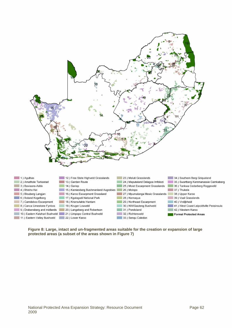
Figure 8: Large, intact and un-fragmented areas suitable for the creation or expansion of large protected areas (a subset of the areas shown in Figure 7)
National Protected Area Expansion Strategy: Resource Document Page 62 2009

Table 20 summarises the areas required to meet protected area targets in each province.
The areas required range from 5.5% (Limpopo) up to a maximum of 12.2% (Free State) of a
province. The five-year protected area targets are calculated as a quarter of the twenty-year
targets.
Table 20: Areas required to meet protected area targets by province
Province Province
area (000ha)
20-year PA target
(%)
Current protected areas
Still required to meet 20-year veg type
targets
Required in the next 5 years
000ha % 000ha % 000ha %
Eastern Cape 16 893 12 687 4.1 1 570 9.3 393 2.3
Free State 12 983 13 167 1.3 1 581 12.2 395 3.0
Gauteng 1 655 13 84 5.1 152 9.2 38 2.3
KwaZulu-Natal 9 333 13 731 7.8 842 9.0 211 2.3
Limpopo 12 575 11 1 489 11.8 687 5.5 172 1.4
Mpumalanga 7 649 13 1 168 15.3 632 8.3 158 2.1
North West 10 651 11 199 1.9 991 9.3 248 2.3
Northern Cape 37 289 11 1 582 4.2 3 333 8.9 833 2.2
Western Cape 12 945 13 1 632 12.6 1 004 7.8 251 1.9
Table 21 summarises the areas required to meet targets in each biome. Generally between
1.7 and 13.4% of the different biomes is required (Table 21). The greatest actual areas are
required in Grassland, Nama Karoo, Savanna and Succulent Karoo. Two critical points need
to be emphasised:
• Firstly, the actual areas which should receive priority attention will need to be defined by
detailed planning that takes into account both opportunities and constraints at a local
level and should form part of the provincial spatial biodiversity plans as they are
developed. This issue is partially addressed below.
• Secondly, the actual area requirements for meeting the protected targets are defined in
terms of individual vegetation types, and hence for an efficient and representative
reserve network, protected area expansion needs to be appropriately directed to the
individual vegetation types which are under-represented rather than to a biome.
National Protected Area Expansion Strategy: Resource Document Page 63 2009
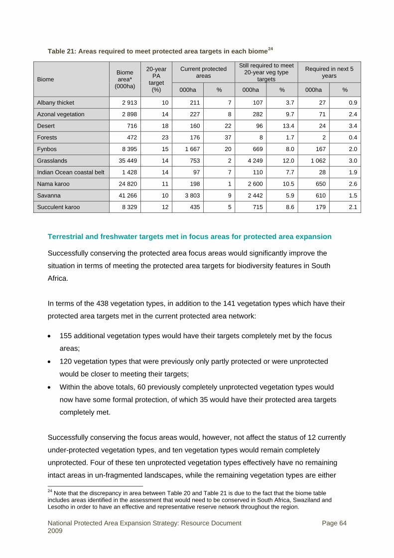
Table 21: Areas required to meet protected area targets in each biome24
Biome Biome area*
(000ha)
20-year PA
target (%)
Current protected areas
Still required to meet 20-year veg type
targets
Required in next 5 years
000ha % 000ha % 000ha %
Albany thicket 2 913 10 211 7 107 3.7 27 0.9
Azonal vegetation 2 898 14 227 8 282 9.7 71 2.4
Desert 716 18 160 22 96 13.4 24 3.4
Forests 472 23 176 37 8 1.7 2 0.4
Fynbos 8 395 15 1 667 20 669 8.0 167 2.0
Grasslands 35 449 14 753 2 4 249 12.0 1 062 3.0
Indian Ocean coastal belt 1 428 14 97 7 110 7.7 28 1.9
Nama karoo 24 820 11 198 1 2 600 10.5 650 2.6
Savanna 41 266 10 3 803 9 2 442 5.9 610 1.5
Succulent karoo 8 329 12 435 5 715 8.6 179 2.1
Terrestrial and freshwater targets met in focus areas for protected area expansion
Successfully conserving the protected area focus areas would significantly improve the
situation in terms of meeting the protected area targets for biodiversity features in South
Africa.
In terms of the 438 vegetation types, in addition to the 141 vegetation types which have their
protected area targets met in the current protected area network:
• 155 additional vegetation types would have their targets completely met by the focus
areas;
• 120 vegetation types that were previously only partly protected or were unprotected
would be closer to meeting their targets;
• Within the above totals, 60 previously completely unprotected vegetation types would
now have some formal protection, of which 35 would have their protected area targets
completely met.
Successfully conserving the focus areas would, however, not affect the status of 12 currently
under-protected vegetation types, and ten vegetation types would remain completely
unprotected. Four of these ten unprotected vegetation types effectively have no remaining
intact areas in un-fragmented landscapes, while the remaining vegetation types are either 24 Note that the discrepancy in area between Table 20 and Table 21 is due to the fact that the biome table includes areas identified in the assessment that would need to be conserved in South Africa, Swaziland and Lesotho in order to have an effective and representative reserve network throughout the region.
National Protected Area Expansion Strategy: Resource Document Page 64 2009

naturally extremely fragmented or have a very limited original extent and occur in a
transformed matrix, or have their remaining natural areas occurring within highly fragmented
landscapes. Conservation action for these vegetation types is probably best addressed by
conservation mechanisms other than protected areas.
In terms of protected area targets for the 44 vegetation groups, in addition to the 18 groups
which have their targets met in the current protected area network:
• 17 additional groups would have their targets completely met by the focus areas;
• Nine additional groups that were previously only partly protected would be closer to
meeting their targets.
In terms of the 11 biomes, in addition to the four biomes which have their protected area
targets met in the current protected area network:
• Six additional biomes would have their targets completely met by the focus areas;
• One biome that was previously only partly protected would be closer to meeting its target
(Nama Karoo would move from 6.5% to 73% of its target).
In terms of meeting freshwater targets, conserving the protected area focus areas and the
current protected area network would significantly improve the status of protection of the
region’s freshwater resources. Figure 9 summarises the change in protection level that
would be achieved for river ecosystems. Key changes include an increase in the number of
well protected river ecosystem types from 26 to 68, in moderately protected river ecosystem
types from 19 to 35, and a decrease in the number of unprotected ecosystem types from 77
to 44.
National Protected Area Expansion Strategy: Resource Document Page 65 2009

61
39
19
26
44
64
11
35
77
68
0
10
20
30
40
50
60
70
80
90
Not protected Poorly protected Hardly protected Moderately protected Well protected
Num
ber o
f riv
er ty
pes
Curent PAsProposed areas
Figure 9: Improvement in the protection level of river ecosystems that would result if the focus areas were conserved
Urgency of protected area activity in different areas
The previous subsections gave an overview of the spatial focus areas that will result in a
more representative and resilient protected area network. In time, all of these areas need to
be addressed. However, a critical issue is attaining an appropriate balance between focusing
protected area expansion on areas where there are good, relatively easy opportunities for
protected area creation that would in the long term result in a representative and an efficient
network, and focusing on urgently addressing current critical areas where the opportunity to
create protected areas is being rapidly lost by the transformation and fragmentation of
habitats. This is discussed in more detail in the NPAES. Detailed planning needs to take
place to ensure that the appropriate conservation mechanism (protected areas, legislation,
land-use planning) is applied in each area to ensure the efficient use of resources.
Broadly, a reasonable approximation of how urgent protected area expansion is in a
particular area can be obtained by looking at the irreplaceability of the vegetation types in
National Protected Area Expansion Strategy: Resource Document Page 66 2009
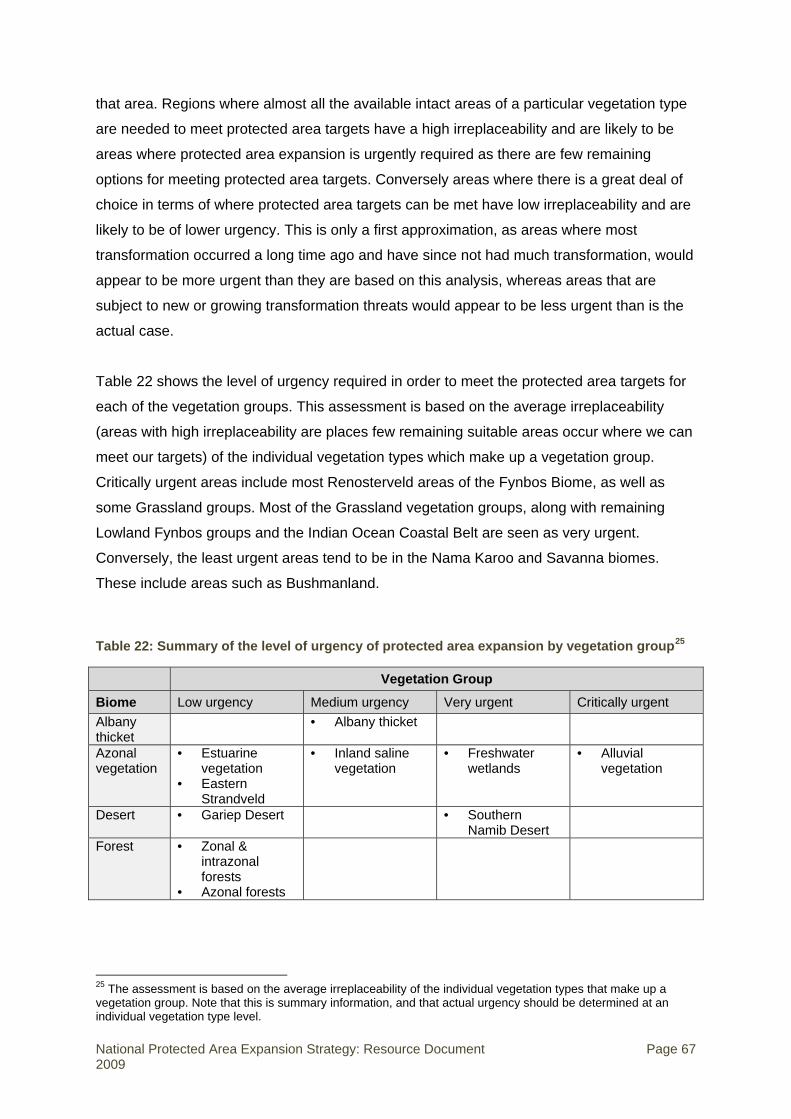
that area. Regions where almost all the available intact areas of a particular vegetation type
are needed to meet protected area targets have a high irreplaceability and are likely to be
areas where protected area expansion is urgently required as there are few remaining
options for meeting protected area targets. Conversely areas where there is a great deal of
choice in terms of where protected area targets can be met have low irreplaceability and are
likely to be of lower urgency. This is only a first approximation, as areas where most
transformation occurred a long time ago and have since not had much transformation, would
appear to be more urgent than they are based on this analysis, whereas areas that are
subject to new or growing transformation threats would appear to be less urgent than is the
actual case.
Table 22 shows the level of urgency required in order to meet the protected area targets for
each of the vegetation groups. This assessment is based on the average irreplaceability
(areas with high irreplaceability are places few remaining suitable areas occur where we can
meet our targets) of the individual vegetation types which make up a vegetation group.
Critically urgent areas include most Renosterveld areas of the Fynbos Biome, as well as
some Grassland groups. Most of the Grassland vegetation groups, along with remaining
Lowland Fynbos groups and the Indian Ocean Coastal Belt are seen as very urgent.
Conversely, the least urgent areas tend to be in the Nama Karoo and Savanna biomes.
These include areas such as Bushmanland.
Table 22: Summary of the level of urgency of protected area expansion by vegetation group25
Vegetation Group
Biome Low urgency Medium urgency Very urgent Critically urgent Albany thicket
• Albany thicket
Azonal vegetation
• Estuarine vegetation
• Eastern Strandveld
• Inland saline vegetation
• Freshwater wetlands
• Alluvial vegetation
Desert • Gariep Desert • Southern Namib Desert
Forest • Zonal & intrazonal forests
• Azonal forests
25 The assessment is based on the average irreplaceability of the individual vegetation types that make up a vegetation group. Note that this is summary information, and that actual urgency should be determined at an individual vegetation type level.
National Protected Area Expansion Strategy: Resource Document Page 67 2009

Vegetation Group
Low urgency Medium urgency Very urgent Critically urgent Biome Fynbos • Western
Fynbos-Renosterveld
• Namaqualand Cape Shrublands
• Southern Fynbos
• Karoo Renosterveld
• Northwest Fynbos
• South Strandveld
• South Coast Fynbos
• Eastern Fynbos-Renosterveld
• Southwest Fynbos
• West Strandveld
• East Coast Renosterveld
• West Coast Renosterveld
Grasslands • Drakenberg Grassland
• Dry Highveld Grassland
• Mesic Highveld Grassland
• Sub-Escarpment Grassland
Indian Ocean coastal belt
• Indian Ocean Coastal Belt
Nama karoo
• Lower Karoo • Bushmanland
• Upper Karoo
Savanna • Kalahari Duneveld
• Mopane
• Lowveld • Eastern
Kalahari Bushveld
• Central Bushveld
• Sub-Escarpment Savanna
Succulent karoo
• Richtersveld • Trans-Escarpment Succulent Karoo
• Rainshadow Valley Karoo
• Namaqualand Sandveld
• Namaqualand Hardeveld
• Knersvlakte
Marine assessment
As explained in Section 1, marine ecosystems were not assessed during the spatial
assessment for this NPAES, and the data presented in this document are summarised from
the NSBA 2004 and previous work done for the Prince Edward Islands EEZ. Important areas
for marine protected area expansion are shown in Figure 3 in Section 1. The areas of
greatest importance have been identified as the Namaqualand coast and offshore areas, the
Agulhas Bank and the Prince Edwards Islands EEZ.
The marine protected area targets summarised in Table 2 in Section 1 are based on
underlying targets for marine bioregions. Table 23 shows protected area targets for inshore
marine bioregions, and Table 24 shows offshore marine protected area targets. See the
main NPAES document for more discussion on these targets.
National Protected Area Expansion Strategy: Resource Document Page 68 2009

Table 23: Protected area targets for inshore marine bioregions
20-year PA target Current protected areas Required to meet 20-year target Required in next 5 years
Bioregion Length No-take Total No-take Total No-take Total No-take Total
km* % % km % km % km % km % km % km %
Namaqua 684 15 25 0 0 0 0 103 15 171 25 26 3.8 43 6.3
SW Cape 420 15 25 51** 12.1 214 51.0 12 2.9 -- -- 3 0.7 -- --
Agulhas 1706 15 25 197 11.5 275 16.1 59 3.5 152 8.9 15 0.9 38 2.2
Natal 693 15 25 43 6.2 143 20.6 61 8.8 30 4.4 15 2.2 8 1.1
Delagoa 153 15 25 43 28.1 153 100 -- -- -- -- -- -- -- --
Total 3656 15 25 334 9.1 785 21.5 234 6 353 9.6 56 1.5 88 2.4
Table notes: * Inshore marine targets are measured in kilometres of coastline because of the varying distances which inshore MPAs extend from the coastline. Inshore is considered to mean from the high water mark to the 30m depth contour. All inshore MPAs extend at least this far. In future we will move towards also using a more accurate area-based measure for inshore MPA targets, but this is not possible with current data. ** This includes the Langebaan Lagoon sanctuary area. Because the Langebaan Lagoon has estuarine characteristics there is not consensus on whether or not the sanctuary area should count towards meeting marine protected area targets.
Table 24: Offshore marine protected area targets
20-year PA target Current protected areas Required to meet 20-year
target Required in next 5 years
Area No-take Total No-take Total No-take Total No-take Total
000km2 % % 000km2 % 000
km2 % 000km2 % 000
km2 % 000km2 % 000
km2 %
Mainland EEZ 1 072 15 20 1.7 0.16 4.2 0.4 159 14.8 210 19.6 40 3.7 53 4.9
Prince Edward Islands EEZ 467 15 20 0 0 0 0 70 15 93 20 18 3.8 23 5
National Protected Area Expansion Strategy: Resource Document Page 69 2009

6. Mechanisms for protected area expansion: additional information26
The NPAES identifies targets for protected areas expansion and areas where expansion
efforts should be focused. It then identifies three main mechanisms for protected area
expansion: acquisition of land, contract agreements, and declaration of public land. This
section provides more detail on these mechanisms, as well as on the option of formalising
the protected area status of existing conservation areas. It describes the potential risks
associated with each protected area expansion mechanism, and proposes several mitigation
measures to reduce the anticipated impact of these risks. It includes a discussion on land
reform and protected area expansion.
Table 23 summarises the expansion mechanisms and implementation options available for
different land ownership and tenure arrangements. These are discussed in more detail in the
sub-sections that follow.
Table 25: Summary of expansion mechanisms for different land ownership and tenure arrangements
Mechanism Implementation options Land ownership and tenure
1. Acquisition of land i) Land donation Private
ii) Land purchase Non-state public land Private land
iii) Property lease State (provincial) Private land State (national) under communal tenure
iv) Land expropriation Private land
2. Negotiation of contract agreements with landowners
i) Contract nature reserve / contract national park / contract protected environment
Private land State (national) under communal tenure Non-state public land
3. Declaration of public land available for conservation
i) Allocate unvested/unallocated national state land to the protected area agency
State (national)
ii) Re-allocate national state land from a responsible national organ of state to the protected area agency
State (national)
iii) Lease national state land under communal tenure to the protected area agency
State (national) Communal tenure
26 Note that pre-July 2009 department names are used in this section.
National Protected Area Expansion Strategy: Resource Document Page 70 2009

Mechanism Implementation options Land ownership and tenure
iv) Dispose of provincial state land to the protected area agency
State (provincial)
v) Allocate/sell/lease or contract non-state, public land to the protected area agency
Non-state public land (local authorities, public entities, government enterprises)
4. Formalising the protected area status of existing conservation areas
i) Statutory conservation areas Private land State (national) State (provincial) Non-state public land
ii) Non-statutory conservation areas Non-state public land Private land
Acquisition of land
There are several options for acquiring land that should be considered for the expansion of
the protected area network:
• Land donations – Although not common, land donations are a highly cost-effective
alternative to land purchase and land expropriation, and are characterised by low
transaction costs.
• Land purchase – The limited funds available to purchase conservation-worthy land
means that this mechanism has limited applicability. Land purchase should be directed
toward key strategic properties of significant biodiversity value for incorporation into
protected areas of high conservation value. Efforts should be made to secure acquisition
funds from external sources, including the corporate sector and relevant NGOs (see
Section 7).
• Land leasing – A lease option may be considered in situations where a landowner is not
open to selling. The leasing option reduces the high transaction costs associated with
purchase, while leasing costs may be offset from income generated from commercial
tourism enterprises undertaken on the property.
• Land or rights expropriation – Land or rights expropriation should be used only in
exceptional circumstances to acquire properties (refer to suggested approach below) or
use rights. In the case of the marine environment, use rights (e.g. mining, fishing) may
be expropriated or modified in terms of Section 18 of the Marine Living Resources Act, to
enable the establishment of a marine protected area.
National Protected Area Expansion Strategy: Resource Document Page 71 2009

The suggested approach to land acquisition is summarised as follows:
• As part of the consultation and negotiation process with targeted landowners,
landowners should be encouraged, under certain circumstances, to donate all or part of
their land for conservation purposes. These circumstances may include instances where
the landowners are concerned with estate planning matters or where land is donated as
part of a biodiversity offset agreement. Donated land may be ceded directly to the
protected area agency, or ceded to an NGO and/or placed in a Land Trust that will in
turn contract it into a protected area (see discussion on contract agreements below).
Such a donation may be deemed a declared public benefit activity by the South African
Revenue Service (SARS) and the incentive of tax benefits for the donor should be
explored (see Section 7).
• Where land is being considered for purchase or leasing:
o Potential funding sources for land purchase, leasing and ongoing management
costs should be identified (see Section 7 for financing options for land acquisition),
and linked to the targeted properties.
o Subject to the availability of funds, the purchase of land should operate on a “willing
seller/willing lessee” basis.
o Legal counsel should be retained to provide ongoing advice on the legal
requirements associated with purchase or leasing of the land.
o In the case of purchase, a title search should be conducted confirming that the
proposed seller holds clear title to the target property, free and clear of any adverse
claims (including land claims), disputes, liens or other encumbrances.
o The proposed purchase/lease price and all other transaction costs associated with
the land purchase/land lease should be assessed prior to formal negotiation. Where
they exist, comparable transactions in the region should also be used to determine
the property sale or lease value.
o Where several properties are being considered in an area, different landowners
should be approached in a discrete and co-ordinated way to avoid the artificial
inflation of property prices and to reduce the risk of not acquiring some parcels of
land.
o In the case of a property purchase, a condition of the purchase (incorporated into
the title deed) should be that it is held in perpetuity for conservation purposes. The
entity taking title to the purchased property should be prohibited from selling or
otherwise transferring the land if any such transfer would adversely impact the
conservation objectives underlying the initial purchase.
National Protected Area Expansion Strategy: Resource Document Page 72 2009

o In the case of a lease, a long-term lease agreement (>25 years) should be
negotiated. Where possible, an option of first refusal should also be negotiated in
the instance where the owner wishes to sell the property.
o The land description in all purchase/lease documents, deeds, easements and
related documents should be verified against actual land boundaries.
• The option of voluntary expropriation for incorporation into the protected area estate may
be pursued with landowners in certain situations such as a deceased estate with no
apparent beneficiaries.
• Involuntary expropriation should be avoided wherever possible. However, where
expropriation is unavoidable, the land or right to the land may be expropriated only in
accordance with the Expropriation Act (Act 63 of 1975), subject to Section 25 of the
Constitution. Marine rights holders should be consulted prior to any amendments of
rights.
• Subject to the final outcomes of the National Treasury’s Environmental Fiscal Reform
process, the land transaction costs should be reduced wherever possible by motivating
for exemptions on taxes and duties associated with land acquisition for protected area
expansion (see Section 7).
• In instances where farm labourers are resident on a property, a resettlement framework
should be developed and implemented prior to acquisition to ensure compliance with the
Extension of Security of Tenure Act (Act 62 of 1997).
To complement the implementation of these acquisition mechanisms, provincial and national
protected area agencies should proactively engage with local government and other
government departments about land-use planning in the focus areas for protected area
expansion.
Negotiation of contract agreements with landowners
The term “biodiversity stewardship” has been introduced into the South African conservation
lexicon in the last few years to describe the formal commitment of landowners to conserve
and effectively manage the biodiversity on their land. Biodiversity stewardship programmes
have been established in some protected area agencies (e.g. CapeNature, EKZNW) and are
being developed in others (e.g. DTEC, MTPA, GDACE) to proactively secure formal
stewardship commitments from private (and other) landowners, and to encourage, facilitate
and support the implementation of good biodiversity management practices.
National Protected Area Expansion Strategy: Resource Document Page 73 2009

A draft national Biodiversity Stewardship Guideline Document has been developed by
DEAT, to provide support to provinces establishing biodiversity stewardship programmes. It
draws on the valuable experience of the well-established biodiversity stewardship
programmes in CapeNature and Ezemvelo KZN Wildlife. The Biodiversity Stewardship
Guideline Document provides much more detail than the brief overview below and is the
primary reference for those wanting to undertake biodiversity stewardship programmes.
DEAT is also in the process of developing a national Biodiversity Stewardship Policy.
Contract agreements through biodiversity stewardship programmes should be pursued not
only in the focus areas for protected area expansion, but also in threatened ecosystems
identified in the NSBA or listed in terms of the Biodiversity Act, and in priority areas identified
in provincial biodiversity plans. Threatened ecosystems are often highly fragmented and thus
not suitable for the creation or expansion of large protected areas, but contractual protected
areas through biodiversity stewardship programmes can play a crucial role in protecting
remaining natural habitat in these ecosystems
Protected area agencies with biodiversity stewardship programmes have developed a model
with three broad biodiversity stewardship options or categories which are offered to
landowners. These options differ in their level of long-term security for biodiversity. They
reflect different levels of conservation value of the land as well as different levels of
commitment to biodiversity conservation made by a landowner:
• Conservation areas – a basic, non-binding agreement by the landowner to undertake
sustainable land-use epractices on the property and to mitigate any impacts that land-
use activities may have on biodiversity.
• Biodiversity agreements – a formal legal agreement to maintain and manage the
important biodiversity features of the property. These can take the form of Biodiversity
Management Agreements in terms of the Biodiversity Act; alternatively they can be
based on contract law.
• Contract protected area – a formal long-term agreement to declare the property, or parts
of it, as a protected area in terms of the Protected Areas Act.
Only one biodiversity stewardship category, the contract protected area, is recommended as
a mechanism to expand the protected area network. This category includes all contract
agreements with landowners that lead to the declaration of the land in question as part of an
existing protected area or a new national or provincial protected area, including special
nature reserve, National Park, nature reserve, protected environment, and specially
National Protected Area Expansion Strategy: Resource Document Page 74 2009

protected forest area. The other two biodiversity stewardship categories are not considered
part of protected area network, as they are not recognised in terms of the Protected Areas
Act.
The suggested approach to contract agreements with landowners is summarised as follows:
• A key strategy for the expansion of the protected area network can be to incrementally
increase the security of the biodiversity stewardship status of land from the conservation
area option through to the contract protected area option over time, if the biodiversity
value of the land warrants this. Where existing or new biodiversity stewardship sites are
located in focus areas for protected area expansion, the protected area agencies should
proactively use incentives (refer to Table 25 in Section 8 for examples) to encourage
these landowners to upgrade their biodiversity stewardship status to a contract
protected area.
• The implementation of the contract protected area category requires considerable
investment in relationships and consultation with the landowners. As part of the
consultation and negotiation process with targeted landowners, dedicated protected
area agency staff need to introduce and explain the detail and implications of the
different stewardship options to the landowners.
• It is strongly recommended that, where this does not already exist, protected area
agencies establish and build institutional capacity to implement and maintain a
biodiversity stewardship programme.
• Where a landowner expresses interest in establishing a contract protected area, the
protected area agency staff will assess the conservation value of the land and if
appropriate negotiate a contract agreement with the landowner. The templates for these
negotiated agreements vary from agency to agency, but the essential elements of the
contract agreement include:
o A description of the management objectives for the property,
o The obligations and rights of the landowner in respect of the property,
o The obligations and rights of the protected area agency in respect of the property,
o The respective responsibilities for costs in respect of the management of the
property for conservation purposes,
o The allocation of income from commercial and other enterprises associated with the
property,
o The governance arrangements for the property,
o Mechanisms for conflict resolution.
National Protected Area Expansion Strategy: Resource Document Page 75 2009

• The management responsibilities of the landowner and the protected area agency
should be made clear and unequivocal at the outset. The operational management of the
property should be directed by an approved management plan for the protected area that
provides for regular monitoring and review of the efficacy of the plan. Operational
management arrangements for the property may vary from:
o Direct responsibility of the protected area agency (e.g. SANParks – contractual
national park),
o Shared responsibility for different functions (e.g. provincial protected area agency
undertakes conservation works and landowner manages tourism enterprises),
o Direct responsibility for conservation works and/or tourism enterprises undertaken
by a third party (e.g. concessionaire or full-time contracted service provider),
o Direct responsibility of the landowner (e.g. provincial nature reserve managed by a
private corporation),
o Or a combination of these.
• Legal counsel should be retained to provide ongoing advice on the legal requirements
associated with the contractual negotiations, including drafting the three documents
needed to enable declaration of the property as a contract protected area:
o Agreement to declare a protected area and consent to assign management
authority, signed by property owner and Minister/MEC,
o Notarial deed to record the title deed restrictions on the property, lodged at the
deeds office and signed by the notary public and the appearer quod attestor,
o Contractual management agreement that details the relationship between the
landowner and the protected area agency.
• The legal procedural steps, in terms of the relevant statutory legislation, must be
followed in the formal process of declaration as a protected area.
• The protected area agency should endeavour to secure an exemption from municipal
taxes for the whole/portion of the contracted land and should also seek to support the
landowner in the resourcing of incident management (e.g. fire control, problem animal
control), rehabilitation (e.g. alien invasive control, game introductions) and conservation
works (e.g. fencing). Fiscal incentives are dealt with further in Section 7.
Declaration of public land available for conservation
There are two types of public land: state land and non-state public land. State land is public
land held by the national and provincial governments. All state land is vested in either the
National Protected Area Expansion Strategy: Resource Document Page 76 2009

national government or a provincial government. State land may, in turn, be allocated in
favour of any other national department or provincial authority.
The State is also the “nominal owner” of most, if not all, land under communal tenure. In
most instances the Minister of Land Affairs exercises the powers of ownership, subject to the
recognition of the rights of the residents.
Non-state public land comprises public land allocated to or owned by:
• Municipalities;
• National or provincial public entities, including agencies, associations, authorities,
boards, bureaus, commissions, companies, corporations, foundations, funds, institutes,
institutions, organisations, regulators, schemes, Sector Education and Training
Authorities, Tribunals and Trusts;
• Government business enterprises.
The approach to the allocation of state land to a national or provincial protected agency for
the purposes of proclaiming a protected area differs depending on, firstly, whether the land is
vested in national or provincial government, and secondly, the type of state land in question.
The suggested approach to the declaration of state land and non-state public land is
summarised in Table 23.
Table 26: A summary of the suggested approach to the declaration of public land available for conservation
Unvested/unallocated state land
State land held by national government and allocated to another organ of state
State land held by national government and under communal tenure
Provincial state land
Non-state public land
• Identify unvested/ unallocated state land that falls within focus areas for protected area expansion in each province.
• Liaise with the relevant Regional Managers (DPW),
• Identify existing allocated state land that the current responsible organ of state (e.g. SANDF, DWAF, DoA) has agreed can be re-allocated for the purposes of incorporation into the protected area
Generally the approach to communal land is that no land should be negotiated for incorporation into the protected area network until the Communal Land Rights Act (Act 11 of 2004) has come into effect, or land claims have been successfully
• Identify unallocated/allocated provincial state land required for consolidation or expansion of the protected area network in each province.
• Liaise with the relevant provincial department
Non-state public land may be incorporated into the protected area estate through either: i) the allocation of land, or ii) land acquisition, or iii) contract agreement. (i) Allocation of land The approach to changing the
National Protected Area Expansion Strategy: Resource Document Page 77 2009

Unvested/unallocated state land
State land held by national government and allocated to another organ of state
State land held by national government and under communal tenure
Provincial state Non-state public land land
Provincial Directors (DLA), Regional Land Claims Commissioner and the provincial General Manager (DoA) about alternative development proposals/land uses for the unvested/unallocated state land identified for incorporation into the protected area network.
• Refine the list of unvested/unallocated state land for incorporation into the protected area network, the type of disposal for each property (allocation is recommended in the case of unallocated state land, and vesting in national government in the case of unvested land) and the proposed management authority.
• Present a consolidated list of proposed properties to the Provincial State Land Disposal Committee for onward recommendation to the National
network. • Identify the
relevant protected area management authority for the affected land.
• Liaise with the relevant Regional Managers (DPW), Provincial Directors (DLA), Regional Land Claims Commissioner (DLA) and the provincial General Manager (DoA) about potential alternative development proposals/land uses for the affected state land.
• Identify the assets and liabilities associated with the identified allocated state land.
• Negotiate an agreement between the current management authority and the proposed protected area agency in respect of the transfer of the assets (e.g. equipment, buildings, staff) and liabilities (e.g. existing use rights, leases,
processed in terms of the Restitution of Land Rights Act (Act 22 of 1994), and land ownership has been (or is in the process of being) transferred to communities (e.g. in form of Community Property Association or Land Trust) or individuals. Thereafter, the biodiversity stewardship options described in the subsection above on contract agreements will guide subsequent discussions and negotiations for the establishment of a protected area. However, in the instance where communal landowners have collaboratively agreed with a specific protected area agency to establish a protected area, the following steps should be adopted: • Only protected
area types in which there is no requirement to enter into a notarial deed that is registered against the relevant property’s title deeds (e.g. protected environment), should be
responsible for the administration of land about the current and/or proposed land uses for the affected provincial state land.
• Identify the relevant protected area management authority for available land.
• In agreement with the affected provincial department, submit a formal request for disposal of provincial state land for incorporation into the protected area estate. This request for disposal would generally consider two disposal options: (i) In the case, of provincial public entities or departments: allocation or long-term lease of the land. (ii) In the case of national protected area agencies: sale of the land, long-term lease of the land or revoking of the vesting back to national government, for onward
allocation of land from the local authority, public entity or government business enterprise to a protected area agency is the same as that described in “national or provincial state land allocated to another organ of state” – columns 2 and 3 of this table. (ii) Land acquisition • Purchase and
lease are the key land acquisition mechanisms that should be considered to support the expansion of the protected area network on non-state public land.
• The approach to land purchase and leasing of land allocated to or owned by public entities or state business enterprises is generally the same as that described for state land (this table) and for private land in the subsection above on land acquisition.
• In the case of municipal land, land may only be disposed of subject to the procedural requirements
National Protected Area Expansion Strategy: Resource Document Page 78 2009

Unvested/unallocated state land
State land held by national government and allocated to another organ of state
State land held by national government and under communal tenure
Provincial state Non-state public land land
State Land Committee and the Minister of Public Works.
• The Minister of Public Works then formally allocates the land to the protected area agency.
land claims, loans).
• Negotiate an agreement with the affected labour unions in the case of affected staff transfers.
Note: State forest land transferred by DWAF may involve a lease agreement. In some cases (e.g. the establishment of a National Park) the State forests have to be de-proclaimed first due to incompatibilities in the legislation governing State forests and National Parks. Assuming that there are no alternative land uses proposed (e.g. redistribution, agricultural projects, resettlement) and that an agreement has been satisfactorily concluded with the existing management agency and the affected labour unions: • The existing
management authority prepares a letter to the Deputy Director-General: Asset Management (DPW) indicating its intent to relinquish control
negotiated with communal landowners. This ensures that there are no encumbrances on the property when private ownership is conferred on the community/individual in terms of the implementation of the Communal Land Rights Act or the Restitution of Land Rights Act.
• The protected area agency and the representatives of the affected community approach DLA offices to make the land available for the establishment of a protected area (in the form of a “back-to-back” lease agreement).
• The protected area agency negotiates a draft lease agreement with the community which describes the rights and responsibilities of the partners to the agreement and the nature of the community benefits to accrue from the establishment of the protected
allocation to the protected area agency.
• The protected area agency liaises with any occupants of the land, the affected local municipality, provincial representatives of DLA and provincial representatives of DPW to address any concerns about the proposed designation as a protected area.
• The provincial department publishes a notice of the proposed disposal in a newspaper/s circulating in the province, calling on interested parties to submit any representations regarding such disposal.
• The provincial department delivers a notice inviting written representations regarding the proposed disposal to: i) any occupants of the land; ii) the affected local municipality; iii) the provincial directors of DPW and DLA; and iv) the Regional
described in Section 90 of the Local Government: Municipal Finance Management Act (2003), the relevant municipal ordinance and any other provincial legislation that may require the prior approval from the Provincial Administration.
• The protected area agency should however strive to keep the lease or purchase costs to a nominal amount as the land is being administered for a public good.
• Where income may be generated from the land incorporated into the protected area network, the protected area agency may consider entering into a joint venture or benefit-sharing agreement with the municipality/ public entity /government enterprise as an incentive to sell or lease the property.
National Protected Area Expansion Strategy: Resource Document Page 79 2009

Unvested/unallocated state land
State land held by national government and allocated to another organ of state
State land held by national government and under communal tenure
Provincial state Non-state public land land
of the affected land, with a recommendation (and copy of the negotiated agreement) that the land is allocated to the protected area agency for the purposes of proclamation as a protected area.
• After consultation with DLA, DPW formally re-allocates the land to the protected area agency.
area. • DLA facilitates
the development of a community/rights holder resolution to establish a protected area, and finalises the negotiation of the terms of the lease agreement.
• All forms relevant to the Interim Protection of Land Rights Act (Act 31 of 1996) must be completed and signed by the different parties to the agreement (e.g. Land Rights-holders resolution, Lease Agreement, Agency Agreement).
• DLA prepares a submission to the Minister of Land Affairs, with the necessary recommendations.
• The Minister formally allocates the land to the protected area agency.
Land Claims Commission.
• On consideration of any submissions, the provincial department makes a recommendation to the premier regarding the disposal.
• In all instances, the protected area agency agrees to a title deed endorsement (or condition of lease) that provides for the reversion of the affected land back to the province if it is not formally proclaimed and managed as a protected area.
• The premier formally allocates the land to the protected area agency.
(iii) Biodiversity stewardship • Wherever
possible, public entities and municipalities should be encouraged to incorporate their land into the protected area estate through contract agreements as part of biodiversity stewardship programmes.
• The suggested approach to the implementation of contract agreements on land allocated to or owned by the municipality / public entity / government enterprise is the same as that described for private land in the subsection above on contract agreements.
National Protected Area Expansion Strategy: Resource Document Page 80 2009

Formalising the protected area status of existing conservation areas
As explained in Section 1, conservation areas are areas that are not formally protected by
law but are informally protected by the current owners and users and managed at least
partly for biodiversity conservation. There are also areas under some form of statutory
protection other than the Protected Areas Act. Because there is no long-term security
associated with conservation areas, they are not a strong form of protection and are not
considered part of the protected area network. As noted in Section 4, South Africa has a
large number of informal conservation areas, although information about their location and
distribution is incomplete. Table 8 and Table 9 in Section 2 give more information about
different types of conservation areas and areas under other forms of statutory protection.
In cases where these areas fall within focus areas for protected area expansion or within
threatened ecosystems, it may be appropriate to formalise their protected area status and
incorporate them into the protected area network. Areas that are under some form of
statutory protection (e.g. natural areas of National Botanical Gardens, indigenous state
forests, closed marine areas, marine exclusion zones, some conservancies, and natural
areas surrounding declared heritage sites) could lend themselves to this.
The suggested approach to the incorporation of conservation areas into the protected area
network is summarised as follows:
• In the case of indigenous state forests, facilitate the transfer of these forests (including
assets, personnel and budgets), on a prioritised basis, to the relevant protected area
agencies for declaration of protected areas.
• Map and assess the conservation value of existing conservation areas.
• Formally designate conservation-worthy conservation areas as protected areas (but see
risks and risk mitigation measures in Table 24 below).
• Incorporate conservation areas newly designated as protected areas into the National
Register of Protected Areas.
Approach to land reform and protected area expansion
As noted in the NPAES, there are opportunities for substantial synergies between land
reform and protected area expansion, with opportunities for protected area expansion to
support the land reform agenda and the diversification of rural livelihood options, especially
in agriculturally marginal areas.
National Protected Area Expansion Strategy: Resource Document Page 81 2009
South Africa’s land reform comprises three inter-related programmes: land restitution, land
tenure reform, and land redistribution.27
• Land restitution gives effect to the constitutional provision that people unfairly
dispossessed after 1913 are entitled either to restitution of that property or to
compensation.
• Land tenure reform is intended is directed towards two distinct objectives. The first is to
address the state of land administration in the communal areas of the former
“homelands” and “coloured reserves”28 by way of the Communal Land Rights Act. The
second objective is to strengthen the security of tenure of farm dwellers living on
commercial farms.
• The land redistribution programme aims to diversify the ownership structure of
commercial farmland.
In instances where land within the focus areas for protected area expansion is subject to
some form of land reform, the protected area agencies may need to engage proactively with
land reform beneficiaries, and other organs of state, to assess the socio-economic feasibility
and desirability of conservation/tourism as a viable land use for these properties.
The following mechanisms may be adopted for land under land reform targeted for protected
area expansion:
• Back-to back lease agreement between DLA, communal landowner and protected area
agency for land under communal tenure, but still in the ownership of DLA (see Table 23),
• Commercial lease agreement for land that has been transferred to a new owner/s (see
sub-section above on acquisition of land),
• Contractual agreement for land that has been transferred to a new owner/s (see sub-
section above on contract agreements).
The suggested approach to the incorporation into the protected area network of land in the
focus areas for protected area expansion which is under some form of land reform, is
summarised as follows: 27 It is estimated that some 25 million hectares is under some form of land reform process (DLA, 2007). 28 Communal areas make up most of the land in the former homelands. These areas consist of land falling under a variety of colonial and apartheid proclamations, as well as land successively owned by the South African Native Trust, South African Bantu Trust and South African Development Trust. The homeland areas and South African Development Trust land amount to approximately 17 million hectares, including Ingonyama Trust land in KZN, as well as the former “self-governing territories” of KwaZulu, Gazankulu, Lebowa, KaNgwane, KwaNdebele and QwaQwa as well as the former “independent” TBVC states Transkei, Bophuthatswana, Venda and Ciskei.
National Protected Area Expansion Strategy: Resource Document Page 82 2009

• Where land is already under some form of conservation or protected area tenure but is
still in state or private ownership, DEAT and the relevant protected area agency should
wherever possible and practicable seek to negotiate a co-management agreement with
the beneficiary/ies, DLA and the Regional Land Claims Commission (RLCC) to retain the
conservation or protected area status (in part or in whole) once ownership has been
transferred.
• Where land is under communal tenure, but is still in state ownership, DEAT, SANBI and
the relevant protected area agency should initiate discussions with local, district and
metropolitan municipalities to ensure that the land use indicated in the municipal
Integrated Development Plans (IDPs) does not compromise future negotiations to
include these properties into the protected area network or conservation area network.
• Where land is still in state ownership and under communal tenure, the relevant protected
area agency should engage with the communal landowners to establish the community’s
interest in establishing a protected area or conservation area. Where an interest is
shown, the protected area agency should follow the Interim Protection of Informal Land
Rights Act procedures and seek to conclude a back-to-back lease agreement that
enables the establishment of a protected area or conservation area. The type of
protected area or conservation area should be one in which there is no requirement to
enter into a notarial deed that is registered against the relevant property’s title deeds.
• Where land is still in private ownership, but subject to restitution processes, the protected
area agency should initiate discussions with the current landowner, the RLCC, DLA and
the future beneficiary/ies about the feasibility of future incorporation of the land into the
protected area network or conservation area network under some form of co-
management agreement.
• Where land is in the process of being transferred to the beneficiary/ies, or has been
transferred, the protected area agency should proactively initiate a negotiation to lease
or contract (or other “softer” biodiversity stewardship options) the property (or portion
thereof) into the protected area network or conservation area network.
• Where land is in the process of being transferred to the beneficiary/ies, or has been
transferred, but negotiations to incorporate land into the protected area network or
conservation area network fail, the relevant protected area agency should provide
ongoing extension, technical and professional support (within the institutions budgetary
and capacity constraints) to ensure compatible and sustainable land use.
National Protected Area Expansion Strategy: Resource Document Page 83 2009

Risks associated with the different protected area expansion mechanisms
The implementation of any of these protected area expansion mechanisms entails several
financial, technical, legal, social and political challenges, many of which may be unique to
the specific context of each site or landowner. It is not possible to anticipate or describe all of
these risks, but there are some generic mitigation measures to minimise the primary risks
associated with the adoption of the different mechanisms proposed for the expansion of the
protected area network. These are summarised in Table 24.
Table 27: A summary of the generic risks associated with protected area expansion mechanisms, and recommendations for mitigation of these risks
Protected area expansion mechanism
Risk Risk mitigation
1. Land donation (i) Donations tax may increase the cost of transaction. (ii) A bequeathed donation may be contested by other beneficiaries in the case of a deceased estate. (iii) Social impacts of land purchase cause tensions with resident farm labourers.
a) As part of the development and implementation of the Treasury’s Environmental Fiscal Reform framework, seek to obtain exemptions from taxes and duties linked to acquiring property for incorporation into the protected area network. b) Develop and implement a Resettlement Framework that meets the requirements of the Extension of Security of Tenure Act.
2. Land purchase (i) Transfer costs may increase the costs of transaction. (ii) Legal and bureaucratic constraints of protected area agencies reduce flexibility and innovation in negotiations for land purchase. (iii) Ongoing land purchases may artificially inflate the property values of land targeted for the protected area network. (iv) Objections to the sale of non-state public land for incorporation into the protected area network may delay the land transaction. (v) Social impacts of land purchase cause tensions with resident farm labourers.
a) As part of the development and implementation of the Treasury’s Environmental Fiscal Reform framework, seek to obtain exemptions from taxes and duties linked to acquiring property for incorporation into the protected area network. b) Funding sources for all the costs associated with land purchase should be secured prior to the submission of an offer to purchase. c) Support land purchases by third parties (e.g. public benefit organisations) for onward incorporation into the protected area network through, for example, biodiversity stewardship agreements (such as contract nature reserves). d) Approach different landowners in a co-ordinated way to maximise the ability to purchase properties in the same area within the target price range. e) Develop and implement a Resettlement Framework that meets the requirements of the Extension of Security of Tenure Act.
National Protected Area Expansion Strategy: Resource Document Page 84 2009

Protected area expansion mechanism
Risk Risk mitigation
3. Land lease (i) Lack of clarity in the Protected Areas Act on the declaration of leased land may preclude its formal declaration29. (ii) Social impacts of land purchase cause tensions with resident farm labourers.
a) Obtain formal legal opinion on the declaration status of leased land prior to negotiating any lease agreements. b) Develop and implement a Resettlement Framework that meets the requirements of the Extension of Security of Tenure Act.
4. Land or rights expropriation
(i) Land or rights expropriations may generate bad publicity and/ or result in suspicions of bad faith negotiations with other landowners.
a) Ensure that expropriations constitute a last resort intervention and are only considered in extreme cases. b) Effectively communicate, and aggressively market, the rationale and logic for land or rights expropriation and the processes that preceded it.
5. Contract agreement
(i) Unrealistic expectations/ demands of communal land rights-holders may create a negotiation impasse. (ii) Slow finalisation of the bureaucratic and legal process may result in the landowner having second thoughts. (iii)The protected area agency may not deliver on its contracted commitments to the landowner. (iv) The landowner may not deliver on its contracted commitments in terms of the agreement. (v) The MEC/Minister may not (for a variety of reasons) sign the negotiated contract agreement and assignation of management authority. (vi) Legal flaws in the contract may set back the negotiated outcomes. (vii) Inadequate protected area agency resources are made available to maintain and service contract agreements
a) Maintain flexibility and adaptability in the contractual arrangements to provide for continual change. b) Communicate effectively and continuously with all the key partners in the contractual arrangements. c) Secure upfront commitment to resources and capacity to negotiate the contract and to maintain the negotiated agreements. d) Formalise working agreements with other partner agencies (notably in the instance of the contractually negotiated incentives) to support the maintenance of the contract agreements. e) Budget for concomitant increase in resource allocation to protected area agency’s biodiversity stewardship programmes.
6. Allocation of unallocated state land
(i) The DLA, DPW and Provincial State Land Disposal Committees may not support the allocation of state land to a protected area agency in the light of the country’s land reform and development priorities. (ii) Un-surveyed boundaries may delay the process and escalate the transaction costs.
a) A formal working agreement (e.g. MoU) should be developed between DEAT, DLA and DPW that describes the criteria for, and processes guiding, the allocation of unallocated state land or the re-allocation of state land to a protected area agency for the purposes of establishing a protected area.
29 It is likely that a lease agreement would effectively constitute a biodiversity stewardship “contract nature reserve”.
National Protected Area Expansion Strategy: Resource Document Page 85 2009

Protected area expansion mechanism
Risk Risk mitigation
7. Re-allocation of state land from another organ of state
(i) The negotiation process for the transfer of assets and liabilities from the current responsible organ of state to the protected area agency could become protracted and issues may remain unresolved. (ii) Relationships with labour unions over staff transfers may become conflictual, leading to delays in land re-allocation. (iii) Un-surveyed, or unclear, boundaries may delay the re-allocation process and escalate the transaction costs. (iv) Alternate development/land use proposals for the land (e.g. land reform) may lead to uncertainties of onward allocation to the protected area agency. (v) Registered land claims on the land may create uncertainty about future ownership/use rights. (ii) The process of transferring land back to DPW for onward allocation may be slow and bureaucratically cumbersome.
a) A formal working agreement between the protected area agency, the affected labour union/s and the affected organ of state should clearly reflect the underlying intent of, and the processes guiding, negotiations. b) A formal working agreement (e.g. MoU) should be developed between DEAT, DLA and DPW that describes the criteria for, and processes guiding, the allocation of unallocated state land or the re-allocation of state land to a protected area agency for the purposes of establishing a protected area. c) Funding should be secured to support the survey of property boundaries.
8. Back-to-back lease agreement of state land under communal tenure
(i) Internal tensions between community members/ representatives may result in failure to secure a community resolution. (ii) Unrealistic expectations of communal land rights-holders may create a negotiation impasse. (iii) Complex negotiated boundaries may increase the costs of boundary surveys. (iii) Successfully negotiated community resolutions and lease agreements could be reneged on (for a variety of reasons) prior to the formal declaration of the protected area.
a) Protected area agencies should adequately educate, capacitate and inform community members and representatives about their rights and responsibilities prior to initiation of negotiations. b) Protected area agencies should then negotiate in good faith and exit negotiation and/or declaration processes when internal tensions arise. c) Negotiated boundaries should be kept simple. c) Funding should be secured to support the survey of property boundaries.
National Protected Area Expansion Strategy: Resource Document Page 86 2009
7. Financial tools for protected area expansion: additional information30
This section provides information on actual and potential financial tools for protected area
expansion. It identifies the main sources of finance for protected area expansion, discusses
fiscal incentives for protected area expansion, and looks briefly at funds for protected area
expansion.
Sources of financing for protected area expansion
Government funding
Most protected area agencies rely heavily on government funds derived from tax revenue.
However, a few protected area agencies (e.g. SANParks, EKZNW) derive a significant
portion of their annual operating budget from income from tourism and game sales.
Government funding of protected area agencies is typically in the form of an annual
appropriation/grant from the national and provincial treasuries, divided into recurrent
(operational costs and human resource costs) and capital expenditure components. Finance
from the capital component has been used to fund land acquisition by some protected area
agencies (e.g. Eastern Cape Parks), while the recurrent component generally covers the
operational costs associated with protected area expansion (e.g. CapeNature’s biodiversity
stewardship programme), primarily in the form of salaries.
In the case of SANParks, DEAT makes a specific annual land grant allocation (e.g. R41m in
2005/6) for the acquisition of land to expand the National Park estate.31 However, the
allocation of government funding to protected area expansion varies considerably between
protected area agencies, with most agencies having no dedicated financial commitment to
protected area expansion per se. Capital and operational budget allocations for the
agencies’ protected area management costs also do not necessarily increase in the Medium
Term Expenditure Framework (MTEF) with new land acquisitions, with the result that
properties incorporated into the protected area network through acquisition may not always
be as well managed as intended.
30 Note that pre-July 2009 department names are used in this section. 31 This grant is subject to VAT.
National Protected Area Expansion Strategy: Resource Document Page 87 2009
Commitment of protected area income streams to finance protected area expansion
In the case of registered public entities (e.g. Marine Living Resources Fund (MLRF)32 , ECP,
EKZNW, MTPA, CapeNature) income streams generated from access to, and use of
resources in, protected areas (i.e. entrance, recreation, accommodation, harvesting, goods,
services, etc.) may be used to cross-subsidise the activities associated with the expansion of
the protected area estate. In the specific case of SANParks, the income from the sale of
fauna (i.e. game sales) and flora has been ring-fenced in a dedicated cost centre (termed
the National Parks land acquisition fund, standing at R23m in 2007/8) and specifically used
to finance strategic land acquisition in the expansion of the National Parks.33
NGO, private sector and donor funding
Many opportunities exist for the protected area agencies to develop partnerships with the
private sector, national and international NGOs, conservation foundations, conservation
trusts and donor agencies to contribute to the expansion of the protected area network.
There is a growing trend in South Africa of close collaboration and pooling of resources
between the protected area agencies, the private sector and the NGO sector in the
expansion of the protected area network (relevant examples include: the collaboration
between De Beers Consolidated Mines Ltd., SANParks, National Parks Trust, WWF-SA and
Peace Parks Foundation in consolidating the Mapungubwe National Park; the partnership
between CapeNature, WWF-SA and the Leslie Hill Succulent Karoo Trust in the expansion
of Anysberg Nature Reserve), notably when linked to the socio-economic development and
upliftment of rural communities. Similarly, several national and international donor agencies
and NGOs (e.g. Global Environment Facility, Conservation International, Critical Ecosystem
Partnership Fund, Flora and Fauna International, WWF, Botanical Society of South Africa)
have committed resources and capacity to support agency-based biodiversity stewardship
programmes in the expansion, and physical linking, of the protected area network and
conservation area network. Most of these investments are short- to medium-term and
catalytic in nature, with the expectation that the long-term sustainability of these investments
lies with the responsible protected area agency and/or contracted landowner and/or
community.
32 The MLRF was established in terms of the Marine Living Resources Act of 1998. In 2001 the Fund became a fully-fledged Public Entity, which meant that it had to comply with the requirements of the Public Finance Management Act (Act 1 of 1999). The MLRF is the main source of funding for operations of MCM. The fund generates its income from levies on fish products, license fees and permits, fines and confiscations, application and harbour fees and transfers from DEAT. 33 The Park Development Fund has more recently been used to fund activities other than land acquisition and legal costs associated with contract negotiations.
National Protected Area Expansion Strategy: Resource Document Page 88 2009
Protected area agencies should continue to develop creative and innovative partnerships
with NGOs, the private sector and donor agencies in implementing their protection area
expansion implementation plans. Protected area agencies, with support from DEAT, should
maintain an enabling legislative and policy framework to facilitate these partnerships.
Securitisation of income streams
Securitisation is defined as a process whereby an asset, debt, obligation or aggregation of
these is turned into a marketable security such as a stock or bond. In the case of the
establishment of a new protected area or expansion of an existing protected area, the
potential exists to aggregate future expected income streams associated with entrance fees,
recreational user fees, hotel/lodge development fees, licensing fees or any other income
stream that may accrue to a protected area agency from acquisition, declaration and
development. Thus, expected future revenues can be sold today as securities to finance
land acquisition (and development) by protected area agencies. Buyers of securitised
instruments will primarily be financial and developmental institutions (e.g. Development Bank
of Southern Africa, Land Bank, Danida Business to Business), as well as various private
individuals or other corporate operations (e.g. Old Mutual, Investec). For successful use of
securitisation, clearly defined rights to future cash flows (income streams) need to be in
place as well as rigorous methodologies for the forecasting of potential future revenue
streams. In-depth risk analysis and sensitivity estimation to fluctuations in flows will be
required as well as an indication of the proposed use of the securitised funds. SANParks
successfully piloted securitization in 2003-4, with a loan from the Industrial Development
Corporation. In this instance, the value of wildlife was used as security.
Fiscal incentives that support protected area expansion
A set of fiscal incentives to support expansion of the protected area network has been
explored through the Biodiversity and Fiscal Reform Project, a partnership project between
the Botanical Society of South Africa, DEAT and National Treasury. Several fiscal incentives
that are specifically targeted at achieving government’s biodiversity objectives, and which
have their own operating mechanisms and means of delivery, have been proposed. They
address four complementary areas, each of which is described briefly below:
• Encourage biodiversity stewardship agreements
• Reduce the transaction costs in land acquisition
• Remove disincentives or perverse incentives in property rates
National Protected Area Expansion Strategy: Resource Document Page 89 2009
• Better deploy Expanded Public Works Programme (EPWP) spending to incentivise
landowners to declare a protected area
Of these four, there have been considerable successes in achieving the first and the third.
DEAT has developed a document, “Biodiversity fiscal incentives: a framework on fiscal
incentives for biodiversity”, which provides an overview of the available fiscal incentives that
relate specifically to biodiversity conservation through custodianship of the land. It is highly
recommended that readers of this section also consult the biodiversity fiscal incentives
framework document.
Encourage landowners to enter into biodiversity stewardship agreements by making conservation management activities tax deductible
As explained in Section 6, a landowner/rights-holder can enter into a contract agreement
with a protected area agency, which involves committing to the implementation of a certified
and audited management plan.
Tax based biodiversity incentives were promulgated in the Revenue Laws Amendment Act
60 of 2008, and have been incorporated into the Income Tax Act 58 of 1962. The incentives
are effective from the 2009/2010 tax year. This provides a significant boost to protected area
expansion by making defined conservation management costs, and in some cases the cost
of the land, tax deductible for landowners who have entered into a contract agreement. They
depend on the existence of a contract with a specified duration between the landowner and
a protected area agency.
Safeguards to avoid abuse of this fiscal incentive include:
• The contractual agreements are audited every year by staff from the relevant protected
area agency;
• Only agreed upon actions/expenditure qualify;
• The agreements contain clauses that if the site is destroyed, developed or otherwise
loses its biodiversity value due to the willing actions of the landowner, then a pre-
determined period of government contributions become immediately re-payable.
National Protected Area Expansion Strategy: Resource Document Page 90 2009
Reduce the transaction costs in land acquisition for the purposes of establishing a protected area
It is proposed that DEAT motivate to National Treasury that any land transaction, for the
purposes of declaring a protected area, be exempt from transfer duty, estate duty (should it
be passed on to the state, or a public benefit organisation), VAT and capital gains tax
(should it be sold to anyone willing to adopt the restrictions, management implications and
status as a protected area). It should also be free of donations tax (or deductible at accepted
market value) if donated to a public benefit organisation for the purposes of declaring a
protected area.
Remove perverse incentives in property rates
The Municipal Property Rates Act (Act 6 of 2004) makes provision for the Minister of
Finance (National Treasury) to assist in drawing up a framework for all municipal exemptions
and rebates. In addition, the Act excludes from property tax “…those parts of a special
nature reserve, national park or nature reserve within the meaning of the Protected Areas
Act … which are not developed or used for commercial, business, agricultural or residential
purposes.” This creates an incentive for landowners to assist in landscape protection
through formally incorporating their property within the above types of protected areas so as
to avoid property tax liability. Importantly, this tax benefit will be withdrawn if the land is
subsequently de-proclaimed at the insistence of the landowner or relevant conservation
authority, in which case the landowner will be held retrospectively liable for any property tax
which would have been due and payable had their land not been so exempted.
However, the Municipal Property Rates Act discriminates against two forms of land use –
ecotourism and game farming – which may be compatible with protected area designation,
by classifying them as commercial rather than agricultural and thus prescribing higher rates
for these uses. This perverse incentive could be mitigated if DEAT and protected area
agencies encourage municipalities to cater in their rates policies for judicious exemptions or
rebates for private land declared as a protected area.
Deploy EPWP spending to incentivise private landowners to declare a protected area
Many landowners cannot afford the high costs of biodiversity management such as the
clearing of invasive plants, fire control and wetland rehabilitation. Nor can they afford the
high capital investments required to establish tourism, or comparable, enterprises that could,
in time, sustain the maintenance of conservation works.
National Protected Area Expansion Strategy: Resource Document Page 91 2009
Matching funds from public works programmes and provincial grant programmes for
conservation works, or public works funding for tourism infrastructure development, in
privately owned protected areas could be used as an incentive to stimulate landowners to
incorporate their land into the protected area network.
Finance mechanisms for protected area expansion
Many protected area agencies and NGOs have as one of their sustainable finance
objectives the establishment of a conservation fund which, through the investment of its
capital, could generate stable and predictable income flows to finance protected area
expansion and management programmes.
Two types of funds are currently used by protected area agencies to co-finance protected
area expansion activities:
• Sinking fund. In this type of fund a specific amount of money, the capital, is invested,
typically in a variety of financial instruments. All the income and dividends earned from
the investment, in addition to the capital, are then spent on relevant projects. Examples
of sinking funds are the WWF Stewardship Trust and the Leslie Hill Succulent Karoo
Trust Fund.
• Endowment fund. In an endowment fund the capital is invested in a variety of financial
instruments but only the income and dividends are spent on relevant projects. This
ensures that the principal of the fund remains untouched and ideally would increase to
retain its real value against inflation. An example of an endowment fund is the Table
Mountain Fund (WWF-SA).
A further type of fund, the revolving trust fund, has been assessed by Owen (2005) as a
further potential financing mechanism to support the agencies protected area expansion
programmes. In a revolving trust established to finance a protected area expansion
programme, the following broad activities would be required:
• An initial pool of funds would be raised to provide a sufficient level of capital to be
available to enable land to be purchased.34
• A capital amount is used to purchase conservation-worthy land.
34 An alternate source of capital may be the donation of a property portfolio to the fund for onward selling.
National Protected Area Expansion Strategy: Resource Document Page 92 2009

• An agreement is negotiated with the protected area agency for the declaration of the
property acquired as a contractual protected area.
• A notarial deed is entered into which records the terms of the agreement, and that those
contractual terms will be binding on the landowner’s successors-in-title.
• The capital of the fund would then be replenished by selling the land at a price that
recovers all costs incurred in purchasing the land, plus the day to day operating costs of
the fund (the holding and management costs) and a profit to help fund the next land
acquisition35 .
35 Where a property has been donated to a conservation body, the funds used to finance its acquisition would have to be replaced by additional donations received from benefactors.
National Protected Area Expansion Strategy: Resource Document Page 93 2009

8. Agency-specific implementation plans
The NPAES provides the strategic framework for the development and execution of agency-
specific implementation plans for protected area expansion. This section sets out common
steps in the development of implementation plans at the protected area agency level, and
suggests a generic format for an agency-specific implementation plan.
Using the protected area targets and focus areas identified in the NPAES as a starting point,
agency-specific implementation plans should provide more explicit detail on:
• Identification and prioritisation of areas for expansion,
• Preferred expansion mechanisms for these priority areas,
• Suite of incentives used to support the preferred expansion mechanisms,
• Identification and phasing of activities required to support expansion,
• Financing of the expansion programme,
• Monitoring and evaluation of progress.
Each protected area agency’s implementation plan, once completed, should be reviewed as
part of the strategic review cycle of the agency. The budgeting for the implementation of
these protected area expansion plans should, in turn, be integrated into the Medium-Term
Expenditure Framework (MTEF) planning cycle.
Common steps in the planning and execution of protected area expansion
Table 26 suggests steps that will broadly guide the planning and execution of protected area
expansion in the different protected area agencies.
Table 28: Common steps in the planning and execution of protected area expansion within each protected area agency
Step Comments 1. Profile land ownership, tenure and use within the focus areas for protected area expansion (see Section 5)
• The product of this step is a more detailed database and map of individual properties within the focus areas for protected area expansion.
National Protected Area Expansion Strategy: Resource Document Page 94 2009

Step Comments 2. Objectively identify and rank priority properties for protected area expansion
• Properties identified in Step 1 may, where feasible and practicable, be evaluated against agreed pre-determined evaluation criteria and ranked in order to provide more useful, meaningful and consistent information for the agency’s decision-makers.
• Priority may, for example, be given to land that: o Is located in a focus area for protected area expansion, o Has a high risk of being transformed, o Is currently under some form of conservation management (i.e. is a
conservation area), o Is publicly owned and available for conservation, o Has the lowest cost (i.e. the economic, social and equity
implications) and highest returns (conservation, financial, socio-economic and political).
3. Develop a phasing for the incorporation of priority properties into the protected area network
• Wherever practicable, expansion of protected areas should be linked to the capacity of the agency to deliver on the management responsibilities for the newly established/expanded protected areas.
• Identify and pursue new financing mechanisms to grow the capacity of the agency to meet the protected area targets identified in the NPAES.
4. Open up channels of direct communication with the targeted landowners and holders of use rights
• The agency will need to develop and maintain a responsive communication and extension system that focuses on building relationships with targeted landowners, and be able to respond to their needs and identify opportunities for voluntary collaboration.
5. Maintain flexibility in the protected area expansion mechanisms and options
• Each protected area agency should pursue an innovative win-win negotiation strategy with the targeted landowners and rights-holders, with a view to obtaining consent to incorporate land into the protected area network.
• Where targeted landowners and rights-holders have expressed an interest in pursuing the option of establishing a protected area, the negotiation process should remain flexible to accommodate the idiosyncratic nature of different land-use and management scenarios, but must ensure that final negotiated agreements are generally equitable and comparable with negotiated outcomes with other landowners and rights-holders.
• A range of different management and governance arrangements should be considered in the negotiation process.
• The protected area agency should consider, whenever possible, using contract agreements, which allow landowners and rights-holders to be incorporated into a protected area without a transfer of title or loss of rights, and which reduce the overwhelming cost of land purchase.
6. Develop incentives for landowners and rights-holders
• Protected area agencies should develop a suite of regulatory, optional and negotiable incentives to encourage landowners and rights-holders to include their land in the protected area network.
• Incentives should be aimed at helping landowners and rights-holders to convert land under low production and unprofitable land uses to a more sustainable conservation-based land use.
• There are already a large number of incentives in use, and include the following: o Fire management services o Social development or economic investment offsets
National Protected Area Expansion Strategy: Resource Document Page 95 2009

Step Comments o Partnerships in nature-based commercial ventures o Technical and professional planning and operations support o Access to marketing resources o Links to planning, development, restoration and operations financing o Clearing of invasive plants o Access to expensive game o Management of sustainable harvesting of natural resources o Legal recognition and support o Land swaps o Employment opportunities o Scientific advice o Lease fees o Extension services o Traversing rights o Tax exemptions o Enforcement support o Fencing supply
7. Aim for the highest level of protection and most cost-effective management and governance
• In negotiations with landowners and rights-holders of targeted properties, the protected area agency should seek to secure the highest level of protection, if the biodiversity value of the property warrants this.
• Where formal protected area status cannot be agreed with the landowner and/or rights holder, the protected area agency should explore alternative biodiversity stewardship options (“biodiversity agreement” or “conservation area”) with the landowner and rights holder to achieve its conservation objectives.
• In time, the protection status may be upgraded to formal protected area when the value of a conservation/nature-based tourism land use has been effectively demonstrated.
• Each protected area agency should assess the feasibility (in terms of social, financial and environmental measures) of alternative management and governance models for the priority properties, and seek to secure a model that will ensure the most cost-effective conservation management of the property.
8. Monitor, evaluate and learn lessons from implementation
• Each protected area agency should integrate its protected area expansion programme into its overall monitoring and evaluation system.
• A feedback loop for revising the protected area expansion programme, based on lessons learnt, should be developed.
• The lessons learnt at the agency level should, in turn, be fed back into the national structures responsible for overseeing the implementation of the national strategy.
National Protected Area Expansion Strategy: Resource Document Page 96 2009

Format and content of agency-specific protected area expansion plans
The proposed content of agency-specific implementation plans for protected area expansion
is presented in Table 27 below. It must be noted that this format simply provides a guiding
framework for protected area agencies and is not prescriptive.
Table 29: Suggested format for an agency-specific implementation plan
Section Description Context (i) An overview of the purpose and structure of the programme.
(ii) A brief contextual overview of the agency’s responsibility for protected areas, and specifically protected area expansion. (iii) A brief overview of the current protected area estate under the agency’s management.
Protected area gap analysis and identification of detailed spatial priorities for expansion
(i) An analysis of the adequacy of the contribution of protected areas under the agency’s management to agreed national protected area targets. (ii) Identification of time-bound, and agency-specific, protected area expansion targets for different ecosystems. (iii) An identification and prioritisation (this will include a description of the evaluation criteria used to rank properties) of properties under different protected area expansion scenarios that could meet these protected area expansion targets. (iv) An identification (where known) of the current land ownership, use and tenure of targeted properties.
Protected area expansion mechanisms
(i) An identification and description of the preferred protected area expansion mechanisms adopted by the agency (for different management scenarios). (ii) A description of the suite of incentives adopted by the agency in the roll-out of the expansion mechanisms.
Implementation plan
(i) A phased roll-out of specific activities that will be required to achieve the spatially defined protected area expansion targets.
Financial plan (i) A description of the financial requirements of the programme (under different management scenarios). (ii) Identification of the financing mechanisms, and any structural requirements, to support programme implementation.
Institutional plan (i) Identification of the institutional structures for the programme. (ii) Identification of departments/branches/etc. responsible for different aspects of the programme implementation.
Monitoring and evaluation plan
(i) Description of the monitoring and evaluation requirements for the programme.
National Protected Area Expansion Strategy: Resource Document Page 97 2009

References
Berliner, D., van der Merwe, I., Benn, G. & Rouget, M. (2006). Systematic Conservation Planning for
the Forest Biome of South Africa: Approach, methods and results used for the selection of priority
forests. Unpublished Report. Department of Water Affairs and Forestry, Pretoria.
CBD (2004). Convention of Biological Diversity. http://www.cbd.int/
Clark, B.M. & Lombard, A.T. (2007). A marine conservation plan for the Agulhas Bioregion: options
and opportunities for enhancing the existing MPA network. Unpublished report. WWF Sanlam
Marine Programme, Stellenbosch, South Africa.
DEAT (2001). A bioregional approach to South Africa’s protected areas. Unpublished Report.
Department of Environmental Affairs and Tourism, Pretoria.
DEAT (2005). National Biodiversity Strategy and Action Plan (NBSAP). Unpublished Report.
Department of Environmental Affairs and Tourism, Pretoria.
DEAT (2007). South Africa’s National Biodiversity Framework (final draft). Unpublished Report.
Department of Environmental Affairs and Tourism, Pretoria.
Desmet, P. R. Cowling. (2004). Using the Species-Area Relationship to Set Baseline Targets for
Conservation. Ecology and Society 9.
Desmet, P., Anderson, T., Egoh, B. & Skowno, A. (2006a). An Assessment of the Biodiversity of the
Thomeng and Taung Dam Sites, Taung, North- West Province, South Africa. Unpublished
Report. North West Parks & Tourism Board.
Desmet, P., Egoh, B. & Skowno, A. (2006b). An Assessment of the Spatial Options for Creating an
Ecological Corridor Between Pilanesberg, Vaalkop and Borakalalo Reserves, North-West
Province, South Africa. Unpublished report. North West Parks & Tourism Board.
Driver, A, Maze, K, Rouget, M, Lombard, AT, Nel, J, Turpie, JK, Cowling, RM, Desmet, P, Goodman,
P, Harris, J, Jonas, Z, Reyers, B, Sink, K & Strauss, T. (2005). National Spatial Biodiversity
Assessment 2004: Priorities for Biodiversity Conservation in South Africa. Strelitzia 17. South
African National Biodiversity Institute. Pretoria.
DTEEA (2007). Free State Protected Areas Expansion Strategy. Unpublished report. Free State
Department of Tourism, Environmental and Economic Affairs. Bloemfontein.
Holness, S. (2007). Personal Communications. South African National Parks, Port Elizabeth.
Holness, S. et al. (In prep.) Systematic assessment of spatial priorities for expansion of South Africa’s
protected area network.
IUCN (1994). Guidelines for Protected Area Management Categories. IUCN, Gland, Switzerland.
Knight, M.H. (2004). Land Incorporation Framework for South African National Parks. Unpublished
Internal Report, South African National Parks.
KZN C-Plan (2006). KwaZulu-Natal Provincial Conservation Plan Version 3. Ezemvelo KZN Wildlife,
Pietermaritzburg.
National Protected Area Expansion Strategy: Resource Document Page 98 2009
Lemm, S. & Attwood, C. (2003. State of Marine Protected Area Management in South Africa.
Unpublished report.
Lombard A.T., Reyers B., Schonegevel Y.L., Cooper J., Smith-Adao L.B., Nel D.C., Froneman, W.,
Ansorge I., Bester M.N., Tosh C.A., Strauss T., Akkers T., O. Gon, Leslie R.W. Chown S.L.
(2007). Conserving pattern and process in the Southern Ocean: Designing a Marine Protected
Area for the Prince Edward Islands. Antarctic Science 19 (1), 39–54.
Lombard, A.T., Strauss, T., Harris, J., Sink, K., Attwood, C. & Hutchings, L. (2004). South African
National Spatial Biodiversity Assessment 2004: Technical Report. Volume 4: Marine Component.
South African National Biodiversity Institute, Pretoria.
Magome, H., Novellie, P. & Hendricks, H. (2007). SANParks Management Plan Coordinated Policy,
2007-2011. Unpublished Report. SANParks. Pretoria.
Malan, D-T. (2007). Expansion Strategy of Limpopo Tourism and Parks (Draft). Unpublished Report.
Limpopo Tourism Board.
Marine Research Task Group (1997). Towards a new policy on Marine Protected Areas for South
Africa. Unpublished Sancor Report, No. 2.
Mucina, L. & Rutherford, M. (2006). Vegetation map of South Africa, Lesotho and Swaziland. Strelitzia
19, South African National Biodiversity Institute, Pretoria.
NBSAP (2005). South Africa’s National Biodiversity Strategy and Action Plan. Department of
Environmental Affairs and Tourism, Pretoria.
Nel, J., Maree, G., Roux, D., Moolman, J., Kleynhans, N., Silberbauer, M. & Driver, A. (2004). South
African National Spatial Biodiversity Assessment 2004: Technical Report. Volume 2: River
Component. CSIR Report Number ENV-S-I-2004-063. Council for Scientific and Industrial
Research, Stellenbosch.
Owen, C-S. (2005). Land Conservation Revolving Fund. Unpublished Report.
Pfab, M. 2006. C-plan 2 analysis. Management priorities for selected protected areas in Gauteng.
Unpublished report. Gauteng Department of Agriculture, Conservation and Environment,
Scientific Services. Johannesburg.
Smith, H. Leader-Williams, (2006). The Maputaland Conservation Planning System and Conservation
Assessment Plan.
Wakelin, J., Goodman, P.S. & Porter, R. 2007. Proposed Expansion of the Formal Protected Area
Network in KZN. Unpublished Report. Ezemvelo KZN Wildlife, Pietermaritzburg.
Willis, C.K. (2008). SANBI Gardens Expansion Strategy: 2008 to 2012. Unpublished Draft Report
(v2.0). SANBI, Pretoria.
National Protected Area Expansion Strategy: Resource Document Page 99 2009

National Protected Area Expansion Strategy: Resource Document Page 100 2009
Selected bibliography
Davey, A.G., (1998). National System Planning for Protected Areas. Best Practice Protected Area
Guidelines Series No. 1, IUCN, Gland and Cambridge.
Dudley, N., Hurd, J. & Belokurov, A. (2005). Towards an effective Protected Areas Network in Africa:
Experience in assessing protected area effectiveness and future proposals. WWF International.
EcoPlan International Inc. BC Parks. (2001). Land Evaluation and Acquisition Framework (LEAF): A
strategic approach to land acquisition. Unpublished Report.
Goriup, P. (ed.) (2003). Protected areas as engines for economic development. IUCN Protected
Areas Programme. Parks, 13, 3.
Lockwood, M., Worboys, G.L. & Kothari, A. (2006).Managing Protected Areas: A global guide.
Earthscan, U.K.
Murray, MI. (2006). Rapid Strategic Agricultural Assessment of the South African Grasslands Biome.
Unpublished Report. South African National Biodiversity Institute, Pretoria.
National Network for Technical Cooperation on Protected Areas. (1999). National Strategy on
Protected Areas: Argentina. Unpublished Report.
Natural Resource Management Ministerial Council. (2005). Directions for the National Reserve
System: A partnership approach. NRMMC, Australia.
NWT Protected Area Strategy Advisory Group (2000) NWT Protected Areas Strategy: A Balanced
Approach to Establishing Protected Areas in the Northwest Territories.
Setplan (2001). Managing the CPPNE: A strategy for private land consolidation. Unpublished Report.


![[email protected] = *@[email protected] 3mm Principles of Programming](https://img.pdfslide.us/doc/110x75/6203a3e9da24ad121e4bc0ab/emailprotected-emailprotected-3mm-principles-of-programming.jpg)

![The Linear Logic Primer [email protected] [email protected]](https://img.pdfslide.us/doc/110x75/613d69f2736caf36b75d0b40/the-linear-logic-primer-emailprotected-emailprotected.jpg)
![CII Vision Document: [email protected] - [email protected]](https://img.pdfslide.us/doc/110x75/6203872eda24ad121e4a75f5/cii-vision-document-emailprotected-emailprotected.jpg)
![ANDREA BRAIDES [email protected] = *@[email protected] Homogenization of Lattice](https://img.pdfslide.us/doc/110x75/613d7b24736caf36b75dd65b/andrea-braides-emailprotected-emailprotected-homogenization.jpg)


![Vision Document - [email protected] - [email protected]](https://img.pdfslide.us/doc/110x75/61fb2b7e2e268c58cd5afacc/vision-document-emailprotected-emailprotected.jpg)

![Email: [email protected], [email protected] - Indian Institute of](https://img.pdfslide.us/doc/110x75/62407f276e6f00699b389ee5/email-emailprotected-emailprotected-indian-institute-of.jpg)