Embed Size (px)
Citation preview
RESEARCH
National Occupational Standards for Environmental Monitors

RESEARCH SPECIALIZATION – ENVIRONMENTAL MONITOR
Copyright 2004 – Canadian Council for Human Resources in the Environment Industry 1
TABLE OF CONTENTS JOB DEFINITION 3 HOW TO USE THIS DOCUMENT 3 LIST OF FIGURES 4 A. CORE
1. Assist with Field Work 5
A1.1 list pre-project activities A1.2 prepare for field research
A1.3 follow instructions when assisting with research A1.4 describe the importance of following sampling protocols A1.5 follow sampling protocols A1.6 describe the requirement for laboratory testing A1.7 use monitoring instrumentation
B. TESTING
1. Assist with Water Testing 7 B1.1 describe water testing B1.2 assist with water testing
2. Assist with Soil Testing 8
B2.1 describe soil testing B2.2 assist with soil testing
3. Assist with Permafrost Testing 10
B3.1 describe permafrost testing B3.2 assist with permafrost testing
4. Assist with Climate Testing 11
B4.1 describe climate testing B4.2 assist with climate testing
5. Assist with Air Quality Testing 13
B5.1 describe air quality testing B5.2 assist with air quality testing
6. Assist with Radiation Testing 15
B6.1 describe radiation testing B6.2 assist with radiation testing
RESEARCH SPECIALIZATION – ENVIRONMENTAL MONITOR
Copyright 2004 – Canadian Council for Human Resources in the Environment Industry 2
C. SURVEYS 1. Assist with Archaeological and Paleontological Surveys 16
C1.1 describe archaeological and paleontological surveys C1.2 assist with archaeological and paleontological surveys
2. Assist with Vegetation Surveys 17
C2.1 describe vegetation surveys C2.2 assist with vegetation surveys
3. Assist with Forest Surveys 19
C3.1 describe forest surveys C3.2 assist with forest surveys
4. Assist with Wildlife Surveys 21
C4.1 describe wildlife surveys C4.2 assist with wildlife surveys
5. Assist with Fish Surveys 23
C5.1 describe fish surveys C5.2 assist with fish surveys
6. Assist with Insect Surveys 26
C6.1 describe insect surveys C6.2 assist with insect surveys
7. Assist with Geological Surveys 28
C7.1 describe geological surveys C7.2 assist with geological surveys
APPENDICES:
Appendix 1 – Figures 30 Appendix 2 – Example of Water Sampling Protocol 36 Appendix 3 – Beaufort Wind Scale 37
GLOSSARY 38
RESEARCH SPECIALIZATION – ENVIRONMENTAL MONITOR
Copyright 2004 – Canadian Council for Human Resources in the Environment Industry 3
JOB DEFINITION What are Environmental Monitors? Environmental monitors (EMs) are individuals who observe the environment and the impacts of human and industrial activities, and communicate this information to various stakeholders. In this way, they may help to mitigate negative environmental impacts. In addition to the Core document, which contains the core skills needed for all EM careers, there are two areas of specialization for EMs: Regulatory and Research. Regulatory EMs are those individuals who monitor the activities of industry to ensure compliance with land-use or other environmental impact agreements. Research EMs are those individuals who assist technicians/technologists in monitoring various factors of the environment. For instance, they assist in wildlife counts, surveys, or sampling. Not all environmental monitors have or require all of the skills noted in these sets of standards, however, all skills that environmental monitors in Canada have are captured in the standards.
HOW TO USE THIS DOCUMENT Category A consists of competencies that are needed for all areas of research. Categories B and C describe additional competencies required when working in specific areas of research.
RESEARCH SPECIALIZATION – ENVIRONMENTAL MONITOR
Copyright 2004 – Canadian Council for Human Resources in the Environment Industry
4
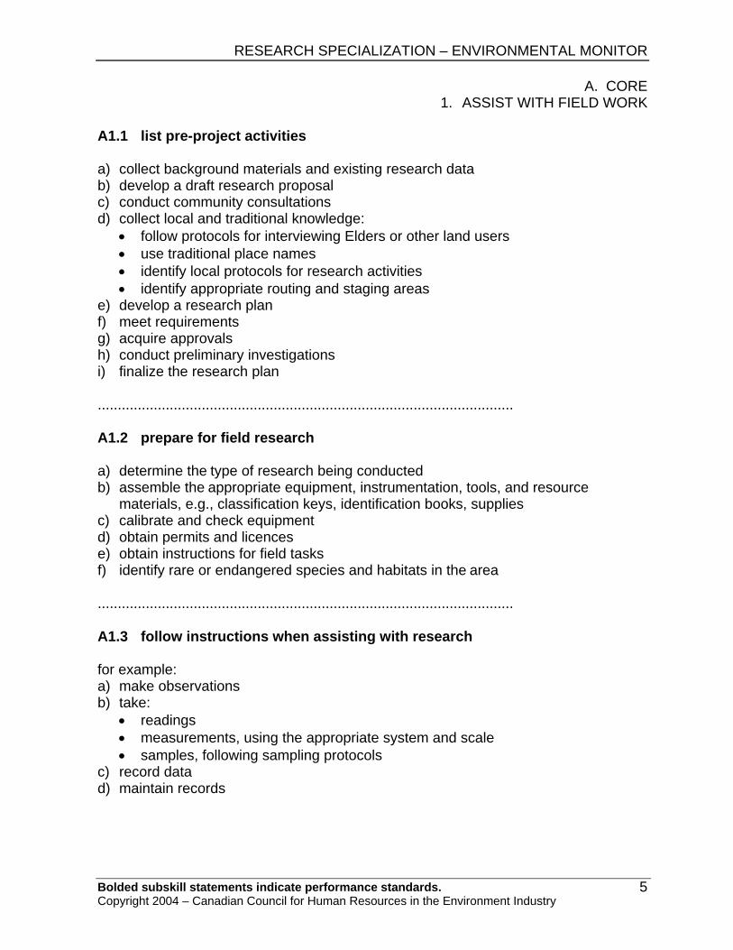
LIST OF FIGURES The equipment and tools included in Appendix 1 are provided as samples only; their appearances and features vary greatly in the field.
Figure # Title First Standard Reference
1 multi-parameter meter * B1.1 2 conductivity meter B1.1 3 secci or Secchi disc B1.1 4a current meter with wading rod* B1.1 4b flow gauge with digimeter* B1.1 5 pH meter* B1.1 6 automated weather station* B1.1 7 water column sampler* B1.1 8 thermistor and protective housing* B2.1 9 active layer in permafrost B3.1 10 continuous and discontinuous permafrost zones in
Canada B3.1
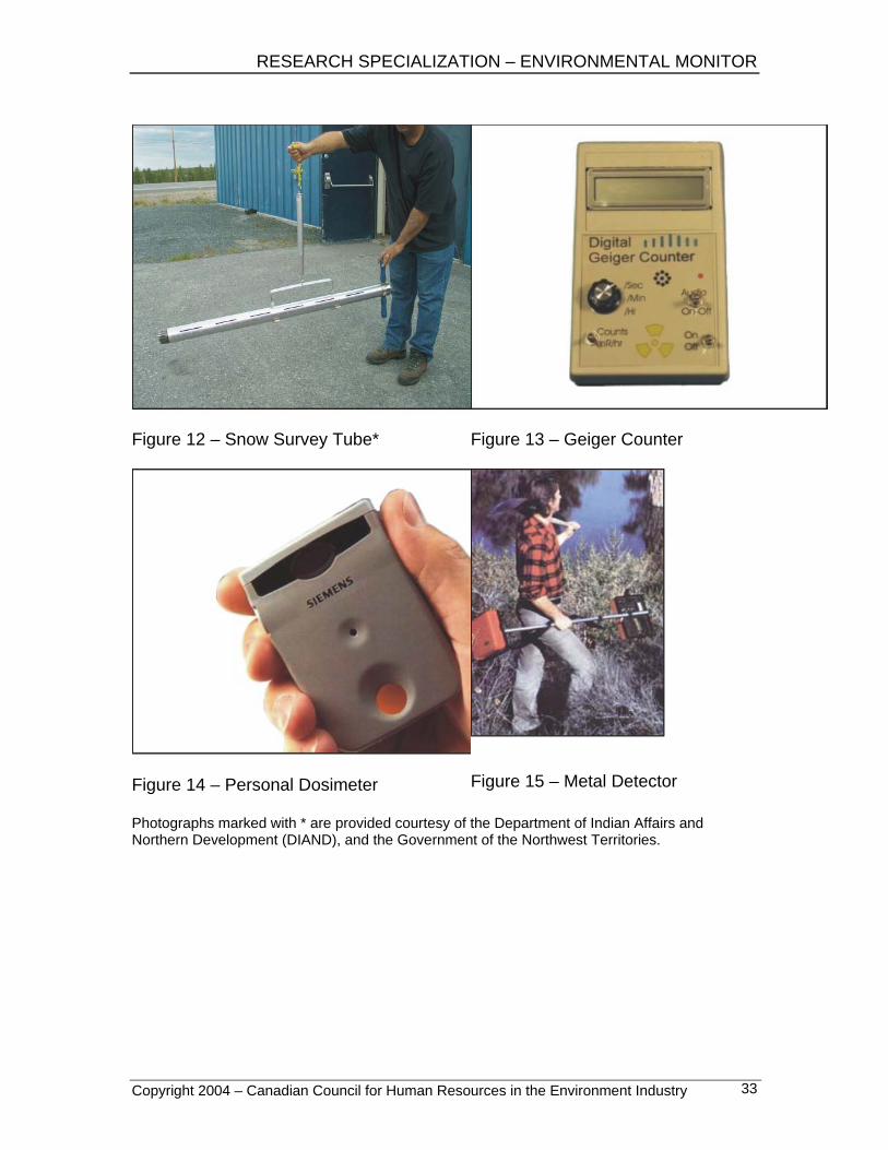
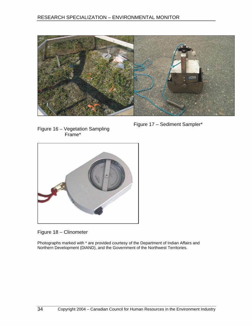
11 anemometer* B4.1 12 snow survey tube* B4.1 13 Geiger counter B6.1 14 personal dosimeter B6.1 15 metal detector C1.1 16 vegetation sampling frame* C2.1 17 sediment sampler* C2.1 18 clinometer C3.1 19 electroshocker C5.1 20 fish finder C5.1
Photographs marked with * are provided courtesy of the Department of Indian Affairs and Northern Development (DIAND), and the Government of the Northwest Territories.
RESEARCH SPECIALIZATION – ENVIRONMENTAL MONITOR
A. CORE 1. ASSIST WITH FIELD WORK
Bolded subskill statements indicate performance standards. Copyright 2004 – Canadian Council for Human Resources in the Environment Industry
5
A1.1 list pre-project activities a) collect background materials and existing research data b) develop a draft research proposal c) conduct community consultations d) collect local and traditional knowledge:
• follow protocols for interviewing Elders or other land users • use traditional place names • identify local protocols for research activities • identify appropriate routing and staging areas
e) develop a research plan f) meet requirements g) acquire approvals h) conduct preliminary investigations i) finalize the research plan ........................................................................................................ A1.2 prepare for field research
a) determine the type of research being conducted b) assemble the appropriate equipment, instrumentation, tools, and resource
materials, e.g., classification keys, identification books, supplies c) calibrate and check equipment d) obtain permits and licences e) obtain instructions for field tasks f) identify rare or endangered species and habitats in the area ........................................................................................................ A1.3 follow instructions when assisting with research for example: a) make observations b) take:
• readings • measurements, using the appropriate system and scale • samples, following sampling protocols
c) record data d) maintain records
RESEARCH SPECIALIZATION – ENVIRONMENTAL MONITOR A. CORE 1. ASSIST WITH FIELD WORK
Bolded subskill statements indicate performance standards. Copyright 2004 – Canadian Council for Human Resources in the Environment Industry
6
A1.4 describe the importance of following sampling protocols to help: a) ensure:
• the most accurate and valid results possible • sample integrity and identification • quality assurance and control • unbiased, consistent, and defensible data
b) minimize errors ........................................................................................................ A1.5 follow sampling protocols a) follow the protocol for the type of sample (see Appendix 2 for an example) b) follow quality assurance and quality control (QAQC) protocols:
• ensure that the sample is not contaminated • record information clearly and correctly on labels and in field notes • complete your section of the chain-of-custody documents
c) advise the next recipient that samples are enroute ........................................................................................................ A1.6 describe the requirement for laboratory testing tests are conducted in a laboratory: a) for precision and accuracy b) because they cannot be done in the field c) to meet licensing requirements ...................................................................................................... A1.7 use monitoring instrumentation a) install or set up the instrumentation b) calibrate or initialize the instrumentation and record results c) operate the instrumentation d) take the measurement or reading:
• take a photograph of the reading, if necessary e) record the data in your field notes f) maintain or reinstall the instrumentation, if necessary g) report any unusual results to your supervisor
RESEARCH SPECIALIZATION – ENVIRONMENTAL MONITOR
B. TESTING 1. ASSIST WITH WATER TESTING
Bolded subskill statements indicate performance standards. Copyright 2004 – Canadian Council for Human Resources in the Environment Industry
7
B1.1 describe water testing a) the study of the attributes of water b) purposes include:
• gathering baseline data • assessing environmental changes
c) methods include: • making observations • collecting samples • using field instrumentation • taking measurements
d) attributes studied include: • physical qualities, e.g., temperature, sediments, colour • chemical qualities, e.g., oxygen, salinity, pH • contaminants, e.g., hydrocarbons • biological qualities, e.g., micro-organisms, macro-invertebrates • features of water bodies, e.g., depth, type, shape, water level, water flow
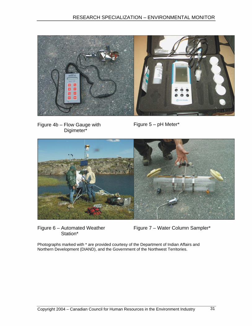
e) instrumentation and tools include: • multi-parameter meter (see Appendix 1, Figure 1) • dissolved oxygen meter • conductivity meter (see Figure 2) • field chemistry kit, e.g., La Motte, Hach • turbidity meter • survey level and rod • secci or Secchi disc (see Figure 3) • current meter with wading rod/flow gauge (see Figures 4a and 4b) • pH meter (see Figure 5) • data logger • automated sampling station (see Figure 6) • water column sampler (see Figure 7) • Eckman dredge
........................................................................................................ B1.2 assist with water testing
a) follow sampling protocols b) take water and sediment samples from specified locations and depths c) take water readings, e.g., flow, temperature, pH d) process samples, e.g., filter and preserve samples e) make observations
RESEARCH SPECIALIZATION – ENVIRONMENTAL MONITOR B. TESTING 2. ASSIST WITH SOIL TESTING
Bolded subskill statements indicate performance standards. Copyright 2004 – Canadian Council for Human Resources in the Environment Industry
8
B2.1 describe soil testing a) the study of soil characteristics b) purposes include:
• acquiring baseline data • determining physical properties • determining effects of activities on soil, wildlife, and vegetation • assessing environmental changes • determining types and/or locations of land activities that could take place
c) methods include: • describing soil profiles • taking soil samples • measuring particle sizes and composition • taking measurements • making observations
d) attributes studied include: • physical characteristics:
− number and depth of soil layers or horizons − parent materials − bulk density − moisture content − particle sizes
• chemical composition: − nutrient levels − quality and quantity of organic matter
• contaminants: − trace metals − persistent organic pollutants (POPs)
• soil biology, e.g., micro- and meso-organisms e) instrumentation and tools include:
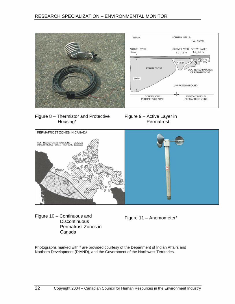
• thermistor (see Figure 8) • shovel/trowel • soil auger • various screens • various bags and containers • tape measure • colour chart • penetrometer • pH kit • hydrochloric acid
RESEARCH SPECIALIZATION – ENVIRONMENTAL MONITOR
B. TESTING 2. ASSIST WITH SOIL TESTING
Bolded subskill statements indicate performance standards. Copyright 2004 – Canadian Council for Human Resources in the Environment Industry
9
B2.2 assist with soil testing a) follow sampling program, e.g., sampling grid, random sampling b) dig or auger soil pits c) construct a soil profile:
• measure layers • take photographs • describe texture, structure, consistency, and colour
d) take soil samples from specified locations and depths
RESEARCH SPECIALIZATION – ENVIRONMENTAL MONITOR B. TESTING 3. ASSIST WITH PERMAFROST TESTING
Bolded subskill statements indicate performance standards. Copyright 2004 – Canadian Council for Human Resources in the Environment Industry
10
B3.1 describe permafrost testing a) to study the characteristics of permafrost b) purposes include:
• climate monitoring • determining ground stability
c) methods include: • sampling • measuring • making observations
d) characteristics studied include: • active layer (see Figure 9):
− temperature − depth − composition
• depth of the organic surface layer • area and size of continuous and discontinuous permafrost (see Figure 10) • water and ice content • soil properties • biophysical properties
e) instrumentation includes: • thermistor • scaled steel probe, i.e., T-bar • permafrost tube • resistivity meter • geophysical instrumentation
........................................................................................................ B3.2 assist with permafrost testing a) follow the sampling program b) take depth and temperature measurements of the active layer as required c) download information from the thermistor with the data logger:
• recalibrate and maintain data logging equipment d) monitor permafrost tubes
RESEARCH SPECIALIZATION – ENVIRONMENTAL MONITOR
B. TESTING 4. ASSIST WITH CLIMATE TESTING
Bolded subskill statements indicate performance standards. Copyright 2004 – Canadian Council for Human Resources in the Environment Industry
11
B4.1 describe climate testing a) the study of climate indicators b) purposes include:
• measuring current conditions • monitoring change over time
c) methods include: • conducting surveys • digging snow pits • making observations • sampling • taking measurements • interpreting photographs • using historical data to reconstruct past climatic conditions • using computer models to forecast climatic conditions • observing lake ice
d) attributes studied include: • daily weather, including:
− temperature − precipitation − relative humidity − percentage of cloud cover − solar radiation, i.e., hours of sunlight − ultraviolet (UV) intensity − barometric pressure − wind speed and direction
• snow and ice characteristics, e.g., snow depth • pack ice • soil temperatures • water levels • historical weather data • erosion • storm surges • smoke or effluent plumes • permafrost temperatures • species’ ranges and size shifts • vegetation and habitat analysis
e) instrumentation and tools include: • anemometer (see Figure 11) or the Beaufort Wind Scale (see Appendix 3) • compass or vane • rain gauge
RESEARCH SPECIALIZATION – ENVIRONMENTAL MONITOR B. TESTING 4. ASSIST WITH CLIMATE TESTING
Bolded subskill statements indicate performance standards. Copyright 2004 – Canadian Council for Human Resources in the Environment Industry
12
• thermometer • penetrometer • ramsonde • data logger • snow survey tube (see Figure 12) • ice auger • density tube • thermistor • weigh scale • graduated probe • R. M. Young wind detector
f) collection of data from instrumentation may be automated ........................................................................................................ B4.2 assist with climate testing a) follow testing protocols b) measure snow/water equivalents:
• insert the density tube into the snow • pull up the sample • weigh the sample
c) take a snow profile, including: • the total depth of the snow • the depth and thickness of each layer • observations of vegetation
d) conduct: • soil tests • water tests • permafrost tests • vegetation and habitat surveys
e) collect weather data
RESEARCH SPECIALIZATION – ENVIRONMENTAL MONITOR
B. TESTING 5. ASSIST WITH AIR QUALITY TESTING
Bolded subskill statements indicate performance standards. Copyright 2004 – Canadian Council for Human Resources in the Environment Industry
13
B5.1 describe air quality testing a) the study of attributes of the air b) purposes include:
• providing baseline data • describing current conditions • determining health risks
c) methods include: • sampling • automated monitoring • taking measurements • making observations
d) attributes studied include: • chemical compositions • chemical emissions, e.g., sulphur dioxide (SO2), carbon dioxide (CO2),
sulphuric acid (H2SO4) • pollen contents • dust contents • total particulate matter, e.g., smoke, ash • moisture • temperature • pressure • indoor air quality
e) measurements include: • mass of particulates • speed and direction of the wind • accumulations • concentrations • ranges and distributions, e.g., spray drift • soil tests • acid deposition • bio-indicator species, e.g., lichens, diatoms
f) instrumentation and tools include: • high volume air sampler • gas sampler, e.g., ground level ozone, CO2, nitrous oxide (NOx) • precipitation sampler • portable air quality monitor

RESEARCH SPECIALIZATION – ENVIRONMENTAL MONITOR B. TESTING 5. ASSIST WITH AIR QUALITY TESTING
Bolded subskill statements indicate performance standards. Copyright 2004 – Canadian Council for Human Resources in the Environment Industry
14
B5.2 assist with air quality testing a) operate high volume air sampler:
• weigh the new filter • collect used filters • place the new filter in the station • weigh the used filter
b) operate/maintain the precipitation sampler c) count/monitor the deposition area sampling d) operate the gas sampler according to laboratory’s and manufacturer’s
instructions e) take samples f) make observations
RESEARCH SPECIALIZATION – ENVIRONMENTAL MONITOR
B. TESTING 6. ASSIST WITH RADIATION TESTING
Bolded subskill statements indicate performance standards. Copyright 2004 – Canadian Council for Human Resources in the Environment Industry
15
B6.1 describe radiation testing a) the assessment of radiation levels in the environment that may occur naturally
or as a result of land activities b) purpose is to assess the radiation levels for mineral potential or contamination c) methods include:
• measuring radon gas • sampling water, soil, and air • identifying minerals
d) characteristics studied include: • types • levels • source identification
e) instrumentation and tools include: • radon monitor • Geiger counter (see Figure 13) • thermoluminescent dosimeter (TLD) • personal dosimeter (see Figure 14)
........................................................................................................ B6.2 assist with radiation testing a) for radon monitors:
• place and replace monitors in designated locations as required b) for thermoluminescent dosimeters:
• install dosimeters • take readings
c) for personal dosimeters: • wear the dosimeter when working at contaminated sites
d) for Geiger counters: • operate the Geiger counter over the designated area • note locations of hot spots, i.e., those with dangerously high readings

RESEARCH SPECIALIZATION – ENVIRONMENTAL MONITOR C. SURVEYS 1. ASSIST WITH ARCHAEOLOGICAL AND PALEONTOLOGICAL SURVEYS
Bolded subskill statements indicate performance standards. Copyright 2004 – Canadian Council for Human Resources in the Environment Industry
16
C1.1 describe archaeological and paleontological surveys a) detailed investigations of the historical evidence of human activity or
biological legacies in accordance with traditional protocols and codes of ethics
b) purpose is to research, protect, and preserve archaeological and paleontological sites
c) methods include: • identifying sites in specific areas • identifying items found at sites • interviewing Elders and other community members • checking records for background research • assessing surface disturbances • assessing topography and proximity to water • documenting artifacts • excavating
d) instrumentation and tools include: • shovel/trowel • various screens and brushes • pick hammer • camera • magnifying glass • metal detector (see Figure 15) • ground penetrating radar • Global Positioning System (GPS)
........................................................................................................ C1.2 assist with archaeological and paleontological surveys a) assist with:
• locating sites • identifying and excavating artifacts • determining the potential significance of artifacts • packing, storing, and transporting artifacts
b) follow protocols when finding or suspecting archaeological sites: • stop work • notify stakeholders
RESEARCH SPECIALIZATION – ENVIRONMENTAL MONITOR
C. SURVEYS 2. ASSIST WITH VEGETATION SURVEYS
Bolded subskill statements indicate performance standards. Copyright 2004 – Canadian Council for Human Resources in the Environment Industry
17
C2.1 describe vegetation surveys a) detailed investigations of plant distribution, abundance, and composition b) purposes include:
• providing baseline data, e.g., growing conditions • describing plant species and communities • monitoring re-vegetation efforts • identifying wildlife and culturally-modified trees • documenting rare species and habitats • determining biomass • checking for indications of climatic and environmental changes
c) methods include: • pre-field research, e.g., mapping, database studies, existing inventories • sampling:
− grids − random stratification − line transects
• describing plant species • studying permanent plots over time • identifying and collecting species • viewing aerial photographs with ground truthing • viewing satellite imagery with ground truthing • counting species
d) characteristics studied include: • plant species, compositions, and distributions • percentage of cover of plant species • life cycles • phenology • regeneration • primary production • bioaccumulation of pollutants • toxicity • physical characteristics:
− height − width − appearance − condition
e) instrumentation and tools include: • quadrat, e.g., vegetation sampling frame (see Figure 16) • flagging tape and stakes • various sample bags
RESEARCH SPECIALIZATION – ENVIRONMENTAL MONITOR C. SURVEYS 2. ASSIST WITH VEGETATION SURVEYS
Bolded subskill statements indicate performance standards. Copyright 2004 – Canadian Council for Human Resources in the Environment Industry
18
• clinometer • Robal pole • hand lens • ruler • range finder • compass • plant press • plant identification book or key • stereoscope for interpreting aerial photographs • boat • waders • various sediment samplers (see Figure 17)
........................................................................................................ C2.2 assist with vegetation surveys a) follow protocols for collecting vegetation samples b) lay out grids, flag lines, and mark points c) determine the slope and aspect d) identify and count plant species e) measure the cover area:
• sketch or visually estimate the amount of vegetation in each grid square f) record the type of:
• terrain • habitat • vegetation • soil • water • damage to area, past or present, e.g., human impact
g) take samples of vegetation as directed

RESEARCH SPECIALIZATION – ENVIRONMENTAL MONITOR
C. SURVEYS 3. ASSIST WITH FOREST SURVEYS
Bolded subskill statements indicate performance standards. Copyright 2004 – Canadian Council for Human Resources in the Environment Industry
19
C3.1 describe forest surveys a) detailed investigations of the forest and understorey distribution and
composition b) purposes include:
• collecting baseline data • conducting a forest inventory, e.g., species, marketability • identifying wildlife and culturally-modified trees • reforestation • research, e.g., growth rates, yield, disease, biomass, forest health, old
growth forests • studying fire potential and effects of fire, e.g., fuel inventory, habitat
expansion c) methods include:
• aerial surveys • ground surveys • permanent sample plots • timber cruising • regeneration surveys • aerial photographs with ground truthing • satellite imagery with ground truthing
d) attributes studied include: • archaeological sites and features of cultural or historical significance • land use • forest composition • fuel load • characteristics of trees:
− dimensions − ages − condition − regeneration, e.g., amount, type
• slope and aspect • marketability • water courses and drainage • soil moisture • density of canopy and understorey • indicators of specific wildlife habitats • soil profiles
e) instrumentation and tools include: • shovel • clinometer (see Figure 18)
RESEARCH SPECIALIZATION – ENVIRONMENTAL MONITOR C. SURVEYS 3. ASSIST WITH FOREST SURVEYS
Bolded subskill statements indicate performance standards. Copyright 2004 – Canadian Council for Human Resources in the Environment Industry
20
• callipers or diameter tape • survey tape • increment borer • point prism • cruising chain • chainsaw • Douglas protractor • aerial photographs, satellite images, and maps
........................................................................................................ C3.2 assist with forest surveys a) follow protocols, e.g., contact local trappers b) assist with laying out plots c) describe species, composition, and seral stage d) take measurements:
• count trees, using point prisms • count seedlings within a grid • use a clinometer to measure heights • use the diameter tape to measure diameters
e) take core samples: • count growth rings • measure the width of rings • note the presence of rot and burn scars
f) take soil samples
RESEARCH SPECIALIZATION – ENVIRONMENTAL MONITOR
C. SURVEYS 4. ASSIST WITH WILDLIFE SURVEYS
Bolded subskill statements indicate performance standards. Copyright 2004 – Canadian Council for Human Resources in the Environment Industry
21
C4.1 describe wildlife surveys a) detailed investigations of animal species, behaviours, and habitats b) purposes include:
• providing baseline data • describing current conditions • describing population, abundance, distribution, and trends • identifying listed species, e.g., threatened, at-risk, endangered • describing reintroduction potential • identifying preferred habitats
c) methods used include: • surveys, e.g., aerial, ground, water • interviews • sampling • mark and recapture • radio tracking
d) attributes studied include: • species • habitat suitability • population abundance and composition • physical conditions • physical characteristics • observed activities and behaviours • indicators of wildlife, e.g., tracks, scat, browse, dens
e) instrumentation and tools include: • binoculars • video monitoring equipment • observation blind • attractants, e.g., bait, scents, playback tapes • radio collar, receiver, tags, and bands • paint and tattoos • tranquilizers and tranquilizer gun • survey tape and stakes • mesh net • live or kill traps • sonar locator • recording equipment • boat • waders • measuring tape • scale
RESEARCH SPECIALIZATION – ENVIRONMENTAL MONITOR C. SURVEYS 4. ASSIST WITH WILDLIFE SURVEYS
Bolded subskill statements indicate performance standards. Copyright 2004 – Canadian Council for Human Resources in the Environment Industry
22
C4.2 assist with wildlife surveys a) follow protocols, e.g., talk to Elders and trappers b) record:
• sites of animal habitation • habitat types • wildlife signs, e.g., tracks, nests, scat, carcasses • weather conditions
c) collect samples d) visit sites at different times of the year, if required:
• allows viewing of seasonal changes in wildlife use
RESEARCH SPECIALIZATION – ENVIRONMENTAL MONITOR
C. SURVEYS 5. ASSIST WITH FISH SURVEYS
Bolded subskill statements indicate performance standards. Copyright 2004 – Canadian Council for Human Resources in the Environment Industry
23
C5.1 describe fish surveys a) detailed investigations of fish species, behaviour, and habitats b) purposes include:
• providing baseline data • describing current conditions • describing population, abundance, and distribution • conducting impact assessments • determining potential for re-introduction and/or restocking • determining consumption safety • conducting research, e.g., nutrient recycling
c) methods include: • population counts • mark and recapture • fish salvage or rescue • floy tagging or fin clipping • fish habitat mapping • bathymetry • surveys, e.g., water, aerial, creel, domestic fishing, commercial fishing • benthic invertebrate studies
d) attributes include: • species • habitats • population • age composition • activity/behaviour:
− migration − depth in water column − diet − feeding cycles − spawning
• physical characteristics: − sex − maturity − fork length − weight − size
• physical conditions: − health, e.g., parasites − appearance, e.g., condition of scales − injuries
RESEARCH SPECIALIZATION – ENVIRONMENTAL MONITOR C. SURVEYS 5. ASSIST WITH FISH SURVEYS
Bolded subskill statements indicate performance standards. Copyright 2004 – Canadian Council for Human Resources in the Environment Industry
24
− fat layers − mutations
e) instrumentation and tools include: • floy tags, radio tags, and receivers • electroshocker (see Figure 19) or electrofisher • fish finder (see Figure 20) • nets, e.g., gill, seine, dip, barrier, live trap, reach • buoys • boat • hand lens • tranquilizers • aircraft • chest or hip waders • personal floatation device (PFD) • wet/dry suit • measuring tape • measuring board • hand-held weight scale • ice auger • fish knife • containers and coolers • lines and hooks • ice jigger • fish bonker • identification key • fish weir • minnow traps
........................................................................................................ C5.2 assist with fish surveys a) follow protocols, e.g., talk to Elders and trappers b) take training before using electroshocker or electrofisher c) record:
• habitats • water parameters • weather conditions
d) bore ice holes e) assist with:
• setting nets
RESEARCH SPECIALIZATION – ENVIRONMENTAL MONITOR
C. SURVEYS 5. ASSIST WITH FISH SURVEYS
Bolded subskill statements indicate performance standards. Copyright 2004 – Canadian Council for Human Resources in the Environment Industry
25
• identifying • weighing • measuring • tagging • fin clipping • scale sampling • implanting transmitters
f) record fish attributes, for example: • measurements, e.g., fork or total length, weight • condition
g) limit fish mortality when returning fish to the water: • follow appropriate catch and release guidelines
h) dissect fish to: • remove otoliths and other structures • sample parasites • determine sex, maturity, and stomach contents
i) prepare fish for shipping to the lab
RESEARCH SPECIALIZATION – ENVIRONMENTAL MONITOR C. SURVEYS 6. ASSIST WITH INSECT SURVEYS
Bolded subskill statements indicate performance standards. Copyright 2004 – Canadian Council for Human Resources in the Environment Industry
26
C6.1 describe insect surveys a) detailed investigations of insect species, behaviours, and habitats b) purposes include:
• collecting baseline data • conducting impact assessments • determining ranges and density • describing population, abundance, and distribution • determining bio-indicators or health of water courses and habitats
c) methods may include: • trapping • studying changes to vegetation, e.g., discolouration, galls, conks, aerial
surveys of colour changes • sampling for analysis and identification • impacts on wildlife:
− identification − preservation − dissection
• counts d) attributes studied include:
• families or orders of species • populations • distribution • life-cycle stages and seasons • deformities • infestations
e) instrumentation and tools include: • passive and active traps, e.g., flight interception traps, pitfall traps • nets, e.g., sweep nets • baits or attractants • chemicals, e.g., alcohol, formaldehyde • survey tape and stakes • dissecting microscope • hand lens • mounting and preserving equipment • identification key
RESEARCH SPECIALIZATION – ENVIRONMENTAL MONITOR
C. SURVEYS 6. ASSIST WITH INSECT SURVEYS
Bolded subskill statements indicate performance standards. Copyright 2004 – Canadian Council for Human Resources in the Environment Industry
27
C6.2 assist with insect surveys a) follow protocols b) collect and replace traps at designated locations c) count and record families or orders of species and their numbers, e.g., check
for eggs, larvae, pupae, and galls d) plot grids e) collect samples f) mount and preserve specimens
RESEARCH SPECIALIZATION – ENVIRONMENTAL MONITOR C. SURVEYS 7. ASSIST WITH GEOLOGICAL SURVEYS
Bolded subskill statements indicate performance standards. Copyright 2004 – Canadian Council for Human Resources in the Environment Industry
28
C7.1 describe geological surveys a) detailed investigations of geological features and characteristics of a region b) purposes include:
• determining the presence or probability of minerals, oil, gas, and water • environmental geological investigation • mapping the geology of an area • research, e.g., mass movement, seismology, anomalies • determining land form stability
c) methods include: • surveys, e.g., aerial, geochemical, geophysical, gravity • satellite imagery • rock and soil sampling • mapping • divining • drilling holes or wells
d) attributes studied include: • presence of indicator minerals • geology for potential oil, gas, and fresh water • geological formations • paleontological evidence • chemical composition • physical properties, e.g., grain size analysis • structures
e) instrumentation and tools include: • geophysical instrumentation, e.g., magnetometer • hand lens • axe • shovel • ground penetrating radar • magnet • weak acid solution • knife • rock hammer • stereoscope • streak plate • compass with inclinometer • sampling materials • resistivity meter • drill • borer

RESEARCH SPECIALIZATION – ENVIRONMENTAL MONITOR
C. SURVEYS 7. ASSIST WITH GEOLOGICAL SURVEYS
Bolded subskill statements indicate performance standards. Copyright 2004 – Canadian Council for Human Resources in the Environment Industry
29
• various screens or sieves • various brushes or blowers • identification book or key
........................................................................................................ C7.2 assist with geological surveys a) follow protocols, e.g., lay out and follow grids, traverse paths b) collect samples c) take measurements d) carry out basic field tests, e.g., dip and strike, carbonate

RESEARCH SPECIALIZATION – ENVIRONMENTAL MONITOR
Copyright 2004 – Canadian Council for Human Resources in the Environment Industry 30
APPENDIX 1 FIGURES
The equipment and tools included here are provided as samples only; their appearances and features vary greatly in the field.
Figure 1 – Multi-parameter Meter*
Figure 2 – Conductivity Meter
Figure 3 – Secci or Secchi Disc
Figure 4a – Current Meter with
Wading Rod*
Photographs marked with * are provided courtesy of the Department of Indian Affairs and Northern Development (DIAND), and the Government of the Northwest Territories.
RESEARCH SPECIALIZATION – ENVIRONMENTAL MONITOR
Copyright 2004 – Canadian Council for Human Resources in the Environment Industry 31
Figure 4b – Flow Gauge with
Digimeter*
Figure 5 – pH Meter*
Figure 6 – Automated Weather
Station*
Figure 7 – Water Column Sampler*
Photographs marked with * are provided courtesy of the Department of Indian Affairs and Northern Development (DIAND), and the Government of the Northwest Territories.
RESEARCH SPECIALIZATION – ENVIRONMENTAL MONITOR
Copyright 2004 – Canadian Council for Human Resources in the Environment Industry 32
Figure 8 – Thermistor and Protective
Housing*
Figure 9 – Active Layer in
Permafrost
Figure 10 – Continuous and
Discontinuous Permafrost Zones in Canada
Figure 11 – Anemometer*
Photographs marked with * are provided courtesy of the Department of Indian Affairs and Northern Development (DIAND), and the Government of the Northwest Territories.
RESEARCH SPECIALIZATION – ENVIRONMENTAL MONITOR
Copyright 2004 – Canadian Council for Human Resources in the Environment Industry 33
Figure 12 – Snow Survey Tube*
Figure 13 – Geiger Counter
Figure 14 – Personal Dosimeter
Figure 15 – Metal Detector
Photographs marked with * are provided courtesy of the Department of Indian Affairs and Northern Development (DIAND), and the Government of the Northwest Territories.
RESEARCH SPECIALIZATION – ENVIRONMENTAL MONITOR
Copyright 2004 – Canadian Council for Human Resources in the Environment Industry 34
Figure 16 – Vegetation Sampling
Frame*
Figure 17 – Sediment Sampler*
Figure 18 – Clinometer Photographs marked with * are provided courtesy of the Department of Indian Affairs and Northern Development (DIAND), and the Government of the Northwest Territories.

RESEARCH SPECIALIZATION – ENVIRONMENTAL MONITOR
Copyright 2004 – Canadian Council for Human Resources in the Environment Industry 35
Figure 19 – Electroshocker
Figure 20 – Fish Finder
Photographs marked with * are provided courtesy of the Department of Indian Affairs and Northern Development (DIAND), and the Government of the Northwest Territories.
RESEARCH SPECIALIZATION – ENVIRONMENTAL MONITOR
Copyright 2004 – Canadian Council for Human Resources in the Environment Industry 36
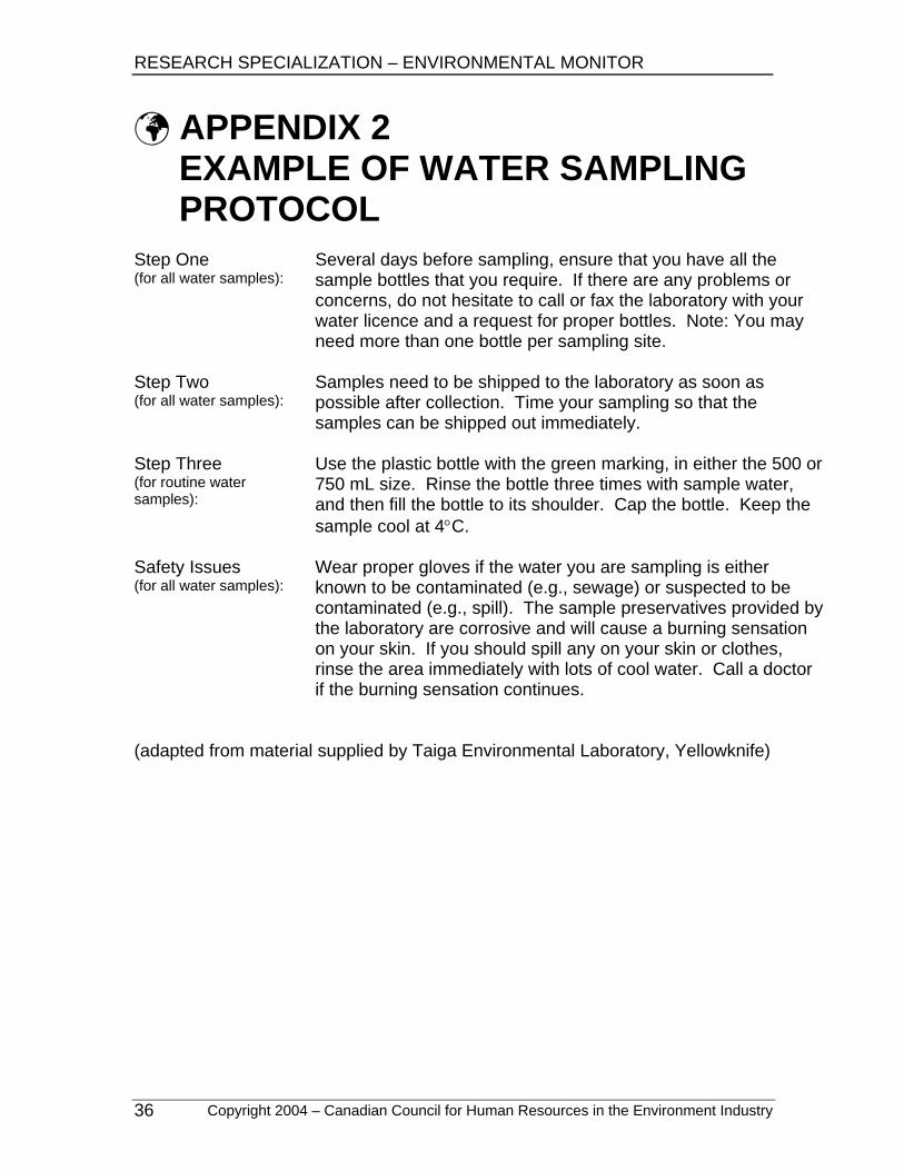
APPENDIX 2 EXAMPLE OF WATER SAMPLING PROTOCOL
Step One (for all water samples):
Several days before sampling, ensure that you have all the sample bottles that you require. If there are any problems or concerns, do not hesitate to call or fax the laboratory with your water licence and a request for proper bottles. Note: You may need more than one bottle per sampling site.
Step Two (for all water samples):
Samples need to be shipped to the laboratory as soon as possible after collection. Time your sampling so that the samples can be shipped out immediately.
Step Three (for routine water samples):
Use the plastic bottle with the green marking, in either the 500 or 750 mL size. Rinse the bottle three times with sample water, and then fill the bottle to its shoulder. Cap the bottle. Keep the sample cool at 4°C.
Safety Issues (for all water samples):
Wear proper gloves if the water you are sampling is either known to be contaminated (e.g., sewage) or suspected to be contaminated (e.g., spill). The sample preservatives provided by the laboratory are corrosive and will cause a burning sensation on your skin. If you should spill any on your skin or clothes, rinse the area immediately with lots of cool water. Call a doctor if the burning sensation continues.
(adapted from material supplied by Taiga Environmental Laboratory, Yellowknife)
RESEARCH SPECIALIZATION – ENVIRONMENTAL MONITOR
Copyright 2004 – Canadian Council for Human Resources in the Environment Industry 37
APPENDIX 3 BEAUFORT WIND SCALE
Wind Speed Beaufort Number or Force mph km/hr knots
Description Effects Land / Sea
0 <1 <1 <1 Calm Still, calm air, smoke will rise vertically. Water is mirror-like.
1 1-3 mph
1-5 kph
1-3 knots Light Air Rising smoke drifts, wind vane is inactive. Small
ripples appear on water surface.
2 4-7 mph
6-11 kph
4-6 knots Light Breeze
Leaves rustle, can feel wind on your face, wind vanes begin to move. Small wavelets develop, crests are glassy.
3 8-12 mph
12-19 kph
7-10 knots Gentle Breeze
Leaves and small twigs move, light weight flags extend. Large wavelets, crests start to break, some whitecaps.
4 13-18 mph
20-28 kph
11-16 knots
Moderate Breeze
Small branches move, raises dust, leaves and paper. Small waves develop, becoming longer, whitecaps.
5 19-24 mph
29-38 kph
17-21 knots Fresh Breeze Small trees sway. White crested wavelets
(whitecaps) form, some spray.
6 25-31 mph
39-49 kph
22-27 knots Strong Breeze
Large tree branches move, telephone wires begin to "whistle", umbrellas are difficult to keep under control. Larger waves form, whitecaps prevalent, spray.
7 32-38 mph
50-61 kph
28-33 knots
Moderate or Near Gale
Large trees sway, becoming difficult to walk. Larger waves develop, white foam from breaking waves begins to be blown.
8 39-46 mph
62-74 kph
34-40 knots
Gale or Fresh Gale
Twigs and small branches are broken from trees, walking is difficult. Moderately large waves with blown foam.
9 47-54 mph
75-88 kph
41-47 knots Strong Gale
Slight damage occurs to buildings, shingles are blown off of roofs. High waves (6 meters), rolling seas, dense foam, Blowing spray reduces visibility.
10 55-63 mph
89-102 kph
48-55 knots
Whole Gale or Storm
Trees are broken or uprooted, building damage is considerable. Large waves (6-9 meters), overhanging crests, sea becomes white with foam, heavy rolling, reduced visibility.
11 64-72 mph
103-117 kph
56-63 knots Violent Storm Extensive widespread damage. Large waves (9-14
meters), white foam, visibility further reduced.
12 73+ mph
118+ kph
64+ knots Hurricane
Extreme destruction, devastation. Large waves over 14 meters, air filled with foam, sea white with foam and driving spray, little visibility.
Table courtesy of http://www.marinewaypoints.com/marine/wind.shtml
RESEARCH SPECIALIZATION – ENVIRONMENTAL MONITOR
Copyright 2004 – Canadian Council for Human Resources in the Environment Industry 38
GLOSSARY accuracy the likelihood or probability that a given measurement is
correct
active layer
the annually-thawed zone that overlies the permafrost
anemometer an instrument used to measure wind velocity and direction
aspect
the compass direction of a slope or surface
auger a mechanized or manual drilling tool used to bore holes; types include soil and ice augers
bathymetry the measurement of the depth of a water body
biomass the total mass of living organisms of one or more species per unit of space
calibrate to ensure that equipment is working correctly, e.g., by comparing it to a known standard
canopy
the uppermost continuous layer of branches and foliage in a stand of trees or shrubs; can also refer to the middle or lower layers in stands with multiple stories
chain-of-custody document
documentation showing the chronological order of individuals responsible for a sample, from the sample site to the laboratory
climate the prevailing environmental conditions resulting from the interactions of wind, water, and temperature
clinometer an instrument used to measure the height of trees; also referred to as an inclinometer
conductivity meter
used to measure the electrical conductivity; determines the salinity of water
cruising chain
a thread-measuring device on which a counter measures the length of line unreeled from the unit, giving the distance travelled; also referred to as a hip chain
RESEARCH SPECIALIZATION – ENVIRONMENTAL MONITOR
Copyright 2004 – Canadian Council for Human Resources in the Environment Industry 39
density for soil testing, a measure of mass over volume; for wildlife surveys, the number or size of a population in relation to a unit of space; for silviculture, stand density is measured as the amount of tree biomass per unit of area
dip angle of a slope from the horizontal
floy tag a identification tag with a unique number; the tag is implanted/attached to a fish below the dorsal fin, and is used in a variety of studies
gall
a swelling on a woody plant caused by the modification of the plant tissue induced by fungi, bacteria, insects, or worms
Geiger counter
a device used to measure radioactivity by detecting and counting ionizing particles
geochemical the chemistry of the earth, its rocks, minerals, and water
geophysical the physical properties of the earth, its rocks, minerals, and water
grid a systematically laid out group of observations or measurement points covering a survey area
ground truthing
an on-ground survey; may be used to verify remotely-sensed data or interpretations
hydrocarbon a substance composed of hydrogen and carbon molecules
indicator mineral a mineral that indicates the presence of another mineral or substance, e.g., garnets are indicators of diamonds
magnetometer an instrument used to measure the strength of magnetic fields
multi-parameter meter
a meter that measures multiple parameters of water
nutrient an element or compound that is obtained from the environment and is required by an organism for growth
organic matter decomposing vegetation found on top of or in topsoil
RESEARCH SPECIALIZATION – ENVIRONMENTAL MONITOR
Copyright 2004 – Canadian Council for Human Resources in the Environment Industry 40
otolith the ear bone in fish; used to determine age
parameter
a measurable factor or characteristic, e.g., height of a tree, pH level of a solution
penetrometer a gauge used to measure snow hardness at each layer
permafrost
ground that remains below 0°C over at least two consecutive winters and the intervening summer
personal dosimeter an instrument used to detect the level of gamma rays to which an individual has been exposed
pH a measure of hydrogen ions in a solution; measured on a scale of 0 to 14; measures relative acidity (< 7) and alkalinity (> 7), with 7 being neutral
pH meter an instrument used to measure pH
plume for water – any water discharging into another water body (e.g., river, lake, ocean) that is differentiated by its colour, composition, or density; for fire – a column of smoke rising from a fire; it can be indicative of the fuel burning, the intensity of the fire, and the direction in which the fire is progressing; consists of gases, particles, and moisture
point prisms an instrument used to estimate forest density
precipitation all forms of water that fall from the atmosphere
precision
degree of refinement in a measurement
probe the part of a measuring instrument that is placed in the medium to be measured
radon monitor
equipment that measures the amount of radon, an inert radioactive gas, that results from the disintegration of radium
ramsonde an instrument used to measure the hardness of an entire snow pack
resistivity meter in geological exploration, an instrument used to measure the ability of the ground to transmit an electrical current, thus identifying different rock types
RESEARCH SPECIALIZATION – ENVIRONMENTAL MONITOR
Copyright 2004 – Canadian Council for Human Resources in the Environment Industry 41
salinity a measure of dissolved salts in water; measured in parts per million
sample integrity to maintain the state of a sample as it existed in the field
sampling protocol a standardized set of written instructions to ensure sample integrity and proper sample collection and identification
secci or Secchi disc a black and white disc that is lowered into the water to measure the depth at which it can no longer be seen; used to measure relative water clarity
sediment loose or broken material that has usually been transported and deposited by water, wind, ice, or by chemical precipitation, and often occurs in layers as mud, silt, sand, or gravel
sediment sampler an instrument used to gather samples of sediment from a body of water
seral of or relating to an ecological sere
sere an entire sequence of ecological communities successively occupying an area, from the initial stage to the climax; see also successional status in Core Occupational Standards for Environmental Monitor
silt soil texture based on particle size; 0.02 – 0.05 mm
snow survey tube an instrument used to measure snow/water equivalent
soil profile
vertical sequence of well-defined soil, sediment, or decaying vegetation layers
strike the horizontal orientation of a slope
survey
verb – the systematic measuring and/or observation of attributes to determine their relative position on, above, or below the earth’s surface; noun – the results of survey activities, or the organization responsible for undertaking a survey
thermistor
a device used to measure temperature
RESEARCH SPECIALIZATION – ENVIRONMENTAL MONITOR
Copyright 2004 – Canadian Council for Human Resources in the Environment Industry 42
thermoluminescent dosimeter (TLD)
an instrument used to measure gamma rays over a long period of time
toxicity a measure of how poisonous a substance is
turbidity a measure of water clarity or the degree to which water is opaque, resulting from suspended solids
turbidity meter an instrument used to measure water clarity
understorey
an underlying layer of vegetation; specifically, the vegetative layer and especially the trees and shrubs between the forest canopy and the ground cover


![Beaufort Republican (Beaufort, S.C.).(Beaufort, S.C.) 1872-03-14 [p ]. · 2014-11-07 · i » AnIndependentFamilyNewspaper,devotedtoPolitics, Literature,andGeneralIntelligence. Our](https://img.pdfslide.us/doc/110x75/5f9843a157a435509e4492b8/beaufort-republican-beaufort-scbeaufort-sc-1872-03-14-p-2014-11-07.jpg)