Embed Size (px)
Citation preview
National Development Framework 2020-2040Explanatory Paper – Welsh National Marine Plan and Ports
December 2019
Why have we published these explanatory papers?During the consultation on the Draft National Development Framework (NDF) some stakeholders suggested further details should be made available setting out how the NDF has been prepared. To assist stakeholders we have produced a collection of explanatory papers to set out the evidence that supports the draft NDF. These papers include:
• The Spatial Strategy
• The Assessments of the NDF
• Future progression of the NDF
• The Regions
• Rural Areas
• Housing need
• Welsh National Marine Plan and Ports
• Evidence compendium
What is this document?This explanatory paper has been prepared to assist readers of the draft NDF in understanding how the relationship between the Draft NDF and the Welsh National Marine Plan and the approach taken to ports policy. It highlights the key policy areas that overlap between the plans and the evidence that have informed the ports policies within the plan.
2
Mae’r ddogfen yma hefyd ar gael yn Gymraeg / This document is also available in Welsh. © Crown copyright 2019 WG39565 Digital ISBN: 978 1 83933 668 3
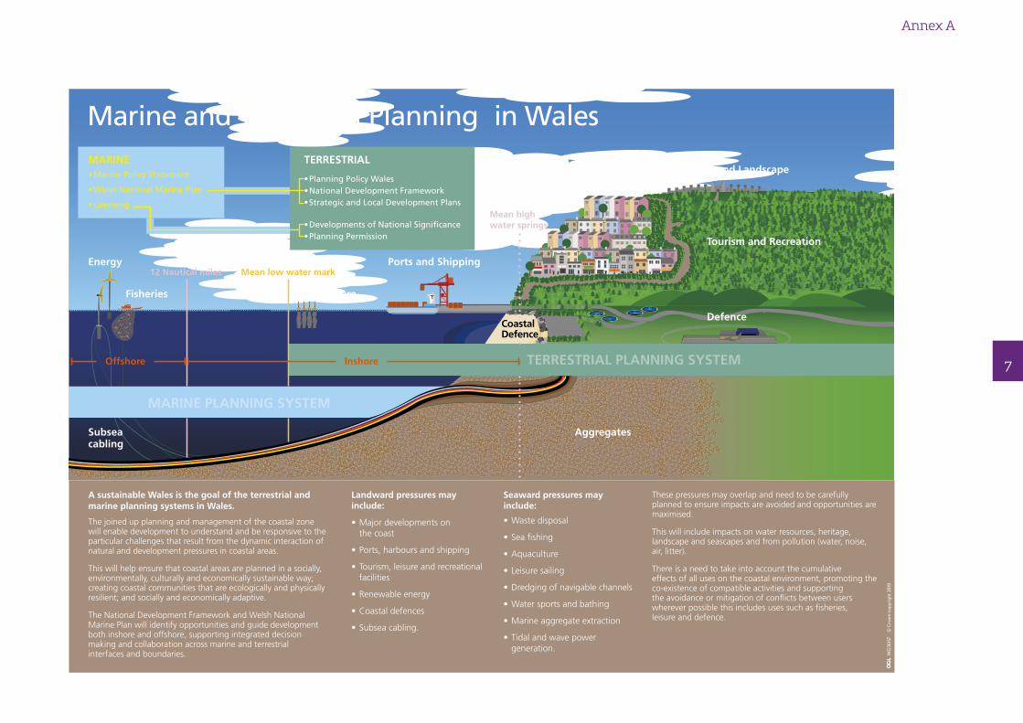
1. The National Development Framework (NDF) and Welsh National Marine Plan (WNMP) identify opportunities and guide sustainable development both inshore and offshore, they support integrated decision making and collaboration across marine and terrestrial interfaces and boundaries. They will be used by decision makers in both marine and terrestrial planning development and strategic planning decisions. The infographic at Annex A explains the relationship between the two planning systems.
2. The timescales for the production of the WNMP and NDF have overlapped but are not aligned, meaning only draft versions of the WNMP have been available during the development of the NDF. Welsh Government officials in both teams have liaised regularly during the production of both plans to ensure they are joined up. The teams will continue to liaise post adoption during plan implementation and review and are taking opportunities to join up approaches to assessments, evidence collection and monitoring for the next versions of these plans.
3. The joined up planning and management across the coastal zone will enable development to understand and be responsive to the particular challenges that result from the dynamic interaction of natural and development pressures in coastal areas. This will help ensure that coastal areas are planned in a socially, environmentally, culturally and economically sustainable way.
4. The terrestrial planning system will guide how these coastal communities will develop and the WNMP will ensure coastal community needs are understood by and taken into account by marine developments. This approach will help provide local benefits from the marine area for our coastal communities.
5. Both land-based and sea-based activities can have a direct impact over wide areas which may cover the jurisdiction of multiple planning authorities (both terrestrial and marine and beyond Wales). Integration of planning across these borders and at local,
national and regional scales is therefore important, as well as integration with other organisations and processes involved in the regulation and management of natural resources and space. In developing both the WNMP and the NDF the intention has been to ensure that there is a clear approach to planning and that there is consistency across the terrestrial and marine areas.
6. There are both landward and seaward pressures which result from development and use of natural resources which must be planned for and managed. Pressures may be positive or adverse and may relate to environmental interests and or socio-economic considerations. Key sources of these pressures are identified in the table below, these may overlap and act synergistically or cumulatively and need to be carefully planned to ensure adverse impacts are avoided and benefits arising from opportunities are maximised.
Key landward activity Seaward Pressures
Major developments on the coast Waste disposal
Ports, harbours and shipping Sea fishing
Tourism, leisure and recreational facilities Aquaculture
Renewable energy Leisure sailing
Coastal defences Dredging of navigable channels
Subsea cabling Water sports and bathing
Marine aggregate extraction
Tidal and wave power generation
3
4
Key policy areas of overlap between plans
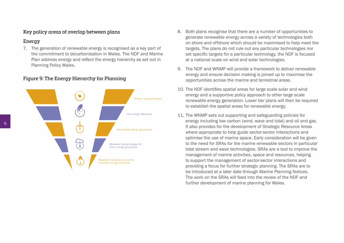
Energy7. The generation of renewable energy is recognised as a key part of
the commitment to decarbonisation in Wales. The NDF and Marine Plan address energy and reflect the energy hierarchy as set out in Planning Policy Wales.
8. Both plans recognise that there are a number of opportunities to generate renewable energy across a variety of technologies both on shore and offshore which should be maximised to help meet the targets. The plans do not rule out any particular technologies nor set specific targets for a particular technology, the NDF is focused at a national scale on wind and solar technologies.
9. The NDF and WNMP will provide a framework to deliver renewable energy and ensure decision making is joined up to maximise the opportunities across the marine and terrestrial areas.
10. The NDF identifies spatial areas for large scale solar and wind energy and a supportive policy approach to other large scale renewable energy generation. Lower tier plans will then be required to establish the spatial areas for renewable energy.
11. The WNMP sets out supporting and safeguarding policies for energy including low carbon (wind, wave and tidal) and oil and gas. It also provides for the development of Strategic Resource Areas where appropriate to help guide sector-sector interactions and optimise the use of marine space. Early consideration will be given to the need for SRAs for the marine renewable sectors in particular tidal stream and wave technologies. SRAs are a tool to improve the management of marine activities, space and resources, helping to support the management of sector-sector interactions and providing a focus for further strategic planning. The SRAs are to be introduced at a later date through Marine Planning Notices. The work on the SRAs will feed into the review of the NDF and further development of marine planning for Wales.
Reduce energy demand
Use energy efficiently
Renewable energy generation
Minimise carbon impact of other energy generation
Minimise extraction of carbon intensive energy materials
Figure 9: The Energy Hierarchy for Planning
12. It is recognised that all marine renewable generation activity has a landward component typically involving cable landfall and associated infrastructure. Further, development at sea has the potential to change the seascape and character of an area including that of coastal communities. Large scale marine renewable development has the potential to provide substantial benefits to local communities during construction and operation and this is recognised as an important opportunity to contribute to the wellbeing of coastal communities.
13. Interconnectors play an important role in balancing energy supply and demand between countries and, again, both planning systems have an important role to play in enabling further deployment of interconnector cables including in relation to landfall at the land sea interface.
Ports 14. The policies within the WNMP and NDF look to support sustainable
development in the ports sector. Ports policy takes a market-led approach and the plans do not favour development of particular ports over others. The NDF does, however, identify Holyhead and the Haven Waterway, recognising their national importance as gateways to Wales and their potential for growth and supporting national and regional economies.
15. Milford Haven is the largest port in Wales https://gov.wales/sites/default/files/statistics-and-research/2019-08/summary-statistics-for-welsh-economic-regions-mid-and-south-west-wales.pdf by volume of freight, predominantly through oil and gas traffic. It handled 32.0 Mt of traffic in 2017, which was 6.6 per cent of the UK total. Freight traffic at Milford Haven accounts for 62.0 per cent of all Welsh port traffic.
1 https://businesswales.gov.wales/enterprisezones/zones/haven-waterway/areas-and-sites-haven-waterway#milford-haven-port2 https://businesswales.gov.wales/enterprisezones/zones/anglesey/areas-and-sites-anglesey#port-of-holyhead
16. Holyhead is the third most important port in Wales by freight volume and is the main port https://gov.wales/sites/default/files/statistics-and-research/2019-08/summary-statistics-for-welsh-economic-regions-wales-north-wales.pdf for freight and sea passenger transport with the Irish Republic. In 2017, 74.9% of passengers travelling by sea between the Republic of Ireland and Wales used the route between Holyhead and Dublin.
17. The draft NDF policies for Holyhead and the Haven Waterway reflect the Welsh Government commitment to strategic development in these areas, as part of enterprise zones. Business Wales describe these sites as follows:
• Milford Haven is one of the finest deep water ports in the world, and also represents a strategically important maritime link from the UK to the rest of the world. There is an excellent maritime supply chain with tugs, waterside security, pilotage, shipping agents and freight companies. The Port Authority has a variety of office and workshop facilities available to rent as well as excellent waterside sites with slipways, dry docks and other facilities to suit anyone looking to construct marine devices.1
• Holyhead Port has deep water port facilities, existing accommodation and development plots on a 98-hectare (242 acres) site. The Inner Harbour, Salt Island and the Outer Harbour offer marine, leisure, transport, energy, cruise and other business opportunities at the main gateway to Ireland. The main gateway to Ireland for freight and passengers, and active in the cruise market. Good road and rail links. 2
5
18. The opportunity for increased cruise shipping at Holyhead reflects a key priority for Visit Wales. https://gov.wales/sites/default/files/publications/2018-05/wales-marine-evidence-report-wmer.pdf This is to increase the volume and value of cruise visits to Wales’ ports. A Cruise Development Strategy for Wales is being developed and this will include recommendations for any future cruise berth developments in Wales.
19. The WNMP recognises the opportunity for growth in cruise shipping. Both planning systems have important roles to play to support the sector. The NDF and related land plans are the primary enabler for further port development whilst the WNMP supports this approach by helping ensure port activities and needs are planned for and maintained including access to ports for shipping through dredged channels where necessary.
Evidence and monitoring20. Sound evidence and monitoring underpins the production of
these plans. Monitoring and evaluation is a critically important step which ensures that the plans and their policies are effectively contributing to achieving their objectives and more widely supporting the achievement of Wales’ well-being goals. The results of such monitoring will feed into the next reviews of the plans, the monitoring will assist the plan makers to amend and strengthen policies to ensure they are achieving the maximum benefits and include new policies where they are needed.
6
Annex A
Llwybr A
rfordir Cymru
Wales Coast Path
Llwybr A
rfordir Cymru
Wales Coast Path
A sustainable Wales is the goal of the terrestrial and marine planning systems in Wales.
The joined up planning and management of the coastal zone will enable development to understand and be responsive to the particular challenges that result from the dynamic interaction of natural and development pressures in coastal areas.
This will help ensure that coastal areas are planned in a socially, environmentally, culturally and economically sustainable way; creating coastal communities that are ecologically and physically resilient; and socially and economically adaptive.
The National Development Framework and Welsh National Marine Plan will identify opportunities and guide development both inshore and offshore, supporting integrated decision making and collaboration across marine and terrestrial interfaces and boundaries.
Landward pressures may include:
• Major developments on the coast
• Ports, harbours and shipping
• Tourism, leisure and recreational facilities
• Renewable energy
• Coastal defences
• Subsea cabling.
Seaward pressures may include:
• Waste disposal
• Sea fishing
• Aquaculture
• Leisure sailing
• Dredging of navigable channels
• Water sports and bathing
• Marine aggregate extraction
• Tidal and wave power generation.
These pressures may overlap and need to be carefully planned to ensure impacts are avoided and opportunities are maximised.
This will include impacts on water resources, heritage, landscape and seascapes and from pollution (water, noise, air, litter).
There is a need to take into account the cumulative effects of all uses on the coastal environment, promoting the co-existence of compatible activities and supporting the avoidance or mitigation of conflicts between users wherever possible this includes uses such as fisheries, leisure and defence.
Marine and Terrestrial Planning in WalesMARINE• Marine Policy Statement
• Welsh National Marine Plan
• Licensing
• Planning Policy Wales• National Development Framework• Strategic and Local Development Plans
• Developments of National Significance• Planning Permission
TERRESTRIAL
TERRESTRIAL PLANNING SYSTEM
MARINE PLANNING SYSTEM
Energy
Fisheries
Subsea cabling
Aquaculture
Ports and Shipping
Heritage and LandscapeCoastal Communities
Tourism and Recreation
Defence
Aggregates
Coastal Defence
12 Nautical miles Mean low water mark
Mean high water springs
InshoreOffshore
WG
3615
7
© C
row
n co
pyrig
ht 2
019
7