Embed Size (px)
Citation preview
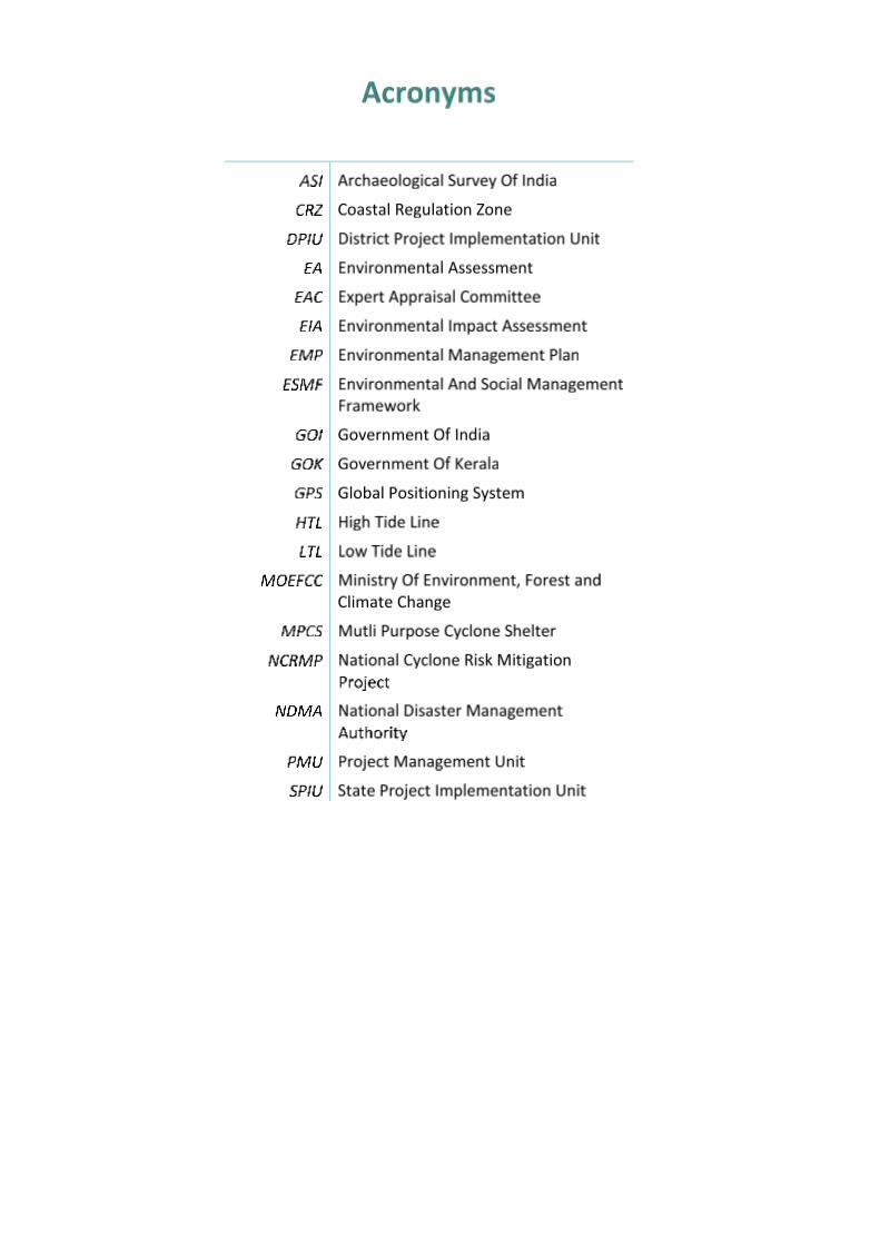
State Project Implementation Unit
Department of Disaster Management
Government of Kerala
NATIONAL CYCLONE RISK MITIGATION PROJECT-KERALA
DRAFT ENVIRONMENT &
SOCIAL MANAGEMENT
FRAMEWORK REPORT
Volume I
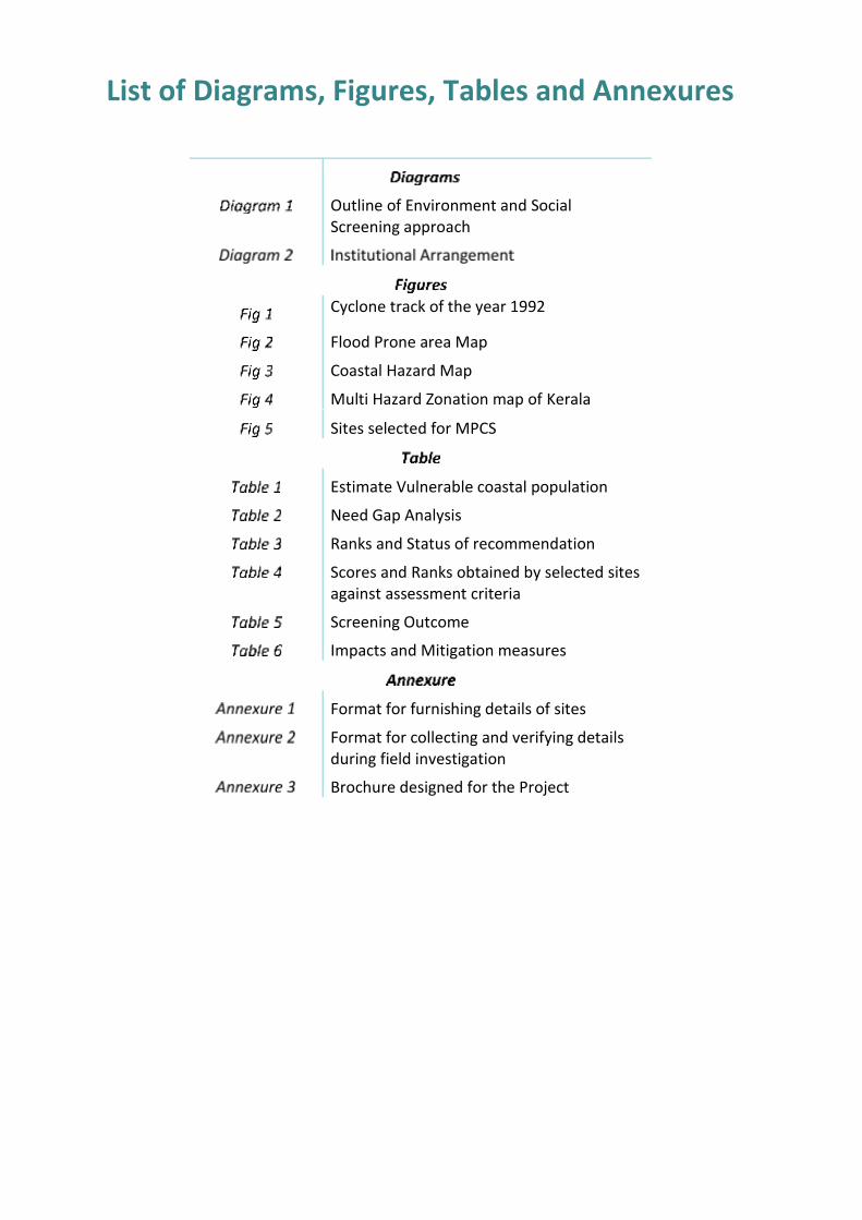
List of Diagrams, Figures, Tables and Annexures
Outline of Environment and Social Screening approach
Cyclone track of the year 1992
Flood Prone area Map
Coastal Hazard Map
Multi Hazard Zonation map of Kerala
Sites selected for MPCS
Estimate Vulnerable coastal population
Need Gap Analysis
Ranks and Status of recommendation
Scores and Ranks obtained by selected sites against assessment criteria
Screening Outcome
Impacts and Mitigation measures
Format for furnishing details of sites
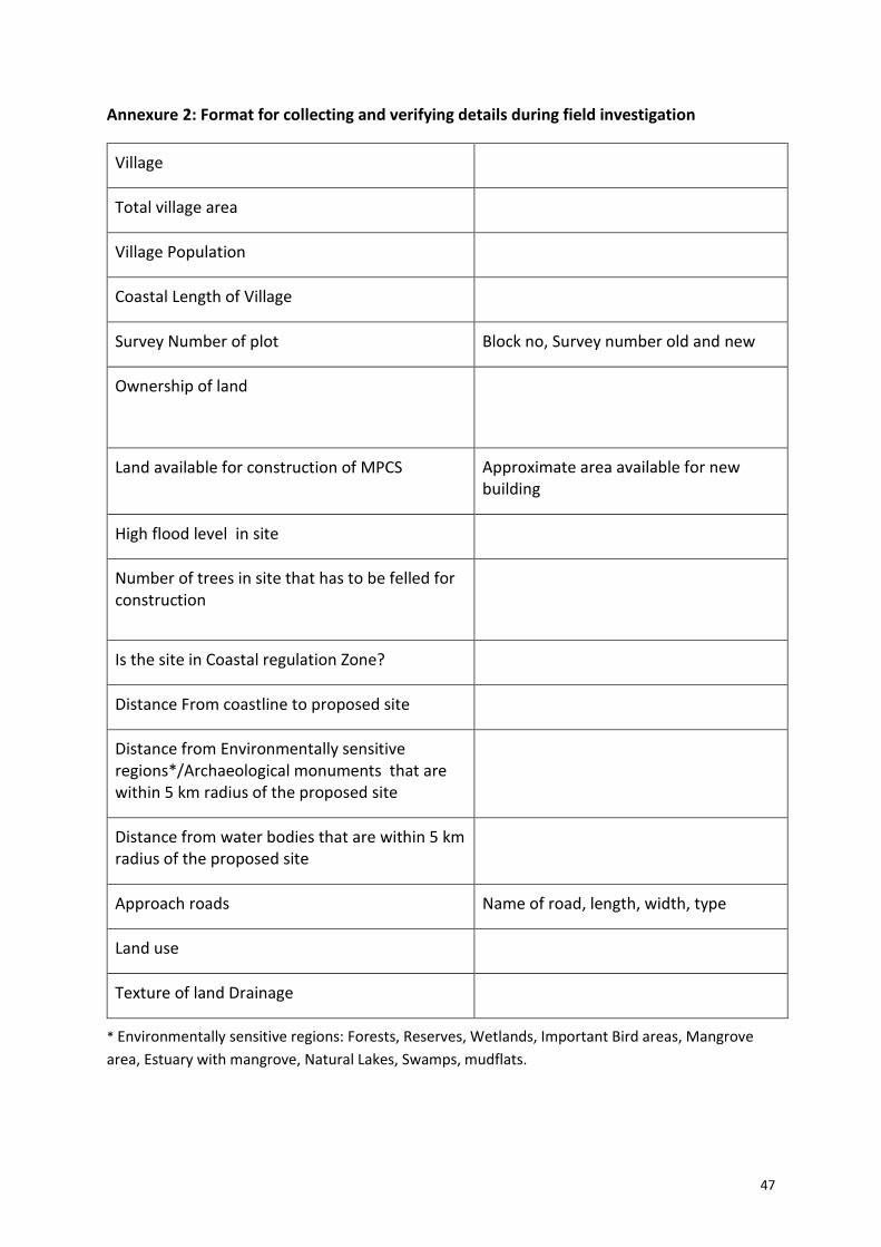
Format for collecting and verifying details during field investigation
Brochure designed for the Project
1
Cyclones are one of the natural hazards
that affect India almost every year causing large
loss of lives and properties. Tropical Cyclone,
also known as ‘Cyclone’, is the term used globally
to cover tropical weather systems in which
winds equal or exceed the minimum of 34 knot
(62 kmph). Hazards associated with tropical
cyclones are long duration high velocity winds,
very heavy rain, storm surge and flooding.
Although, The North Indian Ocean generates
only 7% of the world’s cyclones (5 to 6 cyclones
per year), their impact is comparatively high and
devastating. Tropical cyclones affect the Indian
Coast during pre-monsoon and post-monsoon.
Severe cyclonic storms are prevalent during pre-
monsoon months ie, October and November.
India has a coastline of about 7,516 km
and the entire coast is affected by cyclones with
varying frequency and intensity. Although the
Bay of Bengal and Arabian Sea generates only
about 7% of the World’s cyclones (5 to 6 TC’s per
year) their impact is comparatively high and
devastating. An estimated 40% of the total
population of the country lives within 100 km of
the coast.
The National Cyclone Risk Mitigation
Project [NCRMP] is a project drawn up by
Ministry of Home Affairs, Government of India
with the purpose of creating suitable
infrastructure to mitigate the effects of cyclones
Environmental and Social
management measures are an
integral part of project
execution. The Environment
and Social Management
Framework (ESMF) Report
reflects the methodology
adopted in the process,
procedures related to
screening the site,
documentation and
environment management
plan. This report provides
guidance for planning,
designing and implementing
the construction activities.
The report details out the
various policies, guidelines and
procedures that need to be
integrated during the planning,
design and implementation
cycle of the project. The
framework describes the
principles, objectives and
approach to be followed for
selecting, avoiding, minimizing
and mitigating the adverse
environmental and social
impacts that are likely to arise
due to the project.
It also outlines the indicative
management measures
required to effectively address
the key issues in all phases of the
project.
Abstract
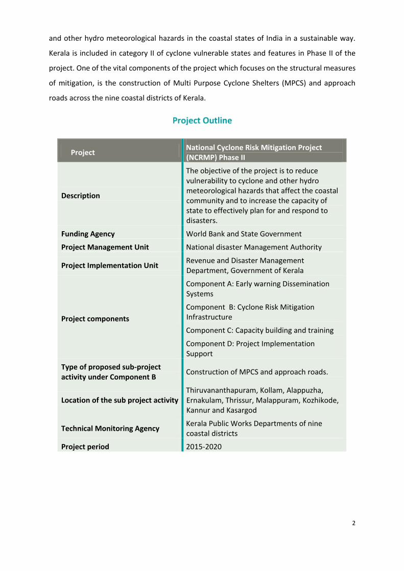
2
and other hydro meteorological hazards in the coastal states of India in a sustainable way.
Kerala is included in category II of cyclone vulnerable states and features in Phase II of the
project. One of the vital components of the project which focuses on the structural measures
of mitigation, is the construction of Multi Purpose Cyclone Shelters (MPCS) and approach
roads across the nine coastal districts of Kerala.
Project National Cyclone Risk Mitigation Project (NCRMP) Phase II
Description
The objective of the project is to reduce vulnerability to cyclone and other hydro meteorological hazards that affect the coastal community and to increase the capacity of state to effectively plan for and respond to disasters.
Funding Agency World Bank and State Government
Project Management Unit National disaster Management Authority
Project Implementation Unit Revenue and Disaster Management Department, Government of Kerala
Project components
Component A: Early warning Dissemination Systems
Component B: Cyclone Risk Mitigation Infrastructure
Component C: Capacity building and training
Component D: Project Implementation Support
Type of proposed sub-project activity under Component B
Construction of MPCS and approach roads.
Location of the sub project activity Thiruvananthapuram, Kollam, Alappuzha, Ernakulam, Thrissur, Malappuram, Kozhikode, Kannur and Kasargod
Technical Monitoring Agency Kerala Public Works Departments of nine coastal districts
Project period 2015-2020
3
Chapter 2: Hazard Profile of Kerala
Kerala is a multi-hazard prone state and disasters of varying nature and intensity that
occur recurrently causes devastation. Natural and Anthropogenic hazards have the potential
to cause disaster poses threat to life, property and socio economic advancement of the state.
The State identifies 39 phenomena that has the potential to cause disaster of which
an average of less than only one cyclone
per decade crosses the state.
Sl.
No.
Month & Year of
occurrence
District
1 Dec, 1908 Thrissur
2 Nov, 1919 Kannur
3 Nov, 1925 Kozhikode
4 May,1932 Malappuram
5 Nov, 1935 Thrissur
6 Nov, 1940 Thrissur
7 May, 1941 Thrissur
8 May, 1962 Kasaragod
9 Dec, 1964 Malappuram
10 Dec, 1972 Kozhikode
11 Nov, 1977 Malappuram
12 Nov, 1978 Kozhikode, Ernakulam
14 Nov, 1984 Kozhikode
15 Nov, 1992 Alappuzha
16 Dec, 2000 Kollam, Trivandrum
18 Oct, 2014 Alappuzha
19 Jun, 2016 Kollam, Idukki
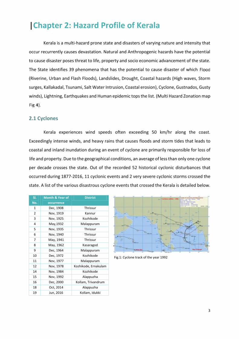
Fig.1: Cyclone track of the year 1992
4
The Severe Cyclone storm of year 1992 crossed caused extensive damage to coastal
districts of the state. During 1877-2016, Northern Coastal bet of the state have been struck
by cyclone the maximum number of times.
Although Kerala falls in the category II of cyclone vulnerable states, the tidal waves
associated with Cyclones can enter land up to 10km and cause massive damage to life and
infrastructure. Exceptional rains, storm surges and strong winds with speeds exceeding
50km/h that follow such cyclonic events cause vast destruction in the coastal areas. In certain
instances, cyclonic storms accompanied by heavy downpour and rise in the sea level cause
floods in inland region. People residing within a distance of 5 km from the sea coast are
generally the worst affected with the inundation varying between 2.5 to 5m and lasting for 5-
6 days.
As per the HRVA report by RMSI on Cyclones, Kollam, Kottayam, and
Thiruvananthapuram districts of Kerala are more vulnerable to cyclonic wind hazard for 100-
year return period event where higher wind speeds of about 85-89 km/h cover a large extent
of these districts. Among these districts, Kollam and Thiruvananthapuram are most vulnerable
to strong winds of about 89 km/h. The report infers that surge heights are higher along the
northern parts of Kerala coast as compared to those of the southern part.
5
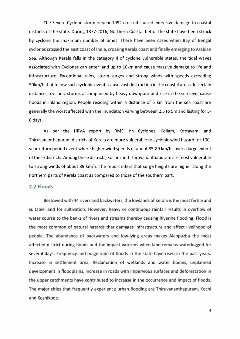
More than 14% of the state’s total area is flood
prone. The frequency of floods and its impacts on life
and property has increased in the recent years
primarily owing to the occurrence of high intensity
rainfall that lasts for few days. The state receives an
average annual rainfall of 3100mm during seasonal
monsoon and 120-140 rainy days per year. Torrential
rainfall during monsoon or Cyclones, which continues
for few days brings heavy water discharge from the
Rivers and streams to the low lying regions of the
district. The water discharge overflows the water
bodies and submerges the lowland adjacent to its
banks.
Wetlands in certain regions of the state, promotes stagnation of water for several
weeks. Kuttanad region in Alappuzha, Kole lands in Thrissur district are major flood prone
areas. Coastal tracts of Ernakulam and Malappuram districts and regions flanking the
Vembanad Lake are other major fold prone regions of the state. In the coastal areas, the tide
levels and the land characteristics will determine the submergence area
Fig 2: Flood Prone area Map
6
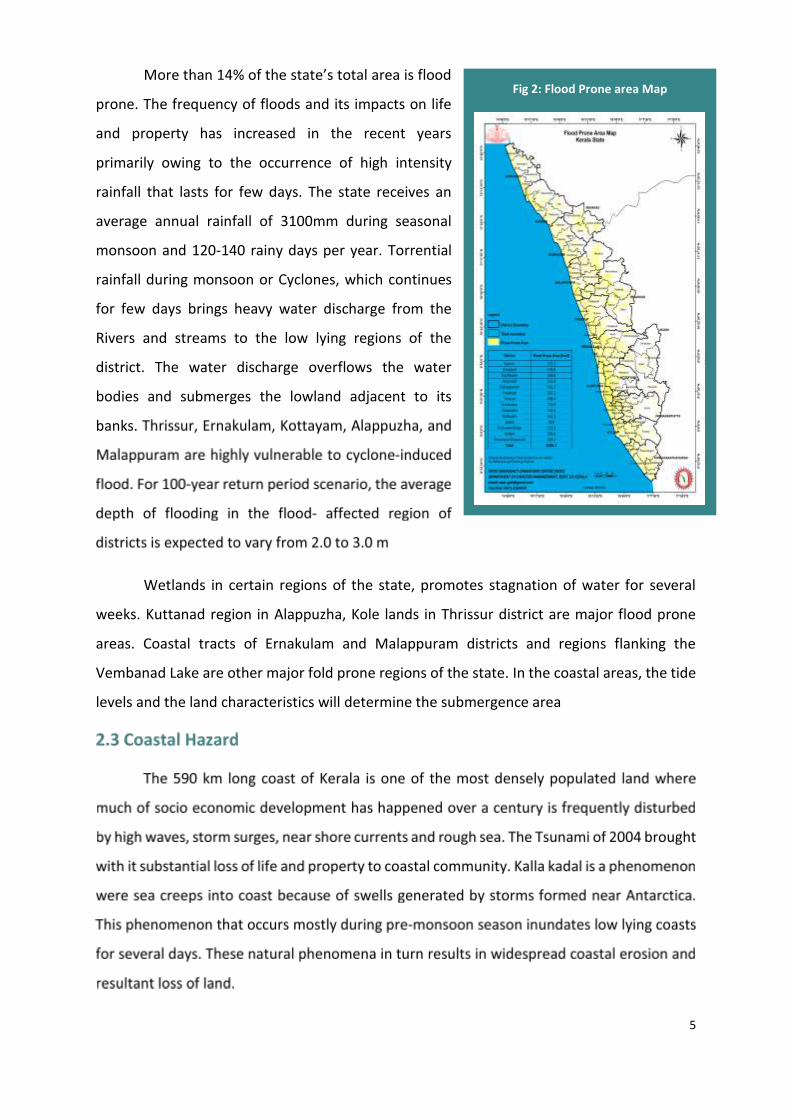
Fig 3: Coastal Hazard Map
7
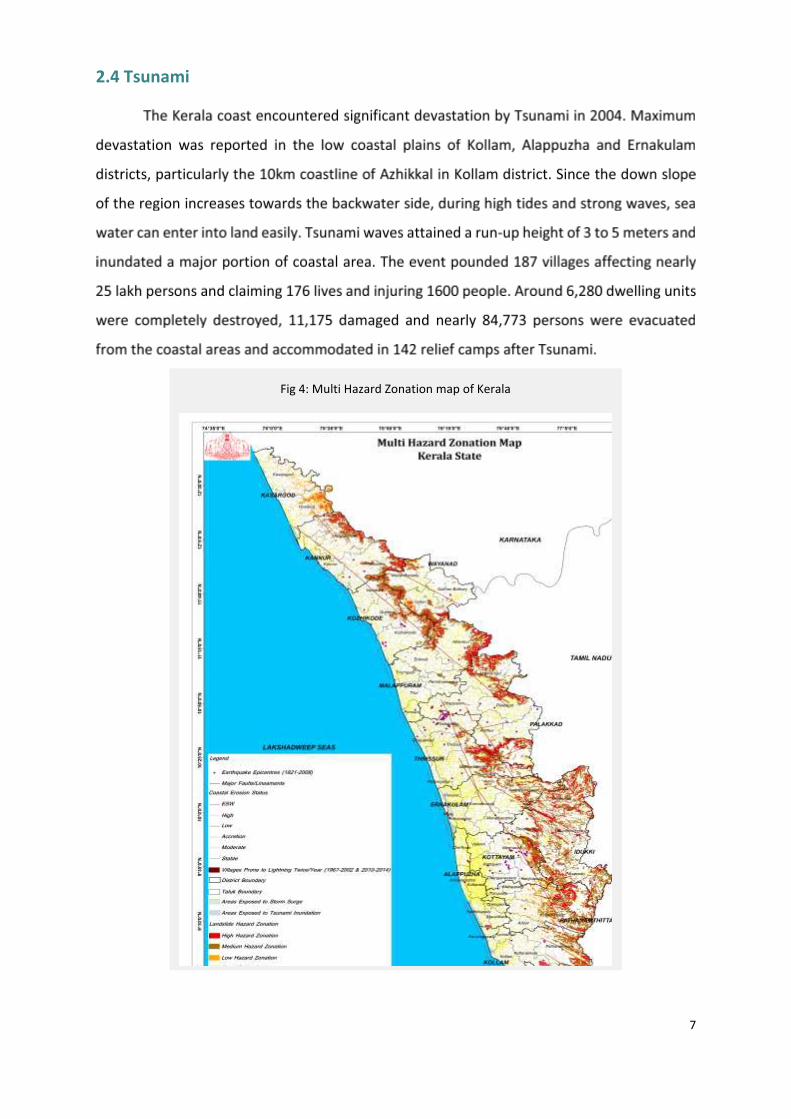
2.4 Tsunami
Fig 4: Multi Hazard Zonation map of Kerala
8
National Cyclone Risk Mitigation Project Phase II focuses on both structural and non-
structural measures of Cyclone and other Hydro meteorological hazard risk mitigation.
Strengthening Early Warning Dissemination Systems, enhancing Capacity and capability of
local communities to respond to disasters being the non-structural measures and
construction of Multi-Purpose Cyclone/Flood shelters (MPCS) being the Structural measures
are of prime emphasis in the project.
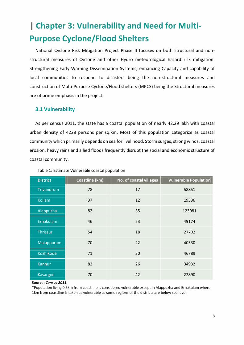
3.1 Vulnerability
As per census 2011, the state has a coastal population of nearly 42.29 lakh with coastal
urban density of 4228 persons per sq.km. Most of this population categorize as coastal
community which primarily depends on sea for livelihood. Storm surges, strong winds, coastal
erosion, heavy rains and allied floods frequently disrupt the social and economic structure of
coastal community.
Table 1: Estimate Vulnerable coastal population
District Coastline (km) No. of coastal villages Vulnerable Population
Trivandrum 78 17 58851
Kollam 37 12 19536
Alappuzha 82 35 123081
Ernakulam 46 23 49174
Thrissur 54 18 27702
Malappuram 70 22 40530
Kozhikode 71 30 46789
Kannur 82 26 34932
Kasargod 70 42 22890
Source: Census 2011. *Population living 0.5km from coastline is considered vulnerable except in Alappuzha and Ernakulam where 1km from coastline is taken as vulnerable as some regions of the districts are below sea level.
9
Storms and flooding for up to 4 weeks during monsoon season, necessitates the state to
shelter families to safe locations during this period. Flood can reach up to height of 2-3 feet
in certain regions of the district flooding almost all households, whether pucca or kutcha,
roads and bridges. Every year during the monsoon, many lives are lost in events associated
with flooding and people have to be evacuated and sheltered for several weeks until the flood
waters retreated. The District Administrations have to evacuate and shelter coastal
community for several weeks from regions highly prone to coastal erosion. The fact that a
large section of the population lives in jerry-built houses of substandard quality, increases the
risk of human impact, in case of any disaster.
3.2 Need for MPCS
It is essential to provide safe places to stay to the vulnerable population during cyclones,
associated tidal waves, storm surges, floods and other hydro meteorological hazards. The lack
of adequate facilities to shelter vulnerable population in safe locations, affects the actual
number of vulnerable population addressed during this period. Schools, community halls and
other infrastructure are presently used as shelters to accommodate the vulnerable
population during floods associated with heavy rainfall in monsoons. In extreme cases, the
need to shelter the population may run up to 2-3 weeks. In such instances, the facilities in
theses shelters are inadequate to satisfy the basic needs of the population. In certain
instances temporary sheds had to be erected to accommodate and facilitate cooking for the
sheltered, during the camp days.
Table 2: Need Gap Analysis
District Vulnerable Population*
Available shelters GAP (Vulnerable population- without
access to shelter) Number [Schools and others]
Population that can be sheltered*
Trivandrum 58851 63 31500 27351
Kollam 19536 16 8000 11536
Alappuzha 123081 134 67000 56081
Ernakulam 49174 75 37500 11674
Thrissur 27702 32 16000 11702
Malappuram 40530 55 27500 13030
10
Kozhikode 46789 47 23500 23289
Kannur 34932 51 25500 9432
Kasargod 22890 22 11000 11890
*Approximate number
3.3 Multipurpose Cyclone shelters
Multi-purpose Cyclone Shelters (MPCS) that are linked to major roads via all-weather
approach roads will be constructed in the nine coastal districts through this project. The
designs of the buildings will be customised depending on the population that has to be
sheltered and the purpose for which the MPCS will be put into use during normal situations.
Provisions for ramps and other disable friendly aspects will be integrated to the building
design. Since, shelters will remain camped by population for continuous periods, provision for
kitchen, generator room and other sanitation facilities will be incorporated to design.
Maintenance and functioning of these MPCS in normal situations will be vested with the
community itself. These shelters will serve as major assets for the coastal community during
the hour of emergencies thus reducing the risk of exposure and vulnerability.
Salient features of MPCS:
Minimization of loss of lives, property and livestock.
Nodal point for receipt and dissemination of cyclone/other hydro meteorological
hazard warnings
Safe keeping of essential stocks/items for post disaster usage.
Nodal point for carrying outpost disaster response and relief activities
Provides temporary protection from the monsoon to the vulnerable population
11
The implementation of the Construction activities proposed under the NCRMP-Kerala must
be consistent with all applicable laws, regulations and notifications of National, State and
Local authorities. Additionally, it is also to be ensured that activities are consistent with World
Bank policies and guidelines. This section includes legislation and policy guidelines identified
as pertinent to environmental and social management framework for NCRMP-Kerala.
4.1 National Policy and Regulatory Framework
Various policies, acts, rules and regulations promulgated by the central and state
governments related to environment and relevant to the project, the scope of key relevant
environment regulations and their relevance is presented in the table below:
4.1.1 Environment (Protection) Act, 1986 & EIA Notification S.O. 1533 dated Sep, 14, 2006
The Environment (Protection) Act, 1986 was introduced as an umbrella legislation that
provides a holistic framework for the protection and improvement to the environment. In
terms of responsibilities, the Act and the associated Rules requires environmental
clearances to be sought for specific types of new / expansion projects (addressed under
Environmental Impact Assessment Notification) and for submission of an environmental
statement to the State Pollution Control Board annually.
Under this Act, the Central Government is empowered to take measures necessary to
protect and improve the quality of the environment by setting standards for emissions and
discharges; regulating the location of industries; management of hazardous wastes, and
protection of public health and welfare. This encompasses all legislations providing for the
protection of environment in the country.
Relevance:
The proposed project intervention involves construction activities that will have indirect
or direct impact on the overall quality of the environment.
12
4.1.2 EIA Notification, 2006
The objective of the EIA Notification, 2006 is to set procedures of environmental
clearance before establishment of identified nature and size. The suitability of site for a
proposed development is one of primary concerns in according environmental clearance
to a project. As per the Notification and subsequent amendments, projects have been
grouped under Category ‘A’ requiring clearance from Expert Appraisal Committee (EAC) of
MoEF&CC, GoI and Category ‘B’ requiring clearance from the State Expert Appraisal
Committee (SEAC).
Projects in hilly terrain (above 1,000 m AMSL) and or Ecologically Sensitive areas is
categorized as ‘B’ and Environmental Clearance is to be obtained from SEAC. Building and
construction projects with ≥ 20,000 sq. m and < 1, 50,000 sq. m of built up area is
categorized as ‘B’ and Environmental Clearance is to be obtained from SEAC. As per EIA
notification, 2006 environmental clearance is mandatory for projects with built up area
more than 20,000 sq mt.
Relevance:
Cyclone shelters being built under this project are less than 20,000 sq.mt in size and
hence do not require Environmental Clearance. If there is a Cyclone shelter/ building or a
construction projects with ≥20,000 sq.
m and <150,000 sq. m of built-up area, it will require prior Environmental Clearance as
per the EIA notification of 2006. Any of the proposed 21 MPCS does not falls with ≥20,000
sq. m and <150,000 sq. m of built-up area and it does not require any clearance under EIA
Notification, 2006.
4.1.3 Coastal Regulation Zone Notification (CRZ), 2011 and its amendments
In exercise of the powers conferred by sub-section (1) and clause (v) of sub-section (2)
of section 3 of the Environment (Protection) Act, 1986 (29 of 1986), the Central
Government, with a view to ensure livelihood security to the fisher communities and other
local communities, living in the coastal areas, to conserve and protect coastal stretches, its
unique environment and its marine area and to promote development through sustainable
13
manner based on scientific principles taking into account the dangers of natural hazards in
the coastal areas, sea level rise due to global warming, does hereby, declare the coastal
stretches of the country and the water area upto its territorial water limit, excluding the
islands of Andaman and Nicobar and Lakshadweep and the marine areas surrounding these
islands upto its territorial limit, as Coastal Regulation Zone (hereinafter referred to as the
CRZ).
The Central Government has constituted the Coastal Zone Management Authority
(CZMA) of Kerala to take measures for protecting and improving the quality of the coastal
environment and preventing, abating and controlling environmental pollution in the
coastal areas of Kerala. A Coastal Zone Management Plan (CZMP) has to be prepared by the
Authority, identifying and classifying the CRZ areas in accordance with the guidelines given
in the Notification and approval has to be obtained from the Ministry of Environment,
Forests & Climate Change, Government of India. According to this, areas covered under
CRZ-I, CRZ-II, CRZ-III and CRZ IV will be identified using satellite imagery and maps in the
scale 1:25,000 will be prepared.
The CRZ has been classified as CRZ-I, CRZ-II,CRZ-III and CRZ IV in the State for the purpose
of regulation of the permitted activities based on the ecological sensitivity and
development status of the area.
Classification of the CRZ – For the purpose of conserving and protecting the coastal areas
and marine waters, the CRZ area shall be classified as follows, namely:-
(i) CRZ-I–
A. The areas that are ecologically sensitive and the geomorphological features which
play a role in the maintaining the integrity of the coast,-
(a) Mangroves, in case mangrove area is more than 1000 sq mts, a buffer of 50meters along the mangroves shall be provided;
(b) Corals and coral reefs and associated biodiversity;
(c) Sand Dunes;
(d) Mudflats which are biologically active;
(e) National parks, marine parks, sanctuaries, reserve forests, wildlife habitats and other protected areas under the provisions of Wild Life (Protection) Act, 1972 (53 of 1972),
14
the Forest (Conservation) Act, 1980 (69 of 1980) or Environment (Protection)Act, 1986 (29 of 1986); including Biosphere Reserves;
(f) Salt Marshes;
(g) Turtle nesting grounds;
(h) Horse shoe crabs habitats;
(i) Sea grass beds;
(j) Nesting grounds of birds;
(k) Areas or structures of archaeological importance and heritage sites.
B. The area between Low Tide Line and High Tide Line;
(ii) CRZ-II-
The areas that have been developed upto or close to the shoreline.
(iii) CRZ-III-
Areas that are relatively undisturbed and those do not belong to either CRZ-I or II which
include coastal zone in the rural areas (developed and undeveloped) and also areas within
municipal limits or in other legally designated urban areas, which are not substantially built
up.
(iv.) CRZ-IV-
A. the water area from the Low Tide Line to twelve nautical miles on the seaward side;
B. shall include the water area of the tidal influenced water body from the mouth of the
water body at the sea upto the influence of tide which is measured as five parts per
thousand during the driest season of the year..
Relevance
The proposed sub-projects under NCRMP are not permissible in CRZ areas, hence the
project does not come under the purview of this notification
15
4.1.4 Forest (Conservation) Act, 1980 and its amendment
This Act provides for the conservation of forests and regulating diversion of forestlands
for non-forestry purposes. When projects fall within forestlands, prior clearance is required
from relevant authorities under the Forest (Conservation) Act, 1980. For diversion of
forestland, the project proponent needs to apply to the State Government. Depending on
the area required to be diverted, the proposals are cleared by MoEF Regional or Central
Offices provided that the cost of compensatory afforestation, cost of rehabilitation of
endangered/rare species of flora/fauna, and the net present value of the forest resources
are deposited upfront with the state Forest Department.
Relevance
• If the area of forests to be diverted exceeds 20 Ha (or 10 Ha in hilly area), prior
permission of Central Government is required;
• If the area of forest to be diverted is between 5 to 20 Ha, the Regional Office of Chief
Conservator of Forests is empowered to approve;
• If the area of forest to be diverted is below or equal to 5 HA, the State Government
can give permission
4.1.5 Water (Prevention & Control of Pollution) Act, 1974 & Air (Prevention & Control of
Pollution) Act, 1981
These two laws are in force to prevent and control land-based pollution. These laws
prescribe the standards for effluent discharge and air emissions and established the State
Pollution Control Board to enforce the provisions of the Acts.
Relevance
The requirement is to obtain a No Objection Certificate i.e., Consent to Establish and
Consent to Operate from State Pollution Control Board.
4.1.6 Ancient Monuments and Archaeological Sites and Remains Act, 1958
16
The act prohibits construction of building within the protected area or carry on any
mining, quarrying, excavating, blasting or any operation of a like nature in such area, or
utilise such area or any part thereof in any other manner without the permission of the
Central Government.
Relevance
The legal requirement is to obtain from ASI a no-objection certificate if any protected
cultural property is within 10km of the project.
4.1.7 The Ramsar Convention on Wetlands of International Importance, 1971
The Ramsar Convention is an international treaty for the conservation and sustainable
utilization of wetlands i.e. to stem the progressive encroachment on and loss of wetlands
now and in the future, recognizing the fundamental ecological functions of wetlands and
their economic, cultural, scientific and recreational value.
Relevance
According to the Ramsar list of Wetlands of International Importance, there are 25
designated wetlands in the country which are required to be protected. Activities
undertaken in the proximity of these wetlands should follow the guidelines of the
convention.
4.1.8 The Land Acquisition Act (LA) of 1894
The private land acquisition will be guided by the provisions and procedures outlined in
this Act. As per the LA Act, the District Collector or any other officer designated will function
as the Land Acquisition Officer on behalf of the Government. There is a provision for
consent award to reduce the time for processing if the land owners are willing to agree for
the price fixed by the Land Acquisition Officer. The option of acquiring lands through private
negotiations is also available.
Relevance
17
The act is applicable in cases where land acquisition is required for construction of Cyclone
Shelters.
4.1.8 National Rehabilitation and Resettlement Policy, 2007
This policy strikes a balance between the need for land for developmental activities &
protecting the interests of land owners and others. The benefits under the new policy are
available to all Project Affected Persons (PAP) & families whose land, property or livelihood
is adversely affected by land acquisition, involuntary displacement due to natural
calamities, etc.
Relevance
The act is applicable in cases where resettlement or rehabilitation due to the project is
required.
4.2 World Bank Policies
The objective of World Bank policies is to prevent and mitigate undue harm to people and the
environment in the development process. These policies provide guidelines for the identification,
preparation, and implementation of programs and projects. NCRMP has been designed to ensure total
compliance to the requirement of World Bank safeguard policies. The following policies are relevant
for the project. The proposed project has been screened against the requirements of the following
World Bank Policies:
4.2.1 Environmental Assessment (OP/BP 4.01)
Environmental Assessment is used in the World Bank to identify, avoid, and mitigate the
potential negative environmental impacts associated with the project cycle. The policy
states that EA and mitigation plans are required for all projects having significant adverse
environmental impacts or involuntary resettlement. EA’s should include analysis of
alternative designs and sites, or consideration of “no option” requiring public participation
and information disclosure before the Bank approves the project. In World Bank
operations, the purpose of Environmental Assessment is to improve decision making, to
18
ensure that project options under consideration are sound and sustainable, and that
potentially affected people have been properly consulted and their concerns addressed.
4.2.2 Involuntary Resettlement (OP/BP 4.12)
The Bank’s Operational Policy 4.12: Involuntary Resettlement is triggered in situations
involving involuntary taking of land and involuntary restrictions of access to legally
designated parks and protected areas. The policy aims to avoid involuntary resettlement to
the extent feasible, or to minimize and mitigate its adverse social and economic impacts. It
promotes participation of displaced people in resettlement planning and implementation,
and its key economic objective is to assist displaced persons in their efforts to improve or
at least restore their incomes and standards of living after displacement. The policy
prescribes compensation and other resettlement measures to achieve its objectives and
requires that borrowers prepare adequate resettlement planning instruments prior to Bank
appraisal of proposed projects.
4.2.3 Indigenous Peoples (OP/BP 4.10)
The World Bank Policy on indigenous peoples, OP/BP 4.10, Indigenous Peoples,
underscores the need for borrowers and Bank staff to identify indigenous peoples, consult
with them, ensure that they participate in and benefit from Bank funded operations in a
culturally appropriate way – and that adverse impacts on them are avoided, or where not
feasible, minimized or mitigated.
4.2.4 Cultural Property (OP/BP 4.11)
The policy defines Physical cultural resources as movable or immovable objects, sites,
structures, groups of structures, and natural features and landscapes that have
archaeological, paleontological, historical, architectural, religious, aesthetic, or other
cultural significance. Physical cultural resources may be located in urban or rural settings,
and may be above or below ground, or under water. Their cultural interest may be at the
local, provincial or national level, or within the international community. The Bank assists
countries to avoid or mitigate adverse impacts on physical cultural resources from
development projects that it finances. The impacts on physical cultural resources resulting
19
from project activities, including mitigating measures, may not contravene either the
borrower’s national legislation, or its obligations under relevant international
environmental treaties and agreements.
The borrower addresses impacts on physical cultural resources in projects proposed for
Bank financing, as an integral part of the environmental assessment (EA) process.
4.2.5 Natural Habitat (OP 4.04)
The policy implementation ensures that Bank-supported development projects give
proper consideration to the conservation of natural habitats, in order to safeguard their
unique biodiversity and ensure the sustainability of the environmental services and
products which natural habitats provide to human society. This policy is applicable when a
project (including any subproject under a sector investment or financial intermediary loan)
with the potential to cause significant conversion (loss) or degradation of natural habitats,
whether directly (through construction) or indirectly (through) human activities induced by
the project.
20
The screening process forms the first step in the environment management process for the
construction activity which aids in early identification of key environmental and social issues
at the implementation level and is carried out in parallel with the Project Engineering
feasibility study. This process helps in identification sites located fully or partially within
setback boundaries of environmentally sensitive areas such as presence of National
Parks/Sanctuaries, Wildlife Sanctuaries, Reserved/Protected forests, Cultural Properties and
Coastal Regulation zones. Similarly, the sites requiring private lands or sites with displacement
issues or sites with impacts on vulnerable people will be identified through this screening
process.
The screening process will help to:
(i) Finalize the sites for construction of MPCS
(ii) Identify the need to obtain any regulatory clearances
(iii) Establish the need to carry out any further assessment
(iv) Prioritize and phase the civil work program/procurement plan
(v) Categorize construction activities
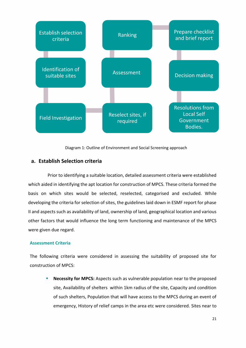
5.1 Screening Approach
The screening approach adopted for selection of suitable sites for construction of MPCS
are in line with the guidelines laid down in Environment and Social Management Framework
for states included in Phase ll of NCRMP. Since, the primary target group of NCRMP is coastal
community which is the most vulnerable to coastal hazards, the screening exercise focused
on identifying the most apt location for MPCS that would advantage be of the target group.
The methodology followed for screening helped to determine the nature and magnitude of
the issues to be tackled at different stages of construction and project implementation. The
steps followed for Environmental and social screening is diagrammatically represented in
Figure 5.
21
Diagram 1: Outline of Environment and Social Screening approach
a. Establish Selection criteria
Prior to identifying a suitable location, detailed assessment criteria were established
which aided in identifying the apt location for construction of MPCS. These criteria formed the
basis on which sites would be selected, reselected, categorised and excluded. While
developing the criteria for selection of sites, the guidelines laid down in ESMF report for phase
II and aspects such as availability of land, ownership of land, geographical location and various
other factors that would influence the long term functioning and maintenance of the MPCS
were given due regard.
Assessment Criteria
The following criteria were considered in assessing the suitability of proposed site for
construction of MPCS:
Necessity for MPCS: Aspects such as vulnerable population near to the proposed
site, Availability of shelters within 1km radius of the site, Capacity and condition
of such shelters, Population that will have access to the MPCS during an event of
emergency, History of relief camps in the area etc were considered. Sites near to
Establish selection criteria
Identification of suitable sites
Field InvestigationReselect sites, if
required
Assessment
RankingPrepare checklist and brief report
Decision making
Resolutions from Local Self
Government Bodies.
22
regions where camps/shelters were conducted/ required during flood, heavy rain,
storm surge, coastal erosion, cyclone etc were preferred.
Area available for construction: Sites which have atleast 15 cents of land available
for construction were considered. The effective area available for construction
after provision for setbacks applicable as per existing Building rules was only taken
into consideration.
Accessibility to basic amenities: The accessibility of site from nearby main roads,
proximity of site to water supply, power, sewer etc were considered in selecting
the site.
Ownership of land: Land in possession with Revenue Department was preferred
to that in possession other departments. The project did not acquire any private
land for construction of MPCS.
Landscape: Terrain of land, bearing capacity of soil on visual observation,
drainage pattern in the region, maximum flood line etc was considered. Sites that
are not flooded during high tide or that remain waterlogged for major part of year
were not selected.
Requirement for demolition: Sites that did not require any demolition to facilitate
construction of MPCS were given priority. However, in sites that required
demolition, the condition of existing building, ownership of the building etc were
taken into account.
Proximity to sea: As the project targets only coastal community primarily, sites
within 10km distance from coastline were only considered. Those sites which fall
beyond 500m from High Tide Line were preferred. The sites within 200m from the
coastline were not preferred and sites that do not require CRZ clearance were
given priority. Sites in extreme proximity to kayals, lakes, streams and other water
bodies were not preferred.
Clearances required for social/archaeological/environmental issues: Sites
adjacent to archaeologically, religiously important structures were avoided. Sites
with issues of Illegal tenants and any social concerns particular to the region were
also avoided. Sites in extreme proximity to rivers, streams and other water bodies
were not preferred. Sites located partly or wholly in wetland, mangrove area,
23
reserved area, archeologically important or any other environmentally sensitive
area.
Legal issues: Sites with legal issues regarding ownership, extent and boundaries
of land and sites committed and finalized for other project etc were given less
priority in the assessment.
b. Identification of suitable sites
The next step in the screening process was to identify suitable sites in the nine
coastal districts of Kerala that meets the assessment criteria. The Principal Secretary,
Revenue and Disaster Management and Project Director of NCRMP-Kerala briefed the
District Collectors regarding the project and the site assessment criteria in the District
Collectors Conference held on 18th September 2015.
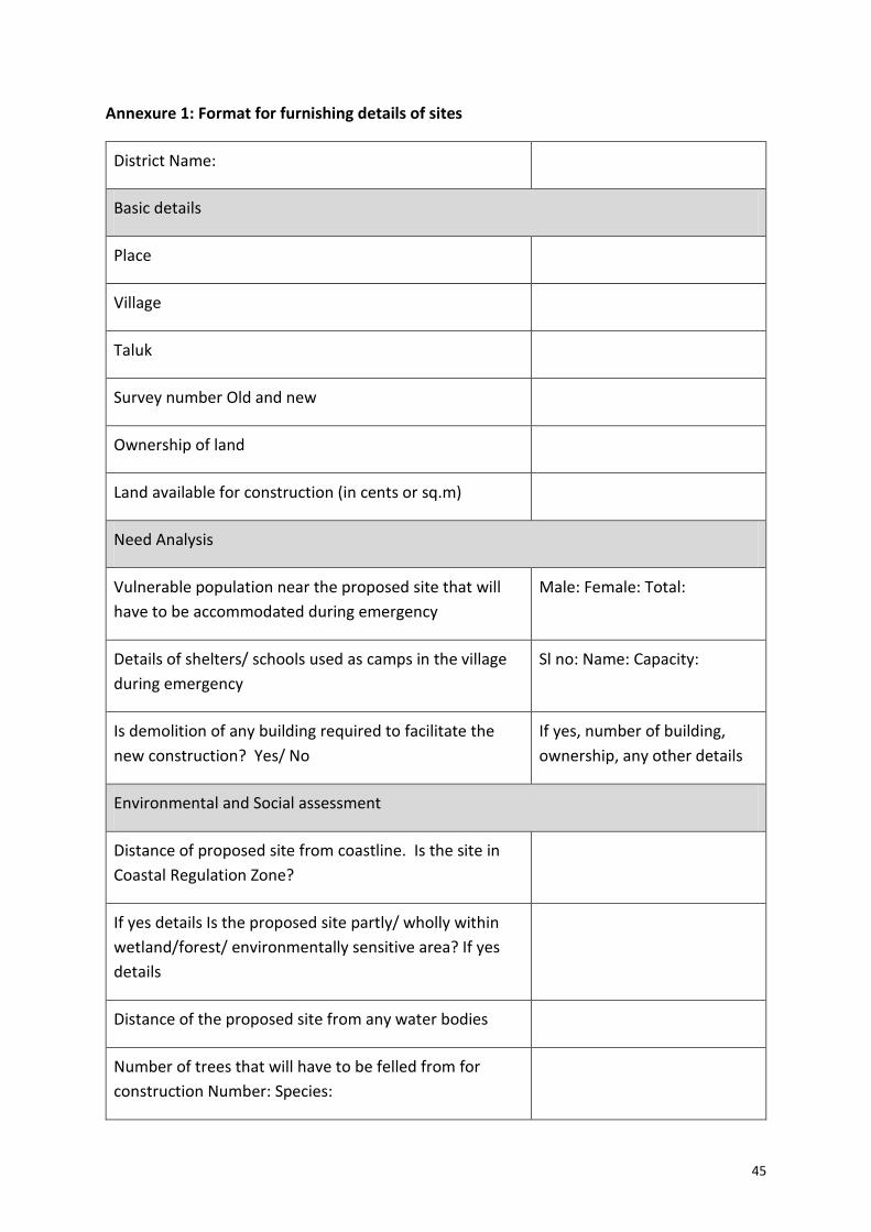
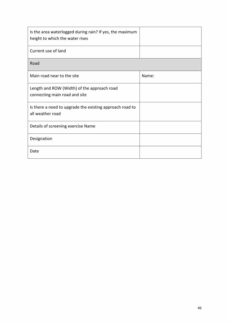
Subsequent to the briefing, a proforma, which was prepared for collection of
details regarding suitable sites, was circulated to District Administration of nine coastal
districts for furnishing the details (Annexure 1). The proforma was structured depending
on the assessment criteria for selection of suitable sites and provided guidance to the
District Administration in identifying the appropriate location for MPCS in the respective
districts (Annexure 1). Upon receiving the details of sites suitable for construction of MPCS,
the information was recorded in spreadsheet format for further assessment.
c. Field Investigation
Field Investigation was done in sites around 80 sites, identified and proposed
by District Administration of nine coastal Districts by the team from State Project
Implementation Unit of the project. During the field investigation, the details furnished in
the proforma were verified and more information was collected from the respective
Village officials, representatives of the local body, School authorities (wherever the site
was within the compound of school) and locals regarding the site. The possible use of the
MPCS during normal times was discussed, suggestion and need of the area was noted.
Measurements and dimensions of the site, soil bearing capacity on visual
observation, existing town planning rules in the region, requirement for demolition and
access road dimensions were verified to check the engineering feasibility in the proposed
site. In sites proposed within the school compound, the scope for campus planning was
discussed in detail with the school authorities for incorporating design parameters that
would complement the functions of the school. The flood level and drainage pattern of the
24
area was recorded and the coordinates of the location was recorded using GPS tracker for
assessment in GIS platform. Photographs of the site, access roads, nearby structures etc
were documented. All requisite and ancillary information supporting the assessment
criteria were collected during field investigation (Annexure 2).
d. Reselection of site
Certain sites which were found inapt for construction of MPCS, as per the
assessment guidelines laid down and thus alternate sites had to be chosen for construction
of MPCS. The District Administration suggested alternative sites in the same region and
the field investigation was performed in the similar manner.
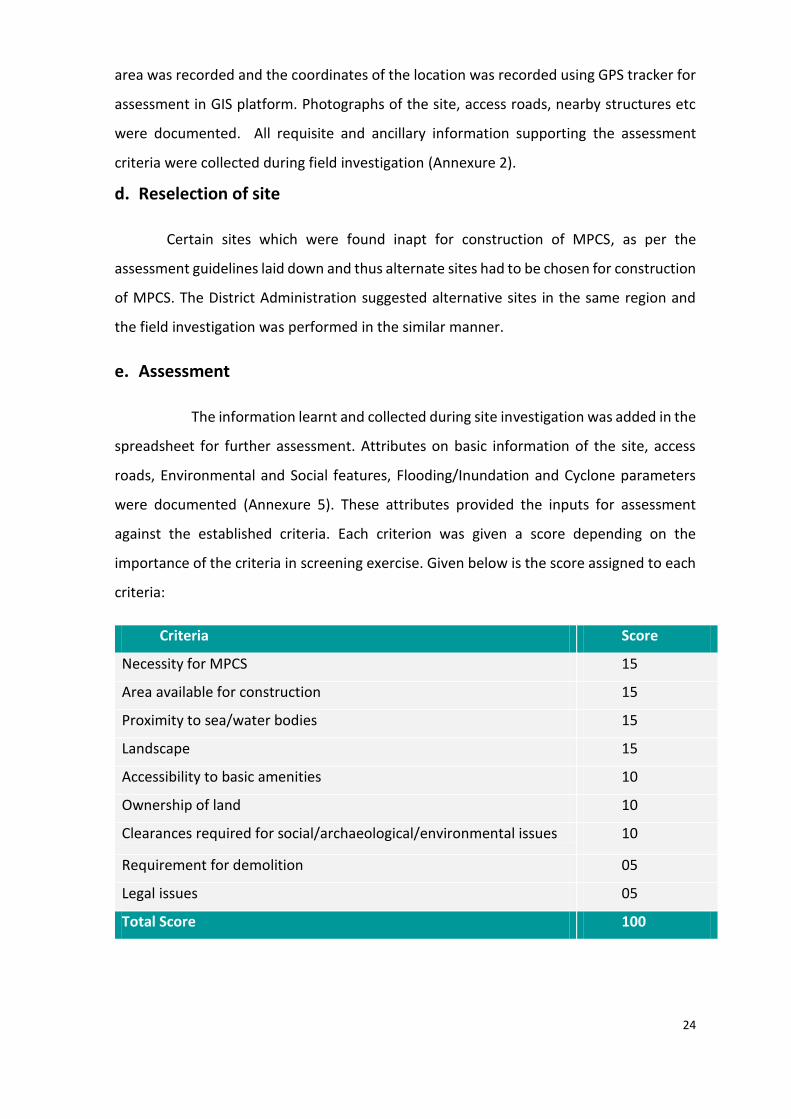
e. Assessment
The information learnt and collected during site investigation was added in the
spreadsheet for further assessment. Attributes on basic information of the site, access
roads, Environmental and Social features, Flooding/Inundation and Cyclone parameters
were documented (Annexure 5). These attributes provided the inputs for assessment
against the established criteria. Each criterion was given a score depending on the
importance of the criteria in screening exercise. Given below is the score assigned to each
criteria:
Criteria Score
Necessity for MPCS 15
Area available for construction 15
Proximity to sea/water bodies 15
Landscape 15
Accessibility to basic amenities 10
Ownership of land 10
Clearances required for social/archaeological/environmental issues 10
Requirement for demolition 05
Legal issues 05
Total Score 100
25
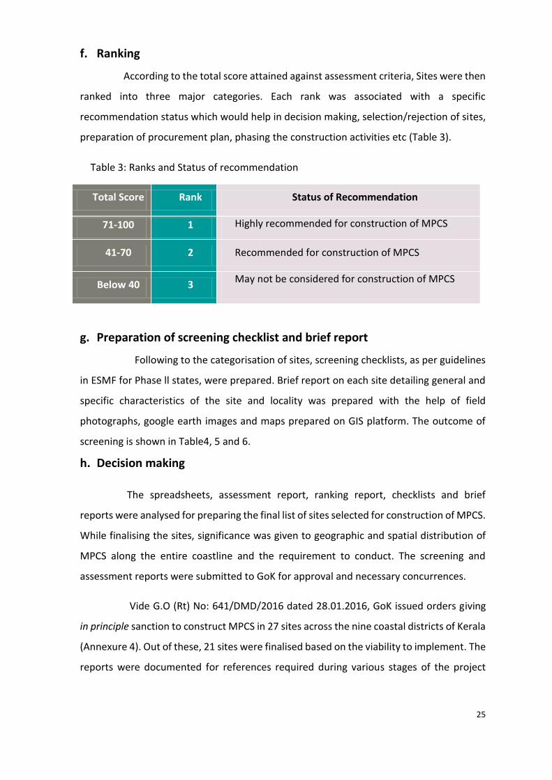
f. Ranking
According to the total score attained against assessment criteria, Sites were then
ranked into three major categories. Each rank was associated with a specific
recommendation status which would help in decision making, selection/rejection of sites,
preparation of procurement plan, phasing the construction activities etc (Table 3).
g. Preparation of screening checklist and brief report
Following to the categorisation of sites, screening checklists, as per guidelines
in ESMF for Phase ll states, were prepared. Brief report on each site detailing general and
specific characteristics of the site and locality was prepared with the help of field
photographs, google earth images and maps prepared on GIS platform. The outcome of
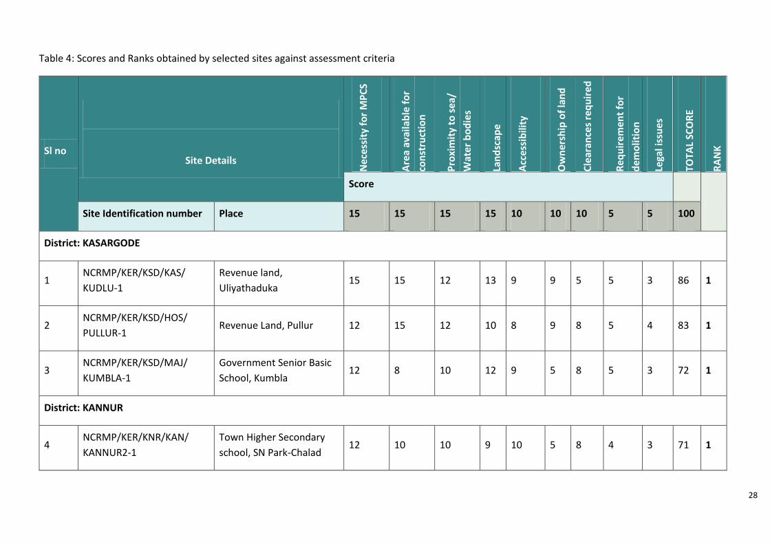
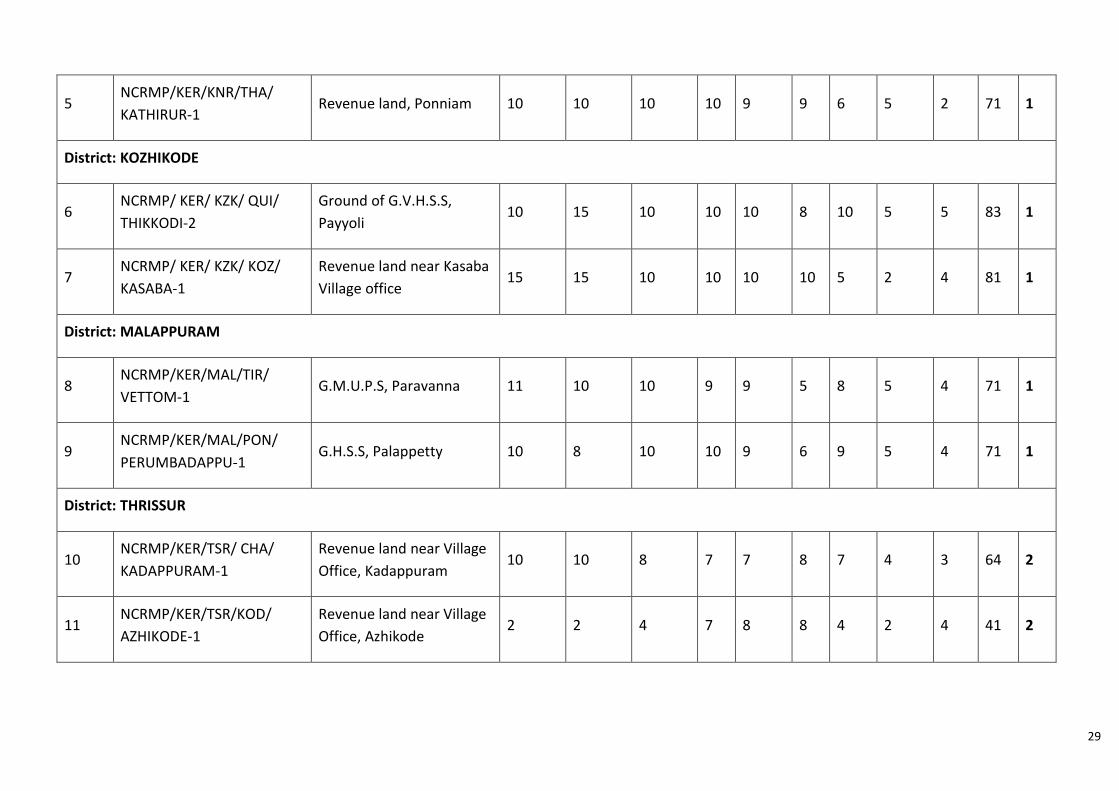
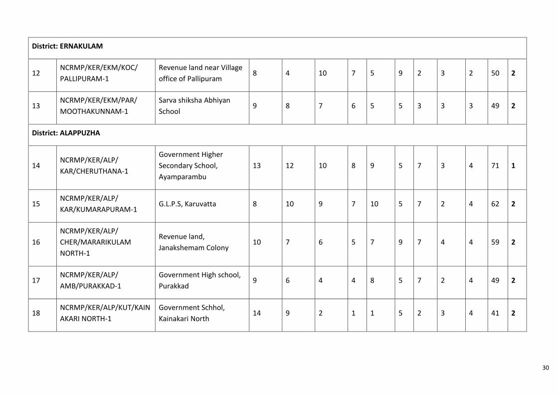
screening is shown in Table4, 5 and 6.
h. Decision making
The spreadsheets, assessment report, ranking report, checklists and brief
reports were analysed for preparing the final list of sites selected for construction of MPCS.
While finalising the sites, significance was given to geographic and spatial distribution of
MPCS along the entire coastline and the requirement to conduct. The screening and
assessment reports were submitted to GoK for approval and necessary concurrences.
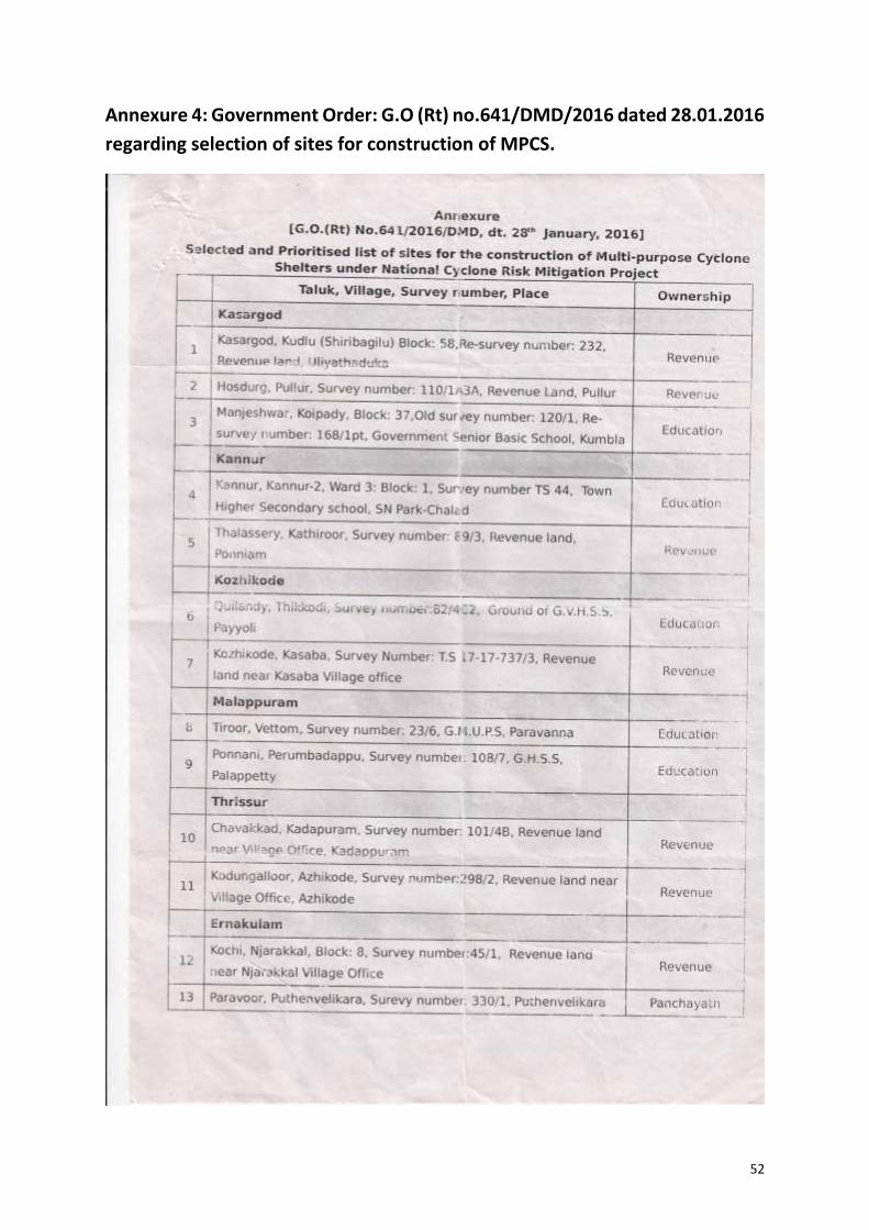
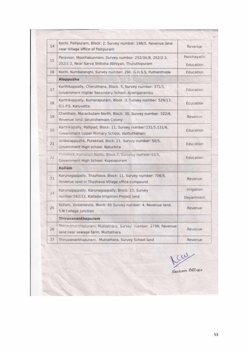
Vide G.O (Rt) No: 641/DMD/2016 dated 28.01.2016, GoK issued orders giving
in principle sanction to construct MPCS in 27 sites across the nine coastal districts of Kerala
(Annexure 4). Out of these, 21 sites were finalised based on the viability to implement. The
reports were documented for references required during various stages of the project
Table 3: Ranks and Status of recommendation
Total Score Rank Status of Recommendation
71-100 1 Highly recommended for construction of MPCS
41-70 2 Recommended for construction of MPCS
Below 40 3 May not be considered for construction of MPCS
26
implementation and monitoring. Consolidated screening and assessment report of
selected sites are given in Table 7 and 8 respectively.
27
i. Resolutions from Local Self-Government Bodies
As the next step of ESMF, procedures for obtaining Resolution from the local
self-government bodies of the selected sites was initiated. The Local Self Government
bodies, ie, Panchayath, Municipal Corporation and City Corporation of the concerned sites
were briefed regarding the objectives and implementation strategy of the project through
the District Project Implementation Units in the nine Coastal Districts. The Local
Community Mobilisers in the districts (wherever their service was available at the time)
and Officials from district Administration did the follow up of activities at the local body
level. Brochures, brief reports and checklists were used as medium to convey information
to stakeholders at all levels.
Any issues regarding availability of land, design of the MPCS, use of MPCs
during normal times etc was resolved at this stage. After the ward/council/committee
level meetings a resolution was approved by the concerned local body stating there is no
objection in constructing the MPCS at the particular location and no environmental or
social issues related to construction is seen. The suggestions towards designs of building
and other concerns were also include in the resolution.
28
Table 4: Scores and Ranks obtained by selected sites against assessment criteria
Sl no
Site Details
Ne
cess
ity
for
MP
CS
Are
a av
aila
ble
fo
r
con
stru
ctio
n
Pro
xim
ity
to s
ea/
Wat
er
bo
die
s
Lan
dsc
ape
Acc
essi
bili
ty
Ow
ner
ship
of
lan
d
Cle
aran
ces
req
uir
ed
Req
uir
emen
t fo
r
dem
olit
ion
Lega
l iss
ues
TOTA
L SC
OR
E
RA
NK
Score
Site Identification number Place 15 15 15 15 10 10 10 5 5 100
District: KASARGODE
1 NCRMP/KER/KSD/KAS/
KUDLU-1
Revenue land,
Uliyathaduka 15 15 12 13 9 9 5 5 3 86 1
2 NCRMP/KER/KSD/HOS/
PULLUR-1 Revenue Land, Pullur 12 15 12 10 8 9 8 5 4 83 1
3 NCRMP/KER/KSD/MAJ/
KUMBLA-1
Government Senior Basic
School, Kumbla 12 8 10 12 9 5 8 5 3 72 1
District: KANNUR
4 NCRMP/KER/KNR/KAN/
KANNUR2-1
Town Higher Secondary
school, SN Park-Chalad 12 10 10 9 10 5 8 4 3 71 1
29
5 NCRMP/KER/KNR/THA/
KATHIRUR-1 Revenue land, Ponniam 10 10 10 10 9 9 6 5 2 71 1
District: KOZHIKODE
6 NCRMP/ KER/ KZK/ QUI/
THIKKODI-2
Ground of G.V.H.S.S,
Payyoli 10 15 10 10 10 8 10 5 5 83 1
7 NCRMP/ KER/ KZK/ KOZ/
KASABA-1
Revenue land near Kasaba
Village office 15 15 10 10 10 10 5 2 4 81 1
District: MALAPPURAM
8 NCRMP/KER/MAL/TIR/
VETTOM-1 G.M.U.P.S, Paravanna 11 10 10 9 9 5 8 5 4 71 1
9 NCRMP/KER/MAL/PON/
PERUMBADAPPU-1 G.H.S.S, Palappetty 10 8 10 10 9 6 9 5 4 71 1
District: THRISSUR
10 NCRMP/KER/TSR/ CHA/
KADAPPURAM-1
Revenue land near Village
Office, Kadappuram 10 10 8 7 7 8 7 4 3 64 2
11 NCRMP/KER/TSR/KOD/
AZHIKODE-1
Revenue land near Village
Office, Azhikode 2 2 4 7 8 8 4 2 4 41 2
30
District: ERNAKULAM
12 NCRMP/KER/EKM/KOC/
PALLIPURAM-1
Revenue land near Village
office of Pallipuram 8 4 10 7 5 9 2 3 2 50 2
13 NCRMP/KER/EKM/PAR/
MOOTHAKUNNAM-1
Sarva shiksha Abhiyan
School 9 8 7 6 5 5 3 3 3 49 2
District: ALAPPUZHA
14 NCRMP/KER/ALP/
KAR/CHERUTHANA-1
Government Higher
Secondary School,
Ayamparambu
13 12 10 8 9 5 7 3 4 71 1
15 NCRMP/KER/ALP/
KAR/KUMARAPURAM-1 G.L.P.S, Karuvatta 8 10 9 7 10 5 7 2 4 62 2
16
NCRMP/KER/ALP/
CHER/MARARIKULAM
NORTH-1
Revenue land,
Janakshemam Colony 10 7 6 5 7 9 7 4 4 59 2
17 NCRMP/KER/ALP/
AMB/PURAKKAD-1
Government High school,
Purakkad 9 6 4 4 8 5 7 2 4 49 2
18 NCRMP/KER/ALP/KUT/KAIN
AKARI NORTH-1
Government Schhol,
Kainakari North 14 9 2 1 1 5 2 3 4 41 2
31
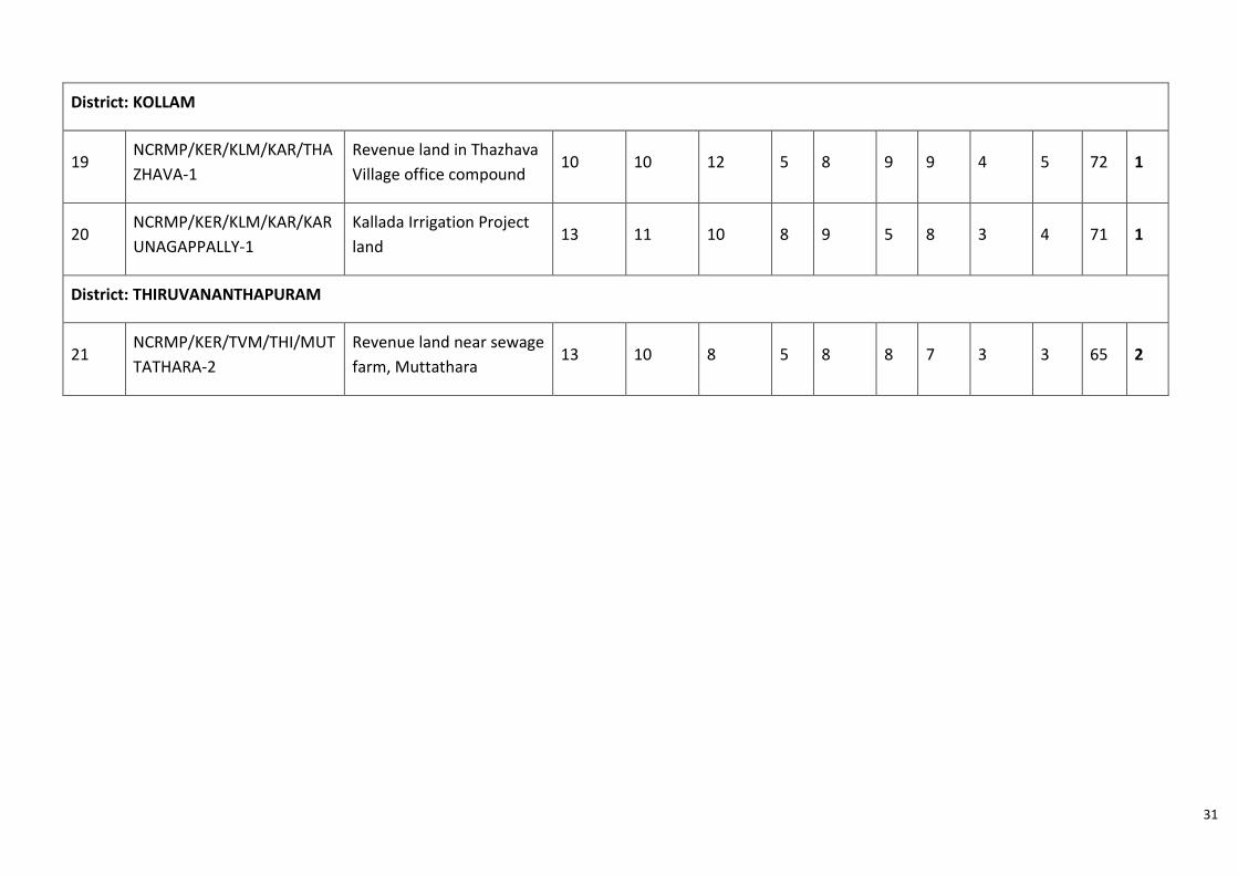
District: KOLLAM
19 NCRMP/KER/KLM/KAR/THA
ZHAVA-1
Revenue land in Thazhava
Village office compound 10 10 12 5 8 9 9 4 5 72 1
20 NCRMP/KER/KLM/KAR/KAR
UNAGAPPALLY-1
Kallada Irrigation Project
land 13 11 10 8 9 5 8 3 4 71 1
District: THIRUVANANTHAPURAM
21 NCRMP/KER/TVM/THI/MUT
TATHARA-2
Revenue land near sewage
farm, Muttathara 13 10 8 5 8 8 7 3 3 65 2
32
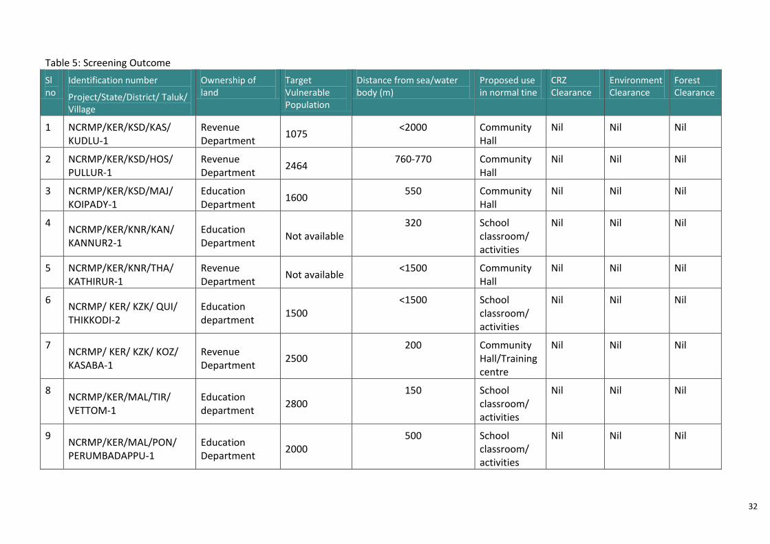
Table 5: Screening Outcome
Sl no
Identification number
Project/State/District/ Taluk/ Village
Ownership of land
Target Vulnerable Population
Distance from sea/water body (m)
Proposed use in normal tine
CRZ Clearance
Environment Clearance
Forest Clearance
1 NCRMP/KER/KSD/KAS/ KUDLU-1
Revenue Department
1075 <2000 Community
Hall Nil Nil Nil
2 NCRMP/KER/KSD/HOS/ PULLUR-1
Revenue Department
2464 760-770 Community
Hall Nil Nil Nil
3 NCRMP/KER/KSD/MAJ/ KOIPADY-1
Education Department
1600 550 Community
Hall Nil Nil Nil
4 NCRMP/KER/KNR/KAN/ KANNUR2-1
Education Department
Not available 320 School
classroom/ activities
Nil Nil Nil
5 NCRMP/KER/KNR/THA/ KATHIRUR-1
Revenue Department
Not available <1500 Community
Hall Nil Nil Nil
6 NCRMP/ KER/ KZK/ QUI/ THIKKODI-2
Education department
1500 <1500 School
classroom/ activities
Nil Nil Nil
7 NCRMP/ KER/ KZK/ KOZ/ KASABA-1
Revenue Department
2500 200 Community
Hall/Training centre
Nil Nil Nil
8 NCRMP/KER/MAL/TIR/ VETTOM-1
Education department
2800 150 School
classroom/ activities
Nil Nil Nil
9 NCRMP/KER/MAL/PON/ PERUMBADAPPU-1
Education Department
2000 500 School
classroom/ activities
Nil Nil Nil
33
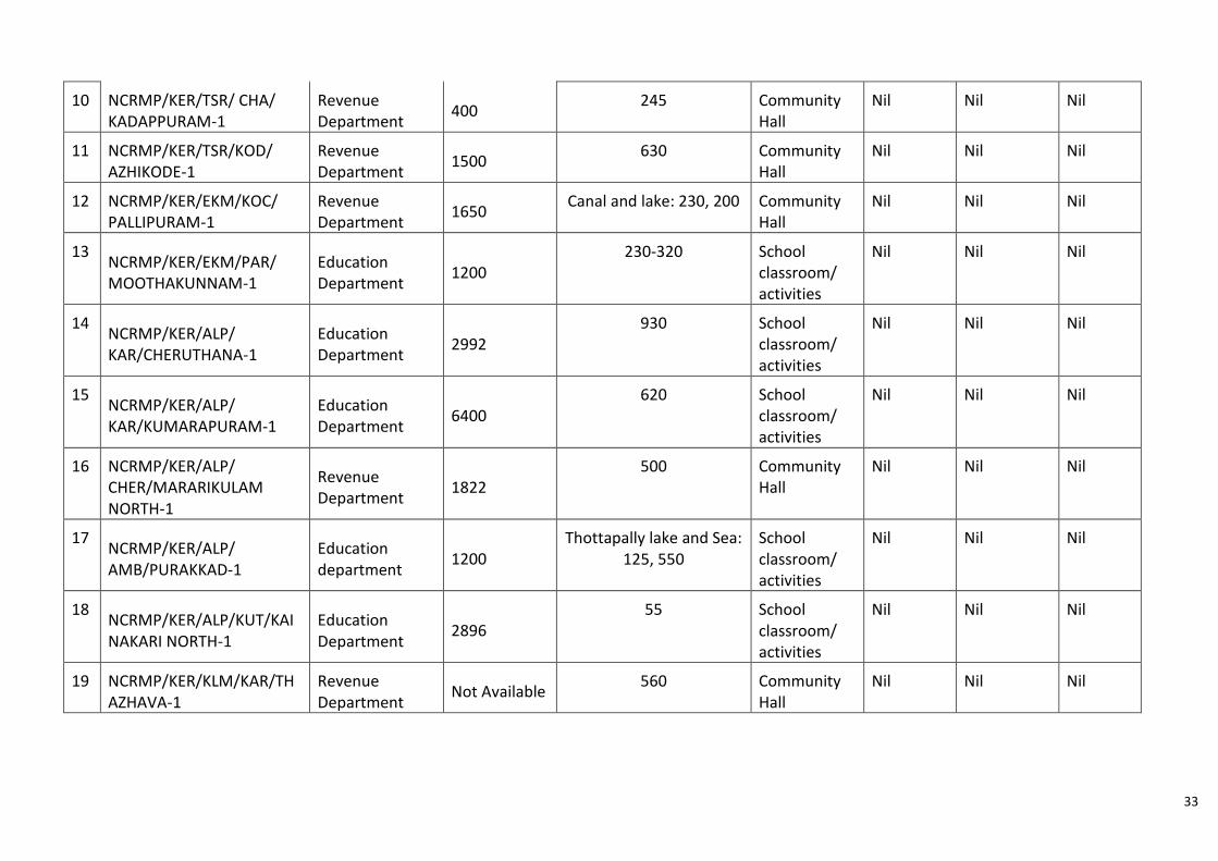
10 NCRMP/KER/TSR/ CHA/ KADAPPURAM-1
Revenue Department
400 245 Community
Hall Nil Nil Nil
11 NCRMP/KER/TSR/KOD/ AZHIKODE-1
Revenue Department
1500 630 Community
Hall Nil Nil Nil
12 NCRMP/KER/EKM/KOC/ PALLIPURAM-1
Revenue Department
1650 Canal and lake: 230, 200 Community
Hall Nil Nil Nil
13 NCRMP/KER/EKM/PAR/ MOOTHAKUNNAM-1
Education Department
1200 230-320 School
classroom/ activities
Nil Nil Nil
14 NCRMP/KER/ALP/ KAR/CHERUTHANA-1
Education Department
2992 930 School
classroom/ activities
Nil Nil Nil
15 NCRMP/KER/ALP/ KAR/KUMARAPURAM-1
Education Department
6400 620 School
classroom/ activities
Nil Nil Nil
16 NCRMP/KER/ALP/ CHER/MARARIKULAM NORTH-1
Revenue Department
1822 500 Community
Hall Nil Nil Nil
17 NCRMP/KER/ALP/ AMB/PURAKKAD-1
Education department
1200 Thottapally lake and Sea:
125, 550 School classroom/ activities
Nil Nil Nil
18 NCRMP/KER/ALP/KUT/KAINAKARI NORTH-1
Education Department
2896 55 School
classroom/ activities
Nil Nil Nil
19 NCRMP/KER/KLM/KAR/THAZHAVA-1
Revenue Department
Not Available 560 Community
Hall Nil Nil Nil
34
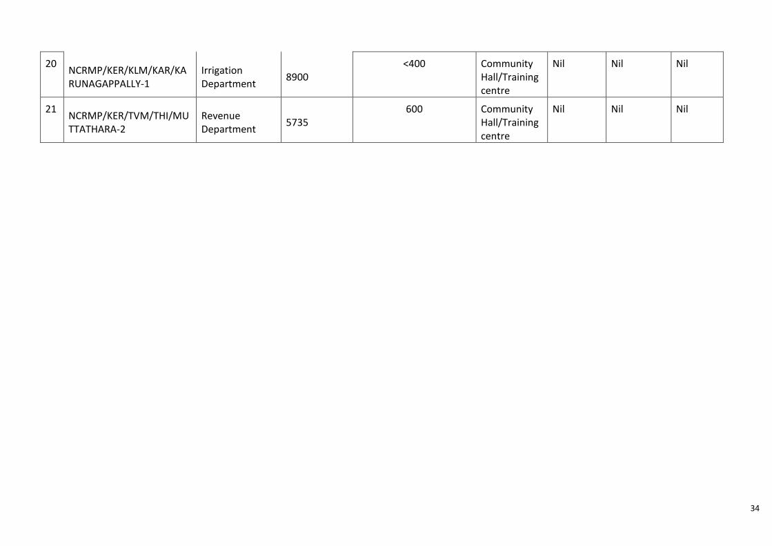
20 NCRMP/KER/KLM/KAR/KARUNAGAPPALLY-1
Irrigation Department
8900 <400 Community
Hall/Training centre
Nil Nil Nil
21 NCRMP/KER/TVM/THI/MUTTATHARA-2
Revenue Department
5735 600 Community
Hall/Training centre
Nil Nil Nil
35
|
Environmental Management Plan (EMP) envisages the plans for the proper
implementation of mitigation measures to reduce the adverse impacts arising out of the
project activities. The goals of the environment and social mitigation measures is achieved
through proper implementation of management plan. It is necessary to have an institutional
arrangement and continuously develop the capacity at all levels of the system to attain the
results of the EMP.
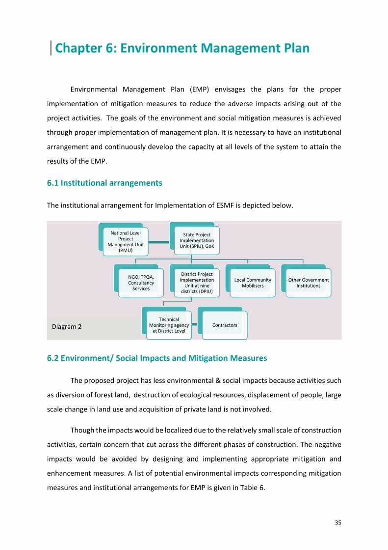
6.1 Institutional arrangements
The institutional arrangement for Implementation of ESMF is depicted below.
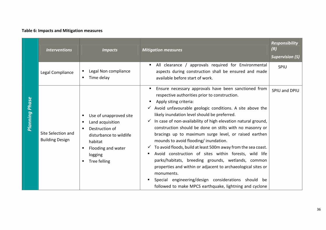
6.2 Environment/ Social Impacts and Mitigation Measures
The proposed project has less environmental & social impacts because activities such
as diversion of forest land, destruction of ecological resources, displacement of people, large
scale change in land use and acquisition of private land is not involved.
Though the impacts would be localized due to the relatively small scale of construction
activities, certain concern that cut across the different phases of construction. The negative
impacts would be avoided by designing and implementing appropriate mitigation and
enhancement measures. A list of potential environmental impacts corresponding mitigation
measures and institutional arrangements for EMP is given in Table 6.
State Project Implementation Unit (SPIU), GoK
National Level Project
Managment Unit (PMU)
NGO, TPQA, Consultancy
Services
District Project Implementation
Unit at nine districts (DPIU)
Technical Monitoring agency
at District LevelContractors
Local Community Mobilisers
Other Government Institutions
Diagram 2
36
Table 6: Impacts and Mitigation measures P
lan
nin
g P
ha
se
Interventions Impacts Mitigation measures
Responsibility (R)
Supervision (S)
Legal Compliance Legal Non compliance
Time delay
All clearance / approvals required for Environmental
aspects during construction shall be ensured and made
available before start of work.
SPIU
Site Selection and
Building Design
Use of unapproved site
Land acquisition
Destruction of
disturbance to wildlife
habitat
Flooding and water
logging
Tree felling
Ensure necessary approvals have been sanctioned from
respective authorities prior to construction.
Apply siting criteria:
Avoid unfavourable geologic conditions. A site above the
likely inundation level should be preferred.
In case of non-availability of high elevation natural ground,
construction should be done on stilts with no masonry or
bracings up to maximum surge level, or raised earthen
mounds to avoid flooding/ inundation.
To avoid floods, build at least 500m away from the sea coast.
Avoid construction of sites within forests, wild life
parks/habitats, breeding grounds, wetlands, common
properties and within or adjacent to archaeological sites or
monuments.
Special engineering/design considerations should be
followed to make MPCS earthquake, lightning and cyclone
SPIU and DPIU
37
resistant and options for making MPCS a green building
should be considered.
Location of the shelter considering storm tide heights, river
or creek flood levels, access and the location of existing
significant hazards.
Site should be selected in consultation with local
communities to check for socially sensitive, conflict prone
areas and usage of such sites for construction should be
avoided.
Avoid/minimize tree felling.
Co
nst
ruct
ion
ph
ase
s
Site Preparation
Demolition of
existing poor
infrastructure
Cutting trees and
site clearance
Transportation of
debris
Land filling/
raising land
level
Destruction of, or
disturbance to habitat
Loss of canopy
Physical or social disruption
to the existing and nearby
communities
Unhygienic/unsanitary
environment due to
demolition of old/ poor
latrines and construction of
camps in development site
Soil erosion/ dust
pollution/siltation/water
pollution
Loss of vegetation
Cutting of trees with specific medicinal, religious,
archaeological, environmental importance should be avoided.
Compensatory plantation by way of Re-plantation of at least
twice the number of trees cut should be carried out in the
project area.
Engage the community members in the construction work
Transport/handle debris from toilet in a hygienic manner
Compaction of developed or raised land, watering land to
reduce aerosols in air.
Placement of construction equipment in a proper place to
avoid traffic congestion and compaction of soils.
Collection and disposal of construction debris in a designated
dumping place.
R: Contractor
S: SPIU and
DPIU,
Technical
Monitoring
Agency
38
Traffic congestion due to
transportation of debris.
Uneven land filling causing
soil erosion
Construction
activities
Use of Ground
water
Working of
machines
Piling
Drainage block
Top soil erosion
Dust during construction,
and due to transport
Noise pollution
Clogging of drainage by soil
run-off, increasing the
chances of flooding Water-
logging and creation of
mosquito breeding grounds
Possible ground water
contamination
Air pollution
Exploitation of potable
water sources due to
construction activities
Uncollected wastes blocked
the drainage and sewage
system
Non-compliance with
regulations
Prior to ground breaking, authorization from the designated
authorities has to be got approved. The activities of
construction shall be scheduled taking into consideration
factors such as sowing of crops, harvesting, availability of
labour, School days and hours (in case site is within school)
during particular periods and other site specific conditions.
Temporary and permanent drainage systems should be
designed to minimize the soil erosion and adverse impact.
Deploy silt fences to avoid/reduce soil erosion and run-off.
Vehicles delivering materials should be covered to reduce
spills.
Local availably materials should be used as much as possible
so as to avoid long distance transportation, especially that of
earth and stone.
Mixing equipment should be well sealed, and vibrating
equipment should be equipped with dust-remove device.
Maintenance of machinery and vehicles should be enhanced
to keep their noise at a minimum. It shall be ensured that all
machinery, equipment and vehicles comply with existing
Central Pollution Control Board emission norms.
Water should be sprayed during construction phase, at the
mixing sites, and temporary roads.
R: Contractor
S: SPIU, DPIU
and Technical
Monitoring
Agency
39
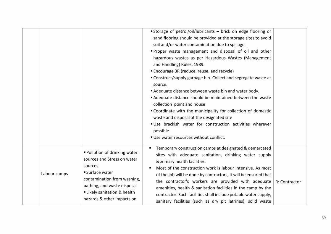
Storage of petrol/oil/lubricants – brick on edge flooring or
sand flooring should be provided at the storage sites to avoid
soil and/or water contamination due to spillage
Proper waste management and disposal of oil and other
hazardous wastes as per Hazardous Wastes (Management
and Handling) Rules, 1989.
Encourage 3R (reduce, reuse, and recycle)
Construct/supply garbage bin. Collect and segregate waste at
source.
Adequate distance between waste bin and water body.
Adequate distance should be maintained between the waste
collection point and house
Coordinate with the municipality for collection of domestic
waste and disposal at the designated site
Use brackish water for construction activities wherever
possible.
Use water resources without conflict.
Labour camps
Pollution of drinking water
sources and Stress on water
sources
Surface water
contamination from washing,
bathing, and waste disposal
Likely sanitation & health
hazards & other impacts on
Temporary construction camps at designated & demarcated
sites with adequate sanitation, drinking water supply
&primary health facilities.
Most of the construction work is labour intensive. As most
of the job will be done by contractors, it will be ensured that
the contractor's workers are provided with adequate
amenities, health & sanitation facilities in the camp by the
contractor. Such facilities shall include potable water supply,
sanitary facilities (such as dry pit latrines), solid waste
R: Contractor
40
the surrounding
environment due to inflow of
construction labourers
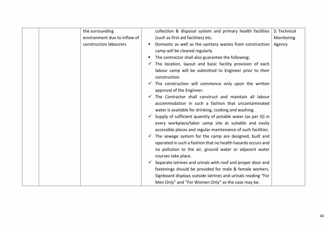
collection & disposal system and primary health facilities
(such as first aid facilities) etc.
Domestic as well as the sanitary wastes from construction
camp will be cleared regularly
The contractor shall also guarantee the following:
The location, layout and basic facility provision of each
labour camp will be submitted to Engineer prior to their
construction.
The construction will commence only upon the written
approval of the Engineer.
The Contractor shall construct and maintain all labour
accommodation in such a fashion that uncontaminated
water is available for drinking, cooking and washing.
Supply of sufficient quantity of potable water (as per IS) in
every workplace/labor camp site at suitable and easily
accessible places and regular maintenance of such facilities.
The sewage system for the camp are designed, built and
operated in such a fashion that no health hazards occurs and
no pollution to the air, ground water or adjacent water
courses take place.
Separate latrines and urinals with roof and proper door and
fastenings should be provided for male & female workers.
Signboard displays outside latrines and urinals reading “For
Men Only” and “For Women Only” as the case may be.
S: Technical
Monitoring
Agency
41
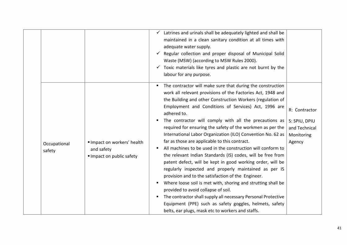
Latrines and urinals shall be adequately lighted and shall be
maintained in a clean sanitary condition at all times with
adequate water supply.
Regular collection and proper disposal of Municipal Solid
Waste (MSW) (according to MSW Rules 2000).
Toxic materials like tyres and plastic are not burnt by the
labour for any purpose.
Occupational
safety
Impact on workers’ health
and safety
Impact on public safety
The contractor will make sure that during the construction
work all relevant provisions of the Factories Act, 1948 and
the Building and other Construction Workers (regulation of
Employment and Conditions of Services) Act, 1996 are
adhered to.
The contractor will comply with all the precautions as
required for ensuring the safety of the workmen as per the
International Labor Organization (ILO) Convention No. 62 as
far as those are applicable to this contract.
All machines to be used in the construction will conform to
the relevant Indian Standards (IS) codes, will be free from
patent defect, will be kept in good working order, will be
regularly inspected and properly maintained as per IS
provision and to the satisfaction of the Engineer.
Where loose soil is met with, shoring and strutting shall be
provided to avoid collapse of soil.
The contractor shall supply all necessary Personal Protective
Equipment (PPE) such as safety goggles, helmets, safety
belts, ear plugs, mask etc to workers and staffs.
R: Contractor
S: SPIU, DPIU
and Technical
Monitoring
Agency
42
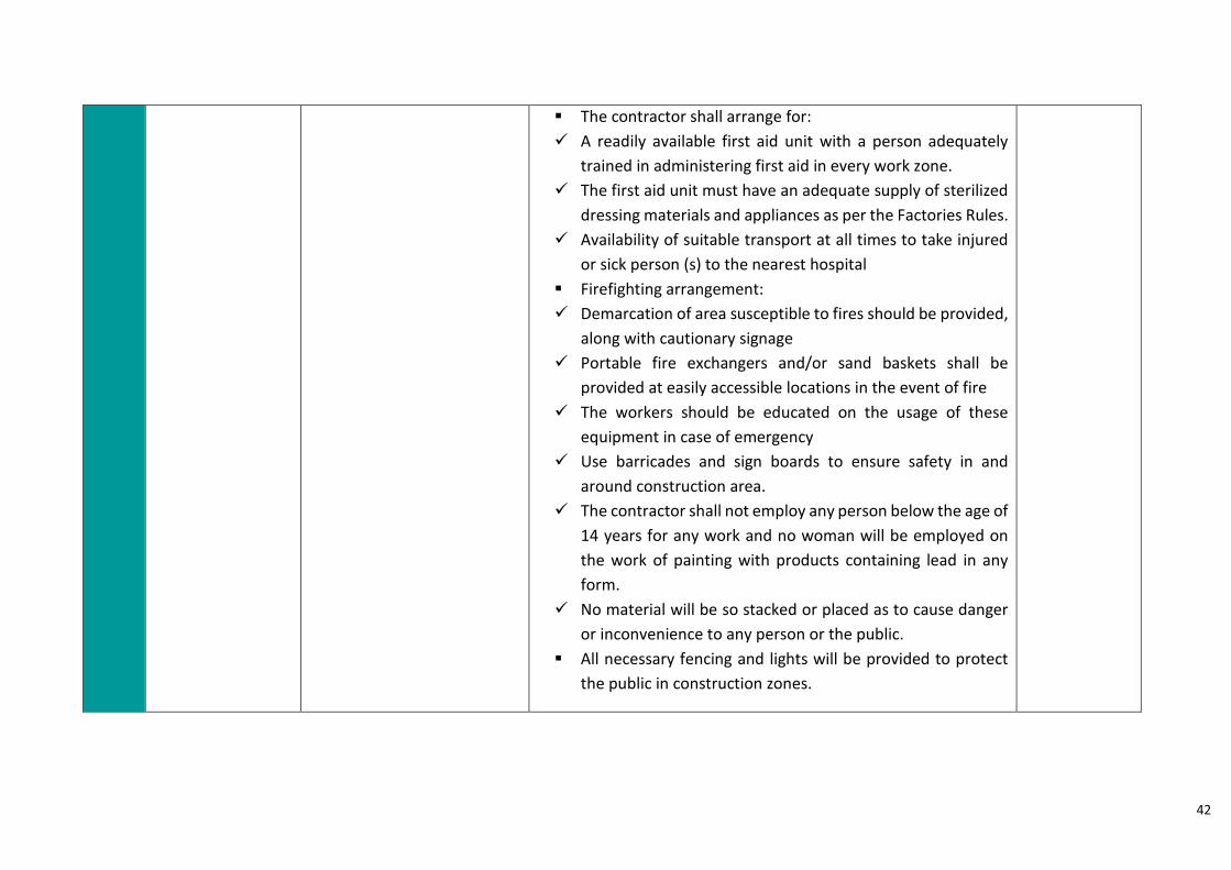
The contractor shall arrange for:
A readily available first aid unit with a person adequately
trained in administering first aid in every work zone.
The first aid unit must have an adequate supply of sterilized
dressing materials and appliances as per the Factories Rules.
Availability of suitable transport at all times to take injured
or sick person (s) to the nearest hospital
Firefighting arrangement:
Demarcation of area susceptible to fires should be provided,
along with cautionary signage
Portable fire exchangers and/or sand baskets shall be
provided at easily accessible locations in the event of fire
The workers should be educated on the usage of these
equipment in case of emergency
Use barricades and sign boards to ensure safety in and
around construction area.
The contractor shall not employ any person below the age of
14 years for any work and no woman will be employed on
the work of painting with products containing lead in any
form.
No material will be so stacked or placed as to cause danger
or inconvenience to any person or the public.
All necessary fencing and lights will be provided to protect
the public in construction zones.
43
Po
st c
on
stru
ctio
n P
ha
se
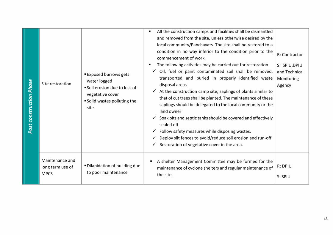
Site restoration
Exposed burrows gets
water logged
Soil erosion due to loss of
vegetative cover
Solid wastes polluting the
site
All the construction camps and facilities shall be dismantled
and removed from the site, unless otherwise desired by the
local community/Panchayats. The site shall be restored to a
condition in no way inferior to the condition prior to the
commencement of work.
The following activities may be carried out for restoration
Oil, fuel or paint contaminated soil shall be removed,
transported and buried in properly identified waste
disposal areas
At the construction camp site, saplings of plants similar to
that of cut trees shall be planted. The maintenance of these
saplings should be delegated to the local community or the
land owner
Soak pits and septic tanks should be covered and effectively
sealed off
Follow safety measures while disposing wastes.
Deploy silt fences to avoid/reduce soil erosion and run-off.
Restoration of vegetative cover in the area.
R: Contractor
S: SPIU,DPIU
and Technical
Monitoring
Agency
Maintenance and
long term use of
MPCS
Dilapidation of building due
to poor maintenance
A shelter Management Committee may be formed for the
maintenance of cyclone shelters and regular maintenance of
the site.
R: DPIU
S: SPIU
44
6.3 Project monitoring
The Environment & Social Sector Specialists at SPIU shall be responsible for overseeing
compliance of the construction activities with the safeguards as well as reviewing the timely
implementation of environment and social provisions as per the ESMF. The Environment and
Social Sector specialists shall report the progress of implementation as well as compliance to
the PIU, PMU and the World Bank. Compliance status reports, Site investigation reports,
Occupational safety status reports will be provided on monthly and quarterly basis at
different phases of construction.
6.4 Financial plan for the ESMF
Necessary budgetary provisions shall be made in the Detailed Project Reports of each
MPCS for implementation of the environmental and social management measures suggested
as part of the ESMF. The cost estimate for each of the project shall include the environmental
management costs and monitoring and compliance costs.
6.5 Update and revisions to the ESMF
The ESMF will be utilized for screening of projects as well as the implementation of
the specified environmental and social management plans in the sub-project activities. The
ESMF report is a “live document”, which will be updated and modified from time to time in
accordance with the regulations and corrective measures suggested in project monitoring
reports. The ESMF will be revised and appropriate management measures will be taken
regarding issues that were not anticipated during the planning phase.
45
Annexure 1: Format for furnishing details of sites
District Name:
Basic details
Place
Village
Taluk
Survey number Old and new
Ownership of land
Land available for construction (in cents or sq.m)
Need Analysis
Vulnerable population near the proposed site that will
have to be accommodated during emergency
Male: Female: Total:
Details of shelters/ schools used as camps in the village
during emergency
Sl no: Name: Capacity:
Is demolition of any building required to facilitate the
new construction? Yes/ No
If yes, number of building,
ownership, any other details
Environmental and Social assessment
Distance of proposed site from coastline. Is the site in
Coastal Regulation Zone?
If yes details Is the proposed site partly/ wholly within
wetland/forest/ environmentally sensitive area? If yes
details
Distance of the proposed site from any water bodies
Number of trees that will have to be felled from for
construction Number: Species:
46
Is the area waterlogged during rain? If yes, the maximum
height to which the water rises
Current use of land
Road
Main road near to the site Name:
Length and ROW (Width) of the approach road
connecting main road and site
Is there a need to upgrade the existing approach road to
all weather road
Details of screening exercise Name
Designation
Date
47
Annexure 2: Format for collecting and verifying details during field investigation
Village
Total village area
Village Population
Coastal Length of Village
Survey Number of plot Block no, Survey number old and new
Ownership of land
Land available for construction of MPCS Approximate area available for new building
High flood level in site
Number of trees in site that has to be felled for construction
Is the site in Coastal regulation Zone?
Distance From coastline to proposed site
Distance from Environmentally sensitive regions*/Archaeological monuments that are within 5 km radius of the proposed site
Distance from water bodies that are within 5 km radius of the proposed site
Approach roads Name of road, length, width, type
Land use
Texture of land Drainage
* Environmentally sensitive regions: Forests, Reserves, Wetlands, Important Bird areas, Mangrove
area, Estuary with mangrove, Natural Lakes, Swamps, mudflats.
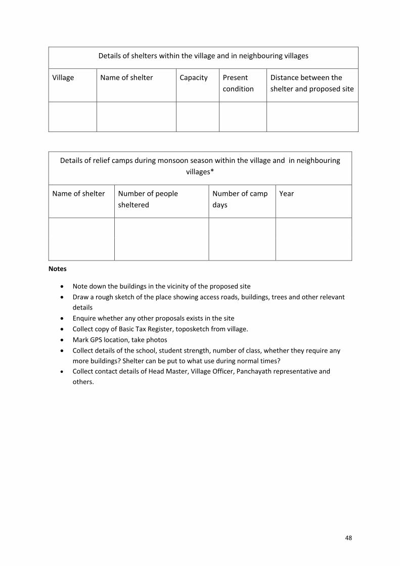
48
Details of shelters within the village and in neighbouring villages
Village Name of shelter Capacity Present
condition
Distance between the
shelter and proposed site
Details of relief camps during monsoon season within the village and in neighbouring
villages*
Name of shelter Number of people
sheltered
Number of camp
days
Year
Notes
Note down the buildings in the vicinity of the proposed site
Draw a rough sketch of the place showing access roads, buildings, trees and other relevant
details
Enquire whether any other proposals exists in the site
Collect copy of Basic Tax Register, toposketch from village.
Mark GPS location, take photos
Collect details of the school, student strength, number of class, whether they require any
more buildings? Shelter can be put to what use during normal times?
Collect contact details of Head Master, Village Officer, Panchayath representative and
others.
50
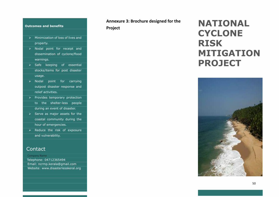
Outcomes and benefits
Minimization of loss of lives and
property.
Nodal point for receipt and
dissemination of cyclone/flood
warnings.
Safe keeping of essential
stocks/items for post disaster
usage.
Nodal point for carrying
outpost disaster response and
relief activities.
Provides temporary protection
to the shelter-less people
during an event of disaster.
Serve as major assets for the
coastal community during the
hour of emergencies.
Reduce the risk of exposure
and vulnerability.
Contact Company Name
Telephone: 04712365494
Email: [email protected]
Website: www.disasterlesskeral.org
Annexure 3: Brochure designed for the
Project
NATIONAL CYCLONE RISK MITIGATION PROJECT
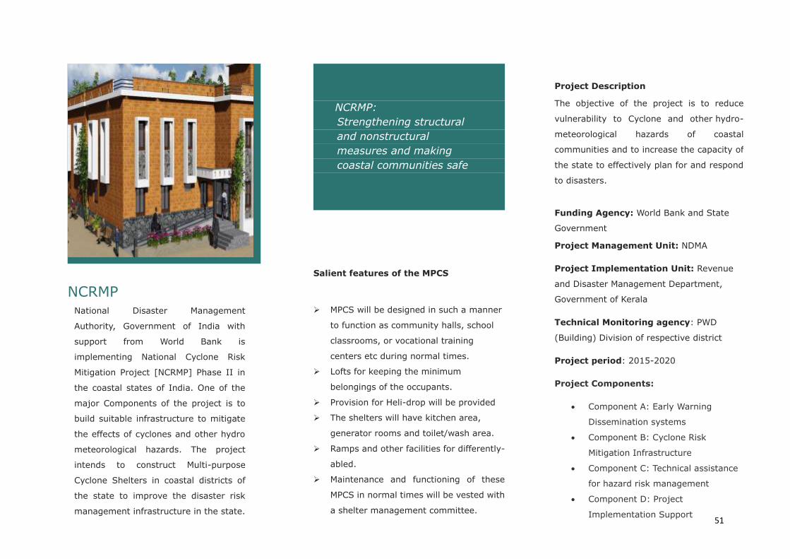
51
NCRMP National Disaster Management
Authority, Government of India with
support from World Bank is
implementing National Cyclone Risk
Mitigation Project [NCRMP] Phase II in
the coastal states of India. One of the
major Components of the project is to
build suitable infrastructure to mitigate
the effects of cyclones and other hydro
meteorological hazards. The project
intends to construct Multi-purpose
Cyclone Shelters in coastal districts of
the state to improve the disaster risk
management infrastructure in the state.
NCRMP:
Strengthening structural
and nonstructural
measures and making
coastal communities safe
Salient features of the MPCS
MPCS will be designed in such a manner
to function as community halls, school
classrooms, or vocational training
centers etc during normal times.
Lofts for keeping the minimum
belongings of the occupants.
Provision for Heli-drop will be provided
The shelters will have kitchen area,
generator rooms and toilet/wash area.
Ramps and other facilities for differently-
abled.
Maintenance and functioning of these
MPCS in normal times will be vested with
a shelter management committee.
Project Description
The objective of the project is to reduce
vulnerability to Cyclone and other hydro-
meteorological hazards of coastal
communities and to increase the capacity of
the state to effectively plan for and respond
to disasters.
Funding Agency: World Bank and State
Government
Project Management Unit: NDMA
Project Implementation Unit: Revenue
and Disaster Management Department,
Government of Kerala
Technical Monitoring agency: PWD
(Building) Division of respective district
Project period: 2015-2020
Project Components:
Component A: Early Warning
Dissemination systems
Component B: Cyclone Risk
Mitigation Infrastructure
Component C: Technical assistance
for hazard risk management
Component D: Project
Implementation Support
52
Annexure 4: Government Order: G.O (Rt) no.641/DMD/2016 dated 28.01.2016
regarding selection of sites for construction of MPCS.
53
55
References
State Disaster Management Plan by Kerala State Disaster Management Authority,
2016
District Disaster Management Plans, at www.disasterlesskerala.org
ESMF for Phase published by World Bank, 2014
Vulnerability Atlas of India by BMPTC
Changes in extreme rainfall events and flood risk in India during the last century by P.
Guhathakurta, Preetha Menon, A. B. Mazumdar and O. P. Sreejith, 2010
National Disaster Reduction Portal, NIDM
National Wetland Atlas, Ministry of Environment And Forest, Government of India
Climate Change Vulnerability and Risk Assessment: Focusing on Coastal India by Ms.
Sneh Gangwar, 2013
Flood moderation by large reservoirs in the humid tropics of Western ghat region of
Kerala, India by George Abe, E. J. James, 2013
Environmental & Social Screening Report of Multipurpose Cyclone Shelters &
Approach Roads by Orissa State Disaster Management Authority, July 2010
Environmental Management Framework (EMF) by National Housing Authority
Ministry of Housing and Public Works, 2014
Environmental Screening Report for The Prasa Rolling Stock Procurement Project
Phase 2 Depot Site Selection Process, 2012
Environmental Screening Report by IVECO South Africa (Pty) Ltd, 2013
Human Impact On Kuttanad Wetland Ecosystem - An Overview by K.A. Sreejith , 2013
Risk Assessment Report for Kerala, RMSI, 2016