Embed Size (px)
Citation preview
NASA CARBON MONITORING SYSTEM:
Prototype Monitoring, Reporting, and Verification
PROGRESS REPORT AND FUTURE PLANS
George Hurtt, Diane Wickland, Kenneth Jucks, Kevin Bowman, Molly Brown, Riley Duren,
Stephen Hagen, and Ariane Verdy
October 2014
NASA Carbon Monitoring System
Executive Summary
This report summarizes progress to date within the Carbon Monitoring System (CMS) project and describes NASA’s longer-term strategy for CMS work and its vision regarding the NASA’s role in Monitoring, Reporting, and Verification (MRV).
The NASA CMS project is forward-looking and designed to make significant contributions in characterizing, quantifying, understanding, and predicting the evolution of global carbon sources and sinks through improved monitoring of carbon stocks and fluxes. The approaches developed have emphasized the exploitation of NASA satellite remote sensing resources, computational capabilities, airborne science capabilities, scientific knowledge, and end-to-end system expertise in combination with effective use of commercial off-the-shelf (COTS) measurement capabilities in order to prototype key data products for MRV. Significant effort is being devoted to rigorous evaluation of the carbon monitoring products being produced, as well as to the characterization and quantification of errors and uncertainties in those products.
Accomplishments to date include the development of a continental U.S. biomass data product and a global carbon flux product; demonstrations of MRV in support of local- and regional-scale carbon management projects; scoping of potential new ocean carbon monitoring products; and engagement of carbon monitoring stakeholders to better understand their needs for carbon data and information products. The CMS project has developed one of the most advanced carbon data assimilation systems in the world that integrates satellite and surface observations related to anthropogenic, oceanic, terrestrial and atmospheric carbon. In 2013, CMS studies were initiated utilizing commercial off-the-shelf airborne measurement methodologies in support of international Reducing Emissions from Deforestation and forest Degradation (REDD), and REDD+ projects in Indonesia, Mexico, Peru, Columbia, and Brazil, as well as carbon sequestration, management, and state-level mapping projects within the U.S. The July 2014 selection of CMS investigations included studies to improve the CMS biomass and flux products and to conduct new MRV-relevant projects at local to regional scales, including several state-level biomass/carbon stock mapping projects within the U.S. and projects to quantify carbon in coastal ecosystems relevant to “blue carbon” objectives of reducing carbon emissions by conserving and sustainably managing a coastal carbon sink.
In the next few years the CMS project will continue to refine, evaluate, and interconnect airborne and satellite data products for carbon monitoring and MRV and will further define the role they can play in a National MRV system. NASA will make effective use of COTS technologies to demonstrate the strong role they can play in supporting MRV for local and regional-scale carbon projects and to acquire the data needed for essential calibration and validation of carbon-measuring satellite sensors and carbon-related data products. NASA will continue to strengthen its collaborations with the other U.S. government agencies involved in carbon measurement, reporting, and verification with the goal of working together to establish a capability for MRV that fully meets the Nation’s needs and provides a model for the world.
I. Carbon Monitoring and Monitoring, Reporting and Verification (MRV)
Importance of Carbon Monitoring Research
Greenhouse gas emission inventories, forest carbon sequestration programs (e.g., Reducing Emissions from Deforestation and forest Degradation (REDD and REDD+), cap-and-trade systems, self-reporting programs, and their associated monitoring, reporting and verification (MRV) frameworks depend upon data that are accurate, systematic, practical, and transparent. A sustained, observationally-driven carbon monitoring system using remote sensing data has the potential to significantly improve the relevant carbon cycle information base for the U.S. and world. Work is needed to prototype and mature relevant measurement and analytical approaches for use in support of MRV frameworks. NASA’s Carbon Monitoring System (CMS) project is prototyping and conducting pilot studies to evaluate technological approaches and methodologies to meet this need.
Multiple Users
There are multiple carbon monitoring, reporting, and verification frameworks in existence, reflecting a diversity of spatial scales, governing bodies, and relevant policies. Three major frameworks include: (1) improving forest carbon inventory data to support the United Nation’s (UN) REDD and REDD+ program (in developing nations, primarily in the pan-tropics) and other carbon management projects (in the United States and elsewhere) for land owners and countries; (2) supporting National and sub-national Greenhouse Gas (GHG) inventories and regular reporting (e.g., all United Nations Framework Convention on Climate Change (UNFCCC) parties and a growing number of states and provinces); and, (3) complementing various reporting systems and registries including those associated with carbon emission trading systems (aka cap and trade or carbon markets).
Multiple Quantities
Across the Earth system, carbon is stored and transferred in multiple forms (e.g., organic molecules, carbon dioxide (CO2), methane (CH4)), in multiple pools (e.g., plants, soils, oceanic, atmospheric), and moves among these pools via various processes both natural and anthropogenic (e.g., photosynthesis, respiration, fossil fuel combustion, land-conversion, advection, fire). A robust carbon monitoring system must deliver accurate estimates of carbon stocks and fluxes needed to adequately characterize the state of and changes to carbon within the Earth system. Examples of some important quantities include:
• Forest carbon data: Area, Volume, Biomass, Carbon Stocks, and Sequestration Potential; • Ocean carbon stocks and fluxes; • Sectorally-resolved CO2 and CH4 emission estimates; • Spatially-resolved fossil-fuel CO2 emissions; • Land use, land-use change and forestry (LULUCF) carbon emissions and removals; • Identification (threshold detection) of fugitive CH4 emission sources; • Constraints on key carbon emission factors; and • Activity data for key sectors.
Multiple Scales
The pattern of carbon stocks and fluxes within the Earth system is complex and variable across a range of spatial and temporal scales. This complexity has important implications for accurately quantifying carbon stocks and fluxes. Likewise, various MRV frameworks have different domains and required spatial resolutions for decision making. Carbon monitoring systems need to be designed and deployed so as to adequately capture carbon cycle complexity and meet the domain/scale requirements set by decision
makers (i.e., resource managers and policy makers). The policy-driven spatial and temporal scale requirements for support of regional and local decision making are generally greater than those for support of large-scale carbon cycle research analyses and global carbon budget assessments. This “scale gap” must be addressed via development of new carbon monitoring approaches that make optimal use of remote sensing technologies, commercial-off-the-shelf (COTS) capabilities, and advanced models to meet user needs.
II. NASA’s Role in Carbon Monitoring and MRV
NASA perspective and capabilities
The NASA Carbon Monitoring System (CMS) is forward-looking and designed to make significant contributions in characterizing, quantifying, understanding, and predicting the evolution of global carbon sources and sinks through improved monitoring of carbon stocks and fluxes (http://carbon.nasa.gov). Initiated and as directed through a Fiscal Year (FY) 2010 appropriation, the project conducts pre-Phase A and pilot initiatives for the development of a Carbon Monitoring System.
NASA’s approach toward a Carbon Monitoring System emphasizes exploitation of the satellite remote sensing resources, computational capabilities, scientific knowledge, airborne science capabilities, and end-to-end system expertise that are major strengths of the NASA Earth Science program. Significant effort is being devoted to rigorous evaluation of the carbon monitoring products being produced, as well as to the characterization and quantification of errors and uncertainties in those products. The emphasis has been on regional, national, and global satellite-based carbon monitoring products relevant to U.S. national needs for completely transparent carbon and biomass inventory processes that provide statistical precision and accuracy with geospatially explicit associated attribute data. NASA’s approach takes into account data and expertise that are the domain of other U.S. Government agencies, involves scientists from other government agencies in its work, and anticipates continuing close communications and/or partnerships with those agencies and their scientific and technical experts as U.S. national efforts toward integrated carbon monitoring mature. NASA’s approach also recognizes a need for complementary local-scale (airborne and surface-based) information to demonstrate quantitative remote sensing methods; to aid in scaling up from project, county, and/or state levels; and for essential evaluation of regional-, national-, and global-scale products. These airborne and surface-based data also have great value in support of satellite data product calibration and validation.
NASA Research on Monitoring Carbon Stocks and Fluxes
NASA’s carbon monitoring research is focused on quantifying the spatial patterns and trends of the carbon stocks and fluxes among and between the active terrestrial, oceanic, and atmospheric reservoirs, including anthropogenic contributions. The existing satellite observational system forms the basis of this monitoring. NASA also utilizes sub-orbital and surface observations, including off-the-shelf technologies, to complement orbital observations. Through its broad program in Earth System Science, NASA utilizes a number of satellites and aircraft that make observations relevant to carbon monitoring and MRV (see Tables 1 and 2). Landsat, for example, provides a 42-year time series of medium resolution (30m) data for use in mapping land-cover and land-use change. The Moderate-resolution Imaging Spectroradiometer (MODIS) on the Terra and Aqua satellites provides similar information at moderate resolution (250m-1km), but with more frequent temporal coverage. Observations of forest vertical structure from ICESat in combination with MODIS land cover data have provided critical data to create forest carbon stock maps across the pan-tropics. The Orbiting Carbon Observatory-2 (OCO-2) mission launched in July 2014 will provide global atmospheric CO2 measurements, a key observable relating land-surface
exchange processes to climate forcing. The interpretation and integration of these atmospheric data require sophisticated models supported by high performance computing. NASA has been at the forefront in the development of advanced models of the atmosphere, ocean, and land that make essential use of satellite data. These efforts are complemented by extensive in situ field measurements and basic research activities that are fundamental to our understanding of the carbon cycle.
Vision/Goal
The goal for NASA’s CMS project is to prototype the development of carbon monitoring capabilities needed to support U.S. needs for MRV. To meet this goal, NASA leverages the best available remote sensing observations, supporting in situ observations, process understanding, and models to consistently and transparently advance carbon monitoring, reporting and verification, including the identification and attribution (to sources/causes) of important carbon stocks and fluxes. NASA’s CMS project aims to provide an improved understanding of uncertainty across multiple scales, with a particular focus on developing a capability for providing well-characterized, quantitative information about carbon in areas of rapid change and policy relevance. Through user engagement activities, the NASA CMS project will take specific actions to be responsive to the needs of stakeholders working to improve monitoring, reporting and verification frameworks.
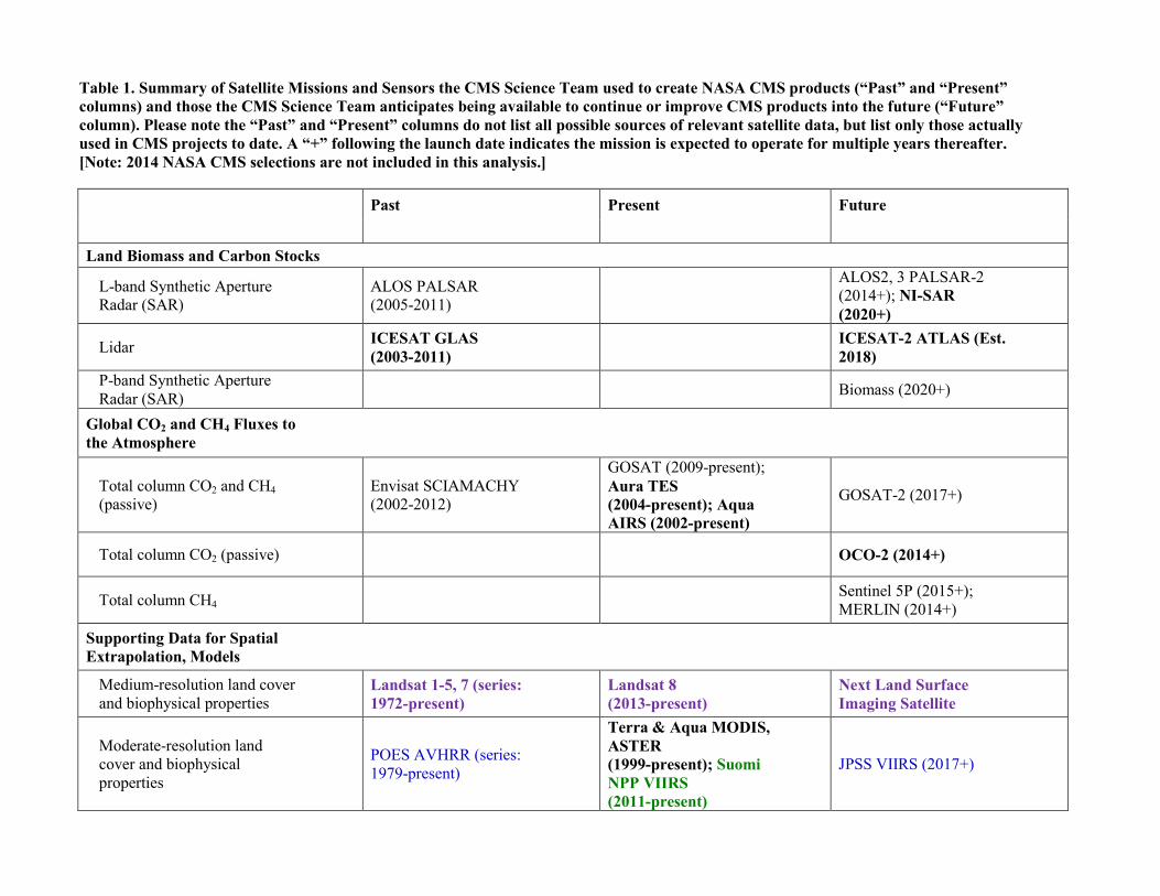
Table 1. Summary of Satellite Missions and Sensors the CMS Science Team used to create NASA CMS products (“Past” and “Present” columns) and those the CMS Science Team anticipates being available to continue or improve CMS products into the future (“Future” column). Please note the “Past” and “Present” columns do not list all possible sources of relevant satellite data, but list only those actually used in CMS projects to date. A “+” following the launch date indicates the mission is expected to operate for multiple years thereafter. [Note: 2014 NASA CMS selections are not included in this analysis.]
Past Present Future
Land Biomass and Carbon Stocks
L-band Synthetic Aperture Radar (SAR)
ALOS PALSAR (2005-2011)
ALOS2, 3 PALSAR-2 (2014+); NI-SAR (2020+)
Lidar ICESAT GLAS (2003-2011)
ICESAT-2 ATLAS (Est. 2018)
P-band Synthetic Aperture Radar (SAR) Biomass (2020+)
Global CO2 and CH4 Fluxes to the Atmosphere
Total column CO2 and CH4 (passive)
Envisat SCIAMACHY (2002-2012)
GOSAT (2009-present); Aura TES (2004-present); Aqua AIRS (2002-present)
GOSAT-2 (2017+)
Total column CO2 (passive) OCO-2 (2014+)
Total column CH4 Sentinel 5P (2015+); MERLIN (2014+)
Supporting Data for Spatial Extrapolation, Models
Medium-resolution land cover and biophysical properties
Landsat 1-5, 7 (series: 1972-present)
Landsat 8 (2013-present)
Next Land Surface Imaging Satellite
Moderate-resolution land cover and biophysical properties
POES AVHRR (series: 1979-present)
Terra & Aqua MODIS, ASTER (1999-present); Suomi NPP VIIRS (2011-present)
JPSS VIIRS (2017+)
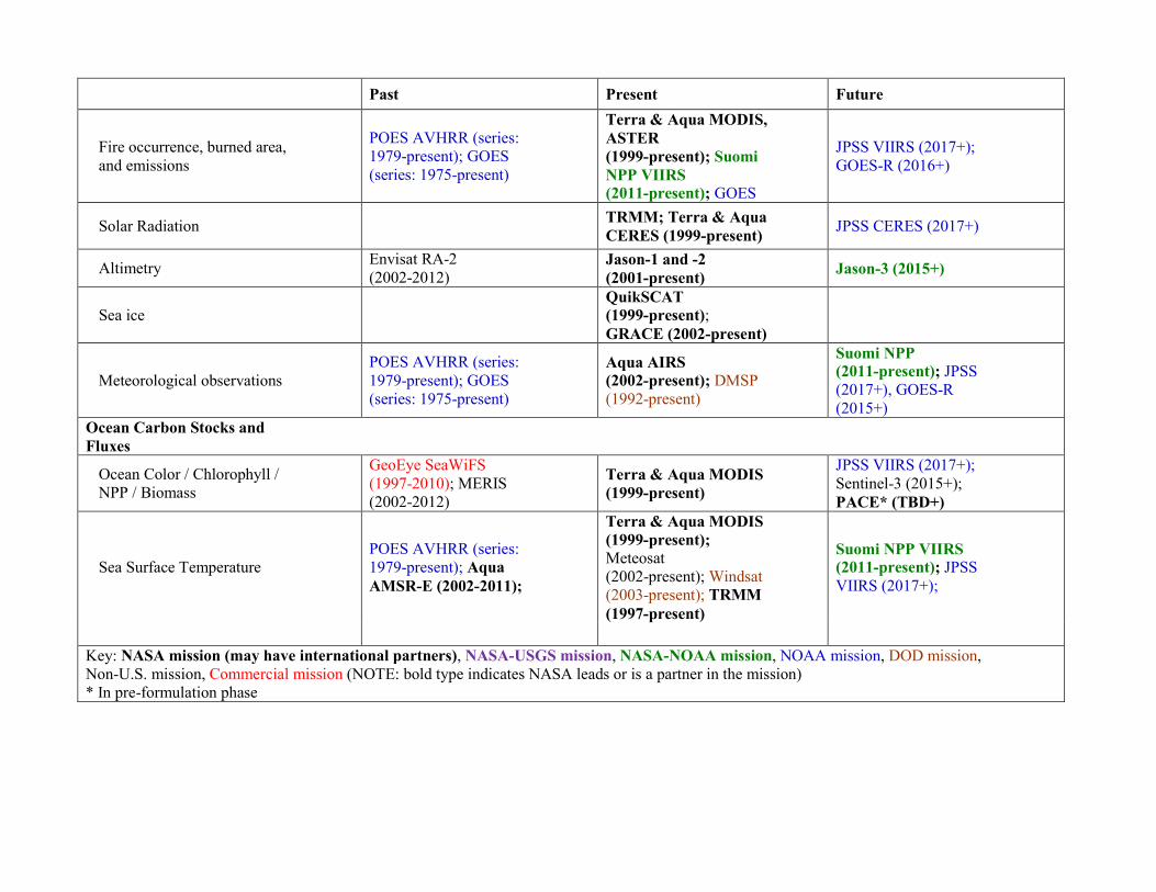
Past Present Future
Fire occurrence, burned area, and emissions
POES AVHRR (series: 1979-present); GOES (series: 1975-present)
Terra & Aqua MODIS, ASTER (1999-present); Suomi NPP VIIRS (2011-present); GOES
JPSS VIIRS (2017+); GOES-R (2016+)
Solar Radiation TRMM; Terra & Aqua CERES (1999-present) JPSS CERES (2017+)
Altimetry Envisat RA-2 (2002-2012)
Jason-1 and -2 (2001-present) Jason-3 (2015+)
Sea ice
QuikSCAT (1999-present); GRACE (2002-present)
Meteorological observations POES AVHRR (series: 1979-present); GOES (series: 1975-present)
Aqua AIRS (2002-present); DMSP (1992-present)
Suomi NPP (2011-present); JPSS (2017+), GOES-R (2015+)
Ocean Carbon Stocks and Fluxes
Ocean Color / Chlorophyll / NPP / Biomass
GeoEye SeaWiFS (1997-2010); MERIS (2002-2012)
Terra & Aqua MODIS (1999-present)
JPSS VIIRS (2017+); Sentinel-3 (2015+); PACE* (TBD+)
Sea Surface Temperature POES AVHRR (series: 1979-present); Aqua AMSR-E (2002-2011);
Terra & Aqua MODIS (1999-present); Meteosat (2002-present); Windsat (2003-present); TRMM (1997-present)
Suomi NPP VIIRS (2011-present); JPSS VIIRS (2017+);
Key: NASA mission (may have international partners), NASA-USGS mission, NASA-NOAA mission, NOAA mission, DOD mission, Non-U.S. mission, Commercial mission (NOTE: bold type indicates NASA leads or is a partner in the mission) * In pre-formulation phase
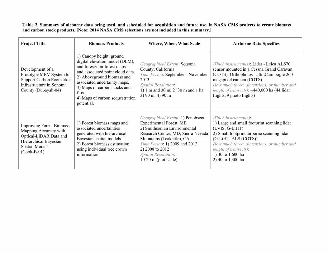
Table 2. Summary of airborne data being used, and scheduled for acquisition and future use, in NASA CMS projects to create biomass and carbon stock products. [Note: 2014 NASA CMS selections are not included in this summary.]
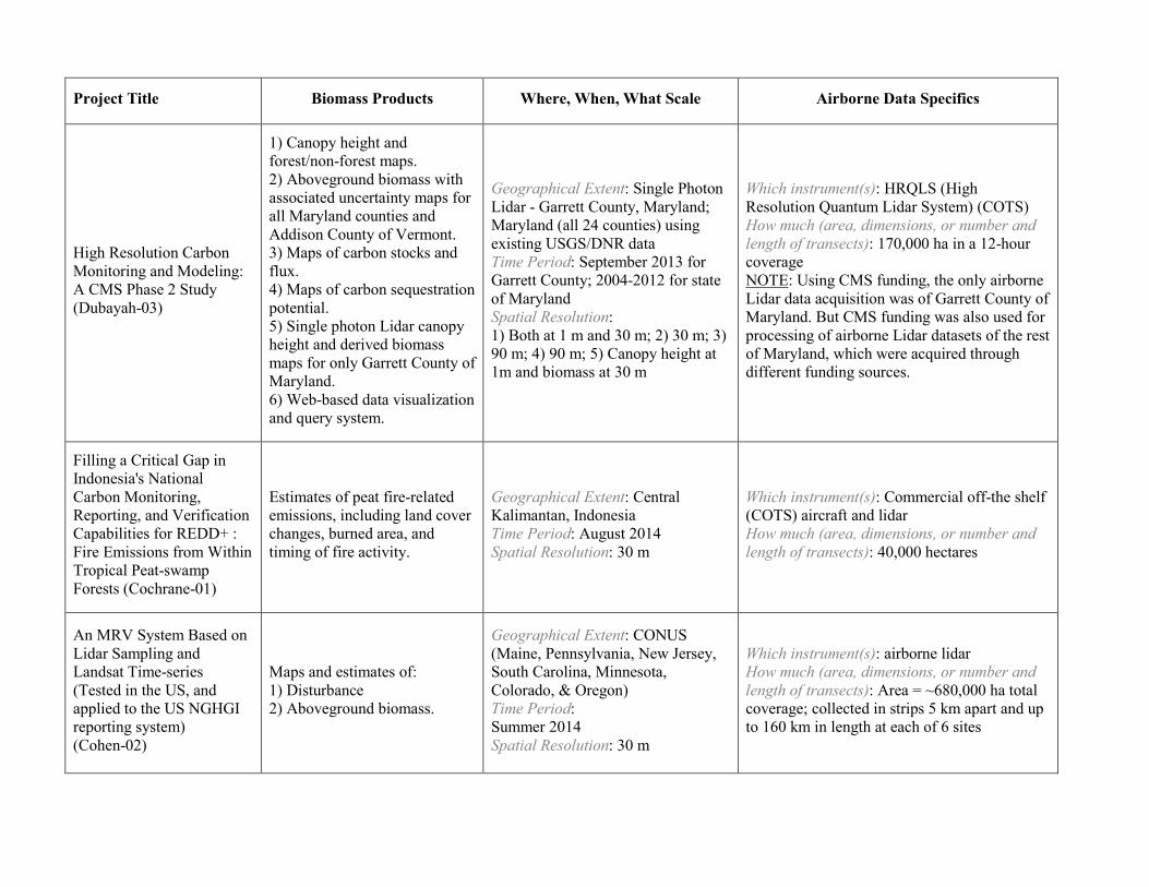
Project Title Biomass Products Where, When, What Scale Airborne Data Specifics
Development of a Prototype MRV System to Support Carbon Ecomarket Infrastructure in Sonoma County (Dubayah-04)
1) Canopy height, ground digital elevation model (DEM), and forest/non-forest maps -- and associated point cloud data. 2) Aboveground biomass and associated uncertainty maps. 3) Maps of carbon stocks and flux. 4) Maps of carbon sequestration potential.
Geographical Extent: Sonoma County, California Time Period: September - November 2013 Spatial Resolution: 1) 1 m and 30 m; 2) 30 m and 1 ha; 3) 90 m; 4) 90 m
Which instrument(s): Lidar - Leica ALS70 sensor mounted in a Cessna Grand Caravan (COTS), Orthophotos- UltraCam Eagle 260 megapixel camera (COTS) How much (area, dimensions, or number and length of transects): ~440,000 ha (44 lidar flights, 9 photo flights)
Improving Forest Biomass Mapping Accuracy with Optical-LiDAR Data and Hierarchical Bayesian Spatial Models (Cook-B-01)
1) Forest biomass maps and associated uncertainties generated with hierarchical Bayesian spatial models. 2) Forest biomass estimation using individual tree crown information.
Geographical Extent: 1) Penobscot Experimental Forest, ME 2) Smithsonian Environmental Research Center, MD; Sierra Nevada Mountains (Teakettle), CA Time Period: 1) 2009 and 2012 2) 2008 to 2012 Spatial Resolution: 10-20 m (plot-scale)
Which instrument(s): 1) Large and small footprint scanning lidar (LVIS, G-LiHT) 2) Small footprint airborne scanning lidar (G-LiHT, ALS (COTS)) How much (area, dimensions, or number and length of transects): 1) 40 to 1,600 ha 2) 40 to 1,300 ha
Project Title Biomass Products Where, When, What Scale Airborne Data Specifics
High Resolution Carbon Monitoring and Modeling: A CMS Phase 2 Study (Dubayah-03)
1) Canopy height and forest/non-forest maps. 2) Aboveground biomass with associated uncertainty maps for all Maryland counties and Addison County of Vermont. 3) Maps of carbon stocks and flux. 4) Maps of carbon sequestration potential. 5) Single photon Lidar canopy height and derived biomass maps for only Garrett County of Maryland. 6) Web-based data visualization and query system.
Geographical Extent: Single Photon Lidar - Garrett County, Maryland; Maryland (all 24 counties) using existing USGS/DNR data Time Period: September 2013 for Garrett County; 2004-2012 for state of Maryland Spatial Resolution: 1) Both at 1 m and 30 m; 2) 30 m; 3) 90 m; 4) 90 m; 5) Canopy height at 1m and biomass at 30 m
Which instrument(s): HRQLS (High Resolution Quantum Lidar System) (COTS) How much (area, dimensions, or number and length of transects): 170,000 ha in a 12-hour coverage NOTE: Using CMS funding, the only airborne Lidar data acquisition was of Garrett County of Maryland. But CMS funding was also used for processing of airborne Lidar datasets of the rest of Maryland, which were acquired through different funding sources.
Filling a Critical Gap in Indonesia's National Carbon Monitoring, Reporting, and Verification Capabilities for REDD+ : Fire Emissions from Within Tropical Peat-swamp Forests (Cochrane-01)
Estimates of peat fire-related emissions, including land cover changes, burned area, and timing of fire activity.
Geographical Extent: Central Kalimantan, Indonesia Time Period: August 2014 Spatial Resolution: 30 m
Which instrument(s): Commercial off-the shelf (COTS) aircraft and lidar How much (area, dimensions, or number and length of transects): 40,000 hectares
An MRV System Based on Lidar Sampling and Landsat Time-series (Tested in the US, and applied to the US NGHGI reporting system) (Cohen-02)
Maps and estimates of: 1) Disturbance 2) Aboveground biomass.
Geographical Extent: CONUS (Maine, Pennsylvania, New Jersey, South Carolina, Minnesota, Colorado, & Oregon) Time Period: Summer 2014 Spatial Resolution: 30 m
Which instrument(s): airborne lidar How much (area, dimensions, or number and length of transects): Area = ~680,000 ha total coverage; collected in strips 5 km apart and up to 160 km in length at each of 6 sites
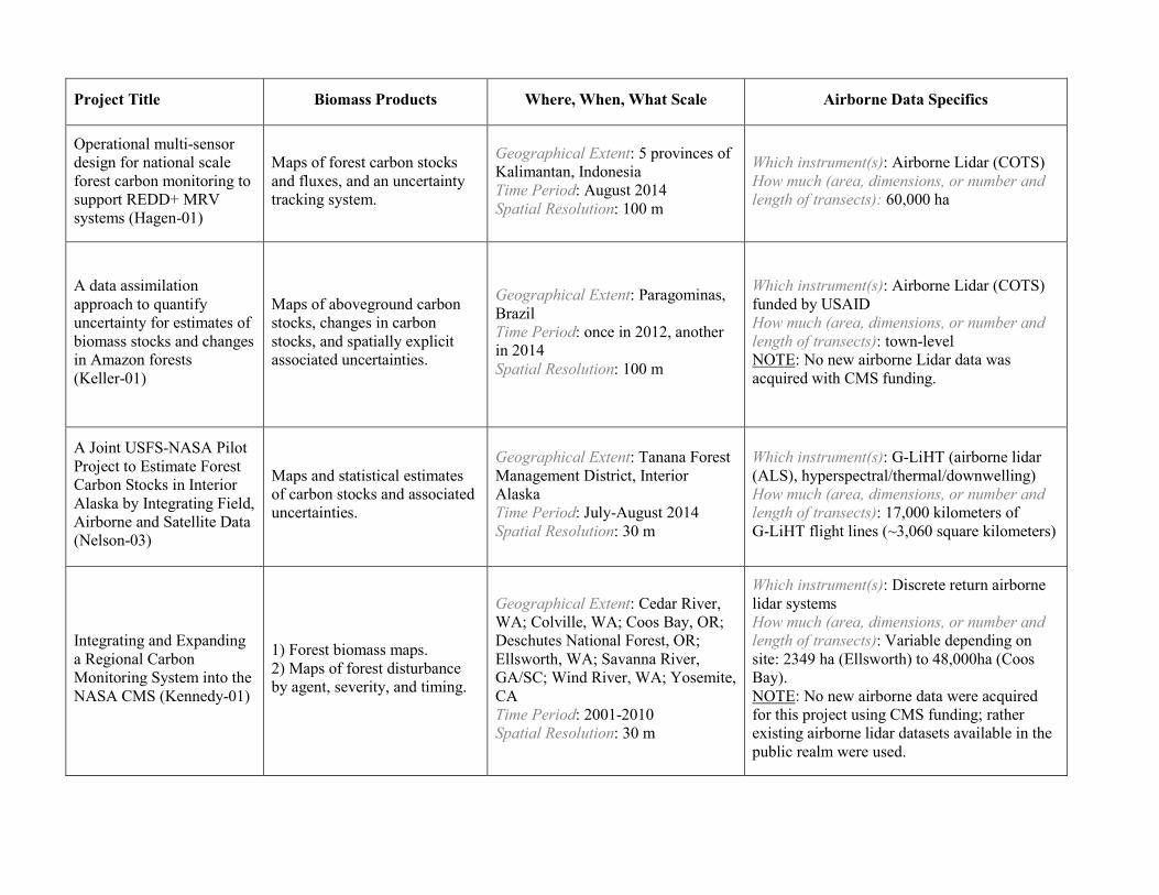
Project Title Biomass Products Where, When, What Scale Airborne Data Specifics
Operational multi-sensor design for national scale forest carbon monitoring to support REDD+ MRV systems (Hagen-01)
Maps of forest carbon stocks and fluxes, and an uncertainty tracking system.
Geographical Extent: 5 provinces of Kalimantan, Indonesia Time Period: August 2014 Spatial Resolution: 100 m
Which instrument(s): Airborne Lidar (COTS) How much (area, dimensions, or number and length of transects): 60,000 ha
A data assimilation approach to quantify uncertainty for estimates of biomass stocks and changes in Amazon forests (Keller-01)
Maps of aboveground carbon stocks, changes in carbon stocks, and spatially explicit associated uncertainties.
Geographical Extent: Paragominas, Brazil Time Period: once in 2012, another in 2014 Spatial Resolution: 100 m
Which instrument(s): Airborne Lidar (COTS) funded by USAID How much (area, dimensions, or number and length of transects): town-level NOTE: No new airborne Lidar data was acquired with CMS funding.
A Joint USFS-NASA Pilot Project to Estimate Forest Carbon Stocks in Interior Alaska by Integrating Field, Airborne and Satellite Data (Nelson-03)
Maps and statistical estimates of carbon stocks and associated uncertainties.
Geographical Extent: Tanana Forest Management District, Interior Alaska Time Period: July-August 2014 Spatial Resolution: 30 m
Which instrument(s): G-LiHT (airborne lidar (ALS), hyperspectral/thermal/downwelling) How much (area, dimensions, or number and length of transects): 17,000 kilometers of G-LiHT flight lines (~3,060 square kilometers)
Integrating and Expanding a Regional Carbon Monitoring System into the NASA CMS (Kennedy-01)
1) Forest biomass maps. 2) Maps of forest disturbance by agent, severity, and timing.
Geographical Extent: Cedar River, WA; Colville, WA; Coos Bay, OR; Deschutes National Forest, OR; Ellsworth, WA; Savanna River, GA/SC; Wind River, WA; Yosemite, CA Time Period: 2001-2010 Spatial Resolution: 30 m
Which instrument(s): Discrete return airborne lidar systems How much (area, dimensions, or number and length of transects): Variable depending on site: 2349 ha (Ellsworth) to 48,000ha (Coos Bay). NOTE: No new airborne data were acquired for this project using CMS funding; rather existing airborne lidar datasets available in the public realm were used.
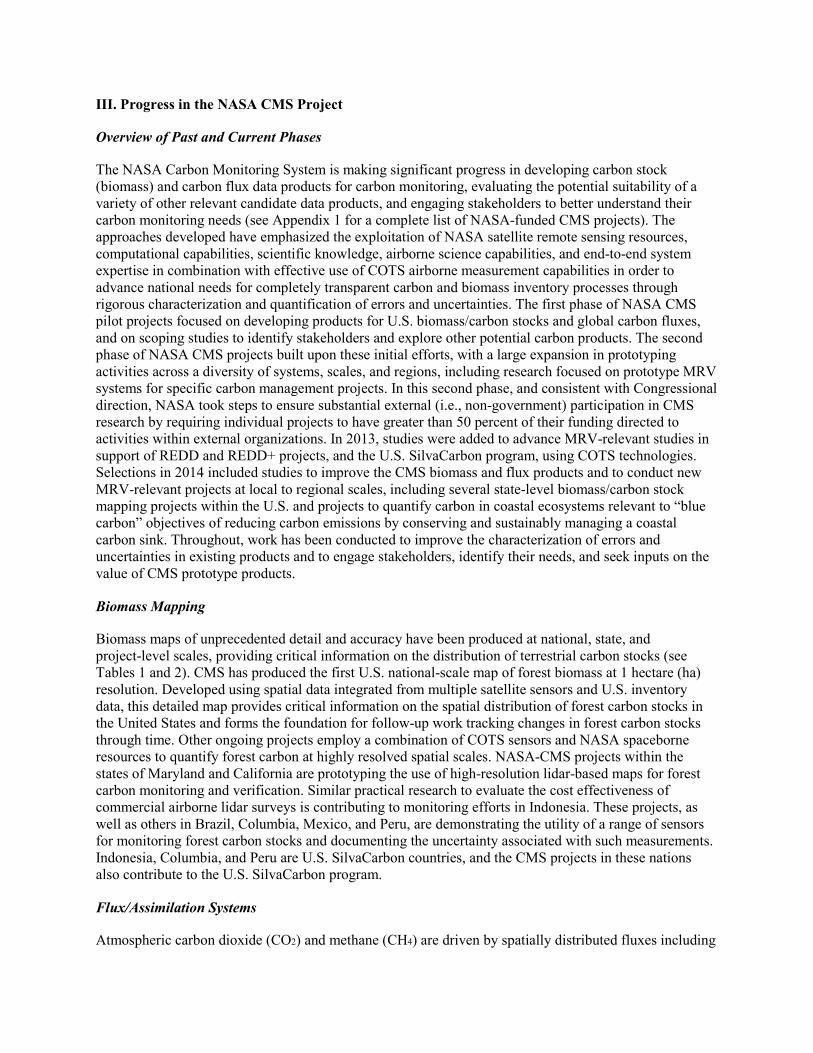
III. Progress in the NASA CMS Project
Overview of Past and Current Phases
The NASA Carbon Monitoring System is making significant progress in developing carbon stock (biomass) and carbon flux data products for carbon monitoring, evaluating the potential suitability of a variety of other relevant candidate data products, and engaging stakeholders to better understand their carbon monitoring needs (see Appendix 1 for a complete list of NASA-funded CMS projects). The approaches developed have emphasized the exploitation of NASA satellite remote sensing resources, computational capabilities, scientific knowledge, airborne science capabilities, and end-to-end system expertise in combination with effective use of COTS airborne measurement capabilities in order to advance national needs for completely transparent carbon and biomass inventory processes through rigorous characterization and quantification of errors and uncertainties. The first phase of NASA CMS pilot projects focused on developing products for U.S. biomass/carbon stocks and global carbon fluxes, and on scoping studies to identify stakeholders and explore other potential carbon products. The second phase of NASA CMS projects built upon these initial efforts, with a large expansion in prototyping activities across a diversity of systems, scales, and regions, including research focused on prototype MRV systems for specific carbon management projects. In this second phase, and consistent with Congressional direction, NASA took steps to ensure substantial external (i.e., non-government) participation in CMS research by requiring individual projects to have greater than 50 percent of their funding directed to activities within external organizations. In 2013, studies were added to advance MRV-relevant studies in support of REDD and REDD+ projects, and the U.S. SilvaCarbon program, using COTS technologies. Selections in 2014 included studies to improve the CMS biomass and flux products and to conduct new MRV-relevant projects at local to regional scales, including several state-level biomass/carbon stock mapping projects within the U.S. and projects to quantify carbon in coastal ecosystems relevant to “blue carbon” objectives of reducing carbon emissions by conserving and sustainably managing a coastal carbon sink. Throughout, work has been conducted to improve the characterization of errors and uncertainties in existing products and to engage stakeholders, identify their needs, and seek inputs on the value of CMS prototype products.
Biomass Mapping
Biomass maps of unprecedented detail and accuracy have been produced at national, state, and project-level scales, providing critical information on the distribution of terrestrial carbon stocks (see Tables 1 and 2). CMS has produced the first U.S. national-scale map of forest biomass at 1 hectare (ha) resolution. Developed using spatial data integrated from multiple satellite sensors and U.S. inventory data, this detailed map provides critical information on the spatial distribution of forest carbon stocks in the United States and forms the foundation for follow-up work tracking changes in forest carbon stocks through time. Other ongoing projects employ a combination of COTS sensors and NASA spaceborne resources to quantify forest carbon at highly resolved spatial scales. NASA-CMS projects within the states of Maryland and California are prototyping the use of high-resolution lidar-based maps for forest carbon monitoring and verification. Similar practical research to evaluate the cost effectiveness of commercial airborne lidar surveys is contributing to monitoring efforts in Indonesia. These projects, as well as others in Brazil, Columbia, Mexico, and Peru, are demonstrating the utility of a range of sensors for monitoring forest carbon stocks and documenting the uncertainty associated with such measurements. Indonesia, Columbia, and Peru are U.S. SilvaCarbon countries, and the CMS projects in these nations also contribute to the U.S. SilvaCarbon program.
Flux/Assimilation Systems
Atmospheric carbon dioxide (CO2) and methane (CH4) are driven by spatially distributed fluxes including
fossil fuel emissions, terrestrial ecosystem uptake and emissions, and ocean uptake and emissions. Harnessing NASA’s end-to-end expertise and the results of its research and analysis investments in carbon cycle science, the CMS project has developed one of the most advanced carbon data assimilation systems in the world that integrates satellite and surface observations related to anthropogenic, oceanic, terrestrial and atmospheric carbon to attribute the atmospheric CO2 growth rate to global spatially distributed fluxes. This system has generated global carbon flux products that have been used to investigate the contribution of tropical forests -- regions critical for REDD -- to the growth rate of atmospheric CO2 in 2010-2011. This system explicitly incorporates the impacts of climate variability such as El Niño on carbon fluxes. These include disturbances such as drought and fire, which play an important role in the stability of forest stocks protected under programs like REDD. In addition, a state-of-the-art methane assimilation system was developed based upon the same framework. Using observations of methane from Japan’s Greenhouse Gases Observing Satellite (GOSAT), the SCanning Imaging Absorption spectroMeter for Atmospheric CHartographY (SCIAMACHY) sensor on the European Space Agency’s (ESA) Environmental Satellite (Envisat), and the Tropospheric Emission Spectrometer (TES) sensor on Aura satellite, this system generated North American flux products. These products were compared with inventories from sources such as livestock, landfills, and natural gas lines. Climate Monitoring System flux research has also addressed the effects of climate variability and fires on carbon fluxes. As the observational record increases with time, the global perspective provided by the CMS flux research has the potential to help attribute carbon fluxes to natural and anthropogenic causes— a critical need for MRV systems.
Ocean Carbon
A robust MRV system would be incomplete without consideration of changes in carbon stocks and fluxes in the ocean. Satellite observations provide the most effective coverage of the ocean surface, and CMS is advancing the utilization of remotely-sensed data for improving the estimation of ocean carbon stocks and fluxes. Early investment in scoping studies to evaluate potential ocean carbon products have yielded global maps of air-sea CO2 fluxes using a combination of state-of-the-art models and observations. These products are essential for calculating global carbon mass balances, which traditionally rely on estimates of the atmospheric and oceanic components to infer the land carbon as a residual quantity; reducing the uncertainty in ocean carbon estimates will consequently reduce the uncertainty on terrestrial carbon estimates. To this end, new methodologies for bringing models into consistency with observations are being developed and evaluated. Knowledge of the timing and location of uptake of atmospheric CO2, and how it responds to fluctuations in the climate, changes in carbon emissions, or eventual geo-engineering efforts, is also critical for carbon monitoring. One focus of CMS has been on the contribution of coastal ecosystems, which are highly complex and variable, to regional carbon budgets. Their contributions may change in response to land management practices in the watersheds draining into the coastal ocean.
User Engagement/Applications Highlights
CMS is working to demonstrate the value of CMS products to users from multiple domains. The project has provided support for meetings with stakeholders, conducted community briefings, developed publications on carbon monitoring research in support of decision making, and is broadening and updating the CMS website to reach out to new communities. Stakeholders for CMS products include natural resource managers who work at a local level to manage and assess carbon-related resources, and policy makers who make decisions or influence policy that these managers seek to implement. Through engagement with these communities, CMS has worked to inform key members of the stakeholder community of practice about the ongoing efforts of the CMS project through briefings that would engage and inform potential users, while being careful to communicate the preliminary nature of the CMS products and production process. To understand how CMS science connects to stakeholders, the project is applying the NASA applications readiness level (ARL): (see
http://www.nasa.gov/sites/default/files/files/ExpandedARLDefinitions4813.pdf) to each project. The CMS Phase Two research selected in 2012 and 2013 has 11 research/prototyping projects focused on scoping and prototyping new products (ARL 1-3), 17 projects that demonstrate a proof of concept and are being validated and tested in a relevant decision making environment (ARL 4-6), and 6 projects that will result in products that will be used in an operational decision-making environment (ARL 7-9). This range of investment is illustrative of NASA’s approach to CMS and the development of capabilities to meet U.S. carbon monitoring needs. It enables advancement on multiple scales and in multiple disciplines simultaneously.
NASA is supporting activities that seek to connect each funded scientist to potential users of their products to ensure that science is using the full range of NASA satellite observations and modeling/analysis capabilities to establish the accuracy, quantitative uncertainties, and utility of products for supporting national and international policy, regulatory, and management activities. For example, the CMS Early Adopter (EA) program will promote applications research that will provide a fundamental understanding of how CMS data products can be scaled and integrated into organizations' policy, business, and management activities to improve decision-making efforts across many disciplines. CMS Early Adopters are defined as those groups and individuals who have a direct or clearly defined need for CMS data products and who have clearly identified requirements for existing and planned NASA CMS scientific output. The goal of the Early Adopter designation is to accelerate the integration of CMS products by providing specific guidance and information to organizations and institutions who commit to engage in work that will enable integration of CMS data products in their applications.
Highlights of Engagement in Monitoring, Reporting and Verification Activities
CMS products are designed to be relevant to decision making. For example, CMS is working with the U.S. Forest Service on improving national forest carbon estimates. This research is addressing longstanding challenges in monitoring carbon stocks in remote interior Alaska with COTS forest biomass airborne lidar data acquisitions, and is improving consistency of national stock change estimates going back to 1990 with time series of historical Landsat imagery. NASA carbon research is also being applied by the National Forest system to meet congressionally mandated carbon monitoring requirements across one-fifth of all U.S. forestland. This application supports planning in Federal forests by identifying the effects of timber management and natural disturbance in the context of carbon storage patterns associated with “no disturbance” reference scenarios. Internationally, the United Nations Food and Agriculture Organization (FAO) is now offering country-level baseline stock estimates produced through CMS as a reporting option for corresponding countries in its 2015 Global Forest Resources Assessment.
At a more local scale, CMS researchers are working with Sonoma County, California, community leaders to establish a COTS-based monitoring infrastructure that can support ecomarket valuations of carbon storage. This work is based upon an earlier CMS collaboration for Maryland. Across a range of scales, CMS researchers are partnering with relevant stakeholders to prototype ways in which NASA’s capacity for observing and modeling carbon dynamics may be harnessed in efforts to officially document the effect of management activities on atmospheric levels of greenhouse gases.
Establishment of a CMS Program of Record for MRV
As part of its annual budget planning process for FY 2013, NASA established a CMS project with its own Work Breakdown Structure (WBS) and 5-year budget line. The current CMS budget line is $10M per year for FY 2014-2019, although the budgets for FY 2016-2019 are notional. The CMS budget line is explained as follows: The Carbon Monitoring System project complements NASA’s overall program in carbon cycle science and observations by producing and distributing products regarding the stores of carbon at the surface and fluxes of carbon between the surface and atmosphere.
IV. Longer-term strategy and next steps
A robust national capability for MRV will require high-quality data products with well-characterized errors and uncertainties that take advantage of the best data available. It must incorporate well-proven in situ and remote sensing data publicly available from all sources, but especially the current high-quality inventory and monitoring data collected by agencies across the U.S. government (see Table 3). New data and data products must be infused in a transparent and systematic way as new networks (e.g., the National Science Foundation’s National Ecological Observatory Network (NEON)) and measurement types (e.g., NASA’s OCO-2 satellite atmospheric CO2 product) become available. Data from COTS capabilities will be essential for CMS developments in support of local and regional projects and for evaluating the larger scale satellite-based products and model-derived products. Data from international satellites providing unique measurement types (e.g., new radar data) will need to be incorporated. NASA CMS-Flux products depend on sophisticated Earth system component models, and CMS will require a steady flow of new understanding and model capabilities from NASA’s research and analysis (R&A) program, as well as other modeling programs in order to keep CMS products current and credible. Thus, there is strong synergy and interdependency between NASA’s CMS project and the monitoring, modeling, and research programs of the other U.S. government agencies. NASA will need to build and maintain strong partnerships with many of these other programs and organizations as it works to advance U.S. remote sensing capabilities for MRV. Ultimately, a U.S. MRV system will need to involve multi-agency collaboration, with each organization bringing the data it is mandated to collect and its internal expertise to produce the high-quality products and information needed for MRV.
NASA’s Commitment to Carbon Monitoring
Consistent with its research and development mandate and the recently established CMS project budget line, NASA will provide leadership in conducting prototyping work and pilot studies toward the development of carbon monitoring capabilities for MRV with an emphasis on the role that satellite and airborne observations and data products can play in a robust national capability. NASA will take action to ensure that what is learned about the value/utility of certain satellite observations within the CMS project is applied in planning for future satellite missions and data products. As these capabilities mature and the requirements for U.S. MRV are fully defined, NASA expects to play a strong role as one of several agencies providing key data and information products. NASA will contribute essential satellite observations and data products, modeling expertise and model products, and scientific expertise for interpretation.
Specific Priorities for the Future NASA CMS Project:
1. Utilizing Future Satellite Sensors
Develop carbon monitoring applications of current and future satellite sensors now in development. For example, NASA Earth science missions now in development including the Soil Moisture Active/Passive (SMAP; scheduled for launch in 2014) mission, Ice, Cloud, and Land Elevation Satellite-2 (ICESat-2, currently with a baseline launch in 2017), Global Ecosystem Dynamics Investigation Lidar (GEDI) instrument (planned for deployment on the International Space Station after 2018) after and NASA-ISRO Synthetic Aperture Radar (NISAR, currently with a launch in 2020) mission, have important capabilities that once proven can be utilized to improve carbon monitoring.
2. Prototyping with COTS Technology
Prototype carbon monitoring capabilities for local and regional-scale projects with COTS technology (e.g. airborne lidar, hyperspectral, radar, thermal remote sensing sensors; also airborne and surface-based in situ sensors). NASA recognizes a need for complementary local-scale (airborne and surface-based) information to demonstrate quantitative remote sensing methods; to aid in scaling up from project, county, and/or state levels; and for essential evaluation of regional-, national-, and global-scale products. By incorporating COTS technological approaches, NASA will actively support the robust development of carbon monitoring capabilities in the private sector.
3. Expanding the Range of Prototyping Activities
Conduct additional prototyping studies to address the high diversity of ecosystem types, landscape complexity, and stakeholder needs in order to advance the development of a robust Carbon Monitoring System. The biomass and flux products will be combined in consistent frameworks to close carbon budgets. Studies to improve carbon flux attribution to natural and anthropogenic causes will continue to be a focus.
4. Rigorous Evaluation, Uncertainty Quantification, Error Characterization
Rigorously evaluate the carbon monitoring products being produced, as well as characterize and quantify errors and uncertainties in those products. Error characterization extends beyond uncertainty quantification to diagnosis and needs to include attribution of anthropogenic versus natural fluxes and separation of key sectors from net flux. Carbon data products need to be transparent and consistent and their strengths and limitations well-documented. Such work is critically important for advancing MRV system capabilities in support of REDD in developing nations. The NASA CMS project will maintain an emphasis on providing error and uncertainty information about all of its products, models, and methodologies.
5. CMS User/Stakeholder Engagement
Develop MRV-related demonstrations that will allow end-to-end expertise and the development of CMS data products based on remote sensing which are useful for community, regional, national, and international decision making. The intent of the activity is to engage with organizations and individuals who may use CMS data products in their decision-making processes to better understand the needs of the broader community for carbon-related environmental information. Through this engagement, the CMS project will ensure that the Earth science community understands the nature, quality, and utility of CMS science information and data products for MRV, and that CMS scientists are responsive to these needs. NASA also intends to conduct rigorous evaluations of the utility of existing and proposed carbon monitoring products for carbon management and policy through an assessment of how the products are used and the value of the information within the context where it was used.
6. Partnerships
Continue and seek to expand partnerships with other U.S. agencies and international partners to maximize scientific progress, capabilities, and relevance and to build the capacity to work together toward a mature MRV system. NASA recognizes the importance of partnering for capabilities best performed by other agencies and high-quality data from other sources. U.S. agencies, including U.S. Department of Agriculture (USDA) Forest Service, National Oceanic and Atmospheric Administration (NOAA), Department of Energy (DOE), Environmental Protection Agency (EPA), and others, have important capabilities to complement NASA’s
expertise (see Table 3). Current and future satellite observations from international partners, such as Japan’s GOSAT and GOSAT-2 missions and the European Space Agency’s Biomass and Sentinel-5 Precursor/TROPOMI (for CH4) missions, will contribute towards filling gaps in measurement capabilities.
7. Modeling and Data Assimilation
Apply advanced models and data assimilation systems in support of MRV. Models have proven to be critically important in making effective use of observations. The link between atmospheric greenhouse gas concentrations and carbon stocks, fluxes, and human management practices is based upon a complex set of interacting processes. A robust modeling capability is necessary to relate observations from satellites and aircraft to carbon cycle quantities of interest, synthesize multiple data sets into a common framework to improve realism and reduce uncertainties, and provide the basis for future projections. Models that simulate the effects of both natural variability and anthropogenic activities on the carbon cycle are critical for attribution, and can be used for distinguishing direct and indirect impacts. Data assimilation systems are a sophisticated mathematical method of incorporating NASA observations into models in order to provide accurate estimates of carbon fluxes and stocks as well as the attribution of those changes to natural and human drivers and will play an important role in future CMS work.
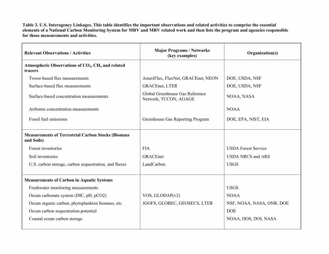
Table 3. U.S. Interagency Linkages. This table identifies the important observations and related activities to comprise the essential elements of a National Carbon Monitoring System for MRV and MRV related work and then lists the program and agencies responsible for those measurements and activities.
Relevant Observations / Activities Major Programs / Networks (key examples) Organization(s)
Atmospheric Observations of CO2, CH4 and related tracers
Tower-based flux measurements AmeriFlux, FluxNet, GRACEnet, NEON DOE, USDA, NSF
Surface-based flux measurements GRACEnet, LTER DOE, USDA, NSF
Surface-based concentration measurements Global Greenhouse Gas Reference Network, TCCON, AGAGE NOAA, NASA
Airborne concentration measurements NOAA
Fossil fuel emissions Greenhouse Gas Reporting Program DOE, EPA, NIST, EIA
Measurements of Terrestrial Carbon Stocks (Biomass and Soils)
Forest inventories FIA USDA Forest Service
Soil inventories GRACEnet USDA NRCS and ARS
U.S. carbon storage, carbon sequestration, and fluxes LandCarbon USGS
Measurements of Carbon in Aquatic Systems
Freshwater monitoring measurements USGS
Ocean carbonate system (DIC, pH, pCO2) VOS, GLODAP(v2) NOAA
Ocean organic carbon, phytoplankton biomass, etc. JGOFS, GLOBEC, GEOSECS, LTER NSF, NOAA, NASA, ONR, DOE
Ocean carbon sequestration potential DOE
Coastal ocean carbon storage NOAA, DOS, DOI, NASA
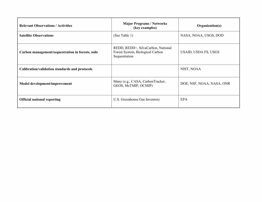
Relevant Observations / Activities Major Programs / Networks (key examples) Organization(s)
Satellite Observations (See Table 1) NASA, NOAA, USGS, DOD
Carbon management/sequestration in forests, soils REDD, REDD+, SilvaCarbon, National Forest System, Biological Carbon Sequestration
USAID, USDA FS, USGS
Calibration/validation standards and protocols NIST, NOAA
Model development/improvement Many (e.g., CASA, CarbonTracker, GEOS, MsTMIP, OCMIP) DOE, NSF, NOAA, NASA, ONR
Official national reporting U.S. Greenhouse Gas Inventory EPA
V. Summary/Conclusions
NASA’s CMS project is working toward the development of a Carbon Monitoring System with initial focus on prototyping data products, satellite and airborne sampling, quantification of carbon stores and fluxes (including the quantification of errors and uncertainties necessary to achieve levels of precision and accuracy required by carbon trading protocols), and overall capabilities for carbon MRV. Accomplishments to date include the development of a continental U.S. biomass data product and a global carbon flux product; demonstrations of MRV in support of local- and regional-scale carbon management projects; scoping of potential new ocean carbon monitoring products; and engagement of carbon monitoring stakeholders to better understand their needs for carbon data and information products. In recent years additional new CMS studies have gotten underway utilizing COTS airborne remote sensing methodologies for MRV in support of international REDD, REDD+, and U.S. SilvaCarbon projects, as well as carbon sequestration/management projects within the U.S.
In 2013, NASA established a program of record around the development of a Carbon Monitoring System by incorporating the CMS budget line into its operating plan and long-term budget projection (notionally $10M per year). In the next few years, the CMS project will continue to refine, evaluate, and interconnect airborne and satellite data products for carbon monitoring and MRV and will further define the role they can play in a national MRV system. NASA will make effective use of COTS technologies to demonstrate the strong role they can play in supporting MRV for local and regional-scale carbon projects and to acquire the data needed for essential calibration and validation of carbon-measuring satellite sensors and carbon-related data products. NASA will continue to strengthen its collaborations with the other U.S. government agencies involved in carbon monitoring, reporting, and verification with a goal of working together to establish a national capability for MRV that fully meets the nation’s needs and provides a model for the world.
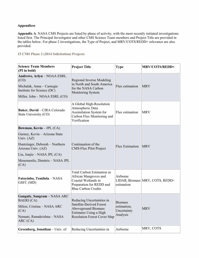
Appendices
Appendix A. NASA CMS Projects are listed by phase of activity, with the most recently initiated investigations listed first. The Principal Investigator and other CMS Science Team members and Project Title are provided in the tables below. For phase 2 investigations, the Type of Project, and MRV/COTS/REDD+ relevance are also provided.
15 CMS Phase 2 (2014 Solicitation) Projects
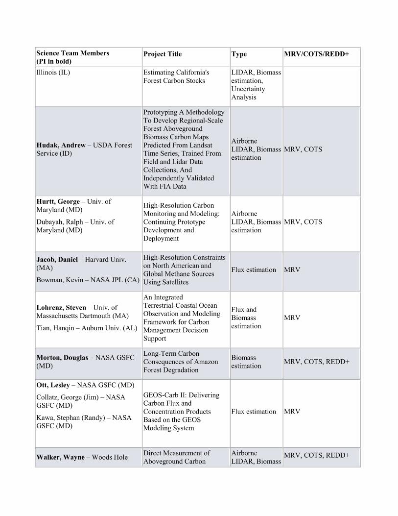
Science Team Members (PI in bold)
Project Title Type MRV/COTS/REDD+
Andrews, Arlyn – NOAA ESRL (CO)
Michalak, Anna – Carnegie Institute for Science (DC)
Miller, John – NOAA ESRL (CO)
Regional Inverse Modeling in North and South America for the NASA Carbon Monitoring System
Flux estimation MRV
Baker, David – CIRA Colorado State University (CO)
A Global High-Resolution Atmospheric Data Assimilation System for Carbon Flux Monitoring and Verification
Flux estimation MRV
Bowman, Kevin – JPL (CA)
Gurney, Kevin – Arizona State Univ. (AZ)
Huntzinger, Deborah – Northern Arizona Univ. (AZ)
Liu, Junjie – NASA JPL (CA)
Menemenlis, Dimitris – NASA JPL (CA)
Continuation of the CMS-Flux Pilot Project Flux Estimation MRV
Fatoyinbo, Temilola – NASA GSFC (MD)
Total Carbon Estimation in African Mangroves and Coastal Wetlands in Preparation for REDD and Blue Carbon Credits
Airborne LIDAR, Biomass estimation
MRV, COTS, REDD+
Ganguly, Sangram – NASA ARC BAERI (CA)
Milesi, Cristina – NASA ARC (CA)
Nemani, Ramakrishna – NASA ARC (CA)
Reducing Uncertainties in Satellite-Derived Forest Aboveground Biomass Estimates Using a High Resolution Forest Cover Map
Biomass estimation, Uncertainty Analysis
MRV
Greenberg, Jonathan – Univ. of Reducing Uncertainties in Airborne MRV, COTS
Science Team Members (PI in bold)
Project Title Type MRV/COTS/REDD+
Illinois (IL) Estimating California's Forest Carbon Stocks
LIDAR, Biomass estimation, Uncertainty Analysis
Hudak, Andrew – USDA Forest Service (ID)
Prototyping A Methodology To Develop Regional-Scale Forest Aboveground Biomass Carbon Maps Predicted From Landsat Time Series, Trained From Field and Lidar Data Collections, And Independently Validated With FIA Data
Airborne LIDAR, Biomass estimation
MRV, COTS
Hurtt, George – Univ. of Maryland (MD)
Dubayah, Ralph – Univ. of Maryland (MD)
High-Resolution Carbon Monitoring and Modeling: Continuing Prototype Development and Deployment
Airborne LIDAR, Biomass estimation
MRV, COTS
Jacob, Daniel – Harvard Univ. (MA)
Bowman, Kevin – NASA JPL (CA)
High-Resolution Constraints on North American and Global Methane Sources Using Satellites
Flux estimation MRV
Lohrenz, Steven – Univ. of Massachusetts Dartmouth (MA)
Tian, Hanqin – Auburn Univ. (AL)
An Integrated Terrestrial-Coastal Ocean Observation and Modeling Framework for Carbon Management Decision Support
Flux and Biomass estimation
MRV
Morton, Douglas – NASA GSFC (MD)
Long-Term Carbon Consequences of Amazon Forest Degradation
Biomass estimation MRV, COTS, REDD+
Ott, Lesley – NASA GSFC (MD)
Collatz, George (Jim) – NASA GSFC (MD)
Kawa, Stephan (Randy) – NASA GSFC (MD)
GEOS-Carb II: Delivering Carbon Flux and Concentration Products Based on the GEOS Modeling System
Flux estimation MRV
Walker, Wayne – Woods Hole Direct Measurement of Aboveground Carbon
Airborne LIDAR, Biomass
MRV, COTS, REDD+
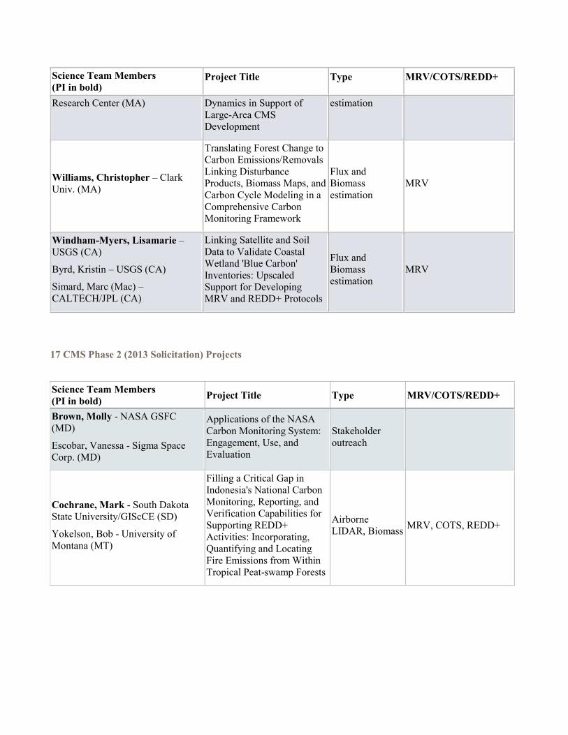
Science Team Members (PI in bold)
Project Title Type MRV/COTS/REDD+
Research Center (MA) Dynamics in Support of Large-Area CMS Development
estimation
Williams, Christopher – Clark Univ. (MA)
Translating Forest Change to Carbon Emissions/Removals Linking Disturbance Products, Biomass Maps, and Carbon Cycle Modeling in a Comprehensive Carbon Monitoring Framework
Flux and Biomass estimation
MRV
Windham-Myers, Lisamarie – USGS (CA)
Byrd, Kristin – USGS (CA)
Simard, Marc (Mac) – CALTECH/JPL (CA)
Linking Satellite and Soil Data to Validate Coastal Wetland 'Blue Carbon' Inventories: Upscaled Support for Developing MRV and REDD+ Protocols
Flux and Biomass estimation
MRV
17 CMS Phase 2 (2013 Solicitation) Projects
Science Team Members (PI in bold) Project Title Type MRV/COTS/REDD+
Brown, Molly - NASA GSFC (MD)
Escobar, Vanessa - Sigma Space Corp. (MD)
Applications of the NASA Carbon Monitoring System: Engagement, Use, and Evaluation
Stakeholder outreach
Cochrane, Mark - South Dakota State University/GIScCE (SD)
Yokelson, Bob - University of Montana (MT)
Filling a Critical Gap in Indonesia's National Carbon Monitoring, Reporting, and Verification Capabilities for Supporting REDD+ Activities: Incorporating, Quantifying and Locating Fire Emissions from Within Tropical Peat-swamp Forests
Airborne LIDAR, Biomass MRV, COTS, REDD+
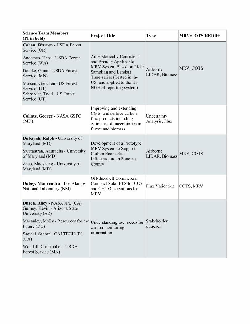
Science Team Members (PI in bold) Project Title Type MRV/COTS/REDD+
Cohen, Warren - USDA Forest Service (OR)
Andersen, Hans - USDA Forest Service (WA)
Domke, Grant - USDA Forest Service (MN)
Moisen, Gretchen - US Forest Service (UT) Schroeder, Todd - US Forest Service (UT)
An Historically Consistent and Broadly Applicable MRV System Based on Lidar Sampling and Landsat Time-series (Tested in the US, and applied to the US NGHGI reporting system)
Airborne LIDAR, Biomass
MRV, COTS
Collatz, George - NASA GSFC (MD)
Improving and extending CMS land surface carbon flux products including estimates of uncertainties in fluxes and biomass
Uncertainty Analysis, Flux
Dubayah, Ralph - University of Maryland (MD)
Swatantran, Anuradha - University of Maryland (MD)
Zhao, Maosheng - University of Maryland (MD)
Development of a Prototype MRV System to Support Carbon Ecomarket Infrastructure in Sonoma County
Airborne LIDAR, Biomass MRV, COTS
Dubey, Manvendra - Los Alamos National Laboratory (NM)
Off-the-shelf Commercial Compact Solar FTS for CO2 and CH4 Observations for MRV
Flux Validation COTS, MRV
Duren, Riley - NASA JPL (CA) Gurney, Kevin - Arizona State University (AZ)
Macauley, Molly - Resources for the Future (DC)
Saatchi, Sassan - CALTECH/JPL (CA)
Woodall, Christopher - USDA Forest Service (MN)
Understanding user needs for carbon monitoring information
Stakeholder outreach
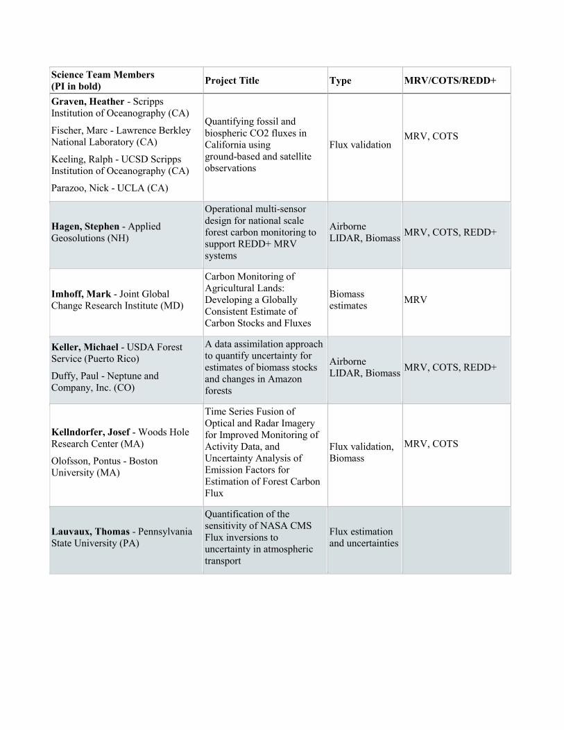
Science Team Members (PI in bold) Project Title Type MRV/COTS/REDD+
Graven, Heather - Scripps Institution of Oceanography (CA)
Fischer, Marc - Lawrence Berkley National Laboratory (CA)
Keeling, Ralph - UCSD Scripps Institution of Oceanography (CA)
Parazoo, Nick - UCLA (CA)
Quantifying fossil and biospheric CO2 fluxes in California using ground-based and satellite observations
Flux validation MRV, COTS
Hagen, Stephen - Applied Geosolutions (NH)
Operational multi-sensor design for national scale forest carbon monitoring to support REDD+ MRV systems
Airborne LIDAR, Biomass MRV, COTS, REDD+
Imhoff, Mark - Joint Global Change Research Institute (MD)
Carbon Monitoring of Agricultural Lands: Developing a Globally Consistent Estimate of Carbon Stocks and Fluxes
Biomass estimates MRV
Keller, Michael - USDA Forest Service (Puerto Rico)
Duffy, Paul - Neptune and Company, Inc. (CO)
A data assimilation approach to quantify uncertainty for estimates of biomass stocks and changes in Amazon forests
Airborne LIDAR, Biomass MRV, COTS, REDD+
Kellndorfer, Josef - Woods Hole Research Center (MA)
Olofsson, Pontus - Boston University (MA)
Time Series Fusion of Optical and Radar Imagery for Improved Monitoring of Activity Data, and Uncertainty Analysis of Emission Factors for Estimation of Forest Carbon Flux
Flux validation, Biomass
MRV, COTS
Lauvaux, Thomas - Pennsylvania State University (PA)
Quantification of the sensitivity of NASA CMS Flux inversions to uncertainty in atmospheric transport
Flux estimation and uncertainties
Science Team Members (PI in bold) Project Title Type MRV/COTS/REDD+
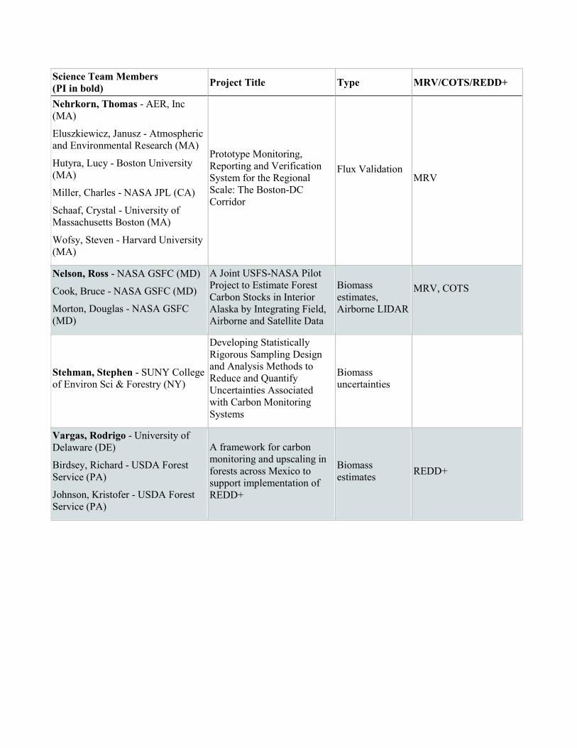
Nehrkorn, Thomas - AER, Inc (MA)
Eluszkiewicz, Janusz - Atmospheric and Environmental Research (MA)
Hutyra, Lucy - Boston University (MA)
Miller, Charles - NASA JPL (CA)
Schaaf, Crystal - University of Massachusetts Boston (MA)
Wofsy, Steven - Harvard University (MA)
Prototype Monitoring, Reporting and Verification System for the Regional Scale: The Boston-DC Corridor
Flux Validation
MRV
Nelson, Ross - NASA GSFC (MD)
Cook, Bruce - NASA GSFC (MD)
Morton, Douglas - NASA GSFC (MD)
A Joint USFS-NASA Pilot Project to Estimate Forest Carbon Stocks in Interior Alaska by Integrating Field, Airborne and Satellite Data
Biomass estimates, Airborne LIDAR
MRV, COTS
Stehman, Stephen - SUNY College of Environ Sci & Forestry (NY)
Developing Statistically Rigorous Sampling Design and Analysis Methods to Reduce and Quantify Uncertainties Associated with Carbon Monitoring Systems
Biomass uncertainties
Vargas, Rodrigo - University of Delaware (DE)
Birdsey, Richard - USDA Forest Service (PA)
Johnson, Kristofer - USDA Forest Service (PA)
A framework for carbon monitoring and upscaling in forests across Mexico to support implementation of REDD+
Biomass estimates REDD+
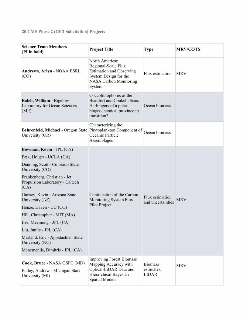
20 CMS Phase 2 (2012 Solicitation) Projects
Science Team Members (PI in bold) Project Title Type MRV/COTS
Andrews, Arlyn - NOAA ESRL (CO)
North American Regional-Scale Flux Estimation and Observing System Design for the NASA Carbon Monitoring System
Flux estimation MRV
Balch, William - Bigelow Laboratory for Ocean Sciences (ME)
Coccolithophores of the Beaufort and Chukchi Seas: Harbingers of a polar biogeochemical province in transition?
Ocean biomass
Behrenfeld, Michael - Oregon State University (OR)
Characterizing the Phytoplankton Component of Oceanic Particle Assemblages
Ocean biomass
Bowman, Kevin - JPL (CA)
Brix, Holger - UCLA (CA)
Denning, Scott - Colorado State University (CO)
Frankenberg, Christian - Jet Propulsion Laboratory / Caltech (CA)
Gurney, Kevin - Arizona State University (AZ)
Henze, Daven - CU (CO)
Hill, Christopher - MIT (MA)
Lee, Meemong - JPL (CA)
Liu, Junjie - JPL (CA)
Marland, Eric - Appalachian State University (NC)
Menemenlis, Dimitris - JPL (CA)
Continuation of the Carbon Monitoring System Flux Pilot Project
Flux estimation and uncertainties MRV
Cook, Bruce - NASA GSFC (MD)
Finley, Andrew - Michigan State University (MI)
Improving Forest Biomass Mapping Accuracy with Optical-LiDAR Data and Hierarchical Bayesian Spatial Models
Biomass estimates, LIDAR
MRV
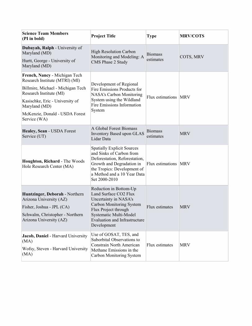
Science Team Members (PI in bold) Project Title Type MRV/COTS
Dubayah, Ralph - University of Maryland (MD)
Hurtt, George - University of Maryland (MD)
High Resolution Carbon Monitoring and Modeling: A CMS Phase 2 Study
Biomass estimates COTS, MRV
French, Nancy - Michigan Tech Research Institute (MTRI) (MI)
Billmire, Michael - Michigan Tech Research Institute (MI)
Kasischke, Eric - University of Maryland (MD)
McKenzie, Donald - USDA Forest Service (WA)
Development of Regional Fire Emissions Products for NASA's Carbon Monitoring System using the Wildland Fire Emissions Information System
Flux estimations MRV
Healey, Sean - USDA Forest Service (UT)
A Global Forest Biomass Inventory Based upon GLAS Lidar Data
Biomass estimates MRV
Houghton, Richard - The Woods Hole Research Center (MA)
Spatially Explicit Sources and Sinks of Carbon from Deforestation, Reforestation, Growth and Degradation in the Tropics: Development of a Method and a 10 Year Data Set 2000-2010
Flux estimations MRV
Huntzinger, Deborah - Northern Arizona University (AZ)
Fisher, Joshua - JPL (CA)
Schwalm, Christopher - Northern Arizona University (AZ)
Reduction in Bottom-Up Land Surface CO2 Flux Uncertainty in NASA's Carbon Monitoring System Flux Project through Systematic Multi-Model Evaluation and Infrastructure Development
Flux estimates MRV
Jacob, Daniel - Harvard University (MA)
Wofsy, Steven - Harvard University (MA)
Use of GOSAT, TES, and Suborbital Observations to Constrain North American Methane Emissions in the Carbon Monitoring System
Flux estimates MRV
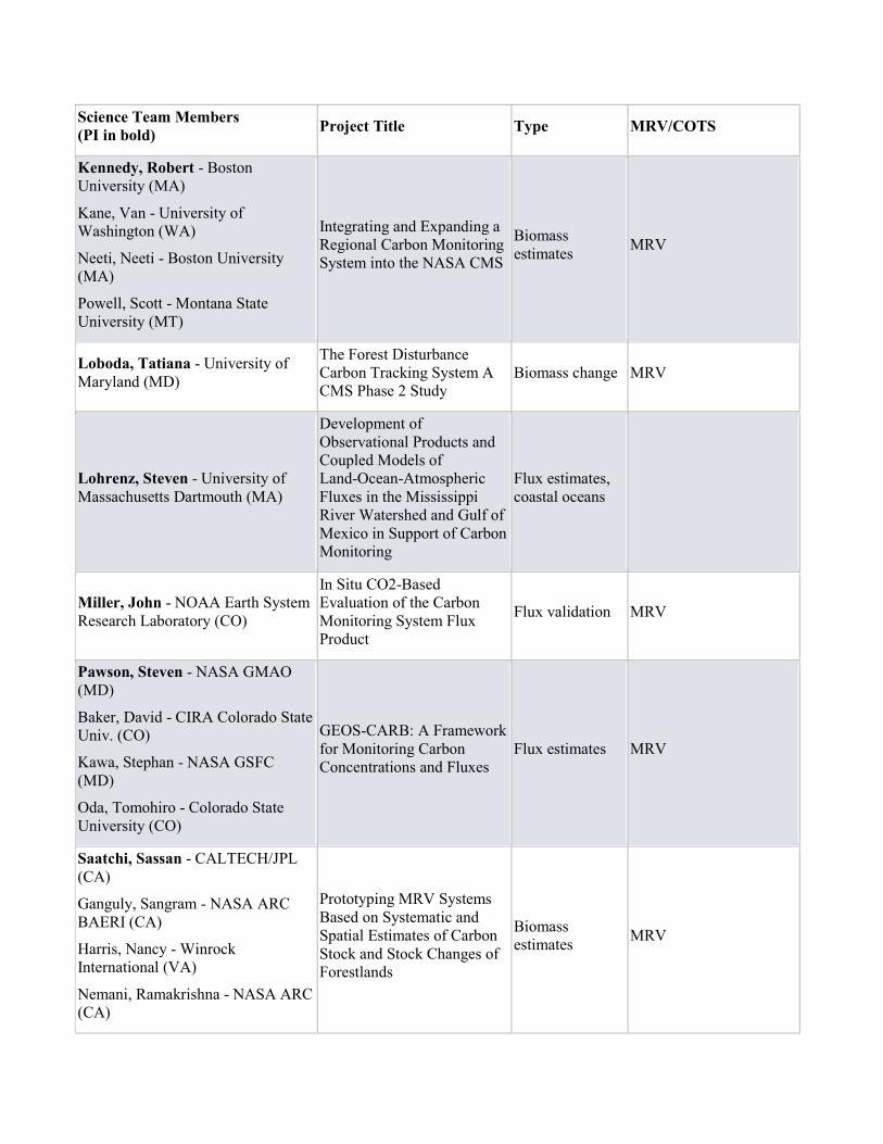
Science Team Members (PI in bold) Project Title Type MRV/COTS
Kennedy, Robert - Boston University (MA)
Kane, Van - University of Washington (WA)
Neeti, Neeti - Boston University (MA)
Powell, Scott - Montana State University (MT)
Integrating and Expanding a Regional Carbon Monitoring System into the NASA CMS
Biomass estimates MRV
Loboda, Tatiana - University of Maryland (MD)
The Forest Disturbance Carbon Tracking System A CMS Phase 2 Study
Biomass change MRV
Lohrenz, Steven - University of Massachusetts Dartmouth (MA)
Development of Observational Products and Coupled Models of Land-Ocean-Atmospheric Fluxes in the Mississippi River Watershed and Gulf of Mexico in Support of Carbon Monitoring
Flux estimates, coastal oceans
Miller, John - NOAA Earth System Research Laboratory (CO)
In Situ CO2-Based Evaluation of the Carbon Monitoring System Flux Product
Flux validation MRV
Pawson, Steven - NASA GMAO (MD)
Baker, David - CIRA Colorado State Univ. (CO)
Kawa, Stephan - NASA GSFC (MD)
Oda, Tomohiro - Colorado State University (CO)
GEOS-CARB: A Framework for Monitoring Carbon Concentrations and Fluxes
Flux estimates MRV
Saatchi, Sassan - CALTECH/JPL (CA)
Ganguly, Sangram - NASA ARC BAERI (CA)
Harris, Nancy - Winrock International (VA)
Nemani, Ramakrishna - NASA ARC (CA)
Prototyping MRV Systems Based on Systematic and Spatial Estimates of Carbon Stock and Stock Changes of Forestlands
Biomass estimates MRV
Science Team Members (PI in bold) Project Title Type MRV/COTS
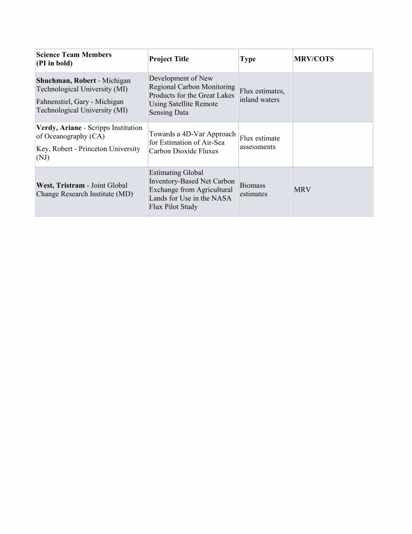
Shuchman, Robert - Michigan Technological University (MI)
Fahnenstiel, Gary - Michigan Technological University (MI)
Development of New Regional Carbon Monitoring Products for the Great Lakes Using Satellite Remote Sensing Data
Flux estimates, inland waters
Verdy, Ariane - Scripps Institution of Oceanography (CA)
Key, Robert - Princeton University (NJ)
Towards a 4D-Var Approach for Estimation of Air-Sea Carbon Dioxide Fluxes
Flux estimate assessments
West, Tristram - Joint Global Change Research Institute (MD)
Estimating Global Inventory-Based Net Carbon Exchange from Agricultural Lands for Use in the NASA Flux Pilot Study
Biomass estimates MRV
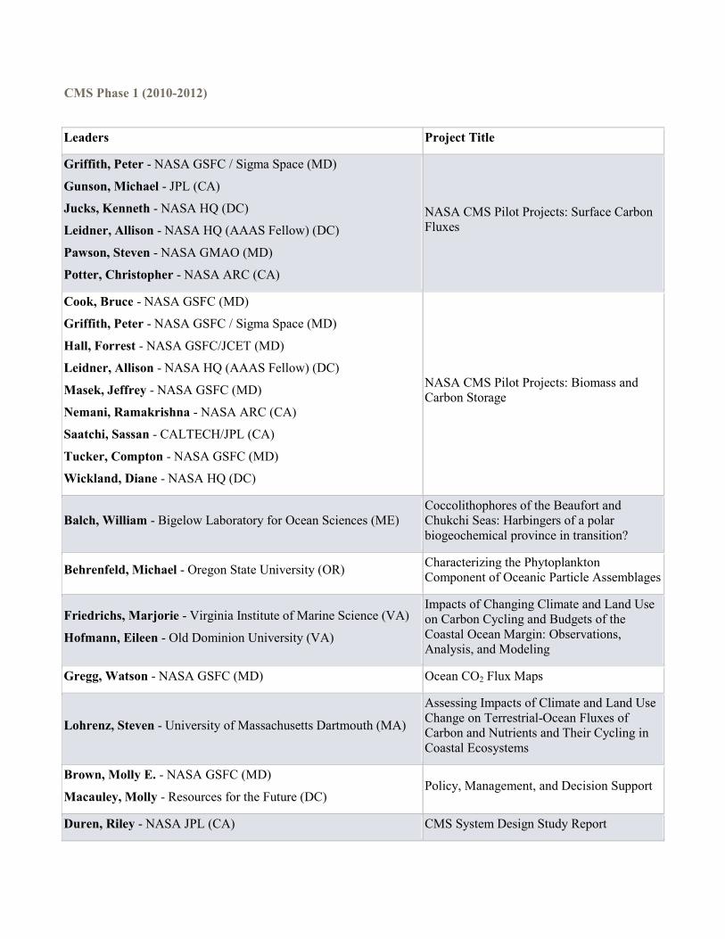
CMS Phase 1 (2010-2012)
Leaders Project Title
Griffith, Peter - NASA GSFC / Sigma Space (MD)
Gunson, Michael - JPL (CA)
Jucks, Kenneth - NASA HQ (DC)
Leidner, Allison - NASA HQ (AAAS Fellow) (DC)
Pawson, Steven - NASA GMAO (MD)
Potter, Christopher - NASA ARC (CA)
NASA CMS Pilot Projects: Surface Carbon Fluxes
Cook, Bruce - NASA GSFC (MD)
Griffith, Peter - NASA GSFC / Sigma Space (MD)
Hall, Forrest - NASA GSFC/JCET (MD)
Leidner, Allison - NASA HQ (AAAS Fellow) (DC)
Masek, Jeffrey - NASA GSFC (MD)
Nemani, Ramakrishna - NASA ARC (CA)
Saatchi, Sassan - CALTECH/JPL (CA)
Tucker, Compton - NASA GSFC (MD)
Wickland, Diane - NASA HQ (DC)
NASA CMS Pilot Projects: Biomass and Carbon Storage
Balch, William - Bigelow Laboratory for Ocean Sciences (ME) Coccolithophores of the Beaufort and Chukchi Seas: Harbingers of a polar biogeochemical province in transition?
Behrenfeld, Michael - Oregon State University (OR) Characterizing the Phytoplankton Component of Oceanic Particle Assemblages
Friedrichs, Marjorie - Virginia Institute of Marine Science (VA)
Hofmann, Eileen - Old Dominion University (VA)
Impacts of Changing Climate and Land Use on Carbon Cycling and Budgets of the Coastal Ocean Margin: Observations, Analysis, and Modeling
Gregg, Watson - NASA GSFC (MD) Ocean CO2 Flux Maps
Lohrenz, Steven - University of Massachusetts Dartmouth (MA)
Assessing Impacts of Climate and Land Use Change on Terrestrial-Ocean Fluxes of Carbon and Nutrients and Their Cycling in Coastal Ecosystems
Brown, Molly E. - NASA GSFC (MD)
Macauley, Molly - Resources for the Future (DC) Policy, Management, and Decision Support
Duren, Riley - NASA JPL (CA) CMS System Design Study Report
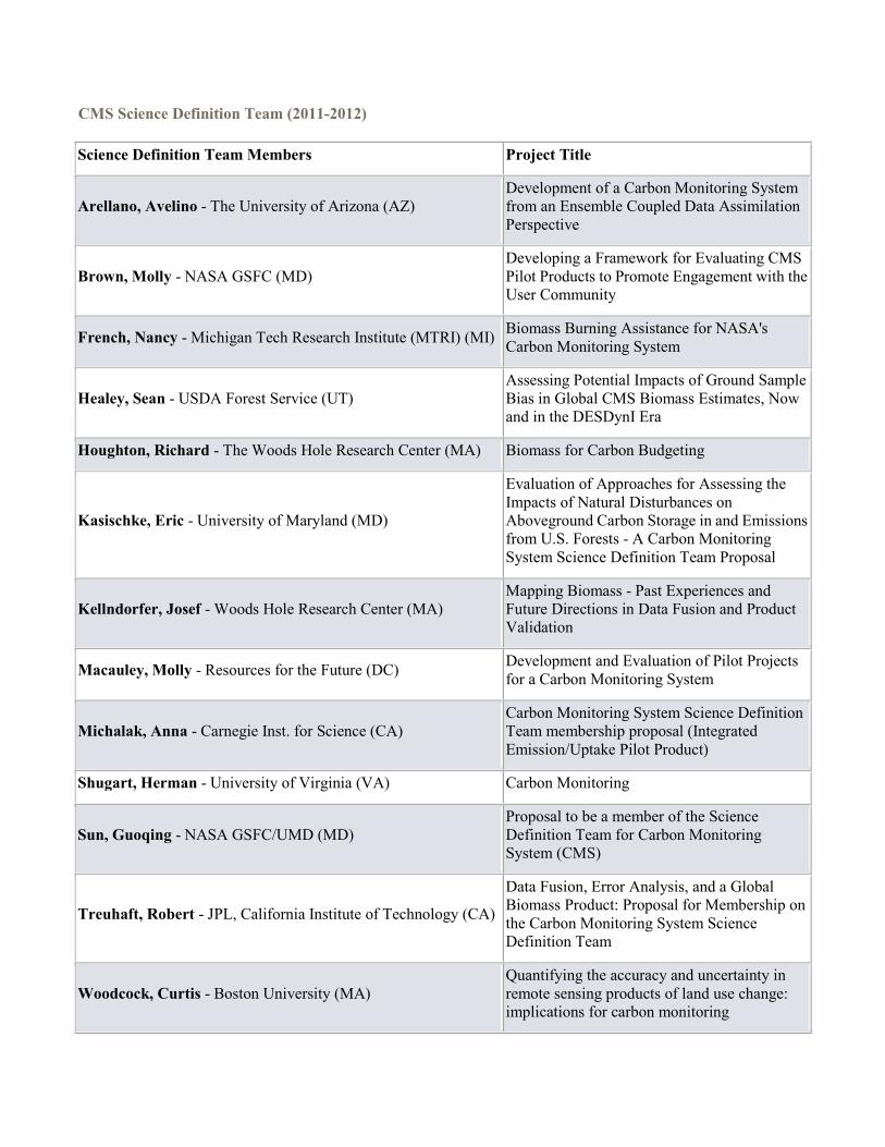
CMS Science Definition Team (2011-2012) Science Definition Team Members Project Title
Arellano, Avelino - The University of Arizona (AZ) Development of a Carbon Monitoring System from an Ensemble Coupled Data Assimilation Perspective
Brown, Molly - NASA GSFC (MD) Developing a Framework for Evaluating CMS Pilot Products to Promote Engagement with the User Community
French, Nancy - Michigan Tech Research Institute (MTRI) (MI) Biomass Burning Assistance for NASA's Carbon Monitoring System
Healey, Sean - USDA Forest Service (UT) Assessing Potential Impacts of Ground Sample Bias in Global CMS Biomass Estimates, Now and in the DESDynI Era
Houghton, Richard - The Woods Hole Research Center (MA) Biomass for Carbon Budgeting
Kasischke, Eric - University of Maryland (MD)
Evaluation of Approaches for Assessing the Impacts of Natural Disturbances on Aboveground Carbon Storage in and Emissions from U.S. Forests - A Carbon Monitoring System Science Definition Team Proposal
Kellndorfer, Josef - Woods Hole Research Center (MA) Mapping Biomass - Past Experiences and Future Directions in Data Fusion and Product Validation
Macauley, Molly - Resources for the Future (DC) Development and Evaluation of Pilot Projects for a Carbon Monitoring System
Michalak, Anna - Carnegie Inst. for Science (CA) Carbon Monitoring System Science Definition Team membership proposal (Integrated Emission/Uptake Pilot Product)
Shugart, Herman - University of Virginia (VA) Carbon Monitoring
Sun, Guoqing - NASA GSFC/UMD (MD) Proposal to be a member of the Science Definition Team for Carbon Monitoring System (CMS)
Treuhaft, Robert - JPL, California Institute of Technology (CA)
Data Fusion, Error Analysis, and a Global Biomass Product: Proposal for Membership on the Carbon Monitoring System Science Definition Team
Woodcock, Curtis - Boston University (MA) Quantifying the accuracy and uncertainty in remote sensing products of land use change: implications for carbon monitoring

Science Definition Team Members Project Title
Xiao, Jingfeng - University of New Hampshire (NH)
Providing Scientific and Technical Guidance to the Development and Evaluation of the Integrated Flux Pilot Product: Forcing Evaluation, Parameter Optimization, Uncertainty Assessment and Product Validation
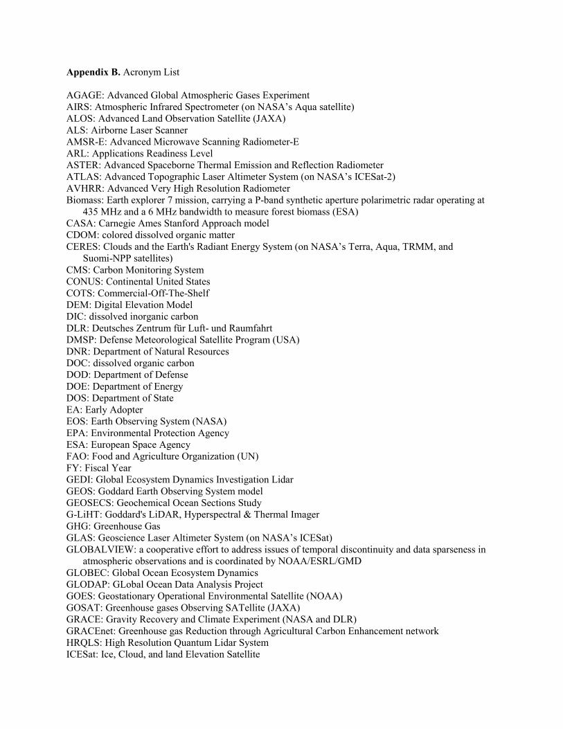
Appendix B. Acronym List
AGAGE: Advanced Global Atmospheric Gases Experiment AIRS: Atmospheric Infrared Spectrometer (on NASA’s Aqua satellite) ALOS: Advanced Land Observation Satellite (JAXA) ALS: Airborne Laser Scanner AMSR-E: Advanced Microwave Scanning Radiometer-E ARL: Applications Readiness Level ASTER: Advanced Spaceborne Thermal Emission and Reflection Radiometer ATLAS: Advanced Topographic Laser Altimeter System (on NASA’s ICESat-2) AVHRR: Advanced Very High Resolution Radiometer Biomass: Earth explorer 7 mission, carrying a P-band synthetic aperture polarimetric radar operating at
435 MHz and a 6 MHz bandwidth to measure forest biomass (ESA) CASA: Carnegie Ames Stanford Approach model CDOM: colored dissolved organic matter CERES: Clouds and the Earth's Radiant Energy System (on NASA’s Terra, Aqua, TRMM, and
Suomi-NPP satellites) CMS: Carbon Monitoring System CONUS: Continental United States COTS: Commercial-Off-The-Shelf DEM: Digital Elevation Model DIC: dissolved inorganic carbon DLR: Deutsches Zentrum für Luft- und Raumfahrt DMSP: Defense Meteorological Satellite Program (USA) DNR: Department of Natural Resources DOC: dissolved organic carbon DOD: Department of Defense DOE: Department of Energy DOS: Department of State EA: Early Adopter EOS: Earth Observing System (NASA) EPA: Environmental Protection Agency ESA: European Space Agency FAO: Food and Agriculture Organization (UN) FY: Fiscal Year GEDI: Global Ecosystem Dynamics Investigation Lidar GEOS: Goddard Earth Observing System model GEOSECS: Geochemical Ocean Sections Study G-LiHT: Goddard's LiDAR, Hyperspectral & Thermal Imager GHG: Greenhouse Gas GLAS: Geoscience Laser Altimeter System (on NASA’s ICESat) GLOBALVIEW: a cooperative effort to address issues of temporal discontinuity and data sparseness in
atmospheric observations and is coordinated by NOAA/ESRL/GMD GLOBEC: Global Ocean Ecosystem Dynamics GLODAP: GLobal Ocean Data Analysis Project GOES: Geostationary Operational Environmental Satellite (NOAA) GOSAT: Greenhouse gases Observing SATellite (JAXA) GRACE: Gravity Recovery and Climate Experiment (NASA and DLR) GRACEnet: Greenhouse gas Reduction through Agricultural Carbon Enhancement network HRQLS: High Resolution Quantum Lidar System ICESat: Ice, Cloud, and land Elevation Satellite
IPCC: Intergovernmental Panel on Climate Change JAXA: Japan Aerospace Exploration Agency JGOFS: Joint Global Ocean Flux Study JPSS: Joint Polar-orbiting Satellite System (NOAA) Landsat: land satellite; longest series of space-based medium-resolution land remote sensing satellites LTER: Long-Term Ecological Research LULUCF: Land Use, Land-Use Change and Forestry LVIS: Land, Vegetation and Ice Sensor MERIS: Medium Resolution Imaging Spectrometer (ESA) MERLIN: Methane Remote sensing LIdar missioN (CNES and DLR) MODIS: Moderate Resolution Imaging Spectroradiometer (NASA) MRV: Monitoring, Reporting, and Verification (also referred to as Measurement, Reporting and
Verification) MsTMIP: Multi-scale Synthesis and Terrestrial Model Intercomparison Project NASA: National Aeronautics and Space Administration (USA) NEON: National Ecological Observatory Network (USA) NI-SAR: NASA - ISRO Synthetic Aperture Radar NIST: National Institute of Standards and Technology NOAA: National Oceanic and Atmospheric Administration (USA) NSF: National Science Foundation OCMIP: Ocean Carbon-Cycle Model Intercomparison Project OCO: Orbiting Carbon Observatory (NASA) ONR: Office of Naval Research PACE: Pre-Aerosol, Clouds, and ocean Ecosystem (NASA) PALSAR: Phased Array type L-band Synthetic Aperture Radar pCO2: partial pressure of carbon dioxide POES: Polar-orbiting Operational Environmental Satellite (NOAA) QuikSCAT: Quick Scatterometer (NASA) R&A: Research and Analysis REDD+: Reducing Emissions from Deforestation and Degradation SAR: Synthetic Aperture Radar SCIAMACHY: SCanning Imaging Absorption spectroMeter for Atmospheric ChartograpHY SeaWiFS: Sea-Viewing Wide Field-of-View Sensor Sentinel-5P: polar orbiting ESA mission to monitor the composition of the atmosphere precursor (on
Metop) SMAP: Soil Moisture Active Passive mission (NASA) SST: Sea Surface Temperature Suomi-NPP: Suomi-National Polar-orbiting Partnership (NASA and NOAA) TCCON: Total Carbon Column Observing Network TES: Tropospheric Emission Spectrometer (on NASA’s Aura satellite) TRMM: Tropical Rainfall Measuring Mission TropOMI: TROPOspheric Monitoring Instrument (on ESA’s Sentinel-5 precursor satellite) UN: United Nations UNFCCC: United Nations Framework Convention on Climate Change USAID: U.S. Agency for International Development USDA: United States Department of Agriculture USGS: United States Geological Survey VIIRS: Visible Infrared Imaging Radiometer Suite (on Suomi NPP and JPSS) VOS: Voluntary Observing Ships WBS: Work Breakdown Structure
Appendix C. Key CMS Publications to Date
Babcock, C., J. Matney, A. O. Finley, A. Weiskittel, and B. D. Cook (2013), Multivariate spatial regression models for predicting individual tree structure variables using LiDAR data, IEEE Appl.Earth Obs. Rem. Sens., 6,6–14, doi: 10.1109/JSTARS.2012.2215582. (Saatchi-02) (Nelson03) (Cook-B-01)
Baccini, A., S. J. Goetz, W. S. Walker, N. T. Laporte, M. Sun, D. Sulla-Menashe, J. Hackler, P. S. A. Beck, R. Dubayah, M. A. Friedl, S. Samanta, and R. A. Houghton (2012), Estimated carbon dioxide emissions from tropical deforestation improved by carbon-density maps, Nat. Clim. Change, 2,182-185, doi: 10.1038/nclimate1354. (Houghton-02)
Birdsey, R., G. Angeles-Perez, W. A. Kurz, A. Lister, M. Olguin, Y. Pan, C. Wayson, B. Wilson, and K. Johnson, (2013), Approaches to monitoring changes in carbon stocks for REDD+, Carbon Manage., 4, 519-537. doi: 10.4155/CMT.13.67 (Vargas-01)
Brown, M.E., V.M. Escobar, M. Macauley, J. Aschbacher, M.P. Milagro-Perez, B. Doorn, L. Friedl (2013) Policy for Robust Space-based Earth Science, Technology and Applications. Space Policy. 29(1). pp 76–82. Doi: 10.1016/j.spacepol.2012.11.007
Brown, M.E., M.K. Macauley (2012) Developing Earth Science Data and Models for Evaluating Climate Policy Outcomes. EOS Transactions AGU, 93(34), 328, doi:10.1029/2012EO340007.
Brown, M.E., M. Macauley (2012), Bringing together users and developers of forest biomass maps, EOS, Transactions of the American Geophysical Union 93(3), 32, doi:10.1029/2012EO030011.
Cai, W.-J., X. Hu, W.-J. Huang, M. C. Murrell, J. C. Lehrter, S. E. Lohrenz, W.-C. Chou, W. Zhai, J. T. Hollibaugh, Y. Wang, P. Zhao, X. Guo, K. Gundersen, M. Dai and G.-C. Gong (2011), Acidification of subsurface coastal waters enhanced by eutrophication, Nat. Geosci., 4(11),766-770, doi: 10.1038/ngeo1297 (Lohrenz-03)
Cook, B. D., L. A. Corp, R. F. Nelson, E. M. Middleton, D. C. Morton, J. T. McCorkel, J. G. Masek, K. J. Ranson, V. Ly, and P. M. Montesano (2013), NASA Goddard's LiDAR, Hyperspectral and Thermal (G-LiHT) Airborne Imager, Rem. Sens., 5, 4045-4066. doi: 10.3390/rs5084045 (Cook-B-01)
Deng, F., J. M. Chen, Y. Pan, W. Peters, R. Birdsey, K. McCullough and J. Xiao (2013), The use of forest stand age information in an atmospheric CO2 inversion applied to North America, Biogeosci., 10, 5335–5348, doi: 10.5194/bg-10-5335-2013 (Xiao- SDT)
Duncanson, L., B. Cook, G. J. Hurtt, and R. Dubayah. (in press) An efficient, multi-layered canopy delineation algorithm for mapping individual tree structure across multiple ecosystems, Rem. Sens. Environ., (Cook-B-01)
Erb, K.-H., T. Kastner, S. Luyssaert, R. A. Houghton, T. Kuemmerle, P. Olofsson, and H. Haberl, (2013), Bias in the attribution of forest carbon sinks, Nat. Clim. Change, 3,854-856, doi: 10.1038/nclimate2004 (Houghton-02)
Finley, A. O., S. Banerjee, B. D. Cook, and J. B. Bradford, (2013), Hierarchical Bayesian spatial models for predicting multiple forest variables using waveform LiDAR, hyperspectral imagery, and large inventory datasets. Int. J. Appl. Earth Obs. Geoinfo., 22SI, 147-160, doi: 10.1016/j.jag.2012.04.007 (Cook-B-01) (Saatchi-02) (Nelson-03)
Finley, A., S. Banerjee and B. D. Cook (in press), Bayesian hierarchical models for spatially misaligned data in R, Meth. Ecol. Evol. (Cook-B-01)
Guhaniyogi, R., A. O. Finley, S. Banerjee, and R. K. Kobe (2013), Modeling complex spatial dependencies: low-rank spatially-varying cross-covariances with application to soil nutrient data, J. Agr. Biol. Environ. Statistics, 18, 274–298, doi: 10.1007/s13253-013-0140-3 (Saatchi-02) (Nelson-03)
Guo, X., W.-J. Cai, W.-J. Huang, Y. Wang, F. Chen, M. C. Murrell, S. E. Lohrenz, L.-Q. Jiang, M. Dai, J. Hartmann, Q. Lin, and R. Culp (2012), Carbon dynamics and community production in the Mississippi River plume, Limnol. Ocean., 57(1), 1-17, doi: 10.4319/lo.2012.57.1.0001 (Lohrenz-04) (Lohrenz-03)
Healey, S. P., P. L. Patterson, S. Saatchi, M. A. Lefsky, A. J. Lister, and E. A. Freeman. (2012), A
sample design for globally consistent biomass estimation using lidar data from the Geoscience Laser Altimeter System (GLAS), Carbon Balance Manage., 7, 10 doi:10.1186/1750-0680-7-10 (Healey-01)
Hopkinson, C. S., W.-J. Cai, and X. Hu (2012), Carbon sequestration in wetland dominated coastal systems: a global sink of rapidly diminishing magnitude, Curr. Opin. Env. Sustain., 4, 1-9, doi: 10.1016/j.cosust.2012.03.005 (Lohrenz-04)
Houghton, R. A. (2013), The emissions of carbon from deforestation and degradation in the tropics: Past trends and future potential, Carbon Manage., 4(5), 539–546, doi: 10.4155/cmt.13.41 (Houghton-02)
Huang W.-J., W.-J. Cai, R. M. Castelao, Y. Wang, and S. E. Lohrenz (2013), Impacts of a wind-driven cross-shelf large river plume on biological production and CO2 uptake in the Gulf of Mexico during spring, Limnol. Ocean., 58(5), 1727-1735,. doi: 10.4319/lo.2013.58.5.1727 (Lohrenz-04)
Huang W.-J., W.-J. Cai, R. T. Powell, S. E. Lohrenz, Y. Wang, L. Q. Jiang, and C. S. Hopkinson (2012), The stoichiometric ratio during biological removal of inorganic carbon and nutrient in the Mississippi River plume and adjacent continental shelf, Biogeosci. Discuss., 9, 1557-1585, doi: 10.5194/bgd-9-1557-2012 (Lohrenz-03)
Huang, W.-J., W. –J. Cai, R. T. Powell, S. E. Lohrenz, Y. Wang, L. –Q. Jiang, and C. S. Hopkinson (2012), The stoichiometry of inorganic carbon and nutrient removal in the Mississippi River plume and adjacent continental shelf, Biogeosci., 9, 1–12, doi:10.5194/bg-9-2781-2012 (Lohrenz-04)
Junttila, V., A. O. Finley, J. B. Bradford, and T. Kauranne (2013), Strategies for minimizing sample size for use in airborne LiDAR-based forest inventory, For. Ecol. Manage., 292, 75–85, doi: 10.1016/j.foreco.2012.12.019 (Saatchi-02) (Nelson-03)
Liu, J., Bowman, K. W., Lee, M., Henze, D. K., Bousserez, N., Brix, H., Collatz, G. J., Menemenlis, D., Ott, L., Pawson, S., Jones, D., & Nassar, R. (2014). Carbon monitoring system flux estimation and attribution: impact of ACOS-GOSAT X-CO2 sampling on the inference of terrestrial biospheric sources and sinks. Tellus Series B-Chemical and Physical Meteorology, 66, 22486. doi:10.3402/tellusb.v66.22486 (Bowman-01)
Montesano, P. M., B. D. Cook, G. Sun, M. Simard, R. F. Nelson, K. J. Ranson, Z. Zhang, and S. Luthcke (2013), Achieving accuracy requirements for forest biomass mapping: A spaceborne data fusion method for estimating forest biomass and LiDAR sampling error, Rem. Sens. Environ., 130, 153-170, doi: 10.1016/j.rse.2012.11.016 (Cook-B-01)
Potter, C., S. Klooster, V. Genovese, C. Hiatt, S. Boriah, V. Kumar, V. Mithal, A. Garg (2012), Terrestrial Ecosystem Carbon Fluxes Predicted from MODIS Satellite Data and Large-Scale Disturbance Modeling, Int. J. Geosci., 3(3), 469-479, doi: 10.4236/ijg.2012.33050 (Gunson-Pawson--Potter-01)
Raczka, B. M., K. J. Davis, and D. Huntzinger (2013), Evaluation of continental carbon cycle simulations with North American flux tower observations. Ecol. Mono., 83(4), 531-556, doi:10.3334/ORNLDAAC/1183
Rosette, J., B. Cook, R. Nelson, C. Huang, J. Masek, C. Tucker, G. Sun, W. Huang, P. Montesano, J. Rubio-Gil, and J. Ranson (in press), Sensor compatibility for biomass change estimation using remote sensing datasets: Part of NASA's Carbon Monitoring System initiative, IEEE Geosci. Rem. Sens. Lett. (Cook-B-01)
Rosette, J., P. R. J. North, J. Rubio-Gil, B. Cook, S. Los, J. Suarez, G. Q. Sun, J. Ranson, and J. B. Blair (2013), Evaluating Prospects for Improved Forest Parameter Retrieval From Satellite LiDAR Using a Physically-Based Radiative Transfer Model, IEEE Appl. Earth Obs. Rem. Sens., 6 (1), 45- 63, doi: 10.1109/JSTARS.2013.2244199
Vargas, R., F. Paz, and B. de Jong (2013), Quantification of forest degradation and belowground carbon dynamics: ongoing challenges for monitoring, reporting and verification activities for REDD+, Carbon Manage., 4, 579-582, doi: 10.4155/CMT.13.63 (Vargas-01)
Verdy, A., M. Mazloff, B. Cornuelle, and S. Y. Kim (2014), Wind-driven sea level variability on the California coast: an adjoint sensitivity analysis, J. Phys. Oceanog., 44 (1), 297-318, doi: 10.1175/JPO-D-13-018.1 (Verdy-01)
West T. O., M. E. Brown, R. M. Duren, S. M. Ogle, and R. H. Moss (2013), Definition, capabilities and components of a terrestrial carbon monitoring system, Carbon Manage., 4, 413-422, doi: 10.4155/CMT.13.36 (West-03)
White, J. C., M. A. Wulder, A. Varhola, M. Vastaranta, N. C. Coops, B. D. Cook, D. Pitt, and M. Woods (2013), A best practices guide for generating forest inventory attributes from airborne laser scanning data using the area-based approach. Forestry Chron., 89, 722-723. (Cook-B-01)
White, J. C., M. A. Wulder, A. Varhola, M. Vastaranta, N. C. Coops, B. D. Cook, D. Pitt, and M. Woods (2013), A best practices guide for generating forest inventory attributes from airborne laser scanning data using the area-based approach. Information Report FI-X-10. Natural Resources Canada, Canadian Forest Service, Canadian Wood Fibre Centre, Pacific Forestry Centre, Victoria, BC. (Cook-B-01)
Xue, Z., R. He, K. Fennel, W. J. Cai, S. Lohrenz, and C. Hopkinson (2013), Modeling ocean circulation and biogeochemical variability in the Gulf of Mexico, Biogeosci. Discuss., 10, 7785-7830, doi: 10.5194/bgd-10-7785-2013 (Lohrenz-04)
Zhang, G., Ganguly, S., Nemani, R. R., White, M. A., Milesi, C., Hashimoto, H., Wang, W., Saatchi, S., Yu, Y., & Myneni, R. B. (2014). Estimation of forest aboveground biomass in California using canopy height and leaf area index estimated from satellite data. Remote Sensing of Environment, 151, 44–56. doi:10.1016/j.rse.2014.01.025 (Saatchi-01, Saatchi-02)