Embed Size (px)
Citation preview

Narrandera Land Use Strategy
PART 7
INDUSTRIAL LANDS REVIEW
August 2011

Narrandera Shire Industrial Lands Review
Narrandera Shire Council Page 2 of 41
Version Control Version No: Date: Author: Section Updated:
1 July 2011 Anthony Newland
2 August 2011 Anthony Newland Sections 1.2, 2.2.2, 3.2, 8, 11, 13 and 14 following an August 2011 Council workshop and request for consolidated recommendations.
This report has been prepared by:
Anthony Newland
Town Planner
M: 0428 668 211
W: www.townplanner.com.au
Level 1, 25 Tompson Street, (PO Box 511)
Wagga Wagga, 2650
ABN: 94 467 886 336
This work is Copyright and may not be reproduced without the written permission of the Narrandera Shire Council. The work may be referenced with appropriate acknowledgement.

Narrandera Shire Industrial Lands Review
Narrandera Shire Council Page 3 of 41
Table of Contents 1 Introduction .............................................................................................................................. 4
1.1 Background to this strategy............................................................................................... 4 1.2 Approach to this review ..................................................................................................... 4
Part A Existing industrial lands .................................................................................................... 5 2 Industrial employment .............................................................................................................. 5
2.1 Industrial and other employment in the Narrandera Township .......................................... 5 2.2 Industrial and other employment in the Narrandera Shire ................................................. 6
3 Narrandera Township industrial land and infrastructure ........................................................... 9
3.1 Narrandera west industrial zone (Leeton Road) ................................................................ 9 3.2 Pine Hill industrial zone ................................................................................................... 12 3.3 Red Hill industrial zone ................................................................................................... 15
4 Barellan and Grong Grong industrial lands ............................................................................ 17
4.1 Barellan .......................................................................................................................... 17 4.2 Grong Grong ................................................................................................................... 17
5 Planned infrastructure upgrades ............................................................................................ 18 6 Unhealthy building land and potentially contaminated land .................................................... 19
6.1 Unhealthy building land ................................................................................................... 20 6.2 Other known contaminated sites ..................................................................................... 24
Part B - Future industrial lands ...................................................................................................... 26 7 Recent industrial land use approvals ..................................................................................... 26
8 Available industrial land ......................................................................................................... 28
9 Current land use masterplans and industrial land .................................................................. 32
10 Relevant industrial land reviews and plans ......................................................................... 33
11 Industrial planning controls ................................................................................................. 34 12 Newell Highway and North Narrandera industrial/commercial uses .................................... 35
13 Likely industrial land requirements and future industrial land zonings ................................. 37
13.1 Summary of industrial demand ....................................................................................... 37 13.2 Narrandera west estate ................................................................................................... 37 13.3 Pine Hill estate ................................................................................................................ 37 13.4 Red Hill estate ................................................................................................................ 38 13.5 Newell Highway and Barellan Road industrial land uses ................................................. 38 13.6 Isolated industrial land uses in the Village zone .............................................................. 38 13.7 Redundant industrial sites ............................................................................................... 39
14 Recommendations of the Review ....................................................................................... 40
Appendix 1 - Table 1 Managing Land Contamination Planning Guidelines ................................... 41

Narrandera Shire Industrial Lands Review
Narrandera Shire Council Page 4 of 41
1 Introduction
1.1 Background to this strategy This strategy forms the seventh component of a comprehensive Land Use Study for the Narrandera Shire, which in turn will be used as the basis for the preparation of the new Standard Instrument Local Environmental Plan (LEP) for the Shire. This new LEP and the accompanying land use study documents will be the first major planning review for the Shire and its settlement areas since the late 1980’s. This strategy follows on from prior parts of the land use study, being:
The Narrandera Shire Profile (Part 1);
The Narrandera Township Housing Study (Part 2);
Barellan and Grong Grong Villages Strategy (Part 3);
Narrandera Rural Lands Strategy (Part 4)
Narrandera Business Centres Strategy (Part 5), and
Narrandera Shire Environmental Lands Review (Part 6).
1.2 Approach to this review The industrial lands review is in two parts. Part A reviews the existing scenario for industrial lands and includes consideration of the following:
Industrial employment in the town and Shire;
Existing industrial land and infrastructure
Industrial land uses in the Villages of Barellan and Grong Grong;
Planned infrastructure upgrades in Narrandera Township;
Buffers around potentially offensive uses, and
Unhealthy building land within the urban areas of the Shire, along with other land uses which have the potential to contaminate land.
Part B of the review considers the future needs for industrial land within the Narrandera Township and Villages, and includes:
Statistics on industrial development applications;
Examination of vacant industrial lands and industrial sites which could undergo redevelopment or change of use;
Current Masterplan studies within the Narrandera Township which will have an influence on location of future industrial lands;
Potential industrial land needs for the future;
Recommended changes to industrial zones within urban areas of the Shire, and
General recommendations of the review.

Narrandera Shire Industrial Lands Review
Narrandera Shire Council Page 5 of 41
Part A Existing industrial lands
2 Industrial employment
2.1 Industrial and other employment in the Narrandera Township Note: This information is derived from the Narrandera Shire Profile
1. In 2001 the Township industries employing over 100 persons were lead by the retail trade, followed by manufacturing, agriculture, forestry and fishing, health and community services, accommodation, cafes and restaurants, wholesale trade, government administration and defence and education. In 2006 this had changed, to be lead by the manufacturing sector, then retail trade, health care and social assistance, public administration and safety, accommodation and food services, education and training, agriculture, forestry and fishing and transport, postal and warehousing. A large drop in employment numbers was experienced by the agriculture, forestry and fishing industry (down 45%), with the largest drop being in the wholesale sector (down 53%) and a smaller drop in the retail sector (14%). Large increases were recorded in the health care and social assistance sector (18%), manufacturing sector (13%) and public administration sector (the largest increase at 35%) with increases in the accommodation and food services (6%) and education and training sector (8%). These changes are provided in chart form below. Chart 1 Narrandera Township industry of employment
Source: ABS Census 2001 & 2006
Within the Narrandera Township the economy has restructured somewhat in the period 2001 to 2006. It will be noteworthy to review the 2011 Census results to see the longer term trend. The increase in manufacturing jobs is positive. The health care and social services sector increased in employment numbers and this trend may continue with an ageing population and more focus on population health generally. The large increase in the public administration sector reflects the importance of the public sector as a major employer in the town and a contributor of salary income to the retail and services sector.
1 Newland Planning and Development 2010 Narrandera Shire Profile
Industry of employment
156180
111
232
124
68101 99
152
85
204
53
200
80 80
136107
180
0
50
100
150
200
250
Ag,
For
estry
, Fishin
g
Man
ufact
uring
Whol
esale
trade
Reta
il tra
de
Acc
omm
odat
ion
& fo
od
Trans
port &
War
ehous
e
Pub
lic a
dmin
istra
tion
Edu
catio
n an
d Tra
ining
Heal
th C
are
& S
ocial
Pers
on
s
2001
2006

Narrandera Shire Industrial Lands Review
Narrandera Shire Council Page 6 of 41
The downturn in agriculture, forestry and fishing industry is suspected to be the result of drought, industry restructuring, government policy and public sector employment. There were also losses in the retail and accommodation/food sector, a factor of the drought, less income to spend in town and a small decline in population. To a certain extent the industry of employment/employment status of Narrandera residents is dependent on the regional economy. Anecdotal evidence suggests that a considerable number of persons residing in Narrandera actually work outside the Shire in the horticulture, viticulture, food processing and manufacturing industries. These people typically travel to the Leeton and Griffith local government areas.
2.2 Industrial and other employment in the Narrandera Shire
2.2.1 Industry of employment
In 2006 agriculture, forestry and fishing was the mainstay of the Shire economy, having 490 persons or 20% of the Shire’s employment base. Manufacturing comprised 11% of the employment base with 275 persons. Similar employment numbers were found in the retail trade (258 persons – 10%) and health care and social assistance (241 persons – 9.5%). Education and training, public administration and training and accommodation and food services each employed around 180 persons, or 7% of the employment base. Transport, postal and warehousing employed 139 persons and construction employed 108 persons. Together the industrial based land uses of manufacturing, transport, postal and warehousing and construction provided a total of 522 jobs, or approximately 25% of all Shire jobs, more than agriculture, forestry and fishing. Table 1 Industry of employment across the Shire of Narrandera
Industry of employment
Living in town Living out of town 2006 total 2001 total for comparison
Agriculture, forestry & fishing
85 405 490 (20%) 639 (24%)
Manufacturing
204 71 275 (11%) 244 (9%)
Retail
200 58 258 (10%) 302 (11%)
Health care & social assistance
180 61 241 (9.5%) 211 (8%)
Education & training
107 79 186 (7%) 170 (6%)
Public admin & safety
136 46 182 (7%) 139 (5%)
Accommodation & food
80 94 174 (7%) 164 (6%)
Transport, postal & warehousing
80 59 139 (5%) 105 (4%)
Construction
75 33 108 (4%) 127 (5%)
Total 1,147 906 2,053 1,948 Source: ABS Census 2001 & 2006

Narrandera Shire Industrial Lands Review
Narrandera Shire Council Page 7 of 41
It is interesting to note the distribution of employees between the various industries in relation to those who live in the Narrandera Township and those who don’t. The statistics in Table 1 show that a significant number of persons live outside the town of Narrandera, but are employed within an employment sector located within or outside the town or otherwise outside the Shire. The exact distribution of travel to employment outside the Shire is not known. The exception of course is agriculture, where the majority of workers live outside the town but work in the Shire’s rural area. Similarly those that live in town are not necessarily employed by an industry in town. Many people are understood to work in the Leeton and Griffith local government areas.
Manufacturing sector
Manufacturing employs the second highest number of persons in the Shire – 275 persons or 11% of the labour force (up from 244 persons in 2001). Local manufacturing businesses include:
Grants Cypress Mill;
Narrandera Flour Mill;
Hutchins Engineering;
Clarke’s Engineering.
Transport sector
The transport sector, employing 139 persons in 2006, is not one of the Shire’s main employers. However this sector has significant unrealised growth potential. Narrandera Township is located at the junction of the Newell Highway (National) and the Sturt Highway (State) and 5700 vehicles pass through Narrandera each day - around 20% of these being heavy vehicles. The Gillenbah commercial area, at the junction of the Highways, is an acknowledged truck rest stop area and is well used by heavy vehicle drivers. The Gillenbah locality has the potential to be used as a B-double, road train and B-triple beak down point and depot for heavy vehicles. The transport industry should be focussed upon to strengthen Narrandera’s position in this sector. Local transport sector businesses include:
Day’s transport;
Hallyar transport;
Paterson’s transport
Terry Smith transport;
Bachelor transport, and
Barry transport.
2.2.2 Number and type of businesses in the Shire
The Australian Bureau of Statistics periodically records the number of businesses within statistical local areas. In December 2007 relevant data for the Narrandera SLA was released2. The data shows that the majority of the 738 businesses within the Shire (84%) had less than five employees, and 56% of businesses did not employ any other persons. 105 businesses (14%) employed between 5 and 19 persons, 6 businesses employed between 20 and 49 persons and six businesses employed more than 100 staff. The actual number of businesses by industry is provided in more detail in Table 2.
2 ABS Catalogue 8165.0 Counts of Australian Businesses 2003-2007, Released 14/12/2007

Narrandera Shire Industrial Lands Review
Narrandera Shire Council Page 8 of 41
Table 2 Businesses by employment sector Narrandera Shire
Business sector
Number businesses Business sector Number businesses
Agriculture, forestry & fisheries
363 Accommodation & food 30
Mining 0 Transport & storage
48
Manufacturing
21 Communication services
6
Electricity, gas & water supply
0 Finance and insurance 12
Construction
54 Property & business 66
Wholesale trade
15 Education 3
Retail trade
81 Health & community services
15
Cultural & recreational services
6 Personal & other services
18
Source: ABS Census 2001 & 2006
Further analysis of the ABS data and comparison with the industry by employment data above emphasises the small business nature of employment in the Shire. The top five businesses by actual number are agriculture, forestry and fisheries, retail trade, property and business services, transport and storage and construction, whereas only agriculture et al and retail are in the top five for number of employees. The industrial based land uses of manufacturing (21), construction (54) and transport/storage (48) provide a total of 123 or (17%) of the Shire’s 738 businesses. The industrial sector is very important to the Narrandera Shire’s employment and expenditure base. Note that Narrandera has a significant Essential Energy Depot located in the Narrandera West Industrial Estate, however this business does not appear in the ABS statistics for ‘Electricity, Gas and Water Supply businesses’ in Table 2 above. The employment statistics of the Essential Energy depot do fall within the various employment categories in Table 1.

Narrandera Shire Industrial Lands Review
Narrandera Shire Council Page 9 of 41
3 Narrandera Township industrial land and infrastructure The Narrandera Township has three specific zoned industrial land areas (Narrandera West, Pine Hill and Red Hill industrial areas). These industrial areas are examined in more detail below. There are also a number of individual industrial businesses and vacant industrial premises located along the Newell Highway, the Barellan Road and the Leeton Road. However the area along the Newell Highway, adjoining and within the Town business area also contains historical and new industrial based businesses. Floor space figures collected for the Narrandera Business Centre’s Strategy indicate that the Newell Highway adjoining the Town Centre and the Centre itself have approximately 6,200m2 of manufacturing and storage type land uses (with 1,800m2 of floor space vacant), and approximately 4,000m2 of automotive uses (with 700m2 of floor space vacant).
3.1 Narrandera west industrial zone (Leeton Road) The Narrandera west industrial area was established in the early 1990’s and is located on the western edge of the township, bounded by the (closed) Tocumwal rail line, River Street and the Leeton Road. The bulk of industrial lands are located within Redgum Street (a cul-de-sac) and on Douglas Street. The rail line borders the industrial land to the east and whilst closed to through rail traffic, is able to operate as a spur line/siding and connects to the main Griffith to Junee line which runs through the Township. Figure 1 Main portion of Narrandera west industrial area
Source: Narrandera Shire GIS

Narrandera Shire Industrial Lands Review
Narrandera Shire Council Page 10 of 41
The land was rezoned for industrial purposes via Amendment No.1 to the Narrandera LEP 1991 in July 1994. The intent of the industrial area was to provide for small allotments of around 2,000m2 for local businesses. The area includes the following businesses.
Essential Energy Field Office and Depot and substation infrastructure;
Narrandera Auto Dismantlers;
Hayllar Transport;
Cropping Systems;
Precision Irrigation Service;
Makeham’s Cabinets;
Narrandera Freight Centre/Star Track Express;
Narrandera Self Storage and Aussie Storage;
Boss Engineering;
Hornsby 4WD;
Hutcheon A&G (John Deere). Within this industrial area the Essential Energy uses, Auto Dismantlers, Hutcheon A&G and Hayllar Transport take up over half the land area. However their land areas are not in all cases fully utilised – see section 8 of this review. This industrial area is serviced with town water but does not have reticulated sewer. Premises rely upon on-site effluent devices. One business on the southern side of Redgum Street has a private sewer main which connects with the Council’s reticulated system. Figure 2 shows the extent of the Leeton Road industrial area (Zone 4(a) General Industrial Zone under the Narrandera Local Environmental Plan 1991) and the location of the available reticulated sewer and town water services.
3.1.1 Surrounding land uses
The Leeton Road industrial area is bordered to the east by the former Tocumwal rail line (little used) and then by the western residential area of the Township. The southern end of the industrial area is bordered by residential uses in Twynam Street and Audley Street. Immediately east of River Street is land zoned for Village (urban) purposes which has residential potential and is likely to have residential land uses in the future (see section 8 of this review). The proximity of residential uses to the industrial land places potential limitations on the type of industrial uses which could occupy the estate. Land uses which require separation from residential land due to noise, vibration, odour or other amenity impactors would not generally be suitable within this area.

Narrandera Shire Industrial Lands Review
Narrandera Shire Council Page 11 of 41
Figure 2 Extent of Leeton Road industrial zone and services

Narrandera Shire Industrial Lands Review
Narrandera Shire Council Page 12 of 41
3.2 Pine Hill industrial zone The Pine Hill industrial area was established in the 1970’s around the sheep yards and the grain storage silo’s and bunkers on the main Griffith to Junee rail line. The land adjoins large rural residential style allotments which are sparsely populated but close enough to be affected by industries which may emit noise and other pollution. The area features a small number of industrial land uses on lots between 0.6 hectares and 5 hectares in area. The Day’s Transport business covers three separate allotments whilst Home Timber and Hardware covers two allotments. The land was formally rezoned for industrial purposes via Amendment No.2 to the Narrandera LEP 1991 in May 1997. The area includes the following businesses and land uses.
District sheep sale yards;
Graincorp silos and bunkers;
Former Rocla Cement Pipe plant (not operational);
Hay’s Transport and Bulk Fertiliser storage;
Narrandera Seed Cleaners;
Oram Engineering;
Home Timber and Hardware. The former Rocla plant has been vacant for over a decade and comprises a significant infrastructure asset, which has deteriorated somewhat over time, but still has potential for a new use using similar infrastructure. The industrial land is serviced with town water but does not have reticulated sewer provision. Figure 4 shows the extent of the industrial zone (Zone 4(a) General Industrial Zone under the Narrandera Local Environmental Plan 1991) and the location of the available reticulated sewer and town water services. Figure 3 Pine Hill industrial area
Source: Narrandera Shire GIS

Narrandera Shire Industrial Lands Review
Narrandera Shire Council Page 13 of 41
3.2.1 Surrounding land uses
The Pine Hill industrial area is bordered to the east and south by large lot residential properties, to the north by the main Griffith to Junee rail line and to the west by Henry Mathieson Oval and residential uses. Importantly though there is a substantial detached dwelling within the current zoned industrial area as indicated on Figure 3. The presence of this dwelling provides limitations to the commencement of new industrial land uses which require physical separation from residential land, and provides potential for amenity impacts on the dwelling from existing industrial land uses such as the adjoining Rocla Cement Pipe plant – should it recommence (which is unlikely at this point).

Narrandera Shire Industrial Lands Review
Narrandera Shire Council Page 14 of 41
Figure 4 Extent of Pine Hill industrial zone and services
Narrandera Shire Industrial Lands Review
Narrandera Shire Council Page 15 of 41
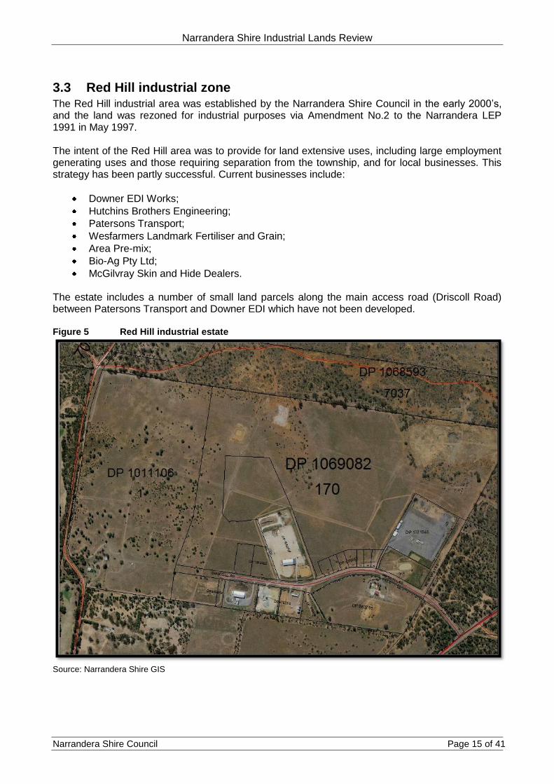
3.3 Red Hill industrial zone The Red Hill industrial area was established by the Narrandera Shire Council in the early 2000’s, and the land was rezoned for industrial purposes via Amendment No.2 to the Narrandera LEP 1991 in May 1997. The intent of the Red Hill area was to provide for land extensive uses, including large employment generating uses and those requiring separation from the township, and for local businesses. This strategy has been partly successful. Current businesses include:
Downer EDI Works;
Hutchins Brothers Engineering;
Patersons Transport;
Wesfarmers Landmark Fertiliser and Grain;
Area Pre-mix;
Bio-Ag Pty Ltd;
McGilvray Skin and Hide Dealers. The estate includes a number of small land parcels along the main access road (Driscoll Road) between Patersons Transport and Downer EDI which have not been developed. Figure 5 Red Hill industrial estate
Source: Narrandera Shire GIS

Narrandera Shire Industrial Lands Review
Narrandera Shire Council Page 16 of 41
The Red Hill estate is serviced by town water but does not have reticulated sewer. The estate at present does not have piped stormwater drainage and kerb and gutter. Stormwater drainage is via open swale drains within the road reserve leading to detention basins within and adjoining the estate. The open drain system and multiple point source discharge from private lands has resulted in the erosion of nearby lands and the siltation of the drainage system. The Council intends providing the estate with piped stormwater drainage and kerb and gutter. Refer to section 5 of this review. Figure 6 shows the extent of the industrial zone (Zone 4(a) General Industrial Zone under the Narrandera Local Environmental Plan 1991) and the location of the available reticulated sewer and town water services.
3.3.1 Surrounding land uses
The Red Hill industrial area is isolated from residential land uses. It is bordered to the east by Crown Land and the Barellan Road, to the north by Crown Land, a hillside and farmland, to the south by the Narrandera Racecourse, and to the west by a hillside and the Narrandera Gold Course. Its relative isolation makes the land more suitable for land uses which may require separation from residential areas. The hillside and downslope between the current developed area and the Golf Course introduces development constraints due to land slope, the cut and fill required to develop land, and the high erosion potential of the sandy soil upon which the estate is located. Figure 6 Extent of Red Hill industrial zone and services

Narrandera Shire Industrial Lands Review
Narrandera Shire Council Page 17 of 41
4 Barellan and Grong Grong industrial lands
4.1 Barellan Barellan does not have a specific zone for industrial land uses. Most businesses are based on the Burley Griffin Way and the rail line. The town’s major industry is the grain receivals and handling depot, operated by Graincorp .This large facility is adjacent to the northern side of the Griffith to Temora rail line which borders the north of the town, and is located in two precincts. There is a precinct on the eastern edge of the town with silos and bunkers and a second in the central village area featuring the main silos. There are two ‘industrial’ automotive uses located along Yapunyah Street in the business area – a Paint and Panel Smash Repairs and a Tyre and Fuel Centre. The Council depot is located on the corner of Yapunyah Street and Kooba Street and a small truck depot/shed is located adjoining on Kooba Street. Between Kooba and Yarran Street is a car ‘junkyard’ which is relatively well screened from Yapunyah Street (Burley Griffin Way). Within the town there are a small number of metal sheds of prior industrial/workshop or storage origin. These appear to be used periodically. At the western end of the town is Findlays grain haulage and storage, and gypsum/lime supplies, featuring a number of separate facilities including a depot, silos, workshop and office. According to the 2006 Census3, 39 persons within the towns workforce of 142 persons (27%) was employed in manufacturing (21 persons), construction (3 persons) or transport, postal and warehousing (15 persons). Not all those persons would be employed within the town (they may travel to Leeton or Griffith based industry) however it does indicate the importance of the industrial sector to Barellan.
4.2 Grong Grong Grong Grong village also does not have a specific zone for industrial land uses. The industrial land uses are again located adjoining the (Newell) Highway and the Griffith to Junee rail line. The town’s major industry is PIC (the Pig Improvement Company) – a pig genetics and breeding facility located around five kilometres south of the Village. This facility employs a fair percentage of the Village’s workforce, anecdotally around 20%. The Village also has a grain receivals and handling depot, operated by Graincorp, located along the eastern end of the Griffith to Junee rail line running through the centre of town. This facility consists of silos and some bunkers. A second large grain handling facility comprising a number of large bunkers, depot and office is operated by Grainflow and is located adjacent to the rail line around three kilometres west of the Village. Other industries within the village include a small bus depot and shed, a Landmark Depot and a small motor vehicle service business adjoining the Newell Highway.
3 Australian Census 2006 Australian Bureau of Statistics

Narrandera Shire Industrial Lands Review
Narrandera Shire Council Page 18 of 41
5 Planned infrastructure upgrades Narrandera’s zoned industrial estates at present do not benefit from full utility services, including sewer, and in the case of Pine Hill, Red Hill and half of Narrandera west, do not benefit from kerb and gutter and piped drainage. At present there are no plans to provide sewer or full kerb and gutter and piped drainage to Pine Hill and Narrandera west (Red Gum Street in Narrandera west does have kerb and gutter). However the Red Hill estate, due to its continuing issues with highly erodible soil, and to present the estate better to potential investors and tenants, is due to be upgraded in the current financial year, at an estimated cost of $650,000. The upgrades include:
Widening the carriageway of Driscoll Road and a new road at its western end, to 13 metres, with a new asphalt seal;
Provision of kerb and gutter and piped stormwater drainage to those roads;
Provision of three new stormwater detention basins above the current building area, to intercept stormwater flow from the hill above, and
Upgrading of existing detention basins below Driscoll Road. Figure 7 Red Hill industrial estate proposed upgrades 2011-2012

Narrandera Shire Industrial Lands Review
Narrandera Shire Council Page 19 of 41
6 Unhealthy building land and potentially contaminated land
Provisions relating to Unhealthy Building Land (UBL) were formerly found within the Unhealthy Building Land Act 1990 and its 2001 Regulation, and were regulated by the then NSW Environment Protection Authority (EPA). The Act and Regulation have since been repealed, as they duplicated powers available under other legislation. Unhealthy building land refers to land which is low lying (liable to flood affectation or other inundation) or contaminated. Many Council’s still keep a register of UBL. Today, flood liable land is controlled through the Environmental Planning and Assessment Act 1979 and the NSW Floodplain Development Manual 2005. Contaminated and potentially contaminated land is controlled through the NSW State Environmental Planning Policy No 55 – Remediation of Land, the Contaminated Lands Management Act 1997 (and Management Guidelines) and the Protection of the Environment Operations Act 1997. Narrandera Shire retains previous UBL lists but does not have an up to date comprehensive list of sites which are contaminated or potentially contaminated due to existing or former land uses. Appendix 1 to this review contains a list of land uses which have the potential to bring about contamination of land4. The Shire and urban areas have a number of current and closed facilities which are found on this list. These include service stations and fuel depots. The Shire does have a Floodplain Risk Management Study and Plan and controls development on the floodplain of the Murrumbidgee River through a Development Control Plan. This review will detail the listed UBL sites and other known sites that are either potentially contaminated or potentially offensive. It is recommended that the Council investigate the production of a more complete list and also produce a development control plan dealing with contaminated land.
4 NSW Department of Urban Affairs and Planning 1998 Managing Land Contamination – Planning Guidelines (SEPP 55
Remediation of Land)

Narrandera Shire Industrial Lands Review
Narrandera Shire Council Page 20 of 41
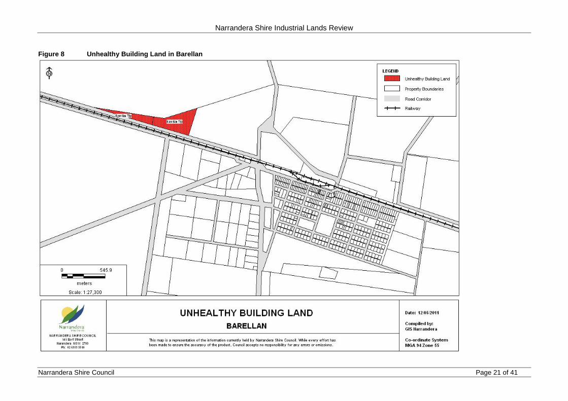
6.1 Unhealthy building land Provided in the Table below is a list of known unhealthy building land within the Shire (found mainly in and around the urban areas. This list is not exhaustive. The UBL sites mainly comprise tips and a former Sanitary Depots (Night Soil waste). Table 3 Unhealthy Building Land Narrandera Shire
LOT SEC DP AREA_HA Gazettal_date Closure_date Site_name
8 10 758757 0.2 19710430 Narrandera Tip
10 10 758757 0.2 19710430 Narrandera Tip
268 751719 2.11 19320316 Narrandera Tip Ext
299 751719 7.98 19780428 Narrandera Tip
166 750821 21.73 19241107 19280101 Grong Grong Tip
230 750821 1.98 19250710 Grong Grong Tip
9 10 758757 0.2 19710430 Narrandera Tip
247 751719 1.18 19291112 19320101 Narrandera Tip Ext
312 751719 2.11 19710430 Narrandera Tip
263 751719 0.76 19280706 19290101 Narrandera Tip
104 751672 9.97 19710813 Barellan Tip
2 114461 0.73 19710430 Narrandera Tip
166 751719 2.07 19140916 Narrandera Sanitary Depot
311 751719 7.53 19770925 Narrandera Tip Ext
18 751672 3.95 19320525 19710101 Barellan Tip
187 751719 13.86 19210415 19240101 Old Sanitary Depot
The following Figures show the Unhealthy Building Land within the Villages of Barellan and Grong Grong and the Township of Narrandera.
Narrandera Shire Industrial Lands Review
Narrandera Shire Council Page 21 of 41
Figure 8 Unhealthy Building Land in Barellan

Narrandera Shire Industrial Lands Review
Narrandera Shire Council Page 22 of 41
Figure 9 Unhealthy Building Land in Grong Grong

Narrandera Shire Industrial Lands Review
Narrandera Shire Council Page 23 of 41
Figure 10 Unhealthy Building Land in Narrandera Township

Narrandera Shire Industrial Lands Review
Narrandera Shire Council Page 24 of 41
6.2 Other known contaminated sites Apart from current and former service stations, which are not listed in this review, there is a former large industrial area which is located within the Narrandera Township area which is likely to be contaminated. This area is notable as the Council is currently preparing masterplans for the future residential and urban use of this area. The land area is located on the Leeton Road between River Street and the Main Canal bridge and was once known as Dixonville. A location map of the land is provided below. Figure 11 Approximate location of ‘Dixonville’
The site is located between Back Dixonville Road and Leeton Road, and has an approximate area of 11 hectares. At present the land has one dwelling, on the centre allotment, and a number of trees in a low lying area adjoining Leeton Road.
Narrandera Shire Industrial Lands Review
Narrandera Shire Council Page 25 of 41
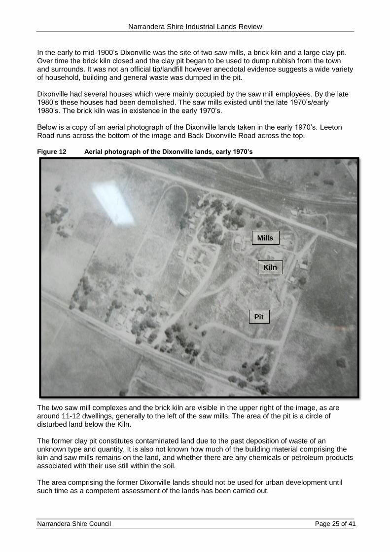
In the early to mid-1900’s Dixonville was the site of two saw mills, a brick kiln and a large clay pit. Over time the brick kiln closed and the clay pit began to be used to dump rubbish from the town and surrounds. It was not an official tip/landfill however anecdotal evidence suggests a wide variety of household, building and general waste was dumped in the pit. Dixonville had several houses which were mainly occupied by the saw mill employees. By the late 1980’s these houses had been demolished. The saw mills existed until the late 1970’s/early 1980’s. The brick kiln was in existence in the early 1970’s. Below is a copy of an aerial photograph of the Dixonville lands taken in the early 1970’s. Leeton Road runs across the bottom of the image and Back Dixonville Road across the top. Figure 12 Aerial photograph of the Dixonville lands, early 1970’s
The two saw mill complexes and the brick kiln are visible in the upper right of the image, as are around 11-12 dwellings, generally to the left of the saw mills. The area of the pit is a circle of disturbed land below the Kiln. The former clay pit constitutes contaminated land due to the past deposition of waste of an unknown type and quantity. It is also not known how much of the building material comprising the kiln and saw mills remains on the land, and whether there are any chemicals or petroleum products associated with their use still within the soil. The area comprising the former Dixonville lands should not be used for urban development until such time as a competent assessment of the lands has been carried out.
Pit
Kiln
Mills

Narrandera Shire Industrial Lands Review
Narrandera Shire Council Page 26 of 41
Part B - Future industrial lands
7 Recent industrial land use approvals Table 4 shows the location, type and value of industrial land approvals in the Shire over the past 10 years. Developments over $100,000 in value are in bold. Table 4 Industrial land building approvals Narrandera Shire July 2000 to December 2011
DA Number Development Proposed Address Value of work
28/2010/2011 Storage of game meats Redhill Industrial Estate 0
66/2009/2010 New buildings, weighbridge production area, car park Redhill Industrial Estate 1,800,000
41/2009/2010 Subdivision (NSC) Redhill Industrial Estate 0
20/2009/2010 Advertising sign Narrandera west 26,400
101/2007/2008 Factory Redhill Industrial Estate 500,000
76/2007/2008 Upgrade of existing office building River Street (sawmill) 51,841.80
40/2007/2008 Shed for timber milling machine River Street (sawmill) 45,000.00
34/2007/2008 Additional earth grain storage bunker and goods Newell Highway Grong Grong 150,000
7/2007/2008 Subdivide land to provide industrial land (NSC) Redhill Industrial Estate 0
76/2006/2007 Upgrade electrical substation Narrandera west 250,000
57/2006/2007 Demolish roof, install bins, re-establish roof Whitton Street (flour mill) 750,000
49/2006/2007 Erect self-storage units Narrandera west 100,000
44/2006/2007 Establish and further grow engineering business Pine Hill Road area 0
19/2006/2007 New factory Redhill Industrial Estate 100,000
96/2005/2006 Subdivide (Redhill Stage 6) Redhill Industrial Estate 0
56/2005/2006 Remove existing rooms & replace with skillion River Street (sawmill) 41,000
35/2005/2006 Processing recyclable materials Dalgetty Street/Barellan Road 50,000
13/2005/2006 Two wool storage sheds Narrandera west
57/2004/2005 Workshop, showroom, office & amenities Narrandera west 80,000
118/2003/2004 Install 150 tonne flour silo at existing warehouse Whitton Street (flour mill) 100,000
45/2003/2004 Transport depot Redhill Industrial Estate 500,000
17/2003/2004 Drying kiln River Street (Sawmill) 35,000
13/2003/2004 Extension of office building Broad Street 50,000
10/2003/2004 Subdivision - Redhill for Patersons Redhill Industrial Estate 0
52/2002/2003 Bulk fertilizer facility Broad Street 70,000
46/2002/2003 Grain receival terminal Grong Grong 7,500,000
87/2001/2001 Bunker and road Grong Grong 1,485
79/2001/2002 Weighbridge Grong Grong 75,000
58/2001/2002 Industrial shed Redhill Industrial Estate 300,000
32/2001/2002 Establish landfill and waste disposal operation Narrandera Landfill 0
87/2000/2001 Grain bunkers (stage 1) Barellan 300,000
25/2000/2001 Subdivision (NSC) Redhill Industrial Estate 1,430
10/2000/2001 Relocation of works depot from Whitton Street Redhill Road 250,000
$13,127,156

Narrandera Shire Industrial Lands Review
Narrandera Shire Council Page 27 of 41
The development statistics include the majority of the new construction at the Red Hill industrial estate, a number of developments at the Narrandera west industrial area, additions to the Grants Sawmill in River Street, additions to the Manildra Flour Mill in Narrandera and establishment and further development of a substantial grain receival terminal off the Newell Highway, south of Grong Grong. During the period there was only one development application for the Pine Hill industrial area. The Grong Grong grain terminal and additions constituted around 60% of the industrial works value over the 10 year period. Another substantial contribution to the total was the initial development of the Paterson transport depot ($500,000) and the subsequent purchase of additional land and construction of a manufacturing facility worth $1.8M. Over the past 10 years the Manildra Flour Mill has also had improvement works to the value of $850,000.

Narrandera Shire Industrial Lands Review
Narrandera Shire Council Page 28 of 41
8 Available industrial land Each industrial zone has been reviewed for vacant land and underutilised areas and the areas tabulated. The results and commentary are as follows. Narrandera west industrial area Narrandera west has approximately 19 hectares of industrial zoned land, with 6.5 hectares vacant and 2.4 hectares of land under-utilised. Under-utilised means that the land is primarily vacant and has a relatively small level of capital investment (buildings and other infrastructure). Underutilised land has the potential for further development, sale or in some cases re-subdivision. Around one third of the vacant land at Narrandera west is Crown Land, however it is understood that the land is not reserved and is available for use. Pine Hill industrial area The Pine Hill industrial area has approximately 6 hectares of industrial zoned land, with only one parcel not used for industrial purposes. That land, of 2.3 hectares, contains a substantial dwelling and shedding and the owners have requested that the land be rezoned to Village. This land is not available for industrial use. One industrial property of 2 hectares has the rear half of the property available for further use. The now abandoned Rocla facility is located on almost 4 hectares of land (Crown Land). Red Hill industrial estate The Red Hill industrial estate has approximately 126 hectares of industrial zoned land. Of this area, approximately 30 hectares is located upon west facing undulating sandhill land which is generally too steep for industrial land uses, and most of which fronts the golf course. This area of land is proposed for an alternate large lot residential use in the Masterplanning exercise referred to in section. This land is owned by the Council. Approximately 54 hectares of land is vacant and within a large residue allotment. However a high pressure gas pipeline runs across the north section of this residue allotment, and a buffer area some 150 metres wide places restrictions on industrial buildings. Open storage uses can be carried out within the buffer area. The residue allotment has a draft road pattern prepared for future re-subdivision, dependent upon demand. This land is owned by the Council. The Red Hill estate has seven small allotments fronting Driscoll Road, between 2,000-3,000m2 each in area. These allotments are in private ownership, with a mix of local and metropolitan owners, and have not yet been developed, despite being under private ownership for some years. It may be that the Red Hill estate is better suited to local businesses who require larger land areas – say 1 hectare or more, however it is not known why the smaller lots have remained undeveloped. The three lots owned by Sydney and Melbourne groups may be for investment purposes. The following Figures show the land vacancies within each estate.

Narrandera Shire Industrial Lands Review
Narrandera Shire Council Page 29 of 41
Figure 13 Vacancies within the Narrandera west industrial estate

Narrandera Shire Industrial Lands Review
Narrandera Shire Council Page 30 of 41
Figure 14 Vacancies within the Pine Hill industrial estate

Narrandera Shire Industrial Lands Review
Narrandera Shire Council Page 31 of 41
Figure 15 Vacancies within the Red Hill industrial estate

Narrandera Shire Industrial Lands Review
Narrandera Shire Council Page 32 of 41
9 Current land use masterplans and industrial land Figure 16 Land currently in the masterplanning phase
Narrandera Township has a significant amount of vacant land within the existing Village zone. The Council is presently masterplanning two large land areas, known generally as Leeton Road and North Narrandera (see Figure above). The Leeton Road area contains the former Dixonville industrial area and settlement, as discussed in section 6.2. This former industrial area places constraints on the use of that land for urban purposes (particularly residential and other sensitive land uses). The North Narrandera area contains a number of current industrial land uses, mainly along the River Street and Watermain Road corridors. These uses include the Grants Saw Mill at the north end of River Street, a recently approved landscape supplies yard on River Street (opposite Watermain Street), a property used for sand extraction and a depot for a local dump truck operator (Watermain Street), an area of land used for sand extraction by the Council north-west of Bells Road (adjoining a private trotting track) and a former Sanitary Depot and tip area at the northern end of Adams Street, near Bells Road. These current and former industrial land uses provide constraints to potential greenfields residential development, and in some cases (saw mill) require buffer areas to be imposed. However the position of the industrial uses does provide future opportunity for co-location of other industrial land uses. The potential for future industrial land uses is being examined within the Masterplanning process.
Leeton Road area
North Narrandera area
Saw mill and industrial land uses

Narrandera Shire Industrial Lands Review
Narrandera Shire Council Page 33 of 41
10 Relevant industrial land reviews and plans In the last decade there have been two main reviews concerning industrial land within the Narrandera Township. The first was in 2007. Consultants ‘tpg’5 were commissioned to prepare a feasibility report on acquiring 18 hectares of Crown Land adjacent to the Council works depot and fronting the Newell Highway, for an industrial park and subdivision. The land is opposite the Graincorp Silos and the Pine Hill residential (large lot) area. The report examined the competitive advantages of the region, infrastructure, regional and local population growth potential, demand factors and market conditions, land supply and sales, take-up, land supply in competing centres, development plan and construction costs, borrowings, sales and return on investment. The feasibility report found that in the short to medium term there was not a pressing need for the proposed industrial subdivision and the high costs of development and likely slow sales would not be conducive to a break even outcome for the Council. The Council did not proceed with the purchase of the land. The second review focussed upon the Red Hill Industrial Estate and the further subdivision of the residue component of the land. The Council employed consultants GHD Pty Ltd to develop a subdivision Masterplan, which was completed in 2009, with a number of options available. The Council have not proceeded with further subdivision, but have elected to carry out the upgrade work outlined in section 5 to this report. The Council did subdivide and sell additional land to a local transport firm for expansion within the estate in 2009/2010.
5 tpg June 2007 Industrial subdivision – Newell Highway (Grong Grong Approach) Narrandera Feasibility Report

Narrandera Shire Industrial Lands Review
Narrandera Shire Council Page 34 of 41
11 Industrial planning controls The main non-statutory planning control for industrial land within the Shire is the Narrandera Industrial Land Development Control Plan (DCP) which came into force in November 2009. The DCP applies to all the presently zoned 4(a) General Industrial Land within the Narrandera Township – the Narrandera West, Pine Hill and Red Hill estates discussed in this report. The DCP provides development, subdivision controls and signage controls, however it is flexible on subdivision lot size provided the lot is fit for purposes, including required vehicle movement. The DCP emphasises the built form, neighbourhood amenity, engineering, water quality and parking controls for new and expanding industrial development. Along with the Standard Instrument Local Environmental Plan, each Council in NSW is required to consolidate all present DCP controls into one document, so that only one document applies to a given allotment in the Shire. The present DCP for industrial lands will require consolidation into a single document, along with other DCP’s presently in force within the Shire. Industrial areas which are proposed to have a Light Industry zoning within the new LEP, will also require specific controls to enforce the definition (industries which do not interfere with the amenity of the area by means of noise, dust, soot, light etc). Statutory planning controls for industrial zoned land and existing industrial land uses in the Village zone are addressed in section 13.

Narrandera Shire Industrial Lands Review
Narrandera Shire Council Page 35 of 41
12 Newell Highway and North Narrandera industrial/commercial uses
There are a number of existing industrial and commercial businesses located along the Newell Highway, adjacent to the business area of Narrandera, adjacent to the rail line, along Myrtle Street, and between Margaret Street, Dalgetty Street and the Barellan Road intersection. This area is loosely described as North Narrandera. The location of the industrial/commercial land uses is shown in spatial form on the figure below, relative to the Narrandera business centre. Accommodation uses on the Highway are also shown. The developments in the area described are historic in nature, in that they established to benefit from the Highway visibility and passing trade, access to the rail line and proximity to the business area, where there were already industrial and automotive land uses. By comparison, the Narrandera West and Red Hill industrial estates are relatively recent additions to the industrial land bank of the town. The Highway and nearby land uses include;
Service Station corner Newell Highway and Audley Street;
TNT Depot 19 Cadell Street (Highway);
Vacant warehouse 7 Cadell Street (Highway);
Underutilised industrial shed 110 Whitton Street (Highway);
Service Station 74 Whitton Street corner Charles Street (Highway);
Car wash 68 Whitton Street corner Arthur Street (Highway);
Former fuel depot 24-48 Whitton Street;
Automotive Repair May Street corner Whitton Street;
Industrial shed 6 Boundary Road;
Kurrajong Waratah Recycling 1 Dalgetty Street;
Industrial yard 3 Dalgetty Street;
Industrial shed 3 Ferrier Street (Highway);
Industrial shed 18 Dalgetty Street;
Narrandera Windscreens 19-21 Ferrier Street corner Margaret Street (Highway);
Depot 22-24 Dalgetty Street;
Self-storage 29 Ferrier Street, access from Roslyn Street;
Deport Myrtle Street. There is also vacant land along the Highway with industrial/showroom capacity for businesses which rely on passing trade visibility. The vacant land is located at:
The south-eastern corner of Larmer Street and the Highway (approximately 2,000m2) and
The south-eastern corner of Audley Street and the Highway (approximately 2,000m2). The vacant land is at the southern entrance to the town and business area. The remainder of the Highway frontage land is generally of residential use. The historic and opportunistic nature of the business uses means that development has not been contiguous and comprehensive. The partial strip development of the Highway area is not uncommon in the context of main roads through townships. It is reasonable to conclude that the lack of more comprehensive development of the Highway strip is an indicator of the local demand for Highway sites, versus the cost of buying a number of established dwellings and redeveloping for business use. If the cost benefit of developing on the Highway is not economic for new business, it would be reasonable to keep the present Village zoning of the land, which is flexible, and will allow for future development of business sites based on market capacity.

Narrandera Shire Industrial Lands Review
Narrandera Shire Council Page 36 of 41
Figure 17 Industrial and commercial sites along Newell Highway and nearby land
Vacant land
Industrial/commercial use
Accommodation use (Highway)
Business Centre

Narrandera Shire Industrial Lands Review
Narrandera Shire Council Page 37 of 41
13 Likely industrial land requirements and future industrial land zonings
13.1 Summary of industrial demand New industrial developments in the Township of Narrandera over the past 10 years have consisted of multiple improvements to the Manildra Flour Mill and the Grants Saw Mill, the gradual development of the Red Hill estate (but mainly limited to two large businesses), new buildings on three vacant lots in the Narrandera west estate, and occupation of an existing warehouse/factory complex in the Pine Hill estate. A substantial grain receival facility was built adjoining the Newell Highway at Grong Grong and new grain bunkers built at Barellan. The take up (use) of vacant land has occurred at Narrandera West (three lots) and the Red Hill estate (two lots used by one business and new land subdivided for an existing business). The demand for vacant land at Narrandera west has not been significant or steady, with no take up since 2007. The take up of land at the Red Hill estate has been slow but steady, essentially all current businesses within the estate have established since 2000 (see section 3.3 of this report). The likely industrial land requirements for each estate are as follows.
13.2 Narrandera west estate The Narrandera west industrial area has six vacant industrial zoned allotments which are capable of being developed. One of these lots is used by Hayllar Transport for truck parking, but has no buildings. Four lots are within Redgum Street and two are on River Street. Demand for new land in the Narrandera west area does not appear to be significant and the current supply should satisfy local small businesses who do not need extensive land areas for development, over the short to medium term. The Narrandera west area is presently zoned 4(a) General Industry under the Narrandera LEP 1991. The estate does not have reticulated sewer and is located in close proximity to the established residential lands of west Narrandera (across the former Tocumwal rail line). There is also potential for adjoining land along Leeton Road to have residential uses (presently being examined in the Masterplanning process discussed in section 9 of this report). The proximity of the estate to current and potential residential areas places some constraints, namely noise constraints, on future development. For this reason the land should be zoned for Light Industry, to prevent the establishment of new businesses which would detrimentally affect the amenity of neighbouring residential areas.
13.3 Pine Hill estate The Pine Hill industrial area generally has some capacity for expansion of existing businesses into underutilised areas of their own land, however the estate does not have a viable vacant land bank. The former Rocla production site occupies a significant land area and significant infrastructure remains on the site. The Pine Hill area provides brownfields redevelopment land, which may be cost competitive with the Narrandera west and Red Hill vacant lands, depending on the incoming industrial use and level of new investment required. The Pine Hill estate is presently zoned 4(a) General Industry under the Narrandera LEP 1991. This is the best zoning for the site, and should retain an equivalent zone under the new Standard
Narrandera Shire Industrial Lands Review
Narrandera Shire Council Page 38 of 41
Instrument; except for the allotment which contains the existing dwelling. The land owner in this instance has requested that this allotment be rezoned to ‘Village’. This is recommended.
13.4 Red Hill estate The Red Hill estate provides the bulk of the Towns land bank and has the most capacity for either small business sites of 2,000m2 to 3,000m2 (seven existing vacant blocks) and larger land extensive industries. The Red Hill estate has ample room for future development, and is expected to remain as the Towns chief source of industrial land in the medium to long term, based on the rate of land take up over the past decade. It is acknowledged that the Red Hill estate was created and developed in the late 1990’s due to a perceived demand for a new green-fields industrial area, and the estate probably benefitted from slightly accelerated development in the first decade due to local pent up demand. Future development may come from an opportunistic external business who can take advantage of Narrandera’s location, and perhaps connection to natural gas supplies, or a local business seeking expansion room. At present the Red Hill estate does not have reticulated sewer, which limits its relative attractiveness to industries which are mild to heavy water users and effluent producers. The Red Hill estate is presently zoned 4(a) General Industry under the Narrandera LEP 1991. This is the best zoning for the site, and should retain an equivalent zone under the new Standard Instrument.
13.5 Newell Highway and Barellan Road industrial land uses The Newell Highway and the southern end of the Barellan Road intersecting the Highway have a variety of industrial/commercial businesses which have generally relied on Highway visibility for trade. Section 12 of this report notes that the historic and opportunistic nature of the business uses along these roads means that development has not been contiguous and comprehensive. At present and in the future the Village zone is quite flexible and able to accommodate most industrial and commercial uses along the Highway and Barellan Road. These roads will not have excellent residential amenity as long as the Highway route remains (which is of great benefit to the Township). It would be possible to rezone this area to a business incentive based zone in the Standard Instrument such as the ‘Enterprise Corridor’, however this could potentially have more restrictions than the Village zone. It is therefore recommended that the current Village zone remain in its Standard Instrument form along these roads, to provide for current and future commercial land uses.
13.6 Isolated industrial land uses in the Village zone The Narrandera Township has a number of isolated industrial/commercial sites. These include the Elders Depot and business centre on the Leeton Road, the Holcim Batching Plant (off Broad Street within the Crown Recreation Reserve and adjacent to the Caravan Park) and the Forestry Nursery and Depot on Elizabeth Street (above the Caravan Park). These land uses exist based on historical gravel and water access factors, and in the Elders case a previous Council approval on a main road. The Elders business is a relatively recent establishment. In the case of the batching plant and the Forestry Nursery/Depot the highest and best use of that land, based on its residential and reserve locality, is likely to be a less intensive land use which could include residential, or recreation, or both. The batching plant (located on freehold land)

Narrandera Shire Industrial Lands Review
Narrandera Shire Council Page 39 of 41
adjoins the former quarry in the Crown Reserve, which has not been fully rehabilitated and is in need of a longer term management/rehabilitation plan for land improvement. In relation to the future zoning of these isolated non-residential sites, the land could be rezoned from the current Village zoning to Industrial. This though would tend to lock in that land use or a similar land use for the future, and would not give the land owner any signal to relocate to a more suitable industrial based area. Retaining the current Village zoning on these sites, which permits residential and recreation based development, would still allow the land uses to continue, whilst discussion could be promoted by the Council to explore options for relocation of the land uses, site clean-up and disposal for a more suitable infill land use which would benefit the locality and the Town. In relation to the Crown Reserve the Council has applied for funding from the NSW Department of Lands to assist in preparing a comprehensive Plan of Management. The presence and future of the Holcim batching plant and former quarry will be of significance to that Plan and the future of the Reserve area.
13.7 Redundant industrial sites These are a number of disused and redundant industrial and automotive sites within the Narrandera Township, both within the main business area (mainly east of East Street) and along or adjacent to the Highway. The former fuel depot and tank farm in Whitton Street is one such example. Pending issues relating to site remediation, the owners of such sites should be encouraged to clean up and sell the land for, in most cases, low to medium density residential living, or aged care living, depending on the site location and access to the business area. The disposal of these sites and the opportunity for new residential units close to the business area would be of benefit to the Township and its new residential stock.

Narrandera Shire Industrial Lands Review
Narrandera Shire Council Page 40 of 41
14 Recommendations of the Review Existing industrial zones
A. That the existing Narrandera west industrial area, currently zoned 4(a) (General Industrial Zone) under the Narrandera LEP 1991, be zoned IN2 Light Industrial in the draft Narrandera LEP 2012;
B. That the existing Pine Hill industrial area, currently zoned 4(a) (General Industrial Zone) under the Narrandera LEP 1991, be zoned IN1 General Industrial in the draft Narrandera LEP 2012 (with the exception of the dwelling parcel – Lot 2, DP 575420 which should be zoned RU5 Village);
C. That the existing Red Hill industrial area, currently zoned 4(a) (General Industrial Zone)
under the Narrandera LEP 1991, be zoned IN1 General Industrial in the draft Narrandera LEP 2012;
Newell Highway and Barellan Road/Highway frontage
D. That the land fronting the Newell Highway and Barellan Road (south) - having existing
industrial/commercial and residential land uses, and currently zoned 2(v) (Village or Urban Zone) under the Narrandera LEP 1991, be zoned RU5 Village in the draft Narrandera LEP 2012, to provide flexibility for the establishment of new business and renewal of existing business.
Existing isolated industrial land uses in the Narrandera Township Village zone
E. That the Council discuss with the owners of existing isolated industrial land uses within Narrandera (isolated from the Newell Highway and industrial zones) the options for the relocation of the business to an existing suitable industrial zoned area, particularly where their present location in within a non-industrial locality.
Redundant industrial sites
F. That the Council discuss with the owners of closed and redundant industrial sites within the Narrandera Township the options for site clean-up and disposal for alternate land uses appropriate to the area.

Narrandera Shire Industrial Lands Review
Narrandera Shire Council Page 41 of 41
Appendix 1 - Table 1 Managing Land Contamination Planning Guidelines Table 1. Some Activities that may Cause Contamination
• acid/alkali plant and formulation
• agricultural/horticultural activities
• airports
• asbestos production and disposal
• chemicals manufacture and formulation
• defence works
• drum re-conditioning works
• dry cleaning establishments
• electrical manufacturing (transformers)
• electroplating and heat treatment premises
• engine works
• explosives industry
• gas works
• iron and steel works
• landfill sites
• metal treatment
• mining and extractive industries
• oil production and storage
• paint formulation and manufacture
• pesticide manufacture and formulation
• power stations
• railway yards
• scrap yards
• service stations
• sheep and cattle dips
• smelting and refining
• tanning and associated trades
• waste storage and treatment
• wood preservation