Embed Size (px)
Citation preview
See discussions, stats, and author profiles for this publication at: https://www.researchgate.net/publication/324111787
Noble et al 2016 KOFIAU AND CENDRAWASIH BAY FRONTIER BASIN
EXPLORATION: FROM JOINT STUDIES TO POST-DRILL ASSESSMENT
Conference Paper · March 2018
CITATIONS
0
READS
36
6 authors, including:
Some of the authors of this publication are also working on these related projects:
Natuna Area, Pliocene and Miocene hydrocarbon identification View project
Petroleum Biomarkers View project
Ron Noble
Agra Energi Indonesia
18 PUBLICATIONS 946 CITATIONS
SEE PROFILE
Philip Teas
ONE
14 PUBLICATIONS 101 CITATIONS
SEE PROFILE
John Decker
25 PUBLICATIONS 63 CITATIONS
SEE PROFILE
Tim Colin McCullagh
Advanced Educational Institutions
4 PUBLICATIONS 12 CITATIONS
SEE PROFILE
All content following this page was uploaded by Ron Noble on 18 May 2018.
The user has requested enhancement of the downloaded file.

* Agra Energi Indonesia, Jakarta Indonesia ** Oro Negro Exploration, California USA
6-TS-16
INDONESIAN PETROLEUM ASSOCIATION 2016 Technical Symposium, Indonesia Exploration: Where From - Where To
KOFIAU AND CENDRAWASIH BAY FRONTIER BASIN EXPLORATION: FROM JOINT
STUDIES TO POST-DRILL ASSESSMENT
R. Noble* P. Teas**
J. Decker** T. McCullagh*
Deddy Sebayang* D. Orange**
ABSTRACT In this article, we describe the exploration activities for two frontier deepwater basins in Eastern Indonesia, undertaken over a period from 2006 to 2013. The two basins are the Kofiau Basin and Cendrawasih Bay (Waipoga) Basin, located respectively on the northwestern and eastern margins of the Bird’s Head terrane of West Papua. Significant datasets were acquired in both basins during the pre-tender stage (open area-joint study) and PSC operations stage. This included regional 2D seismic, gravity/magnetics, high resolution sea floor multi-beam, piston core geochemistry, and prospect-specific 2D and 3D seismic programs. Two deepwater exploration wells were subsequently drilled in Kofiau (Ajek-1 and Elit-1) and one well in Cendrawasih Bay (Elang-1). The two basins show some similarities in their stratigraphic architecture, but also some important differences in tectonic setting and structural evolution. The Kofiau basin is a northeast-southwest trending depocenter with two major episodes of basin formation; one in the early Pliocene, followed by a period of deformation and erosion, and another depositional period lasting from the mid Pliocene until Recent. The basin evolution is controlled by the Sorong Fault Zone, the main strike slip plate bounding fault between the Australian Plate and the Pacific Plate. Eocene to late Miocene carbonates of the New Guinea Limestone (NGL) comprise the effective basement of the Kofiau basin. The Kais limestone member at the top of NGL is likely to occur at drillable depths in the northern part of the basin, but is generally too deep to be of interest over much of the area.
The Cendrawasih Bay (Waipoga) Basin belongs to a large Plio-Pleistocene post-collisional clastic.basin complex which extends across northern New Guinea. The northern margin is formed by the major east-west trending Sorong-Yapen Fault zone, to the west and southwest by the Bird’s Head and Lengguru Fold Belt, to the south by the Weyland mountain terranes, and to the east by the Waipoga Foldbelt. It contains Miocene to Pleistocene sequences which attain sediment thicknesses of at least 25,000 ft in the Waipoga Trough. Sea-floor piston cores revealed the presence of significant oil and gas seepage. Crude oil biomarkers and carbon isotopes showed that, in both basins, the oil was derived from a Tertiary source rock, most likely of the Klasafet Formation type (Late Miocene-Pliocene). Seepage of thermogenic and biogenic gases was also recorded, although the relative amounts of each differed between areas. Two exploration wells in Kofiau targeted Plio-Pleistocene sands in structural/stratigraphic traps, and showed the presence of good quality sands charged with mixed thermogenic-biogenic gas, although the pay sands at these locations were not sufficiently thick for commercial development. The exploration well in Cendrawasih Bay targeted a sedimentary package comprising carbonates and clastics of Tertiary age in a large four-way structural anticline. The well successfully encountered a moderately thick limestone section of Miocene to Eocene age, however the carbonate was tight and non-productive. No indications of thermogenic hydrocarbons were seen in the well.
Reconciliation of the drilling results with evidence for active petroleum systems in both basins provides the impetus and direction for follow-up exploration activity.

INTRODUCTION Eastern Indonesia offers many opportunities for oil and gas exploration. The region also poses significant challenges. The opportunities stem from a large number of under-explored basins with a variety of attractive play types. The challenges lie both above ground and in the subsurface, not the least of which is the availability of sufficient seismic and well data to encourage frontier exploration activity. Due to high project costs and substantial investment risk, work has tended to focus around areas with proven oil and gas. Not surprisingly, most activity has followed previous exploration success, which is mainly centered around the Salawati basin, Bintuni basin, onshore Seram and Timor Sea regions. This has left many sedimentary basins largely undrilled, despite the apparent prospectivity of the acreage. In order to encourage exploration activity, MIGAS introduced the Direct Award process for tendering work areas (Minister Decree no. 1480/ year 2004). This allowed companies to conduct joint studies with Government approved universities prior to submitting a bid for the nominated block. The initiative has been very successful, with a significant increase in PSC licensing activity occurring between 2004-2011, particularly in deepwater and frontier regions. The Joint Study process also promoted the acquisition of new data in remote areas on a non-proprietary basis. One such program was the Indonesia Frontier Basin (IFB) project, conducted by TGS-NOPEC / TDI Brooks, and underwritten by Black Gold Energy LLC and its affiliates (Orange et al., 2009). The IFB project provided a significant volume of marine 2D seismic, gravity/magnetics, seafloor bathymetry and piston core geochemistry over many undrilled or under-explored basins in Eastern Indonesia (Bernard et al., 2008). In this paper, two areas are described that were initially covered by data from the IFB program. Joint studies were carried out in the Kofiau and Cendrawasih Bay basins in 2006/2008 and PSC blocks were released by MIGAS for bidding in 2008/2009. After PSC award, additional 2D and 3D seismic were acquired, prospects were mapped, a drilling program was designed, and exploration wells were drilled. The results of the program are described herein, with particular reference to the reconciliation of pre-drill insights and post-drill outcomes. EXPLORATION AREAS The two areas of interest, Kofiau and Cendrawasih Bay, are shown in Figure 1, together with the main
tectonic elements of the Bird’s Head / West Papua region. A. KOFIAU BASIN
Regional Structure The Kofiau basin is a northeast-southwest trending depocenter with two major episodes of formation, one in the early Pliocene followed by a period of deformation and erosion and another period of deposition lasting from the mid Pliocene until recent formation of the basin is controlled by the Sorong-Yapen Fault Zone, the main strike slip plate bounding fault between the Australian Plate and the Pacific Plate (Decker et al., 2009). The Sorong Fault initiated approximately 7Ma in the region of the Bird’s Head of West Papua. Net movement across the fault is likely in the 100s of kilometers in magnitude and is responsible for distributing fragments of Australian-affinity crust from eastern to central Indonesia. Strike slip fault movement resulted in local transtensional deformation and the formation of restricted marine basins along the trend of the fault zone. While the transtensional motion in the Kofiau basin region dominates, with associated normal faulting and roll over folding, relatively minor shifts in plate motion vectors or activation of non-optimally oriented fault surfaces can result in transpression accompanied by folding and uplift. Such a case is likely responsible for the mid Pliocene unconformity as well as more recent folding in the eastern part of the Kofiau PSC.
Regional Stratigraphy The generalized stratigraphy of the Kofiau and Salawati Basins is shown in Figure 2. The Eocene to late Miocene carbonates of the New Guinea Formation comprise the effective basement of the Kofiau basin. Beneath the New Guinea section is likely to be Mesozoic continental rocks of Australian northwest shelf affinity, however, these units are considered too deep to impact the petroleum system. The New Guinea carbonate is generally capped by the Kais Formation which is defined as lagoonal reef build-ups at the top of the carbonate unit (Satyana, 2003). The Klasafet formation is a marine shale deposited contemporaneously with the Kais as facies equivalent deep-water shale to the Kais reef build-ups. The Klasafet is overlain by the Klasaman Formation which is a lithologically similar, marine shale dominant unit. Limestone and sandstone occur within both the Klasafet and Klasaman formations but are not distinguished with unique formation names. The Klasafet-Klasaman transition effectively
occurs at the Miocene-Pliocene transition. A major regional unconformity occurs in the mid Pliocene and exposed rocks at least as old as the mid Miocene New Guinea Formation. This results in Klasaman being superimposed on a large range of sub-cropping units. The Klasaman appears to be more sand prone above the mid Pliocene unconformity, likely as a result of uplifted hinterlands shedding more coarse clastic debris into the marine system. The Pliocene-Pleistocene boundary is also marked by a major unconformity and overlain by the Sele Formation which typically forms a mollase deposit.
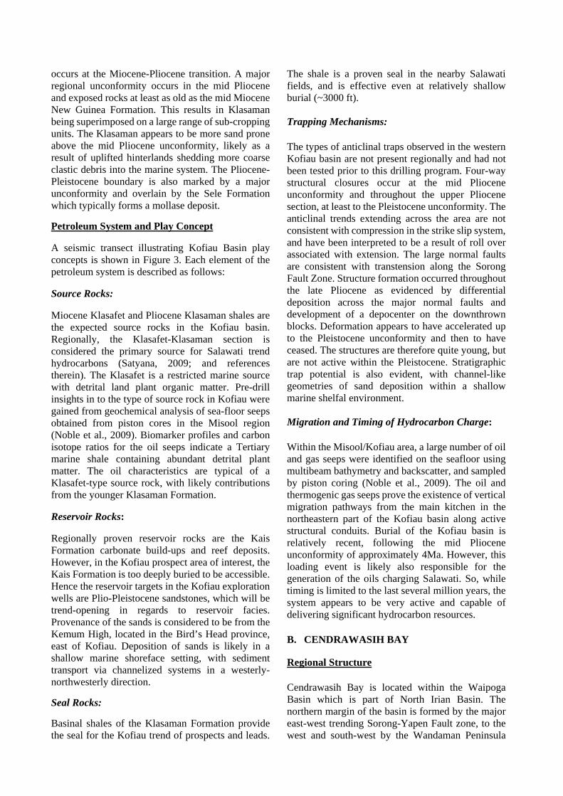
Petroleum System and Play Concept A seismic transect illustrating Kofiau Basin play concepts is shown in Figure 3. Each element of the petroleum system is described as follows: Source Rocks: Miocene Klasafet and Pliocene Klasaman shales are the expected source rocks in the Kofiau basin. Regionally, the Klasafet-Klasaman section is considered the primary source for Salawati trend hydrocarbons (Satyana, 2009; and references therein). The Klasafet is a restricted marine source with detrital land plant organic matter. Pre-drill insights in to the type of source rock in Kofiau were gained from geochemical analysis of sea-floor seeps obtained from piston cores in the Misool region (Noble et al., 2009). Biomarker profiles and carbon isotope ratios for the oil seeps indicate a Tertiary marine shale containing abundant detrital plant matter. The oil characteristics are typical of a Klasafet-type source rock, with likely contributions from the younger Klasaman Formation. Reservoir Rocks: Regionally proven reservoir rocks are the Kais Formation carbonate build-ups and reef deposits. However, in the Kofiau prospect area of interest, the Kais Formation is too deeply buried to be accessible. Hence the reservoir targets in the Kofiau exploration wells are Plio-Pleistocene sandstones, which will be trend-opening in regards to reservoir facies. Provenance of the sands is considered to be from the Kemum High, located in the Bird’s Head province, east of Kofiau. Deposition of sands is likely in a shallow marine shoreface setting, with sediment transport via channelized systems in a westerly-northwesterly direction.
Seal Rocks:
Basinal shales of the Klasaman Formation provide the seal for the Kofiau trend of prospects and leads.
The shale is a proven seal in the nearby Salawati fields, and is effective even at relatively shallow burial (~3000 ft). Trapping Mechanisms: The types of anticlinal traps observed in the western Kofiau basin are not present regionally and had not been tested prior to this drilling program. Four-way structural closures occur at the mid Pliocene unconformity and throughout the upper Pliocene section, at least to the Pleistocene unconformity. The anticlinal trends extending across the area are not consistent with compression in the strike slip system, and have been interpreted to be a result of roll over associated with extension. The large normal faults are consistent with transtension along the Sorong Fault Zone. Structure formation occurred throughout the late Pliocene as evidenced by differential deposition across the major normal faults and development of a depocenter on the downthrown blocks. Deformation appears to have accelerated up to the Pleistocene unconformity and then to have ceased. The structures are therefore quite young, but are not active within the Pleistocene. Stratigraphic trap potential is also evident, with channel-like geometries of sand deposition within a shallow marine shelfal environment.
Migration and Timing of Hydrocarbon Charge: Within the Misool/Kofiau area, a large number of oil and gas seeps were identified on the seafloor using multibeam bathymetry and backscatter, and sampled by piston coring (Noble et al., 2009). The oil and thermogenic gas seeps prove the existence of vertical migration pathways from the main kitchen in the northeastern part of the Kofiau basin along active structural conduits. Burial of the Kofiau basin is relatively recent, following the mid Pliocene unconformity of approximately 4Ma. However, this loading event is likely also responsible for the generation of the oils charging Salawati. So, while timing is limited to the last several million years, the system appears to be very active and capable of delivering significant hydrocarbon resources. B. CENDRAWASIH BAY
Regional Structure Cendrawasih Bay is located within the Waipoga Basin which is part of North Irian Basin. The northern margin of the basin is formed by the major east-west trending Sorong-Yapen Fault zone, to the west and south-west by the Wandaman Peninsula

and Lengguru Fold Belt, to the south by the Weyland mountain overthrust terranes and to the east by the Waipoga Foldbelt (Figure 1; Sapiie et al., 2010). The Waipoga Basin belongs to a large Plio-Pleistocene post-collisional clastic basin complex which extends across northern New Guinea and West Papua. It contains Miocene to Pleistocene sequences which attain offshore an estimated thickness of over 20,000 ft (sediments overlying the economic basement reach a thickness of 4.5 seconds in Cendrawasih Bay). Onshore, at least 25,000 ft of sediments are contained within the Waipoga Trough. Plio-Pleistocene deposits are interpreted as clastics deposited in a deep marine to a near-shore environment whereas older sediments are interpreted as fluvial-shelfal sands (McAdoo and Haebig, 1999). Northward movement of the Australia-India Plate, coupled with the westward relative motion of the Caroline and Philippine plates, produced oblique convergence along the northern edge of the Australian continent. Convergence and transform motion have dominated the evolution of the northern Australian Margin since the latest Miocene and have probably resulted in major crustal shortening in northeastern Papua. Structural exploration targets in Cendrawasih Bay are interpreted as products of this oblique movement. The plate collision caused the formation of an orogenic zone parallel to the Australian continental margin, extending through Irian Jaya and New Guinea (New Guinea Fold Belt) and characterized by "thin-skin"deformation. In order to accommodate the difference in crustal shortening between the New Guinea Mobile Belt and Bird’s Head, two major crustal breaks, the southwest trending Waipoga Fault and the complementary southeast trending Wandamen Fault were formed at an early stage of the convergence. The stress generated at the intersection of these fracture systems was relieved by overthrusting of continental segments to form the Weyland Overthrust. Large slabs of crustal rocks have been thrust tens of kilometers southwards over the Australian continental crust (Dow & Sukamto, 1984). Plate convergence is also marked by the collision of the Australian continent with the Melanesian Arc of the oceanic province and by the cessation of island arc volcanism. Regional Stratigraphy The generalized stratigraphy of the North Irian basin is shown in Figure 4. Sediment fill, as observed and measured in outcrop, has been continuous through
the Tertiary with the exception of a regional depositional hiatus in the Late Miocene. This hiatus resulted in a major unconformity that can be traced over large areas of the basin on seismic data. This unconformity marks the base of the Mamberamo Formation and the top of the Makats Formation or older formations. Prior to the hiatus, almost 19,000 feet of dominantly clastic sediments had accumulated in the North Irian Basin. Lateral facies changes resulted in locally significant carbonate buildups. These sediments are assigned to the Auwewa, Darante and Makats Formations. Post hiatus, deposition of the Mamberamo Formation continued uninterrupted until the present except for local, minor unconformities. The Mamberamo Formation consists of 4 members totaling 23,000 feet in thickness as measured in outcrop. These thicknesses assuming the maximum section of each formation is in the same place would imply a total North Irian Basin fill of nearly 42,000 feet. Seismic evidence is available which indicates that the North Irian Basin is at least 25,000 to 30,000 feet deep along its axis. Local down-warped areas may exist which are even deeper (McAdoo and Haebig, 1999). Petroleum System and Play Concept Seismic transects, illustrating the play concept in Cendrawasih Bay are shown in Figure 5. Each element of the petroleum system is described as follows: Source Rocks: The presence of hydrocarbon shows in onshore exploration wells and the proximity of oil and gas surface seeps in the offshore Mamberamo delta area are indicative of effective source rocks in the region (McAdoo and Haebig, 1999). The source of the hydrocarbons has not been proven conclusively, but is likely to be within the Neogene section (Makat and Memberamo formations). Biogenic gas is also important, as seen in Mamberamo sandstone reservoirs of the Niengo-1 well which flowed gas on test (Satyana et al., 2007). Seep analysis of sea bed piston cores in Cendrawasih Bay indicated mainly gas occurrences. Biogenic gas was commonly in high abundance. Thermogenic gas was less prevalent, but identifiable in some cores. One significant oil seep was positively identified on the basin flank, and its geochemical characteristics indicated a marine source rock of Tertiary age (Noble et al., 2009). The positive indication of an active oil migration system provided a strong incentive to test the basin potential with an exploration well. In

addition, in-situ biogenic gas was considered a viable charging option for Pleistocene prospects. Reservoir Rocks: Regionally proven reservoir rocks in the adjacent Waropen Basin are Memberamo sands and Hollandia carbonates. Mamberamo Formation sandstones in the R-1, Niengo-1 and other exploration wells exhibit good porosities in the order of 23% (McAdoo and Haebig, 1999). The main reservoir target in the deepwater Waipoga Basin was a seismically defined thick sedimentary package interpreted as fluvial-deltaic sediments overlain by a limestone section. The interval may be equivalent to the Oligo-Miocene Darante to Makat formation in the neighboring Waropen Basin, although, the exact age and type of reservoir facies was uncertain prior to drilling. Seal Rocks: Intraformational shales equivalent to the Makat and Memberamo Formations provide seal for prospects in Cendrawasih Bay area. Seismic interpretation and outcrop data indicate these shale formations are widely deposited regionally. Trapping Mechanisms: Traps for gas discoveries in the neighboring Waropen Basin, such as Niengo, are four way anticlinal closures that are most likely related to transpressional deformation. A similar trapping mechanism is anticipated for prospects and leads located within the offshore Waipoga basin. Migration and Timing of Hydrocarbon Charge: The low geothermal gradient generally observed in northern Irian Jaya implies that mature source rocks would only be found in the deepest parts of the basin (McAdoo and Haebig, 1999). The Cendrawasih Bay kitchen is most likely located in the southeast corner of Waipoga Basin, corresponding to the main Plio-Pleistocene sediment depocenter. Migration is expected to occur laterally and vertically into permeable beds that drain the mature kitchen. Charging events are considered to be young, corresponding to the massive thickness of Plio-Pleistocene sediments in the basin depocenter. EXPLORATION DRILLING
A. Kofiau Two wells were drilled in the Kofiau study area: Ajek-1 (Dec 2012), water depth 1,853 ft; and Elit-1
(Aug 2013), water depth 1,334 ft. Both wells were located within 3D seismic coverage (Figure 6). Ajek-1 successfully tested a series of high amplitude reflector packages, which were prognosed as hydrocarbon saturated, sand prone strata. The Kofiau basin was formed by movement of the Sorong Fault during the Late Pliocene providing accommodation space for a thick package of sediment. Drilling results indicated this section comprised thick claystones with minor siltstones and occasional sandstone and limestone beds, deposited in a shallow marine environment. Thin layers of gas bearing, fine grained, quartzose clastic deposits with common to abundant shell debris were intersected at the depths corresponding to seismic reflector packages. The well drilled through the mid Pliocene Unconformity and reached a total depth of 6,185 ft TVDSS in a predominantly claystone section. Based on mud gas readings and wireline log measurements, all zones with adequate porosity were found to be gas saturated. Hydrocarbon samples obtained by MDT in three such porous intervals confirmed the presence of gas charged sands. However, net pay thickness at this well location was insufficient to support a commercial gas development. The second well drilled in the basin, Elit-1, also tested a series of high amplitude reflector packages of Late Pliocene age. The primary amplitude target was intersected at the prognosed depth of 3,700 ft, with a significant gas kick at the top of the reservoir. Wireline logs and sample analysis indicated gas bearing sands, although the net pay count was below the commercial threshold. The well reached a total depth of 3,914 ft TVDSS in Late Pliocene claystones. Mud gas compositional profiles and MDT samples were used to gain insights into the origin of hydrocarbons. Isotube mud gas samples were collected in Ajek-1. Real time rig-site measurement of mud gas carbon isotopes was conducted in Elit-1 (Schlumberger). Figure 7 shows a plot of gas isotope ratio (delta C13 of methane) versus depth below mud line for both wells. A mixing trend between biogenic and thermogenic methane is clearly evident. The shallowest samples are characterized by isotopically light methane, which is of bacterial origin. A trend towards heavier carbon isotopes is seen with depth, which indicates an increasing contribution from thermogenic gas. Mud gas composition in Ajek-1 (not illustrated here) also indicates an increasing amount of wet gas with depth (C2+). Hence it is interpreted that a thermogenic migration front is moving vertically through conduits in the sediment column, and has contributed to the charging of

porous intervals. The deepest MDT sample from Ajek-1 (5,310 ft) has C2+ content of 13% and delta C13 methane value of -46 per mil, indicating a significant contribution of thermogenic gas, with possible oil affinity.
B. Cendrawasih Bay The Elang-1 exploration well (July, 2013) was successfully drilled to test the hydrocarbon potential of a large anticlinal structure covered by 3D seismic in Cendrawasih Bay. Water depth at the well location was 5,033 ft (Figure 8). Elang-1 targeted a seismic package which was prognosed as carbonates overlying a fluvio-deltaic section. The top of the primary target was encountered at 13,665 ft, after drilling through a thicker than expected Pleistocene section with 8,350 feet of sediments deposited at an extremely high rate of 5,500 ft/Ma. The upper part of the target interval comprised a massive micritic limestone, with occasional marls and mudstones. The limestone was tight, with no hydrocarbon indications during drilling. Biostratigraphy indicated Miocene to Oligocene age, similar to Wurui Limestones and related units seen in outcrop (Pieters et al, 1983). Below 14,125 ft the section graded to interbedded mudstones, siltstones and claystones, and eventually, to volcanogenic sediments to the base of the well at 15,779 ft TVDSS. The oldest dateable sediments were of Middle Eocene age. No adequate reservoir properties were encountered over the target section. Mud gas samples were continuously monitored at the rig site for composition (C1 to C5) and carbon isotope ratios of methane. The gas compositional profile indicated low levels of methane over the entire section, with negligible C2+ components. Delta C13 ratios for methane ranged from -75 to -65 per mil, indicating gas of biogenic origin only (Figure 9). This remarkable profile indicates that thermogenic hydrocarbons had not migrated into the section of interest at the Elang-1 well location, which was further supported by a lack of wet gas and hydrocarbon fluorescence in the cuttings.
RECONCILIATION OF PRE- AND POST-DRILL RESULTS
It is instructive to look back at the exploration concepts developed during the joint study and PSC technical evaluation stage, and compare these to the actual results of drilling in both exploration areas.
A. KOFIAU The Misool JSA identified the Kofiau basin as a structurally interesting province due to the tectonic interaction of two major plates: the Pacific plate and the Australian plate. The Kofiau area straddles the Sorong strike slip fault which is taken as a major tectonic boundary between the two plates. The Sorong-Yapen Fault is a major left-lateral fault that has been active since the early Pliocene. The regional tectonic regime of this boundary is transpressional resulting from relatively northward movement of Australia and westward movement of the Pacific. However, at Kofiau, the Sorong fault bends left around the Bird’s Head and is transtentional, with the dominant local structures being a series of en‐echelon roll over folds and synthetic left‐lateral faults trending in a NNE – SSW direction (Decker et al., 2009). This has resulted in several well defined four-way and three-way faulted anticlinal closures that are readily mapped on seismic. From a look-back perspective, the structural targets identified for drilling in Kofiau are very robust, and unlikely to change significantly with information gained from the well data. Reservoir development in the previously untested Plio-Pleistocene section of the Kofiau Basin was a key risk prior to drilling. Seismic amplitude mapping played an important role in defining likely channelized sand fairways. Amplitude extractions were mapped at multiple stratigraphic levels, and well locations were selected in order to intersect the best stacked reservoirs. However, post drill evaluation of Ajek-1 showed that sands were not particularly well developed, although where present, the sands displayed good reservoir properties. Ajek-1 was drilled at a crestal location on a large anticlinal feature. It is probable that the structural elevation at the time of sediment deposition resulted in sand by-pass at the structural crest. It is considered that locations on the flanks of structural highs would likely contain ponded sediments with potential for thicker sand development. This would offer attractive opportunities for follow-on exploration in the Pliocene play. The Elit-1 well, in contrast, targeted a clearly defined channelized body from 3D seismic mapping. This was largely a stratigraphic trap within the Late Pliocene depositional fairway. Drilling results indicted a much thicker sand body, compared to those encountered at Ajek. This is a positive result with respect to the sand delivery system in the Kofiau area. As stated earlier, the net pay count at Elit-1 was below commercial threshold. This is most likely due

to limitations of the trap/seal geometry, rather than a lack of reservoir or charge. In terms of hydrocarbon charge, an important feature observed during the open area-joint study phase, was the seepage of oil and gas on the sea floor. The Misool JSA had oil seeps that were tied geochemically to a Late Tertiary Klasafet–type source system (Noble et al, 2009). Gas of thermogenic and biogenic origin was also observed in the sea bed cores. Drilling at Ajek-1 and Elit-1 discovered only gas in the sandstones, the composition of which was confirmed by MDT sampling. A question then arises as to why there was such a strong indication of oil pre-drill, but only gas in the two wells. The answer lies in the hydrocarbon migration and basin plumbing system. The oil on the sea floor is mainly associated with mud volcanoes which are widely known as vertical conduits for fluid movement (Kopf, 2002; Hansen et al., 2005). There is a high correspondence between prolific oil seepage and the presence of mud volcanoes in the study area. In other locations away from the mud volcanoes, migration takes place at normal rates via typical carrier bed networks, both lateral and vertical. It therefore appears that the Ajek and Elit wells were drilled in locations where the oil migration front has not reached the targeted stratigraphic level. In a young, vertically drained basin such as Kofiau, considerable “migration lag” is likely to occur. Future drilling for deeper targets, or in other parts of the basin, holds promise to uncover the hidden oil potential.
B. CENDRAWASIH BAY Prior to the Cendrawasih Bay Joint Study in 2006, the deepwater section of the Waipoga Basin had received no exploration attention. The only exploration wells drilled were in shallow water locations on the present day shelf, and some onshore wells in the adjacent Waropen basin. The majority of these wells targeted the Plio-Pleistocene interval, and there were no penetrations of sections similar to the primary objective of Elang-1. Technical work undertaken during the Joint study showed that Cendrawasih Bay contained a thick sedimentary section that thickened progressively from west to east. The section was deformed in a compressional foldbelt that appears to be actively forming at the present time (Decker et al., 2009). This foldbelt was not the focus of the initial exploration program, although it remains an interesting opportunity for the future. Instead a large basement high that was clearly apparent in the center of the basin (Sapiie et al.,
2010) provided the target for the Elang-1 exploration well. The size and location of the Elang structural closure was not a concern and the new well information (i.e. check shot velocities) will only serve to improve the depth structural picture going forward. The major uncertainties were in the make-up of the sedimentary section below the Pliocene unconformity. What type of reservoir and source rock facies would be encountered, if any? Also, the composition and crustal affinity of the basement was unknown. There had been much debate in the literature on whether the basin was underlain by continental, transitional or oceanic crust and the differing heat flow scenarios offered by each hypotheses (Dow and Hartono, 1982; McAdoo and Haebig, 1999; Decker et al., 2009). Such questions are typical of frontier basin exploration, and the answers can only be known by drilling. As it turns out, the Elang-1well did not encounter high quality reservoir rocks in the target interval. The lack of thermogenic hydrocarbons also threw in to question the presence of good quality source rocks, adequate heat flow, migration pathways and timing of events. Cendrawasih Bay covers a vast area of over 30,000 sqkm, and other play types in the basin offer alternative elements to an effective petroleum system. Reconciliation of another key piece of pre-drill information is required. A very positive oil seep was identified on the flanks of the basin from seafloor geochemical analysis (Noble et al., 2009). Pre-drill basin modeling indicated that oil migration would have occurred from a structural low in the southeast sector of Cendrawasih Bay (see Sapiie et al., 2010 for basin structure map). This migration scenario resulted in flow vectors that pass through the Elang well location, which was not borne out by drilling results. Hence another migration scenario must exist for the oil seep, which adds to the allure of future exploration activity. Furthermore, the sea floor geochemistry identified large amounts biogenic gas seepage. This is encouraging for biogenic gas plays which are known to occur in North Papuan basins (Satyana et al., 2007). CONCLUSIONS Exploration activities were conducted in two frontier deepwater basins of Eastern Indonesia; namely, the Kofiau Basin and Cendrawasih Bay (Waipoga) Basin, located respectively on the northwestern and eastern margins of the Bird’s Head of West Papua. The prospectivity of the two areas was initially defined by Joint Studies supported by MIGAS and

Indonesian universities. The Joint Studies were followed by PSC operations under the supervision of SKK MIGAS, which led to the drilling of two exploration wells in Kofiau, and one exploration well in Cendrawasih Bay. These wells represented the first deepwater drilling operations in each respective basin. In the Kofiau basin, a thick Pliocene section was targeted in structural and stratigraphic trapping configurations with seismic amplitude support. The two wells (Ajek-1 and Elit-1) encountered gas pay in good quality Late Pliocene shallow marine sands, although the net pay thickness was below commercial threshold. In Cendrawasih Bay, a large four way anticlinal closure in the basin center was targeted, with pre-drill prognosis of a carbonate reservoir facies overlying a fluvio-deltaic section. The well (Elang-1) encountered a massive micritic limestone of Miocene to Oligocene age which was tight, with no hydrocarbon indications during drilling. Reconciliation of pre-drill and post-drill results in Kofiau showed that reservoir quality sands in the Pliocene section were correctly predicted. Additional work is required to locate areas where the sands have thickened in suitable trapping configurations to offer attractive drilling targets. Furthermore, the widespread occurrence of crude oil seepage on the seafloor holds promise that an oil play exists below the section tested by the two wells. In Cendrawasih Bay, the absence of high quality reservoir rocks and lack of thermogenic hydrocarbons indicate that key elements of the petroleum system are missing at this well location. However, an unquestionable oil seep has been identified previously on the sea floor, as well as abundant seepage of gas derived mainly from biogenic sources. Cendrawasih Bay covers a vast area, and other play types in the basin offer alternative opportunities to discovering a new hydrocarbon province.
ACKNOWLEDGMENTS
The authors wish to thank their colleagues, past and present, for their contributions to the technical work described in this article. The exploration programs were conducted when Black Gold Energy, and subsequently Niko Resources Limited, operated the two study areas. Both companies and their managements demonstrated great creativity, commitment and passion towards frontier basin exploration in Indonesia. The authors also acknowledge the contributions of various joint venture partners who participated in the two study areas. MIGAS and SKK MIGAS are gratefully acknowledged for their support of the project and
their permission to publish this historical information. REFERENCES Bernard, B.B., Brooks, J.M., Baillie, P., Decker, J., Teas, P.A., and Orange, D.L., 2008, Surface Geochemical Exploration and Heat Flow Surveys in Fifteen (15) Frontier Indonesia Basins: Proceedings of Indonesian Petroleum Association, 32nd Annual Convention, 14 p. Decker, J., Bergman, S. C., Teas, P. A., Baillie P., Orange D., 2009, Constraints on the Tectonic Evolution of the Bird’s Head, West Papua, Indonesia: Proceedings of Indonesian Petroleum Association, 33rd Annual Convention, 24 p. Dow, D.B., and Hartono, U., 1982. The Nature of the Crust Underlying Cenderawasih (Geelvink) Bay, Irian Jaya: Proceedings Indonesian Petroleum Association, 11th Annual Convention, p. 203-210. Dow D.B. and Hartono, U., 1984, The Mechanism of Pleistocene Plate Convergence along Northeastern Irian Jaya: Proceedings Indonesian Petroleum Association, 13th Annual Convention, p.145-150. Dow, D.B. and Sukamto, R., 1984. Late Tertiary to Quaternary Tectonics of Irian Jaya. Episodes, v. 7, no. 4, p. 3-9. Hansen, J.P., Cartwright, J.A, Huuse, M., and Calusen, O.R., 2002. 3D seismic expression of fluid migration and mud remobilization on the Gjallar Ridge, Offshore Mid-Norway. Basin Research, v. 17, pp. 123-139. Knopf, A.J., 2002. Significance of Mud Volcanism. Reviews of Geophysics, v. 40, p. 2-1 – 2-52. McAdoo, R. L., and Haebig, J. C., 1999, Tectonic Elements ofteh North Irian Basin: Proceedings of Indonesia Petroleum Association, 27th Annual Convention, 17 p. Noble, R., Orange, D., Decker, J., Teas, P.A., Baillie, P., 2009, Oil and Gas Seeps in Deep Marine Sea Floor Cores as Indicators of Active Petroleum Systems in Indonesia: Proceedings of Indonesia Petroleum Association, 33rd Annual Convention, 10 p. Orange, D., Decker, J., Teas, P.A., Baillie, P., and Johnstone, T., 2009, Using SeaSeep Surveys to Identify and Sample Natural Hydrocarbon Seeps in Offshore Frontier Basins: Proceedings of Indonesia

Petroleum Association, 33rd Annual Convention, 21 p. Pieters, P.E., C.J. Pigram, D.S. Trail, D.B. Dow, N., Ratman, and R. Sukamto, 1983. The Stratigraphy of Western Irian Jaya: Proceedings of Indonesian Petroleum Association, 12th Annual Convention, p. 229-261. Sapiie, B., Adyagharini, A.C., Teas, P., 2010, New Insight of Tectonic Evolution of Cendrawasih Bay and its implication for Hydrocarbon Prospect, Papua Indonesia: Proceedings of Indonesian Petroleum Association, 25th Annual Convention, 11 p. Satyana, A. H., 2003, Re-evaluation of the Sedimentology and Evolution of the Kais Carbonate
Platform, Salawati Basin, Eastern Indonesia: Exploration Significance: Proceedings of Indonesian Petroleum Association, 29th Annual Convention, 22 p. Satyana, A. H., Marpaung, L.P., Purwaningsih, M., Utama, M. K., 2007, Regional Gas Geochemistry of Indonesia: Genetic Characterization and Habitat of Natural Gas: Proceedings of Indonesian Petroleum Association, 31st Annual Convention, 31 p.
Satyana, A. H., 2009, Emergence of New Petroleum System in the Mature Salawati Basin: Keys from Geochemical Biomarkers: Proceedings of Indonesian Petroleum Association, 33rd Annual Convention,21p.

Figure 1 - Kofiau and Cendrawasih Bay Location Map and Tectonic Elements (modified after Decker et al., 2009)

Figure 2 - Kofiau and Salawati Basins Generalized Stratigraphy
Figure 3 - Seismic Transect illustrating Play Concepts in the Kofiau Basin (modified after Decker et al., 2009)

Figure 4 - North Irian Basin Generalized Stratigraphy (modified after McAdoo and Haebig, 1999)

Figure 5 - Seismic Transects illustrating the Play Concepts in Cendrawasih Bay (modified after Decker et al., 2009; Sapiie et al., 2010). See Decker et al., 2009 for stratigraphic definitions.

Figure 6 - Seismic Transect showing Ajek-1 and Elit-1 wells in Kofiau Basin. MPU = Mid Pliocene Unconformity

Figure 7 - Gas isotope (delta C13 methane) versus depth plot for Kofiau Basin wells

Figure 8 - Seismic Transect showing Elang-1 well in Cendrawasih Bay

Figure 9 - Gas isotope (delta C13 methane) versus depth plot for Cendrawasih Bay well
View publication statsView publication stats