Embed Size (px)
Citation preview
Supported by:
The depiction and use of boundaries, names andassociated data shown here do not imply endorsement or
Map focuses onEach barangay is detailed forreferencePlease be advised that datasetsmay not be complete.
!
!
!
Lupo
Damayan
Cabangila
Cabugao
Catmon
DalipdipGinictan
Linayasan
Lumaynay
Cortes
Man-Up
Odiong
Poblacion
Quinasay-AnTalon
Tibiao
Aranas
Calizo
Lonoy
Ambolong
Angas
Bay-Ang
Cabugao
Camaligan
Camanci
IpilLalab
Lupit
Magpag-Ong
Mambuquiao
Man-Up
Mandong
Napti
Palay
Poblacion
Songcolan
Tabon
Cawayan
Dumaguit Fatima
Lawa-An OchandoPinamuk-An
Agbun-Od
AgcagayBayebaye
Ganzon
Guintas
Igang
Linambasan
Lucero
Maantol
Milan
Pangabuan
Pasol-OSan Juan
Burias
CaidquidTumalalud
Agtatacay Norte
Agtatacay Sur
Bilao
Batan
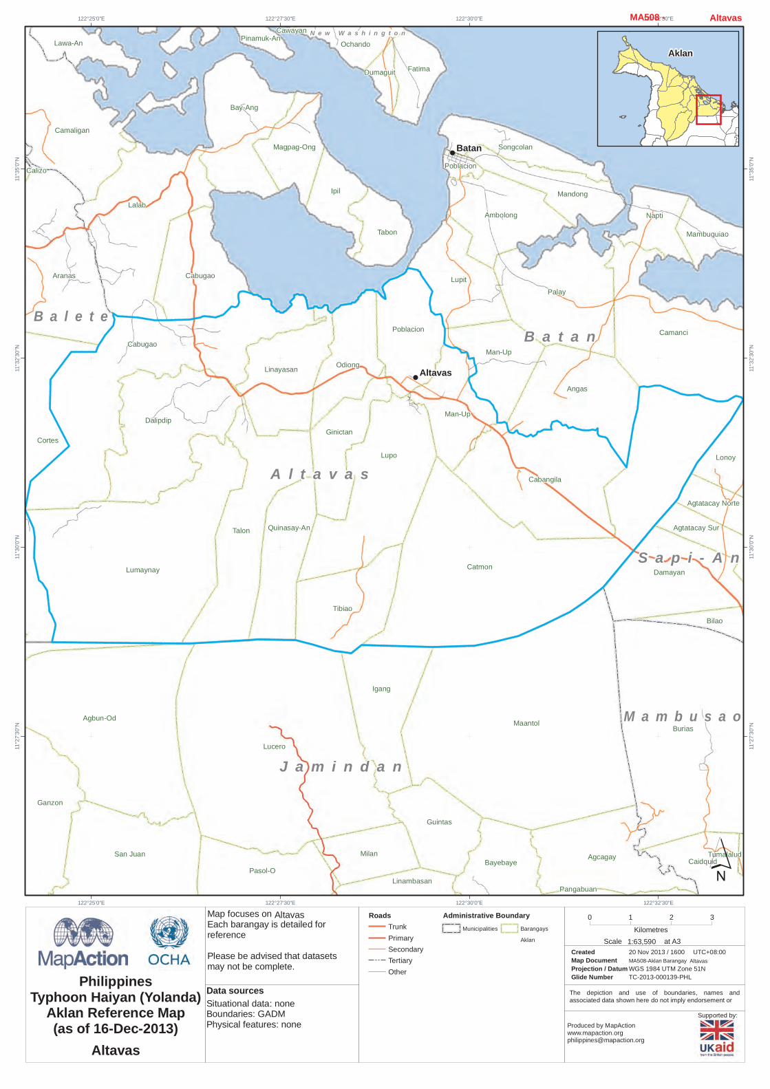
Altavas
A l t a v a s
B a l e t eB a t a n
N e w W a s h i n g t o n
J a m i n d a n
M a m b u s a o
S a p i - A n
122°32'30"E
122°32'30"E
122°30'0"E
122°30'0"E
122°27'30"E
122°27'30"E
122°25'0"E
122°25'0"E11
°35'0"
N
11°35
'0"N
11°32
'30"N
11°32
'30"N
11°30
'0"N
11°30
'0"N
11°27
'30"N
11°27
'30"N
´0 1 2 3
Kilometres
Created 20 Nov 2013 / 1600Map Document MA508-Aklan BarangayProjection / Datum WGS 1984 UTM Zone 51NGlide Number TC-2013-000139-PHL
UTC+08:00
PhilippinesTyphoon Haiyan (Yolanda)
Aklan Reference Map(as of 16-Dec-2013) Produced by MapAction
Situational data: noneBoundaries: GADMPhysical features: none
Data sources
RoadsTrunkPrimarySecondaryTertiaryOther
Altavas
Altavas
Administrative BoundaryMunicipalities Barangays
Aklan 1:63,590Scale at A3
Altavas MA508 -
Aklan
Altavas

Supported by:
The depiction and use of boundaries, names andassociated data shown here do not imply endorsement or
Map focuses onEach barangay is detailed forreferencePlease be advised that datasetsmay not be complete.
!
!
!
Cortes
Cabugao
Dalipdip
Linayasan
Lumaynay
Quinasay-An
Talon
Aranas
Arcangel
Calizo
Daja Norte Feliciano
Fulgencio
Guanko
Morales
Oquendo
Poblacion
Agbanawan
Badiangan
Daguitan
San Juan
Daja Sur
Dingle
Lapnag
Libas Pagsanghan
Polo
Polocate
San Isidro
Sibalew
Sigcay
Taba-Ao
Tinapuay
Torralba
VenturanzaBay-Ang
Cabugao
Caiyang
Camaligan
Lalab
Magpag-Ong
Magubahay
Agmailig
Bonza
Calacabian
Calamcan
Casit-An
Guadalupe
Janlud
JulitaMagugba
Ogsip
Ortega Pampango
Pinonoy
Poblacion
Sibalew
Guinatu-An
Logohon
Napnot
PaningayanPoblacion
Singay
Tigbawan
KinalangayNuevo
Navitas
Rosario
Tambuan JugasLawa-An
Pinamuk-An
Agbun-Od
Ganzon
Lucero
Pasol-O
Balete
A l t a v a s
B a l e t e
B a n g aB a t a n
L i b a c a o
M a d a l a g
M a l i n a o
N e w W a s h i n g t o n
J a m i n d a n
122°25'0"E
122°25'0"E
122°22'30"E
122°22'30"E
122°20'0"E
122°20'0"E11
°35'0"
N
11°35
'0"N
11°32
'30"N
11°32
'30"N
11°30
'0"N
11°30
'0"N
11°27
'30"N
11°27
'30"N
´0 1 2 3
Kilometres
Created 20 Nov 2013 / 1600Map Document MA508-Aklan BarangayProjection / Datum WGS 1984 UTM Zone 51NGlide Number TC-2013-000139-PHL
UTC+08:00
PhilippinesTyphoon Haiyan (Yolanda)
Aklan Reference Map(as of 16-Dec-2013) Produced by MapAction
Situational data: noneBoundaries: GADMPhysical features: none
Data sources
RoadsTrunkPrimarySecondaryTertiaryOther
Balete
Balete
Administrative BoundaryMunicipalities Barangays
Aklan 1:61,208Scale at A3
Balete MA508 -
Aklan
Balete
Supported by:
The depiction and use of boundaries, names andassociated data shown here do not imply endorsement or
Map focuses onEach barangay is detailed forreferencePlease be advised that datasetsmay not be complete.
!
!
Alfonso XII
Hilwan
Arcangel
Guanko
Morales
Oquendo
Agmailig
Dalagsa-An
Batobato
BonzaCalacabian
Calamcan
Can-AwanCasit-An
Maliao
Guadalupe
Janlud
Julita
Luctoga
Magugba
Manika
Ogsip
Ortega
Oyang
Pampango
Pinonoy
Poblacion
RiveraRosal
SibalewAlas-As
Cabangahan
Dit-Ana
Guinatu-An
Logohon
Mamba
Maria Cristina
Medina
NapnotPaningayan
Panipiason
San Jose
Tigbawan
Ganzon
Jaena Norte
Jaena Sur
Libacao
B a l e t e
L i b a c a o
M a d a l a g
B a r b a z a
J a m i n d a n
T a p a z
122°20'0"E
122°20'0"E
122°17'30"E
122°17'30"E
122°15'0"E
122°15'0"E
122°12'30"E
122°12'30"E11
°30'0"
N
11°30
'0"N
11°27
'30"N
11°27
'30"N
11°25
'0"N
11°25
'0"N
11°22
'30"N
11°22
'30"N
11°20
'0"N
11°20
'0"N
´0 1 2 3
Kilometres
Created 20 Nov 2013 / 1600Map Document MA508-Aklan BarangayProjection / Datum WGS 1984 UTM Zone 51NGlide Number TC-2013-000139-PHL
UTC+08:00
PhilippinesTyphoon Haiyan (Yolanda)
Aklan Reference Map(as of 16-Dec-2013) Produced by MapAction
Situational data: noneBoundaries: GADMPhysical features: none
Data sources
RoadsTrunkPrimarySecondaryTertiaryOther
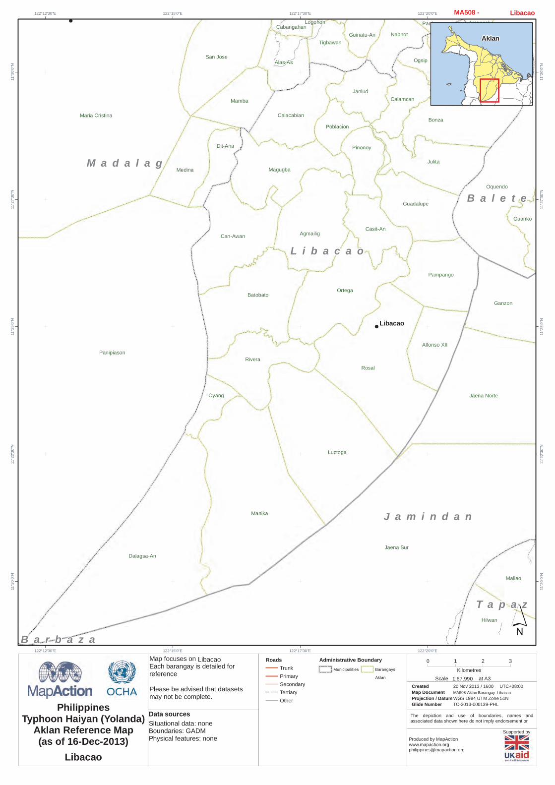
Libacao
Libacao
Administrative BoundaryMunicipalities Barangays
Aklan 1:67,990Scale at A3
Libacao MA508 -
Aklan
Libacao

Supported by:
The depiction and use of boundaries, names andassociated data shown here do not imply endorsement or
Map focuses onEach barangay is detailed forreferencePlease be advised that datasetsmay not be complete.
!
!
Agmailig
Jaena Sur
Arcangel
Oquendo
Badiangan
Daguitan
Daja NorteDaja Sur
SibalewTinapuay
Torralba
Julita
Alfonso XII
Batobato
BonzaCalacabian
Calamcan
Can-AwanCasit-An
Dalagsa-An
Guadalupe
Janlud
Hilwan
Luctoga
Magugba
Manika
Ogsip
Ortega
Oyang
Pampango
Pinonoy
Poblacion
Rivera Rosal
Sibalew
Alaminos
Alas-As
Bacyang
Balactasan
Cabangahan
Cabilawan
Catabana
Dit-Ana
Galicia
Guinatu-An
Logohon
MambaMaria Cristina
Medina
Mercedes
Napnot
Pang-ItanPaningayan
Panipiason
Poblacion
San Jose
SingayTalangban
Talimagao
Tigbawan
Bulabud
Capataga
RosarioSipac
Sugnod
Mayabay
Nalusdan
Alojipan
Buenavista
Flores
Magsaysay
Osorio
Paningayan
Simbola
Abiera
Alegre
P. Javier
Tuno
Ganzon
Jaena Norte
Madalag
Libacao
B a l e t e
B a n g a
L i b a c a o
M a d a l a g
M a l i n a o
B a r b a z a
C u l a s i
S e b a s t e
T i b i a oJ a m i n d a n
T a p a z
122°20'0"E
122°20'0"E
122°17'30"E
122°17'30"E
122°15'0"E
122°15'0"E
122°12'30"E
122°12'30"E
122°10'0"E
122°10'0"E11
°32'30
"N
11°32
'30"N
11°30
'0"N
11°30
'0"N
11°27
'30"N
11°27
'30"N
11°25
'0"N
11°25
'0"N
11°22
'30"N
11°22
'30"N
11°20
'0"N
11°20
'0"N
´0 1 2 3 4
Kilometres
Created 20 Nov 2013 / 1600Map Document MA508-Aklan BarangayProjection / Datum WGS 1984 UTM Zone 51NGlide Number TC-2013-000139-PHL
UTC+08:00
PhilippinesTyphoon Haiyan (Yolanda)
Aklan Reference Map(as of 16-Dec-2013) Produced by MapAction
Situational data: noneBoundaries: GADMPhysical features: none
Data sources
RoadsTrunkPrimarySecondaryTertiaryOther
Madalag
Madalag
Administrative BoundaryMunicipalities Barangays
Aklan 1:85,143Scale at A3
Madalag MA508 -
Aklan
Madalag
Supported by:
The depiction and use of boundaries, names andassociated data shown here do not imply endorsement or
Map focuses onEach barangay is detailed forreferencePlease be advised that datasetsmay not be complete.
!
!
!
!
!
!
Carugdog
Tamalagon
Tamokoe
Tondog
Cerrudo
Cabugao
Regador
Agcawilan
Alibagon
Cogon
SantaCruzBigaa
Santa CruzSilakat-Nonok
Tayhawan
Agbalogo
Aglucay
Vivo
BagongBarrio
Baybay
Cabatanga
Cajilo
Calangcang
Calimbajan
Castillo
Cayangwan
Dumga
Libang
MantiguibPoblacion
Tibiawan
Tina
Tugas
Banaybanay
Biga-A
Cogon
Lilo-An
Malandayon
Osman
Poblacion
San Dimas
San Ramon
San Roque
DongonEast
Dongon West
Navitas
Tabangka
Afga
Baybay
Dapdap
DumatadJawili
Lanipga
Napatag
Panayakan
Poblacion
Pudiot
Tagas
Tangalan
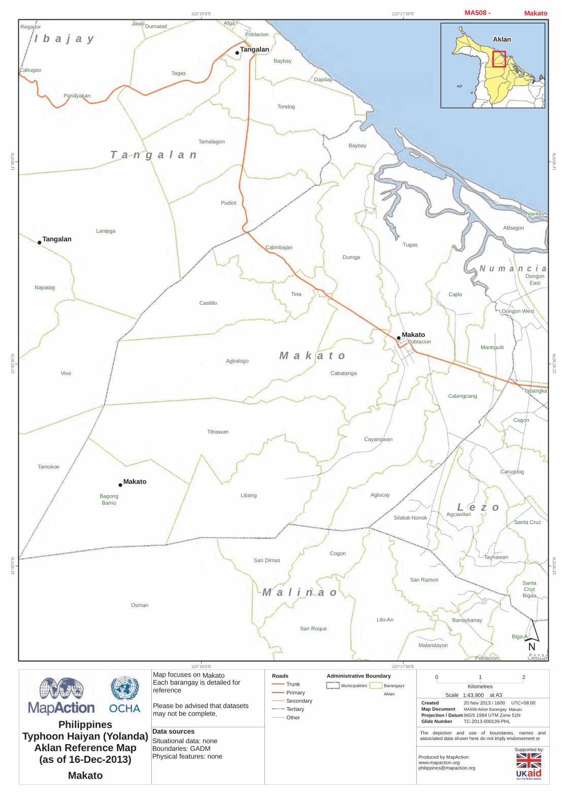
Tangalan
Makato
Makato
B a n g a
I b a j a y
L e z o
M a k a t o
M a l i n a o
N u m a n c i a
T a n g a l a n
122°17'30"E
122°17'30"E
122°15'0"E
122°15'0"E11
°45'0"
N
11°45
'0"N
11°42
'30"N
11°42
'30"N
11°40
'0"N
11°40
'0"N
´0 1 2
Kilometres
Created 20 Nov 2013 / 1600Map Document MA508-Aklan BarangayProjection / Datum WGS 1984 UTM Zone 51NGlide Number TC-2013-000139-PHL
UTC+08:00
PhilippinesTyphoon Haiyan (Yolanda)
Aklan Reference Map(as of 16-Dec-2013) Produced by MapAction
Situational data: noneBoundaries: GADMPhysical features: none
Data sources
RoadsTrunkPrimarySecondaryTertiaryOther
Makato
Makato
Administrative BoundaryMunicipalities Barangays
Aklan 1:43,900Scale at A3
Makato MA508 -
Aklan
Makato

Supported by:
The depiction and use of boundaries, names andassociated data shown here do not imply endorsement or
Map focuses onEach barangay is detailed forreferencePlease be advised that datasetsmay not be complete.
!
!
!
El Progreso
Paz
Alegria
Balusbos
Bel-Is
Cabugan
Tag-Osip
Habana
Katipunan
Mayapay
Nazareth
Poblacion
Argao
Balabag
Balusbus
Cabulihan
Caticlan
Cogon
Cubay Norte
Cubay SurDumlog
Manoc-Manoc
MotagNaasug
Nabaoy
Napaan
Poblacion
San Viray
Yapak
Habana
Laserna
Libertad
Pawa
Rizal
Tagororoc
Unidos
Union
Bulanao CubayIgcagay Maramig Pajo
Malay
BuruangaB u r u a n g a
M a l a y
N a b a s
L i b e r t a d P a n d a n122°0'0"E
122°0'0"E
121°57'30"E
121°57'30"E
121°55'0"E
121°55'0"E
121°52'30"E
121°52'30"E11
°57'30
"N
11°57
'30"N
11°55
'0"N
11°55
'0"N
11°52
'30"N
11°52
'30"N
11°50
'0"N
11°50
'0"N
´0 1 2 3
Kilometres
Created 20 Nov 2013 / 1600Map Document MA508-Aklan BarangayProjection / Datum WGS 1984 UTM Zone 51NGlide Number TC-2013-000139-PHL
UTC+08:00
PhilippinesTyphoon Haiyan (Yolanda)
Aklan Reference Map(as of 16-Dec-2013) Produced by MapAction
Situational data: noneBoundaries: GADMPhysical features: none
Data sources
RoadsTrunkPrimarySecondaryTertiaryOther
Malay
Malay
Administrative BoundaryMunicipalities Barangays
Aklan 1:58,423Scale at A3
Malay MA508 -
Aklan
Malay

Supported by:
The depiction and use of boundaries, names andassociated data shown here do not imply endorsement or
Map focuses onEach barangay is detailed forreferencePlease be advised that datasetsmay not be complete.
!
!
!
!
!
!
!
!
Sibalew
Idio
Nauhon
P. Javier
Bacan
Badiangan
CerrudoCupang
Daguitan
Daja Norte Daja Sur
Dingle
Lapnag
Palale
Polo
Polocate
Cogon
Sigcay
Taba-Ao
TinapuayTorralba
Ugsod
Aparicio
Malindog
Mina-A
MonlaqueRivera
Yawan
Agcawilan
Bagto
Bugasongan
Carugdog
Poblacion
Poblacion
SantaCruzBigaa
SantaCruz
Silakat-Nonok
Tayhawan
CalacabianCalamcan
Janlud
Ogsip
Alaminos
Alas-As
Bacyang
Balactasan
Cabangahan
Cabilawan
Catabana
Galicia
Guinatu-An
Logohon
Mamba
Maria Cristina
Mercedes
Napnot
Pang-Itan PaningayanPoblacion
San Jose
SingayTalangban
Talimagao
Tigbawan
Agbalogo
AglucayBagongBarrio
Cabatanga
Cajilo
Calangcang
Castillo
Cayangwan
Dumga
Libang
MantiguibPoblacion
Tibiawan
BanaybanayBiga-A
Bulabud
Cabayugan
Capataga
Cogon
Dangcalan
Kinalangay Nuevo
Kinalangay Viejo
Lilo-An
Malandayon
Manhanip
Navitas
Osman
Poblacion
Rosario
San Dimas
San Ramon
San Roque
SipacSugnod
Tambuan
Tigpalas
Dongon East
DongonWestPoblacion
Tabangka
Napatag
Tamokoe
Vivo
Simbola
Maadios
Napuid
Abiera
Alegre
Callan
Makato
Malinao
Madalag
Makato
B a n g a
I b a j a y
L e z o
L i b a c a o
M a d a l a g
M a k a t o
M a l i n a o
N u m a n c i a
T a n g a l a n
C u l a s i
P a n d a n
S e b a s t e
122°17'30"E
122°17'30"E
122°15'0"E
122°15'0"E
122°10'0"E
122°10'0"E
122°12'30"E
122°12'30"E11
°42'30
"N
11°42
'30"N
11°40
'0"N
11°40
'0"N
11°37
'30"N
11°37
'30"N
11°35
'0"N
11°35
'0"N
11°32
'30"N
11°32
'30"N
11°30
'0"N
11°30
'0"N´
0 1 2 3 4Kilometres
Created 20 Nov 2013 / 1600Map Document MA508-Aklan BarangayProjection / Datum WGS 1984 UTM Zone 51NGlide Number TC-2013-000139-PHL
UTC+08:00
PhilippinesTyphoon Haiyan (Yolanda)
Aklan Reference Map(as of 16-Dec-2013) Produced by MapAction
Situational data: noneBoundaries: GADMPhysical features: none
Data sources
RoadsTrunkPrimarySecondaryTertiaryOther
Malinao
Malinao
Administrative BoundaryMunicipalities Barangays
Aklan 1:74,729Scale at A3
Malinao MA508 -
Aklan
Malinao

Supported by:
The depiction and use of boundaries, names andassociated data shown here do not imply endorsement or
Map focuses onEach barangay is detailed forreferencePlease be advised that datasetsmay not be complete.
!
!
!
Caticlan
Patria
Tag-Osip
Antipolo
Aquino
Buenasuerte
Napaan
San Viray
Alimbo-Baybay
Buenafortuna
Santa Cruz
Buenavista
Gibon
Habana
Laserna
Libertad
Magallanes
Matabana
Nagustan
Pawa
Pinatuad
Poblacion
Rizal
Solido
Tagororoc
Toledo
Unidos
Union
Bulanao
Cubay
Maramig Pajo
Paz
San Roque
Buang
Candari
Luhod-Bayang
Nabas
NabasB u r u a n g a
I b a j a y
M a l a y
N a b a s
L i b e r t a d
P a n d a n
122°5'0"E
122°5'0"E
122°2'30"E
122°2'30"E
122°0'0"E
122°0'0"E11
°55'0"
N
11°55
'0"N
11°52
'30"N
11°52
'30"N
11°50
'0"N
11°50
'0"N
11°47
'30"N
11°47
'30"N
´0 1 2 3
Kilometres
Created 20 Nov 2013 / 1600Map Document MA508-Aklan BarangayProjection / Datum WGS 1984 UTM Zone 51NGlide Number TC-2013-000139-PHL
UTC+08:00
PhilippinesTyphoon Haiyan (Yolanda)
Aklan Reference Map(as of 16-Dec-2013) Produced by MapAction
Situational data: noneBoundaries: GADMPhysical features: none
Data sources
RoadsTrunkPrimarySecondaryTertiaryOther
Nabas
Nabas
Administrative BoundaryMunicipalities Barangays
Aklan 1:56,974Scale at A3
Nabas MA508 -
Aklan
Nabas
Supported by:
The depiction and use of boundaries, names andassociated data shown here do not imply endorsement or
Map focuses onEach barangay is detailed forreferencePlease be advised that datasetsmay not be complete.
!
!
!
!
!
!
"
Cortes
Camanci Sur
Cabugao Linayasan OdiongPoblacion
Aranas
Arcangel
Calizo
SanIsidro
Feliciano
Fulgencio
MoralesPoblacion
Linabuan Sur
Mangan
Muguing
Pagsanghan
Laguinbanua East
Tabayon
Venturanza
Bay-Ang
Cabugao
Caiyang
Camaligan
IpilLalab
Lupit
Magpag-Ong
Magubahay
Poblacion
Songcolan
Tabon
Andagaw
Bachaw Sur
Briones
Buswang New
Buswang Old
CaanoEstancia
Linabuan Norte
Mabilo
Mobo
Nalook
Poblacion
Pook
Tigayon
Tinigaw
Candelaria
Cawayan
DumaguitFatima
Guinbaliwan
Jalas
JugasLawa-An
Mabilo
Mataphao
Ochando
Pinamuk-An
Poblacion
Polo
Puis
Tambak
Bulwang
Kalibo
Balete
A l t a v a s
B a l e t e
B a n g a
B a t a n
K a l i b o
N e w W a s h i n g t o n
N u m a n c i a
122°27'30"E
122°27'30"E
122°25'0"E
122°25'0"E
122°22'30"E
122°22'30"E11
°42'30
"N
11°42
'30"N
11°40
'0"N
11°40
'0"N
11°37
'30"N
11°37
'30"N
11°35
'0"N
11°35
'0"N
´0 1 2 3
Kilometres
Created 20 Nov 2013 / 1600Map Document MA508-Aklan BarangayProjection / Datum WGS 1984 UTM Zone 51NGlide Number TC-2013-000139-PHL
UTC+08:00
PhilippinesTyphoon Haiyan (Yolanda)
Aklan Reference Map(as of 16-Dec-2013) Produced by MapAction
Situational data: noneBoundaries: GADMPhysical features: none
Data sources
RoadsTrunkPrimarySecondaryTertiaryOther
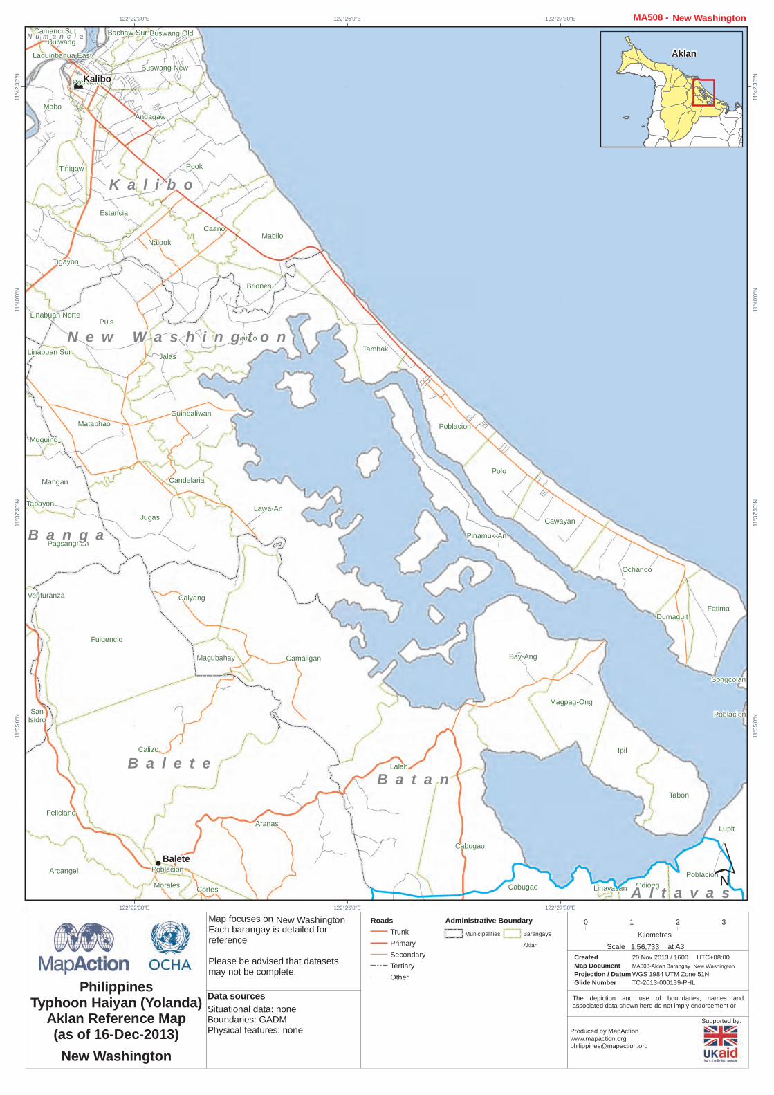
New Washington
New Washington
Administrative BoundaryMunicipalities Barangays
Aklan 1:56,733Scale at A3
New Washington MA508 -
Aklan
New Washington
Supported by:
The depiction and use of boundaries, names andassociated data shown here do not imply endorsement or
Map focuses onEach barangay is detailed forreferencePlease be advised that datasetsmay not be complete.
!
!
!
"
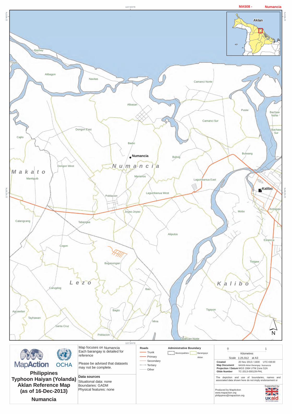
Linabuan Norte
Pusiw
Andagaw
BachawNorte
BachawSur
Estancia
Bagto
Mobo
Poblacion
Tigayon
Tinigaw
Agcawilan
Tabangka
Bugasongan
Carugdog
Cogon
Ibao
Mina
Poblacion
Santa Cruz
Tayhawan
Alibagon
Baybay
Cajilo
Calangcang
Mantiguib
Tugas
Albasan
Aliputos
Badio
BubogBulwang
Camanci Norte
Camanci Sur
Dongon East
Dongon West
Joyao-Joyao
Laguinbanua East
Laguinbanua West
Marianos
Navitas
Poblacion
Kalibo
Numancia
K a l i b oL e z o
M a k a t oN u m a n c i a
122°20'0"E
122°20'0"E11
°45'0"
N
11°45
'0"N
11°42
'30"N
11°42
'30"N
´0 1
Kilometres
Created 20 Nov 2013 / 1600Map Document MA508-Aklan BarangayProjection / Datum WGS 1984 UTM Zone 51NGlide Number TC-2013-000139-PHL
UTC+08:00
PhilippinesTyphoon Haiyan (Yolanda)
Aklan Reference Map(as of 16-Dec-2013) Produced by MapAction
Situational data: noneBoundaries: GADMPhysical features: none
Data sources
RoadsTrunkPrimarySecondaryTertiaryOther
Numancia
Numancia
Administrative BoundaryMunicipalities Barangays
Aklan 1:25,912Scale at A3
Numancia MA508 -
Aklan
Numancia


![109 w] ^ 0 [ ï}Ú}²Vóÿ ÿ ÿ ÿ ÿ ÿ ÿ ÿ - Nagasaki...n n n n n n n n n n n n n n n n n n n n n n n n n n n n n n n n n n n n n n n n n n n n n n n n n n n n n n n n n n n n](https://img.pdfslide.us/doc/110x75/5f36fb8f1f26d128d06b20dc/109-w-0-v-nagasaki-n-n-n-n-n-n-n-n-n.jpg)