1
MYANMAR Buthidaung, Maungdaw, and Rathedaung Townships / Rakhine State Imagery analysis: 31 August - 11 October 2017 | Published 17 November 2017 | Version 1.1 Complex Emergency CE20130326MMR This map illustrates areas of satellite- detected destroyed or otherwise damaged settlements in Buthidaung, Maungdaw, and Rathedaung Townships in the Maungdaw and Sittwe Districts of Rakhine State in Myanmar. Analysis used satellite imagery collected on multiple dates between 31 August and 11 October 2017 and encompassed an area of about 4,800 square kilometers. Satellite analysis combined with information on settlement locations in Myanmar indicate that approximately 275 towns and villages were affected. This includes 34 in Buthidaung, 225 in Maungdaw, and 16 in Rathedaung. Note that these locations are indicated on the map though only a sampling are labeled due to the limitations of the map size and scale. Inset graphics show what is likely the village of Hpaw Ti Kaung, destroyed sometime between 16 September and 1 October 2017, with only a few structures and trees undamaged. Continued cloud cover and haze during the period in question means that destruction is likely underestimated in this analysis. This is a preliminary analysis and has not yet been validated in the field. Please send ground feedback to UNITAR - UNOSAT. " ) " ) " ) Buthidaung Maungdaw Rathedaung Zay Di Pyin Ah Htet Nan Yar Than Du Auk Nan Yar Gu Mi Yar Kyaung Toe Baw Taw Lar Mi Kyaung Chaung Taing Bin Gar Thit Tone Nar Gwa Son Ta Man Thar Ah Nauk Rakhine Ta Man Thar Thea Kone Tan Yae Nauk Ngar Thar San Kar Pin Yin Pa Da Kar Taung Tat Chaung Than Hpa Yar Done Ku Lar Kyet Kyein Sa Bai Kone Hpaw Ti Kaung Gyit Chaung Pyaung Pyit Lin Bar Gone Nar Tha Dut Taung Ywet Nyoe Taung May Ze Tu Lar Shein Kar Li Thet Kay Pyin Doe Tan Kywe Htar Pyin Yae Myet Taung Zu La Ba Gone Nar Mar Di Lar Ka Nyin Tan Tat U Chaung Zon Mar Kan Hpu Maw Tu Lar Thaung Paing Nyar Tha Yae Kone Tan Kyaung Taung Tha Pyay Taw Hpway Yar Gyin Taw Zay Di Thin Baw Kwea Ywar Thit Su Ra Li Ye Aung Chaung Let Hpweit Kya Mu Hti Kyun Taung Kyun Pauk Sin Oe Thaung Khu Lar Kyun Pauk Pyu Su Kyaw U Goke Pi Aw Lan Pyin Ku Lar Yin Ma Zay Yin Ma Kyaung Taung Kone Taung Mar Zi Tha Yet Taung 92°53'0"E 92°53'0"E 92°46'0"E 92°46'0"E 92°39'0"E 92°39'0"E 92°32'0"E 92°32'0"E 92°25'0"E 92°25'0"E 92°18'0"E 92°18'0"E 92°11'0"E 92°11'0"E 21°25'0"N 21°25'0"N 21°18'0"N 21°18'0"N 21°11'0"N 21°11'0"N 21°4'0"N 21°4'0"N 20°57'0"N 20°57'0"N 20°50'0"N 20°50'0"N 20°43'0"N 20°43'0"N 20°36'0"N 20°36'0"N 20°29'0"N 20°29'0"N 20°22'0"N 20°22'0"N 20°15'0"N 20°15'0"N ¥ ¦ ¬ ¥ ¦ ¬ ¥ ¦ ¬ ¥ ¦ ¬ ¥ ¦ ¬ ¥ ¦ ¬ ¥ ¦ ¬ Dhaka Hanoi Thimphu Vientiane Naypyidaw Bangkok Phnom Penh INDIA CHINA THAILAND MYANMAR The depiction and use of boundaries, geographic names and related data shown here are not warranted to be error-free nor do they imply official endorsement or acceptance by the United Nations. UNOSAT is a program of the United Nations Institute for Training and Research (UNITAR), providing satellite imagery and related geographic information, research and analysis to UN humanitarian & development agencies & their implementing partners. This work by UNITAR-UNOSAT is licensed under a CC BY-NC 3.0. UNITAR - UNOSAT - Palais des Nations CH-1211 Geneva 10, Switzerland - T: +41 22 767 4020 (UNOSAT Operations) - Hotline 24/7 : +41 75 411 4998 - [email protected] - www.unitar.org/unosat Destroyed areas in Buthidaung, Maungdaw, and Rathedaung Townships of Rakhine State in Myanmar Satellite Data (1): WorldView-3 Imagery Dates: 11 October 2017 Resolution: 32 cm Satellite Data (2): WorldView-2 Imagery Dates: 25 October and 9 October 2017 Resolution: 50 cm Copyright: © 2017 DigitalGlobe Source: US Department of State - HIU - NextView License Satellite Data (3): Multiple previous images Other Data: HDX; MIMU Analysis : UNITAR - UNOSAT Production: UNITAR - UNOSAT Analysis conducted with ArcGIS v10.4.1 Coordinate System: WGS 1984 UTM Zone 46N Projection: Transverse Mercator Datum: WGS 1984 Units: Meter ! I Map Scale for A3: 1:400,000 Æ I Map location 0 5 10 15 20 Km See inset for close-up view of destroyed structures INSET: 1 October 2017 - Hpaw Ti Kaung INSET: 16 September 2017 - Hpaw Ti Kaung Township Number of affected settlements Buthidaung 34 Maungdaw 225 Rathedaung 16 Legend Areas of destruction Cloud obscured (as of 11 October 2017) International boundary " ) Township capital Township boundary Affected town or village UNOSAT analysis area

MYANMAR - UNITARunosat-maps.web.cern.ch/unosat-maps/MM/CE20130326MMR/...2017/10/11  · settlement locations in Myanmar indicate that approximately 275 towns and villages were affected

  • Upload
    others

  • View
    2

  • Download
    0

Embed Size (px)

Citation preview

MYANMARButhidaung, Maungdaw, and Rathedaung Townships / Rakhine StateImagery analysis: 31 August - 11 October 2017 | Published 17 November 2017 | Version 1.1

ComplexEmergency

CE20130326MMR

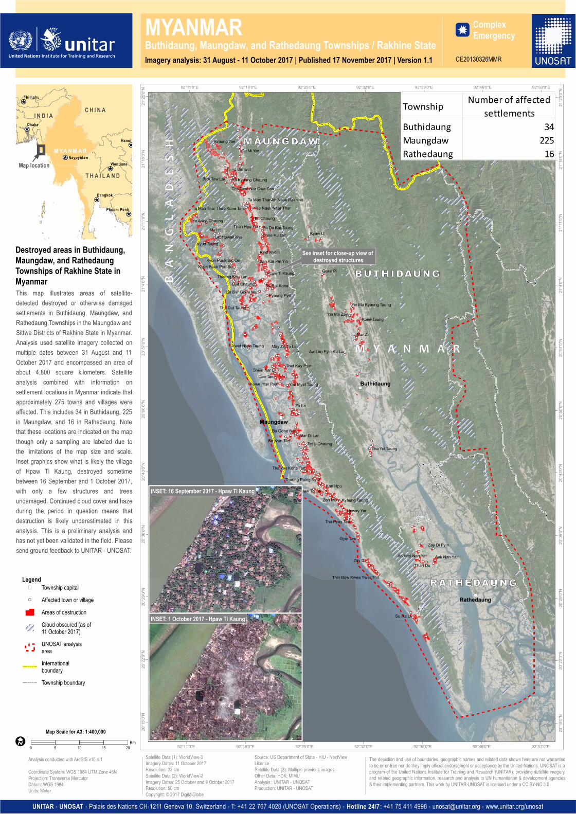
This map illustrates areas of satellite-detected destroyed or otherwise damagedsettlements in Buthidaung, Maungdaw, andRathedaung Townships in the Maungdaw andSittwe Districts of Rakhine State in Myanmar.Analysis used satellite imagery collected onmultiple dates between 31 August and 11October 2017 and encompassed an area ofabout 4,800 square kilometers. Satelliteanalysis combined with information onsettlement locations in Myanmar indicate thatapproximately 275 towns and villages wereaffected. This includes 34 in Buthidaung, 225in Maungdaw, and 16 in Rathedaung. Notethat these locations are indicated on the mapthough only a sampling are labeled due tothe limitations of the map size and scale.Inset graphics show what is likely the villageof Hpaw Ti Kaung, destroyed sometimebetween 16 September and 1 October 2017,with only a few structures and treesundamaged. Continued cloud cover and hazeduring the period in question means thatdestruction is likely underestimated in thisanalysis. This is a preliminary analysis andhas not yet been validated in the field. Pleasesend ground feedback to UNITAR - UNOSAT.

")

")

")

Buthidaung

Maungdaw

Rathedaung

Zay Di Pyin

Ah Htet Nan YarThan Du

Auk Nan Yar

Gu Mi YarKyaung Toe

Baw Taw Lar Mi Kyaung Chaung

Taing Bin Gar

Thit Tone Nar Gwa Son

Ta Man Thar Ah Nauk RakhineTa Man Thar Thea Kone Tan Yae Nauk Ngar Thar

San Kar Pin Yin

Pa Da Kar TaungTat Chaung

Than Hpa YarDone Ku Lar

Kyet Kyein

Sa Bai Kone

Hpaw Ti Kaung

Gyit Chaung

Pyaung PyitLin Bar Gone Nar

Tha Dut Taung

Ywet Nyoe Taung May Ze Tu Lar

Shein Kar LiThet Kay Pyin

Doe TanKywe Htar Pyin Yae Myet Taung

Zu La

Ba Gone NarMar Di Lar

Ka Nyin Tan Tat U Chaung

Zon Mar

Kan HpuMaw Tu Lar

Thaung Paing Nyar

Tha Yae Kone Tan

Kyaung Taung

Tha Pyay Taw

Hpway Yar

Gyin Taw

Zay Di

Thin Baw Kwea Ywar Thit

Su Ra Li

Ye Aung Chaung

Let Hpweit KyaMu Hti

Kyun Taung

Kyun Pauk Sin Oe

Thaung Khu Lar

Kyun Pauk Pyu Su

Kyaw U

Goke Pi

Aw Lan Pyin Ku Lar

Yin Ma ZayYin Ma Kyaung Taung

Kone Taung

Mar Zi

Tha Yet Taung

92°53'0"E

92°53'0"E

92°46'0"E

92°46'0"E

92°39'0"E

92°39'0"E

92°32'0"E

92°32'0"E

92°25'0"E

92°25'0"E

92°18'0"E

92°18'0"E

92°11'0"E

92°11'0"E

21°25

'0"N

21°25

'0"N

21°18

'0"N

21°18

'0"N

21°11

'0"N

21°11

'0"N

21°4'

0"N

21°4'

0"N

20°57

'0"N

20°57

'0"N

20°50

'0"N

20°50

'0"N

20°43

'0"N

20°43

'0"N

20°36

'0"N

20°36

'0"N

20°29

'0"N

20°29

'0"N

20°22

'0"N

20°22

'0"N

20°15

'0"N

20°15

'0"N

¥¦¬

¥¦¬

¥¦¬

¥¦¬

¥¦¬

¥¦¬

¥¦¬

Dhaka

Hanoi

Thimphu

VientianeNaypyidaw

Bangkok

Phnom Penh

I N D I A C H I N A

T H A I L A N D

M YA N M A R

The depiction and use of boundaries, geographic names and related data shown here are not warrantedto be error-free nor do they imply official endorsement or acceptance by the United Nations. UNOSAT is aprogram of the United Nations Institute for Training and Research (UNITAR), providing satellite imageryand related geographic information, research and analysis to UN humanitarian & development agencies& their implementing partners. This work by UNITAR-UNOSAT is licensed under a CC BY-NC 3.0.

UNITAR - UNOSAT - Palais des Nations CH-1211 Geneva 10, Switzerland - T: +41 22 767 4020 (UNOSAT Operations) - Hotline 24/7 : +41 75 411 4998 - [email protected] - www.unitar.org/unosat

Destroyed areas in Buthidaung,Maungdaw, and RathedaungTownships of Rakhine State inMyanmar

Satellite Data (1): WorldView-3Imagery Dates: 11 October 2017Resolution: 32 cmSatellite Data (2): WorldView-2Imagery Dates: 25 October and 9 October 2017Resolution: 50 cmCopyright: © 2017 DigitalGlobe

Source: US Department of State - HIU - NextViewLicenseSatellite Data (3): Multiple previous imagesOther Data: HDX; MIMUAnalysis : UNITAR - UNOSATProduction: UNITAR - UNOSAT

Analysis conducted with ArcGIS v10.4.1

Coordinate System: WGS 1984 UTM Zone 46NProjection: Transverse MercatorDatum: WGS 1984Units: Meter

!IMap Scale for A3: 1:400,000

ÆI

Map location

0 5 10 15 20Km

See inset for close-up view of destroyed structures

INSET: 1 October 2017 - Hpaw Ti Kaung

INSET: 16 September 2017 - Hpaw Ti Kaung

Township Number of affected settlements

Buthidaung 34Maungdaw 225Rathedaung 16

Legend

Areas of destructionCloud obscured (as of11 October 2017)

Internationalboundary

") Township capital

Township boundary

Affected town or village

UNOSAT analysisarea