Embed Size (px)
Citation preview

MMUUNNIICCIIPPAALL PPUUBBLLIICC AACCCCEESSSS PPLLAANN
Township of Middle, Cape May County, New Jersey
Submitted for Approval: January 2015
Approved by the New Jersey Department
of Environmental Protection: {Date of NJDEP Approval}
Adoption by the Township
{Date of Municipal Adoption}
Prepared by
4907 New Jersey Avenue
Wildwood, NJ 08260 (609) 522-5150
Prepared for

MUNICIPAL PUBLIC ACCESS PLAN Township of Middle,
Cape May County, New Jersey
i
APPROVAL OF THIS MUNICIPAL PUBLIC ACCESS PLAN DOES NOT ELIMINATE
THE NEED FOR ANY FEDERAL, STATE, COUNTY OR MUNICIPAL PERMITS,
CERTIFICATIONS, AUTHORIZATIONS OR OTHER APPROVALS THAT MAY BE
REQUIRED BY ANY APPLICANT, NOR SHALL THE APPROVAL OF THIS
MUNICIPAL PUBLIC ACCESS PLAN OBLIGATE THE NEW JERSEY
DEPARTMENT OF ENVIRONMENTAL PROTECTION TO ISSUE ANY PERMITS,
CERTIFICATIONS, AUTHORIZATIONS OR OTHER APPROVALS REQUIRED FOR
ANY PROJECT DESCRIBED IN THIS MUNICIPAL PUBLIC ACCESS PLAN.


MUNICIPAL PUBLIC ACCESS PLAN Township of Middle,
Cape May County, New Jersey
iii
TABLE OF CONTENTS 1.0 INTRODUCTION 1.1 Intent ...................................................................................................................................... 1.2 Background ........................................................................................................................... 1.3 The MPAP Planning Process ................................................................................................ 1.3.1 Plan Endorsement ................................................................................................................. 1.3.2 Master Plan and Open Space & Recreation Plan ................................................................. 1.3.2 Approval and Master Plan Incorporation ............................................................................... 1.4 Authority for Municipal Public Access Plans ......................................................................... 1.5 State of New Jersey Public Access Goals ............................................................................ 2.0 MUNICIPAL OVERVIEW AND ACCESS VISION 2.1 Overview of Municipality ........................................................................................................ 2.1.1 Municipal Description ............................................................................................................ 2.2 Municipal Public Access Vision ............................................................................................. 2.2.1 Municipal Public Access Vision ............................................................................................. 2.3 Public Access Vision Consistency with Master Plan ............................................................. 2.3.1 Public Access Vision Consistency with Master Plan ............................................................. 2.4 Public Access Vision Consistency with State Development and Redevelopment Plan ....... 2.4.1 Public Access Vision Consistency with State Development and Redevelopment Plan ....... 3.0 PUBLIC ACCESS NEEDS ASSESSMENT 3.1 Public Access Locations ........................................................................................................ 3.1.1 Improved Public Access Locations ....................................................................................... 3.1.2 Points of Public Access to Waterways Lacking Improvement .............................................. 3.2 Other Potential Points of Access to Waterways .................................................................... 4.0 COMMUNITY NEEDS ASSESSMENT 4.1 The Process .......................................................................................................................... 5.0 IMPLEMENTATION STRATEGY 5.1 Priorities................................................................................................................................. 5.2 Maintaining of Existing Public Access .................................................................................. 6.0 RESOLUTION OF INCORPORATION APPENDICES Appendix 1: Draft Planning Board Resolution Incorporating MPAP into Middle Township
Master Plan Appendix 2: Map: Middle Township Improved and Unimproved Waterway Access Points
Recommended for Enhancement Appendix 3: Public Access to Waterways: Existing Conditions Spreadsheet

MUNICIPAL PUBLIC ACCESS PLAN Township of Middle,
Cape May County, New Jersey
1
1.0 INTRODUCTION 1.1 Intent
The intent of this Municipal Public Access Plan ("MPAP") is to provide a comprehensive public access plan for the Township of Middle ("Township") which lays out the Township's vision for providing access to tidal waters and shorelines along Middle Township’s borders. This MPAP was developed in accordance with N.J.A.C. 7:7E-8.11 and in collaboration with the New Jersey Department of Environmental Protection ("NJDEP"), and has been approved by the NJDEP. The development and implementation of this MPAP supports the policy of local determination of public access locations and facilities, while safeguarding regulatory flexibility and potential funding opportunities for Middle Township.
1.2 Background Public rights of access to and use of the tidal shorelines and waters, including the ocean, bays, and tidal rivers, in New Jersey are founded in the "Public Trust Doctrine". First set by the Roman Emperor Justinian around A.D. 500 as part of Roman civil law, the Public Trust Doctrine establishes the public’s right to full use of the seashore as declared in the following quotation from Book II of the Institutes of Justinian:
By the law of nature these things are common to all mankind – the air, running water, the sea, and consequently the shores of the sea. No one, therefore, is forbidden to approach the seashore, provided that he respects habitations, monuments, and the buildings, which are not, like the sea, subject only to the law of nations.
Influenced by Roman civil law, the tenets of public trust were maintained through English common Law and adopted by the original 13 colonies. Following the American Revolution, the royal right to tidelands was vested to the 13 new states, then to each subsequent state, and has remained a part of public policy into the present time. Through various judicial decisions, the right of use upheld by the Public Trust Doctrine has been incorporated into many state constitutions and statutes, allowing the public the right to all lands, water and resources held in the public trust by the state, including those in New Jersey. The NJDEP adopted revised rules governing public access on November 5, 2012. These rules enable municipalities to develop and adopt MPAPs to govern public access within each individual municipality. This MPAP consists of an inventory of public access locations, plus plans to preserve and enhance access based on community needs and State standards.
1.3 The MPAP Planning Process
1.3.1 Plan Endorsement

MUNICIPAL PUBLIC ACCESS PLAN Township of Middle,
Cape May County, New Jersey
2
In November 2004, the Township commenced the regulatory process under the State Planning Act1 to have its Zoning, Land Development and related planning policies and regulations certified by the Office of Planning Advocacy ("OPA") and the State Planning Commission. Such certification, known as Plan Endorsement, signifies that a municipality's policies and regulations related to growth and land use are consistent with the New Jersey State Development & Redevelopment Plan ("State Plan"), and confers on municipalities special status as relates to permitting and development.
In December 2005, the Township formally submitted a Petition for Initial Plan Endorsement to OPA. After staff review and recommendation to the State Planning Commission, the Township's Petition was approved.
Working cooperatively, the Township and OPA developed an Action Plan and entered into a Memorandum of Understanding ("MOU") regarding future Township actions in furtherance of the Endorsed Plan. In December 2006, the Township adopted Resolution No. 574-06, entering into the MOU with OPA. Since then, the Township has actively worked to achieve the action items agreed-upon as part of the MOU.
1.3.2 Master Plan and Open Space & Recreation Plan The MOU outlined a number of actions the Township was to take in furtherance of the Endorsed Plan. These actions included the conduct of a General Reexamination of the Township's Master Plan and preparation of an Open Space & Recreation Plan Element for incorporation into the Master Plan. As to the Reexamination of the Master Plan, the Planning Board adopted the 2010 Reexamination Report on July 22, 2010. This report: (i) provides comment on the significant progress made in addressing two major land use issues identified in the 2003 Master Plan, these being the development of homes on uplands adjacent to environmentally sensitive areas and development of areas without sewer service; and (ii) provides recommendations per Master Plan Element, some of which include, for the purposes of this Plan, working with Cape May County to expand the existing bike path and the call for the encouragement of programs of preservation by other agencies to provide for greater areas of unfragmented open space extending from Beaver Swamp State Wildlife Areas to the multiple drainage basins. Middle Township’s Open Space and Recreation Plan (OSRP) was adopted by the Planning Board on April 25, 2013. This document serves several functions in that it: (i) articulates goals and policies for the enjoyment of the numerous recreation amenities found within the Township, (ii) comprehensively identifies the Township’s public and private recreation amenities, and (iii) sets forth site-specific recommendations for the addressing of needs to enable enhanced opportunities for the enjoyment of each site. In the promotion of providing access to tidal waters and shorelines, the OSRP calls for the support of nature tourism and its positive effect on the local and regional economy, in part, through the taking advantage of the natural resources of the Township, including water access; and the development of public access points along the
1 N.J.S.A. 52:18A-203

MUNICIPAL PUBLIC ACCESS PLAN Township of Middle,
Cape May County, New Jersey
3
Delaware Bay to be more accommodating to visitors and residents, while maintaining the critical wildlife habitat.2 The overarching recommendation of the OSRP is that the Township enhance opportunity for public access to waterways through (i) the improvement of amenities as identified through the public process for Shellbay Pier, Avalon Manor Pier, Reeds Beach, and Norbury’s Landing, (ii) installation of improvements at Cooks Beach, Goshen Landing, and Nummy Island, provided any future development respects and preserves existing wildlife habitats and plant life, and (iii) opportunities that exist for access to waterways over privately held lands, such as marinas and other locations.
1.3.3 Approval and Master Plan Incorporation
On November 12, 2013, Township representatives met with NJDEP staff to begin the public access planning process and continued to liaison informally with NJDEP as the MPAP was being developed. This MPAP is based on recommendations: (i) contained within the Township’s Open Space and Recreation Plan, (ii) suggestions advanced by the Township Business Administrator and staff, and (iii) ideas gleaned from liaison with NJDEP staff. Subsequent to preparation, the MPAP was presented to the Middle Township Planning Board ("Planning Board") and approved for submission to NJDEP. It is the intent of Middle Township, pending receipt of NJDEP approval, to incorporate the MPAP with the Open Space and Recreation Plan Element of the Township's Master Plan, pursuant to Planning Board action, as required under the Municipal Land Use Law. N.J.S.A. 40: 55D-1 et seq. Incorporation into the Master Plan, and final approval of this MPAP by the NJDEP, will be recognized by public notice in the NJDEP Bulletin. Pursuant to the aforementioned local and NJDEP approvals, all public access decisions made within Middle Township will be guided by and consistent with this MPAP.
1.4 Authority for Municipal Public Access Plans The authority for a municipality to develop a MPAP is derived from the Coastal Zone Management Rules, N.J.A.C. 7:7E, adopted by NJDEP on November 5, 2012. The premise of the authorization of Municipal Public Access Plans is that public access to tidal waters is fundamentally linked to local conditions. Municipalities have a better awareness and are more responsive to these conditions than a broader State “one size fits all” mandated public access plan. The voluntary development of a MPAP by Middle Township enables the Township to better plan, implement, maintain, and improve the provision of public access for its residents and visitors. Once incorporated into the Open Space and Recreation Plan Element of the Township's Master Plan, the MPAP will serve, in part, to inform and/or identify public access requirements associated with any proposed development or redevelopment project.
2 Middle Township, Cape May County, New Jersey, Open Space and Recreation Plan(OSRP), April 2013, pp. 10‐11.

MUNICIPAL PUBLIC ACCESS PLAN Township of Middle,
Cape May County, New Jersey
4
Upon approval of the MPAP by NJDEP and incorporation into the Master Plan, the Township will be responsible for ensuring that public access to tidal waterways along the municipality’s shorelines is provided in accordance with this plan. For each new public access project, the Township will provide NJDEP with a letter confirming its consistency with this MPAP. Any permit issued by NJDEP will reflect such consistency and ensure that public access requirements are satisfied in accordance to the MPAP. Pursuant to N.J.A.C. 7:7E-8.11(j)4, the Township is required to submit a progress report on MPAP implementation to NJDEP within five (5) years from date of adoption.
1.5 State of New Jersey Public Access Goals3
Through the Coastal Zone Management Rules, the State of New Jersey has established a broad set of coastal protection goals. As specifically addressing public access: • Effectively manage ocean and estuarine resources through sustainable
recreational and commercial fisheries, as well as through the safe and environmentally sound use of coastal waters and beaches.
• Provide meaningful public access to and use of tidal waterways and their
shores. • Preserve public trust rights to tidal waterways and their shores. • Preserve and enhance views of the coastal landscape to enrich aesthetic and
cultural values and vital communities. • The enhancement of public access by promoting adequate affordable public
facilities and services. • Create and enhance opportunities for public access to tidal waterways and
their shores, on a non-discriminatory basis. • Maintain all existing public access to, and along tidal waterways and their
shores. • Provide opportunities for public access to tidal waterways and theirs shores
through new development. • Provide public access that does not create conditions that may be reasonably
expected to endanger public health and safety, damage the environment, or create significant homeland security vulnerability.
This Municipal Public Access Plan, which embraces and reflects these goals, will serve to preserve, protect, and enhance the public’s ability to access the public trust lands which surround Middle Township.
3 N.J.A.C. 7:7E, adopted by NJDEP on November 5, 2012; specifically 7:7E-1.1(c). (Exhibit 1).

MUNICIPAL PUBLIC ACCESS PLAN Township of Middle,
Cape May County, New Jersey
5
2.0 MUNICIPALITY OVERVIEW AND ACCESS VISION 2.1 Overview of Municipality 2.1.1 Municipal Description4
Middle Township, Cape May County, New Jersey ("Township") is a rural community with valuable natural, cultural and historic resources that serve both residents and visitors to the region. In addition to vast open space and many recreational facilities, the Township's diverse commercial corridors and developed areas include Cape May County's only college5, its only hospital6 and the County seat. 7 The Township is physically located in the center of the County, and therefore hosts a tremendous number of travelers through its unique collection of hamlets, villages and Town Centers. As a tourist destination, the Township experiences significant increases in population, traffic and economic activity during the summer tourist season. The Township's development policies and regulations encourage the preservation of land as well as active and passive, private and commercial recreational uses. Significantly, the Township boasts: In excess of 30 miles of coastline along the Delaware Bay and Inter-coastal
Waterway Twenty-one (21) recreation and open space facilities, including the nationally
recognized Cape May County Zoo. Diverse and distinct ecosystems including salt and freshwater wetlands, upland
and wetland forests and the internationally renowned Delaware Bay ecosystem, one of the largest and most biologically diverse estuaries in the nation.
Considerable Federal, State, County, municipal and nonprofit preserved open
space, including 4,800 acres of the Cape May National Wildlife Refuge. Water access along the entire east and west borders. Significant (quantity and quality) historic structures. Further, 50% of the Township's incorporated area is wetlands and other 20% is floodplains, waterways or other open water bodies. Major water bodies within or adjacent to the Township include: ·
4 Source: Middle Township, Cape May County, New Jersey: Open Space and Recreation Plan. Terenik Land Use Planning
(April 2013) 5 Cape May County Campus of the Cape Atlantic Community College in the Cape May Courthouse section of the Township. 6 Cape Regional Medical Center in the Cape May Courthouse section of the Township. 7 Cape May Courthouse.
MUNICIPAL PUBLIC ACCESS PLAN Township of Middle,
Cape May County, New Jersey
6
Delaware Bay Great Sound Jenkins Sound Grassy Sound Richardson Sound, and Approximately 20 tidal creeks. 8 Major Township-owned facilities providing waterway access are Shellbay Pier, Avalon Manor Fishing Pier, Reeds Pier, and Norbury’s Landing.
2.2 Municipal Public Access Vision 2.2.1 Middle Township’s vision for enhanced public waterway access, is rooted in the below
policy statements, which have been developed from field observation and analysis of existing and proposed public access points to waterways. These policy statements are consistent with recommendations contained in the Township’s Open Space and Recreation Plan: a. Scope of improvements should be tempered by (i) the condition of existing
infrastructure, and in particular, roadway infrastructure, (ii) effect on proximate residential development, as well as, (iii) effect on indigenous natural systems.
b. Installation of improvements should be phased to coincide with the installation
of supporting infrastructure. c. Future improvements are to be context sensitive, to mean, the improvements
are to incorporate, and be sensitive to, the character of the area where being proposed.
d. Location, arrangement, and materials of proposed improvements are to be
viewed through the lens of resiliency, the thrust of which being the extent to which improvements incorporate features to mitigate storm damage.
e. Where found necessary due to either natural or manmade constraints, the
reasonableness of allowing existing conditions to remain intact so to serve as a limiting feature as to intensity of use should be evaluated.
f. To maximize opportunity for public access to waterways, opportunity for access is to be a consideration in the review of private sector development proposals.
g. Long term durability of improvements is to be improved through a vigorous
program of preventative maintenance. h. Wayfinding signs to direct the Township’s visitors to points of public access is a
necessary ingredient of this plan; as such, all signs required by the State of New Jersey and signs for the convenience of the public will be posted.
8 OSRP (2013), p. 65.

MUNICIPAL PUBLIC ACCESS PLAN Township of Middle,
Cape May County, New Jersey
7
i. Interpretative signs should be utilized in locations where their placement enhances the public’s experience of the natural resource, to which they refer, as they promote an appreciation for the significance of these resources through the information they provide.
j. Public access to waterways is to benefit all of our citizens, necessitating the
provision of accessible routes of access, consistent with the state’s accessibility guidelines.
k. Sanitary facilities for the convenience of the public are necessary and will be provided, at least on a seasonal basis, where deemed appropriate.
l. Governing body review of condition of public access to waterway facilities and opportunities is necessary to assure Middle Township keeps pace with the access to waterways needs of the public; as such, the Township will make this concern a periodic discussion item on the governing body agenda.
m. Sites potentially eligible for nomination to the State of New Jersey Register of Historic Places, which occur within existing or possible future points of waterway access must be preserved. The State of New Jersey owned navigation aid to oystermen found at Pierces Point, on Beach Road, is of local significance and may be eligible for nomination to the State’s Register, necessitating Township liaison with Historic Preservation Office within the New Jersey Department of Environmental Protection.
2.3 Public Access Vision Consistency with Master Plan
2.3.1 Enhanced public access to waterways as advanced under this MPAP is consistent with Middle Township’s Master Plan. Consistency with same is achieved, when it is considered that: a. The benefits of enjoyment of the outdoors is an expression of an overarching
goal of the Middle Township Master Plan of improving quality of life through sound land use planning.
b. The increase in tourism as a result of enhanced waterway access is in concert
with the economic goal of promoting a balanced, diverse and strong economic tax base, and the ancillary objective of supporting existing coastal development and the water-based recreation industry as a component of the Township’s economy.
c. Enhanced waterway access is an expression of the recreation goal of providing
both active and passive recreation facilities and programs to serve Township residents, and the ancillary objectives of planning for and providing active recreation facilities and programs that meet the needs of current Township residents and, as well, identifying and planning for future recreation uses consistent with forecasted growth.

MUNICIPAL PUBLIC ACCESS PLAN Township of Middle,
Cape May County, New Jersey
8
2.4 Public Access Vision Consistency with State Development and Redevelopment Plan 2.4.1 Under the State Development and Redevelopment Plan (SDRP), significant areas of
the Township, west of Route 47, which generally parallel the Delaware Bay, are classified as Environmentally Sensitive Planning Area (PA5). Lands having this classification are characterized by “watersheds of pristine waters, trout streams and drinking water supply reservoirs; recharge areas for potable water aquifers; habitats of endangered and threatened plant and animal species; coastal and freshwater wetlands; prime forested areas; scenic vistas; and other significant topographical, geological or ecological features, particularly coastal barrier spits and islands.”9 The primary thrust of the PA5 classification is the protection of environmental resources and accommodation of growth in Centers. Middle Township’s MPAP is consistent with aspects of the SDRP’s Recreation, Economic Development, and Natural Resource Conservation policy objectives established for the PA5 area in that:10 a. Through the call for enhancements to existing points of public access and call
for limited future development, the plan mirrors the thrust of the Recreation Policy of promoting access to public lands; and is also consistent with Economic Development Policy of promoting appropriate recreational and natural resource-based activities in the Environs that are responsive to the needs of the surrounding region and supportive of the travel and tourism industry;
b. Through the call for context sensitive development and development having as
little an area of disturbance as practicable, the plan is consistent with the Natural Resource Conservation Policy of protecting and preserving natural systems and sensitive natural resources, to include natural landscapes of exceptional value, scenic vistas, and other significant environmentally sensitive features. In this regard, the plan is also consistent with the Land Use Policy theme for development/redevelopment in the Environs, which emphasizes the maintaining and enhancement of the natural resources of the area.
The thrust of this plan is also consistent with the below intentions of the Parks and Natural Areas classification of the SDRP, of:
a. Providing for the protection of critical natural resources; b. Providing public recreational and educational opportunities; and c. Ensuring the maintenance of associated facilities.11
9 The New Jersey State Development and Redevelopment Plan, adopted March 1, 2001, p.215. 10 Ibid., pp. 218‐219. 11 The New Jersey State Development and Redevelopment Plan, p. 227.

MUNICIPAL PUBLIC ACCESS PLAN Township of Middle,
Cape May County, New Jersey
9
3.0 PUBLIC ACCESS NEEDS ASSESSMENT 3.1 Public Access Locations 3.1.1 Improved public access to waterways locations include:
- Avalon Fishing Pier - Shellbay Pier - Norbury’s Landing - Bidwelll Jetty at Reeds Beach - Bennys Landing
Descriptions of existing conditions and access needs to enhance waterway access are as indicated below. Avalon Fishing Pier. The Avalon Fishing Pier is Township owned and is found at the end of Old Avalon Boulevard, which in turn is accessed from Avalon Boulevard. The only improvement is the fishing pier, which is situated next to a boat marina. The pier gives the appearance of being well maintained, but is nonetheless affected by structural issues and encroaches onto private property.

MUNICIPAL PUBLIC ACCESS PLAN Township of Middle,
Cape May County, New Jersey
10
There are no permanent or temporary restrictions affecting the site. The pier is classified as a utilized site.12 Factors which limit public enjoyment of the pier include (i) a lack of directional signage to the facility, (ii) lack of dedicated parking, (iii) lack of handicap accessibility, and (iv) lack of restroom facilities. An additional issue limiting enjoyment relates to the conflict that results from anglers casting to the south and boaters using the abutting marina.
View From Pier to End of Old Avalon Boulevard Apart from addressing the above mentioned limiting factors, consideration should be given to re-designing the pier in the manner suggested in the Township’s Open Space and Recreation Plan, which calls for a pier of L-shape construction that would result in more frontage along the water and serve to alleviate the conflict with marina boaters. Shellbay Pier. Shellbay Pier is a Township owned facility which is found at the end of East Shell Bay Avenue. The facility boasts an expansive, well maintained pier; three pavilions, temporary restroom facilities in the form of a port-o-pot, a small parking area abutting the pier, as well as, informal parking along each side of East Shell Bay
12 Utilized site means the location is used by the public and provides official or unofficial public access.

MUNICIPAL PUBLIC ACCESS PLAN Township of Middle,
Cape May County, New Jersey
11
Avenue, within the facility area. Provision is made for handicap accessibility by way of a reserved accessible stall and ramp allowing for access to the pier
View of Jenkins Sound From Pier Amenities: Parking, Pavilions, and Pier The only restriction relates to the hours of operation, posted as being 5:00 A.M. to 9:00 P.M. The pier is classified as a utilized site; apart from fishing, the site affords opportunity for crabbing, wildlife viewing, and picnicking. The most limiting factor impacting public enjoyment of the pier relates to a lack of directional signage to the facility. Overall, the site is in excellent condition; the site would however benefit from a re-striping of the parking lot area and reroofing of the northerly most pavilion. Norbury’s Landing. The site known as Norbury’s Landing is found at the southwest corner of the Township and provides access to the Delaware Bay. The site is more specifically situated at the westerly terminus of Millman Boulevard, immediately west of the intersection with Delaware Avenue. Improvements relating to this public access point are limited to two small aluminum benches and an interpretative sign providing information on horse shoe crabs.

MUNICIPAL PUBLIC ACCESS PLAN Township of Middle,
Cape May County, New Jersey
12
There are no permanent or temporary restrictions affecting the site. The landing is classified as a utilized site, which affords opportunity for surf fishing, wildlife viewing, and vistas of the Delaware Bay. Factors which limit public enjoyment of the landing include (i) a lack of dedicated parking, (ii) lack of handicap accessibility, and (iii) insufficient seating area. Apart from addressing the aforementioned limiting factors, the site would benefit from additional interpretative/educational signs and accommodation for the launching of canoes and kayaks.
MUNICIPAL PUBLIC ACCESS PLAN Township of Middle,
Cape May County, New Jersey
13
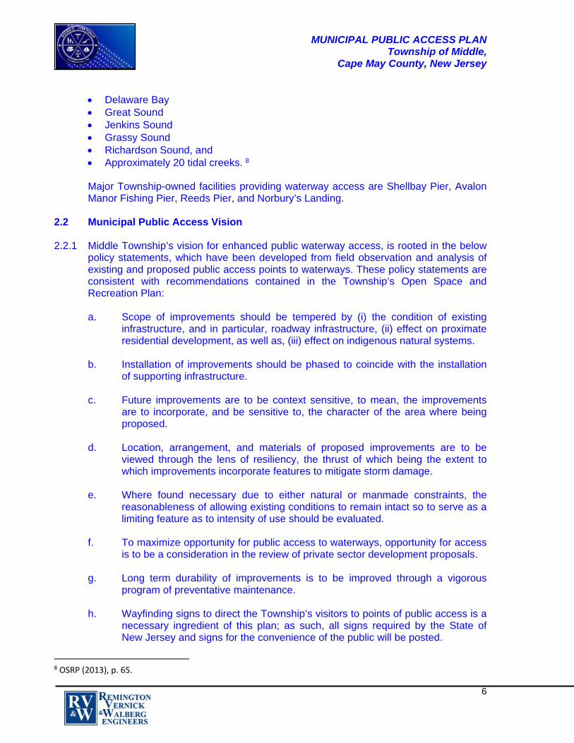
Bidwell Jetty at Reeds Beach. The jetty, which is Township owned, is found at the northerly terminus of North Beach Avenue at the confluence of Bidwell Creek and the Delaware Bay, and affords opportunity for Delaware Bay fishing, as well as, wildlife viewing. There are no ancillary improvements; in this instance to mean, that there are no signs, directional or interpretative/educational, and no restrooms. A small, informal parking area is available at the end of North Beach Avenue, which is at least 100 yards from the foot of the jetty. The route of travel from the parking area to the jetty is not handicap accessible.

MUNICIPAL PUBLIC ACCESS PLAN Township of Middle,
Cape May County, New Jersey
14
Reeds Beach Bidwell Jetty There are no temporary or permanent restrictions. The site does appear to be only sparingly utilized, which may result from a lack of public awareness, the distance of the area from North Delsea Drive, and the narrowness of the Beach Avenue cartway, which is approximately 15 feet, making two-way circulation difficult.
Narrow Cartway: North Beach Avenue
MUNICIPAL PUBLIC ACCESS PLAN Township of Middle,
Cape May County, New Jersey
15
For greater utilization of the jetty area, consideration should be given to providing directional signage along North Delsea Drive and Reeds Beach Road, the placement of interpretative/educational signs along the path from the parking area to the jetty, provision of seasonal temporary restroom facilities, and modifications to enable handicap accessibility. Care should however be taken to not over promote the site until improvements are made, in particular, to North Beach Avenue, to assure the roadway can sustain an increase in traffic likely to result from greater public use. Middle Township has applied for Cape May County Open Space funding to underwrite the costs of an ambitious design, which provides delineated gravel or clam shell parking areas, the construction of a gazebo at the Delaware Bay end of the jetty, the construction of a ramp, ancillary beach restoration, milling and overlay of the terminus of North Beach Avenue, as well as, the placement of a bench and porta-potties. The decision on the award of funding is expected in late winter/early spring. Bennys Landing. This landing is found at the end of Bennys Landing Road, which road is accessed from Bayberry Drive, approximately 0.8 miles from the landing area. The landing, which is classified as a utilized site, is Township owned and affords spectacular views of Jenkins Sound. A small residential development is located proximate to the landing area. The landing area sustained Superstorm Sandy damage, which is readily apparent by the deteriorated condition of the bulkhead, the abutting concrete area, and the brickwork supporting the landing’s two benches.

MUNICIPAL PUBLIC ACCESS PLAN Township of Middle,
Cape May County, New Jersey
16
View of Jenkins Sound Presently, restrictions on the enjoyment of the landing relate to the limitations imposed by the Superstorm damage, which relate to the severe break-up of the landing’s concrete area and damage to the supporting bulkhead. Middle Township has approved a plan for reconstruction; which plan calls for the removal of all broken concrete, as well as, removal of the existing timber bulkhead, to allow for installation of a new vinyl bulkhead, the pouring of new concrete in place of the broken concrete, placement of a van-accessible stall and ramp, and steel cable fencing. All of the aforementioned improvements are now nearly in place.

MUNICIPAL PUBLIC ACCESS PLAN Township of Middle,
Cape May County, New Jersey
17
Severe Superstorm Sandy Damage Factors limiting public enjoyment relate to the remoteness of the area and the lack of public awareness. Given the proximity of the residential development and the small area of the amenity, this plan does not call for any more intense a use of the area than has historically occurred.
3.1.2 Points of Public Access to Waterways Lacking Improvements
Points of waterway access lacking supporting improvements and for which only minimal improvements should be considered include the following sites: - Nummy Island - Kimbles Beach - Cooks Beach - Goshen Landing Nummy Island. This island is found along Ocean Drive between Stone Harbor and North Wildwood. The island is a popular location for “birders”, fisherman, boaters and jet skiers, who use the limited beach area proximate to Ocean Drive as a launch area.

MUNICIPAL PUBLIC ACCESS PLAN Township of Middle,
Cape May County, New Jersey
18
View Looking West From Ocean Drive The area is undeveloped other than for a gravel drive entrance to a small area of beach. Parking for those wishing to visit Nummy Island is limited to informal parking on the swath of grass area along Ocean Drive. Given the specter of vehicles in the grass area backing opposite the flow of traffic to launch small boats or jet skis and potential for traffic conflict, only minimal improvements should be made to limit the intensity of use. The site is classified as utilized. The placement of interpretative signs should be considered to educate the public and promote appreciation of the value of this resource.

MUNICIPAL PUBLIC ACCESS PLAN Township of Middle,
Cape May County, New Jersey
19
Unimproved Access From Ocean Drive Kimbles Beach. This beach is found at the terminus of Kimbles Beach Road, which road connects with Delsea Drive at a point approximately 1.2 miles from the beach and affords views of the Delaware Bay. The entirety of Kimbles Beach Road is paved; the need for surface course repair is however evident at the roadway terminus. The cartway has an approximate width of 16 feet. Access to the beach occurs at a point where there is found a cluster of residential development. The beach is also bounded immediately to the north by a National Wildlife Refuge area. There are no amenities at the site.

MUNICIPAL PUBLIC ACCESS PLAN Township of Middle,
Cape May County, New Jersey
20
The site does appear to be only sparingly utilized, which in all likelihood results from a lack of public awareness, the distance of the area from North Delsea Drive, and the narrowness of the cartway, which impedes two-way circulation. There is limited opportunity for informal parking at the terminus of the street and there are no restrictions as to use of the site, other than those imposed by the seasons. The area is classified as un-utilized,13 to mean, the location has no improvements and receives little or no use by the public. Any improvements to the area for the convenience of the public need to be carefully considered given the proximity of the wildlife refuge area, and narrowness of the cartway, providing access to the area. Cooks Beach. Cooks Beach is found along the Delaware Bay at the westerly terminus of Cooks Beach Road, which connects with North Delsea Drive at a point approximately 1.0 miles from the beach. There are no improvements at this location other than for the deteriorated remnants of a pier at the water’s edge. The most limiting feature that needs to be addressed, concurrent with the promotion of enhanced access to the area, is the instances of expansive and severe surface course deterioration of both paved and compacted gravel areas of the access road.
13 Un‐utilized means the location contains no improvements and receives little or no use by the public.

MUNICIPAL PUBLIC ACCESS PLAN Township of Middle,
Cape May County, New Jersey
21
Remnants of Pier The area is un-utilized as it provides no improvements and is only sparingly utilized; however, over time, this area could be an area for fishing, boating/kayaking, wildlife viewing, and enjoyment of spectacular views of the Delaware Bay, with the installation of much needed roadway repair.

MUNICIPAL PUBLIC ACCESS PLAN Township of Middle,
Cape May County, New Jersey
22
View Looking South Goshen Landing. Goshen Landing is an unimproved area that is found at what would be the westerly terminus of an unimproved extension of Goshen Landing Road at the Goshen Creek. The access roadway intersects with North Delsea Drive approximately 0.8 miles from the Creek, which is a tributary of the Delaware Bay. The area is remote and at this time cannot be accessed by automobiles. The site is classified as un-utilized.
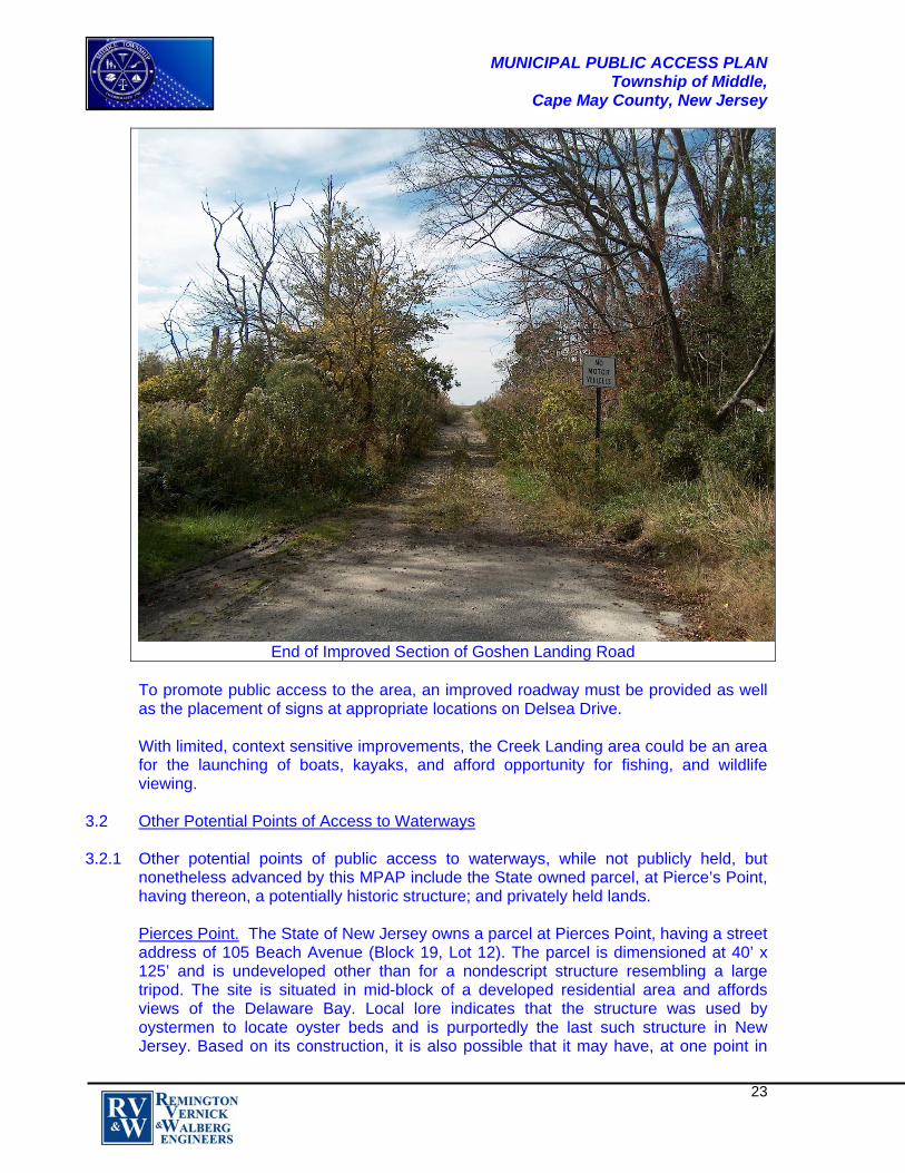
MUNICIPAL PUBLIC ACCESS PLAN Township of Middle,
Cape May County, New Jersey
23
End of Improved Section of Goshen Landing Road To promote public access to the area, an improved roadway must be provided as well as the placement of signs at appropriate locations on Delsea Drive. With limited, context sensitive improvements, the Creek Landing area could be an area for the launching of boats, kayaks, and afford opportunity for fishing, and wildlife viewing.
3.2 Other Potential Points of Access to Waterways 3.2.1 Other potential points of public access to waterways, while not publicly held, but
nonetheless advanced by this MPAP include the State owned parcel, at Pierce’s Point, having thereon, a potentially historic structure; and privately held lands. Pierces Point. The State of New Jersey owns a parcel at Pierces Point, having a street address of 105 Beach Avenue (Block 19, Lot 12). The parcel is dimensioned at 40’ x 125’ and is undeveloped other than for a nondescript structure resembling a large tripod. The site is situated in mid-block of a developed residential area and affords views of the Delaware Bay. Local lore indicates that the structure was used by oystermen to locate oyster beds and is purportedly the last such structure in New Jersey. Based on its construction, it is also possible that it may have, at one point in

MUNICIPAL PUBLIC ACCESS PLAN Township of Middle,
Cape May County, New Jersey
24
time, been used as a support structure for a lighted navigation aid. Given its significance, presuming it being the last such structure of its type in New Jersey, necessary repairs should be made to the structure and an interpretative sign placed. Further investigation of the historic use of the site is necessary to confirm the use of the structure and determine eligibility for nomination to the State’s Register of Historic Places.
Privately Held Lands. This MPAP endorses the possibility of public access to waterways over privately held lands throughout the Township. This being the case, opportunity for public access over privately held lands will be explored in conjunction with the development review/approval process. Opportunity for access to waterways is also afforded through the use of marinas and other means such as the rental of docks, often a feature of residential development along waterways. Representative of these types of opportunities is the pattern of development found about the Grassy Sound area. Grassy Sound is the expanse of water viewed looking south from the intersection of Ocean Drive and North Wildwood Boulevard, for which there are three points of improved access, just to the north of North Wildwood Boulevard. Each of the sites are privately held and occur in areas of residential development. On the west side of the Sound, there is a private boardwalk reserved for use by residents of the area, many of whom have docks. On the east side of the Sound, at the terminus of Old North Wildwood Boulevard, there is found the Grassy Sound Marina. For users of the marina, the site provides on-site parking and restroom facilities. The only restriction on use relates to the seasonal nature of the marina.

MUNICIPAL PUBLIC ACCESS PLAN Township of Middle,
Cape May County, New Jersey
25
View Looking South From North Wildwood Boulevard
Private Boardwalk: West Side
Grassy Sound Marina Ocean Drive Sign Also on the east side and just to the north of, and paralleling Old North Wildwood Boulevard, is an un-named, gravel roadway, which leads to a residential development. Many of the units have docks; it is unclear however as to whether or not any of the slips are available for rent by the public as the road is posted as being private and not to be used without permission of the owner.
MUNICIPAL PUBLIC ACCESS PLAN Township of Middle,
Cape May County, New Jersey
26
Private Road 4.0 COMMUNITY NEEDS ASSESSMENT 4.1 The Process
The public access needs, described in the previous section, results from field observation as well as from the process employed in the preparation of the Township’s 2013 Open Space and Recreation Plan (OSRP), for which Middle Township performed a community needs assessment that included public access to waterways. As part of the OSRP, there was extensive public participation, including:
Interviews with twenty-five (25) stakeholder groups; A public survey with 188 responses; A field trip to visit seven (7) sites; Fifteen (15) press releases and corresponding news articles; Two (2) public meetings; and Frequent website updates to detail plan progression, concepts, and survey results.
In sum, preparation of the OSRP revealed that the public’s primary access needs are currently being met. The parcels described herein offer a variety of amenities including public access to the inter-coastal waterway, public access to the Delaware Bay, with

MUNICIPAL PUBLIC ACCESS PLAN Township of Middle,
Cape May County, New Jersey
27
opportunities for fishing, crabbing, bird watching and passive recreation. Notwithstanding same, there are recommendations for public access improvement as described in Section 3.0 above.
5.0 IMPLEMENTATION STRATEGY 5.1 Priorities
The most pressing priority relative to public access to waterways is the restoration of superstorm damage to Bennys Landing, which restoration is to include the construction of a new bulkhead. The plan for restoration of this site has been approved by the Township and the restoration work has commenced. Costs of improvements are approximately $330,000.00; anticipated date of completion is the first quarter of 2015. The repair of the surface course deterioration at the terminus of Kimbles Beach Road is a priority; the extent of work necessary to remediate the existing condition should be scoped in 2015. Of less urgency is the repair of the surface course of Cooks Beach Road to improve access to Cooks Beach, which due to the extensive need for repair will, in all likelihood, require a phased approach, pursuant to engineering review. The assuring of handicap accessibility at all improved public access to waterways points, other than at Shellbay Pier, which is fully handicap accessible; remains a high priority as does the placement of way finding signs to all sites. It should be noted that the improvements recommended herein do not have an impact on any evacuation routes.
5.2 Maintaining of Existing Public Access
Middle Township will continue to maintain and improve, as recommended herein, all improved public access to waterways points. Improvements to unimproved public access to waterways points will be sensitive to the capacity of these areas to accommodate anticipated intensity of use. Where found applicable, proposed improvements to all public access to waterways points will be consistent with the requirements for protection of shore areas, as promulgated by the Army Corps of Engineers.

MUNICIPAL PUBLIC ACCESS PLAN Township of Middle,
Cape May County, New Jersey
28
6.0 RESOLUTION OF INCORPORATION
The New Jersey Department of Environmental Protection (NJDEP) approved this MPAP on _________________, 2015. The Planning Board of Middle Township, via adoption of Resolution No. _________, on _____________, 2015, incorporated this NJDEP-approved MPAP into the Open Space and Recreation Plan Element of the Middle Township Master Plan. The draft resolution is provided in Appendix 4.
MUNICIPAL PUBLIC ACCESS PLAN Township of Middle,
Cape May County, New Jersey
APPENDICES
Appendix 1 Draft Planning Board Resolution Incorporating MPAP into Middle Township Master Plan
Appendix 2 Map: Middle Township Improved and
Unimproved Waterway Access Points Recommended for Enhancement
Appendix 3 Public Access to Waterways:
Existing Conditions Spreadsheet

MUNICIPAL PUBLIC ACCESS PLAN Township of Middle,
Cape May County, New Jersey
Appendix 1
RESOLUTION INCORPORATING MUNICIPAL PUBLIC ACCES PLAN (MPAP) INTO THE MIDDLE TOWNSHIP MASTER PLAN
Resolution #__________
APPROVING THE MUNICIPAL PUBLIC ACCESS PLAN
WHEREAS, the document entitled Municipal Public Access Plan ("MPAP"), Township of Middle, Cape May County, New Jersey was reviewed by the Planning Board of the Township of Middle, pursuant to N.J.S.A. 40:55D-28.a, on ___________, 2015, for incorporation into the Middle Township Master Plan, and WHEREAS, the Planning Board of the Township of Middle recognizes the need to make the MPAP an authorized component of the Middle Township Master Plan; NOW, THEREFORE, BE IT RESOLVED by the Planning Board of the Township of Middle that the document entitled Municipal Public Access Plan, Township of Middle, Cape May County, New Jersey, is hereby adopted and made a part of the Open Space and Recreation Plan (OSRP) Element of the Township Master Plan. I hereby certify the foregoing to be a resolution adopted by the Planning Board of the Township of Middle at a meeting held on ___________, 2015.
_______________________________ Planning Board Chair
_______________________________
Planning Board Secretary

!>
!5Nummy Island
Norburys Landing
!>Shellbay Pier
!>South Reed Beach
!5Cooks Beach
!>Reeds Pier
!5
Goshen Landing
!>
Avalon Fishing Pier
!>
Grassy Sound
!5Kimbles Beach
!5Pierces Point
!>Bennys Landing
Sources: Esri, HERE, DeLorme, USGS, Intermap, increment P Corp., NRCAN, Esri Japan, METI, EsriChina (Hong Kong), Esri (Thailand), TomTom, MapmyIndia, © OpenStreetMap contributors, and the GISUser Community
³
LegendTidal WaterwaysMunicipal BoundaryImproved Waterway Public Access PointsUnimproved Waterway Public Access Points
!>!5
General Notes and Data Sources:1. This map was created, in part, utilizing parcel, municipal boundary and location data provided by the Cape May County Department of Regional Planning & Development. 2. Additional Waterway Access Roadway Systems and location datawas provided by Environmental Systems Research Institure (ESRI).3. Additional cadastral feature mapping data, such as, tidal waterways, roadways, railroads, aerial orthophotography, etc. was obtained from the New Jersey Department of Environmental Protection (NJDEP). This secondary product has not been verified by (NJDEP) and is not state-authorized.4. All positions are based on the following: -NAD 83 (horizontal datum) -New Jersey State Plane Coordinate System -English units (feet) 5. The geodetic accuracy and precision of the Geographic Information System (GIS) data contained in this mapping has not been developed nor verified by a professional licensed land surveyor and shall not be nor is intended to be used in matters requiring delineation and location of true ground horizontal and/or vertical controls.
Project No.: 0506T033 Date: 12/12/2014 Drawn by: K.R.Z. Scale: N.T.S.
Middle Township Improved and Unimproved Waterway Access Points Recommended for Enhancement
Appendix 2
MUNICIPAL PUBLIC ACCESS PLAN Township of Middle,
Cape May County, New Jersey
Appendix 3
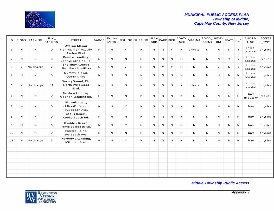
Middle Township Public Access
ID SIGNS PARKINGNUM_
PARKINGSTREET BADGE
SWIM‐
MINGFISHING SURFING
PLAY‐
GRDPARK PIER
BOAT‐
LNCHMARINA
FOOD_
DRINK
REST‐
RMSEATS H_C
SHORE‐
LINE
ACCESS
_TYPE
1 N N 0
Avalon Manor
Fishing Pier, 701 Old
Avalon Blvd.
N N Y N N N Y N private N N N Yinter‐
coasta lphys ica l
2 N N 0Bennys Landing,
Bennys Landing Rd.N N N N N N N N N N N Y Y
inter‐
coasta lvisual
3 Y No charge 7Shel lbay Avenue
Pier, East Shel lbay N N Y N N Y Y N N N Y N Y
inter‐
coasta lphys ica l
4 N N 0Nummy Is land,
Ocean Drive N N N N N N N N N N N N Ninter‐
coasta lphys ica l
5 Y No charge 12
Grassy Sound, Old
North Wildwood
Blvd.N N N N N N N Y private N Y N N
inter‐
coasta lphys ica l
6 N N 0Goshen Landing,
Goshen Landing Rd. N N N N N N N N N N N N Nbay
tributaryvisual
7 N N 0
Bidwel ls Jetty
at Reed's Beach,
301 Beach Ave.N N Y N N N N N N N N N N bay phys ica l
8 N N 0Cooks Beach,
Cooks Beach Rd. N N N N N N N N N N N N N bay phys ica l
9 N N 0Kimbles Beach,
Kimbles Beach Rd.N N Y N N N N N N N N N N bay phys ica l
10 N N 0Pierces Point,
105 Beach Ave.N N N N N N N N N N N N N bay phys ica l
11 N No charge 5Norbury's Landing,
Mil lman Blvd.N N Y N N N N N N N N N N bay phys ica l