Embed Size (px)
DESCRIPTION
Multi-Municipal Comprehensive Plan for the City of Connellsville, Connellsville Township & South Connellsville. Chapters 9-13.
Citation preview

FINAL DRAFT MULTI-MUNICIPAL COMPREHENSIVE PLAN
CITY OF CONNELLSVILLE, CONNELLSVILLE TOWNSHIP, AND SOUTH CONNELLSVILLE BOROUGH
Chapter 9 Transportation Plan -1
November 2009
Chapter 9 Transportation Plan
Introduction The transportation plan provides a framework for critical decision making that will influence the land use, development patterns, and future growth of the Connellsville area. Municipal and individual land use decisions are strongly influenced by existing or proposed transportation systems, while at the same time these decisions affect the circulation systems and the functions that the system elements are expected to perform. Existing and proposed development areas should be considered when transportation system improvements are programmed. In turn, future growth should not result in development patterns that will adversely affect the transportation system.
Transportation Planning
Transportation planning in the Connellsville area occurs within the context of transportation planning for Fayette County. The county’s transportation planning, in turn, occurs as part of the regional transportation planning process, which incorporates transportation needs for the ten-county region of southwestern Pennsylvania. The Southwestern Pennsylvania Commission (SPC) guides this process. SPC is charged with ensuring that existing and future funding of transportation projects are based on a comprehensive, cooperative, and continuing process. The Pennsylvania Department of Transportation (PennDOT) is also an active planning partner.
The main outcome of this process is the Transportation Improvement Program (TIP). Due to limited resources, not all transportation projects can be funded. Creation of the TIP involves prioritizing the many projects in the region for implementation. The TIP covers a four-year period and identifies all projects slated for advancement during that time frame. TIP projects advanced include both highway and transit projects for the ten-county region. Through the Fayette County Planning Commission, Fayette County participates in the TIP process by submitting funding requests to SPC’s technical committees that are charged with developing the TIP.
Listing a project on the TIP is an important first step in working towards implementation. However, a project’s presence on the TIP does not guarantee a commitment or obligation to fund the project. There are three Title I (Highway/Bridge) projects currently on the 2009-2012 TIP in the City of Connellsville. Table 9-1 lists the current TIP projects. These projects are keyed to Map 9-1 on the following page.

FINAL DRAFT MULTI-MUNICIPAL COMPREHENSIVE PLAN
CITY OF CONNELLSVILLE, CONNELLSVILLE TOWNSHIP, AND SOUTH CONNELLSVILLE BOROUGH
Chapter 9 Transportation Plan -2
November 2009
Table 9-1 Transportation Improvement Program Projects in the Planning Region 2009-2012 Map # Project Location and Type Municipality Completion
Date MPMS State Route Estimated Cost
11 Memorial Bridge - Bridge Restoration/Rehab over Youghiogheny river Connellsville City 2011 29811 119 $17 million
17 Pittsburgh St. Bridge - Bridge Replacement over Trump Run Connellsville City 2011 29895 1037 $2 million
35 SR 711 Escape Ramp - Study Restoration and Safety Improvement Connellsville City 2010 30003 711 $3 million
Map 9-1: Transportation Improvement Program
FINAL DRAFT MULTI-MUNICIPAL COMPREHENSIVE PLAN
CITY OF CONNELLSVILLE, CONNELLSVILLE TOWNSHIP, AND SOUTH CONNELLSVILLE BOROUGH
Chapter 9 Transportation Plan -3
November 2009
Transportation System
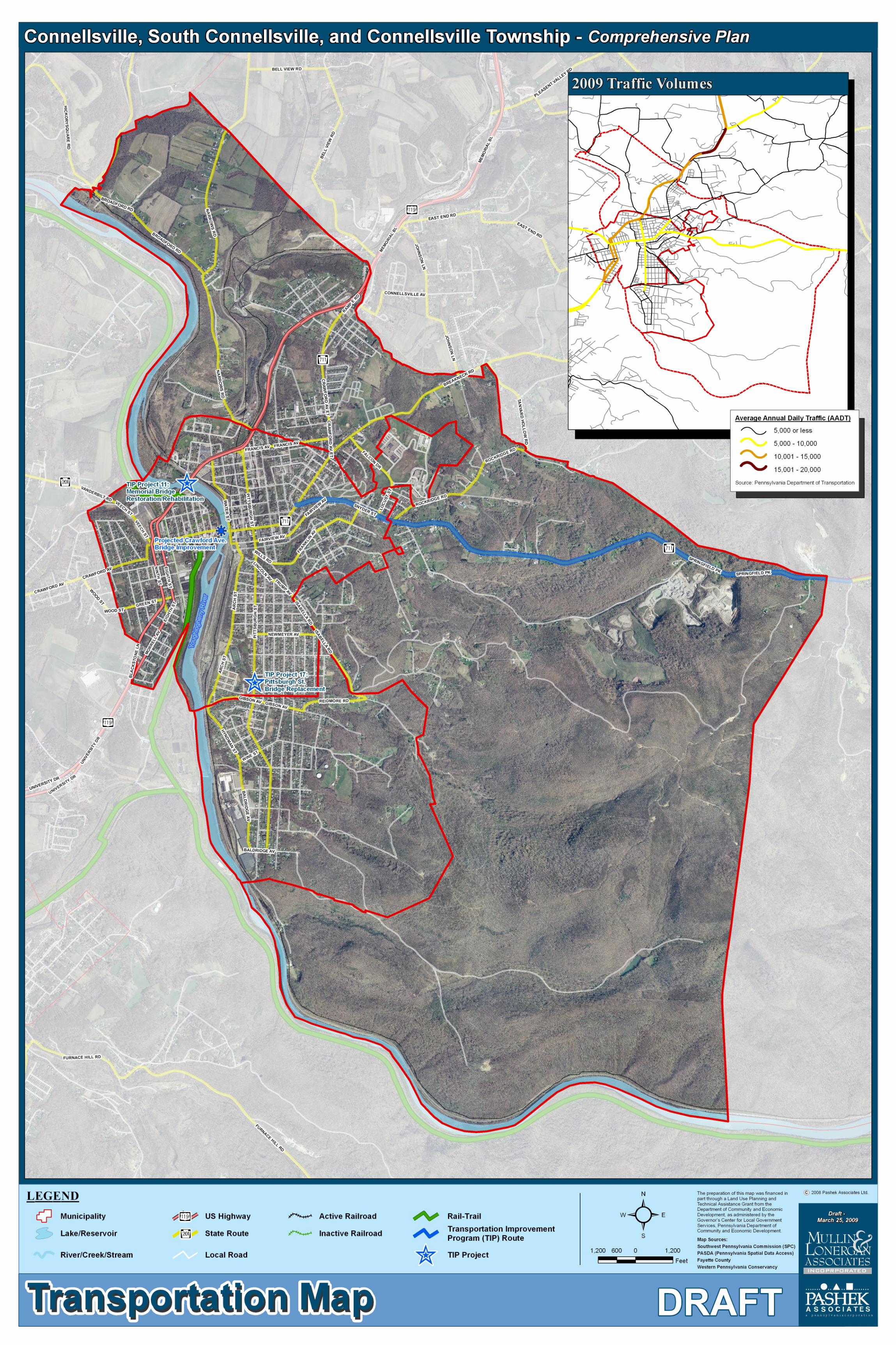
An efficient transportation system moves people and goods within and across an area safely and efficiently through a variety of modes. The Connellsville area’s transportation network includes roads, rail lines, bridges, an airport (located in Lemont Furnace), waterways, bicycle trails, and pedestrian paths. Modes of transportation include motor vehicles, trains, boats, airplanes, bicycles, and walking. Addressing the planning region’s future transportation needs begins with a sound understanding of the region’s existing and proposed transportation system. The Transportation Map on the following page highlights the modes of transportation available in the Connellsville area.
Roads
The Connellsville area’s primary roads include U.S. Route 119, which is the primary north/south corridor with links to major economic, recreational, and historic attractions; SR 711, which is the primary east/west corridor; and SR 201, which links Connellsville to communities to the west and northwest of Fayette County into Westmoreland County.
The Connellsville area’s road system is a vital element in its overall transportation network. Since vehicular traffic is the main existing and projected mode of transport, the road system will continue to be the basis of transportation through and within the region.
The roadway system in the Connellsville area is comprised of a variety of roads. These roads are defined as a hierarchy, identifying both the function and level of demand for each road. Functional classification reflects how a roadway fits into the larger transportation network. This includes whether a roadway serves residents traveling within the area, or serves motorists traveling through the area. The Pennsylvania Department of Transportation (PennDOT) has defined the following road classifications:
• Arterials:
Arterials primarily serve through and regional traffic on roads designed for mobility. They are subdivided into roads that are part of the Interstate System, and Other Arterials.
• Interstate Highways, Other Freeways, and Expressways:
This classification consists of all presently designated freeway routes meeting the Interstate geometric and construction standards for future traffic. It is the highest classification of arterial roads and streets and provides the highest level of mobility, at the highest speed, for a long uninterrupted distance.
• Other Arterials:
These consist of limited-access freeways, multi-lane highways, and other important highways supplementing the interstate system. Other Arterials connect, as directly as practicable, the nation’s principal urbanized areas, cities, and industrial centers; serve the
FINAL DRAFT MULTI-MUNICIPAL COMPREHENSIVE PLAN
CITY OF CONNELLSVILLE, CONNELLSVILLE TOWNSHIP, AND SOUTH CONNELLSVILLE BOROUGH
Chapter 9 Transportation Plan -4
November 2009
national defense; and connect at suitable border points with routes of continental importance.
• Collectors:
Collectors provide land access service and traffic circulation within residential neighborhoods, commercial and industrial areas, and downtown city centers. Collectors connect local roads and streets with arterials and provide less mobility than arterials at lower speed and for a shorter distance.
• Locals
Local roads and streets provide a high level of access to abutting land but offer limited mobility.
Table 9-2 below lists the arterials and collectors within the Connellsville area. All other roads within the planning region are local roads and streets. Table 9-2 Arterials and Collectors in the Planning Region
Road ClassificationPA Route 119 Other Arterials - Principal Arterial RoadwayPA Route 711 Other Arterials - Principal Arterial RoadwayPA Route 201 Other Arterials -Minor Arterial RoadwaySource: PA Department of Transportation
Existing Traffic Volumes
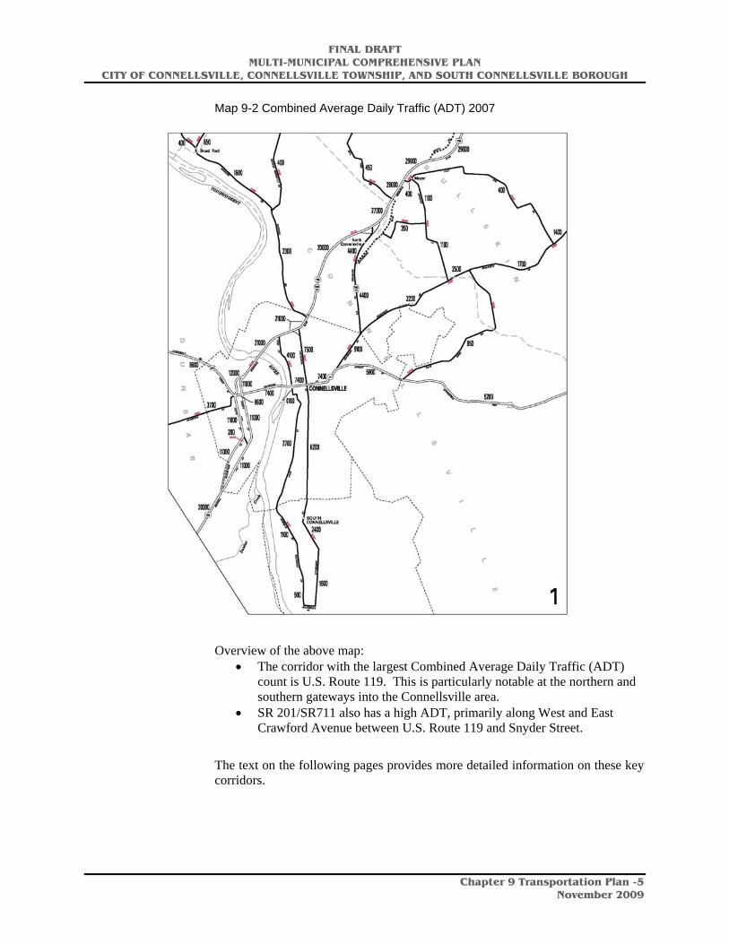
The following map outlines the combined Average Daily Traffic (ADT) according to traffic data collected by PennDOT for main roads in the Connellsville area. The traffic volumes on the map reflect combined southbound and northbound traffic counts. The Transportation Map on the previous page also has a summary of the traffic volume by category.
FINAL DRAFT MULTI-MUNICIPAL COMPREHENSIVE PLAN
CITY OF CONNELLSVILLE, CONNELLSVILLE TOWNSHIP, AND SOUTH CONNELLSVILLE BOROUGH
Chapter 9 Transportation Plan -5
November 2009
Map 9-2 Combined Average Daily Traffic (ADT) 2007
Overview of the above map:
• The corridor with the largest Combined Average Daily Traffic (ADT) count is U.S. Route 119. This is particularly notable at the northern and southern gateways into the Connellsville area.
• SR 201/SR711 also has a high ADT, primarily along West and East Crawford Avenue between U.S. Route 119 and Snyder Street.
The text on the following pages provides more detailed information on these key corridors.

FINAL DRAFT MULTI-MUNICIPAL COMPREHENSIVE PLAN
CITY OF CONNELLSVILLE, CONNELLSVILLE TOWNSHIP, AND SOUTH CONNELLSVILLE BOROUGH
Chapter 9 Transportation Plan -6
November 2009
U.S Route 119
U.S. Route 119 is the primary north-south corridor connecting the three communities with the Pennsylvania Turnpike (U.S. 76) and communities south, including Uniontown. U.S. Route 119 provides both benefits and challenges to the area. The highest traffic volume levels for the Connellsville area are along U.S. Route 119 at the northern and southern gateways into the community.
Northern Gateway: Between Bell View Road and East Crawford Avenue
• Southbound traffic at the northern gateway into Connellsville Township has an average daily traffic volume of 14,309 cars and 1,391 trucks (2006 PennDOT data). This intersection, at U.S. Route 119 and SR 711, creates a potential for hazardous traffic conditions.
• Northbound traffic, just north of the U.S. Route 119 and SR 711 intersection, is also heavy, with an average daily traffic volume of 12,624 cars and 1,131 trucks (2006 PennDOT data).
Southern Gateway: Between West Crawford Avenue and Prince Street
• The southbound segment experiences an average daily traffic volume of 11,295 cars and 892 trucks (2008 PennDOT data).
• The northbound segment experiences an average daily traffic volume of 10,638 cars and 1,148 trucks (2007 PennDOT data).
Peak Hour Delay Locations
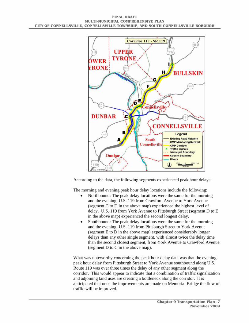
The U.S. Route 119 roadway carries a high volume of traffic that brings a large number of area residents and visitors to businesses adjoining U.S. Route 119. It also provides access to businesses and residential neighborhoods in each of the communities. The map on the following page, produced by PennDOT, highlights segments of the Congestion Management Process (CMP) Monitoring Network and Corridor analyzed as part of the ongoing evaluation of traffic delay points along the roadway. The CMP system provides data that can assist in pin pointing problem intersections and corridors.
FINAL DRAFT MULTI-MUNICIPAL COMPREHENSIVE PLAN
CITY OF CONNELLSVILLE, CONNELLSVILLE TOWNSHIP, AND SOUTH CONNELLSVILLE BOROUGH
Chapter 9 Transportation Plan -7
November 2009
According to the data, the following segments experienced peak hour delays: The morning and evening peak hour delay locations include the following:
• Northbound: The peak delay locations were the same for the morning and the evening: U.S. 119 from Crawford Avenue to York Avenue (segment C to D in the above map) experienced the highest level of delay. U.S. 119 from York Avenue to Pittsburgh Street (segment D to E in the above map) experienced the second longest delay.
• Southbound: The peak delay locations were the same for the morning and the evening: U.S. 119 from Pittsburgh Street to York Avenue (segment E to D in the above map) experienced considerably longer delays than any other single segment, with almost twice the delay time than the second closest segment, from York Avenue to Crawford Avenue (segment D to C in the above map).
What was noteworthy concerning the peak hour delay data was that the evening peak hour delay from Pittsburgh Street to York Avenue southbound along U.S. Route 119 was over three times the delay of any other segment along the corridor. This would appear to indicate that a combination of traffic signalization and adjoining land uses are creating a bottleneck along the corridor. It is anticipated that once the improvements are made on Memorial Bridge the flow of traffic will be improved.
FINAL DRAFT MULTI-MUNICIPAL COMPREHENSIVE PLAN
CITY OF CONNELLSVILLE, CONNELLSVILLE TOWNSHIP, AND SOUTH CONNELLSVILLE BOROUGH
Chapter 9 Transportation Plan -8
November 2009
Traffic Accident Data
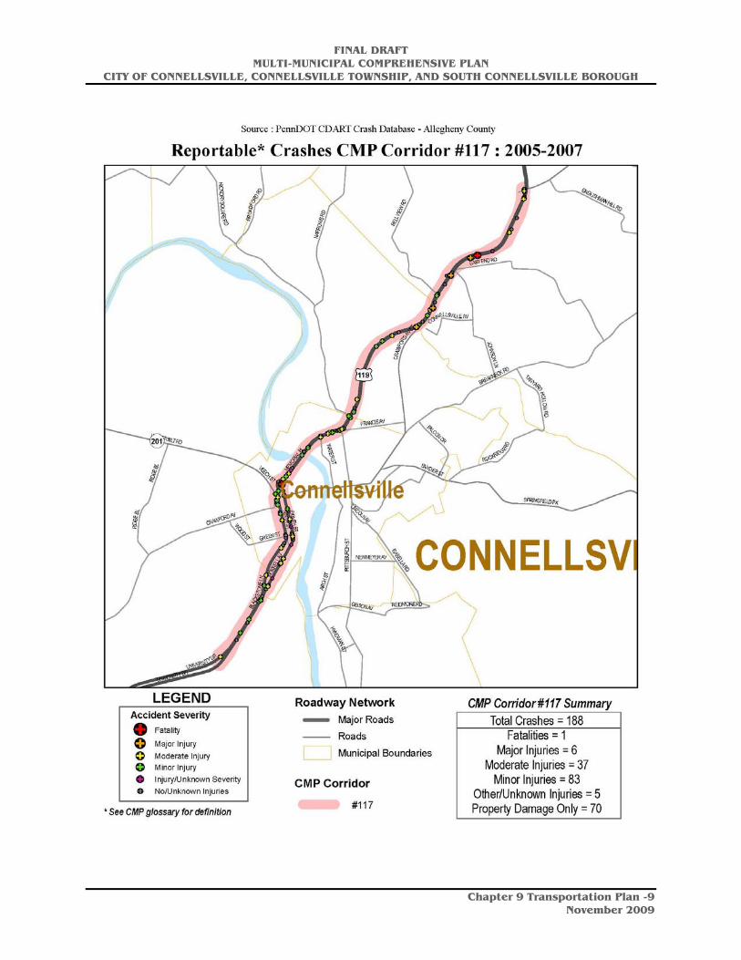
The map of the U.S Route 119 roadway applicable to the Connellsville area (identified as CMP Corridor 117 by PennDOT) on the following page shows traffic accident data along this corridor. This data correlates closely to the peak hour delay data outlined earlier. The northbound and southbound segments of U.S. Route 119 between West Crawford Avenue and Prince Street tend to be the areas with the highest concentration of traffic accidents. The U.S. Route 119 corridor just north of the intersection with SR 201 is also problematic. In addition, the northern terminus of U.S. Route 119 into Connellsville Township between Bell View Road and the East Crawford Avenue leading directly into Connellsville Township has experienced a high level of crashes.
FINAL DRAFT MULTI-MUNICIPAL COMPREHENSIVE PLAN
CITY OF CONNELLSVILLE, CONNELLSVILLE TOWNSHIP, AND SOUTH CONNELLSVILLE BOROUGH
Chapter 9 Transportation Plan -9
November 2009
FINAL DRAFT MULTI-MUNICIPAL COMPREHENSIVE PLAN
CITY OF CONNELLSVILLE, CONNELLSVILLE TOWNSHIP, AND SOUTH CONNELLSVILLE BOROUGH
Chapter 9 Transportation Plan -10
November 2009
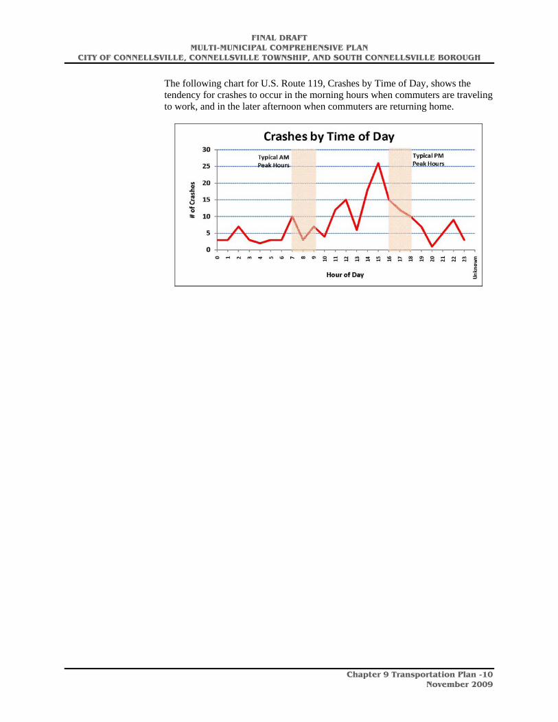
The following chart for U.S. Route 119, Crashes by Time of Day, shows the tendency for crashes to occur in the morning hours when commuters are traveling to work, and in the later afternoon when commuters are returning home.

FINAL DRAFT MULTI-MUNICIPAL COMPREHENSIVE PLAN
CITY OF CONNELLSVILLE, CONNELLSVILLE TOWNSHIP, AND SOUTH CONNELLSVILLE BOROUGH
Chapter 9 Transportation Plan -11
November 2009
The following chart shows the crashes by collision type. Most of the crashes were angle collisions at 36% of all accidents. In addition, the data shows a crash rate of 1.40 per million vehicle-miles traveled and a severity index of 2.35. For Fayette County as a whole, the average crash rate is 1.01 for major arterials, indicating that the rate for U.S. Route 119 (CMP Corridor #117) is higher than other major arterials in the county.
FINAL DRAFT MULTI-MUNICIPAL COMPREHENSIVE PLAN
CITY OF CONNELLSVILLE, CONNELLSVILLE TOWNSHIP, AND SOUTH CONNELLSVILLE BOROUGH
Chapter 9 Transportation Plan -12
November 2009
Implications for Land Use On U.S. Route 119
The implications for land use and transportation on U.S. Route 119 include the following:
• The northern gateway to Connellsville Township at U.S. Route 119 and the Crawford Avenue Extension continues to experience a high level of traffic accidents. This directly impacts the land development potential of the parcels on East Crawford Avenue closest to the interchange due to the traffic conditions in the area. A traffic analysis should be conducted by a traffic engineer to determine methods of providing for a smoother flow of traffic. This in turn would add to the viability of developing parcels along the East Crawford Avenue closest to the interchange. The intersection of U.S. Route 119 and East Crawford Avenue is a busy intersection with challenges in terms of turning lanes and visual identifiers. The traffic accident confirms that this intersection continues to present challenges to the road system in the area.
• The portion of U.S. Route 119 southbound between Pittsburgh Street and York Avenue has the highest level of morning traffic delays, over twice the delay level of the York Avenue to Crawford Avenue segment. This segment has a number of auto-oriented strip shopping plazas and stores. Egress and ingress may be inadequate along this corridor. Also, the traffic light at York Avenue and Pittsburgh Street may need to be re-signalized. A traffic engineering study of this segment should be conducted to determine how to create a better flow of traffic and to reduce the traffic delays along this corridor.
• The portion of U.S. Route 119 near the shopping plaza at the bend between the Memorial Bridge and West Crawford Avenue, just north of the intersection with SR 201, is another area segment impacted by surrounding land uses. The shopping plaza, combined with the curvature of the road highlights multiple issues. This segment should be closely monitored and additional studies conducted to determine the best options to reduce the traffic delays and the number of accidents that occur in this area.
SR 711/SR 201
State Route (SR) 711 is the primary east-west corridor connecting the three communities with the SR 201 and points east. The segment of SR 711 with the highest average daily traffic volume of cars is between the intersection of U.S. Route 119/SR 711/West Crawford Avenue and Snyder Street and the Crawford Avenue Extension, with 7,436 cars traveling in both directions. Average daily truck volume is 149 (2007 PennDOT data). The segment between the intersection of Snyder Street and the Crawford Avenue Extension and Rockridge Road is 5,909, with average daily truck volume of 886 (2007 PennDOT data). While the car traffic volume is lower, the volume of truck traffic is the highest along the SR 711 corridor within the Connellsville area.

FINAL DRAFT MULTI-MUNICIPAL COMPREHENSIVE PLAN
CITY OF CONNELLSVILLE, CONNELLSVILLE TOWNSHIP, AND SOUTH CONNELLSVILLE BOROUGH
Chapter 9 Transportation Plan -13
November 2009
Peak Hour Delay Locations
The map below, produced by PennDOT, highlights segments of the Congestion Management Process (CMP) Monitoring Network and Corridor analyzed as part of the ongoing evaluation of traffic delay points along the roadway. It can provide data that assists in pin pointing problem intersections and corridors.
According to the data, the following segments experienced peak hour delays: The morning and evening peak hour delay locations include the following:
• Eastbound: The peak delay locations were the same for the morning and the evening: SR 711/West Crawford Avenue from U.S. Route 119 to Pittsburgh Street (segment B to C in the above map) had the highest level of delays. SR 201 from Ridge Boulevard to U.S. Route 119 (segment A to B in the above map) experienced the second longest delays for eastbound traffic.
• Westbound: The peak delay locations were the same for the morning and the evening: SR 711/West Crawford Avenue from Pittsburgh Street to U.S. Route 119 (segment C to B in the above map) had the highest level of delays. The second highest level of morning peak hour delay occurred from East Crawford Avenue to Pittsburgh Street (segment D to C in the above map) experienced the highest level of delay. In the evening, the peak hour delay was from Rock Ridge Road to Crawford Avenue (segment E to D in the above map).
Traffic Accident Data
FINAL DRAFT MULTI-MUNICIPAL COMPREHENSIVE PLAN
CITY OF CONNELLSVILLE, CONNELLSVILLE TOWNSHIP, AND SOUTH CONNELLSVILLE BOROUGH
Chapter 9 Transportation Plan -14
November 2009
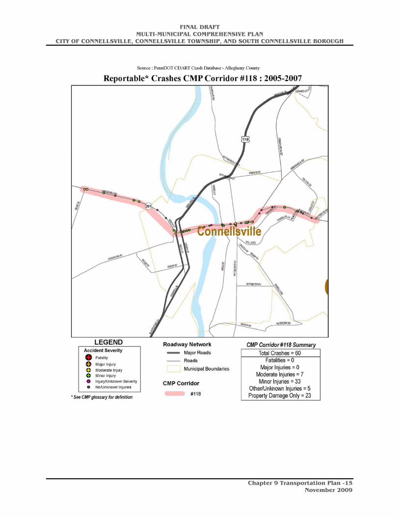
The map of the Route 711/201 roadway applicable to the Connellsville area (identified as CMP Corridor 118 by PennDOT) on the following page shows traffic accident data along this corridor. This data correlates closely to the peak hour delay data outlined earlier. The areas with the highest level of traffic accidents tend to be concentrated at the intersection of U.S. Route 119/Eight Street and West Crawford Avenue, areas close to the Crawford bridge, particularly at Arch Street, the intersection of West Crawford and Pittsburgh Street, and East Crawford Avenue between Pittsburgh Street and Prospect Street.
FINAL DRAFT MULTI-MUNICIPAL COMPREHENSIVE PLAN
CITY OF CONNELLSVILLE, CONNELLSVILLE TOWNSHIP, AND SOUTH CONNELLSVILLE BOROUGH
Chapter 9 Transportation Plan -15
November 2009
FINAL DRAFT MULTI-MUNICIPAL COMPREHENSIVE PLAN
CITY OF CONNELLSVILLE, CONNELLSVILLE TOWNSHIP, AND SOUTH CONNELLSVILLE BOROUGH
Chapter 9 Transportation Plan -16
November 2009
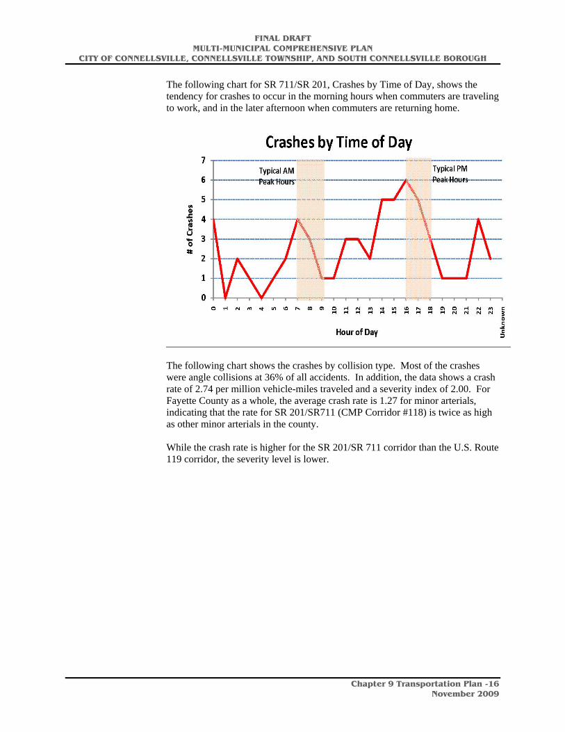
The following chart for SR 711/SR 201, Crashes by Time of Day, shows the tendency for crashes to occur in the morning hours when commuters are traveling to work, and in the later afternoon when commuters are returning home.
The following chart shows the crashes by collision type. Most of the crashes were angle collisions at 36% of all accidents. In addition, the data shows a crash rate of 2.74 per million vehicle-miles traveled and a severity index of 2.00. For Fayette County as a whole, the average crash rate is 1.27 for minor arterials, indicating that the rate for SR 201/SR711 (CMP Corridor #118) is twice as high as other minor arterials in the county. While the crash rate is higher for the SR 201/SR 711 corridor than the U.S. Route 119 corridor, the severity level is lower.

FINAL DRAFT MULTI-MUNICIPAL COMPREHENSIVE PLAN
CITY OF CONNELLSVILLE, CONNELLSVILLE TOWNSHIP, AND SOUTH CONNELLSVILLE BOROUGH
Chapter 9 Transportation Plan -17
November 2009
FINAL DRAFT MULTI-MUNICIPAL COMPREHENSIVE PLAN
CITY OF CONNELLSVILLE, CONNELLSVILLE TOWNSHIP, AND SOUTH CONNELLSVILLE BOROUGH
Chapter 9 Transportation Plan -18
November 2009
Impact of Truck Traffic
The types of industries in the Connellsville area, including heavy industrial manufacturing and extractive industries, lends itself to transporting the raw goods, as well as finished products via trucks (in addition to rail). There are a large number of trucks that traverse the roadways in the Connellsville area to bring raw materials to the plants in the area. The truck traffic also results in challenges to the roadway system in Connellsville. The mix of heavy truck traffic combined with auto and, as anticipated, greater bicycle travel presents new challenges to the roadway system, particularly on SR 711. A more detailed transportation engineering study should be conducted to determine the best alternate routes for truck traffic in the Connellsville area. Truck traffic will continue to be an important part of the economy, and should be balanced with other forms of transport.
Projected Traffic Growth
The Southwestern Pennsylvania Commission (SPC) has projected traffic growth rates on major roads within the City of Connellsville, Connellsville Township, and South Connellsville Borough. SPC’s projected linear annual growth rates from SPC’s Cycle-8 Forecast (2005 – 2035) projects the following: Table 9-4 Linear Annual Growth
City of Connellsville/South Connellsville Borough 1.03%Connellsville Township 0.73%Source: Southweste rn Pennsylvania Commission, Cycle 8 Forecast: 2005 - 2035
Congestion and Safety Issues
There are several locations where traffic congestion has led to potential safety issues. These include the following:
• West Crawford Avenue in the City of Connellsville is particularly congested during morning rush hour and in the late afternoon/early evening when school buses are returning students home and people begin leaving work. This was verified by the traffic delay data and crash information from PennDOT.
• The Memorial Bridge over the Youghiogheny River in the City of Connellsville is in need of repair as it is heavily traveled by local users and its infrastructure is outdated. A $17 million restoration/rehabilitation of the bridge is underway and scheduled to continue through 2011.
• Pittsburgh Street truck traffic continues to be a public safety and quality of life issue. Although the posted speed limit is 25 mph, traffic often moves at a faster rate.
FINAL DRAFT MULTI-MUNICIPAL COMPREHENSIVE PLAN
CITY OF CONNELLSVILLE, CONNELLSVILLE TOWNSHIP, AND SOUTH CONNELLSVILLE BOROUGH
Chapter 9 Transportation Plan -19
November 2009
• There are no other routes to the Anchor Hocking plant in South Connellsville Borough other than Pittsburgh Street. Another route is needed to provide better accessibility to the plant. A feasibility study was conducted several years ago to build a bridge to the Anchor Hocking site from Route 119 over the Youghiogheny River, but the bridge was never built. A traffic engineering study should be conducted to determine the best routes, opening up the redevelopment options for the plants in South Connellsville Borough.
Condition of Local Roads
Connellsville area roads that are not under federal, state, or county jurisdiction are maintained by the three municipalities. Road construction and maintenance is a substantial item in municipal budgets. Each of the municipalities prepares and annually updates a street maintenance and improvement program. The condition of planning region roads varies, but most roads are in good condition and are well maintained.
As mentioned in Chapter 7, mine subsidence impacts roads by causing sections of roadways to sink or collapse, thereby forcing road closures, lane restrictions, and detours.
Since vehicular traffic is the primary present and anticipated future mode of transportation in the planning region, the three municipalities must continue to work with the state and county to maintain and improve the road network.
Bridges
Maintaining bridges in a structurally sound condition prevents the need to close them or post them with weight limits. Posted and closed bridges limit access and/or necessitate detours, resulting in inconveniences for motorists traveling within and through an area. Posted and closed bridges also pose public safety concerns by increasing the amount of time that emergency vehicles take to reach their destinations. Regular maintenance, rehabilitation, and replacement are needed to insure that bridges continue to serve their vital function in a transportation system.
The current TIP includes the following bridge replacement projects in the Connellsville area:
• Memorial Bridge Restoration/Rehab in the City of Connellsville
• Pittsburgh Street bridge replacement over Trump Run in the City of Connellsville
In order to keep the Connellsville area’s bridges functioning as essential elements of the area’s transportation system, the three municipalities should continue to collaborate with PennDOT and Fayette County to identify needed bridge maintenance, rehabilitation, and replacement, and to secure federal, state, and county funding for such work.
FINAL DRAFT MULTI-MUNICIPAL COMPREHENSIVE PLAN
CITY OF CONNELLSVILLE, CONNELLSVILLE TOWNSHIP, AND SOUTH CONNELLSVILLE BOROUGH
Chapter 9 Transportation Plan -20
November 2009
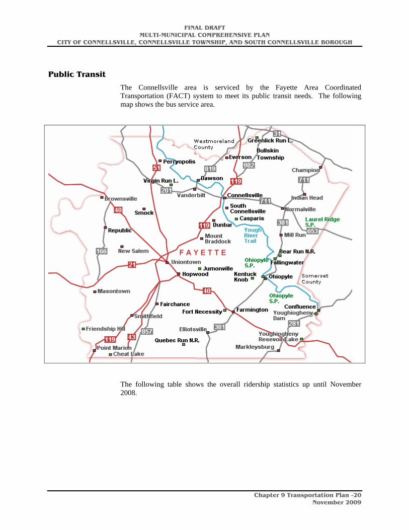
Public Transit
The Connellsville area is serviced by the Fayette Area Coordinated Transportation (FACT) system to meet its public transit needs. The following map shows the bus service area.
The following table shows the overall ridership statistics up until November 2008.

FINAL DRAFT MULTI-MUNICIPAL COMPREHENSIVE PLAN
CITY OF CONNELLSVILLE, CONNELLSVILLE TOWNSHIP, AND SOUTH CONNELLSVILLE BOROUGH
Chapter 9 Transportation Plan -21
November 2009
Table 9-5 FACT Ridership FY 2008
For detailed information on bus routes and fares for the Connellsville area, explore the FACT website at http://www.factbus.com.
Rail
Railroads have an important role in an area’s transportation system. They provide a means for transporting both people and goods. Railroads are especially suited for the movement of freight (e.g., motorized vehicles, coal, lumber, etc.) that is difficult or inefficient to transport by highways, waterways, or air.
Railroad for Business Transport
Rail service is vital to many businesses, especially industrial firms whose shipments cannot be made via other modes of transportation. This is particularly true for manufacturing firms along the Youghiogheny River. Maintaining rail service in the Connellsville area is therefore a vital economic development tool for attracting and accommodating businesses that rely on rail access. In addition, freight rail service has experienced an increase in use due to rising oil costs.
The rail yard located in Connellsville is one of the primary rail yards in the region with a repair shop that services trains that are part of the CSX rail network. There has been some preliminary discussion concerning the placement of a National Gateway in Connellsville, which would involve the development of an intermodal terminal that would allow freight to be easily transferred between trucks and rail cars. No final decision has been made concerning the location, although Connellsville is a candidate for the terminal.
Passenger Railroad
Connellsville has an Amtrak Station located relatively close to the downtown business district. The Capitol Limited train, which runs daily between Washington, D.C. and Chicago, provides an ideal rail passenger link for the Connellsville area. The Capitol Limited train #29 westbound from Washington, D.C. to Chicago departs Connellsville at 9:42 P.M. The Capital Limited train #30 eastbound from Chicago to Washington, D.C. arrives in Connellsville at 7:24
FINAL DRAFT MULTI-MUNICIPAL COMPREHENSIVE PLAN
CITY OF CONNELLSVILLE, CONNELLSVILLE TOWNSHIP, AND SOUTH CONNELLSVILLE BOROUGH
Chapter 9 Transportation Plan -22
November 2009
A.M. (as of October 27, 2008). More information is available on the Amtrak website at http://www.amtrak.com. In addition, see Chapter 4, Economic Assessment and Development Strategy, for additional analysis and a conceptual drawing of the proposed new passenger station.
Unused Rights-of-Way
As previously noted, maintaining the Connellsville area’s rail infrastructure is important to the economic health of the area. Therefore, if any portion of the existing rail network becomes inactive, its right-of-way should be maintained for railroad or other transportation-related reuse to support future economic development goals. Abandoned rights-of-way may lend themselves to recreational reuses (rails-to-trails projects) or other uses.
Airports
The Joseph A. Hardy Connellsville Airport (located four miles southwest of Connellsville) is a general service facility with a 3,458 foot paved runway. The airport is open to the public and tourists often fly into the airport and then rent a car to visit area attractions, including Fallingwater and the Nemacolin Woodlands resort.
Aircraft operations average 53 per day (for the 12 month period ending August 30, 2008) and include 59% local general aviation, 21% transient general aviation, 11% military, and 9% air taxi services. There are 49 aircraft based on field. The airport is owned and operated by the Fayette County Airport Authority. The airport does not provide scheduled passenger or cargo services.
Waterways
Fayette County is one of 11 counties served by the waterways that make up the Port of Pittsburgh. It serves as a commercial waterway for the transportation of minerals, petroleum products, chemicals, and other materials.
To maintain navigability, the U.S. Army Corps of Engineers operates and maintains a series of locks and dams on the Susquehanna River.
Pedestrian and Bicycle Transportation
The Parks and Recreation section of this document and the Economic Assessment and Development Strategy chapter provide an in-depth analysis of the pedestrian and bicycle transportation opportunities available.
Conclusions
Transportation plays a critical role in the development of an area. Therefore, the maintenance and improvements made to the Connellsville area’s transportation system must accommodate the current and future needs of the area.

FINAL DRAFT MULTI-MUNICIPAL COMPREHENSIVE PLAN
CITY OF CONNELLSVILLE, CONNELLSVILLE TOWNSHIP, AND SOUTH CONNELLSVILLE BOROUGH
Chapter 9 Transportation Plan -23
November 2009
The Connellsville area’s transportation system is composed of roads, rail lines, bridges, a small airport (nearby), waterways, bicycle routes, and pedestrian paths. This network meets most of the transportation needs of today’s residents, workers, and visitors. However, some current unmet needs and the area’s future transportation needs will require additions, improvements, and expansions to the current transportation network. This is particularly true of the bridges in Connellsville.
Since vehicular traffic is the primary present and anticipated future mode of transportation in the region, Connellsville must maintain and upgrade the local elements of the transportation network. This network will continue to have challenges, with the combination of auto and heavy truck traffic. For the larger elements of the transportation network, the municipalities must collaborate with Fayette County, the Southwestern Pennsylvania Commission, the Pennsylvania Department of Transportation, and developers to maintain and improve the road network, including the upkeep of bridges.
Implementation
The following goals and objectives are proposed to develop and maintain an integrated transportation system to meet Connellsville’s present and future needs:
Goal: Maintain, improve, and upgrade the existing transportation network.
Objectives:
1. Enhance existing municipal systems for identifying, prioritizing, and implementing road and bridge improvements.
2. Maintain cooperation and collaboration with Fayette County, PennDOT, Southwestern Pennsylvania Commission, and other agencies to identify and implement needed improvements to roads, bridges, waterways, railroads, and other elements of the existing transportation system.
3. Develop support and consensus among local, county, state, and federal officials and legislators to lobby for additional funding for planning region transportation projects and to insure prompt completion of local Transportation Improvement Program projects.
4. Maintain and improve the existing public transit system.
5. Redevelop the existing Amtrak Station to encourage higher usage.
6. Upgrade the U.S. Route 119 and East Crawford Avenue intersection leading into Connellsville Township.
FINAL DRAFT MULTI-MUNICIPAL COMPREHENSIVE PLAN
CITY OF CONNELLSVILLE, CONNELLSVILLE TOWNSHIP, AND SOUTH CONNELLSVILLE BOROUGH
Chapter 9 Transportation Plan -24
November 2009
Goal: Improve transportation safety.
Objectives:
1. Work with Fayette County, PennDOT, and other transportation partners to develop safer alternatives for roads with high accident rates.
2. Identify and complete safety-related projects, including improvements that minimize pedestrian/vehicular conflicts.
3. Discourage highway strip commercial development, support clustered developments, and encourage connecting service roads between commercial developments.
4. Conduct a transportation engineering study to determine best alternatives for U.S. Route 119 and East Crawford Avenue intersection leading into Connellsville Township.
5. Explore alternate truck routes for the truck traffic on SR 711.
6. Explore methods of traffic modification on U.S. Route 119, particularly at critical segments, including between Prince Street and West Crawford Avenue and between West Crawford Avenue and Pittsburgh Street.
Goal: Develop a transportation network to meet the region’s future needs.
Objectives:
1. Link the Amtrak station in Connellsville with area transportation networks (i.e., multi-modal: buses, autos, bikes, etc.).
2. Continue to work with Fayette County, the Southwestern Pennsylvania Commission, PennDOT, the U.S. Army Corps of Engineers, railroad companies, and others to identify, prioritize, and implement improvements to and expansion of the transportation network.
3. Encourage alternative transportation systems, including bicycle and pedestrian circulation systems, in existing and new developments to link residential and commercial areas.
4. Explore the potential for a bridge across the Youghiogheny River to provide an alternate transportation route from the Anchor Hocking plant. This would add to the marketability of the site and reduce traffic congestion on Pittsburgh Street.
5. Support the development of an intermodal rail terminal in Connellsville that would add jobs to the area.
6. Explore the possibility of a SR 711 and U.S Route 119 connector providing a Connellsville bypass to alleviate the heavy truck and auto traffic and to provide opportunities for development of parcels along key corridors.
W:\CLIENT\PA\CONNELLSVILLE\COMP PLAN\Document\Ch 9 Transportation.doc

FINAL DRAFT MULTI-MUNICIPAL COMPREHENSIVE PLAN
CITY OF CONNELLSVILLE, CONNELLSVILLE TOWNSHIP, AND SOUTH CONNELLSVILLE BOROUGH
Chapter 10 Parks, Recreation, and Open Space Plan - 1
November 2009
Chapter 10 Parks, Recreation, and Open Space Plan
Local Recreation Facilities
One of the basic needs of any community is for adequate recreational facilities that are appropriately located for citizen use. Facilities are often provided by municipalities, school districts, counties, states, private businesses, and non-profit organizations.
The Connellsville region’s parks system is very typical of many Pennsylvania municipalities. A community park serves as the community’s major recreation facility and is supplemented by smaller playgrounds or parks that are scattered throughout the community’s neighborhoods. Local schools extend the parks system by providing additional playground and sports facilities.
Additionally, larger regional parks, such as county and state parks in Fayette, Westmoreland, Washington, Greene, and Allegheny Counties, complement the local system by providing a variety of facilities and activities not otherwise available.
Area trails, such as the Youghiogheny River Trail, the Great Allegheny Passage, Sheepskin Trail, Indian Creek Valley Trail, and other developed and proposed trails all provide part of a trail system for the entire region, thereby, bringing recreational opportunities to area residents.
Local Parks Overview
Most of the local parks in the Connellsville region are located in the city of Connellsville. City-owned parks include two community parks (East Park and Yough Park) and nine neighborhood parks. Additionally, there are numerous school-owned recreation facilities and a Little League-owned ballfield in the City. South Connellsville has one park (South Connellsville Playground) and Connellsville Township is planning to develop a park on a vacant lot on Hawthorn Street.
Park Classifications General DescriptionNeighborhood Park The neighborhood park remains the
basic unit of the park system and serves as the recreational focus of the neighborhood.
Community Park Serves a broader purpose than Neighborhood Park; focus is on meeting community-based recreational needs and preserving unique landscapes and open spaces.
Analysis of the local parks shows that there is a good balance of recreation facilities to serve the three municipalities. The majority of the facilities are

FINAL DRAFT MULTI-MUNICIPAL COMPREHENSIVE PLAN
CITY OF CONNELLSVILLE, CONNELLSVILLE TOWNSHIP, AND SOUTH CONNELLSVILLE BOROUGH
Chapter 10 Parks, Recreation, and Open Space Plan - 2
November 2009
in fair condition with equipment that appears to be several years old, showing some signs of aging and safety concerns. A few facilities that are newer or have been recently rehabilitated are in good condition. Some facilities are in poor condition, having equipment that is in extreme disrepair and is in need of immediate upgrading or replacement. A detailed analysis of individual facilities can be found in Appendix A of this report.
Overall there are four key issues that need to be addressed at most of the municipal facilities.
1. Compliance with the Americans with Disabilities Act (ADA)
Very few facilities in the local parks are compliant with the Americans with Disabilities Act. The Americans with Disabilities Act is a comprehensive civil rights law which prohibits discrimination on the basis of disability. Titles II and III of the ADA require, among other things, that newly constructed and altered State and local government facilities, places of public accommodation, and commercial facilities be readily accessible to and usable by individuals with disabilities. Recreation facilities, including play areas, are among the types of facilities covered by titles II and III of the ADA.
Recommendation: Bring all municipal recreation facilities into compliance with ADA. Estimated Cost: See cost estimates for individual parks in Appendix A. Responsible Party: Each municipality is responsible for their own parks.
2. Playground Safety
Across the nation, over 150,000 children are treated annually in hospital emergency rooms for playground-related injuries. To reduce the occurrence and severity of playground injuries several organizations have developed playground safety standards, which, if followed, should dramatically reduce the number and severity of playground accidents. The American Society for Testing and Materials (ASTM), the United States Consumer Product Safety Commission (CPSC), and the Architectural and Transportation Barriers Compliance Board are three organizations that have established general guidelines for new and existing playgrounds and technical guidelines for equipment and surfacing. These guidelines and regulations include the following:
• ASTM F-1487 Standard for Playground Equipment for Public Use • ASTM F-1292 Standard for Playground Surfacing for Public Use • United States Consumer Product Safety Commission Handbook for
Public Playground Safety
The playgrounds that were observed as part of this study were seen to have many safety hazards. These hazards included:
• No protective surfacing under playground equipment • Broken equipment • Older, non-compliant equipment • Equipment that is located too close to other equipment • Entrapment and entanglement hazards • Dangerous protrusions

FINAL DRAFT MULTI-MUNICIPAL COMPREHENSIVE PLAN
CITY OF CONNELLSVILLE, CONNELLSVILLE TOWNSHIP, AND SOUTH CONNELLSVILLE BOROUGH
Chapter 10 Parks, Recreation, and Open Space Plan - 3
November 2009
• Poor maintenance • Equipment that is too close to roadways • Inadequate guard rails and protective barriers
Recommendation: A playground safety audit should be conducted on all municipally-owned playgrounds by a Certified Playground Safety Inspector. Estimated Cost: City of Connellsville $8,000; South Connellsville Borough $1,000 Recommendation: All equipment should be brought into compliance according to the recommendations of the audit. Repairs to equipment should be made using only recommended replacement parts from the equipment manufacturer. Estimated Cost: Costs for this will be based on the playground safety audit findings.
3. Deferred Maintenance
Deferred maintenance was evident in all municipally owned parks. Deferred maintenance is maintenance that should have been previously completed but has been delayed. It is frequently the result of inadequate funding, insufficient staff time, or poor planning. Deferred maintenance results in unsightliness, unsafe conditions, and rapid deterioration of facilities. It encourages vandalism and graffiti. In the long-run, deferred maintenance is more costly to the municipality than an adequate maintenance program. It is sometimes difficult to identify all deferred maintenance because it may not be visible for several years. The following is a list of some of the deferred maintenance tasks that were observed.
• Repairing water damage • Water runoff control • Sealing asphalt courts • Repairing cracks in asphalt • Painting or sealing wood surfaces • Shingle replacement • Repairing or replacing rotted wood • Fence maintenance • Fence replacement • Replenishing infield surfaces • Graffiti removal • Playground equipment repairs • Replenishing playground safety surfaces • Painting lines on sport courts • Repair or replacement of vandalized equipment or facilities • Sport net replacement (tennis, basketball, volleyball) • Concrete repairs • Tree trimming • Vegetation control • Electrical and plumbing repairs • Sign repairs • Winterization of facilities • Leaf raking and disposal
FINAL DRAFT MULTI-MUNICIPAL COMPREHENSIVE PLAN
CITY OF CONNELLSVILLE, CONNELLSVILLE TOWNSHIP, AND SOUTH CONNELLSVILLE BOROUGH
Chapter 10 Parks, Recreation, and Open Space Plan - 4
November 2009
• Parking lot grading, aggregate replenishment, pothole repairs Recommendation: Develop a plan to address deferred maintenance in each park. Prioritize the repairs and establish an ongoing budget item to address the repairs. This can be done in-house or by hiring an objective recreation consultant. Cost Estimate: See individual park descriptions. Responsible Party: Each municipality is responsible for their own parks.
4. Maintenance and Risk Management Program
A risk management plan for parks and recreation facilities is of the highest importance for the safety of the residents and to minimize the municipalities’ liability exposure. Risk management is accident prevention. When facilities and programs are provided for public use, every precaution should be taken to ensure user safety. Documentation of all risk management procedures is essential, not only for good record keeping and maintenance scheduling, but also to provide evidence in case of legal action.
The risk management plan should be based on the competence and training of recreation and maintenance staff. Staff should be trained in safety procedures and should be expected to be constantly aware of the condition of facilities used. Staff should be trained to recognize and post unsafe conditions, prevent the use of unsafe equipment and facilities, and report safety hazards, in writing, so they can be remedied in a timely manner. Regularly scheduled safety inspections should be conducted by trained staff at every facility available for public use. Written work orders should be issued for needed repairs and completed work should be documented.
Adequate liability insurance must be kept up-to-date. As new programs and facilities are developed, liability insurance coverage should be revised to reflect new conditions. Regular communication with the insurance carriers is necessary. Both risk to users and insurance costs may be reduced if all existing and proposed facilities can be brought into compliance with current safety standards and guidelines.
Development of a Park Maintenance Plan is the first step in risk management. A Park Maintenance Plan should set maintenance standards that will keep recreation facilities safe, reduce liability risks, and plan for prevention of accidents. In order to accomplish this, the Municipality should develop and follow a complete preventative maintenance and risk management program. All facilities should be scheduled for regular inspection and assessment. In the spring and summer, these inspections may be performed when a site is visited for mowing. A written inspection form should be completed, and minor repairs should be made immediately. Areas or equipment needing major repairs or having parts missing should be posted as unsafe, reported in writing, and repaired as soon as possible.
Projects should be prioritized according to existing condition and usage. Work on these projects should be scheduled around the regular mowing, inspection, and repair schedule.

FINAL DRAFT MULTI-MUNICIPAL COMPREHENSIVE PLAN
CITY OF CONNELLSVILLE, CONNELLSVILLE TOWNSHIP, AND SOUTH CONNELLSVILLE BOROUGH
Chapter 10 Parks, Recreation, and Open Space Plan - 5
November 2009
Routine equipment maintenance and servicing must be scheduled and performed on a regular basis. Maintenance equipment is expensive and should last a long time. With proper care, replacement of maintenance equipment can be kept to a minimum. An equipment and tool inventory should be kept accurate and up-to-date to assure the availability of proper tools when they are needed. A fund should be established to provide for new maintenance equipment and a regular replacement program.
Regular review of legal requirements and inspections for conformance to sanitary regulations, criteria for licensing, fire laws, building codes, pesticide applications, and safety procedures should be a priority for the maintenance staff. The Municipality should keep up to date with safety standards such as those published by the American Society for Testing Materials and the Consumer Product Safety Commission.
In addition to planning for risk management, a maintenance plan will set standards of care for all facilities. This allows for a measure of productivity in park and facility maintenance.
Park maintenance staff should be well trained in all aspects of their work. Attendance at a park maintenance management school is highly recommended. The National Recreation and Park Association sponsors several such schools across the country. The closest is held at Olgebay Park in Wheeling, West Virginia in January or February each year.
Additionally, the National Recreation and Park Association (www.nrpa.org) and the Pennsylvania Recreation and Park Society (www.prps.org) provide regular one and two-day training sessions in most areas of park maintenance. The National Park and Recreation Association also provides publications dealing with current maintenance issues in parks and recreation. Other maintenance and risk management training is offered by the Pennsylvania Recreation and Parks Society.
The staff should be well trained in ballfield maintenance, turf care, vehicle and equipment maintenance and building and facility maintenance. Other training for specific programs and facilities may also be necessary.
It is also recommended that at least one staff person have a Pesticide Applicator certification from the PA Department of Agriculture in category 23 for parks. Other staff should be certified as pesticide technicians, to allow them to apply pesticides under the direction of the Park Maintenance Manager.
Recommendation: Develop, fund, and implement an ongoing maintenance plan that will adequately address all maintenance needs of the parks. Ensure that those maintenance items that have been deferred are adequately addressed for the future. (See attached samples of maintenance plans)
Estimated Cost: $15,000 for the City of Connellsville for an outside consultant, however, it could be completed by the City staff. South Connellsville Borough could develop the plan with existing Borough staff.
Responsible Party: Each municipality
FINAL DRAFT MULTI-MUNICIPAL COMPREHENSIVE PLAN
CITY OF CONNELLSVILLE, CONNELLSVILLE TOWNSHIP, AND SOUTH CONNELLSVILLE BOROUGH
Chapter 10 Parks, Recreation, and Open Space Plan - 6
November 2009
Recommendation (City of Connellsville only): Consider having fewer parks that fit within the City’s capacity to manage and maintain rather than more parks that cannot be properly cared for. This may mean closing some of the neighborhood parks. Estimated Cost: No cost – sale of individual properties will generate revenue to the City that could be used to fund upgrades to other parks. Recommendation: Ensure that appropriate maintenance funding is available for any new recreation facilities that are acquired or developed by the City. Estimated Cost: The cost will be determined by the facilities that are being considered.
Other Considerations
Tennis courts and volleyball court areas need to be evaluated for present-day usefulness to the community. Some of these facilities could be converted to other uses in areas where they do not receive much use. Conversions could include grassy areas, parking, street hockey courts, picnic shelters, etc. At the same time the number of neighborhood parks needs to be evaluated to determine if there is still a viable need for these parks throughout the community. Many communities have found that community parks are better designed to meet the needs of their residents. And that it is more cost effective to maintain fewer larger parks that many smaller ones.
The graffiti problem needs to be addressed. Once graffiti becomes commonplace in a park it is difficult to curb it. Some basic strategies to address curbing graffiti are as follows:
• Remove it or cover it as soon as it appears. Places with graffiti tend to attract more graffiti. If it is removed immediately, it is less likely to come back. Vandals prefer to paint graffiti where it will stay.
• Maintain parks to a high standard of care. Vandals tend toward facilities that are already in poor condition.
• Vandals who paint graffiti should be arrested and prosecuted to the fullest extent of the law. This will help to deter future vandalism.
Park and Recreation Facility Inventory Summary
A full description of these inventories can be found in Appendix A of this report.
City of Connellsville Parks
East Park Size: 12.42 acres Park Type: Community Park Ownership: City of Connellsville Facilities: Four picnic shelters, a playground, tennis court,
basketball court, bocce court, two horseshoe courts, a ballfield, walking path, and an outdoor stage
East Park serves as the Borough’s only community park. It is beautifully developed using stone architectures for its main facilities. Facilities are
FINAL DRAFT MULTI-MUNICIPAL COMPREHENSIVE PLAN
CITY OF CONNELLSVILLE, CONNELLSVILLE TOWNSHIP, AND SOUTH CONNELLSVILLE BOROUGH
Chapter 10 Parks, Recreation, and Open Space Plan - 7
November 2009
packed rather tightly into the twelve acres. Many of the facilities in the park are not in compliance with the Americans with Disabilities Act.
While the park’s location in a wooded ravine with steep slopes enhances its beauty, it also creates a number of access, maintenance and use issues. Water related issues such as constantly flowing runoff; extremely wet soils; standing water; and erosion affect the parks use and maintenance. The flowing water frequently erodes areas of the park that undermine constructed facilities such as picnic shelters, trails, retaining walls, and recreation facilities. Even in periods of reasonably dry weather, the park is burdened with standing water and wet soils making it difficult to use many of its facilities. Access to the park is also difficult. The access road to the park is very steep and limited parking is available within the park. Most users must walk from nearby neighborhoods or park at the top of the hill and walk down to its facilities. Additionally, some of the facilities that are located in the park are particularly susceptible to the perils of wet soils and erosion.
Recommendation: Develop a master site plan for East Park that will address current deficiencies and plan for its long-term future. Such a plan will help determine the best uses and types of facilities for this park; direct ADA compliance, and address parking concerns. Future modifications to the park, based on a well designed master plan, would significantly enhance its use and provide better recreational opportunities for Connellsville residents. Estimated Cost: $50,000 Responsible Party: City of Connellsville
Second Ward Park Size: 1.3 acres Park Type: Neighborhood Ownership: City of Connellsville Facilities: Picnic shelter, playground, basketball court, and parking
area Recommendations: Address deferred maintenance (see previously described deferred maintenance section); make repairs to the playground based on the safety audit; replace perimeter fencing Estimated costs: $15,000-$25,000
12th Street Park Size: 3.06 acres Park Type: Neighborhood Park Ownership: City of Connellsville Facilities: Basketball court, playground, baseball field, street
hockey court, parking area Recommendations: Address deferred maintenance (see previously described deferred maintenance section); create a parking area; make repairs to the playground based on the findings safety audit; reinstall the tall fence along the right outfield to protect adjacent property owners; resurface blacktop courts Estimated costs: $100,000-$150,000
FINAL DRAFT MULTI-MUNICIPAL COMPREHENSIVE PLAN
CITY OF CONNELLSVILLE, CONNELLSVILLE TOWNSHIP, AND SOUTH CONNELLSVILLE BOROUGH
Chapter 10 Parks, Recreation, and Open Space Plan - 8
November 2009
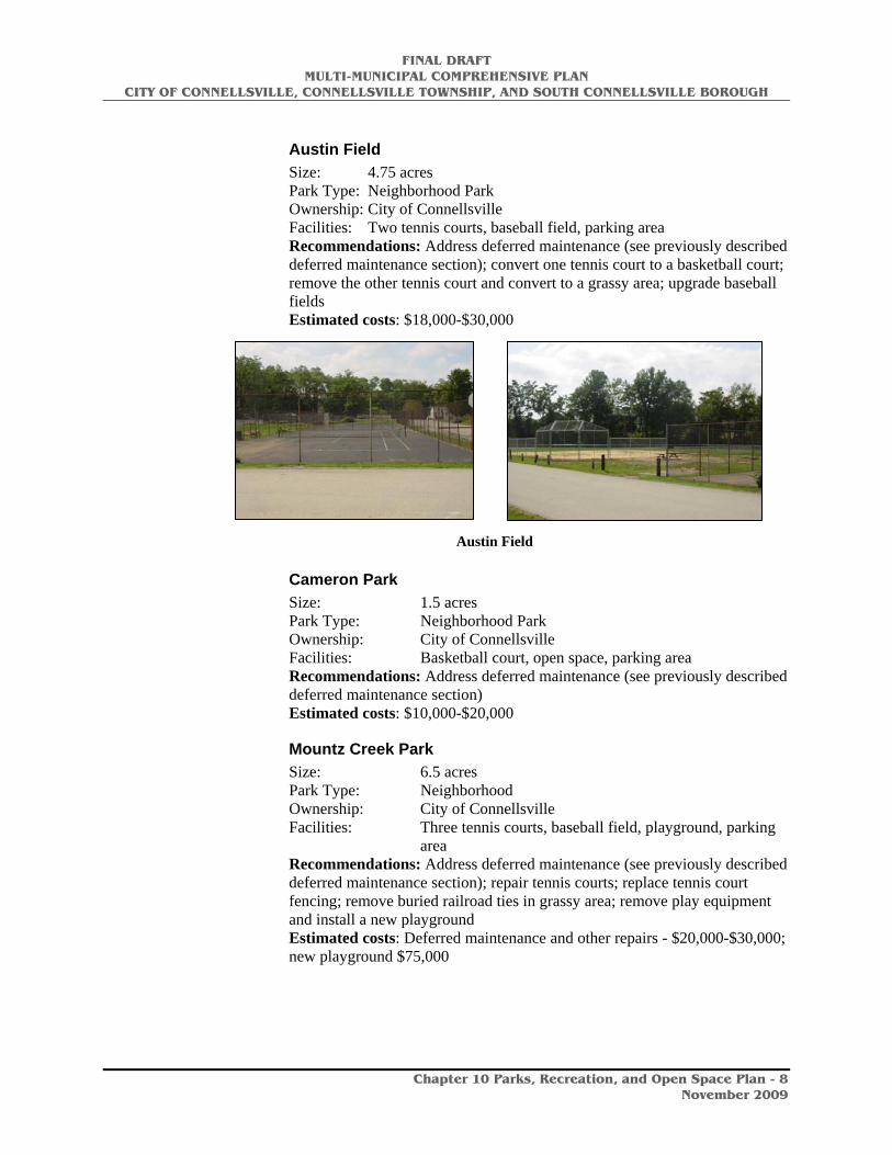
Austin Field
Austin Field Size: 4.75 acres Park Type: Neighborhood Park Ownership: City of Connellsville Facilities: Two tennis courts, baseball field, parking area Recommendations: Address deferred maintenance (see previously described deferred maintenance section); convert one tennis court to a basketball court; remove the other tennis court and convert to a grassy area; upgrade baseball fields Estimated costs: $18,000-$30,000
Cameron Park Size: 1.5 acres Park Type: Neighborhood Park Ownership: City of Connellsville Facilities: Basketball court, open space, parking area Recommendations: Address deferred maintenance (see previously described deferred maintenance section) Estimated costs: $10,000-$20,000
Mountz Creek Park Size: 6.5 acres Park Type: Neighborhood Ownership: City of Connellsville Facilities: Three tennis courts, baseball field, playground, parking
area Recommendations: Address deferred maintenance (see previously described deferred maintenance section); repair tennis courts; replace tennis court fencing; remove buried railroad ties in grassy area; remove play equipment and install a new playground Estimated costs: Deferred maintenance and other repairs - $20,000-$30,000; new playground $75,000

FINAL DRAFT MULTI-MUNICIPAL COMPREHENSIVE PLAN
CITY OF CONNELLSVILLE, CONNELLSVILLE TOWNSHIP, AND SOUTH CONNELLSVILLE BOROUGH
Chapter 10 Parks, Recreation, and Open Space Plan - 9
November 2009
Pinnacle Playground Size: 2.75 acre Park Type: Neighborhood Park Ownership: City of Connellsville Facilities: Basketball courts, playground, parking area Recommendations: Address deferred maintenance (see previously described deferred maintenance section); upgrade playground according to the findings of the safety audit. Estimated costs: $25,000 – $30,000
Southside Park Size: 1.45 acres Park Type: Neighborhood Ownership: City of Connellsville Facilities: Basketball court, playground, picnic shelter, volleyball
court, parking area Recommendations: Address deferred maintenance (see previously described deferred maintenance section); replace the playground Estimated costs: Deferred maintenance - $15,000-$25,000; Playground replacement - $75,000
Woodruff Park Size: 6.70 acres Park Type: Neighborhood Park Ownership: City of Connellsville Facilities: Picnic shelter, concession stand, two basketball courts,
playground, public restrooms, parking area Recommendations: Address deferred maintenance (see previously described deferred maintenance section); replace backstop; repair parking lot; make repairs to the playground based on the safety audit Estimated costs: $75,000-$200,000
Connellsville Little League Field Size: 2.75 acres (approx.) Park Type: Neighborhood Park Ownership: Connellsville Little League
Association Facilities: Little league field, press box,
restrooms, parking area
Yough River Park Size: 6.63 acres Park Type: Community/Special Use Ownership: City of Connellsville Facilities: Two picnic shelters, gazebo, bike trail access, boat
launch, concession stand/restroom, bandstand, four horseshoe courts, volleyball court, playground, boardwalk, two parking areas
Connellsville Little League Field
FINAL DRAFT MULTI-MUNICIPAL COMPREHENSIVE PLAN
CITY OF CONNELLSVILLE, CONNELLSVILLE TOWNSHIP, AND SOUTH CONNELLSVILLE BOROUGH
Chapter 10 Parks, Recreation, and Open Space Plan - 10
November 2009
The park also includes an area operated by the Connellsville Historical Society that includes the Colonel Crawford Cabin, a spring house, picnic shelter, and open lawn area.
This park will serve as the hub of the regions trails. The Great Allegheny Passage, the proposed Youghiogheny River Water Trail, and the planned Inter-City Loop Trail will all converge at this location. The park must be a place that will make visitors feel good about being in Connellsville. As well, it should draw residents who want to access the river, use the trails for recreation and exercise, or enjoy a gathering of family and friends.
As the City and region move to become one of the premier trail towns along the Great Allegheny Passage, this park will become a gateway to the community. A way finding system should be designed to point trail users toward key amenities in the City as well as business, historic, recreational, and natural attractions. The same way finding system should direct persons from city streets to the park and trails.
The proposed Inter-City Loop Trail will connect local residents and downtown business persons to the park and trails, and will also provide access for trail users to the host of City attractions.
Recommendations: Develop this park to be the hub of the region’s recreation. Implement the recommendations of the recently completed master site plan. This park should become one of the focal points of the community. Estimated Cost: See the master site plan
South Connellsville Park
South Connellsville Playground Size: 4.65 acres Park Type: Neighborhood Park Ownership: South Connellsville Borough Facilities: Tennis court, basketball court, playground, walking trail,
two baseball fields, picnic shelter, parking areas Comments: Serves as a community park for all of South
Connellsville. Recommendations: Make repairs to the playground based on the findings of the safety audit; improve drainage on the ballfields and trail Estimated costs: Playground upgrades - $30,000 Drainage improvements $30,000
Connellsville Township Park
Hawthorn Street Park – proposed for development Size: .35 acres Park Type: Neighborhood Park Ownership: Connellsville Township Facilities: Proposed facilities include benches, picnic tables, a
pavilion, and playground equipment

FINAL DRAFT MULTI-MUNICIPAL COMPREHENSIVE PLAN
CITY OF CONNELLSVILLE, CONNELLSVILLE TOWNSHIP, AND SOUTH CONNELLSVILLE BOROUGH
Chapter 10 Parks, Recreation, and Open Space Plan - 11
November 2009
Connellsville Area School District Recreation Facilities
The following facilities are located within the bounds of the three municipalities. An inventory of these facilities can be found in Appendix B.
Senior High School Outdoor facilities: Baseball field, softball field, batting cages, football/soccer field, practice football field, track, two practice soccer fields, four tennis courts.
Indoor facilities: Gymnasium, remedial gymnasium, wrestling room, weight/training room, swimming pool.
Junior High East Outdoor facilities: Practice baseball field, practice football field,
Indoor facilities: Gymnasium, remedial gymnasium
Connellsville Township Elementary School Outdoor facilities: Playground
Indoor facilities: Gymnasium
Zachariah Connell Elementary School Outdoor facilities: Playground, baseball field
Indoor facilities: Gymnasium
Southside Elementary School Outdoor facilities: Playground; grass play area
Indoor facilities: Gymnasium
Road leading into the school facilities
Southside School playground
FINAL DRAFT MULTI-MUNICIPAL COMPREHENSIVE PLAN
CITY OF CONNELLSVILLE, CONNELLSVILLE TOWNSHIP, AND SOUTH CONNELLSVILLE BOROUGH
Chapter 10 Parks, Recreation, and Open Space Plan - 12
November 2009
Private Schools
Geibel High School Outdoor facilities: Baseball field, softball field, football/soccer field
Indoor facilities: Gymnasium
Connellsville Area Catholic Elementary School Outdoor facilities: Play area
Indoor facilities: Gymnasium
See Appendix A for a more detailed inventory and analysis.
Connellsville Community Center
Located at 201 E. Fairview Avenue, the Connellsville Community Center was erected in 1916 as Connellsville School District’s new high school. The building eventually became a Junior High School and was later closed and sold to the City in 1983. The Greater Connellsville Area Community Center, Inc., a private, non-profit organization, now leases the building from the City and operates it as a community center. They employ a full-time executive director, secretary, and maintenance supervisor.
The Center houses a variety of social and recreational services including:
• Connellsville Community Ministries • Fayette County Community Action Agency • Twin Trees Community Living Arrangements • Salvation Army assistance programs • HoBo Model Railroad Club
The building includes 37 former classrooms, office space, a small gymnasium with bleacher seating, a 600 seat auditorium, and an 18’x60’ indoor swimming pool. The building is in fair condition, facing problems of an aging facility. The staff and Board have done a remarkable job of daily maintenance and up-keep on the building. Unfortunately the building still faces the need for significant improvements and attention to deferred maintenance. Much of the building is not in compliance with current building codes or with the Americans with Disabilities Act. A grant has been secured to renovate the auditorium. Similar investments will need to be made in other parts of the building as well.
A complete structural analysis should be conducted for the entire building to identify needed improvements and to provide a strategic plan from which the Community Center Board will be able to anticipate necessary structural investments. The existing pool is closed and is no longer used. Significant liability issues are inherent with the operation of such facilities. In an effort to reduce both risk and liability, a full infrastructure, operations, and compliance analysis should be completed on the community center’s pool.

FINAL DRAFT MULTI-MUNICIPAL COMPREHENSIVE PLAN
CITY OF CONNELLSVILLE, CONNELLSVILLE TOWNSHIP, AND SOUTH CONNELLSVILLE BOROUGH
Chapter 10 Parks, Recreation, and Open Space Plan - 13
November 2009
Great Allegheny Passage Trail south of Connellsville
Connellsville Area Trails
The trails of the Connellsville area have the potential to become the defining feature of the community for years to come. The convergence of multiple trails, both land and water based, can have a significant impact on the Connellsville community.
Trails provide a multitude of recreational opportunities for people of all ages and abilities. They attract users because of the vast array of opportunities that come with them…..the opportunity to walk, run, bike, blade or paddle; to enjoy the scenery, to exercise, to see the wildlife, be active, to be alone, to be with friends…the list goes on and on. It is because of this vast array of opportunities that trail users have rapidly become one of the largest recreational user groups nationwide. They come from the local community, from other places close-by, and from greater distances away.
The Youghiogheny River Trail has long been a recreation facility for residents of the Connellsville area. More recently, as it has become part of the Great Allegheny Passage, it has become an attraction for many from outside the area. The recent connection of the Sheepskin Trail will eventually connect to other regional trails; with the proposed Coal and Coke Trail connection, the development of an Inter-City Loop Trail, and the designation of the Yough River Water Trail, there is great attraction for visitors and trail users from around the region and beyond.
If the long-term trail plans fully pan out for the Connellsville area, it would mean as many as five trails converging in Connellsville. This will provide unprecedented recreational opportunities for local residents and will bring a throng of visitors through Connellsville.
Studies show that the longer a trail is the farther people will travel to visit it, the longer they will stay, and the more money they will spend. A single day user will spend four times as much as a local user will spend, and an overnight visitor will spend twice the amount of a single day user. Additionally, the more options available in a given location, the more likely trail users are to spend additional time there. Connellsville has the benefit of being along the 150-mile Great Allegheny Passage and that of being able to offer many recreational and support options for those who are passing through. The Inter-City Loop will offer access to a variety of businesses and attractions, while the Yough River Water Trail will provide a complementary opportunity for land trail users.
FINAL DRAFT MULTI-MUNICIPAL COMPREHENSIVE PLAN
CITY OF CONNELLSVILLE, CONNELLSVILLE TOWNSHIP, AND SOUTH CONNELLSVILLE BOROUGH
Chapter 10 Parks, Recreation, and Open Space Plan - 14
November 2009
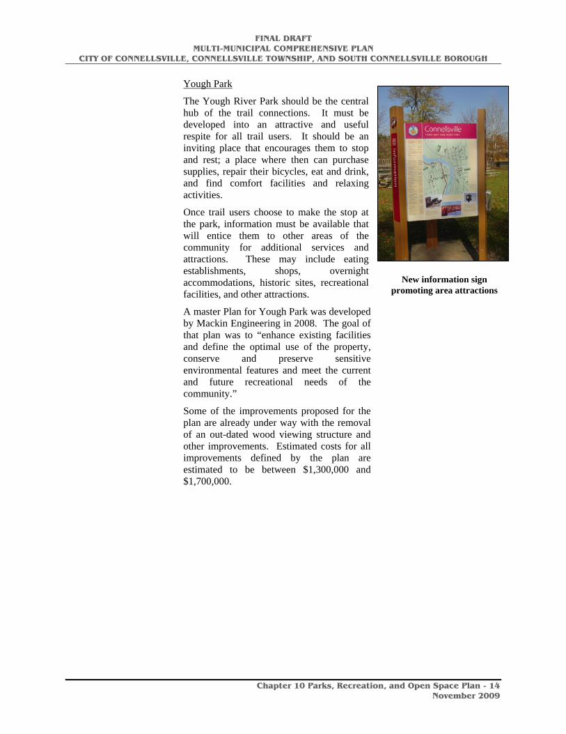
New information sign promoting area attractions
Yough Park
The Yough River Park should be the central hub of the trail connections. It must be developed into an attractive and useful respite for all trail users. It should be an inviting place that encourages them to stop and rest; a place where then can purchase supplies, repair their bicycles, eat and drink, and find comfort facilities and relaxing activities.
Once trail users choose to make the stop at the park, information must be available that will entice them to other areas of the community for additional services and attractions. These may include eating establishments, shops, overnight accommodations, historic sites, recreational facilities, and other attractions.
A master Plan for Yough Park was developed by Mackin Engineering in 2008. The goal of that plan was to “enhance existing facilities and define the optimal use of the property, conserve and preserve sensitive environmental features and meet the current and future recreational needs of the community.”
Some of the improvements proposed for the plan are already under way with the removal of an out-dated wood viewing structure and other improvements. Estimated costs for all improvements defined by the plan are estimated to be between $1,300,000 and $1,700,000.

FINAL DRAFT MULTI-MUNICIPAL COMPREHENSIVE PLAN
CITY OF CONNELLSVILLE, CONNELLSVILLE TOWNSHIP, AND SOUTH CONNELLSVILLE BOROUGH
Chapter 10 Parks, Recreation, and Open Space Plan - 15
November 2009
Prepared by Mackin Engineering, 2008
The Gateway to Gateway Master Plan
Prepared by Pashek Associates in 2009, the Plan identified several strategies related to improving parking at the Yough Park trailhead parking area. These include development of diagonal parking along North Third Street and to consider additional parking where the current beer distributor is located next to existing parking. The latter presumes an amicable relocation of the business to a new, more visible site, freeing up this riverfront land for higher and better uses. Although this might enhance parking issues for special events at Yough Park, there was some public input encouraging more park-like uses of the land should the beer distributor be relocated. There is always a tension between wanting to provide adequate parking for popular special events and the desire to not have to invest significant capital in paved areas that are rarely used for most of the year.

FINAL DRAFT MULTI-MUNICIPAL COMPREHENSIVE PLAN
CITY OF CONNELLSVILLE, CONNELLSVILLE TOWNSHIP, AND SOUTH CONNELLSVILLE BOROUGH
Chapter 10 Parks, Recreation, and Open Space Plan - 16
November 2009
Parking next to Yough Park
Prepared by Pashek Associates, 2009

FINAL DRAFT MULTI-MUNICIPAL COMPREHENSIVE PLAN
CITY OF CONNELLSVILLE, CONNELLSVILLE TOWNSHIP, AND SOUTH CONNELLSVILLE BOROUGH
Chapter 10 Parks, Recreation, and Open Space Plan - 17
November 2009
Diagonal Parking along North Third Street
Stewart’s Crossing
To celebrate a historic event in the history of the Connellsville area and to better interpret that event, a master plan for improvements to the park along the Yough River near the northern gateway into Connellsville along the

FINAL DRAFT MULTI-MUNICIPAL COMPREHENSIVE PLAN
CITY OF CONNELLSVILLE, CONNELLSVILLE TOWNSHIP, AND SOUTH CONNELLSVILLE BOROUGH
Chapter 10 Parks, Recreation, and Open Space Plan - 18
November 2009
Greater Allegheny Passage trail was developed. This plan was prepared by Widmer Engineering and David Reagan in 2008.
Development in this area includes additional park/trailhead parking behind Martin’s Grocery Store, trail connections to the Old Railroad Trestle and other trail user and park visitor amenities. Engineering has begun on the parking lot.

FINAL DRAFT MULTI-MUNICIPAL COMPREHENSIVE PLAN
CITY OF CONNELLSVILLE, CONNELLSVILLE TOWNSHIP, AND SOUTH CONNELLSVILLE BOROUGH
Chapter 10 Parks, Recreation, and Open Space Plan - 19
November 2009
Prepared by Widmer Engineering and David Reagan, 2008
Youghiogheny River Trail (part of the Great Allegheny Passage)
Flowing from the Youghiogheny Dam outlet just south of Confluence, PA and heading north to McKeesport, the Youghiogheny River, and its parallel trail-corridor, cover 70 miles. The Youghiogheny River Trail (YRT) is part of the Great Allegheny Passage, a 150-mile system of biking and hiking trails connecting Pittsburgh, PA with Cumberland, MD. The Great Allegheny Passage will eventually connect to Washington DC.
The YRT is divided into two sections, the YRT north, and the YRT south. The 43-mile North section is owned and operated by the Regional Trail Corporation. The 27-mile south section is owned and operated by the Commonwealth of PA, Department of Conservation and Natural Resources (DCNR), Bureau of State Parks.
FINAL DRAFT MULTI-MUNICIPAL COMPREHENSIVE PLAN
CITY OF CONNELLSVILLE, CONNELLSVILLE TOWNSHIP, AND SOUTH CONNELLSVILLE BOROUGH
Chapter 10 Parks, Recreation, and Open Space Plan - 20
November 2009
New gateway at Youghiogheny Trail
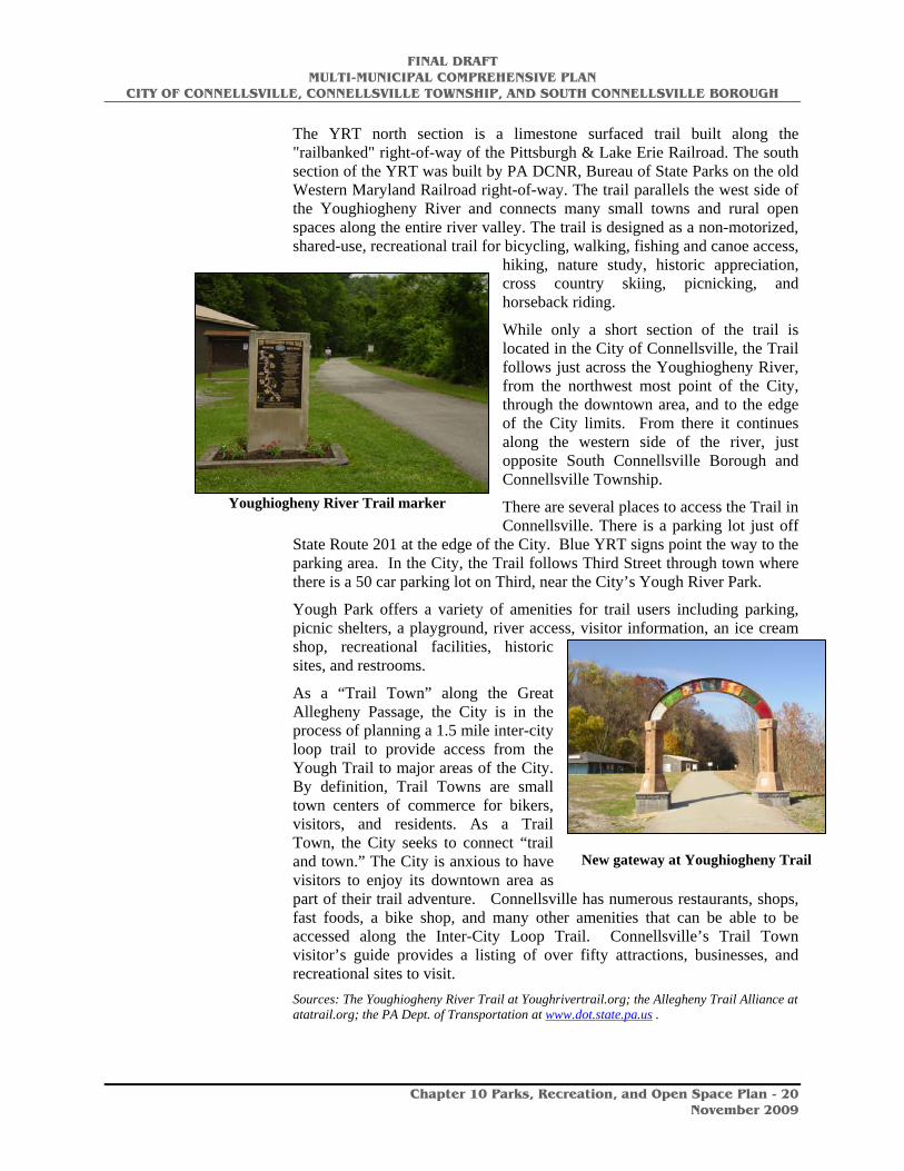
Youghiogheny River Trail marker
The YRT north section is a limestone surfaced trail built along the "railbanked" right-of-way of the Pittsburgh & Lake Erie Railroad. The south section of the YRT was built by PA DCNR, Bureau of State Parks on the old Western Maryland Railroad right-of-way. The trail parallels the west side of the Youghiogheny River and connects many small towns and rural open spaces along the entire river valley. The trail is designed as a non-motorized, shared-use, recreational trail for bicycling, walking, fishing and canoe access,
hiking, nature study, historic appreciation, cross country skiing, picnicking, and horseback riding.
While only a short section of the trail is located in the City of Connellsville, the Trail follows just across the Youghiogheny River, from the northwest most point of the City, through the downtown area, and to the edge of the City limits. From there it continues along the western side of the river, just opposite South Connellsville Borough and Connellsville Township.
There are several places to access the Trail in Connellsville. There is a parking lot just off
State Route 201 at the edge of the City. Blue YRT signs point the way to the parking area. In the City, the Trail follows Third Street through town where there is a 50 car parking lot on Third, near the City’s Yough River Park.
Yough Park offers a variety of amenities for trail users including parking, picnic shelters, a playground, river access, visitor information, an ice cream shop, recreational facilities, historic sites, and restrooms.
As a “Trail Town” along the Great Allegheny Passage, the City is in the process of planning a 1.5 mile inter-city loop trail to provide access from the Yough Trail to major areas of the City. By definition, Trail Towns are small town centers of commerce for bikers, visitors, and residents. As a Trail Town, the City seeks to connect “trail and town.” The City is anxious to have visitors to enjoy its downtown area as part of their trail adventure. Connellsville has numerous restaurants, shops, fast foods, a bike shop, and many other amenities that can be able to be accessed along the Inter-City Loop Trail. Connellsville’s Trail Town visitor’s guide provides a listing of over fifty attractions, businesses, and recreational sites to visit. Sources: The Youghiogheny River Trail at Youghrivertrail.org; the Allegheny Trail Alliance at atatrail.org; the PA Dept. of Transportation at www.dot.state.pa.us .

FINAL DRAFT MULTI-MUNICIPAL COMPREHENSIVE PLAN
CITY OF CONNELLSVILLE, CONNELLSVILLE TOWNSHIP, AND SOUTH CONNELLSVILLE BOROUGH
Chapter 10 Parks, Recreation, and Open Space Plan - 21
November 2009
An important element of planning for the Gateway to Gateway Master Plan was creating a stronger link from the Third Street Greater Allegheny Passage trail corridor to Downtown Connellsville. Recent studies show a significant economic impact of trail users on the vitality of trail towns. To strengthen the link between the trail and downtown, recommendations were developed to create a bike friendly streetscape along Crawford Avenue, across an enhanced Crawford Avenue bridge, into downtown, as illustrated on the following page.

FINAL DRAFT MULTI-MUNICIPAL COMPREHENSIVE PLAN
CITY OF CONNELLSVILLE, CONNELLSVILLE TOWNSHIP, AND SOUTH CONNELLSVILLE BOROUGH
Chapter 10 Parks, Recreation, and Open Space Plan - 22
November 2009
Prepared by Pashek Associates, 2009

FINAL DRAFT MULTI-MUNICIPAL COMPREHENSIVE PLAN
CITY OF CONNELLSVILLE, CONNELLSVILLE TOWNSHIP, AND SOUTH CONNELLSVILLE BOROUGH
Chapter 10 Parks, Recreation, and Open Space Plan - 23
November 2009
Prepared by Pashek Associates, 2009

FINAL DRAFT MULTI-MUNICIPAL COMPREHENSIVE PLAN
CITY OF CONNELLSVILLE, CONNELLSVILLE TOWNSHIP, AND SOUTH CONNELLSVILLE BOROUGH
Chapter 10 Parks, Recreation, and Open Space Plan - 24
November 2009

FINAL DRAFT MULTI-MUNICIPAL COMPREHENSIVE PLAN
CITY OF CONNELLSVILLE, CONNELLSVILLE TOWNSHIP, AND SOUTH CONNELLSVILLE BOROUGH
Chapter 10 Parks, Recreation, and Open Space Plan - 25
November 2009
Sheepskin Trail
The Sheepskin is a rail-trail project that cuts through the heart of central Fayette County. Still in the early stages of development, it is a missing link to a nationally significant trail system. To the north, it will link with the Pittsburgh-to-Washington DC Rail-Trail Network, the Potomac Heritage National Scenic Trail, and the American Discovery Trail. To the south, it will link with the West Virginia Rail-Trail System, and the American Discovery Trail. As a recreational greenway, the Sheepskin will link the Youghiogheny, Monongahela, and Cheat River watersheds—making it a significant greenway.
The Sheepskin is entirely in Fayette County, Pennsylvania, and will run approximately 33 miles from Dunbar Township (at the Youghiogheny River Trail connection) to Point Marion Borough (at the Mon River Trail connection). The trail will likely alternate between a “rail-trail” and a “rail-with-trail,” following the old Penn Central line, the old B&O / CSX line, and the active Southwest Pennsylvania Railroad.
The initial 2.2 miles of the Sheepskin Trail, located in Dunbar Township, opened on Memorial Day 2008 as a spur trail off of the Youghiogheny River Trail. The trail was developed through a PA Department of Conservation and Natural Resources planning grant obtained by Fayette County. Ultimately, the Sheepskin Trail will be 33 miles of rail trail connecting Port Marion and the trail system around Morgantown, through Uniontown to the Great Allegheny Passage just above Connellsville. Source: Local Hikes website http://www.localhikes.com/Hikes/Sheepskin_6280.asp, and Fayette County website http://www.co.fayette.pa.us/fayette/lib/fayette/trails/about_the_sheepskin_trail.pdf
Coal and Coke Trail
The Coal & Coke Trail is a 5 1/2 mile-long trail linking the Westmoreland County communities of Mount Pleasant and Scottdale. The Trail provides outdoor recreational opportunities for walkers, joggers, bikers, hikers, and cross-country skiers. The Coal and Coke Trail provides a non-motorized, handicapped accessible transportation source for area residents as well as tourists. Although most of the trail is bordered by woods, it crosses two roads and includes a share-the-road stretch about 1/4 mile long. It parallels Jacobs Creek for much of its length and crosses bridges over two of its tributaries - Sherrick Run and Shupe Run.
Along the way, trail enthusiasts can enjoy beautiful natural areas and occasional wildlife while following Jacob’s Creek past old coke ovens and
FINAL DRAFT MULTI-MUNICIPAL COMPREHENSIVE PLAN
CITY OF CONNELLSVILLE, CONNELLSVILLE TOWNSHIP, AND SOUTH CONNELLSVILLE BOROUGH
Chapter 10 Parks, Recreation, and Open Space Plan - 26
November 2009
adjoining communities. The trail follows “in history’s footsteps” the same paths as General Braddock, H.C. Frick, Andrew Carnegie, A.C. Cochran, and others. There are future plans to also provide a link to the West Overton Museum. The Coal and Coke Trail Chapter is a volunteer organization and is associated with the Regional Trail Corporation, a non-profit entity which promotes the conversion of right of ways into trails within Westmoreland, Allegheny and Fayette Counties.
The City of Connellsville proposes a connection of the Coke and Coal Trail with the Yough River Trail and their planned Inter-City Trail within the City limits. Source: Westmoreland County Parks and Recreation website at: http://www.co.westmoreland.pa.us/parks/cwp/view.asp?a=3&q=619363
The Youghiogheny River and Water Trail
The Yough River, by itself, is an exceptional recreational attraction for the Connellsville area. In combination with other local facilities, it becomes a hub of recreation for the entire region. It provides a wide variety of recreational opportunities. The most apparent are fishing, boating, canoeing, and kayaking. Swimming could be an option if a suitable location is available for the development of a beach area. Additionally, many people who prefer not to recreate on the water still enjoy being near the waters edge for their recreation pursuits. Many simply enjoy walking, sitting, picnicking, or relaxing along the rivers edge, fishing from the shore, recreating in riverside parks, seeing views of the river from a variety of locations such as scenic overlooks, residential areas, the business district, and parks.
While this Plan recommends that the Yough River Park be developed as the focal point of access to the river, the municipalities should consider protecting as much of the river front property as possible for public use and access. This can be done through acquisition, easements, or use agreements with private property owners.
A small privately owned beach, sometimes known as either Connellsville Beach or South Connellsville Beach, is located along the river in South Connellsville Borough. It is not available for public use.
A multiple track rail line through South Connellsville Borough and into Connellsville Township makes access to the River extremely difficult. The best option for the region is to develop access points in Connellsville Borough and provide bicycle, pedestrian, and vehicular routes to the those points.
The River is designated as a water trail by the PA Fish and Boat Commission. Water trails are similar to land trails except that users travel on waterways rather than land, using canoes, kayaks and small motorized watercraft. Like land-based trails, water trails are recreational corridors between specific locations. They have access points, boat launches, day use sites, and other amenities such as camping and picnic areas. As a designated water trail, Fish and Boat Commission has developed a map of the river that

FINAL DRAFT MULTI-MUNICIPAL COMPREHENSIVE PLAN
CITY OF CONNELLSVILLE, CONNELLSVILLE TOWNSHIP, AND SOUTH CONNELLSVILLE BOROUGH
Chapter 10 Parks, Recreation, and Open Space Plan - 27
November 2009
identifies access points and amenities; and interprets natural, cultural and historic features along the river. Additionally, it will provide use and safety information for users.
As a Trail Town, the addition of a water trail will provide added recreational and economic opportunities for the Connellsville area. A designated water trail will add great value to the area as it works to develop its Trail Town opportunities. A water trail brings an additional set of recreational users to the area.
The Pennsylvania Environmental Council has recently completed official map and guide for the Youghiogheny River Water Trail. The following description of the process comes from their website.
Although the river is used extensively by boaters, no official trail has been developed to map and explain the best places to put in and take out, things to see on the way and hazards to avoid. The Yough Water Trail will be unique because of the great variety in the river. Water flow is good below the Youghiogheny Reservoir because the Army Corps of Engineers regulates the water level. The first section, known as the Middle Yough, is a gorgeous area where the river cuts through Laurel Ridge offering Class I-II boating. Below Ohiopyle, the Class III-IV rapids of the Lower Yough are only for the experienced boater or those who opt for the outfitted raft trips with experienced guides. Below Connellsville, the river flattens out but the fishing remains good and opportunities to explore the rich history of coal mining and coke making are abundant along the adjacent shores. Interpretation of the river's recovery from years of extensive coal mining and other degradation are also available.
The goal of the water trail is to map and interpret features along the river from Yough Lake to the mouth of the river at McKeesport. The final map was published by the PA Fish and Boat Commission early in 2009. Source: http://www.pecpa.org/node/396
Robinson Falls
Robinson Falls is locally known as a "pristine archaeological site" located in Dunbar Township, just outside of Connellsville. The falls are located under Rt. 201 on Falls Avenue. Although this is outside the study area for this Plan, Connellsville should support and encourage the preservation and conservation of this unique natural and historic site.
Regional Recreation Opportunities
The regional trails have already been described as part of the previous inventory. Other regional facilities that impact the residents of the Connellsville area include three county parks, tow state parks, a state forests, and six state game lands.

FINAL DRAFT MULTI-MUNICIPAL COMPREHENSIVE PLAN
CITY OF CONNELLSVILLE, CONNELLSVILLE TOWNSHIP, AND SOUTH CONNELLSVILLE BOROUGH
Chapter 10 Parks, Recreation, and Open Space Plan - 28
November 2009
Fayette County Parks
Dunlap Creek Park, located in Menallen Township consists of 74 acres of wood and meadows, and a 30 acre lake that is used for boating and fishing. Facilities at this park include playgrounds, pavilions and a baseball field.
German-Masontown Park, located along the Monongahela River in the southwestern portion of the County is the largest of the County-owned parks consisting of 125 acres in German Township and Masontown Borough. The park has baseball fields, pavilions, an outdoor amphitheatre, a playground, tennis courts, soccer field, a bocce court, horse shoe pits, and a walking path.
Jacobs Creek Park contains 100 acres including a 60 acre lake for fishing and boating, picnic pavilions, and a playground.
State Parks, Forests, and Game Lands
Ohiopyle State Park - 19,052 acres. The focal point of the park is the more than 14 miles of the Youghiogheny River Gorge that travels through the park. The Yough provides some of the best whitewater boating in the Eastern U. S. as well as spectacular scenery. The Falls Day Use Area has parking, modern restrooms, gift shop/snack bar, and overlook platforms with beautiful scenery.
Laurel Ridge State Park - 13,625-acres. The park stretches along Laurel Mountain from the Youghiogheny River at Ohiopyle to the Conemaugh Gorge near Johnstown. The main feature of the park is the 70-mile Laurel Highlands Hiking Trail.
PA State Game Lands 51, 296, 238, 138, 265, and 111 are located in Fayette County near the Connellsville area.
Forbes State Forest – A portion of the 50,000 acre forest is located in Fayette County near the Connellsville area.
Maintenance and Management Plans
Maintaining the parks to a high standard ensures continued use of the parks and facilities and enhances the quality of life of local residents. It also encourages visitors to use the facilities and projects a positive image of the area. See Appendix C for more information.
Summary
There are a number of key issues that must be addressed in order to maximize the enjoyment and use of available recreational facilities. These issues include bringing all municipal recreation facilities into ADA compliance, conducting a playground safety audit, complying with the audit recommendations, addressing deferred maintenance in each park, explore the option of consolidating parks, and consider maintenance expenses when exploring new park or recreational facility options.
Besides the parks, ballfield, and school recreational facilities, there are the trail facilities connected to the Great Allegheny Passage that provide a wide range of opportunities that continue to grow and evolve.

FINAL DRAFT MULTI-MUNICIPAL COMPREHENSIVE PLAN
CITY OF CONNELLSVILLE, CONNELLSVILLE TOWNSHIP, AND SOUTH CONNELLSVILLE BOROUGH
Chapter 10 Parks, Recreation, and Open Space Plan - 29
November 2009
Implementation
Goal: Maintain, improve, and use existing parks and recreation resources to improve the quality of life for planning area residents.
Objectives:
1. Continue to maintain and improve municipal parks for both active and passive recreation.
2. Where feasible, use school district facilities to supplement community recreation facilities.
3. Encourage the private sector to enhance community recreational resources by maintaining and improving their facilities, e.g., Little League ballfields.
4. Pursue private sector and public sector funding for park and recreation improvements.
Goal: Improve the quality of life for planning area residents by increasing or expanding recreational resources and opportunities.
Objectives:
1. Promote improved health of residents by expanding the pedestrian and bicycle circulation system within the area, especially to link residential, commercial, and recreational areas.
2. As residential development occurs, monitor population increases to determine the nature, time, size, number, and location of needed additional recreation facilities.
3. Encourage and support the development of joint recreational facilities among state, regional, county, and local organizations.
4. Investigate the feasibility of redeveloping brownfields for recreational uses.
5. Pursue private sector and public sector funding for expanding and enhancing recreational resources.
Goal: Maintain the planning area’s rural character by preserving open space.
Objectives: 1. Encourage future development in areas with adequate
infrastructure and suitable topography, thus facilitating the preservation of open space.
2. Maintain farms as open space via appropriate zoning and agricultural preservation programs.
FINAL DRAFT MULTI-MUNICIPAL COMPREHENSIVE PLAN
CITY OF CONNELLSVILLE, CONNELLSVILLE TOWNSHIP, AND SOUTH CONNELLSVILLE BOROUGH
Chapter 10 Parks, Recreation, and Open Space Plan - 30
November 2009
3. Pursue private sector and public sector funding to acquire land to preserve existing open space.
Goal: Enhance the ability of park users to enjoy Yough Park through a more attractive layout of facilities, conserve and preserve sensitive environmental features, better trail access through the park, and more parking.
Objectives:
1. Realign parking lot to be more efficient 2. Realign Trail through the park and consider developing
Torrance Avenue as a bike only route 3. Create a new playground with a historical theme 4. Relocate or construct new picnic pavilions 5. Improve the boat launch 6. Stabilize the river bank 7. Expand the “Cream of the Trail” concessions, office and
restroom facility to better serve park visitors and trail users
Goal: Further the historic interpretation of “Stewart’s Crossing” by enhancing the park to accommodate additional visitors.
Objectives:
1. Improve Trailhead parking behind Martin’s Shopping Plaza 2. Provide additional trails to link to the Old Railroad Trestle
and other site features proposed for the park 3. Add information to provide additional historic interpretation
of “Stewart’s Crossing” 4. Develop additional trail and park amenities as money
becomes available
Goal: Enhance the trail experience from Yough Park to the Ohiopyle State Park border, while developing trail amenities that encourage trail users to stop and explore into downtown Connellsville.
Objectives:
1. Explore opportunities to relocate the beer distributor that
currently uses portions of City land. Develop that land for additional trailhead parking or to provide new home sites overlooking the river.
2. Develop the existing triangular park bound by Third Street and North First Street into a “commons” area for unstructured activities. Construct angled parking along Third Street to replace the parking currently taking place in the city park. Create at the end of the Commons attractive plantings, signs and sculpture to form another attractive gateway into Connellsville.
FINAL DRAFT MULTI-MUNICIPAL COMPREHENSIVE PLAN
CITY OF CONNELLSVILLE, CONNELLSVILLE TOWNSHIP, AND SOUTH CONNELLSVILLE BOROUGH
Chapter 10 Parks, Recreation, and Open Space Plan - 31
November 2009
3. Infill with new housing that incorporates the attractive architecture of many existing homes in the neighborhood.
4. Develop the intersection of Third Street and Crawford Avenue as a key gateway into the downtown business district. Construct trail user friendly plaza with bike storage, information kiosks and possibly new infill buildings to include offices, new retail on the first floor and possibly a youth hostel on the second floor.
5. Develop an attractive, bike friendly streetscape along Crawford Avenue that continues across the bridge into downtown Connellsville.
6. Develop cantilevered bike/ped walks on either or both sides of the Crawford Avenue bridge.
7. Develop trail alignment adjustments and attractive natural species plantings along the trail as it continues south from Crawford Avenue.
8. Create an attractive gateway at the southern end of the trail in Connellsville, welcoming people from Ohiopyle State Park into Connellsville. Provide information kiosks to identify opportunities in the downtown district. Provide additional interpretive information about the role of historic and present day industries in the development of Connellsville.
Goal: Utilize the Youghiogheny River as a local recreation opportunity and
as a regional water trail.
Objectives:
1. Redevelop Yough Park as the focal point of access to the River by local residents and as a gateway to the Connellsville region for river users from outside the region.
2. Promote the Youghiogheny River Water Trail for its recreational, historic, and tourism opportunities.
3. Recognize the Youghiogheny River Water Trail as a significant component of Trail Town development.
4. Develop pedestrian, bicycle and vehicular routes to connect residents of South Connellsville and Connellsville Township to the Yough Park access to the River and trails.
5. Protect and preserve as much of the river front property in the three municipalities as possible for public use and access. This can be done through acquisition, easements, or use agreements with private property owners.
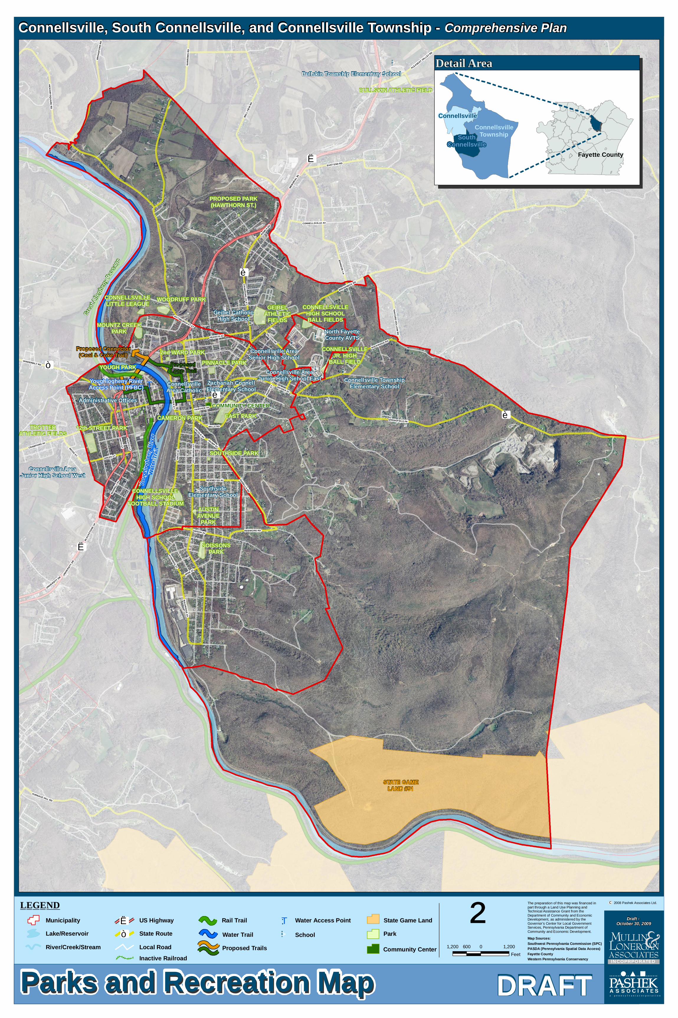
!>
!>
!> !>
!>
!>
!>
!>
!>
!>
:"T"è
"Ë
"Ë
"è
"ò
"è
STATE GAMELAND #51
BULLSKIN ATHLETIC FIELD
Bullskin Township Elementary School
CONNELLSVILLELITTLE LEAGUE WOODRUFF PARK
MOUNTZ CREEKPARK
CONNELLSVILLEJR. HIGH
BALL FIELD
CONNELLSVILLEHIGH SCHOOLBALL FIELDS
GEIBELATHLETIC
FIELDS
Connellsville AreaJunior High School East Connellsville Township
Elementary School
Connellsville AreaSenior High School
Geibel CatholicHigh School
North FayetteCounty AVTS
ConnellsvilleArea Catholic
Zachariah ConnellElementary School
AUSTINAVENUE
PARK
CONNELLSVILLE HIGH SCHOOL
FOOTBALL STADIUM
SOISSONSPARK
SouthsideElementary School
TROTTERATHLETIC FIELDS
Connellsville AreaJunior High School West
Administrative Offices
Youghiogheny RiverAccess Point (PFBC)
Youg
hiogh
eny R
iver
Youg
hiogh
eny R
iver
Water
Trail
Water
Trail
Great
Alleg
heny
Pass
age
YOUGH PARK
2nd WARD PARKPINNACLE PARK
EAST PARKCAMERON PARK
SOUTHSIDE PARK
12th STREET PARK
COMMUNITY CENTER
PROPOSED PARK(HAWTHORN ST.)
Proposed Loop Trail
Proposed Connector(Coal & Coke Trail)
MEMOR
IAL BL
BREAKNECK RD
SPRINGFIELD PK
NARR
OWS
RDPIT
TSBU
RGH
ST
FURNACE HILL RD
EAST END RD
ARCH
ST
BELL
VIEW
RD
BROA
DFOR
D RD
JOHNSON LN
SWINK HILL RD
ENGLISHMAN HILL RD
UNIVERSIT
Y DR
ROCKRIDGE RD
WATER ST
CRAWFORD AV
BLAC
KSTO
NE LN
ISABELLA RD
RICH HILL RD
CRAWFORD AV ET
GIBSON AV
QUAIL HILL RD
SNYDER ST
FRANCIS AV
BREA
KIRO
N RD
EIGHTH ST
HYNDMAN ST
HICKORYSQUARE RD
FAIRVIEW AV
MORR
ELL A
V
NINTH ST
VANDERBILT RD
FALCON DR
PLEASENT VALLEY RD
GREEN ST
WOOD ST
TANYARD HOLLOW RD
BALDRIDGE AV
NEWMEYER AV
WILLS RD
REIDMORE RD
CONNELLSVILLE AV
WINE ST
LINCOLN AV
TRUMP AV
PERR
Y ST
PITTSBURGH ST ET
RAMP E RD
UNIVERSITY DR
Parks and Recreation MapParks and Recreation Map DRAFT
Connellsville, South Connellsville, and Connellsville Township - Comprehensive Plan
²c 2008 Pashek Associates Ltd.The preparation of this map was financed in
part through a Land Use Planning and Technical Assistance Grant from the Department of Community and Economic Development, as administered by the Governor’s Center for Local Government Services, Pennsylvania Department of Community and Economic Development.
Map Sources:Southwest Pennsylvania Commission (SPC)PASDA (Pennsylvania Spatial Data Access) Fayette CountyWestern Pennsylvania Conservancy
1,200 0 1,200600Feet
Detail Area
Fayette County
SouthConnellsville
ConnellsvilleTownship
Connellsville
Draft - October 30, 2009
a p e n n s y l v a n i a c o r p o r a t i o n
INCOPRPORATED
Proposed Trails
LEGEND
River/Creek/Stream Local Road
State Game LandLake/Reservoir State Route"ò
Rail Trail
School
Municipality US Highway"Ë
Inactive Railroad
Water Access PointWater Trail
:"T
!> Park
Community Center
FINAL DRAFT MULTI-MUNICIPAL COMPREHENSIVE PLAN
CITY OF CONNELLSVILLE, CONNELLSVILLE TOWNSHIP, AND SOUTH CONNELLSVILLE BOROUGH
Chapter 11 Energy Conservation Plan - 1
November 2009
Chapter 11 Energy Conservation Plan
Introduction
The purpose of this section of the comprehensive plan is to analyze the impact of plan elements on energy consumption and to promote the effective use of energy sources. This topic will become increasingly important as the economy continues to transition to include a wider range of fuel sources and consumer consumption patterns.
Impact of Plan Elements on Energy Consumption
The comprehensive plan contains numerous elements that impact energy consumption. Such elements and their energy conservation ramifications include the following:
Encouraging infill development in urban areas rather than new development in suburban or rural areas, thereby making maximum use of existing public infrastructure.
Promoting compact, mixed use development that will create walkable neighborhoods that reduce the use of automobiles for daily activities. This will reduce fuel consumption.
Supporting cluster development that will minimize the amount of roadway needed to serve and link residential, commercial, and other areas and thereby reduce travel times and fuel consumption.
Encouraging the rehabilitation of existing structures in developed areas to reduce the demand for new construction in undeveloped areas. This will reduce the need for additional roads and fuel consumption.
Supporting the development of a variety of housing types, thereby providing additional housing choices for people who work within the planning region but currently live outside the area. Such additional housing choices will reduce commuting times and fuel consumption. Riverfront housing on the Youghiogheny River could link housing with riverfront activities, creating more dynamic housing options that take advantage of the riverfront.
Creating and improving pedestrian and bicycling circulation systems (including greenways) that will encourage hiking and biking as alternatives to automobiles, thereby reducing fuel consumption. One example is the proposed 1.5 mile Inter-City Hiking/Biking Loop linking downtown Connellsville with the Great Allegheny Passage Trail and businesses on S.R. 119.

FINAL DRAFT MULTI-MUNICIPAL COMPREHENSIVE PLAN
CITY OF CONNELLSVILLE, CONNELLSVILLE TOWNSHIP, AND SOUTH CONNELLSVILLE BOROUGH
Chapter 11 Energy Conservation Plan - 2
November 2009
Promoting energy efficient design and materials for new construction and rehabilitation that will reduce fuel consumption for heating and cooling structures.
Maintaining the transportation network to prevent road and bridge closures that necessitate detours and entail increased fuel consumption.
Improving the public transit system to reduce the use of automobiles, thereby reducing fuel consumption.
Pursuing economic development efforts to provide more jobs within the planning area, thereby reducing the need for area residents to travel outside the planning area for employment. This reduces travel times and fuel consumption.
Implementation
The following goals and objectives are proposed to address the planning region’s energy conservation and development needs:
Goal: Reduce energy consumption.
Objectives:
1. Establish standards to guide the appropriate and efficient use of energy in municipal programs, purchases, and practices.
2. Promote carpooling and public transit use.
3. Support ongoing programs for resource recovery and recycling of solid wastes.
4. Continue efforts of cooperation among residents, utility companies, and local, county, regional, state, and federal agencies concerning energy-related issues and programs.
5. Work with Fayette County and economic development agencies to attract businesses that will provide jobs for planning area residents. This will reduce the commuting times (and therefore energy costs) of area residents.
6. Maintain elements of the transportation network (e.g., roads and bridges) to reduce the need for detours that increase fuel consumption and costs.
7. Support transportation improvements that will reduce energy consumption by alleviating traffic congestion and improving traffic flow.
FINAL DRAFT MULTI-MUNICIPAL COMPREHENSIVE PLAN
CITY OF CONNELLSVILLE, CONNELLSVILLE TOWNSHIP, AND SOUTH CONNELLSVILLE BOROUGH
Chapter 11 Energy Conservation Plan - 3
November 2009
8. Encourage alternative transportation networks, e.g., bicycle and pedestrian circulation systems that will reduce the need for automobile use for daily activities.
9. Support clustered development with connecting service roads and paths that accommodate vehicles, bicycles, and pedestrians.
10. Educate property owners regarding the benefits of energy conservation – saving money, making housing affordable, etc.
11. Encourage the use of new DEP programs, such as the Pennsylvania Sunshine Solar Program, to reduce energy consumption.
Goal: Promote the conservation of non-renewable energy resources.
Objectives:
1. Adopt and enforce development and building standards that encourage and support energy efficient design and materials in all construction and land development. Promote the U.S. Environmental Protection Agency’s Energy Star Program regarding the use of energy efficient products in all new construction and rehabilitation. Also, encourage landscaping that promotes energy conservation, e.g., using trees as wind shields or for shading to reduce the cost of heating or cooling structures.
2. Encourage and participate in any energy conservation planning or programs undertaken by Fayette County or regional, state, or federal entities.
3. Support natural resource preservation, conservation, and protection measures for both renewable and non-renewable energy resources.
Goal: Encourage the development of renewable energy sources.
Objectives:
1. Promote development, use, and protection of renewable energy resources, e.g., solar, wind, and water. Protection can be achieved through land use regulations and other measures.
2. Establish standards to regulate noise pollution generated by wind turbines.
See Appendix D: Urban Sustainability Guidelines for more information.
FINAL DRAFT MULTI-MUNICIPAL COMPREHENSIVE PLAN
CITY OF CONNELLSVILLE, CONNELLSVILLE TOWNSHIP, AND SOUTH CONNELLSVILLE BOROUGH
Chapter 12 Land Use Plan - 1
November 2009
Chapter 12 Land Use Plan
Introduction
This element of the multi-municipal comprehensive plan provides guidance on future land use in the planning area. The land use plan should be evaluated in conjunction with all the other plan elements, including transportation, community facilities and open space. Existing land use patterns have a significant impact on the future land use plan for the planning area, in addition to traffic circulation and demand for community facilities and services.
The Future Land Use Plan map included in this section is intended to be general in nature for Connellsville Township and South Connellsville Borough. It is not intended to serve as a zoning map. For the City of Connellsville the map is more specific, particularly as it relates to the central business district. Currently, the City of Connellsville and Connellsville Township administer there own zoning codes and ordinances. South Connellsville Borough’s zoning is covered under Fayette County’s zoning ordinance.
Analysis of Existing Land Use Patterns 1
The land use patterns of the City of Connellsville, South Connellsville Borough, and Connellsville Township vary according to the development patterns of the communities over the last 200 years. The three communities have retained much of their rural characteristics.
City of Connellsville
The City of Connellsville has a healthy mix of residential, commercial, and industrial uses. The City of Connellsville’s central business district serves as the main central business area for the three communities. The central business district contains a distinct, traditional business district, with older historic buildings that have storefronts with some residential and office uses above on the second and third floors. The residential areas closer to the central business district are dense, with smaller lot sizes and narrower setbacks. The housing located west, south, and east of the downtown tends to be on larger lots with more single-family homes. The parcels adjoining U.S. Route 119 in the northwestern portion of the community tend to be more auto-oriented, with shopping centers and plazas that are conducive to automobile traffic. The industrial areas are primarily located along the eastern bank of the Youghiogheny River and just south of West Crawford Avenue near the central business district.
1 Existing land uses within the planning area were determined through a combination of visually observed land uses and a review of the land’s underlying zoning classification.

FINAL DRAFT MULTI-MUNICIPAL COMPREHENSIVE PLAN
CITY OF CONNELLSVILLE, CONNELLSVILLE TOWNSHIP, AND SOUTH CONNELLSVILLE BOROUGH
Chapter 12 Land Use Plan - 2
November 2009
Connellsville’s Traditional Central Business District
South Connellsville Borough
South Connellsville Borough, to the south of the City of Connellsville, is primarily a low-density residential community, with a small commercial area. It also contains a large tract of industrial land along the Youghiogheny River that houses the former Anchor Hocking site and the Crown Cork and Seal plant. The eastern portion of the community contains a large tract of wooded land. The southeastern portion of South Connellsville Borough contains an outdoor sports club. The area also contains a portion of the South Connellsville Slopes Biological Diversity Area (BDA), which consists primarily of vast expanses of open space, consisting predominantly of woodlands, wetlands, steep slopes and other environmentally constrained land areas.
Connellsville Township
Connellsville Township is primarily a low-density residential community with farms and an abundance of open space. The township contains 7,368 acres of largely wooded land with residential areas, commercial districts, and industrial uses interspersed throughout. It is estimated that close to 80% of the land within Connellsville Township is open space.
The Existing Land Use maps on the following pages are for each of the three communities.
Commercial
Commercial uses are found throughout the Connellsville area but are concentrated primarily in the City of Connellsville. There are neighborhood convenience stores located in each of the communities. Other types of commercial uses can also be found along major transportation routes throughout the communities, particularly along Rt. 119 but also along Rt. 711.
Commercial uses range from small businesses on single lots to strip mall developments along major corridor and small shopping centers at key intersections.

FINAL DRAFT MULTI-MUNICIPAL COMPREHENSIVE PLAN
CITY OF CONNELLSVILLE, CONNELLSVILLE TOWNSHIP, AND SOUTH CONNELLSVILLE BOROUGH
Chapter 12 Land Use Plan - 3
November 2009
Established Single Family Housing in Connellsville Township
Medium density housing in the City of Connellsville
Higher density housing in the City of Connellsville
Residential
Single-family residential is the primary housing type in each of the three communities.
The lower density units are located primarily in Connellsville Township. Many of these homes are located on bigger lots with larger setbacks and backyards. Many of the homes in the eastern portion of the township abut the more open spaces that provide recreational opportunities.
Medium density residential uses are found primarily in the residential areas of the City of Connellsville as well as South Connellsville Borough. These areas are also primarily detached single family units. Lot sizes are generally more compact and smaller. These areas are typically served by public water and sewer systems.
Higher density residential units tend to be located closer to the City of Connellsville’s central business district, and along the main corridors of U.S. Route 119 and SR 711. These developments patterns follow a traditional pattern of development radiating from the central business district when rail and street cars were the primary means of transportation. Many of the homes were built around the turn of the century, from the 1880’s to the early 1900’s.

FINAL DRAFT MULTI-MUNICIPAL COMPREHENSIVE PLAN
CITY OF CONNELLSVILLE, CONNELLSVILLE TOWNSHIP, AND SOUTH CONNELLSVILLE BOROUGH
Chapter 12 Land Use Plan - 4
November 2009
Connellsville Heritage Apartments in the City of Connellsville
The existing multi-family housing in the planning area is primarily located in the City of Connellsville. This consists of several small apartment complexes, in addition to larger, multi-story housing, primarily off of U.S. Route 119 and North Pittsburgh Street northeast of the core downtown area. There are a few residential units that occupy upper floors in the business
district, primarily along West Crawford Avenue.
The following existing land use maps for the three communities are based on a combination of sources that include the following: current zoning maps, field visits, input from community stakeholders, and land use information from the Fayette County Assessment web site.

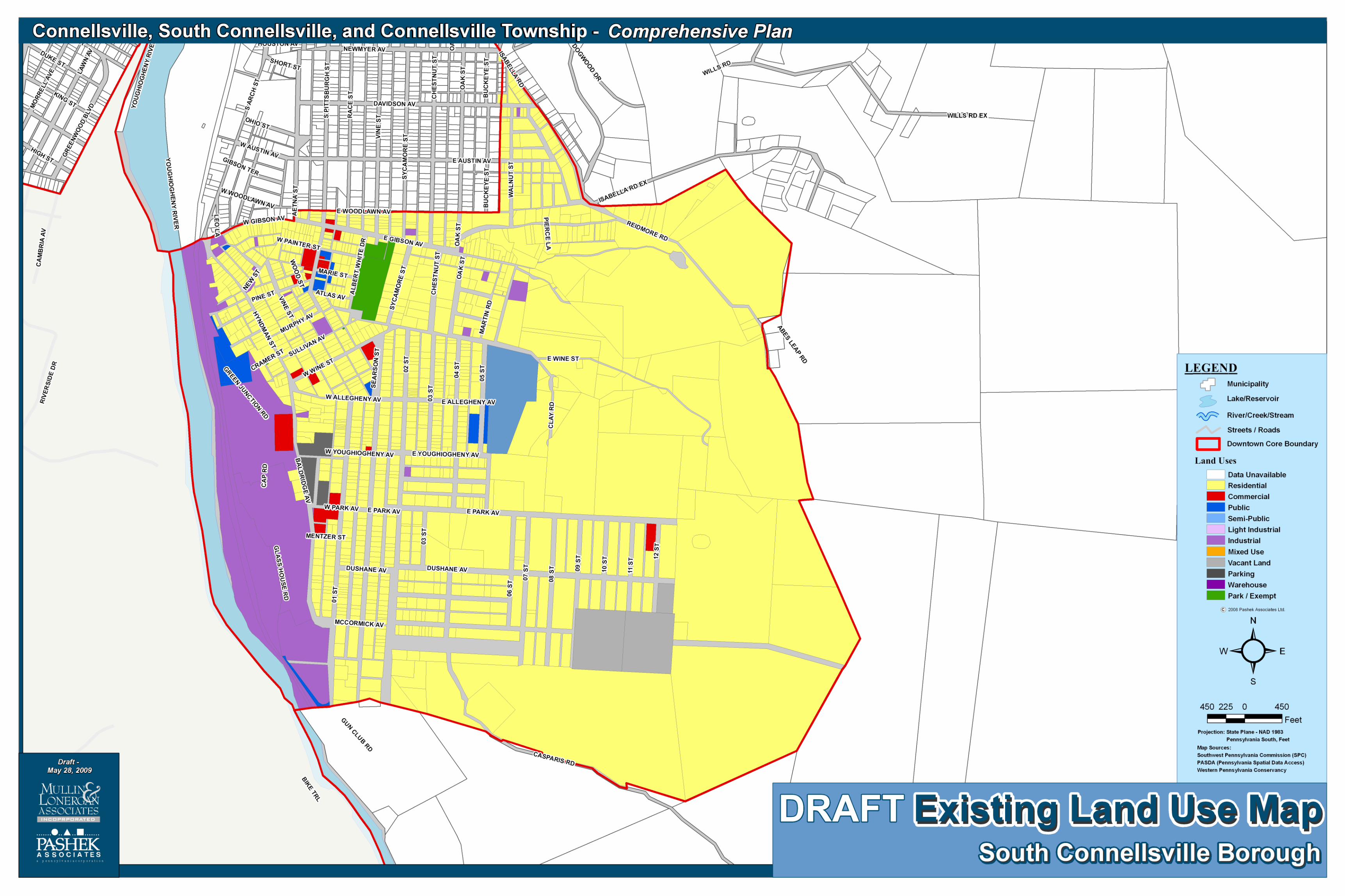


FINAL DRAFT MULTI-MUNICIPAL COMPREHENSIVE PLAN
CITY OF CONNELLSVILLE, CONNELLSVILLE TOWNSHIP, AND SOUTH CONNELLSVILLE BOROUGH
Chapter 12 Land Use Plan - 5
November 2009
Open space in Connellsville Township
Anchor Hocking Plant in South Connellsville Township
Industrial
Industrial uses are primarily located along the Youghiogheny River, although industrial uses can be found interspersed in other areas in each of the three communities, including within residential areas.
Agricultural
No agriculture land exists in the City of Connellsville. In Connellsville Township, the topography limits the majority of the undeveloped land to open space with some agricultural use. For South Connellsville Borough, the topography also precludes traditional agriculture. Most of the open space is used for recreational purposes or remains undeveloped.
Park and Open Space
Vast expanses of open space contribute to the rich rural environment across the Connellsville area, particularly on the eastern and southeastern edges of Connellsville Township and the eastern areas of South Connellsville Borough. Typically, open space refers to land that is not specifically agricultural in nature. Dedicated public park space is also plentiful and smaller community-oriented park and playground areas exist in all the municipalities. More detailed information is provided in Chapter 10 of this document.
FINAL DRAFT MULTI-MUNICIPAL COMPREHENSIVE PLAN
CITY OF CONNELLSVILLE, CONNELLSVILLE TOWNSHIP, AND SOUTH CONNELLSVILLE BOROUGH
Chapter 12 Land Use Plan - 6
November 2009
Steep slopes and hillside in
South Connellsville Borough
Community Facilities
Other land uses in the planning region include community facilities such as government buildings, libraries, post offices, volunteer fire departments and the park facilities at Youghiogheny Park.
Future Land Use Plan
Future land use designations recommended for the three communities in the planning area are discussed below. These designations are also illustrated on the Future Land Use maps for each of the three communities. Future Land Use maps should be consistent with the Future Land Use Plan element of the comprehensive plan. As discussed at the beginning of this chapter, the zoning and review process is different in each community. The City of Connellsville and Connellsville Township administer their own zoning codes and ordinances. South Connellsville Borough’s zoning is covered under Fayette County’s zoning ordinance. In addition, due to the built-out nature of some of the communities, in particular the City of Connellsville, there is a wide-range of uses in each land use category that may not be compatible. For instance, within the low density residential future land use category there are uses that range from commercial to industrial. The land uses for the property owners are protected by a grandfather clause which does not preclude certain land uses in a defined area. These categories should be viewed as broad categories based on the predominant existing land use.
FINAL DRAFT MULTI-MUNICIPAL COMPREHENSIVE PLAN
CITY OF CONNELLSVILLE, CONNELLSVILLE TOWNSHIP, AND SOUTH CONNELLSVILLE BOROUGH
Chapter 12 Land Use Plan - 7
November 2009
Low Density Residential
These areas are intended generally for residential development of one dwelling unit per quarter-acre or half-acre lot (depending on the municipality) with public sewer service. With on-lot septic systems, one dwelling unit per two acres should not be exceeded.
Typically, areas recommended for the Low Density Residential designation reflect residential development that has occurred along existing township roads and within subdivisions containing new roads. Land adjoining existing development, which is considered appropriate for expansion of residential development because of the absence of severe building limitations, has also been included in this category. Low Density Residential areas are appropriate as future growth areas, particularly for Connellsville Township and some portions of South Connellsville Borough. For the City of Connellsville most of the low density area is built-out, with potential infill development opportunities as parcels become available from demolition or other avenues.
High Density Residential
High Density Residential areas are found around the core area of Connellsville’s existing developed nodes. These areas have the greatest potential for new infill development. These areas are within existing public sewer and water service areas or have the potential to be served by public sewer and water in the near future. Residential development for new single family housing units would be appropriate with 1 dwelling unit per 6,000 to 8,000 square feet (depending on the municipality) with public sewer service.
Encouraging development to locate in areas where public sewer and water exist allows for a greater density of development to occur, providing for compact, orderly growth and more efficient provision of utilities.
Central Business District
Central Business District areas are intended to accommodate a wide range of medium to high density commercial uses at appropriate locations where a nucleus of commercial uses exist. These would include businesses serving the day-to-day needs of local residents in addition to regional customers for the banks, law offices, engineering firms and other professional services. Commercial uses would also include small personal service establishments (beauty salons, barber shops, in-home repair businesses of small appliances or computers, etc.) and small retail establishments (video rental store, florist shop, coffee shop, newsstand, bakery, etc.).
Highway Commercial
Highway Commercial areas are intended to accommodate a larger, more regional customer base along more heavily traveled routes, including SR 711 and U.S. Route119 to move travelers through the Connellsville area.
Corridor
Corridor Areas are intended to provide as transition areas between higher density central business districts and/or residential areas. Examples of these

FINAL DRAFT MULTI-MUNICIPAL COMPREHENSIVE PLAN
CITY OF CONNELLSVILLE, CONNELLSVILLE TOWNSHIP, AND SOUTH CONNELLSVILLE BOROUGH
Chapter 12 Land Use Plan - 8
November 2009
corridors include portions of Pittsburgh Street between U.S. Route119 close to Crawford Avenue. These areas have unique land use issues ranging from conversion of single-family homes to business use and land uses which may be inappropriate in proximity to a residential community.
Industrial
The intent of the Industrial areas is to accommodate a wide range of light and heavy industrial land uses with access to major transportation routes which would have limited impact on nearby residential areas. Appropriate land uses might include offices, light industry, mixed commercial uses, research and development, warehousing and distribution, transportation-related land uses, and extraction industries. Industrial areas are appropriately designated as future growth areas. A minimum lot size of 20,000 square feet is recommended if public sewer service is available. Otherwise, DEP requirements should govern the development standards.
Agriculture/Open Space
This land use category would be used for areas designated for the preservation of agricultural lands and scenic landscapes where existing farms can continue and expand while protected from the encroachment of higher density and incompatible land uses. Agricultural security areas and rural resource areas would also be included. Appropriate land uses include agriculture and associated structures such as barns and storage buildings, agricultural-related businesses, woodlands, parks, community facilities, and greenways.
Agriculture areas would also accommodate rural residential development which can be a combination of farmland, woodland, open space, and low density residential development. Some low density residential subdivision has occurred in these areas, and such growth pressure will continue. These areas are typically found away from major thoroughfares. Public water and sewer services for these areas are not planned in the near future, and in some cases, may not be constructed in order to maintain the rural environment. Furthermore, some of the land designated as Agriculture is restrictive to development because of steep slopes. There are very few areas that qualify as agricultural due to the topography.
Single family residential development is appropriate in the Agriculture/Open Space areas with one dwelling unit per two acres with on-lot septic systems and one dwelling unit per one acre with public sewer service.
Parks and Recreation
The intent of the Parks and Recreation land use category is to limit, and in some cases prohibit, development in areas with severe limitations to development due primarily to steep slopes, floodplains, wetlands, wet soils, headwaters of streams, and woodlands. It also includes floodplains, wetlands, and hydric soils along stream corridors. It is intended to protect the valuable parks and recreation assets in the Connellsville area.
Limited development should occur in these areas in order to:

FINAL DRAFT MULTI-MUNICIPAL COMPREHENSIVE PLAN
CITY OF CONNELLSVILLE, CONNELLSVILLE TOWNSHIP, AND SOUTH CONNELLSVILLE BOROUGH
Chapter 12 Land Use Plan - 9
November 2009
• protect watersheds and water supplies, vulnerable wooded steep slopes, and woodlands
• maintain rural character
• conserve ecosystems by maintaining an adequate critical mass through connecting the ecosystems
The Future Land Use designations illustrated on the Future Land Use maps are summarized in Table 12-1. This provides for an accommodation of land uses.
Anticipated Growth Areas
Land use is a critical component of the planning area’s multi-municipal comprehensive plan. Public policy relative to the desirable use of land will play a key role in defining the area’s future. The planning area’s Future Land Use plan has been designed to reflect the vision of residents regarding their desires and hopes for the area. The goal of this multi-municipal comprehensive plan is to describe the characteristics of areas where future growth is appropriate.
The following criteria can be used to define where growth should occur in the planning area:
Proximity to transportation corridors
Proximity to existing population centers
Proximity to existing and proposed utilities (e.g., water and sewer lines)
Proximity to areas projected to incur population and housing unit increases
Economic impact (e.g., job creation, re-use of existing brownfields and vacant buildings)
Distance from land with environmental constraints (e.g., steep slopes, floodplains, open space, natural resources), and
Preservation of prime agricultural soils and forested lands.
These guidelines are meant to provide a general framework for the location of future development. It is anticipated that economics will generally guide the overall future development patterns in the planning area.
In the planning area, the designated growth areas include the Low Density Residential, High Density Residential, Central Business District, Highway Commercial, Corridor, and Industrial land use categories on the Future Land Use map for each of the three communities. See the Future Land Use maps for details.

FINAL DRAFT MULTI-MUNICIPAL COMPREHENSIVE PLAN
CITY OF CONNELLSVILLE, CONNELLSVILLE TOWNSHIP, AND SOUTH CONNELLSVILLE BOROUGH
Chapter 12 Land Use Plan - 10
November 2009
Anticipated Rural Resource Areas
In addition to designating growth areas, the planning area may also designate rural resource areas. The MPC defines a rural resource area as one “within which rural resources uses including but not limited to, agriculture, timbering, mining, quarrying and other extractive industries, forest and game lands and recreation and tourism are encouraged and enhanced, development that is compatible with or supportive of such uses is permitted, and public infrastructure services are not provided except in villages.” The rural resource area designation is intended to restrict development in designated rural areas and to limit the availability of infrastructure in such areas. The MPC further provides that publicly financed water and sewer services will not be provided in these areas.
Through the comprehensive planning process, large expanses of woodland and open space areas were designated as areas where the municipalities sought to preserve the existing characteristics. These included undisturbed or minimally disturbed woodlands and open space, as well as public parks. It was recognized that these rural and natural characteristics were valuable indicators of the quality of life enjoyed by current residents in the Connellsville area and sought out by new residents. To preserve these areas in a state as close as possible to their current condition became a high priority. Guiding future development in the planning region to designated future growth areas would complement the preservation of rural resource areas.
On the Future Land Use maps, rural resource areas include Agriculture /Open Space, Parks and Recreation, and Natural/Open Space land use categories.

FINAL DRAFT MULTI-MUNICIPAL COMPREHENSIVE PLAN
CITY OF CONNELLSVILLE, CONNELLSVILLE TOWNSHIP, AND SOUTH CONNELLSVILLE BOROUGH
Chapter 12 Land Use Plan - 11
November 2009
Table 12-1 Future Land Use Designations
Land Use Category Purpose Appropriate Land Uses Recommended Minimum Lot Size
Agriculture/Open Space*
Areas designated for preservation of agricultural lands and scenic landscapes where existing farms can continue and expand, protected from the encroachment of incompatible uses
Agricultural uses and associated structures, Single-family detached dwellings, Agricultural-related businesses, Woodlands, Parks, Community facilities
Maximum density of 1-2 dwelling units per 10 acres
Low Density Residential
Designated areas where the greatest amount of residential development has and should occur
Single family detached and attached dwellings, agricultural uses and associated structures, mobile home parks, parks, community facilities, greenways
1 dwelling unit per 0.25-0.5 acres with sewer, depending on municipality; 1 dwelling unit per 2 acres with on-lot septic
High Density Residential
Designated areas where the greatest amount of residential development has and should occur
Single family detached and attached dwellings, townhouses, apartments, assisted living facilities, parks, community facilities, cluster housing developments, duplexes, personal care homes, group care homes, nursing homes (depending on municipality), greenways
8-12 dwelling units per 1 acre with sewer, depending on municipality
Corridor
Designated areas designed to accommodate both single family and multi-family residential with professional service establishments along heavily traveled roadways between the highway commercial and central business district
single family detached and attached dwellings; professional service establishments such as doctor, attorney, accountant, and dentist offices, beauty salons and barbershops, and other services where clients are typically received by appointment
10,000 square feet with sewer
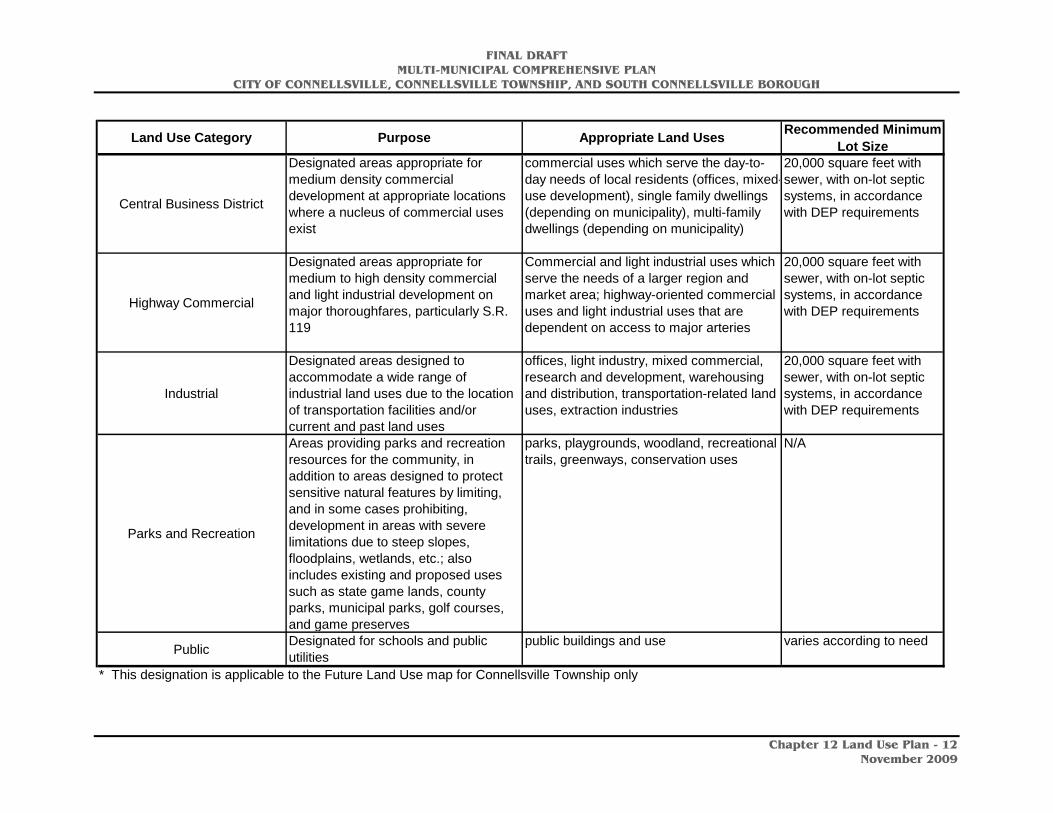
FINAL DRAFT MULTI-MUNICIPAL COMPREHENSIVE PLAN
CITY OF CONNELLSVILLE, CONNELLSVILLE TOWNSHIP, AND SOUTH CONNELLSVILLE BOROUGH
Chapter 12 Land Use Plan - 12
November 2009
Land Use Category Purpose Appropriate Land Uses Recommended Minimum Lot Size
Central Business District
Designated areas appropriate for medium density commercial development at appropriate locations where a nucleus of commercial uses exist
commercial uses which serve the day-to-day needs of local residents (offices, mixed-use development), single family dwellings (depending on municipality), multi-family dwellings (depending on municipality)
20,000 square feet with sewer, with on-lot septic systems, in accordance with DEP requirements
Highway Commercial
Designated areas appropriate for medium to high density commercial and light industrial development on major thoroughfares, particularly S.R. 119
Commercial and light industrial uses which serve the needs of a larger region and market area; highway-oriented commercial uses and light industrial uses that are dependent on access to major arteries
20,000 square feet with sewer, with on-lot septic systems, in accordance with DEP requirements
Industrial
Designated areas designed to accommodate a wide range of industrial land uses due to the location of transportation facilities and/or current and past land uses
offices, light industry, mixed commercial, research and development, warehousing and distribution, transportation-related land uses, extraction industries
20,000 square feet with sewer, with on-lot septic systems, in accordance with DEP requirements
Parks and Recreation
Areas providing parks and recreation resources for the community, in addition to areas designed to protect sensitive natural features by limiting, and in some cases prohibiting, development in areas with severe limitations due to steep slopes, floodplains, wetlands, etc.; also includes existing and proposed uses such as state game lands, county parks, municipal parks, golf courses, and game preserves
parks, playgrounds, woodland, recreational trails, greenways, conservation uses
N/A
Public Designated for schools and public utilities
public buildings and use varies according to need
* This designation is applicable to the Future Land Use map for Connellsville Township only
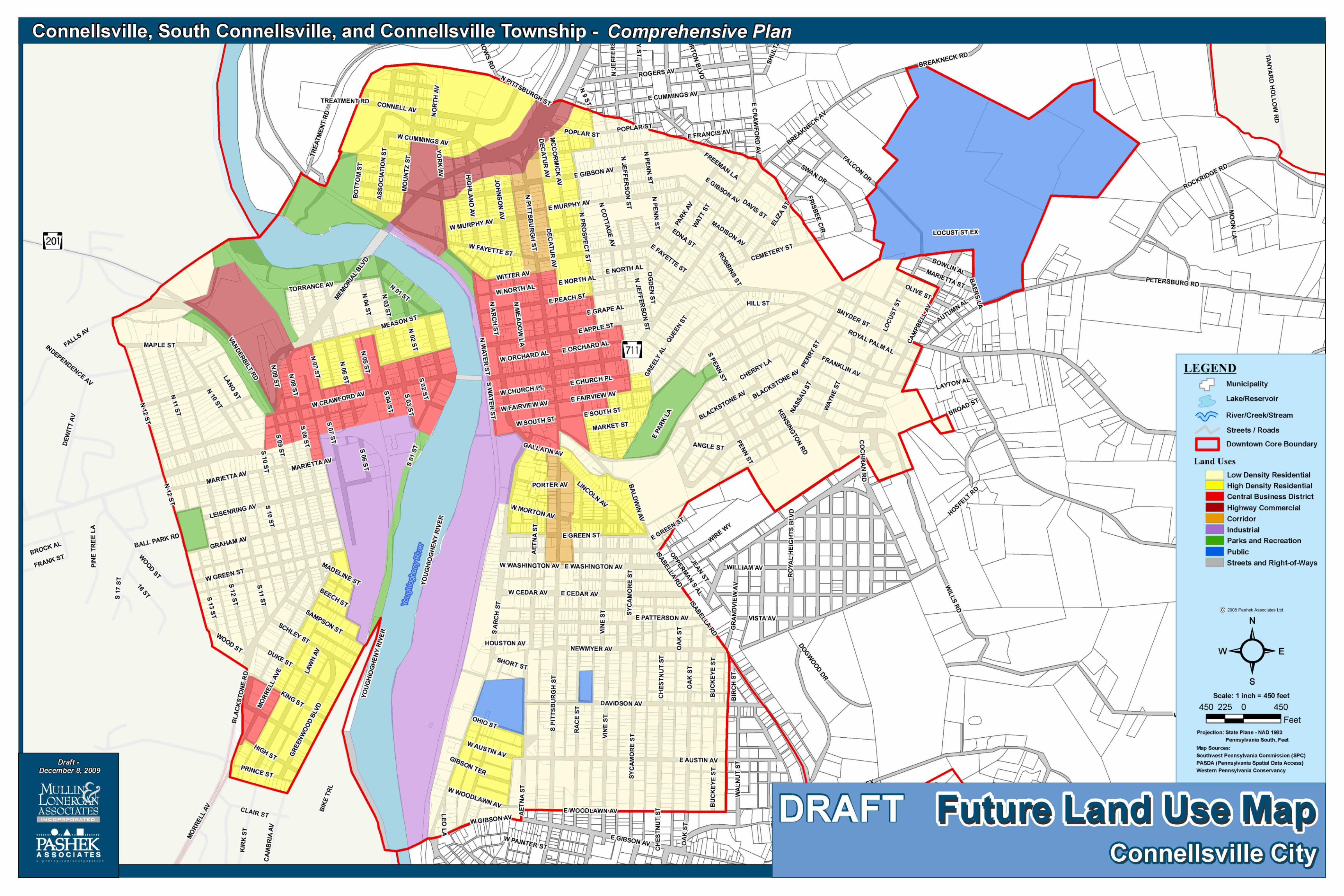


FINAL DRAFT MULTI-MUNICIPAL COMPREHENSIVE PLAN
CITY OF CONNELLSVILLE, CONNELLSVILLE TOWNSHIP, AND SOUTH CONNELLSVILLE BOROUGH
Chapter 12 Land Use Plan - 13
November 2009
Implementation
The Land Use Plan establishes policies for guiding future land use within the planning region and serves as a framework on which to base regulatory controls, such as zoning ordinances and subdivision and land development ordinances. The following goals and objectives will enable the planning region to achieve its Land Use vision.
Non-Residential Development
Goal: Encourage commercial and industrial development, infill development, and redevelopment that are well integrated and compatible with the surrounding context and character of adjacent land uses.
Objectives:
1. Permit mixed-use development in the City of Connellsville’s central business district.
2. Encourage commercial development of East Crawford Avenue at the Gateway into Connellsville Township.
3. Develop land use and development regulations for commercial and industrial land uses that protect the health, safety and welfare of Connellsville area residents.
4. The City of Connellsville should develop its own land development ordinance and update its subdivision ordinance.
5. Minimize potential land use conflicts between residential and non-residential land uses through appropriate zoning regulations.
6. Guide commercial and industrial development to appropriate areas where adequate infrastructure exists.
7. Revitalize brownfield sites.
8. Encourage development of visitor and tourism facilities, including lodging, restaurants and related facilities.
Residential Development
Goal: Provide for safe and adequate housing for a variety of household types and income levels.
Objectives:
1. Promote mixed-use development; encourage upper floor residential use, particularly in the central business district through an updated zoning code that permits such use.
FINAL DRAFT MULTI-MUNICIPAL COMPREHENSIVE PLAN
CITY OF CONNELLSVILLE, CONNELLSVILLE TOWNSHIP, AND SOUTH CONNELLSVILLE BOROUGH
Chapter 12 Land Use Plan - 14
November 2009
2. Provide for a variety of housing types, including single family, duplexes, townhouses, apartment complexes, assisted living facilities, and independent living facilities for households.
3. Promote the public health, safety and general welfare of residents through the provision of quality housing through sound planning and appropriate enforcement of zoning, floodplain management, and building codes.
4. Guide future development to anticipated growth areas in order to preserve valuable agricultural lands, recreation areas, scenic vistas, and rural roads.
Natural Resources
Goal: Protect significant natural resources such as floodplains, wetlands, steep slopes, woodlands, biological diversity areas, and watercourses.
Objectives:
1. Allow the location of natural features to guide the type and intensity of future development.
2. Minimize negative environmental impacts related to growth and development.
3. Prioritize the preservation and protection of significant natural resource areas.
4. Protect surface and groundwater resources from point and non-point source pollutants through adequate land development regulations.
5. Prevent further intrusion of hazardous materials into groundwater or other environmentally sensitive areas.
Open Space and Agricultural Preservation
Goal: Promote open space preservation that contributes to the desirable rural character of the Connellsville planning area.
Objectives:
1. Preserve open space in strategic locations across the planning area through sound planning policies and appropriate land use controls.
2. Provide flexibility in land use controls to promote alternative or supplemental agricultural ventures.
3. Encourage open space preservation through conservation easement purchase or donation.
FINAL DRAFT MULTI-MUNICIPAL COMPREHENSIVE PLAN
CITY OF CONNELLSVILLE, CONNELLSVILLE TOWNSHIP, AND SOUTH CONNELLSVILLE BOROUGH
Chapter 12 Land Use Plan - 15
November 2009
Future Land Use and Growth Management
Goal: Encourage growth in the Connellsville area while protecting the natural environment, maintaining visual quality, and providing services and community facilities.
Objectives:
1. Foster a community with a well-balanced mix of residential, commercial, industrial, open space, agricultural, and public land uses that support and complement the area.
2. Explore multi-municipal zoning for the three communities.
3. Provide for future growth in areas best suited for development that will protect and enhance the planning area’s quality of life.
4. Maintain the integrity of agricultural and rural areas by limiting development and infrastructures extensions into these areas.
5. Use growth management techniques to preserve open space, protect environmental resources, and minimize development costs.
6. Update the City of Connellsville’s zoning ordinance.
FINAL DRAFT MULTI-MUNICIPAL COMPREHENSIVE PLAN
CITY OF CONNELLSVILLE, CONNELLSVILLE TOWNSHIP, AND SOUTH CONNELLSVILLE BOROUGH
Chapter 13 Implementation Plan - 1
November 2009
Chapter 13: Implementation Plan
Introduction
Implementation of the recommendations in the Multi-municipal Comprehensive Plan for the City of Connellsville, Connellsville Township, and South Connellsville Borough will require the cooperation and collaboration of the three municipal governing bodies in addition to many public and private sector entities. These might include the Fay-Penn Economic Development Council, the Redevelopment Authority of the County of Fayette, the Redevelopment Authority of the City of Connellsville, the Fayette County Commissioners, the Fayette County Housing Authority, the Progress Council and the Trail Town Program, DCED and DCNR, PennDOT, municipal planning boards and commissions, municipal residents, non-profit organizations, for-profit developers, human and social services agencies, the business community and others. In implementing the recommendations, the municipalities in the Connellsville area will need to consider a phasing plan with short-term, middle-term, and long-term phases. An action plan has been provided to serve as a framework for implementation, ensuring that the phasing of recommendations is coordinated over a period of years. Short-term recommendations should generally be completed within one to three years; middle-term recommendations should be completed within four to seven years; and long-term recommendations should be completed within eight to ten years. The glossary included on the following two pages will be helpful in reviewing the Implementation Matrix. It lists the various public agencies, programs and potential funding resources for recommendations included in the action plan.
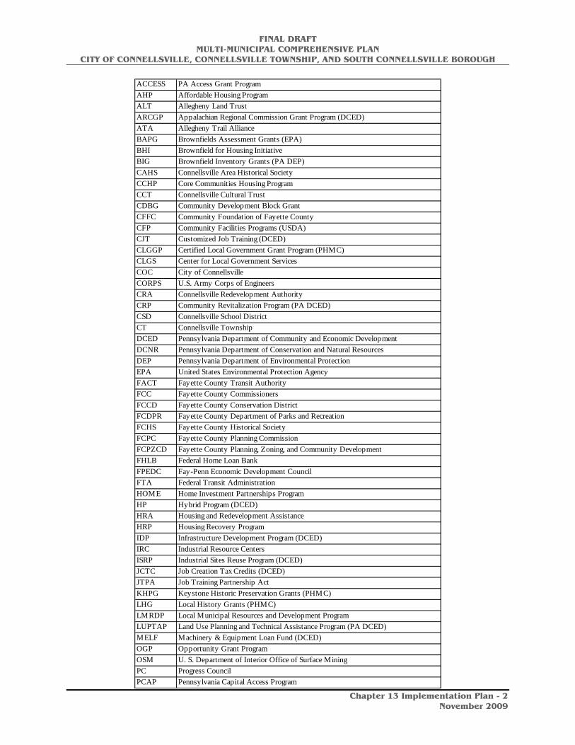
FINAL DRAFT MULTI-MUNICIPAL COMPREHENSIVE PLAN
CITY OF CONNELLSVILLE, CONNELLSVILLE TOWNSHIP, AND SOUTH CONNELLSVILLE BOROUGH
Chapter 13 Implementation Plan - 2
November 2009
ACCESS PA Access Grant ProgramAHP Affordable Housing ProgramALT Allegheny Land TrustARCGP Appalachian Regional Commission Grant Program (DCED)ATA Allegheny Trail AllianceBAPG Brownfields Assessment Grants (EPA)BHI Brownfield for Housing InitiativeBIG Brownfield Inventory Grants (PA DEP)CAHS Connellsville Area Historical SocietyCCHP Core Communities Housing ProgramCCT Connellsville Cultural TrustCDBG Community Development Block GrantCFFC Community Foundation of Fayette CountyCFP Community Facilities Programs (USDA)CJT Customized Job Training (DCED)CLGGP Certified Local Government Grant Program (PHMC)CLGS Center for Local Government ServicesCOC City of ConnellsvilleCORPS U.S. Army Corps of EngineersCRA Connellsville Redevelopment AuthorityCRP Community Revitalization Program (PA DCED)CSD Connellsville School DistrictCT Connellsville TownshipDCED Pennsylvania Department of Community and Economic DevelopmentDCNR Pennsylvania Department of Conservation and Natural ResourcesDEP Pennsylvania Department of Environmental ProtectionEPA United States Environmental Protection AgencyFACT Fayette County Transit AuthorityFCC Fayette County CommissionersFCCD Fayette County Conservation DistrictFCDPR Fayette County Department of Parks and RecreationFCHS Fayette County Historical SocietyFCPC Fayette County Planning CommissionFCPZCD Fayette County Planning, Zoning, and Community DevelopmentFHLB Federal Home Loan BankFPEDC Fay-Penn Economic Development CouncilFTA Federal Transit AdministrationHOME Home Investment Partnerships ProgramHP Hybrid Program (DCED)HRA Housing and Redevelopment AssistanceHRP Housing Recovery ProgramIDP Infrastructure Development Program (DCED)IRC Industrial Resource CentersISRP Industrial Sites Reuse Program (DCED)JCTC Job Creation Tax Credits (DCED)JTPA Job Training Partnership ActKHPG Keystone Historic Preservation Grants (PHMC)LHG Local History Grants (PHMC)LMRDP Local Municipal Resources and Development ProgramLUPTAP Land Use Planning and Technical Assistance Program (PA DCED)MELF Machinery & Equipment Loan Fund (DCED)OGP Opportunity Grant ProgramOSM U. S. Department of Interior Office of Surface MiningPC Progress CouncilPCAP Pennsylvania Capital Access Program

FINAL DRAFT MULTI-MUNICIPAL COMPREHENSIVE PLAN
CITY OF CONNELLSVILLE, CONNELLSVILLE TOWNSHIP, AND SOUTH CONNELLSVILLE BOROUGH
Chapter 13 Implementation Plan - 3
November 2009
PCAP Pennsylvania Capital Access ProgramPEC Pennsylvania Environmental CouncilPEDFA Pennsylvania Economic Development Financing AuthorityPennDOT Pennsylvania Department of TransportationPF Progress FundPFOP Preservation Fund of Pennsylvania (PP)PHMC Pennsylvania Historical and Museum CommissionPHPP Pennsylvania Heritage Parks Program (DCNR)PIDA Pennsylvania Industrial Development AuthorityPMBDA Pennsylvania Minority Business Development AuthorityPP Preservation PennsylvaniaPSR Pennsylvania Street Relief (DEP)PSU-CE Penn State University Cooperative ExtensionPTC Pennsylvania Turnpike CommissionRACF Redevelopment Authority of the County of FayetteRBS Rural Business – Cooperative Development Service (USDA)RCGP Rivers Conservation Grant Program (DCNR)RDG Rural Grants Program (USDA)RDTC Research and Development Tax CreditRHS Rural Housing Services (USDA)RLISC Rural Local Initiative Support CorporationRTT Rails-to-Trails Grant Program (DCNR)RUS Rural Utilities Service (USDA)SBA Small Business AdministrationSBF Small Business FirstSCB South Connellsville BoroughSMS Shared Municipal ServicesSPC Southwestern Pennsylvania CommissionTEA-21 Transportation Equity Act for the 21st CenturyTSAP Targeted Site Assessment Program (EPA)TTP Trail Town ProgramUSDA United States Department of AgricultureUSDI United States Department of the InteriorUSDOE U. S. Department of EnergyUSEPA United States Environmental Protection AgencyWPC Western Pennsylvania ConservancyWPCAMR Western Pennsylvania Coalition for Abandoned Mine ReclamationYRTC Yough River Trail Council

FINAL DRAFT MULTI-MUNICIPAL COMPREHENSIVE PLAN
CITY OF CONNELLSVILLE, CONNELLSVILLE TOWNSHIP, AND SOUTH CONNELLSVILLE BOROUGH
Chapter 13 Implementation Plan - 4
November 2009
ECONOMIC DEVELOPMENT PLAN: Core Area of the City of Connellsville (See Chapter 4, Economic Assessment and Development Strategy, for prioritized projects).
Recommendation Responsible Party Possible Funding Sources
Estimated Cost Schedule
Goal: Link the Great Allegheny Passage (GAP) with overall economic development efforts in the City of Connellsville
Continue to work with the Trail Town Program, the Connellsville Redevelopment Authority, Fay-Penn Economic Development Council, and others to link the overall economic development efforts: physical development and redevelopment; marketing and promotion; land use and zoning; circulation enhancements, visitor services; and public and recreational improvements.
COC, CRA, FPEDC, TTP, Fayette County
Municipal general revenues; LUPTAP; CDBG; DCNR, PennDOT
-- Ongoing
Goal: Implement a development strategy that maximizes public resources to leverage area strengths
Develop key gateway locations, including the property on the corner of 3rd Street and W. Crawford, and the corner of Arch Street and W. Crawford.
COC, CRA DCED, RACF, FPEDC $5 million*
Short-term
Explore future opportunities to develop the Mongell property at the corner of 1st Street and West Crawford Avenue.
$2-3 million *
Explore site acquisition, assembly, and demolition of parcels on the south side of W. Crawford between Pittsburgh Street and Meadow Lane.
COC, CRA DCED, RACF, FPEDC $100,000 – 500,000 *
Short-term
Redevelop the Brimstone Building as a mixed-use building. CRA, COC DCED, RACF, FPEDC, CRA
$2.5 million * Middle-term
Strategically relocate businesses that are on or near the riverfront that could be better located elsewhere, including beer distributorships and auto-related businesses.
CRA, COC FPEDC, RACF, CRA $200,000 * Short-term
Implement the proposed 1.5 mile “Inter-City” hiking/biking loop through the downtown area that links the GAP trail with the central business district, the Youghiogheny Riverfront and Yough Park, and businesses on U.S. Route 119.
DOC, DCNR, TTP, PennDOT, trail groups
COC, DCNR, DCED, PennDOT, TTP
$50,000 * Short-term

FINAL DRAFT MULTI-MUNICIPAL COMPREHENSIVE PLAN
CITY OF CONNELLSVILLE, CONNELLSVILLE TOWNSHIP, AND SOUTH CONNELLSVILLE BOROUGH
Chapter 13 Implementation Plan - 5
November 2009
* These are estimates based on comparable projects. Final numbers should be based on a development budget.
Recommendation Responsible Party Possible Funding Sources
Estimated Cost Schedule
Explore re-use of the Aaron’s building to determine rehabilitation costs.
COC, CRA DCED, CRA, RACF, private loans
$2.5 million * Long-term
Goal: Enhance the physical infrastructure
Identify infrastructure improvements needed to support future residential, commercial, and industrial development, and request technical and financial assistance to obtain implementation funding.
COC, CRA DCED, PennDOT, CRA Staff costs Short-term
Improve signage to allow for a more user-friendly environment COC, CRA CRA, COC, PennDOT $100,000 * Short-term
Install amenities that are visitor-friendly and appropriately placed, including bike racks and facilities for bikers.
COC, CRA CRA, COC $500,000 * Middle-term
Implement a façade improvement program to enhance the physical environment.
COC, CRA CRA, FPEDC, RACF $50,000 * Short-term
Implement a streetscape enhancement program, including street trees, flower boxes, and other features.
COC, CRA COC, CRA, Main Street Program
$50,000 * Short-term
Goal: Develop municipal policies that support and reinforce the positive economic developments
Implement a Main Street program to assist in promoting the economic development currently underway.
COC, CRA CRA $50,000 (first year) Short-term
Implement a zoning ordinance for the City of Connellsville that creates appropriate standards for the historic business district (setbacks, building height, lot sizes).
COC COC, LUPTAP $20,000 Short-term
Assist entrepreneurs who are interested in locating to the area; encourage businesses that reinforce the overall recreation and tourism economic development efforts.
CRA, COC, FPEDC CRA, FPEDC Staff costs Ongoing
* These are estimates based on comparable projects. Final numbers should be based on a development budget.
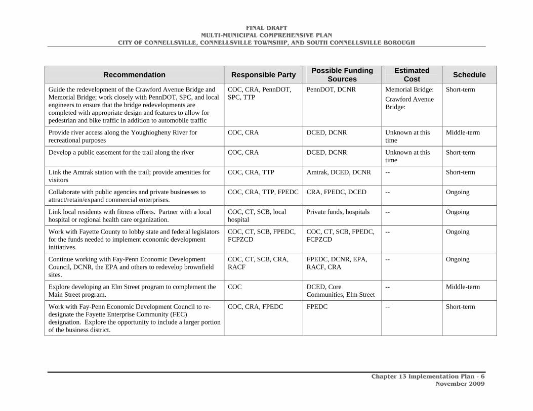
FINAL DRAFT MULTI-MUNICIPAL COMPREHENSIVE PLAN
CITY OF CONNELLSVILLE, CONNELLSVILLE TOWNSHIP, AND SOUTH CONNELLSVILLE BOROUGH
Chapter 13 Implementation Plan - 6
November 2009
Recommendation Responsible Party Possible Funding Sources
Estimated Cost Schedule
Guide the redevelopment of the Crawford Avenue Bridge and Memorial Bridge; work closely with PennDOT, SPC, and local engineers to ensure that the bridge redevelopments are completed with appropriate design and features to allow for pedestrian and bike traffic in addition to automobile traffic
COC, CRA, PennDOT, SPC, TTP
PennDOT, DCNR Memorial Bridge: Crawford Avenue Bridge:
Short-term
Provide river access along the Youghiogheny River for recreational purposes
COC, CRA DCED, DCNR Unknown at this time
Middle-term
Develop a public easement for the trail along the river COC, CRA DCED, DCNR Unknown at this time
Short-term
Link the Amtrak station with the trail; provide amenities for visitors
COC, CRA, TTP Amtrak, DCED, DCNR -- Short-term
Collaborate with public agencies and private businesses to attract/retain/expand commercial enterprises.
COC, CRA, TTP, FPEDC CRA, FPEDC, DCED -- Ongoing
Link local residents with fitness efforts. Partner with a local hospital or regional health care organization.
COC, CT, SCB, local hospital
Private funds, hospitals -- Ongoing
Work with Fayette County to lobby state and federal legislators for the funds needed to implement economic development initiatives.
COC, CT, SCB, FPEDC, FCPZCD
COC, CT, SCB, FPEDC, FCPZCD
-- Ongoing
Continue working with Fay-Penn Economic Development Council, DCNR, the EPA and others to redevelop brownfield sites.
COC, CT, SCB, CRA, RACF
FPEDC, DCNR, EPA, RACF, CRA
-- Ongoing
Explore developing an Elm Street program to complement the Main Street program.
COC DCED, Core Communities, Elm Street
-- Middle-term
Work with Fay-Penn Economic Development Council to re-designate the Fayette Enterprise Community (FEC) designation. Explore the opportunity to include a larger portion of the business district.
COC, CRA, FPEDC FPEDC -- Short-term

FINAL DRAFT MULTI-MUNICIPAL COMPREHENSIVE PLAN
CITY OF CONNELLSVILLE, CONNELLSVILLE TOWNSHIP, AND SOUTH CONNELLSVILLE BOROUGH
Chapter 13 Implementation Plan - 7
November 2009
Recommendation Responsible Party Possible Funding Sources
Estimated Cost Schedule
Goal: Enhance marketing and promotional efforts
Create a link to the Connellsville website on the GAP website to encourage more visitors into Connellsville
COC, TTP0, PC TTP -- Short-term
Sponsor a local promotional event, such as Pedal Pittsburgh or other similar rides, to highlight Connellsville’s recreational and cultural resources.
COC, TTP, CRA, CCT TTP, CRA, private sponsors
Unknown at this time
Ongoing
Promote Amtrak day trips to Connellsville to attract more visitors and reinforce the gateway to the Laurel Highlands.
COC, CRA, PC, TTP CRA, PC, TTP -- Ongoing
Offer a shuttle service from the trail head parking area to area lodging.
CRA, TTP FPEDC, private funds Unknown at this time
Short-term

FINAL DRAFT MULTI-MUNICIPAL COMPREHENSIVE PLAN
CITY OF CONNELLSVILLE, CONNELLSVILLE TOWNSHIP, AND SOUTH CONNELLSVILLE BOROUGH
Chapter 13 Implementation Plan - 8
November 2009
OVERALL ECONOMIC DEVELOPMENT PLAN
Recommendation Responsible Entity Possible Funding Sources
Estimated Cost Schedule
Goal: Enhance the vitality of the Connellsville planning area by achieving a strong economic base.
Work with Fayette County and economic development agencies to identify, target, and support industries that will provide jobs for area residents, including jobs in growing industries such as education, health care, social services, professional services, arts, entertainment, recreation, food services, and related businesses.
FPEDC, COC, CT, SCB FPEDC, JCTC (DCED) Staff time Ongoing
Redevelop vacant or underutilized commercial and industrial land, including Anchor Hocking, to provide jobs and enhance municipal tax bases.
FPEDC, SCB, CT, COC FPEDC, CRA $3 million * Short-term
Pursue the revitalization of the City of Connellsville’s central business district, especially revitalization of its physical environment.
CRA, COC CRA, FPEDC, DCED $1-5 million * Short-term
Collaborate with public agencies, including Fay-Penn Economic Development Council, and private businesses to attract/retain/expand commercial enterprises.
COC, CT, SCB -- Staff time Short-term
Work with Fayette County to lobby state and federal legislators for the funds needed to implement economic development initiatives.
COC, CT, SCB, FPEDC, CRA
-- Staff time Ongoing
Goal: Implement municipal actions to encourage economic development.
Maintain an adequate supply of land zoned for commercial and industrial uses in appropriate locations.
COC, CT, SCB, FCPZCD -- Staff time Ongoing
* These are estimates based on comparable projects. Final numbers should be based on a development budget.

FINAL DRAFT MULTI-MUNICIPAL COMPREHENSIVE PLAN
CITY OF CONNELLSVILLE, CONNELLSVILLE TOWNSHIP, AND SOUTH CONNELLSVILLE BOROUGH
Chapter 13 Implementation Plan - 9
November 2009
Recommendation Responsible Party Possible Funding
Sources Estimated
Cost Schedule Maintain an updated inventory of planning area brownfields and request Fayette County’s technical assistance with assessing the redevelopment potential of these sites.
COC, SCB, CT, CRA, FPEDC
-- -- Ongoing
Identify infrastructure improvements needed to support future residential, commercial, and industrial development, and request Fayette County technical and financial assistance to obtain implementation funding. This would include the area in Connellsville Township between Norton Avenue and Geibel High School.
COC, SCB, CT, CRA -- -- Short-term
Utilize the Pennsylvania Urban Redevelopment Law (35 P.S. 1701-1747) to eliminate blight and rehabilitate blighted sections of the communities.
CRA, RACF LUPTAP, County funds, redevelopment funds
$50,000 per plan, depending on scale of project
Short-term

FINAL DRAFT MULTI-MUNICIPAL COMPREHENSIVE PLAN
CITY OF CONNELLSVILLE, CONNELLSVILLE TOWNSHIP, AND SOUTH CONNELLSVILLE BOROUGH
Chapter 13 Implementation Plan - 10
November 2009
HOUSING PLAN
Recommendation Responsible Entity Possible Funding Sources
Estimated Cost Schedule
Goal: Promote the preservation of the existing housing stock to maintain affordable housing in the planning area.
Enforce building codes and property maintenance codes in an equitable manner.
COC, CT, SCB CDBG, Municipal general revenues
N/A Ongoing
Work with the Connellsville Redevelopment Authority and the Redevelopment Authority of the County of Fayette to market housing rehabilitation activities throughout the planning area.
COC, CT, SCB, CRA, RACF
CRA, RACF, FCPZCD
N/A Short-term
Encourage the demolition and clearance of severely dilapidated structures in order to arrest further neighborhood deterioration and decay.
COC, CT, SCB, CRA, RACF
DCED (NSP) Municipal general revenues
Depends on the structure
Short-term
Maintain and upgrade infrastructure such as streets, sidewalks and curbs to preserve the stability and integrity of existing residential neighborhoods.
COC, CT, SCB, CRA, RACF
DCED (CRP) $100,000 annually per municipality *
Short-term
Goal: Promote the rehabilitation of housing units in proximity to the City of Connellsville’s central business district
Focus housing resources towards encouraging new homeownership
COC, CT, SCB CDBG, DCED (HRP), RHS
N/A Short-term
Focus housing resources in the following targeted areas:
City of Connellsville:
First Time homebuyers program: Between West Morton Avenue and West Crawford Avenue and the central business district (Southside area)
Connellsville Township:
Units adjacent to North Jefferson Street
South Connellsville Borough:
Along S. Pittsburgh Street between Woodlawn Avenue, the gateway into South Connellsville Borough, and West
COC, CT, SCB CDBG, DCED (HRP), RHS
$2 million * Short-term
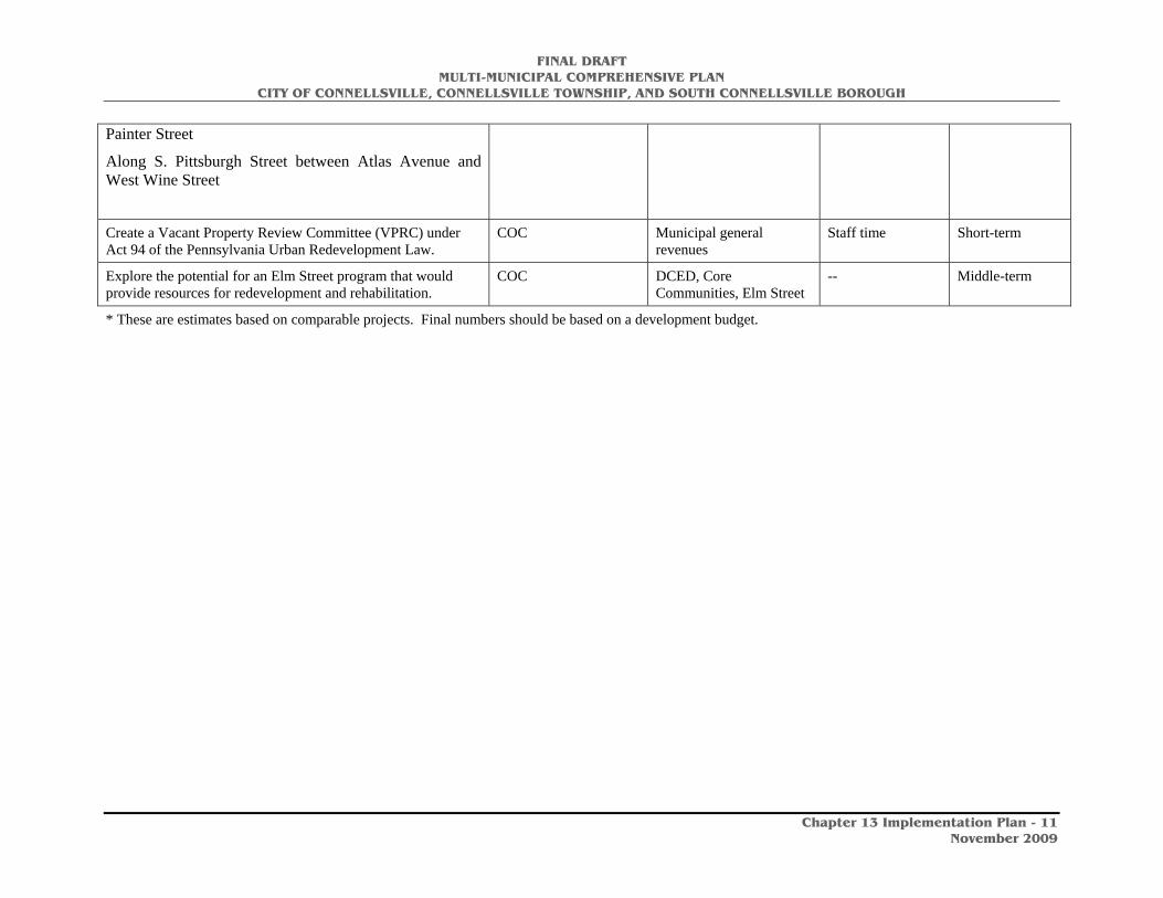
FINAL DRAFT MULTI-MUNICIPAL COMPREHENSIVE PLAN
CITY OF CONNELLSVILLE, CONNELLSVILLE TOWNSHIP, AND SOUTH CONNELLSVILLE BOROUGH
Chapter 13 Implementation Plan - 11
November 2009
Painter Street
Along S. Pittsburgh Street between Atlas Avenue and West Wine Street
Create a Vacant Property Review Committee (VPRC) under Act 94 of the Pennsylvania Urban Redevelopment Law.
COC Municipal general revenues
Staff time Short-term
Explore the potential for an Elm Street program that would provide resources for redevelopment and rehabilitation.
COC DCED, Core Communities, Elm Street
-- Middle-term
* These are estimates based on comparable projects. Final numbers should be based on a development budget.

FINAL DRAFT MULTI-MUNICIPAL COMPREHENSIVE PLAN
CITY OF CONNELLSVILLE, CONNELLSVILLE TOWNSHIP, AND SOUTH CONNELLSVILLE BOROUGH
Chapter 13 Implementation Plan - 12
November 2009
Recommendation Responsible Entity Possible Funding Sources
Estimated Cost Schedule
Goal: Encourage the location of higher density housing within walking distance and convenient commutable distance of employment, shopping and other activities through downtown revitalization, mixed use developments and other creative strategies.
Adopt zoning regulations that foster the creation of housing units on the upper floors of commercial structures in the City of Connellsville and South Connellsville Borough in appropriate locations.
COC, SCB, CT LUPTAP, Municipal general revenues
COC: Included in zoning costs
Short-term
Adopt zoning regulations that permit cluster residential developments by right.
COC, SCB, CT LUPTAP, Municipal general revenues
COC: Included in zoning costs
Short-term
Promote the inclusion of multi-family housing types such as apartments and townhouses in residential districts located in or near urbanized areas with existing infrastructure.
COC, SCB, CT LUPTAP, Municipal general revenues
COC: Included in zoning costs
Short-term
Adopt zoning regulations that encourage and permit infill residential development on existing lots of record (i.e., traditional narrow lots with lesser front setbacks, etc.).
COC, SCB, CT LUPTAP, Municipal general revenues
COC: Included in zoning costs
Short-term
Consider incorporating contextual design standards for new infill housing so that the new structures are compatible and similar in size, height, and design to existing surrounding homes.
COC, SCB, CT LUPTAP, Municipal general revenues
COC: Included in zoning costs
Short-term
Goal: Encourage the development of riverfront housing.
Explore options for additional housing on the Youghiogheny Riverfront:
• Identify potential development sites on the riverfront • Explore current ownership • Check floodplain and any additional environmental
factors • Explore potential for site assembly • Develop a financing plan
COC, CRA COC, DCED, FHLB, Private funds
$150,000 Short-term

FINAL DRAFT MULTI-MUNICIPAL COMPREHENSIVE PLAN
CITY OF CONNELLSVILLE, CONNELLSVILLE TOWNSHIP, AND SOUTH CONNELLSVILLE BOROUGH
Chapter 13 Implementation Plan - 13
November 2009
Goal: Encourage the development of housing that meets market demand.
Explore the market potential for a wider range of housing, including for the affordable, move-up, and higher-income markets.
• Identify potential development sites • Explore potential for site assembly • Develop a financing plan
COC, SCB, CT, private and non-profit developers
DCED, FHLB, Private funds
-- Middle-term
Goal: Revise the zoning ordinance in the City of Connellsville to clarify the types of housing permitted in residentially zoned areas. Update the zoning ordinance in Connellsville Township to allow for more residential development and to better manage the types of development. South Connellsville Borough should work with Fayette County to update the zoning ordinance for the community.
• Revise and update the zoning ordinance relevant to housing per the comprehensive plan
• Encourage residential development close to the downtown areas
• Create opportunities for new development
COC, SCB, CT LUPTAP, Municipal general revenues
-- Short-term

FINAL DRAFT MULTI-MUNICIPAL COMPREHENSIVE PLAN
CITY OF CONNELLSVILLE, CONNELLSVILLE TOWNSHIP, AND SOUTH CONNELLSVILLE BOROUGH
Chapter 13 Implementation Plan - 14
November 2009
HISTORIC AND CULTURAL RESOURCES PLAN
Recommendation Responsible Entity Possible Funding Sources
Estimated Cost Schedule
Goal: Identify, preserve, protect, and enhance the historic, architectural, and cultural resources in the Connellsville Area.
Encourage the identification, preservation, protection, enhancement, and re-use (where appropriate) of historic and architectural resources, including but not limited to the Aaron’s Building, Brimstone Building, Connellsville Armory, Great Allegheny Passage Trail, and the Youghiogheny Riverfront.
CCT, CRA, CAHS, FCHS, COC, CT, SCB
LHG, KHPG Dependent upon identified structure
Ongoing
Collaborate with and support the efforts of the county and local historical societies to identify and preserve, restore and enhance historical, archeological, and cultural resources.
CCT, CRA, CAHS, FCHS, COC, CT, SCB
LHG, KHPG N/A Ongoing
Through Fayette County, receive current information on historical preservation programs, and public and private sector funding sources.
CCT, CRA, CAHS, FCHS, COC, CT, SCB
-- N/A Ongoing
Apply for National Register historic district designation where significant historic resources exist.
CCT, CAHS, FCHS LHG, KHPG $50,000 Short-term
Create municipally regulated historic districts where significant historic resources exist, i.e. South Pittsburgh Street.
CCT, CAHS, FCHS LHG, KHPG $10,000 per district Short-term
Incorporate historic preservation into local zoning ordinances. COC, SCB, CT LUPTAP COC: included in zoning costs
Short-term
Provide information about the 20% historic rehabilitation tax credit to owners of eligible properties.
CCT, CAHS, FCHS, CRA -- N/A Ongoing
Work in close collaboration with county government, businesses, and others to apply for historic designation and funding under state, federal, and other programs.
CCT, CAHS, FCHS, CRA LHG, KHPG N/A Ongoing
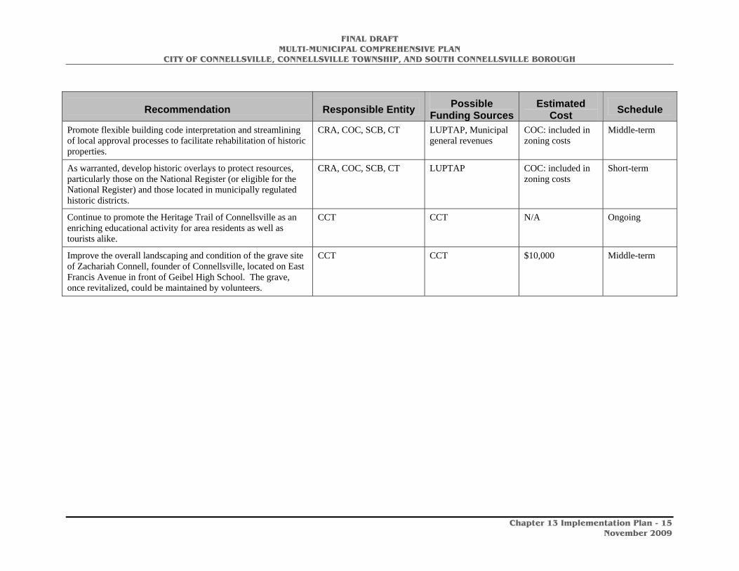
FINAL DRAFT MULTI-MUNICIPAL COMPREHENSIVE PLAN
CITY OF CONNELLSVILLE, CONNELLSVILLE TOWNSHIP, AND SOUTH CONNELLSVILLE BOROUGH
Chapter 13 Implementation Plan - 15
November 2009
Recommendation Responsible Entity Possible Funding Sources
Estimated Cost Schedule
Promote flexible building code interpretation and streamlining of local approval processes to facilitate rehabilitation of historic properties.
CRA, COC, SCB, CT LUPTAP, Municipal general revenues
COC: included in zoning costs
Middle-term
As warranted, develop historic overlays to protect resources, particularly those on the National Register (or eligible for the National Register) and those located in municipally regulated historic districts.
CRA, COC, SCB, CT LUPTAP COC: included in zoning costs
Short-term
Continue to promote the Heritage Trail of Connellsville as an enriching educational activity for area residents as well as tourists alike.
CCT CCT N/A Ongoing
Improve the overall landscaping and condition of the grave site of Zachariah Connell, founder of Connellsville, located on East Francis Avenue in front of Geibel High School. The grave, once revitalized, could be maintained by volunteers.
CCT CCT $10,000 Middle-term
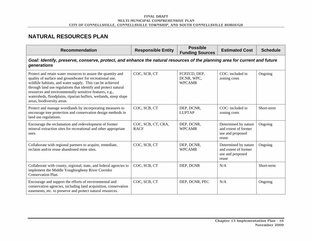
FINAL DRAFT MULTI-MUNICIPAL COMPREHENSIVE PLAN
CITY OF CONNELLSVILLE, CONNELLSVILLE TOWNSHIP, AND SOUTH CONNELLSVILLE BOROUGH
Chapter 13 Implementation Plan - 16
November 2009
NATURAL RESOURCES PLAN
Recommendation Responsible Entity Possible Funding Sources Estimated Cost Schedule
Goal: Identify, preserve, conserve, protect, and enhance the natural resources of the planning area for current and future generations
Protect and retain water resources to assure the quantity and quality of surface and groundwater for recreational use, wildlife habitats, and water supply. This can be achieved through land use regulations that identify and protect natural resources and environmentally sensitive features, e.g., watersheds, floodplains, riparian buffers, wetlands, steep slope areas, biodiversity areas.
COC, SCB, CT FCPZCD, DEP, DCNR, WPC, WPCAMR
COC: included in zoning costs
Ongoing
Protect and manage woodlands by incorporating measures to encourage tree protection and conservation design methods in land use regulations.
COC, SCB, CT DEP, DCNR, LUPTAP
COC: included in zoning costs
Short-term
Encourage the reclamation and redevelopment of former mineral extraction sites for recreational and other appropriate uses.
COC, SCB, CT, CRA, RACF
DEP, DCNR, WPCAMR
Determined by nature and extent of former use and proposed reuse
Ongoing
Collaborate with regional partners to acquire, remediate, reclaim and/or reuse abandoned mine sites.
COC, SCB, CT DEP, DCNR, WPCAMR
Determined by nature and extent of former use and proposed reuse
Ongoing
Collaborate with county, regional, state, and federal agencies to implement the Middle Youghiogheny River Corridor Conservation Plan.
COC, SCB, CT DEP, DCNR N/A Short-term
Encourage and support the efforts of environmental and conservation agencies, including land acquisition, conservation easements, etc. to preserve and protect natural resources.
COC, SCB, CT DEP, DCNR, PEC N/A Ongoing

FINAL DRAFT MULTI-MUNICIPAL COMPREHENSIVE PLAN
CITY OF CONNELLSVILLE, CONNELLSVILLE TOWNSHIP, AND SOUTH CONNELLSVILLE BOROUGH
Chapter 13 Implementation Plan - 17
November 2009
Recommendation Responsible Entity Possible Funding Sources Estimated Cost Schedule
When reviewing land development proposals, require soil survey analysis to insure the suitability of the site for such development, and identify natural resources, i.e., wetlands, floodplains, natural heritage areas, etc.
COC, SCB, CT Municipal general revenues
Determined by size and location of development
Ongoing
Update and implement storm water management programs. COC, SCB, CT Municipal general revenues
COC: included in zoning costs
Short-term
Enact and enforce property maintenance codes and other ordinances to curtail illegal dumping and abandoned vehicles.
COC, SCB, CT Municipal general revenues
Staff time Ongoing
Adopt a floodplain ordinance that is consistent with State and Federal regulations to protect the respective municipalities should any floods or other natural disasters occur.
COC, SCB, CT Municipal general revenues, LUPTAP
-- Short-term
Collaborate with county, regional, state, and federal agencies, the Fayette County Conservation District, Fayette County Planning Commission, and local watershed associations to pursue funding to prepare and implement plans that address the preservation, conservation, protection, and enhancement of natural resources, e.g. sustainable forestry management programs.
COC, SCB, CT, FCPZCD Municipal general revenues, LUPTAP
-- Ongoing
Work with the Fayette County Planning, Zoning, and Community Development office, DEP, DEP, the EPA, and other agencies to keep up-to-date on the environmental and regulatory issues related to the Marcellus Shale development.
COC, SCB, CT, FCPZCD, DEP
DEP, DCNR, EPA -- Ongoing
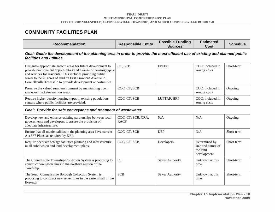
FINAL DRAFT MULTI-MUNICIPAL COMPREHENSIVE PLAN
CITY OF CONNELLSVILLE, CONNELLSVILLE TOWNSHIP, AND SOUTH CONNELLSVILLE BOROUGH
Chapter 13 Implementation Plan - 18
November 2009
COMMUNITY FACILITIES PLAN
Recommendation Responsible Entity Possible Funding Sources
Estimated Cost Schedule
Goal: Guide the development of the planning area in order to provide the most efficient use of existing and planned public facilities and utilities.
Designate appropriate growth areas for future development to provide employment opportunities and a range of housing types and services for residents. This includes providing public sewer to the 26 acres of land on East Crawford Avenue in Connellsville Township to provide development opportunities.
CT, SCB FPEDC COC: included in zoning costs
Short-term
Preserve the valued rural environment by maintaining open space and parks/recreation areas.
COC, CT, SCB COC: included in zoning costs
Ongoing
Require higher density housing types in existing population centers where public facilities are provided.
COC, CT, SCB LUPTAP, HRP COC: included in zoning costs
Ongoing
Goal: Provide for safe conveyance and treatment of wastewater.
Develop new and enhance existing partnerships between local governments and developers to assure the provision of adequate infrastructure.
COC, CT, SCB, CRA, RACF
N/A N/A Ongoing
Ensure that all municipalities in the planning area have current Act 537 Plans, as required by DEP.
COC, CT, SCB DEP N/A Short-term
Require adequate sewage facilities planning and infrastructure in all subdivision and land development plans.
COC, CT, SCB Developers Determined by size and nature of the land development
Short-term
The Connellsville Township Collection System is proposing to construct new sewer lines in the northern section of the Township.
CT Sewer Authority Unknown at this time
Short-term
The South Connellsville Borough Collection System is proposing to construct new sewer lines in the eastern half of the Borough
SCB Sewer Authority Unknown at this time
Short-term

FINAL DRAFT MULTI-MUNICIPAL COMPREHENSIVE PLAN
CITY OF CONNELLSVILLE, CONNELLSVILLE TOWNSHIP, AND SOUTH CONNELLSVILLE BOROUGH
Chapter 13 Implementation Plan - 19
November 2009
Recommendation Responsible Entity Possible Funding
Sources Estimated
Cost Schedule
Goal: Ensure that the best quality and quantity of potable water is available to residents.
Regulate new development activity through adequate land use and development ordinances to ensure groundwater supplies are protected.
COC, SCB, CT DEP, Municipal general revenues
-- Short-term
Continue to collaborate with surrounding local units of government on issues that cross municipal boundaries, such as watershed areas.
COC, SCB, CT DEP, Municipal general revenues
-- Ongoing
Goal: Foster regional planning and implementation initiatives for municipal services and other areas of local government.
Continue to investigate opportunities to share planning and delivery of municipal services with neighboring municipalities both within and outside of the planning area.
COC, SCB, CT DCED -- Ongoing
Explore applying for a Shared Municipal Services (SMS) Program grant.
COC, SCB, CT SMS Unknown at this time
Short-term
Explore applying for a COPS grant to improve police services. COC, SCB, CT COPS Unknown at this time
Short-term

FINAL DRAFT MULTI-MUNICIPAL COMPREHENSIVE PLAN
CITY OF CONNELLSVILLE, CONNELLSVILLE TOWNSHIP, AND SOUTH CONNELLSVILLE BOROUGH
Chapter 13 Implementation Plan - 20
November 2009
TRANSPORTATION PLAN
Recommendation Responsible Entity Possible Funding Sources
Estimated Cost Schedule
Goal: Maintain, improve, and upgrade the existing transportation network.
Enhance existing municipal systems for identifying, prioritizing, and implementing road and bridge improvements.
COC, SCB, CT, PennDOT, SPC
Municipal general revenues
N/A Short-term
Maintain cooperation and collaboration with Fayette County, PennDOT, Southwestern Pennsylvania Commission, and other agencies to identify and implement needed improvements to roads, bridges, waterways, railroads, and other elements of the existing transportation system.
COC, SCB, CT, PennDOT, SPC
N/A N/A Ongoing
Develop support and consensus among local, county, state, and federal officials and legislators to lobby for additional funding for planning regional transportation projects and to insure prompt completion of local Transportation Improvement Program projects.
COC, SCB, CT, PennDOT, SPC, and local legislators
N/A N/A Ongoing
Maintain and improve the existing public transit system. FACT FACT, FTA N/A Ongoing
Redevelop the existing Amtrak station to encourage higher station use.
COC, CRA, TTP, PEC Amtrak Estimate currently underway
Short-term
Upgrade the U.S. Route 119 and East Crawford Avenue intersection leading into Connellsville Township.
PennDOT PennDOT Unknown at this time
Short-term
Goal: Improve transportation safety.
Work with Fayette County, PennDOT, and other transportation partners to develop safer alternatives for roads with high accident rates.
COC, SCB, CT, PennDOT
PennDOT Depends on road segment
Short-term
Identify and complete safety-related projects, including improvements that minimize pedestrian/vehicular conflicts.
COC, SCB, CT, PennDOT
PennDOT N/A Short-term
Discourage highway strip commercial development, support clustered developments, and encourage connecting service roads between commercial developments.
COC, CT, SCB, CRA, FPEDC, RACF
LUPTAP COC: included in zoning costs
Short-term
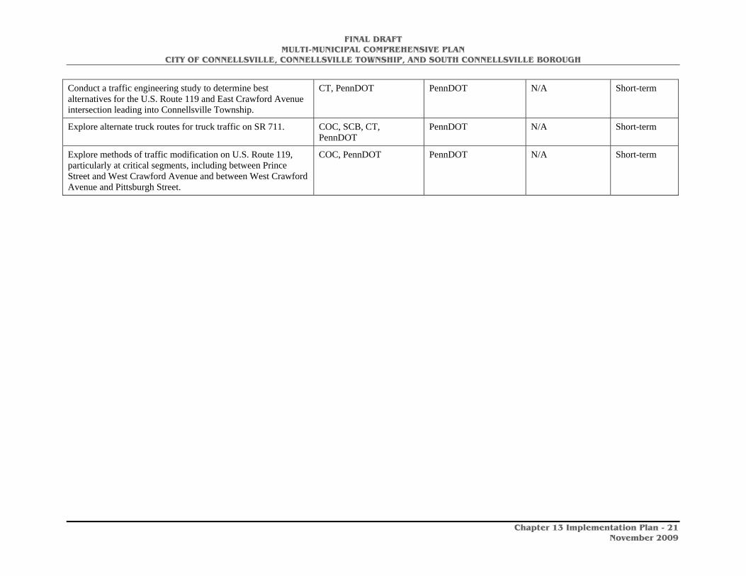
FINAL DRAFT MULTI-MUNICIPAL COMPREHENSIVE PLAN
CITY OF CONNELLSVILLE, CONNELLSVILLE TOWNSHIP, AND SOUTH CONNELLSVILLE BOROUGH
Chapter 13 Implementation Plan - 21
November 2009
Conduct a traffic engineering study to determine best alternatives for the U.S. Route 119 and East Crawford Avenue intersection leading into Connellsville Township.
CT, PennDOT PennDOT N/A Short-term
Explore alternate truck routes for truck traffic on SR 711. COC, SCB, CT, PennDOT
PennDOT N/A Short-term
Explore methods of traffic modification on U.S. Route 119, particularly at critical segments, including between Prince Street and West Crawford Avenue and between West Crawford Avenue and Pittsburgh Street.
COC, PennDOT PennDOT N/A Short-term
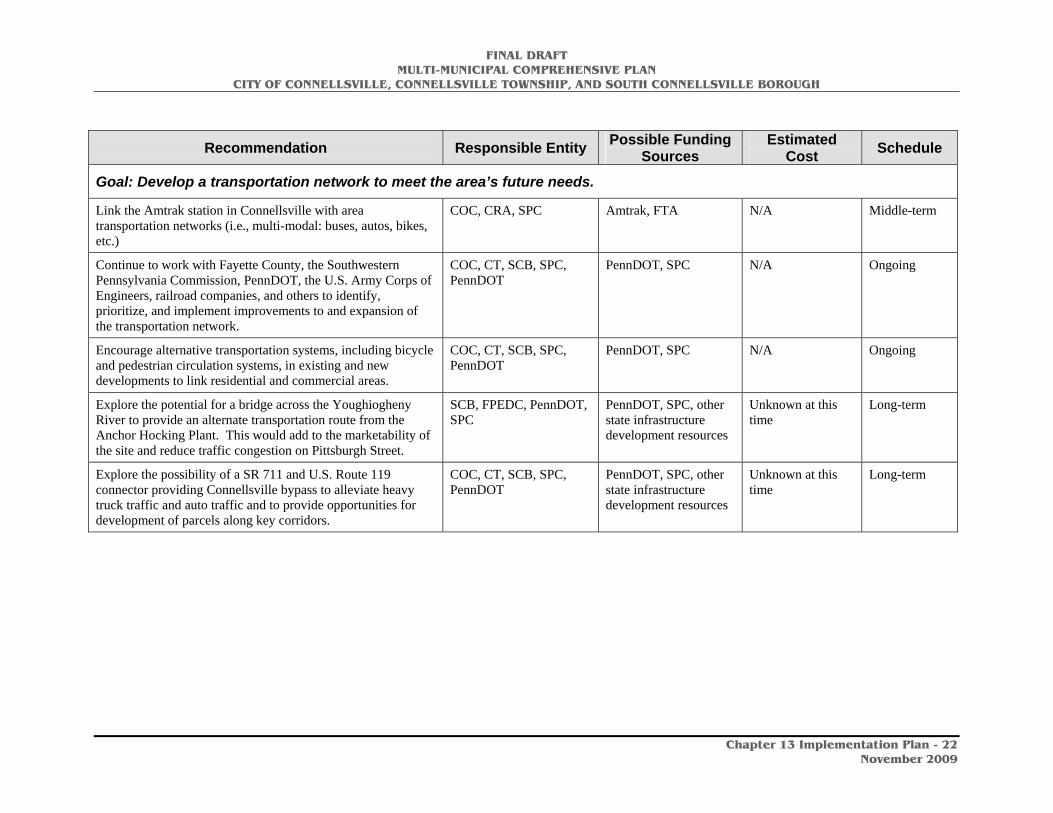
FINAL DRAFT MULTI-MUNICIPAL COMPREHENSIVE PLAN
CITY OF CONNELLSVILLE, CONNELLSVILLE TOWNSHIP, AND SOUTH CONNELLSVILLE BOROUGH
Chapter 13 Implementation Plan - 22
November 2009
Recommendation Responsible Entity Possible Funding Sources
Estimated Cost Schedule
Goal: Develop a transportation network to meet the area’s future needs.
Link the Amtrak station in Connellsville with area transportation networks (i.e., multi-modal: buses, autos, bikes, etc.)
COC, CRA, SPC Amtrak, FTA N/A Middle-term
Continue to work with Fayette County, the Southwestern Pennsylvania Commission, PennDOT, the U.S. Army Corps of Engineers, railroad companies, and others to identify, prioritize, and implement improvements to and expansion of the transportation network.
COC, CT, SCB, SPC, PennDOT
PennDOT, SPC N/A Ongoing
Encourage alternative transportation systems, including bicycle and pedestrian circulation systems, in existing and new developments to link residential and commercial areas.
COC, CT, SCB, SPC, PennDOT
PennDOT, SPC N/A Ongoing
Explore the potential for a bridge across the Youghiogheny River to provide an alternate transportation route from the Anchor Hocking Plant. This would add to the marketability of the site and reduce traffic congestion on Pittsburgh Street.
SCB, FPEDC, PennDOT, SPC
PennDOT, SPC, other state infrastructure development resources
Unknown at this time
Long-term
Explore the possibility of a SR 711 and U.S. Route 119 connector providing Connellsville bypass to alleviate heavy truck traffic and auto traffic and to provide opportunities for development of parcels along key corridors.
COC, CT, SCB, SPC, PennDOT
PennDOT, SPC, other state infrastructure development resources
Unknown at this time
Long-term
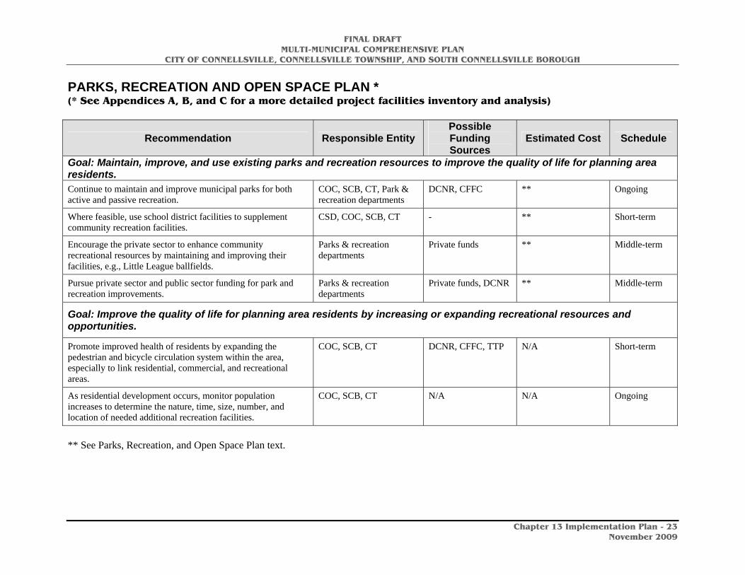
FINAL DRAFT MULTI-MUNICIPAL COMPREHENSIVE PLAN
CITY OF CONNELLSVILLE, CONNELLSVILLE TOWNSHIP, AND SOUTH CONNELLSVILLE BOROUGH
Chapter 13 Implementation Plan - 23
November 2009
PARKS, RECREATION AND OPEN SPACE PLAN * (* See Appendices A, B, and C for a more detailed project facilities inventory and analysis)
Recommendation Responsible Entity Possible Funding Sources
Estimated Cost Schedule
Goal: Maintain, improve, and use existing parks and recreation resources to improve the quality of life for planning area residents. Continue to maintain and improve municipal parks for both active and passive recreation.
COC, SCB, CT, Park & recreation departments
DCNR, CFFC ** Ongoing
Where feasible, use school district facilities to supplement community recreation facilities.
CSD, COC, SCB, CT - ** Short-term
Encourage the private sector to enhance community recreational resources by maintaining and improving their facilities, e.g., Little League ballfields.
Parks & recreation departments
Private funds ** Middle-term
Pursue private sector and public sector funding for park and recreation improvements.
Parks & recreation departments
Private funds, DCNR ** Middle-term
Goal: Improve the quality of life for planning area residents by increasing or expanding recreational resources and opportunities.
Promote improved health of residents by expanding the pedestrian and bicycle circulation system within the area, especially to link residential, commercial, and recreational areas.
COC, SCB, CT DCNR, CFFC, TTP N/A Short-term
As residential development occurs, monitor population increases to determine the nature, time, size, number, and location of needed additional recreation facilities.
COC, SCB, CT N/A N/A Ongoing
** See Parks, Recreation, and Open Space Plan text.
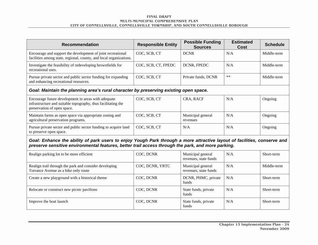
FINAL DRAFT MULTI-MUNICIPAL COMPREHENSIVE PLAN
CITY OF CONNELLSVILLE, CONNELLSVILLE TOWNSHIP, AND SOUTH CONNELLSVILLE BOROUGH
Chapter 13 Implementation Plan - 24
November 2009
Recommendation Responsible Entity Possible Funding Sources
Estimated Cost Schedule
Encourage and support the development of joint recreational facilities among state, regional, county, and local organizations.
COC, SCB, CT DCNR N/A Middle-term
Investigate the feasibility of redeveloping brownfields for recreational uses.
COC, SCB, CT, FPEDC DCNR, FPEDC N/A Middle-term
Pursue private sector and public sector funding for expanding and enhancing recreational resources.
COC, SCB, CT Private funds, DCNR ** Middle-term
Goal: Maintain the planning area’s rural character by preserving existing open space.
Encourage future development in areas with adequate infrastructure and suitable topography, thus facilitating the preservation of open space.
COC, SCB, CT CRA, RACF N/A Ongoing
Maintain farms as open space via appropriate zoning and agricultural preservation programs.
COC, SCB, CT Municipal general revenues
N/A Ongoing
Pursue private sector and public sector funding to acquire land to preserve open space.
COC, SCB, CT N/A N/A Ongoing
Goal: Enhance the ability of park users to enjoy Yough Park through a more attractive layout of facilities, conserve and preserve sensitive environmental features, better trail access through the park, and more parking.
Realign parking lot to be more efficient COC, DCNR Municipal general revenues, state funds
N/A Short-term
Realign trail through the park and consider developing Torrance Avenue as a bike only route
COC, DCNR, YRTC Municipal general revenues, state funds
N/A Middle-term
Create a new playground with a historical theme COC, DCNR DCNR, PHMC, private funds
N/A Short-term
Relocate or construct new picnic pavilions COC, DCNR State funds, private funds
N/A Short-term
Improve the boat launch COC, DCNR State funds, private funds
N/A Short-term
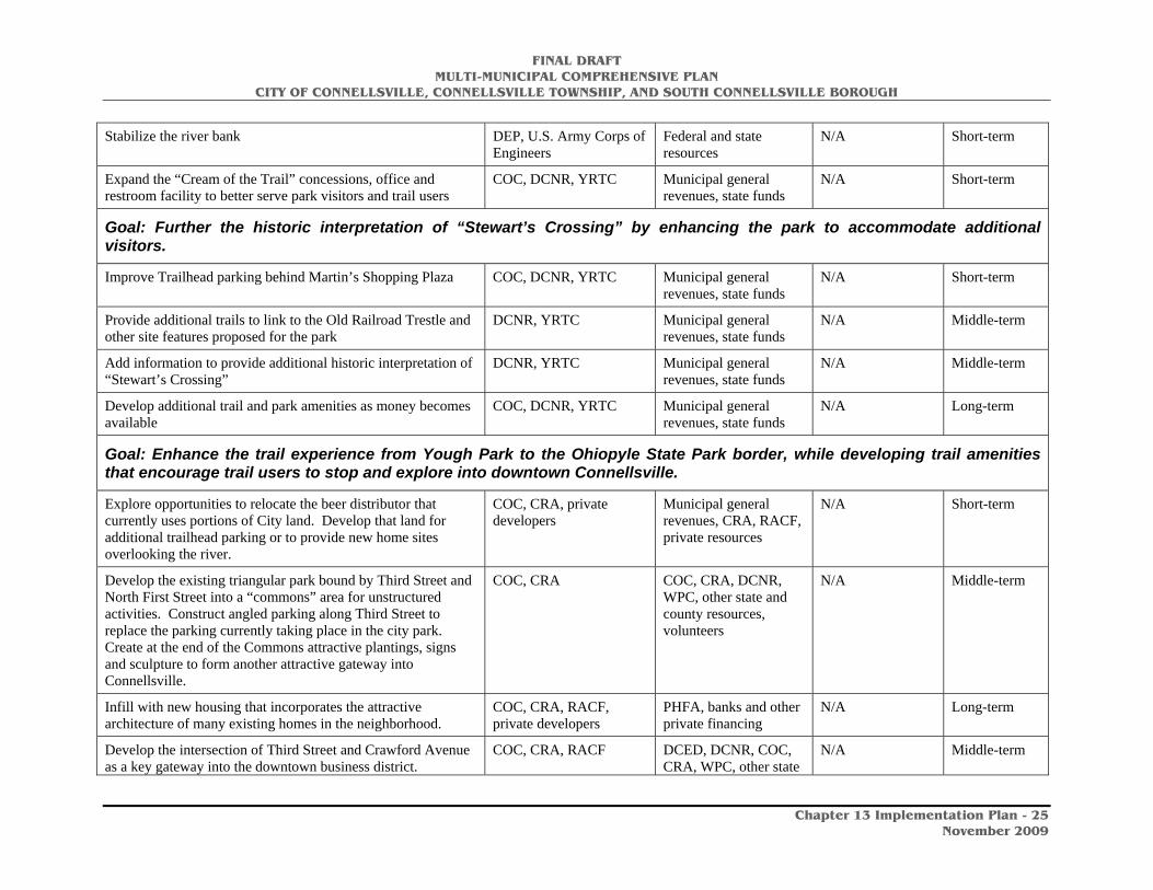
FINAL DRAFT MULTI-MUNICIPAL COMPREHENSIVE PLAN
CITY OF CONNELLSVILLE, CONNELLSVILLE TOWNSHIP, AND SOUTH CONNELLSVILLE BOROUGH
Chapter 13 Implementation Plan - 25
November 2009
Stabilize the river bank DEP, U.S. Army Corps of Engineers
Federal and state resources
N/A Short-term
Expand the “Cream of the Trail” concessions, office and restroom facility to better serve park visitors and trail users
COC, DCNR, YRTC Municipal general revenues, state funds
N/A Short-term
Goal: Further the historic interpretation of “Stewart’s Crossing” by enhancing the park to accommodate additional visitors.
Improve Trailhead parking behind Martin’s Shopping Plaza COC, DCNR, YRTC Municipal general revenues, state funds
N/A Short-term
Provide additional trails to link to the Old Railroad Trestle and other site features proposed for the park
DCNR, YRTC Municipal general revenues, state funds
N/A Middle-term
Add information to provide additional historic interpretation of “Stewart’s Crossing”
DCNR, YRTC Municipal general revenues, state funds
N/A Middle-term
Develop additional trail and park amenities as money becomes available
COC, DCNR, YRTC Municipal general revenues, state funds
N/A Long-term
Goal: Enhance the trail experience from Yough Park to the Ohiopyle State Park border, while developing trail amenities that encourage trail users to stop and explore into downtown Connellsville.
Explore opportunities to relocate the beer distributor that currently uses portions of City land. Develop that land for additional trailhead parking or to provide new home sites overlooking the river.
COC, CRA, private developers
Municipal general revenues, CRA, RACF, private resources
N/A Short-term
Develop the existing triangular park bound by Third Street and North First Street into a “commons” area for unstructured activities. Construct angled parking along Third Street to replace the parking currently taking place in the city park. Create at the end of the Commons attractive plantings, signs and sculpture to form another attractive gateway into Connellsville.
COC, CRA COC, CRA, DCNR, WPC, other state and county resources, volunteers
N/A Middle-term
Infill with new housing that incorporates the attractive architecture of many existing homes in the neighborhood.
COC, CRA, RACF, private developers
PHFA, banks and other private financing
N/A Long-term
Develop the intersection of Third Street and Crawford Avenue as a key gateway into the downtown business district.
COC, CRA, RACF DCED, DCNR, COC, CRA, WPC, other state
N/A Middle-term
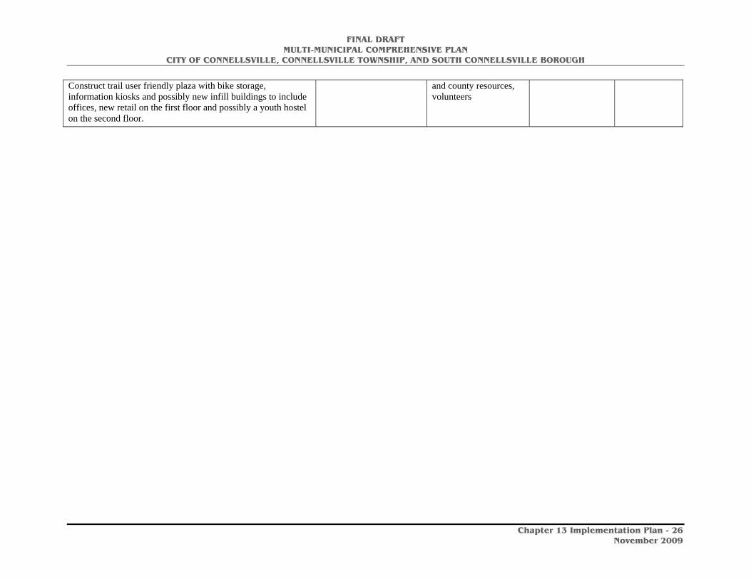
FINAL DRAFT MULTI-MUNICIPAL COMPREHENSIVE PLAN
CITY OF CONNELLSVILLE, CONNELLSVILLE TOWNSHIP, AND SOUTH CONNELLSVILLE BOROUGH
Chapter 13 Implementation Plan - 26
November 2009
Construct trail user friendly plaza with bike storage, information kiosks and possibly new infill buildings to include offices, new retail on the first floor and possibly a youth hostel on the second floor.
and county resources, volunteers

FINAL DRAFT MULTI-MUNICIPAL COMPREHENSIVE PLAN
CITY OF CONNELLSVILLE, CONNELLSVILLE TOWNSHIP, AND SOUTH CONNELLSVILLE BOROUGH
Chapter 13 Implementation Plan - 27
November 2009
Develop an attractive, bike friendly streetscape along Crawford Avenue that continues across the bridge into downtown Connellsville.
COC, CRA, TTP, WPC COC, CRA, TTP, WPC N/A Short-term
Develop cantilevered bike/pedestrian walks on either or both sides of the Crawford Avenue bridge.
PennDOT, SPC PennDOT, SPC N/A Medium-term
Develop trail alignment adjustments and attractive natural species plantings along the trail as it continues south from Crawford Avenue.
COC, CRA, TTP, WPC COC, CRA, TTP, WPC N/A Short-term
Create an attractive gateway at the southern end of the trail in Connellsville, welcoming people from Ohiopyle State Park into Connellsville. Provide information kiosks to identify opportunities in the downtown district. Provide additional interpretive information about the role of historic and present day industries in the development of Connellsville.
COC, CRA, TTP, WPC COC, CRA, TTP, WPC N/A Short-term
Goal: Utilize the Youghiogheny River as a local recreation opportunity and as a regional water trail.
Redevelop Yough Park as the focal point of access to the River by local residents and as a gateway to the Connellsville region for river users from outside the region.
DCNR, COC, SCB, CT DCNR, CDBG, other local, county, and state resources
N/A Short-term
Promote the Youghiogheny River Water Trail for its recreational, historic, and tourism opportunities.
COC, CRA, SCB, CT, TTP, ATA
-- N/A Ongoing
Recognize the Youghiogheny River Water Trail as a significant component of Trail Town development.
COC, CRA, SCB, CT, TTP, ATA
-- -- Ongoing
Develop pedestrian, bicycle and vehicular routes to connect residents of South Connellsville and Connellsville Township to the Yough Park access to the River and trails.
SCB, CT DCNR, CDBG, other local, county, and state resources
N/A Medium-term
Protect and preserve as much of the river front property in the three municipalities as possible for public use and access. This can be done through acquisition, easements, or use agreements with private property owners.
COC, SCB, CT, -- -- Ongoing
* See Parks, Recreation, and Open Space Plan text.

FINAL DRAFT MULTI-MUNICIPAL COMPREHENSIVE PLAN
CITY OF CONNELLSVILLE, CONNELLSVILLE TOWNSHIP, AND SOUTH CONNELLSVILLE BOROUGH
Chapter 13 Implementation Plan - 28
November 2009
ENERGY CONSERVATION PLAN
Recommendation Responsible Entity Possible Funding Sources
Estimated Cost Schedule
Goal: Reduce energy consumption.
Establish standards to guide the appropriate and efficient use of energy in municipal programs, purchases, and practices.
COC, SCB, CT EPA, DCNR, DOE N/A Ongoing
Promote carpooling and public transit use. SPC FACT, SPC, FTA N/A Ongoing
Support ongoing programs for resource recovery and recycling of solid wastes.
SPC PEC, DOE N/A Ongoing
Continue efforts of cooperation among residents, utility companies, and local, county, regional, state, and federal agencies concerning energy-related issues and programs.
COC, SCB, CT, SPC DOE, DCNR N/A Ongoing
Work with Fayette County and economic development agencies to attract businesses that will provide jobs for planning area residents. This will reduce the commuting times (and therefore energy costs) of area residents.
COC, SCB, CT, SPC, FPEDC
DOE, DCNR, SPC N/A Ongoing
Maintain elements of the transportation network (e.g., roads and bridges) to reduce the need for detours that increase fuel consumption and costs.
COC, SCB, CT, SPC, FPEDC
DOE, DCNR, SPC, PennDOT
N/A Ongoing
Support transportation improvements that will reduce energy consumption by alleviating traffic congestion and improving traffic flow.
COC, SCB, CT, SPC, FPEDC
DOE, DCNR, SPC, PennDOT
N/A Ongoing
Encourage alternative transportation networks, e.g., bicycle and pedestrian circulation systems that will reduce the need for automobile use for daily activities.
COC, SCB, CT, SPC, FPEDC
DOE, DCNR, SPC N/A Ongoing
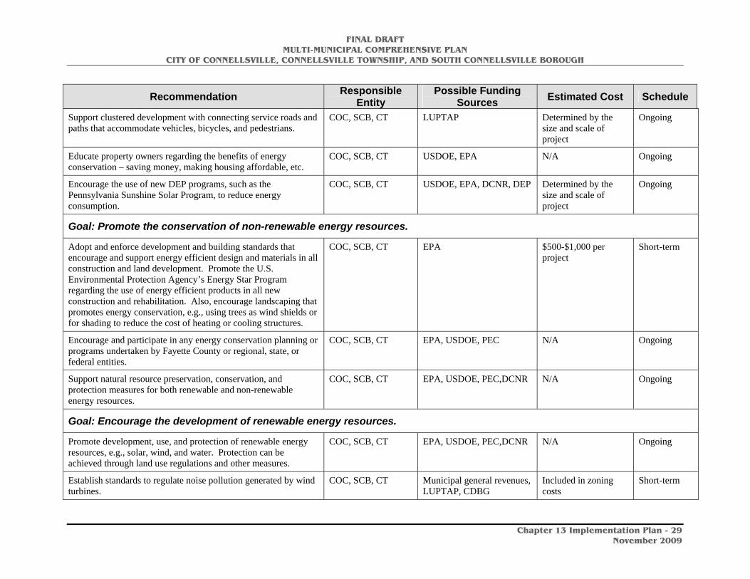
FINAL DRAFT MULTI-MUNICIPAL COMPREHENSIVE PLAN
CITY OF CONNELLSVILLE, CONNELLSVILLE TOWNSHIP, AND SOUTH CONNELLSVILLE BOROUGH
Chapter 13 Implementation Plan - 29
November 2009
Recommendation Responsible Entity
Possible Funding Sources Estimated Cost Schedule
Support clustered development with connecting service roads and paths that accommodate vehicles, bicycles, and pedestrians.
COC, SCB, CT LUPTAP Determined by the size and scale of project
Ongoing
Educate property owners regarding the benefits of energy conservation – saving money, making housing affordable, etc.
COC, SCB, CT USDOE, EPA N/A Ongoing
Encourage the use of new DEP programs, such as the Pennsylvania Sunshine Solar Program, to reduce energy consumption.
COC, SCB, CT USDOE, EPA, DCNR, DEP Determined by the size and scale of project
Ongoing
Goal: Promote the conservation of non-renewable energy resources.
Adopt and enforce development and building standards that encourage and support energy efficient design and materials in all construction and land development. Promote the U.S. Environmental Protection Agency’s Energy Star Program regarding the use of energy efficient products in all new construction and rehabilitation. Also, encourage landscaping that promotes energy conservation, e.g., using trees as wind shields or for shading to reduce the cost of heating or cooling structures.
COC, SCB, CT EPA $500-$1,000 per project
Short-term
Encourage and participate in any energy conservation planning or programs undertaken by Fayette County or regional, state, or federal entities.
COC, SCB, CT EPA, USDOE, PEC N/A Ongoing
Support natural resource preservation, conservation, and protection measures for both renewable and non-renewable energy resources.
COC, SCB, CT EPA, USDOE, PEC,DCNR N/A Ongoing
Goal: Encourage the development of renewable energy resources.
Promote development, use, and protection of renewable energy resources, e.g., solar, wind, and water. Protection can be achieved through land use regulations and other measures.
COC, SCB, CT EPA, USDOE, PEC,DCNR N/A Ongoing
Establish standards to regulate noise pollution generated by wind turbines.
COC, SCB, CT Municipal general revenues, LUPTAP, CDBG
Included in zoning costs
Short-term

FINAL DRAFT MULTI-MUNICIPAL COMPREHENSIVE PLAN
CITY OF CONNELLSVILLE, CONNELLSVILLE TOWNSHIP, AND SOUTH CONNELLSVILLE BOROUGH
Chapter 13 Implementation Plan - 30
November 2009
LAND USE PLAN
Recommendation Responsible Entity Possible Funding Sources
Estimated Cost Schedule
Non-Residential Development Goal: Encourage commercial and industrial development, infill development, and redevelopment that are well integrated and compatible with the surrounding context and character of adjacent land uses.
Permit mixed-use development in the City of Connellsville’s central business district.
COC LUPTAP, Municipal general revenues
Included in cost of zoning ordinance
Short-term
Develop land use and development regulations for commercial and industrial land uses that protect the health, safety and welfare of Connellsville area residents.
COC, SCB, CT LUPTAP, Municipal general revenues
Included in cost of zoning ordinance (for the City of Connellsville)
Short-term
The City of Connellsville should develop its owns land development ordinance and updated its subdivision ordinance.
COC LUPTAP, Municipal general revenues
$20,000 Short-term
Minimize potential land use conflicts between residential and non-residential land uses through appropriate zoning regulations.
COC, SCB, CT LUPTAP, Municipal general revenues
Included in cost of zoning ordinance (for the City of Connellsville)
Short-term
Guide commercial and industrial development to appropriate areas where adequate infrastructure exists.
COC, SCB, CT, CRA, RACF, FPEDC
LUPTAP, Municipal general revenues
Included in cost of zoning ordinance (for the City of Connellsville)
Short-term
Revitalize brownfield sites. COC, SCB, CT BAPG N/A Ongoing
Encourage development of visitor and tourism facilities, including lodging, restaurants and related facilities.
COC, SCB, CT, TTP PC, DCED N/A Middle-term
Residential Development Goal: Provide for safe and adequate housing for a variety of household types and income levels.
Promote mixed-use development; encourage upper floor residential use, particularly in the central business district through an updated zoning code that permits such use.
COC, SCB, CT LUPTAP, Municipal general revenues
N/A Short-term